NORWEGIAN JOURNAL OF GEOLOGY Dee p structure of the Mid Norway rifted mar g in 205 Deep structure of the Mid Norwa y riſted margin Per Terje Osmundsen, Anna Sommaruga, Jan Reidar Skilbrei & Odleiv Olesen Osmundsen, P.T., Sommaruga, A., Skilbrei, J.R. & Olesen, 0.: Deep structure of the Mid Norway riſted margin. Norwegian journal of Geology, Vol. 82, pp. 205-224. Trondheim 2002, ISSN 029-196X. Interpretation of regional, long-offset seismic reflection and potential field data reveals new information on the deep structural amework of the Mid Norway area, and thus on the prolonged extensional history of the NE Adantic passive margin. The Trøndelag Platform is underlain by an array of deep, pre-Middle Triassic half-graben basins bounded by N-S and NE-SW-trending dip-slip or oblique normal faults that detach between 6s and 8s two-way time (). Comparison with onshore deformation patterns indicates that this fault system most likely originated as a result of late/post-orogeic extension of the Caledonian nappe pile lasting om Devonian into the Early Carboniferous. Subsequent re-activation of this fault pattern controlled Permian to lower Triassic basin deposition. T he relationship between the pre-Middle Triassic basins in the Trøndelag Plat- form area and the Jurassic basins on the Halten Terrace involves the successive development of two generations of eensional detachments and their interaction with a deep-seated, antiformal culmination interpreted here as a metamorphic core complex. Denudation of the core complex was related to large-magnitude eension in the Mid- to Late Palaeozoic, and was most likely responsible for the warping and de-activation of the Pala- eozoic detachment that presendy underlies the Trøndelag Platform. Renewed activity along the distal flank of the core-complex controlled develop- ment of e platform/terrace boundary, as well as the ramp-flat geometry of the terrace-bounding Bremstein-Vingleia Fault Complex (BVFC) in the vicinity of the Njord field. West of the Frø High, low-angle incision by a basin-bounding, large-magnitude, low-angle normal fault into the footwall of an older detachment zone produced a core-complex in the form of a mylonite ont that was exhumed in the footwall of the low-angle normal fault. T he extent of the Palaeowic-Mesozoic core-comples are roughly indicated by strong positive magnetic anomalies in the Frø High and Halten Terrace areas. T hese anomalies probably reflect the denudation of highly magnetic, high-grade metamorphic rocks that resided in the deep crust prior to extension. Our interpretation highlights the importance of the KFC and the BVFC as ndamental, large-magnitude border faults in the late Triassic-Jurassic riſt architecture. West of the k Fault Complex (KFC), the northemmost Møre d southern V øring Basins are underlain at great depth by arrays of rotated fault blocks that are bounded by W-dipping normal faults and that contain wedge-shaped, pre-Creta- ceous half-graben basins. In our interpretation, sedimentary rocks can be found down to at !east 9 s in the deepest parts of the rotated half-gra- ben. We tentatively infer a Jurassic age for parts of half-graben basin l. Some of the faults clearly cut deep-seated reflection hands, whereas some are interpreted to detach on top of the reflective lower crust. The latter scenario applies to the most highly eended,' western parts of the nor- thern Møre and southern V øring Basins. T he northern parts of the V øring Basin appears to be characterized by SE-dipping faults such as the one that flanks the Træna Basin in the . This fault was active at !east om the Early Cretaceous onwards. By the late Early Cretaceous, the large, roughly N-S trending basin-bounding faults such as the BVFC and the KFC had become extinct, with exception of subordinate, out-of-sequence reactivation. extensional detachment under the western parts of the basin may have been active into later parts of the Early Cretaceous, but was rendered extinct prior to the end of the Cenomanian. However, om this time and onwards into the Early Tertiary, large, SE-dipping faults of the northern V øring Basin were still active, providing accommodation for large volumes of Late Cretaceous sediments in areas such as the Træna Basin. T he N-S-trending part of the earlier, mainly Jurassic system was characterized by stratigraphic overstepping of extinct fault planes, and by erosional degradation and draping of residual riſt topography. Per Tee Osmundsen, Anna Sommarug ]an Reidar Skilbrei & Odleiv Olesen: Geological Surv ofNorway, N-7491 Trondheim, Norway E-mail: per.osmundsen@ngu.no lntroduction The deep structure of continental riſt zones and passive margins is regularly addressed to discuss primary aspects of riſt development, including the location and geometry of fundamental, crustal-scale structures and the degree of re-activation of inherited structural grains. These primary parameters affect directly the magnitudes of stretching and subsidence, the routing of sediments from source to sink and the location of depocentres in the syn- and post-riſt stratigraphy. Both scientifically and commercially, the understanding of these processes and parameters is important. In deep riſt basins, however, interpretation of structural style, modes of extension and their impact on subsidence patterns and basin geometry may be hampered by poor seismic coverage for levels deeper than the 6-7 s two- way time (twt) commonly covered by commercial seis- mic surveys. Geological seing The Northeast Atlantic margin developed through a series of riſt phases that culminated with the anset of continental separation at c. 53 Ma in the Norwegian- Greenland Sea (e.g. Skogseid et al. 1992). The strati- graphy, shallow structure, crustal-scale velocity struc- ture and succession of main riſt events are relatively well known in the Norwegian Sea area (e.g. Dalland et al. 1988, Blystad et al. 1995, Mjelde et al., 1997, 1998,

Welcome message from author
This document is posted to help you gain knowledge. Please leave a comment to let me know what you think about it! Share it to your friends and learn new things together.
Transcript
NORWEGIAN JOURNAL OF GEOLOGY Deep structure of the Mid Norway rifted margin 205
Deep structure of the Mid Norway rifted margin
Per Terje Osmundsen, Anna Sommaruga, Jan Reidar Skilbrei & Odleiv Olesen
Osmundsen, P.T., Sommaruga, A., Skilbrei, J.R. & Olesen, 0.: Deep structure of the Mid Norway rifted margin. Norwegian journal of Geology, Vol. 82, pp. 205-224. Trondheim 2002, ISSN 029-196X.
Interpretation of regional, long-offset seismic reflection and potential field data reveals new information on the deep structural framework of the Mid Norway area, and thus on the prolonged extensional history of the NE Adantic passive margin. T he Trøndelag Platform is underlain by an array of deep, pre-Middle Triassic half-graben basins bounded by N-S and NE-SW-trending dip-slip or oblique normal faults that detach between 6s and 8s two-way time (twt). Comparison with onshore deformation patterns indicates that this fault system most likely originated as a result of late/post -orogeli.ic extension of the Caledonian nappe pile lasting from the Devonian in to the Early Carboniferous. Subsequent re-activation of this fault pattern controlled Permian to lower Triassic basin deposition. T he relationship between the pre-Middle Triassic basins in the Trøndelag Platform area and the Jurassic basins on the Halten Terrace involves the successive development of two generations of extensional detachments and their interaction with a deep-seated, antiformal culmination interpreted here as a metamorphic co re complex. Denudation of the co re complex was related to large-magnitude extension in the Mid- to Late Palaeozoic, and was most likely responsible for the warping and de-activation of the Palaeozoic detachment that presendy underlies the Trøndelag Platform. Renewed activity along the distal flank of the core-complex controlled development of the platform/terrace boundary, as well as the ramp-flat geometry of the terrace-bounding Bremstein-Vingleia Fault Complex (BVFC) in the vicinity of the Njord field. West of the Frøya High, low-angle incision by a basin-bounding, large-magnitude, low-angle normal fault into the footwall of an older detachment zone produced a core-complex in the form of a mylonite front that was exhumed in the footwall of the low-angle normal fault. The extent of the Palaeowic-Mesozoic core-complexes are roughly indicated by strong positive magnetic anomalies in the Frøya High and Halten Terrace areas. T hese anomalies probably reflect the denudation of highly magnetic, high-grade metamorphic rocks that resided in the deep crust prior to extension. Our interpretation highlights the importance of the KFC and the BVFC as fundamental, large-magnitude border faults in the late Triassic-Jurassic rift architecture. West of the Klakk Fault Complex (KFC), the northemmost Møre and southern V øring Basins are underlain at great depth by arrays of rotated fault blocks that are bounded by W-dipping normal faults and that contain wedge-shaped, pre-Cretaceous half-graben basins. In o ur interpretation, sedimentary rocks can be found down to at !east 9 s twt in the deepest parts of the rotated half-graben. We tentatively infer a Jurassic age for parts of the half-graben basin fill. Some of the faults clearly cut deep-seated reflection hands, whereas some are interpreted to detach on top of the reflective lower crust. T he latter scenario applies to the most highly extended,' western parts of the northern Møre and southern V øring Basins. T he northern parts of the V øring Basin appears to be characterized by SE-dipping faults such as the o ne that flanks the Træna Basin in the NW. This fault was active at !east from the Early Cretaceous onwards. By the late Early Cretaceous, the large, roughly N-S trending basin-bounding faults such as the BVFC and the KFC had become extinct, with exception of subordinate, out-of-sequence reactivation. An extensional detachment under the western parts of the basin may have been active in to later parts of the Early Cretaceous, but was rendered extinct prior to the end of the Cenomanian. However, from this time and onwards in to the Early Tertiary, large, SE-dipping faults of the northern V øring Basin were still active, providing accommodation for large volumes of Late Cretaceous sediments in areas such as the Træna Basin. T he N-S-trending part of the earlier, mainly Jurassic system was characterized by stratigraphic overstepping of extinct fault planes, and by erosional degradation and draping of residual rift topography.
Per Terje Osmundsen, Anna Sommaruga, ]an Reidar Skilbrei & Odleiv Olesen: Geological Survey of Norway, N-7491 Trondheim, Norway. E-mail: [email protected]
lntroduction The deep structure of continental rift zones and passive margins is regularly addressed to discuss primary aspects of rift development, including the location and geometry of fundamental, crustal-scale structures and the degree of re-activation of inherited structural grains. These primary parameters affect directly the magnitudes of stretching and subsidence, the routing of sediments from source to sink and the location of depocentres in the syn- and post-rift stratigraphy. Both scientifically and commercially, the understanding of these processes and parameters is important. In deep rift basins, however, interpretation of structural style, modes of extension and their impact on subsidence
patterns and basin geometry may be hampered by poor seismic coverage for levels deeper than the 6-7 s twoway time (twt) commonly covered by commercial seismic surveys.
Geological setting
The Northeast Atlantic margin developed through a series of rift phases that culminated with the anset of continental separation at c. 53 Ma in the NorwegianGreenland Sea (e.g. Skogseid et al. 1992). The stratigraphy, shallow structure, crustal-scale velocity structure and succession of main rift events are relatively well known in the Norwegian Sea area (e.g. Dalland et al. 1988, Blystad et al. 1995, Mjelde et al., 1997, 1998,
206 P.T. Osmundsen et al.
o· t- 2"
T .. T
...
70";.:.
.......... . ··
l ..
s· T
a· T
... ...
l a·
10" T
16" T
1a" T
l 14"
20" 1
NORWEGIAN JOURNAl OF GEOlOGY
--\72"
..-\ 68"
- TortW)'""""'""'"""'
- Marginal bighs capped by Palaoogene volcanic rocks
c:::::J Palacogeoe volcanica, laDdward side of the C�C&Ip�DCDI - Cretaceous and Tutiary Buins (Barenta Sea) (inner flows)
-�...... 68"--' �bi ....
- Platform area and shallow terrace
- Cretaccous buin on the Trøndelag Platfonn - TcrniCCiandspun:
PermG-Triuåc basin on the Trøndelag futt orm
rrTTTTTl Tertiary volcanic esc���pment
= Oceanic fnctwe zone
-=-=- Bolmdaly of Tertiary Iavas (inner flowa)
- - Oceanic magnetic anomaly
: �,·:. · ·: -� Subcrop of top Basement below Quatemary
On.sbore teoloø
&4"-\- PermiaD
1111 Old Rod Sandstone
- Uppennost Allochthon
Upper Allochthon
Middle Allochlhon
Sedimentary cover Precambrian cryslalline rocks
- Sedimcntuy cover Prccambrian cryatalline rocb
NonnalFaults --
� AL= Aurland-l.&rdal window AKW"' Alta-Kvænangen window ASW"' Afna.Spekedal window BPW = Børgef"ellet window
} Lowu Allocbtbon
} Parautocbthon and Lower Allocbthon
CNBW"' Central Norway Basement window GOC • Grond-Olden culmination
so·-1 M"' MørkedaJ window MF=Mullfjcllet NPW"' Nuafjlillet window NSD = Nordfjord-Sogn detachmeot RKW "' Reppudfjord-Komagfjord wiDdow RW :o: Rombak window SF= SbdOra window VB =Vand and Betto windows WGR =Western Gneiss Region ()pen arrows: Devooian tcctonic transport dircctioos Offshore map: from Blystad et al. 199:5; Brekke et al1999; Gabrielsen et al. 1999; Smetburst 2000, and data from NPD-Olje Direktorat.
se•-l Scandinavian Ca/edoniJes tectonostratigraphic mop: Sveriges geologiska undersøkning Ser. Ba nr. 35; compiled byGce et al. 1985
Oruhore-Ojfthore map: modified from Mosar 2000.
-..\. Onshore-mJJgnetic anomalies: from Skogscid et al. 16•2000.
O ( UTM projecrion- z.one 32, WG$84) 300 km
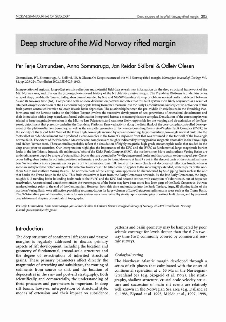
Fig. l. Structural overview map and nomenclature of the Mid-Norwegian shelf (Blystad et al. 1995) with geology of onshore areas ( compilation by Mosar, 20 0 2). Arrows indicate Devonian maximum elongation trends and tectonic transport directions related to syn/post orogenic extension; simplified from Fossen (1992), Krabbendam & Dewey (1998), Braathen et al. (20 0 0 , 20 0 2), and Osmundsen et al. (20 0 3). BVFC- Bremstein-Vingleia Fault Complex; CNBW - Central Norway basement window; HD- Høybakken detachment; KD - Kollstraumen detachment; MTFC: Møre-Trøndelag Fault Complex.

NORWEGIAN JOURNAL OF GEOLOGY
Dore et al. 1999, Brekke 2000, Skogseid et al. 2000). Following late-to post-Caledonian extension in the Devonian, successive rift events affected the present NE Atlantic margin in Late Palaeozoic, Triassic, Jurassic and Cretaceous times, followed by the Late Cretaceous to Early Eocene extension that led to breakup and onset of sea-floor spreading (op.cit). The resultant, megascopic architecture of the Mid Norway rifted margin can be described in terms of a rhomb-shaped platform surrounded by terrace and deep basin areas (Blystad et al. 1995, Fig. 1). Previous work in the Northern North Sea area and in the Møre Basin has indicated the presence, and probable reactivation, of Palaeozoic detachments at depth (e.g. Gabrielsen et al. 1999, Fossen et al. 2000, Odinsen et al. 2000). Furthermore, it has been pointed out that the NE-SW, N-S and NW-SE fault trends that dominate the Mid Norway rifted margin resemble the orientation of Palaeozoic fault patterns onshore Norway, and it has been considered likely that these trends were reactivated during later rift phases (Skogseid et al. 1992, Dore et al. 1997, Roberts et al. 1999). However, previous workers have not addressed the nature of this proposed re-activation in any detail.
The platform areas that border the Mesozoic rift systems of the NE Atlantic margin are characterized by a thin Mesozoic succession, and constitute ideal study areas with respect to the pre-Mesozoic tectono-sedimentary configuration. Previous studies have shown that the Mesozoic and Cenozoic succession on the Trøndelag Platform is characterized largely by flat-lying or gently seaward-dipping, Middle Triassic and younger strata (Blystad et al. 1995). Parts of the platform are, however, underlain by Permian deposits ( Op. cit. and Dore et al. 1999), and a southeast-facing, half-graben geometry has been inferred for the Permian Froan Basin (Fig. l, Blystad et al. 1995). Bugge et al. (2002) described a total of 750 m of Late Permian and Early Triassic sedimentary rocks from two wells drilled east of the Helgeland Basin.
An intriguing feature of the Mid-Norwegian margin is the extreme thickness of the Mesozoic sedimentary fills in the V øring and Møre Basins. Some controversy exists over the depth to the base of the Cretaceous succession, which reaches 13 km or more in the interpretation of Blystad et al. (1995) and of Brekke (2000), but there is a general consensus that the V øring and Møre Basins are characterized by severely attenuated continental crust (e.g. Dore et al. 1999). Based on the interpretation of wide-angle seismic refraction (OBS) and gravity data, the depth to Moho is believed to be 20-25 km underneath large parts of the V øring Basin (Mjelde et al. 1997, 1998, Raum et al. 2002). However, the crystalline part of the crust has been interpreted as thinned to c. l O km under the basin, and locally, to less than 3 km (Raum et al. 2002). To the southwest, it has been suggested that the deepest parts of the Møre Basin may rest on proto-
Deep structure of the Mid Norway rifted margin 207
oceanic crust (Lundin & Dore 1997).
Data, scope and strategy of interpretation
In the present study, we have used high-quality, langoffset seismic reflection data in combination with potential field data and stratigraphic information from a total of 21 wells, to address the deep structure of parts of the NE Atlantic margin. The long-offset seismic data used in this study belong to a spaced regional grid of 14 lines covering the Møre and V øring Basins. The data were recorded to 14 s twt and are of good to very good quality, showing events down to 10-12 s twt and providing good, laterally continuous images of stratigraphy and structure down to 8-9 s twt. The seismic imagery of fault planes at depth is locally exellent, in particular with respect to large-magnitude, moderate- to lowangle normal faults. Spacing between the lines varies between 35 and 170 km. We have concentrated our study on five NW-SE-trending lines that traverse the southern Vøringlnorthernmost Møre Basins (Fig. 1). Additional interpretation was carried out on 3 NE-SWtrending tie lines and on a number of lines selected from surveys recorded to 7 s twt. A total of 2344 km of long-offset seismic data was used in the study together with c. 950 km of seismic data recorded to 7 s twt.
A primary goal in the interpretation was the deep, mainly pre-Cretaceous structure. However we also carried out interpretation at shallower levels, to reveal any relationships between the deep structuring and the shallower-seated structure and stratigraphy. A timecorrelative approach was chosen in the interpretation. Our aim has been to address the configuration and style of deep-seated geological structures that constitute main boundaries in the rift architecture, to discuss the tempora} and spatial relationships between structures developed during successive rift events, and to discuss the mode(s) of extension under the deepest, most highly attenuated basin areas. The lateral extent of some fundamental aspects of the deep structure is discussed based on correlation with potential field data.
Description of interpreted seismic ond potential field dato
The Trøndelag Platform
In combination with gravity data, our interpretation of three, long-offset seismic lines that cross the Trøndelag Platform puts new constraints on the extent and geometry of the pre-Middle Triassic basin(s) identified by previous workers. On our residual gravity map (Fig. 2), the entire platform area is subdivided into a series of gravity lows separated by NE-SW- and N-S- to NNWSSE-trending highs. A top-to-basement map, based mainly on gravity and magnetic data (Skilbrei et al.,

208 P.T. Osmundsen et al.
2002), reveals a dramatic basement topography under the Trøndelag Platform. Considering the gently dipping Mid-Triassic and younger succession, development of the basement topography must mainly have pre-dated Middle Triassic deposition. This is confirmed by the deep seismic data, which provide a good image of the configuration of deep structures and basins. The level interpreted as the to p of basement is characterized by a strong reflection that can be correlated across the faults (Fig. 3), and along a NE-SW trending tie line (not shown) into the Nordland Ridge/Helgeland Basin area. In central parts of the Trøndelag Platform area (Fig. 4),
the Froan Basin is shown to constitute the near-shore part of an array ofNW-dipping half-grabens separated by SE-throwing faults that show normal separation and that are characterized by apparent horizontal separations up to more than l O km ( obliquity between fault di p direction and profile orientation not accounted for). The SE-dipping, pre-Middle Triassic fault array soles into a flat-lying reflection sequence situated at c. 8 s twt. The SE boundary of the pre-Middle Triassic basin is characterized in this area by a flexure, as the faulted top of basement rises gradually towards the Norwegian mainland (Fig. 4). The decrease in basement depth governs the gradual thinning of the Middle to Late Triassic, more gently dipping succession. Thus, in this area, a basinwards-sloping basement topography was clearly present as early as in the Triassic.
In the south-central parts of the platform (Fig. 5), our interpretation shows a scoop-shaped basin, fragmented at depth into a series of rotated half-grabens bounded by normal faults of apparent opposite polarity. The faults merge and flatten at c. 6 s twt, along a sub-horizontal reflection band. Farther south (Fig. 6), this reflection band is gently westward dipping and rises to a level of c. 2,5 s twt dose to the mainland. A deeper reflection band, identified in Fig. 5, is sub-horizontal under the pre-Middle Triassic basin but dips gently seawards in the area of the platform-terrace boundary. Apparently, a portion of the middle crust is sandwich ed between this reflection band and the one that constitutes the level of detachment for the pre-Middle Triassic basin.
Correlation with the residual gravity map (Fig. 2) shows that the crests of the larger fault blocks correspond to gravimetric highs that are oriented NE-SW and N-S. In the southeast, a NE-SW trending fault with a vertical separation of c. 2,3 s twt in the seismic section constitutes the SE boundary of the basin. No postMiddle Triassic activity can be demonstrated along the SE boundary fault in the area of our section. The wedge-shaped, pre-Middle Triassic basins are up to c. 1,5 s thick in the two-way time sections, and at least one unconformity has been identified in the basin fill. The unconformity is indicated by the onlap of reflectors on to the top of the thicker, wedge-shaped reflector packages in the proximity of larger normal faults. At
NORWEGIAN JOURNAL OF GEOLOGY
mGal -31 ·17 ·12 .e-e-e-5-4-l·2·1.01 2235e7ø10131727
Fig. 2. Gravity map of the Norwegian Sea area. Note NE-SW and NS trending gravimetric highs in the platform area. The pattern of gravimetric highs and lows is interpreted to reflect the configuration of deep-seated Palaeozoic-Early Mesozoic, rotated fault-blocks and half-graben basins (see text). Compare the trends of the gravimetric highs with the main outline of the Platform, Terrace and Basin areas as displayed on Fig. l. TP- Trøndelag Platform; HT- Halten Terrace; PH- Frøya High; CNBW- Central Norway basement window.
this stratigraphic level, it appears that most of the intra-basinal faults were inactive, and creation of faultinduced accommodation was concentrated along the basin boundaries. The strongly rotated top of basement indicates that onlap relationships are present also at the base of the Palaeozoic succession. The western boundary fault for the Palaeozoic basin, located southeast of 6407/6-2 in fig. 5, was clearly re-activated in the Jurassic and the Cretaceous. Some of the intra-basinal faults also show evidence for re-activation around the Jurassic-Cretaceous boundary (Figs. 5 and 6).
The Triassic and pre-Middle Triassic seismic units can be traced into the area of the Helgeland Basin. The reflection pattern at depth below the Middle Triassic is less informative here, but Permian rocks are present in the basin (Blystad et al. 1995, Brekke, 2000, Bugge et al. 2002), which has the form of a scoop with relatively steep boundaries in the northwest as well as in the southeast (Fig. 7). A deep-seated reflection band at c. 7 s twt underlies much of the basin, and may tentatively correspond to the detachment level that underlies the rotated fault blocks farther south.
In summary, our interpretation of deep seismic and potential field data shows that the entire Trøndelag Platform is underlain by thick successions of preMiddle Triassic strata that are localized in deep halfgrabens rooted in a common detachment situated between 6 and 8 s twt. The structural style in the configu-

NORWEGIAN JOURNAL OF GEOLOGY Deep structure of the Mid Norwoy riked margin 209
2.0 s
7.0
Fig. 3. Seismic example of deep, pre-Middle Triassic structures and basins underneath the Trøndelag Platform, see fig. 5 for location. Vertical scale in seconds two-way time (twt), horizontal scale bar= 10 km. T- Base of sub-horisonta� Middle Triassic succession; U- Palaeozoic or Early Mesozoic onlap unconformity ; TB - Top of basement, alternative/y older Palaeozoic strata; F- fault-plane reflections; D - detachment leve/ for half-graben bounding faults.
ration of Palaeozoic, fault-bounded basins changes from south to north in the platform area, and clearly indicates shift(s) of polarity along same of the NE-SWtrending, basin-bounding structures. The NE-SW and N-S tren ds of the pre-Middle Triassic faults is reflected by the trends of the younger faults that define the platform outline, and, on the grander scale, the general outline of the Mid-Norwegian margin (Fig. l). This is in accordance with earlier suggestions by Dore et al. ( 1997) and points towards a fundamental aspect of re-activation during formation of the Mid-Norwegian margin.
The platform-terrace boundary
The southern Halten Terrace: - The southern platformterrace boundary is constituted by the Bremstein-Vingleia Fault Complex (BVFC, Blystad et al. 1995). In the seismic data, a well-defined fault-plane reflection reveals the ramp-flat geometry of the BVFC in the vicinity of well 6407/7-1 (Fig. 8). A deep set of reflections defines an antiformal structure with the crest located directly beneath the ramp-flat transition at c. 4,5 s twt (Figs. 6 & 8). The seismic expression of the BVFC merges with the band of reflections that define the NW flank of the antiform. The reflection band attains a gentler dip with depth on the time sections and can be traced under most of the Halten Terrace down to c. 9,5 s twt befare it rises slightly towards the Klakk Fault Complex (KFC; Fig. 6).
East of the BVFC, the low-angle reflection band underlying the Palaeozoic-Early Mesozoic basin dips towards
the platform-terrace boundary, but does not appear to cut the antiformal culmination; rather, the low-angle reflectors appear to merge with the SE flank of the antiform. In the hanging wall of the BVFC, the strongly rotated fault block hosting well 6407/7-1 (Njord Field) is bounded to the NW by a planar fault splay that merges with the ramp segment of the BVFC (Fig. 6). To the south, west of the Frøya High (Fig. 9), the configuration is different from that in the Njord area. South of the intersection between the BVFC and KFC, a lowangle detachment fault constitutes the boundary between the platform and the deep basin (below).
Farther north (Figs. 4 and 5), deep reflections do not display the high-amplitude antiformal pattern observed in the Njord area. Deep reflection packages are flatlying or display low-amplitude undulations. Also, with respect to the BVFC, a change in geometry appears to have taken place; the ramp-flat geometry is not evident in fig. 5. Here, the main displacement at the platformterrace boundary is located along one major fault and 2-3 subordinate anes. Correspondingly, the hanging wall comprises one large, rotated fault block (the Halten Terrace area), and lacks the separate 'rider' block observed in the area of 640717-1. In the Dønna Terrace area, however, a ramp-flat geometry is inferred for the Revfallet Fault Complex (Fig. 4).
On the aeromagnetic map (Fig. 10), the Frøya High is characterized by the highest amplitude ( > 1200 n T, Skilbrei et al. 2002) positive magnetic anomaly observed on the Mid-Norway margin. Positive magnetic anomalies

21 O P.T. Osmundsen et al.
are also present under parts of the Trøndelag Platform, and a roughly E-W-trending positive anomaly traverses northern Halten Terrace dose to the area of the Revfallet Fault Complex. These magnetic anomalies probably have their source at depth in the basement (Skilbrei et al. 2002). The association of strong positive magnetic anomalies with the footwall of large-magnitude, domain-bounding normal faults point towards a genetie relationship between the observed anomalies and the deep structure. From south to north on the Halten Terrace, the amplitude of the deep, antiformal reflections decays to become flat and more deep-seated. This occurs in concert with a change in the geometry of the BVFC, from a relatively shallow ramp-flat geometry in the south to a more simple, listric shape in the north. The relationship suggests a fundamental link between the deep structure and the shallower-level fault geometry (see discussion).
The Halten Terrace
Structure. - From the above observations and interpretations, it follows that the Halten Terrace constitutes a rotated fault block in the hanging wall of the BVFC, and that much of the Terrace is underlain by the lowangle, ductile continuation of the BVFC (Fig. 6). The Halten Terrace hosts fault systems that offset reflectors
NORWEGIAN JOURNAL OF GEOLOGY
in the Jurassic and upper Triassic succession, but that cannot be identified at deeper levels. Previous workers have interpreted these fault systems to detach in Middle Triassic salt layers (e.g. Whitjack et al. 1989, Whitjack & Callaway 2000). However, the Halten Terrace also contains faults that cut deeper into the pre-Middle Triassic stratigraphy. A number of faults that are moderate- to low angle in the time sections cut deep reflectors below the Middle Triassic level. East of the Sklinna Ridge, the dips decrease in the Triassic strata as they flatten into a syndinal binge area adjacent to a fault (F on Fig. 5) that also affects the Jurassic succession. Still doser to the fault trace, Triassic strata are rotated further, attaining NW dips. Below the base of the Jurassic, small faults, antithetic to fault F contain wedge-shaped reflector packages in the hanging wall, indicate Triassic, syn-tectonic sedimentation. Although the fault-plane reflection is lost at c. 5 s twt, we suggest that the structure of the Sklinna Ridge in this area reflects development of a drag syndine in the hanging wall of a moderate- to low-angle normal fault (F) that experienced a main phase of activity in the ?Late Triassic, and that most likely flattens with depth underneath the ridge (Fig. 5). The relations between this fault and the KFC is not well constrained in the seismic data, but a model of shortcut-faulting related to an inherited ramp-flat normal fault would be in accordance with the above observations and interpretations.
Fig. 4. Geoseismic section traversing the Trøndelag Platform, the Dønna Terrace and south-central parts of the V øring Basin. Note pre-Middle Triassic half-graben basins bounded by a SE-dipping fault array in the Trøndelag Platform area. The faults appear to detach at c. 8 s twt. The SE margin of the Palaeozoic basin is constituted by a flexure. The sedimentary architecture in the Triassic and ]urassic succession of the Dønna Terrace is characterised by thickness variation related to gentle deflections of the stratigraphy and by unconformities at base Middle ]urassic, base Upper ]urassic and Base Cretaceous levels. The deflection of the stratigraphy and the formation of unconformities may re late to extensional faulting along the Revfallet Fault Complex (see text).
Fig. 5. Geoseismic section traversing the Trøndelag Platform, the Halten Terrace and parts of the southern V øring Basin. Note the scoop-shaped, pre-Middle Triassic basin in the Trøndelag Platform area and the common leve! of detachment at c. 6.s twt (compare to Fig. 3). The SE margin of the Palaeozoic basin is constituted here by a large normal fault. Onlap unconformities characterise parts of the pre-Middle Triassic fill in the vicinity of the main, basin-bounding faults and give evidence for a late phase of fault-block rotation in the latest Palaeozoic or earliest Mesozoic; some of the intrabasinal faults, however, appear to terminate at low levels in the pre-Triassic stratigraphy. The deflection of the ]urassic stratigraphy in to a relative/y simple growth syncline in the hanging wall of the Brems tein Fault Complex contrasts with the more complex stratigraphic architecture to the south (Fig. 5) and to the north adjacent to the Revfallet Fault complex (Fig. 3 ). Most like/y, this reflects variations in the geometry of the Terrace-bounding faults. On the west side of the Halten Terrace, the master fault of the Klakk Fault Complex is displayed as a large-magnitude, low-angle normal fault with an apparent horisontal separation of c. 30 km. The subdivision of inferred ]urassic stratigraphy west of the KFC is tentative. See text for discussion.
Fig. 6. Geoseismic section traversing the Trøndelag Platform, Halten Terrace and southern V øring Basin. Note the basinward-dipping detachment under the Trøndelag platform; a deep, antiformal culmination with crest located at c. 4, 5 s twt in the vicinity of 640 7/7 -l; the ramp-flat geometry of the Bremstein-Vingleia Fault Complex. Note also the onlap unconformities in the Triassic and ]urassic succession on the Halten Terrace; the triangular rider blocks associated with the Klakk Fault Complex; the deep-seated reflector band located at c. l Os twt;. and the extremely attenuated area associated with low-angle detachment under the western parts of the basin.
Fig. 7. Geoseismic section traversing the Helgeland Basin, the Træna Basin, the Utgard high and the Gjallar Ridge. Note the flexural character of the SE margin of the Træna Basin, the triangular feature at depth under the Verna Dome, and deep reflectors under the faults in the Gjallar Ridge. Note also ocean-dipping reflections in the marginal high area and prograding lava deltas in the area of the V øring escarpment. See text for discussion.
Fig. 9. Geoseismic section traversing the Frøya High and the northernmost Møre Basin. Note intra-basement reflectors west of the Frøya High, the large magnitude of displacement (c. 40 km) on the adjacent low-angle normal fault and the pattern of deep-seated, rotated fault blocks under the northernmost Møre Basin. See text for discussion.

NORWEGIAN jOURNAL OF GEOLOGY Deep structure of the Mid Norway rihed margin 211
Fles Fault Complex Rås Basin Revfallet Fault Complex Nordland Ridge
Sklinna Ridge Dønna Terrace 6507/07-1 6507/08-04 6507/12-2 Froan Basin IKU8 IKU7
ii��;;�:!!!!!!:!!!!!!:!!!!ii!illiilllllllllll����:!::���������:;!!!!illiiiil .. l .. l ... i ... :.=====�� �� ·�·······�·······��!: ������ j � ------ 8 g
Fig.4.
NW
Fig.S.
Færoe-Shetland Escarpment
Modgunn Arch
Helland-Hansen Arch
6406/03-2
50 km
Bremstein- Vingleia Fault Complex
6407/06-3 6407/06-2
····�-
6408/04-1
Klakk Fault Complex
Bremstein-Vingleia Fault Complex
Halten � ;l; Terrace Rås Basin
SE
Froan Basin
10 �
ESE o
Legend
CJ Deep crust and upper mantle
CJ Reflective basement
CJ Poorly reflective seismic units; may include basement, Palaeozoic and/or Early Mesozoic sedimentary rocks
c:=::J Mid-Late Palaeozoic? Caledonian nappes?
El Mid-Late Palaeozoic - Early Mesozoic
- Early Triassic?
C=:J Mid- Late Triassic
- Early Jurassic (Båt Gp) - Middle Jurassic (Fangst Gp) CJ Late Jurassic (Viking Gp) (Subdivision of Jurassic tentative in deep basin areas)
---CJ
Early Cretaceous
Early Cretaceous (Cromer Knoll Gp) Early Cretaceous, Turonian (Cromer Knoll Gp) Late Cretaceous (Shetland Gp)
Palaeocene - Lower Eocene (Rogaland Gp) Eocene (Hordaland Gp) Late Eocene - Early/Middle Miocene (Hordaland Gp. - Nordland Gp) Intra Miocene
� 8
Late Miocene - Early/Middle Pliocene
Late Pliocene
f-lO
12 50 km 14 ��---------------------- --�==========�----------------------------------------�======�--------------------------� Fig. 6. Fig. 12 Fig. 8
NW Utgard High V øring Marginal High Gjallar Ridge Rym intrusive complex Verna Dome TrænaBasin
12 14
Helgeland Basin SE
�8 ""to
12 50 km 12 J4L-------------------------------------------------------------------------------------------�----------------------------------------------------------------------------------� 14
Fig. 7. NW
Fig. 11

212 P.T. Osmundsen et al. NORWEGIAN jOURNAl OF GEOLOGY
2.0 s
8.0
Fig. 8. Seismic example showing the geometry of the Bremstein-Vingleia Fault Complex in the vicinity of well6407 /7 -l (Njord Field area, location in fig. 6). Vertical scale in seconds twt, horizontal scale bar = l O km. Note the well-developed fault-plane reflection in the syndepositional fault breakaway area (Fb ), the flat portion of the fault plane (Ff), and in the area of the ramp (Fr). The crest of an antiformal culmination (C) is located directly underneath the ramp. BC- Base of Cretaceous. See text.
Late Triassic-Early Cretaceous faults and associated sedimentation patterns. - Sedimentation patterns on the Halten and Dønna Terraces have not been focussed upon in this study. However, our spaced grid of seismic data does show variation in depositional style adjacent to the larger structures. In three of our sections, wedgeshaped reflection packages of Late Triassic to Late Jurassic age are banked against the Revfallet (Fig. 4) and Bremstein-Vingleia (Figs. 5 & 6) Fault Complexes. In the central parts of the Halten Terrace (Fig. 5), stratigraphic architecture in the Jurassic adjacent to the BVFC is consistent with a simple growth fold (see also Whitjack et al. 1989, Whitjack & Callaway 2000) with reflector packages thinning away from the hinge area. To the south and north of this area, however (Figs. 4 & 6), the stratigraphic architecture in the Dønna and Halten Terraces is more complicated, and characterized by thickness variations and several pronounced unconformities in the ?Late Triassic-Upper Jurassic interval. In the south (Fig. 6), the Upper Triassic and Lower Juras-
sic strata terminate against a gently SE-dipping reflector. It is possible that this pattern is a result of salt movements; the alternative interpretation is that of a Triassic onlap unconformity. At a stratigraphically higher level, Middle and Upper Jurassic reflectors downlap onto an unconformity at the top of the faulted Lower Jurassic succession, which defines a gentle syncline with NW-dipping strata dose to the planar fault west of 6407/7 -l. T his syn dine must have existed prior to Late Jurassic sedimentation, and also appears to pre-date parts of the Mid Jurassic stratigraphy. Expansion of the Upper Jurassic succession towards the fault indicates a main p hase of activity during this time.
To the north (Fig. 4), thickness variations and unconformities characterize the Late Jurassic-Early Cretaceous succession in the hanging wall of the Revfallet Fault Complex (RFC). Here, Lower and Middle Jurassic strata, deformed in a gentle syncline, are truncated by an erosional surface at the base of the Upper Jurassic;
NORWEGIAN JOURNAL OF GEOLOGY
Upper Jurassic strata are then truncated by the base of the Cretaceous. The gentle deflections of the stratigraphy were clearly syn-depositional, and most likely related to subsidence along the RFC.
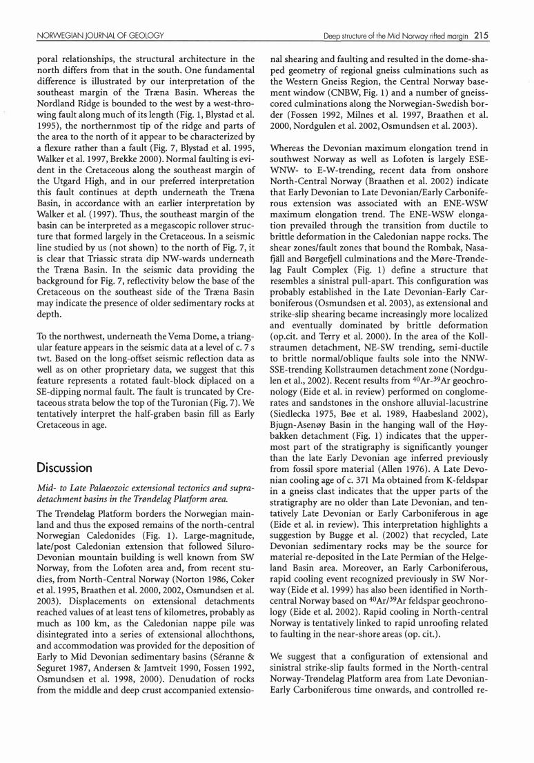
The boundary to the deep basin areas
The Klakk Fault Complex (KFC, Blystad et al. 1995) constitutes the boundary between terrace and platform areas and the deep north em Møre and south em V øring Basins. O ur interpretations show that the geometry and magnitude of displacement along the KFC changes dramatically from south to north; furthermore, observations of the fault-zone architecture give some dues toward the temporal development of the terrace/basin boundary.
In the south, the KFC formally constitutes the eastern boundary of the northernmost Møre Basin (Blystad et al. 1995). The long-offset seismic data do, however, reveal that this part of the basin boundary is more complex. West of the Frøya High (Fig. 9), the boundary to the deeper parts of the Møre Basin is constituted by a large-magnitude, low-angle normal fault with an apparent horizontal separation in the order of 40 km. The long-offset seismic data allow the assessment of the geometry of the fault down to a level of c. 8 s twt based on good-quality fault-plane reflections (Fig. 1 1). The horizontal separation is constrained in the footwall by the top of metamorphic basement drilled west of the Frøya High (6306/10-1) and in the hanging wall by the top of a transparent seismic unit, interpreted to represent basement rocks, that occurs at c. 9 s twt (Fig. 11). In the footwall, a strong reflection band with a gentle antiformal shape in the time sections occurs in the basement at c. 4 s twt, below the rotated fault block penetrated by 6306/ l 0-1. This reflection band is rotated sub-parallel to the basin-bounding detachment, and becomes part of the gently dipping reflectivity that characterizes the footwall down to c. 9 s twt. However at this level sub-horizontal reflectivity in the footwall appears to be cut by the detachment at a relatively high angle. The relationship between the large-magnitude normal fault west of the Frøya High and the KFC cannot be addressed from the seismic dataset used in this study (Fig. 9).
On the southwestern margin of the Halten Terrace, displacement along the KFC is significantly less than along
·the low-angle normal fault west of the Frøya High. Horizontal separation is c. 10-15 km in the area of fig. 6, and the master fault plane dips more steeply than the main detachment west of the Frøya High. The KFC can be traced as an arra y of fault-plane reflections to c. 7,5 s twt. The KFC in this area is also associated with relatively shallow-level, rider fault blocks that are triangular in cross-section and that appear to be stacked in the footwall of the master fault. In the interpretation in fig.
Deep structure of the Mid Norway rifted margin 213
6, each rider is bounded by a fault that terminates in progressively older stratigraphic levels of the Triassic succession.
Our geoseismic section in fig. 5 traverses the KFC on the western side of the central terrace area. Here, the apparent horizontal separation on the KFC is c. 30 km. Two or three fault terraces characterize the KFC, and again, the reflection from the master fault plane appears on the basin side of the fault complex. The area is characterized by a strong positive magnetic anomaly that runs in an E-W direction that roughly follows the boundary between the Halten Terrace and the Dønna Terrace and that links with the broader positive anomaly located on the E side of the terrace areas. Along the KFC, drilled and dated Cretaceous strata of Cenomanian age overstep the fault, and the main activity must have taken place prior to this time. Moreover, undated strata that pre-date the Late Cenomanian interval do not show signs of significant deformation along the fault plane. The seismic signature of the succession that overlies the unconformity on top of the rotated fault blocks is relatively homogeneous down towards the unconformity. We interpret this succession to be Cretaceous in age, with possible exception of the lowermost parts that drape residual rift topography associated with the fault blocks adjacent to the KFC (Figs. 5, 6 & 12).
The northern Møre and southern V øring Basins
Basement structure. - The northernmost Møre and southern V øring Basins are bound by the KFC in the east (Blystad et al. 1995), and show a pronounced similarity in the configuration of deep structures (Fig. 6 & 9). In the seismic data, an undulating band of relatively strong reflections characterizes levels between c. 8 and 10 s twt. The deep reflections are characterized by sigmoidal geometries where they interact with oblique,
NW-dipping reflections that can be traced down to levels between 6 and 9 s twt and that locally appear to truncate the deep-seated reflection hands (Fig. 12). Commonly, there is a contrast in the reflection pattern across the NW-dipping reflections. In our interpretation, the deep basin structure is dominated by arrays of rotated fault blocks, separated by NW-dipping faults in a c. 100-120 km wide, strongly attenuated area that separates the Halten Terrace and Frøya High from the Vøring and Møre marginal highs, respectively. Under parts of this area, the reflectivity in the lower crust, as well as along some of the interpreted fault planes, is very strong, and it is considered likely that intrusive bodies in the form of sills and dykes contribute to the strong reflectivity. In our interpretation, the most strongly attenuated crust is located in a relatively distal position with respect to the Halten Terrace and Frøya High areas. In the most highly attenuated area, we
214 P.T. Osmundsen et al.
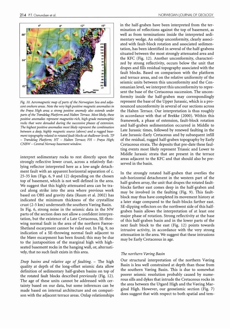
4" 12" 16"
Fig. 10. Aeromagnetic map of parts of the Norwegian Sea and adjacent onshore areas. Note the very high positive magnetic anomalies in the Frøya High area; a strong positive anomaly also extends under parts of the Trøndelag Platform and Halten Terrace. Most likely, these positive anomalies represent magnetite-rich, high-grade metamophic rocks that were denuded during the successive phases of extension. The highest positive anomalies most likely represent the combination between a deep, highly magnetic source (above) and a rugged basement topography related to rotated fault blocks at shallower levels. TP - Trøndelag Platform; HT - Halten Terrace; PH - Frøya High; CNBW- Central Norway basement window.
interpret sedimentary rocks to rest directly upon the strongly reflective lower crust, across a relatively flatlying reflector interpreted here as a low-angle detachment fault with an apparent horizontal separation of c. 25-35 km (Figs. 6, 9 and 12) depending on the chosen top of basement, which is not well defined in the area. We suggest that this highly attenuated area can be traced along strike into the area where previous work based on OBS and gravity data (Raum et al. 2002) has indicated the minimum thickness of the crystalline crust (2-5 km) underneath the southern V øring Basin. In Fig. 6, strong noise in the seismic data in the NW
parts of the section does not allow a confident interpretation, but the existence of a Late Cretaceous, SE-throwing normal fault in the area of the northern FaeroeShetland escarpment cannot be ruled out. In Fig. 9, no indication of a SE-throwing normal fault adjacent to the Møre escarpment has been found; this may be due to the juxtaposition of the marginal high with highseated basement rocks in the hanging wall, or, alternatively, that no such fault exists in this area.
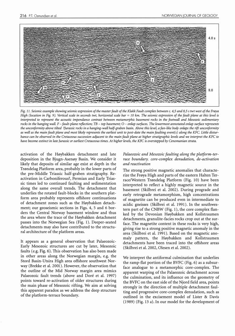
Deep basins and relative age of faulting. - The high quality at depth of the long-offset seismic data allow definition of sedimentary half-graben basins on top of the rotated fault blocks described previously (Fig. 12). The age of these units cannot be addressed with certainty based on our data, but some inferences can be made based on internal architecture and on comparison with the adjacent terrace areas. Onlap relationships
NORWEGIAN JOURNAL OF GEOLOGY
in the half-graben have been interpreted from the termination of reflections against the top of basement, as well as from terminations inside the interpreted sedimentary wedge. An onlap unconformity, clearly associated with fault-block rotation and associated sedimentation, has been identified in several of the half-grabens situated between the most strongly attenuated area and the KFC (Fig. 12). Another unconformity, characterized by strong reflectivity, occurs below the unit that drapes and fills residual topography associated with the fault blocks. Based on comparison with the platform and terrace areas, and on the relative uniformity of the seismic units between this unconformity and the Cenomanian level, we interpret this unconformity to represent the base of the Cretaceous succession. The unconformity inside the half-graben may correspondingly represent the base of the Upper Jurassic, which is a pronounced unconformity in several of our sections across the Halten Terrace. Our interpretation is thus roughly in accordance with that of Brekke (2000). Within this framework, a phase of extension, fault-block rotation and half-graben sedimentation occurred in Middle to Late Jurassic times, followed by renewed faulting in the Late Jurassic-Early Cretaceous and by subsequent infill of the residual, rugged half-graben topography by Early Cretaceous strata. The deposits that pre-date these faulting events most likely represent Triassic and Lower to Middle Jurassic strata that are present in the terrace areas adjacent to the KFC and that should also be preserved in the basin.
In the strongly rotated half-graben that overlies the sub-horizontal detachment in the western part of the half-graben array, the unit that drapes the rotated faultblocks farther east comes deep in the half-graben and may be involved in the faulting (Fig. 9). This faultblock may thus have completed its movement history at a later stage compared to the fault-blocks farther east. SE-dipping reflectors on the northwest side of this halfgraben basin allows the interpretation of at least one major phase of rotation. Strong reflectivity at the base of this half-graben basin and in the lower parts of the next fault block to the east (Fig. 12) points towards intrusive activity, in accordance with the very strong attenuation in the area. We suggest that these intrusions may be Early Cretaceous in age.
The northern V øring Basin
Our structural interpretation of the northern V øring Basin is less well constrained at depth than those from the southern Vøring Basin. This is due to somewhat poorer seismic resolution probably caused by numerous sills and dykes that in trude the Cretaceous rocks in the area between the Utgard High and the V øring Marginal High. However, our geoseismic section (Fig. 7) does suggest that with respect to both spatial and tem-
NORWEGIAN JOURNAL OF GEOLOGY
poral relationships, the structural architecture in the north differs from that in the south. One fundamental difference is illustrated by our interpretation of the southeast margin of the Træna Basin. Whereas the Nordland Ridge is bounded to the west by a west-throwing fault along much of its length (Fig. l, Blystad et al. 1995), the northernmost tip of the ridge and parts of the area to the north of it appear to be characterized by a flexure rather than a fault (Fig. 7, Blystad et al. 1995, Walker et al. 1997, Brekke 2000). Normal faulting is evident in the Cretaceous along the southeast margin of the Utgard High, and in our preferred interpretation this fault continues at depth underneath the Træna Basin, in accordance with an earlier interpretation by Walker et al. ( 1997). Thus, the southeast margin of the basin can be interpreted as a megascopic rollover structure that formed largely in the Cretaceous. In a seismic line studied by us (not shown) to the north of Fig. 7, it is clear that Triassic strata dip NW-wards underneath the Træna Basin. In the seismic data providing the background for Fig. 7, reflectivity below the base of the Cretaceous on the southeast side of the Træna Basin may indicate the presence of older sedimentary rocks at depth.
To the northwest, underneath the Verna Dome, a triangular feature appears in the seismic data at a level of c. 7 s twt. Based on the lang-offset seismic reflection data as well as on other proprietary data, we suggest that this feature represents a rotated fault-block diplaced on a SE-dipping normal fault. The fault is truncated by Cretaceous strata below the top of the Turonian (Fig. 7). We tentatively interpret the half-graben basin fill as Early Cretaceous in age.
Discussion Mid- to Late Palaeozoic extensional tectonics and supradetachment basins in the Trøndelag Platform area.
The Trøndelag Platform borders the Norwegian mainland and thus the exposed remains of the north-central Norwegian Caledonides (Fig. 1). Large-magnitude, late/post Caledonian extension that followed SiluroDevonian mountain building is well known from SW Norway, from the Lofoten area and, from recent studies, from North-Central Norway (Norton 1986, Coker et al. 1995, Braathen et al. 2000, 2002, Osmundsen et al. 2003). Displacements on extensional detachments reached values of at least tens of kilometres, probably as much as 100 km, as the Caledonian nappe pile was disintegrated into a series of extensional allochthons, and accommodation was provided for the deposition of Early to Mid Devonian sedimentary basins (Seranne & Seguret 1987, Andersen & Jamtveit 1990, Fossen 1992, Osmundsen et al. 1998, 2000). Denudation of rocks from the middle and deep crust accompanied extensio-
Deep structure of the Mid Norway rifted margin 215
nal shearing and faulting and resulted in the dome-shaped geometry of regional gneiss culminations such as the Western Gneiss Region, the Central Norway basement window ( CNBW, Fig. l) and a num ber of gneisscored culminations along the Norwegian-Swedish border (Fossen 1992, Milnes et al. 1997, Braathen et al. 2000, Nordgulen et al. 2002, Osmundsen et al. 2003).
Whereas the Devonian maximum elongation trend in southwest Norway as well as Lofoten is largely ESEWNW- to E-W-trending, recent data from onshore North-Central Norway (Braathen et al. 2002) indicate that Early Devonian to Late Devonian/Early Carboniferous extension was associated with an ENE-WSW maximum elongation trend. The ENE-WSW elongation prevailed through the transition from ductile to brittle deformation in the Caledonian nappe rocks. The shear zones/fault zones that bound the Rombak, Nasafjall and Børgefjell culminations and the Møre-Trøndelag Fault Complex (Fig. l) define a structure that resembles a sinistral pull-apart. This configuration was probably established in the Late Devonian-Early Carboniferous (Osmundsen et al. 2003), as extensional and strike-slip shearing became increasingly more localized and eventually dominated by brittle deformation (op.cit. and Terry et al. 2000). In the area of the Kollstraumen detachment, NE-SW trending, semi-ductile to brittle normal!oblique faults sole into the NNWSSE-trending Kollstraumen detachment zone (Nordgulen et al., 2002). Recent results from 40Ar-39Ar geochronology (Eide et al. in review) performed on conglomerates and sandstones in the onshore alluvial-lacustrine (Siedlecka 1975, Bøe et al. 1989, Haabesland 2002), Bjugn-Asenøy Basin in the hanging wall of the Høybakken detachment (Fig. l) indicates that the uppermost part of the stratigraphy is significantly younger than the late Early Devonian age inferred previously from fossil spore material (Allen 1976). A Late Devonian cooling age of c. 371 Ma obtained from K-feldspar in a gneiss clast indicates that the upper parts of the stratigraphy are no older than Late Devonian, and tentatively Late Devonian or Early Carboniferous in age (Eide et al. in review). This interpretation highlights a suggestion by Bugge et al. (2002) that recycled, Late Devonian sedimentary rocks may be the source for material re-deposited in the Late Permian of the Helgeland Basin area. Moreover, an Early Carboniferous, rapid cooling event recognized previously in SW Norway (Eide et al. 1999) has also been identified in Northcentral Norway based on 40 Arf39 Ar feldspar geochronology (Eide et al. 2002). Rapid cooling in North-central Norway is tentatively linked to rapid unroofing related to faulting in the near-shore areas (op. cit.).
We suggest that a configuration of extensional and sinistral strike-slip faults formed in the North-central Norway-Trøndelag Platform area from Late DevonianEarly Carboniferous time onwards, and controlled re-
216 P.T. Osmundsen et al. NORWEGIAN JOURNAL OF GEOLOGY
4.0 s
8.0
Fig. Il. Seismic example showing seismic expression of the master fault of the Klakk Fault com?lex_ between �· 4,5 and 8,5 s twt west of t�e Frøy� High (location in Fig. 9 ). Vertical sea le in seconds twt, horizontal scale bar = l O km. The setsmtc e:'f'resswn of the fault p !ane
. at th�s leve! ts
interpreted to represent the acoustic impendance contrast between metamorphic basement rocks m the footwall and Mesozotc sedtmentary rocks in the hanging wall. F- fault-plane reflection; TB- top basement; O- on�p surfaces .
. The lowermo�t annotated onlap s�rface represe�ts
the unconformity above tilted ?]urassic rocks in a hanging-wall half-graben basm. Above thts l�el, a f�n-ltke body onlaps the rift un�onfo�mtty as well as the main fault plane and most likely represents the earliest unit to post-date the mam faultmg event(s) along the KFC. Ltttle dtsturbance can be observed in the Cretaceous succession adjacent to the main fault plane at higher stratigraphic levels and we interpret the KFC to have become extinct in late Jurassic or earliest Cretaceous times. At higher levels, the KFC is overstepped by Cenomanian strata.
activation of the Høybakken detachment and late deposition in the Bjugn-Asenøy Basin. We consider it likely that deposits of similar age exist at depth in the Trøndelag Platform area, probably in the lower parts of the pre-Middle Triassic half-graben stratigraphy. Reactivation in Carboniferous?, Permian and Early Triassic times led to continued faulting and sedimentation along the same overall trends. The detachment that underlies the rotated fault-blocks in the southern platform area probably represents offshore continuations of detachment zones such as the Høybakken detachment; our geoseismic sections in Figs. 4, 5 and 6 borders the Central Norway basement window and thus the area where the trace of the Høybakken detachment passes into the Norwegian Sea (Fig. 1). Deeper-seated detachments may also have contributed to the structural architecture of the platform areas.
It appears as a general observation that PalaeozoicEarly Mesozoic structures are cut by later, Mesozoic faults (e.g. Fig. 6). This observation has also been made in other areas along the Norwegian margin, e.g. the Stord Basin-Utsira High area offshore southwest Norway (Brekke et al. 2001). However, the observation that the outline of the Mid Norway margin area mimics Palaeozoic fault trends (above and Dore et al. 1997) points toward re-activation of older structures during the main phase of Mesozoic rifting. We aim at solving this apparent paradox as we address the deep structure of the platform-terrace boundary.
Palaeozoic and Mesozoic faulting along the platform-terrace boundary. core-complex denudation, de-activation and reactivation
The strong positive magnetic anomalies that characterize the Frøya High and parts of the eastern Halten Terrace/Western Trøndelag Platform (Fig. l O) have been interpreted to reflect a highly magnetic source in the basement (Skilbrei et al. 2002). During prograde and early retrograde metamorphism, high concentrations of magnetite can be produced even in intermediate to acidic gneisses (Skilbrei et al. 1991). In the southwestern part of the CNBW (Fig. 1), the core complex flanked by the Devonian Høybakken and Kollstraumen detachments, granulite-facies rocks crop out at the surface. The magnetite content in these rocks is very high, giving rise to a strong positive magnetic anomaly in the area (Skilbrei et al. 1991). Based on the magnetic anomaly pattern, the Høybakken and Kollstraumen detachments have been traced into the offshore areas (Skilbrei et al. 2002, Olesen et al. 2002).
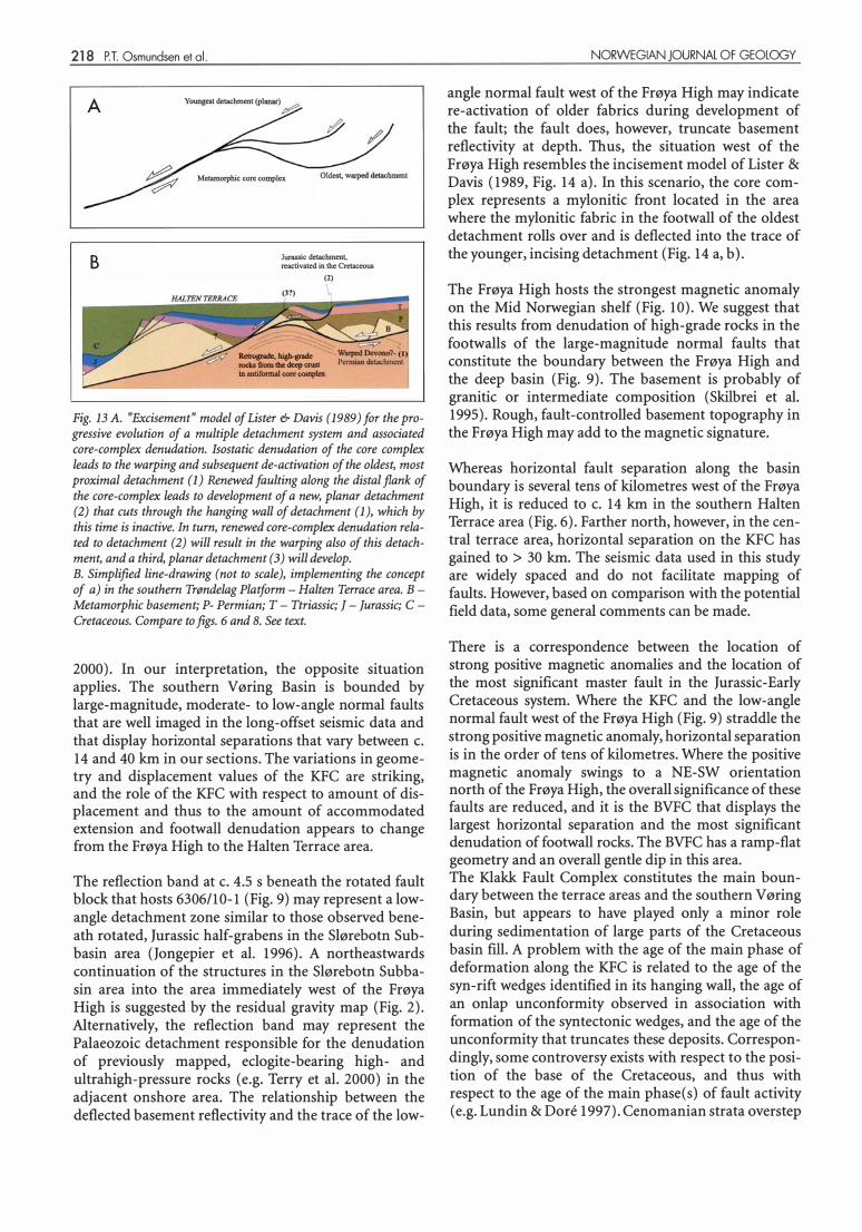
We interpret the antiformal culmination that underlies the ramp-flat portion of the BVFC (Fig. 6) as a subsurface analogue to a metamorphic core-complex. The apparent warping of the Palaeozoic detachment across the culmination, and its influence on the geometry of the BVFC on the east side of the Njord field area, points strongly in the direction of multiple detachment faulting and progressive core-complex denudation, such as outlined in the excisement model of Lister & Davis {1989) (Fig. 13 a). In our model for the development of
NORWEGIAN JOURNAL OF GEOLOGY Deep structure of the Mid Norway rifted margin 217
3,0 s
10,0
Fig. 12. Seismic example showing expression of deep-seated, rotated fault-block under the western parts of the southern V øring Basin (location in Fig. 6). Vertical scale in seconds twt, horizontal scale bar= 10 km. O- onlap surfaces in syntectonic, tentatively ]urassic basin fill and at the base of the Cretaceous; F- half-graben bounding faults; I- possible intrusive rocks along fault plane and in lower parts of the fault-block. The sedimentary succession (Lower Cretaceous?) down-thrown on the NW side of the fault-block appears to rest directly upon a subhorisontal detachment surface (D) on the top of reflective lower crust.
the platform-terrace boundary outlined in fig. 13 b, the initial and probably most important phase of corecomplex denudation took place in the Palaeozoic. The warping of the Palaeozoic detachment across the core complex led to its de-activation prior to the Middle Triassic, and thus to the formation of a structural barder that protected the Trøndelag Platform from later rift events. The distal (i.e. northwest) flank of the corecomplex became the locus for renewed faulting in Late Triassic and Jurassic times. This probably gave rise to a new p hase of denudation of the core-complex and thus to the development of a ramp-flat geometry on the BVFC. Most likely, continued faulting led to development of a hanging wall rollover anticline-syncline pair that encompassed the Njord fault block as well as the main parts of the Halten Terrace. Onlap relationships observed in the Late Triassic-Early Jurassic succession in the Njord fault-block and on the Halten Terrace may have resulted from this configuration. Tentatively, the planar fault that separates the Njord area from the main part of the Halten Terrace (Fig. 6) was the third fault to develop in the multi p le system of progressively younger normal faults. This fault nucleated in the ramp area, dissected the already deflected hanging wall of the BVFC, and appears to have experienced a main phase of subsidence in the Middle and Late Jurassic. Whereas erosional degradation of this fault took place from Earliest Cretaceous time, minor faulting along the ramp-flat portion of the BVFC is evident in the Late Cretaceous
strata. We suggest that the Late Cretaceous activity on the ramp-flat BVFC represents an event that was 'outof-sequence' with respect to the forma ti on of the faults.
It follows from the above discussion that in the southern Trøndelag Platform-Halten Terrace area, the location of the Mesozoic platform-terrace boundary was guided by a pre-existing, antiformal core-complex inherited from Palaeozoic, large-magnitude extension. The topography of the core-complex appears to change northwards, and its control on the location and geometry of the BVFC may have been less accentuated in this area. A positive magnetic anomaly runs E-W along the northern boundary of the Halten Terrace (Fig. 10); a possibility is that the BVFC cuts the core-complex in this area. The structural style, as well as the role in the denudation of deep structural levels in the footwall indicates that the master fault for the Jurassic-Early Cretaceous extension is defined by the BVFC in the southern part of the Halten Terrace. Farther south, the low-angle detachment identified west of the Frøya High (Fig. 9) must have played a similar role in the denudation of rocks from the middle and deep crust ( see below).
The terrace-basin boundary
It has been proposed that the Jurassic-earliest Cretaceous basin lacked major basin-boundary faults (Brekke
218 P.T. Osmundsen et al.
A
B
Youngest detacbment (planar) �
Metamorphic core complex
Jurassic detachment. reactivated in the Ccctaceous
(2)
.... � �---
Retroønde. hish-gnde roc:b from the deep crust in antiformal coro complex
Fig. 13 A. "Excisement" model of Lister & Davis (1989) for the progressive evolution of a multiple detachment system and associated core-complex denudation. Isostatic denudation of the core complex leads to the warping and subsequent de-activation of the oldest, most proximal detachment (l) Renewed faulting along the distal jlank of the core-complex leads to development of a new, planar detachment (2) that cuts through the hanging wall of detachment (1), which by this time is inactive. In turn, renewed core-complex denudation related to detachment (2) will result in the warping also of this detachment, and a third, planar detachment (3) will develop. B. Simplified line-drawing (not to scale), implementing the concept of a) in the southern Trøndelag Platform - Halten Terrace area. BMetamorphic basement; P- Permian; T - Ttriassic; ] - ]urassic; C -Cretaceous. Compare to figs. 6 and 8. See text.
2000). In our interpretation, the opposite situation applies. The southern V øring Basin is bounded by large-magnitude, moderate- to low-angle normal faults that are well imaged in the long-offset seismic data and that display horizontal separations that vary between c. 14 and 40 km in our sections. The variations in geometry and displacement values of the KFC are striking, and the role of the KFC with respect to amount of displacement and thus to the amount of accommodated extension and footwall denudation appears to change from the Frøya High to the Halten Terrace area.
The reflection band at c. 4.5 s beneath the rotated fault block that hosts 6306/10-1 (Fig. 9) may represent a lowangle detachment zone similar to those observed beneath rotated, Jurassic half-grabens in the Slørebotn Subbasin area (Jongepier et al. 1996). A northeastwards continuation of the structures in the Slørebotn Subbasin area into the area immediately west of the Frøya High is suggested by the residual gravity map (Fig. 2). Alternatively, the reflection band may represent the Palaeozoic detachment responsible for the denudation of previously mapped, eclogite-bearing high- and ultrahigh-pressure rocks (e.g. Terry et al. 2000) in the adjacent onshore area. The relationship between the deflected basement reflectivity and the trace of the low-
NORWEGIAN JOURNAL OF GEOLOGY
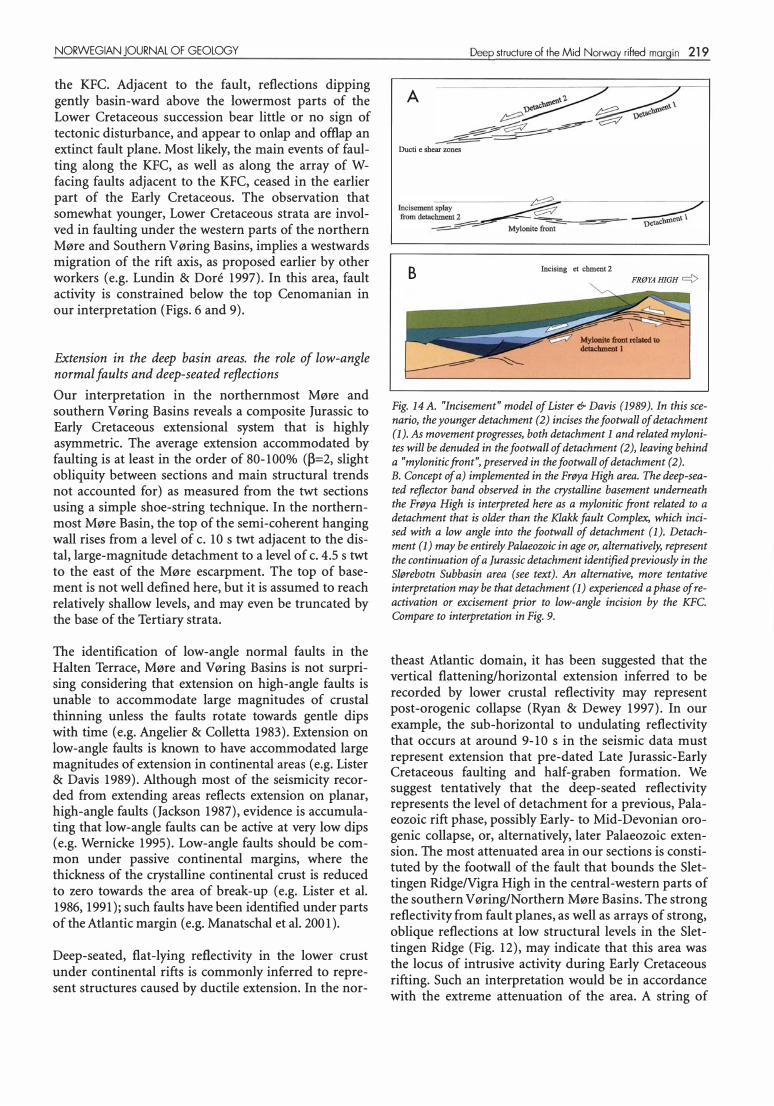
angle normal fault west of the Frøya High may indicate re-activation of older fabrics during development of the fault; the fault does, however, truncate basement reflectivity at depth. Thus, the situation west of the Frøya High resembles the incisement model of Lister & Davis (1989, Fig. 14 a). In this scenario, the core complex represents a mylonitic front located in the area where the mylonitic fabric in the footwall of the oldest detachment rolls over and is deflected into the trace of the younger, incising detachment (Fig. 14 a, b).
The Frøya High hosts the strongest magnetic anomaly on the Mid Norwegian shelf (Fig. 10). We suggest that this results from denudation of high-grade rocks in the footwalls of the large-magnitude normal faults that constitute the boundary between the Frøya High and the deep basin (Fig. 9). The basement is probably of granitic or intermediate composition (Skilbrei et al. 1995). Rough, fault-controlled basement topography in the Frøya High may add to the magnetic signature.
Whereas horizontal fault separation along the basin boundary is several tens of kilometres west of the Frøya High, it is reduced to c. 14 km in the southern Halten Terrace area (Fig. 6). Farther north, however, in the central terrace area, horizontal separation on the KFC has gained to > 30 km. The seismic data used in this study are widely spaced and do not facilitate mapping of faults. However, based on comparison with the potential field data, some general comments can be made.
There is a correspondence between the location of strong positive magnetic anomalies and the location of the most significant master fault in the Jurassic-Early Cretaceous system. Where the KFC and the low-angle normal fault west of the Frøya High (Fig. 9) straddle the strong positive magnetic anomaly, horizontal separation is in the order of tens of kilometres. Where the positive magnetic anomaly swings to a NE-SW orientation north of the Frøya High, the overall significance of these faults are reduced, and it is the BVFC that displays the largest horizontal separation and the most significant denudation of footwall rocks. The BVFC has a ramp-flat geometry and an overall gentle di p in this area. The Klakk Fault Complex constitutes the main boundary between the terrace areas and the southern V øring Basin, but appears to have played only a minor role during sedimentation of large parts of the Cretaceous basin fill. A problem with the age of the main p hase of deformation along the KFC is related to the age of the syn-rift wedges identified in its hanging wall, the age of an onlap unconformity observed in association with formation of the syntectonic wedges, and the age of the unconformity that truncates these deposits. Correspondingly, some controversy exists with respect to the position of the base of the Cretaceous, and thus with respect to the age of the main phase(s) of fault activity (e.g. Lundin & Dore 1997). Cenomanian strata overstep
NORWEGIAN JOURNAL OF GEOLOGY
the KFC. Adjacent to the fault, reflections dipping gently basin-ward above the Iowermost parts of the Lower Cretaceous succession bear little or no sign of tectonic disturbance, and appear to onlap and offlap an extinct fault plane. Most likely, the main events of faulting along the KFC, as well as along the array of Wfacing faults adjacent to the KFC, ceased in the earlier part of the Early Cretaceous. The observation that somewhat younger, Lower Cretaceous strata are involved in faulting under the western parts of the northern Møre and Southern V øring Basins, implies a westwards migration of the rift axis, as proposed earlier by other workers (e.g. Lundin & Dore 1997). In this area, fault activity is constrained below the top Cenomanian in our interpretation (Figs. 6 and 9).
Extension in the deep basin areas. the role of low-angle normal faults and deep-seated reflections
Our interpretation in the northernmost Møre and southern V øring Basins reveals a composite Jurassic to Early Cretaceous extensional system that is highly asymmetric. The average extension accommodated by faulting is at !east in the order of 80-100% (�=2, slight obliquity between sections and main structural trends not accounted for) as measured from the twt sections using a simple shoe-string technique. In the northernmost Møre Basin, the top of the semi-coherent hanging wall rises from a leve! of c. 10 s twt adjacent to the distal, large-magnitude detachment to a leve! of c. 4.5 s twt to the east of the Møre escarpment. The top of basement is not well defined here, but it is assumed to reach relatively shallow levels, and may even be truncated by the base of the Tertiary strata.
The identification of low-angle normal faults in the Halten Terrace, Møre and Vøring Basins is not surprising considering that extension on high-angle faults is unable to accommodate large magnitudes of crustal thinning unless the faults rotate towards gentle dips with time (e.g. Angelier & Colletta 1983). Extension on Iow-angle faults is known to have accommodated large magnitudes of extension in continental areas (e.g. Lister & Davis 1989). Although most of the seismicity recorded from extending areas reflects extension on planar, high-angle faults (Jackson 1987), evi
_dence is accumu�a
ting that low-angle faults can be actlve at very low d1ps (e.g. Wernicke 1995). Low-angle faults should be common under passive continental margins, where the thickness of the crystalline continental crust is reduced to zero towards the area of break-up (e.g. Lister et al. 1986, 1991); such faults have been identified under parts of the Atlantic margin (e.g. Manatschal et al. 200 l).
Deep-seated, flat-lying reflectivity in the lower crust under continental rifts is commonly inferred to represent structures caused by ductile extension. In the nor-
Deep structure of the Mid Norway rilted margin 219
A
Ductile sbear zones
Incisementsplay� from detachment 2
� -=- ��====--� Mylonitefro�
B Jncising detachment 2
FRØYA HIGH 9
Fig. 14 A. "Incisement" model of Lister & Davis (1989). In this scenario, the younger detachment (2) incises the footwall of detachment (l). As movement progresses, both detachment l and related mylonites will be denuded in the footwall of detachment (2), leaving behind a "mylonitic front", preserved in the footwall of detachment (2). B. Concept of a) implemented in the Frøya High area. The deep-seated reflector band observed in the crystalline basement underneath the Frøya High is interpreted here as a mylonitic front rela:ed
.to �
detachment that is older than the Klakk fault Complex, whtch mctsed with a low angle into the footwall of detachment (1). Detachment (l) may be entirely Palaeozoic in age or, alternatively, represent the continuation of a ]urassic detachment identified previously in the Slørebotn Subbasin area (see text). An alternative, more tentative interpretation may be that detachment (l) experienced a phase of reactivation or excisement prior to low-angle incision by the KFC. Compare to interpretation in Fig. 9.
theast Atlantic domain, it has been suggested that the vertical flattening/horizontal extension inferred to be recorded by lower crustal reflectivity may represent post-orogenic collapse (Ryan & Dewey 1997). In our example, the sub-horizontal to undulating reflectivity that occurs at around 9-1 O s in the seismic data must represent extension that pre-dated Late Juras�ic-Early Cretaceous faulting and half-graben formatwn. We suggest tentatively that the deep-seated �eflectivity represents the leve! of detachment for a prev10us, Palaeozoic rift phase, possibly Early- to Mid-Devonian orogenic collapse, or, alternatively, later Pala
.eozo�c exte�
sion. The most attenuated area in our sectwns IS constltuted by the footwall of the fault that bounds the Slettingen Ridge/Vigra High in the central-western parts of the southern V øring/Northern Møre Basins. The strong reflectivity from fault planes, as well as arrays of strong, oblique reflections at low structural levels in the Slettingen Ridge (Fig. 12), may indicate that this area was the locus of intrusive activity during Early Cretaceous rifting. Such an interpretation would be in accor
_dance
with the extreme attenuation of the area. A stnng of

220 P.T. Osmundsen et al.
strong positive magnetic anomalies is located along the Vigra High southwestwards in the Møre Basin. Based on expanding spread profiles, Olafsson et al. (l992) concluded that this area was characterized by very strong attenuation, leaving only a few kilometres of crystalline crust. It has been suggested (Lundin & Dore 1997) that the strong positive anomalies represent seamounts and that the central parts of the Møre Basin is underlain by proto-oceanic crust. Based on the above observations we suggest as an alternative that the anomalies may reflect the southwestward continuation of a rotated fault block that becomes even more densely intruded southwards (e.g. Skilbrei et al. 1995). Both interpretations are consistent with the axis of the Early Cretaceous rift being located under the western parts of the Møre/Southern Vøring Basins, and both are compatible with Early Cretaceous igneous activity. In our interpretation, the location of the rift axis was controlled by a low-angle normal fault with displacement in the order of several tens of kilometres, that brings Jurassic(?) and Early Cretaceous strata into contact with highly reflective lower crust. Most likely, this strongly attenuated area continues northward into the area characterized by 2-3 km thick continental crust identified by Raum et al. (2002) based on wide-angle seismic and gravity data.
The level of detachment for low-angle normal faults is commonly discussed in highly extended terranes. Theoretical strength/depth functions are commonly used to argue that faults sole out at levels characterized by low rock strength, such as the brittle-ductile transition or the crust-mantle boundary (e.g. Lister et al. 1986). In seismic reflection data from continental rift zones and passive margin settings, deep structural levels are commonly characterized by sub-horizontal reflections interpreted to represent ductile extensional features in the lower crust. Our observation that some of the faults in the most highly attenuated parts of the basin appear to cut lower crustal reflectivity indicate firstly, that the crustal section was extended prior to the Jurassic faulting, and secondly, that the ductile-brittle transition may have been re-positioned to a structurally lower level during extension. A structural pattern that resembles that outlined above has been interpreted for part of the Iberian margin in the vicinity of Hobby High, where rocks interpreted to represent deep crust was drilled at a number of ODP sites (Whitmarsh et al. 2000). In the Iberian example, moderate-to low-angle normal faults were clearly associated with the extension that pre-dates break-up. These faults cut reflectivity in the lower crust in a manner similar to that described above, and were interpreted to also cut the crustmantle boundary beneath the Iberia Abyssal Plain (Whitmarsh et al. 2000). Based on our interpretation in the Norwegian sea area, we suggest that a number of the faults related to the Late Jurassic/Early Cretaceous rift phase either sole out along the crust-mantle boun-
NORWEGIAN JOURNAL OF GEOLOGY
dary or, alternatively, cut the Moho. However, in the most attenuated area under the western parts of the basin the ridge-bounding fault soles out along the top of the strongly reflective lower crust. In this case, a subhorizontal detachment apparently developed on top of the reflective lower crust.
The northern V øring Basin
The geometri es of the Triassic in the Helgeland Basin as interpreted by Brekke (2000) may suggest that the Triassic succession was deposited in a synclinal hanging wall basin above a SE-dipping, ramp-flat extensional fault. Thus, in accordance with earlier interpretation by Walker et al. (1997), the Træna Basin may well have a history that pre-dates the Early Cretaceous.
The Early Cretaceous rift phase was important in the northern V øring Basin. Significant volum es of preTuronian rocks are interpreted to have been deposited in the fault-bounded Træna Basin and in the areas northwest of the Utgard High. Our interpretation of the northern V øring Basin points towards a structural framework of SE-facing normal faults in the area of Fig. 7. This would be consistent with a change in polarity of the Early Cretaceous structures with respect to the southwestern parts of the basin (Torske & Prestvik 1991, see also Mosar et al., 2002). Polarity changes are not uncommon in rift zones, and northwards from our Fig. 7, a more symmetrical fault pattern appears to characterize the Lofoten area (Blystad et al. 1995, Brekke 2000).
To the northwest, however, faulting persisted into the Late Cretaceous in the Træna Basin area, and into Campanian, Maastrichtian and even Palaeocene time on the Gjallar Ridge (Fig. 7, Ren et al. 1999, Dore et al. 1999, Hjelstuen et al. 1999). Northwest of the Gjallar Ridge, Palaeo-Eocene lava flows ("inner flows" of Blystad et al. 1995) associated with the V øring escarpment appear to be affected by normal faulting that occurred prior to the progradation of lava deltas (Fig. 7 ., Planke et al. 1999) across the escarpment area in the Eocene.
Models involving metamorphic core-complexes and extensional detachment faults have been proposed previously for the Mid-Cretaceous to Palaeocene development of the Gjallar Ridge area (Lundin & Dore 1997, Dore et al. 1999, Ren et al. 1999). The occurrence of strong magnetic anomalies probably related to domeshaped, mid-crustal reflectors under the Gjallar Ridge (Lundin & Dore 1997) and the prevalence of low-angle normal faults in the area (Fig. 7) supports such an interpretation. However, a lingering question is related to the existence and dip direction of a master detachment beneath the NW-dipping low-angle faults in the ridge. A deep-seated master detachment would be in accordance

NORWEGIAN JOURNAL OF GEOLOG Y
with an interpretation of strong magnetic anomalies in the Gjallar area as core-complexes. A SE-dipping deep detachment in the Gjallar area would be consistent with a switch in the location of core complexes from the southeast to the northwest parts of the rift, and with the switch from mainly west-throwing normal faults in the southern parts of the basin to SE-throwing faults in the north. NW-SE-trending lineaments may have played an important role in the segmentation of the rift; the wide line spacing does, however, hamper our interpretation in this respect. To the north of the study area, large, NW-throwing faults bound the Nyk High and the Ribban Basin, whereas the Vestfjorden Basin is bounded by a SE-dipping fault. Thus, a more mixed polarity appears to take over in the Lofoten area (e.g. Olesen et al. 1997, Brekke 2000).
Conclusions Interpretation of long-offset seismic reflection data has improved our ability to address directly the deep structure of the Norwegian Sea area, and thus the modes of extension that accompanied a series of rift phases from the Palaeozoic into the Early Tertiary. We have shown that Palaeozoic phases of extension left a structural imprint that was exploited by Mesozoic rift phases. Terrace- and basin-bounding normal faults that flank or incise older core complexes reveal magnitudes of displacement of several tens of kilometres. More specifically, we want to point out the following:
l. The V øring Basin owes its general outline to fault patterns that developed in Devono- Carboniferous time, in a strain field characterized by ENE-WSW extension and sinistral strike-slip. Low stratigraphic levels in the Palaeozoic basins identified under the Trøndelag Platform may thus contain deposits of DevonoCarboniferous age.
2. Palaeozoic to Early Mesozoic, supra-detachment half-graben basins formed in the Trøndelag Platform area as extension continued, possibly associated with a change to a more westerly direction of maximum elongation, allowing for normal separation along ENE-WSW-trending faults.
3. Palaeozoic to Mesozoic extensional detachments and associated core-complexes developed successively, through excision and incision, along the platformterrace boundaries and, further south, along the platform-basin boundary. In parts of the study area, the association of core-complexes and large-magnitude normal faults controlled the location and geometry of main domain boundaries in the rift. In the southern Trøndelag Platform-Halten Terrace area, large-magnitude extension along a Palaeozoic detachment resulted in the formation and denudation of an antiformal, metamorphic core-complex, and to
Deep structure of the Mid Norway rifted margin 221
warping and de-activation of the ?Devon o-Permian detachment prior to the Middle Triassic. The corecomplex controlled the location and ramp-flat geometry of the Bremstein-Vingleia Fault Complex in the ?Late Triassic and Jurassic through rejuvenation of faulting along the northwestern flank of the core complex, probably through a renewed phase of denudation of the metamorphic co re. A more planar fault splay nucleated in the ramp area and isolated the strongly rotated fault-block that currently hosts the Njord field.
4. West of the Frøya High, a Jurassic/Earliest Cretaceous, large-magnitude, low-angle normal fault incised into the footwall of an older detachment at a low angle, leading to renewed denudation of the footwall and to the development of a warped mylonitic front. In the footwall, high-grade metamorphic rocks, once part of the deep crustal root of the Caledonian orogen, had been denuded into the middle crust during Palaeozoic extension; these rocks were further denuded in the Jurassic and Early Cretaceous. The extreme amounts of denudation of high-grade metamorphic rocks in the footwall, probably coupled with fault-block topography at structurally high levels in the basement, provide an explanation for the extremely high positive magnetic anomalies recorded in the Frøya High area.
5. The incision of the older detachment zone may provide an explanation for hands of deep reflectors being cut by Jurassic faults and incorporated in rotated fault-blocks underneath the deeper parts of the northern Møre and southern V øring Basins. Thus, tentatively, the deep-seated reflection hands that occupy a position between 9 and 10 s twt on the sections may represent deformation products inherited mainly from the Palaeozoic rift phases.
6. The large magnitudes of displacement along the fundamental, basin-bounding structures were largely responsible for the pronounced asymmetry of the rift architecture in the southern V øringlnorthernmost Møre Basin. The deep basin areas are dominated by W-throwing normal faults. The age of faulting under the east-central parts of the basin is suggested to be Jurassic into earliest Cretaceous in age, with wellimaged unconformities at the base of the inferred Upper Jurassic and Cretaceous successions, respectively. In the western parts of the basin, faulting probably continued further in to the Early Cretaceous.
7. The axis of the later, Early Cretaceous rift was located in the western parts of the V øring Basin, where a low-angle detachment soling into the earlier, flatlying, lower crustal reflectivity accommodated horizontal separation in the order of >20 km. Only a few kilometres of crystalline crust is left under this strongly attenuated area, which is believed to follow the main trend of the earlier Jurassic rift system. Faulting ceased prior to the end of the Cenomanian. We consider it likely that igneous activity in the form
222 P.T. Osmundsen et al.
of deep-seated intrusive rocks accompanied stretching in the most attenuated parts of the rift.
8. Southeasterly dips on the large-scale, Early Cretaceous structures in the northern V øring Basin indicate a shift of polarity in the large-scale structural configuration. In this area, fault activity persisted until the Early Tertiary, whereas the N-S trending, Jurassic-Cretaceous faults in the southern V øring Basin had become extinct by this time.
Acknowledgements. - We thank the following BAT project sponsors for their strong support during the past five years: Norsk Agip, BP, ChevronTexaco, ConocoPhillips, ExxonMobil, Norsk Hydro, NS Norske Shell and Statoil. Research affiliations and exchanges with The Norwegian Petroleum Directorate and the University of Oslo have also been of benefit to the project. Schlumberger Geco-Prakla is thanked for allowing publication of the geoseismic sections and selected parts of the long-offset seismic data. The paper has benefitted from discussions with Jon Mosar and Martha Withjack, as well as with personnel from the partner companies. Elizabeth Eide commented on an early version of the manuscript. Irene Lundquist is thanked for the drafting of Fig. 9. The paper has benefitted from insightful reviews by Harald Brekke, Erik Lundin and Sverre Planke.
References Allen, K.C. 1976: Devonian spores from outer Trøndelag. Norsk Geolo
gisk Tidsskrift 56, 437-448. Andersen, T. B. & Jamtveit, B. 1990. Uplift of deep crust during oroge
nic extensional collapse: A model based on field studies in the Sogn-Sunnfjord Region of western Norway. Tectonics 9, 1097-1111.
Angelier, J. & Colletta, B. 1983: Tension fractures and extensional tectonics. Nature 301, 49-51.
Blystad, P., Brekke, H., Færseth, R.B., Larsen, B.T., Skogseid, J. & Tørudbakken, B. 1995: Structural elements of the Norwegian Continental Shelf Part Il: The Norwegian Sea Region. Norwegian Petroleum Directorate Bulletin 8.
Brekke, H. 2000: The tectonic evolution of the Norwegian Sea continental margin, with emphasis on the V øring and Møre basins. In Nøttvedt, A. et al. (eds): Dynamics of the Norwegian margin. Geological Society, London, Special Publication 167, 327-378.
Brekke, H., Sjulstad, H.l., Magnus, C. & Williams, R.W. 2001: Sedimentary environments offshore Norway: an overview. In Martinsen, O. & Dreyer, T. (eds): Sedimentary environments offshore Norway - Palaeozoic to Recent. NPF Special Publication 10, 7-37. Elsevier Science B. V., Amsterdam.
Braathen, A., Nordgulen, Ø., Osmundsen, P.T., Andersen, T.B., Solli, A. & Roberts, D. 2000: Devonian, orogen-parallel, opposed extension in the Central Norwegian Caledonides. Geology 28,615-618.
Braathen, A., Osmundsen, P.T., Nordgulen, Ø., Roberts, D. & Meyer, G.B. 2002: Orogen-parallel extension of the Caledonides in northern Central Norway: an overview. Norwegian Journal of Geology 82, 225-241.
Bugge, T., Ringås, J.E., Leith, D.A., Mangerud, G., Weiss, H.M. & Leith, T.L. 2002: Upper Permian as a new play model on the mid-Norwegian continental shelf: Investigated by shallow stratigraphic drilling. American Association of Petroleum Geologists, Bulletin 86, l 07-127.
Bøe, R., Atakan, K. & Sturt, B.A. 1989: The style of deformation in the Devonian rocks of Hitra and Smøla, central Norway. Norges geologiske undersøkelse, Bulletin 414, 1-19.
Coker, J. E., Steltenpohl, M.G., Andresen, A. & Kunk, M. J. 1995: An
NORWEGIAN JOURNAL OF GEOLOGY
40 Arf39 Ar thermochronology of the ofoten-troms region: Implications for terrane amalgamation and extensional collapse of the northern Scandinavian Caledonides. Tectonics 14, 435-447.
Dalland, A., Worsley, D. & Ofstad, K. 1988: A lithostratigraphic scheme for the Mesozoic and Cenozoic succession offshore mid-and northern Norway. NPD-Bulletin, 4, 65pp.
Dore, A., Lundin, E., Fichler, C. & Olesen, O. 1997: Patterns of basement structure and reactivation along the NE Atlantic margin. Journal of the Geological Society, London 154, 85-92
Dore, A. G., Lundin, E. R, Jensen, L.N., Birkeland, Ø., Eliassen, P.E. & Fichler, C. 1999: Principal tectonic events in the evolution of the Northwest European Atlantic margin. In: Fleet, A.J. & Boldy, S.A.R. (eds): Petroleum Geology ofNorthwest Europe: proceedings of the sth
Conference, 41-61. Eide, E.A., Haabesland, N.E., Andersen, T.B., Osmundsen, P.T.,
Roberts, D. & Kendrick, M.A.: Upper Devonian sedimentary rocks revealed in western-central Norway through 40 Arf39 Ar provenance analysis of 'Old Red Sandstone'. Journal of the Geological Society, London, in review.
Eide, E.A, Osmundsen, P.T., Meyer, G.B., Kendrick, M.A. & Corfu, F. 2002: The Nesna Shear wne, north-central Norway: an 40ArJ39Ar record of Middle Devonian-Early Carboniferous ductile extension and unroofing. Norwegian Journal of Geology 82, 317-339.
Eide, E.A., Torsvik, T.H., Andersen, T.B. & Arnaud, N.O. 1999: Early Carboniferous unroofing in western Norway: A tale of alkali feidspar geochronology. Journal ofGeology 107, 353-374.
Fossen, H. 1992: The role of extensional tectonics in southwest Norway. Journal ofStructural Geology 14, 1033-1046.
Fossen, H., Odinsen, T., Færseth, R.B. & Gabrielsen, R.H. 2000: Detachments and low-angle faults in the northern North Sea rift system. In Nøttvedt, A. et al. (eds.): Dynamics of the Norwegian margin. Geological Society, London, Special Publication 167, 105-131.
Gabrielsen, R.H., Odinsen, T. & Grunnaleite, l. 1999: Structuring of the Northern Viking Graben and the Møre Basin; the influence of basement structural grain and the particular role of the MøreTrøndelag Fault Complex. Marine and Petroleum Geology 16, 443-465.
Hjelstuen, B.O., Eldholm, O. & Skogseid, J. 1999: Cenozoic evolution of the northern V øring margin. Geological Society of America, Bulletin 111, 1792-1807.
Haabesland, N.E., Osmundsen, P.T. & Andersen, T.B. 2002: TectonoSedimentary evolution of the Asen Formation, a Devonian half
graben infilling at Fosen, Trøndelag. In Hurst, A. (ed.): Onshoreoffshore relationships on the Nordic Atlantic margin. Abstracts and proceedings of the Norwegian Geological Society (NGF) 2, 2002, 100-103.
Jackson, J.A. 1987: Active normal faulting and crustal extension. In Coward, M.P., Dewey, J.F. & Hancock, P.L. ( eds): Continental Extensional Tectonics. Geological Society, London 28, 3-17.
Lister, G.S. & Davis, G.A. 1989: The origin of metamorphic core complexes and detachment faults formed during Tertiary continental extension in the northern Colorado River region, U.S.A. Journal of Structural Geology 11,65-94.
Lister, G.S., Etheridge, M.A. & Symonds, P.A. 1991: Detachment models for the formation of passive continental margins. Tectonics 10, l 038-1064.
Lister, G.S., Etheridge, M.A. & Symonds, P.A. 1986: Detachment faulting and the evolution of passive continental margins. Geology 14, 246-250.
Lundin, E.R. & Dore, A.G. 1997: A tectonic model for the Norwegian passive margin with irnplications for the NE Atlantic: early Cretaceous to break-up. Journal of the Geological Society, London 154, 545-550.
Manatschal, G., Froitzheim, N., Rubenach, M.J. & Turrin, B.D. 2001: The role of detachment faulting in the formation of an ocean-con-
NORWEGIAN JOURNAL OF GEOLOGY
tinent transition: insights from the Iberia Abyssal plain. In Wilson, R.C.L., Whimarsh, R.B., Taylor, B. & Froitzman, N. (eds): Non-volcanic Rifting of Continental Margins: A Comparison of Evidence from Land and Sea. Geological Society, London, Special Publication 187, 405-428.
Milnes, G., Wenneberg, O.P., Skår, Ø. & Koestler, A.G. 1997. Contraction, extension and timing in the south Norwegian Caledonides: the Sognefjord transect. In Burg, J-P. & Ford, M. (eds): Orogeny Through Time. Geological Society, London, Special Publication 121, 123-148.
Mjelde, R., Kodaira, S., Shimamura, H., Kanazawa, T., Shiobara, H., Berg, E.W. & Riise, O. 1997: Crustal structure of the central parts of the V øring Basin, mid-Norway margin, from ocean-bottom seismographs. Tectonophysics 277, 235-257.
Mjelde, R., Digranes, P., Shimamura, H., Shiobara, H., Kodaira, S., Brekke, H., Egebjerg, T., Sørenes, N. & Thorbjørnsen, S. 1998: Crustal structure of the northern part of the V øring Basin, midNorway margin, from wide-angle seismic and gravity data. Tectonophysics 293, 175-205.
Mosar, J. 2000: Depth of extensional faulting on the Mid-Norway Atlantic passive margin. Norges geologiske undersøkelse, Bulletin 437, 1-7.
Mosar, J., Osmundsen, P.T., Sommaruga, A., Torsvik, T.H. & Eide, E.A. 2002: Greenland-Norway separation: A new geodynamic model for the North Atlantic. Norwegian journal of Geology 82, 281-298.
Norton, M.G. 1986: Late Caledonian extension in western Norway: a response to extreme crustal thickening. Tectonics 5, 195-204.
Nordgulen, Ø., Braathen, A., Corfu, F., Osmundsen, P.T. & Husmo, T. 2002: Polyphase kinematics and geochronology of the late-Caledonian Kollstraumen detachment, north-central Norway. Norwegian Journal ofGeology 82, 299-316.
Odinsen, T., Christiansson, P., Gabrielsen, R.H., Faleide, J.I. & Berge, A.M. 2000: The geometries and deep structure of the northern North Sea rift system. In N øttvedt, A. et al. ( eds): Dynamics of the Norwegian Margin. Geological Society, Special Publication 167, 41-57.
Olafsson, 1., Sundvor, E., Eldholm, O. & Grue, K. 1992: Møre Margin: crustal structure from analysis of expanded spread profiles. Marine Geophysical Researches 14, 137-162.
Olesen, 0., Lundin, E., Nordgulen, Ø., Osmundsen, P.T., Skilbrei, J.R., Smethurst, M.A., Solli, A., Bugge, T. & Fichler, C. 2002: Bridging the gap between the onshore and offshore geology in northern Norway utilizing potential field data. Norwegian Journal of Geology 82, 243-262.
Olesen, 0., Torsvik, T., Tveten, E., Zwaan, K.B., Løseth, H. & Henningsen, T. 1997: Basement structure of the continental margin in the Lofoten-Lopphavet area, Northern Norway; constraints from
potential field data, on-land structural mapping and palaeomagnetic data. Norsk Geologisk Tidsskrift 77, 15-30.
Osmundsen, P.T., Andersen, T.B., Markussen, S. & Svend by, A.K. 1998: Tectonics and sedimentation in the hanging wall of a regional extensional detachment: the Devonian Kvamshesten basin, W. Norway. Basin Research 10, 213-234.
Osmundsen, P.T., Bakke, B., Svendby, A.K. & Andersen, T.B. 2000: Architecture of the Middle Devonian Kvamshesten Group, western Norway: sedimentary response to deformation above a ramp-flat extensional fault. In Friend, P.F. & Williams, B.P.J. (eds): New Perspectives on the Old Red Sandstone. Geological Society, London, Special Publication 180, 503-535.
Osmundsen, P.T., Braathen, A., Nordgulen, Ø., Roberts, D., Meyer, G.B. & Eide, E. 2003: The Nesna shear zone and adjacent gneisscored culminations, North-central Norwegian Caledonides. Journal of the Geological Society, London 160, 1-14.
Planke, S., Alvestad, E. & Eldholm, O. 1999: Seismic characteristics of basaltic extrusive and intrusive rocks. Leading Edge 18, 342-348.
Raum, T., Mjelde, R., Digranes, P., Shimamura, H., Shiobara, H.,
Deep structure of the Mid Norway rifted margin 223
Kodaira, S., Haatvedt, G., Sørenes, N. & Thorbjørnsen, T. 2002: Crustal structure of the southern part of the V øring basin, midNorway margin, from wide-angle seismic and gravity data. Tectonophysics 355, 99-126.
Ren, S., Skogseid, J. & Eldholm, O. 1999: Late Cretaceous-Palaeocene extension on the V øring volcanic margin. In Erzinger, J., Sibuet, JC &. Talwani, M. (eds): Volcanic margins. Marine Geophysical Researches 20, 343-349.
Roberts, D.G., Thompson, M, Mitchener, B., Hossack, J., Carmichael, S. & Bjørnseth, H-M. 1999: Palaeozoic to Tertiary rift and basin dynamics: mid-Norway to the Bay of Biscay - a new context for hydrocarbon prospectivity in the deep water frontier. In Fleet, A.J. & Boldy, S.A.R. (eds.): Petroleum geology ofNorthwest Europe: Proceedings of the fifth Conference, 7-40. Geological Society, London.
Ryan, P.D. & Dewey, J.F. 1997: Continental eclogites and the Wilson Cycle. journal of the Geological Society, London 154, 437-442.
Seranne, M. & Seguret, M. 1987: The Devonian basins of western Norway: tectonics and kinematics of an extending crust. In Coward, M.P., Dewey, J,F. & Hancock, P.L. (eds. ) : Continental Extensional Tectonics. Geological Society, London, Special Publication 28, 537-548.
Siedlecka, A. 1975: Old Red Sandstone lithostratigraphy and sedimentation of the o u ter Fosen area, Trondheim region. Norges geologiske undersøkelse, Bulletin 321 , 1-36.
Skilbrei, J.R., Olesen, 0., Osmundsen, P.T., Kihle, 0., Aaro, S. & Fjellanger, E. 2002: A study of basement structures and some onshoreoffshore correlations in central Norway. Norwegian journal of Geology 82, 263-279.
Skilbrei, J.R., Sindre, A., McEnroe, S., Robinson, P. & Kihle, O. 1995: Combined interpretation of potential field-, petrophysical data and topography from Central Norway and the continental shelf between 62° N and 65° N, including a preliminary report on palaeomagnetic dating of faults near Molde. NGU-report 95.027. 74 pp.
Skilbrei, J.R., Skyseth, T. & Olesen, O. 1991: Petrophysical data and opaque mineralogy of high-grade and retrogressed lithologies: implications for the interpretation of aeromagnetic anomalies in northern Vestranden, Central Norway. Tectonophysics 192, 2 1 -3 1 .
Skogseid, J., Pedersen, T. & Larsen, V.B. 1992: V øring Basin: subsidence and tectonic evolution. In Larsen, R.M., Brekke, H., Larsen, B.T. & Talleraas ( eds ): Structural and Tectonic Modelling and its Application to Petroleum Geology. NPF Special Publication l, 55-82. Elsevier, Amsterdam.
Skogseid, J., Planke, S., Faleide, J.I., Pedersen, T., Eldholm, O. & Neverdal, F. 2000: NE Atlantic continental rifting and volcanic margin formation. In Nøttvedt, A. et al. ( eds. ): Dynamics of the Norwegian margin. Geological Society, London, Special Publication 167, 295-326.
Terry, M.P., Robinson, P., Hamilton, M.A. & Jercinovic, M. 2000: Monazite geochronology of UHP and HP metamorphism, deformation, and exhumation, Nordøyane, Western Gneiss region, Norway. American Mineralogist 85, 1651-1664.
Torske, T. & Prestvik, T. 1991: Mesozoic detachment faulting between Greenland and Norway: Inferences from Jan Mayen Fracture Zone system and associated alkalic volcanic rocks. Geology 19, 481-484.
Walker, I.M., Berry, K.A., Bruce, J.R., Bysto, L. & Snow, J.H. 1997: Structural modelling of regional depth pro files in the V øring Basin: implications for the structural and stratigraphic development of the Norwegian passive margin. journal of the Geological Society, London 154, 537-544.
Wernicke, B. 1995: Low-angle normal faults and seismicity - a review. journal of Geophysical Research l 00, 20159-2017 4.
Whitjack, M.O. & Callaway, S. 2000: Active normal faulting beneath a salt layer: an experimental study of deformation patterns in the cover sequence. American Association of Petroleum Geologists 84, 627-651.
Whitjack, M.O., Meisling, K.E. & Russel!, L.R. 1989. Forced folding and basement-detached normal faulting in the Haltenbanken area,

224 P.T. Osmundsen et al.
offshore Norway. In Tankard, A.J. & Balkwill, H.R. (eds.): Extensional Tectonics and stratigraphy of the North Atlantic Margins. Association of American Petroleum geologists Memoirs 46, 567-575.
Whitmarsh, R.B., Dean, S.M., Minshull, T.A. & Tompkins, M. 2000: Tectonic implications of exposure of lower continental crust beneath the Iberia Abyssal Plain, North east Atlantic Ocean: Geophysical evidence. Tectonics 1 9, 1919-942.
NORWEGIAN JOURNAL OF GEOLOGY
Related Documents