Debris-flow hazard assessment related to geomorphological and geological setting and to shallow-landslides occurrence. D. Fontan & D. Murgese SEA Consulting S.r.l., via Cernaia 27, 10121 Turin, Italy. Keywords: debris flow, shallow landslide, alluvial-fan, natural hazard, system theory, GIS. ABSTRACT: Debris-flows hazard assessment related to shallow landslides occurrence is evaluated by means of AFHE (Alluvial Fan Hazard Evaluation) and SLHA (Shallow Landslides Hazard As- sessment) methods. Both methodologies are based on the combination of weighted thematic maps, whose weights are calculated following the system theory approach. Results are obtained by means of GIS analysis. The AFHE method allows the calculation of the catchment hazard index and the production of the alluvial-fan hazard maps. The catchment hazard index describes the hill-slope proneness to deliver sediment towards the channels and the capability of the latter to transfer this sediment to the apex of the alluvial fan. The alluvial-fan hazard-map is a raster map, where the al- luvial fan is partitioned into square cells, each one characterised by specific coefficients, ranging from 0 (very low hazard) to 1 (very high hazard). Values are given based on process energy, event frequency, prevailing geomorphological processes and hydraulic studies. The SLHA method allows the identification of potential sediment sources for debris-flows. This procedure is applied to obtain the shallow-landslide susceptibility for the catchment area by combining weighted thematic maps. Maps are related to the factors that control the occurrence of shallow landslide: geomorphology (slope, landslides presence), soil geotechnical properties, land cover, land use, soil permeability etc. The coupled methods were applied in a mountain area of the western Italian Alps. The proposed procedures are effective both at regional and at local scale, allowing a simple and quick preliminary hazard assessment. 1 INTRODUCTION Debris-flows represent one of the major threats for human communities in the Alpine regions. This is due to the fact that past urban expansion occurred mainly on alluvial-fans increasing the risk re- lated to this phenomenon and exposing an increasing number of people and facilities to this danger. An important task in natural hazard assessment, when dealing with alluvial-fan hazard zoning, is the identification of all those sectors which in case of intense rainfall may be affected by the debris flows. Another important task is the estimation of the magnitude of these events. This information is particularly useful in urban planning and when developing new mitigation structures. This work introduces the combined use of two techniques developed by S.E.A. consultants: Shallow Landslides Hazard Assessment (SLHA) and Alluvial Fan Hazard Evaluation (AFHE). The first method provides information about the occurrence of shallow-landslide for the catchment area,

Welcome message from author
This document is posted to help you gain knowledge. Please leave a comment to let me know what you think about it! Share it to your friends and learn new things together.
Transcript
Debris-flow hazard assessment related to geomorphological and
geological setting and to shallow-landslides occurrence.
D. Fontan & D. Murgese SEA Consulting S.r.l., via Cernaia 27, 10121 Turin, Italy.
Keywords: debris flow, shallow landslide, alluvial-fan, natural hazard, system theory, GIS.
ABSTRACT: Debris-flows hazard assessment related to shallow landslides occurrence is evaluated
by means of AFHE (Alluvial Fan Hazard Evaluation) and SLHA (Shallow Landslides Hazard As-
sessment) methods. Both methodologies are based on the combination of weighted thematic maps,
whose weights are calculated following the system theory approach. Results are obtained by means
of GIS analysis. The AFHE method allows the calculation of the catchment hazard index and the
production of the alluvial-fan hazard maps. The catchment hazard index describes the hill-slope
proneness to deliver sediment towards the channels and the capability of the latter to transfer this
sediment to the apex of the alluvial fan. The alluvial-fan hazard-map is a raster map, where the al-
luvial fan is partitioned into square cells, each one characterised by specific coefficients, ranging
from 0 (very low hazard) to 1 (very high hazard). Values are given based on process energy, event
frequency, prevailing geomorphological processes and hydraulic studies. The SLHA method allows
the identification of potential sediment sources for debris-flows. This procedure is applied to obtain
the shallow-landslide susceptibility for the catchment area by combining weighted thematic maps.
Maps are related to the factors that control the occurrence of shallow landslide: geomorphology
(slope, landslides presence), soil geotechnical properties, land cover, land use, soil permeability etc.
The coupled methods were applied in a mountain area of the western Italian Alps. The proposed
procedures are effective both at regional and at local scale, allowing a simple and quick preliminary
hazard assessment.
1 INTRODUCTION
Debris-flows represent one of the major threats for human communities in the Alpine regions. This
is due to the fact that past urban expansion occurred mainly on alluvial-fans increasing the risk re-
lated to this phenomenon and exposing an increasing number of people and facilities to this danger.
An important task in natural hazard assessment, when dealing with alluvial-fan hazard zoning, is
the identification of all those sectors which in case of intense rainfall may be affected by the debris
flows. Another important task is the estimation of the magnitude of these events. This information
is particularly useful in urban planning and when developing new mitigation structures.
This work introduces the combined use of two techniques developed by S.E.A. consultants:
Shallow Landslides Hazard Assessment (SLHA) and Alluvial Fan Hazard Evaluation (AFHE). The
first method provides information about the occurrence of shallow-landslide for the catchment area,
thus about the debris flow material sources. The second method allows the calculation of indexes
which give an idea about the percentage of sediment which can be transported from the slopes to
the alluvial-fan apex by the drainage network; based on this information alluvial-fan zoning is per-
formed. Considering different hazard levels and initial debris-flow magnitude, different urban
planning policies and mitigation structures can be devised.
2 THEORETICAL FRAMEWORK: THE SYSTEM THEORY IN BRIEF
The weight of each factor influencing shallow-landslide occurrence or the alluvial-fan haz-
ard index is calculated following the fully coupled model (FCM) proposed by Jiao and
Hudson (1995). The basic tool for analysing the interactions between the factors control-
ling the evolution of the studied process (in this case the occurrence of shallow landslides)
is a squared matrix: the Binary Interaction Matrix (BIM). Factors are placed in the leading
diagonal boxes of the matrix (the leading diagonal is the one from top left to bottom right).
Using a clockwise convention, we consider the influence of factor A on factor B in one
off-diagonal box and the influence of factor B on factor A in another off-diagonal box (Fig.
1a). Interactions between the factors are quantified following an expert semi-quantitative
method (Jiao and Hudson, 1995): 0 no interaction, ±1 weak interaction, ±2 medium inter-
action, ±3 strong interaction, ±4 “critical” interaction. Positive values indicate a positive
correlation between the two considered factors, whereas a negative value is assigned in
case of negative correlation. Taking into account that the BIM considers only interactions
between single pairs of factors at a time, the value given to each box of the leading diago-
nal is 0 (i.e. factor A does not influence itself). When all the binary interactions are de-
fined, the BIM is then used for examining the complete interaction network existing be-
tween all the variables of the model. Figure 1b shows a possible mechanism where factor
A influences factor D, which in turn influences factor E, which influences factor B, which
influences factor C, which influences factor A. This means that the interaction between A
and D in a “fully” coupled model does not depend only on the relationship between the two
factors, but it also depends on the binary relationships (i.e. D on E or B on C) in the path-
way (loop) from A to A. The complete set of pathways displayed by the interaction matrix
can be portrayed by means of graph theory (Fig. 1c) (Diestel, 2005). The leading diagonal
boxes become the nodes of the graph and the arcs connecting the nodes represent the bi-
nary interactions defined by means of the initial BIM (Fig. b). The path displayed by the
arcs indicates that, when the model is considered as whole (fully coupled), a single factor
does influence itself (loop from factor A back to factor A). In order to evaluate this feed-
back process together with all the relations formerly outlined by the BIM, the Jordan recur-
sion algorithm is applied. This algorithm converts the BIM into a Global Interaction Matrix
(GIM), where all the relations between factors and feedback processes are considered to-
gether. Since one factor can influence itself in the GIM, the values of the leading diagonal
boxes will differ from 0. The GIM provides the weights of each factor.
For a given situation, the model output will be the weighted sum of the factors value
time factors weights:
nn11 F k F k output Model ⋅+………+⋅= (1)
where ki is the weight of factor i and Fi is the factor value.
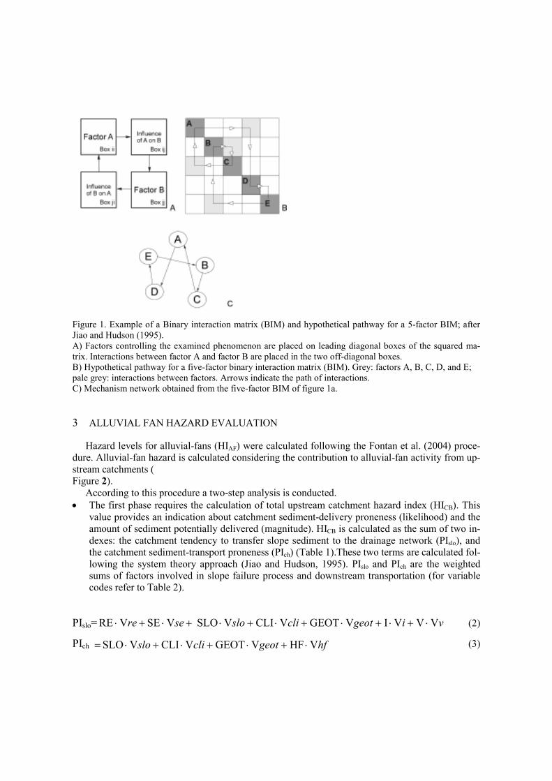
Figure 1. Example of a Binary interaction matrix (BIM) and hypothetical pathway for a 5-factor BIM; after
Jiao and Hudson (1995).
A) Factors controlling the examined phenomenon are placed on leading diagonal boxes of the squared ma-
trix. Interactions between factor A and factor B are placed in the two off-diagonal boxes.
B) Hypothetical pathway for a five-factor binary interaction matrix (BIM). Grey: factors A, B, C, D, and E;
pale grey: interactions between factors. Arrows indicate the path of interactions.
C) Mechanism network obtained from the five-factor BIM of figure 1a.
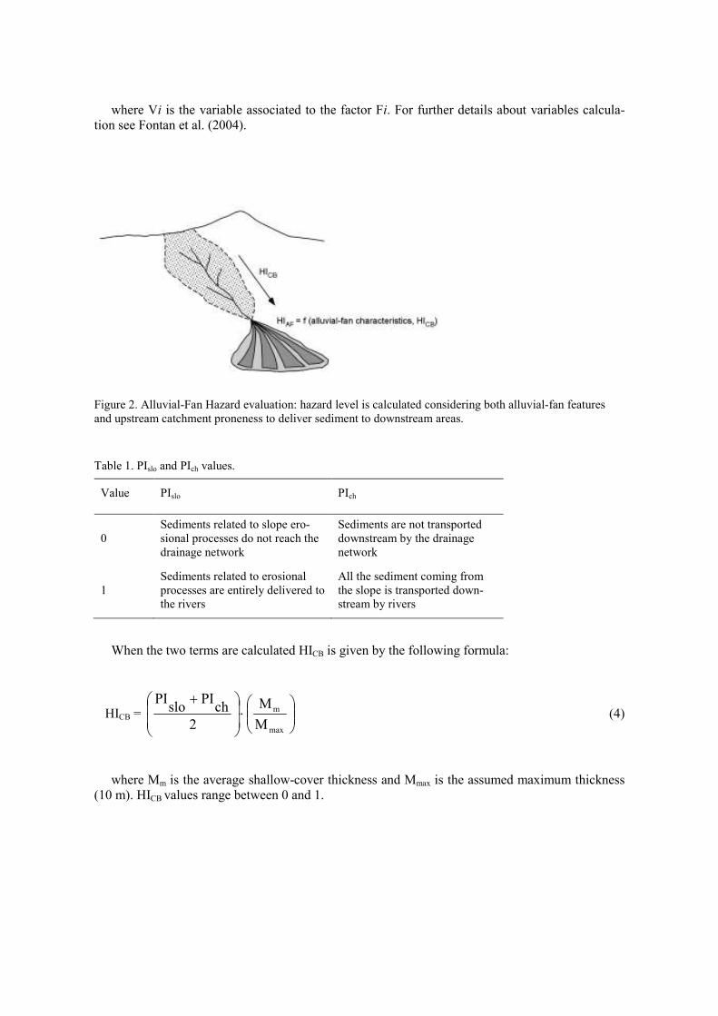
3 ALLUVIAL FAN HAZARD EVALUATION
Hazard levels for alluvial-fans (HIAF) were calculated following the Fontan et al. (2004) proce-
dure. Alluvial-fan hazard is calculated considering the contribution to alluvial-fan activity from up-
stream catchments (
Figure 2).
According to this procedure a two-step analysis is conducted.
• The first phase requires the calculation of total upstream catchment hazard index (HICB). This
value provides an indication about catchment sediment-delivery proneness (likelihood) and the
amount of sediment potentially delivered (magnitude). HICB is calculated as the sum of two in-
dexes: the catchment tendency to transfer slope sediment to the drainage network (PIslo), and
the catchment sediment-transport proneness (PIch) (Table 1).These two terms are calculated fol-
lowing the system theory approach (Jiao and Hudson, 1995). PIslo and PIch are the weighted
sums of factors involved in slope failure process and downstream transportation (for variable
codes refer to Table 2).
PIslo= V V V I V GEOT V CLI V SLO V SE V RE vigeotclislosere ⋅+⋅+⋅+⋅+⋅+⋅+⋅ (2)
PIch hfgeotclislo V HF V GEOT V CLI V SLO ⋅+⋅+⋅+⋅= (3)
where Vi is the variable associated to the factor Fi. For further details about variables calcula-
tion see Fontan et al. (2004).
Figure 2. Alluvial-Fan Hazard evaluation: hazard level is calculated considering both alluvial-fan features
and upstream catchment proneness to deliver sediment to downstream areas.
Table 1. PIslo and PIch values.
Value PIslo PIch
0
Sediments related to slope ero-
sional processes do not reach the
drainage network
Sediments are not transported
downstream by the drainage
network
1
Sediments related to erosional
processes are entirely delivered to
the rivers
All the sediment coming from
the slope is transported down-
stream by rivers
When the two terms are calculated HICB is given by the following formula:
HICB =
⋅
+
max
m
M
M
2
chPI
sloPI
(4)
where Mm is the average shallow-cover thickness and Mmax is the assumed maximum thickness
(10 m). HICB values range between 0 and 1.
Table 2 – Factors involved in HICB calculation
Factor Code Description Data source
Quaternary deposits
SE
GEOT
I
Erodibility for slope deposits
Geotechnical proprieties
Infiltration proneness
Geological map
Slope SLO Tan (slope angle°) Digital Terrain Model
Outcrops RE Bedrock erodibility Geological map
Land cover V Vegetal cover values f(type and
density) Land cover map
Landslides (landslides re-
ported for the study area) I
Contribution to infiltration due to
landslide presence Geomorphological map
Human-made mitigation
structures HF
Contribution to slope stability due
to slope engineering Field observation
Climate CLI Rainfall Contribution to slopes in-
stability
Piedmont Region Mete-
orological Database
• The second phase is related only to the alluvial-fan system areas. Hazard index calculation in-
volves the sum of factors related to alluvial-fan features, represented in the form of vector data.
These features are gathered by means of historical geomorphological and geological analyses
focused on the alluvial-fan. For each vector layer, geographic objects are given a value based
on the feature represented and the situation observed on the field or obtained from biblio-
graphic information. Data used in this phase are related to:
o HICB, expressed as an homogeneous value for the entire alluvial fan;
o Alluvial-fan Channels classified based on activity state (based on field observa-
tion and data from hydraulic studies);
o Depressions or hummocks;
o Historical analysis, which allows the identification of areas already affected by
debris-flows in the past;
o Presence of debris related to former alluvial-fan activity;
o Vegetal cover;
o Average slope. Slope classes are 0°-4° (areas, whose inclination does not allow
flow propagation), 4°-11° (areas whose inclination allows sediment transporta-
tion), >11° (areas potentially subject to erosion) (Takahashi, 1981);
o Sediment grain-size;
o Stream-flow conditions. A distinction between floodable and non-floodable ar-
eas;
o Alluvial-fan activity. Active and inactive alluvial-fan sectors.
Based on field observations, these attributes are given values between 0 and 1 (0 not critical
condition, 1 critical condition). Each one of the ten factors is represented as a thematic layer.
Using the combination-maps technique, HIAF is calculated as the sum of the factor values di-
vided by 10 (number of factors).
4 SHALLOW LANDSLIDE HAZARD ASSESSMENT
Shallow landslides hazard was assessed according to the methodology proposed by (Fontan et al.,
in prep.). Shallow Landslides Hazard Assessment (SLHA) calculates landslides susceptibility-
levels for specific areas based on the combination of weighted thematic maps (factors involved in
the SLHA model). According to this method, shallow landslides hazard index (SLHI) is calculated
as follows:
x a x a x a x a x aSLHI nn44332211 ⋅+…+⋅+⋅+⋅+⋅= 5
where xi are the values of parameters influencing landslide occurrence, and ai are weights meas-
uring the relevance of each parameter. Weights are determined according to the system theory (Jiao
and Hudson, 1995).
Factors considered by SLHA model are given in Table 3. Variables assume values between 0
and 1 according to the classification system of Fontan et al., (in prep.).
5 HAZARD ASSESSMENT
Debris-flows hazard assessment involves the identification of the potential sediment source areas
(sectors characterised by high shallow landslide susceptibility) and the analysis of the mechanisms
favouring down-slope sediment transport. The first goal is achieved by the application of SHLA,
whereas the second objective is achieved by means of AFHE.
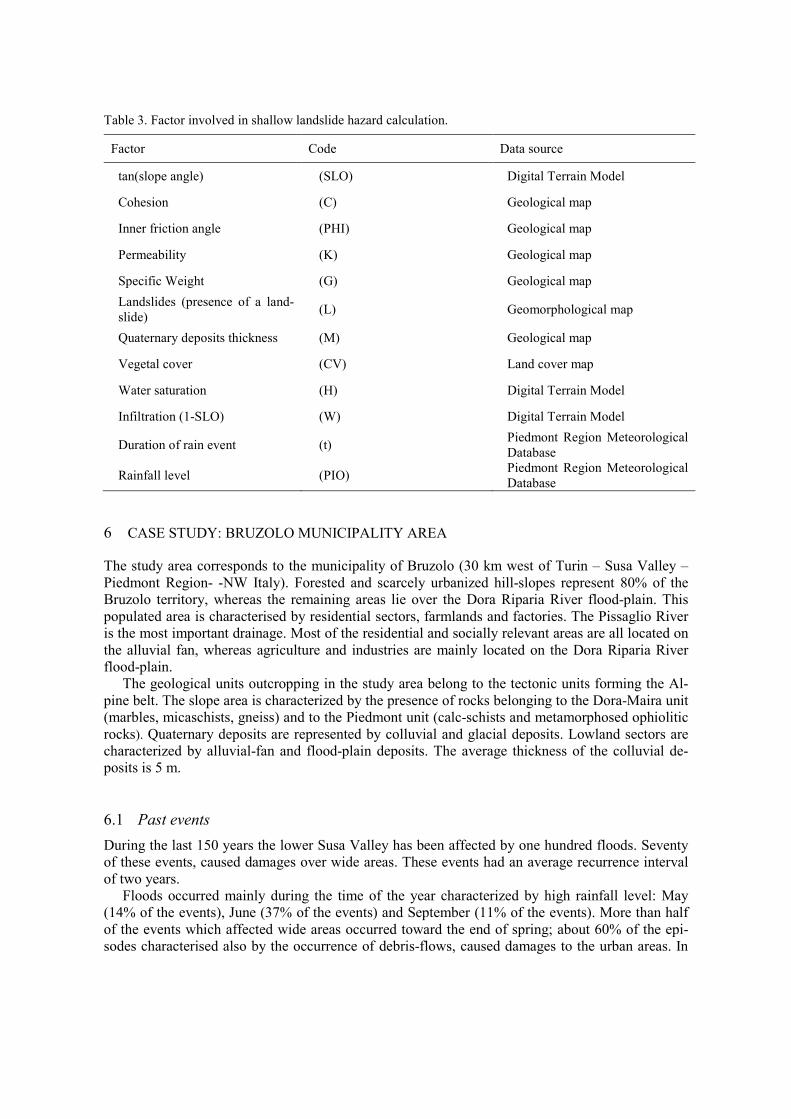
Table 3. Factor involved in shallow landslide hazard calculation.
Factor Code Data source
tan(slope angle) (SLO) Digital Terrain Model
Cohesion (C) Geological map
Inner friction angle (PHI) Geological map
Permeability (K) Geological map
Specific Weight (G) Geological map
Landslides (presence of a land-
slide) (L) Geomorphological map
Quaternary deposits thickness (M) Geological map
Vegetal cover (CV) Land cover map
Water saturation (H) Digital Terrain Model
Infiltration (1-SLO) (W) Digital Terrain Model
Duration of rain event (t) Piedmont Region Meteorological
Database
Rainfall level (PIO) Piedmont Region Meteorological
Database
6 CASE STUDY: BRUZOLO MUNICIPALITY AREA
The study area corresponds to the municipality of Bruzolo (30 km west of Turin – Susa Valley –
Piedmont Region- -NW Italy). Forested and scarcely urbanized hill-slopes represent 80% of the
Bruzolo territory, whereas the remaining areas lie over the Dora Riparia River flood-plain. This
populated area is characterised by residential sectors, farmlands and factories. The Pissaglio River
is the most important drainage. Most of the residential and socially relevant areas are all located on
the alluvial fan, whereas agriculture and industries are mainly located on the Dora Riparia River
flood-plain.
The geological units outcropping in the study area belong to the tectonic units forming the Al-
pine belt. The slope area is characterized by the presence of rocks belonging to the Dora-Maira unit
(marbles, micaschists, gneiss) and to the Piedmont unit (calc-schists and metamorphosed ophiolitic
rocks). Quaternary deposits are represented by colluvial and glacial deposits. Lowland sectors are
characterized by alluvial-fan and flood-plain deposits. The average thickness of the colluvial de-
posits is 5 m.
6.1 Past events
During the last 150 years the lower Susa Valley has been affected by one hundred floods. Seventy
of these events, caused damages over wide areas. These events had an average recurrence interval
of two years.
Floods occurred mainly during the time of the year characterized by high rainfall level: May
(14% of the events), June (37% of the events) and September (11% of the events). More than half
of the events which affected wide areas occurred toward the end of spring; about 60% of the epi-
sodes characterised also by the occurrence of debris-flows, caused damages to the urban areas. In
eight cases, floods and/or debris-flows caused a total of forty victims among the population. Ac-
cording to local public archives, the most severe events occurred in October 1685, May 1728, July
1885, June 1891 and 1957, May 1977 and October 2000 (tab. 4).
During the last three hundred years, twenty floods have been recorded for the Pissaglio river, af-
fecting urban areas in six cases. In October 1846, 12 people died and several buildings were dam-
aged. In June 1875, one person died, due to a house collapsing. In 1957, the area in the vicinity of
the cemetery was flooded. Since the 19th century, the inhabitants of Bruzolo have built river engi-
neering structures in the upper and middle section of the alluvial fan, to prevent damages and vic-
tims in case of floods. The first structure to be realized was the embankment named “la Mura”,
which was built on the left riverbank of the Pissaglio river (fig. ). The most recent structures (river-
bank reinforcements and check dams along the Pissaglio river) were built in 1957 and 2000.
Table 4 Events (folds, debris-flows) recorded for Bruzolo municipality .
Year Damages
1710 NA
1728 NA
1798 Campobellino and Gerbido regions damaged.
Cotti R. Toassone region damaged
1811 NA
1842 NA
1846
Barboj houses destroyed
12 people died
River bank damaged
1860 NA
1875 NA
1900 NA
1900 NA
1900 River engineering structures damaged
1919 River engineering structures damaged
1927 NA
1937 NA
1945 NA
1947 NA
1947 NA
1955 NA
1957 Embankment built in 1845 destroyed
1964 NA
1968 NA
1972 Damages to the local roads
2000 -
Figure 3. Maps showing the areas affected by June 1957 and October 2000 floods. River engineering struc-
tures built after these events are also displayed.
6.2 SLHA application
The data related to the factors involved in shallow landslide assessment were acquired from the
Piedmont Region Meteorological Database, the Digital Terrain Model, the geological and the land-
cover map for Bruzolo’s municipality (Table 3).
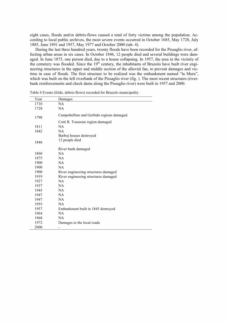
According to the results shown in
Figure 4, 65% of the slope area is characterised by very high hazard level. Sectors presenting
the highest shallow-landslides hazard level are located in the upper part of the study area, with
grassland vegetation and/or slopes angle >25°. Another critical area is located just up-slope the al-
luvial-fan apex. For this sector the Pissaglio riverbanks display high shallow-landslide hazard lev-
els. In case of heavy rain, these parts of the catchment could provide a high amount of sediment,
which could easily reach the Pissaglio alluvial-fan.
6.3 AFHE calculation
AFHE calculation was performed considering the data related to the Pissaglio River catchment. In-
dexes values calculated for the first phase of the analysis (see par. 3) are shown in Table 4.
Table 4. HICB, PIslo and PIcha calculated for the Pissaglio River catchment. Index Value
HICB 0.36
PIslo 0.56
PIcha 0.89
HICB was calculated considering a shallow-cover average thickness of 5 m. Calculation was per-
formed considering the worst meteorological conditions: the highest precipitation level recorded
for the study area and rainfall event lasting 24 hours.
Only half (56%) of the total amount of shallow-landslide sediment reaches the drainage network
(PIslo). Rivers deliver down-valley about 89% (PIcha) of the total amount of sediments which is
transferred from the slopes. The total amount of sediments transferred to the alluvial-fan by the
coupled slope-river system is about 36% (HICB) of the total volume of shallow-landslides which
occurred on the hill-slope areas.
The HICB value was used during the second phase of the analysis: the alluvial-fan hazard as-
sessment (Fig. 5).
High hazard levels are recorded for those sectors near the Pissaglio River characterised by the
presence of abandoned channels. These areas are also characterised by the presence of debris-flow
lobes. Bruzolo’s urban expansion is restricted to those sectors characterised by low hazard level.
7 CONCLUSIONS
The combined application of Shallow Landslides Hazard Assessment and Alluvial Fan Hazard
Evaluation represents a useful tool for local communities. Shallow-landslide hazard assessment al-
lows the systematic identification of sectors characterised by high shallow-landslide occurrence
proneness. These sectors can be considered as the major source of sediment which can be delivered
to the streams of the Pissaglio river catchment, which covers 55% of the study area. Main control-
ling factors for landslide triggering appear to be slope angle and vegetation cover. High shallow-
landslide hazard levels are recorded for areas where the slope angle is >25° and vegetation cover is
mainly grassland. When assessing the hazard related to the occurrence of debris-flow, which in turn
could affect the Bruzolo urban area, the efficiency of the coupled slope-river system in transferring
sediment from the hill-slope sectors to the alluvial fan was estimated by means of alluvial fan haz-
ard evaluation. According to the analysis, only 36% of the total sediment volume involved in shal-
low-landslide is transferred downstream.
Geological, geomorphological and historical analysis allowed the alluvial-fan hazard zoning. In-
formation acquired for this part of the study includes data related to past alluvial-fan activity and
results from hydraulic studies. This interpretation provides useful information about the future po-
tential evolution of the alluvial-fan system.
The methods proposed permit a first-order assessment of the potential sediment source-areas for
debris-flows. Shallow-landside hazard assessment gives an indication for local authorities and risk
managers about the areas where land management policies should focus in order to reduce shallow-
landslides occurrence. Studies aimed at exactly evaluating the potential amount of sediment in-
volved in landslides would provide information about the magnitude of debris-flows which could
represent a threat for the inhabited areas on the alluvial fan. This information is in turn a key ele-
ment when planning mitigation structures and urban expansion policies.
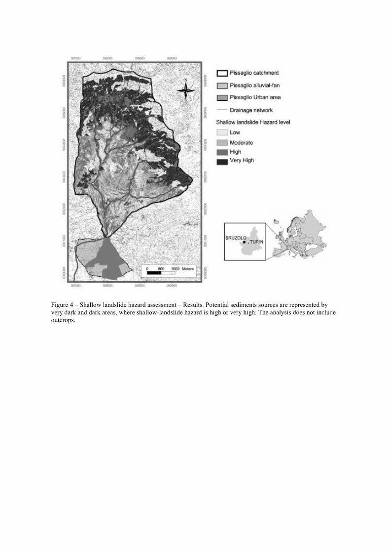
Figure 4 – Shallow landslide hazard assessment – Results. Potential sediments sources are represented by
very dark and dark areas, where shallow-landslide hazard is high or very high. The analysis does not include
outcrops.
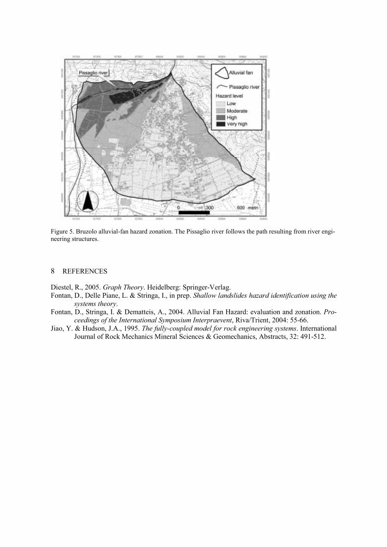
Figure 5. Bruzolo alluvial-fan hazard zonation. The Pissaglio river follows the path resulting from river engi-
neering structures.
8 REFERENCES
Diestel, R., 2005. Graph Theory. Heidelberg: Springer-Verlag.
Fontan, D., Delle Piane, L. & Stringa, I., in prep. Shallow landslides hazard identification using the
systems theory.
Fontan, D., Stringa, I. & Dematteis, A., 2004. Alluvial Fan Hazard: evaluation and zonation. Pro-
ceedings of the International Symposium Interpraevent, Riva/Trient, 2004: 55-66.
Jiao, Y. & Hudson, J.A., 1995. The fully-coupled model for rock engineering systems. International
Journal of Rock Mechanics Mineral Sciences & Geomechanics, Abstracts, 32: 491-512.
Related Documents