209 FEATURE © Blackwell Publishing Ltd, The Geologists’ Association & The Geological Society of London, Geology Today, Vol. 26, No. 6, November–December 2010 Feature Debris flow burial of ancient wall system in the Upper Po River valley William C. Mahaney 1 , Pierre Tricart 2 , Rene W. Barendregt 3 , Christopher Carcaillet 4 , Davide Rabufetti 5 & Volli Kalm 6 1 Quaternary Surveys, 26 Thornhill Ave, Thornhill, Ontario, Canada, L4J 1J4 (arkose@rogers. com; b.kapran@hotmail. com), 2 Laboratoire de Géodynamique des Chaînes alpines, University of Grenoble, Observatoire des Sciences de l’Univers, 38041 Grenoble, France; (Pierre. [email protected]), 3 Department of Geography, University of Lethbridge, Alberta, Canada, T1K 3M4; (Barendregt@uleth. ca), 4 Centre de Bio- Archéologie et d’Ecologie (UMR5059 CNRS/EPHE), Institut de Botanique, Université Montpellier 2, 163 Rue Broussonet, 34090 Montpellier, France; (Christopher.Carcaillet@ univ-montp2.fr), 5 ARPA Piemonte Area delle attività regionali per la previsione e il monitoraggio ambientale Via Pio VII, 9-10135 Torino, (d.rabufetti@arpa. piemonte.it), 6 Institute of Ecology and Earth Sciences, Tartu University, Tartu, Estonia, 51014. (Volli. [email protected]) The regrouping area, where Hannibal is thought to have reformed his army after forging a path through a massive rockfall in the Cottian Alps, has been reshaped by a blanket of sediment deposited from debris flows following heavy rain in spring, 2008. Analysis of precipitation data for the period mid- May to mid-June, 2008, shows that 722 mm of rain fell at 2150 m, falling off to half that amount at 3325 m on the flanks of Mon Viso. Following exhaustive analysis of environmental factors connected with the invasion of Italy at the start of the Second Punic War (218 BC), identification of the regrouping area for the Carthaginian Army centred on the presence of an ancient stone wall system which possibly dates from Hannibalic times. Lichen cover, lichen diameters, weathering characteristics, degree to which boulders had sunk into the resident soil, and presence of ancient hearths all combined to make this area a choice locale for reconstructive geoarchaeology. Large scale mass wasting off a prominent bedrock bar adjacent to the wall system in the Upper Po River Valley resulted in burial of most of the prominent wall structures which will complicate any exploration geoarchaeology attempts in future. A nested series of rock wall systems on the floodplain of the Upper Po River below the Col de la Traversette in the Cottian Alps of Italy were buried by debris flows emplaced during heavy spring runoff in 2008. Be- cause these interconnected wall systems are thought to date from Hannibal’s passage through the Alps, and may contain artefacts important in elucidating the military culture of ancient Carthage, burial may make it difficult to locate the sites for future geoar- chaeological excavation. The purpose of this article is to draw attention to the site, providing supporting geomorphological evidence as to its composition and age. The key environmental variables elucidated by researchers (whose work is indicated in the ‘Sug- gestions for Further Reading’, below), to identify the invasion route of the Punic Army, centre on: 1, pres- ence of a major defile in which the Gauls attacked; 2, presence of firnpack adjacent to the high col; 3, long view into Italy from the crest; 4, steep ledges and cliffs on the lee side of the Alps; 5, presence of a two-tier ‘landslide’ (rockfall) blocking the army on the lee side; and 6, a regrouping area sufficient to provide forage and water for the army. Many researchers have described various areas they consider suitable as the ‘regrouping or restaging area’, but with the exception of the Upper Po, all oth- er sites are below cols which lack: firnpack; sufficient view into Italy; and suitable blocking rockfall deposit. Only the regrouping area we described in 1988, with its ancient sunken wall system, closely fits the de- scription provided by Polybius (III, 55) who followed the path of the Punic Army some seventy years later. Because analysis of the walls and adjacent hearth sites might yield artefact information, important in elucidating information on the military culture of an- cient Carthage, it is important to document the effect of their burial by debris flow activity that occurred in late spring 2008. Shallow excavation that might have been possible following a metal detector survey

Welcome message from author
This document is posted to help you gain knowledge. Please leave a comment to let me know what you think about it! Share it to your friends and learn new things together.
Transcript
209
FEATURE
© Blackwell Publishing Ltd, The Geologists’ Association & The Geological Society of London, Geology Today, Vol. 26, No. 6, November–December 2010
FeatureDebris flow burial of ancient wall system in the Upper Po River valley
William C. Mahaney1, Pierre Tricart2, Rene W. Barendregt3, Christopher Carcaillet4, Davide Rabufetti5 & Volli Kalm6
1Quaternary Surveys, 26
Thornhill Ave, Thornhill,
Ontario, Canada, L4J
1J4 (arkose@rogers.
com; b.kapran@hotmail.
com), 2Laboratoire
de Géodynamique
des Chaînes alpines,
University of Grenoble,
Observatoire des Sciences
de l’Univers, 38041
Grenoble, France; (Pierre.
[email protected]), 3Department of Geography,
University of Lethbridge,
Alberta, Canada, T1K
3M4; (Barendregt@uleth.
ca), 4Centre de Bio-
Archéologie et d’Ecologie
(UMR5059 CNRS/EPHE),
Institut de Botanique,
Université Montpellier
2, 163 Rue Broussonet,
34090 Montpellier, France;
(Christopher.Carcaillet@
univ-montp2.fr), 5ARPA
Piemonte Area delle attività
regionali per la previsione e
il monitoraggio ambientale
Via Pio VII, 9-10135
Torino, (d.rabufetti@arpa.
piemonte.it), 6Institute of
Ecology and Earth Sciences,
Tartu University, Tartu,
Estonia, 51014. (Volli.
The regrouping area, where Hannibal is thought to have reformed his army after forging a path through a massive rockfall in the Cottian Alps, has been reshaped by a blanket of sediment deposited from debris flows following heavy rain in spring, 2008. Analysis of precipitation data for the period mid-May to mid-June, 2008, shows that 722 mm of rain fell at 2150 m, falling off to half that amount at 3325 m on the flanks of Mon Viso. Following exhaustive analysis of environmental factors connected with the invasion of Italy at the start of the Second Punic War (218 bc), identification of the regrouping area for the Carthaginian Army centred on the presence of an ancient stone wall system which possibly dates from Hannibalic times. Lichen cover, lichen diameters, weathering characteristics, degree to which boulders had sunk into the resident soil, and presence of ancient hearths all combined to make this area a choice locale for reconstructive geoarchaeology. Large scale mass wasting off a prominent bedrock bar adjacent to the wall system in the Upper Po River Valley resulted in burial of most of the prominent wall structures which will complicate any exploration geoarchaeology attempts in future.
A nested series of rock wall systems on the floodplain of the Upper Po River below the Col de la Traversette in the Cottian Alps of Italy were buried by debris flows emplaced during heavy spring runoff in 2008. Be-cause these interconnected wall systems are thought to date from Hannibal’s passage through the Alps, and may contain artefacts important in elucidating the military culture of ancient Carthage, burial may make it difficult to locate the sites for future geoar-chaeological excavation. The purpose of this article is to draw attention to the site, providing supporting geomorphological evidence as to its composition and age.
The key environmental variables elucidated by researchers (whose work is indicated in the ‘Sug-gestions for Further Reading’, below), to identify the invasion route of the Punic Army, centre on: 1, pres-ence of a major defile in which the Gauls attacked; 2, presence of firnpack adjacent to the high col; 3, long view into Italy from the crest; 4, steep ledges and cliffs
on the lee side of the Alps; 5, presence of a two-tier ‘landslide’ (rockfall) blocking the army on the lee side; and 6, a regrouping area sufficient to provide forage and water for the army.
Many researchers have described various areas they consider suitable as the ‘regrouping or restaging area’, but with the exception of the Upper Po, all oth-er sites are below cols which lack: firnpack; sufficient view into Italy; and suitable blocking rockfall deposit. Only the regrouping area we described in 1988, with its ancient sunken wall system, closely fits the de-scription provided by Polybius (III, 55) who followed the path of the Punic Army some seventy years later. Because analysis of the walls and adjacent hearth sites might yield artefact information, important in elucidating information on the military culture of an-cient Carthage, it is important to document the effect of their burial by debris flow activity that occurred in late spring 2008. Shallow excavation that might have been possible following a metal detector survey

210
FEATURE
© Blackwell Publishing Ltd, The Geologists’ Association & The Geological Society of London, Geology Today, Vol. 26, No. 6, November–December 2010
will most likely now become more difficult to carry out and may well require ground penetrating radar (GPR) to accomplish any recovery of materials.
Regional setting
The area where Hannibal crossed the Alps into the NW frontier of Italia is directly north of Mon Viso (3843 m a.s.l.), the highest mountain in the Cottian Alps. Mon Viso belongs to the internal zone of the Western Alpine arc, which displays a thick pile of metamorphic nappes derived from an earlier rifted structure of Early to Middle Jurassic age, and from its oceanic Late Jurassic to Cretaceous successor. The nappes, with their recumbent folds and flat lying fo-liations, suffered first, deep subduction in high pres-sure-low temperature metamorphic conditions (eclog-ite facies), before building an accretionary wedge in less severe (blueschist facies) conditions. The latter occurred while the ocean was closed and its west-ern stretched margin shortened in Late Cretaceous to Early Cenozoic times. During subsequent collision, several shortening phases resulted in post-nappe folds and thrusts, the latest directed toward the core of the arc (the so-called backfolds and backthrusts), which underline the curved geometry of the inner mountain belt. From the Late Cenozoic onwards, this complex polystage structure corresponds to the most thickened part of the Alpine crust, which underwent gravita-
tional collapse. The collapse resulted in extensional and transtensional faulting, parallel and transverse to the mountain belt, i.e. roughly tangential and radial to the arc. The late Alpine fault net, which remains partly active today, is directly responsible for the loca-tion of the main valleys such as the Upper Po River. It explains why relief appears more confused in the internal arc than in the external arc beyond and to the west of the Durance River.
The lithologies present in the Upper Po Valley range from metabasalt in the Col de la Traversette it-self grading into calcareous mica schist (the ‘Schistes lustrés’ and ‘calcescisti’ of French and Italian Alpine geologists) in the upper valley. Contact with outcrops of gabbro and basalt at the ~2000 m contour is ac-companied by positive relief in the form of prominent bedrock bars that resist weathering and glacigenic
Fig. 1. a. Regional geological map of the Upper Po Catchment and adjacent area. The anomalous weather pattern documented from the Upper Po River Basin was felt across the entire Western Alps. Two areas where sites are documented in the text are indicated with arrows (from Mahaney, 2010); b. Air imagery of the Po River valley at the 2000 m contour. The arrow shows the location of the stone wall system.
Fig. 2. Foraging area in the Upper Po area where Hannibal may have regrouped after forging a path through the blocking rockfall (From Mahaney, 2010).

211
FEATURE
© Blackwell Publishing Ltd, The Geologists’ Association & The Geological Society of London, Geology Today, Vol. 26, No. 6, November–December 2010
processes better than the mica schist outcrops to the west. To the east exposures of serpentinite (derived from mantle peridotites) provide rock which is more prone to weathering and release, and includes the areas of mass wasted debris discussed below.
Examining the site
Methods Shallow excavation of fluvisols that dominate on the valley floor were carried out to determine soil depth and common soil profile characteristics. Shear strengths were determined with a common SOILTEST penetrometer. Lithologies were determined by field observation and comparison with the regional geological map. No excavations were attempted as we did not have a licensed archaeologist in the field team. Attempts to observe charcoal flakes in the fluvisols that might support Livy’s contention that the rockfall mass was fired to break up or comminute boulders were unsuccessful. No bogs are present from which core material might be recovered. Radiocarbon dating might be employed if suitable amounts of organic material can be recovered from underneath the boulder mass making up the wall system.
Meteorological data, provided by ARPA-Piemonte in Italy, consist of daily precipitation and temperature measurements from stations at 638 to 3325 m a.s.l., the highest station on the flanks of Mt Viso in the Cottian Alps.
Sites prior to burial The area stretching from below the albergo at 2020 m a.s.l. is a composite of gentle glacial bedrock steps that extend down-valley to the alpine road patrol gate at ~1900 m a.s.l., approximately 6 km from the town of Crisollo at 1700 m elevation. The present timberline is located at 1800 m but recent pollen investigations indicate the tree limit may have reached to the elevation of the rockfall at 2600 m, the deposit that blocked Hannibal’s Army, approximately 2200 yr bp.
The regrouping area is today a lush carpet of grasses and sedges with sufficient water fed from three main drainages to the south, west and north and with many small rivulets (Fig. 2) active in the autumn when Hannibal is reputed to have crossed over into Italy. There are many large boulders in the valley bottom that might have provided a break from the wind and hollows where tents may have been erected to shelter troops from the elements. If a forest was present all the way to the rockfall as suggested by pollen analysis there would have been a wood supply for fires to maintain a level of warmth and for cooking. With regard to the three-day stay by some 60 000 troops, horses, mules and elephants while the path through the rockfall was being constructed it is probable that many personal items might have been discarded or lost and certainly stone walls may either have existed prior to the Hannibalic incursion or constructed on the spot by soldiers as bivouacs to attend to the wounded or as cooking areas to feed
Fig. 3. Stonewall system below the debris flow.
Fig. 4. Stonewall system now covered with debris flow sediment.
212
FEATURE
© Blackwell Publishing Ltd, The Geologists’ Association & The Geological Society of London, Geology Today, Vol. 26, No. 6, November–December 2010
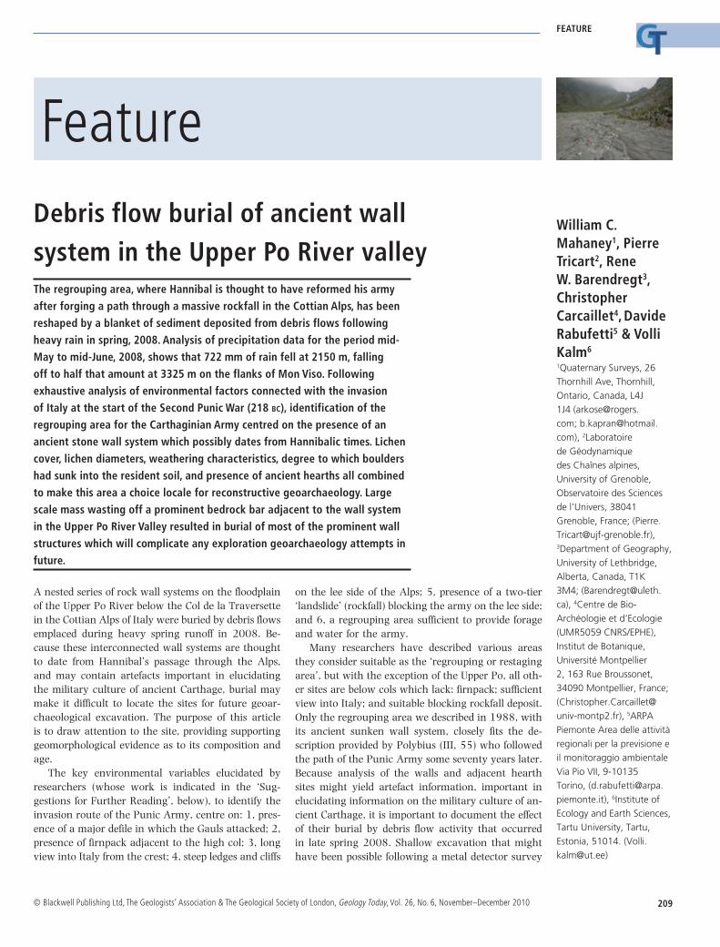
the troops.The wall system (Figs 3, 4), first investigated in
2004, consists of boulders with a mean size of 0.5 m built up in a network that may have been used to compartmentalize people or animals and with a sunk-en base deep into the underlying soil. With a present height above the land surface of 0.2 to 0.5 m it is pos-sible the walls were used primarily as a windbreak to maintain cooking fires with a canopy of canvas sup-ported by timber. Sunken areas in between the walls suggest possible hearths but none were excavated for fear of disturbing what might be potentially impor-tant geo-archaeological sites. Location of the highest density of sunken walls within 100 to 150 m of the trail leading up the bedrock wall to the west may well indicate that disabled or wounded soldiers were tended to, at this higher end of the regrouping area.
Large boulders shown in Figs 3 and 4 carry at least 50 per cent lichen cover and look at, or near, lichen growth longevity. Burial of these surfaces in snow during the winter probably reduces lichen de-struction by ice crystal blasting which would occur on exposed surfaces. Strong advecting winds reach-ing above 50 m/s in winter probably restrict crus-tose lichen growth on exposed outcrops limiting the use of lichen parameters as an age estimation index. The location of the stone walls above the floodplain of the Upper Po River does not favour irrigation, so lichen growth is dependent strictly on the substrate mineralogy which is favourable for growth of most species, including those in normal alpine climate and time. Fertilization by marmots is a possibility,
in places impossible to identify with certainty, but the boulders are not positioned high enough and in prominent places to favour bird fertilization known to occur in the general area. Lichen longevity for this middle latitude locality strongly affected by nearby marine moisture sources in the Mediterranean and Adriatic, is estimated at ~2000 years. This value is partly arrived at by previously studied lichen growth near Mt. Blanc.
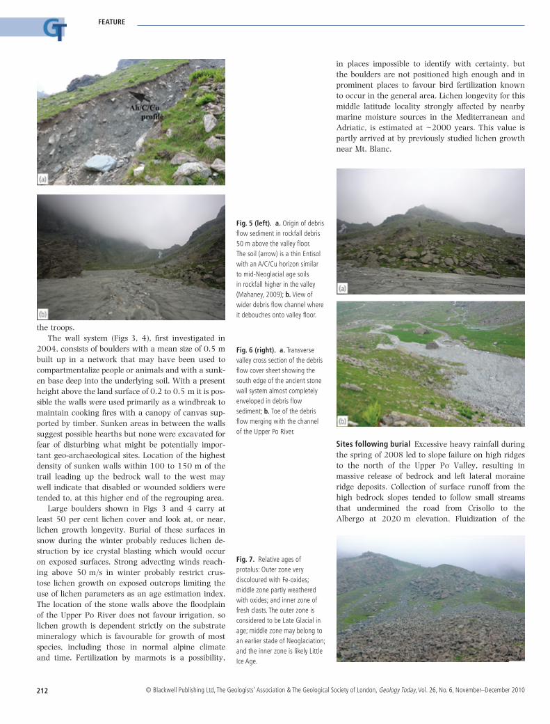
Fig. 5 (left). a. Origin of debris flow sediment in rockfall debris 50 m above the valley floor. The soil (arrow) is a thin Entisol with an A/C/Cu horizon similar to mid-Neoglacial age soils in rockfall higher in the valley (Mahaney, 2009); b. View of wider debris flow channel where it debouches onto valley floor.
Fig. 6 (right). a. Transverse valley cross section of the debris flow cover sheet showing the south edge of the ancient stone wall system almost completely enveloped in debris flow sediment; b. Toe of the debris flow merging with the channel of the Upper Po River.
Sites following burial Excessive heavy rainfall during the spring of 2008 led to slope failure on high ridges to the north of the Upper Po Valley, resulting in massive release of bedrock and left lateral moraine ridge deposits. Collection of surface runoff from the high bedrock slopes tended to follow small streams that undermined the road from Crisollo to the Albergo at 2020 m elevation. Fluidization of the
Fig. 7. Relative ages of protalus: Outer zone very discoloured with Fe-oxides; middle zone partly weathered with oxides; and inner zone of fresh clasts. The outer zone is considered to be Late Glacial in age; middle zone may belong to an earlier stade of Neoglaciation; and the inner zone is likely Little Ice Age.

213
FEATURE
© Blackwell Publishing Ltd, The Geologists’ Association & The Geological Society of London, Geology Today, Vol. 26, No. 6, November–December 2010
moraine sediment led to the production of a mass of low viscosity debris flow material that blanketed the valley floor (Fig. 5A, B) and covered much of the stone wall network. Normally, debris flow deposits have a somewhat greater ratio of clast to water, and hence higher viscosity, giving rise to lower flow rates and development of levees on either side of the flows. The distal ends of these debris flow show sheetflow characteristics with no evidence of levees, suggesting that the flows became fluid as debris torrents debouching onto the valley floor as sheetfloods/shallow alluvial aprons. However, adjacent to the debris flow activity, rockfall off the serpentinite outcrops can be clearly demarcated from the older talus and protalus deposits (Fig. 7) that, judging by their lichen cover, have considerable antiquity, perhaps correlative with the time of passage of the Punic Army.
Meteorological considerations During the period of 27–31 May 2008, intense precipitation registered in the western Alps, Piemonte Region of Italy (Table 1, Fig. 8), triggering a large number of shallow landslides and debris flows on the mountain catchment, as well as floods in the down-valley streams feeding the Po River catchment. This event came after two rainy months, culminating in April 2008, with rainfall amounting to 30 per cent above the mean value (period 1960–1990) on record; and after a week of antecedent heavy rain (Table 2). This event produced soil moisture saturation in a short time, enhancing runoff, slope failure and gully initiation from the storm. As shown above, unstable rockfall deposits with low vegetation cover were prime targets where debris flows were easily generated.
Finally, a statistical characterization of the storm is carried out on the base of the maximum cumula-tive rainfall over different durations. The values are reported in Table 3. The comparison with the clima-tological values expressed in terms of IDF (Intensity-Duration-Curves) curves is shown in Fig. 10.
The comparison in Fig. 10 highlights the most critical duration over 12 and 24 hours whose return period is: greater than 50 years for Colle Barant and Pian Giasset gauges; about 15 years for Crissolo and about five years at Paesana. Furthermore the strong orographic effect appears very clearly with a consid-erable increase of precipitation linked to elevation. Finally it is useful to take into account the snow level to assess if the rainfall rate increase with elevation is counter balanced by the presence of snow (wa-ter equivalent). From Fig. 11, the assessment is that above 3000 m a.s.l., the presence of snow accumula-tion between 2150 and 3325 m may have played a significant role in flooding at high elevations as the ambient air temperature was between 0 and 5°C.
Table 2. Rainfall totals (mm) in the antecedent period in the Upper Po Basin culminating in the last week of May.
Weeks (day–month) ——————————————————————————— 31–3 7–4 14–4 21–4 28–4 5–5 12–5 19–5 6–4 13–4 20–4 27–4 4–5 11–5 18–5 25–5 Total
1.5 32.7 81.1 17.1 6.3 11.0 31.9 76.5 258.0
Table 1. Daily rainfall (mm)
Station–Municipality 27–05 28–05 29–05 30–05 Total
Colle Barant–Bobbio Pellice 52.8 20.4 312.2 40.4 425.8Pian Giasset–Crissolo 36.8 17.6 185.2 33.2 272.8Crissolo–Crissolo 39.4 12.0 145.2 33.8 230.6Paesana–Paesana 10.4 5.0 118.0 27.2 160.6
Table 3. Maximum rainfall (mm) accumulated for different durations
Station–Municipality 1 h 3 h 6 h 12 h 24 h
Colle Barant–Bobbio Pellice 36.8 75.4 127.6 222.8 325.0Pian Giasset–Crissolo 31.4 51.0 78.0 136.2 200.4Crissolo–Crissolo 20.8 40.8 53.8 94.4 159.0Paesana–Paesana 28.4 41.0 68.0 88.2 127.4Paesana–Paesana 10.4 5.0 118.0 27.2 160.6
Fig. 8. Map showing rainfall distributions (isohyets) in the Upper Po River Basin, Italy.
Conclusions
The possible recovery of artefact evidence related to the passage of the Punic Army awaits exploratory geoarchaeology by qualified personnel with a license to dig the site. The covering of mass wasted debris reaching to 0.5–0.7 m depth will make recovery all the more difficult and require something more in-

214
FEATURE
© Blackwell Publishing Ltd, The Geologists’ Association & The Geological Society of London, Geology Today, Vol. 26, No. 6, November–December 2010
Fig. 9. Hourly hydrographs. The heaviest precipitation received at the 2000 m contour (Pian Giasset) and above on the slope of Mon Viso where mass wasting was the most severe.
Fig. 10. Maximum rainfall in the event compared with the IDF curves.
volved than a metal detector survey. With the thick-ness of overburden it will probably be necessary to use ground penetrating radar to image the subsurface and determine preferred excavation localities. Cross correlation of data provided here with ancient texts provided by Polybius and Livy suggest this is one of the prime localities that offers promise to recover evi-dence of occupation by either Hannibal or his brother Hasdrubal, the latter perishing on the Metaurus River after transiting the Alps with a relief army in 207.
The extreme mass wasting events that led to ex-cessive debris flow activity in the period mid-May to mid-June 2008 was initiated by anomalous precipita-tion up to the ~2200 m a.s.l. Above the ~2100 m contour precipitation dropped off to about half the amount which fell below, suggesting the convective system that produced the rainfall was depleted of moisture as it approached the high slopes of Mon Viso. The sediments affected by loading with exces-sive moisture are lateral moraines and rockfall debris that responded to moisture saturation with loss of shear resistance in the clast supported matrix mate-rial giving rise to rather low viscosity flows. In some areas these low viscosity flows became supercharged rivers, streams with considerable water volume and lower bed load. Channels were cut on valley sides as indicated by the imagery above, while near the valley bottoms, water and sediments debouched onto the valley floor creating an extensive alluvial surface. In
some valleys, to the north of the Po River, debris flows surrounded and consumed farm buildings damming up small streams in the process. Slope failure was facilitated by low frequency of grasses and sedges, water saturation of thin soils with pebbly loamy sand and sandy loam textures, and soil parent materials with low bulk densities ~1.5 g/ml. With low evapo-transpiration at the surface and rapid saturation, por-tions of slopes were rapidly fluidized, and entire chan-nels were cut almost instantly, as saturated deposits lost shear resistance.
Acknowledgements
Funding from Quaternary Surveys, Toronto, is grate-fully acknowledged. Data are from the ARPA Pie-monte meteorological database. We thank Barbara Kapran for assistance in the field and the use of Figs 5, 6 and 7.
Suggestions for further reading
Allison, R.J. & Bristow, G.E. (1999). The effects of fire on rock weathering: some further considerations of laboratory experimental simulation. Earth Sur-face Processes and Landforms, v.24, pp.707–713.
Bagnall, N. (1999). The Punic Wars. Pimlico, London, 347pp.

215
FEATURE
© Blackwell Publishing Ltd, The Geologists’ Association & The Geological Society of London, Geology Today, Vol. 26, No. 6, November–December 2010
Fig. 11. Air temperatures recorded by the ARPA Piemonte monitoring network.
Beer, G. de (1967), Hannibal’s March. Sidgwick & Jack-son, London, 164pp.
Birkeland, P.W. (1999). Soils and Geomorphology. Ox-ford University Press, Oxford, UK, 430pp.
Brown, J.E.T. (1963). Hannibal’s route across the Alps. Greece and Rome, Second Series v.10, pp.38-46.
Connolly, P. (1981). Greece and Rome at War. Mac-Donald & Co.
Cottrell, L. (1992). Hannibal Enemy of Rome. Da Capo Press, NY, 257pp.
David, F. (1995), Vegetation dynamics in the northern French Alps. Historical Biology, v.9, pp.269–295.
Davis, B.A.S., Brewer, S., Stevenson, A.C. & Guiot, J. (2003). The temperature of Europe during the Holocene reconstructed from pollen data. Quater-nary Science Reviews, v.22, pp.1701–1716
Dodge, T.H. (1891) Hannibal, Houghton Mifflin, NY.Egli, M., Mirabella, A., Sartori, G. & Fitze, P. (2003),
Weathering rates as a function of climate: results from a climosequence of the Val Genova (Tren-tino), Italian Alps. Geoderma, v.111, pp.99–121.
Guillaume, A. (1967), Annibal Franchit les Alpes. Edi-tions des Cahiers des Alpes, Montfleury, France.
Lancel, S. (1999), Hannibal. Blackwell, Oxford, 243pp.
Larauza, M.J.-L. (1826), Critical History of the Cross-ing of the Alps by Hannibal. Dondey-Dupré, Paris, 222pp.
Lazenby, J.F. (1998), Hannibal’s War. University of Oklahoma Press, Norman, 340pp.
Livy, trans. Aubrey de Sélincourt, (1972), The War with Hannibal. Penguin, London, 711pp.
Mahaney, W.C. (2004). A geological/topographical reconnaissance of Hannibal’s invasion route into Italia in 218 bc. In Caldwell, D.R., Ehlen, J. and
Harmon, R.S. (eds), Studies in Military Geography and Geology. Kluwer Academic Publishers, Dor-drecht, pp.67–78.
Mahaney, W.C. (2008). Hannibal’s Odyssey: Environ-mental Background to the Alpine Invasion of Italia. Gorgias Press, Piscataway, NJ, 345pp.
Mahaney, W.C. (2010). The alpine invasion of Italia in 218 BC: geological reconnaissance of the alpine route. American Journal of Ancient History, New Se-ries 6, in press.
Mahaney, W.C., Milner, M.W., Sodhi, Rana, Dorn R.I., Boccia, S., Beukens, R.P., Tricart, Pierre, Schwartz, Stephane, Chamorro-Perrez, E., Barendregt, R.W., Kalm, Volli, Dirszowsky, Randy W. (2007), Analy-sis of burnt schist outcrops in the Alps: relation to historical archaeology and Hannibal’s crossing. Geoarchaeology, v.22, pp.797–816.
Mahaney, W.C., Kalm, V. & Dirszowsky, R. (2009), The Hannibalic Invasion of Italia in 218 BC: geo-logical/topographic analysis of the invasion routes, In, Nathanial, C.P, Abrahart, R.G., Bradshaw, R.P. (eds), Military Geography and Geology: History and Technology. Land Quality Management Press, Not-tingham, UK, pp.76–86.
Motta R. & Nola P. (2001). Growth trends and dy-namics in subalpine forest stands in the Varaita valley (Piedmont, Italy) and their relationships with human activities and global change. Journal of Vegetation Science, v.12, pp.219–230.
Neumann, J. (1992). Climatic conditions in the Alps in the years about the year of Hannibal’s crossing (218 bc). Climatic Change, v.22, pp.139–150.
Pech, P., Jomelli, V., Baumgart-Kotarba, M., Bravard, J-P., Chardon, M., Jacob, N., Kedzia, S., Kotarba, A., Raczkowska, Z. & Tsao, C. (2003). A licheno-metric growth curve in the French Alps: Ailefroide and Veneon valleys; Massifs des Ecrins. Geodinami-ca Acta, v.16, pp.187–193.
Prevas, J. (1998). Hannibal Crosses the Alps. Sarpedon, Rockville Centre, N.Y., 232 pp.
Proctor, Dennis. (1971). Hannibal’s March in History. Oxford University Press, Oxford, 229pp.
Renaud, J.P., (1996). L’itineraire transalpine d’Hannibal. La fin d’une enigma, Archeologia. Prehistoire et Archeologie-Dijon, v.324, pp.48–55.
Walbank, F.W. (1956). Some reflections on Hannibal’s Pass. Journal of Roman Studies, v.46, pp.37–45
Walbank, F.W. (1990). Polybius. University of Califor-nia Press, Berkeley, CA, 201pp.
Related Documents