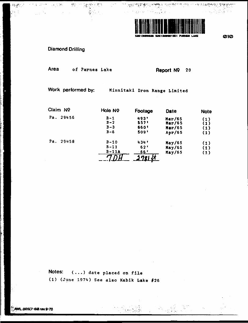
•s' 1 ! ft"; 5M13MN913D1 FAMES LAKE Diamond Drilling 010 Area of Parnes Lake Report NO 20 Work performed by: Minnitaki Iron Range Limited Claim N9 Pa. 29456 Pa. 29M58 Hole NO Footage Date Note B-l B-2 B-3 B-6 B-10 B-ll B-11A 1MM i*93* 557' 6601 509' i*3"* f 62' 6fr' *1V# Mar/65 Har/65 Mar/65 Apr/65 May/65 May/65 May/65 (1) (1) (1) (1) (1) (1) (1) Notes: ( ...) date placed on file (1) (June 197U) See also Kabik Lake #26 "VWL.OO5U-60lrev.9-72

Welcome message from author
This document is posted to help you gain knowledge. Please leave a comment to let me know what you think about it! Share it to your friends and learn new things together.
Transcript
•s' 1! ft";
5M13MN913D1 FAMES LAKE
Diamond Drilling
010
Area of Parnes Lake Report NO 20
Work performed by: Minnitaki Iron Range Limited
Claim N9
Pa. 29456
Pa. 29M58
Hole NO Footage Date NoteB-lB-2B-3B-6
B-10B-llB-11A
1MM
i*93*557'6601509'
i*3"* f62'6fr'
*1V#
Mar/65Har/65Mar/65Apr/65
May/65May/65May/65
(1)(1)(1)(1)
(1)(1)(1)
Notes: ( ...) date placed on file
(1) (June 197U) See also Kabik Lake #26
"VWL.OO5U-60lrev.9-72
I'/
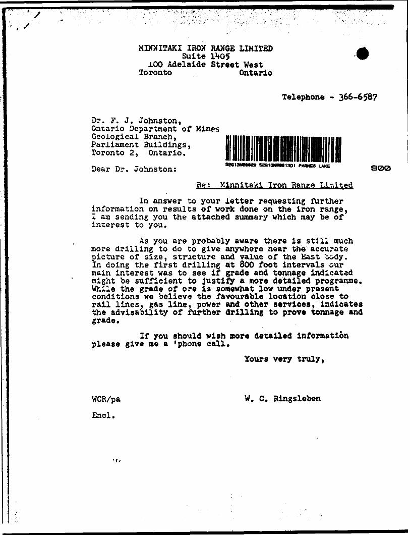
MINNITAKI IRON RANGE LIMITEDSuite 1MD5
100 Adelaide Street Vest Toronto Ontario
Telephone - 366-658?
Dr. F. J. Johnston, Ontario Department of Mines Geological Branch, Parliament Buildings, Toronto 2, Ontario.Dear Dr. Johnston: 5M"'""a' 5ae'3 900
Ret K4nnltaki Iron Range Limited
In answer to your letter requesting further information on results of work done on the iron range, I am sending you the attached summary which may be of interest to you.
As you are probably aware there is still much more drilling to do to give anywhere near the' accurate picture of size, s t rae tu re and value of the East body. In doing the first drilling at 800 foot intervals our main interest was to see if grade and tonnage indicated might be sufficient to Justify a more detailed programme. While the grade of ore is somewhat low under present conditions we believe the favourable location close to rail lines, gas line, power and other services, indicates the advisability of further drilling to prove tonnage and grade*
If you should wish nore detailed information please give me a 'phone call.
Yours very truly,
WCR/pa W. C. Ringsleben
End.

SUMMARY OF RESULTS OF EXPLORATION
DURING 196*f AND 1965 ON THE
PROPERTY OF MINNITAKI IRON RANGE LIMITED
January lith, 1967 III!
52G13NWM26 52G13NWM1301 PARNES LAKE OSO
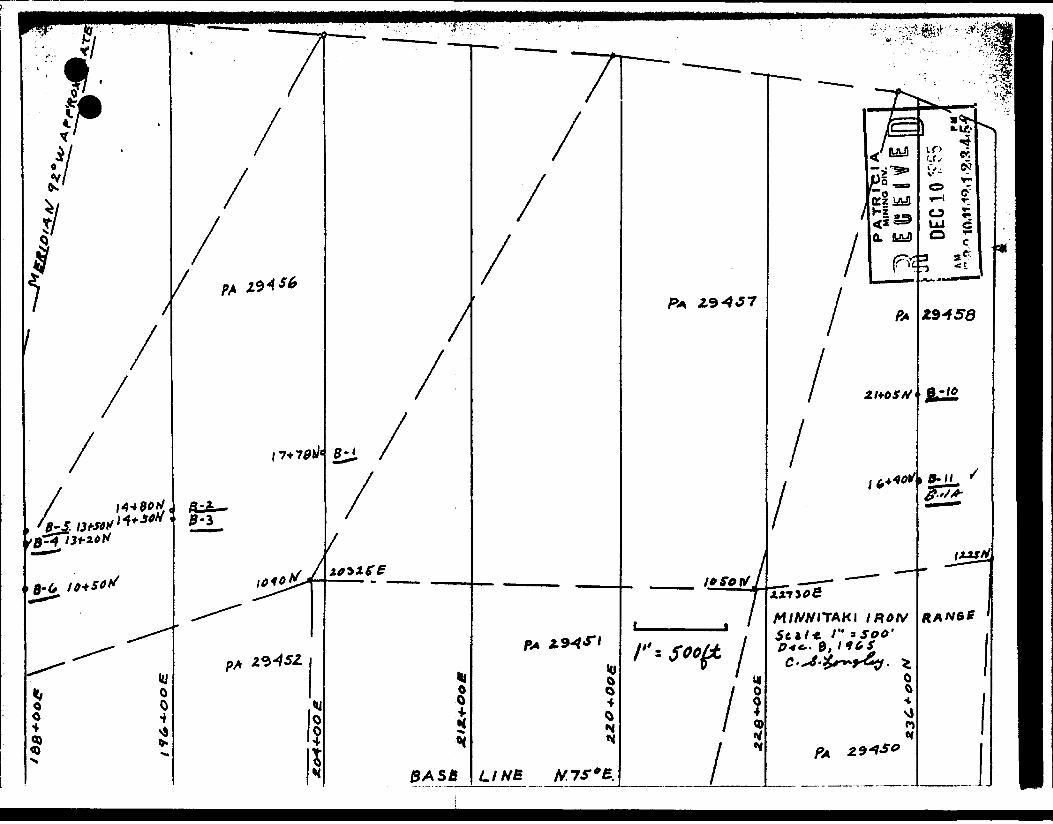
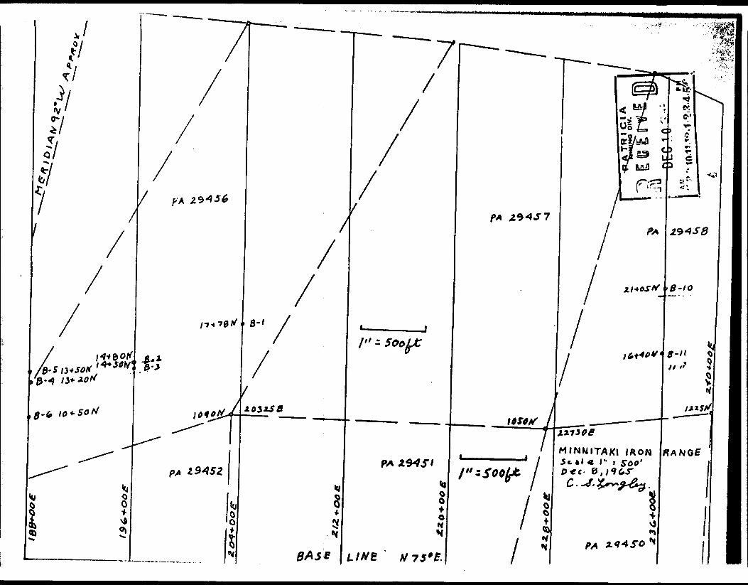
There are three areas along the strike of the iron formation vhere anomalies with readings of over 30,000 gammas suggest important amounts of magnetite. These are:
1. Main or Eastern zone extending from section 17,000 E to section 26,800. This zone commences one mile east of the south end ofDallas Lake.
2. Kiddle zone between sections 7,700 and 9,800, which is one-half mile south of Dallas Lake.
3. We:;t zone from 8,^)0 ft east to 16,UOO ft east of August Lake.
The rost easterly or Main zone occurs on a ridge one-half mile south of Twill Lake, where for a distance of 3,000 feet several bands across an 800 foot width make up at least 50 percent of the formation. This can be extended to the east another mile where the magnetometer readings indicate widths may be 150 feet to 250 feet. The ridge is 100 feet to 200 feet above the level of Twill Lake.
The Main zone includes two anomalous areas between sections 20,800 E and 23,1*00 E which have not been explored. They lie immed iately east and south of the wide section and drilling will be re quired to prove size and grade. On these two lenses the magnetometer readings indicate lengths of 1,000 feet and 1,300 feet with widths of 100 feet to 125 feet.
Drilling in the Main zone was done at 800 ft intervals between sections 17,200 E and 20,^00 E. No. 10 ho}e was drilled on the eastern extension of this zone on section 23,600 E. The anomaly continues another 3,200 feet to the east.
Drilling is not finished but based on the magnetometer survey which suggests a certain amount of continuity of the main iron bands between drill holes a reasonable estimate of 200,000 tons per vertical foot is indicated. , The width of iron formation which might be mined in a pit would vary between 200 feet on the east end and 175 feet to 850 feet on the west part. The average assay of the drill core sections is between 18# to 19/S acid soluble iron. All these figures are tentative and subject to revision when drilling of the body is completed at closer intervals.
No sampling or drilling has been done on the Middle and Western zones. The magnetometer survey on the Middle zone indicates the iron formation is 200 to **00 feet wide for a length of 800 feet but narrows quickly going westward to approximately 50 feet for a length of 1,300 feet. While this is a small body the high magnetometer readings suggest it may contain some good grade material.
l \c- ***\
II tt m u*i
^K* M
)
* \*
__
K ^
A.&
44
-OO
C.
\ 5^-
w
—
A.
"X.
t "
\•\
- l
o, M
t^ i •n
PA
TR
ltS
IAM
ININ
G
"
*ft
* '^?
ff^D
ECio
'?e
a

Y li ' .
DIAMOND DRILL RECORDPROPERTY Range Limited
SHtn NUMMI
LATITUDE.
DEPARTUIE
ELEVATION
16-40 K.
236-00 E.
SECTION
DATUM
S I c* •p ,.——.... * A3. i*
M -45 0
TO
HOLE No. B-ll,.;r-. B^
siAtTio^ey 25, 1965
coMnnco " 28, 1965
UlTIMATf DEPTH .62* It. 66.*.
raoposco Dim 350*
• DEPTH FCCT
1 0-34*
1 34-58
1 56-62
M 6 2*
1 D. H.
I 0-32
9 32-58
J 58-66
M 6 6*
1
FOR MATION
C*SII:G
SAMPlC NO.
tIRON FORi!ATICN- 40-41, 42.5-44.5 ^ink ac
LEAN IHON FORLL-.TICK- 46'- 4" pink
El-ID OF ROLL- hele stopped due to
11A
OVERBURDEN- Casinc to 54*
T RON FORLL'vTTCK- 29-^0, 41.5-42.5
LEAN TRON FORilATTCK-
feldsT
js^alng
Pink a
END OF HOLE- Hele stoooed as drillinK dThere was u cave at 35*. The hele out of the casing.
was c
r*OM
Id int
ar andbreak
sid IB
iscontemente
TO
rusive
quart
pas- —
fcrufllv
inued.1 and
WIDTH
p*
t Wit
;he c
ASSAY VALUE
1 'JllflT
sment i
•.y.
rashed
NO*THCHN HIMCI r OK" tot n tv./t*
MltLCO *

* * V- lM.KING OIV.
PROPERTY
SMin NUMMR l
IATITUDI 17-78 N.
WABTOM 204-00 E.
HIVATION
DIAMOND DRILLIron Range Limited
SECTION MOM TO
DATUM
MAIINC N. 15*W.
Di^45.0 c 0; 33"'* ^93*
RECORDj
HOLE N
l C E i w E [f NOvir- "
Larch 3, ..1963.......
coMnmo.Har. .13, 1965
UlTIMAU DffTH 493
raoroscD DOTH
DEPTH rCCT
0-7 7 -29
29-82
82-123
123-19
FORMATION
Overburden Greenstone- generally fine graine
crystals of pyrite up to ^" size.
45* to core axis. 14-15 Lost Cor
LEAN IRON FORMATION- Alternatlnr
iron formation" and "chloritic, e
metar.orohosed sediments" . Banding
usually as individual crystals bu
to bedding.
IRON FORllATTON- thin banded, sillpyrite crystals A. seams. Bedding
113 to 122 bedding scrambled.
) j;jSrIL^ITIC IRON FORMATION- alte
and Jasper, generally uniform. 1
folding i.* breccia zone, 169.5-17
SAMPLE NO.
1, cbl
Shea
mow
)rite :
:ing 4
e; 16-17 coa:
zones i
enerel
45 to
t some
ceous45-55'
mat in
32-150
2 carb
sf "bai
y f ln^
550 to, 4r
ran fi
but
5 thin
cerbo
im-te.
TO
lob, E
fracti
se RTIded s'
grail
cere i
in thlT
iTnst j r
Je^ity
bands
late a
1S7-1I
WIDTH
hot 1
ring
InedHear
ed t
r1a.
SAftr
n, "tles
of m
tera
9 fn
ASSAY VALUES
hrougt
genera
nore eml
us nor
ornftt 1p
Pyr1 t*
f PITfl
lorltlregui
s-netH
tpn, 3
with
lly at
eld * 1Iky qu~ Jsspl
A R IIAp
llel
c withar.
e, all
50-154
3" 2"artz
riA^I**
j
lea
MOHToOH MIME* root *o* "lv./** , - ^X vJT
^. ^ Cameron Drilling Co. .., .. ^- i ^^ i^-^^^^c^
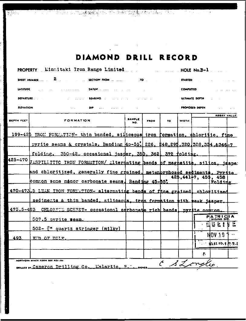
DIAMOND DRILL RICORDPROPERTY ........Linn l taki Iron Range Limited
SHEET NUMMR
LATITUDE.
DEPARTURE
EUVATION
SECTION FROM
DATUM
MARINO
DIP
TO
HOLE No.B-1
STARTED
COMPIETED
ULTIMATE DEPTH
PROPOSED DEPTH
fl DEPTH FEET
I 199-42
1425-470r^1 470-473
• 475.5-4
fl 493
FOR MAT ION
3 IRQ:: FORLUTICN- thin bended, silpyrite aeons fit crystals. Bandinc
foldinc. 350-42^. occasional ^asj
JA3PILLITTC IRON FORMATION/ Alterr
and chloritized, generally fine ri
comiuon s one ndnor carbonate seans.
.5 LEAK TPON FORirATTON- alternntlt
sedlmer.ts i. thin banded, silieeoi
33 CHLO- TI~Z SCHIST- occasional ea
507.5 pyrite Beam.
502- 2" quartz stringer (milky)STT) O"5* HCLT?.
•AM PL*NO.
lceous40-55*.
er, 35
atlnc
ained,
Bandl
g ben(?
a^^lnrboiat
FROM
iron
226,
3 r 362
bands
metes*
ne 45-
a of f
n foTia
e rich
TO
rormat:
148.29!
372 -
3f ID8ff
?rphos 42:
i5l
In* J-T
it Inn '
WIDTH
on, c
.320
jlidjjletlt
id se.,441
i1 ni*fl
lith
ASSAY VALUE'.
hlorit
328.3!
g.
, sil
IID&. ftti•7, 451
eh 1m
IAH)f jj
I P
' fe
i^1 it-.
lo. fi
4.2:346
ca t Jf
r ?y^*, 458Foldlr
•1t^7**r
A TRIGMtNINO DOy uOV1.S'0.11.10,f
ne-7
ApfiJ
te
g ——
IA
i g .; -.
?.a.4
MOOTMCHM HIMC* f OHM (O* HCV./l*
MiLico-. Cameron Drilling Co. c -

DIAMOND DRILL RECORD
fl i
iP A TR l C l A
MiK-NG 31V.
PROPERTY. kin&itaki Iroa Range Limited l
iv OY " ^HOLE Noi B-2 , vr. tA , a.o
SNtn NUMtC*
UTITUDI
OfMITUM
ELEVATION
14-80 N.
196-00 S.
SECTION MOM
DATUM
IEAIING
TO
S. 15 E.
oir 45 t O, 260 C 55?'
r l4, 1965
w 18, 1965
ULTIMATE DfPTH 557
540
DEPTH FCCT
0 -15 15- 25
1-5- 42
• 42-2461 —i1 —m
• 246-304
FORMATION **"oLe
Overburden JASPIL1ITIC IRON FORJ^TION- fine
to core axis. Carbonate at 17'.
Chlorite '"IL'.RTZ CARBOl^T! LCFTST-
Eraln*
- schi?
quartz and carbonate seams with chlorite
pyrite throughout with frequent le rge cicarbonate veins, 42' -1" pyrite ciystals
JASFILLITTC IRON FORLATION- dens*65,72,92,133-135, 173.188, 194.20]
nlnor faulting, 74-76 schistose, S
sut by quartz stringers. 137-138 s
veins, schistosity at 45*. 125-14
/l/r^T- f.P^YTJACX:^- schistose pnel
several bands c* I ron for^^-tion fi
fine. 218.
2-102
eh 1st
8 carbsslc K
OTE a f
F*OM
d t ban
t os-' ty
Incluystalsat se
cralne
224, 2
Light
But by
Dna t e
ith ba
en In c
TO
ilng v
fiO* tn
s ions. 58-5
hist T
3 lea
26, 24!
arown
cala!
3 e ains.
id Inff
IBS to
WIDTH
ariab
Pine
J r 63
.P. c
i bio
L^2A
OlOTi
A *
148-
it c4
a f o
ASSAY VALUES
e f r 01
*f]*
V dlS:
n 45-7* c
TIT".
J ?prr1 nr tiArty l •64 nufiT't?,.— 1
mtftot
sky. 4.^
P fnlfl-
id s1H
ntftT f
6A Pfi
)*. Co
it rid
1 BS ft(;
fie*, 4f
c A nil a
iiiflf't^
e PI*** w
itains
V
t
T F.
o-i^
MOHTMCAN MINC* 'OHM (Ol OCV./I*
Cameron Drilling Co.MlUf O *T———————————————————————————————— .tlCMO.

DIAMOND DRILLPROPERTY ..luinn it alii Iron han^e Liaited
2
RECORDHOLE No.3-2
SMUT NUMM*
UTITUOI. .
MPARTURI,.
SICTION MOM
DATUM .
UAMNG
TO
COMPUTED
UtTIMATf OtfTH
HfVATION DIP . nOPOSf 0 DCPTH .
otPTH retT
504-376
376-400
400-520
520-557
557'
FORMATION
LEA?! TF.CK FORI'.iTTON- nlterntttiner
and altered sediments, lyrite con
culclte and cuartz veinlets.
J;SPTLLTTTC T Rr T' ^ORI.IiTTCN- Intel
chert, Jasper L a lter- d preywackt
3onsiderable fracturing. Banding f
L",^T TRON ?OR1 'TTrTT- s ine aa 304-
iTTr:?.,n r ^. r^^ D 0 - n ^1nnpl h^r
T-T5 0^ HOI,?
NO.
"ones
mon, b
banded
t all
nneral
370'.
da o^
^
of ban
C97HQ
cut by
lv 45-
^on f
TO
led si
45-fiCf
tlte 1
calc v• e*}5
WIDTH
ioeoi
( SO!
due '
A*SAV VALUCC
is gre]
10 fol(
ihert .
;e strlngeri
-l\
f
T. F.
Ing
brown
PA7RMINING
k V) i
NOVi.'1011-"*
CI AD'V.
i ^ 1&
f -1.0.5 '
MOHTHCON WMCII rO*M tO* HfV^*4 j*j, * . J S/
MIUXO " Cftr-e^on Dlnnnrd Dr'ill'lnr- Hn, T.t.ri , UKMB ^^ f~^^ . "^ .y

DIAMOND DRILL RECORDPROPERTY
SHffT NUMM* l
14-50 K.
Iron Range Limited.
SECTION UOM TO
LATITUDE.
DtPAITUtC
E1IVATION
DATUM
196-00 E. •EAIINO ** ...*
0,,-4.5't O; -28 \, 660*
HOLE No.B-3
STAKED -arch 21, 1965
coMnmo ". 27, 1965
UlTIMATE DEWH 660*. .
DOTH 650 f
DEPTH rccT
0-16 16 - 19
19-114
114-131
131-366
366-530
FOR MATION
Cverb-raen CKLOF.T1-E :.U;JITZ CAREONATS SCH7ST-
-iineralisbtlcn sit 19 1 schism-Iron
J.iPILLITIC IRON FORLlATIOK-Bandi:
66-68, 93-94.5, 97.5-103, 107.5-1C
:.uartz-CARBO::ATE SCHIST- 123* fol
JASPILLITIC IRON FORLi;kTIOK- Altei
ir.d greywacke- ren:nj.nts of schist,
jareclally at achlst-lron forni-.tic
L61 1 171'X 176* 18Qf 200 f 215,220 r 2
J85 1 . 298'. 340'. 360 '-372*
LZAN IRON FCRL'-.TTON- elterr.ttlnr
jadinents ind th^n nhpnetlte ^ich
L':3 f . 4^:4'. 452'. 477-550' Inters
\C*- ft ^ •.tl PT* t (".rt VT*1 t1. **
• AMPLE NO
schls
format
S. 6 t 4
9 ach1,
ding 1n tit Ing
Band i
n eont
24.227
I'jnds
and a\
e ''-Id
r*OM
tinr clcn co5*. 65
St T
Q bandbunds
ne pen
bCtS.
-9,238
of fin
lies r•f-.- "Lt
TO
I5 0 to .
itact.
•66, 71
: d Ir oi
of: mt
jrtilly
?oldlni
.245 r 2^
1eh hft
* """on 1
WIDTH
ore
-71
fortgnet
45t :" 15;7-a r ;
6u
ids.
"oy*ip
A**AV VALUES
xis. :
lUTtZ
latlcn,
te, Jt
*yrlte
: * . isef!65,27(
;
t (hloijl^Void -l*
;^ nn h'
*vrlte
va ins
spar. a
conusor
r lB*'3Mi 1*
-3 r 27E
MOV
izdft 1 *
r^. A'C
nfl 4
illCc
R 1 C 1'•t* U'V
-tf 4-i n ''n,* o••^••Kt
MOIITHCMM MIMM fomSt *oi ~*f v./** * " JIQ . ^.y y-
M....... Care -on '^fvoid Dr^'Mnp (!n. .~.™ ^' ^^S' J ^'^^a^*^

r - -- /--•-v •^;;. 1/""^ : - - . - ' ~ - "" "v--' : '.~" * : .- i\l:^v '~'~.-~ .*- * - ""- '- "- •--"•' ' *-*~".. '/./t 1 J'-
DIAMOND DRILL RECORDPROPERTY
SHEET NUMU*
lATITUDE..
DCPARTUIE
EUVATION
Range Linited
SECTION no*
DATUM
IIAIINO
.TO
HOLE No. E-3
STAtTtO ..
IHTIMATI MPTN
ocrm
~ DEPTH FEET
530-617
617-621
62i-6fcO
660
NOOTMCIIX
FORMATION
JASPIL. IT T C IRON FCRIL'.TTO::- tltei
and chloritic, fener--lly fine f"'-^
Curbonate *. Iteration, pyrite L eh]
571 T 572.5: Slickenaides 55" : 567-6
folding.
LL~:: IH01,T FCRI..TTCX- Fine . . ulr.ei
bc.:.cis of iron formation.
Gre^.cKe.
Znd of hole.
•AM^LC NO.
r: -.t i ni
ned me
orlte
17 SOL,
chlor
mo**
banes
taiscrp
com ondin*- i
itic c
TO
of nui
Hosed ;
. Band
preitul
revuDC
.
WIDTH
net-!
ed Ir,
ng 4
p, c
:e ivi
AMAV VALUES
e, ell:
nts ( {
Lo:
Jnside
;h occ;
P i
to
wr
r
ct, je
reywae
t Corsable
slcnal
SJR.'fi,"• 0*T^W C*V.
* 'st ri t J la D V
V i c '
^•••iaBB
seer
ket
A
E Ir~2-/I;!"
moen r OHM tot ncv./n ^,j ,? ^^S jrt
"

P A "H l C: l A
DIAMOND DRILL RECORD P"';
PROPERTY W nnltaKi Iron Range Limited
SMUT NUMMR
•" LATITUDE . .
MfAtTURc 236.-00 .E. .
IUVATION 01327 See. Level.
SfCTION FROM
DATUM
TO
ICAIING K. 15. TT*
Oir 0 .-45* ; 215' -38*; 430* -33*
HOLE N9- 5-10- - -:
19,1965
22,1965
UlTIMATI OtrTN 434
of rri* 510*
OtPTH rCCT
0-10 10-16.17-18. 19-24.
24.5-69
69.2-76
85-108
108-142
142-186J.86.5-1 194-207
207-235235-312 312-323*Zp1 R — ^O w t** * W^w
352-36^
362.5-4
4^4
FORMATION
Casing 5 GRET.VACKE 16.5-17 PORPHYRY5 IRON FCRL.VTICK 16.5-19 QUARTZ 5 PORPHYRY; 1" iron formation at 't
.2 IRON FOR1/J.TION- Porphyry: 26-2(Red bnd white quartz: 51-51.5; 52- : 30-85 f PORPHYRY 76-80* TROW ^O!
VERY LEAN GREL'IT IRON FORLIATTCK- ^
GR2ZNISH IRON FORl'.ATION- Pink quj
.5 JASPILLITIC IRON Foia^TioN-cut94 75)0 DIORITE
FAIR GRADE IRON FORl^vTION CUT AT
LE^N IRON FORMATIONJASPILLITIC IRON FORl^ATICN- Dior J
.5 GRE21TI3H GREYWACKE
•AMPUC NO.
1*
.5: 2-353, 44i. ^TTOJ
arts *
rtz 11at 40;
tt 50
te 241
52 LIGHT "UARTZ PORPHYRY- re s enbled quart.5 IRON FORMATION
S4 "UARTZ-FELDSPAR PORPHYRY-reserallocal banding
T^-TJ mf ^TOT T?
les qu
moM
-27.5:-44.3,
D8 ' -3W
5-115.
^uart0
-242.5
zite o
artzlt
TO
28.5-44.6-4:
WIDTH
50; 65.5;
115 8 ; 6P-S"
j
i 155-:
; 251-1
r ouer
.56'
152.
izose
a or suartzi
ASSAY VALUES
L. 2-65I. F. (
* 33-
fireyn!
)36 Kr
;33.5.sut at
w C ^(
oke.ba
'Wacke
34*40 D
*
ndin
MO'TMfHK HIMC* roHM tO* "IV /H ^ * t ^j, y 7
M.,,. B .. Cameron Drilling Co. .^.. *-- ' -^ ^ ~^^^*i
0^^p -^""^-a*

l* s Soofjt
v 7s*eMinnitaki Iron Range Scale l" - 5oo*
Dec. 8 t 19G5 C. S. Longley.

P ** V r* l C*:JMNG D'
DIAMOND DRILL RECORDPROPERTY . X1™1 talcl U
SMfIT NUMMR
LAmUW 10-50 N-
DCMtTUK 180-00 E
f IUVATION .. ......... . ....
ron nange Limited
.. . . SICTION HOM .TO
DATUM
lEAtINC ^* ^5 E
Dir 0 -45*; E50' -35*i 500' -30 *
HOLE ^
STAITID
UITIMATI
J^ 1 P-ft"' ' '
9 " 17, 19fi5
OffTH 509
OfrTH.. . ......... .... ... .... . ....
DEPTH FCCT
o - ie18-24
24-100
100-190
190-230:
!30-444
44.5-5
509
FORMATION
OVERBURDEN- sandy clay CAREONATIL2D GREYWACKE: white qtz
J^PILLITIC IRON FORKATIOK- Cons i
Predomlnent banding at 35 to 450 .
LXAN TROt: FOm-:iTTON- prlm.-rlly eh
common, cagnetite 10-20?5 and sill
J;JID3) l^aNETITE IRON FOR1./.TION- f
alteration cutting bands. Banding
5 LEAN IRON FORMATION- Chloritic
sedlDer:ts Interlayeredwlth banded
comcon, Banding at 50*. at 250' tt
Porphyry: 415-7; 426-9; 436.5-438:
9 GREYTTACfGE- occasionally gneiss!^ to the contact. Llnectlcn at 56 a
w n tr Kri.Tt
SAMPLE NO.
s t ra
ierabl
90-1Q
|Lorlt1
ea wit
iintly
ut 45'
Tine K
macne
320':
312-3j. cal
; 452*
rwoM
narn
fold:alte:
•fin*
i band)
jasDl
*
*aln6d
ilte li
55* at
339-2ariou
957 a
TO
v T: i nli
nz a ndatlon
gT*ft|p*
. Bane
11 tlc.
soniflt
on t oi
400 '.
40; 3.
and/c505*
WIDTH
atrs
fra*more
A SAI;
ing. i
late
1 R1A9
Itfit^f
In-P *
5-7;
r cbl
I*o os
ASSAY VALUES
turlnpIntana
jjfflA'l^'.*
t 50: df
r sill•-
SLfiMiH
n, JFe*
253 n-
^fifi-9 '
critic
to col
throue 9ft*
L pyrle^i*^'
QGcmaJ
NCVMB 10"''
i o j ng
f* "i S * p
^^n-^close
lar of
dgouTS" b*--
ex*
RI CI
1& l' t
l 0 '-' V
10, f .0 '
fl-2
y 5
ho*
Mine* ro'x *o*
Cameron Diamond Drilling Co./* ^t'C^- ^c5 ,

L**fi^^^s?
m-\
"D
/"sPL A A/
CLAIMS AVD AUOMAL
Related Documents