1 / 10 David P. Lusch, Ph.D. [email protected] David P. Lusch, Ph.D. Distinguished Senior Research Specialist Michigan State University Dept. of Geography, Remote Sensing & GIS Research and Outreach Services Group Institute of Water Research Michigan’s Michigan’s W W ater ater W W ithdrawal ithdrawal A A ssessment Process ssessment Process and and Using the WWA Tool for Planning Using the WWA Tool for Planning and Watershed Management and Watershed Management and

David P. Lusch, Ph.D. [email protected] 1 / 10 David P. Lusch, Ph.D. Distinguished Senior Research Specialist Michigan State University Dept. of Geography,
Dec 28, 2015
Welcome message from author
This document is posted to help you gain knowledge. Please leave a comment to let me know what you think about it! Share it to your friends and learn new things together.
Transcript

1 / 10David P. Lusch, Ph.D.
David P. Lusch, Ph.D.Distinguished Senior Research Specialist
Michigan State UniversityDept. of Geography, Remote Sensing & GIS
Research and Outreach Services Group
Institute of Water Research
Michigan’s Michigan’s WWater ater WWithdrawal ithdrawal AAssessment Process ssessment Process
andand Using the WWA Tool for Planning Using the WWA Tool for Planning
and Watershed Managementand Watershed Management
and

2 / 10David P. Lusch, Ph.D.
• Overview of the groundwater & surface water resources of the regions
• Overview of the Water Withdrawal Assessment Tool (WWAT)
•Example uses of the WWAT for sustainable community development
Michigan’s Water Withdrawal Assessment Process Michigan’s Water Withdrawal Assessment Process for Planning and Watershed Managementfor Planning and Watershed Management

3 / 10David P. Lusch, Ph.D.
•Evaluating your Master Plan– Check all the areas zoned residential
(self-supplied) or Commercial/Industrial (self-supplied) to determine which catchments they fall within.
– “Roads” and “Aerial Photos” Data Layers in WWAT are very useful spatial references.
– Use “New Withdrawal” in WWAT to determine the total allowable depletion in those catchments.
Michigan’s Water Withdrawal Assessment Process Michigan’s Water Withdrawal Assessment Process for Planning and Watershed Managementfor Planning and Watershed Management

4 / 10David P. Lusch, Ph.D.
Michigan’s Water Withdrawal Assessment Process Michigan’s Water Withdrawal Assessment Process for Planning and Watershed Managementfor Planning and Watershed Management
1
2
3
For explorationpurposes, we can
ignore these boxes.

5 / 10David P. Lusch, Ph.D.
http://www.miwwat.org/getflow.asp?
trans=5400
&shore=0
&bdrkf=1
&bdrkt=99999
&aline=0.000
&bline=25.460
&cline=25.523 Allowable catchment depletion (gpm)(initial amount – not yet updated!!)
&dphzoned=125
&estdphbdrk=458
&pctdrift=100
&pctrock=0
&kvw=233.693
&type=Cold transitional stream&wsid=12269
&x=-84.105415
&y=44.613435
&mapx=650155.8847889714
&mapy=453061.31356536905
Michigan’s Water Withdrawal Assessment Process Michigan’s Water Withdrawal Assessment Process for Planning and Watershed Managementfor Planning and Watershed Management

6 / 10David P. Lusch, Ph.D.
•So how many gpm do you need?– A standard residence needs a minimum of 20
gpm (~ 60 gpm with home irrigation).
– For clustered developments (e.g., PUDs), multiply the # of parcels times 20 gpm to estimate the cumulative depletion.
e.g. 15 parcels x 20 gpm/parcel = 300 gpm
– Note: residential water well withdrawals are NOT regulated by state law. Consider re-arranging the zoning map to mitigate potential adverse impacts.
Michigan’s Water Withdrawal Assessment Process Michigan’s Water Withdrawal Assessment Process for Planning and Watershed Managementfor Planning and Watershed Management

7 / 10David P. Lusch, Ph.D.
•So how many gpm do you need?– Commercial/industrial user needs vary
widely. Some water-intensive businesses may need 600 – 1000 gpm.
– PA 33 (2006) prohibits a local unit of government from enacting or enforcing an ordinance that regulates a large quantity withdrawal (i.e., 70 gpm or more).
– The evaluation suggested here is with the intent of re-arranging the zoning map to mitigate potential adverse impacts.
Michigan’s Water Withdrawal Assessment Process Michigan’s Water Withdrawal Assessment Process for Planning and Watershed Managementfor Planning and Watershed Management

8 / 10David P. Lusch, Ph.D.
•Revise your Site Plan Review process– Amend your site plan review checklist to
require submission of applicable LQW Registration with the site plan for any self-supplied facility with a pumping capacity of 70 gpm or more (e.g., within “Other Environmental Impacts” section).
Michigan’s Water Withdrawal Assessment Process Michigan’s Water Withdrawal Assessment Process for Planning and Watershed Managementfor Planning and Watershed Management
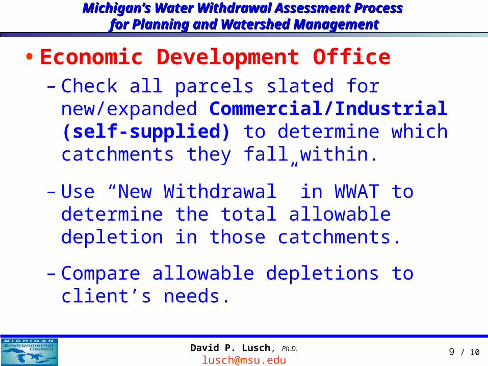
9 / 10David P. Lusch, Ph.D.
•Economic Development Office– Check all parcels slated for new/expanded
Commercial/Industrial (self-supplied) to determine which catchments they fall within.
– Use “New Withdrawal” in WWAT to determine the total allowable depletion in those catchments.
– Compare allowable depletions to client’s needs.
Michigan’s Water Withdrawal Assessment Process Michigan’s Water Withdrawal Assessment Process for Planning and Watershed Managementfor Planning and Watershed Management

10 / 10David P. Lusch, Ph.D.
The EndThis concludes our
presentation segments
www.miwwat.org
gwmap.rsgis.msu.edu
Michigan’s Water Withdrawal Assessment Process Michigan’s Water Withdrawal Assessment Process for Planning and Watershed Managementfor Planning and Watershed Management
Related Documents