DAVID MINDESS ELEMENTARY SCHOOL ASSESSMENT REPORT Ashland, MA January 2017

Welcome message from author
This document is posted to help you gain knowledge. Please leave a comment to let me know what you think about it! Share it to your friends and learn new things together.
Transcript
DAVID MINDESS ELEMENTARY SCHOOL ASSESSMENT REPORT
Ashland, MA January 2017

David Mindess Elementary School Walk Assessment 1
1 Introduction
The Town of Ashland has signed a Community Compact with the Commonwealth, adopting
Infrastructure, Safe Routes to School, and Citizen Engagement as its three best practices. In support of
the Community Compact and in order to implement the Safe Routes to School best practice, the Town
requested that Massachusetts Safe Routes to School (MA SRTS) conduct an assessment for the David
Mindess Elementary School (Mindess School). Toole Design Group, Inc. (TDG), one of the contractors
hired by MassDOT to complete SRTS planning and design tasks, conducted this assessment for the
Mindess School.
The assessment examined existing conditions around and to the Mindess School. This report documents
barriers to walking and bicycling at and near the school; gaps in the bicycling and walking network
around the school; observations of current behavior; and potential recommendations for
improvements.
This report summarizes the findings of the assessment and outlines next steps for improving walking
and bicycling to and from the school.
This report is organized in the following sections:
1. Introduction
2. MA SRTS Program and Assessments
3. David Mindess Elementary School
4. Observations and Findings
5. Recommendations
6. Next Steps
2 MA SRTS Program and Assessments
2.1 MA SRTS Program
The purpose of the SRTS program is:
(1) To enable and encourage children, including those with disabilities, to walk and bicycle to school;
(2) To make bicycling and walking to school a safer and more appealing transportation alternative, thereby encouraging a healthy and active lifestyle from an early age; and
(3) To facilitate the planning, development, and implementation of projects and activities that will improve safety and reduce traffic, fuel consumption, and air pollution in the vicinity of schools.
SRTS programs use the 5 E’s (Engineering, Education, Encouragement, Enforcement, and Evaluation) to meet the goals of the program. Successful SRTS programs incorporate all E’s when working to make walking and bicycling to school a safe and attractive choice for students and their families.
MA SRTS is comprised of an infrastructure program (which supports the Engineering aspect) and a non-infrastructure program (which supports Education, Encouragement, Enforcement, and Evaluation).

David Mindess Elementary School Walk Assessment 2
2.2 Assessments
This SRTS assessment is based on a walk audit conducted in June 2016. A walk audit is a group exercise
in which a team walks around the school campus and adjacent neighborhoods to observe, identify and
document walking and biking conditions. The findings of the assessment are used to identify barriers to
walking and bicycling in the environment surrounding a school, and are documented in a report.
The assessment for the Mindess School was held on June 15, 2016 with MassDOT and TDG staff, school
staff, and community stakeholders. The assessment included observations of the walking school bus
route, key walking and bicycling routes to school, and the dismissal process. The following people
participated:
Mindess School: James Adams (Superintendent), Claudia Bennett (Vice Principal), Lisa Beaudin
(Nutrition Services), Susan Palefsky (Nutrition Services), Tricia Kendall (Parent)
Town of Ashland: Yolanda Greaves (Representative, Selectman Office), Michael Herbert (Town
Manager), Craig Davis (Police Chief), Edward Burman (Police Sergeant), Beth Reynolds (Director of
Economic Development), Nathaniel Strosberg (Town Planner)
MassDOT: Nicole Tishler (MA SRTS Program Director), Erin Reed (MA SRTS Statewide Coordinator),
Melissa Green (MA SRTS Outreach Coordinator)
Toole Design Group: Catherine Duffy (Transportation Planner), Heather Georgallas (Engineer)
3 David Mindess Elementary School
This section describes the Mindess School’s characteristics, including a summary of how far students live
from the school, which indicates the potential for walking or biking to school. End-of-the-day school
dismissal procedures are also described in this section.
3.1 School Characteristics
The Mindess School is located at 90 Concord Avenue, Ashland, MA and has 608 students in grades 3-5.
In the 2017-2018 academic year, the Mindess School will transition to a middle school, enrolling
students in grades 7-8. School staff expect that there will be an increase in students walking and
bicycling to school and a decline in bus ridership with this transition.
Students’ families can purchase bus passes for approximately $300 per year, regardless of residential
location. Many students are picked up by private vehicle even if they have a bus pass.

David Mindess Elementary School Walk Assessment 3
The Mindess School administered the MA SRTS parent survey (included in Appendix 1) in 2016 to
develop an understanding of student travel patterns. Approximately 42% (254) of Mindess School
students are estimated to live
within two miles of school,
which is considered a bikeable
distance. One mile is
considered to be a walkable
distance, and 18% (110) of
students are estimated to live
within that distance. As shown
in Figure 1, 40 of those 254
students are estimated to
actually walk or bike to school.
The last page of the survey
report in Appendix 1 shows a
map of estimated student
resident locations based on the
survey results.
Figure 1: Numbers of students living within walkable/bikeable distances of school compared to numbers that actually walk or bike.
David Mindess Elementary School Walk Assessment 4
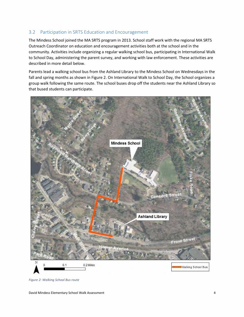
3.2 Participation in SRTS Education and Encouragement
The Mindess School joined the MA SRTS program in 2013. School staff work with the regional MA SRTS
Outreach Coordinator on education and encouragement activities both at the school and in the
community. Activities include organizing a regular walking school bus, participating in International Walk
to School Day, administering the parent survey, and working with law enforcement. These activities are
described in more detail below.
Parents lead a walking school bus from the Ashland Library to the Mindess School on Wednesdays in the
fall and spring months as shown in Figure 2. On International Walk to School Day, the School organizes a
group walk following the same route. The school buses drop off the students near the Ashland Library so
that bused students can participate.
Figure 2: Walking School Bus route

David Mindess Elementary School Walk Assessment 5
As noted above, the Mindess School administered the parent survey this year to establish an
understanding of travel behavior and parent perceptions of walking and bicycling to and around the
Mindess School. The results will provide an important baseline from which to measure future success of
SRTS in Ashland.
The Ashland Police Department is supportive of students walking and bicycling to and from school. The
Town recently converted all traffic signals town-wide to include an exclusive pedestrian phase. The
Police Department and the Nutrition Director for the Mindess School have been actively coordinating to
improve walking and bicycling conditions and traffic congestion around the School.
3.3 Dismissal Procedures
Students at the Mindess School are dismissed in three phases:
Phase 1. Parent/guardian vehicles; eastbound walkers and bicyclists
Phase 2. School buses
Phase 3. Westbound walkers and bicyclists
Figure 3 shows the Mindess School campus and access points.

David Mindess Elementary School Walk Assessment 6
Figure 3: Mindess School campus
3.3.1 Phase 1: Parent/guardian vehicles; eastbound walkers and bicyclists
Students picked up by parents in private vehicles and students walking or bicycling to the east of the
school are dismissed first at 2:40. On the day of the walk audit, there were 16 students who either
walked through an informal path adjacent to the field east of the school or walked down the sidewalk
alongside the east driveway to Concord Street.
Students who get picked up by private vehicle are escorted by staff volunteers from the East Entrance
(Figure 3) through a very faded crosswalk, across an asphalt path, to the pick-up circle. When all vehicles
waiting in the pick-up circle are loaded, they are dismissed and the next wave of vehicles enters the
circle.
East driveway
(enter only)
West driveway
(exit only)
Pick-up circle
East entrance
West entrance
Traffic cones

David Mindess Elementary School Walk Assessment 7
Orange cones are arranged along the side of the circle to prevent students from entering the travel lane;
however, students do not comply with this barrier. Students were observed playing in the travel lane,
standing with their backs to traffic, using iPads and mobile phones, and generally demonstrating unsafe
behavior (Figure 4).
During the walk audit (described in more detail below), parents were observed queuing in the pick-up
circle and along Concord Street (Figure 5) about 40 minutes before dismissal. Concord Street is a two-
way, two-lane road with no parking. There were approximately 80 vehicles in the queue, which
extended past Fiske Avenue. The queuing vehicles blocked the eastbound lane on Concord Street for
about 40 minutes prior to dismissal and 10 minutes after dismissal. Several cars were observed driving
eastbound in the westbound lane for 600 feet or more to bypass the queue. The 80-vehicle queue
moved through the pick-up circle in 12 minutes. There is a 5-minute idling policy at the school, though
this was not enforced during the walk audit.
Figure 4: The pick-up queue during dismissal.

David Mindess Elementary School Walk Assessment 8
3.3.2 Phase 2: School buses
In Phase 2, the buses arrive and park in the
designated bus loading zone. The bus loading
zone also serves as the pedestrian zone. When
all the buses are in place, bus-riding students
are dismissed and loaded onto the buses. This
process takes about 10 minutes. Once all
students are loaded, the buses depart via the
west driveway, at about 2:55 PM.
3.3.3 Phase 3: Westbound walkers and
bicyclists
After all buses have cleared the driveway,
westbound walkers and bicyclists are dismissed
from the west doors of the school to the west driveway. (On the day of the walk assessment, there were
16 westbound walkers and 6 westbound bicyclists; at least three of the students bicycling were not
wearing helmets.) Along the west driveway, there is a white line to delineate the bus loading/pedestrian
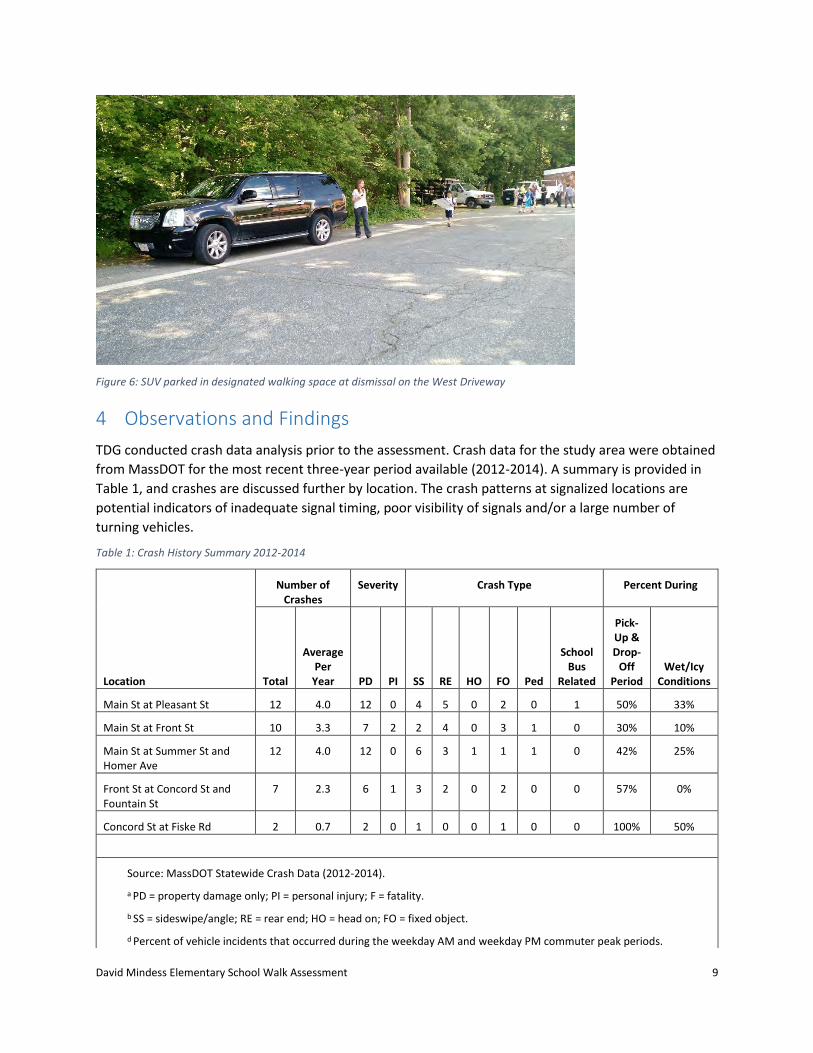
zone from the travel lane, as shown in Figure 6. Students somewhat comply with this white line. On the
day of the walk assessment, a large SUV was parked in the bus loading/pedestrian zone, forcing students
out into the travel lane.
Unlike eastbound walkers and bikers, who are dismissed first with students being picked up by parents,
westbound walkers and bikers wait about 17 minutes in the gym to be dismissed last. The school does
not allow these students to be dismissed until vehicle and bus traffic has cleared the campus out of
concern for potential conflicts along the roads. School staff also noted that there is a freight train
passing through downtown at 2:42 PM, and there is concern that this could be a danger to students.
However, the first phase of dismissal commences at 2:40 and the distance between the school and the
railroad crossing downtown is 0.4 miles, so it is unlikely that this is a potential conflict because students
would not reach the crossing until after the train has passed. Furthermore, residence data suggest that
few, if any students would cross the tracks to get home from school.
Dismissal concerns:
Excessive vehicle idling and queuing on Concord Street
Vehicles driving against traffic due to idling vehicles blocking the travel lane on Concord Street
Unsafe behavior displayed by students
Late dismissal of walkers and bicyclists.
Figure 5: Vehicle queue of parents prior to dismissal on Concord Street.
David Mindess Elementary School Walk Assessment 9
Figure 6: SUV parked in designated walking space at dismissal on the West Driveway
4 Observations and Findings
TDG conducted crash data analysis prior to the assessment. Crash data for the study area were obtained
from MassDOT for the most recent three-year period available (2012-2014). A summary is provided in
Table 1, and crashes are discussed further by location. The crash patterns at signalized locations are
potential indicators of inadequate signal timing, poor visibility of signals and/or a large number of
turning vehicles.
Table 1: Crash History Summary 2012-2014
Location
Number of Crashes
Severity Crash Type Percent During
Total
Average Per
Year PD PI SS RE HO FO Ped
School Bus
Related
Pick-Up & Drop-
Off Period
Wet/Icy Conditions
Main St at Pleasant St 12 4.0 12 0 4 5 0 2 0 1 50% 33%
Main St at Front St 10 3.3 7 2 2 4 0 3 1 0 30% 10%
Main St at Summer St and Homer Ave
12 4.0 12 0 6 3 1 1 1 0 42% 25%
Front St at Concord St and Fountain St
7 2.3 6 1 3 2 0 2 0 0 57% 0%
Concord St at Fiske Rd 2 0.7 2 0 1 0 0 1 0 0 100% 50%
Source: MassDOT Statewide Crash Data (2012-2014).
a PD = property damage only; PI = personal injury; F = fatality.
b SS = sideswipe/angle; RE = rear end; HO = head on; FO = fixed object.
d Percent of vehicle incidents that occurred during the weekday AM and weekday PM commuter peak periods.

David Mindess Elementary School Walk Assessment 10
Prior to attending the assessment, TDG worked with the Mindess School and MA SRTS staff to begin to
identify issues and conditions that should be considered during the assessment. The assessment began
with a discussion of factors impacting walking and biking to Mindess School. Then the group observed
school dismissal; catalogued the locations of key walking and bicycle infrastructure (including sidewalks,
pathways, and traffic control features); and identified other factors impacting travel to and from the
school.
Figure 7 shows eight critical sites observed during the walk assessment. The study area (within the
yellow line) was selected for high numbers of student residences within walking distance to the school
and confirmed by the school champion as an area in need of bicycle and pedestrian improvements.
Conditions of each of the eight sites observed during the audit (Figure 7) are described below, followed
by summary of the crash data. Recommendations for addressing barriers to walking and biking to school
are identified and described in Section 5.
Figure 7: Walk audit study area

David Mindess Elementary School Walk Assessment 11
Site #1: Main Street and Pleasant Street
Figure 8: Site #1-Intersection of Pleasant Street and Main Street
The intersection of Main Street at Pleasant Street is a signalized T-intersection. Main Street runs in the
general north-south direction with Pleasant Street intersecting from the west. Sidewalks are present
along both sides of Main Street and Pleasant Street. Land use is primarily residential and commercial at
this location. There is no on-street parking in this area. Cherry Street intersects Pleasant Street from the
south approximately 85’ to the west of Main Street. The Ashland MBTA Commuter Rail parking lot is
located on Pleasant Street.
At the intersection, Main Street consists of one through travel lane and one turning lane in both
directions. Pleasant Street consists of one left-turn lane and one right-turn lane, and there is a raised
median on this approach.
There are crosswalks across the northbound Main Street and Pleasant Street approaches. The traffic
signal provides an exclusive pedestrian phase and has emergency vehicle preemption. Push buttons are
provided at both ends of the crosswalks, as well as in the median on the Pleasant Street approach.
Pleasant St

David Mindess Elementary School Walk Assessment 12
Wide corner curb radii create a long crossing
distance for the Pleasant Street crosswalk,
while a skewed alignment lengthens the
Main Street crosswalk.
The intersection of Main Street at Pleasant
Street experienced 12 reported collisions
within the three year time period (2012
through 2014), averaging approximately 4
crashes per year. All reported collisions
resulted in property damage only. Of the 12
crashes reported during this period, four
were either sideswipe or angle type and five
were rear-end crashes. In 2013, there was
one reported rear-end collision involving a
school bus that resulted in property damage only. It was observed that 50% of the crashes occurred
during the drop-off and/or pick-up peak travel hours and another 33% occurred during wet/icy roadway
conditions.
Barriers to walking/bicycling to school:
Long crossing distances
Figure 9: Intersection of Pleasant Street and Main Street, looking north on Main Street with Pleasant Street on the left.
David Mindess Elementary School Walk Assessment 13
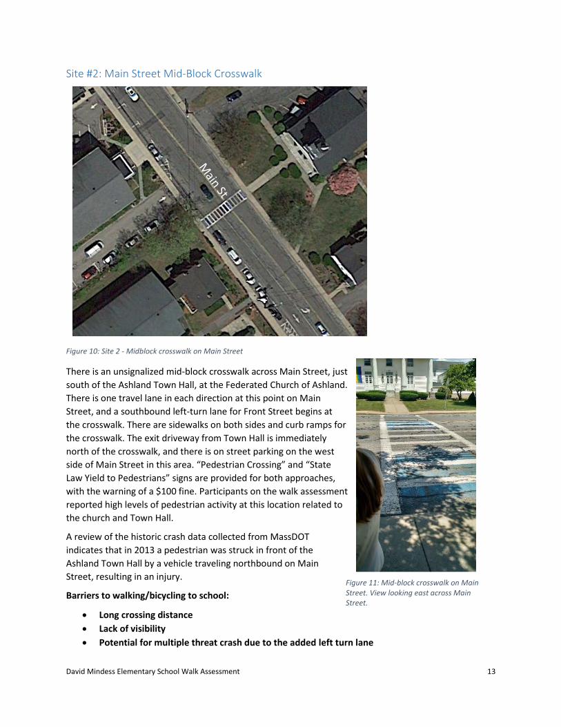
Site #2: Main Street Mid-Block Crosswalk
Figure 10: Site 2 - Midblock crosswalk on Main Street
There is an unsignalized mid-block crosswalk across Main Street, just
south of the Ashland Town Hall, at the Federated Church of Ashland.
There is one travel lane in each direction at this point on Main
Street, and a southbound left-turn lane for Front Street begins at
the crosswalk. There are sidewalks on both sides and curb ramps for
the crosswalk. The exit driveway from Town Hall is immediately
north of the crosswalk, and there is on street parking on the west
side of Main Street in this area. “Pedestrian Crossing” and “State
Law Yield to Pedestrians” signs are provided for both approaches,
with the warning of a $100 fine. Participants on the walk assessment
reported high levels of pedestrian activity at this location related to
the church and Town Hall.
A review of the historic crash data collected from MassDOT
indicates that in 2013 a pedestrian was struck in front of the
Ashland Town Hall by a vehicle traveling northbound on Main
Street, resulting in an injury.
Barriers to walking/bicycling to school:
Long crossing distance
Lack of visibility
Potential for multiple threat crash due to the added left turn lane
Figure 11: Mid-block crosswalk on Main Street. View looking east across Main Street.
David Mindess Elementary School Walk Assessment 14
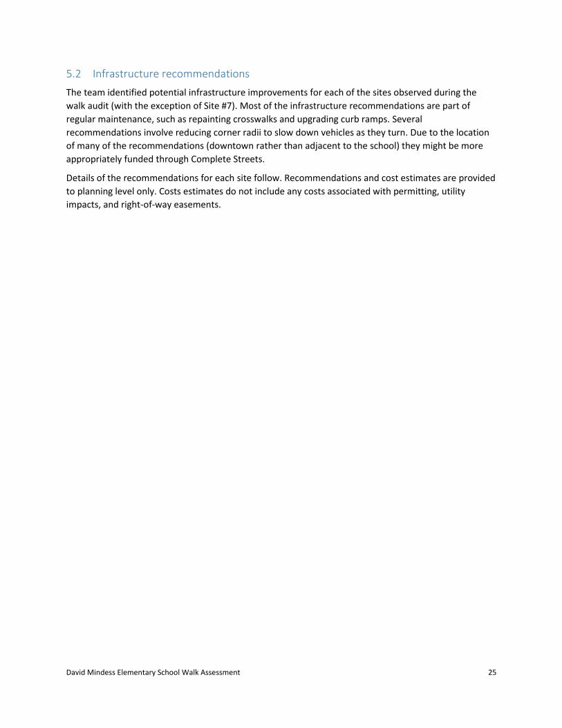
Site #3: Main Street and Front Street
Figure 12: Site #3-Intersection of Main Street and Front Street
The intersection of Main Street at Front Street forms a signalized three-legged intersection. Main Street
runs in the general north-south direction with Front Street intersecting from the east. At the
intersection, Main Street consists of one through lane and one turning lane in both directions. Front
Street consists of one left-turn lane and one right-turn lane. There are median islands on Front Street
and on the northbound Main Street approach.
Land use is primarily commercial and retail at this location. The Police Department and Fire Station are
located opposite Front Street and there is an at-grade railroad crossing located just south of the
intersection. There is on-street parking on the west side of Main Street.
There are crosswalks across all approaches and sidewalks along both sides of each approach. The
existing traffic signal provides an exclusive pedestrian phase, emergency vehicle preemption, and
pedestrian push buttons. Push buttons are provided on all crosswalk termini, as well as in the concrete
median located on the Front Street approach. The crosswalk across Front Street is long due to wide
corner radii, however, the raised median provides a crossing refuge.
Police Dept
Fire Station

David Mindess Elementary School Walk Assessment 15
There is a crossing guard stationed at
this intersection during school arrival
and dismissal periods.
The intersection of Main Street at
Front Street experienced ten reported
collisions within the three year time
period (2012 through 2014), averaging
approximately 3.3 crashes per year.
The majority of the reported collisions
resulted in property damage only,
however two were reported to have
resulted in personal injury. Of the ten
crashes reported during this period,
four were rear-end crashes. In 2013,
there was one reported collision involving a vehicle traveling southbound that struck a pedestrian. It was
also observed that 30% of the crashes occurred during the drop-off and/or pick-up peak travel hours
and another 10% occurred during wet/icy roadway conditions.
Barriers to walking/bicycling to school:
Long crossing distance
Large curb radii
Figure 13: Intersection of Main Street and Front Street. View looking east on Main Street towards Front Street.
David Mindess Elementary School Walk Assessment 16
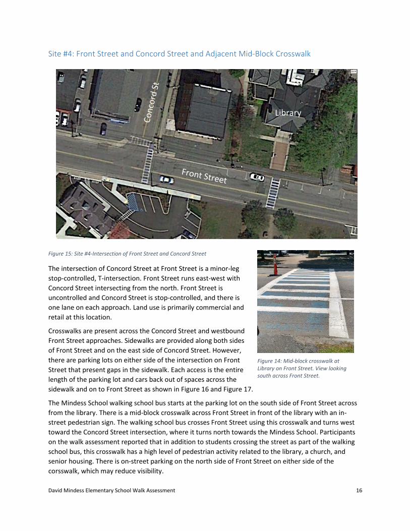
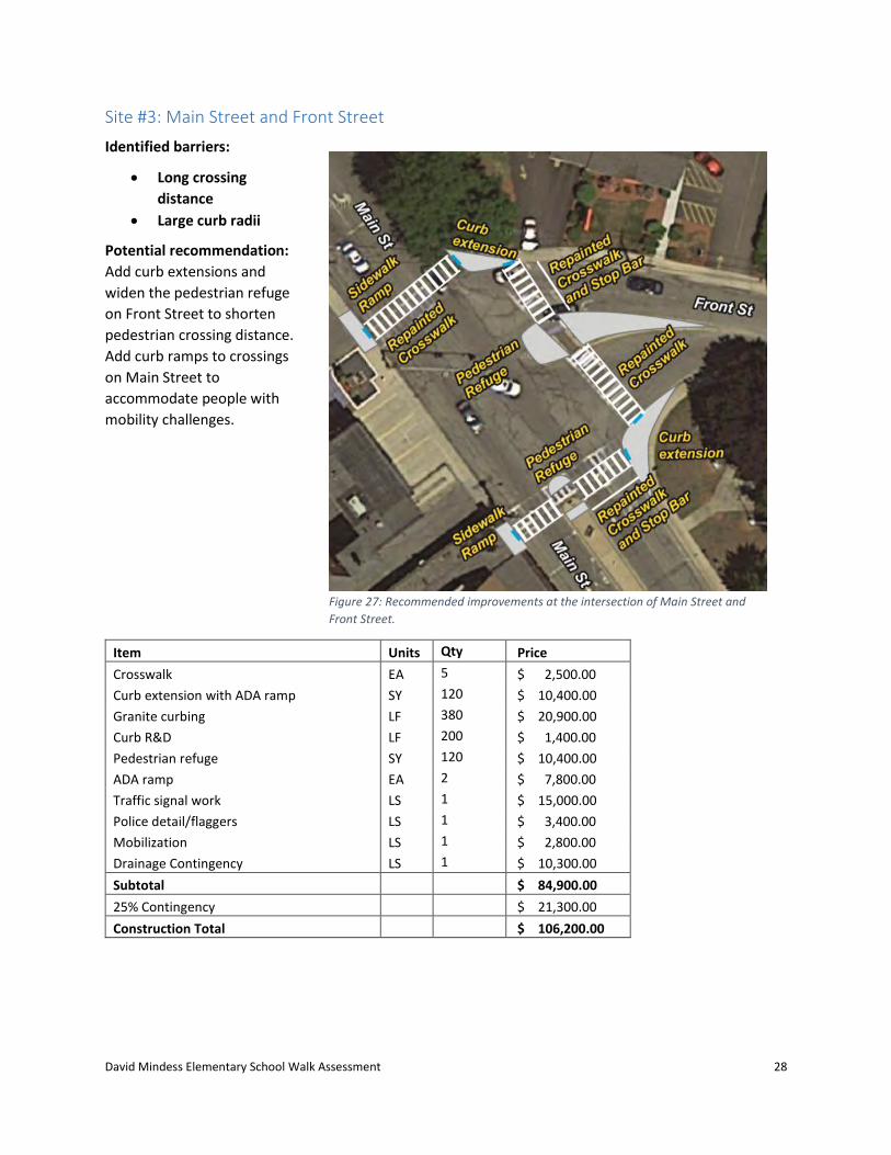
Site #4: Front Street and Concord Street and Adjacent Mid-Block Crosswalk
Figure 15: Site #4-Intersection of Front Street and Concord Street
The intersection of Concord Street at Front Street is a minor-leg
stop-controlled, T-intersection. Front Street runs east-west with
Concord Street intersecting from the north. Front Street is
uncontrolled and Concord Street is stop-controlled, and there is
one lane on each approach. Land use is primarily commercial and
retail at this location.
Crosswalks are present across the Concord Street and westbound
Front Street approaches. Sidewalks are provided along both sides
of Front Street and on the east side of Concord Street. However,
there are parking lots on either side of the intersection on Front
Street that present gaps in the sidewalk. Each access is the entire
length of the parking lot and cars back out of spaces across the
sidewalk and on to Front Street as shown in Figure 16 and Figure 17.
The Mindess School walking school bus starts at the parking lot on the south side of Front Street across
from the library. There is a mid-block crosswalk across Front Street in front of the library with an in-
street pedestrian sign. The walking school bus crosses Front Street using this crosswalk and turns west
toward the Concord Street intersection, where it turns north towards the Mindess School. Participants
on the walk assessment reported that in addition to students crossing the street as part of the walking
school bus, this crosswalk has a high level of pedestrian activity related to the library, a church, and
senior housing. There is on-street parking on the north side of Front Street on either side of the
corsswalk, which may reduce visibility.
Library
Figure 14: Mid-block crosswalk at Library on Front Street. View looking south across Front Street.

David Mindess Elementary School Walk Assessment 17
The location experienced seven reported collisions from 2012 through
2014, averaging approximately 2.3 crashes per year. Of the seven
crashes reported, one collision resulted in personal injury. Three
reported crashes were either sideswipe or angle type and two were
rear-end crashes. It was observed that 57% of the crashes occurred
during the drop-off and/or pick-up peak travel hours and none
occurred during wet/icy roadway conditions.
Figure 17: Driveway access on Front Street northwest of intersection with Concord Street
Barriers to walking/bicycling to school:
Missing sidewalk at parking lots on northern side of Front Street
Long crossing distances
Lack of pedestrian visibility
Figure 16: Parking lot at the intersection of Concord Street and Front Street. View looking east on Front Street.
David Mindess Elementary School Walk Assessment 18
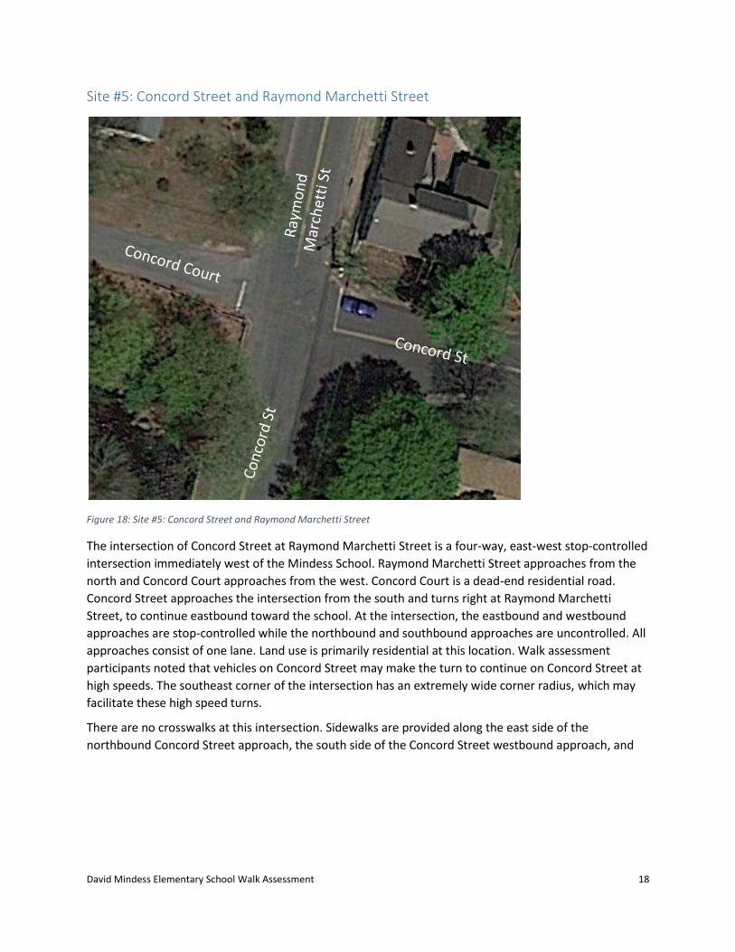
Site #5: Concord Street and Raymond Marchetti Street
Figure 18: Site #5: Concord Street and Raymond Marchetti Street
The intersection of Concord Street at Raymond Marchetti Street is a four-way, east-west stop-controlled
intersection immediately west of the Mindess School. Raymond Marchetti Street approaches from the
north and Concord Court approaches from the west. Concord Court is a dead-end residential road.
Concord Street approaches the intersection from the south and turns right at Raymond Marchetti
Street, to continue eastbound toward the school. At the intersection, the eastbound and westbound
approaches are stop-controlled while the northbound and southbound approaches are uncontrolled. All
approaches consist of one lane. Land use is primarily residential at this location. Walk assessment
participants noted that vehicles on Concord Street may make the turn to continue on Concord Street at
high speeds. The southeast corner of the intersection has an extremely wide corner radius, which may
facilitate these high speed turns.
There are no crosswalks at this intersection. Sidewalks are provided along the east side of the
northbound Concord Street approach, the south side of the Concord Street westbound approach, and

David Mindess Elementary School Walk Assessment 19
the west side of Raymond Marchetti Street.
With the missing sidewalks and crosswalks,
there is no safe route between the school
and the neighborhoods on the west side of
Raymond Marchetti Street.
There were no reported crashes 2012-2014
at this location.
Barriers to walking/bicycling to school:
Missing sidewalks and crosswalks
Wide northbound right turning
radius
Figure 19: Intersection of Concord Street and Raymond Marchetti Way. View looking north from southeast corner.
David Mindess Elementary School Walk Assessment 20
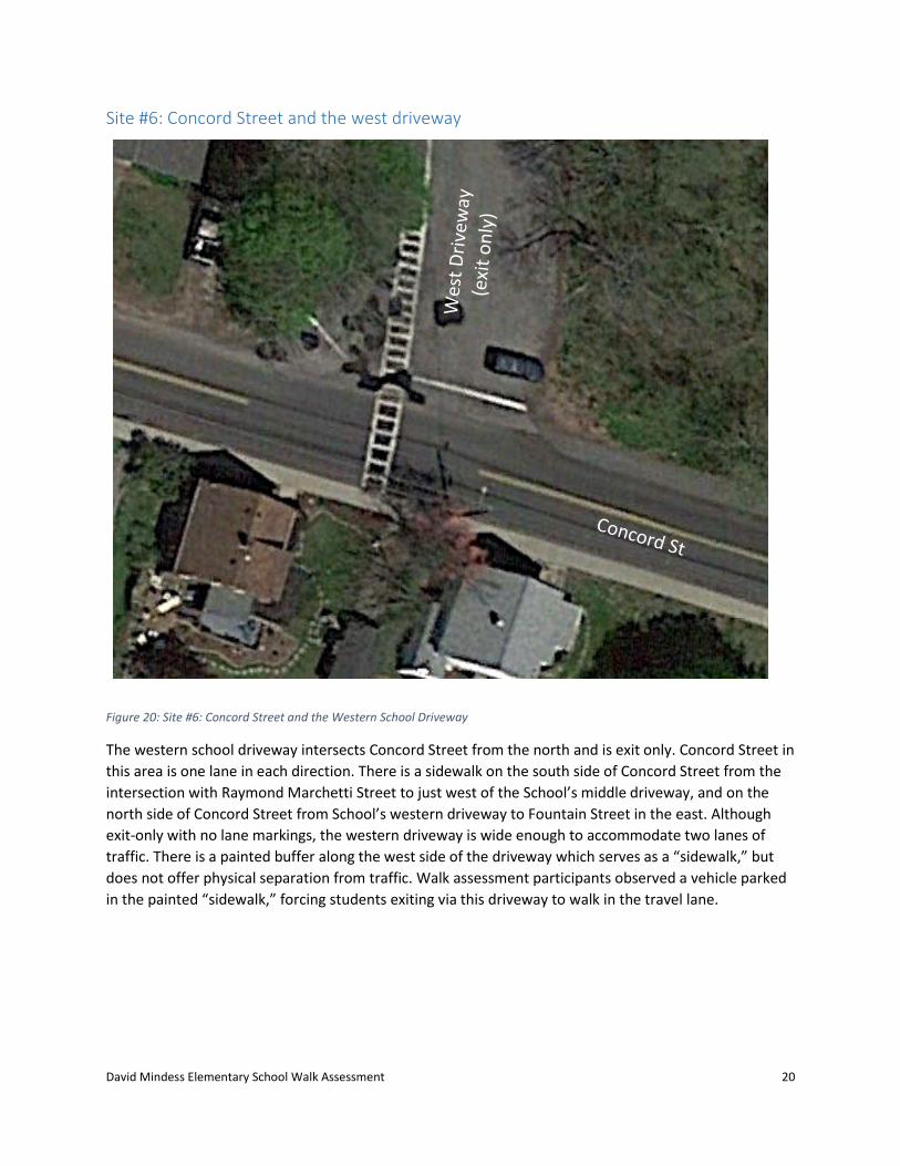
Site #6: Concord Street and the west driveway
Figure 20: Site #6: Concord Street and the Western School Driveway
The western school driveway intersects Concord Street from the north and is exit only. Concord Street in
this area is one lane in each direction. There is a sidewalk on the south side of Concord Street from the
intersection with Raymond Marchetti Street to just west of the School’s middle driveway, and on the
north side of Concord Street from School’s western driveway to Fountain Street in the east. Although
exit-only with no lane markings, the western driveway is wide enough to accommodate two lanes of
traffic. There is a painted buffer along the west side of the driveway which serves as a “sidewalk,” but
does not offer physical separation from traffic. Walk assessment participants observed a vehicle parked
in the painted “sidewalk,” forcing students exiting via this driveway to walk in the travel lane.
David Mindess Elementary School Walk Assessment 21
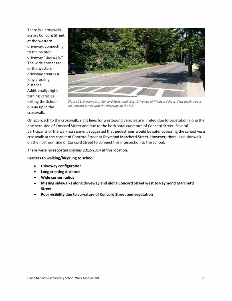
There is a crosswalk
across Concord Street
at the western
driveway, connecting
to the painted
driveway “sidewalk.”
The wide corner radii
of the western
driveway creates a
long crossing
distance.
Additionally, right-
turning vehicles
exiting the School
queue up in the
crosswalk.
On approach to the crosswalk, sight lines for westbound vehicles are limited due to vegetation along the
northern side of Concord Street and due to the horizontal curvature of Concord Street. Several
participants of the walk assessment suggested that pedestrians would be safer accessing the school via a
crosswalk at the corner of Concord Street at Raymond Marchetti Street. However, there is no sidewalk
on the northern side of Concord Street to connect this intersection to the School.
There were no reported crashes 2012-2014 at this location.
Barriers to walking/bicycling to school:
Driveway configuration
Long crossing distance
Wide corner radius
Missing sidewalks along driveway and along Concord Street west to Raymond Marchetti
Street
Poor visibility due to curvature of Concord Street and vegetation
Figure 21: Crosswalk at Concord Street and West Driveway of Mindess School. View looking east on Concord Street with the driveway on the left.

David Mindess Elementary School Walk Assessment 22
Site #7: Concord Street and the east driveway
Figure 22: Concord Street and the east driveway
The east driveway is a two-lane enter-
only driveway providing access for all
vehicles to the school, school parking lot
and the pick-up circle utilized for private
vehicle pick-up. The middle driveway is a
one lane exit-only driveway from the
parent pick-up circle.
The intersection of Concord Street at
Fiske Road (to the east of the East
Driveway) experienced two reported
collisions within the three year time
period (2012 through 2014), averaging
less than one crash per year. All reported collisions resulted in property damage only. One reported
crash was an angular crash while the other was a single vehicle collision that crashes with a fixed-object.
Both crashes occurred during the drop-off and/or pick-up peak travel hours and 50% occurred during
wet/icy roadway conditions.
Although there are no physical barriers to walking or bicycling to school at this intersection, the walk
assessment participants observed unsafe practices during dismissal at this intersection, described in the
following section.
Barriers to walking/bicycling to school:
Disorganized behavior during dismissal period on the school driveway
Figure 23: Looking west on Concord Street with the east driveway on the right.
David Mindess Elementary School Walk Assessment 23
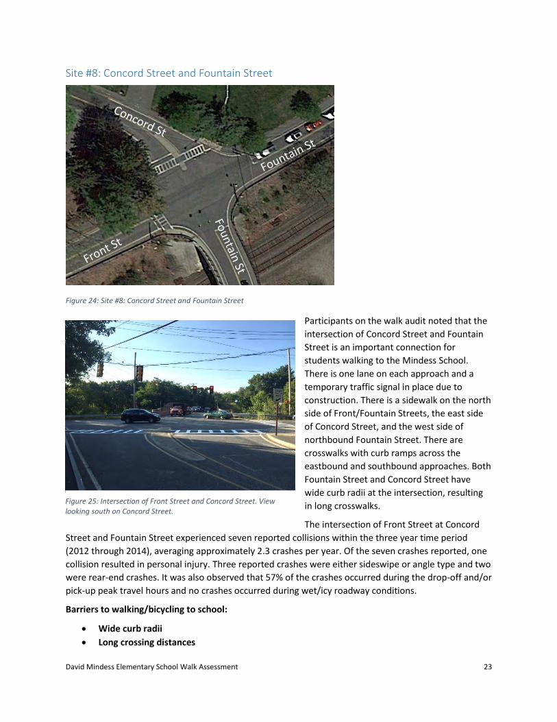
Site #8: Concord Street and Fountain Street
Figure 24: Site #8: Concord Street and Fountain Street
Participants on the walk audit noted that the
intersection of Concord Street and Fountain
Street is an important connection for
students walking to the Mindess School.
There is one lane on each approach and a
temporary traffic signal in place due to
construction. There is a sidewalk on the north
side of Front/Fountain Streets, the east side
of Concord Street, and the west side of
northbound Fountain Street. There are
crosswalks with curb ramps across the
eastbound and southbound approaches. Both
Fountain Street and Concord Street have
wide curb radii at the intersection, resulting
in long crosswalks.
The intersection of Front Street at Concord
Street and Fountain Street experienced seven reported collisions within the three year time period
(2012 through 2014), averaging approximately 2.3 crashes per year. Of the seven crashes reported, one
collision resulted in personal injury. Three reported crashes were either sideswipe or angle type and two
were rear-end crashes. It was also observed that 57% of the crashes occurred during the drop-off and/or
pick-up peak travel hours and no crashes occurred during wet/icy roadway conditions.
Barriers to walking/bicycling to school:
Wide curb radii
Long crossing distances
Figure 25: Intersection of Front Street and Concord Street. View looking south on Concord Street.

David Mindess Elementary School Walk Assessment 24
5 Recommendations
The purpose of this SRTS assessment is to identify barriers to walking and bicycling to school and
recommend non-infrastructure and, if applicable, infrastructure projects to address those barriers. This
section describes potential non-infrastructure and infrastructure recommendations.
5.1 Non-infrastructure recommendations
The non-infrastructure strategies described below are important to encouraging safe walking and biking
to school and may be implemented immediately. SRTS non-infrastructure programming is an important
part of increasing the number of students who walk and bike to school and making it safer for those
students walking and bicycling.
The Mindess School should increase its SRTS non-infrastructure offerings, including, but not limited to:
Early release of walkers and bicyclists.
Students should be rewarded for walking and bicycling to school by being dismissed first. Rather
than dismissing walking and biking students last to avoid conflicts, students should instead be
taught safe skills to navigate traffic on their way home from school.
Pedestrian and bicycle safety curriculum.
Students must learn safe bicycle and pedestrian skills to safely navigate their way around their
town. Understanding traffic rules and safe practices will help students act safely in the pick-up
loop and employ safe walking and bicycling skills in the West Driveway.
Educational and enforcement campaign to address queuing and idling.
Parents should be encouraged to arrive at the school at the actual dismissal time. If parents
were to arrive at dismissal, they would likely wait a maximum of 10-15 minutes in the queue to
pick up children, as opposed to the 40-50 minutes they currently wait idling along Concord
Street, blocking the westbound travel lane and creating unsafe conditions. School staff and law
enforcement can actively warn parents who are queuing and idling for a targeted period before
handing out tickets and fines. The school should also enforce the no parking rule along the
“sidewalk” in the West Driveway where students walk and bike.
Crossing guard stationed at the intersection of Concord Street and the West Driveway.
Adding a crossing guard at this corner would provide assistance to the walking school bus and
likely encourage more families to walk and bike. The majority of school traffic passes through
this intersection at dismissal, which may make it challenging for students walking and bicycling.
The crossing guard should be moved to the intersection of Concord Street and Raymond
Marchetti Street if a sidewalk and crosswalk are constructed on the northern side of Concord
Street as recommended below.
David Mindess Elementary School Walk Assessment 25
5.2 Infrastructure recommendations
The team identified potential infrastructure improvements for each of the sites observed during the
walk audit (with the exception of Site #7). Most of the infrastructure recommendations are part of
regular maintenance, such as repainting crosswalks and upgrading curb ramps. Several
recommendations involve reducing corner radii to slow down vehicles as they turn. Due to the location
of many of the recommendations (downtown rather than adjacent to the school) they might be more
appropriately funded through Complete Streets.
Details of the recommendations for each site follow. Recommendations and cost estimates are provided
to planning level only. Costs estimates do not include any costs associated with permitting, utility
impacts, and right-of-way easements.

David Mindess Elementary School Walk Assessment 26
Site #1: Main Street and Pleasant Street
Identified barriers:
Long crossing distances
Potential recommendation: Add curb extensions to Pleasant Street and realign the crosswalk on Main
Street to shorten crossing distances for pedestrians.
Figure 26: Recommended improvements at the intersection of Main Street and Pleasant Street.
Item Units Qty Price
Crosswalk EA 3 $ 1,500.00 Curb Extension with ADA Ramp SY 75 $ 6,450.00 Granite Curbing LF 230 $ 12,650.00 Curb R&D LF 125 $ 875.00 Pedestrian refuge SY 5 $ 430.00 ADA ramp EA 2 $ 7,800.00 Traffic signal work LS $ 15,000.00 Police detail/flaggers (assumed cost) LS 1 $ 2,200.00 Mobilization LS 1 $ 1,800.00 Drainage Contingency LS 1 $ 7,325.00
Subtotal $ 56,000.00
25% Contingency $ 14,000.00
Construction Total $ 70,000.00

David Mindess Elementary School Walk Assessment 27
Site #2: Main Street Mid-Block Crosswalk
Identified barriers:
Long crossing distance
Lack of visibility
Potential for multiple threat crash due to the added left turn lane
Potential recommendation: Add curb extension at crosswalk.
Item Units Qty Price
Crosswalk EA 1 $ 500.00 Curb extension with ADA ramp SY 23 $ 2,000.00 Granite curbing LF 30 $ 1,650.00 Curb R&D LF 40 $ 300.00 ADA Ramp EA 1 $ 3,900.00 Police detail/flaggers (assumed cost) LS 1 $ 400.00 Mobilization LS 1 $ 400.00 Drainage Contingency LS 1 $ 1,275.00
Subtotal $ 10,525.00
25% Contingency $ 2,700.00
Construction Total $ 13,225.00
David Mindess Elementary School Walk Assessment 28
Site #3: Main Street and Front Street
Identified barriers:
Long crossing
distance
Large curb radii
Potential recommendation:
Add curb extensions and
widen the pedestrian refuge
on Front Street to shorten
pedestrian crossing distance.
Add curb ramps to crossings
on Main Street to
accommodate people with
mobility challenges.
Item Units Qty Price
Crosswalk EA 5 $ 2,500.00
Curb extension with ADA ramp SY 120 $ 10,400.00
Granite curbing LF 380 $ 20,900.00
Curb R&D LF 200 $ 1,400.00
Pedestrian refuge SY 120 $ 10,400.00
ADA ramp EA 2 $ 7,800.00
Traffic signal work LS 1 $ 15,000.00
Police detail/flaggers LS 1 $ 3,400.00
Mobilization LS 1 $ 2,800.00
Drainage Contingency LS 1 $ 10,300.00
Subtotal $ 84,900.00
25% Contingency $ 21,300.00
Construction Total $ 106,200.00
Figure 27: Recommended improvements at the intersection of Main Street and
Front Street.
David Mindess Elementary School Walk Assessment 29
Site #4: Front Street and Concord Street and Adjacent Mid-Block Crosswalk
Identified barriers:
Missing sidewalk at
parking lots on northern
side of Front Street
Long crossing distances
Lack of pedestrian
visibility
Potential recommendation: Add
two pedestrian warning signs at
the uncontrolled crosswalk
across Front Street at Concord
Street, and two rectangular rapid
flashing beacons at the mid-block
crosswalk connecting the
municipal parking lot to the
library at Front Street. Construct
concrete sidewalk with granite
curbing across the driveway to
better define the sidewalk space
from parking. Construct a curb
extension at the midblock
crossing on the north side of
Front Street. Realign the crosswalk across Front Street at Concord Street so the crosswalks do not
provide apex style curb ramps. Add ADA compliant ramps with detectable warning pads at both
crosswalks, and restripe the crosswalk with high-visibility ladder style markings.
Item Units Qty Price
Sidewalk SY 90 $ 7,740.00
Crosswalk EA 3 $ 1,500.00
Curb extension with ADA ramp SY 24 $ 2,100.00
Granite curbing LF 80 $ 4,400.00
Curb R&D LF 90 $ 650.00
ADA ramp EA 5 $ 19,500.00
RRFB Pair 1 $ 15,000.00
Police detail/flaggers LS 1 $ 2,540.00
Mobilization LS 1 $ 2,100.00
Drainage Contingency LS 1 $ 7,650.00
Subtotal $ 63,200.00
25% Contingency $ 15,800.00
Construction Total $ 79,000.00
Figure 28: Recommended improvements at the intersection of Front Street and
Concord Street.

David Mindess Elementary School Walk Assessment 30
Site #5: Concord Street and Raymond Marchetti Street
Identified barriers:
Missing sidewalks
and crosswalks
Wide northbound
right turning radius
Potential recommendation:
Construct a sidewalk on the
north side of Concord Street
and on the west side of the
Mindess School West
Driveway. Reinstall the
existing crosswalk with
ramps to cross Concord
Street at the Mindess School
West Driveway. Install a
crosswalk and accessible
ramps on either side to cross
Concord Street at Raymond
Marchetti Way. Reduce the
wide corner radius on the
southeast corner of Concord
Street.
Item Units Qty Price
Sidewalk SY 500 $ 43,000.00
Crosswalk EA 2 $ 1,000.00
Curb extension with ADA ramp SY 24 $ 2,100.00
Granite curbing LF 1010 $ 55,550.00
Curb R&D LF 100 $ 700.00
ADA ramp EA 3 $ 11,700.00
Police detail/flaggers LS 1 $ 5,700.00
Mobilization LS 1 $ 4,700.00
Drainage Contingency LS 1 $ 17,200.00
Subtotal $ 141,700.00
25% Contingency $ 35,000.00
Construction Total $ 176,700.00
Figure 29: Recommended improvements at the intersection of Concord Street and
Raymond Marchetti Way and at the west driveway.

David Mindess Elementary School Walk Assessment 31
Site #6: Concord Street and the west driveway
Identified barriers:
Driveway configuration
Long crossing distance
Wide corner radius
Missing sidewalks along driveway and Concord Street west to Raymond Marchetti Street
Poor visibility due to curvature of Concord Street and vegetation
Potential recommendation: Construct a sidewalk along the east side of Raymond Marchetti Way and an
off-road path connecting this new sidewalk to the Mindess School west driveway. Procure an easement
from one or more property owners to construct the path. Ideally, this recommendation would be
completed in tandem with the recommendation for Site #5, which includes a sidewalk on the northern
side of Concord Street and west side of the Mindess School West Driveway.
Figure 30: Recommended Improvements to Connect the Mindess School Driveway to Alfred Road.
Item Units Qty Price
Sidewalk SY 320 $ 27,600.00
Off-road path LS 1 $ 30,000.00
Granite curbing LF 575 $ 31,700.00
ADA ramp EA 1 $ 3,900.00
Police detail/flaggers LS 1 $ 4,700.00
Mobilization LS 1 $ 3,900.00
Drainage Contingency LS 1 $ 14,000.00
Subtotal $ 115,800.00
25% Contingency $ 29,000.00
Construction Total $ 144,800.00
David Mindess Elementary School Walk Assessment 32
Site #7: Concord Street and the east driveway
Identified barriers:
Disorganized behavior during dismissal period on the school driveway.
Potential recommendation: See the non-infrastructure recommendations in Section 5.1 above.
Site #8: Concord Street and Fountain Street
Identified barriers:
Wide curb radii
Long crossing distances.
Potential recommendation: Construct curb extensions to shorten the crossing distance across Concord
Street and Front Street.
Figure 31: Recommended improvements at the intersection of Concord Street and Front Street (East).
Item Units Qty Price
Crosswalk EA 3 $ 1,500.00
Curb extension with ADA ramp SY 170 $ 14,700.00
Granite curbing LF 200 $ 11,000.00
Curb R&D LF 120 $ 900.00
Traffic signal work LS 1 $ 25,000.00
Police detail/flaggers LS 1 $ 2,700.00
Mobilization LS 1 $ 2,200.00
Drainage Contingency LS 1 $ 8,000.00
Subtotal $ 66,000.00
25% Contingency $ 16,500.00
Construction Total $ 82,500.00
David Mindess Elementary School Walk Assessment 33
5.3 Recommendation Cost Estimate Summary
Figure 32: Recommendations Summary
Recommendation Estimated Cost
1. Main Street and Pleasant Street $ 69,400
2. Main Street Mid-block Crosswalk $ 13,200
3. Main Street and Front Street $ 106,200
4. Front Street and Concord Street $ 79,000
5. Concord Street and Raymond Marchetti Way $ 176,700
6. Concord Street and the west driveway $ 144,800
7. Concord Street and the east driveway $ 0
8. Concord Street and Front Street $ 82,500
TOTAL $ 671,800
6 Next Steps
Based on the findings of this assessment and work previously completed for the Mindess School in
Ashland, MassDOT does not recommend using MA SRTS funds for an infrastructure project. Rather, the
Town may want to consider using MassDOT Complete Streets funding to pursue these
recommendations. Given the location of the school near downtown, these improvements will benefit a
greater number of community members.

David Mindess Elementary School Walk Assessment 34
Appendix 1: Parent Survey
MASafeRoutesSurvey.orgSurvey ReportAshland - David MindessJune 13, 2016
Introduction
This report will help your school plan safe transporta-tion options for all students. It contains the resultsof a survey conducted at Ashland - David Mindess inJune 2016. Participating parents provided informationabout how students travel to school and their approxi-mate home location. If your school is interested in
� reducing traffic congestion,� encouraging walking and biking,� increasing safety, or� tracking progress towards community goals,
then this information can help you identify the rightstrategies and best opportunities for new projects andinvestments.
How to Read This Report
This report measures distance to school in terms ofwalksheds and bikesheds. A walkshed includes all thehomes within a certain distance to school, based onmapped sidewalks, pedestrian paths, and low volumeroadways. We define walksheds for 0.5, 1.0, and 1.5mile walking distances to school. A bikeshed of 2.0miles also includes multi-use paths and on-road cycle fa-cilities, where mapped. For a map of the walksheds andbikesheds, see the last page of the report. Where ”walk-shed” is used alone, it always includes the bikeshed ofthe same distance.
Survey Statistics
� Survey Dates: 2016-06-02 to 2016-06-16� Responses Received: 119� School-wide Participation Rate: 20%
The figure below shows the survey participation rate foreach grade. Total enrollment is based on the 2015-2016school year, per Department of Elementary and Sec-ondary Education. Survey responses from each gradewere used to estimate the distance and travel choicefor the entire grade.The higher the participation rate,the more reliable the survey results are.
16% 25% 18%16% 25% 18%0
50
100
150
200
3 4 5Grade
Num
ber
of S
tude
nts
Completed Survey No Response Received
Participation by GradeAshland − David Mindess

Student Proximity
� Average Distance to School: 2.2 miles� Within 1.0 Mile Walkshed: 18%� Within 2.0 Mile Bikeshed: 42%
The chart and table below show the number of studentssurveyed and the total estimated students by walkshed.Student totals by walkshed are estimated assuming thatthe proportion of surveyed students within each walk-shed and grade is proportional to the enrolled studentswithin each walkshed and grade.
0
100
200
300
0.5 1.0 1.5 2.0 2.0+Walkshed (miles)
Num
ber
of S
tude
nts
Surveyed Estimated
Students by WalkshedAshland − David Mindess
Students By WalkshedStudents 0.5 1.0 1.5 2.0 2.0+
Estimated 44 66 77 67 353Surveyed 9 13 15 13 69Percent 7% 11% 13% 11% 58%
Student Travel Choices
� Walk\Bike Trips Within One Mile: 36%� Walk\Bike Trips Overall: 7%� Family Vehicle\Carpool Trips Overall: 21%� School Bus Trips Beyond One Mile: 79%
The chart below shows what percent of trips are madeby each travel mode in the morning and afternoon.
0%
20%
40%
60%
School Bus Family Vehicle Walk Carpool Bike TransitMode Choice
Per
cent
of T
rips
Morning Afternoon
Morning and Afternoon Mode ChoicesAshland − David Mindess
Walk share is 4.9% in the morning and 8.2% in the af-ternoon. The auto share is lower in the afternoon, indi-cating that as many as 30.8% of those who are drivento school in the morning get home by other means inthe afternoon.
Morning Afternoon
0
100
200
300
0.5 1.0 1.5 2.0 2.0+ 0.5 1.0 1.5 2.0 2.0+Walkshed (miles)
Est
imat
ed N
umbe
r of
Trip
s
Auto School Bus Walk/Bike
Students by Walkshed and Travel Mode, Morning and AfternoonAshland − David Mindess
Travel Mode, Morning and Afternoon0.5 1.0 1.5 2.0 2.0+
MorningAuto 14 18 36 12 68School Bus 0 48 42 55 285Walk 30 0 0 0 0
AfternoonAuto 0 4 34 10 54School Bus 4 52 43 57 299Walk 40 10 0 0 0
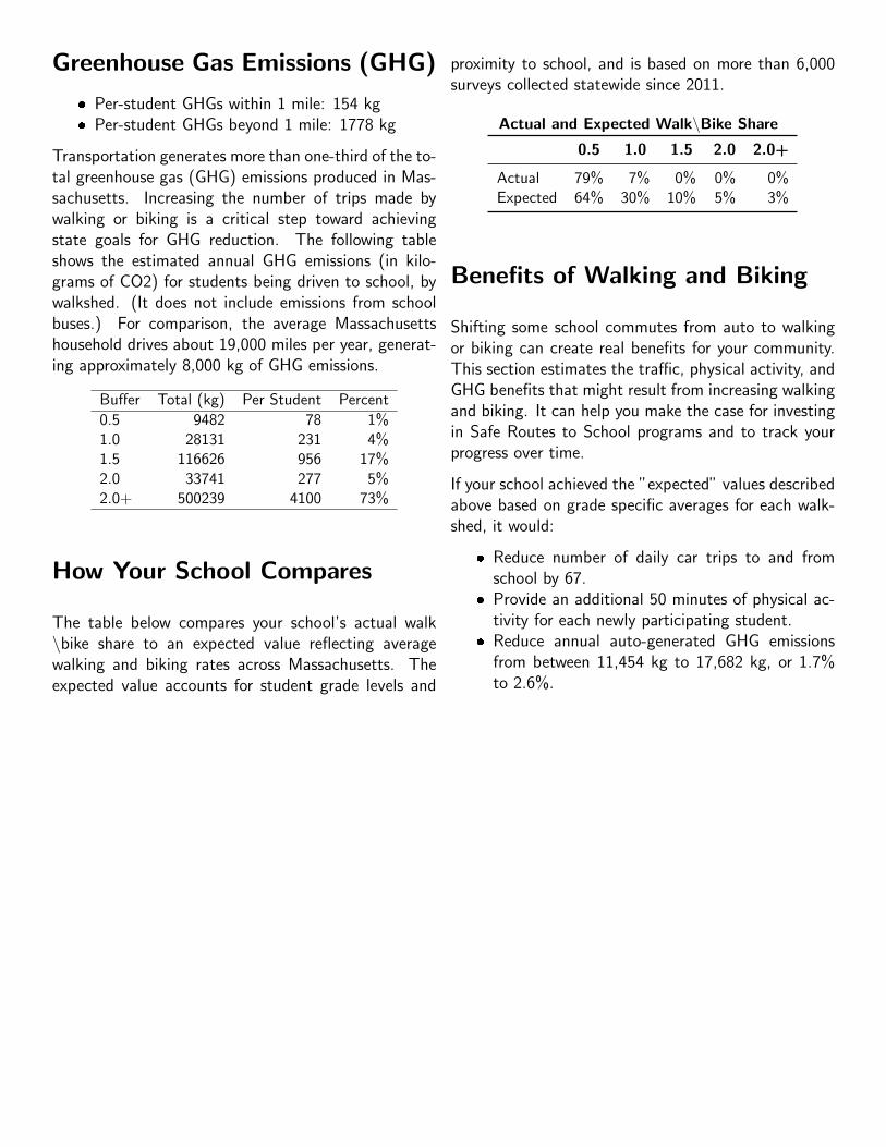
Greenhouse Gas Emissions (GHG)
� Per-student GHGs within 1 mile: 154 kg� Per-student GHGs beyond 1 mile: 1778 kg
Transportation generates more than one-third of the to-tal greenhouse gas (GHG) emissions produced in Mas-sachusetts. Increasing the number of trips made bywalking or biking is a critical step toward achievingstate goals for GHG reduction. The following tableshows the estimated annual GHG emissions (in kilo-grams of CO2) for students being driven to school, bywalkshed. (It does not include emissions from schoolbuses.) For comparison, the average Massachusettshousehold drives about 19,000 miles per year, generat-ing approximately 8,000 kg of GHG emissions.
Buffer Total (kg) Per Student Percent
0.5 9482 78 1%1.0 28131 231 4%1.5 116626 956 17%2.0 33741 277 5%2.0+ 500239 4100 73%
How Your School Compares
The table below compares your school’s actual walk\bike share to an expected value reflecting averagewalking and biking rates across Massachusetts. Theexpected value accounts for student grade levels and
proximity to school, and is based on more than 6,000surveys collected statewide since 2011.
Actual and Expected Walk\Bike Share
0.5 1.0 1.5 2.0 2.0+
Actual 79% 7% 0% 0% 0%Expected 64% 30% 10% 5% 3%
Benefits of Walking and Biking
Shifting some school commutes from auto to walkingor biking can create real benefits for your community.This section estimates the traffic, physical activity, andGHG benefits that might result from increasing walkingand biking. It can help you make the case for investingin Safe Routes to School programs and to track yourprogress over time.
If your school achieved the ”expected” values describedabove based on grade specific averages for each walk-shed, it would:
� Reduce number of daily car trips to and fromschool by 67.
� Provide an additional 50 minutes of physical ac-tivity for each newly participating student.
� Reduce annual auto-generated GHG emissionsfrom between 11,454 kg to 17,682 kg, or 1.7%to 2.6%.
A s h l a n d
ASHLAND
90
90
9
135
90
135
135
30
126
126
126
135
99
tSdnalhgiH
dRretsecroW
Ashland St
tSretniW
tStceps
orP
tSkaO
tSkaO
dRekpT
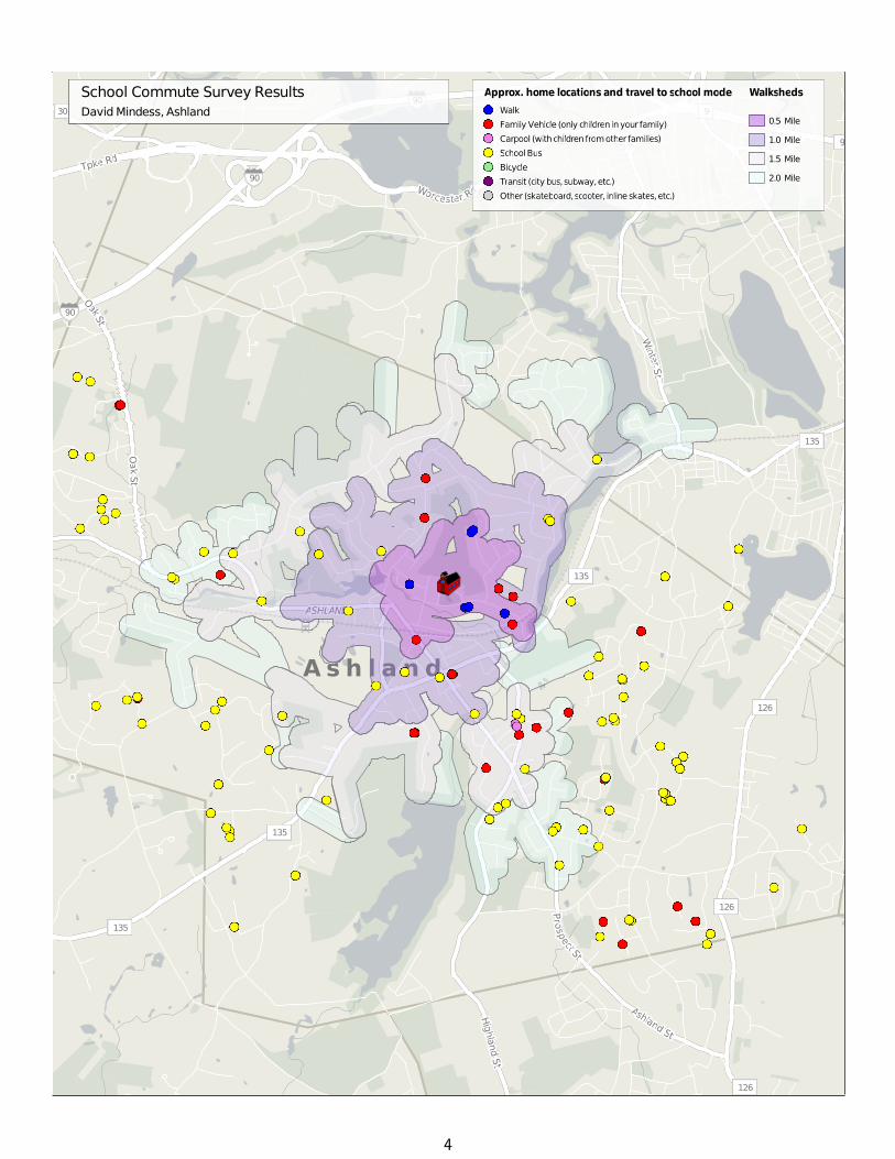
School Commute Survey ResultsDavidMindess, Ashland
Approx. home locations and travel to school mode Walksheds
Walk
Family Vehicle (only children inyour family)
Carpool (withchildren fromother families)
SchoolBus
Bicycle
Transit (city bus,subway,etc.)
Other (skateboard,scooter, inline skates,etc.)
0.5 Mile
1.0 Mile
1.5 Mile
2.0 Mile
4

David Mindess Elementary School Walk Assessment 35
This report was prepared by:
January 2017
Related Documents