University of Nebraska - Lincoln DigitalCommons@University of Nebraska - Lincoln USGS Staff -- Published Research US Geological Survey 2013 Dating North America’s oldest petroglyphs, Winnemucca Lake subbasin, Nevada L.V. Benson University of Colorado at Boulder, [email protected] E.M. Haori Nevada State Museum J. Southon University of California - Irvine B. Aleck Pyramid Lake Paiute Tribe Museum and Visitor Center Follow this and additional works at: hp://digitalcommons.unl.edu/usgsstaffpub is Article is brought to you for free and open access by the US Geological Survey at DigitalCommons@University of Nebraska - Lincoln. It has been accepted for inclusion in USGS Staff -- Published Research by an authorized administrator of DigitalCommons@University of Nebraska - Lincoln. Benson, L.V.; Haori, E.M.; Southon, J.; and Aleck, B., "Dating North America’s oldest petroglyphs, Winnemucca Lake subbasin, Nevada" (2013). USGS Staff -- Published Research. 778. hp://digitalcommons.unl.edu/usgsstaffpub/778

Welcome message from author
This document is posted to help you gain knowledge. Please leave a comment to let me know what you think about it! Share it to your friends and learn new things together.
Transcript
University of Nebraska - LincolnDigitalCommons@University of Nebraska - Lincoln
USGS Staff -- Published Research US Geological Survey
2013
Dating North America’s oldest petroglyphs,Winnemucca Lake subbasin, NevadaL.V. BensonUniversity of Colorado at Boulder, [email protected]
E.M. HattoriNevada State Museum
J. SouthonUniversity of California - Irvine
B. AleckPyramid Lake Paiute Tribe Museum and Visitor Center
Follow this and additional works at: http://digitalcommons.unl.edu/usgsstaffpub
This Article is brought to you for free and open access by the US Geological Survey at DigitalCommons@University of Nebraska - Lincoln. It has beenaccepted for inclusion in USGS Staff -- Published Research by an authorized administrator of DigitalCommons@University of Nebraska - Lincoln.
Benson, L.V.; Hattori, E.M.; Southon, J.; and Aleck, B., "Dating North America’s oldest petroglyphs, Winnemucca Lake subbasin,Nevada" (2013). USGS Staff -- Published Research. 778.http://digitalcommons.unl.edu/usgsstaffpub/778

Dating North America’s oldest petroglyphs, Winnemucca Lakesubbasin, Nevada
L.V. Benson a,*, E.M. Hattori b, J. Southon c, B. Aleck d
aMuseum of Natural History, University of Colorado, 602 Pine Street, Boulder, CO 30302, USAbNevada State Museum, Carson City, NV 89701, USAc Earth System Science, University of California, Irvine, CA 92697, USAd Pyramid Lake Paiute Tribe Museum and Visitor Center, Nixon, NV 89424, USA
a r t i c l e i n f o
Article history:Received 30 March 2013Received in revised form14 June 2013Accepted 15 June 2013
Keywords:PetroglyphsRock artGreat BasinWinnemucca LakePyramid Lake
a b s t r a c t
On the west side of the Winnemucca Lake subbasin, Nevada, distinctive deeply carved meter-scalepetroglyphs are closely spaced, forming panels on boulder-sized surfaces of a partially collapsed tufamound. The large, complex motifs at this side are formed by deeply carved lines and cupules. A carbonatecrust deposited between 10 200 and 9800 calibrated years B.P. (ka) coats petroglyphs at the base of themound between elevations of 1202 and 1206 m. Petroglyphs above the carbonate crust are carved into abranching form of carbonate that dates to 14.8 ka. Radiocarbon dates on a multiple-layered algal tufa onthe east side of the basin, which formed at an elevation of 1205 m, as well as a sediment-core-based totalinorganic carbon record for the period 17.0e9.5 ka indicate that water level in the Winnemucca Lakesubbasin was constrained by spill over the Emerson Pass Sill (1207 m) for most of the time between12.9 � 0.3 and �9.2 ka. These and other data indicate that the lake in the Winnemucca Lake subbasin fellbeneath its spill point between 14.8 and 13.2 ka and also between 11.3 and 10.5 ka (or between 11.5 and11.1 ka), exposing the base of the collapsed tufa mound to petroglyph carving. The tufa-based 14C recordsupports decreased lake levels between 14.8e13.2 ka and 11.3e10.5 ka. Native American artifacts foundin the Lahontan Basin date to the latter time interval. This does not rule out the possibility that petro-glyph carving occurred between 14.8 and 13.2 ka when Pyramid Lake was relatively shallow and Win-nemucca Lake had desiccated.
Published by Elsevier Ltd.
1. Introduction
1.1. Early American art forms
Recent Paleoindian research in the Americas (Dillehay et al.,2008; Gilbert et al., 2008; Overstreet and Stafford, 1997) suggeststhat humans reached the Americas prior to the Clovis period, whichbegan w13 100 calendar years before present (hereafter 13.1 ka).The earliest art in the Americas is arguably represented by a frag-mented fossil bone from Florida (Purdy et al., 2011). The bone ap-pears to be engraved with the figure of a mammoth, whose fossilremains date no later than 13 ka in eastern North America (Faithand Surovell, 2009; Grayson and Meltzer, 2003). The earliestpetroglyph in South America is a pecked anthropomorphic figure incentral-eastern Brazil; it has a minimum age of w10.6 ka and may
be as old as 12 ka (Neves et al., 2012). Prior to our study, the oldestpetroglyphs in North America (Cannon and Ricks, 1986) were rep-resented by a panel of deeply incised, tightly clustered geometricpetroglyphs from a cliff face along a basalt ridge at Long Lake insouth-central Oregon. These petroglyphs were subsequently partlyburied by the 7.63 ka Mount Mazama tephra (Zdanowicz et al.,1999). Here we report on early Archaic/Paleoindian petroglyphsfrom the Winnemucca Lake subbasin, Nevada, that were carvedsometime between 14.8 � 0.2 and 10.3 � 0.1 ka.
1.2. The Winnemucca Lake petroglyph site
The Lahontan Basin (Fig. 1A) is located on the western edge ofthe Great Basin of the western USA. Three subbasins occupy thewestern side of the Lahontan Basin, Pyramid Lake, WinnemuccaLake, and the Smoke Creek-Black Rock Desert subbasins. On thewestern edge of the Winnemucca Lake subbasin, Nevada, justinside the eastern boundary of the Pyramid Lake Indian Reser-vation (site WDL12, Fig. 1B), numerous deeply carved meter-scale
* Corresponding author. Tel.: þ1 303 4495529.E-mail address: [email protected] (L.V. Benson).
Contents lists available at SciVerse ScienceDirect
Journal of Archaeological Science
journal homepage: http: / /www.elsevier .com/locate/ jas
0305-4403/$ e see front matter Published by Elsevier Ltd.http://dx.doi.org/10.1016/j.jas.2013.06.022
Journal of Archaeological Science 40 (2013) 4466e4476

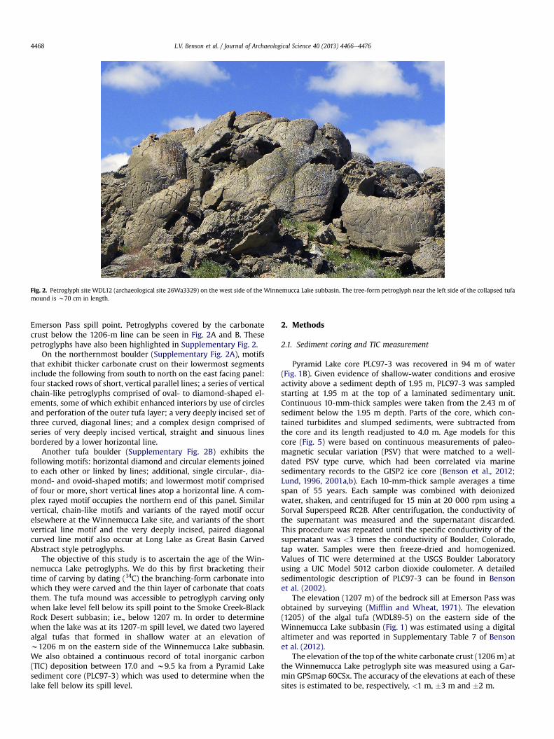
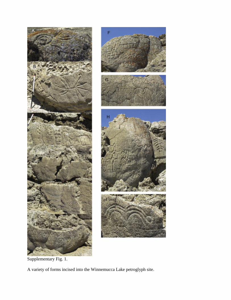
petroglyphs are closely spaced, forming panels on boulder-sizedsurfaces of a partially collapsed tufa mound (Fig. 2,Supplementary Fig. 1).
The Winnemucca Lake petroglyph site 26Wa3329 (also knownby its earlier site designation NV-Wa-29 in the University of Cali-fornia archaeological site files) was recognized as an unusual, andpossibly, very early petroglyph site by Connick and Connick (1992).Their survey of Great Basin, California, and Southwestern archae-ological and ethnographic literature revealed a suite of attributesthat distinguished theWinnemucca Lake petroglyphs from the vastmajority of other Great Basin petroglyph and pictograph sites. Themotifs at this side are large and complex. Deeply carved lines(“grooves”) and dots (“cups” or cupules) form complex designs. Thecarvings are commonly 1e2 cm deep with cupules occurring onvertical versus horizontal surfaces. Some of the petroglyph motifsare represented elsewhere in the western Great Basin but they areneither oversized nor deeply incised. Missing from this site aresome of the more common younger Great Basin petroglyph motifs,including zoomorphs, anthropomorphs, and handprints. Connickand Connick (1992) suggested that the Winnemucca Lake petro-glyphs represented various meteorological symbols, e.g., cloudsand lightning, associated with ethnographic and archaeologicalcultures from the American Southwest and southern California. Ouranalysis, however, found closer technological, chronological, and
design concordance with a site in south central Oregon, as well asother localities in the western Great Basin.
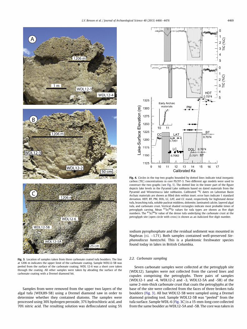
During an early trip to the petroglyph site, the senior authornoticed that some petroglyphs on an east facing panel near thebase of the tufa mount were partially coated with a thin whitecarbonate crust that reached an elevation of w1206 m (Fig. 3), theapproximate elevation of the northern spill point (Emerson Passat w1207 m) of the Winnemucca and Pyramid lake subbasins tothe Smoke Creek-Black Rock Desert subbasin (Fig. 1). Above thecarbonate crust, it is apparent that the petroglyphs were originallycarved into a branching form of tufa (Benson, 1994), which wasdeposited between 16.2 and 14.8 ka (Supplementary Table 1, BTsamples in Fig. 4). In some instances, the lower portions of severalelements on this panel are coated by the carbonate crust whilethe upper portions of the same elements remain uncoated or areonly lightly coated because they are situated above the boundaryfor the zone of carbonate precipitation at w1206 m. Somepetroglyph elements on these panels are partially or entirelycovered by varying thicknesses of the carbonate crust and motifdetails obscured.
The carbonate crust appears to thin in an upward direction,probably indicating deposition during differing overflow velocities;the higher the overflow velocity the higher the elevation of car-bonate deposition at the petroglyph site which lies far south of the
Fig. 1. A. The Lake Lahontan Basin, which contains seven lake subbasins separated by seven spill points (sills); B. The Pyramid and Winnemucca lake subbasins, Nevada. Astor Pass,Emerson Pass, and Mud Lake Slough spill points (dark red rectangles) are labeled, respectively, AP, EP, and MLS. Historic pre-irrigation surface areas of Pyramid and WinnemuccaLakes are bounded by thin black lines. WDL12 is the petroglyph site; WDL89-5 is the algal tufa site. The PLC97-3 sediment core site is shown as a blue square. Petroglyphs coated bythe carbonate crust in A and B have been highlighted in Supplementary Fig. 2. (For interpretation of the references to colour in this figure legend, the reader is referred to the webversion of this article.)
L.V. Benson et al. / Journal of Archaeological Science 40 (2013) 4466e4476 4467
Emerson Pass spill point. Petroglyphs covered by the carbonatecrust below the 1206-m line can be seen in Fig. 2A and B. Thesepetroglyphs have also been highlighted in Supplementary Fig. 2.
On the northernmost boulder (Supplementary Fig. 2A), motifsthat exhibit thicker carbonate crust on their lowermost segmentsinclude the following from south to north on the east facing panel:four stacked rows of short, vertical parallel lines; a series of verticalchain-like petroglyphs comprised of oval- to diamond-shaped el-ements, some of which exhibit enhanced interiors by use of circlesand perforation of the outer tufa layer; a very deeply incised set ofthree curved, diagonal lines; and a complex design comprised ofseries of very deeply incised vertical, straight and sinuous linesbordered by a lower horizontal line.
Another tufa boulder (Supplementary Fig. 2B) exhibits thefollowing motifs: horizontal diamond and circular elements joinedto each other or linked by lines; additional, single circular-, dia-mond- and ovoid-shaped motifs; and lowermost motif comprisedof four or more, short vertical lines atop a horizontal line. A com-plex rayed motif occupies the northern end of this panel. Similarvertical, chain-like motifs and variants of the rayed motif occurelsewhere at the Winnemucca Lake site, and variants of the shortvertical line motif and the very deeply incised, paired diagonalcurved line motif also occur at Long Lake as Great Basin CarvedAbstract style petroglyphs.
The objective of this study is to ascertain the age of the Win-nemucca Lake petroglyphs. We do this by first bracketing theirtime of carving by dating (14C) the branching-form carbonate intowhich they were carved and the thin layer of carbonate that coatsthem. The tufa mound was accessible to petroglyph carving onlywhen lake level fell below its spill point to the Smoke Creek-BlackRock Desert subbasin; i.e., below 1207 m. In order to determinewhen the lake was at its 1207-m spill level, we dated two layeredalgal tufas that formed in shallow water at an elevation ofw1206 m on the eastern side of the Winnemucca Lake subbasin.We also obtained a continuous record of total inorganic carbon(TIC) deposition between 17.0 and w9.5 ka from a Pyramid Lakesediment core (PLC97-3) which was used to determine when thelake fell below its spill level.
2. Methods
2.1. Sediment coring and TIC measurement
Pyramid Lake core PLC97-3 was recovered in 94 m of water(Fig. 1B). Given evidence of shallow-water conditions and erosiveactivity above a sediment depth of 1.95 m, PLC97-3 was sampledstarting at 1.95 m at the top of a laminated sedimentary unit.Continuous 10-mm-thick samples were taken from the 2.43 m ofsediment below the 1.95 m depth. Parts of the core, which con-tained turbidites and slumped sediments, were subtracted fromthe core and its length readjusted to 4.0 m. Age models for thiscore (Fig. 5) were based on continuous measurements of paleo-magnetic secular variation (PSV) that were matched to a well-dated PSV type curve, which had been correlated via marinesedimentary records to the GISP2 ice core (Benson et al., 2012;Lund, 1996, 2001a,b). Each 10-mm-thick sample averages a timespan of 55 years. Each sample was combined with deionizedwater, shaken, and centrifuged for 15 min at 20 000 rpm using aSorval Superspeed RC2B. After centrifugation, the conductivity ofthe supernatant was measured and the supernatant discarded.This procedure was repeated until the specific conductivity of thesupernatant was <3 times the conductivity of Boulder, Colorado,tap water. Samples were then freeze-dried and homogenized.Values of TIC were determined at the USGS Boulder Laboratoryusing a UIC Model 5012 carbon dioxide coulometer. A detailedsedimentologic description of PLC97-3 can be found in Bensonet al. (2002).
The elevation (1207 m) of the bedrock sill at Emerson Pass wasobtained by surveying (Mifflin and Wheat, 1971). The elevation(1205) of the algal tufa (WDL89-5) on the eastern side of theWinnemucca Lake subbasin (Fig. 1) was estimated using a digitalaltimeter and was reported in Supplementary Table 7 of Bensonet al. (2012).
The elevation of the top of the white carbonate crust (1206m) atthe Winnemucca Lake petroglyph site was measured using a Gar-min GPSmap 60CSx. The accuracy of the elevations at each of thesesites is estimated to be, respectively, <1 m, �3 m and �2 m.
Fig. 2. Petroglyph site WDL12 (archaeological site 26Wa3329) on the west side of the Winnemucca Lake subbasin. The tree-form petroglyph near the left side of the collapsed tufamound is w70 cm in length.
L.V. Benson et al. / Journal of Archaeological Science 40 (2013) 4466e44764468
Samples from were removed from the upper two layers of thealgal tufa (WDL89-5B) using a Dremel diamond saw in order todetermine whether they contained diatoms. The samples wereprocessed using 30% hydrogen peroxide, 37% hydrochloric acid, and70% nitric acid. The resulting solution was deflocculated using 5%
sodium pyrophosphate and the residual sediment was mounted inNaphrax (r.i. �1.71). Both samples contained well-preserved Ste-phanodiscus hantzschii. This is a planktonic freshwater speciesfound today in lakes in British Columbia.
2.2. Carbonate sampling
Seven carbonate samples were collected at the petroglyph site(WDL12). Samples were not collected from the carved lines andcupules comprising the petroglyphs. Three pairs of samples(WDL12-1 and -4, WDL12-2 and -3, WDL12-5A and -5B) of thesame 2-mm-thick carbonate crust that coats the petroglyphs at thebase of the site were collected from the faces of three broken tufaboulders (Fig. 3). All but WDL12-5B were sampled using a Dremeldiamond grinding tool. Sample WDL12-5B was “peeled” from thetufa surface. SampleWDL-6 (Fig. 3C) is a 15-mm-long core collectedfrom the same boulder asWDL12-5A and -5B. The corewas taken in
Fig. 3. Location of samples taken from three carbonate coated tufa boulders. The lineat 1206 m indicates the upper limit of the carbonate coating. Sample WDL12-5B waspeeled from the surface of the carbonate coating; WDL 12-6 was a short core takenthrough the coating. All other samples were taken by abrading the surface of thecarbonate coating with a Dremel diamond bit.
Fig. 4. Circles in the top two graphs bounded by dotted lines indicate total inorganiccarbon (TIC) concentrations in core PLC97-3. Two different age models were used toconstruct the two graphs (see Fig. 5). The dotted line in the lower part of the figuredepicts lake levels in the Pyramid Lake subbasin based on dated materials from thePyramid and Winnemucca lake subbasins. Calibrated 14C dates on Lahontan BasinArchaic materials are shown as filled dots within inset; error bars indicate 1 standarddeviation. HDT, BT, PM, DOL, LC, LAT, and CC stand, respectively for highstand densetufa, branching tufa, soluble packrat middens, dolomite, laminated calcite, layered algaltufa, and carbonate crust. Vertical shaded rectangles indicate most probable times ofpetroglyph carving. Mean 87Sr/86Sr values for tufa types are shown as five digitnumbers. The 87Sr/86Sr value of the dense tufa underlying the carbonate crust at thepetroglyph site (open circle with cross) is shown as an italicized five digit number.
L.V. Benson et al. / Journal of Archaeological Science 40 (2013) 4466e4476 4469

order to penetrate a dense carbonate layer (WDL12-6B) that waslocated beneath the carbonate crust.
Radiocarbon ages were obtained on non-archaeological tufas.Two layered algal tufas (WDL89 5B and 5C) that had been collectedin 1989 from the east side of the Winnemucca Lake subbasin weresubsampled using a diamond Dremel bit. Powdered samples fromfive layers in WDL89 5B and three layers in WDL89 5C werecollected (Fig. 6). Both algal tufas were coated with a carbonatecrust similar in appearance to the crust coating the base of thepetroglyph site. Carbonate crusts at both sites (WDL12 andWDL89)formed at elevations slightly below 1206 m.
2.3. Processes that shift the 14C age of samples from their times ofdeposition
All 15 carbonate samples were 14C dated at the University ofCalifornia-Irvine W.M. Keck Carbon Cycle Accelerator Mass Spec-trometry Laboratory. All data in this paper were calibrated usingStuiver and Reimer, 1993 (version 5.0) together with intcal09.14c.
2.3.1. The reservoir effectIn some situations, 14C dates on lacustrine carbonates are sub-
ject to a “reservoir effect”, wherein, the presence of excess deadcarbon can shift the apparent 14C ages of carbon-bearing materialsto values older than their actual dates of formation/deposition.Dead carbon can enter the lake via surface-water input as well asdiffusion/advection across the sedimentewater interface. Atmo-spheric CO2, containing modern carbon, can minimize and eveneliminate the reservoir effect if the gas exchange rate across theairewater interface is sufficiently rapid.
The overflow of water from the Pyramid-Winnemucca Lakecomplex to the Smoke Creek-Black Rock Desert can lessen and eveneliminate a preexisting reservoir effect. Spill across the Emerson
Fig. 5. Two PSV-based age models for core PLC97-3. Black dots are PSV ages acquiredby matching the PSV record in PLC97-3 to the PSV record in well-dated sediment cores.Dashed lines in A. indicate the limits of each polynomial fit to PSV subsets. PSV ages areaccurate within �200 years.
Fig. 6. A. Algal tufa sample WDL89-5B; B. cross section through WDL89-5B showing locations of five 14C dated samples; C. algal tufa sample WDL89-5C; D. cross section throughWDL89-5C showing locations of three 14C dated samples.
L.V. Benson et al. / Journal of Archaeological Science 40 (2013) 4466e44764470

Pass Sill (Fig. 1) implies that the Truckee River was discharging alarge volume of water to the lake occupying the Pyramid andWinnemucca lake subbasins. The increasing fraction of modern-carbon-bearing snow-melt runoff relative to the fraction of dead-carbon-bearing groundwater in the Truckee River during times ofspill over Emerson Pass resulted in declines in the fraction of deadcarbon in the river as well as a reduction in the ionic strength(salinity) of lake water. Gas (CO2) exchange operates more effi-ciently as the concentration of dissolved inorganic carbon (DIC)decreases, effectively removing the dead carbon dissolved in thelake. Therefore, increased stream-flow discharge to a lake and (or)increased spill from the lake to an adjacent subbasin tend tominimize a lake’s reservoir effect.
Carbonates found at elevations slightly below 1207 m weredepositedwhen the lakewas hydrologically open and spilling acrossthe Emerson Pass Sill. Carbon isotopes in the total organic carbonfraction (TOC) fraction of lake sediment generally have the sameratios as carbonates (e.g., tufas) deposited at the same time, giventhat the have the same carbon source, the DIC in lakewater.We can,therefore, assess the magnitude of the reservoir effect during timesof spill by comparing the PSV-based age of a sediment sample withthe calibrated 14C age of the TOC fraction in that sample. During therise of Lake Lahontan (30e25 ka) and during its intermittent spill tothe Carson Desert subbasin (25e18 ka) (Fig. 7A), the calibrated 14Cages of the TOC fraction in four sediment samples were less than orequal to their PSV ages (Fig. 7B), demonstrating that a substantialreservoir effect was not present in Lake Lahontan during its spill toan adjacent subbasin. Therefore, the 14C ages of tufas deposited
during spill over the Emerson Pass Sill should not be expected tohave been offset by a substantial reservoir effect.
2.3.2. The addition of modern carbon during subaerial exposureThe addition of modern carbon during subaerial exposure can
shift the age of deposition of a carbonate to younger values. Addi-tion of modern carbon to the porous carbonate crusts that coattufas at both WDL12 and WDL89-5 sites is likely to have occurredthroughout the Holocene after the crust was subaerially exposed tolow-pH precipitation. Rain water may have dissolved part of thecrust and the resulting solution, which contained both old andmodern carbon, would have subsequently warmed, causing CaCO3,containing some modern carbon, to reprecipitate within the porespaces in the carbonate crust. To check for contamination withsecondary carbon, 50% of each of eight algal layers was leachedprior to AMS 14C analysis. We later decided to remove (acid leach)differing amounts (20, 40, 50, 60, and 80%) of five subsamples fromWDL89 5C-1 to determine how the age of the porous carbonatecrust changed with amount leached. WDL89 5C-1 was chosen forthis experiment, given that it was most likely to have sufferedsecondary contamination with modern carbon. The results of thisexperiment (Table 1) indicated that the age of the sample increasedwith the amount of sample removed. As a result, we decided toremove 80% of each sample prior to AMS 14C analysis, except forWDL89 5B-5 for which insufficient material remained.
It should be noted that the 14C date of WDL89 5C-1 never“leveled off” as a function of leaching (Supplementary Fig. 3). Thisimplies the existence of a refractory carbonate contaminant in thecarbonate crust and suggests that the resulting 14C ages obtained onsamples of the carbonate crust from both the collapsed tufa moundand the algal tufas represent minimum values.
2.4. Strontium-isotope analyses
Nine samples (five algal layers, three carbonate crusts from thepetroglyph site, and the dense carbonate found below the car-bonate crust at the WDL12 site) were also subjected to 87Sr/86Sranalysis. The 87Sr/86Sr analyses were done at the University ofColorado heavy-isotopes laboratory. The error in the 87Sr/86Sr an-alyses was <1 unit in the fifth decimal place. Previous 87Sr/86Sranalyses of Pyramid Lake tufas (Benson and Peterman, 1995) arelisted in Supplementary Table 1.
3. Results and discussion
3.1. Tufa-based elevation history of Lake Lahontan
The 14C-dated tufa sequence in Fig. 4 indicates that LakeLahontan receded from its highstand between 15 and w14.5 ka.Dolomite formed in the Pyramid Lake subbasin betweenw14.4 and13.9 ka, implying the existence of a relatively shallow, saline lake.The oldest dolomite date (14.4 ka) is considered themost reliable asthe porous dolomite may have been subsequently contaminatedwith younger carbonate precipitated from Pyramid Lake. There isno record of carbonate deposition between 13.9 and 12.8 ka, sug-gesting the lake may have fallen below 1160 m at this time. Be-tween 12.8 and 11.1 ka, laminated low-magnesium calcite wasdeposited on the western edge of the Pyramid Lake subbasin,indicating the presence of a deep freshwater lake.
3.2. Age of the branching tufa into which the petroglyphs werecarved
Petroglyphs found above the carbonate crust have been carvedinto a branching form of tufa. The ages and 87Sr/86Sr values of the
Fig. 7. A. Relative elevation of Lake Lahontan between 33 and 16 ka (Benson et al.,2012). Decreasing values of d18O in this sediment core indicate increasing lake eleva-tion or spill rate across the Darwin Pass Sill into the Carson Desert subbasin. The arrowindicates lake-level rise between 30 and 25 ka, and the shaded area indicates an in-terval of intermittent spill across Darwin Pass Sill between 25 and 17 ka; B. Calibrated14C ages of four sediment samples in Pyramid Lake core PLC08-1 versus their PSV-based ages (Benson et al., 2012). The PSV-based ages have been tied to the GISP2ice-core layer-counted chronology. The data indicate the lack of a reservoir effect whenthe lake in the Pyramid Lake subbasin was rising and when it was spilling to anadjacent subbasin.
L.V. Benson et al. / Journal of Archaeological Science 40 (2013) 4466e4476 4471

Table 1Calibrated 14C ages and 87Sr/86Sr analyses of carbonate samples from sites WDL89 and WDL12 on, respectively, the east and west sides of the Winnemucca Lake subbasin.
Sample name Layer type Ele. (m) UCIAMS no. Leach(%)
14C Age(BP)
� Calib age1 � s range
Area (%) Calib age2 � s range
Area (%) Calib 1 � s
age (midpt)� 87Sr/86Sr
(err ¼ 0.00001)
Algal tufas from east side of Winnemucca Lake BasinWDL89 5B-1 2e3 mm white
crust1205 10 8535 50 8635 20 9542e9561 67 9538e9631 98 9550 10
10 8732 80 8800 25 9766e9898 100 9696e9917 99 9830 70 0.70589WDL89 5B-2 3-mm stromatolite
layer1205 10 8536 50 10 030 20 11 404e11 459 33 11 393e11 641 94 11 430 30
10 8733 80 10 080 25 11 611e11 754 97 11 593e11 811 79 11 680 70 0.70604WDL89 5B-3 1-mm white layer 1205 10 8537 50 9770 20 11 197e11 220 100 11 184e11 232 100 11 210 10
10 8734 80 9990 25 11 327e11 409 52 11 303e11 507 70 11 370 40WDL89 5B-4 1-mm stromatolite
layer1205 10 8538 50 10 280 25 12 004e12 008 100 11 970e12 140 100 12 050 40 0.70604
10 8735 80 10 380 25 12 270e12 379 61 12 105e12 390 100 12 320 50WDL89 5B-5 2e4 mm gray layer 1205 10 8539 50 10 370 25 12 132e12 221 50 12 243e12 387 51 12 180 40 0.70622WDL89 5C-1 1-mm white crust 1205 108 548 20 8505 20 9498e9527 100 9484e9533 100 9510 10
108 549 40 8565 25 9530e9543 100 9516e9550 96 9540 10108 540 50 8630 25 9540e9562 65 9535e9633 96 9550 10108 551 60 8680 20 9556e9630 92 9551e9680 100 9590 40108 736 80 8700 20 9598e9680 95 9557e9696 100 9640 40108 550 80 8985 25 10 174e10 208 100 10 153e10 230 98 10 190 20
WDL89 5C-6 4e6 mm stromatolitelayer
1205 108 542 50 10 000 25 11 429e11 495 36 11 315e11 616 100 11 460 30108 738 80 10 145 25 11 756e11 828 55 11 704e11 849 55 11 790 40
WDL89 5C-5 2e4 mm gray layer 1205 108 541 50 10 570 30 12 528e12 586 75 12 517e12 622 68 12 580 30108 737 80 10 645 30 12 558e12 619 100 12 545e12 667 100 12 590 30 0.70623
Tufa coatings from west side of Winnemucca Lake Basin (petroglyph site)WDL12-1 Abraded white crust 1206 109 220 80 7900 15 8666e8717 68 8627e8770 98 8690 30WDL12-4 Abraded white crust 1206 109 221 80 8785 15 9736e9797 53 9703e9893 100 9770 30 0.70616WDL12-2 Abraded white crust 1204 109 222 80 8860 15 10 063e10 123 60 10 052e10 154 53 10 090 30WDL12-3 Abraded white crust 1204 109 223 80 9075 15 10 227e10 240 100 10 215e10 247 99 10 230 10 0.70621WDL12-5A Abraded white crust 1203 109 224 80 8890 15 9985e10 045 44 9915e10 097 78 10 020 30WDL12-5B Pieces of white crust 1203 109 225 80 8920 15 9948e9989 46 9923e9996 41 9970 20 0.70623WDL12-6B Carbonate below crust 1203 109 226 80 10 000 15 11 432e11 493 37 11 329e11 503 64 11 460 30 0.70606
11 550e11 601 37 11 570 30
Abraded white crust refers to a carbonate coating that was sampled with a dremel grinding tool. Area refers to the relative area under the probability curve. Leach to the amount of carbonate removed prior to 14C analysis refers.
L.V.Bensonet
al./Journal
ofArchaeological
Science40
(2013)4466
e4476
4472

branching tufas are essentially the same as those of dense tufasformed during the Lahontan highstand (Table S1, Fig. 4), indicatingthat the petroglyphs above the carbonate crust were carved intodeep-water branching tufas that formed prior to 14.8 ka.
3.3. Age of the carbonate that coats the petroglyphs
To provide a minimum age for carving of the low-elevation(1202e1206 m) petroglyphs, we dated the carbonate crust thatcoats the petroglyphs (Fig. 3). The six carbonate-crust samples fromthe petroglyph site (WDL12) exhibited an age range of 10.23e9.77 ka with one outlier at 8.69 ka (Table 1). As the sample abrasionprocess did not always reach the inner (oldest) part of the car-bonate crust, we conclude that initial deposition of the carbonatecrust occurred at 10.2 ka and continued until 9.8 ka, a conjectureconsistent with the TIC data discussed in Section 3.5, which in-dicates that lake level was constrained by overflow at 1207 m untilw9.3 � 0.1 ka. We, therefore, conclude that the petroglyphs werecarved sometime between 14.8 and 10.2 ka.
3.4. Time of deposition of the algal tufas
We also dated individual layers within algal tufas (Fig. 5B and D)from the same approximate elevation (1205 m) on the eastern sideof the Winnemucca Lake subbasin (Table 1) in order to establishdiscrete times during which the lake occupying the Pyramid andWinnemucca lake subbasins was spilling across Emerson Pass.Substantial deposition of carbonate occurs when the surfaceelevation of a lake is stabilized by spill to an adjacent subbasin.CaCO3, which exhibits retrograde solubility, will precipitate in thewarm shallow water immediately below the spill elevation; hencethe observed preferential deposition of carbonate between 1202and 1206 m. Three pieces of this carbonate tufa (WDL89-5), notincluding its carbonate crust, had been previously shown to havedates ranging from 12.5 to 11.3 ka (Supplementary Table 1).
After leaching, the carbonate crusts coating the WDL89 5B-1and 5C-1 samples produced calibrated ages of 10.2, 9.83, and9.64 ka (Table 1). Radiocarbon analyses of the dense carbonatelayers within the two WDL89-5 samples indicated a calibrated agerange of 12.59e11.43 ka (Table 1), implying that the lake occupyingthe two subbasins had been at or near the Emerson Pass spill point(1207 m) during much of that time interval. The fact that the87Sr/86Sr values and age ranges of the algal tufas and laminatedcarbonates are almost identical (Fig. 4) supports the existence of arelatively deep and freshwater lake in the Pyramid and Winne-mucca subbasins much of the time between 12.8 and 11.3 ka.
3.5. TIC and the continuous record of spill from the PyramideWinnemucca Lake complex
Although highly informative, the tufa data are discontinuous intime and do not allow us to determine how continuous was thelake’s occupation of the 1207-m spill point. This is critical because,during times of spill across Emerson Pass, the base of the tufamound was under water and was, therefore, not accessible for thecarving of petroglyphs. To address this question, we plotted thecontinuous set of TIC concentrations in sediment core PLC97-3 forthe interval 17.0 to w9.5 ka (Fig. 4). In doing this we implementedtwo age models for PLC97-3. The uppermost TIC record in Fig. 4relies on the age model depicted in Fig. 5A and the lower TIC re-cord in Fig. 4 relies on the age model depicted in Fig. 5B. Thestriking difference in the two TIC records between 11.5 and 10.5 ka(Fig. 4) attests to the sensitivity of the fit to the PSV ages in theupper part (<2.2 m) of PLC97-3 when sedimentation rates wereextremely low.
When a lake increases in volume or overflows to an adjacentbasin, the concentrations of dissolved Ca2 and CO2�
3 decrease and,therefore, the frequency and amount of CaCO3 precipitated alsodecreases. Thus, the amount of TIC recorded in lake sediment de-creases duringwet periods. On the other hand, when a lake exists ina hydrologically closed state or decreases in size, the relative con-centration of TIC increases in its sediments (see, e.g., Benson et al.,2012). The continuous TIC records in Fig. 4 indicate that LakeLahontan fell from its highstand level at w15 ka reaching a level ofw1165m at 14.5 ka and then remained hydrologically closed at lowlevels until w13.3 ka. At that time, it rose to its 1207 m spill pointand remained there for much of the time between 13.2 andw9.5 ka.
The TIC records resulting from the two age models indicate thatthe base of the petroglyph site was subaerially exposed between15.0 and 13.2 ka and was subject to the carving of petroglyphs.However, the TIC records resulting from the two age models indi-cate different times of possible subaerial exposure after 13.2 ka.One age model (Fig. 5A) indicates that the base of site WDL12 wassubaerially exposed between 11.3 and 10.5 ka and the other agemodel (Fig. 5B) indicates that the base of site WDL12 was subaer-ially exposed between 11.5 and 11.1 ka.
3.6. What underlies the carbonate crust at site WDL12?
Unfortunately, we were not permitted to explore the layeringhistory directly associated with a carbonate encrusted petroglyph.Therefore, we do not know whether some or all of the dense layerspresent in the WDL89-5 samples also are present beneath thecarbonate crust at the petroglyph site. We also do not knowwhether petroglyph carving pre- or post-dated the deposition ofsuch layers. We were allowed to collect a shallow (10-mm-long)core (WDL12-6) from a nearby carbonate-encrusted boulder thatlacked petroglyphs (Fig. 3C). The core penetrated a dense carbonatelayer (WDL12-6B) that underlies the carbonate crust at that locality.The dense layer had a date ofw11.5 ka (Table 1), which is consistentwith the date (11.7 ka) of the youngest algal stromatolite layer inWDL89 5B-2. The 87Sr/86Sr ratios of WDL12-6B and WDL89 5B-2are also nearly identical, suggesting the dense carbonate layerprecipitated at the same time from the same body of water. Thisimplies that some of the carbonate deposited on the east side of theWinnemucca Lake subbasin was also deposited on the base of thecarved tufa mound on the west side of the subbasin. However, wewere unable to determine whether this carbonate had coated thebase of the tufa mound prior to or after the petroglyphs werecarved. If prior to, it would indicate that petroglyph carvingoccurred before 11.5 ka, which would imply that the petroglyphswere carved sometime between 14.8 and 13. ka.
3.7. Implications of the strontium-isotope record
As Lake Lahontan fell from its highstand elevation, input ofradiogenic 87Sr/86Sr to the Pyramid and Winnemucca lake sub-basins from the Humboldt River ceased (Benson and Peterman,1995). Therefore, the 87Sr/86Sr of water in the latter two sub-basins decreased due to the sole input of Truckee River water whichcontains Sr with a relatively low 87Sr/86Sr ratio (SupplementaryTable 1). The decrease in 87Sr/86Sr (0.70622e0.70589) of the algaltufa layers with decreasing age (12.18e9.83 ka) (Table 1) supportsthe concept that the algal layers were deposited from lake waterthat was being diluted with Truckee River water as the lake over-flowed the Emerson Pass Sill. This finding also is consistent with thepresence of freshwater diatoms in the upper two algal tufa layerswhich imply the existence of a spilling lake in the WinnemuccaLake subbasin.
L.V. Benson et al. / Journal of Archaeological Science 40 (2013) 4466e4476 4473

3.8. Ages of archaic materials found in the Lahontan Basin
Calibrated ages of Lahontan Basin Archaic materials (humanbone, hair, textiles, fishing line) listed in Supplementary Table 2 areplotted in Fig. 4. Textiles from the Winnemucca Lake subbasin dateas early as 10.68 ka (Hattori, 1982). These materials range in agefrom 11.0 to 10.4 ka, and fall within the 11.2e10.3 ka tufa gap. Thetwo age models (Fig. 5) indicate that the base of site WDL12 wassubaerially exposed between 11.3 and 10.5 ka or between 11.5 and11.1 ka (Fig. 4). Thus, the TIC record associated with the first agemodel is consistent with the tufa record and suggests that LahontanBasin Native Americans could have been responsible for the crea-tion of petroglyphs found at the base of the collapsed tufa mound.The TIC record associated with the second age model (Fig. 5B)suggests that there existed a very narrow window between 13.2andw9.5 kawhen the petroglyphs could have been carved and thatthis window opened just prior to evidence for early Archaic NativeAmericans in the Lahontan Basin.We cannot rule out the possibilitythat petroglyph carving occurred between 14.8 and 12.8 ka whenthe lake in the Pyramid Lake subbasin was at low levels and Win-nemucca Lake had desiccated. Paleoindians had reached the GreatBasin on or before 14.4 ka (Gilbert et al., 2008) and if they alsooccupied the Lahontan Basin at that time, it is conceivable theywitnessed the desiccation of Winnemucca Lake and created thepetroglyphs at archaeological site 26Wa3329.
3.9. Comparison of the Winnemucca Lake petroglyph site with theLong Lake petroglyph site
The Long Lake petroglyph site is comprised of dozens ofpetroglyph panels pecked, painted, and deeply carved into ledgesand boulders exposed along a 4-km-long, low, basalt rim over-looking ephemeral Long Lake above Warner Valley, Lake County,Oregon (Cannon and Ricks, 1986). Some of these petroglyph panelsare very distinctive, and one of these panels (Fig. 8) was buried bythe 7.63 ka Mount Mazama tephra. Until publication of this paper,this panel represented the oldest and best dated early archaicpetroglyph panel in the Great Basin. Cannon and Ricks (1986)named the distinctive style of carving displayed at the Long Lakesite “Great Basin Carved Abstract”. In addition to the buried panel,other panels at Long Lake share attributes with panels and petro-glyphs at the Winnemucca Lake site (see, e.g., Figs. 2 and 9). Thedominate projectile points at Long Lake are Great Basin stemmedand Humboldt Concave base types (Cannon and Ricks, 2008).
Fig. 8. Petroglyph panel at Long Lake, Oregon, displaying deeply incised carvings inbasalt. Mount Mazama tephra originally covered lighter area on base of panel. Blackvertical bar ¼ 15 cm.
Fig. 9. Petroglyph panel at Long Lake, Oregon located w1.2 km north of panel in Fig. 8.Note motifs comprised of short vertical lines in upper part of panel and stackedchevron variants in lower left of panel. Black vertical bar ¼ 15 cm.
Fig. 10. A. Relatively young petroglyph from the southern end of the WinnemuccaLake subbasin. Note shallow line depth. B. Deeply carved lines in tufa at WinnemuccaLake petroglyph site. Black bars are 10 cm in length.
L.V. Benson et al. / Journal of Archaeological Science 40 (2013) 4466e44764474
There are distinctive design features common to both theWinnemucca Lake and Long Lake petroglyphs which also appearelsewhere in the Great Basin (Connick and Connick, 1992; Heizerand Baumhoff, 1962; Swartz, 1978). These include the followingfeatures: relatively deep carved lines; dominance of linear, curved,and circular geometric designs; symmetrical groupings of cupuleson vertical faces; and relatively dense grouping of elements.Although the tufa at Winnemucca Lake is relatively soft whencompared to Long Lake basalt, the vast majority of petroglyphscarved into other tufa formations in the Winnemucca and Pyramidlake subbasins are much shallower in depth than those at site26Wa3329 (Fig. 10A and B) (Connick and Connick, 1992). Mostpetroglyphs assigned to the middle archaic-historic time sequencewere formed by relatively shallow (<5-mm depth) carving (Heizerand Baumhoff, 1962).
Specific, distinctive design elements occur at both the Long LakeandWinnemucca Lake sites. Among these elements are “tree-form”
designs comprised of series of evenly spaced, vertically oriented(sometimes arched) chevrons bisected by a vertical line (Figs. 9
and 11). Another distinctive element, with variants, that occur atboth sites are deeply incised petroglyph panels with short linearsections containing vertical, parallel lines (Figs. 9 and 12). At theWinnemucca and Long lake sites, cupules are utilized as elementsin the creation of patterned designs on vertical faces (Figs. 13 and14). Cupules are shallow mortar-like pits that most commonlyoccur on horizontally oriented surfaces. Sometimes the pits areassociated with interconnecting troughs or grooves. Heizer andBaumhoff (1962) classify the latter association as the pit andgroove rock art style that they consider to be an older Great Basinpetroglyph type. We consider theWinnemucca Lake petroglyphs to
Fig. 12. Stacked set of short vertical lines at the Winnemucca Lake petroglyph site. Thecarbonate coating that reached 1206 m is shown as the white patchy surface in thelower half of the figure.
Fig. 13. Cupules on the vertical face of a tufa boulder at the Winnemucca Lakepetroglyph site. Cupules can also be seen in Fig. 2. Vertical black bar is 50 cm in length.
Fig. 14. Heavily patinated and eroded cupules on a vertical basalt face at Long Lake,Oregon. Vertical black bar is 20 cm in length.
Fig. 11. Bisected chevron design (tree form) at the Winnemucca Lake petroglyph site.The tree form is 70 cm tall. Note additional tree form in shadow at upper left of figure.
L.V. Benson et al. / Journal of Archaeological Science 40 (2013) 4466e4476 4475
represent an early archaic style characterized by distinctive designelements and motifs created using deeply carved lines and cupules.It is possibly a variant of Cannon and Ricks’ (1986) Great BasinCarved Abstract style.
4. Conclusions
Radiocarbon dating was used to directly bracket the time in-terval during which Native Americans carved an array of geometricforms into a prominent tufa mound (site 26Wa3329) on thewestern side of the Winnemucca Lake subbasin. The carbonateinto which the petroglyphs were carved has a minimum date of14.8 ka and the carbonate crust that coats petroglyphs near thebase of the tufa mound has a maximum date of 10.2 ka. Threeother data sources were used to indirectly determine when waterlevel in the Pyramid and Winnemucca lake subbasins was held at1207 m by overflow across the Emerson Pass Sill. When the coa-lesced lake system was at this level, the base of the tufa moundwas not accessible for carving. The indirect data sources include:the TIC record from a lake-sediment core (PLC97-3), tufa-baseddata on the 87Sr/86Sr evolution of lake water, and 14C ages of car-bonate layers in an algal tufa deposited at 1205 m on the easternside of the Winnemucca Lake subbasin. The indirect data setsindicate that the base of the collapsed tufa mound was subaeriallyexposed between 14.8 and 13.2 ka and between 11.3 and 10.5 ka orbetween 11.5 and 11.1 ka (depending on which ageedepth modelis adopted). Low lake levels in the tufa-based 14C record supportthe 14.8e13.2 ka and 11.3e10.5 ka intervals, and Native Americanartifacts found in the Lahontan Basin also date to the latter timeinterval. However, these data do not rule out the possibility thatpetroglyph carving occurred between 14.8 and w13 ka whenPyramid Lake was relatively shallow and Winnemucca Lake haddesiccated.
The carbonate crust coating both the base of the petroglyph siteand algal tufa on the opposite of the subbasin indicate the persis-tence of a large body of water in the Lahontan Basin until �9.2 ka.The influence of such an intense and previously unrecorded post-Younger Dryas wet event in the western Great Basin on prehis-toric Native American cultures remains to be determined.
The 26Wa3329 petroglyphs share a number of attributes withthe Long Lake, Oregon, petroglyphs dating to at least the earlyarchaic period. These include deeply carved lines and cupules ingeometric motifs shared between the two regional sites. Deeplycarved, specific motifs that are common to both Winnemucca Lakeand Long Lake sites are also found elsewhere in the western GreatBasin from Oregon to southeastern California.
Acknowledgments
Support for this project was provided by the National ResearchProgram of the U.S. Geological Survey. The authors thank the Pyr-amid Lake Tribal Council for allowing access to the WinnemuccaLake subbasin petroglyph site. Emily Verplanck at the University ofColorado performed the strontium-isotope analyses. We also thankBill Cannon, Lakeview District BLM, and Sue Ann Monteleone,Nevada State Museum, for their technical assistance. We thankScott Starratt of the U.S. Geological Survey who performed thediatom analyses.
Appendix A. Supplementary data
Supplementary data related to this article can be found at http://dx.doi.org/10.1016/j.jas.2013.06.022.
References
Benson, L., 1994. Carbonate deposition, Pyramid Lake subbasin, Nevada: 1. sequenceof formation and elevational distribution of carbonate deposits (tufas). Palae-ogeography Palaeoclimatology Palaeoecology 109, 55e87.
Benson, L., Kashgarian, M., Rye, R., Lund, S., Paillet, F., Smoot, J., Kester, C.,Mensing, S., Meko, D., Lindström, S., 2002. Holocene multidecadal and multi-centennial droughts affecting Northern California and Nevada. QuaternaryScience Reviews 21, 659e682.
Benson, L., Peterman, Z., 1995. Carbonate deposition, Pyramid lake subbasin,Nevada: 3. The use of 87Sr values in carbonate deposits (tufas) to determine thehydrologic state of paleolake systems. Palaeogeography PalaeoclimatologyPalaeoecology 119, 201e213.
Benson, L., Smoot, J.P., Lund, S.P., Mensing, S.A., Foit Jr., F.F., Rye, R.O., 2012. Insightsfrom a synthesis of old and new climate-proxy data from the Pyramid andWinnemucca lake basins for the period 48e11.5 cal ka. Quaternary Interna-tional. http://dx.doi.org/10.1016/j.quaint.2012.02.040.
Cannon, W., Ricks, M.J., 1986. The Lake County rock art inventory: implications forprehistoric settlement and land use patterns. In: Ames, K.M. (Ed.), 1986. Con-tributions to the Archaeology of Oregon 1983e1986, vol. 3, pp. 1e23. Associa-tion of Oregon Archaeologists Occasional Papers.
Cannon, W.J., Ricks, M.J., 2008. Ethnobotanical Clues to Rock Art Placement. In:Paper Presented at the 31st Great Basin Anthropological Conference, Port-land, OR.
Connick, R.E., Connick, F., 1992. The hitherto unrecognized importance of Nevada site26Wa3329: a monumental site with southwestern connections. In: Hedges, K.(Ed.), Rock Art Papers, San Diego Museum Papers, vol. 28(9), pp. 73e99.
Dillehay, T.D., Ramirez, C., Pino, M., Collins, M.B., Rossen, J., Pino-Navarro, J.D., 2008.Monte Verde: seaweed, food, medicine, and the peopling of South America.Science 320, 784e786.
Faith, J.T., Surovell, T.A., 2009. Synchronous extinction of North America’s Pleisto-cene mammals. Proceedings of the National Academy of Sciences 106, 20641e20645.
Gilbert, M.T.P., Jenkins, D.L., Götherstrom, A., Naveran, N., Sanchez, J.J., Hofreiter, M.,Thomsen, P.F., Binladen, J., Higham, T.F.G., Yohe II, R.M., Parr, R., Cummings, L.Scott, Willerslev, E., 2008. DNA from pre-Clovis human coprolites in Oregon,North America. Science 320, 786e788.
Grayson, D.K., Meltzer, D.J., 2003. A requiem for North American overkill. Journal ofArchaeological Science 30, 585e593.
Hattori, E.M., 1982. The Archaeology of Falcon Hill. In: Anthropological Paper No. 18.Nevada State Museum, Winnemucca Lake, Washoe County, Nevada.
Heizer, R.F., Baumhoff, M.A., 1962. Prehistoric Rock Art of Nevada and Eastern Cal-ifornia. University of California Press, Berkeley.
Lund, S.P., 1996. A comparison of Holocene paleomagnetic secular variation recordsfrom North America. Journal of Geophysical Research 101, 8007e8024.
Lund, S.P., Acton, G.D., Clement, B., Okada, M., Williams, T., 2001a. Paleomagneticrecords of Stage 3 excursions from ODP Leg 172 sediments. In: Keigwin, L.D.,Rio, D., Acton, G.D., Arnold, A.E. (Eds.), 2001a. Proceedings of the Ocean DrillingProject, Scientific Results, vol. 172. (Chapter 10).
Lund, S.P., Acton, G.D., Clement, B., Okada, M., Williams, T., 2001b. Brunhes Epochmagnetic field excursions recorded in ODP Leg 172 sediments. In: Keigwin, L.D.,Rio, D., Acton, G.D., Arnold, A.E. (Eds.), 2001b. Proceedings of the Ocean DrillingProject, Scientific Results, vol. 172. (Chapter 11).
Mifflin, M.D., Wheat, M.M., 1971. Isostatic rebound in the Lahontan Basin, north-western Great Basin. In: Geological Society of America Annual Meeting, p. 647.
Neves, W.A., Araujo, A.G.M., Bernardo, D.V., Kipnis, R., Feathers, J.K., 2012. Rock artat the Pleistocene/Holocene boundary in eastern South America. PLoS ONE 7(2), e32228. http://dx.doi.org/10.1371/journal.pone.0032228.
Overstreet, D.F., Stafford Jr., T.W., 1997. Additions to a revised chronology for culturaland non-cultural mammoth and mastodon fossils in the southwestern LakeMichigan Basin. Current Research in the Pleistocene 14, 70e71.
Purdy, B.A., Jones, K.S., Bourne, G., Hulbert Jr., R.C., 2011. Earliest art in the Americas:incised imager of a proboscidean on a mineralized extinct animal bone fromVero Beach, Florida. Journal of Archaeological Science 38, 2908e2913.
Stuiver, M., Reimer, P.J., 1993. Extended 14C data base and revised CALIB 3.0 cali-bration program. Radiocarbon 35, 215e230.
Swartz Jr., B.K., 1978. Klamath Basin Petroglyphs. In: Anthropological Papers No. 12.Revised and Abridged Ballena Press.
Zdanowicz, C.M., Zielinski, G.A., Germani, M.S., 1999. Mount Mazama eruption:calendrical age verified and atmospheric impact assessed. Geology 27, 621e624.
L.V. Benson et al. / Journal of Archaeological Science 40 (2013) 4466e44764476
Supplementary Fig. 1.
A variety of forms incised into the Winnemucca Lake petroglyph site.

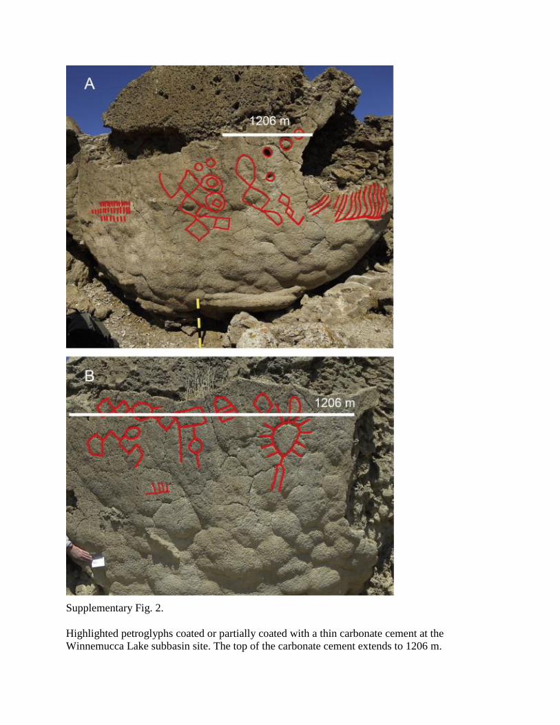
Supplementary Fig. 2.
Highlighted petroglyphs coated or partially coated with a thin carbonate cement at the
Winnemucca Lake subbasin site. The top of the carbonate cement extends to 1206 m.
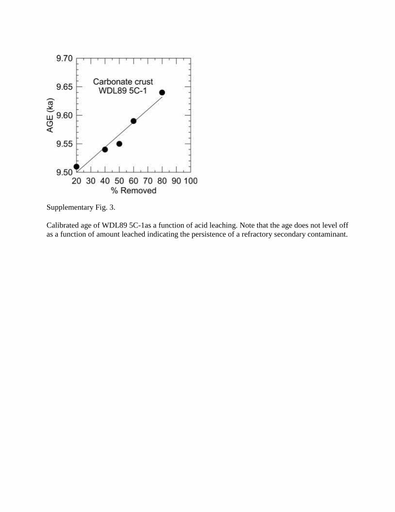
Supplementary Fig. 3.
Calibrated age of WDL89 5C-1as a function of acid leaching. Note that the age does not level off
as a function of amount leached indicating the persistence of a refractory secondary contaminant.
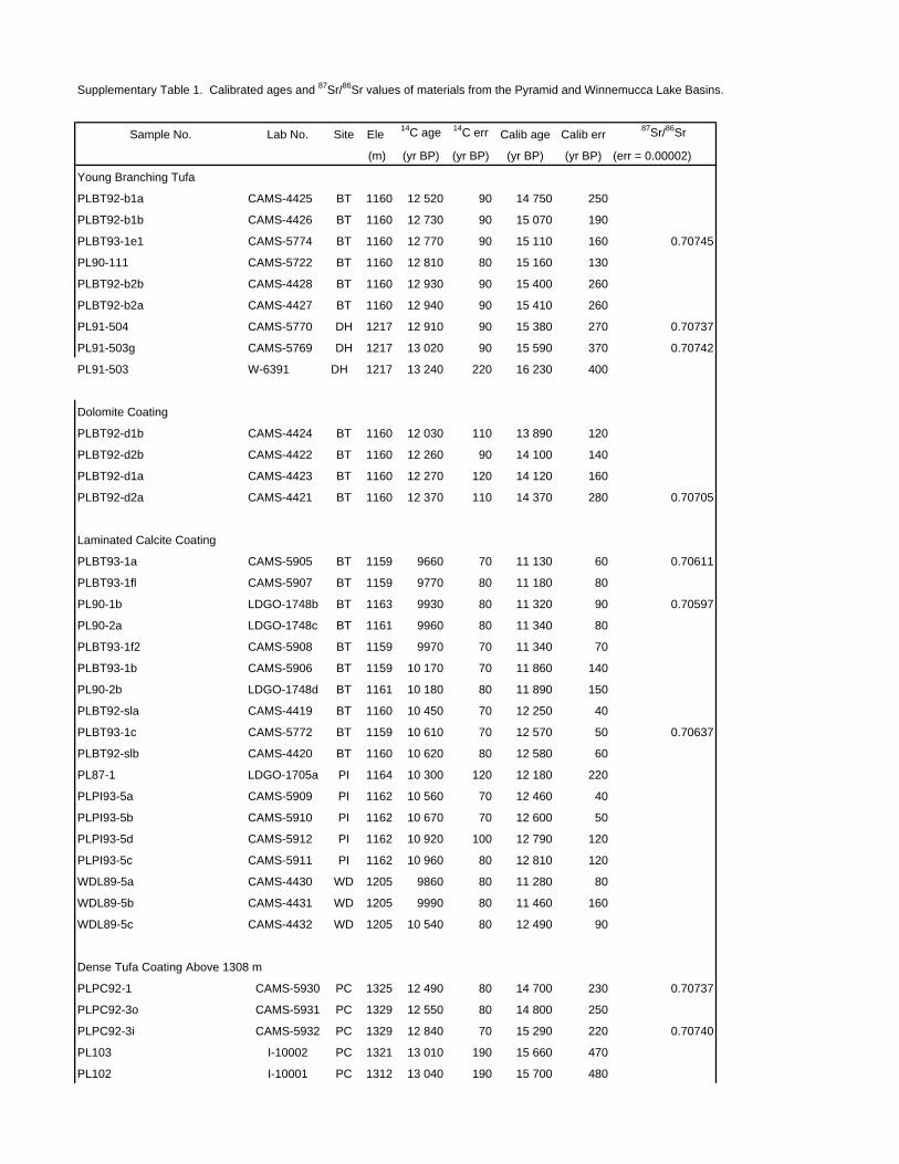
Supplementary Table 1. Calibrated ages and 87Sr/86Sr values of materials from the Pyramid and Winnemucca Lake Basins.
Sample No. Lab No. Site Ele 14C age 14C err Calib age Calib err
87Sr/86Sr
(m) (yr BP) (yr BP) (yr BP) (yr BP) (err = 0.00002)
Young Branching Tufa
PLBT92-b1a CAMS-4425 BT 1160 12 520 90 14 750 250
PLBT92-b1b CAMS-4426 BT 1160 12 730 90 15 070 190
PLBT93-1e1 CAMS-5774 BT 1160 12 770 90 15 110 160 0.70745
PL90-111 CAMS-5722 BT 1160 12 810 80 15 160 130
PLBT92-b2b CAMS-4428 BT 1160 12 930 90 15 400 260
PLBT92-b2a CAMS-4427 BT 1160 12 940 90 15 410 260
PL91-504 CAMS-5770 DH 1217 12 910 90 15 380 270 0.70737
PL91-503g CAMS-5769 DH 1217 13 020 90 15 590 370 0.70742
PL91-503 W-6391 DH 1217 13 240 220 16 230 400
Dolomite Coating
PLBT92-d1b CAMS-4424 BT 1160 12 030 110 13 890 120
PLBT92-d2b CAMS-4422 BT 1160 12 260 90 14 100 140
PLBT92-d1a CAMS-4423 BT 1160 12 270 120 14 120 160
PLBT92-d2a CAMS-4421 BT 1160 12 370 110 14 370 280 0.70705
Laminated Calcite Coating
PLBT93-1a CAMS-5905 BT 1159 9660 70 11 130 60 0.70611
PLBT93-1fl CAMS-5907 BT 1159 9770 80 11 180 80
PL90-1b LDGO-1748b BT 1163 9930 80 11 320 90 0.70597
PL90-2a LDGO-1748c BT 1161 9960 80 11 340 80
PLBT93-1f2 CAMS-5908 BT 1159 9970 70 11 340 70
PLBT93-1b CAMS-5906 BT 1159 10 170 70 11 860 140
PL90-2b LDGO-1748d BT 1161 10 180 80 11 890 150
PLBT92-sla CAMS-4419 BT 1160 10 450 70 12 250 40
PLBT93-1c CAMS-5772 BT 1159 10 610 70 12 570 50 0.70637
PLBT92-slb CAMS-4420 BT 1160 10 620 80 12 580 60
PL87-1 LDGO-1705a PI 1164 10 300 120 12 180 220
PLPI93-5a CAMS-5909 PI 1162 10 560 70 12 460 40
PLPI93-5b CAMS-5910 PI 1162 10 670 70 12 600 50
PLPI93-5d CAMS-5912 PI 1162 10 920 100 12 790 120
PLPI93-5c CAMS-5911 PI 1162 10 960 80 12 810 120
WDL89-5a CAMS-4430 WD 1205 9860 80 11 280 80
WDL89-5b CAMS-4431 WD 1205 9990 80 11 460 160
WDL89-5c CAMS-4432 WD 1205 10 540 80 12 490 90
Dense Tufa Coating Above 1308 m
PLPC92-1 CAMS-5930 PC 1325 12 490 80 14 700 230 0.70737
PLPC92-3o CAMS-5931 PC 1329 12 550 80 14 800 250
PLPC92-3i CAMS-5932 PC 1329 12 840 70 15 290 220 0.70740
PL103 I-10002 PC 1321 13 010 190 15 660 470
PL102 I-10001 PC 1312 13 040 190 15 700 480

PL113 I-10028 PC 1326 13 090 190 15 920 450
PL104 I-10003 PC 1321 13 320 200 16 320 440
PL105 I-10004 PC 1324 13 520 200 16 600 320
PL101 I-10000 PC 1312 13 600 200 16 700 260
PL41 I-9344 PC 1311 13 890 210 16 980 210
PL100 I-9992 PC 1312 14 290 220 17 370 280
PL21 I-9326 TH 1325 13 090 190 15 910 450
PL20 I-9325 TH 1311 14 030 210 17 070 190 0.70737
Organic Samples Winnemucca Lake Basin
Fishbone Cave L-245 FC 1231 11 200 250 13 050 250
Falcon Hill No. 1 I-14009 FH 1296 11 270 270 13 130 270
Guano Cave No. 11 A-3699 GC 1231 11 580 290 13 460 290
Falcon Hill No. 2 I-14011 FH 1296 11 770 250 13 610 250
Crypt Cave No. P3A I-14016 CC 1249 11 810 230 13 640 240
Guano Cave No. 781 A-3696 GC 1231 11 810 230 13 640 240
Guano Cave No. 2 I-14014 GC 1231 11 850 170 13 660 180
Guano Cave No. 6A A-3695 GC 1231 11 890 250 13 720 280
Falcon Hill No. 2 A-3489 FH 1296 12 020 470 14 020 640
Guano Cave No. 10 A-3698 GC 1231 12 060 260 13 910 340
Guano Cave No. 9 A-3697 GC 1231 12 070 210 13 920 320
Crypt Cave No. 84-28 I-14013 CC 1249 12 130 180 13 990 250
Crypt Cave No. 1 I-14008 CC 1249 12 240 180 14 210 340
Fishbone Cave AA-759 FC 1231 12 280 520 14 380 790
Crypt Cave No. 84-2A I-14010 CC 1249 12 350 180 14 350 320
River samples
Truckee River 0.70527
Humboldt River 0.70951
Pyramid Lake 0.70580
GeologicObservatory (LDGO). Site abbreviations: Blanc Tetons (BT), Doghead Rock (DH), Pyramid Island
beach (PI), Pipline Canyon (PC), Terraced Hills (TH), Winnemucca Dry Lake Basin (WD).
Benson, L., Peterman Z., 1995. Carbonate deposition, Pyramid Lake subbasin, Nevada: 3. The use of 87Sr values
in carbonate deposits (tufas) to determine the hydrologic state of paleolake systems. Palaeogeography
Palaeoclimatology Palaeoecology 119, 201-213.
Benson, L., Kashgarian M., Rubin M., 1995. Carbonate deposition, Pyramid Lake subbasin, Nevada: 2. Lake levels
and polar jet stream positions reconstructed from radiocarbon ages and elevations of carbonates (tufas)
deposited in the Lahontan Basin. Palaeogeography Palaeoclimatology Palaeoecology 117, 1-30.
Benson, L., Smoot, J.P., Lund, S.P., Mensing, S.A., Foit F.F. Jr, Rye. R.O., 2012. Insights from a synthesis of old
and new climate-proxy data from the Pyramid and Winnemucca lake basins for the period 48-11.5 cal ka.
Quaternary International. doi:10.1016/j.quaint.2012.02.040.
LaboratoryCenter for Accelerator Mass Spectrometry (CAMS), U.S. Geological Survey (I, W), Lamont-Doherty
Data in this table came from Benson & Peterman 1995; Benson et al. 1995; Benson et al. 2012. Sources of the 14C analys

Supplementry Table 2. 14C and calibrated ages of Paleoindian materials from the Lahontan Basin (Hattori, 1982; Tuohy and Dansie 1997).
Sample No. 14C Age ± Calib Age Area Calib Age Area Calib 1-σ Age ±(yr BP) 1-σ range (%) 2-σ range (%) (midpt)
Pyramid Lake Subbasin Wizards Beach SkeletonUCR3445 9515 155 10652-11094 96 10405-11225 100 10870 220CAMS-28214 9250 60 10371-10510 76 10257-10569 100 10440 70
GX-13744 9660 170 10761-11215 100 10506-11411 98 10990 230
UCLA675 9450 120 10545-10805 69 10402-11166 100 10680 130Carson Lake Subbasin Spirit Cave Man HairCAMS-12353 9360 60 10508-10665 100 10406-10741 100 10590 80CAMS-12354 9350 70 10494-10676 96 10372-10742 97 10580 90UCR3261-2 9440 60 10582-10742 100 10511-10801 89 10660 80Carson Lake Subbasin Spirit Cave Man BoneCAMS-12352 9430 60 10580-10730 100 10503-10795 93 10650 80Carson Lake Subbasin Spirit Cave Female BoneUCR3475 9300 70 10392-10587 95 10272-10671 100 10490 100Carson Lake Subbasin Spirit Cave MattingCAMS-24194 9410 60 10570-10713 100 10491-10788 97 10640 70CAMS-24197 9460 60 10583-10778 100 10566-10871 83 10680 100CAMS-24199 9430 70 10566-10756 100 10495-10832 87 10660 90Carson Lake Subbasin Grimes Burial Cave Diamond PlaitingCAMS-3691 9470 60 10645-10785 73 10564-10876 79 10720 130
Hattori, E.M., 1982. The archaeology of Falcon Hill, Winnemucca Lake, Washoe County, Nevada. Nevada State Museum Anthropological Paper No. 18.
Tuohy, D.R., Dansie, A.J., 1997. New information regarding early Holocene manifestations in the western Great Basin. Nevada Historical Society Quarterly 40, 24-56.
Pyramid Lake Subbasin Sagebrush Fishing Line
Winnemucca Lake Subbasin Falcon Hill Basketry
Related Documents