Case Z(CD)-06-20 1 Staff Report Planning and Zoning Commission DATE: February 16, 2021 REZONING CASE #: Z(CD)-06-20 DESCRIPTION: “The Mills” PUD Neighborhood Commercial Component Technical Data Sheet Amendment (PUD to PUD) APPLICANT/OWNER: Ken Orndorff, Green Street Land Co. LLC LOCATION: Rocky River Rd intersections with Holden Ave & Drake Mill Ln PIN#s: 5527-53-7783, 5527-51-5799, and 5527-43-2316, 5527-53-1807, 5527-52-1831, 5527-42-8038 AREA: +/- 73.908 Acres (parcels) and +/- 6.99 Acres (Streets) ZONING: Planned Unit Development (PUD) PREPARED BY: Starla Rogers, Planning & Development Manager BACKGROUND The subject property consists of six (6) parcels totaling approximately +/- 73.908 acres with the addition of +/- 6.99 acres within City street rights-of-way directly adjacent to the subject parcels (total amounts to +/- 80.9). The property is zoned Planned Unit Development (PUD) and is a portion of the project known as “The Mills at Rocky River.” The primary property was voluntarily annexed with the effective date being 7/17/97. The was subsequently split zoned to CURM-2 (Conditional Use Residential Medium Density) for the residential component and CUC-2 (Conditional Use General Commercial) for the future commercial area. Later, in 2005, the entirely of the property was combined under one zoning district, PUD (Planned Unit Development) with an overall master plan and a Technical Data Sheet, which described the permitted uses, delineated a residential component and Neighborhood Commercial – Mixed Use area (commercial component). dimensional criteria, density regulations, etc. The full project was approved for a maximum of 1,200 dwelling units which included the allowance of both townhomes and multi-family within the area designated as the neighborhood commercial component. It should be noted that a +/- 53 acre tract, that is the site of CC Griffin Middle School, was included in the original PUD zoning map amendment, but is not included in the 532 acres referenced in the Technical Data Sheet. SUMMARY OF CURRENT REQUEST The current applicant is working towards development of the neighborhood commercial component and is requesting to modify the Technical Data Sheet. The most notable requested change to the Technical Data Sheet is the modification of how density would be calculated for the neighborhood commercial component. Page 3 of the document currently states: “Net residential density in the Neighborhood Commercial shall not exceed 4.30 dwelling units per acre…” The applicant has requested that the word “net” be replaced with “gross.” Net density is calculated by accessing “The number of dwelling units divided by the net acreage remaining after subtracting all critical areas and streets,” in accordance

Welcome message from author
This document is posted to help you gain knowledge. Please leave a comment to let me know what you think about it! Share it to your friends and learn new things together.
Transcript

Case Z(CD)-06-20 1
Staff Report Planning and Zoning Commission DATE: February 16, 2021 REZONING CASE #: Z(CD)-06-20 DESCRIPTION: “The Mills” PUD Neighborhood Commercial Component
Technical Data Sheet Amendment (PUD to PUD)
APPLICANT/OWNER: Ken Orndorff, Green Street Land Co. LLC LOCATION: Rocky River Rd intersections with Holden Ave & Drake Mill Ln PIN#s: 5527-53-7783, 5527-51-5799, and 5527-43-2316, 5527-53-1807,
5527-52-1831, 5527-42-8038 AREA: +/- 73.908 Acres (parcels) and +/- 6.99 Acres (Streets)
ZONING: Planned Unit Development (PUD) PREPARED BY: Starla Rogers, Planning & Development Manager
BACKGROUND The subject property consists of six (6) parcels totaling approximately +/- 73.908 acres with the addition of +/- 6.99 acres within City street rights-of-way directly adjacent to the subject parcels (total amounts to +/- 80.9). The property is zoned Planned Unit Development (PUD) and is a portion of the project known as “The Mills at Rocky River.” The primary property was voluntarily annexed with the effective date being 7/17/97. The was subsequently split zoned to CURM-2 (Conditional Use Residential Medium Density) for the residential component and CUC-2 (Conditional Use General Commercial) for the future commercial area. Later, in 2005, the entirely of the property was combined under one zoning district, PUD (Planned Unit Development) with an overall master plan and a Technical Data Sheet, which described the permitted uses, delineated a residential component and Neighborhood Commercial – Mixed Use area (commercial component). dimensional criteria, density regulations, etc. The full project was approved for a maximum of 1,200 dwelling units which included the allowance of both townhomes and multi-family within the area designated as the neighborhood commercial component. It should be noted that a +/- 53 acre tract, that is the site of CC Griffin Middle School, was included in the original PUD zoning map amendment, but is not included in the 532 acres referenced in the Technical Data Sheet.
SUMMARY OF CURRENT REQUEST
The current applicant is working towards development of the neighborhood commercial component and is requesting to modify the Technical Data Sheet.
The most notable requested change to the Technical Data Sheet is the modification of how density would be calculated for the neighborhood commercial component. Page 3 of the document currently states: “Net residential density in the Neighborhood Commercial shall not exceed 4.30 dwelling units per acre…” The applicant has requested that the word “net” be replaced with “gross.” Net density is calculated by accessing “The number of dwelling units divided by the net acreage remaining after subtracting all critical areas and streets,” in accordance

Case Z(CD)-06-20 2
with CDO Article 14. This is not a typical density calculation technique utilized by the City in other zoning applications. The most common measure is “gross” density which is calculated by dividing the number of residential units by the complete overall acreage. In addition to the “net” density calculation not being the City’s typical method, it also proves more difficult to administer for projects that develop in phases, particularly large-scale, multi-year developments. Should the Commission decide to approve the request, the result of allowing the modification for density calculation from net to gross would permit the applicant to develop more residential units within the neighborhood commercial component than under the current calculation method. The increased unit count would be no more than 90 units. However, the proposal would not alter the allowable density for the neighborhood commercial component, which would remain at no more than 4.30 dwelling units per acre. It also would not alter the overall permitted number of dwellings for The Mills project. The maximum project unit count would remain at 1,200. The original PUD rezoning approval from 2005 designated the permitted uses for the neighborhood commercial component. The permitted uses include all allowed uses in the B-1, C-1 and C-2 zoning districts, in addition to the allowance of townhomes and multi-family. Some nonresidential uses within these zoning districts include, but are not limited to offices, retail stores, dry cleaners, ABC stores, hotels, motels, restaurants, movie theaters, taverns, health clubs, parking ramps, and congregate care establishments. The Technical Data Sheet references the allowable uses based on these zoning districts but does not specify every potential use. It explicitly does not mention congregate care/congregate living, although the use is permitted based on being allowed in the B-1, C-1, and C-2 zoning districts. As an added layer of comfort, that the use will continue to be permitted, the applicant has requested that it be expressly noted as an allowable use. The applicant has also requested a statement be added clarifying that living quarters within congregate care facilities do not count towards the allowable residential density. The City does not currently classify these facilities as residential and thus they would not be added towards density or unit count. However, the applicant has made the request for added certainty in future development. In addition, language regarding overall density for the entire PUD has been modified to state Maximum Dwelling Units (1200 units) rather than “Gross Residential Density” (2.25 dwelling units per acre). The residential component of The Mills is now either constructed or platted in its entirety with 848 single-family detached lots, which does not exceed the allowed density of 2.25 dwelling units per acre. Furthermore, the approved maximum unit count for the overall development is currently (and would remain) 1,200 and the modification would serve to align the allowable unit count references throughout the document. A summary of the modifications is listed below and a redlined, revised, Technical Data Sheet has been submitted for the Commission’s review. Proposed modifications include:
1. Alteration of neighborhood commercial component density calculation from “net” to “gross.”
2. Overall residential unit count clarification (no change to previous approvals). Maximum of 1,200 dwelling units for the entire PUD.
3. Correction of typographical errors and Concord Development reference (CDO). 4. Clarification that congregate care/congregate living facilities, senior housing, assisted
living and nursing homes are permitted uses. (Note: these uses are already permitted. The applicant has requested the specific addition of the use, called out, to eliminate any uncertainty by potential tenants or new property owners in the future.
5. Clarification that living quarters within congregate care/congregate living facilities, senior housing, assisted living and nursing homes do not count towards residential density. (Note: The City does not count the living quarters towards density for these uses. The applicant

Case Z(CD)-06-20 3
has requested the specific statement to eliminate any uncertainty by potential tenants or new property owners in the future).
6. Elimination of stipulations regarding Townhome, Live-Work Residential Dwellings being “for sale” only units. (Note: the City cannot enforce “sale” v/s “rental” per the NC General Statues and case law).
7. Removal of the Common Open Space investment budget as a specific number. (Note: the City does not regulate the numerical value to construction improvements).
Project Overview
Total Acreage- +/- 585 (532 without Middle School) Maximum Project Residential Units 1,200 (< or = 2.25 du/acre) Approved SF Detached Lots +/- 848 Previous Commercial Acreage (Net) +/- 56 acres Proposed Commercial Acreage (Gross) +/- 80.9 acres Approved and Proposed Neighborhood Commercial Component Density
< 4.3 du/acre (No more than 400 units)
COMPLIANCE WITH 2030 LAND USE PLAN
2030 LAND USE PLAN The 2030 Land Use Plan (LUP) designates the subject property as “Village Center” in which Planned Unit Development (PUD) is a corresponding zoning classification to the Land Use Category. Further guidance from the Land Use Plan is as follows: From the 2030 Land Use Plan Chapter 5 – “Village Center”: “Village Center areas are typically located at key intersections of minor transportation corridors. These centers are often located in areas with FLU (Future Land Use) categories that are residential and/or rural in focus with limited non-residential development nearby. Oftentimes areas designated as Village Centers already contain some non-residential development, usually highway-oriented retail, office, or light industrial, with supportive zoning. Village Centers represent opportunities to create small/mid-size commercial and mixed-use centers and limit strip commercial in areas that are predominantly residential in character.
As with the larger Mixed-Use Activity Centers, the smaller Village Center creates an alternative to strip commercial development by concentrating non-residential uses in areas where infrastructure and residential demand support them. Consequently, none of the designated Village Centers proposed would develop without residential growth preceding it, thus creating the demand. Similarly, Village Centers would not develop if there was inadequate infrastructure, such as roads, water and sewer service.”
Existing Zoning and Land Uses (Subject Parcel)
Current Zoning of Subject
Property
Zoning Within 500 Feet Land Uses(s) of Subject Property Land Uses within 500 Feet
Planned Unit Development
(PUD)
North PUD (Planned Unit Development) and County LDR (Low Density Residential)
Single-Family Detached
Single-Family Detached
South County CR (Countryside Residential)
and County LDR (Low Density Residential)
Single-Family Detached, Vacant, School
East PUD (Planned Unit Development) Single-Family Detached
West County LDR (Low Density Residential) Vacant, Single-Family Detached

Case Z(CD)-06-20 4
Land Use Plan Overall Objectives:
Objective 1.5: Foster an attractive and functional mix of living, working, shopping and recreational uses within Mixed-Use Activity Centers and Village Centers.
Policy Guidance for Objective 1.5:
· Mixed-Use Zoning: Ensure that applicable zoning districts and development regulations facilitate development of a mix of compatibly integrated residential and non-residential uses within each Mixed-Use Activity Center and Village Center.
Objective 1.6: Provide a diverse mix and range of housing options throughout the City that will
accommodate the current and future needs of the citizens of Concord. · Housing Balance: Ensure that zoning allows for a mix of housing types at a variety of prices to
meet the demands of existing and future residents. · Mixed-Density Housing: Foster a compatible mix of higher density housing types at different
densities within mixed-use activity centers and village centers. SUGGESTED STATEMENT OF CONSISTENCY
• The subject property is approximately +/- 80.9 acres (including street rights-of-way) and is currently zoned Planned Unit Development (PUD).
• The subject property was annexed on 7/17/97 and the subject neighborhood commercial
component remains vacant.
• The proposed zoning amendment is consistent with the 2030 Land Use Plan (LUP) as PUD (Planned Unit Development) is considered corresponding zoning classification to the “Village Center” Land Use category. Although the residential component of the overall Mills project has been under planning and development since the annexation in 1997, the neighborhood commercial component has remained vacant as zoned. The 2030 Land Use Plan, Chapter 5, notes that “none of the designated Village Centers proposed would develop without residential growth preceding it, thus creating the demand.” The proposed modifications would allow the development of additional residential dwelling units within the neighborhood commercial component, above that currently allowed under the net density calculation method, thereby increasing demand for commercial. Furthermore, the amendment would permit additional units of either multi-family or single-family attached dwellings within the project’s boundaries, providing an increased mix of housing choices and prices, furthering the Land Use Plan’s guidance in Objectives 1.5 and 1.6.
• The zoning amendment is reasonable and in the public interest because the proposed modifications will allow for an attractive and functional mix of living, working, shopping and recreational uses within the Village Center. The proposal does not modify any uses permitted under the 2006 approval. The request would allow for an increased number of residential units within the neighborhood commercial component, creating demand and potentially providing a catalyst for the adjacent commercial development’s initiation. In doing so, the existing residential within The Mills and surrounding area would have access to commercial/retail/office uses not currently available within close proximity, reducing the need to drive to these services and reducing traffic on Rocky River Rd.
SUGGESTED RECOMMENDATION AND CONDITIONS

Case Z(CD)-06-20 5
The staff finds the consistent 2030 Land Use Plan and staff has no objections to the petition.
1. Compliance with the “The Mills at Rocky River” Technical Data Sheet and Conditional Notes, by Greenstreet Land Company, dated January 2021.
2. For the purpose of calculating density, the neighborhood commercial component’s gross land area is 80.9 acres.
3. Compliance with all approvals from 2005 and 2006 outside the Technical Data Sheet modifications dated January 2021.
4. Technical site plan review is required.
PROCEDURAL CONSIDERATIONS This particular case is a rezoning, which under the CDO, is “legislative” in nature. Legislative hearings DO NOT require the swearing or affirming of witnesses prior to testimony at the public hearing.

R
Know what's below.before you dig.Call
·
·
·
·
·
·
·
·
sdyer
Typewritten Text
FOR REVIEW ONLY
Ken Orndorff
Line
Ken Orndorff
Text Box
general notes: -PUD residential not to exceed 1,200 units total -multifamily residential buildings limited to 3 stories maximum -Maximum neighborhood commercial residential density is 4.3 du/acre (not to exceed 400 units)
Ken Orndorff
Polygon
Ken Orndorff
Polygon
Ken Orndorff
Polygon
Ken Orndorff
Polygon

"Mills at Rocky River" City of Concord, North Carolina
AMENDED
Technical Data Sheet And Conditional Notes
2005
September 2006January 2021
General Provisions The development depicted on the provided sketch plan illustrates the general arrangement of the proposed uses for this development. However, the final configuration of the uses within the development may change within the limits of the City of Concord Unified Development Ordinance (UDOCDO) and the standards established on the Technical Data Sheet during design development and construction phases, as long as the total number of residential lots does not exceed 1200 and the total extent of commercial development is between 45 and 85 acres. Street alignments and lot dimensions may be amended in further detailed design phases to accommodate final lot locations, but changes greater than 10% in extent may require subsequent Planning and Zoning Commission review -and approval. The Applicant reserves the right to change the number of dwelling units (DU) from one residential type to another as long as the total number of dwelling units does not exceed a maximum of 1200 units.
Mills at Rocky River Planned Unit Development Land Development Standards Pursuant to Section 4.9.1 "Purposed" Planned Unit Development (PUD), whereas PUD zoning is provided for the orderly development of land with a mix of uses and intensity, intended to permit flexibility in the design, construction and processing of residential and non-residential developments of a quality that could not be achieved under conventional zoning approaches, the Applicant seeks to obtain approval of the use of the following Development Standards concurrently with the approval of this Rezoning petition and Conditional Use permit.
The standards established by this Technical Data Sheet, depicted on the submitted Sketch Plan and/or any other accompanying documents, shall be followed in connection with development in Phase One taking place on this site.
Permitted Uses Subject to the requirements set forth below, a maximum of 1200 dwelling units will be constructed on site. ·
a. Single-Family Parcels: Single family detached dwelling units shall be allowed in Parcels S.F. 45; S.F. 50; S.F.60; S.F.80; S.F. 90; and S.F.100. Minimum lot widths, front setbacks, side yards and rear yards are detailed below.
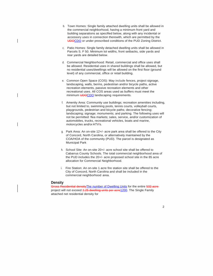
b. Town Homes: Single family attached dwelling units shall be allowed in the commercial neighborhood, having a minimum front yard and building separations as specified below, along with any incidental or accessory uses in connection therewith, which are permitted by the UDOCDO or under prescribed conditions of the PUD Zoning District.
c. Patio Homes: Single family detached dwelling units shall be allowed in
Parcels S. F 50. Minimum lot widths, front setbacks, side yards and rear yards are detailed below.
d. Commercial Neighborhood: Retail, commercial and office uses shall
be allowed. Residential uses in shared buildings shall be allowed, but no residential uses/dwellings will be allowed on the first floor (ground level) of any commercial, office or retail building.
e. Common Open Space (COS): May include fences, project signage,
landscaping, walls, berms, pedestrian and/or bicycle paths, active recreation elements, passive recreation elements and other recreational uses. All COS areas used as buffers must meet the minimum UDOCDO landscaping requirements.
f. Amenity Area: Community use buildings; recreation amenities including,
but not limited to, swimming pools, tennis courts, volleyball courts, playgrounds, pedestrian and bicycle paths; decorative fencing; landscaping; signage; monuments; and parking. The following uses will not be permitted: flea markets; sales, service, and/or customization of automobiles, trucks, recreational vehicles, boats and marine, motorcycles and/or ATV's.
g. Park Area: An on-site 12+/- acre park area shall be offered to the City
of Concord, North Carolina, or alternatively maintained by the COA/HOA of the community (PUD). The parcel is designated as Municipal Park
h. School Site: An on-site 20+/- acre school site shall be offered to
Cabarrus County Schools. The total commercial neighborhood area of the PUD includes the 20+/- acre proposed school site in the 85 acre allocation for Commercial Neighborhood.
i. Fire Station: An on-site 1 acre fire station site shall be offered to the
City of Concord, North Carolina and shall be included in the commercial neighborhood area.
Density Gross Residential densityThe number of Dwelling Units for the entire 532 acre project will not exceed 2.25 dwelling units per acre1200. The Single Family attached net residential density for
2

these unit types shall not exceed 7.20 dwelling units per acre. Net Gross residential density in the Neighborhood Commercial shall not exceed 4.30 dwelling units per acre, and no dwelling units will be allowed on the first floor (ground level) of any commercial, office or retail building. Common Open Space, public rights-of-way, and donated park areas shall be included in the calculations for Gross residential density.
Design Standards Area Units_
S.F.-45 Minimum Lot Width 45 feet 23 acres 182
Minimum Front Setback: 5 feet Minimum Side Yard: 3 feet Minimum Rear Yard: 5 feet
S. F. - 50 (Patio Homes) 15 acres 118 Minimum Lot Width: 50 feet Minimum Front Setback: 5 feet Minimum Side Yard: 3 feet Minimum Rear Yard: 5 feet
S.F.-60 Minimum Lot Width: 60 feet Minimum Front Setback: 20 feet Minimum Side Yard: 5 feet Minimum Rear Yard: 10 feet
S.F.-80 Minimum Lot Width: 80 feet Minimum Front Setback: 20 feet Minimum Side Yard: 6 feet Minimum Rear Yard: 15 feet
S.F. -90 Minimum Lot Width: 90 feet Minimum Front Setback: 20 feet Minimum Side Yard: 6 feet Minimum Rear Yard: 20 feet
S.F.100 Minimum Lot Width: 100 feet Minimum Front Setback: 20 feet Minimum Side Yard: 7 feet Minimum Rear Yard: 20 feet Town Homes 18 acres 130
Minimum Front Setback: 5 feet Minimum Side Yard 0 feet Minimum Rear Yard 0 feet Building Separation: 16 feet
3
19 acres 103
47 acres
140
9 acres
32
125 acres
286
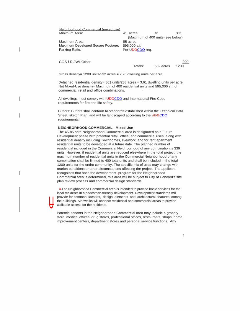
Neighborhood Commercial (mixed use) Minimum Area: 45 acres 85 339
(Maximum of 400 units- see below) Maximum Area: Maximum Developed Square Footage: Parking Ratio:
85 acres 595,000 s.f. Per UDOCDO req.
COS I RIJWL Other 209 Totals: 532 acres 1200
Gross density= 1200 units/532 acres = 2.26 dwelling units per acre
Detached residential density= 861 units/238 acres = 3.61 dwelling units per acre Net Mixed-Use density= Maximum of 400 residential units and 595,000 s.f. of commercial, retail and office combinations. ·
All dwellings must comply with UDOCDO and International Fire Code requirements for fire and life safety.
Buffers: Buffers shall conform to standards established within the Technical Data Sheet, sketch Plan, and will be landscaped according to the UDOCDO requirements.
NEIGHBORHOOD COMMERCIAL - Mixed Use The 45-85 acre Neighborhood Commercial area is designated as a Future Development phase with potential retail, office, and commercial uses, along with residential density including Townhomes, live/work, and for rent apartment residential units to be developed at a future date. The planned number of residential included in the Commercial Neighborhood of any combination is 339 units. However, if residential units are reduced elsewhere in the total project, the maximum number of residential units in the Commercial Neighborhood of any combination shall be limited to 400 total units and shall be included in the total 1200 units for the entire community. The specific mix of uses may change with market conditions or other circumstances affecting the project. The applicant recognizes that once the development program for the Neighborhood Commercial area is determined, this area will be subject to City of Concord's site plan review process and commercial design standards.
h The Neighborhood Commercial area is intended to provide basic services for the
local residents in a pedestrian-friendly development. Development standards will provide for common facades, design elements and architectural features among the buildings. Sidewalks will connect residential and commercial areas to provide walkable access for the residents.
Potential tenants in the Neighborhood Commercial area may include a grocery store, medical offices, drug stores, professional offices, restaurants, shops, home improvemen_t centers, department stores and personal service functions. Any
4
U

residential dwelling units in the Neighborhood Commercial area will count towards the overall maximum of 1200 dwelling units.
Permitted Uses UDOCDO permitted uses (per Table 4.6-1CDO Article 8) in the B-1, C-1, and C-2 Zoning Districts (including offices, retail stores, dry cleaners, ABC stores, hotels, motels, restaurants, movie theaters, taverns, health clubs, parking ramps, bed and breakfast establishments, congregate care/congregate living facilities, senior housing, assisted living and nursing homes) shall be allowed in the Neighborhood Commercial area, but must comply with all relevant UDOCDO requirements. Commercial activities that are permitted in the UDOCDO B-1, C-1 and C-2 Zoning Districts as Conditional Uses must apply for (and obtain) Conditional Use Permits (CUP's) from the Planning and Zoning Commission.
Civic and Institutional Uses Civic and Institutional Uses that are allowed as a Permitted Use in the UDOCDO C- 1 and/or C-2 Zoning Districts shall be permitted in the Neighborhood Commercial area (including day care centers and dance/music studios, YMCA), except for the following:
- Group Homes - Religious Institutions - Schools, Public or Private
Professional Office I Business Uses All Professional Office I Business Uses that are allowed as a Permitted or Conditional Use in the 8-1 District including the following:
- Pet Care Services (excluding kennels)
Retail Trade Uses All Retail Trade Uses that are allowed as a Permitted or Conditional Use in the C-1, C-2 and /or 8-1 Districts including the following:
- Hobby Stores - Dry Cleaners - ABC Stores
Prohibited Uses The following uses are prohibited in the Neighborhood Commercial area:
-Adult entertainment establishments - Mini-warehouses - Major Automotive Repair centers - Bail Bonding services - Pawnshops
Residential Uses In Neighborhood Commercial Applicant reserves the right to develop residential uses in the neighborhood Commercial area. Residential units will not be permitted on the first floor (ground level) of any commercial, retail or office building. Ground level uses shall include
5

the aforementioned Permitted Uses.( Townhome, and Live-Work residential dwellings will be allowed only as "for sale" units, and will not be used as rental or leased space.and Apartments may be included in the Commercial Neighborhood as "for rent" and shall be consistent with the architectural quality and design of the other improvements in the Commercial Neighborhood. Floors above street level are not restricted to residential uses and may be utilized for commercial/retail uses. Residential uses cannot be mixed with other uses (e.g. office and residential) on the same floor. This does not prevent future conversion of a floor to a different use; for example, residential units into office space (provided that all proposed uses comply with relevant Concord Fire and Life Safety regulations and International Fire Code requirements). Congregate care/congregate living facilities, senior housing, assisted living and nursing homes shall not be deemed to be “Dwelling Units” as defined in the CDO with regard to density calculations.
Public Streets and Sidewalks Minimum dimensions shall meet standards set forth in UDOCDO Appendix C, unless otherwise noted in the Technical Data Sheet.
Common Open Space Common Open Space shall be provided as depicted on the preliminary plat and as noted in the Technical Data Sheet. Respectively, Common Open Space will be owned and maintained by the Home Owner's Association (HOA), and the Commercial Owner's Association (COA). A minimum of 10% of the total project area will be set aside as Common Open Space, in accordance with UDOCDO requirements. Property located within the FEMA floodplain (excluding the floodway), the River Stream Overlay District, and any areas dedicated for public park/greenway areas may be counted towards calculating the required 10% of Common Open Space.
Common Open Space investment includes a budget of $2.2 million-for the amenity and further estimate value of the land set aside as common open space to be $5.9 million for a total common open space investment estimate of $8.1 million.
Buffer Yards Buffer yards shall meet UDOCDO width and landscaping requirements. Existing vegetation preserved on the site and natural land features (rivers, streams, topography, etc.) may be utilized in lieu of required landscape plantings to satisfy buffer and/or screening requirements (if approved by Development Services Director).
Landscaping and Monuments The Applicant requests the right to submit a Comprehensive Landscape Package for part (or all) of the project. The Comprehensive Landscape Package shall include proposed landscaping for that portion being developed and shall be in accordance with the UDOCDO Article 7 requirements as well as the preliminary plat typical sections and notes. Any landscaping or monuments located within an area of interest for NCDOT shall be approved by that agency. The Landscaped
6
Common Open Space areas shall be maintained respectively by the HOA or COA.
Parking and Loading Parking and loading and other requirements for each permitted use and platted lot will comply with the parking requirements specified in the UDOCDO and the Technical Data sheet.
Access to Lots Access driveways to each platted lot for each permitted use and platted lot shall comply with UDOCDO requirements.
Signage The Applicant requests the right to submit a Comprehensive Signage Package for the overall project. The Comprehensive Signage Package shall include proposed signage for the entire development and shall be in accordance with UDOCDO requirements. Any signage located within an area of interest for NCDOT shall be approved by that agency.
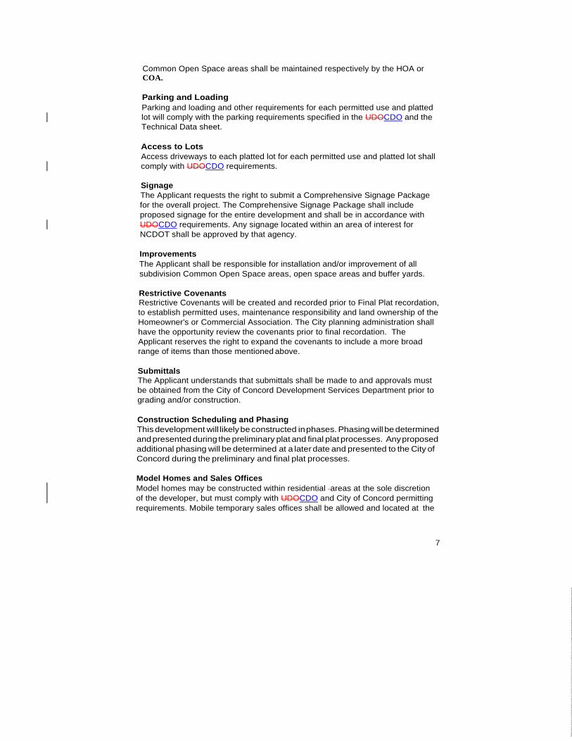
Improvements The Applicant shall be responsible for installation and/or improvement of all subdivision Common Open Space areas, open space areas and buffer yards.
Restrictive Covenants Restrictive Covenants will be created and recorded prior to Final Plat recordation, to establish permitted uses, maintenance responsibility and land ownership of the Homeowner's or Commercial Association. The City planning administration shall have the opportunity review the covenants prior to final recordation. The Applicant reserves the right to expand the covenants to include a more broad range of items than those mentioned above.
Submittals The Applicant understands that submittals shall be made to and approvals must be obtained from the City of Concord Development Services Department prior to grading and/or construction.
Construction Scheduling and Phasing This development will likely be constructed in phases. Phasing will be determined and presented during the preliminary plat and final plat processes. Any proposed additional phasing will be determined at a later date and presented to the City of Concord during the preliminary and final plat processes.
Model Homes and Sales Offices Model homes may be constructed within residential areas at the sole discretion of the developer, but must comply with UDOCDO and City of Concord permitting requirements. Mobile temporary sales offices shall be allowed and located at the
7

sole discretion of the developer, but must comply with UDOCDO and City of Concord permitting requirements.
Water and Sewer The Applicant understands that water and sewer service will be provided by City of Concord for the total number of proposed lots in the overall project. It is the Applicant's responsibility to incur all costs I infrastructure for providing the water and sewer throughout the project for each lot. The Applicant will comply with all City of Concord water and sewer specifications. A water and sewer Authorization to Construct or fully executed Developers Agreement must be received from City of Concord's Engineering Department prior to obtaining a grading permit for any portion of the development utilizing City of Concord water and sewer service.
Applicable Ordinances Development of this site will be subject to UDOCDO standards and requirements in effect on the date of rezoning/CUP submittal.
Binding Effect of the PUD Any re-zoning and CUP approval conditions shall be binding upon the applicant and subsequent owners of the site and their assigns, unless amended according to UDOCDO guidelines.
Amendments to the PUD Any requested amendments to the PUD must be submitted to the City of Concord Development Services Department, in accordance with UDOCDO guidelines.
Greenways The applicant shall offer to donate a portion of land for a public greenway/trail system along Rocky River to be used as a component of a future public greenway and recreational area. Publicly dedicated greenway corridors and easements shall be included in Common Open Space calculations. Greenway corridors and/or easements may be contained within the boundary lines of the FEMA Rocky River 100-year floodplain. The Rocky River greenway/trail system, trail connections and parking area shall be offered for public use and donated to the City of Concord. The developer shall be under no obligation to fund, construct, maintain or otherwise manage any proposed Rocky River public greenway/trail system.
Vehicular Access and Road Improvements
a. Vehicular Access: Vehicular access will be provided at two points from Rocky River Road in the general locations depicted on the Sketch Plan. Adjustments to the locations of street and driveway entrances may occur, as required to meet state and local agency standards and coordinate with final subdivision and site plan design.
b. Improvements to Existing Roads: Improvements to Rocky River Road will be coordinated with the NCDOT and the City of Concord.
8

Right of Way Acquisition Applicant/ Developer or their assignee shall be responsible for any expenses incurred by the City for right-of-way acquisition. The applicant shall be required to construct various roadway improvements as recommended by the NCDOT, the City of Concord, and/or the approved Traffic Impact Study {TIS) prepared by Kubilins Transportation Group, Inc. to mitigate project impacts, as specifically defined herein by type of individual land use any design of turn-lane improvements, road improvements, or signals which require the acquisition of additional off-site right-of-way, not under the control or ownership of the applicant/developer, it is agreed between the City of Concord or its assignee that the applicant shall make a "good faith effort" to acquire such right-of-way from adjoining land owners.
Applicant's efforts to satisfy this requirement shall include an offer to the adjoining landowner(s) based on an appraised value for the additional right-of- way along with appropriate documentation describing such efforts. In the event that the applicant is unsuccessful in acquiring the necessary right-of-way to accommodate the design of the required roadway improvements, the City of Concord and/or NCDOT will cooperate with applicant in efforts to acquire such right-of-way. If good faith effort fails, process/permits will not be held up pending right of way acquisition.
9


DRAKE MILL
LN SW
ROCKYMEADOWS LN
STO
NEP
ILE
DRSW
GA
LLOW
AYLN
SW
MOSS CREEK DR
BOTTLE
BRU
SH LN
THIS
TLE
DO
WN
DR
ROCKY RIV
ER RD
WATERW
HEEL
STSW
RAYLEE
AVE SW
CROUSE
CT SW
CAT
TAIL
CT
SW
DO
VE
RM
ILL
DR
SW
SEW
AL
L
AVE
SW
NEWSOMECT SW
MIL
LTO
WN
CT
SW
VAN BURENAVE SW
HILL
IARD
LN
WIN
TER
GAR
DEN
DR
RETREAT RD
MER
RYM
OU
NT
CT
RET
REA
TR
D
MILL CREEKLN SW
PEMBROOK RD
BABB
LIN
GBR
OO
K LN
ELBENSLN SW
GRIST MILLDR SW
BLAK
EBR
OO
KDR
BOUL
AIDE
STSW
SCAR
BRO
UGH
CIR
SW
MIL
LRU
INS
AVE
SW
MILLSTONE
CIR SW
PAU
LLI
NKE
R P
L
HOLD
EN A
VE S
W
PHARR MILL RD
LOWER
ROCKYRIVER RD
SN
SN
SN
VC
CI
NCCGIA
Z(CD)-06-20LUP Map
"The Mills" PUDNeighborhood
CommercialTechnical Data Sheet
Amendment
Location:Rocky River Rd intersections with
Holden Ave &Drake Mill Ln
Multiple PINs
Source: City of ConcordPlanning Department
These maps and products are designed for generalreference only and data contained herein is subject to change. The City Of Concord, it's employees or agents make no warranty of merchantability or fitness for any purpose, expressed or implied, and assume no legal responsibility for the information contained therein. Data used is from multiple sources with various scales and accuracy. Additional research such as field surveys may be necessary to determine actual conditions.
Disclaimer
Subject PropertySubject Property

DRAKE MILL LN SW
ROCKYMEADOWS LN
STO
NEP
ILE
DRSW
GALLOWAY
LNS
W
MOSS CREEK DR
BOTTLE
BRU
SH LN
THIS
TLE
DO
WN
DR
ROCKY RIV
ER RD
WATERW
HEEL
STSW
RAYLEE
AVESW
CROUSE
CT SW
CAT
TAIL
CT
SW
DO
VE
RM
ILL
DR
SW
SEW
AL
L
AVE
SW
NEWSOMECT SW
MIL
LTO
WN
CT
SW
VAN BURENAVE SW
HILL
IARD
LN
WIN
TER
GAR
DEN
DR
RETREAT RD
MER
RYM
OU
NT
CT
RET
REA
TR
D
MILL
CREE
KLN
SW
PEMBROOKRD
BABB
LING
BRO
OK
LN
ELBENSLN SW
GRIST MILLDR SW
BLAK
EBR
OO
KDR
BOUL
AIDE
STSW
SCAR
BRO
UGH
CIR
SW
MIL
LRU
INS
AVE
SW
MILLSTONE
CIR SW
PAU
LLI
NKE
R P
L
HOLDENAVE SW
PHARRMILL RD
LOWER
ROCKYRIVER RD
County OI
County LDR
County LDR
County LDR
County LDR
County CR
County CR
County CR
County AO
NCCGIA
Z(CD)-06-20 Zoning Map
"The Mills" PUDNeighborhood
CommercialTechnical Data Sheet
Amendment
Location:Rocky River Rd intersections with
Holden Ave &Drake Mill Ln
Multiple PINs
Source: City of ConcordPlanning Department
These maps and products are designed for generalreference only and data contained herein is subject to change. The City Of Concord, it's employees or agents make no warranty of merchantability or fitness for any purpose, expressed or implied, and assume no legal responsibility for the information contained therein. Data used is from multiple sources with various scales and accuracy. Additional research such as field surveys may be necessary to determine actual conditions.
Disclaimer
Subject PropertySubject Property

DRAKE MILL
LN SW
ROCKYMEADOWS LN
STO
NEP
ILE
DRSW
GA
LLOW
AYLN
SW
MOSS CREEK DR
BOTTLE
BRU
SH LN
THIS
TLE
DO
WN
DR
ROCKY RIV
ER R
D
WATERW
HEEL
ST
SW
RAYLEE
AVESW
CROUSE
CT SWDO
VER
MILL
DRSW
SEW
AL
L
AVE
SW
NEWSOMECT SW
MIL
LTO
WN
CT
SW
VAN BURENAVE SW
HILL
IARD
LN
WIN
TER
GAR
DEN
DR
RETREAT RD
MER
RYM
OU
NT
CT
RET
REA
TR
D
MILL CREEKLN SW
PEMBROOK RD
BABB
LING
BRO
OK
LN
ELBENSLN SW
GRIST MILLDR SW
BLAK
EBR
OO
KDR
BOUL
AIDE
STSW
SCAR
BRO
UGH
CIR
SW
MIL
LRU
INS
AVE
SW
MILLSTONE
CIR SW
PAU
LLI
NKE
R P
L
HOLD
EN A
VE S
W
PHARR MILL RD
LOWER
ROCKYRIVER RD
NCCGIA
Z(CD)-06-20Subject Property Map
"The Mills" PUDNeighborhood
CommercialTechnical Data Sheet
Amendment
Location:Rocky River Rd intersections with
Holden Ave &Drake Mill Ln
Multiple PINs
Source: City of ConcordPlanning Department
These maps and products are designed for generalreference only and data contained herein is subject to change. The City Of Concord, it's employees or agents make no warranty of merchantability or fitness for any purpose, expressed or implied, and assume no legal responsibility for the information contained therein. Data used is from multiple sources with various scales and accuracy. Additional research such as field surveys may be necessary to determine actual conditions.
Disclaimer
Subject PropertySubject Property
Related Documents