DATASHEET Key Features ► Surveying, imaging and 3D scanning in one powerful solution ► Improved Trimble VISION technology for video robotic control, scene documentation and photogrametric measurements ► Locate2Protect real-time equipment management ► Trimble DR Plus for long range and superior accuracy ► Intuitive Trimble Access Field Software ► Trimble Business Center Office Software for quick data processing ► Seamless integration with the Trimble V10 Imaging Rover and GNSS receivers Trimble S7 TOTAL STATION THE MOST PRODUCTIVE TOTAL STATION The Trimble ® S7 Total Station combines scanning, imaging and surveying into one powerful solution. Now you only need one instrument on the job site to perform all your data capture. Create 3D models, high accuracy visual site documentation, point clouds, and more using the Trimble S7, Trimble Access ™ field software and Trimble Business Center office software. The Trimble S7 is the ultimate system for efficient surveying, allowing you to adapt to any situation and increasing your productivity in the field. The combination of SureScan, Trimble VISION ™ , FineLock ™ and DR Plus technology, along with many other features, means you’ll be able to collect data faster and more accurately than ever before. Integrated 3D Scanning Save time in the field and in the office with Trimble SureScan technology. Now you have the flexibility to perform feature-rich scans every day. Efficiently capture the information you need to create digital terrain models (DTMs), perform volume calculations and make topographic measurements faster than with traditional surveying methods. SureScan technology enables you to collect and process data faster by focusing on collecting the right points, not just more points. Improved Trimble VISION Technology Trimble VISION technology gives you the power to direct your survey with live video images on the controller as well as create a wide variety of deliverables from collected imagery. Capture measurements to prisms or reflectorless with point-and-click efficiency via video. Quickly document your site and add notes directly to the pictures in the field to ensure you never miss that critical information. Back in the office, you can use your Trimble VISION data for measurements, or to process 360-degree panoramas and high dynamic range (HDR) images for even clearer deliverables. Superior Accuracy with Trimble DR Plus Trimble DR Plus range measurement technology provides extended range of Direct Reflex measurement without a prism. Now you can you measure further with fewer instrument set-ups and enhance your scanning performance. Trimble DR Plus, combined with the smooth and silent MagDrive ™ servo technology, creates unmatched capability for quick measurements, without compromising on accuracy. Manage Your Assets Know where your total stations are 24 hours a day with Trimble Locate2Protect technology. See where your equipment is at any given time and get alerts if your instrument leaves a job site or experiences unexpected equipment shock or abuse. Trimble InSphere ™ Equipment Manager lets you view usage and keep up-to-date on firmware, software and maintenance requirements. With Trimble Locate2Protect and InSphere Equipment Manager, you can rest assured knowing your equipment is up-to-date and where it should be. Powerful Field and Office Software Choose from a variety of Trimble controllers operating the feature rich, intuitive Trimble Access field software. Streamlined workflows like Roads, Utilities and Pipelines guide crews through common project types, helping to get the job done faster with less distractions. Trimble Access workflows can also be customized to fit your needs. Back in the office, trust Trimble Business Center to help you check, process and adjust your optical and GNSS data in one software solution. 18000_291194_bouaiz1g_fpi__defaultImposition_press.pdf 1 1/22/2018 1:01:43 PM

Welcome message from author
This document is posted to help you gain knowledge. Please leave a comment to let me know what you think about it! Share it to your friends and learn new things together.
Transcript

TRANSFORMING THE WAY THE WORLD WORKS
DATASHEET
Key Features ► Surveying, imaging and 3D scanning in
one powerful solution
► Improved Trimble VISION technology for video robotic control, scene documentation and photogrametric measurements
► Locate2Protect real-time equipment management
► Trimble DR Plus for long range and superior accuracy
► Intuitive Trimble Access Field Software
► Trimble Business Center Office Software for quick data processing
► Seamless integration with the Trimble V10 Imaging Rover and GNSS receivers
Trimble S7TOTAL STATION
THE MOST PRODUCTIVE TOTAL STATION The Trimble® S7 Total Station combines scanning, imaging and surveying into one powerful solution. Now you only need one instrument on the job site to perform all your data capture. Create 3D models, high accuracy visual site documentation, point clouds, and more using the Trimble S7, Trimble Access™ field software and Trimble Business Center office software.
The Trimble S7 is the ultimate system for efficient surveying, allowing you to adapt to any situation and increasing your productivity in the field. The combination of SureScan, Trimble VISION™, FineLock™ and DR Plus technology, along with many other features, means you’ll be able to collect data faster and more accurately than ever before.
Integrated 3D Scanning
Save time in the field and in the office with Trimble SureScan technology. Now you have the flexibility to perform feature-rich scans every day. Efficiently capture the information you need to create digital terrain models (DTMs), perform volume calculations and make topographic measurements faster than with traditional surveying methods. SureScan technology enables you to collect and process data faster by focusing on collecting the right points, not just more points.
Improved Trimble VISION Technology
Trimble VISION technology gives you the power to direct your survey with live video images on the controller as well as create a wide variety of deliverables from collected imagery. Capture measurements to prisms or reflectorless with point-and-click efficiency via video. Quickly document your site and add notes directly to the pictures in the field to ensure you never miss that critical information. Back in the office, you can use your Trimble VISION data for measurements, or to process 360-degree panoramas and high dynamic range (HDR) images for even clearer deliverables.
Superior Accuracy with Trimble DR Plus
Trimble DR Plus range measurement technology provides extended range of Direct Reflex measurement without a prism. Now you can you measure further with fewer instrument set-ups and enhance your scanning performance. Trimble DR Plus, combined with the smooth and silent MagDrive™ servo technology, creates unmatched capability for quick measurements, without compromising on accuracy.
Manage Your Assets
Know where your total stations are 24 hours a day with Trimble Locate2Protect technology. See where your equipment is at any given time and get alerts if your instrument leaves a job site or experiences unexpected equipment shock or abuse.
Trimble InSphere™ Equipment Manager lets you view usage and keep up-to-date on firmware, software and maintenance requirements. With Trimble Locate2Protect and InSphere Equipment Manager, you can rest assured knowing your equipment is up-to-date and where it should be.
Powerful Field and Office Software
Choose from a variety of Trimble controllers operating the feature rich, intuitive Trimble Access field software. Streamlined workflows like Roads, Utilities and Pipelines guide crews through common project types, helping to get the job done faster with less distractions. Trimble Access workflows can also be customized to fit your needs.
Back in the office, trust Trimble Business Center to help you check, process and adjust your optical and GNSS data in one software solution.
18000_291194_bouaiz1g_fpi__defaultImposition_press.pdf 1 1/22/2018 1:01:43 PM

TRANSFORMING THE WAY THE WORLD WORKS
DATASHEET
PERFORMANCEAngle measurementSensor type . . . . . . . . . . . . . . . . . . . . . . . . . . . . . . . . . . . . . . . . . . . . . . . . . . . . . . . . . . . . . . . . . . . . . . . . . . . . . . . . . . . . . . . . . . . . . . Absolute encoder with diametrical readingAccuracy (Standard deviation based on DIN 18723) . . . . . . . . . . . . . . . . . . . . . . . . . . . . . . . . . . . . . . . . . . . . . . . . . . . . . . . . . . . . . . . . . . . . . . . . . . . . . . . . . . . . 1" (0.3 mgon)
2" (0.6 mgon), 3" (1.0 mgon), or 5" (1.5 mgon)Display (least count) . . . . . . . . . . . . . . . . . . . . . . . . . . . . . . . . . . . . . . . . . . . . . . . . . . . . . . . . . . . . . . . . . . . . . . . . . . . . . . . . . . . . . . . . . . . . . . . . . . . . . . . . . . . . . . 0.1" (0.01 mgon)Automatic level compensator
Type . . . . . . . . . . . . . . . . . . . . . . . . . . . . . . . . . . . . . . . . . . . . . . . . . . . . . . . . . . . . . . . . . . . . . . . . . . . . . . . . . . . . . . . . . . . . . . . . . . . . . . . . . . . . . . . . . . . . . . . . Centered dual-axisAccuracy . . . . . . . . . . . . . . . . . . . . . . . . . . . . . . . . . . . . . . . . . . . . . . . . . . . . . . . . . . . . . . . . . . . . . . . . . . . . . . . . . . . . . . . . . . . . . . . . . . . . . . . . . . . . . . . . . . . . . . 0.5" (0.15 mgon)Range . . . . . . . . . . . . . . . . . . . . . . . . . . . . . . . . . . . . . . . . . . . . . . . . . . . . . . . . . . . . . . . . . . . . . . . . . . . . . . . . . . . . . . . . . . . . . . . . . . . . . . . . . . . . . . . . . . . . . . . ±5.4’ (±100 mgon)
Distance measurementAccuracy (ISO)
Prism modeStandard1 . . . . . . . . . . . . . . . . . . . . . . . . . . . . . . . . . . . . . . . . . . . . . . . . . . . . . . . . . . . . . . . . . . . . . . . . . . . . . . . . . . . . . . . . . . . . . . . . . . . 1 mm + 2 ppm (0.003 ft + 2 ppm)
Accuracy (RMSE)Prism mode
Standard . . . . . . . . . . . . . . . . . . . . . . . . . . . . . . . . . . . . . . . . . . . . . . . . . . . . . . . . . . . . . . . . . . . . . . . . . . . . . . . . . . . . . . . . . . . . . . . . . .2 mm + 2 ppm (0.0065 ft + 2 ppm)Tracking . . . . . . . . . . . . . . . . . . . . . . . . . . . . . . . . . . . . . . . . . . . . . . . . . . . . . . . . . . . . . . . . . . . . . . . . . . . . . . . . . . . . . . . . . . . . . . . . . . . . 4 mm + 2 ppm (0.013 ft + 2 ppm)
DR modeStandard . . . . . . . . . . . . . . . . . . . . . . . . . . . . . . . . . . . . . . . . . . . . . . . . . . . . . . . . . . . . . . . . . . . . . . . . . . . . . . . . . . . . . . . . . . . . . . . . . .2 mm + 2 ppm (0.0065 ft + 2 ppm)Tracking . . . . . . . . . . . . . . . . . . . . . . . . . . . . . . . . . . . . . . . . . . . . . . . . . . . . . . . . . . . . . . . . . . . . . . . . . . . . . . . . . . . . . . . . . . . . . . . . . . . . 4 mm + 2 ppm (0.013 ft + 2 ppm)Extended range . . . . . . . . . . . . . . . . . . . . . . . . . . . . . . . . . . . . . . . . . . . . . . . . . . . . . . . . . . . . . . . . . . . . . . . . . . . . . . . . . . . . . . . . . . . . 10 mm + 2 ppm (0.033 ft + 2 ppm)
Measuring timePrism mode
Standard . . . . . . . . . . . . . . . . . . . . . . . . . . . . . . . . . . . . . . . . . . . . . . . . . . . . . . . . . . . . . . . . . . . . . . . . . . . . . . . . . . . . . . . . . . . . . . . . . . . . . . . . . . . . . . . . . . . . . . . . . . . . .1.2 secTracking . . . . . . . . . . . . . . . . . . . . . . . . . . . . . . . . . . . . . . . . . . . . . . . . . . . . . . . . . . . . . . . . . . . . . . . . . . . . . . . . . . . . . . . . . . . . . . . . . . . . . . . . . . . . . . . . . . . . . . . . . . . . . 0.4 sec
DR modeStandard . . . . . . . . . . . . . . . . . . . . . . . . . . . . . . . . . . . . . . . . . . . . . . . . . . . . . . . . . . . . . . . . . . . . . . . . . . . . . . . . . . . . . . . . . . . . . . . . . . . . . . . . . . . . . . . . . . . . . . . . . . . . 1–5 secTracking . . . . . . . . . . . . . . . . . . . . . . . . . . . . . . . . . . . . . . . . . . . . . . . . . . . . . . . . . . . . . . . . . . . . . . . . . . . . . . . . . . . . . . . . . . . . . . . . . . . . . . . . . . . . . . . . . . . . . . . . . . . . . 0.4 sec
Measurement rangePrism mode5, 6
1 prism . . . . . . . . . . . . . . . . . . . . . . . . . . . . . . . . . . . . . . . . . . . . . . . . . . . . . . . . . . . . . . . . . . . . . . . . . . . . . . . . . . . . . . . . . . . . . . . . . . . . . . . . . . . . . . . . . . . 2,500 m (8,202 ft)1 prism Long Range mode . . . . . . . . . . . . . . . . . . . . . . . . . . . . . . . . . . . . . . . . . . . . . . . . . . . . . . . . . . . . . . . . . . . . . . . . . . . . . . . . . . . . . 5,500 m (18,044 ft) (max. range)
Shortest possible range . . . . . . . . . . . . . . . . . . . . . . . . . . . . . . . . . . . . . . . . . . . . . . . . . . . . . . . . . . . . . . . . . . . . . . . . . . . . . . . . . . . . . . . . . . . . . . . . . . . . . . . . . . 0.2 m (0.65 ft)DR mode
Good(Good visibility, low ambient light)
Normal(Normal visibility, moderate unlight,
some heat shimmer)
Difficult(Haze, object in direct sunlight,
turbulence)
White card (90% reflective)3 1,300 m (4,265 ft) 1,300 m (4,265 ft) 1,200 m (3,937 ft)
Gray card (18% reflective)3 600 m (1,969 ft) 600 m (1,969 ft) 550 m (1,804 ft)
Reflective foil 20 mm . . . . . . . . . . . . . . . . . . . . . . . . . . . . . . . . . . . . . . . . . . . . . . . . . . . . . . . . . . . . . . . . . . . . . . . . . . . . . . . . . . . . . . . . . . . . . . . . . . . . . . .1,000 m (3,280 ft)Shortest possible range . . . . . . . . . . . . . . . . . . . . . . . . . . . . . . . . . . . . . . . . . . . . . . . . . . . . . . . . . . . . . . . . . . . . . . . . . . . . . . . . . . . . . . . . . . . . . . . . . . . . . . . . . . 1 m (3.28 ft)
DR Extended Range ModeWhite Card (90% reflective)3 . . . . . . . . . . . . . . . . . . . . . . . . . . . . . . . . . . . . . . . . . . . . . . . . . . . . . . . . . . . . . . . . . . . . . . . . . . . . . . . . . . . . . . . . . . . . . . . . . . . . . . . . . 2,200 m
ScanningRange2, 3 . . . . . . . . . . . . . . . . . . . . . . . . . . . . . . . . . . . . . . . . . . . . . . . . . . . . . . . . . . . . . . . . . . . . . . . . . . . . . . . . . . . . . . . . . . . . . . . . . . . from 1 m up to 250 m (3.28 ft–820 ft)Speed4 . . . . . . . . . . . . . . . . . . . . . . . . . . . . . . . . . . . . . . . . . . . . . . . . . . . . . . . . . . . . . . . . . . . . . . . . . . . . . . . . . . . . . . . . . . . . . . . . . . . . . . . . . . . . . . . . . . . . . . up to 15 points/secMinimum point spacing . . . . . . . . . . . . . . . . . . . . . . . . . . . . . . . . . . . . . . . . . . . . . . . . . . . . . . . . . . . . . . . . . . . . . . . . . . . . . . . . . . . . . . . . . . . . . . . . . . . . . . . . . 10 mm (0.032 ft)Standard deviation . . . . . . . . . . . . . . . . . . . . . . . . . . . . . . . . . . . . . . . . . . . . . . . . . . . . . . . . . . . . . . . . . . . . . . . . . . . . . . . . . . . . . . . . 1.5 mm @ ≤50 m (0.0049 ft @ ≤164 ft)
Single 3D point accuracy. . . . . . . . . . . . . . . . . . . . . . . . . . . . . . . . . . . . . . . . . . . . . . . . . . . . . . . . . . . . . . . . . . . . . . . . . . . . . . . . . 10 mm @ ≤150 m (0.032 ft @ ≤492 ft)
EDM SPECIFICATIONS (DR PLUS)Light source . . . . . . . . . . . . . . . . . . . . . . . . . . . . . . . . . . . . . . . . . . . . . . . . . . . . . . . . . . . . . . . . . . . . . . . . . . . . . . . . . . . . . . . . . . . . . . . Pulsed Laser diode 905 nm; Laser class 1Beam divergence
Horizontal . . . . . . . . . . . . . . . . . . . . . . . . . . . . . . . . . . . . . . . . . . . . . . . . . . . . . . . . . . . . . . . . . . . . . . . . . . . . . . . . . . . . . . . . . . . . . . . . . . . . . . . . . . . 2 cm/50 m (0.06 ft/164 ft)Vertical . . . . . . . . . . . . . . . . . . . . . . . . . . . . . . . . . . . . . . . . . . . . . . . . . . . . . . . . . . . . . . . . . . . . . . . . . . . . . . . . . . . . . . . . . . . . . . . . . . . . . . . . . . . . . .4 cm/50 m (0.13 ft/164 ft)
18000_291194_bouaiz1g_fpi__defaultImposition_press.pdf 1 1/22/2018 1:01:43 PM
Trimble S7 TOTAL STATION
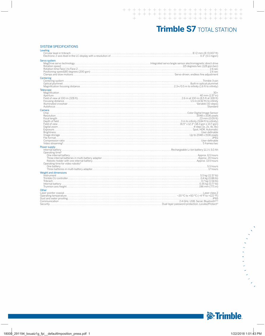
SYSTEM SPECIFICATIONSLeveling
Circular level in tribrach . . . . . . . . . . . . . . . . . . . . . . . . . . . . . . . . . . . . . . . . . . . . . . . . . . . . . . . . . . . . . . . . . . . . . . . . . . . . . . . . . . . . . . . . . . . . . . . . . . . 8'/2 mm (8'/0.007 ft)Electronic 2-axis level in the LC-display with a resolution of . . . . . . . . . . . . . . . . . . . . . . . . . . . . . . . . . . . . . . . . . . . . . . . . . . . . . . . . . . . . . . . . . . . . . . . . . 0.3" (0.1 mgon)
Servo systemMagDrive servo technology . . . . . . . . . . . . . . . . . . . . . . . . . . . . . . . . . . . . . . . . . . . . . . . . . . . . . . . . . . . . . .Integrated servo/angle sensor electromagnetic direct driveRotation speed . . . . . . . . . . . . . . . . . . . . . . . . . . . . . . . . . . . . . . . . . . . . . . . . . . . . . . . . . . . . . . . . . . . . . . . . . . . . . . . . . . . . . . . . . . . . . . . . . . . 115 degrees/sec (128 gon/sec)Rotation time Face 1 to Face 2 . . . . . . . . . . . . . . . . . . . . . . . . . . . . . . . . . . . . . . . . . . . . . . . . . . . . . . . . . . . . . . . . . . . . . . . . . . . . . . . . . . . . . . . . . . . . . . . . . . . . . . . . . . . . 2.6 secPositioning speed180 degrees (200 gon) . . . . . . . . . . . . . . . . . . . . . . . . . . . . . . . . . . . . . . . . . . . . . . . . . . . . . . . . . . . . . . . . . . . . . . . . . . . . . . . . . . . . . . . . . . . . . . . . . 2.6 secClamps and slow motions . . . . . . . . . . . . . . . . . . . . . . . . . . . . . . . . . . . . . . . . . . . . . . . . . . . . . . . . . . . . . . . . . . . . . . . . . . . . . . . . . . Servo-driven, endless fine adjustment
CenteringCentering system . . . . . . . . . . . . . . . . . . . . . . . . . . . . . . . . . . . . . . . . . . . . . . . . . . . . . . . . . . . . . . . . . . . . . . . . . . . . . . . . . . . . . . . . . . . . . . . . . . . . . . . . . . . . . . . . . .Trimble 3-pinOptical plummet . . . . . . . . . . . . . . . . . . . . . . . . . . . . . . . . . . . . . . . . . . . . . . . . . . . . . . . . . . . . . . . . . . . . . . . . . . . . . . . . . . . . . . . . . . . . . . . . . . . . . . . . Built-in optical plummetMagnification focusing distance . . . . . . . . . . . . . . . . . . . . . . . . . . . . . . . . . . . . . . . . . . . . . . . . . . . . . . . . . . . . . . . . . . . . . . . . . . . . . 2.3×/0.5 m to infinity (1.6 ft to infinity)
TelescopeMagnification . . . . . . . . . . . . . . . . . . . . . . . . . . . . . . . . . . . . . . . . . . . . . . . . . . . . . . . . . . . . . . . . . . . . . . . . . . . . . . . . . . . . . . . . . . . . . . . . . . . . . . . . . . . . . . . . . . . . . . . . . . . . . . 30×Aperture . . . . . . . . . . . . . . . . . . . . . . . . . . . . . . . . . . . . . . . . . . . . . . . . . . . . . . . . . . . . . . . . . . . . . . . . . . . . . . . . . . . . . . . . . . . . . . . . . . . . . . . . . . . . . . . . . . . . . . . 40 mm (1.57 in)Field of view at 100 m (328 ft) . . . . . . . . . . . . . . . . . . . . . . . . . . . . . . . . . . . . . . . . . . . . . . . . . . . . . . . . . . . . . . . . . . . . . . . . . . . . . . . . . . . . . 2.6 m at 100 m (8.5 ft at 328 ft)Focusing distance . . . . . . . . . . . . . . . . . . . . . . . . . . . . . . . . . . . . . . . . . . . . . . . . . . . . . . . . . . . . . . . . . . . . . . . . . . . . . . . . . . . . . . . . . . . . . . . . . . . . . . . 1.5 m (4.92 ft) to infinityIlluminated crosshair . . . . . . . . . . . . . . . . . . . . . . . . . . . . . . . . . . . . . . . . . . . . . . . . . . . . . . . . . . . . . . . . . . . . . . . . . . . . . . . . . . . . . . . . . . . . . . . . . . . . . . . . . Variable (10 steps)Autofocus . . . . . . . . . . . . . . . . . . . . . . . . . . . . . . . . . . . . . . . . . . . . . . . . . . . . . . . . . . . . . . . . . . . . . . . . . . . . . . . . . . . . . . . . . . . . . . . . . . . . . . . . . . . . . . . . . . . . . . . . . . . . Standard
CameraChip . . . . . . . . . . . . . . . . . . . . . . . . . . . . . . . . . . . . . . . . . . . . . . . . . . . . . . . . . . . . . . . . . . . . . . . . . . . . . . . . . . . . . . . . . . . . . . . . . . . . . . . . . . . . . . . . . Color Digital Image SensorResolution . . . . . . . . . . . . . . . . . . . . . . . . . . . . . . . . . . . . . . . . . . . . . . . . . . . . . . . . . . . . . . . . . . . . . . . . . . . . . . . . . . . . . . . . . . . . . . . . . . . . . . . . . . . . . . . . . . . 2048 x 1536 pixelsFocal length . . . . . . . . . . . . . . . . . . . . . . . . . . . . . . . . . . . . . . . . . . . . . . . . . . . . . . . . . . . . . . . . . . . . . . . . . . . . . . . . . . . . . . . . . . . . . . . . . . . . . . . . . . . . . . . . . . . . 23 mm (0.09 ft)Depth of field . . . . . . . . . . . . . . . . . . . . . . . . . . . . . . . . . . . . . . . . . . . . . . . . . . . . . . . . . . . . . . . . . . . . . . . . . . . . . . . . . . . . . . . . . . . . . . . . . . . .3 m to infinity (9.84 ft to infinity)Field of view . . . . . . . . . . . . . . . . . . . . . . . . . . . . . . . . . . . . . . . . . . . . . . . . . . . . . . . . . . . . . . . . . . . . . . . . . . . . . . . . . . . . . . . . . . . . . . . . . . . . 16.5° x 12.3° (18.3 gon x 13.7 gon)Digital zoom . . . . . . . . . . . . . . . . . . . . . . . . . . . . . . . . . . . . . . . . . . . . . . . . . . . . . . . . . . . . . . . . . . . . . . . . . . . . . . . . . . . . . . . . . . . . . . . . . . . . . . . . . . . . . . . 4-step (1x, 2x, 4x, 8x)Exposure . . . . . . . . . . . . . . . . . . . . . . . . . . . . . . . . . . . . . . . . . . . . . . . . . . . . . . . . . . . . . . . . . . . . . . . . . . . . . . . . . . . . . . . . . . . . . . . . . . . . . . . . . . . . . . . . . Spot, HDR, AutomaticBrightness . . . . . . . . . . . . . . . . . . . . . . . . . . . . . . . . . . . . . . . . . . . . . . . . . . . . . . . . . . . . . . . . . . . . . . . . . . . . . . . . . . . . . . . . . . . . . . . . . . . . . . . . . . . . . . . . . . . . . . . User-definableImage storage . . . . . . . . . . . . . . . . . . . . . . . . . . . . . . . . . . . . . . . . . . . . . . . . . . . . . . . . . . . . . . . . . . . . . . . . . . . . . . . . . . . . . . . . . . . . . . . . . . . . . . . . . .Up to 2048 x 1536 pixelsFile format . . . . . . . . . . . . . . . . . . . . . . . . . . . . . . . . . . . . . . . . . . . . . . . . . . . . . . . . . . . . . . . . . . . . . . . . . . . . . . . . . . . . . . . . . . . . . . . . . . . . . . . . . . . . . . . . . . . . . . . . . . . . . . . . JPEGCompression ratio . . . . . . . . . . . . . . . . . . . . . . . . . . . . . . . . . . . . . . . . . . . . . . . . . . . . . . . . . . . . . . . . . . . . . . . . . . . . . . . . . . . . . . . . . . . . . . . . . . . . . . . . . . . . . . . User-definableVideo streaming8 . . . . . . . . . . . . . . . . . . . . . . . . . . . . . . . . . . . . . . . . . . . . . . . . . . . . . . . . . . . . . . . . . . . . . . . . . . . . . . . . . . . . . . . . . . . . . . . . . . . . . . . . . . . . . . . . . . 5 frames/sec
Power supplyInternal battery . . . . . . . . . . . . . . . . . . . . . . . . . . . . . . . . . . . . . . . . . . . . . . . . . . . . . . . . . . . . . . . . . . . . . . . . . . . . . . . . . . . . . . . . . .Rechargeable Li-Ion battery 11.1 V, 5.0 AhOperating time9
One internal battery . . . . . . . . . . . . . . . . . . . . . . . . . . . . . . . . . . . . . . . . . . . . . . . . . . . . . . . . . . . . . . . . . . . . . . . . . . . . . . . . . . . . . . . . . . . . . . . . . . . . . . . . Approx. 6.5 hoursThree internal batteries in multi-battery adapter . . . . . . . . . . . . . . . . . . . . . . . . . . . . . . . . . . . . . . . . . . . . . . . . . . . . . . . . . . . . . . . . . . . . . . . . . . . . . . .Approx. 20 hoursRobotic holder with one internal battery . . . . . . . . . . . . . . . . . . . . . . . . . . . . . . . . . . . . . . . . . . . . . . . . . . . . . . . . . . . . . . . . . . . . . . . . . . . . . . . . . . . . . .Approx. 13.5 hours
Operating time for video robotic9
One battery . . . . . . . . . . . . . . . . . . . . . . . . . . . . . . . . . . . . . . . . . . . . . . . . . . . . . . . . . . . . . . . . . . . . . . . . . . . . . . . . . . . . . . . . . . . . . . . . . . . . . . . . . . . . . . . . . . . . . . . . 5.5 hoursThree batteries in multi-battery adapter . . . . . . . . . . . . . . . . . . . . . . . . . . . . . . . . . . . . . . . . . . . . . . . . . . . . . . . . . . . . . . . . . . . . . . . . . . . . . . . . . . . . . . . . . . . . . . . 17 hours
Weight and dimensionsInstrument . . . . . . . . . . . . . . . . . . . . . . . . . . . . . . . . . . . . . . . . . . . . . . . . . . . . . . . . . . . . . . . . . . . . . . . . . . . . . . . . . . . . . . . . . . . . . . . . . . . . . . . . . . . . . . . . . . . . . 5.5 kg (11.57 lb)Trimble CU controller . . . . . . . . . . . . . . . . . . . . . . . . . . . . . . . . . . . . . . . . . . . . . . . . . . . . . . . . . . . . . . . . . . . . . . . . . . . . . . . . . . . . . . . . . . . . . . . . . . . . . . . . . . . . .0.4 kg (0.88 lb)Tribrach . . . . . . . . . . . . . . . . . . . . . . . . . . . . . . . . . . . . . . . . . . . . . . . . . . . . . . . . . . . . . . . . . . . . . . . . . . . . . . . . . . . . . . . . . . . . . . . . . . . . . . . . . . . . . . . . . . . . . . . . . 0.7 kg (1.54 lb)Internal battery . . . . . . . . . . . . . . . . . . . . . . . . . . . . . . . . . . . . . . . . . . . . . . . . . . . . . . . . . . . . . . . . . . . . . . . . . . . . . . . . . . . . . . . . . . . . . . . . . . . . . . . . . . . . . . . . .0.35 kg (0.77 lb)Trunnion axis height . . . . . . . . . . . . . . . . . . . . . . . . . . . . . . . . . . . . . . . . . . . . . . . . . . . . . . . . . . . . . . . . . . . . . . . . . . . . . . . . . . . . . . . . . . . . . . . . . . . . . . . . . . . . .196 mm (7.71 in)
OtherLaser pointer coaxial . . . . . . . . . . . . . . . . . . . . . . . . . . . . . . . . . . . . . . . . . . . . . . . . . . . . . . . . . . . . . . . . . . . . . . . . . . . . . . . . . . . . . . . . . . . . . . . . . . . . . . . . . . . . . . . . . .Laser class 2Operating temperature . . . . . . . . . . . . . . . . . . . . . . . . . . . . . . . . . . . . . . . . . . . . . . . . . . . . . . . . . . . . . . . . . . . . . . . . . . . . . . . . . . . . . . . . . . –20 ºC to +50 ºC (–4 ºF to +122 ºF)Dust and water proofing . . . . . . . . . . . . . . . . . . . . . . . . . . . . . . . . . . . . . . . . . . . . . . . . . . . . . . . . . . . . . . . . . . . . . . . . . . . . . . . . . . . . . . . . . . . . . . . . . . . . . . . . . . . . . . . . . . . . . . .IP65Communication . . . . . . . . . . . . . . . . . . . . . . . . . . . . . . . . . . . . . . . . . . . . . . . . . . . . . . . . . . . . . . . . . . . . . . . . . . . . . . . . . . . . . . . . . . . . . . . . . . 2.4 GHz, USB, Serial, Bluetooth®10
Security . . . . . . . . . . . . . . . . . . . . . . . . . . . . . . . . . . . . . . . . . . . . . . . . . . . . . . . . . . . . . . . . . . . . . . . . . . . . . . . . . . . . . . . . . . . . Dual-layer password protection, Locate2Protect11
18000_291194_bouaiz1g_fpi__defaultImposition_press.pdf 1 1/22/2018 1:01:43 PM

TRANSFORMING THE WAY THE WORLD WORKS
DATASHEET
Specifications subject to change without notice.
Trimble S7 TOTAL STATION
1 Standard deviation according to ISO17123-4.2 Target color, atmospheric conditions, and scanning angles will impact range.3 Kodak Gray Card, Catalog number E1527795.4 Target shape, texture, and color; grid size; and distance and angle to target; will impact speed.5 Standard clear: No haze. Overcast or moderate sunlight with very light heat shimmer.6 Range and accuracy depend on atmospheric conditions, size of prisms and background radiation.7 Dependent on selected size of search window.8 0.5 frames per second with remote operation.9 The capacity in –20 ºC (–5 ºF) is 75% of the capacity at +20 ºC (68 ºF).10 Bluetooth type approvals are country specific.11 Functionality and availability dependent on region.12 Solution acquisition time is dependent upon solution geometry and GPS position quality.
AUTOLOCK AND ROBOTIC SURVEYINGAutolock and Robotic Range6
Passive prisms . . . . . . . . . . . . . . . . . . . . . . . . . . . . . . . . . . . . . . . 500–700 m (1,640–2,297 ft)Trimble MultiTrack Target . . . . . . . . . . . . . . . . . . . . . . . . . . . . . . . . . . . . . . . . .800 m (2,625 ft)Trimble ActiveTrack 360 Target . . . . . . . . . . . . . . . . . . . . . . . . . . . . . . . . . . . . 500 m (1,640 ft)
Autolock pointing precision at 200 m (656 ft) (Standard deviation)5
Passive prisms . . . . . . . . . . . . . . . . . . . . . . . . . . . . . . . . . . . . . . . . . . . . . . . . . . <2 mm (0.007 ft)Trimble MultiTrack Target . . . . . . . . . . . . . . . . . . . . . . . . . . . . . . . . . . . . . . . . <2 mm (0.007 ft) Trimble ActiveTrack 360 Target . . . . . . . . . . . . . . . . . . . . . . . . . . . . . . . . . . . <2 mm (0.007 ft)
Shortest search distance . . . . . . . . . . . . . . . . . . . . . . . . . . . . . . . . . . . . . . . . . . . . . . 0.2 m (0.65 ft)Type of radio internal/external . . . . 2.4 GHz frequency-hopping, spread-sprectrum radios
Search time (typical)7 . . . . . . . . . . . . . . . . . . . . . . . . . . . . . . . . . . . . . . . . . . . . . . . . . . . . . . 2–10 sec
FINELOCKPointing precision at 300 m (980 ft)
(standard deviation)6 . . . . . . . . . . . . . . . . . . . . . . . . . . . . . . . . . . . . . . . . . . . . <1 mm (0.003 ft)Range to passive prisms (min–max)6 . . . . . . . . . . . . . . . . . . 20 m–700 m (64 ft–2,297 ft)
Minimum spacing between prismsat 200 m (656 ft) . . . . . . . . . . . . . . . . . . . . . . . . . . . . . . . . . . . . . . . . . . . . . . . . .0.8 m (2.625 ft)
GPS SEARCH/GEOLOCKGPS Search/GeoLock . . . . . . . . . . . . . . . . . . . . . . . . . . . . . . . . . . . . . . . . .360 degrees (400 gon)
or defined horizontal and vertical search windowSolution acquisition time12 . . . . . . . . . . . . . . . . . . . . . . . . . . . . . . . . . . . . . . . . . . . . . . . . . 15–30 secTarget re-acquisition time . . . . . . . . . . . . . . . . . . . . . . . . . . . . . . . . . . . . . . . . . . . . . . . . . . . . <3 secRange . . . . . . . . . . . . . . . . . . . . . . . . . . . . . . . . . . . . . . . . . . . . . . . . Autolock & Robotic range limits
NORTH AMERICATrimble Navigation Limited10368 Westmoor DrWestminster CO 80021USA
EUROPETrimble Germany GmbHAm Prime Parc 1165479 Raunheim GERMANY
ASIA-PACIFICTrimble Navigation Singapore Pty Limited80 Marine Parade Road#22-06, Parkway ParadeSingapore 449269 SINGAPORE
Contact your local Trimble Authorized Distribution Partner for more information
© 2015-2017, Trimble Inc. All rights reserved. Trimble, the Globe & Triangle logo, and Autolock are trademarks of Trimble Inc., registered in the United States and in other countries. Access, FineLock, InSphere, MagDrive, MultiTrack, SurePoint, and VISION are trademarks of Trimble Inc. The Bluetooth word mark and logos are owned by the Bluetooth SIG, Inc. and any use of such marks by Trimble Inc. is under license. All other trademarks are the property of their respective owners. PN 022516-154C (07/17)
www.seilergeo.com
Seiler InstrumentToll Free: 888-263-8918Email: [email protected]
18000_291194_bouaiz1g_fpi__defaultImposition_press.pdf 1 1/22/2018 1:01:43 PM
CONTACT YOUR LOCAL TRIMBLE AUTHORIZED DISTRIBUTION PARTNER FOR MORE INFORMATION:
Related Documents


