Data Buoy Cooperation Panel Inserting buoy data onto the GTS Table of contents Data Buoy Cooperation Panel 1 Inserting buoy data onto the GTS 1 1. Introduction 2 2. The Global Telecommunication System (GTS) 2 3. Need for real time observational data 2 4. Benefits of disseminating your data onto the GTS: 2 5. What if your data are sensitive? 3 6. How to insert the data on GTS? 5 Figure 1: Flow chart of steps involved in inserting data on the GTS 5 Figure 2: Map of WMO areas for allocation of WMO numbers based upon buoy deployment area 6 7. What to do after the buoys are on GTS? 7 8. Contacts 7 9. Letter or Email template for encouraging distribution on the GTS. SAMPLE ONLY. 8 Letter - Sample Word Document (.doc) Letter - Sample PDF Document(.pdf) 8 Appendix A - GTS Technical File for the Argos System 9

Welcome message from author
This document is posted to help you gain knowledge. Please leave a comment to let me know what you think about it! Share it to your friends and learn new things together.
Transcript

Data Buoy Cooperation Panel
Inserting buoy data onto the GTS
Table of contents
Data Buoy Cooperation Panel 1
Inserting buoy data onto the GTS 1
1. Introduction 2
2. The Global Telecommunication System (GTS) 2
3. Need for real time observational data 2
4. Benefits of disseminating your data onto the GTS: 2
5. What if your data are sensitive? 3
6. How to insert the data on GTS? 5
Figure 1: Flow chart of steps involved in inserting data on the GTS 5
Figure 2: Map of WMO areas for allocation of WMO numbers based upon buoy deployment area 6
7. What to do after the buoys are on GTS? 7
8. Contacts 7
9. Letter or Email template for encouraging distribution on the GTS. SAMPLE ONLY. 8
Letter - Sample Word Document (.doc) Letter - Sample PDF Document(.pdf) 8
Appendix A - GTS Technical File for the Argos System 9

1. Introduction
The information contained here relates to operators or programme leaders of all Oceanographic Platforms. It is aimed mainly at users of the Argos System, but parts of it may also apply to users of other communication systems. The Global Telecommunication System used to disseminate meteorological and oceanographic data are explained and users are encouraged to consider the benefits of sharing their data via this system. The data arising from your program, as well as providing you with the data and information you need, has the potential to benefit the broader scientific community. A large number of Argos users already distribute their data on the Global Telecommunication System which assists weather forecasting, ocean modelling and climate research (for more on the GTS, please see paragraph on GTS below). As well as these wider community benefits, a direct benefit for you could be that many nations' weather centers can monitor the quality of the data produced within your program and identify possible issues with data.
2. The Global Telecommunication System (GTS)
The GTS is a telecommunication network of point to point circuits which is operated by National Meteorological Services, as a component of the World Weather Watch (WWW) of the WMO (http://www.wmo.int). Real time meteorological and oceanographic data are exchanged (distributed onto the GTS network) on a voluntary basis for insertion into numerical weather prediction models. It is a very good example of international co-operation for the benefit of operational weather and marine forecasting.
More information about the GTS: http://www.wmo.int/web/www/TEM/gts.html
3. Need for real time observational data
The land-based observation network (weather stations) is for the most part, sufficiently dense and produces data of good quality. However, over ocean areas there is a real lack of meteorological data, particularly in the data sparse areas not covered by the networks of the Ship Observations Team (SOT) reporting weather data in real time onto the GTS. In addition many geo-physical variables either cannot be measured directly using remote sensing technology or ground truth is needed for that purpose to obtain sufficient accuracy.
Hence Principal Investigators or Managers of drifting and moored buoy programmes are regularly requested to allow the dissemination of their data onto the GTS. Variables such as Air Pressure, Air Temperature, Sea Surface Temperature, Air Pressure Tendency, Wind and even Sub-Surface Temperature are particularly useful.
Any platform which measures one or more of these variables would be of a valuable interest for the meteorological models to improve the quality of the weather forecasts produced, so should be disseminated onto the GTS.
4. Benefits of disseminating your data onto the GTS:

The data from over 70% of Argos ocean buoys worldwide are now sent onto the GTS. This input is helping weather centers to produce better forecasts and contributing in the long term to global climate studies. Data from Iridium Buoys is now also inserted onto the GTS by commercial data processing providers (CLS, CLS America and JouBeh) and national meteorological/oceanographic centers.
The distribution of your data onto the GTS can also provide you with direct benefits. Some points to consider are:
Advantages
1. Several weather centers will monitor the quality of your data, after they are inserted in numerical models and compared with them. You will automatically be told about any problems, e.g. sensor bias (Quality Control). Buoy monitoring statistics are produced monthly by major meteorological centres and are available to the public.
2. If required, you will be assisted by the DBCP Technical Coordinator, free of charge, in all your dealings with the Argos system. For instance, a WMO number is allocated to each buoy reporting on the GTS, the technical coordinator can assist in obtaining these numbers.
3. CLS/CLS America does not charge for the GTS Service. Platform status changes, such as recalibrating a sensor, will also be free of charge. Your regular Argos results will be unaffected by GTS distribution. For example, the Argos processing centers can apply transfer functions to your GTS data but still provide you with your raw data.
Please contact either the Technical Coordinator of the DBCP or your CLS/CLS America/JouBeh representative, if you have any questions, or wish to authorise GTS distribution.
5. What if your data are sensitive?
If for confidentiality reasons, you are reluctant to allow the dissemination of your drifting buoy data onto the GTS, you may be interested in this additional information:
i. Disallow some sensor information: If you wish, you can authorise GTS distribution for certain sensor data on the platform which may be of use to Meteorology or Ocean forecast, while denying GTS distribution for other sensors.
ii. Downgrade the position resolution: The position of the platform will always be included in GTS reports and positions are normally encoded to the 1000th of degree and the location quality class is normally distributed. Locations with accuracy of about 10 Km (~10th of degree) are still useful for meteorological purposes. So, you can ask to disseminate location data to the 100th or even to the 10th of degree (Latitude/Longitude), additionally you can ask that the location quality class not be distributed on GTS. This would avoid the possibility of another researcher (if they could access the GTS data, which is unlikely) using the data for surface velocity research purposes.
iii. Not a research tool: GTS is an operational tool. Most of the GTS users are Meteorological Centres and use the GTS data for real-time or near real-time forecasting. They are not interested in using the data for research purposes, besides there is no indication in the message of the characteristics of the drifter: shape and size of the drifter, type of the drogue, etc....It is possible to indicate the drogue status (depth, attached, detached) in GTS reports, but you may ask to remove that information. This kind of information is needed only

to know if the drifter is a good Lagrangian drifter and if so, to correct the data using a calibration formula (e.g. wind stress...) to obtain a better accuracy.
iv. Archives: The Responsible National Oceanographic Data Center for Drifting Buoys (RNODC/DB) which is operated by the ISDM ( in Canada routinely archives buoy data from the GTS. Users may ask ISDM to provide them with GTS data and use these for research purposes. There is however the possibility for you to sign a contract with ISDM to hold your drifting buoy data in confidence for an agreed period: ISDM would NOT, in that case, provide users with these data without prior written authorisation from you.
ISDM web links
• http://isdm.gc.ca/ • http://www.meds-sdmm.dfo-mpo.gc.ca/isdm-gdsi/drib-bder/gts-
smt/index-eng.asp

6. How to insert the data on GTS?
Figure 1: Flow chart of steps involved in inserting data on the GTS (http://www.jcommops.org/DBCP/doc/gts_data_flow.pdf, 250KB, PDF file).

Note: Assistance can be obtained from the Technical Coordinator of the DBCP (see below).
Obtaining WMO numbers:
One WMO number is allocated for each buoy reporting on GTS. WMO numbers are allocated depending upon buoy type (i.e. drifting or moored), international programme in which the buoy participates (e.g. WOCE), and deployment area (see map below). There are National Focal Points in many countries responsible for allocating WMO numbers. Please contact your National Focal Point and provide him/her with following information:
a. Number of buoys, and for each buoy: b. Buoy type c. Deployment area (refer to the map below) d. International programme, if any, in which the buoy participates.
Using this detail the National Focal Point will and he/she will provide you with the WMO numbers.
More detail on allocation of WMO numbers can be obtained at on the WMO website. If you prefer, the Technical Coordinator of the DBCP can contact the National Focal Point on your behalf and obtain the numbers for you.
Details about WMO Numbers: http://www.jcommops.org/wmo_numbers.html
Once allocated, you can re-use WMO numbers for future buoys provided that buoy type, deployment area, and international programme remains the same. If your buoy programme stops and do not intend to deploy buoys in the future, please release the WMO numbers to your National Focal Point.
Figure 2: Map of WMO areas for allocation of WMO numbers based upon buoy
deployment area

If you experience any problems with WMO numbers please contact the The Marine Meteorology and Oceanography Programme at WMO directly.
Providing CLS/CLS America with technical file information:
There is certain information required before CLS can enable the distribution onto the GTS. The following information forms part of an Argos Technical File, which enables this to happen without issue. CLS would prefer that you submit the technical file prior to deployment.
a. WMO number b. Argos message format (bit positions and number of bits for each sensor) c. List of sensors authorised for GTS distribution d. Calibration curves and coefficients for converting binary information (e.g. counts)
from the Argos messages into geo-physical units (e.g. Temperature in Celsius). e. Deployment date and approximate deployment position. f. Specific algorithms, if any, for computing time of observation g. Specific algorithms, if any, for computing Argos message checksum (to validate
integrity of Argos message, i.e. check that message is error free at the BIT level)
A GTS technical file template is available in Appendix A below, print it, fill it out, scan it or send the paper form to processing center (see contacts below).
Alerting the data processing center as soon as the buoy is operational:
Ask for immediate distribution of the buoy data on the GTS.
7. What to do after the buoys are on GTS?
Continue using the data as usual
After the buoy data are distributed on GTS, although specific quality control checks are operated in real time at the processing centres, and in deferred time at meteorological centres using the data, it is recommended that you also monitor the quality of the buoy data and ask your representative at the processing center to stop GTS distribution for any failed sensors or for the whole buoy - if you believe the data are not of good quality anymore.
When a buoy is removed from GTS distribution (by CLS or JouBeh, based on your instructions), its WMO number is automatically de-allocated and the number can be re-used for another buoy of the same type deployed in the same area.
8. Contacts
Data Buoy Cooperation Panel Technical Coordinator
• http://www.jcommops.org/dbcp/community/contacts.html
National Focal Points for Buoy Programmes
• http://www.jcomm.info/index.php?option=com_oe&task=viewGroupRecord&groupID=147

WMO Marine Meteorology and Oceanography Programme
• http://www.wmo.int/pages/prog/amp/mmop/contact_us.html
Data Processing Providers
CLS and CLS America (Argos and Iridium)
• http://www.cls.fr/html/cls/contacts_en.html
JouBeh (Iridium)
• http://www.joubeh.com/contact.aspx?id=3
9. Letter or Email template for encouraging distribution on the GTS. SAMPLE ONLY.
Letter - Sample Word Document (.doc)
Letter - Sample PDF Document(.pdf)

Appendix A - GTS Technical File for the Argos System
This Technical File is for you to specify how you want your data processed and sent onto the GTS. You will find an example and explanations just before each sheet to fill out. If your requirements are more detailed than those discussed in this document, please contact us by e-mail, fax or phone.
The Argos GTS data processing system
Two centers process Argos data for distribution via the GTS:
• United States Global Processing Center (USGPC) in Washington DC, USA,
• French Global Processing Center (FRGPC) in Toulouse, France.
One of the goals of the system is to optimize the quantity and quality of Argos data sent onto the GTS without interfering with Principle Investigators' (PIs') requirements.
The Global Telecommunication System (GTS) is a network of point-to-point circuits operated by National Meteorological Services as a component of the World Meteorological Organization's (WMO's) World Weather Watch (WWW). It is used to exchange meteorological, hydrological, and oceanographic data on a global basis, in real time and according to WMO formats and regulations.
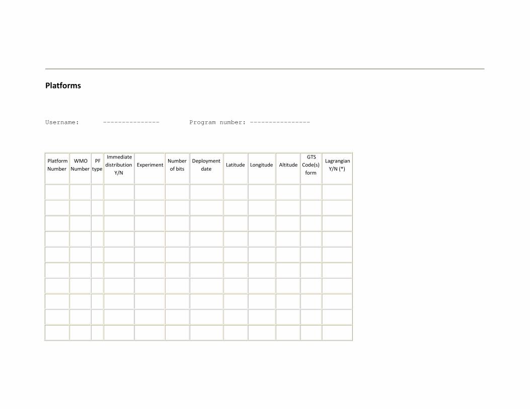
Platforms
Username: --------------- Program number: ----------------
Platform
Number
WMO
Number
PF
type
Immediate
distribution
Y/N
Experiment Number
of bits
Deployment
date Latitude Longitude Altitude
GTS
Code(s)
form
Lagrangian
Y/N (*)

(*) If Yes: Drogue Shape: Holey sock Drogue Depth: 15 Meters Drogue attached: Yes
Example:
Platform
Number
WMO
Number
PF
type
Immediate
distribution
Y/N
Experiment Number
of bits
Deployment
date Latitude Longitude Altitude
GTS
Code(s)
form
Lagrangian
Y/N (*)
Example
9999 55555 -1 Y TOGA 256 April 95 24.637 N 40.078 W 0 Drifter Y
(*) If Yes: Drogue Shape: Holey sock Drogue Depth: 15 Meters Drogue attached: Yes

Explanation of fields:
WMO Number Enter the WMO number assigned to the platform. To obtain WMO numbers please contact:
- your National Focal Point for Drifting Buoy Programs (see list in Appendix 2), or - the Technical Coordinator of the Data Buoy Cooperation Panel (DBCP).
WMO numbers are assigned by country, according to where the buoy is deployed and the type of buoy.
PF Type Enter the code for the type of station:
-8 Fixed platform
-2 Moored buoy
-1 Drifting buoy
+4 Ship
Immediate distribution
Y/N
If the platform data must be sent onto the GTS as soon as possible: enter "Y". If we must wait for your confirmation, enter "N".
Experiment If the platform is part of an international experiment or program (e.g. TOGA, WOCE, IAPB) enter the program name.
Number of bits Enter the total number of bits sent by the platform in each Argos message.
GTS code form BUOY: Drifting or moored buoy
SYNOP: Land station
SHIP: Ship
BATHY: Bathythermal profile
TESAC: Sub-surface temperature and salinity
HYDRA: Hydrological station
Lagrangian Y/N Enter whether the platform is a Lagrangian drifter (accurately following sea currents) or not.
Drogue shape Enter the shape of the drogue (e.g. Holey sock, Tristar, etc.).
Drogue depth Enter the drogue depth in meters.
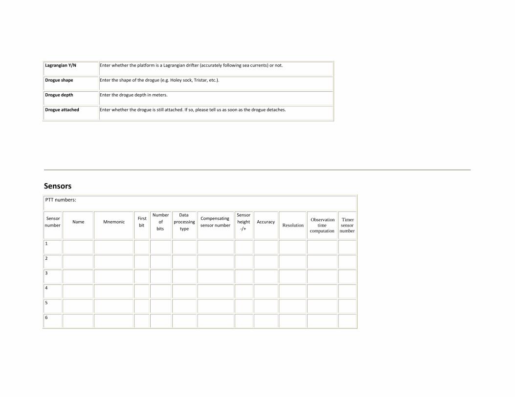
Drogue attached Enter whether the drogue is still attached. If so, please tell us as soon as the drogue detaches.
Sensors
PTT numbers:
Sensor
number Name Mnemonic
First
bit
Number
of
bits
Data
processing
type
Compensating
sensor number
Sensor
height
-/+
Accuracy Resolution
Observation time
computation
Timer sensor number
1
2
3
4
5
6

7
8
9
10
11
12
13
14
15
16
17
18
19
20
21
22
23
24

25
26
27
28
29
30
31
32
Example:
PTT numbers:
Sensor
number Name Mnemonic
First
bit
Number
of
bits
Data
processing
type
Compensating
sensor number
Sensor
height
-/+
Accuracy Resolution
Observation time
computation
Timer sensor number
Example
1 Synoptic hour HOUR 8 8 3600
2 Internal
temperature INTEMP_SY 16 10 B1 0 0 .1 °C 0.01 °C B8 2

3
Synoptic
atmospheric
pressure
ATMPRES_SY 26 10 B4 3 0 0. 01 hPa 0.01 hPa B8 2
4
5
...
...
Explanation of fields:
Name Enter the name of the sensor in plain form, e.g. atmospheric pressure, synoptic atmospheric pressure.
Mnemonic Enter your suggested sensor number in capital letters (maximum: 16 alphanumeric characters). We recommend the
following:
ATMPRES atmospheric pressure
SEATEMP sea-surface temperature
AIRTEMP air temperature
WINDSP wind speed
WINDIR wind direction
TEND atmospheric pressure tendency
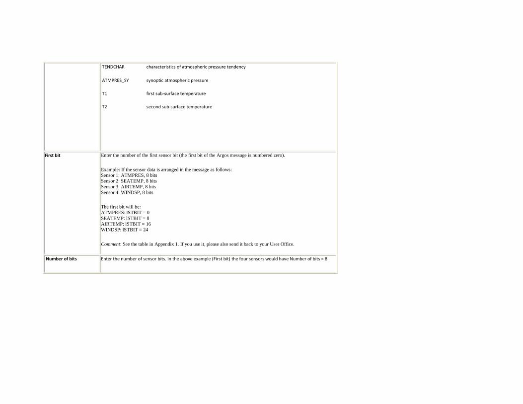
TENDCHAR characteristics of atmospheric pressure tendency
ATMPRES_SY synoptic atmospheric pressure
T1 first sub-surface temperature
T2 second sub-surface temperature
First bit Enter the number of the first sensor bit (the first bit of the Argos message is numbered zero).
Example: If the sensor data is arranged in the message as follows: Sensor 1: ATMPRES, 8 bits Sensor 2: SEATEMP, 8 bits Sensor 3: AIRTEMP, 8 bits Sensor 4: WINDSP, 8 bits
The first bit will be: ATMPRES: lSTBIT = 0 SEATEMP: lSTBIT = 8 AIRTEMP: lSTBIT = 16 WINDSP: lSTBIT = 24
Comment: See the table in Appendix 1. If you use it, please also send it back to your User Office.
Number of bits Enter the number of sensor bits. In the above example (First bit) the four sensors would have Number of bits = 8

Data processing type Enter the type of data processing you require:
B1 Provides physical values. These are obtained from the raw data and its calibration curve.
The calibration curve is defined by up to 20 points, extreme values included. They can be
shown as one or more straight line segments. Calculation is by linear interpolation
between the tabulated values (see below).
B4 Outputs physical values. These are obtained from the raw data, its calibration curve and a
transfer function. The transfer function can be up to a fifth-order polynomial. A first
polynomial (Ai) is applied to the main (actual) raw value. If you wish, you may define a
second polynomial (Bi) to compensate the main value (see below).
SM ,
software module
Enter the name of the module you choose and the values of the coefficients on a
separate sheet (see below). For example, SM=TEMP_LOGA. Please refer to your GTS
subsystem reference manual for details of the software modules available, or contact
your User Office.
Timer If the sensor is a clock counter, specify the units for conversion to seconds. For example,
if the counter is coded in tens of minutes (1=10 minutes, 2=20 minutes, etc.) enter 600.
Checksum If the sensor value is a checksum, use a separate sheet to specify how to check the Argos
message integrity based on the value of the checksum word encoded in the mesage.
Compensating sensor
number
Enter the number of the compensating sensor if there is one. In the example, sensor ATMPRES_SY is temperature-
compensated using the value of sensor INTEMP_SY (i.e. sensor number 3).
Sensor height Enter the height of the sensor relative to the station. For example, for a temperature probe 20 m below the sea
surface, enter -20; for a wind sensor on a pylon at 10 m height, enter +10.
Accuracy Enter the sensor accuracy (ex.: +/- 0.1 hPa).
Resolution Enter the sensor resolution (ex.: 0.01 hPa).
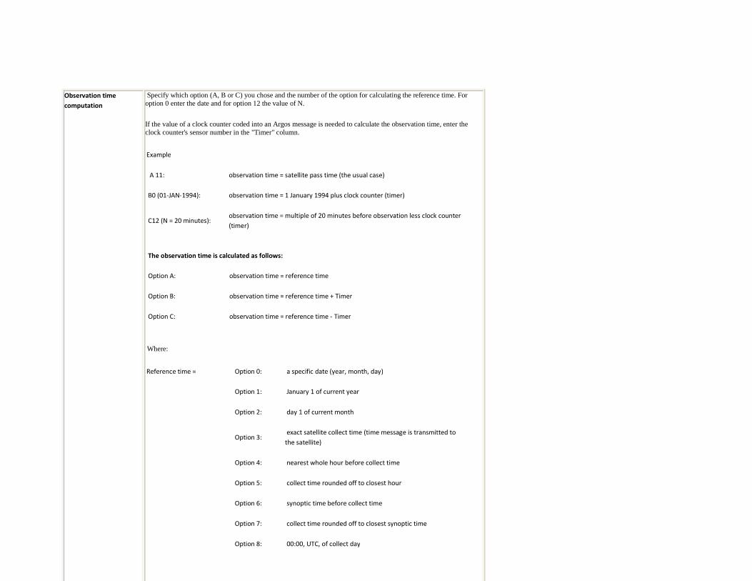
Observation time
computation
Specify which option (A, B or C) you chose and the number of the option for calculating the reference time. For option 0 enter the date and for option 12 the value of N.
If the value of a clock counter coded into an Argos message is needed to calculate the observation time, enter the clock counter's sensor number in the "Timer" column.
Example
A 11: observation time = satellite pass time (the usual case)
B0 (01-JAN-1994): observation time = 1 January 1994 plus clock counter (timer)
C12 (N = 20 minutes): observation time = multiple of 20 minutes before observation less clock counter
(timer)
The observation time is calculated as follows:
Option A: observation time = reference time
Option B: observation time = reference time + Timer
Option C: observation time = reference time - Timer
Where:
Reference time = Option 0: a specific date (year, month, day)
Option 1: January 1 of current year
Option 2: day 1 of current month
Option 3: exact satellite collect time (time message is transmitted to
the satellite)
Option 4: nearest whole hour before collect time
Option 5: collect time rounded off to closest hour
Option 6: synoptic time before collect time
Option 7: collect time rounded off to closest synoptic time
Option 8: 00:00, UTC, of collect day

Timer sensor number For a sensor using a clock counter to calculate observation time, enter the counter's sensor number in the "Timer"
column.
Type-B1 processing
Processing option B1 outputs physical data, for example temperatures in °C, by reading a calibration curve, or transfer function, to interpret the raw sensor outputs.
You can provide up to 20 points, including end points, to define your calibration curve. The curve is a straight line segment or set of segments. Between the points, Argos estimates by linear interpolation.
Comments
• Raw values must be unsigned integers.
• Physical values may be expressed as up to seven signed (+ or -) significant figures, with a signed or unsigned exponent.
Examples: -352, 10E-2.
• The first raw value / physical value pair must represent a raw value with all bits 0.
• The last raw value / physical value pair must represent a raw value with all bits 1.
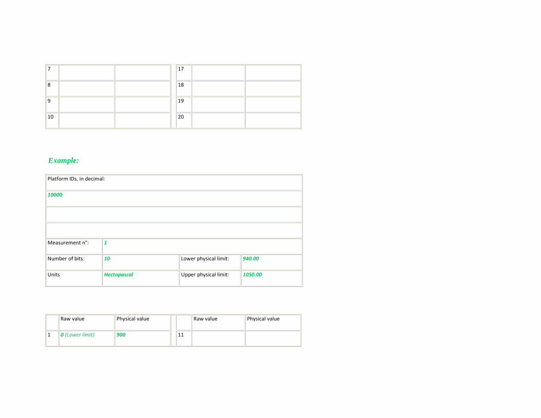
Kate O'Riley is using processing option B1 in its simplest form, i.e. defining two points to give a straight line. In the example, a raw sensor output of 700 converts to a pressure of 1016.3 hPa

Platform IDs, in decimal:
Measurement n°:
Number of bits: Lower physical limit:
Units Upper physical limit:
Raw value Physical value
Raw value Physical value
1 11
2 12
3 13
4 14
5 15
6 16
7 17
8 18
9 19
10 20
Example:
Platform IDs, in decimal:
10000
Measurement n°: 1
Number of bits: 10 Lower physical limit: 940.00
Units Hectopascal Upper physical limit: 1050.00
Raw value Physical value
Raw value Physical value
1 0 (Lower limit) 900 11
2 1023 (Upper limit) 1070 12
3 13
4 14
5 15
6 16
7 17
8 18
9 19
10 20
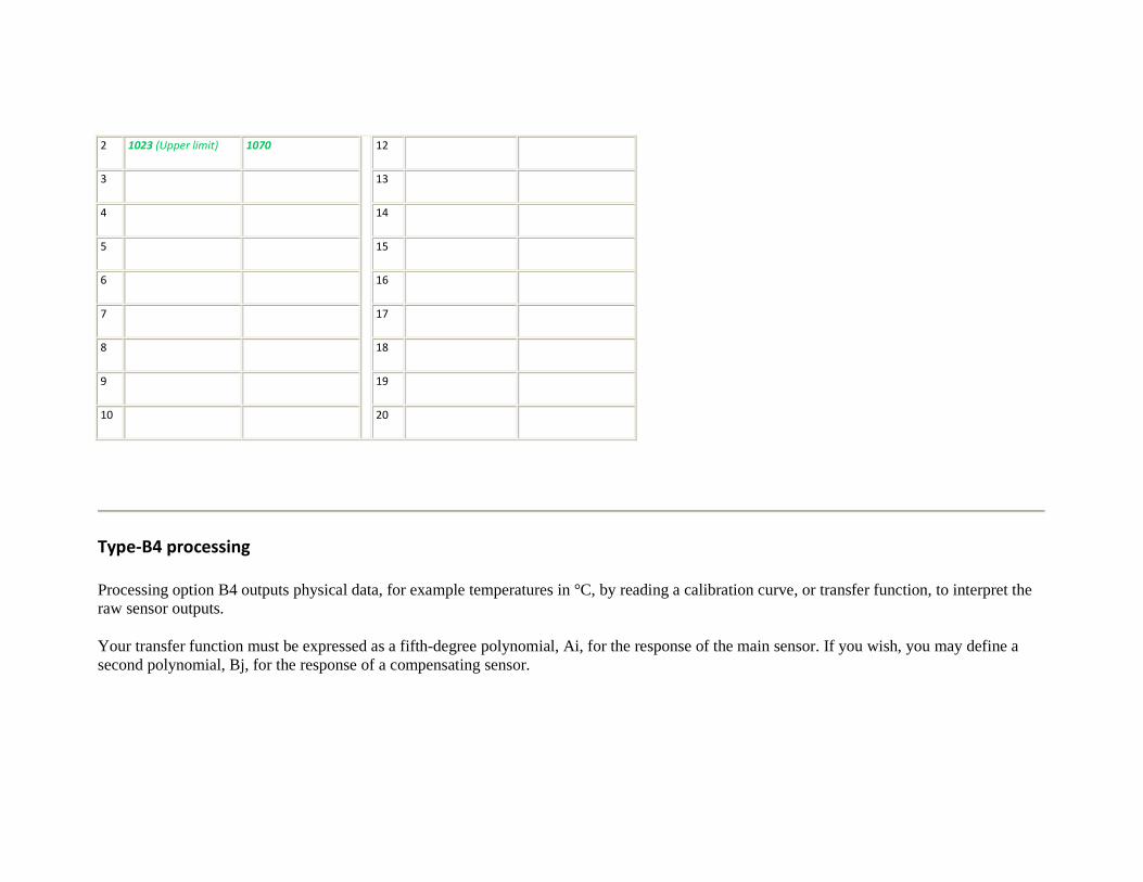
Type-B4 processing
Processing option B4 outputs physical data, for example temperatures in °C, by reading a calibration curve, or transfer function, to interpret the raw sensor outputs.
Your transfer function must be expressed as a fifth-degree polynomial, Ai, for the response of the main sensor. If you wish, you may define a second polynomial, Bj, for the response of a compensating sensor.

Comments
• Coefficients may be expressed as up to seven signed (+ or -) significant figures, with one or two figures signed or unsigned exponents.
Examples: -352, 10E-2.
• The formula is:
R = A0 + A1Xi + A2Xi2 + A3Xi3 + A4Xi4 + A5Xi5 + B1Xj + B2*Xj2 + B3Xj3 + B4Xj4 + B5Xj5
where:
R is the result
Xi and Xj are the main and compensating sensor outputs
• By setting the B coefficients to zero, the formula becomes a simple polynomial for use with a single sensor.
• B4 processing can be used to switch the order of the sensor data in the results by setting A1 through A5 to zero and transferring to the
compensating sensor (B1 through B5).
Example: Kate O'Riley defines a sensor response such that the physical value for a main sensor output of 42 is 11°, for any compensating sensor output: all coefficients for the compensating sensor are zero.
Platform IDs, in decimal:

Measurement n°:
Number of bits: Lower physical limit:
Units Upper physical limit:
Main raw value Compensating raw value
Measurement n°
Number of bits
Coefficients A0
A1 B1
A2 B2
A3 B3
A4 B4
A5 B5

Example:
Platform IDs, in decimal:
10000
Measurement n°: 10
Number of bits: 6 Lower physical limit: 0
Units °C Upper physical limit: 15
Main raw value Compensating raw value
Measurement n° 10
Number of bits 6
Coefficients A0 -0.5
A1 0 B1 0
A2 652 E-3 B2 0
A3 0 B3 0

A4 0 B4 0
A5 0 B5 0
Type-SM processing
Software
module name
Sensors
Lower limit
Higher limit
Coefficient Value
C01
C02
C03
C04
C05

C06
C07
C08
C09
C10
C11
C12
C13
C14
C15
C16
C17
C18
C19
C20
End of Technical file.
Related Documents