Welcome message from author
This document is posted to help you gain knowledge. Please leave a comment to let me know what you think about it! Share it to your friends and learn new things together.
Transcript


DAMPIER ARCHIPELAGO NATURE RESERVES
MANAGEMENT PLAN
1990-2000
Prepared byKeith Morris
Project Team
Allan Padgett (Coordinator)
Keith Morris
Hugh Chevis
Greg Oliver
Department of Conservation and Land Management
i
PREFACE
The islands of the Dampier Archipelago, located off the Pilbara coast, have significant conservation,
historic and archeological values. Since 1965 they have also been a valued recreation resource for the
public from nearby Pilbara communities.
Many of the islands are nature reserves, vested in the National Parks and Nature Conservation
Authority (NPNCA), and managed by the Department of Conservation and Land Management
(CALM). In addition to these, there are other islands and parts of islands in the Archipelago also
vested in the NPNCA and managed by CALM, which are reserved for conservation and recreation.
This plan proposes management programs only for the nature reserves of the archipelago, and
recommends that their purpose be changed to National Park to allow for the recreational use of the
islands. Parliament needs to approve of the change of purpose before actions proposed within this
plan and requiring National Park status are able to proceed.
Within the term of this plan, the islands presently reserved for conservation and recreation will be
incorporated into the national park and a comprehensive management plan produced.
The NPNCA is responsible for the preparation of management plans for all lands which are vested in
it. A draft management plan for Dampier Archipelago Nature Reserves was prepared by officers of
CALM and issued by the Authority for public comment. After consideration of public comment, the
NPNCA submitted the revised draft plan to the Hon. Minister for the Environment for approval. The
Minister approved this document as the Management Plan for Dampier Archipelago Nature Reserves
on 6 June 1990.
The final plan will be current for up to ten (10) years, from the date of adoption, but may be revised
within this period, following statutory requirements for public review.
On 24 May 1990, the Bush Fires Board endorsed this plan under Section 34(i) of the Bush Fires Act
1954.
i i
TABLE OF CONTENTS
PREFACE ___________________________________________________________________ i
TABLE OF CONTENTS________________________________________________________ii
ACKNOWLEDGEMENTS_____________________________________________________ iv
A GUIDE TO THIS PLAN______________________________________________________v
PART A
THE DAMPIER ARCHIPELAGO RESOURCE ____________________________________11.0 STUDY AREA__________________________________________________________2
1.1 LOCATION______________________________________________________________________21.2 LAND STATUS __________________________________________________________________21.3 CLIMATE _______________________________________________________________________81.4 LANDSCAPE ___________________________________________________________________111.5 IMPLICATIONS FOR MANAGEMENT______________________________________________13
2.0 HISTORY AND LAND USE______________________________________________132.1 ABORIGINAL OCCUPATION______________________________________________________132.2 EARLY EUROPEAN EXPLORATION_______________________________________________142.3 LAND-USE 1860-1960____________________________________________________________152.4 LAND-USE 1960-PRESENT _______________________________________________________162.5 AQUACULTURE ________________________________________________________________212.6 POSSIBLE FUTURE LAND-USES__________________________________________________222.7 HISTORY OF RESERVE STATUS _________________________________________________222.8 IMPLICATIONS FOR MANAGEMENT______________________________________________23
3.0 BIOLOGICAL RESOURCES_____________________________________________243.1 FLORA ________________________________________________________________________243.2 VEGETATION___________________________________________________________________263.3 FIRE HISTORY _________________________________________________________________283.4 FAUNA ________________________________________________________________________293.5 NATURE CONSERVATION VALUES_______________________________________________333.6 IMPLICATIONS FOR MANAGEMENT______________________________________________36
PART B
PLAN FOR MANAGEMENT __________________________________________________374.0 MANAGEMENT OBJECTIVES___________________________________________38
4.1 GENERAL OBJECTIVES__________________________________________________________384.2 SPECIFIC MANAGEMENT OBJECTIVES ___________________________________________38
5.0 MANAGEMENT FOR CONSERVATION OF FLORA, FAUNA AND LANDSCAPE395.1 FIRE PROTECTION______________________________________________________________395.2 CONTROL OF INTRODUCED PLANTS_____________________________________________415.3 CONTROL OF INTRODUCED ANIMALS ___________________________________________425.4 CONTROL OF ACCESS FOR MINING AND INDUSTRIAL PURPOSES__________________435.5 AQUACULTURE ________________________________________________________________455.6 HABITAT DEGRADATION AND REHABILITATION __________________________________465.7 MARINE POLLUTION____________________________________________________________475.8 RESEARCH AND MONITORING __________________________________________________48
6.0 MANAGEMENT OF ABORIGINAL AND HISTORIC SITES___________________50
7.0 MANAGEMENT FOR PUBLIC USE_______________________________________517.1 MANAGEMENT ZONINGS________________________________________________________51
i i i
7.2 GUIDELINES FOR PUBLIC USE___________________________________________________577.3 INTERPRETATION ______________________________________________________________587.4 COMMERCIAL CONCESSIONS___________________________________________________60
8.0 PARK PROGRAMMES_________________________________________________61
9.0 PLAN IMPLEMENTATION AND REVISION________________________________68
BIBLIOGRAPHY ____________________________________________________________69
APPENDIX 1 CONDITIONS OF USE FOR SURVEY STATIONS IN THE DAMPIERARCHIPELAGO - WOODSIDE ________________________________________________74
APPENDIX II DAMPIER ARCHIPELAGO ISLAND NAME CODES________________76
APPENDIX III DISTRIBUTION OF THE TERRESTRIAL MAMMALS IN THE
DAMPIER ARCHIPELAGO ___________________________________________________77
APPENDIX IV MARINE MAMMALS OF THE DAMPIER ARCHIPELAGO _________78
SEPARATE DOCUMENTAPPENDIX V Distribution of Birds in the Dampier ArchipelagoAPPENDIX VI Distribution of Amphibians and Reptiles in the Dampier Archipelago
FIGURES
FIGURE 1. LOCATION OF THE DAMPIER ARCHIPELAGOFIGURE 2. LAND STATUS OF ISLANDS IN THE DAMPIER ARCHIPELAGOFIGURE 3. GEOLOGY OF THE DAMPIER ARCHIPELAGOFIGURE 4. MANAGEMENT ZONINGS FOR THE NATURE RESERVES IN THE
DAMPIER ARCHIPELAGO
TABLES
TABLE 1. STATUS OF ISLANDS IN THE DAMPIER ARCHIPELAGOTABLE 2. A SUMMARY OF METEROLOGICAL, DATA FROM DAMPIER SALT PTY
LTDTABLE 3. SHIRE OF ROEBOURNE POPULATION 1965-1991TABLE 4. ESTIMATES OF THE MAXIMUM PUBLIC USE OF NATURE RESERVES
IN THE DAMPIER ARCHIPELAGO OCTOBER 1982 - OCTOBERTABLE 5. BREEDING OF SEA AND SHORE BIRDS IN THE DAMPIER
ARCHIPELAGOTABLE 6. DAMPIER ARCHIPELAGO NATURE RESERVES: ZONINGS FOR PUBLIC
USE
iv
ACKNOWLEDGEMENTS
The Planning Team consists of Allan Padgett (Coordinator), Keith Morris, Hugh Chevis, and Greg
Oliver. Keith Morris prepared the Draft Management Plan with the co-operation of several CALM
personnel, in particular Dr Andrew Burbidge, Dr Barry Wilson, Dr Tony Start, Sue Moore, Barry
Muir and Peter Sandell.
Many other people (from within and outside CALM) and organisations (both government and
community-based) have contributed to this plan, and their assistance is gratefully acknowledged. Mr
Charlie Nicholson (EPA) provided useful comments on the draft. Ms Yvonne Hobbs, Ms Pam
Bremner and the clerical staff at the Wildlife Research Centre, Woodvale are to be thanked for their
efficient typing and editing of the draft plan.
Officers of the Department of Mines, the Department of Resources Development and of the Western
Australian Museum, representatives of the Pilbara offshore petroleum industry, and the Shire of
Roebourne have provided valuable information and advice. The many people and organisations who
prepared submissions on the draft management plan are especially acknowledged. Cover photo of
Enderby Island is by Keith Morris.
The efforts of Bob Symons, Loretta Nutini and Sharon Collis of CALM Mapping Branch in
preparing the maps are much appreciated. Thanks are due to Anthony Sutton for technical assistance
including editing of the document. Debbie Bowra is to be congratulated for her excellent word
processing skills, persistence and cheer.

v
A GUIDE TO THIS PLAN
Overall the plan is divided into 2 major parts, The Dampier Archipelago Resource, containing
sections on the Study Area, History and Land-Use, and Biological Resources; and a Plan for
Management, referring to Management Objectives, Management for Conservation of Flora, Fauna
and the Landscape, Management of Aboriginal and Historic Sites, Management for Public Use, and
Plan Implementation and Revision.
In Part A, each section contains background information followed by various implications for
management. For Part B, each section begins with a set of objectives, followed by a rationale, and
concludes with various management strategies. Priorities have been allocated for all strategies (refer
8.0 Park Programmes).
1
PART A
THE DAMPIER ARCHIPELAGO RESOURCE
2
1.0 STUDY AREA
1.1 LOCATION
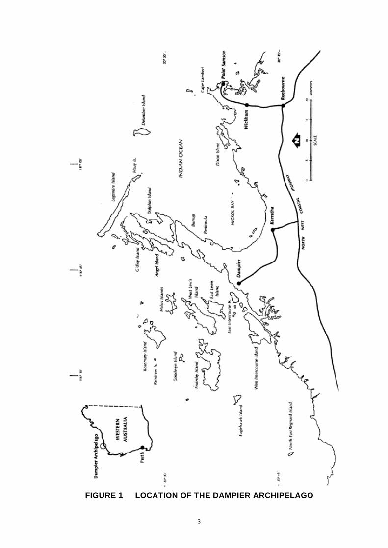
The Dampier Archipelago comprises 42 islands, islets and rocks lying within a 45 km radius of the
town of Dampier on the north-west coast of Western Australia (Figure 1). 'Me archipelago lies within
the Shire of Roebourne between latitudes 20•20'S - 20•45'S and longitude 116•25'E -117•05'E and
at the eastern end of an extensive chain of coastal islands between Exmouth and Dampier. For
management purposes, Eaglehawk Island is regarded as the western-most island of the archipelago,
and Delarnbre Island the eastern-most.
1.2 LAND STATUS
1.2.1 Nature Reserves
Twenty-five of the islands in the Dampier Archipelago are incorporated into 4 nature reserves (Table
1, Figure 2), and it is these islands only that are covered by this management plan. The nature
reserves are vested in the National Parks and Nature Conservation Authority (NPNCA) for the
conservation of flora and fauna, and managed by the Department of Conservation and Land
Management (CALM). All the nature reserves extend to low water mark. The plan recommends that
the purpose of these island nature reserves be changed to National Park. The whole of the Dampier
Archipelago is on the Register of the National Estate.
The nature reserves have varying reservation status, viz:
(a) Class A Nature Reserve 36915 comprising the whole of Rosemary (except for a Department of
Land Administration Special Lease of 7 ha) and Enderby Islands, having a total area of 4436
ha. (NOTE: this figure is a more recent measurement than the 1980 total of 4352 ha derived
from Table 1).
(b) Class B Nature Reserve 34944 comprising the whole of Dolphin Island and having an area of
3203 ha.
(c) Class C Nature Reserve 36913 comprising the whole of Egret, Eaglehawk, Goodwyn, Kendrew,
Brigadier, Lady Nora, Conzinc, Angel, Gidley, Tozer, Wilcox, Keast, Hauy, Mawby, and
Delambre Islands; Bare Rock, Nelson Rocks, Millers Rocks, Collier Rocks and Elphick Nob;
various un-named islands between Gidley and Keast Islands; and a portion of Malus Island;
with a total area of approximately 3020ha.
(d) Class C Nature Reserve 39202 comprising the whole of Cohen Island, an area of 11 ha.
3
FIGURE 1 LOCATION OF THE DAMPIER ARCHIPELAGO

4
TABLE 1 STATUS OF ISLANDS IN THE DAMPIER ARCHIPELAGO
(see below for explanation of abbreviations)
RESERVE ISLAND NAME VESTED DATE OF PURPOSE AREACLASS AUTHORITY VESTING (HA)
B34944 Dolphin Island NPNCA 12/10/77 Cons F & F 3203
C36907 East Lewis Island NPNCA Aug 1987 Cons & Rec 1018
C36909 West Lewis Island NPNCA Aug 1987 Cons & Rec 2082
C36910 Malus Island (part) NPNCA Aug 1987 Cons & Rec 76
C36913 Angel Island " 24/10/80 Cons F &F 880Bare Rock " 25/05/84 " " 3Brigadier Island " 25/05/84 " " 6Collier Rocks " 24/10/80 " " 408Conzinc: Island " 25/05/84 " " 11Delambre Island " 24/10/80 " " 320Eaglehawk Island " 25/05/84 " " 140Elphick Nob " 25/05/84 " " 22Egret Island " 25/05/84 " " 1Gidley Island " 24/10/80 " " 845Goodwyn Island " 24/10/80 " " 65Hauy Island " 24/10/80 " " 105Keast Island " 24/10/80 " " 51Kendrew Island " 25/05/84 " " 6Lady Nora Island " 25/05/84 " " 27Malus Island (part) " 24/10/80 " " 170Mawby Island " 24/10/80 " " 3Millers Rocks " 25/05/84 " " 1Nelson Rocks " 25/05/84 " " 1Tozer Island " 25/05/84 " " 1Wilcox Island " 25/05/84 " " 20
A36915 Enderby Island NPNCA 24/10/80 Cons F & F 3290Rosemary Island NPNCA 24/10/80 Cons F & F 1062
C39202 Cohen Island NPNCA 29/09/85 Cons F & F 11
S. Lease East Intercourse Is. Not vested Mining (H.I.) 3003116/3469 Tidepole Island " " 10
S Lease Mistaken Island Not vested Mining (D.S) 203116/4976
Crown Land Dixon Island Not vested 500East Mid Intercourse Is. " " 2Haycock Island " " 5Intercourse Island " " 20Legendre Island Min Ind Dev 1300Pemberton Island Not vested 2Roly Rocks " " 1Walcott Island " " 10West Intercourse Is. " " 2300West Mid Intercourse Is. " " 2

5
EXPLANATION OF ABBREVIATIONS:
Reserve Class
A - tenure can be changed only by agreement of both Houses of the W.A. Parliament.
B - tenure can be changed by the Governor of W.A. without approval by Parliament.
However, the reasons for any changes must be reported to Parliament by the
Ministers for Lands.
C - tenure can be changed by the Governor, without reference to Parliament. However,
changes must be published in the Government Gazette.
NPNCA - National Parks and Nature Conservation Authority
Min Ind Dev - Minister for Industrial Development
Cons F & F - Conservation of Flora and Fauna
Cons & Rec - Conservation and Recreation
H.I. - Hamersley Iron Pty Ltd.
D. S. - Dampier Salt Pty Ltd.
S. Lease - Special Lease

6

7
1.2.2 Recreation Reserves
The central portion of Malus Island (C36910), and all of East and West Lewis Islands (C36907 and
C36909 respectively) are reserves for conservation and recreation, vested in the NPNCA. These
reserves are also managed by CALM, however they are not covered by this management plan (refer
1.2.5).
1.2.3 Leases Under the Land Act 1933
(a) North West Game Fishing Club:
Since 1963 the North West Game Fishing Club (NWGFC) has, under the Land Act 1933, leased a 7
ha site on Norbill Bay, Rosemary Island, for their club house and associated buildings. The NWGFC
lease is on Crown land and is leased through the Department of Land Administration. This is not part
of the nature reserve. The NWGFC lease continued after Rosemary Island became a nature reserve in
1980, and is renewable every ten years. The current lease commenced on 1 January 1984.
(b) Marine Navigation Beacons:
Three marine navigation beacons are positioned on land in the archipelago which is vested in the
Commonwealth of Australia. One of these leases, on Legendre Island, consists of approximately 250
ha and adjoins a Ministerial Reserve. Another, on Courtenay Head, Malus Island, is 144 m2 in area
and leased by Hamersley Iron Pty Ltd. The third lease, on Rosemary Island, covers 767m2. The latter
two leases are surrounded by nature reserve.
1.2.4 Other Crown Land
The remainder of the islands in the Dampier Archipelago are Crown land, some of which are covered
by Special Leases (Mining) held by Hamersley Iron Pty. Ltd., or Dampier Salt Pty. Ltd. (Table 1).
The majority of Legendre Island is vested in the Minister for Industrial Development.
The Burrup Peninsula was formerly known as Dampier Island, as it was separated from the mainland
by tidal creek systems and mudflats. With the development of Dampier in the 1960's and later the
Dampier Salt fields, service causeways and levee banks were constructed across the creeks and
mudflats, and their regular tidal inundation was prevented. Hence the Burrup Peninsula is now
regarded as part of the mainland. Much of it is covered by special leases for mining and industrial
purposes. The northern portion (about 3000 ha) is crown land covered by a Temporary Reserve
vested in the Minister for Mines.
1.2.5. Scope of the Management Plan
This management plan will apply only to the islands in the Dampier Archipelago which are currently
nature reserves. The plan does not cover the reserves vested for conservation and recreation (portion
8
of Malus Island, and East and West Lewis Islands). It is expected that these will be incorporated in
subsequent plans when land tenure issues have been resolved. During the life of this plan
consideration will be given to incorporating marine reserves and the northern portion of the Burrup
Peninsula into an integrated management plan for a marine park covering the archipelago.
1.3 CLIMATE
The climate of the Dampier Archipelago region can be described as semi-desert tropical (Bagnouls
and Gaussen 1957), with two seasons; a hot summer extending from October to April, and a mild
winter from May to September. The area usually experiences the effects of 2-3 cyclones per year.
These cyclonic disturbances are accompanied by heavy rainfall, strong winds and higher tides. Since
1969, meteorological data have been available from Dampier Salt Pty. Ltd., approximately 5 km
from the coast adjacent to the Dampier Archipelago. A summary of this data is shown in Table 2.
1.3.1 Temperature
Mean summer temperatures range from a minimum of 24•C to a maximum of 35•C. Mean winter
temperatures range from a minimum of 17•C to a maximum of 29•C.
1.3.2 Rainfall
Rainfall is seasonal but unreliable. The mean annual rainfall is 276 mm from 31 rain days. There are
two peaks of rainfall during the year. The first peak from January to March is due to tropical
thunderstorms and cyclonic activity. The second peak from May to June is due to the
passage of low pressure systems through the south of the state. The driest period is between
September and November. Evaporation is approximately 2500 mm per year and exceeds rainfall by
a factor of nine.
The islands possibly receive more rain than the adjacent mainland. Consistently higher rainfall was
recorded by a rain gauge set on Enderby Island in the period 1983-87:

9
TABLE 2 A Summary of the Meteorological Data from Dampier Salt Pty.Ltd. (1969 - 1985).
(Meteorological Station Number 0050601, lat 20•43'S, long 116•45' elevation 8.0m)
JAN FEB MAR APR MAY JUN JUL AUG SEP OCT NOV DEC YR
Mean Dai ly
Maximum
Temperature
(•C) 35.4 36.2 36.1 33.5 29.5 26.5 26.1 27.3 30.2 32.0 34.1 35.8
Mean Dai ly
Minimum
Temperature
(•C) 26.2 26.5 25.7 22.2 18.0 14.9 13.7 15.0 17.0 19.6 22.2 25.3
Mean Relat ive
Humidity (%)
0 9 0 0 56 57 55 44 43 45 46 45 35 38 39 47
1 5 0 0 51 48 45 37 36 37 37 37 31 36 40 44
Rainfal l (mm)
mean 31 53 60 21 36 32 19 10 1 1 1 11
276
median 17 52 43 2 18 5 6 1 1 0 0 1
303
No. raindays 4 4 5 2 3 3 4 2 0 1 1 2 31

10
Dampier Salt Enderby Island
1983 43.5 (mm) 67.5 (mm)
1984 261.9 293.5
1985 140.9 155.5
1986 248.4 268.0
1987 260.4 270.0
The Dampier Salt recordings for this period were all below average and reflect the variable nature of
the rainfall.
1.3.3 Growing Period
Ombrothermic (rainfall/temperature) curves using the Dampier Salt meteorological data show that
rainfall intersects the temperature curve only in March, suggesting that plant growth is most likely to
occur at this time. This short growing period is typical of the semi-desert tropical bioclimatic zone
(Bagnouls and Gaussen, 1957).
1.3.4 Humidity
Relative humidity is highest during the summer months, averaging 48% at 0900 hrs and 43% at 1500
hrs. Early morning dews can occur in both summer and winter.
1.3.5 Wind
Wind patterns are significantly different between winter and summer. Winter wind patterns generally
consist of an easterly wind modified by a later night and early morning south-easterly land breeze.
This changes in the afternoon to a north-westerly sea breeze. Wind speeds are at a maximum during
the early morning, often exceeding 20 knots, and decrease during the afternoon and evening. The
summer wind pattern consists of a prevailing westerly wind modified by a night and early morning
south-easterly land breeze, and an afternoon north-westerly sea breeze. Wind speeds occasionally
exceed 20 knots in the afternoon (Anon., 1979). Winds of up to 100 knots can be experienced
during tropical cyclones.
1.3.6 Tides
Tides in the Dampier Archipelago are semi-diumal with a maximum spring tidal range of 4.7 m and
a minimum neap tidal range of 0.4 m. Storm surges may increase the tidal range by 2.0 m during
cyclonic activity. Some islands (such as Goodwyn and Malus Islands) are regularly divided into 2 or
more smaller islands by spring tidal activity.
11
1.4 LANDSCAPE
1.4.1 Landform
The Dampier Archipelago was formed 6000 - 8000 years ago when rising sea levels, caused by the
melting of polar ice caps during the warmer interglacial period, flooded coastal valleys leaving hills
and ridges exposed as islands (Men-Rees 1979; Semeniuk et al., 1982).
The islands range in size from rock islets of less than 1 ha. to Enderby Island, the largest, of 3290 ha.
Dolphin is the highest island in the archipelago rising to 120 m above sea level.
Topographically, many of the islands resemble the adjacent mainland and Burrup Peninsula, and are
steep and rugged, with coastal cliffs and large rock piles. These rock piles and cliffs are separated by
valleys, beaches and coastal sandplains. Sparsely vegetated sand dunes rising to 3 m have formed at
the landward margin of beaches and may also occur further inland on the sandplain. Drainage lines
which run from the valleys across the sandplain to the ocean, cut through these dunes. Rock holes in
the valleys fill with fresh water following rain, however no permanent fresh water source is known on
the islands.
The small islets such as Millers and Nelson Rocks, and the islands to the north of the archipelago
such as Hauy and Delambre, are low and flat, and the beaches are often backed by a low limestone
cliff rather than a sand dune. These islands tend to be aligned around the seaward margin of the
archipelago and represent remnants of the coastal dune system of an earlier period when the
mainland shore was located further north than at present. At that time the igneous islands of today
were rocky hills on a coastal plain.
1.4.2 Geology
The geology of the Dampier Archipelago Nature Reserves is described in Biggs (1976a), Biggs
(1976b), Kriewaldt (1964), and Ryan (1966) and shown in Figure 3.
Unlike most island nature reserves off the north-west, which are composed of Cainozoic sediments
younger than 64 million years old (Ma), many of the islands of the archipelago are composed of
Precambrian volcanic and granitic rocks. The oldest rocks are Archaean granite and granite gneiss
(older than 2800 Ma), which crop out on Dolphin, Tozer and Enderby Islands. These are
unconformably overlain by the Mount Roe Basalt (about 2700 Ma) which consists of basaltic lavas
and volcanogenic sediments. Intruded at the unconformity beneath the Mount Roe Basalt are
granophyre and gabbro of the Gidley Granophyre. The youngest recognised igneous rocks in the
area, are long and narrow dolerite dykes which cut all other Precambrian rocks. Beaches and

12

13
sandplains of Holocene (less than 0.01 Ma) shelly sands have formed in the bays of the islands.
Sandplains are more extensive on the western islands. Mud and silt replace the shelly sands in some
bays. Older sand deposits occur further inland and some valleys contain weathered alluviums and
red-brown silty sands.
The flatter islets and islands to the north of the archipelago are composed of Pleistocene dune
limestone. Areas of fringing Holocene sands also occur on these limestone islands, however, most
sandplain areas are pink-brown limestone derived sands.
1.5 IMPLICATIONS FOR MANAGEMENT
1 The existing status of islands in the Dampier Archipelago is confusing to the public and needs
to be rationalised to ensure efficient management of the area.
2. Management planning, research and operational activities must consider the predominantly
rugged and arid nature of the nature reserves. The beaches adjacent to sandplains are relatively
easy points of access to many of the islands and hence will be a focus of any public activity.
These areas will therefore require most attention with respect to management for public use. In
particular, the sand dunes adjacent to the beaches are prone to erosion if disturbed.
3. The climate dictates that most public use of the nature reserves would occur during the winter
months.
4. Many of the small islands and rocks do not have beaches and are relatively inaccessible to the
public.
5. Many of the islands of the archipelago not covered by the plan including vacant Crown land
should be considered for reservation in the future.
2.0 HISTORY AND LAND USE
2.1 ABORIGINAL OCCUPATION
The islands of the Dampier Archipelago show abundant evidence of previous occupation by
Aboriginal people in the form of, for example, shell middens, stone "factory" sites, rock engravings,
hunting hides and habitation sites. Recent evidence (Lorblanchet, unpublished manuscript) suggests
14
that Aboriginal people have utilised the area for probably 18 000 years, that is, well before rising seas
isolated the coastal plains and hills as an archipelago approximately 8 000 years ago.
It is now believed that two groups utilized the islands (Rhoads and Gara, 1984). At the time of
European settlement of the Roebourne district in the 1860s, the Yapurarra people were considered to
be the traditional inhabitants of the Dampier Archipelago and Burrup Peninsula, and were referred to
as the "island people" by the neighbouring Aboriginal groups. Some of the more western islands in
the archipelago were also visited by the Martuyhinira people, a predominantly mainland group
occupying land to the west of the Nickol Bay area.
It is estimated that the Yapurarra once numbered 100 - 120 individuals (Rhoads and Gara, 1984), but
none now survive. These people used rafts to travel between the islands and made extensive use of the
abundant marine life for food. Fresh water was available to them for part of the year from rock
pools. Latz (pers. comm.) also suggests that shallow wells may have been dug in suitable areas on
sandplains following rain. It is probably this group that Lieutenant Philip Parker King saw and
communicated with during his visit to the Dampier Archipelago in 1818 (Lee, 1925). Their decline
in the late nineteenth century followed the introduction of disease (such as smallpox), exploitation by
whalers and pearlers, and violent confrontation with European settlers, for example the Flying Foam
massacre in 1868 (Gara, 1983).
2.2 EARLY EUROPEAN EXPLORATION
The group of islands now known as the Dampier Archipelago were known to early Dutch navigators.
It appears together with Barrow Island and the Montebello Islands on a chart drawn in 1628 for the
Dutch East India Company (de la Rue, 1979).
The first recorded European visit to the Dampier Archipelago was made by the Englishman William
Dampier in 1699. He landed on an island which he named Rosemary Island because of the presence
of the plant Olearia axillaris, which reminded him of the English herb, Rosemary. However, it is now
agreed that the island which bears this name today is not the one originally named by Dampier
(King, 1817; Tuckfield, 1955; George, 1971). McIlroy (1979) suggests that Malus Island was the
island visited by Dampier and the "Bluff Head" referred to was Courtenay Head on the north of
Malus Island.
In 1772 St. Allouarn noted "Rosemary Island" while sailing from North West Cape to Timor, however
no landing was made (Henn, 1934). In 1801 Nicholas Baudin in the "Geographe" named the group
of islands Dampier's Archipelago, and apparently misinterpreted Dampier's naming Rosemary Island.
Baudin named Malus Island and assigned the name Rosemary to an island 4 km to the north-west of

15
Malus Island. Legendre, Hauy and Delambre Islands were also named during this visit. Further east,
Baudin named Depuch Island and the Forestier Archipelago. Lieutenant Philip Parker King made a
more detailed excursion into the Dampier Archipelago during his voyage in the "Mermaid" along the
north-west coast in 1818. During his 2 week visit Enderby, Gidley, the Lewis Islands and the
Intercourse Islands were named, as was Nickol Bay to the east of the Dampier Archipelago.
In September 1851, Lieutenant F.B. Helpman visited the Archipelago in search of guano deposits
and made particular mention of "numerous fresh native foot marks on the beach..." and "... three
graves lying side by side" on Enderby Island (McIlroy, 1979). These graves were believed to be of
early whalers; however their exact location is not known, and they have not been found since.
The first party of Europeans to explore the inland Pilbara region landed at Hearson Cove, on the
Burrup Peninsula, in 1861. This party under the leadership of F.T. Gregory, travelled from Fremantle
in the "Dolphin" to determine the potential of the north west for agriculture. Dolphin Island was
named after this ship, and several other features such as Pemberton, Walcott and Dixon Islands and
Cape Lambert were named by Gregory after members of this expedition (Gregory and Gregory,
1884).
2.3 LAND-USE 1860-1960
Following Gregory's reports of good grazing land in the Pilbara in 1861, settlers journeyed from the
south to establish the pastoral industry, and by 1866 the town of Roebourne had become established.
Cossack was established as the port for Roebourne in 1872. Gregory also noted that pearl shell was
abundant in the waters of the Dampier Archipelago and he took several valuable pearls with him
when he returned to Fremantle. A pearling fleet soon became established at Cossack, and Flying
Foam Passage, between Angel and Gidley Islands to the west and Dolphin Island to the east, became
the major pearling area in the north-west between 1870 and 1900. In 1873, 500 people including
Europeans, Malays, Chinese and Aboriginals were working in this area, and rock pools on Dolphin
Island were used to supply fresh water for these operations. The remnants of a pearling camp can be
found today in Black Hawke Bay on Gidley Island (MacIlroy, 1979). Flying Foam Passage was also
used extensively during this period as a sheltered route for shipping between Cossack and Fremantle.
Six graves on the west side of Dolphin Island are believed to be of pearlers.
From 1870 to 1872, a whaling station was established on Malus Island to process Humpback whales
taken by longboats operating around the Dampier Archipelago (MacIlroy, 1979). Remains of the try
pots and ovens are still evident, on that part of Malus Island now classified as Recreation Reserve
36910.

16
The stone ruins of a pastoral settlement are found on the east side of West Lewis Island. The date of
occupation and name of lessee are not known; however it is thought to have been abandoned prior to
1900. It has been estimated that the stockyards were large enough to hold several hundred sheep,
however the actual number was probably less due to watering constraints (Macllroy, 1979). Several
pastoral leases were granted by the Department of Lands and Surveys over islands in the Dampier
Archipelago between 1900 - 1930, however the earliest of these post-dates the abandonment of the
settlement on West Lewis Island.
Between 1900 - 1960, islands in the Dampier Archipelago were used for shelter and as campsites by
commercial fishermen (oysters and wet line fishermen) from Point Samson and Onslow. During this
period turtles and their eggs were taken commercially around the Dampier Archipelago and until
1936 a turtle meat canning company operated at Cossack. The last turtles were taken commercially in
1963 when the licenced fishermen ceased hunting in the area because the large tidal variation made
the shallow waters too dirty to catch efficiently. Very little recreational activity was undertaken by the
public as the population of the region was small and the islands were relatively inaccessible at this
stage.
Two war time wrecks can be found on Enderby Island. One of these is the remains of the 30 ton
yacht "Sedjatra" which was wrecked on the north west side in 1942 while en route from Indonesia to
Fremantle after the Japanese invasion of Singapore. The other is the dismantled parts of a PBY 5
Catalina flying boat located on the east side of Enderby Island. This flying boat belonged to the 10th
Air Wing of the United States Navy which operated from Crawley Bay (Perth), Geraldton and
Exmouth between 1942 and 1944. During this time they conducted reconnaissance and night
bombing raids over Japanese held islands in the Timor region. One of these flying boats was forced
to put down in the sea near Enderby Island due to mechanical problems, and during the night broke
its moorings and was washed ashore.
2.4 LAND-USE 1960-PRESENT
2.4.1 Recreation and Research
a) Background and Population Estimates
The majority of people using the islands for recreation are residents in the Shire of Roebourne towns
of Dampier, Karratha, Wickham and Roebourne, all of which are within a 50 km radius of the
archipelago.
When the Commonwealth Government eased restrictions of iron ore exports in 1960, exploration and
development of ore deposits in the Pilbara proceeded rapidly, and since 1965, the permanent
population of the Shire of Roebourne has increased dramatically (Table 3). The increase began in

17
1965 when Hamersley Iron Pty. Ltd. constructed the town and port of Dampier to accommodate the
company's 2500 employees involved in the export of iron ore. The adjacent Dampier Archipelago, at
this stage vacant Crown land, immediately became a focus for recreational activities and shacks were
erected on Enderby, Malus, East Lewis and West Lewis Islands. From 1965-1976, the population
increased 10 fold as further development of ports and towns for the iron ore industry occurred, in
particular Karratha and Wickham. With the development of the North West Shelf Gas project by
Woodside Offshore Petroleum Pty. Ltd. and with Karratha becoming a significant regional centre, by
1981, the population of the Shire of Roebourne was 14 887, the most populated of the 4 Pilbara local
government areas. This trend is continuing. The second stage of the North West Gas Shelf project
commenced in 1985, and this in addition to the proposed developments of the Channar iron ore
deposit by Hamersley Iron Pty. Ltd. will result in an estimated increase in population to 18 000 by
1991 (Elliott, 1986).
Boat ownership rates are extremely high in these towns (approximately one boat to every 10 people
in Karratha) and recreational use of the islands will increase as the population increases. In addition
to the local population, the archipelago is also visited during the cooler months by organised marine
charters and cruising yachts from elsewhere in Australia and overseas.
TABLE 3 SHIRE OF ROEBOURNE POPULATION 1965-1991
YEAR POPULATION DATASOURCE
1965 1000 Elliott 1986
1976 10650 Aust. Bur. Stat. Census 1976
1981 14887 Aust. Bur. Stat. Census 1981
1985 15500 Elliott 1986
1991 18000 Elliott 1986
b) Public Use Survey
Between 1982 - 1985 regular surveys of public use of the archipelago were undertaken during
holiday and non-holiday periods (Table 4). The following points characterise public use of the
islands:

18
i) Because of the climate and topography of the islands, camping and day trips are restricted
almost exclusively to the beaches.
ii) Campers and daytrippers prefer to use beaches on their own, avoiding other users. Hence they
generally use nature reserve beaches, rather than "shack" beaches on recreation reserves for
their recreational activities.
iii) Most camping occurs during long weekends or holidays in the cooler months (April
-September). However because of the rostered day off system operated by the larger
companies in the region, which provides long weekends for employees outside public holidays,
some camping occurs during ordinary weekends. The maximum number of camps observed
on the nature reserves was 32 (Easter 1984 - Table 4). If it is assumed that 4 people occupy
each camp this equates to approximately 120 people.
iv) The extent of day trip use of nature reserves was more difficult to estimate, however up to 17
boats (approximately 70 people) at a time were observed on the islands, but not associated with
a camp. Up to 150 boats were observed around the islands at any one time. These were mainly
involved in amateur fishing and diving activities and fishermen often clean fish on the islands
before returning to Dampier.
v) Many of the public users were not aware of which islands were nature reserves and which were
not. Dogs often accompanied campers and day trippers, and open fires were used by campers.
c) Shacks
Apart from the North West Game Fishing Club facilities on Rosemary Island (See 1.2.3), all shacks
are now located on recreation reserves 36907 (East Lewis Island) 36909 (West Lewis Island) and
36910 (part of Malus Island). Thirty- three shacks (June 1986) exist on these reserves. Three
dilapidated shacks remain on Delambre Island, and the concrete floor of a shack removed in 1984
remains on Goodwyn Island. Some temporary frames have been left by the public on some nature
reserve beaches.
d) Research Station
The Department of Conservation and Land Management controls a research station on Enderby
Island, and this is used as a base for research and management operations in the Dampier
Archipelago.
e) Airstrip and Vehicle Tracks

19
As part of their use of Rosemary Island prior to it becoming a nature reserve, the North West Game
Fishing Club constructed an airstrip and a well on the north side of the island. Vehicle tracks connect
these and other parts of the island to their base in Norbill Bay. Use of the airstrip was stopped in
1983, and in May 1985 explosives were used to break up the compacted airstrip surface to facilitate
vegetation regrowth. Another track connects the marine navigation beacon on Rosemary Island with
Norbill Bay and is used by the Department of Transport and Communications for servicing purposes.

20
TABLE 4 ESTIMATES OF THE MAXIMUM PUBLIC USE OFNATURE RESERVES IN THE DAMPIER ARCHIPELAGOFROM OCTOBER 1982 - OCTOBER 1985.
Approximately four people are associated with each boat or camp (--- No Observation)
LONG WEEKEND/ NORMAL WEEKEND
HOLIDAYS
Number of
Public Max. No. Max. No. Max. No. Max. No.
Holidays of boats of camps of boats of camps
JAN 2 106 15 76 0
FEB 0 0 0 5 0
MAR 1 68 8 --- 0
APR 2 151 32 53 0
MAY 1 23 0 53 0
JUN 1 25 11 8 1
JUL 1 79 4 72 0
AUG 1 117 7 --- 0
SEP 1 43 12 37 3
OCT 1 86 4 12 3
NOV 0 0 0 --- 0
DEC 2 --- 0 --- 0

21
2.4.2 Mining and Industrial Use
a) Mining Tenements for Limesand and Limestone
In 1968, an iron ore pelletizing plant commenced operating in Dampier. Associated with this
Hamersley Iron Pty. Ltd. lodged applications for mining tenements covering the beaches and
sandplain on many of the islands in the Dampier Archipelago (Rosemary, Enderby, Malus, Delambre,
Hauy, Legendre, Keast, East Lewis and Goodwyn Islands, and Collier Rocks). These applications were
for the extraction of limesand, used in the production of iron ore pellets, and limestone for possible
use in future iron and steel production. Legendre Island in particular was identified as a possible
strategic source of limestone deposits. Prior to creation of the nature reserves in 1980, Cabinet
approved the application for mineral leases on Enderby Island, but refused those on Rosemary
Island. When the majority of other islands were reserved for Conservation of Flora and Fauna
(C36913), Cabinet decided that all existing and future applications for mining tenements be granted
on no more stringent conditions than are reasonably required to protect the environment, and
provide for adequate rehabilitation after the completion of mining. The pellet plant ceased operating
in 1980 and no extraction of limesand or limestone occurred on any of the islands, although some
exploratory pits were dug on Enderby Island. All limesand for the pellet plant was obtained from
deposits at Hearson Cove on the Burrup Peninsula.
b) Radio Positioning Base Stations
With the development of the North West Shelf Gas Project in 1980, there have been regular requests
by Woodside Offshore Petroleum Pty. Ltd. to erect temporary manned and unmanned radio
positioning base stations on nature reserves in the Dampier Archipelago. Selection and ongoing use
of these sites is covered by the guidelines within the document on low impact industrial use of islands
(refer Appendix 1). Recently, permanent navigation aids were installed on Angel and Gidley Islands
by Woodside to indicate the position of the submarine gas trunkline.
2.5 AQUACULTURE
Two leases have been granted in Flying Foam Passage under the Pearling Act 1912 one of which is
for the production of Pteria penguin pearl oysters. These operations are currently managed from
floating platforms. There are a number of other applications for leases for aquaculture in the area of
the Archipelago, including requests for shore bases. To date these applications have not been
approved.
22
2.6 POSSIBLE FUTURE LAND-USES
Because of the limited availability of suitable beaches on the mainland, and the preference by the
public for water based recreational activities, use of the nature reserves by the public will increase as
the populations of nearby towns (in particular Karratha) increases.
Mining tenements covering several of the nature reserves are still held by Hamersley Iron Pty. Ltd.,
and the extraction of limesand and limestone from them is possible in the future. Requests by
Woodside Offshore Petroleum Pty. Ltd. for temporary radio base positioning stations on the nature
reserves are likely to continue.
Until December 1987, Rosemary, Enderby and Goodwyn Islands were covered by petroleum
exploration permit WA 192-P. This permit lapsed, however this area has again been offered for
petroleum exploration under the Petroleum (Submerged Lands) Act 1967. Exploratory surveys of
the waters and lands within this area are possible in the future. There could be requests for
production facilities in the area if exploration indicated the presence of petroleum reserves. Currently
the Dampier Archipelago is not affected by any Petroleum Act 1967 leases.
Legendre Island is vested in the Minister for Industrial Development because of its potential as a deep
water port site (Gillespie, 1975). Should this proposal proceed, Legendre Island would be linked to
the Burrup Peninsula with a causeway across several of the island nature reserves, and continuing
through the proposed reserve on the northern Burrup Peninsula along a route to be determined by
reference to natural and cultural values of the islands and the peninsula.
2.7 HISTORY OF RESERVE STATUS
The value of the islands of the Dampier Archipelago to nature conservation and for future
recreational use was realised in 1962 when the Australian Academy of Science recommended that:
a) the Dampier Archipelago be gazetted as an "A" Class reserve comprising a national park; and
b) a biological survey should be undertaken with recommendations made concerning areas for
public recreation and areas for the preservation of flora and fauna.
No further action was taken at that time but as the Pilbara iron ore industry developed so did
recreational pressures on the islands. A detailed biological survey was undertaken (Burbidge and
Prince, 1972) and the Conservation Through Reserves Committee (CTRC) recommended to the
Environmental Protection Authority (EPA) in 1974 that the majority of the islands be declared Class
"A" reserve for the Conservation of Flora and Fauna. It was also recommended that Enderby Island

23
be reserved for recreation and conservation, and that other islands be left unreserved for future port
sites and associated industries and for a causeway to Legendre Island.
The residents of Dampier and Karratha felt that the CTRC recommendations did not adequately
provide for recreation and through their Dampier Archipelago Reserves Committee submitted
proposals for 5 "open recreation" areas on the islands. These areas would allow for the construction
of shacks, as well as camping and day trips.
In the EPA report to Cabinet in 1975, the CTRC recommendations were modified and provided for
more recreation reserves than initially suggested.
In October 1977 Dolphin Island was declared a B Class reserve for the Conservation of Flora and
Fauna. The Dampier Archipelago Recreation Advisory Committee (DARAC) was appointed in 1978
to advise the Minister for Conservation and the Environment on the management of proposed
recreation reserves in the archipelago. However in 1980, before DARAC reported to the Minister, the
majority of the islands were declared nature reserves with portions of some reserved for recreation.
By this stage several shacks had been erected on some of the islands and their distribution to a large
extent determined the positioning of the recreation reserves. Camping for up to 5 nights, and day
trips were permitted to continue on nature reserves, however no permanent structures were to be
erected (West Australian Wildlife Authority, 1980). Legendre Island remained vacant Crown land for
possible future development as a port site (Gillespie, 1975).
In 1984, the reserve status of the islands was reviewed and all of East and West Lewis Islands
(formerly nature reserves) became recreation reserves. The recreation reserve containing shacks on
Malus Island remained as such, however all other recreation reserves on Rosemary, Angel, and
Delambre Islands were cancelled and incorporated into the adjacent nature reserve. This resulted in
the reserve status as presently exists (refer 1.2).
2.8 IMPLICATIONS FOR MANAGEMENT
1 The full significance of the Aboriginal sites in the Dampier Archipelago is unknown and a
detailed site survey is required. Nevertheless, there is no doubt that the rock art on the islands
has enormous cultural value.
2. Aboriginal sites and objects are protected under the Aboriginal Heritage Act 1972. It will be
necessary to obtain permission from the Western Australian Museum before management
operations, which may involve Aboriginal sites, can be undertaken.

24
3. The Dampier Archipelago has featured in the early coastal exploration and development of the
north-west of Western Australia and several historic sites are known from the islands. Relics
from more recent events such as the Second World War also occur. These sites and relics are
worth preserving for their educational and heritage values. Much is known about these sites
and this information should be used in the interpretive process for the nature reserves.
4. With the development of the iron ore industry since 1960, recreational use of the islands has
increased dramatically. Some environmental degradation has occurred and regulation of
public use will be necessary to protect the nature reserves' conservation values.
5. Further increased recreational use of the islands will occur. The use of nature reserves for
camping is incompatible with management objectives for nature reserves and it would be
appropriate for the purpose of the islands to be changed to national park immediately. Further,
it would be appropriate that, at the expiry of this plan, the recreation reserves be incorporated
into the national park. The issue of shack licences on the recreation reserves will be resolved
within the life of the management plan.
6. Further industrial use of the islands is likely. In particular, liaison should be maintained with
Woodside Offshore Petroleum Pty. Ltd. regarding the location of permanent and
nonpermanent navigation sites and radio positioning sites on the nature reserves. Use of the
islands for the extraction of limesands and limestone, or facilities for the petroleum industry
would be subject to Government policy on mining and exploration in nature reserves, and the
Environmental Protection Act 1986.
7. Ships conveying petroleum products through the archipelago together with the presence of a
submarine gas/condensate pipeline and onshore bulk fuel handling and storage facilities
present a possible threat of contamination to the Dampier Archipelago.
Seabirds and marine life, including the shoreline and intertidal biota of the nature reserves are
at risk.
3.0 BIOLOGICAL RESOURCES
3.1 FLORA
3.1.1 Collecting History
The islands of the Dampier Archipelago have considerable significance in the history of botanical
research in Western Australia.

25
The first recorded collection of plants from the archipelago was by William Dampier in 1699. He
collected specimens of the Sturt Pea Clianthus formosus and the native Rosemary shrub Olearia
axillaris, and noted other species such as Ipomoea pes-caprae (George, 197 1).
The botanist Alan Cunningham collected several species from the Dampier Archipelago in 1818
when he accompanied Philip King on a journey of exploration along the north-west coast. Species
collected include the native fig Ficus platypoda, Cynanchum floribundwn, Swainsona pterostylis and
an Acacia sp. possibly A. bivenosa (Lee, 1925). The type specimen of the native tomato Solanum
phlomoides was collected from Enderby Island by Cunningham (Purdie et al., 1982).
In 1861, Pemberton Walcott collected from the "Dampier Archipelago" (probably Burrup Peninsula
and Dolphin Island) while he waited for F.T. Gregory to return from exploring the inland Pilbara
region. Many native grasses were included in his collection (Gardner, 1952).
In 1961 a W.A. Museum expedition, and in 1962 a joint W.A. Museum and W.A. Herbarium
expedition visited several of the islands. Both collected flora specimens but a more detailed collection
was undertaken in 1970 as part of a biological survey of the Dampier Archipelago (Burbidge and
Prince, 1972). More recently Blackwell et al. (1979) have compiled a report on the flora and
vegetation of the Burrup Peninsula and southern part of Dolphin Island. In 1987, Long (1988)
undertook a flora survey of selected islands in the Archipelago, on behalf of CALM.
3.1.2 Flora Composition
Two hundred and eighty eight species of native terrestrial plants from 60 families are known from
the Dampier Archipelago. The Poaceae and Papilionaceae are well represented. Six species are listed
as poorly collected and/or geographically restricted in the Pilbara by Van Leeuwen (1983);
Terminalia supranitifolia, Trianthema turgidifolia, Brachychiton acuminatum, Triumfetta
leptacantha, Paspalidium tabulawn, and Scaevola cunninghamii. Further surveys may find that
some of these species such as Terminalia supranitifolia and Brachychiton acuminatum are more
widespread. Long (1988) recorded undescribed species of Heliotropium and Paspalidium, and the
occurrence of Scaevola amblyanthera, a species not previously recorded in W.A.
Dolphin Island (3202 ha) is the most floristically diverse with 157 species. Enderby Island, of similar
size (3290 ha), but of slightly different geological formation, supports 117 species of plant, although
further surveys will possibly increase this number. The sandplain and water-course areas in particular
on Dolphin Island support a diverse flora.
26
Currently there are no data on the intertidal marine flora, although it is obvious that there are many
species of algae and sea-grass inhabiting the intertidal zone of the nature reserves. The sea-grass is of
particular significance in providing habitat and feeding grounds for dugongs and turtles.
3.1.3 Introduced Plants
At least seven species of introduced plant are known from isolated areas in the archipelago. Buffel
Grass Cenchrus ciliaris is well established on the old airstrip on Rosemary Island; Kapok Bush Aerva
javanica occurs on some sandplains, and the prickly pear Opuntia stricta did occur on Enderby
Island but was eradicated by departmental officers in 1985.
Opuntia is well established on East and West Lewis Islands and has been subject to control attempts
by the Agriculture Protection Board. Spraying with the herbicide 245-T in 1979 was unsuccessful,
however biological control trials with Cochineal insects (1984-1986) were successful. In October
1986 Cochineal insects were distributed to all Prickly Pear infestations around East and West Lewis
Islands. Palms (Cocos nucifera) and a Tamarisk tree have been planted on the North West Game
Fishing Club lease on Rosemary Island. A Palm Phoenix dactylifera has been planted near the well
site on Rosemary Island. Salsold kali, which is common on many islands is now regarded an an
introduced species (Wilson, 1984).
3.2 VEGETATION
The Dampier Archipelago lies immediately adjacent to the Abydos Plain in the Fortescue Botanical
Province (Beard, 1975). The vegetation is predominantly Eremaean (desert tropical) in character,
however the Burrup Peninsula, and Dolphin, Angel, and Gidley Islands are botanically different from
the Abydos Plain with a higher number of Northern Botanical Province (Kimberley) species
(Blackwell et al., 1979). The rockpile formation of the islands, together with the higher humidities
and incidence of dews on the coast contribute to this difference. The vegetation of the islands has
been infrequently burnt and has been largely unaffected by pastoral and mining activities and
represents a climax situation in most instances.
Beard (1975) broadly mapped the Dampier Archipelago as grass steppe plains (spinifex Triodia
pungens) with no trees or shrubs. However, Burbidge and Prince (1972) recognised six vegetation
associations in the Archipelago varying with soils and topography, and these form the basis of the
vegetation description used in this management plan. The vegetation and flora of the Burrup
Peninsula and southern portion of Dolphin Island have been assessed in detail by Blackwell et al.
(1979) as part of the Environmental Review and Management Program for the North West Shelf Gas
Development Project (EPA, 1979).
27
The vegetation associations, commencing at the lowest point on the landscape are:
a) Littoral Association
Mangrove communities occur as narrow bands of vegetation in sheltered locations such as tidal
creeks or bays where the substrate is muddy. These attain a height of 4 m and form dense thickets on
the shore line. Gordon (1983) estimates that approximately 330 ha of mangal (mangrove habitat)
occur around islands in the Dampier Archipelago, predominantly on Enderby, Gidley and Dolphin
Islands. The White Mangrove, Avicennia marina, is the most common species, with another five
species known. The only Pilbara mangrove species not recorded on the islands is Osbornia
octodonta.
Salt water tolerant communities are often found at the mouths of drainage lines and on the landward
side of the mangrove communities. These areas are frequently inundated by sea water during spring
tides. Dominant species include Salt Water Couch Sporobolus virginicus, Halosarcia halocnemoides
and Enchylaena tomentosa. On the small limestone islets such as Nelson Rocks, which are subject to
frequent salt spray, Thelkeldia diffusa is a dominant species.
b) Sandplain Association
Recently formed (that is in the last 6000 years or so) sandplains of shelly sands occur adjacent to
many of the beaches in the Dampier Archipelago, particularly on the basalt and granophyre based
islands. The sandplain vegetation is probably the most diverse of any association on the islands.
The vegetation is sparse low shrubs to 2 m dominated by native wattles Acacia bivenosa and A.
coriacea and Myoporum acuminatum over mid-dense hummock grasses Spinifex longifolius and
Triodia pungens. Bloodwood Eucalypts Eucalyptus terminalis and Weeping Box E. patellaris to 4 m
occur on sandplains at the west end of Enderby Island. These species also occur on rocky soils on
Dolphin Island. Annual species such as the Sturt Pea Clianthus formosus, Swainsona pterostylis and
Trichodesma zeylanicum appear following rain, particularly along drainage fines.
The creeper Ipomoea pes-caprae is common on the foredunes. On the pink-brown sandplains of the
limestone islands, dominant species include Triodia spp., Salsola kali, Ptilotus exaltatus, Sorghum
plumosum and Sarcostemma australe.
c) Run-on Areas and Flats Association
These are areas of heavier alluvial soils which become water logged or flooded after heavy rain. They
support a variety of mid-dense grasses, and a few shrubs. Dominant species include the grasses
Sorghum plumosum, Setaria dielsii, Chrysopogon pallidus and Eulalia fulva, the ground covers

28
Tribulus occidentalis and Mukia maderaspatana, and shrubs Sesbania cannabina and Cassia
venusta.
d) Drainage-lines Association
Drainage lines among the rocky slopes of the larger islands support a diverse array of flora
particularly on Dolphin Island. The vegetation consists of sparse trees and/or shrubs to 4 in,
predominantly Eucalyptus microtheca, E. terminalis, E. patellaris, and Terminalia canescens, over
sparse shrubs to 2 m including Sarcostemma australe, Cassia spp. and Sesbania cannabina. Where
water is retained in rock pools for long periods Cyperus vaginatus and Scirpus litoralis occur. Dense
Triodia angusta tussocks grow in drier water courses.
e) Rocky Slope Association
This is the most common association in the archipelago and is probably Beard's "grass steppe .
The vegetation consists of very sparse shrubs (less than 2 m) of Acacia pyrifolia, Grevillea
pyramidalis and Hakea suberea, over mid-dense hummock grass Triodia wiseana, on rocky soils.
Other grasses such as Themeda australis and Eriachne obtusa also occur.
A very sparse vegetation cover is found on the higher rock piles and outcrops. On Dolphin, Angel
and Gidley Islands, the vegetation consists of small pockets of fire-sensitive tree and shrub species
such as Brachychiton australe, native figs Ficus platypoda and F. virens, Weeping Pittosporum, P.
phylliraeoides and Terminalia supranitifolia. Grasses such as Triodia wiseana and Themeda australis
occur where soil has accumulated. The rocky areas of Enderby and Rosemary Island are not as
diverse.
The rocky outcrops on the limestone islands are less rugged, but they also support sparse shrubs to 2
m, predominantly F. platypoda and P. phylliraeoides.
3.3 FIRE HISTORY
Fires are likely to have occurred on the islands in the past through burning by Aboriginal people,
and wild fires as a result of lightning strike.
The Yapurarra people who occupied the islands of the Dampier Archipelago prior to the 1860s
would have used fire for a variety of management purposes including regeneration of food plants,
clearing camp sites, and hunting. These fires were regular, but probably only covered small areas of
land, producing a mosaic of vegetation seral stages. Superimposed on this, occasional lightning

29
strikes may have produced more extensive fire patterns. Since the 1960s these less frequent, but more
extensive fires have been the pattern, and this is reflected in the climax and in some instances,
senescent vegetation seral stages, which dominate on the islands. Thus in the last 100 years or so, the
"natural" fire regime has changed from one of small but frequent fires to one of large but less
frequent fires.
Aerial photography taken in 1957 does not show any discernible fire scars on the islands in the
Dampier Archipelago. In November 1979 a wildfire burnt the majority of Angel Island, having
escaped from a signalling fire lit by stranded fishermen. In October 1982, another wildfire
presumably started by a lightning strike burnt a large portion of Legendre Island. In January 1987,
approximately 200 ha on the south east side of Dolphin Island was burnt. This fire was contained by
the lack of vegetation on the rocky slopes. In August 1988, approximately 9 ha at the east end of
Hauy Island was burnt as a result of an escaping camp fire, and in January, 1989 the majority of
Collier Rocks was burnt. No other wildfires are known since the town of Dampier was established in
1965. There are however fire scars possibly 20 - 50 years old on the eucalypts at the western end of
Enderby Island.
In 1980 a small area on the east end of Enderby Island was deliberately burnt by Department of
Fisheries and Wildlife personnel as part of the research program into the requirements of Rothschilds
Rock Wallaby, Petrogale rothschildi.
3.4 FAUNA
3.4.1 Collecting History
Notes on the fauna of the Dampier Archipelago, particularly sea-birds and turtles, were made by
William Dampier in 1699. Alan Cunningham recorded some of the marine fauna during King's visit
to the Dampier Archipelago in 1818 (Lee, 1925). In 1901 J.T. Tunney collected the first specimens
of the native rodent Rattus tunneyi from the Lewis islands and Rothschilds Rock Wallaby Petrogale
rothschildi from Enderby Island. F. Lawson Whitlock recorded several nesting sea-birds in the
Dampier Archipelago in 1918 (Whitlock, 1918; Serventy and Whittel, 1976). Several vertebrate and
invertebrate specimens were collected during W.A. Museum visits to the islands in 1961, 1962, 1971
and 1972 (Kendrick 1961; Kitchener and Vicker, 1981). The first detailed biological survey of the
Dampier Archipelago was undertaken in 1970 (Burbidge and Prince, 1972), following a
recommendation by the Australian Academy of Science in 1962 that the islands become Class A
reserves. Further biological surveys have been undertaken by Connell (1983) and by CALM between
1982 - 1986 during the preparation of this management plan. A collection of aquatic invertebrates
from a freshwater rock pool on Dolphin Island was made in March 1984, and a collection of
30
terrestrial invertebrates, predominantly insects, was undertaken on Enderby and Rosemary Islands
and Nelson Rocks in July 1985 by Mr P. McMillan.
There has been limited study of the marine fauna of the archipelago. A W.A. Museum field team
made an extensive collection of invertebrates on the shores of Rosemary Island in 1961, and
conducted an intensive study of a population of Crown of Thorns Starfish at Kendrew Island in
1972-74 (Wilson and Marsh, 1975). During the latter study a detailed survey was made of the
intertidal fauna at Kendrew Island, but the results have not been published. Further study on the
marine flora and fauna was made by the Department of Conservation and Environment in 1981-84,
including some habitat mapping of the shallow zones of the archipelago. Resulting from that project
Simpson (1985) published an important paper on mass spawning by corals in the archipelago.
3.4.2 Faunal Composition
a) Mammals
Twelve species of native mammal, including 3 species of marsupial, 5 species of rodent and 4 species
of bat have been recorded from the islands in the Dampier Archipelago (refer Appendix III). One of
the bat species, the Little Red Flying Fox Pteropus scapulatus is known only from remains of one
individual collected on a beach at Enderby Island. This species is probably a rare visitor to the islands
although common on the mainland along the coast.
Three introduced mammal species are also known from the islands, and another, the sheep Ovis aries
was kept on West Lewis Island between 1890 - 1900. The European Red Fox Vulpes vulpes and Feral
Cat Felis catus occur on the islands adjacent to the Burrup Peninsula: Dolphin, Angel, Gidley, Keast,
Legendre and Hauy Islands, and Collier Rocks. Over the last 50 years they have invaded these islands
from the Burrup Peninsula which at low tide is connected to Dolphin Island. Control of foxes and
cats on the Burrup Peninsula and adjacent islands has been undertaken since 1980 using meat baits
impregnated with lethal doses of 1080 (sodium fluoroacetate). Tolerance trials undertaken by the
Agriculture Protection Board indicate that at the doses used, this baiting is not lethal to the native
fauna, which has a natural resistance to the effects of 1080 (King, 1989; King et al., 1989). The
House Mouse Mus musculus occurs on Dixon Island.
On the Burrup Peninsula, Tingay (1978) and Butler (1983) recorded 12 species of native and 4
species of introduced mammal. The presence of the introduced Black Rat Rattus rattus is of
particular concern as this species has readily colonized other north-west islands, where it is the subject
of eradication programs.
At least 8 species of marine mammal occur in the waters around the Dampier Archipelago: the
Dugong Dugong dugon, Humpback Whale Megaptera novaehollandiae, Risso's Dolphin Grampus
griseus, Bottlenosed Dolphin Tursiops truncatus, Indo-Pacific Hump-backed Dolphin Sousa

31
chinensis, False Killer Whale Pseudorca crassidens and the Southern Bottle-nosed Whale
Hyperoodon planifrons. Many of the shallow bays and areas between islands are used by the Dugong
for feeding on sea grasses. Humpback whales and their young are often seen among the islands from
July - September on their way to southern waters. Between 1870 -1872 they were taken by whalers in
the archipelago and processed for oil on Malus Island.
b) Birds
One hundred and two species of bird have been recorded in the Dampier Archipelago (refer
Appendix V). One species, the Mangrove Kingfisher Halcyon choloris was gazetted under the
Wildlife Conservation Act 1950 as fauna which is likely to become extinct or is rare (Government
Gazette 2/12/88). More recent assessment however, has exposed a broader range than previously
known, and the endangered status of the Mangrove Kingfisher is currently in the process of being
revoked. The larger Enderby and Dolphin Islands, with their more diverse vegetation, support the
most species, 71 and 69 species respectively. The close proximity of these islands to the mainland
also contributes to their avian species diversity.
At least 25 species (10 land bird species and 15 sea and shore bird species) are known to breed on
the islands. As many of the land birds are resident on the islands, the number of species breeding is
probably higher than indicated. Many of the smaller islands and islets such as Goodwyn and Keast
Islands, and Nelson Rocks are important as sea bird nesting sites. Some sea birds such as the Fairy
and Bridled Tern are only present in the archipelago during their breeding season, while others such
as the Osprey, White-breasted Sea Eagle and Silver Gull are present throughout the year. Migratory
waders, which are protected under a joint agreement between the Australian, Japanese and Chinese
Governments, use the archipelago's beaches and mud fiats as feeding and resting sites during their
long flights between Australia and their breeding grounds in northern Russia. Eighty-eight species of
bird have been recorded on the Burrup Peninsula (Tingay and Tingay, 1978).
c) Reptiles
Forty-one species of terrestrial reptile are known from the Dampier Archipelago (refer Appendix
VI). This is a more diverse terrestrial herpetofauna than either Barrow Island (35 species) or the
Burrup Peninsula (32 species). Dolphin Island supports nearly half (20 species) of the total known
for the Archipelago. The Pilbara Olive Python Morelia olivacea barroni, which shelters in rock piles
and feeds in adjacent areas is gazetted as fauna which is in need of special protection (Government
Gazette 2/12/88). The Mulga or King Brown Snake Pseudechis australis is the only dangerous reptile
recorded. However, the Desert Death Adder Acanthopis pyrrhus has been recorded on the Burrup
Peninsula (Butler, 1983) and possibly also occurs on islands in the archipelago, particularly Dolphin
Island.

32
Four species of marine turtle, the Green Chelonia mydas, Hawksbill Eretmochelys imbricata, Flatback
Natator depressus and Loggerhead Turtle Caretta caretta, use the beaches of the Dampier
Archipelago for nesting during the summer months (refer Appendix VI). Up to 12 species of sea
snake could occur in the waters off the Dampier Archipelago (Cogger 1979). These are potentially
dangerous.
d) Amphibians
Two species of frog, the Desert Tree Frog Litoria rubella and Main's Frog Cyclorana maini have
been recorded from fresh water rock holes on Dolphin Island (refer Appendix VI). These are also
found on the Burrup Peninsula and are widespread in the Pilbara.
e) Freshwater and Terrestrial Invertebrate Fauna
The limited surveys undertaken suggest that the Dampier Archipelago supports a diverse invertebrate
fauna. At least 16 species of aquatic invertebrate occur in the fresh water rock pools of Dolphin
Island, and at least 152 species of predominantly terrestrial invertebrates (Arthropoda) occur on
Enderby Island. Of particular interest are the attractive Jewel Beetles (Family Buprestidae) which are
protected in Western Australia under the Wildlife Conservation Act 1950. Of the nine species
recorded on Enderby Island, four are yet to be described. In and areas, Jewel Beetles act as
pollinators for many of the native plant species. On Enderby Island they are associated
predominantly with flowering Acacia spp.
Three species of land snail (family Camaenidae) have been collected from various islands: Thersites
convicta, Bellrhagada plicata and Kimboraga sp. Land snails are important for the breakdown of
vegetation litter and returning of nutrients to the soil. They rely on dense vegetation cover, especially
spinifex Triodia for survival through the dry periods of the year.
f) Marine Invertebrate Fauna
The intertidal zone of the Dampier Archipelago is characterised by wide sandflats and mudflats,
rocky shores, coral reefs and mangals, all of which support an extremely abundant and diverse
invertebrate fauna. Although there is no published account, the common species are well known.
Included in the marine intertidal fauna there are a number of molluscs which are avidly collected by
amateur and commercial conchologists. Some of these species, the volutes for example, have direct
development. That is, the young hatch direct from attachment egg masses and there is no planktonic
dispersal stage, so that they are vulnerable to local extinction from over collecting.
Since the nature reserves extend to low water mark, the intertidal fauna is protected in the same way
as the terrestrial fauna of the islands.

33
3.5 NATURE CONSERVATION VALUES
3.5.1 Diverse Biotic Assemblages
The majority of the larger islands in the Dampier Archipelago are different geologically from other
Pilbara offshore islands, being composed of Proterozoic basalts and granophyres, and Archaean
granites, rather than Quaternary and Tertiary limestones. They are similar to, and biologically
representative of the range country of the Pilbara mainland but have not, however, been subject to the
same disturbance since European settlement, particularly from mining and pastoral activities. Hence,
they still support a high diversity of flora and fauna which contributes significantly to the biota of the
Pilbara region. Approximately 32 percent of the flowering plant species and 30 percent of the
vertebrate fauna species known from the Pilbara region, occurs on the islands.
3.5.2 Undisturbed Vegetation/Habitat
The undisturbed vegetation associations are known to be important for the continued survival of
much of the fauna. The sandplain and mangrove associations are particularly important and
vulnerable to disturbance. Mammals such as Rothschilds Rock-wallaby, Little Northern Native-cat
and Common Rock-rat forage on sandplains adjacent to their rock pile refuges. Tunneys Rat and the
Sandy Inland Mouse are totally restricted to sandplain habitat. Many of the larger shrubs and trees
occur on sandplains and these are important as nesting sites for many of the resident land bird
species. Mangrove communities are also a vital natural resource in terms of plant primary production,
feeding and breeding areas for a wide array of marine, terrestrial and aerial fauna, and as important
stabilizing agents for beach areas subject to erosion.
3.5.3 Infrequent Fires
The biotic assemblages on the islands have been subject to some fire disturbance in the past (refer
3.3). However, they have been spared the frequent extensive fires that have characterised the
mainland since European occupation, and which have been implicated in the decline of certain native
mammal species over the last 50 years (Burbidge, 1985). Blackwell et al. (1979) comment:
The most difference between Dolphin Island and the Burrup Peninsula is the density and
development of vegetation. In the absence of fire on Dolphin Island, the plant communities
have developed to the climax stage with deep, almost continuous ground cover of Triodia
hummocks and relatively clear boundaries between communities. On the Burrup Peninsula
however, wide ranging fires during the last decade have exposed substrate and obscured
boundaries between communities. And: On the peninsula the rarest species and plant
communities were in unburnt areas.

34
3.5.4 Absence of Introduced Species
Because of their relative isolation many of the islands in the archipelago have not been invaded by
introduced plants and animals and hence support populations which are close to their most "natural"
state. Some introduced species do occur on the islands, however they are restricted in distribution and
can be controlled effectively. The introduced fox and cat have been implicated in the decline of
many medium sized marsupials such as rock wallabies. Enderby and Rosemary Islands support the
only feral animal free populations of Rothschilds Rock Wallaby, a species which is restricted to the
Pilbara region. The breeding of sea-birds and marine turtles is also enhanced by the absence of
introduced predators.
3.5.5 Breeding and Refuge Sites for Marine Species
The islands provide important undisturbed nesting and refuge sites for several marine species.
Sixteen species of sea-bird and 10 shore-bird species nest on the islands. Most species breed during
the winter months, however throughout the year there is at least one species nesting at any one time
(Table 5). The nesting record of the Australian Pelican on Keast Island is only the eighth location for
the State (Serventy and Whittel, 1976). The Wedge-tailed Shearwater reaches close to the northern
limit of its breeding range in the Dampier Archipelago, and the Bridled Tern is close to its northern
breeding limit (Serventy and Whittel, 1976). The Fairy Tern has declined in the southeast of
Australia, largely due to its habit of nesting on mainland beaches during the summer months. In
W.A. this decline is not as noticeable, but protected island nesting sites such as the Dampier
Archipelago may become important for this species in the future. Many other sea-birds (for example,
Pied and Sooty Oyster-catchers, and Caspian Tern) also nest on exposed beaches or amongst
vegetation close to beaches such as Spinifex longifolius. Several species of migratory waderbirds use
the beaches and mudflats in the Dampier Archipelago as resting and feeding areas during their long
flights between southern Australian feeding areas and northern hemisphere breeding sites. Waders
and their habitat are protected by a joint agreement between the Governments of Australia, Japan and
China.
Four species of marine turtle nest on beaches in the Dampier Archipelago during the summer
months, and these are being tagged as part of a long term turtle tagging program which will provide
information on the movements of turtles, both within and outside Australian waters and on their
reproductive behaviour. All are protected in Australian waters. One of these, the Flatback Turtle, is
believed to be endemic to Australian waters however the others, especially the Green Turtle, are
thought to be migratory and are taken in south-east Asian waters for food and shell. Nesting sites are
also prone to disturbance in these areas. Mangrove lined creeks on the islands are important habitat
as feeding and refuge areas for juvenile turtles.

35
TABLE 5 BREEDING OF SEA AND SHORE BIRDS IN THE DAMPIERARCHIPELAGO
MONTH
J F M A M J J A S O N D
Wedgetailed Shearwater
Australian Pelican
Eastern Reef Heron
Mangrove Heron
Osprey
Brahminy Kite
White-breasted Sea Eagle
Beach Stone-curlew
Pied Oystercatcher
Sooty Oystercatcher
Red-capped Plover
Silver Gull
Caspian Tern
Bridled Tern
Fairy Tern
Crested Tern
3.5.6 Species of Special Interest
The Dampier Archipelago supports two species of vertebrate fauna, the Mangrove Kingfisher and
Pilbara Olive Python, that are gazetted as fauna which is likely to become extinct or is rare, or
otherwise in need of special protection. Several species of protected Jewel beetles (Family
Buprestidae) occur on the islands. Several of the plant species found on the islands are considered to
be geographically restricted, presently undescribed, or in need of taxonomic revision, and at least one
species, Scaevold amblyanthera, was previously thought not to occur in W.A.
The islands also support several species with an unusual geographical distribution. While the flora is
Eremaean in general character, it contains a group of species more typical of the Kimberley region.
These are found almost exclusively in the more humid, moist and fire free rock pocket, and creek
bed areas of Dolphin, Angel and Gidley Islands, but do occur in similar locations on the Burrup
Peninsula. Several of the faunal elements are also considered to be Kimberley species. The Little

36
Northern Native-cat and Common Rock-rat have extensive distributions across the north of Australia,
but penetrate the Pilbara, including the Dampier Archipelago. Tunney's Rat occurs on many of the
islands in the Dampier Archipelago, however it is not found on the Pilbara mainland although
occurring in the neighbouring Kimberley and Shark Bay regions. Some birds such as the Jabiru and
Brown Booby approach the southern extremity of their distribution in the vicinity of the Dampier
Archipelago.
3.6 IMPLICATIONS FOR MANAGEMENT
1 The maintenance of the islands' conservation values should be the primary objective of
management.
2. The sandplain and beach areas of the islands will require particular management attention as
they are the most likely areas to be subject to degradation through public use (e.g. erosion,
escaped camp fires, collection of firewood) and are potential areas for the mining of limesand.
The sandplain areas support a diverse array of flora and fauna. Beaches are important as
sea-bird and marine turtle nesting sites.
3. Knowledge of appropriate fire management practices is lacking. Research should be directed
towards this as soon as possible.
4. The location of plant species considered to be geographically restricted, presently undescribed,
or in need of taxonomic revision needs to be known by CALM's regional personnel, to ensure
that management operations do not unintentionally affect these species.
5. Continued monitoring of sea-bird and marine turtle nesting sites is essential if the success of
management strategies advocated in this plan is to be determined. Most sea-bird breeding
occurs during the winter months when most use is made of the islands by the public for
recreation.
6. Management strategies should include a continuation and refinement of the control programs
for foxes and feral cats on the northern portion of the Burrup Peninsula and adjacent islands.
Weed control should be implemented where necessary.
7. Unlicensed shell collecting in the nature reserves' intertidal zones is, by definition, illegal.
Because of the breeding strategy of many target species, especially the volutes, shell collecting
can cause local extinction. It is necessary to ban shell-collecting in these areas except that
which is conducted for scientific or educational purposes under permit. This ban applies to
both living and dead shells.

37
PART B
PLAN FOR MANAGEMENT

38
4.0 MANAGEMENT OBJECTIVES
4.1 GENERAL OBJECTIVES
This management plan recommends that the purpose of the nature reserves in the Dampier
Archipelago be changed to National Park. Given the conservation, historic, archaeological and
recreational values of the reserves, this purpose is considered to be the most appropriate.
Objectives for the management of nature reserves in Western Australia are laid out in Section
56(1)(d) of the Conservation and Land Management Act 1984, hereinafter referred to as the CALM
Act:
... to maintain and restore the natural environment, and to protect, care for, and promote the
study of, indigenous flora and fauna.
No provision is made in these objectives for recreation on nature reserves. However such provision is
made in the objectives for management of national parks in W.A., and this status would be more
appropriate to the islands which are presently nature reserves in the Dampier Archipelago.
Objectives for management of national parks in W.A. are laid out in Section 56(1)(c) of the CALM
Act:
… to fulfill so much of the demand for recreation by members of the public as is consistent
with the proper maintenance and restoration of the natural environment, the protection of
indigenous flora and fauna and the preservation of any feature of archaeological, historic or
scientific interest.
The 25 islands vested in the National Parks and Nature Conservation Authority as nature reserves and
referred to within this plan as the Dampier Archipelago Nature Reserves, are recommended to
become a single management unit to be referred to as the Dampier Archipelago National Park.
The creation of the national park is the prerogative of Parliament, which the Authority hopes will
agree to the change proposed. Those actions proposed in this plan which require the status of
National Park will need to await such time as changes in purpose are made.
4.2 SPECIFIC MANAGEMENT OBJECTIVES
Giving due consideration to the above, the following are the management objectives for the islands of
the Dampier Archipelago subject to this plan:

39
a) To conserve the flora and fauna, in particular to maintain the full complement of native
species present, their habitats, and the natural ecological processes which sustain their
communities;
b) To conserve the physical landscape;
c) To protect archaeological and historic values; and
d) To provide for the proper recreational and educational use of the islands, consistent with
a), b) and c) above.
5.0 MANAGEMENT FOR CONSERVATION OF FLORA,FAUNA AND LANDSCAPE
To conserve the flora, fauna and physical landscape of the islands subject to this plan, active
management is required in the following areas:
a) Fire protection;
b) Control of introduced plants;
c) Control of introduced animals;
d) Control of access for mining and industrial purposes;
e) Habitat degradation and rehabilitation; and
f) Research and monitoring.
5.1 FIRE PROTECTION
OBJECTIVES
1. To protect and enhance the wildlife conservation values of the Park.
2. To protect the lives of visitors, staff and firefighters.
3. To protect community values on the islands, including Departmental facilities and equipment.
4. To use fire cautiously in the management of vegetation and wildlife habitat.
5. To reduce the incidence of wildfire resulting from human activity.

40
RATIONALE
The usefulness of fire as a management tool on semi-arid tropical islands is poorly understood. Little
is known of the relationship between fire and the maintenance of habitat diversity in these situations.
Some use of fire by Aboriginal people for hunting, signalling, and habitat modification probably
occurred as it did on the mainland.
The islands have been subject to infrequent wildfires from either lightning strikes or escaped
campfires and with increased public use of the islands these events are likely to continue. Frequent
fires can have a detrimental effect on the environment through the degradation of native vegetation,
and subsequent erosion, and the promotion of introduced plant species. The physical features of the
islands will influence the extent of wildfire spread. On the larger islands, the poorly vegetated rocky
slopes and mangrove lined creeks and mudflats will probably restrict fire to the sandplain areas.
Smaller, sandy islands will be totally burnt.
Most, if not all recreational use occurs on the island beaches. Also there are few facilities present on
the islands. As a consequence, the requirement to protect life and property by establishing fuel
reduced areas is restricted to the limited circumstances of protecting Departmental facilities.
The use of fire will be directed primarily towards experimental manipulation of habitat for wildlife
conservation.
STRATEGIES
1. Until further research is conducted on the relationship of fire to the maintenance of habitat
diversity on semi-arid northwest islands, a no planned bum policy for the islands will be
implemented.
2. The Departments ability to suppress a wildfire on the nature reserves is limited. Attempts
should be made if possible, particularly where small islands are involved. CALM personnel and
equipment will also be available to assist in the control of wildfires on recreation reserves.
3. A contingency plan for action in the event of a wildfire will be prepared. Control of a wildfire
on the islands will be the responsibility of the senior CALM officer present.
4. Bum-back techniques are an appropriate form of fire control on the islands. The extensive use
of sea water is undesirable as salt water significantly inhibits vegetation regeneration in and
environments.

41
5. There is no immediate requirement for firebreak construction on any of the islands, with the
exception of a cleared area around the Enderby Island Research Station for the protection of
buildings and equipment. If a need is seen for firebreak construction in the future, flora
surveys of the area will be undertaken prior to construction to ensure that no species which are
rare or in need of special protection are affected.
6. The public will be permitted to use only gas cooking equipment. Open camp fires on the
nature reserves will be prohibited.
7. The staff in the Dampier Port Authority control tower on the Burrup Peninsula have a
commanding view of the Dampier Archipelago and have been requested to inform CALM in
Karratha of any fire occurring on the islands.
5.2 CONTROL OF INTRODUCED PLANTS
OBJECTIVES
1. To preserve the natural flora assemblages on the islands.
2. To prevent the introduction of exotic plants to the islands.
3. To control and, where appropriate, eradicate plants not native to the islands, wherever these
occur.
RATIONALE
Several species of introduced plant already occur on the islands. These, in particular the grasses, are
capable of spreading rapidly and competitively excluding native species once the soil has been
disturbed. With the increasing use of the islands for recreational and industrial purposes the spread of
existing species and the introduction of other species is possible unless precautionary steps are
implemented.
STRATEGIES
1. A survey of all the islands subject to this plan will be undertaken to determine the extent and
distribution of introduced plant species.

42
2. Departmental personnel will ensure that introduced plant species are not spread onto, or
around, reserves during the course of research projects or management operations. Similarly,
industrial use of the reserves will be subject to environmental hygiene conditions which prevent
the spread of exotic species onto the islands (Appendix 1).
3. Eradication of introduced species such as Tamarisk, Kapok Bush and Opuntia will be
attempted. Buffel Grass, spread throughout a number of the islands, for example in the vicinity
of the old airstrip on Rosemary Island, would be controlled only in areas of human disturbance
and where small outbreaks occur.
4. In co-operation with the Agriculture Protection Board, the Prickly Pear infestations on East and
West Lewis Islands will be monitored to determine the effectiveness of the recent biological
control attempts. Until the Prickly Pear has been eradicated, the islands close to East and West
Lewis Islands will be monitored for fresh outbreaks. To achieve total eradication it might be
necessary to invoke other control measures.
5. Leaseholders on recreation reserves will be allowed to grow endemic island species around their
shacks. Planting of exotic species will not be allowed, to prevent their spread to adjacent nature
reserves.
6. The existing conditions for occupancy of the Special Lease in Norbill Bay by the North West
Game Fishing Club do not include reference to the planting of exotic plant species. Palms and
a Tamarisk tree have been planted on the lease. Further plantings of exotic species should be
discouraged and requests for shade trees referred to CALM.
5.3 CONTROL OF INTRODUCED ANIMALS
OBJECT1VES
1. To preserve the natural faunal assemblages on the islands.
2. To prevent the introduction of exotic animals.
3. To control and, where appropriate, eradicate animals not native to the islands, wherever these
occur.

43
RATIONALE
Introduced animal species are known to have a detrimental effect on native fauna. The fox and feral
cat have occupied the islands to the north of the Burrup Peninsula for at least 50 years and have been
implicated in the decline of the rock wallaby Petrogale rothschildi. Other small mammal species,
birds, reptiles and turtle nesting have probably also been affected by these predators. It is possible
that the other introduced species on the Burrup Peninsula, the Black Rat Rattus rattus and House
Mouse Mus musculus, will move north to colonise the islands, and compete with the native rodent
species.
STRATEGIES
1. Regular control of fox and cat populations will be undertaken on the northern portion of the
Burrup Peninsula and adjacent islands using meat baits impregnated with lethal doses of
sodium monofluoroacetate (1080). Complete eradication of these species is not possible
because of the connections at low tide between the Burrup Peninsula and Dolphin Island,
however populations will be maintained at acceptably low levels. Control work on the Burrup
Peninsula will be undertaken in liaison with Woodside Offshore Petroleum Pty. Ltd.
2. The spread, if any, of the introduced rodents Rams rattus and Mus musculus on the Burrup
Peninsula will be monitored. Woodside Offshore Petroleum will be requested to include this in
their regular fauna monitoring programs. Dolphin Island will also be monitored regularly by
CALM for Raw and Mus.
3. To prevent the further introduction of exotic fauna onto the islands subject to this plan, no pets
or any other animal will be permitted to be taken onto any such islands in the archipelago.
5.4 CONTROL OF ACCESS FOR MINING AND INDUSTRIALPURPOSES
OBJECTIVE
1. To ensure that mining and industrial activities do not reduce the conservation values of the
islands.

44
RATIONALE
The developments which have led to the Dampier Archipelago becoming a focus for recreational
activities have also led to its use and potential use for mining and industrial purposes. It is possible
that in the future Hamersley Iron Pty. Ltd. will seek to exercise their option to mine limesand and
limestone from leases on the islands for the processing of iron ore. It is also possible that the islands
may be subject to requests as locations for oil or gas production facilities.
Woodside Offshore Petroleum Pty. Ltd. have made regular requests, since 198 1, for the erection of
temporary radio positioning base stations and navigation aids (guidelines for low impact industrial
use of the islands are presented in Appendix 1). These have always been approved subject to site
inspection and conditions relating to the Wildlife Conservation Regulations. Recently permanent
navigation aids have been erected on Angel and Gidley Islands. Marine navigation beacons on
Rosemary and Malus Island are regularly serviced by Department of Transport and Communications.
Legendre Island is a Ministerial Reserve for Industrial Development and it is possible that further port
facilities may be developed on this island in the future. This would necessitate a road connection
between the Burrup Peninsula and Legendre Island, across some of the nature reserves, and passing
through the proposed reserve on the northern Burrup Peninsula along a route to be determined by
reference to natural and cultural values of the islands and the peninsula.
STRATEGIES
1. Any proposal for exploration, mining or industrial activity on the islands subject to this plan,
will be referred to the EPA, and an appropriate level of assessment sought.
2. The erection of small scale temporary facilities such as radio positioning base stations and
navigation aids will be subject to regulations under the CALM Act and preceded by a joint site
inspection by officers from CALM and the company involved. This inspection will include a
survey for rare, endangered or geographically restricted flora, and an assessment of Aboriginal
sites, if any, in the immediate vicinity of the proposed facility (refer Appendix 1).
3. Approval for access for any mining or industrial purposes will require that no plants or animals
are introduced to the islands through equipment and stores.
4. Liaison be maintained between the appropriate Federal and State departments, industry and
Port Authorities to ensure that adequate conditions are set and followed to minimise
detrimental environmental effects of accidental spill of petroleum products.

45
5.5 AQUACULTURE
OBJECTIVE
1. To ensure that land bases required in conjunction with aquacultural activities do not reduce the
conservation values of the islands.
RATIONALE
Two pearling leases are currently present within the waters of the Dampier Archipelago. In addition,
one further application to farm Pteria penguin (Wing Shell) in the Dampier Archipelago has been
made to the Fisheries Department.
It is likely that in the future further applications will be made to the Fisheries Department to establish
aquacultural industries in the Dampier Archipelago.
Some aquacultural activities require land bases for the purpose of propagation, processing and
security. It is therefore possible that applications will be made to CALM by proponents wishing to
establish land bases on island reserves.
STRATEGIES
1. Use of islands for land bases associated with aquaculture will not be encouraged. Where
possible, adjacent mainland areas should be developed in preference to the islands.
2. Draw the attention of the EPA to development proposals requiring formal assessment
procedures.
3. If aquaculture land bases do proceed on the island reserves, this should be by way of
concessions/leases from the Executive Director. Lands should not be excised from reserves.
4. A condition of the granting of a lease/concession will be that the proponent develops a
management plan to the satisfaction of CALM.

46
5.6 HABITAT DEGRADATION AND REHABILITATION
OBJECT1VES
1. To prevent any further habitat degradation through public use.
2. To encourage the regrowth of natural vegetation in disturbed areas.
3. To remove rubbish and recreational structures from the islands subject to this plan.
RATIONALE
Habitat degradation diminishes the conservation values of the islands in several ways. It can alter the
vegetation structure and hence affect the faunal composition. The removal of natural vegetation and
disturbance of the soil also encourages the spread of exotic plant species and promotes erosion.
Some environmental degradation has already occurred, particularly on Rosemary Island, and
management programs need to ensure that this is restricted and that rehabilitation ensures the natural
regrowth of vegetation.
STRATEGIES
1. Vegetation regrowth on the old airstrip on Rosemary Island will be monitored. If the Buffel
Grass in the vicinity of the airstrip is eradicated selected indigenous species including Triodia
spp. and Myoporwn acuminatum will be planted to assist in the rehabilitation of the area.
2. With the exception of the service access track to the marine navigation beacon, and the NWGFC
track to the airstrip (but not beyond it) all vehicle tracks on the present Rosemary Island nature
reserve will be closed and vehicular use of them prohibited. No further tracks are to be
constructed.
3. Except for the use of the tractor on Rosemary Island by NWGFC members on approved tracks,
no vehicles will be permitted on the islands subject to this plan.
4. Areas that have been cleared of vegetation for camping sites will have public access restricted
until regeneration of vegetation has occurred. No further clearing of vegetation for camping
sites or collection of firewood will be permitted.
47
5. The derelict remains of shacks and camping shelters that occur on some of the islands subject
to this plan will be removed. No permanent structures are to be erected on the islands, except at
the departmental research facility on Enderby Island.
6. Rubbish from either recreational or other use of the islands, must not be left on the islands.
Every effort will be made to encourage the public to remove their rubbish and the Shire of
Roebourne and Hampton Harbour Boat and Sailing Club requested to erect and maintain large
rubbish bins at boat launching ramps in Dampier, Karratha and Wickham. The NWGFC will be
requested to remove rubbish, which has accumulated over the years, from the reserve adjacent
to their lease in Norbill Bay.
7. Areas zoned for public use in this management plan will be regularly monitored for habitat
degradation, and rehabilitation operations conducted where necessary. Special attention will be
paid to sand dunes adjacent to popular recreation beaches.
5.7 MARINE POLLUTION
OBJECTIVE
1. To minimise pollution of marine waters by fuel or chemicals.
RATIONALE
The marine and fringing terrestrial and island environments of the Dampier Archipelago are
susceptible to contamination by petroleum products and other toxic substances discharged or leaking
from pipelines, ships and onshore bulk handling and storage facilities. The transport through the
archipelago or use of any toxic or hazardous chemical, and the discharge of wastes from adjacent
land or waters, requires appropriate management.
STRATEGY
1. That in the event of an oil spill occurring, CALM will provide environmental advice to the
responsible authorities defined under the terms of The National Plan to Combat Pollution of
the Sea by Oil:
Inland Waters
The State Marine Authority (Department of Marine and Harbours) and Local Government
(Shire of Roebourne).

48
Within Ports and Harbours
The Port Authority (Dampier or Port Walcott)
Beaches and Foreshores
The Local Authority and State Marine Authority
Territorial Waters
The State and Commonwealth through the Operational Committee
High Seas
The Commonwealth
5.8 RESEARCH AND MONITORING
OBJECTIVES
1. To utilise the islands as a resource for research into coastal tropical semi-arid ecosystems (both
marine and terrestrial).
2. To obtain information relevant to the current and future management of the islands and of
surrounding waters.
RATIONALE
Research provides information on species requirements which is essential for their effective
management, while monitoring studies enable the success or otherwise of management programs to
be assessed. Some research and monitoring studies have been initiated on the nature reserves, for
example biological survey, requirements of the rock-wallaby and utilisation of turtle nesting beaches.
However, the successful management of the islands depends on these studies being continued and
expanded. Other studies, such as those into the most appropriate fire regime for the islands, have yet
to be initiated. Research into marine, archaeological and historic values should also be regarded as an
integral part of the management of the islands.
STRATEGIES
49
1. All research programs on the islands, whether undertaken by CALM personnel or others, are to
be covered by appropriate permits issued by the Department. Any fauna removed from the
islands under permit for research purposes will not be returned.
2. Research into the most appropriate fire regime to maintain the existing flora and fauna of the
islands will be encouraged. Special attention should be given to the effects of different burning
regimes on vegetation and vegetation succession.
3. Research into marine life including aquacultural prospects, will be encouraged in order to
promote better informed and more integrated management of the archipelago.
4. The status of the rock wallaby and other small mammal populations will be monitored, and
study made of the population biology of these species with special attention on the effects of
different fire regimes.
5. Surveys will be conducted on the distribution of rare and poorly collected flora, and on the
distribution of exotic plant species in the archipelago. The spread of exotic plant and animal
species will be monitored.
6. Scientific collection of those flora species presently undescribed or in need of taxonomic
revision should be encouraged.
7. Control techniques for exotic plants and animals will be developed ensuring minimal effect on
non-target species. Close liaison with the Research Branch of the Agriculture Protection Board
will be maintained with regard to the control of foxes and feral cats in the Dampier
Archipelago. Monitoring the effect of baiting programs will be continued.
8. Utilization of the islands by marine turtles and seabirds for breeding will be continually
monitored, particularly with respect to disturbance resulting from public and industrial use of
the islands. Long term tagging studies of marine turtles in the archipelago will continue.
9. Rehabilitation operations undertaken on the islands will be monitored at regular intervals.
10. Recreational use of the islands and the environmental effects of that use will be monitored.
11. Research relating to Aboriginal and historic sites on the nature reserves by the relevant
Government departments and institutions will be encouraged.

50
12. A biological survey will be conducted of islands in the Dampier Archipelago not currently
reserved for conservation of flora and fauna, with a view to vesting for that purpose.
6.0 MANAGEMENT OF ABORIGINAL AND HISTORIC SITES
OBJECTIVES
1. To locate and protect all Aboriginal sites and objects on the islands subject to this plan and to
comply with the Aboriginal Heritage Act 1972.
2. To locate and protect all historic sites on the islands.
RATIONALE
Many significant Aboriginal and historic sites are known on the nature reserves. CALM is obliged to
conform with the Aboriginal Heritage Act 1972 which protects Aboriginal sites and objects. Very
little published information is available on Aboriginal sites in the archipelago, however many sites are
known to the local community and to CALM personnel. Several of the historic sites have significant
cultural value and are listed on the National Estate Register.
STRATEGIES
1. The W.A. Museum will be encouraged to undertake surveys of Aboriginal sites and objects on
the islands.
2. Aboriginal sites already known will be reported to the W.A. Museum Registrar of Aboriginal
Sites.
3. To ensure that departmental management practices do not damage Aboriginal and historical
sites and objects, departmental staff should receive training on the requirements and their
obligation under the Aboriginal Heritage Act.
4. The W.A. Museum, and Roebourne Aboriginal groups will be consulted about the care and use
of, and access to, Aboriginal sites and objects.

51
5. Information on historic sites and, where appropriate, information concerning the Aboriginal
occupation of the islands will be featured in the interpretive processes for the management of
the islands.
6. Visitation to Aboriginal and historic sites will be monitored and, if necessary, controlled.
7.0 MANAGEMENT FOR PUBLIC USE
Management for public use of the nature reserves will be based on zonings for particular use, the
development of guidelines for public use and for commercial concessions, and an emphasis on
interpretive measures. Environmental education is considered an essential part of management.
7.1 MANAGEMENT ZONINGS
OBJECTIVE
1. To provide for a pattern of public use that does not diminish the values of the islands.
RATIONALE
Islands presently nature reserves have been used by the public for the past 20 years or so for
camping, day trips, and construction of shacks, and this practice in some areas has contributed to
degradation of the environment. No public shacks now exist on the nature reserves. However as
camping and daytrip activities increase, so does the potential for increased environmental degradation
and disturbance to the vegetation and fauna (particularly nesting sea-birds and turtles).
Portions of the islands subject to this plan are suitable for camping and daytrips, and provision is
made for these activities. However the erection of permanent structures is excluded because of their
tendency to concentrate public use and increase environmental degradation. 'Me visual impact of
permanent structures on beaches is also not consistent with the objectives for conservation reserves.
It is likely that there will be commercial interest in the development of accommodation facilities on
the nature reserves within the life of this plan (10 years). However the development of such facilities
is incompatible with management objectives outlined within this plan. Rather, the construction of
infrastructure for tourism will be encouraged on the nearby mainland. Commercial concessions may
be granted to enable daytrip or camping visits to the islands.
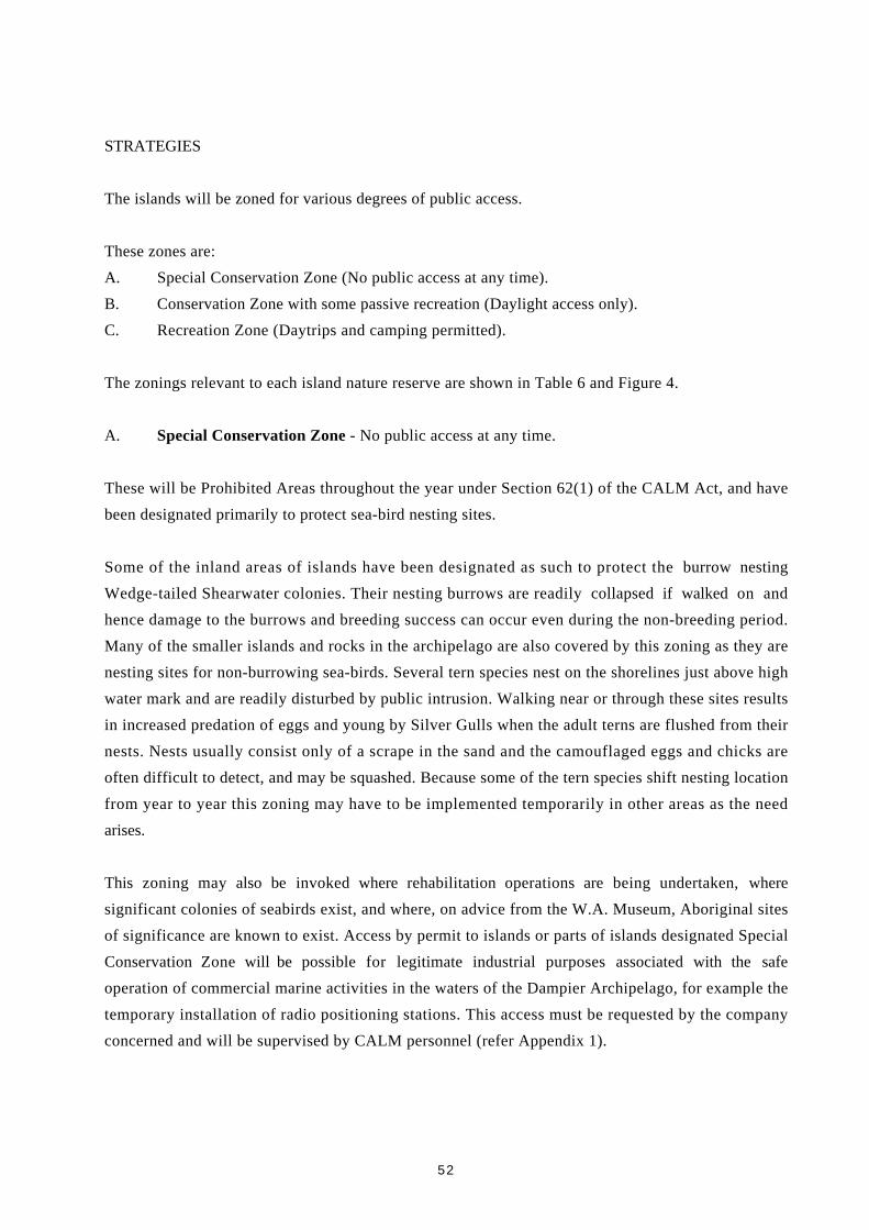
52
STRATEGIES
The islands will be zoned for various degrees of public access.
These zones are:
A. Special Conservation Zone (No public access at any time).
B. Conservation Zone with some passive recreation (Daylight access only).
C. Recreation Zone (Daytrips and camping permitted).
The zonings relevant to each island nature reserve are shown in Table 6 and Figure 4.
A. Special Conservation Zone - No public access at any time.
These will be Prohibited Areas throughout the year under Section 62(1) of the CALM Act, and have
been designated primarily to protect sea-bird nesting sites.
Some of the inland areas of islands have been designated as such to protect the burrow nesting
Wedge-tailed Shearwater colonies. Their nesting burrows are readily collapsed if walked on and
hence damage to the burrows and breeding success can occur even during the non-breeding period.
Many of the smaller islands and rocks in the archipelago are also covered by this zoning as they are
nesting sites for non-burrowing sea-birds. Several tern species nest on the shorelines just above high
water mark and are readily disturbed by public intrusion. Walking near or through these sites results
in increased predation of eggs and young by Silver Gulls when the adult terns are flushed from their
nests. Nests usually consist only of a scrape in the sand and the camouflaged eggs and chicks are
often difficult to detect, and may be squashed. Because some of the tern species shift nesting location
from year to year this zoning may have to be implemented temporarily in other areas as the need
arises.
This zoning may also be invoked where rehabilitation operations are being undertaken, where
significant colonies of seabirds exist, and where, on advice from the W.A. Museum, Aboriginal sites
of significance are known to exist. Access by permit to islands or parts of islands designated Special
Conservation Zone will be possible for legitimate industrial purposes associated with the safe
operation of commercial marine activities in the waters of the Dampier Archipelago, for example the
temporary installation of radio positioning stations. This access must be requested by the company
concerned and will be supervised by CALM personnel (refer Appendix 1).

53
B. Conservation Zone - Daylight access only
These areas will be Limited Access Areas under Section 62(1) of the CALM Act and have been
designated:
1) to protect important turtle nesting beaches and to prevent disturbances to nesting turtles; and
2) to prevent possible vegetation degradation to the inland areas of the islands through camping
activities.
Hence this zoning allows for daylight recreational access to the important turtle nesting beaches and
the inland areas of most of the islands.
Access for industrial purposes will be as above for the Special Conservation Zone.
C. Recreational Zone - Daytrips and Camping Permitted
These areas will be Recreational Areas for Specified Activities under Section 62(1) of the CALM Act
and have been designated to allow public enjoyment of the islands without diminishing their
conservation values. Camping for up to five (5) nights to 100m inland of the high water mark will be
permitted on:
- all the beach areas of Angel and Gidley Islands, and Collier Rocks
- all the beach areas, except the south-eastern beaches, of Dolphin Island
- all the beach areas, except the two western most beaches, and the eastern most beaches, of
Enderby Island
- Norbill Bay and Chookie Bay, Rosemary Island
- Marney Bay, Malus Island
- the south facing beach of Goodwyn Island
- the south east facing beach of Eaglehawk Island
- the eastern beach of Hauy Island
- the south tip of Delambre Island (up to a distance of 100 m north on either the east or west side
of the island).
Unrestricted day access will be permitted to all recreation areas mentioned above. All day trip and
camping activities will be subject to the guidelines for public use (refer 7.2).

54
TABLE 6 DAMPIER ARCHIPELAGO NATURE RESERVES: ZONINGFOR PUBLIC USE
ISLAND
Beaches - Zoning Remainder of Island - Zoning
Angel *C B
Bare Rock A A
Brigadier A A
Cohen A A
Collier Rocks C B
Conzinc Eastern beaches B
Remainder A A
Delambre Southern tip C
Remainder B B
Dolphin South-Eastern beaches B
Remainder C B
Eaglehawk South-Eastern beach C
Remainder B B
Elphick Nob A A
Egret A A
Enderby East and West beaches B
Remainder C B
Gidley C B
Goodwyn South beach C
Remainder A A
Hauy East beach C
Remainder A A
Keast A A
Kendrew A A
Malus (part) Marney Bay C
Remainder B B
Mawby A A
Millers Rocks A A
Nelson Rocks A A
Rosemary Norbill. Bay C
Chookie Bay C
Remainder B B
Tozer B B
Wilcox B B
* Zones A, B and C as defined in 7.1-STRATEGIES.
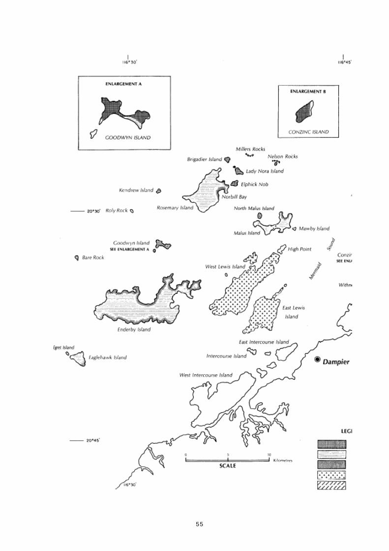
55

56

57
7.2 GUIDELINES FOR PUBLIC USE
OBJECTIVES
1. To ensure public use does not diminish the conservation values of the islands.
2. To inform the public of the guidelines governing their use of the islands.
RATIONALE
The nature reserves were established primarily for their conservation values and Wildlife Conservation
Regulations exist to protect these values, while providing for access to the reserves by the public.
Similar protection will be afforded under the CALM Act and National Parks Regulations should the
islands become a national park, with resultant improvements in public access and recreational
opportunities. The public also need to be aware of the protection afforded Heritage Places (WA) Act,
presently before Parliament. As some of the historic sites are listed on the National Estate Register,
they are protected from some activities under the provisions of the Australian Heritage Commission
Act 1976.
STRATEGIES
1. Provisions of the Wildlife Conservation Act 1950 and the CALM Act will apply to the reserves,
viz:
a) Day visits and camping for up to 5 nights will be permitted in the appropriate areas
(refer 7. 1);
b) No permanent structures are to be erected by the public;
c) Flora and fauna of the reserves, including intertidal marine species may not be killed,
disturbed, or removed from the reserves except for scientific or educational purposes,
authorised by permit. (Note that shell collecting in the intertidal zone is thus prohibited.
This applies to all shells, whether living or not.);
d) Rocks and soil may not be removed or disturbed for campsites, or any other purpose
except by permit;
e) Dogs, cats or any other animal are not to be taken onto the reserves;

58
f) Plants are not to be taken to, or planted on the reserves;
g) All offal, refuse, rubbish and fitter is to be removed and returned to the mainland, not
burnt or buried on the reserve;
h) No vehicular transport is to be used on the reserves, except with the written approval of
the Executive Director,
i) Cooking with gas equipment only is permitted. Open fires and the use of reserve
vegetation for fires is prohibited; and
j) Firearms are prohibited on the reserves.
2. The protection afforded to Aboriginal and historic sites under the provisions of the Aboriginal
Heritage Act 1972 and the proposed Heritage Places (WA) Act respectively, will be made clear
to the public.
3. The NWGFC which operates on Rosemary Island during the winter months, will be requested to
continue their surveillance of public use of Norbill Bay.
4. Regular patrols of the islands by the District Wildlife Officer and other CALM personnel with
the appropriate authority will be maintained to ensure that the public use guidelines are not
breached.
5. Public use of the reserves will continue to be monitored.
7.3 INTERPRETATION
OBJECTIVES
1. To provide the public with information relevant to management of the islands subject to this
plan.
2. To increase public awareness and appreciation of the values of the islands.

59
RATIONALE
Management of the islands will be enhanced if the public users are informed of management
strategies such as those relating to island status, zoning and public use guidelines. Increasing public
awareness of the conservation values will assist management.
STRATEGIES
Several methods of informing the public will be adopted.
1. Departmental Reserve Signs
Reserve signs of modular pine log construction and conforming to the CALM sign standards will be
erected on beaches most often visited by the public. These will give the island name and use symbols
to demonstrate restrictions on open fires and pets on the reserves. "No camping" symbols will be used
in the appropriate areas. Positive symbols such as those depicting walking, photography and fishing
will also be displayed. Signs indicating the use zoning of the beach or island will be erected.
2. Information Boards
Once this management plan has been accepted in its final form, information boards will be erected at
the boat ramps in Dampier, Karratha and Wickham. These will show a plan of the Dampier
Archipelago with island reserve status and the management zonings of this plan. Information boards
will also be situated at the boundaries of management zonings to indicate to the public why the
zoning was created and restrictions imposed (for example at turtle and sea-bird nesting locations).
Historic and Aboriginal site information boards will be erected where appropriate following
consultation with the Western Australian Museum.
3. Management Brochures
Separate brochures will be produced in the early stages of the term of the management plan. These
include:
- a brochure summarising the management zonings of the islands and guidelines for public use
- a brochure summarising the natural, historic and archaeological values of the reserves
- a brochure containing guidelines for observing fauna such as nesting turtles and sea-birds,
together with notes on the biology of these species
- brochures containing check lists of the flora and fauna of the reserves.
These brochures will be displayed in the CALM and Department of Marine and Harbours offices in
Karratha and distributed to tourist and marine charter operators in the region. Shack owners on the
recreation reserves will be provided with copies.

60
4. Newspaper Articles and Public Relations
Articles on points of interest relating to the islands and information on management operations
undertaken will be offered regularly to local newspapers and mining company magazines.
Every opportunity will be taken by CALM personnel to speak to the public on the management of
the islands, for example, through seminars and other forums.
5. Environmental Education
Some fauna is accessible and can be used to promote nature conservation without detrimental effects.
Sites such as active Osprey nests can be approached at certain times and photographed unsupervised
with no harm to the nesting birds. If demand exists, it could be possible to arrange supervised visits to
turtle nesting beaches and Wedge-tailed Shearwater rookeries. Controlled access to other seabird
nesting sites is possible.
The Department's research station on Enderby Island will be used for organised nature studies by
interested groups such as the Nickol Bay Naturalist Club and school biology classes.
Information regarding historic and, where appropriate, Aboriginal sites will be included in
environmental education programs.
7.4 COMMERCIAL CONCESSIONS
OBJECTIVE
1. To allow use of parts of the Dampier Archipelago nature reserves by a limited number of
commercial operators, while ensuring that the reserves environment and other users are not
adversely affected.
RATIONALE
As the population of the Pilbara continues to grow and visitor interest in the archipelago increases,
proposals from commercial operators for various concessions will arise. These might include guided
tours by properly trained personnel, boating trips with designated landings, and short-term small
group camping.
Activities proposed would need to be compatible with the natural and cultural values of the islands,
and restrictions on visitor numbers might need to be applied.

61
STRATEGIES
1. Concessions which are consistent with the purpose of reservation and preservation of the
archipelago may be approved if proposals fulfil the guidelines of the CALM recreation policy
and are acceptable to the NPNCA and Minister.
2. Liaise with local government to ensure provision of facilities in nearby towns for tour
members.
3. Ensure that tour operators contact CALM staff before visiting the archipelago and encourage
them to obtain interpretive information.
4. Provide training for tour operators to ensure that concession holders meet certain minimum
standards of operation and conform with regulations.
8.0 PARK PROGRAMMES
Actions to be taken as a result of this plan have been grouped and summarised in the following
tables.
Priorities have been assigned as follows:
HIGH Essential to stated objectives.
MEDIUM Essential to long-term objectives of the plan but may be deferred pending the
availability of resources.
LOW Desirable but will only be undertaken when other demands on resources have
been met.

62
MANAGEMENT FOR CONSERVATION OF FLORA, FAUNA AND LANDSCAPE
PROPOSED ACTION PRIORITY REFERENCES
(Page Strategy No.)
5.1 Fire Protection
Implement no planned burn policy for the H 39(1)
islands, except where limited burning
is undertaken for research purposes.
Develop a contingency plan for action in H 39(3)
the event of a wildfire on the islands.
Staff training in fire management. H 39(1)
Provide fire protection to the Enderby H 40(5)
Island Research Station.
5.2 Control of Introduced Plants
Survey islands to determine extent and H 41(1)
distribution of introduced plant species.
Staff training in environmental hygiene H 41(2)
conditions.
Eradication/control of introduced species. H 41(3,4)
Develop catalogue of acceptable shade M 41(6)
trees for islands.
5.3 Control of Introduced Animals
Control of feral fox and cat populations H 42(1)
on the Burrup Peninsual and adjacent
islands in liaison with Woodside
Petroleum and APB.
Monitoring the status of all exotic animals H 42(2)
on the islands of the Dampier Archipelago.
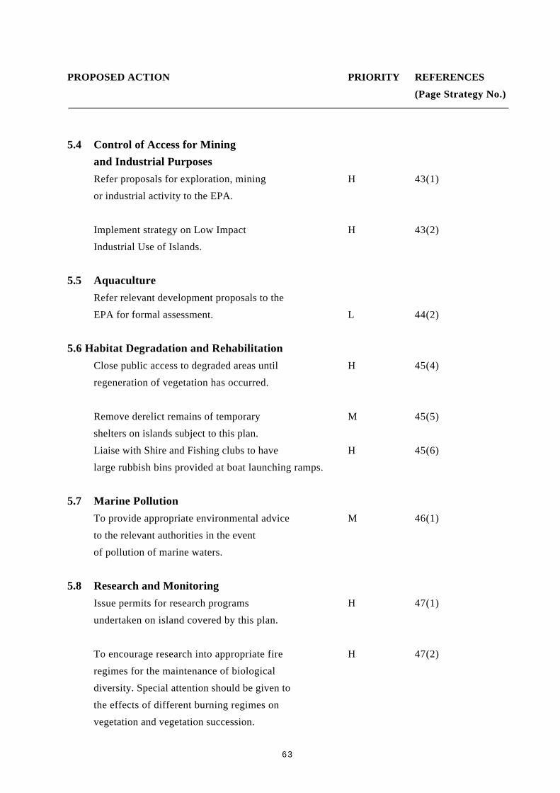
63
PROPOSED ACTION PRIORITY REFERENCES
(Page Strategy No.)
5.4 Control of Access for Mining
and Industrial Purposes
Refer proposals for exploration, mining H 43(1)
or industrial activity to the EPA.
Implement strategy on Low Impact H 43(2)
Industrial Use of Islands.
5.5 Aquaculture
Refer relevant development proposals to the
EPA for formal assessment. L 44(2)
5.6 Habitat Degradation and Rehabilitation
Close public access to degraded areas until H 45(4)
regeneration of vegetation has occurred.
Remove derelict remains of temporary M 45(5)
shelters on islands subject to this plan.
Liaise with Shire and Fishing clubs to have H 45(6)
large rubbish bins provided at boat launching ramps.
5.7 Marine Pollution
To provide appropriate environmental advice M 46(1)
to the relevant authorities in the event
of pollution of marine waters.
5.8 Research and Monitoring
Issue permits for research programs H 47(1)
undertaken on island covered by this plan.
To encourage research into appropriate fire H 47(2)
regimes for the maintenance of biological
diversity. Special attention should be given to
the effects of different burning regimes on
vegetation and vegetation succession.

64
PROPOSED ACTION PRIORITY REFERENCES
(Page Strategy No.)
Research into the marine environment of the H 47(3)
archipelago including biota of the intertidal
zone.
Research into the population biology of M 48(4)
small mammals with special attention on
the effects of different fire regimes.
Monitor the status of the rock wallaby H 48(4)
and other small mammal populations with
special reference to the effects of various
fire regimes.
Survey the distribution of rare and poorly H 48(5)
collected flora and the distribution of
exotic plants.
Collect flora species presently undescribed M 48(6)
or in need of taxonomic revision.
Liaise with APB to develop control H 48(7)
techniques for exotic plants and animals
that will minimise effect on non-target
species.
Monitor the use of islands by marine turtles H 48(8)
and seabirds for breeding.
Conduct tagging studies on marine turtles H 48(8)
in the archipelago.
Monitor rehabilitation operations on the H 48(9)
islands.

65
PROPOSED ACTION PRIORITY REFERENCES
(Page Strategy No.)
Monitor recreational use and the environ- H 48(10)
mental effects of that use.
Encourage research relating to Aboriginal M 48(11)
and historic sites on the islands.
Conduct a biological survey of islands H 48(12)
in the Dampier Archipelago not currently
reserved for the conservation of flora
and fauna.
6.0 Management of Aboriginal and Historic Sites
Transport will be made available to WA M 49(1)
Museum staff to enable survey work on
islands in the Dampier Archipelago.
Aboriginal Site recording forms will be M 49(2)
compiled by CALM staff and forwarded
to the WA Museum.
Staff training on the requirements and H 49(3)
objectives under the Aboriginal Heritage
Act 1972
Consult with WA Museum and Roebourne H 49(4)
groups about care and use of, and access
to, Aboriginal sites and objects.
Collect information on historic sites M 49(5)
and Aboriginal sites.
7.0 Management Zonings
Implement park zoning plan. H 51(A)

66
PROPOSED ACTION PRIORITY REFERENCES
(Page Strategy No.)
Erect notices, if required, to temporarily H 51(A)
close sections of reserves to members of
the public so as to protect seabird nesting
areas and rehabilitating sites.
Erect notices on the advice of the WA M 51 (A)
Museum to protect Aboriginal sites
of significance.
7.2 Guidelines for Public Use
District Wildlife Officer and other CALM H 57(4)
personnel with the appropriate authority
to patrol the islands subject to this plan
to ensure public use guidelines are not
breached.
7.3 Interpretation
Erect Departmental signs on beaches with H 57(1)
high visitation.
Erect information boards at boat ramps H 58(2)
showing island status and management
zonings.
Erect information boards at the boundaries H 58(2)
of management zonings.

67
PROPOSED ACTION PRIORITY REFERENCES
(Page Strategy No.)
Produce management brochures
summarizing:
- management zonings and guidelines H 58(3)
for public use
- natural, historic and archaeological M 58(3)
values of the islands
- guidelines for observing fauna with M 58(3)
notes on their biology.
Development of an interpretive program H 58(5)
incorporating interpretation and visitor
information.
7.4 Commercial Concessions
Liaise with local government to ensure M 59(2)
that nearby towns provide appropriate
visitor facilities.
Derive a procedure whereby tour M 59(3)
operators contact CALM staff prior to
visiting the archipelago.
Encourage tour operators to obtain M 59(3)
interpretive information.
Provide training for tour operators to M 59(4)
ensure that concession holders meet
appropriate standards of operation and
conform with regulations.

68
9.0 PLAN IMPLEMENTATION AND REVISION
Once adopted this management plan will be implemented by CALM within the framework of
available public resources. It is proposed that the status of plan implementation be reviewed annually
by CALM regional and branch personnel. Where it is considered that management practice is not in
accordance with the plan, steps will be taken to amend management practice or, alternatively, revise
the plan.
The management plan will remain in force for a period of 10 years expiring in 2000. Amendments
may be made to the plan within this period. In the event of the plan being revoked before expiry, a
new plan will be substituted in accordance with the provisions of the CALM Act.
It is possible that an advisory committee could be established to assist with management of the nature
reserves and other proposals for conservation reserves with broadly based membership providing an
avenue for general community input into management, and for input from appropriate authorities.
The committee would be established in accordance with CALM Policy Statement No. 4 Departmental
Advisory Committees, and advisory to the Executive Director (CALM) through the Regional Manager
(Pilbara). Members will be appointed by the Minister. Meetings will generally be convened in
response to a request from the CALM Regional Manager.

69
BIBLIOGRAPHY
Australian Academy of Science (1962). Report of the Western Australian Sub-Committee of the
Australian Academy of Science Committee on National Parks (unpubl. report).
Australian Bureau of Statistics. Census, 1976.
Australian Bureau of Statistics. Census, 198 1.
Bagnouls, and Gaussen, H (1957). Les climats ecologiques et leur classification. Annls. Geogr. 66:
193-220.
Beard,JS (1975). The Vegetation of the Pilbara Area. University of WA Press. Perth, WA.
Biggs, E R (1976a). Dampier-Eaglehawk Island - Rosemary Urban Geology, 1.50 000 scale Urban
Geology Series. Western Australia Geological Survey Map 2256 IV, 2156 1, 2257111.
Biggs, E R (1976b). Nickol Bay - Legendre Urban Geology, 1:50 000 scale Urban Geology Series.
Western Australia Geological Survey Map 2256 1 - 2257 11.
Bindon, P and Lofgren, M (1982). Walled rock shelters and a cached spear in the Pilbara Region,
Western Australia. Rec. West. Aust. Mus. 10 (2): 11-126.
Blackwell, M I; Trudgen, M E and Weston, A S (1979). Vegetation and Floristics of the Burrup
Peninsula. Woodside Petroleum Development Pty. Ltd., North West Shelf Development
Project.
Burbidge, A A (1985). Fire and mammals in hummock grasslands of the and zone. Proceedings of a
symposium Fire Ecology and Management of Western Australian Ecosystems. Western
Australian Institute of Technology. Perth, 1985.
Burbidge, A A and Prince, R I T (1972). The Fauna, Flora and Planned Useage of the Dampier
Archipelago. Report No. 11. Department of Fisheries and Fauna, W.A.
Butler, W H (1983). Burrup Peninsula Fauna Survey. Woodside Offshore Petroleum Pty. Ltd.
(unpubl. report).
Cogger, H G (1979). Reptiles and Amphibians of Australia. A H and A W Reed Pty. Ltd..

70
Connell, G W (1983). Biogeography and Community Structure of Insular Herpetofaunas. Unpubl.
BSc (Hons) thesis, Department of Zoology, UWA.
Conservation Through Reserves Committee (1974). Conservation Reserves in Western Australia.
Report of the Conservation Through Reserves Committee to the Environmental Protection
Authority.
Department of Industrial Development (1983). The Pilbara: A Regional Profile (unpubl. report).
De la Rue, K (1979). Pearl Shell and Pastures. Cossack Project Committee (Inc).
Elliott, K (1986). Population Projections for the Pilbara Region, 1991. Department of Regional
Development and the North West. Perth, W.A.
Environmental Protection Authority (1975). A report to Hon. Minister for Conservation and
Environment on Conservation Reserves for Western Australia as recommended by the
Environmental Protection Authority system 4, 8, 9, 10, 11 and 12.
Gara, T J (1983). The Flying Foam Massacre: An incident on the north-west frontier Western
Australia. Archaeology of Anzaas 1983. W.A. Museum, Perth.
Gardner, G A (1952). Flora of Western Australia: Gramineae. Government Printer, Perth.
George, A S (1971). The plants seen and collected in north-western Australian by William Dampier.
W.A. Nat . 11 (8): 173-178.
Gillespie, J D (1975). Proposed deepwater port at Legendre Island (unpubl. report).
Gordon, D M (1983). A preliminary study of mangroves of the Dampier Archipelago, Western
Australia. Department Conservation and Environment, Environmental Note No. 141.
Green, J W (1985). Census of Vascular Plants- of Western Australia. W.A. Herbarium, Department
Agriculture, Perth.
Gregory, A C and Gregory F T (1884). Journals of Australian Exploration. James C Beal,
Government Printer, Brisbane. (Facsimile edition 1981 Hesperian Press).
Henn, P U (1934). French exploration on the Western Australian coast. Early days 2 (15): 1932 -
1936. W.A. Historical Soc.
71
Kendrick, G (1961). Field Note Book - Rosemary Island. W.A. Museum.
King, D R, Twigg, L E and Gardner, J L (1989). Tolerance to Sodium Monofluoroacetate in
Dasyurids from Western Australia. Aust. Wild. Res. 16: 131-40.
King, D R (1989). An Assessment of the Hazard Posed to Northern Quolls (Dasyurus hallucatus) by
Aerial Baiting with 1080 to Control Dingoes. Aust. Wildl. Res. 16 : 569-74.
King, P P (1817). Narrative of a survey of the intertropical and western coasts of Australia. Vol 2.
John Murray, London.
Kinnear, J; Onus, M and Bromilow, B (1984). Foxes, Feral Cats, and Rock Wallabies. Swans. 14 (1):
3-8.
Kitchener, D J and Vicker, E (1981). Catalogue of Modern Mammals in the Western Australian
Museum 1885 to 1981. Western Australian Museum.
Kriewaldt, M (1964). Dampier and Barrow Island, Western Australia. 1:250 000 Geological Series.
Western Australia Geological Survey, Explanatory Notes, SF/50-2 and SF/50-1.
Lee, I. (1925). Early Explorers in Australia. Methun & Co Ltd, London.
Long, V.L. (1988). Dampier Archipelago flora survey (1987). (Unpubl. report).
Lorblanchet, M (1989). Midderns and Engravings, Dampier (WA). Australian Institute of Aboriginal
Studies, Canberra, ACT (unpubl. report).
Marchant, L (1982). France Australe. Artlook Books, Perth W.A.
Macllroy, J (1979). Dampier Archipelago Historic Sites Surveys. Australian Heritage Commission.
Merrilees, D (1979). The prehistoric environment in Western Australia. J. Roy. Soc. W.A. 62 : (1-4)
109-128.4.
Purdie, R W, Symon, D E and Haegi, L (1982). Solanaceae in Flora of Australia. Vol 29. Australian
Government Publishing Services.
Randolph, P (1973). Field Note Book. Department Aboriginal Sites, W.A. Museum.

72
Rhoads, J W and Gara, T J (1984). Introduction. In Dampier Archaeological Project: Survey and
Salvage of Aboriginal Sites on Portion of the Burrup Peninsula for Woodside Offshore
Petroleum Pty Ltd. Aboriginal Sites Department, Western Australian Museum.
Ryan, G R (1966). Roebourne, Western Australia. 1:250 000 Geological Series. Western Australia
Geological Survey, Explanatory Notes, SF/50-3.
Semeniuk, V, Chalmer, P N and Le Provost, 1 (1982). The marine environments of the Dampier
Archipelago. J. Roy. Soc. W.A. 65 (3): 97-114.
Serventy, D L and Whittel H M (1976). Birds of Western Australia. University of W.A. Press, Perth,
W.A.
Simpson, C J (1985). Mass spawning of scleractinian corals in the Dampier Archipelago and the
implications for management of coral reefs in Western Australia. Department Conservation and
Environment, Perth, W.A. Bulletin 244: 1-35
Tingay, A and Tingay, S R (1978). Vertebrate fauna study of Burrup Peninsula. Woodside Offshore
Petroleum Pty. Ltd. (unpublished report).
Tuckfield, T (1955). William Dampier ... where did he land? W.A. Hist. Soc. 5 (1): 5-15.
Van Leeuwen, S (1983). Rare and geographically restricted plants of the Pilbara, Fortescue
Botanical District. Department Fisheries and Wildlife (unpublished report).
Vinnicombe, P. (1987). Dampier Archeological Project: Resource document of the survey and
salvage of Aboriginal sites. (Unpubl. report). Woodside Offshore Petroleum Pty. Ltd.
Virili, F.L. (1977). Aboriginal sites and rock art of the Dampier Archipelago, Western Australia. In
Form, in Indigenous Art: Schematisation in the Art of Aboriginal Australia and Prehistoric
Europe, pp 439-451. (Ed. P.J. Ucko): Australian Institute of Aboriginal Studies, Canberra.
Whitlock, F.L. (1918). Notes of birds breeding in Dampier Archipelago, NW coast of Australia. Emu
18 : 240-253.
Wilson, B.R. and Marsh, L.M. (1975). Seasonal behaviour of a 'normal' population of Acanthaster in
Western Australia. In Crown-of-Thorns Starfish Seminar Proceedings, Brisbane 6 Sept. 1974.
Aust. Govt. Printing Service.

73
Wilson, P.G. (1984). Chenopodiaceae. In Flora of Australia. Vol. 4. Commonwealth of Australia.
Woodside Petroleum Development Pty. Ltd. (1979). Draft Environmental Impact Statement and
Environmental Review and Management Program, North West Shelf Development Project.
Wordick, F.U. (1982). The Yindjibarndi Language. Pacific Linguistics 71 .

74
APPENDIX 1 CONDITIONS OF USE FOR SURVEY STATIONSIN THE DAMPIER ARCHIPELAGO - WOODSIDE
1. (a) Most of the sites have been in operation for some time and the facilities well established.
CALM agrees these sites remain as positioned, and Woodside undertakes to conform to
the "Conditions of Use".
(b) Prior to the establishment of new sites on CALM lands, joint CALM/Woodside Offshore
Petroleum site inspection would be required. These would take into account:
a) rare, endangered or geographically restricted flora and an assessment of
Aboriginal Sites, if any, in the immediate vicinity of the proposed facility;
b) the need for the proposed site to be suitable to meet the technical and safety
requirements of Woodside;
c) seabird nesting sites; and
d) safety requirements (including helicopter landing sites).
2. (a) A minimum of 2 weeks notice to be given to CALM, whenever possible, prior to the
activation of an existing site.
(b) Notice should include whether the site will be manned, an indication of how long the site
will be in use and of the frequency of helicopter visits.
(c) Subsequent visits by Woodside Offshore Petroleum personnel to an activated site during
the period of activation would not require notification.
(d) If the CALM Regional Manager believes the primary and/or secondary sites are located
in areas known or thought likely to be adjacent to active sea-bird rookeries and nest sites,
CALM and Woodside will review (including possible site inspection) to decide upon the
most appropriate action and to ensure any disturbances are minimised. This may include
moving the positioning facilities between the primary and secondary sites if technically
possible or relocating the rookeries and nest sites.
If given notice well in excess of two weeks, CALM could include some pre-activation
inspections in normal island inspections.
3. Conditions of Use
(a) No pets shall be taken to the island.

75
(b) Visual checks will be made on all equipment prior to transportation to ensure that it is
free of exotic plant propagules and animals.
(c) Disturbance to flora shall be kept to a minimum.
(d) Particular care shall be taken to avoid walking over Wedge-tailed Shearwater burrows and
in other areas where sea-birds are nesting.
(e) All reasonable precautions shall be taken to minimise disturbance to any animal, its
habitat, nesting or spawning ground.
(f) No firearms shall be taken to the island.
(g) No rubbish shall be left on the island.
(h) Compliance with Aboriginal Heritage Act 1972.
(i) Commensurate with flying and safety requirements applicable at the time, helicopter
approaches shall be from the sector which will minimise disturbance to seabird rookeries
and nest sites.
4. Existing supplementary stations will be treated as existing primary sites, and new
supplementary stations will be treated as under the Initial Site Selection conditions.
NOTE: These conditions have been prepared with specific reference to Woodside Offshore
Petroleum, but will be applicable to all such survey stations.

76
APPENDIX II DAMPIER ARCHIPELAGO ISLAND NAMECODES
An = Angel Island
Ba = Bare Rock
Br = Brigadier Island
Co = Cohen Island
Cl = Collier Rocks
Cn = Conzinc Island
De = Delambre Island
Di = Dixon Island
Do = Dolphin Island
Ea = Eaglehawk Island
El = East Intercourse Island
EL = East Lewis Island
Ep = Elphick Nob
Eg = Egret Island
En = Enderby Island
Gi = Gidley Island
Go = Goodwyn Island
Ha = Hauy Island
Hi = High Point
Ke = Keast Island
Kn = Kendrew Island
LN = Lady Nora Island
Le = Legendre Island
Ma = Malus Island
Mw = Mawby Island
Mi = Millers Rocks
Ne = Nelson Rocks
NM = North Malus Island
Ro = Roly Rocks
Rs = Rosemary Island
Te = Tem Island
Ti = Tidepole Island
TO = Tozer Island
WI = West Intercourse
WL = West Lewis Island

77
APPENDIX III DISTRIBUTION OF THE TERRESTRIALMAMMALS IN THE
DAMPIER ARCHIPELAGO
Island Name Code
An Co Di Do El EL En Gi Ha Ke Kn Le Ma NM Rs To Ti WI WL
Marsupialia
Dasyuridae
Dasyurus hallucatus . . . x . . . . . . . . . . . . . . .
Macropodidae
Macropus robustus . . x x x x . . . . . . . . . x . x x
Petrogale rothschildi . . . x . . x . . . . . . . x . . . x
Eutheria
Pteropodidae
Pteropus scapulatus . . . . . x . . . . . . . . . . . . .
Emballonuridae
Taphozous georgianus . . . x . . . . . . . . . . . . . . .
Vesperfilionidae
Eptesicus finlaysoni . . . . . x . . . . . . . x . . . . .
Nyctophilus geoffroyi . . . . . x . . . . . . . . . . . . .
Muridae
Pseudomys
hermannsburgensis . . x . . . . . . . . . . . x . . . .
Rattus tunneyi . . . x . x x . x x . x x . . . . .x
Zyzomys argurus x . . x . . x . . . x x . . x . . . .
Hydromys chrysogaster . x . . . . . . . . . . . . x . . . .
Mus musculus . . x . . . . . . . . . . . . . . . .
unidentified murid . . . . x . . x . . . . . . . . x x .
Canidae
Vulpes vulpes x x . x x . . x x x . x . . . . . . .
Felidae
Felis catus x . . x x . . . . . . . . . ext . . . .
Bovidae
Ovis aries . . . . . ext . . . . . . . . . . . . ext
ext = now extinct.
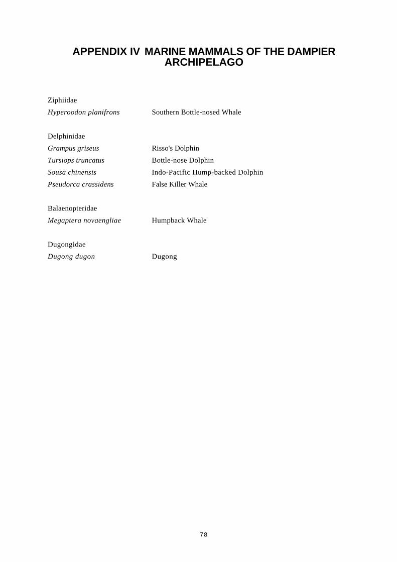
78
APPENDIX IV MARINE MAMMALS OF THE DAMPIERARCHIPELAGO
Ziphiidae
Hyperoodon planifrons Southern Bottle-nosed Whale
Delphinidae
Grampus griseus Risso's Dolphin
Tursiops truncatus Bottle-nose Dolphin
Sousa chinensis Indo-Pacific Hump-backed Dolphin
Pseudorca crassidens False Killer Whale
Balaenopteridae
Megaptera novaengliae Humpback Whale
Dugongidae
Dugong dugon Dugong
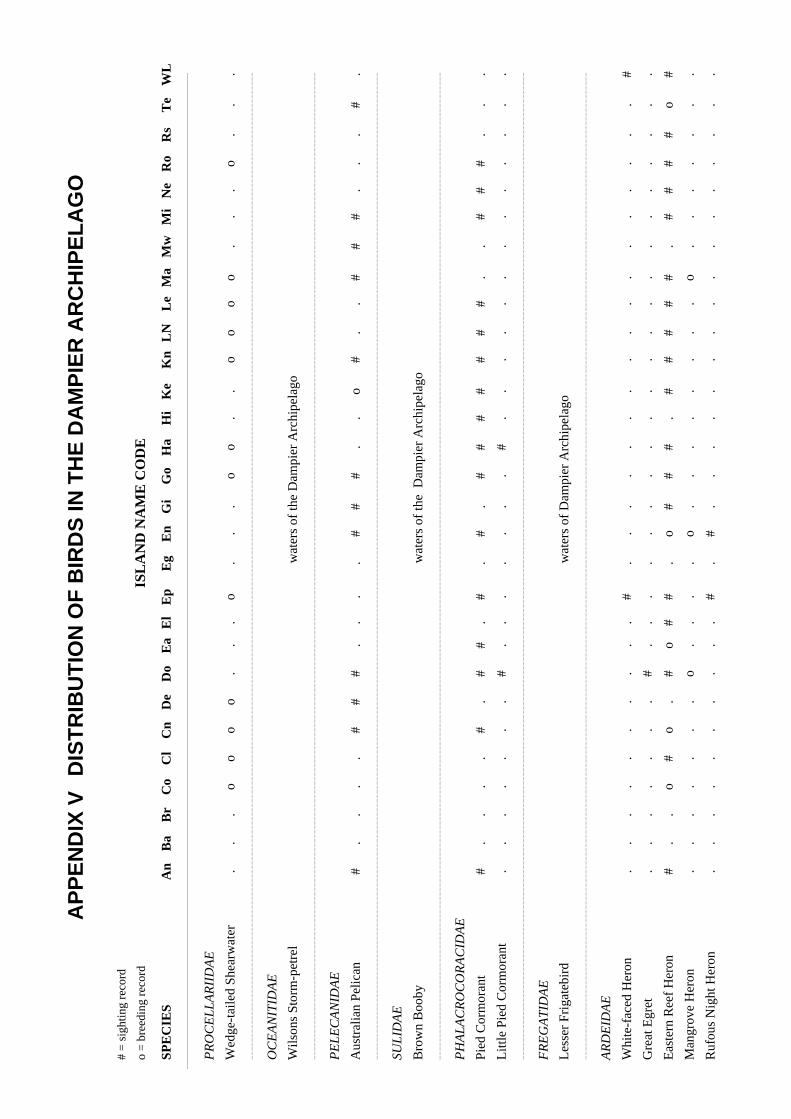
AP
PE
ND
IX V
DIS
TR
IBU
TIO
N O
F B
IRD
S IN
TH
E D
AM
PIE
R A
RC
HIP
EL
AG
O
# =
sig
htin
g re
cord
o =
bre
edin
g re
cord
ISL
AN
D N
AM
E C
OD
E
SPE
CIE
SA
nB
aB
rC
oC
lC
nD
eD
oE
aE
lE
pE
gE
nG
iG
oH
aH
iK
eK
nL
NL
eM
aM
wM
iN
eR
oR
sT
eW
L
PR
OC
EL
LA
RII
DA
E
Wed
ge-t
aile
d Sh
earw
ater
..
.o
oo
o.
..
o.
..
oo
..
oo
oo
..
.o
..
.
----
----
----
----
----
----
----
----
----
----
----
----
----
----
----
----
----
----
----
----
----
----
----
----
----
----
----
----
----
----
----
----
----
----
----
----
----
----
----
----
----
----
----
----
----
----
----
----
----
----
----
----
----
----
----
---
OC
EA
NIT
IDA
E
Wils
ons
Stor
m-p
etre
lw
ater
s of
the
Dam
pier
Arc
hipe
lago
----
----
----
----
----
----
----
----
----
----
----
----
----
----
----
----
----
----
----
----
----
----
----
----
----
----
----
----
----
----
----
----
----
----
----
----
----
----
----
----
----
----
----
----
----
----
----
----
----
----
----
----
----
----
----
---
PE
LE
CA
NID
AE
Aus
tral
ian
Pelic
an#
..
..
##
#.
..
.#
##
..
o#
..
##
#.
..
#.
----
----
----
----
----
----
----
----
----
----
----
----
----
----
----
----
----
----
----
----
----
----
----
----
----
----
----
----
----
----
----
----
----
----
----
----
----
----
----
----
----
----
----
----
----
----
----
----
----
----
----
----
----
----
----
---
SUL
IDA
E
Bro
wn
Boo
byw
ater
s of
the
Dam
pier
Arc
hipe
lago
----
----
----
----
----
----
----
----
----
----
----
----
----
----
----
----
----
----
----
----
----
----
----
----
----
----
----
----
----
----
----
----
----
----
----
----
----
----
----
----
----
----
----
----
----
----
----
----
----
----
----
----
----
----
----
---
PH
AL
AC
RO
CO
RA
CID
AE
Pied
Cor
mor
ant
#.
..
.#
.#
#.
#.
#.
##
##
##
#.
.#
##
..
.
Litt
le P
ied
Cor
mor
ant
..
..
..
.#
..
..
..
.#
..
..
..
..
..
..
.
----
----
----
----
----
----
----
----
----
----
----
----
----
----
----
----
----
----
----
----
----
----
----
----
----
----
----
----
----
----
----
----
----
----
----
----
----
----
----
----
----
----
----
----
----
----
----
----
----
----
----
----
----
----
----
---
FR
EG
AT
IDA
E
Les
ser
Frig
ateb
ird
wat
ers
of D
ampi
er A
rchi
pela
go
----
----
----
----
----
----
----
----
----
----
----
----
----
----
----
----
----
----
----
----
----
----
----
----
----
----
----
----
----
----
----
----
----
----
----
----
----
----
----
----
----
----
----
----
----
----
----
----
----
----
----
----
----
----
----
---
AR
DE
IDA
E
Whi
te-f
aced
Her
on.
..
..
..
..
.#
..
..
..
..
..
..
..
..
.#
Gre
at E
gret
..
..
..
.#
..
..
..
..
..
..
..
..
..
..
.
Eas
tern
Ree
f H
eron
#.
.o
#o
.#
o#
#.
o#
##
.#
##
##
.#
##
#o
#
Man
grov
e H
eron
..
..
..
.o
..
..
o.
..
..
..
.o
..
..
..
.
Ruf
ous
Nig
ht H
eron
..
..
..
..
..
#.
#.
..
..
..
..
..
..
..
.

# =
sig
htin
g re
cord
o =
bre
edin
g re
cord
ISL
AN
D N
AM
E C
OD
E
SPE
CIE
SA
nB
aB
rC
oC
lC
nD
eD
oE
aE
lE
pE
gE
nG
iG
oH
aH
iK
eK
nL
NL
eM
aM
wM
iN
eR
oR
sT
eW
L
CIC
ON
IID
AE
Bla
ck-n
ecke
d St
ork
..
..
..
.#
..
..
..
..
..
..
..
..
..
..
.
----
----
----
----
----
----
----
----
----
----
----
----
----
----
----
----
----
----
----
----
----
----
----
----
----
----
----
----
----
----
----
----
----
----
----
----
----
----
----
----
----
----
----
----
----
----
----
----
----
----
----
----
----
----
----
---
AN
AT
IDA
E
Plum
ed W
hist
ling
Duc
k#
..
..
..
..
..
.#
..
..
..
..
..
..
.#
..
----
----
----
----
----
----
----
----
----
----
----
----
----
----
----
----
----
----
----
----
----
----
----
----
----
----
----
----
----
----
----
----
----
----
----
----
----
----
----
----
----
----
----
----
----
----
----
----
----
----
----
----
----
----
----
---
AC
CIP
ITR
IDA
E
Bla
ck-s
houl
dere
d K
ite.
..
..
..
..
..
.#
..
#.
..
.#
..
..
.#
.#
Bra
hmin
y K
ite.
#.
.#
#.
#.
#.
##
.#
..
..
.#
o.
..
.o
.o
Col
lare
d Sp
arro
wha
wk
..
..
..
.#
..
..
..
..
..
..
..
..
..
..
.
Bro
wn
Gos
haw
k.
..
..
..
..
..
.#
..
..
..
..
..
..
..
.#
Whi
te-b
reas
ted
Sea
Eag
leo
.o
..
##
oo
oo
.o
#o
.#
oo
#o
#.
.#
.#
#o
Spot
ted
Har
rier
#.
..
..
..
..
..
#.
..
..
..
#.
..
..
..
#
Osp
rey
o.
oo
oo
oo
oo
oo
oo
oo
oo
oo
oo
oo
o.
oo
o
Whi
stlin
g K
ite.
..
..
..
#.
..
.#
..
..
..
##
..
..
.#
. #
----
----
----
----
----
----
----
----
----
----
----
----
----
----
----
----
----
----
----
----
----
----
----
----
----
----
----
----
----
----
----
----
----
----
----
----
----
----
----
----
----
----
----
----
----
----
----
----
----
----
----
----
----
----
----
---
FA
LC
ON
IDA
E
Bro
wn
Falc
on.
..
..
..
#.
..
.#
..
..
..
#.
..
..
.#
.#
Aus
tral
ian
Kes
trel
#.
o#
..
##
#.
#.
#.
o.
.#
o#
##
..
..
#.
#
----
----
----
----
----
----
----
----
----
----
----
----
----
----
----
----
----
----
----
----
----
----
----
----
----
----
----
----
----
----
----
----
----
----
----
----
----
----
----
----
----
----
----
----
----
----
----
----
----
----
----
----
----
----
----
---
PH
ASI
AN
IDA
E
Bro
wn
Qua
ilo
..
..
..
..
o#
.#
..
..
..
.o
..
..
.o
.o
----
----
----
----
----
----
----
----
----
----
----
----
----
----
----
----
----
----
----
----
----
----
----
----
----
----
----
----
----
----
----
----
----
----
----
----
----
----
----
----
----
----
----
----
----
----
----
----
----
----
----
----
----
----
----
---
TU
RN
ICID
AE
Litt
le B
utto
n-qu
ail
..
..
..
..
..
..
#.
..
..
..
..
..
..
#.
.
----
----
----
----
----
----
----
----
----
----
----
----
----
----
----
----
----
----
----
----
----
----
----
----
----
----
----
----
----
----
----
----
----
----
----
----
----
----
----
----
----
----
----
----
----
----
----
----
----
----
----
----
----
----
----
---

# =
sig
htin
g re
cord
o =
bre
edin
g re
cord
ISL
AN
D N
AM
E C
OD
E
SPE
CIE
SA
nB
aB
rC
oC
lC
nD
eD
oE
aE
lE
pE
gE
nG
iG
oH
aH
iK
eK
nL
NL
eM
aM
wM
iN
eR
oR
sT
eW
L
HA
EM
AT
OP
OD
IDA
E
Pied
Oys
terc
atch
er#
.#
.#
##
..
..
o.
##
.o
.#
##
..
.#
#.
#
Soot
y O
yste
rcat
cher
#.
.o
.#
.#
#.
.#
o.
##
..
.#
##
..
..
##
#
----
----
----
----
----
----
----
----
----
----
----
----
----
----
----
----
----
----
----
----
----
----
----
----
----
----
----
----
----
----
----
----
----
----
----
----
----
----
----
----
----
----
----
----
----
----
----
----
----
----
----
----
----
----
----
---
CH
AR
AD
RII
DA
E
Gre
y Pl
over
..
..
..
.#
#.
..
..
..
..
..
..
..
..
..
.
Lar
ge S
and
Plov
er.
..
..
..
#.
..
..
..
..
..
#.
#.
..
..
..
Red
-cap
ped
Plov
er#
..
..
..
##
..
.#
.#
..
..
#.
#.
..
.#
.o
Mon
golia
n Sa
nd P
love
r.
..
..
..
#.
..
.#
..
#.
..
#.
..
..
.#
..
Ori
enta
l Plo
ver
..
..
..
..
..
..
#.
..
..
.#
..
..
..
..
.
----
----
----
----
----
----
----
----
----
----
----
----
----
----
----
----
----
----
----
----
----
----
----
----
----
----
----
----
----
----
----
----
----
----
----
----
----
----
----
----
----
----
----
----
----
----
----
----
----
----
----
----
----
----
----
---
SCO
LO
PA
CID
AE
Rud
dy T
urns
tone
#.
.#
.#
##
##
#.
#.
.#
.#
##
..
.#
..
#.
#
Eas
tern
Cur
lew
----
----
----
----
----
----
----
----
----
----
----
----
----
----
----
----
----
----
----
----
----
----
----
----
----
----
----
----
----
----
----
----
----
----
----
----
----
----
----
----
----
----
----
----
----
----
----
----
----
----
----
----
----
----
----
---
SCO
LO
PA
CID
AE
Whi
mbr
el#
.#
..
..
..
..
.#
#.
..
..
##
..
.#
..
..
Gre
y-ta
iled
Tat
tler
..
.#
.#
.#
..
..
#.
#.
..
..
##
..
..
..
.
Gre
ensh
ank
..
..
..
..
..
..
#.
..
..
..
..
..
..
#.
#
Com
mon
San
dpip
er.
..
..
..
#.
..
.#
..
..
..
..
..
..
..
.#
Red
Kno
t God
wit
..
..
..
..
#.
..
..
..
..
..
..
..
..
..
.
Shar
p-ta
iled
Sand
pipe
r.
..
..
..
.#
..
.#
..
..
..
..
..
..
..
..
Red
-nec
ked
Stin
t.
..
..
..
#.
..
..
..
..
..
..
..
..
.#
..
Cur
lew
San
dpip
er.
..
..
..
#.
..
.#
..
..
..
..
..
..
..
..
Bar
-tai
led
God
wit
#.
..
..
.#
#.
..
..
..
..
..
..
..
..
..
.
----
----
----
----
----
----
----
----
----
----
----
----
----
----
----
----
----
----
----
----
----
----
----
----
----
----
----
----
----
----
----
----
----
----
----
----
----
----
----
----
----
----
----
----
----
----
----
----
----
----
----
----
----
----
----
---

# =
sig
htin
g re
cord
o =
bre
edin
g re
cord
ISL
AN
D N
AM
E C
OD
E
SPE
CIE
SA
nB
aB
rC
oC
lC
nD
eD
oE
aE
lE
pE
gE
nG
iG
oH
aH
iK
eK
nL
NL
eM
aM
wM
iN
eR
oR
sT
eW
L
BU
RH
INID
AE
Bus
h St
one
Cur
lew
..
..
..
..
..
..
#.
..
..
..
##
..
..
#.
#
Bea
ch S
tone
Cur
lew
#.
. #
.#
##
..
..
o.
##
..
..
..
#.
..
o.
o
----
----
----
----
----
----
----
----
----
----
----
----
----
----
----
----
----
----
----
----
----
----
----
----
----
----
----
----
----
----
----
----
----
----
----
----
----
----
----
----
----
----
----
----
----
----
----
----
----
----
----
----
----
----
----
---
LA
RID
AE
Silv
er G
ull
##
##
##
##
##
o#
##
o#
##
###
##
##
##
o#
#
Cas
pian
Ter
n.
.#
o.
o#
#.
..
oo
.#
..
o#
o.
#.
.#
#o
o#
Whi
sker
ed T
ern
Gul
l-bi
lled
Ter
n.
..
..
..
..
..
.#
..
..
..
..
..
..
.#
..
Ros
eate
Ter
n.
..
..
..
#.
..
.#
..
..
..
..
..
..
..
..
Bri
dled
Ter
n.
..
#.
.#
..
..
..
..
..
##
..
..
##
##
..
Fair
y T
ern
..
.#
#.
#.
..
o.
..
o.
.#
o#
..
.#
##
..
.
Cre
sted
Ter
n#
..
o#
.#
##
..
o#
.#
..
.#
#.
#.
..
#o
o#
Les
ser
Cre
sted
Ter
n#
##
##
##
##
##
o#
##
##
##
##
##
#o
#o
##
Com
mon
Ter
n#
..
..
.#
#.
#.
.#
..
##
.#
..
..
..
##
..
Com
mon
Nod
dyw
ater
s th
e D
ampi
er A
rchi
pela
go
----
----
----
----
----
----
----
----
----
----
----
----
----
----
----
----
----
----
----
----
----
----
----
----
----
----
----
----
----
----
----
----
----
----
----
----
----
----
----
----
----
----
----
----
----
----
----
----
----
----
----
----
----
----
----
---
CO
LU
MB
IDA
E
Peac
eful
Dov
e.
..
..
..
#.
..
.#
..
..
..
..
..
..
.#
..
Dia
mon
d D
ove
..
..
..
.#
..
..
#.
..
..
..
..
..
..
#.
#
Bar
-sho
ulde
red
Dov
e#
..
.#
.#
#.
#.
.o
.#
..
..
.o
##
..
.#
.#
Cre
sted
Pig
eon
..
..
..
.#
..
..
..
..
..
..
..
..
..
..
.
----
----
----
----
----
----
----
----
----
----
----
----
----
----
----
----
----
----
----
----
----
----
----
----
----
----
----
----
----
----
----
----
----
----
----
----
----
----
----
----
----
----
----
----
----
----
----
----
----
----
----
----
----
----
----
---
PSI
TT
AC
IDA
E
Gal
ah#
..
..
..
#.
..
.#
..
..
..
..
..
..
..
..
Cor
ella
#.
#.
..
##
#o
..
#.
#.
#.
##
#o
..
..
#.
#
Bud
geri
gar
..
..
..
..
..
..
..
..
..
..
#.
..
..
#.
.
----
----
----
----
----
----
----
----
----
----
----
----
----
----
----
----
----
----
----
----
----
----
----
----
----
----
----
----
----
----
----
----
----
----
----
----
----
----
----
----
----
----
----
----
----
----
----
----
----
----
----
----
----
----
----
---

# =
sig
htin
g re
cord
o =
bre
edin
g re
cord
ISL
AN
D N
AM
E C
OD
E
SPE
CIE
SA
nB
aB
rC
oC
lC
nD
eD
oE
aE
lE
pE
gE
nG
iG
oH
aH
iK
eK
nL
NL
eM
aM
wM
iN
eR
oR
sT
eW
L
CU
CU
LID
AE
Palli
d C
ucko
o.
..
..
..
#.
..
..
..
..
..
..
..
..
..
.#
Hor
sefi
eld
Bro
nze
Cuc
koo
..
..
..
..
..
..
#.
..
..
..
..
..
..
..
.
----
----
----
----
----
----
----
----
----
----
----
----
----
----
----
----
----
----
----
----
----
----
----
----
----
----
----
----
----
----
----
----
----
----
----
----
----
----
----
----
----
----
----
----
----
----
----
----
----
----
----
----
----
----
----
---
STR
IGID
AE
Boo
book
Ow
l.
..
..
..
#.
..
..
..
..
..
..
..
..
..
..
Bar
n O
wl
#.
..
..
..
..
..
..
..
..
..
..
..
..
..
#
----
----
----
----
----
----
----
----
----
----
----
----
----
----
----
----
----
----
----
----
----
----
----
----
----
----
----
----
----
----
----
----
----
----
----
----
----
----
----
----
----
----
----
----
----
----
----
----
----
----
----
----
----
----
----
---
PO
DA
RG
IDA
E
Taw
ny F
rogm
outh
..
..
..
.#
..
..
#.
..
..
..
..
..
..
..
.
----
----
----
----
----
----
----
----
----
----
----
----
----
----
----
----
----
----
----
----
----
----
----
----
----
----
----
----
----
----
----
----
----
----
----
----
----
----
----
----
----
----
----
----
----
----
----
----
----
----
----
----
----
----
----
---
CA
PR
IMU
LG
IDA
E
Spot
ted
Nig
htja
r.
..
..
..
..
..
.#
..
..
..
..
..
..
..
..
----
----
----
----
----
----
----
----
----
----
----
----
----
----
----
----
----
----
----
----
----
----
----
----
----
----
----
----
----
----
----
----
----
----
----
----
----
----
----
----
----
----
----
----
----
----
----
----
----
----
----
----
----
----
----
---
AP
OD
IDA
E
Fork
-tai
led
Swif
t.
..
..
.#
..
..
.#
..
..
..
..
..
..
..
..
----
----
----
----
----
----
----
----
----
----
----
----
----
----
----
----
----
----
----
----
----
----
----
----
----
----
----
----
----
----
----
----
----
----
----
----
----
----
----
----
----
----
----
----
----
----
----
----
----
----
----
----
----
----
----
---
AL
CE
DIN
IDA
E
Man
grov
e K
ingf
ishe
r.
..
..
..
#.
..
.#
..
..
..
..
..
..
..
..
Sacr
ed K
ingf
ishe
r#
..
..
..
#.
..
.#
..
#.
..
##
#.
..
..
.#
----
----
----
----
----
----
----
----
----
----
----
----
----
----
----
----
----
----
----
----
----
----
----
----
----
----
----
----
----
----
----
----
----
----
----
----
----
----
----
----
----
----
----
----
----
----
----
----
----
----
----
----
----
----
----
---
HIR
UN
DIN
IDA
E
Wel
com
e Sw
allo
w#
.#
..
o#
#.
.#
.#
..
#.
##
##
..
..
.#
.#
Tre
e M
artin
#.
..
..
.#
..
..
..
.#
..
..
..
..
..
..
.
----
----
----
----
----
----
----
----
----
----
----
----
----
----
----
----
----
----
----
----
----
----
----
----
----
----
----
----
----
----
----
----
----
----
----
----
----
----
----
----
----
----
----
----
----
----
----
----
----
----
----
----
----
----
----
---
MO
TA
CIL
UD
AE
Ric
hard
's P
ipit
#.
..
.#
.#
o#
..
##
##
..
##
##
..
..
#.
#
----
----
----
----
----
----
----
----
----
----
----
----
----
----
----
----
----
----
----
----
----
----
----
----
----
----
----
----
----
----
----
----
----
----
----
----
----
----
----
----
----
----
----
----
----
----
----
----
----
----
----
----
----
----
----
---
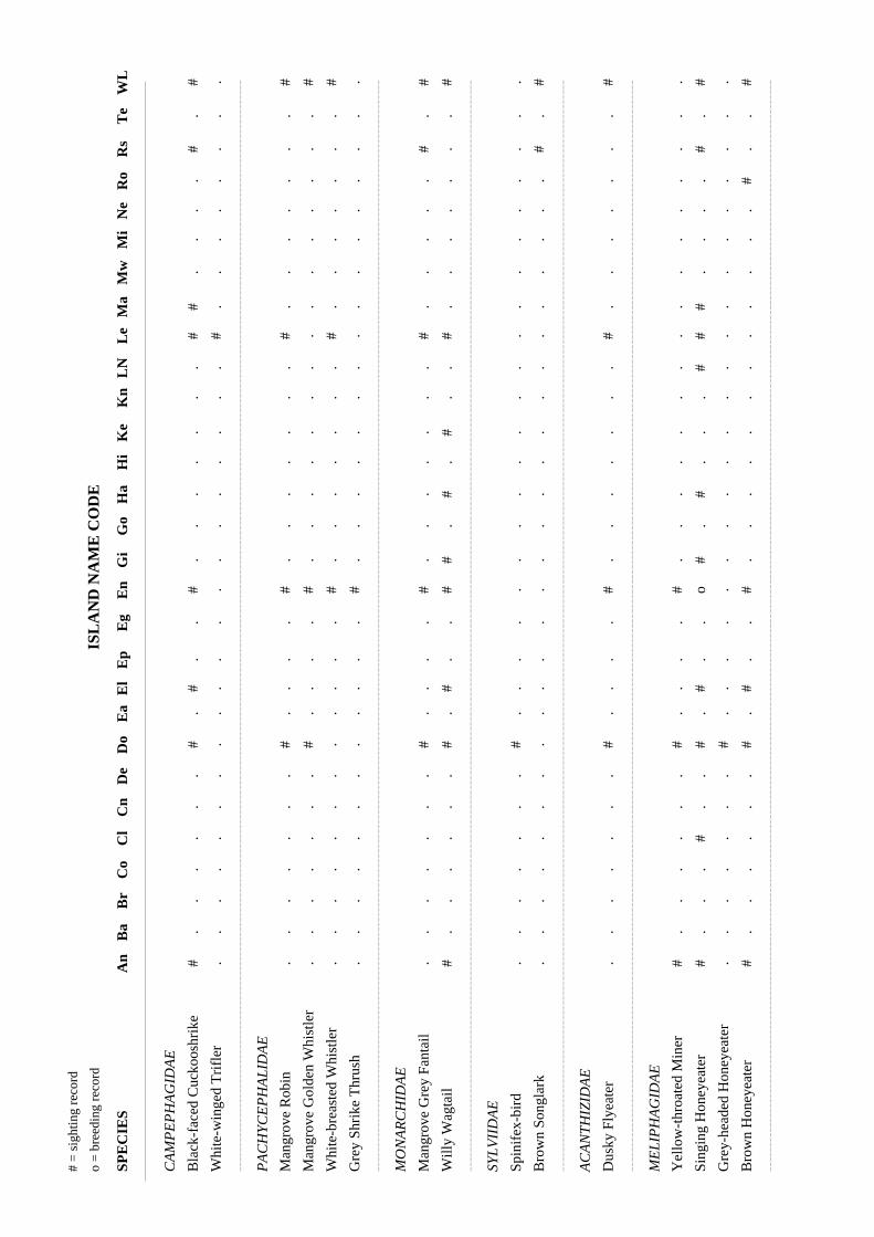
# =
sig
htin
g re
cord
o =
bre
edin
g re
cord
ISL
AN
D N
AM
E C
OD
E
SPE
CIE
SA
nB
aB
rC
oC
lC
nD
eD
oE
aE
lE
pE
gE
nG
iG
oH
aH
iK
eK
nL
NL
eM
aM
wM
iN
eR
oR
sT
eW
L
CA
MP
EP
HA
GID
AE
Bla
ck-f
aced
Cuc
koos
hrik
e#
..
..
..
#.
#.
.#
..
..
..
.#
#.
..
.#
.#
Whi
te-w
inge
d T
rifl
er.
..
..
..
..
..
..
..
..
..
.#
..
..
..
..
----
----
----
----
----
----
----
----
----
----
----
----
----
----
----
----
----
----
----
----
----
----
----
----
----
----
----
----
----
----
----
----
----
----
----
----
----
----
----
----
----
----
----
----
----
----
----
----
----
----
----
----
----
----
----
---
PA
CH
YC
EP
HA
LID
AE
Man
grov
e R
obin
..
..
..
.#
..
..
#.
..
..
..
#.
..
..
..
#
Man
grov
e G
olde
n W
hist
ler
..
..
..
.#
..
..
#.
..
..
..
..
..
..
..
#
Whi
te-b
reas
ted
Whi
stle
r.
..
..
..
..
..
.#
..
..
..
.#
..
..
..
.#
Gre
y Sh
rike
Thr
ush
..
..
..
..
..
..
#.
..
..
..
..
..
..
..
.
----
----
----
----
----
----
----
----
----
----
----
----
----
----
----
----
----
----
----
----
----
----
----
----
----
----
----
----
----
----
----
----
----
----
----
----
----
----
----
----
----
----
----
----
----
----
----
----
----
----
----
----
----
----
----
---
MO
NA
RC
HID
AE
Man
grov
e G
rey
Fant
ail
..
..
..
.#
..
..
#.
..
..
..
#.
..
..
#.
#
Will
y W
agta
il#
..
..
..
#.
#.
.#
#.
#.
#.
.#
..
..
..
.#
----
----
----
----
----
----
----
----
----
----
----
----
----
----
----
----
----
----
----
----
----
----
----
----
----
----
----
----
----
----
----
----
----
----
----
----
----
----
----
----
----
----
----
----
----
----
----
----
----
----
----
----
----
----
----
---
SYL
VII
DA
E
Spin
ifex
-bir
d.
..
..
..
#.
..
..
..
..
..
..
..
..
..
..
Bro
wn
Song
lark
..
..
..
..
..
..
..
..
..
..
..
..
..
#.
#
----
----
----
----
----
----
----
----
----
----
----
----
----
----
----
----
----
----
----
----
----
----
----
----
----
----
----
----
----
----
----
----
----
----
----
----
----
----
----
----
----
----
----
----
----
----
----
----
----
----
----
----
----
----
----
---
AC
AN
TH
IZID
AE
Dus
ky F
lyea
ter
..
..
..
.#
..
..
#.
..
..
..
#.
..
..
..
#
----
----
----
----
----
----
----
----
----
----
----
----
----
----
----
----
----
----
----
----
----
----
----
----
----
----
----
----
----
----
----
----
----
----
----
----
----
----
----
----
----
----
----
----
----
----
----
----
----
----
----
----
----
----
----
---
ME
LIP
HA
GID
AE
Yel
low
-thr
oate
d M
iner
#.
..
..
.#
..
..
#.
..
..
..
..
..
..
..
.
Sing
ing
Hon
eyea
ter
#.
..
#.
.#
.#
..
o#
.#
..
.#
##
..
..
#.
#
Gre
y-he
aded
Hon
eyea
ter
..
..
..
.#
..
..
..
..
..
..
..
..
..
..
.
Bro
wn
Hon
eyea
ter
#.
..
..
.#
.#
..
#.
..
..
..
..
..
.#
..
#
----
----
----
----
----
----
----
----
----
----
----
----
----
----
----
----
----
----
----
----
----
----
----
----
----
----
----
----
----
----
----
----
----
----
----
----
----
----
----
----
----
----
----
----
----
----
----
----
----
----
----
----
----
----
----
---

# =
sig
htin
g re
cord
o =
bre
edin
g re
cord
ISL
AN
D N
AM
E C
OD
E
SPE
CIE
SA
nB
aB
rC
oC
lC
nD
eD
oE
aE
lE
pE
gE
nG
iG
oH
aH
iK
eK
nL
NL
eM
aM
wM
iN
eR
oR
sT
eW
L
PA
RD
AL
OT
IDA
E
Stri
ated
Par
dalo
te.
..
..
..
..
..
.#
..
..
..
..
..
..
..
..
----
----
----
----
----
----
----
----
----
----
----
----
----
----
----
----
----
----
----
----
----
----
----
----
----
----
----
----
----
----
----
----
----
----
----
----
----
----
----
----
----
----
----
----
----
----
----
----
----
----
----
----
----
----
----
---
ZO
STE
RO
PID
AE
Yel
low
Whi
te-e
ye.
..
..
..
#.
..
.#
..
..
..
.#
..
..
.#
.#
----
----
----
----
----
----
----
----
----
----
----
----
----
----
----
----
----
----
----
----
----
----
----
----
----
----
----
----
----
----
----
----
----
----
----
----
----
----
----
----
----
----
----
----
----
----
----
----
----
----
----
----
----
----
----
---
PL
OC
EID
AE
Pain
ted
Finc
h#
..
..
..
#.
..
..
..
..
..
..
..
..
.#
.#
Zeb
ra F
inch
..
..
..
.#
..
..
#.
..
..
..
..
..
..
..
#
----
----
----
----
----
----
----
----
----
----
----
----
----
----
----
----
----
----
----
----
----
----
----
----
----
----
----
----
----
----
----
----
----
----
----
----
----
----
----
----
----
----
----
----
----
----
----
----
----
----
----
----
----
----
----
---
GR
AL
LIN
IDA
AE
Mag
pie-
lark
..
..
..
.#
..
..
..
..
..
..
..
..
..
..
.
----
----
----
----
----
----
----
----
----
----
----
----
----
----
----
----
----
----
----
----
----
----
----
----
----
----
----
----
----
----
----
----
----
----
----
----
----
----
----
----
----
----
----
----
----
----
----
----
----
----
----
----
----
----
----
---
AR
TA
MID
AE
Bla
ck-f
aced
Woo
dsw
allo
w.
..
..
..
#.
..
..
..
..
..
..
..
..
..
..
Mas
ked
Woo
dsw
allo
w.
..
..
..
#.
..
..
..
..
..
..
..
..
..
..
little
Woo
dsw
allo
w.
..
..
..
#.
..
..
#.
..
..
..
..
..
..
..
Whi
te-b
reas
ted
Woo
dsw
allo
w.
..
..
..
#.
..
.#
..
..
..
.#
#.
..
.#
.#
----
----
----
----
----
----
----
----
----
----
----
----
----
----
----
----
----
----
----
----
----
----
----
----
----
----
----
----
----
----
----
----
----
----
----
----
----
----
----
----
----
----
----
----
----
----
----
----
----
----
----
----
----
----
----
---
CR
AC
TIC
IDA
E
Pied
But
cher
bird
#.
#.
#.
.#
.#
#.
##
#.
..
#o
.#
..
..
o.
#
----
----
----
----
----
----
----
----
----
----
----
----
----
----
----
----
----
----
----
----
----
----
----
----
----
----
----
----
----
----
----
----
----
----
----
----
----
----
----
----
----
----
----
----
----
----
----
----
----
----
----
----
----
----
----
---
CO
RV
IDA
E
Aus
tral
ian
Cro
w.
..
.#
..
#.
#.
.o
.#
..
..
.#
..
..
.o
.#

AP
PE
ND
IX V
ID
IST
RIB
UT
ION
OF
AM
PH
IBIA
NS
AN
D R
EP
TIL
ES
IN T
HE
DA
MP
IER
AR
CH
IPE
LA
GO
ISL
AN
D N
AM
E C
OD
E
SPE
CIE
S
An
Co
De
Do
Ea
Ep
En
Gi
Go
Ha
Hi
Ke
Kn
LN
Le
NM
Ma
Mw
Rs
WL
HY
LID
AE
Cyc
lora
na m
aini
xx
Lit
oria
rub
ella
x
CH
EL
ON
IID
AE
Car
etta
car
etta
x
C. m
ydas
xx
xx
xx
xx
xx
xx
xx
Ere
tmoc
hely
s im
bric
ata
xx
xx
xx
xx
x
Nat
ator
dep
ress
usx
xx
xx
GE
KK
ON
IDA
E
Cre
nada
ctyl
us o
cell
atus
hor
nix
Dip
loda
ctyl
us c
onsp
icil
latu
sx
D. e
lder
ix
x
D. s
teno
dact
ylus
x
Geh
yra
pilb
ara
xx
x
G. p
unct
ata
xx
xx
xx
xx
xx
x
G. v
arie
gata
xx
xx
x
Het
eron
otia
bin
oei
xx
xx
xx
xx
xx
xx
Oed
ura
mar
mor
ata
xx

ISL
AN
D N
AM
E C
OD
E
SPE
CIE
S
An
Co
De
Do
Ea
Ep
En
Gi
Go
Ha
Hi
Ke
Kn
LN
Le
NM
Ma
Mw
Rs
WL
PYG
OPO
DID
AE
Del
ma
bore
ax
Lia
lis
burt
onis
x
AG
AM
IDA
E
Cte
noph
orus
c. c
audi
cinc
tus
xx
xx
xx
x
C. i
. Iso
lepi
sx
Gem
mat
opho
ra g
. gil
bert
ix
xx
xx
xx
VA
RA
NID
AE
Var
anus
aca
nthu
rus
xx
x
V. g
ould
iix
xx
xx
V. p
anop
tes
rubi
dus
xx
V. t
. tri
stis
xx
SCIN
CID
AE
Car
lia
tric
anth
ax
Cry
ptob
leph
arus
pla
gioc
epha
lus
xx
x
Cte
notu
s pa
nthe
rinu
s oc
elli
fer
x
C. s
axat
ilis
xx
xx
xx
xx
xx
xx
xx
xx
C. s
erve
ntyi
xx
x
Ege
rnia
pil
bare
nsis
xx
x
Ler
ista
bip
esx
xx
xx
xx
xx
x
L. m
uell
eri
xx
xx
x

ISL
AN
D N
AM
E C
OD
E
SPE
CIE
S
An
Co
De
Do
Ea
Ep
En
Gi
Go
Ha
Hi
Ke
Kn
LN
Le
NM
Ma
Mw
Rs
WL
Men
etia
sur
dax
Mor
ethi
a ru
fica
uda
exqu
isit
ax
xx
xx
xx
Om
olep
ida
bran
chia
lis
x
Sphe
nom
orph
us i.
isol
epis
xx
xx
xx
xx
xx
xx
xx
x
TY
PHL
OPI
DA
E
Rha
mph
otyp
hlop
s di
vers
usx
x
am
mod
ytes
AC
RO
CH
OR
DID
AE
Aip
ysur
us la
evis
wat
ers
of th
e D
ampi
er A
rchi
pela
go
Ast
roti
a st
okes
iiw
ater
s of
the
Dam
pier
Arc
hipe
lago
BO
IDA
E
Asp
idit
es m
elan
ocep
halu
sx
xx
Mor
elia
oli
vace
a ba
rron
ix
x
M. p
erth
ensi
sx
xx
M. s
. sti
mso
nix
EL
API
DA
E
Dem
ansi
a ru
fesc
ens
x
Eph
alop
his
grey
iw
ater
s of
the
Dam
pier
Arc
hipe
lago
Pse
udec
his
aust
rali
sx

ISL
AN
D N
AM
E C
OD
E
SPE
CIE
S
An
Co
De
Do
Ea
Ep
En
Gi
Go
Ha
Hi
Ke
Kn
LN
Le
NM
Ma
Mw
Rs
WL
HO
MA
LO
PSID
AE
For
doni
a le
ucob
alia
wat
ers
of th
e D
ampi
er A
rchi
pela
go
Hyd
rela
ps d
arw
inie
nsi
wat
ers
of th
e D
ampi
er A
rchi
pela
go
HY
DR
OPH
IID
AE
Hyd
roph
is m
ajor
wat
ers
of th
e D
ampi
er A
rchi
pela
go
Related Documents