Water Resources Management 16: 489–503, 2002. © 2003 Kluwer Academic Publishers. Printed in the Netherlands. 489 Dam-Break Flood Emergency Management System ARMANDA S. RODRIGUES 1 , MARIA A. SANTOS 1∗ , A. D. SANTOS 1 and FERNANDA ROCHA 2 1 Laboratório Nacional de Engenharia Civil (National Civil Engineering Laboratory), Hydraulics Department, Av. do Brasil, 101, Lisboa, Portugal; 2 Serviço Nacional de Protecção Civil (National Service for Civil Protection), Av. do Forte em Carnaxide (Edifício da Protecção Civil), Carnaxide, Portugal ( ∗ author for correspondence, e-mail: [email protected], fax: 21 844 3016) (Received: 18 May 2001; in final form: 18 October 2001) Abstract. Natural or induced floods are of increasing concern to water managers and civil protection services for three main reasons. Firstly, a continuous and ‘unconscious’ increase of social pressure in the flooding valleys amplifies flood vulnerabilities and consequently natural or induced flood risk. Secondly, the alarming forecasts of the impact of potential climate changes on water resources, in spite of the high uncertainty associated to these forecasts, points out to larger flood hazards. Thirdly, dam-break induced accidents may occur more frequently due to infrastructure aging. Emergency Planning is a non-structural measure to minimise flood impacts playing an important role in crisis management. In fact, if a disaster cannot be avoided, individual and social structure preparedness may be of great help in risk reduction. An Internet-based system that supports flood emergency management is presented in this article. This application is part of a more complete system, developed with the goal of endowing the Portuguese water authorities, dam owners and the civil protection system, with adequate tools to store and easily retrieve information on dams and their downstream valleys, to model the flood wave induced by a dam break and, eventually, to manage the response to flood-induced catastrophes. Key words: dam-break induced flood, decision support system, emergency planning, risk manage- ment 1. Introduction The increasing focus on dam safety is a problem of major concern to technicians and entities responsible for designing, licensing, constructing and managing such structures. In spite of the growing experience in designing and building dams, as well as in using more appropriate materials, dam safety is increasingly an issue of debate among the international community. At the same time, there is a growing public awareness of the potential risk for people, structures and property in the downstream valley. This concern led to the creation of a Dam Safety Committee within the Inter- national Committee of Large Dams (ICOLD), which defined a set of guidelines to be taken into account, during the design and construction phases of dams. At the national level, most western countries are also issuing similar guidelines.

Welcome message from author
This document is posted to help you gain knowledge. Please leave a comment to let me know what you think about it! Share it to your friends and learn new things together.
Transcript
Water Resources Management 16: 489–503, 2002.© 2003 Kluwer Academic Publishers. Printed in the Netherlands.
489
Dam-Break Flood Emergency Management System
ARMANDA S. RODRIGUES1, MARIA A. SANTOS1∗, A. D. SANTOS1 andFERNANDA ROCHA2
1 Laboratório Nacional de Engenharia Civil (National Civil Engineering Laboratory), HydraulicsDepartment, Av. do Brasil, 101, Lisboa, Portugal; 2 Serviço Nacional de Protecção Civil (NationalService for Civil Protection), Av. do Forte em Carnaxide (Edifício da Protecção Civil), Carnaxide,Portugal(∗ author for correspondence, e-mail: [email protected], fax: 21 844 3016)
(Received: 18 May 2001; in final form: 18 October 2001)
Abstract. Natural or induced floods are of increasing concern to water managers and civil protectionservices for three main reasons. Firstly, a continuous and ‘unconscious’ increase of social pressurein the flooding valleys amplifies flood vulnerabilities and consequently natural or induced flood risk.Secondly, the alarming forecasts of the impact of potential climate changes on water resources, inspite of the high uncertainty associated to these forecasts, points out to larger flood hazards. Thirdly,dam-break induced accidents may occur more frequently due to infrastructure aging. EmergencyPlanning is a non-structural measure to minimise flood impacts playing an important role in crisismanagement. In fact, if a disaster cannot be avoided, individual and social structure preparednessmay be of great help in risk reduction. An Internet-based system that supports flood emergencymanagement is presented in this article. This application is part of a more complete system, developedwith the goal of endowing the Portuguese water authorities, dam owners and the civil protectionsystem, with adequate tools to store and easily retrieve information on dams and their downstreamvalleys, to model the flood wave induced by a dam break and, eventually, to manage the response toflood-induced catastrophes.
Key words: dam-break induced flood, decision support system, emergency planning, risk manage-ment
1. Introduction
The increasing focus on dam safety is a problem of major concern to techniciansand entities responsible for designing, licensing, constructing and managing suchstructures. In spite of the growing experience in designing and building dams, aswell as in using more appropriate materials, dam safety is increasingly an issue ofdebate among the international community. At the same time, there is a growingpublic awareness of the potential risk for people, structures and property in thedownstream valley.
This concern led to the creation of a Dam Safety Committee within the Inter-national Committee of Large Dams (ICOLD), which defined a set of guidelines tobe taken into account, during the design and construction phases of dams. At thenational level, most western countries are also issuing similar guidelines.
490 A. S. RODRIGUES ET AL.
Although considered of low risk, incidents with dams may cause significantdamage both directly and indirectly. Direct losses are usually easier to assess (as-suming human lives are quantifiable), but indirect losses are difficult to measureand may take some time before the original situation is restored. Moreover, it isimpossible to define a pattern for these damages. In some occurrences, such as theBaldwin Hills and Teton cases in the U.S.A., very high costs are associated witha small number of casualties. Other examples, such as the cases of the South ForkDam, in the U.S.A., and the Verjont dam in Italy led to tragedies of more than2000 deaths (Ramos, 1995). Many other examples of dam accidents throughoutthe world can be found in the literature.
‘An ounce of prevention is worth a pound of cure’, the old saying tells us.Disaster prevention and vulnerability reduction are topics of major concern in
many local, national or international organisations for some years. The United Na-tions declared 1990–1999 as the International Decade for Natural Disaster Reduc-tion. In 1999, to give continuity to the work carried out, an International Strategyfor Disaster Reduction was adopted ‘to enable all societies to become resilient tothe effects of natural hazards and related technological and environmental dis-asters, in order to reduce human, economic and social losses’. In the follow-ing years, the World Disaster Reduction Campaigns have tried to increase publicawareness on the social and economical impacts of such disasters. Of special in-terest is the 2001 Campaign ‘Countering Disasters, Targeting Vulnerability’, whichcovers the following themes: i) the role of science and technology in disasterreduction; ii) building disaster resistant infrastructures; and iii) mobilising localcommunities in reducing disasters.
From the scientific side, many studies and products on this issue can be found inthe literature. Some examples are: Krzysztofowicz et al. (1994), Penning-Rowselland Fordham (1994), Neal and Phillips (1995), Bureau of Reclamation (1995,1995a), Hindley (1996), Kuperman et al. (1996), Almeida and Viseu (1997), Ford(1999), ETEAM (2001) and CNIG (1998).
Therefore, an emergency management system with capacity to: i) forecast crit-ical situations; ii) warn the population as well as the authorities; and iii) supportthe civil protection system to deal with an emergency, is a most helpful tool tominimize the impact of an accident.
DamAid, the emergency management system described herein, fulfils mainlythe third objective, i.e. it is intended to help the Civil Protection System in Por-tugal, physically distributed, to manage an emergency caused by the failure of theFuncho-Arade dam system in Algarve (Southern Portugal). With minor changes,the system can be applied to manage other natural or man-induced flood cata-strophes. It is an Internet-based application, with two components, which allowsi) the implementation of an emergency plan; and ii) the access to a GeographicInformation System (GIS) characterising the dam downstream valley. The firstcomponent is based on the national, regional and local flood emergency plans.It uses Java Server Pages to generate a complete description of the several phases
DAM-BREAK FLOOD EMERGENCY MANAGEMENT SYSTEM 491
and measures taken throughout one specific crisis. The second component usescurrent online mapping technology to generate a web-based applet that enables theuser to view, manipulate and updata the geographic information available for theemergency area. These two components are integrated to endow decision makerswith the capacity for taking adequate measures in real time. DamAid is part of alarger decision-support system created in the framework of a project that aimed todevelop a set of methodologies for dam-break flood risk management. The projectwas partially funded by NATO, under its Science for Stability Program, and suppor-ted by the Water Instutute (INAG), the Electricity Utility (EDP) and the NationalService for Civil Protection (SNPC). EDP is the major dam owner in Portugaland the role of INAG is twofold: dam owner and water authority responsible forlicensing the construction and exploitation of all dams. SNPC is responsible forco-ordinating, at national level, all civil protection activities.
2. Emergency Planning
2.1. EMERGENCY MANAGEMENT
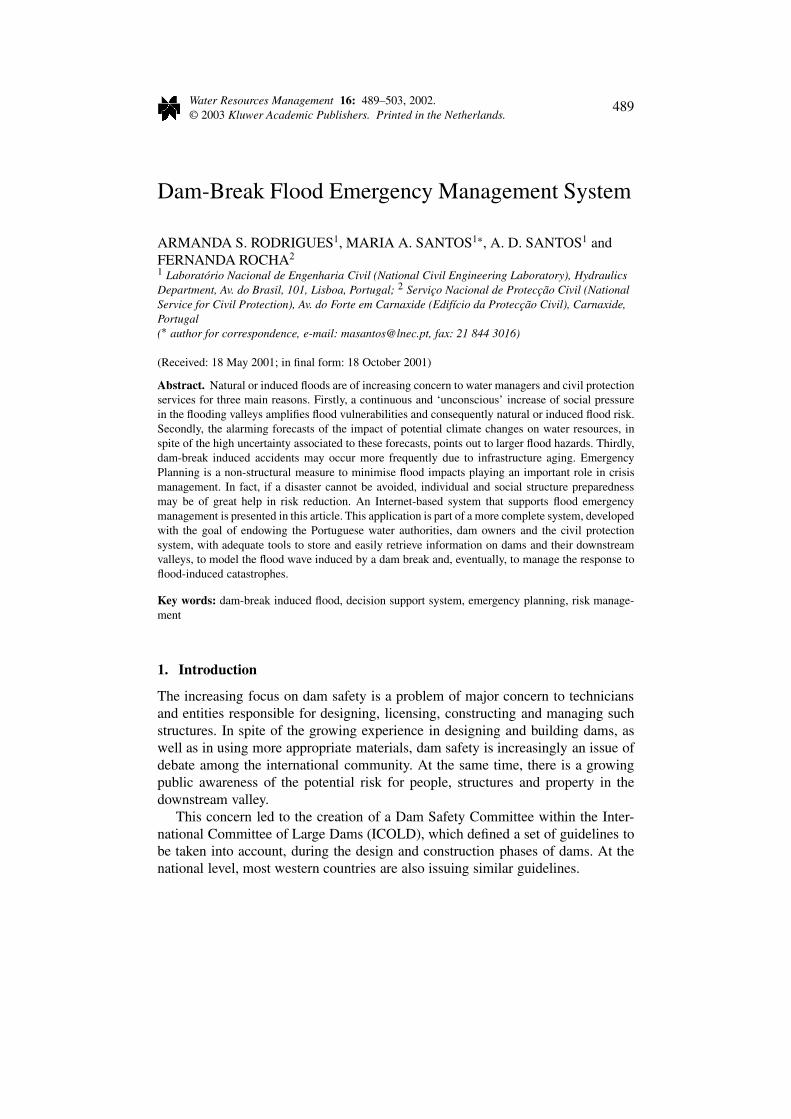
Emergency management aims to protect life, minimising damage to property or theenvironment and alleviating suffering. This requires permanent planning, updatingand training, and includes three� cyclical phases (Figure 1).
Risk Mitigation is the first phase of this cycle and can be regarded as the se-lective application of appropriate techniques and management principles to reduceeither the likelihood of an adverse occurrence or its consequences, or both (ICOLD,1999). Risk Mitigation can only be achieved through the joint effort of different so-ciety sectors. In what concerns emergency management, risk mitigation integratesPrevention and Preparedness of organizations (society) and individuals.
Prevention includes a set of structural or non-structural measures that reducesthe hazard�� and/or the risk‡ (e.g. restrictions or requirements put into place throughvarious means including legislation, mitigation programs, codes, standards...).
Preparedness includes all activities aiming to ensure an effective and efficientresponse, namely preparing organizations and individuals to respond to the hazard.Being prepared to face a catastrophe is an important step to minimize its potentialdamage and emergency planning plays a very important role.
Response implies the activation and the implementation of energency plans andprocedures, as well as the coordination of response efforts, namely, the issue ofalerts and warnings; the provision of adequate emergency public information; andthe relief and post-disaster assistance, including taking care of the wounded and
� Some authors consider that the emergency management cycle has four phases: Mitigation,Preparedness, Response and Recovery.
�� Natural hazard – the probability of occurrence, within a specific period of time in a given area,of a potentially damaging natural phenomenon (UNDRO, 1991).
‡ Risk – total expected losses in lives and property for a given area due to a given type andmagnitude of natural hazards (UNDRO, 1991).
492 A. S. RODRIGUES ET AL.
Figure 1. Emergency management phases (Adapted from UNDRO, 1991).
casualties and providing evacuation and emergency shelter, medical care, food andclothing.
Finally, Recovery from the disaster implies a set of activities to bring systemsand facilities back to normal, including conducting damage assessments and assur-ing the continuity and quality of basic services until the restoration is complete.
2.2. EMERGENCY PLANS
Emergency plans are flexible, dynamic and adequate tools containing a set ofmeasures, rules, guidelines, procedures and missions designed to face and man-age emergency situations and minimize their impacts. They should cover the lastthree phases referred to above: Preparedness, Response and Recovery. Emergencyplans are important tools that help dam owners, civil protection agents and au-thorities prepare to manage a crisis, with roles, responsibilities, priorities and theirarticulation completely established.
Dam safety emergency plans in Portugal are divided in two parts. The InternalEmergency Plan (IEP), which concerns the dam reservoir and dam safety features,must contain a set of guidelines providing for a range of monitoring and surveil-lance procedures and response actions that the dam personnel should take, if anabnormal situation occurs. The dam owner is responsible for its preparation, testingand updating. The External Emergency Plan (EEP), which is a responsibility of thecivil protection system, concerns the emergency management of the dam down-stream valley. In the case of the Arade dam valley, the Municipalities of Silves,Portimão and Lagoa are charged with the task of updating the information contentsof this EEP, both tabular and geo-referenced data.
These two emergency plans need to be closely articulated. Below, a detaileddescription of EEP is presented.
DAM-BREAK FLOOD EMERGENCY MANAGEMENT SYSTEM 493
These plans must allow the Civil Protection System:
• To monitor hydrometeorological data and follow meteorological and floodforecasts;
• to be informed on the dam discharges and reservoir storages;• to identify civil protection agents and their responsibilities and missions;• to identify other relevant agencies in emergency management as well as their
responsibilities and missions;• to establish the decision-making hierarchy;• to identify available means to alert authorities and issue public warnings;• to inventory and allocate means and resources to emergency situations;• to guarantee the safety of people and property;• to develop and coordinate operations.
Depending on the extension of the flood-prone area, the external emergency planis set in motion and coordinated at the local (Municipal Civil Protection Service –SMPO), regional (SNPC District� Delegation – DDPC) or national levels (NationalService for Civil Protection – SNPC).
For the sake of action, three emergency phases are considered:
• Before emergency, when the plan is prepared, updated and tested;• During emergency, when an abnormal situation occurs; this phase is divided in
three levels associated with different colours: yellow, orange and red, depend-ing on the catastrophe magnitude;
• Post-emergency, when the recovery actions are taken.
During emergency, measures and procedures must take into account that the valleyis not equally affected considering different risk zones that call for different typesof action.
In the case study described below, the risk zone criterion is based on: i) theelapsed time (t) between the dam failure and the arrival of the dam-break floodwave to a given downstream section; ii) the wave dynamics: velocity (u) and height(h); and, iii) the time variable necessary for rescue operations throughout the valley.
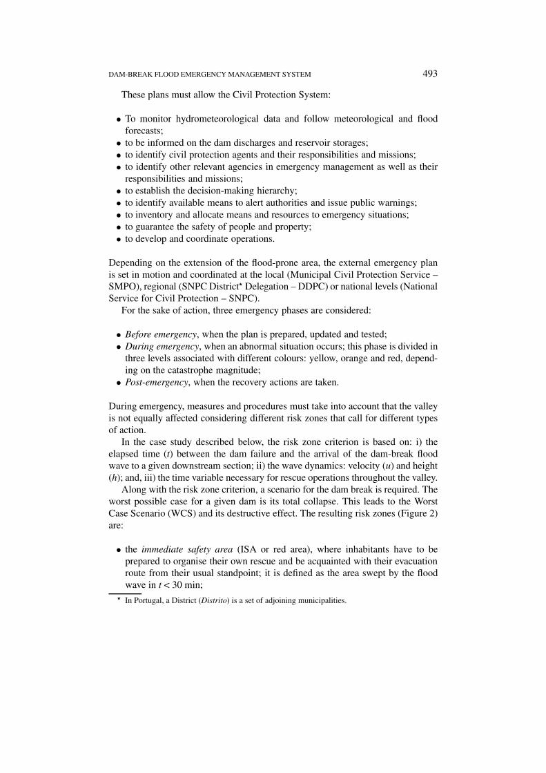
Along with the risk zone criterion, a scenario for the dam break is required. Theworst possible case for a given dam is its total collapse. This leads to the WorstCase Scenario (WCS) and its destructive effect. The resulting risk zones (Figure 2)are:
• the immediate safety area (ISA or red area), where inhabitants have to beprepared to organise their own rescue and be acquainted with their evacuationroute from their usual standpoint; it is defined as the area swept by the floodwave in t < 30 min;
� In Portugal, a District (Distrito) is a set of adjoining municipalities.
494 A. S. RODRIGUES ET AL.
Figure 2. Outline of the Arade valley risk zones under the Worst Case Scenario.
• the intermediate area (orange area), where civil protection material and humanresources have an important role in the rescue operations of the most vulner-able community groups (e.g. elderly people, disabled, children); it is definedeither by 30 < t < 120 min or by u·h > 0.5 m2 s−1 in the river banks (floodedareas outside the river channel);
• the low risk area (green area), considered to be sufficient for the whole popula-tion to be aware of the forthcoming danger and to take the necessary measuresassociated with the emergency; it is defined by t > 120 min or u·h < 0.5 m2 s−1
in the river banks.
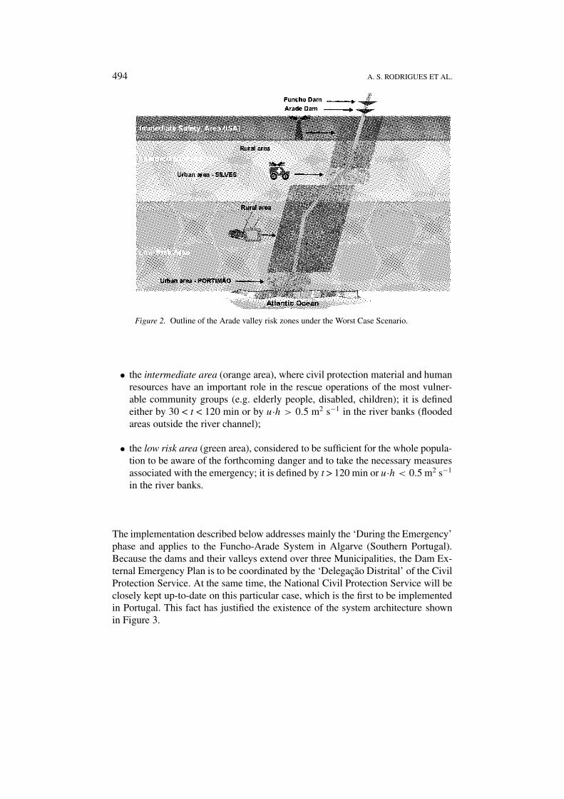
The implementation described below addresses mainly the ‘During the Emergency’phase and applies to the Funcho-Arade System in Algarve (Southern Portugal).Because the dams and their valleys extend over three Municipalities, the Dam Ex-ternal Emergency Plan is to be coordinated by the ‘Delegação Distrital’ of the CivilProtection Service. At the same time, the National Civil Protection Service will beclosely kept up-to-date on this particular case, which is the first to be implementedin Portugal. This fact has justified the existence of the system architecture shownin Figure 3.
DAM-BREAK FLOOD EMERGENCY MANAGEMENT SYSTEM 495
Figure 3. DamAid Architecture.
3. DamAid System
3.1. ARCHITECTURE
As said above, the DamAid system, described in this article, implements a damEEP case study. It was conceived to enable several hierarchical levels of the civilprotection system, which are geographically apart, to manage and/or accompanythe same dam rupture emergency.
Existing hierarchical levels include National, District and Local Civil ProtectionAgents that gather in crisis centres and provide directions to operational teams inthe field as the consequences of emergencies develop. The given directions arebased on the definitions of the plans, specified for the level at which the emer-gency will be managed. Therefore, DamAid was developed as a decision-makingaid (as well as an information system) to help crisis centres during emergencymanagement.
Conceptually, the system was divided into two components, the EmergencyManager component (EM) and the Geographic Information component (GI). TheEM maintains civil protection officers informed of the current state of the EEPwhile the GI enables access to the currently relevant geographic data. This concep-tual design has been achieved through the physical separation of these components,resulting from an Internet-based client/server implementation.
DamAid enables distributed emergency management. This implies a client/serverarchitecture with one server associated to each component and specific clients
496 A. S. RODRIGUES ET AL.
defined by different types of civil protection access (Figure 3). The EM serverholds the information about the current emergency, as well as the log of the actionstaken in its context. The GI server contains the geo-referenced data. Depending onthe roles played by the different civil protection levels, there may be several typesof clients communicating with these servers.
The existence of two levels of decision, in this case study�, has led to thefollowing specifications of the client side of the emergency manager component(Figure 3):
• SNPCClient: The National level client, which allows the National Civil Pro-tection Service (National level) to be kept up-to-date on the situation and in-tervene, if necessary;
• DDPCClient: The District level client, which provides the Civil ProtectionDistrict Delegation (Regional level) with the tools to set the Plan into actionand coordinate its implementation;
• BriefingLog: The periodic briefings client, which may be associated with anyclient level.
The EM Server, the central server, is capable of managing the information arrivingfrom the first two client sources, suggesting the currently relevant measures to takeand requesting final decision from the responsible civil protection officer.
Associated with these clients is the briefings client that enables to log the de-cisions and measures taken at the several dicision levels. The EM Server does nothave its own user interface. It communicates with users through the several clients(Figure 3).
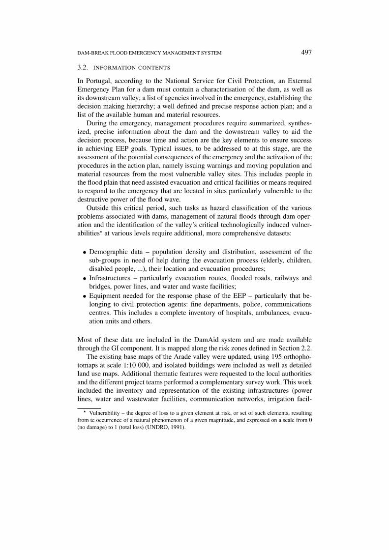
The briefings log interface (see Figure 4) enables the connection with severalinformation sources used by civil protection agents to evaluate the emergencysituation. It is also possible to use this part of the system to access these sources(weather, water resources, seismic and press information), to immediately decideon the measures to take and consequently, to store the decisions made in the brief-ings log.
Along with the EM component, the GI component is an information supporttool. Its main objective is to store, process and disseminate geographical datawithin the EEP framework. The information contained in the system includes notonly base data from the area at risk, but other types of data required to the eval-uation of the specific areas at risk (e.g. important services and infrastructures).Section 3.2 describes in more detail the system information contents.
� In future applications, the number of client applications needed will depend on the existing civilprotection decision-making hierarchy of each particular case.
DAM-BREAK FLOOD EMERGENCY MANAGEMENT SYSTEM 497
3.2. INFORMATION CONTENTS
In Portugal, according to the National Service for Civil Protection, an ExternalEmergency Plan for a dam must contain a characterisation of the dam, as well asits downstream valley; a list of agencies involved in the emergency, establishing thedecision making hierarchy; a well defined and precise response action plan; and alist of the available human and material resources.
During the emergency, management procedures require summarized, synthes-ized, precise information about the dam and the downstream valley to aid thedecision process, because time and action are the key elements to ensure successin achieving EEP goals. Typical issues, to be addressed to at this stage, are theassessment of the potential consequences of the emergency and the activation of theprocedures in the action plan, namely issuing warnings and moving population andmaterial resources from the most vulnerable valley sites. This includes people inthe flood plain that need assisted evacuation and critical facilities or means requiredto respond to the emergency that are located in sites particularly vulnerable to thedestructive power of the flood wave.
Outside this critical period, such tasks as hazard classification of the variousproblems associated with dams, management of natural floods through dam oper-ation and the identification of the valley’s critical technologically induced vulner-abilities� at various levels require additional, more comprehensive datasets:
• Demographic data – population density and distribution, assessment of thesub-groups in need of help during the evacuation process (elderly, children,disabled people, ...), their location and evacuation procedures;
• Infrastructures – particularly evacuation routes, flooded roads, railways andbridges, power lines, and water and waste facilities;
• Equipment needed for the response phase of the EEP – particularly that be-longing to civil protection agents: fine departments, police, communicationscentres. This includes a complete inventory of hospitals, ambulances, evacu-ation units and others.
Most of these data are included in the DamAid system and are made availablethrough the GI component. It is mapped along the risk zones defined in Section 2.2.
The existing base maps of the Arade valley were updated, using 195 orthopho-tomaps at scale 1:10 000, and isolated buildings were included as well as detailedland use maps. Additional thematic features were requested to the local authoritiesand the different project teams performed a complementary survey work. This workincluded the inventory and representation of the existing infrastructures (powerlines, water and wastewater facilities, communication networks, irrigation facil-
� Vulnerability – the degree of loss to a given element at risk, or set of such elements, resultingfrom te occurrence of a natural phenomenon of a given magnitude, and expressed on a scale from 0(no damage) to 1 (total loss) (UNDRO, 1991).
498 A. S. RODRIGUES ET AL.
ities, and harbour facilities). Such community facilities as hospitals, pharmacies,kindergartens, authorities buildings, police buidings, were also made part of thesystem.
Land use data were provided by the three municipalities downstream the dams– Silves, Portimão and Lagoa – on a 1:25 000 scale.
Social data were obtained through the smallest statistical territorial dataset avail-able in Portugal, namely the statistical subsection/city block spatial unit developedat a 1:25 000 scale. These data are officially updated every 10 yr and includepopulation distribution by age, number of buildings, number of families and soon.
On the other hand, for each risk zone, but the Immediate Safety Zone, a de-tailed thematic map was created using Arcview 3.x. The map views were thendevided by themes according to the EEP: urban areas, population, infrastructuresand facilities, protected areas and national monuments. A final view overlaying theabove themes within the potentially flooded areas in the Worst Case Scenario wascreated. These views transform the available data into information readily usable‘during the emergency’ phase.
For the Intermediate Safety Zone, the system supports the management of theemergency situation in real time, through the visualization of the different vulner-abilities, enabling locating and selecting the reported affected areas. It also allowsranking priorities, and dispatching rescue teams through the operational road net-work, using the adequate vehicle and equipment to perform their tasks efficiently.Also available are an estimate of the wave propagation for different time periodsand the delimitation of the evacuated areas.
For the low risk area, information on the location of the available material re-sources, necessary during the emergency phase, is included, showing the routesbetween these locations and emergency sites.
Regarding the Immediate Safety Area, although the system is of little value‘during the emergency’ phase, it can be used as a repository of all buildings, alongwith their inhabitants’ names and contacts, and other infrastructures in the area.These data are available both in map and text versions.
3.3. DAMAID IMPLEMENTATION
The implementation of the EM component follows the Emergency plan rules andsequence, in order to serve as a step-by-step reminder of the plan actions at eachphase. The implementation of the GI component improves the evaluation capacityof the civil protection system, at the management level, by providing informationon disruptions taking place at each phase and on the needs of populations at risk.Logging actions and briefings facilitates the evaluation of the situation both duringand after the emergency.
The emergency manager component was develop using Internet technology(Figure 4), specifically Java Beans and Java Server Pages-JSP (SUN MICROSYS-
DAM-BREAK FLOOD EMERGENCY MANAGEMENT SYSTEM 499
Figure 4. DamAid: The Emergency Manager Interface.
TEMS, 2000) with the aim to provide a portable solution in terms of ApplicationServer and Client Browser as well as integration with the GI component, which isbased on ESRI ArcIMS tools (ESRI, 2000).
The use of Java Beans, in the server part of the EM component, has enabledmodelling the relevant entities in the system, which includes the emergency man-agement in terms of Colours (corresponding to the emergency levels describedin Section 2.2) and emergency briefings. Java Beans classes implement the Ap-plication Program Interface (API) for these entities, which compose the relevantinformation in an Emergency. JSP complements this server view as the basis forthe development of different portable client interfaces, each one as a presentationlayer applicable to every decision level in the system.
Specifically, each emergency is handled as an information object composed ofseveral other types of objects (phases, logs, events) stored in the server and updatedfrom each type of client. However, because there may be differences in managingthe emergency at different levels, the information concerning each one is handledseparately, as well as their current colour phases. Once an emergency (or a sub-
500 A. S. RODRIGUES ET AL.
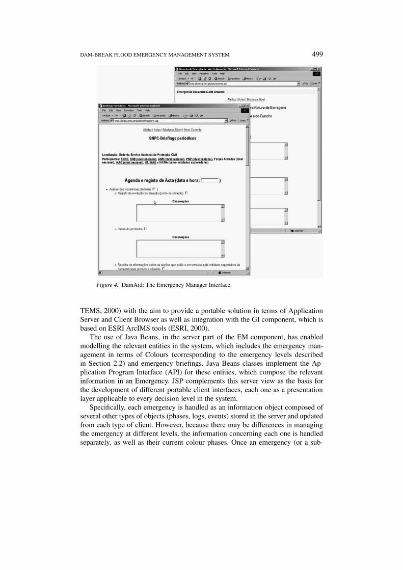
Figure 5. DamAid: Interface for the GI Component.
phase of it) is over, its sequence of actions is mapped into an HTML document,which becomes available for access and evaluation.
The GI component (Figure 5) has two main operational modes: one to operateduring the emergency, another one to operate during the prevention, preparednessand recovery phases (see Section 2.1).
Its implementation was based on ArcIMS 3.0, the ESRI-based product for dis-seminating high-end GIS and mapping services via Internet. This solution waschosen because the initial stages of the project where developed using ESRI Arcinfoand Arcview products. The use of existing data in ArcIMS was supported throughthe creation of ArcIMS projects files (AXL format).
The development of the GI component involved the following steps:
• Definition and preparation of datasets to be used – this involved choosingthe relevant datasets for the different modes of the component. It also in-
DAM-BREAK FLOOD EMERGENCY MANAGEMENT SYSTEM 501
volved the structuring of the views to be provided in themes like population,infrastructures, equipment and critical vulnerabilities;
• definition of GI services – each of the relevant themes of the GI server was or-ganized and delivered by the server as a single service, which could be viewedin association with other themes;
• Website development and customization – this step involved the generationand customization of the code that is currently part of the different GI clients,which are associated, at different levels, with the administrative EM clients.
4. Final Considerations
The system described above can play a very important role in EEP development,upgrade, testing and implementation. It enables easy updating of the system and theplan itself and it facilitates training on and simulation of dam break emergencieswith the participation of the various civil protection agents.
Although the potential of DamAid may be extended as a field-based tool, us-ing current mobile technology to update the existing emergency information, thedevelopment of the system followed the needs of crisis at Civil Protection Agents(CPAs). This means that the design of the system contemplated the applicationof emergency plans at several jurisdictional levels, as it is currently done. Theresulting tool provides CPAs with the necessary information to make decisionsbased on the plans; it does not autonomously manage the emergency.
The system is a prototype and its main objective was to improve emergencymanagement at crisis centres of the civil protection system, without disruptingtheir current work methodology. Therefore, there was not a concern with devel-oping security measures for the system, as this will be addressed in operationaldevelopment.
The EM component represents a digital version of the EEP plan. This means thatthe plan becomes of easy access and its execution involves a step-by-step reminderof the defined rules and actions. Its distributed implementation is of low cost, highportability and easy maintenance. The generation of logging material, particularlyof briefings has facilitated the process of archiving evaluation materials during theemergency.
As to the GI component, the main advantage of using ArcIMS results fromthe possibility implementation of a simple, scalable GIS over an Intranet, keepingcosts low. Its main disadvantage is the lack of GIS analyses tools, and the need forprogramming to add further functionalities, keeping Arcview and its extensionsnecessary to develop emergency plans. Being a JAVA-based product, it requireslarge amounts of RAM memory. However, the use of pure HTML solutions isalso available. The browser interface and its simplicity of use help unskilled man-agers to engage in a new approach to emergency management and emergency plandevelopment.
502 A. S. RODRIGUES ET AL.
The fact that the system was built as a prototype that would computationallyfacilitate the civil protection system process of managing emergencies, has lim-ited the potential of the system in several ways, which the authors believed mightbe reduced in a future operational system. Firstly, it was not possible to directlyconnect the system with information sources and thus receive updates in real-time.The CPAs hierarchical levels operate based on the emergency current controllingCPA preferring to independently access and evaluate the value of data sources anddecide to use them on a case-by-case basis. Had they chosen otherwise, existingtechnology would facilitate that approach.
Secondly, information logged during the emergency (associated with the EMcomponent), could not be integrated as a data source in the GI component andis independently managed by CPAs. This is the civil protection system’s currentwork methodology and an attempt to integrate these data would cause a high rateof disruption in a system that cannot fail.
However, the association of both tools in one system has enabled the accessand evaluation of geographic information in the plan. The next step for the im-provement of this system is obviously the integration of real-time emergency datainto the GI information, in conformity with the CPAs needs. This will enable thecreation of powerful analytic processes, which is not currently possible.
Acknowledgements
Acknowledgement is due to NATO, INAG and EDP for their financial support. Ac-knowledgement is also due to the NATO PO-FLOODRISK project team, namelyits director and manager, respectively Prof. A. Betâmio de Almeida and Dr. C.Matias Ramos, who made the project possible, and M. Gamboa e Teresa Viseu,Delta Silva, P. Farrajota and J. P. Fernandes for their contributions to the decisionsupport system of which DamAid is a part.
References
Almeida, A. B. and Viseu, T. (eds): 1997, Dams and Safety Management at Downstream Valleys, A.A. Balkema, Rotterdam, 247 p.
Bureau of Reclamation: 1995, Emergency Planning and Exercise Guidlines: Guidance Documents,Vol. I, U.S. Department of the Interior, U.S.A.
Bureau of Reclamation: 1995a, Emergency Planning and Exercise Guidelines: Technical Handbook,Vol. II, U.S. Department of the Interior, U.S.A.
CNIG: 1998, RISE: Rede de Informação de Sistemas de Emergências (Emergency System Informa-tion Network), <http://crise.cnig.pt/crise/portfolio.htm>.
ESRI: 2000, ArcIMS Online, <http://arcimsonline.esri.com/>.ETEAM: 2001, Eteam: Internet-based Emergency and Event Management Software,
<www.eteam.com>.Ford, D. T.: 1999, ‘WatchDog: An Automated Flood-Warning, Decision Support System’, non-
published paper, David Ford Consulting Engineers, Sacramento, California, 9 p.
DAM-BREAK FLOOD EMERGENCY MANAGEMENT SYSTEM 503
Hindley, M.: 1996, Dam Safety: Early Warning, International Water Power and Dam Construction,March, 17.
ICOLD: 1999, Bulletin on Risk Assessment: Risk Assessment as an Aid to Dam Safety Management,Draft, International Commission of Large Dams, Draft 24.08.99, 102 p.
Krzysztofowicz, R., Kelly, K. S. and Long, D.: 1994, ‘Reliability of Flood Warning Systems’, J.Water Res. Plan. Manage. 120(6), November/December, 906–926.
Kuperman, S. C., Re, G., Canholi, A. P., Nakandakari, M. K. and Luiz, M. W.: 1996, Dam Safety: ANew Approach, International Water Power and Dam Construction, March, 18–20.
Neal, D. M. and Phillips, B. D.: 1995, ‘Effective Emergency Management: Reconsidering theBureaucratic Approach’, Disasters 19(4), 327–337.
Penning-Rowell, E. and Fordham, M. (eds): 1994, Floods Across Europe: Flood Hazard Assessment,Modelling and Management, University Press, London, 214 p.
Ramos, C. M.: 1995, Segurança de Barragens: Aspectos Hidráulicos e Operacionais (Dam Safety:Hydraulic and Operational Issues), Informação Técnica de Hidráulica, ITH38, LNEC, Lisbon,47 p. (in Portuguese).
Santos, M. A. and Silva, D. (eds): 1998, Risco e Gestão de Crises em Vales a Jusante de Barragens(Risk and Emergency Management at Downstream Valleys of Dams), Proceedings of a workshopon Risk and Emergency Management at Downstream Valleys of Dams, held in Lisbon, November6, 1997, NATO and LNEC, Lisbon, 151 p. (in Portuguese).
SUN MICROSYSTEMS: 2000, Java Server PagesTM: Dynamically Generated Web Content,<http://java.sun/com/jsp>.
UNDRO: 1991, Mitigating Natural Disasters: Phenomena, Effects and Options. A Manual for PolicyMakers and Planners, Office of the United Nations Disaster Relief Co-ordinator, New York.
Related Documents


