D3.6 D3.6 HEIMDALL Demonstrations – Issue 3 Instrument Collaborative Project Call / Topic H2020-SEC-2016-2017/H2020-SEC-2016-2017-1 Project Title Multi-Hazard Cooperative Management Tool for Data Exchange, Response Planning and Scenario Building Project Number 740689 Project Acronym HEIMDALL Project Start Date 01/05/2017 Project Duration 42 months Contributing WP WP 3 Dissemination Level PU Contractual Delivery Date M34 Actual Delivery Date 12/03/2020 Editor David Martín (PCF) Contributors Solange Martínez, Lena Schlegel (EKUT), Benjamin Barth, Monika Friedemann, Christian Knopp, Sandro Martinis, Alberto Viseras Ruiz, (DLR), Alexandros Bartzas, Spyros Pantazis, (SPH), Jordi Vendrell, Celia Conde (PCF), Miguel Mendes (TSYL), Diana Mathew, Angel Grablev, Joseph Muna (AVA), Stéphanie Battiston, Julien Briant (UNISTRA),

Welcome message from author
This document is posted to help you gain knowledge. Please leave a comment to let me know what you think about it! Share it to your friends and learn new things together.
Transcript
D3.6
D3.6
HEIMDALL Demonstrations – Issue 3
Instrument Collaborative Project
Call / Topic H2020-SEC-2016-2017/H2020-SEC-2016-2017-1
Project Title Multi-Hazard Cooperative Management Tool for Data Exchange, Response Planning and Scenario Building
Project Number 740689
Project Acronym HEIMDALL
Project Start Date 01/05/2017
Project Duration 42 months
Contributing WP WP 3
Dissemination Level PU
Contractual Delivery Date M34
Actual Delivery Date 12/03/2020
Editor David Martín (PCF)
Contributors Solange Martínez, Lena Schlegel (EKUT), Benjamin Barth, Monika Friedemann, Christian Knopp, Sandro Martinis, Alberto Viseras Ruiz, (DLR), Alexandros Bartzas, Spyros Pantazis, (SPH), Jordi Vendrell, Celia Conde (PCF), Miguel Mendes (TSYL), Diana Mathew, Angel Grablev, Joseph Muna (AVA), Stéphanie Battiston, Julien Briant (UNISTRA),

HEIMDALL [740689] D3.6
Guido Luzi (CTTC), José Becerra (ICGC), Flavio Pignone (CIMA), Daniel Milla, Edgar Nebot, Jordi Pagès, Laia Estivill, Claudi Gallardo (INT), Sefik Muhic, Jesper Bachmann, Kim Lintrup (FBBR), Bruce Farquharson (SFRS), Silvia Venier, Nedim Jasic (CRI)
HEIMDALL [740689] D3.6
12/03/2020 i
Document History
Version Date Modifications Source
0.1 30/10/2019 First draft PCF
0.2 14/12/2019 First Issue PCF
0.3 12/03/2020 QA version INT
1.0.F 12/03/2020 Final Version DLR
HEIMDALL [740689] D3.6
12/03/2020 ii
Table of Contents List of Figures ........................................................................................................................ iv
List of Tables .......................................................................................................................... v
List of Acronyms .................................................................................................................... vi
Executive Summary .............................................................................................................. 9
1 Introduction ...................................................................................................................10
2 Glossary ........................................................................................................................11
3 Target audience of the demonstrations .........................................................................13
3.1 Overview of the target audience .............................................................................13
3.2 Goals and benefits .................................................................................................13
Benefits for the technical partners ...................................................................13 3.2.1
Benefits for the end-users ...............................................................................13 3.2.2
4 Methodology for Exercises (Releases B and C).............................................................14
5 Preparation phase of exercise LAND-1 and LAND-2 (Release B) .................................15
5.1 Preparedness phase ..............................................................................................15
Exercise Setup ................................................................................................15 5.1.1
Story ...............................................................................................................17 5.1.2
New system functionalities ..............................................................................23 5.1.3
5.2 Response phase ....................................................................................................25
Exercise Setup ................................................................................................25 5.2.1
Story ...............................................................................................................26 5.2.2
New system functionalities ..............................................................................36 5.2.3
5.3 Execution phase .....................................................................................................37
Dry Runs 1 & 2 ................................................................................................37 5.3.1
Exercise Runs .................................................................................................37 5.3.2
Schedule .........................................................................................................38 5.3.3
5.4 Evaluation phase ....................................................................................................39
Data collection .................................................................................................39 5.4.1
Data analysis...................................................................................................39 5.4.2
6 Preparation phase of exercise FLOOD-1 (Release C) ...................................................46
6.1 Training session .....................................................................................................46
Objectives .......................................................................................................46 6.1.1
Story ...............................................................................................................46 6.1.2
6.2 Preparedness and Response phases .....................................................................54
Exercise Setup ................................................................................................54 6.2.1
Story ...............................................................................................................56 6.2.2
Solutions .........................................................................................................72 6.2.3
6.3 Execution phase .....................................................................................................73
HEIMDALL [740689] D3.6
12/03/2020 iii
Dry Runs 1, 2, 3 and 4 ....................................................................................73 6.3.1
Exercise Runs .................................................................................................73 6.3.2
6.4 Evaluation phase ....................................................................................................75
Data collection .................................................................................................75 6.4.1
Data analysis...................................................................................................76 6.4.2
7 Conclusion ....................................................................................................................84
8 References ....................................................................................................................85
9 Annex I. Outcomes of the Dry Run 1 (EUW3) ................................................................86
10 Annex II. Outcomes of the Dry Run 2 (EUW3) ...........................................................88
11 Annex III. Outcomes of the Dry Run 1 (EUW4) ..........................................................90
12 Annex IV. Outcomes of the Dry Run 2 (EUW4) ..........................................................91
13 Annex V. Outcomes of the Dry Run 3 (EUW4) ...........................................................93
14 Annex VI. Outcomes of the Dry Run 4 (EUW4) ..........................................................94
15 Annex VII. Agenda of End-Users Workshop 3............................................................95
16 Annex VIII. Agenda of End-Users Workshop 4...........................................................96
17 Annex IX. List of attendees of End-Users Workshop 3 ...............................................97
18 Annex X. List of attendees of End-Users Workshop 4 ................................................99
Annex XI. Questionnaire for End-Users Workshop 3 .......................................................... 101
19 Annex XII. Template for Observations during Release B Exercises ......................... 111
20 Annex XIII. Questionnaire for End-Users Workshop 4 .............................................. 114
HEIMDALL [740689] D3.6
12/03/2020 iv
List of Figures
Figure 5-1. Roles in the exercise organisation for EUW3 ......................................................16
Figure 5-2. Exercise organisation for EUW3 .........................................................................17
Figure 6-1. Roles in the exercise organisation for EUW4 ......................................................55
Figure 6-2. Exercise organisation for EUW4 .........................................................................56
Figure 6-3. Accumulated rainfall from the 11th of November at 00h UTC to the 12th of November at 00h UTC (24h). ...............................................................................................58
Figure 6-4. Accumulated rainfall from the 9th of November at 00h UTC to the 13th of November at 00h UTC (96h). ...............................................................................................58
Figure 6-5. Landslides ..........................................................................................................58
Figure 6-6. Flooded areas ....................................................................................................58
Figure 6-7. Town of Carasco ................................................................................................58
HEIMDALL [740689] D3.6
12/03/2020 v
List of Tables
Table 5-1. Legend of LAND-1 of Release B. .........................................................................19
Table 5-2. Storyboard for story LAND-1 of Release B. .........................................................19
Table 5-3. Messages and coordinates for damaged buildings for story LAND-1 ...................22
Table 5-4. Legend of LAND-2 of Release B. .........................................................................27
Table 5-5. Storyboard for LAND-2 of Release B. ..................................................................28
Table 5-6. Vulnerable elements created for story LAND-2 ....................................................36
Table 5-7. Messages and coordinates for damaged buildings for story LAND-2 ...................36
Table 5-8. Photos of End-User Workshop 3. ........................................................................38
Table 5-9. Questionnaire outcomes of exercise LAND-1 (preparedness phase). ..................39
Table 5-10. Open questions from questionnaire outcomes of exercise LAND-1 (preparedness phase). .................................................................................................................................41
Table 5-11. Questionnaire outcomes of exercise LAND-2 (response phase). .......................41
Table 5-12. Open questions from questionnaire outcomes of exercise LAND-2 (response phase). .................................................................................................................................43
Table 6-1. Training session story board – User settings. ......................................................47
Table 6-2. Training session story board – Scenario management. .......................................48
Table 6-3. Training session story board – Alerts. ..................................................................49
Table 6-4. Training session story board – Simulation mode..................................................50
Table 6-5. Training session story board – Impact Assessment and Summary. .....................50
Table 6-6. Training session story board – Response Plan. ...................................................51
Table 6-7. Training session story board – Decision Support. ................................................51
Table 6-8. Training session story board – Scenario matching. ..............................................52
Table 6-9. Training session story board – SitRep. ................................................................53
Table 6-10. Training session story board – Catalogue. .........................................................53
Table 6-11. Legend of the Storyboard for FLOOD-1 of Release C........................................59
Table 6-12. Storyboard for FLOOD-1 of Release C. .............................................................59
Table 6-13: Detailed specification for story FLOOD-1. ..........................................................72
Table 6-14 Photos of End-User Workshop 4 ........................................................................74
Table 6-15. Questionnaire outcomes of system Release C. .................................................76
HEIMDALL [740689] D3.6
12/03/2020 vi
List of Acronyms
AB Advisory Board
AVA Avanti Communications LTD
CA
CFRS
Consortium Agreement
Catalan Fire and Rescue Service
CIMA Centro Internazionale in Monitoraggio Ambientale – Fondazione CIMA (CIMA Foundation)
CRI Associazione della Croce Rossa Italiana (Italian Red Cross)
CTTC Centre Tecnològic de Telecomunicacions de Catalunya (Catalan Tecnological Telecommunications Centre)
DLR Deutsches Zentrum für Luft- und Raumfahrt e.V. (German Aerospace Center)
DRM
EC
Disaster Risk Management
European Commission
EKUT Eberhardt Karls Universität Tübingen
EUW End-User Workshop
FBBR Frederiksborg Brand og Redning (Frederiskborg Fire and Rescue Service)
GA Grant Agreement
ICGC Institut Cartogràfic I Geològic de Catalunya (Catalan Institute of Cartography and Geology)
INT Departament d’Interior – Ministry of Home Affairs (Government of Catalonia)
IPR Intellectual Property Right
MoM Minutes of Meeting
PB Project Board
PC Project Coordinator
PCF Fundació d’Ecologia del Foc i Gestió d’Incendis Pau Costa Alcubierre (Pau Costa Foundation)
QMR Quarterly Management Report
SFRS Scottish Fire and Rescue Service
SKP Stage Key Points
SP Service Platform
SPH Space Hellas S.A.
TL Task Leader
TM Technical Manager

HEIMDALL [740689] D3.6
12/03/2020 vii
ToC Table of Contents
TSYL Tecnosylva S.L.
UNISTRA Université de Strasbourg (University of Strasbourg)
UI User Interface
WP Work Package
WPL Work Package Leader

HEIMDALL [740689] D3.6
12/03/2020 viii
Intentionally blank
HEIMDALL [740689] D3.6
12/03/2020 9
Executive Summary
This document provides the concept for demonstrations planned in HEIMDALL, focussing at Releases B and C. The methodology is based on the experiences from DRIVER+ Project.
The methodology describes the three phases of the demonstrations:
the preparation that describes the problem, the exercise and sets the scenario of the exercises and stories;
the execution phase that comprises the dry runs and the final execution of the demonstration exercises;
the evaluation phase, that contains the evaluation made by end-users at the end of the exercises.
Additionally, the training phase was incorporated for Release C under the purpose of guaranteeing sufficient understanding of, and familiarity with, the system by the users prior to the execution phase.
HEIMDALL [740689] D3.6
12/03/2020 10
1 Introduction
This document serves as a reference for the demonstration preparation in the HEIMDALL project, focussing on features available for the Release B and C of the system.
As described in the previous deliverables on HEIMDALL Demonstrations [1], the case studies collected in the previous deliverables D3.1 [4], D3.2 [5] and D3.3 [6] will serve as a basis to elaborate the stories of the demonstrations.
We define demonstration as the execution of a story by the end-users using the demo-version of the HEIMDALL system. Thus, for each selected story, one demonstration will be designed based on a dedicated storyboard. Since the last deliverable on HEIMDALL demonstrations (D3.5 - Issue 2) [8] two more Demonstrations exercises were carried out, the first based on a landslide case in Monesi di Mendatica (Italy), corresponding to Release B of the HEIMDALL system, and the second based on a flash flood case in the Entella river (Italy), corresponding to Release C. To guide the development of both demonstrations, storyboards were designed for both of the defined stories. As a core objective, these two stories were due to continue to demonstrate the practical usefulness of the HEIMDALL system during the preparedness and response phases and then to evaluate it. Additionally, for release C the training mode was incorporated into the platform expecting the HEIMDALL platform to be likewise used as a training tool.
As for Release B the HEIMDALL team agreed to develop two stories for one selected landslide case study (CRI) about a landslide in the village of Monesi di Mendatica (region of Liguria, Italy): story LAND-1 for the preparedness phase and story LAND-2 for the response phase. However, for release C it was agreed to develop one single story, FLOOD-1, that integrates both the preparedness and the response phases, and to develop and additional storyboard for a training session before the actual demo.
Demonstrations in HEIMDALL are held within the End-Users Workshops (EUW). The EUWs have the aim to join the end-users partners and the members of the Advisory Board (AB), to facilitate their test and evaluation of the system, through the performance of a series of actions taken as part of the stories.
The specific steps towards the Release B and Release C demonstrations can be summarized as follows:
The requirements for the stories are defined considering the user response planning activities and processes analysis.
Definition of the selected stories.
Definition/description of individual story boards for the features and functionalities to be demonstrated for each of the defined stories considering all the HEIMDALL modules that are available for each Release in question.
Debriefing questionnaire provided to the end-users after each demonstration.
Specification of use cases for the system requirements due for Releases B and C.
HEIMDALL [740689] D3.6
12/03/2020 11
2 Glossary
Story General description of a situation, defining the specific hazards and the extent of their impacts, focusing on a specific area of interest. A story always applies to one or more preparedness and response planning phases and associated activities.
Story LAND-1 Story based on landslide case study 1 (CRI) about preparedness activities for a landslide in the village of Monesi di Mendatica (region of Liguria, Italy).
Story LAND-2 Story based on landslide case study 1 (CRI) about response activities for a landslide in the village of Monesi di Mendatica (region of Liguria, Italy).
Story FLOOD-1 (training)
Story based on flash flood case study 2 (CIMA) dedicated to provide training to the end-users and to the members of the AB prior to the demo exercise and that consisted of a reduced version of the story used for the demo that was based on a flood in the town of Carasco, in the Entella river basin (region of Liguria, Italy).
Story FLOOD-1 (demo)
Story based on flash flood case study 2 (CIMA) about preparedness activities for a flood in the town of Carasco in the Entella river basin (region of Liguria, Italy).
Scenario Real or hypothetical situation comprised of a hazard (hazard scenario), projected or produced impacts (risk scenario), and all related disaster management decisions, plans, and lessons learnt for the purpose of risk assessment, training and response planning.
Storyboard Description how the story is presented in the demonstration to the user groups and technical partners, respectively. Individual storyboards will be developed to demonstrate the features and functionalities for each of the selected stories.
Workflow Structured description of the interaction and information flow between user and system, and the system components; no implication of the timeline; formalized specification of the story.
Information flow Is part of the workflow.
Demonstrator A demonstrator of a software system is a piece of software that demonstrates the usage and functionality of the software system. A demonstrator distinguishes from an operational software system in the way that not all components may be stable or fully implemented.
Web services A Web service is a well-defined Web interface that allows to access the functionality of a component.
Modules A module in the HEIMDALL system is a single software artefact with a dedicated single functionality.
Components A component is a logical grouping of one or more modules.
Release B The second release of system functionalities, specifically addressed to be evaluated through the execution of two stories, as part of the demonstration 2.

HEIMDALL [740689] D3.6
12/03/2020 12
Release C The second release of system functionalities, specifically addressed to be evaluated through the execution of one story and one training session, as part of the demonstration 3.
HEIMDALL [740689] D3.6
12/03/2020 13
3 Target audience of the demonstrations
3.1 Overview of the target audience The target audience of the demonstrations are:
The end-users of the HEIMDALL consortium
The members of the Advisory Board
3.2 Goals and benefits The demonstrations have goals for the technical and the end-user partners in the HEIMDALL consortium as well as for the Advisory Board.
Benefits for the technical partners 3.2.1The technical goals can be summarized as follows:
Learning by doing; improve common understanding; proof of (technical) concept.
Testing.
Collecting feedback from end-users.
Validation of the system in accordance with the Vee Model [1].
Benefits for the end-users 3.2.2The following benefits are envisaged for the end-users:
Understanding of the HEIMDALL service concept and functionalities; opportunities to cooperate in specifying and developing the approach and planned technologies.
Understanding of the expected products; opportunity for active participation in specification and development of products; “collaborative design”.

HEIMDALL [740689] D3.6
12/03/2020 14
4 Methodology for Exercises (Releases B and C)
The methodology employed for the demonstration exercises relevant to HEIMDAL Releases B and C is based on the Trial Guidance Methodology developed by the DRIVER+ project, which was described in the HEIMDALL Deliverable D3.5 Demonstrations – Issue 2 [8].
HEIMDALL [740689] D3.6
12/03/2020 15
5 Preparation phase of exercise LAND-1 and LAND-2 (Release B)
This chapter describes the preparation phase of Exercise LAND-1 and LAND-2, based on the Preparedness and Response phases of DRM, respectively.
5.1 Preparedness phase This section contains the prepared materials for exercise LAND-1.
Exercise Setup 5.1.1The functionalities implemented for Release B will be presented and evaluated in an interactive exercise by use of the HEIMDALL system modules.
5.1.1.1 Context
Participants: HEIMDALL consortium and members of the AB
What: Demonstration 2 of the HEIMDALL project
Purpose: Test and evaluate Release B functionalities by the end-user partners and the members of the AB
Host: CIMA, at their headquarters in Savona (Italy)
5.1.1.2 Exercise type
The exercise will be conducted as a functional exercise allowing participants to perform their duties in a simulated operational environment. Activities for a functional exercise are scenario-driven, such as the failure of a critical business function or a specific hazard scenario. Functional exercises are designed to exercise specific team members, procedures and resources (e.g. communications, warning, notifications and equipment set-up).
5.1.1.3 Exercise roles
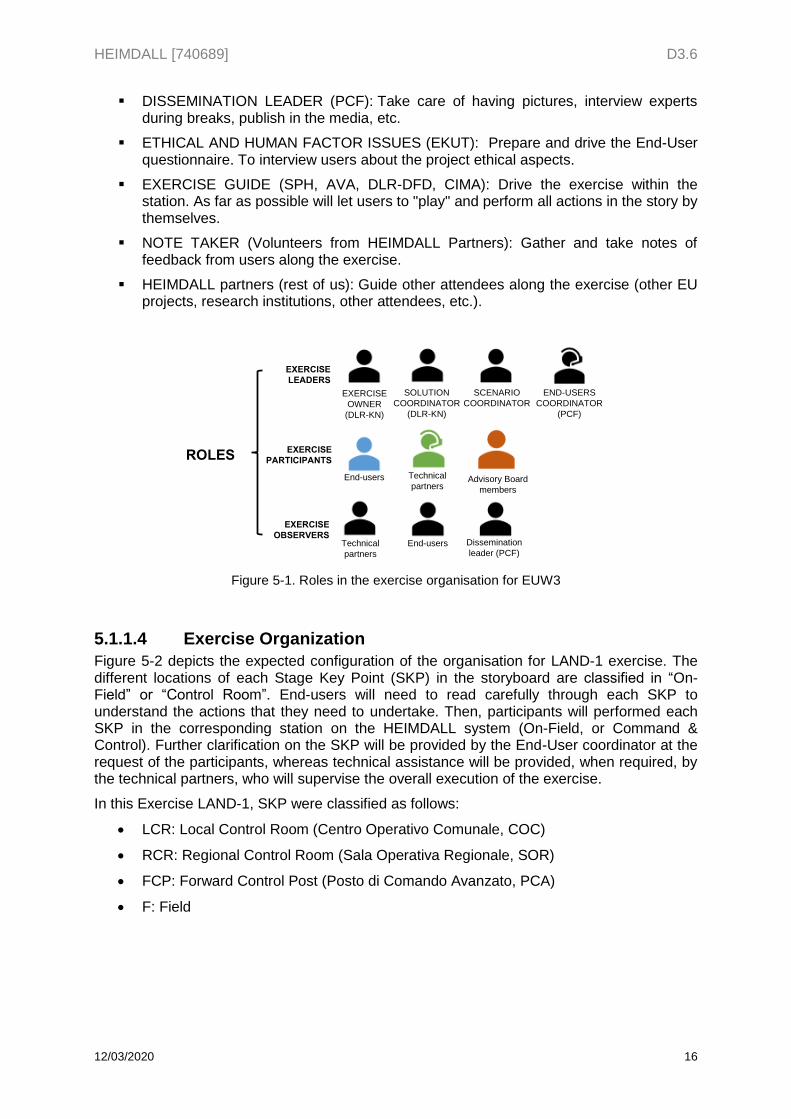
Exercise roles are assigned as follows to the members of the Consortium so as to ensure appropriate performance of the exercise:
EXERCISE OWNER (DLR-KN): Overall coordination, presentation and introduction of Advisory Board, formalities, etc.
SOLUTION COORDINATOR (DLR-KN): Lead rehearsal on day 1. Take care of all system technical aspects, to have ready extra technical information if required, etc.
o ICGC, CTTC will support landslide simulator explanation and in-situ sensors. ICGC has already prepared a short explanation of the Landslide simulator, and a set of extra “case studies” to deeply test the simulator, if is required from the users side.
SCENARIO COORDINATOR (PCF): Introduce the overall framework of Case Studies, Stories, justify the "fictive steps" in the stories, control timeline and evolution of the exercises among different stations.
END-USER COORDINATOR (PCF): Ensure a minimum feedback from the users side, assure attendance from end-users, inform end-users beforehand about the background, objectives of the workshop, what will be done, etc.
HEIMDALL [740689] D3.6
12/03/2020 16
DISSEMINATION LEADER (PCF): Take care of having pictures, interview experts during breaks, publish in the media, etc.
ETHICAL AND HUMAN FACTOR ISSUES (EKUT): Prepare and drive the End-User questionnaire. To interview users about the project ethical aspects.
EXERCISE GUIDE (SPH, AVA, DLR-DFD, CIMA): Drive the exercise within the station. As far as possible will let users to "play" and perform all actions in the story by themselves.
NOTE TAKER (Volunteers from HEIMDALL Partners): Gather and take notes of feedback from users along the exercise.
HEIMDALL partners (rest of us): Guide other attendees along the exercise (other EU projects, research institutions, other attendees, etc.).
Figure 5-1. Roles in the exercise organisation for EUW3
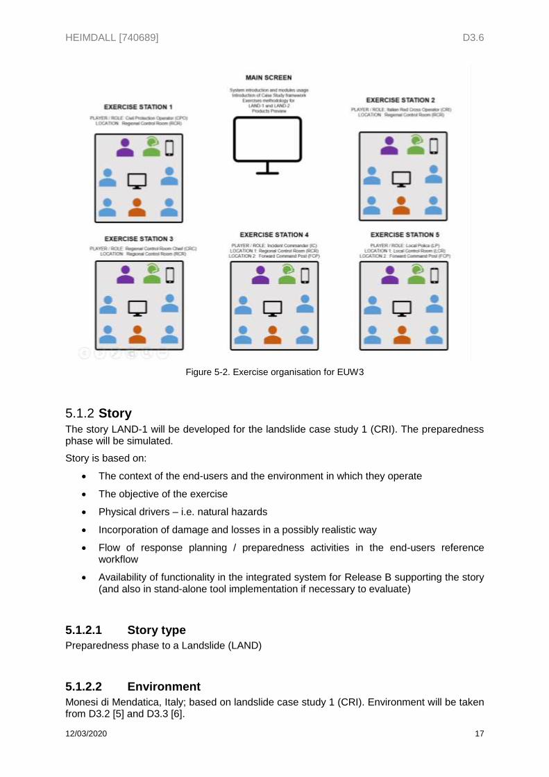
5.1.1.4 Exercise Organization
Figure 5-2 depicts the expected configuration of the organisation for LAND-1 exercise. The different locations of each Stage Key Point (SKP) in the storyboard are classified in “On-Field” or “Control Room”. End-users will need to read carefully through each SKP to understand the actions that they need to undertake. Then, participants will performed each SKP in the corresponding station on the HEIMDALL system (On-Field, or Command & Control). Further clarification on the SKP will be provided by the End-User coordinator at the request of the participants, whereas technical assistance will be provided, when required, by the technical partners, who will supervise the overall execution of the exercise.
In this Exercise LAND-1, SKP were classified as follows:
LCR: Local Control Room (Centro Operativo Comunale, COC)
RCR: Regional Control Room (Sala Operativa Regionale, SOR)
FCP: Forward Control Post (Posto di Comando Avanzato, PCA)
F: Field
End-users Technical
partners
Technical
partners
ROLES
SOLUTION
COORDINATOR
(DLR-KN)
SCENARIO
COORDINATOREXERCISE
OWNER
(DLR-KN)
EXERCISE
PARTICIPANTS
EXERCISE
OBSERVERSEnd-users Dissemination
leader (PCF)
EXERCISE
LEADERS
END-USERS
COORDINATOR
(PCF)
Advisory Board
members
HEIMDALL [740689] D3.6
12/03/2020 17
Figure 5-2. Exercise organisation for EUW3
Story 5.1.2The story LAND-1 will be developed for the landslide case study 1 (CRI). The preparedness phase will be simulated.
Story is based on:
The context of the end-users and the environment in which they operate
The objective of the exercise
Physical drivers – i.e. natural hazards
Incorporation of damage and losses in a possibly realistic way
Flow of response planning / preparedness activities in the end-users reference workflow
Availability of functionality in the integrated system for Release B supporting the story (and also in stand-alone tool implementation if necessary to evaluate)
5.1.2.1 Story type
Preparedness phase to a Landslide (LAND)
5.1.2.2 Environment
Monesi di Mendatica, Italy; based on landslide case study 1 (CRI). Environment will be taken from D3.2 [5] and D3.3 [6].
HEIMDALL [740689] D3.6
12/03/2020 18
5.1.2.3 Players and roles
Target groups must be selected for the exercises according to:
CPO: Civil Protection / Fire Fighter Operator
CRI: Italian Red Cross Operators
CRC: (Regional / Local) Control Room Chief
IC: Incident Commander
LP: Local Police
5.1.2.4 Locations
LCR: Local Control Room (Centro Operativo Comunale, COC)
RCR: Regional Control Room (Sala Operativa Regionale, SOR)
FCP: Forward Control Post (Posto di Comando Avanzato, PCA)
F: Field
The scenario will require a commitment of stakeholders (end-users and decision makers) from different Crisis Management levels (local, regional), such as representatives of regional police and fire services.
Actions will be taken by these stakeholders in a realistic information environment, based on currently available means, Crisis Management plans, rescue procedures and good practices of participants. Solution providers are asked to support the actors in their mission to respond to the story.
5.1.2.5 Stages/Scenes
Stage 1: command and control centre (strategic)
5.1.2.6 Story Description
The story represents the preparedness phase for Monesi di Mendatica landslide. The aims of the actions within this preparedness phase are “to be prepared” and ready against future events, avoiding reactive responses and fostering pro-active decisions by knowing in advance the potential affectations.
Since no in-situ sensors are available for Monesi di Mendatica landslide, some steps included in the story refer to Barberà de la Conca site. Barberà de la Conca is a village in Catalonia (Spain) that is affected by a terrain movement and is being monitored with a monitoring system consisting in in-situ hydrological and geotechnical sensors and periodic GB-SAR campaigns, owned by ICGC. This situation has been represented in the story, trough the creation of a scenario with “fictive data” as part of the HEIMDALL training mode.
This story collects the actions performed by civil protection operators, the red cross operator, the local police in the period before the event, which resulted in a set of preparedness actions, such as the creation and publication of the hydrogeological risk management plan (including both flood and landslide risk in the area surrounding Monesi di Mendatica), the elaboration of a plan for raising population awareness on this type of risks and the identification of lessons learned during previous landslides, as well as a set of training activities.
HEIMDALL [740689] D3.6
12/03/2020 19
5.1.2.7 Associated documents
The following associated documents can be found in the HEIMDALL D3.2 on Case Studies – Issue 2 [5].
Hydrogeological risk management plan (HRMP) o Local Plan: Piano Intercomunale di Protezione Civile – Piano di Emergenza
per Rischio Idrogeologico o Regional Plan: Piano Provinciale di Protezione Civile
Hydrogeological risk awareness plan (HRAP)
Historical document on landslides (HD)
Lessons learned document (LLD) o ICS fillable forms from FEMA available at
https://training.fema.gov/icsresource/icsforms.aspx
Weather forecast document (WFD, Bollettino meteo)
5.1.2.8 Storyboards
Storyboards for the defined story stages using implemented functionalities for Release B. Each step in the storyboard is indexed by Stage Key Points (SKP).
Table 5-1. Legend of LAND-1 of Release B.
User interaction with HEIMDALL
No user interaction with HEIMDALL and/or informative step
Relevant information to follow the incident
User interaction - training scenario
No user interaction - training scenario
Relevant information to follow the incident
Table 5-2. Storyboard for story LAND-1 of Release B.
SKP Time Key event Player Location ID Brief description
1. 3 20/09/2016 09:00
The CPO logs into the system
CPO RCR TR_Scen_1
TR_UeRM_12
To log in, create a
scenario
2. 20/09/2016 09:00
The CRI operators logs into the platform and confirm their entry.
CRI RCR TR_UI_1
TR_UeRM_02
User Login
3. 20/09/2016 09:00
The Control Room chief logs into the platform and confirms his/her entry.
CRC RCR TR_UI_1
TR_UeRM_02
User Login
4. 20/09/2016 09:00
The Incident Commander logs into on the platform and confirms his/her entry.
IC RCR TR_UI_1
TR_UeRM_02
User Login
5. 20/09/2016 09:00
The Local Police logs into on the platform and
LP LCR TR_UI_1
TR_UeRM
User Login
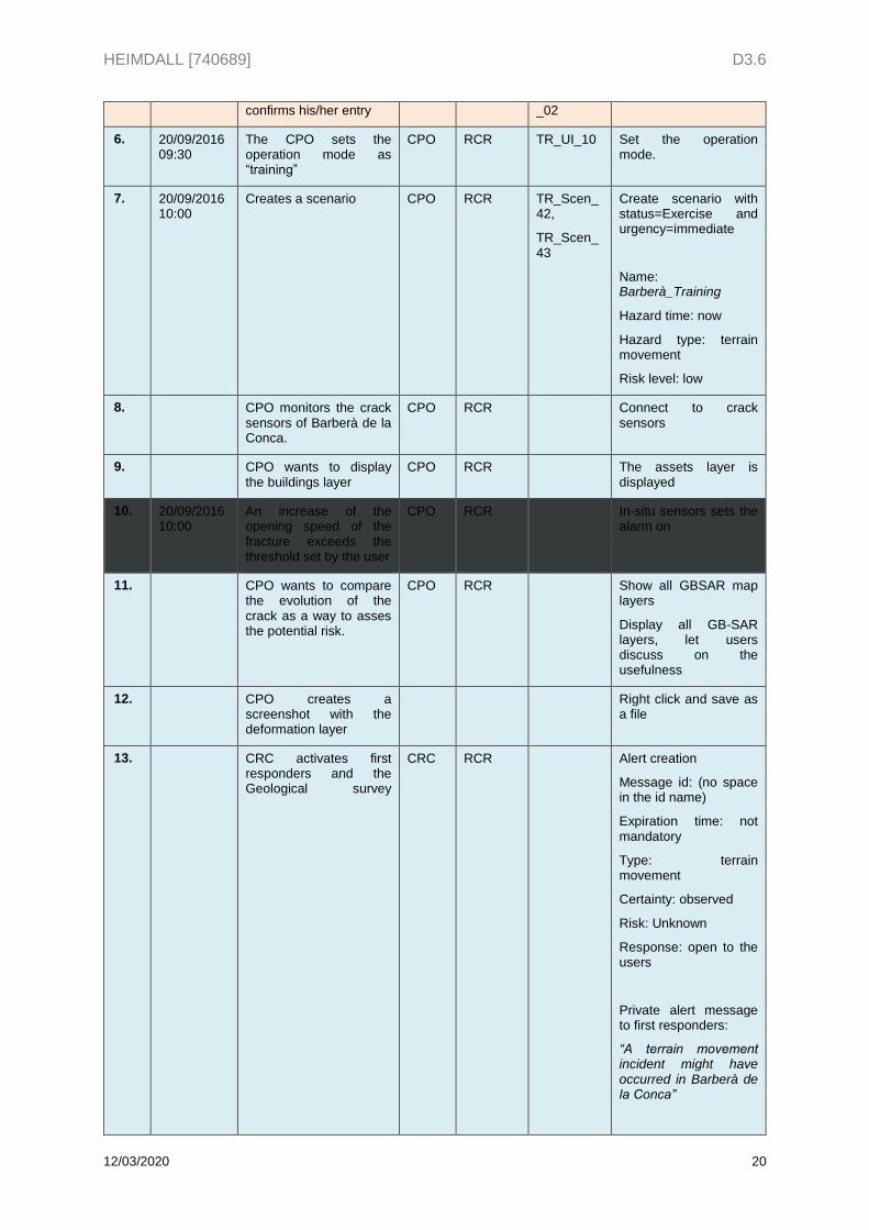
HEIMDALL [740689] D3.6
12/03/2020 20
confirms his/her entry _02
6. 20/09/2016 09:30
The CPO sets the operation mode as “training”
CPO RCR TR_UI_10 Set the operation mode.
7. 20/09/2016 10:00
Creates a scenario CPO RCR TR_Scen_42,
TR_Scen_43
Create scenario with status=Exercise and urgency=immediate
Name: Barberà_Training
Hazard time: now
Hazard type: terrain movement
Risk level: low
8. CPO monitors the crack sensors of Barberà de la Conca.
CPO RCR Connect to crack sensors
9. CPO wants to display the buildings layer
CPO RCR The assets layer is displayed
10. 20/09/2016 10:00
An increase of the opening speed of the fracture exceeds the threshold set by the user
CPO RCR In-situ sensors sets the alarm on
11. CPO wants to compare the evolution of the crack as a way to asses the potential risk.
CPO RCR Show all GBSAR map layers
Display all GB-SAR layers, let users discuss on the usefulness
12. CPO creates a screenshot with the deformation layer
Right click and save as a file
13. CRC activates first responders and the Geological survey
CRC RCR Alert creation
Message id: (no space in the id name)
Expiration time: not mandatory
Type: terrain movement
Certainty: observed
Risk: Unknown
Response: open to the users
Private alert message to first responders:
“A terrain movement incident might have occurred in Barberà de la Conca”
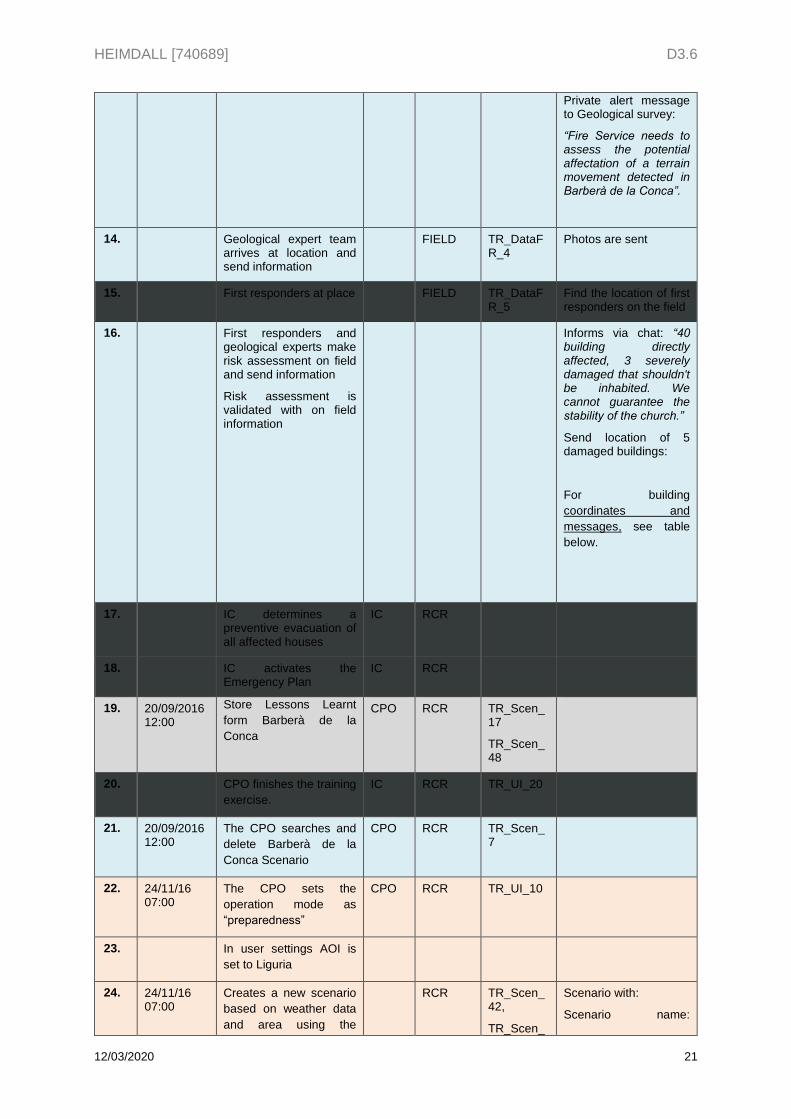
HEIMDALL [740689] D3.6
12/03/2020 21
Private alert message to Geological survey:
“Fire Service needs to assess the potential affectation of a terrain movement detected in Barberà de la Conca”.
14. Geological expert team arrives at location and send information
FIELD TR_DataFR_4
Photos are sent
15. First responders at place FIELD TR_DataFR_5
Find the location of first responders on the field
16. First responders and geological experts make risk assessment on field and send information
Risk assessment is validated with on field information
Informs via chat: “40 building directly affected, 3 severely damaged that shouldn't be inhabited. We cannot guarantee the stability of the church.”
Send location of 5 damaged buildings:
For building
coordinates and
messages, see table
below.
17. IC determines a preventive evacuation of all affected houses
IC RCR
18. IC activates the Emergency Plan
IC RCR
19. 20/09/2016 12:00
Store Lessons Learnt
form Barberà de la
Conca
CPO RCR TR_Scen_17
TR_Scen_48
20. CPO finishes the training
exercise.
IC RCR TR_UI_20
21. 20/09/2016 12:00
The CPO searches and
delete Barberà de la
Conca Scenario
CPO RCR TR_Scen_7
22. 24/11/16 07:00
The CPO sets the
operation mode as
“preparedness”
CPO RCR TR_UI_10
23. In user settings AOI is
set to Liguria
24. 24/11/16 07:00
Creates a new scenario
based on weather data
and area using the
RCR TR_Scen_42,
TR_Scen_
Scenario with:
Scenario name:
HEIMDALL [740689] D3.6
12/03/2020 22
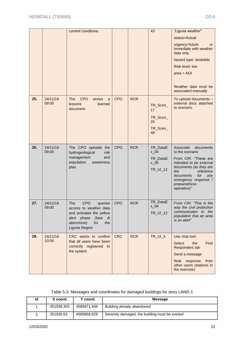
current conditions. 43 “Liguria weather”
status=Actual
urgency=future or immediate with weather data only
hazard type: landslide
Risk level: low
area = AOI
Weather data must be associated manually
25. 24/11/16 09:00
The CPO stores a
lessons learned
document
CPO RCR
TR_Scen_
17
TR_Scen_20
TR_Scen_48
To upload documents – external docs attached to scenario.
26. 24/11/16 09:00
The CPO uploads the
hydrogeological risk
management and
population awareness
plan.
CPO RCR TR_DataEx_04
TR_DataEx_05
TR_UI_12
Associate documents to the scenario
From CRI: “These are intended to be external documents (as they are the reference documents for any emergency response / preparedness operation)”
27. 24/11/16 09:00
The CPO queries
access to weather data
and activates the yellow
alert phase (fase di
attenzione) for the
Liguria Region
CPO RCR TR_DataEx_04
TR_UI_12
From CRI: “This is the way the civil protection communicates to the population that an area is on alert”
28. 24/11/16 10:00
CRC wants to confirm
that all users have been
correctly registered to
the system
CRC RCR TR_UI_3 Use chat tool:
Select the First Responders tab
Send a message
Wait response from other users (stations in the exercise)
Table 5-3. Messages and coordinates for damaged buildings for story LAND-1
id X coord. Y coord. Message
1 351938.303 4585871.448 Building already abandoned
2 351930.63 4585868.629 Severely damaged, the building must be evicted
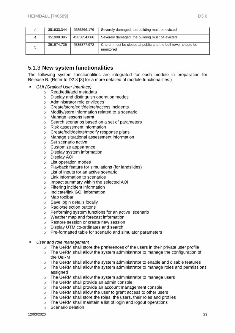
HEIMDALL [740689] D3.6
12/03/2020 23
3 351933.344 4585866.176 Severely damaged, the building must be evicted
4 351908.395 4585854.066 Severely damaged, the building must be evicted
5 351974.736 4585877.972 Church must be closed at public and the bell-tower should be
monitored
New system functionalities 5.1.3The following system functionalities are integrated for each module in preparation for Release B. (Refer to D2.3 [3] for a more detailed of module functionalities.)
GUI (Grafical User Interface) o Read/edit/add metadata o Display and distinguish operation modes o Administrator role privileges o Create/store/edit/delete/access incidents o Modify/store information related to a scenario o Manage lessons learnt o Search scenarios based on a set of parameters o Risk assessment information o Create/edit/delete/modify response plans o Manage situational assessment information o Set scenario active o Customize appearance o Display system information o Display AOI o List operation modes o Playback feature for simulations (for landslides) o List of inputs for an active scenario o Link information to scenarios o Impact summary within the selected AOI o Filtering incident information o Indicate/link GOI information o Map toolbar o Save login details locally o Radio/selection buttons o Performing system functions for an active scenario o Weather map and forecast information o Restore session or create new session o Display UTM co-ordinates and search o Pre-formatted table for scenario and simulator parameters
User and role management
o The UeRM shall store the preferences of the users in their private user profile o The UeRM shall allow the system administrator to manage the configuration of
the UeRM o The UeRM shall allow the system administrator to enable and disable features o The UeRM shall allow the system administrator to manage roles and permissions
assigned o The UeRM shall allow the system administrator to manage users o The UeRM shall provide an admin console o The UeRM shall provide an account management console o The UeRM shall allow the user to grant access to other users o The UeRM shall store the roles, the users, their roles and profiles o The UeRM shall maintain a list of login and logout operations o Scenario deletion
HEIMDALL [740689] D3.6
12/03/2020 24
o Deletion of scenario and lessons learnt templates o Modification of scenario information o Modification of map symbology o Creation of map layers o IG access (send alerts)
Service platform
o The SP shall provide a database to store EO data o The SP shall receive and store georeferenced information from first responders o The SP shall provide means to configure its operational parameters o The SP shall run on virtualised IT infrastructures o The SP shall be easily extended with new sensors, modules, etc.
Crowdsourced and First Responders Data (App)
o Map of the AOI in the cache memory o Send media to HEIMDALL system
Alert receiver to be checked
External systems o Present information about critical infrastructures o The system shall assign data received from a first responder to a specific incident o The system shall access meteorological information from private stations/users. o The system shall access the information of soil characteristics, elevations and
landslide inventories available in the simulation area o The system shall access and display pre-defined potential damage map
information for a respective region. o The system shall show the location of assets on the map o The system shall allow the deletion of information received from first responders. o The system shall be able to receive incidents through the crowdsourcing
application. o First Responders location
Fire/Flood simulation
o Adjust past fire spread simulations o Estimate the geomorphological elements o Simplified flood simulation o Simplified model o Adjust of past flood simulations o Simplified simulations using multiple discharge input points
Landslide modelling
o Delineate information on source areas o Access weather data o Delineate safe and unsafe areas
Scenario management
o Delete scenario o Associate geotagged pictures to a scenario o Create a scenario with weather data only o Store extended weather parameters o Store weather forecast in different fixed time frames o Mark current weather conditions as verified by a field user o Store area of scenario o Associate GUI screenshots to a scenario o Store lifecycle phase o Store status
HEIMDALL [740689] D3.6
12/03/2020 25
o Store urgency o Updated lessons learnt data structure o Updated response plan data structure
Risk and impact assessment
o Estimation of the physical exposure o Assessment of the physical impact o Estimate the expected impact based on the identified affected components,
damage/vulnerability functions and the simulation/EO products o Estimate the number of affected people o Integrate information on monetary values and based on this estimate the impact o Preliminary risk information products based on end user knowledge o Provide the hazard extent to be displayed o Generate risk assessments for forest fires, floods and landslides o Consider cascading effects on vulnerability o Integrate data sets of infrastructures o Identify infrastructures not affected o Information on the municipality membership o Expected physical damage based on identified assets/GOIs
Impact summary
o EDXL-based situation report for scenarios o ISA information for GOIs at risk in a specified geographical location o Modify ISA information o Total percentage of damaged GOIs in AOI o Total degree of physical damage in AOI o Simple filtering of ISA Information
Information gateway
o Different levels of predefined areas o Different types of areas o Different types of users when message is private o Multi-channel capabilities o Share pictures
5.2 Response phase This section contains the prepared materials for exercise LAND-2.
Exercise Setup 5.2.1The functionalities implemented for Release B will be presented and evaluated in an interactive exercise by use of the HEIMDALL system modules.
5.2.1.1 Context
Participants: HEIMDALL consortium and members of the AB.
What: Demonstration 2 of the HEIMDALL project.
Purpose: Test and evaluate Release B functionalities by the end-user partners and the members of the AB.
Host: CIMA, at their headquarters in Savona (Italy).
HEIMDALL [740689] D3.6
12/03/2020 26
5.2.1.2 Exercise type
The exercise will be conducted as a functional exercise allowing participants to perform their duties in a simulated operational environment. Activities for a functional exercise are scenario-driven, such as the failure of a critical business function or a specific hazard scenario. Functional exercises are designed to exercise specific team members, procedures and resources (e.g. communications, warning, notifications and equipment set-up).
5.2.1.3 Exercise roles
See 5.1.1.3 Exercise roles.
5.2.1.4 Exercise organisation
See 5.1.1.4 Exercise Organization.
5.2.1.5 Schedule
The schedule results from the selected data collection approaches
Presentation of the story and study questions (15 min).
Each run of the story shall take approximately 30-45 minutes of simulated time, representing from 3 to 4 hours of operational time.
Debriefing questionnaire (30 min).
Story 5.2.2The story LAND-2 will be developed for the landslide case study 1 (CRI). The response phase will be simulated.
Story is based on:
The context of the end-users and the environment in which they operate
The objective of the exercise
Physical drivers – i.e. natural hazards
Incorporation of damage and losses in a possibly realistic way
Flow of response planning / preparedness activities in the end-users reference workflow
Availability of functionality in the integrated system for Release A supporting the story (and also in stand-alone tool implementation if necessary to evaluate)
5.2.2.1 Story type
Response phase to a Landslide (LAND)
5.2.2.2 Environment
Monesi di Mendatica, Italy; based on landslide case study 1 (CRI). Environment will be taken from D3.2.
HEIMDALL [740689] D3.6
12/03/2020 27
5.2.2.3 Players and roles
Target groups must be selected for the exercises according to:
CPO: Civil Protection / Fire Fighter Operator
CRI: Italian Red Cross Operator
CRC: (Regional / Local) Control Room Chief
IC: Incident Commander
LP: Local Police
5.2.2.4 Locations
LCR: Local Control Room (Centro Operativo Misto, COM)
RCR: Regional Control Room (Sala Operativa Regionale, SOR)
FCP: Forward Control Post (Posto di Comando Avanzato, PCA)
F: Field
112: 112 Alarm Centre
The scenario will require a commitment of stakeholders (end-users and decision makers) from different Crisis Management levels (local, regional), such as representatives of regional police and fire services.
Actions will be taken by these stakeholders in a realistic information environment, based on currently available means, Crisis Management plans, rescue procedures and good practices of participants. Solution providers are asked to support the actors in their mission to respond to the story.
5.2.2.5 Story Description
The story represents the response phase to the landslide that occurred on November 24th 2016 in Monesi di Mendatica, a village in the Imperia province in the alpine area of the Liguria Region. The Monesi landslides occurred after heavy rainfalls had woken up a paleofrana causing large terrain movements. The story starts in the morning, where the pre-alert phase was activated due to the heavy rainfalls, and continues to the actual emergency response phase.
The road between San Bernardo and Monesi was completely covered by the terrain and therefore Monesi remained isolated from the rest of the area. One house was completely destroyed while 25% of houses were condemned and several others heavily damaged. There were no human casualties as a result of the landslide, but the majority of people living in Monesi had to be rescued from their houses and evacuated in safe areas.
The Regional Control Room of the Liguria Region was informed by the Local Control Room that the local emergency response plan was activated to rescue potentially affected persons. Operators from the civil protection, the Italian Red Cross, Vigili del Fuoco, and Local Police were deployed on site, a helicopter was dispatched as well as two excavators and two ambulances. All resources deployed during the Monesi Landslide can be found at HEIMDALL Deliverable D3.2 Case Studies – Issue 2 [5].
5.2.2.6 Storyboard
Storyboards for the defined story stages using implemented functionalities for release B.
Table 5-4. Legend of LAND-2 of Release B.
HEIMDALL [740689] D3.6
12/03/2020 28
User interaction with HEIMDALL performed in Release B
User interaction with HEIMDALL.
Action not performed in the exercise, but relevant information to follow the incident
No user interaction with HEIMDALL and/or informative step
Relevant information to follow the incident
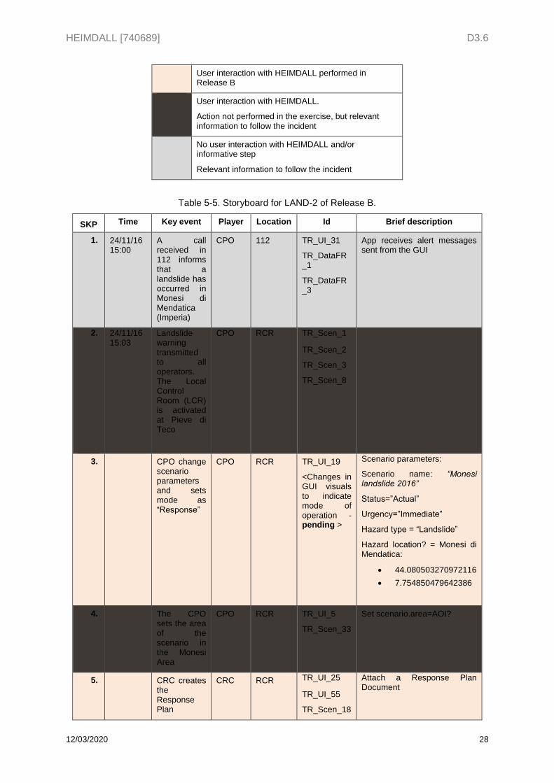
Table 5-5. Storyboard for LAND-2 of Release B.
SKP Time Key event Player Location Id Brief description
1. 24/11/16 15:00
A call received in 112 informs that a landslide has occurred in Monesi di Mendatica (Imperia)
CPO 112 TR_UI_31
TR_DataFR_1
TR_DataFR_3
App receives alert messages sent from the GUI
2. Nomes mmencio
24/11/16 15:03
Landslide warning transmitted to all operators. The Local Control Room (LCR) is activated at Pieve di Teco
CPO RCR TR_Scen_1
TR_Scen_2
TR_Scen_3
TR_Scen_8
3. CPO change scenario parameters and sets mode as “Response”
CPO RCR TR_UI_19
<Changes in GUI visuals to indicate mode of operation - pending >
Scenario parameters:
Scenario name: “Monesi landslide 2016”
Status=”Actual”
Urgency=”Immediate”
Hazard type = “Landslide”
Hazard location? = Monesi di Mendatica:
44.080503270972116
7.754850479642386
4. The CPO sets the area of the scenario in the Monesi Area
CPO RCR TR_UI_5
TR_Scen_33
Set scenario.area=AOI?
5. CRC creates the Response Plan
CRC RCR TR_UI_25
TR_UI_55
TR_Scen_18
Attach a Response Plan Document
HEIMDALL [740689] D3.6
12/03/2020 29
TR_Scen_49
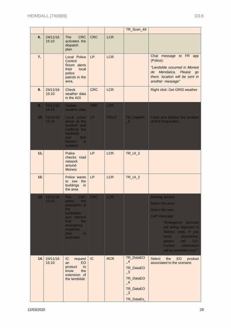
6. 24/11/16 15:10
The CRC activates the dispatch plan
CRC LCR
7. Local Police Control Room alerts their local police patrols in the area.
LP LCR Chat message to FR app
(Police):
“Landslide occurred in Monesi
de Mendatica. Please go
there. location will be sent in
another message”
8. 24/11/16 15:10
Check weather data in the AOI
CRC LCR Right click: Get GRID weather
9. 24/11/16 15:10
Update weather data
CRC LCR
10. 24/11/16 15.10
Local police arrive at the incident and confirms the landslide and that Monesi is isolated
LP FIELD TR_DataFR_5
Track and display the location of first responders
11. Police checks road network around Monesi
LP LCR TR_UI_2
12. Police wants to see the buildings in the area
LP LCR TR_UI_2
13. 24/11/16 15:10
The CRC alerts the population of the landslides and informs that the emergency response plan is activated
CRC LCR Alerting service
Select the area
Select the user
CAP message:
“Emergency services
are being deployed in
Monesi area, if you
need assistance,
please call 112.
Further information
will be provided soon”
14. 24/11/16 15:10
IC request an EO product to know the extension of the landslide
IC RCR TR_DataEO_4
TR_DataEO_3
TR_DataEO_4
TR_DataEO_3
TR_DataEx_
Select the EO product associated to the scenario
HEIMDALL [740689] D3.6
12/03/2020 30
01
TR_Scen_12
TR_UI_47
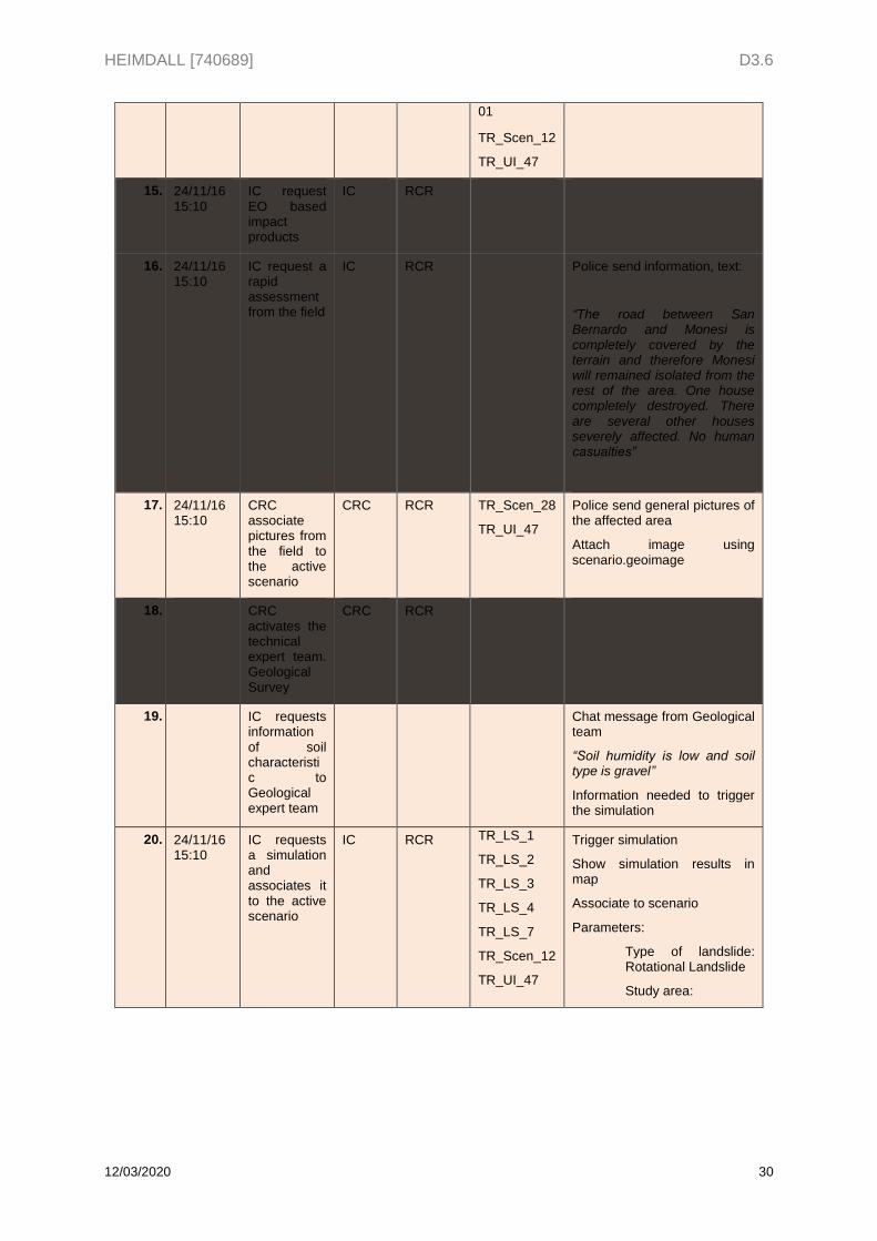
15. 24/11/16 15:10
IC request EO based impact products
IC RCR
16. 24/11/16 15:10
IC request a rapid assessment from the field
IC RCR Police send information, text:
“The road between San Bernardo and Monesi is completely covered by the terrain and therefore Monesi will remained isolated from the rest of the area. One house completely destroyed. There are several other houses severely affected. No human casualties”
17. 24/11/16 15:10
CRC associate pictures from the field to the active scenario
CRC RCR TR_Scen_28
TR_UI_47
Police send general pictures of the affected area
Attach image using scenario.geoimage
18. CRC activates the technical expert team. Geological Survey
CRC RCR
19. IC requests information of soil characteristic to Geological expert team
Chat message from Geological team
“Soil humidity is low and soil type is gravel”
Information needed to trigger the simulation
20. 24/11/16 15:10
IC requests a simulation and associates it to the active scenario
IC RCR TR_LS_1
TR_LS_2
TR_LS_3
TR_LS_4
TR_LS_7
TR_Scen_12
TR_UI_47
Trigger simulation
Show simulation results in map
Associate to scenario
Parameters:
Type of landslide: Rotational Landslide
Study area:
HEIMDALL [740689] D3.6
12/03/2020 31
Size: Large
Soil humidity: Dry
Soil type: Sand
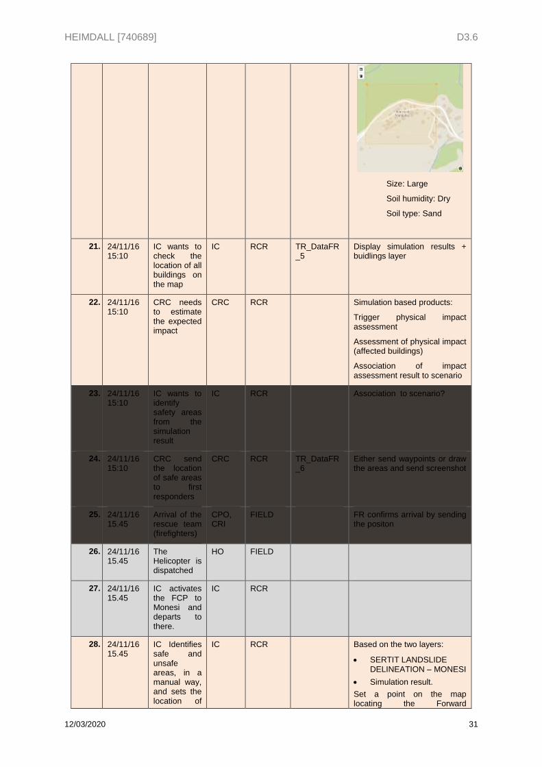
21. 24/11/16 15:10
IC wants to check the location of all buildings on the map
IC RCR TR_DataFR_5
Display simulation results + buidlings layer
22. 24/11/16 15:10
CRC needs to estimate the expected impact
CRC RCR Simulation based products:
Trigger physical impact assessment
Assessment of physical impact (affected buildings)
Association of impact assessment result to scenario
23. 24/11/16 15:10
IC wants to identify safety areas from the simulation result
IC RCR Association to scenario?
24. 24/11/16 15:10
CRC send the location of safe areas to first responders
CRC RCR TR_DataFR_6
Either send waypoints or draw the areas and send screenshot
25. 24/11/16 15.45
Arrival of the rescue team (firefighters)
CPO, CRI
FIELD FR confirms arrival by sending the positon
26. 24/11/16 15.45
The Helicopter is dispatched
HO FIELD
27. 24/11/16 15.45
IC activates the FCP to Monesi and departs to there.
IC RCR
28. 24/11/16 15.45
IC Identifies safe and unsafe areas, in a manual way, and sets the location of
IC RCR Based on the two layers:
SERTIT LANDSLIDE DELINEATION – MONESI
Simulation result.
Set a point on the map locating the Forward
HEIMDALL [740689] D3.6
12/03/2020 32
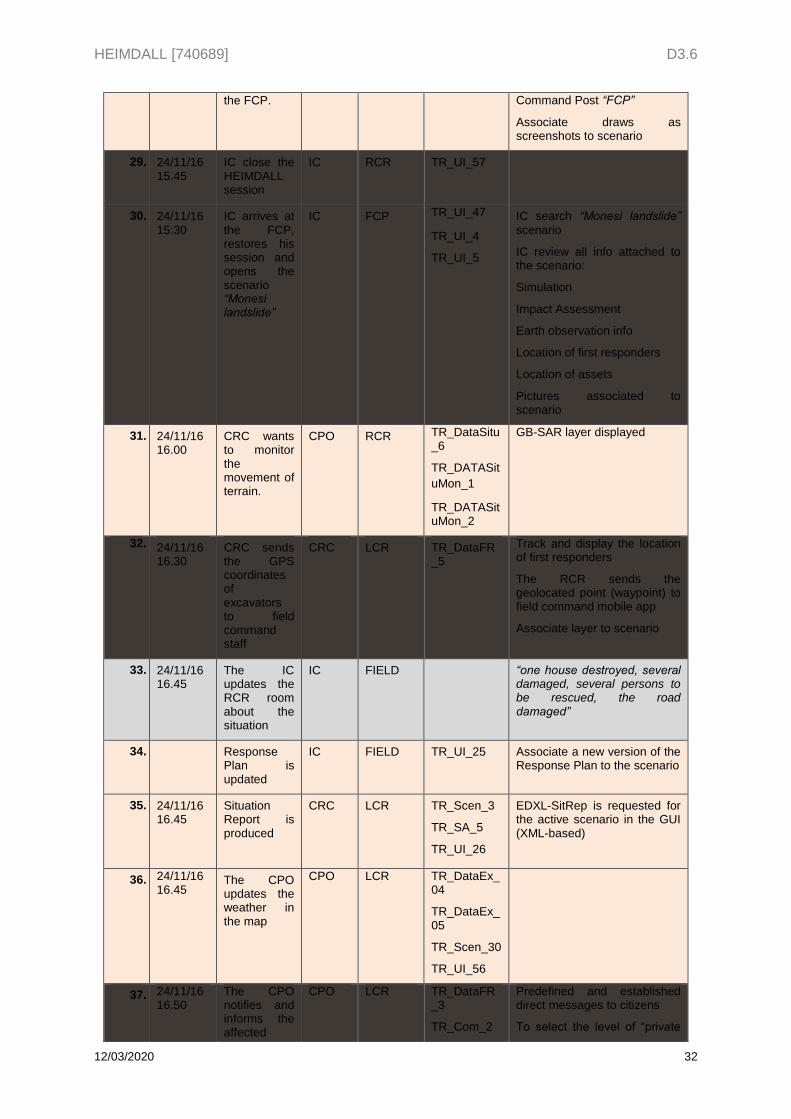
the FCP. Command Post “FCP”
Associate draws as screenshots to scenario
29. 24/11/16 15.45
IC close the HEIMDALL session
IC RCR TR_UI_57
30. 24/11/16 15:30
IC arrives at the FCP, restores his session and opens the scenario “Monesi landslide”
IC FCP TR_UI_47
TR_UI_4
TR_UI_5
IC search “Monesi landslide”
scenario
IC review all info attached to the scenario:
Simulation
Impact Assessment
Earth observation info
Location of first responders
Location of assets
Pictures associated to scenario
31. 24/11/16 16.00
CRC wants to monitor the movement of terrain.
CPO RCR TR_DataSitu_6
TR_DATASit
uMon_1
TR_DATASituMon_2
GB-SAR layer displayed
32. 24/11/16 16.30
CRC sends the GPS coordinates of excavators to field command staff
CRC LCR TR_DataFR_5
Track and display the location of first responders
The RCR sends the geolocated point (waypoint) to field command mobile app
Associate layer to scenario
33. 24/11/16 16.45
The IC updates the RCR room about the situation
IC FIELD “one house destroyed, several damaged, several persons to be rescued, the road damaged”
34. Response Plan is updated
IC FIELD TR_UI_25 Associate a new version of the Response Plan to the scenario
35. 24/11/16 16.45
Situation Report is produced
CRC LCR TR_Scen_3
TR_SA_5
TR_UI_26
EDXL-SitRep is requested for the active scenario in the GUI (XML-based)
36. 24/11/16 16.45
The CPO updates the weather in the map
CPO LCR TR_DataEx_04
TR_DataEx_05
TR_Scen_30
TR_UI_56
37. 24/11/16 16.50
The CPO notifies and informs the affected
CPO LCR TR_DataFR_3
TR_Com_2
Predefined and established direct messages to citizens
To select the level of “private
HEIMDALL [740689] D3.6
12/03/2020 33
population, in particular the vulnerable elements.
TR_Com_3
TR_UI_31
group” were to send the message.
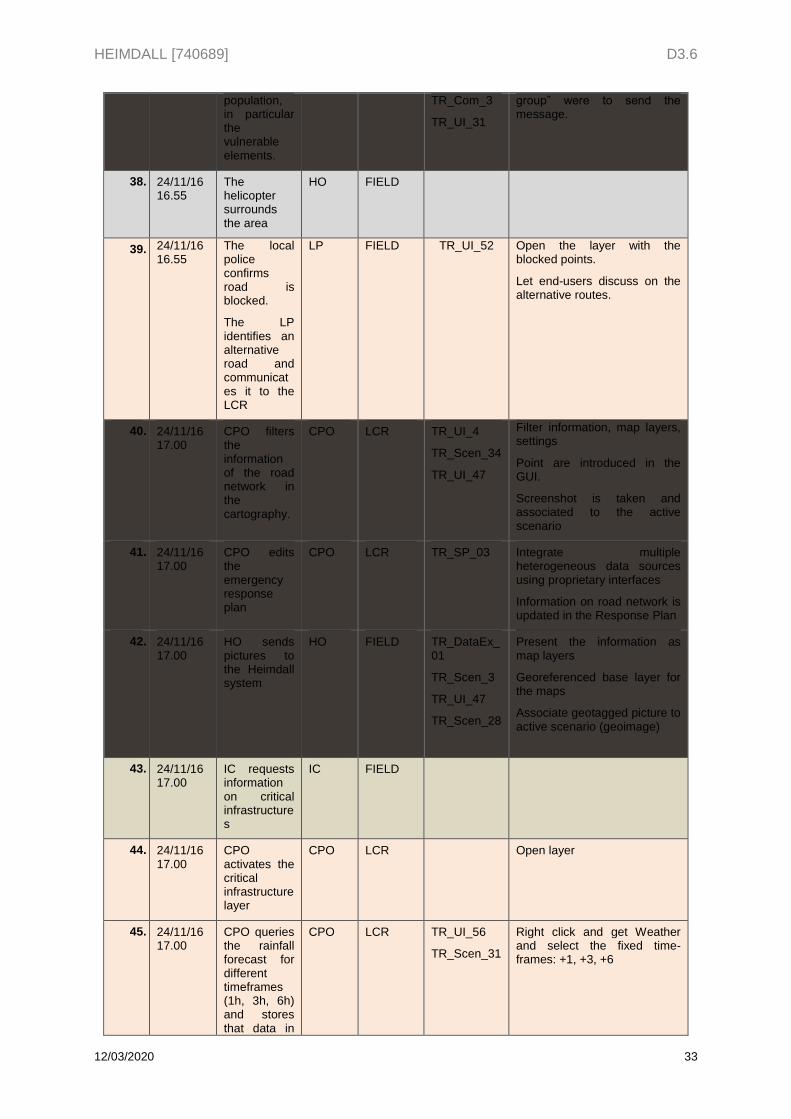
38. 24/11/16 16.55
The helicopter surrounds the area
HO FIELD
39. 24/11/16 16.55
The local police confirms road is blocked.
The LP identifies an alternative road and communicates it to the LCR
LP FIELD TR_UI_52 Open the layer with the blocked points.
Let end-users discuss on the alternative routes.
40. 24/11/16 17.00
CPO filters the information of the road network in the cartography.
CPO LCR TR_UI_4
TR_Scen_34
TR_UI_47
Filter information, map layers, settings
Point are introduced in the GUI.
Screenshot is taken and associated to the active scenario
41. 24/11/16 17.00
CPO edits the emergency response plan
CPO LCR TR_SP_03 Integrate multiple heterogeneous data sources using proprietary interfaces
Information on road network is updated in the Response Plan
42. 24/11/16 17.00
HO sends pictures to the Heimdall system
HO FIELD TR_DataEx_01
TR_Scen_3
TR_UI_47
TR_Scen_28
Present the information as map layers
Georeferenced base layer for the maps
Associate geotagged picture to active scenario (geoimage)
43. 24/11/16 17.00
IC requests information on critical infrastructures
IC FIELD
44. 24/11/16 17.00
CPO activates the critical infrastructure layer
CPO LCR Open layer
45. 24/11/16 17.00
CPO queries the rainfall forecast for different timeframes (1h, 3h, 6h) and stores that data in
CPO LCR TR_UI_56
TR_Scen_31
Right click and get Weather and select the fixed time-frames: +1, +3, +6
HEIMDALL [740689] D3.6
12/03/2020 34
the active scenario
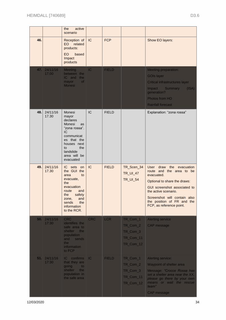
46. Reception of EO related products:
EO based Impact products
IC FCP Show EO layers:
47. 24/11/16 17.00
Meeting between the IC and the mayor of Monesi
IC FIELD Meeting preparation:
GOIs layer
Critical infrastructures layer
Impact Summary (ISA) generation?
Photos from HO
Rainfall forecast
48. 24/11/16 17.30
Monesi mayor declares Monesi as “zona rossa”. IC communicates that the houses next to the landslide area will be evacuated
IC FIELD Explanation: “zona rossa”
49. 24/11/16 17.30
IC sets on the GUI the area to evacuate, the evacuation route and the safety zone, and sends the information to the RCR.
IC FIELD TR_Scen_34
TR_UI_47
TR_UI_54
User draw the evacuation route and the area to be evacuated.
Optional to share the draws:
GUI screenshot associated to the active scenario.
Screenshot will contain also the position of FR and the FCP, as reference point.
50. 24/11/16 17:30
CRC identifies the safe area to shelter the population and sends the information to FCP
CRC LCR TR_Com_1
TR_Com_2
TR_Com_3
TR_Com_11
TR_Com_12
Alerting service
CAP message
51. 24/11/16 17:30
IC confirms that they are going to shelter the population in the safe area
IC FIELD TR_Com_1
TR_Com_2
TR_Com_3
TR_Com_11
TR_Com_12
Alerting service:
Waypoint of shelter area
Message: “Crocce Rossa has set a shelter area near the XX, please go there by your own means or wait the rescue team”
CAP message
HEIMDALL [740689] D3.6
12/03/2020 35
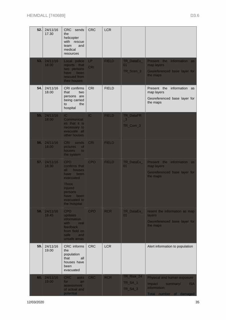
52. 24/11/16 17.30
CRC sends the helicopter with rescue team and medical resources
CRC
LCR
53. 24/11/16 18.00
Local police reports that two persons have been rescued from their houses
LP
CRI
FIELD TR_DataEx_01
TR_Scen_3
Present the information as map layers
Georeferenced base layer for the maps
54. 24/11/16 18.00
CRI confirms that two persons are being carried to the hospital
CRI FIELD Present the information as map layers
Georeferenced base layer for the maps
55. 24/11/16 18.00
IC Communicates that it is necessary to evacuate all other houses
IC FIELD TR_DataFR_3
TR_Com_3
56. 24/11/16 18.00
CRI sends pictures of houses to the system
CRI FIELD
57. 24/11/16 18.30
CPO confirms that all houses have been evacuated
Three injured persons have been evacuated to the Hospital
CPO FIELD TR_DataEx_01
Present the information as map layers
Georeferenced base layer for the maps
58. 24/11/16 18.45
CPO updates information with real feedback from field on safe and unsafe areas
CPO RCR TR_DataEx_01
resent the information as map layers
Georeferenced base layer for the maps
59. 24/11/16 19.00
CRC informs the population that all houses have been evacuated
CRC LCR Alert information to population
60. 24/11/16 19.00
CRC asks for an assessment of actual and potential
CRC RCR TR_Risk_24
TR_SA_1
TR_SA_3
Physical and human exposure
Impact summary/ ISA information:
Total number of damaged
HEIMDALL [740689] D3.6
12/03/2020 36
damages and of strategic infrastructures that might be affected
TR_SA_6
TR_UI_26
TR_SA_17
TR_UI_49
buildings in AOI
Maximum hazard level in AOI
Associate impact summary/ISA information to scenario
61. 24/11/16 19.30
The IC confirms that the rescue actions are over
IC FIELD
62. CPO request a rainfall simulation
Associate Landslide Rainfall Analysis
Date set on: 24/11/2016
Climate: Cool Mediterranean Climate
Location: set a point on Monesi
63. CPO creates a lesson learnt in the “Monesi landslide” scenario and associates a lesson learnt document
CPO RCR TR_Scen_17
TR_Scen_48
Creates a “Rapid Lessons learnt” (not attaching a document)
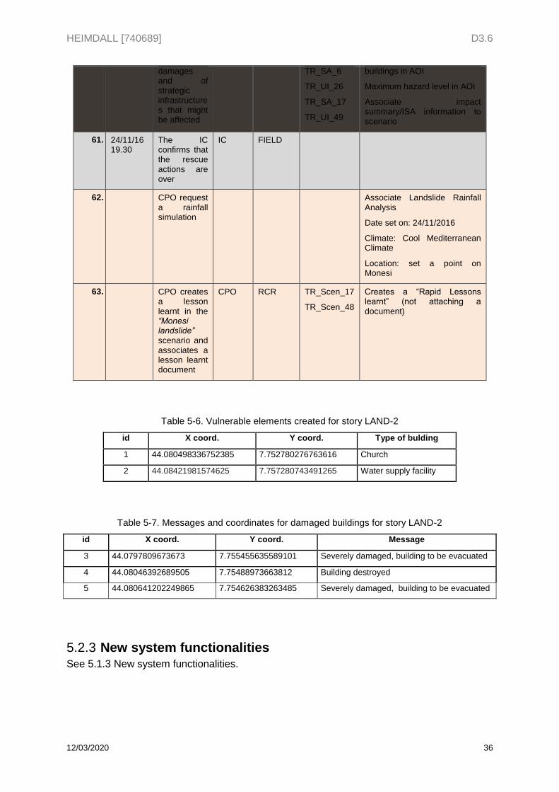
Table 5-6. Vulnerable elements created for story LAND-2
id X coord. Y coord. Type of bulding
1 44.080498336752385 7.752780276763616 Church
2 44.08421981574625 7.757280743491265 Water supply facility
Table 5-7. Messages and coordinates for damaged buildings for story LAND-2
id X coord. Y coord. Message
3 44.0797809673673 7.755455635589101 Severely damaged, building to be evacuated
4 44.08046392689505 7.75488973663812 Building destroyed
5 44.080641202249865 7.754626383263485 Severely damaged, building to be evacuated
New system functionalities 5.2.3See 5.1.3 New system functionalities.
HEIMDALL [740689] D3.6
12/03/2020 37
5.3 Execution phase The execution phase for the demonstration in the End-Users Workshop 3 is composed by 2 dry runs and the execution of the Exercises LAND-1 and LAND-2.
Two dry runs were organised during the month before the End-Users Workshop 3.
Dry Runs 1 & 2 5.3.1Only the technical partners attended the Dry Runs in order to avoid providing end-users with extra information about the exercise organisation and solutions before the exercise run, because it was considered this could cause unwanted disturbance in the results.
5.3.1.1 Dry Runs
The outcomes of the Dry Run 1 in preparation for the EUW3 can be found at Annex I. Outcomes of the Dry Run 1.
The outcomes of the meeting Dry Run 2 in preparation for the EUW3 can be found at Annex II. Outcomes of the Dry Run 2 (EUW3).
Exercise Runs 5.3.2The final run of two exercises LAND-1 and LAND-2, was held within the frame of the End-Users Workshop 3, hosted by the CIMA, in their headquarter premises in Savona, on 17th of April, 2019.
The agenda of the meeting can be found at Annex VII. Agenda of End-Users Workshop 3.
The list of attendees can be found at Annex IX. List of attendees of End-Users Workshop 3.
o HEIMDALL Partners attendees: 36
HEIMDALL Technical partners: 18
HEIMDALL End-users: 18
o HEIMDALL Advisory Board members: 4
o Other: 5
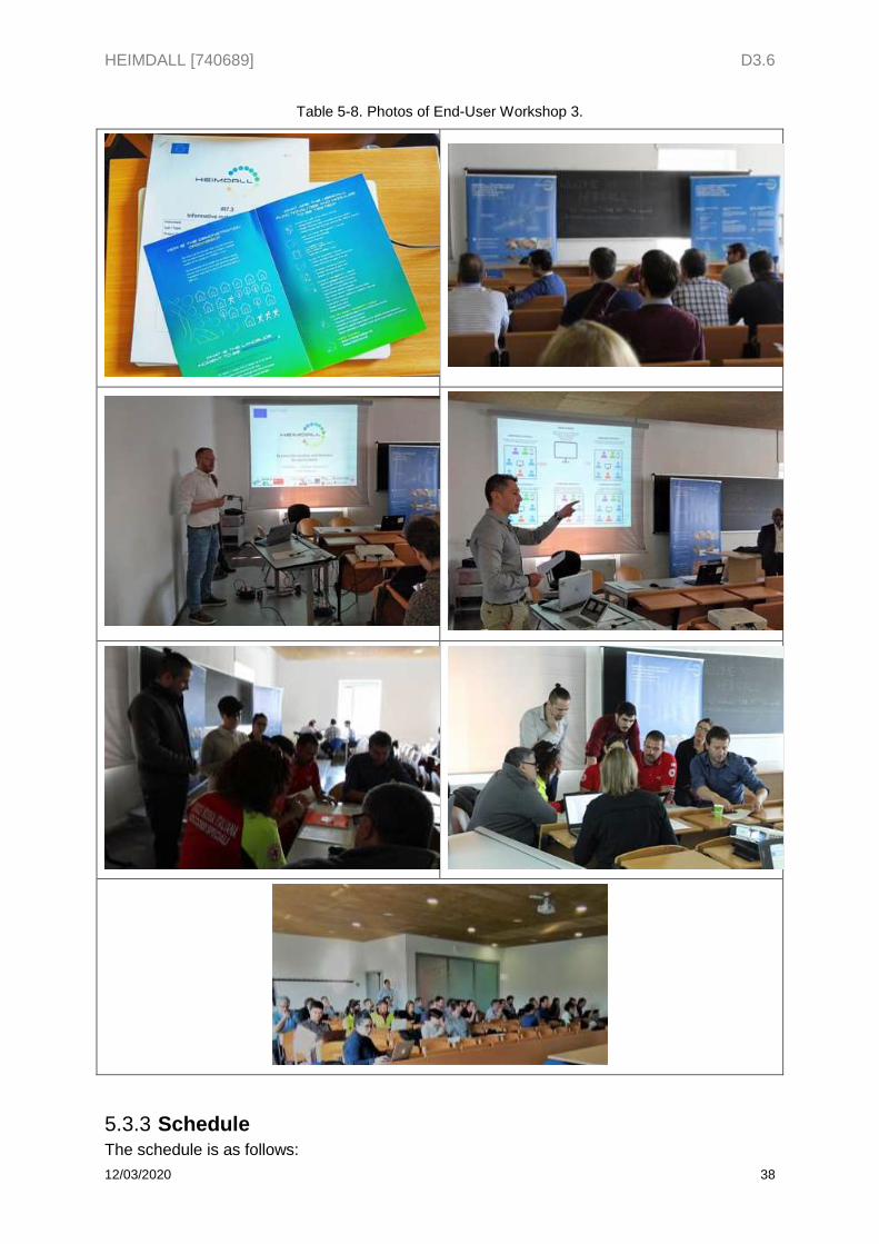
Photos of the End-Users Workshop 3 can be seen in the following table
HEIMDALL [740689] D3.6
12/03/2020 38
Table 5-8. Photos of End-User Workshop 3.
Schedule 5.3.3The schedule is as follows:
HEIMDALL [740689] D3.6
12/03/2020 39
Presentation of the story and study questions (15 min).
Each run of the story shall take approximately 30-45 minutes of simulated time, representing from 3 to 4 hours of operational time.
Debriefing questionnaire and other selected data collection approaches (30 min).
5.4 Evaluation phase This chapter comprises the actions to collect and analyse the feedback from end-users and the Member of the Advisory Board after the demonstration, as well as the information and data collected by technical partners along the exercise sessions.
Data collection 5.4.1Two data collection techniques were employed in order to gather participants’ feedback on the platform features and functionalities:
- Note taking: through the ongoing exercise there was a dedicated note taker to collect all the system’s shortcomings, and key missing capabilities pointed by the participants and the member of the AB as well as other feedback.
- Questionnaire: a questionnaire addressed to the participants of the End-users Workshop was prepared by EKUT in order to assess the fulfilment of user requirements. The questionnaire was divided into two main parts: one dedicated on the preparedness phase, and another focused on the response phase. A sample of this questionnaire can be seen in Annex XI. Questionnaire for End-Users Workshop 3.
The feedback gather by means of both techniques was further analysed and arranged to prepare the D2.2 [2] and D2.3 [3].
Data analysis 5.4.2A total number of 17 experts (HEIMDALL end-users and Advisory Board members) answered the questionnaire.
5.4.2.1 Questionnaire outcomes
Two questionnaires were prepared in advance so as to collect participants’ feedback from system Release B, one relevant to exercise LAND-1 (preparedness phase), and another to LAND-2 (response phase).
The main outcomes of the two questionnaires, which were collected by EKUT, are presented below along with some comments provided by the responders:
Please note that each questionnaires includes two open questions (highlighted with a star *). Responses to those questions can be consulted in Table 5-10 and Table 5-12.
Table 5-9. Questionnaire outcomes of exercise LAND-1 (preparedness phase).
Fulfilment
Questions Yes Partially No Not applicable Open
anwers
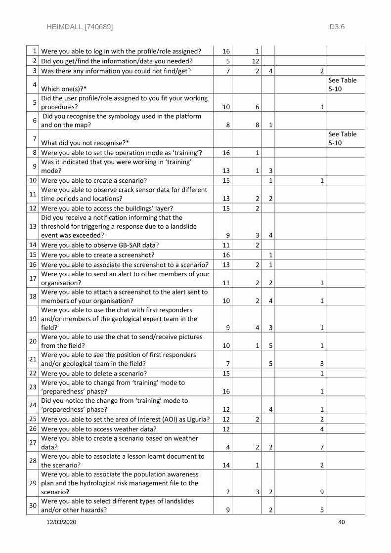
HEIMDALL [740689] D3.6
12/03/2020 40
1 Were you able to log in with the profile/role assigned? 16 1
2 Did you get/find the information/data you needed? 5 12
3 Was there any information you could not find/get? 7 2 4 2
4 Which one(s)?*
See Table 5-10
5 Did the user profile/role assigned to you fit your working procedures? 10 6 1
6 Did you recognise the symbology used in the platform and on the map? 8 8 1
7 What did you not recognise?*
See Table 5-10
8 Were you able to set the operation mode as ‘training’? 16 1
9 Was it indicated that you were working in ‘training’ mode? 13 1 3
10 Were you able to create a scenario? 15 1 1
11 Were you able to observe crack sensor data for different time periods and locations? 13 2 2
12 Were you able to access the buildings’ layer? 15 2
13 Did you receive a notification informing that the threshold for triggering a response due to a landslide event was exceeded? 9 3 4
14 Were you able to observe GB-SAR data? 11 2
15 Were you able to create a screenshot? 16 1
16 Were you able to associate the screenshot to a scenario? 13 2 1
17 Were you able to send an alert to other members of your organisation? 11 2 2 1
18 Were you able to attach a screenshot to the alert sent to members of your organisation? 10 2 4 1
19 Were you able to use the chat with first responders and/or members of the geological expert team in the field? 9 4 3 1
20 Were you able to use the chat to send/receive pictures from the field? 10 1 5 1
21 Were you able to see the position of first responders and/or geological team in the field? 7 5 3
22 Were you able to delete a scenario? 15 1
23 Were you able to change from ‘training’ mode to ‘preparedness’ phase? 16 1
24 Did you notice the change from ‘training’ mode to ‘preparedness’ phase? 12 4 1
25 Were you able to set the area of interest (AOI) as Liguria? 12 2 2
26 Were you able to access weather data? 12 4
27 Were you able to create a scenario based on weather data? 4 2 2 7
28 Were you able to associate a lesson learnt document to the scenario? 14 1 2
29 Were you able to associate the population awareness plan and the hydrological risk management file to the scenario? 2 3 2 9
30 Were you able to select different types of landslides and/or other hazards? 9 2 5
HEIMDALL [740689] D3.6
12/03/2020 41
31 In a scale from 1 to 5 (1 is bad and 5 is excellent), how do you evaluate the interaction with the platform in terms of…? 1 2 3 4 5
- Organisation of menus/information 1 8 6 2
- Data structure of forms 2 7 6 1
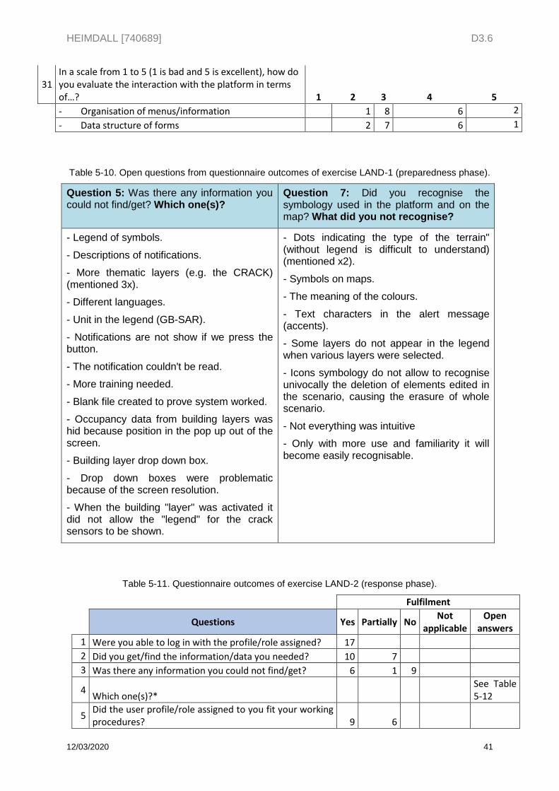
Table 5-10. Open questions from questionnaire outcomes of exercise LAND-1 (preparedness phase).
Question 5: Was there any information you could not find/get? Which one(s)?
Question 7: Did you recognise the symbology used in the platform and on the map? What did you not recognise?
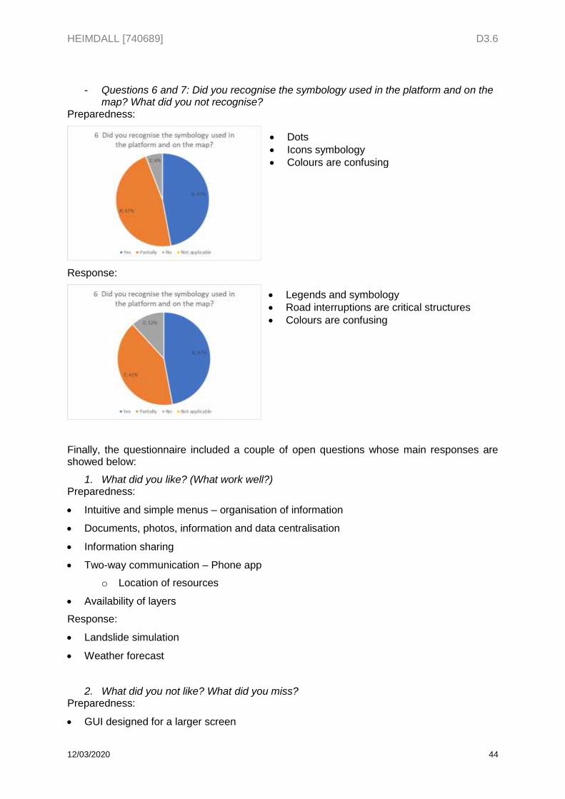
- Legend of symbols.
- Descriptions of notifications.
- More thematic layers (e.g. the CRACK) (mentioned 3x).
- Different languages.
- Unit in the legend (GB-SAR).
- Notifications are not show if we press the button.
- The notification couldn't be read.
- More training needed.
- Blank file created to prove system worked.
- Occupancy data from building layers was hid because position in the pop up out of the screen.
- Building layer drop down box.
- Drop down boxes were problematic because of the screen resolution.
- When the building "layer" was activated it did not allow the "legend" for the crack sensors to be shown.
- Dots indicating the type of the terrain" (without legend is difficult to understand) (mentioned x2).
- Symbols on maps.
- The meaning of the colours.
- Text characters in the alert message (accents).
- Some layers do not appear in the legend when various layers were selected.
- Icons symbology do not allow to recognise univocally the deletion of elements edited in the scenario, causing the erasure of whole scenario.
- Not everything was intuitive
- Only with more use and familiarity it will become easily recognisable.
Table 5-11. Questionnaire outcomes of exercise LAND-2 (response phase).
Fulfilment
Questions Yes Partially No
Not applicable
Open answers
1 Were you able to log in with the profile/role assigned? 17
2 Did you get/find the information/data you needed? 10 7
3 Was there any information you could not find/get? 6 1 9
4 Which one(s)?*
See Table 5-12
5 Did the user profile/role assigned to you fit your working procedures? 9 6
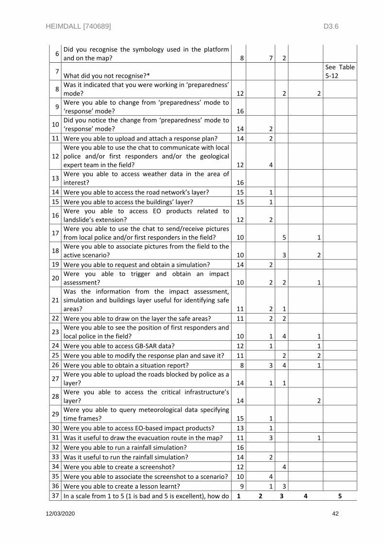
HEIMDALL [740689] D3.6
12/03/2020 42
6 Did you recognise the symbology used in the platform and on the map? 8 7 2
7 What did you not recognise?*
See Table 5-12
8 Was it indicated that you were working in ‘preparedness’ mode? 12 2 2
9 Were you able to change from ‘preparedness’ mode to ‘response’ mode? 16
10 Did you notice the change from ‘preparedness’ mode to ‘response’ mode? 14 2
11 Were you able to upload and attach a response plan? 14 2
12 Were you able to use the chat to communicate with local police and/or first responders and/or the geological expert team in the field? 12 4
13 Were you able to access weather data in the area of interest? 16
14 Were you able to access the road network’s layer? 15 1
15 Were you able to access the buildings’ layer? 15 1
16 Were you able to access EO products related to landslide’s extension? 12 2
17 Were you able to use the chat to send/receive pictures from local police and/or first responders in the field? 10 5 1
18 Were you able to associate pictures from the field to the active scenario? 10 3 2
19 Were you able to request and obtain a simulation? 14 2
20 Were you able to trigger and obtain an impact assessment? 10 2 2 1
21 Was the information from the impact assessment, simulation and buildings layer useful for identifying safe areas? 11 2 1
22 Were you able to draw on the layer the safe areas? 11 2 2
23 Were you able to see the position of first responders and local police in the field? 10 1 4 1
24 Were you able to access GB-SAR data? 12 1 1
25 Were you able to modify the response plan and save it? 11 2 2
26 Were you able to obtain a situation report? 8 3 4 1
27 Were you able to upload the roads blocked by police as a layer? 14 1 1
28 Were you able to access the critical infrastructure’s layer? 14 2
29 Were you able to query meteorological data specifying time frames? 15 1
30 Were you able to access EO-based impact products? 13 1
31 Was it useful to draw the evacuation route in the map? 11 3 1
32 Were you able to run a rainfall simulation? 16
33 Was it useful to run the rainfall simulation? 14 2
34 Were you able to create a screenshot? 12 4
35 Were you able to associate the screenshot to a scenario? 10 4
36 Were you able to create a lesson learnt? 9 1 3
37 In a scale from 1 to 5 (1 is bad and 5 is excellent), how do 1 2 3 4 5
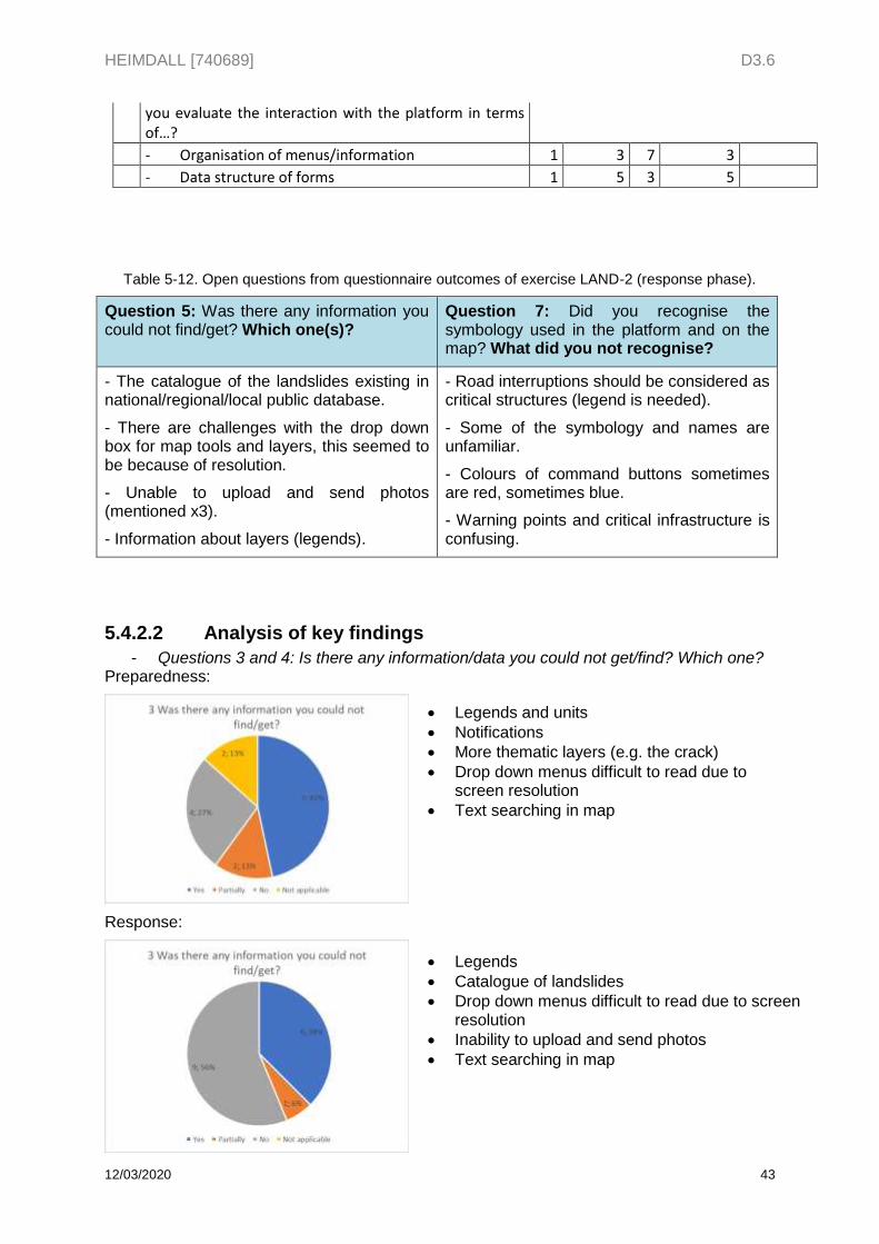
HEIMDALL [740689] D3.6
12/03/2020 43
you evaluate the interaction with the platform in terms of…?
- Organisation of menus/information 1 3 7 3
- Data structure of forms 1 5 3 5
Table 5-12. Open questions from questionnaire outcomes of exercise LAND-2 (response phase).
Question 5: Was there any information you could not find/get? Which one(s)?
Question 7: Did you recognise the symbology used in the platform and on the map? What did you not recognise?
- The catalogue of the landslides existing in national/regional/local public database.
- There are challenges with the drop down box for map tools and layers, this seemed to be because of resolution.
- Unable to upload and send photos (mentioned x3).
- Information about layers (legends).
- Road interruptions should be considered as critical structures (legend is needed).
- Some of the symbology and names are unfamiliar.
- Colours of command buttons sometimes are red, sometimes blue.
- Warning points and critical infrastructure is confusing.
5.4.2.2 Analysis of key findings
- Questions 3 and 4: Is there any information/data you could not get/find? Which one? Preparedness:
Response:
Legends and units
Notifications
More thematic layers (e.g. the crack)
Drop down menus difficult to read due to screen resolution
Text searching in map
Legends
Catalogue of landslides
Drop down menus difficult to read due to screen resolution
Inability to upload and send photos
Text searching in map
HEIMDALL [740689] D3.6
12/03/2020 44
- Questions 6 and 7: Did you recognise the symbology used in the platform and on the map? What did you not recognise?
Preparedness:
Response:
Finally, the questionnaire included a couple of open questions whose main responses are showed below:
1. What did you like? (What work well?) Preparedness:
Intuitive and simple menus – organisation of information
Documents, photos, information and data centralisation
Information sharing
Two-way communication – Phone app
o Location of resources
Availability of layers
Response:
Landslide simulation
Weather forecast
2. What did you not like? What did you miss? Preparedness:
GUI designed for a larger screen
Dots
Icons symbology
Colours are confusing
Legends and symbology
Road interruptions are critical structures
Colours are confusing
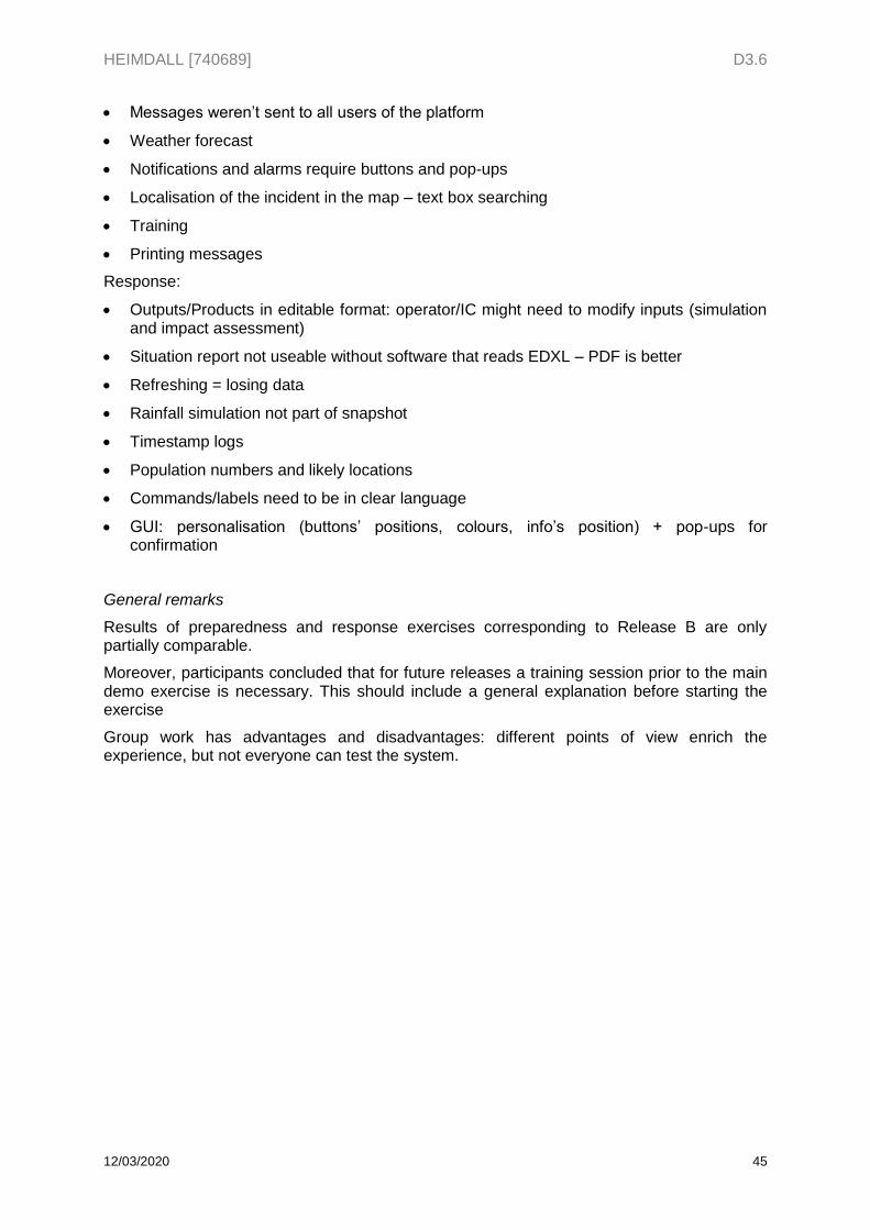
HEIMDALL [740689] D3.6
12/03/2020 45
Messages weren’t sent to all users of the platform
Weather forecast
Notifications and alarms require buttons and pop-ups
Localisation of the incident in the map – text box searching
Training
Printing messages
Response:
Outputs/Products in editable format: operator/IC might need to modify inputs (simulation and impact assessment)
Situation report not useable without software that reads EDXL – PDF is better
Refreshing = losing data
Rainfall simulation not part of snapshot
Timestamp logs
Population numbers and likely locations
Commands/labels need to be in clear language
GUI: personalisation (buttons’ positions, colours, info’s position) + pop-ups for confirmation
General remarks
Results of preparedness and response exercises corresponding to Release B are only partially comparable.
Moreover, participants concluded that for future releases a training session prior to the main demo exercise is necessary. This should include a general explanation before starting the exercise
Group work has advantages and disadvantages: different points of view enrich the experience, but not everyone can test the system.
HEIMDALL [740689] D3.6
12/03/2020 46
6 Preparation phase of exercise FLOOD-1 (Release C)
This chapter describes the preparation phase of Exercise FLOOD-1, based ona training session as well as on the Preparedness and Response phases of DRM.
6.1 Training session This chapter contains the prepared materials for the training session conducted prior to the exercise FLOOD-1.
Objectives 6.1.1
The main objective of the training session is to guarantee sufficient understanding of, and familiarity with, the system by the users prior to the demonstration exercise. The instructions that are presented here are a simplified version of the story board that will be used for the demonstration exercise with the only difference that the sequence of actions is split according to the different HEIMDALL modules. During the training session each module will be presented by a technical partner, and the set of actions relevant to that module will be performed in the main screen so that the users can do the same in parallel.
Specific objectives are outlined as follows:
Explain the general appearance of the GUI. Outline the main functionalities of the different HEIMDALL modules. Provide step-by-step examples of their operation. Attend to any queries coming from end-users. Identify new end-user requirements and modify existing ones. Provide all the information required to carry out a successful performance during the
demonstration exercise.
Story 6.1.2
6.1.2.1 Players
PD: Local Police personnel:
o PD – CRO: Police Control Room Operator
o PD – F: Police Units in the Field
FRS: Fire and Rescue Service personnel:
o FRS – CRO: Fire and Rescue Service Control Room Operator
o FRS – F: Firefighting Units in the Field
6.1.2.2 Locations
FRS – NCR: Fire and Rescue Service National Control Room
FRS – RCR: Fire and Rescue Service Regional Control Room
PD – RCR: Police Regional Control Room
CP – NCC: Civil Protection National Coordination Centre
FCP: Forward Control Post
F: Field
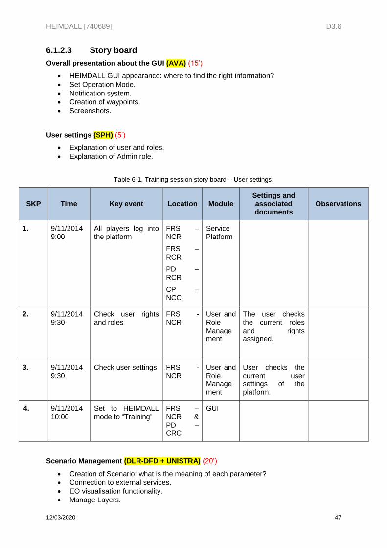
HEIMDALL [740689] D3.6
12/03/2020 47
6.1.2.3 Story board
Overall presentation about the GUI (AVA) (15’)
HEIMDALL GUI appearance: where to find the right information?
Set Operation Mode.
Notification system.
Creation of waypoints.
Screenshots.
User settings (SPH) (5’)
Explanation of user and roles.
Explanation of Admin role.
Table 6-1. Training session story board – User settings.
SKP Time Key event Location Module Settings and associated documents
Observations
1. 9/11/2014 9:00
All players log into the platform
FRS – NCR
FRS – RCR
PD – RCR
CP – NCC
Service Platform
2. 9/11/2014 9:30
Check user rights and roles
FRS - NCR
User and Role Management
The user checks the current roles and rights assigned.
3. 9/11/2014 9:30
Check user settings FRS - NCR
User and Role Management
User checks the current user settings of the platform.
4. 9/11/2014 10:00
Set to HEIMDALL mode to “Training”
FRS – NCR & PD – CRC
GUI
Scenario Management (DLR-DFD + UNISTRA) (20’)
Creation of Scenario: what is the meaning of each parameter?
Connection to external services.
EO visualisation functionality.
Manage Layers.
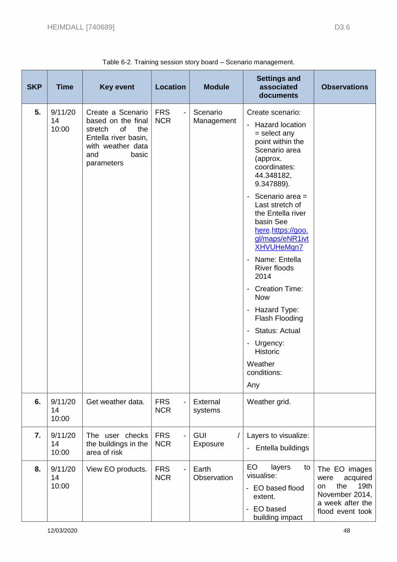
HEIMDALL [740689] D3.6
12/03/2020 48
Table 6-2. Training session story board – Scenario management.
SKP Time Key event Location Module Settings and associated documents
Observations
5. 9/11/2014 10:00
Create a Scenario based on the final stretch of the Entella river basin, with weather data and basic parameters
FRS - NCR
Scenario Management
Create scenario:
- Hazard location = select any point within the Scenario area (approx. coordinates: 44.348182, 9.347889).
- Scenario area = Last stretch of the Entella river basin See here.https://goo.gl/maps/eNR1ivtXHVUHeMqn7
- Name: Entella River floods 2014
- Creation Time: Now
- Hazard Type: Flash Flooding
- Status: Actual
- Urgency: Historic
Weather conditions:
Any
6. 9/11/2014 10:00
Get weather data. FRS - NCR
External systems
Weather grid.
7. 9/11/2014 10:00
The user checks the buildings in the area of risk
FRS - NCR
GUI / Exposure
Layers to visualize:
- Entella buildings
8. 9/11/2014 10:00
View EO products. FRS - NCR
Earth Observation
EO layers to visualise:
- EO based flood extent.
- EO based building impact
The EO images were acquired on the 19th November 2014, a week after the flood event took
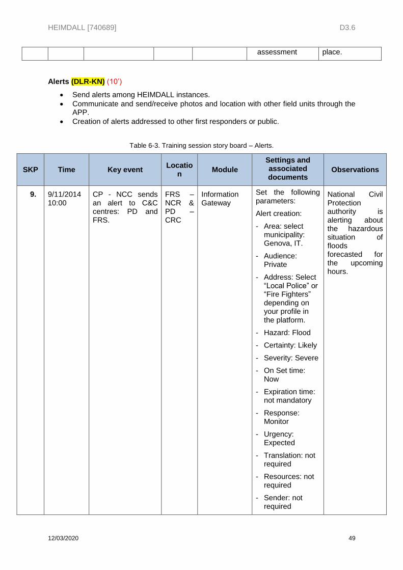
HEIMDALL [740689] D3.6
12/03/2020 49
assessment place.
Alerts (DLR-KN) (10’)
Send alerts among HEIMDALL instances.
Communicate and send/receive photos and location with other field units through the APP.
Creation of alerts addressed to other first responders or public.
Table 6-3. Training session story board – Alerts.
SKP Time Key event Locatio
n Module
Settings and associated documents
Observations
9. 9/11/2014 10:00
CP - NCC sends an alert to C&C centres: PD and FRS.
FRS – NCR & PD – CRC
Information Gateway
Set the following parameters:
Alert creation:
- Area: select municipality: Genova, IT.
- Audience: Private
- Address: Select “Local Police” or “Fire Fighters” depending on your profile in the platform.
- Hazard: Flood
- Certainty: Likely
- Severity: Severe
- On Set time: Now
- Expiration time: not mandatory
- Response: Monitor
- Urgency: Expected
- Translation: not required
- Resources: not required
- Sender: not required
National Civil Protection authority is alerting about the hazardous situation of floods forecasted for the upcoming hours.
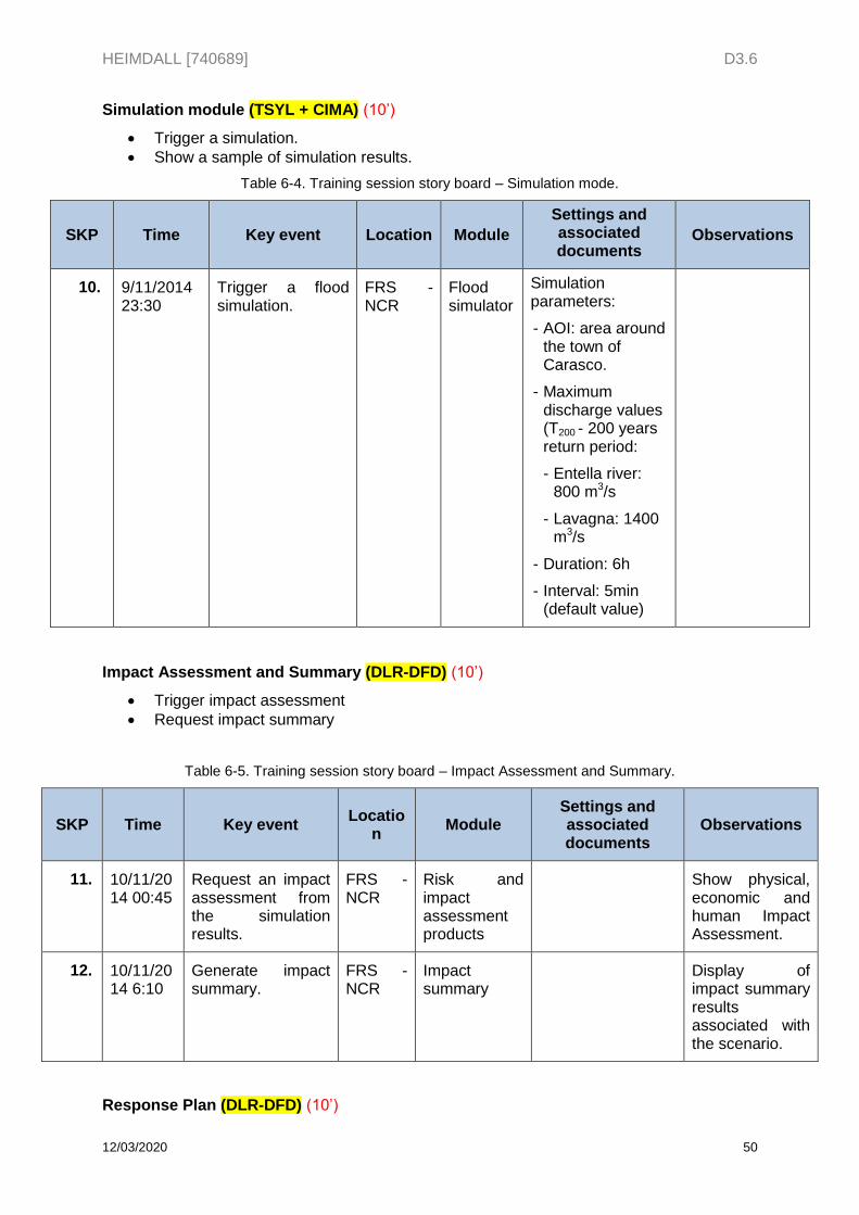
HEIMDALL [740689] D3.6
12/03/2020 50
Simulation module (TSYL + CIMA) (10’)
Trigger a simulation.
Show a sample of simulation results.
Table 6-4. Training session story board – Simulation mode.
SKP Time Key event Location Module
Settings and associated documents
Observations
10. 9/11/2014 23:30
Trigger a flood simulation.
FRS - NCR
Flood simulator
Simulation parameters:
- AOI: area around the town of Carasco.
- Maximum discharge values (T200 - 200 years return period:
- Entella river: 800 m3/s
- Lavagna: 1400 m3/s
- Duration: 6h
- Interval: 5min (default value)
Impact Assessment and Summary (DLR-DFD) (10’)
Trigger impact assessment
Request impact summary
Table 6-5. Training session story board – Impact Assessment and Summary.
SKP Time Key event Locatio
n Module
Settings and associated documents
Observations
11. 10/11/2014 00:45
Request an impact assessment from the simulation results.
FRS - NCR
Risk and impact assessment products
Show physical, economic and human Impact Assessment.
12. 10/11/2014 6:10
Generate impact summary.
FRS - NCR
Impact summary
Display of impact summary results associated with the scenario.
Response Plan (DLR-DFD) (10’)
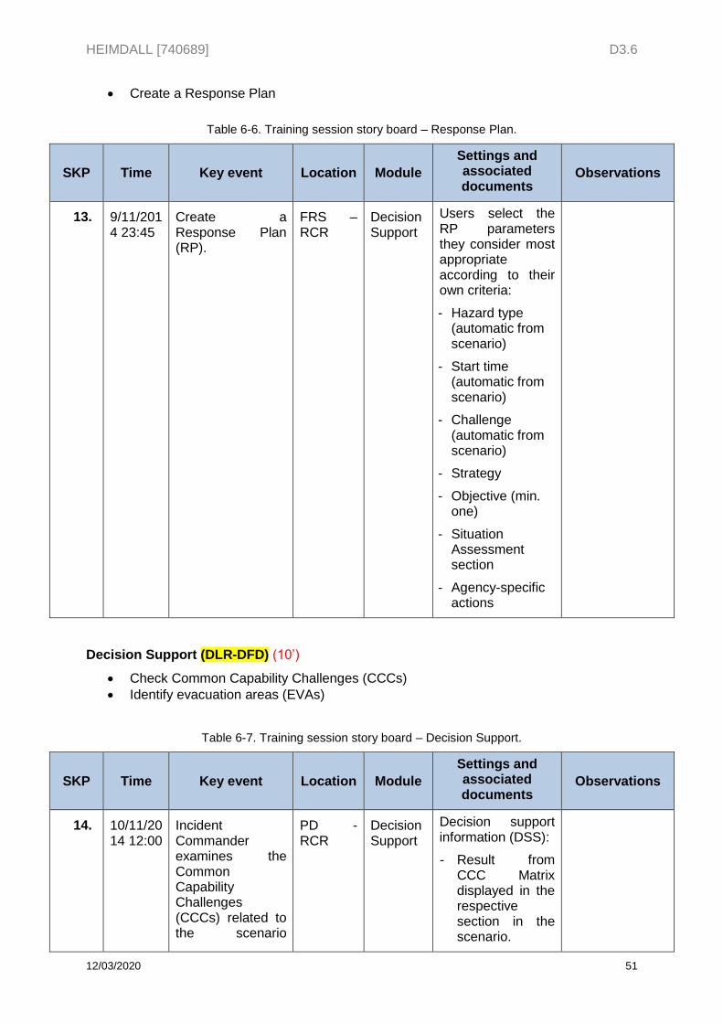
HEIMDALL [740689] D3.6
12/03/2020 51
Create a Response Plan
Table 6-6. Training session story board – Response Plan.
SKP Time Key event Location Module
Settings and associated documents
Observations
13. 9/11/2014 23:45
Create a Response Plan (RP).
FRS – RCR
Decision Support
Users select the RP parameters they consider most appropriate according to their own criteria:
- Hazard type (automatic from scenario)
- Start time (automatic from scenario)
- Challenge (automatic from scenario)
- Strategy
- Objective (min. one)
- Situation Assessment section
- Agency-specific actions
Decision Support (DLR-DFD) (10’)
Check Common Capability Challenges (CCCs)
Identify evacuation areas (EVAs)
Table 6-7. Training session story board – Decision Support.
SKP Time Key event Location Module
Settings and associated documents
Observations
14. 10/11/2014 12:00
Incident Commander examines the Common Capability Challenges (CCCs) related to the scenario
PD - RCR
Decision Support
Decision support information (DSS):
- Result from CCC Matrix displayed in the respective section in the scenario.
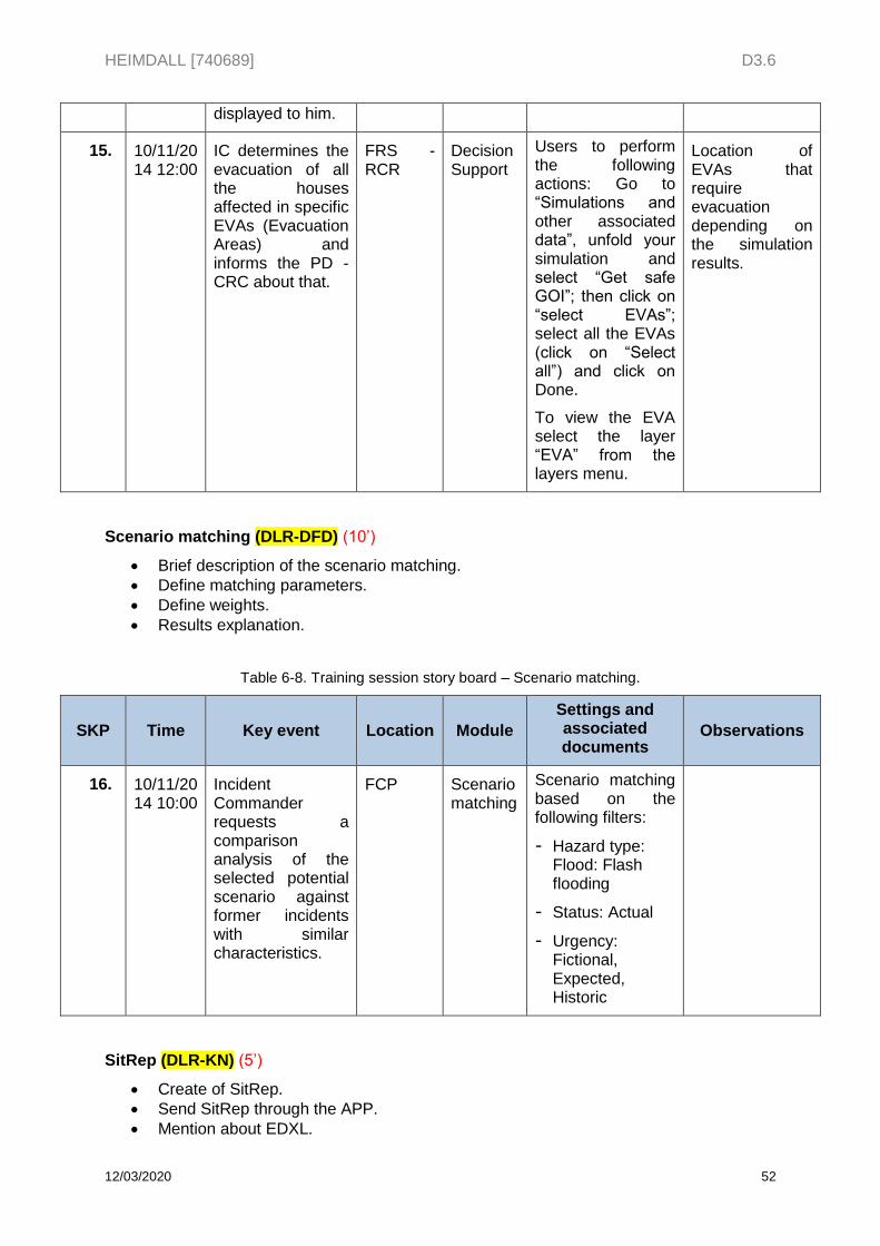
HEIMDALL [740689] D3.6
12/03/2020 52
displayed to him.
15. 10/11/2014 12:00
IC determines the evacuation of all the houses affected in specific EVAs (Evacuation Areas) and informs the PD - CRC about that.
FRS - RCR
Decision Support
Users to perform the following actions: Go to “Simulations and other associated data”, unfold your simulation and select “Get safe GOI”; then click on “select EVAs”; select all the EVAs (click on “Select all”) and click on Done.
To view the EVA select the layer “EVA” from the layers menu.
Location of EVAs that require evacuation depending on the simulation results.
Scenario matching (DLR-DFD) (10’)
Brief description of the scenario matching.
Define matching parameters.
Define weights.
Results explanation.
Table 6-8. Training session story board – Scenario matching.
SKP Time Key event Location Module
Settings and associated documents
Observations
16. 10/11/2014 10:00
Incident Commander requests a comparison analysis of the selected potential scenario against former incidents with similar characteristics.
FCP Scenario matching
Scenario matching based on the following filters:
- Hazard type: Flood: Flash flooding
- Status: Actual
- Urgency: Fictional, Expected, Historic
SitRep (DLR-KN) (5’)
Create of SitRep.
Send SitRep through the APP.
Mention about EDXL.
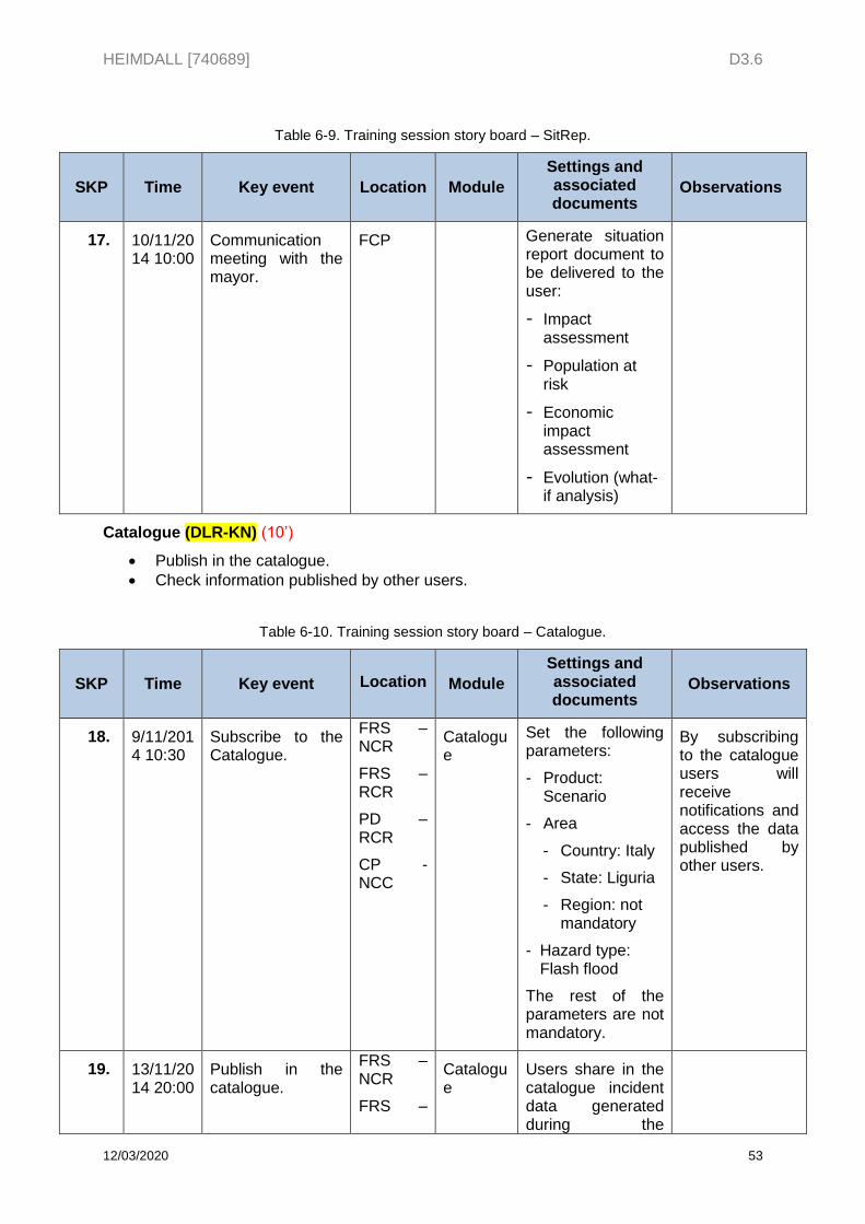
HEIMDALL [740689] D3.6
12/03/2020 53
Table 6-9. Training session story board – SitRep.
SKP Time Key event Location Module
Settings and associated documents
Observations
17. 10/11/2014 10:00
Communication meeting with the mayor.
FCP Generate situation report document to be delivered to the user:
- Impact assessment
- Population at risk
- Economic impact assessment
- Evolution (what-if analysis)
Catalogue (DLR-KN) (10’)
Publish in the catalogue.
Check information published by other users.
Table 6-10. Training session story board – Catalogue.
SKP Time Key event Location Module
Settings and associated documents
Observations
18. 9/11/2014 10:30
Subscribe to the Catalogue.
FRS – NCR
FRS – RCR
PD – RCR
CP - NCC
Catalogue
Set the following parameters:
- Product: Scenario
- Area
- Country: Italy
- State: Liguria
- Region: not mandatory
- Hazard type: Flash flood
The rest of the parameters are not mandatory.
By subscribing to the catalogue users will receive notifications and access the data published by other users.
19. 13/11/2014 20:00
Publish in the catalogue.
FRS – NCR
FRS –
Catalogue
Users share in the catalogue incident data generated during the
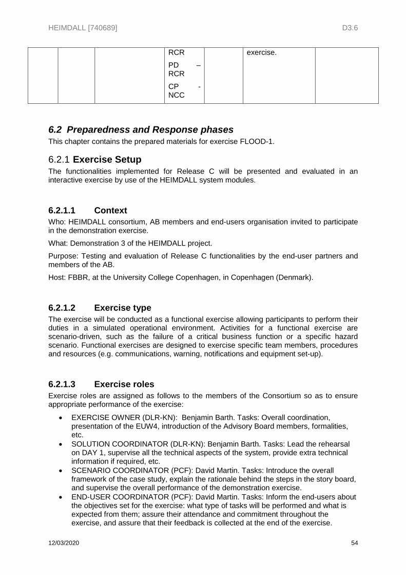
HEIMDALL [740689] D3.6
12/03/2020 54
RCR
PD – RCR
CP - NCC
exercise.
6.2 Preparedness and Response phases This chapter contains the prepared materials for exercise FLOOD-1.
Exercise Setup 6.2.1The functionalities implemented for Release C will be presented and evaluated in an interactive exercise by use of the HEIMDALL system modules.
6.2.1.1 Context
Who: HEIMDALL consortium, AB members and end-users organisation invited to participate in the demonstration exercise.
What: Demonstration 3 of the HEIMDALL project.
Purpose: Testing and evaluation of Release C functionalities by the end-user partners and members of the AB.
Host: FBBR, at the University College Copenhagen, in Copenhagen (Denmark).
6.2.1.2 Exercise type
The exercise will be conducted as a functional exercise allowing participants to perform their duties in a simulated operational environment. Activities for a functional exercise are scenario-driven, such as the failure of a critical business function or a specific hazard scenario. Functional exercises are designed to exercise specific team members, procedures and resources (e.g. communications, warning, notifications and equipment set-up).
6.2.1.3 Exercise roles
Exercise roles are assigned as follows to the members of the Consortium so as to ensure appropriate performance of the exercise:
EXERCISE OWNER (DLR-KN): Benjamin Barth. Tasks: Overall coordination, presentation of the EUW4, introduction of the Advisory Board members, formalities, etc.
SOLUTION COORDINATOR (DLR-KN): Benjamin Barth. Tasks: Lead the rehearsal on DAY 1, supervise all the technical aspects of the system, provide extra technical information if required, etc.
SCENARIO COORDINATOR (PCF): David Martin. Tasks: Introduce the overall framework of the case study, explain the rationale behind the steps in the story board, and supervise the overall performance of the demonstration exercise.
END-USER COORDINATOR (PCF): David Martin. Tasks: Inform the end-users about the objectives set for the exercise: what type of tasks will be performed and what is expected from them; assure their attendance and commitment throughout the exercise, and assure that their feedback is collected at the end of the exercise.
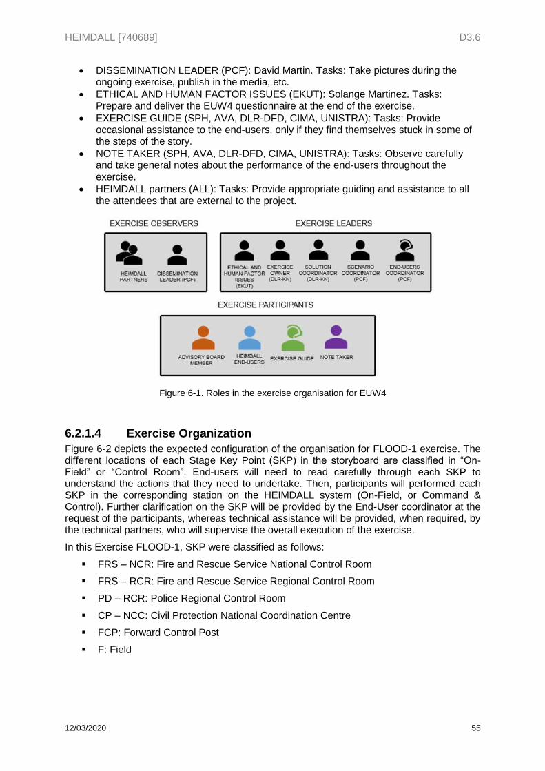
HEIMDALL [740689] D3.6
12/03/2020 55
DISSEMINATION LEADER (PCF): David Martin. Tasks: Take pictures during the ongoing exercise, publish in the media, etc.
ETHICAL AND HUMAN FACTOR ISSUES (EKUT): Solange Martinez. Tasks: Prepare and deliver the EUW4 questionnaire at the end of the exercise.
EXERCISE GUIDE (SPH, AVA, DLR-DFD, CIMA, UNISTRA): Tasks: Provide occasional assistance to the end-users, only if they find themselves stuck in some of the steps of the story.
NOTE TAKER (SPH, AVA, DLR-DFD, CIMA, UNISTRA): Tasks: Observe carefully and take general notes about the performance of the end-users throughout the exercise.
HEIMDALL partners (ALL): Tasks: Provide appropriate guiding and assistance to all the attendees that are external to the project.
Figure 6-1. Roles in the exercise organisation for EUW4
6.2.1.4 Exercise Organization
Figure 6-2 depicts the expected configuration of the organisation for FLOOD-1 exercise. The different locations of each Stage Key Point (SKP) in the storyboard are classified in “On-Field” or “Control Room”. End-users will need to read carefully through each SKP to understand the actions that they need to undertake. Then, participants will performed each SKP in the corresponding station on the HEIMDALL system (On-Field, or Command & Control). Further clarification on the SKP will be provided by the End-User coordinator at the request of the participants, whereas technical assistance will be provided, when required, by the technical partners, who will supervise the overall execution of the exercise.
In this Exercise FLOOD-1, SKP were classified as follows:
FRS – NCR: Fire and Rescue Service National Control Room
FRS – RCR: Fire and Rescue Service Regional Control Room
PD – RCR: Police Regional Control Room
CP – NCC: Civil Protection National Coordination Centre
FCP: Forward Control Post
F: Field
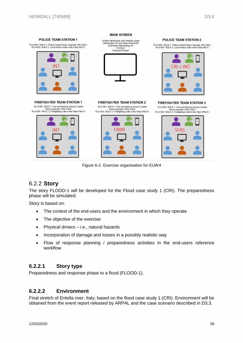
HEIMDALL [740689] D3.6
12/03/2020 56
Figure 6-2. Exercise organisation for EUW4
Story 6.2.2The story FLOOD-1 will be developed for the Flood case study 1 (CRI). The preparedness phase will be simulated.
Story is based on:
The context of the end-users and the environment in which they operate
The objective of the exercise
Physical drivers – i.e., natural hazards
Incorporation of damage and losses in a possibly realistic way
Flow of response planning / preparedness activities in the end-users reference workflow
6.2.2.1 Story type
Preparedness and response phase to a flood (FLOOD-1).
6.2.2.2 Environment
Final stretch of Entella river, Italy; based on the flood case study 1 (CRI). Environment will be obtained from the event report released by ARPAL and the case scenario described in D3.3.
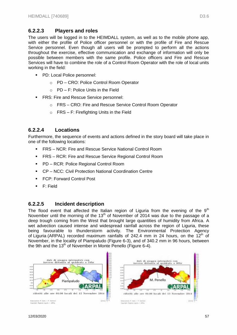
HEIMDALL [740689] D3.6
12/03/2020 57
6.2.2.3 Players and roles
The users will be logged in to the HEIMDALL system, as well as to the mobile phone app, with either the profile of Police officer personnel or with the profile of Fire and Rescue Service personnel. Even though all users will be prompted to perform all the actions throughout the exercise, effective communication and exchange of information will only be possible between members with the same profile. Police officers and Fire and Rescue Services will have to combine the role of a Control Room Operator with the role of local units working in the field:
PD: Local Police personnel:
o PD – CRO: Police Control Room Operator
o PD – F: Police Units in the Field
FRS: Fire and Rescue Service personnel:
o FRS – CRO: Fire and Rescue Service Control Room Operator
o FRS – F: Firefighting Units in the Field
6.2.2.4 Locations
Furthermore, the sequence of events and actions defined in the story board will take place in one of the following locations:
FRS – NCR: Fire and Rescue Service National Control Room
FRS – RCR: Fire and Rescue Service Regional Control Room
PD – RCR: Police Regional Control Room
CP – NCC: Civil Protection National Coordination Centre
FCP: Forward Control Post
F: Field
6.2.2.5 Incident description
The flood event that affected the Italian region of Liguria from the evening of the 9th November until the morning of the 13th of November of 2014 was due to the passage of a deep trough coming from the West that brought large quantities of humidity from Africa. A wet advection caused intense and widespread rainfall across the region of Liguria, these being favourable to thunderstorm activity. The Environmental Protection Agency of Liguria (ARPAL) recorded maximum rainfalls of 242.4 mm in 24 hours, on the 12th of November, in the locality of Piampaludo (Figure 6-3), and of 340.2 mm in 96 hours, between the 9th and the 13th of November in Monte Penello (Figure 6-4).
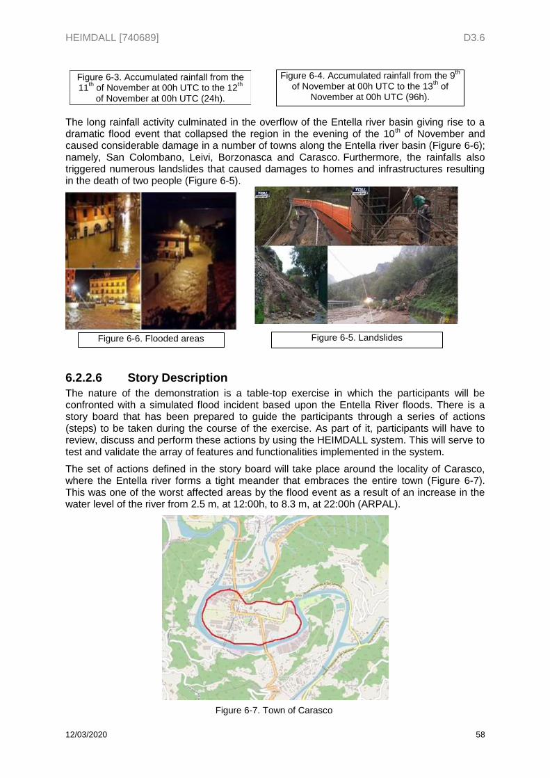
HEIMDALL [740689] D3.6
12/03/2020 58
The long rainfall activity culminated in the overflow of the Entella river basin giving rise to a dramatic flood event that collapsed the region in the evening of the 10th of November and caused considerable damage in a number of towns along the Entella river basin (Figure 6-6); namely, San Colombano, Leivi, Borzonasca and Carasco. Furthermore, the rainfalls also triggered numerous landslides that caused damages to homes and infrastructures resulting in the death of two people (Figure 6-5).
6.2.2.6 Story Description
The nature of the demonstration is a table-top exercise in which the participants will be confronted with a simulated flood incident based upon the Entella River floods. There is a story board that has been prepared to guide the participants through a series of actions (steps) to be taken during the course of the exercise. As part of it, participants will have to review, discuss and perform these actions by using the HEIMDALL system. This will serve to test and validate the array of features and functionalities implemented in the system.
The set of actions defined in the story board will take place around the locality of Carasco, where the Entella river forms a tight meander that embraces the entire town (Figure 6-7). This was one of the worst affected areas by the flood event as a result of an increase in the water level of the river from 2.5 m, at 12:00h, to 8.3 m, at 22:00h (ARPAL).
Figure 6-4. Accumulated rainfall from the 9th
of November at 00h UTC to the 13th of
November at 00h UTC (96h).
Figure 6-6. Flooded areas
Figure 6-3. Accumulated rainfall from the 11
th of November at 00h UTC to the 12
th
of November at 00h UTC (24h).
Figure 6-5. Landslides
Figure 6-7. Town of Carasco
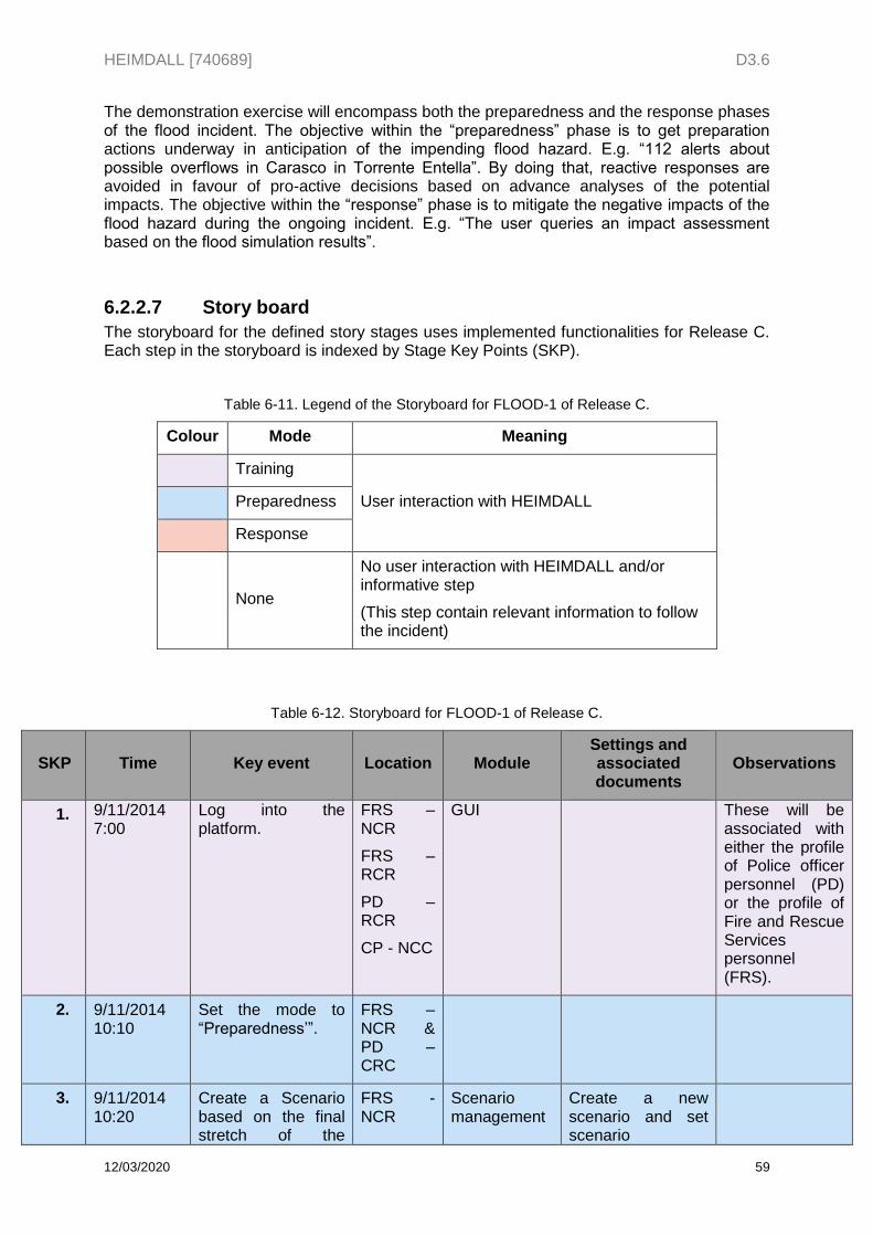
HEIMDALL [740689] D3.6
12/03/2020 59
The demonstration exercise will encompass both the preparedness and the response phases of the flood incident. The objective within the “preparedness” phase is to get preparation actions underway in anticipation of the impending flood hazard. E.g. “112 alerts about possible overflows in Carasco in Torrente Entella”. By doing that, reactive responses are avoided in favour of pro-active decisions based on advance analyses of the potential impacts. The objective within the “response” phase is to mitigate the negative impacts of the flood hazard during the ongoing incident. E.g. “The user queries an impact assessment based on the flood simulation results”.
6.2.2.7 Story board
The storyboard for the defined story stages uses implemented functionalities for Release C. Each step in the storyboard is indexed by Stage Key Points (SKP).
Table 6-11. Legend of the Storyboard for FLOOD-1 of Release C.
Colour Mode Meaning
Training
User interaction with HEIMDALL Preparedness
Response
None
No user interaction with HEIMDALL and/or informative step
(This step contain relevant information to follow the incident)
Table 6-12. Storyboard for FLOOD-1 of Release C.
SKP Time Key event Location Module Settings and associated documents
Observations
1. 9/11/2014 7:00
Log into the platform.
FRS – NCR
FRS – RCR
PD – RCR
CP - NCC
GUI
These will be associated with either the profile of Police officer personnel (PD) or the profile of Fire and Rescue Services personnel (FRS).
2. 9/11/2014 10:10
Set the mode to “Preparedness’”.
FRS – NCR & PD – CRC
3. 9/11/2014 10:20
Create a Scenario based on the final stretch of the
FRS - NCR
Scenario management
Create a new scenario and set scenario
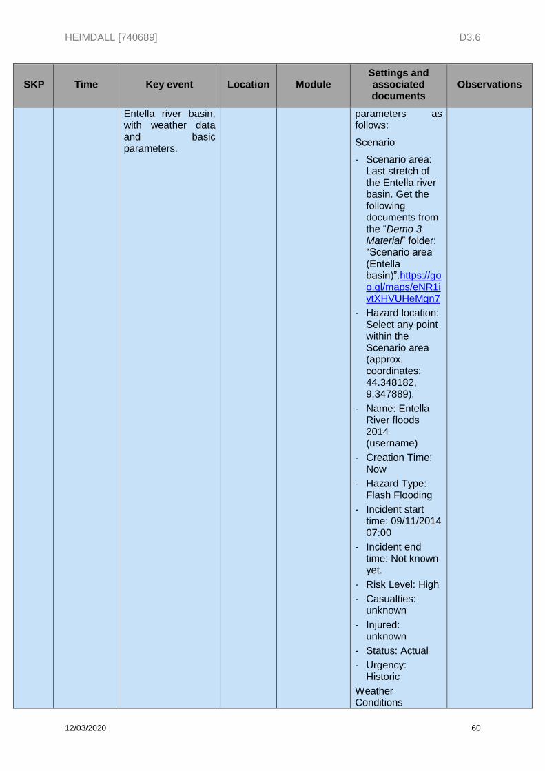
HEIMDALL [740689] D3.6
12/03/2020 60
SKP Time Key event Location Module Settings and associated documents
Observations
Entella river basin, with weather data and basic parameters.
parameters as follows:
Scenario
- Scenario area: Last stretch of the Entella river basin. Get the following documents from the “Demo 3 Material” folder: “Scenario area (Entella basin)”.https://goo.gl/maps/eNR1ivtXHVUHeMqn7
- Hazard location: Select any point within the Scenario area (approx. coordinates: 44.348182, 9.347889).
- Name: Entella River floods 2014 (username)
- Creation Time: Now
- Hazard Type: Flash Flooding
- Incident start time: 09/11/2014 07:00
- Incident end time: Not known yet.
- Risk Level: High
- Casualties: unknown
- Injured: unknown
- Status: Actual
- Urgency: Historic
Weather Conditions
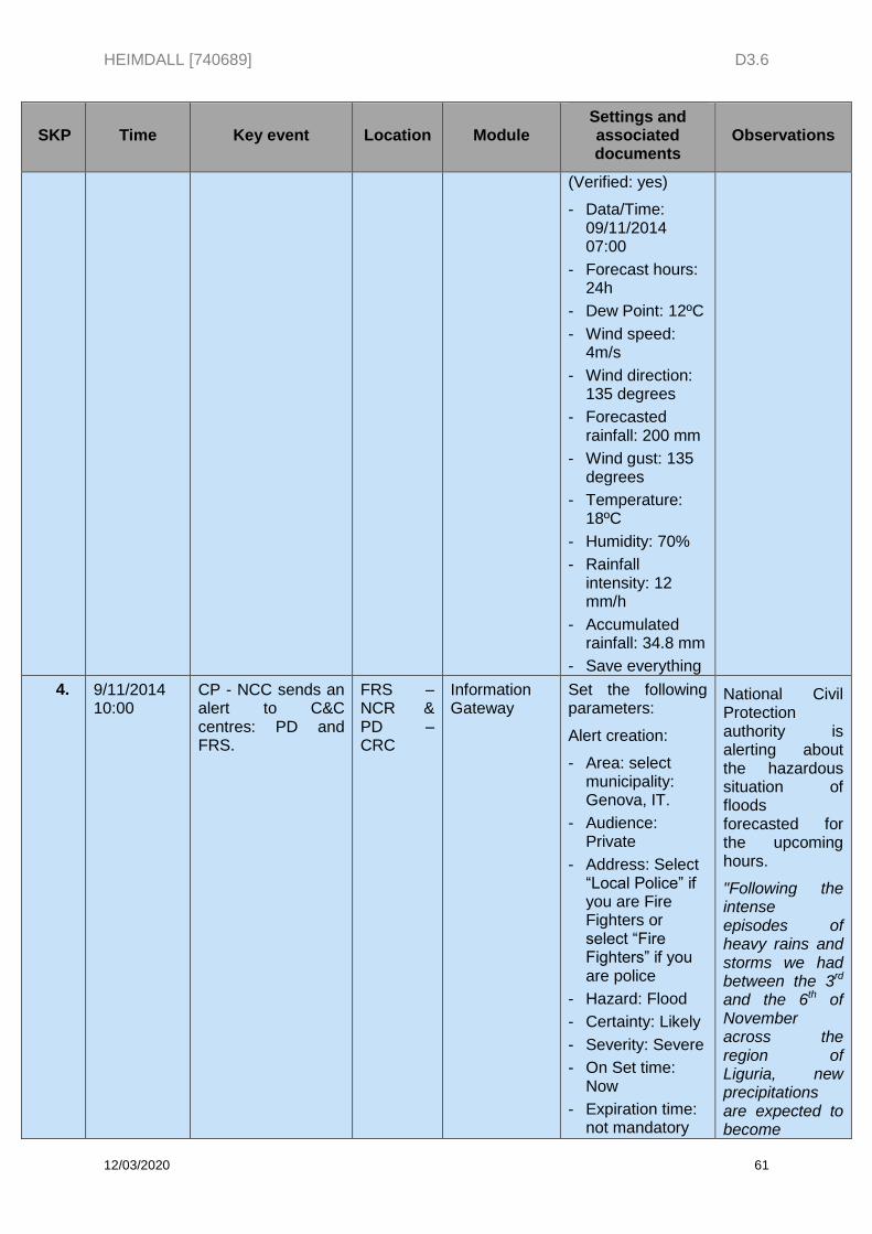
HEIMDALL [740689] D3.6
12/03/2020 61
SKP Time Key event Location Module Settings and associated documents
Observations
(Verified: yes)
- Data/Time: 09/11/2014 07:00
- Forecast hours: 24h
- Dew Point: 12ºC
- Wind speed: 4m/s
- Wind direction: 135 degrees
- Forecasted rainfall: 200 mm
- Wind gust: 135 degrees
- Temperature: 18ºC
- Humidity: 70%
- Rainfall intensity: 12 mm/h
- Accumulated rainfall: 34.8 mm
- Save everything
4. 9/11/2014 10:00
CP - NCC sends an alert to C&C centres: PD and FRS.
FRS – NCR & PD – CRC
Information Gateway
Set the following parameters:
Alert creation:
- Area: select municipality: Genova, IT.
- Audience: Private
- Address: Select “Local Police” if you are Fire Fighters or select “Fire Fighters” if you are police
- Hazard: Flood
- Certainty: Likely
- Severity: Severe
- On Set time: Now
- Expiration time: not mandatory
National Civil Protection authority is alerting about the hazardous situation of floods forecasted for the upcoming hours.
"Following the intense episodes of heavy rains and storms we had between the 3rd and the 6th of November across the region of Liguria, new precipitations are expected to become
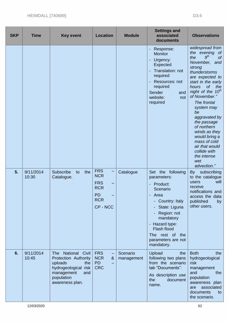
HEIMDALL [740689] D3.6
12/03/2020 62
SKP Time Key event Location Module Settings and associated documents
Observations
- Response: Monitor
- Urgency: Expected
- Translation: not required
- Resources: not required
Sender and website: not required
widespread from the evening of the 9th of November, and strong thunderstorms are expected to start in the early hours of the night of the 10th of November.”
The frontal system may be aggravated by the passage of northern winds as they would bring a mass of cold air that would collide with the intense wet advection.”
5. 9/11/2014 10:30
Subscribe to the Catalogue.
FRS – NCR
FRS – RCR
PD – RCR
CP - NCC
Catalogue Set the following parameters:
- Product: Scenario
- Area
- Country: Italy
- State: Liguria
- Region: not mandatory
- Hazard type: Flash flood
The rest of the parameters are not mandatory.
By subscribing to the catalogue users will receive notifications and access the data published by other users.
6. 9/11/2014 10:45
The National Civil Protection Authority uploads the hydrogeological risk management and population awareness plan.
FRS – NCR & PD – CRC
Scenario management
Upload the following two plans from the scenario tab “Documents”:
As description use the document name.
Both the hydrogeological risk management and the population awareness plan are associated documents to the scenario.
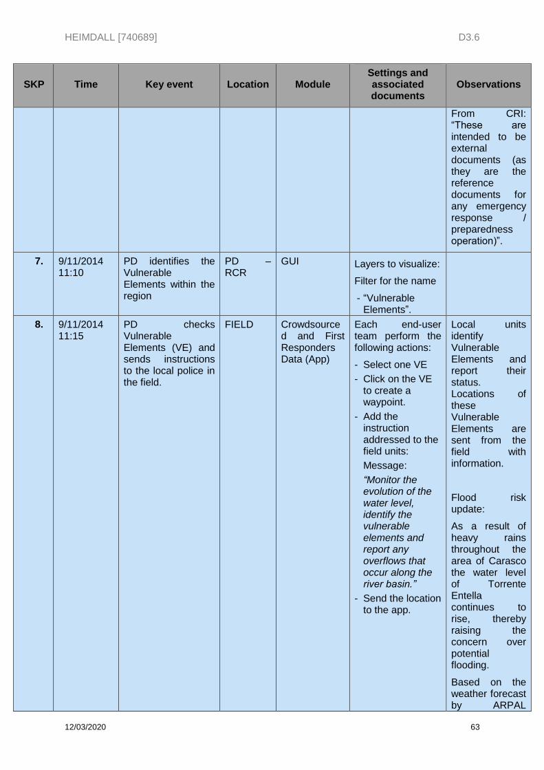
HEIMDALL [740689] D3.6
12/03/2020 63
SKP Time Key event Location Module Settings and associated documents
Observations
From CRI: “These are intended to be external documents (as they are the reference documents for any emergency response / preparedness operation)”.
7. 9/11/2014 11:10
PD identifies the Vulnerable Elements within the region
PD – RCR
GUI Layers to visualize:
Filter for the name
- “Vulnerable Elements”.
8. 9/11/2014 11:15
PD checks Vulnerable Elements (VE) and sends instructions to the local police in the field.
FIELD Crowdsourced and First Responders Data (App)
Each end-user team perform the following actions:
- Select one VE
- Click on the VE to create a waypoint.
- Add the instruction addressed to the field units:
Message:
“Monitor the evolution of the water level, identify the vulnerable elements and report any overflows that occur along the river basin.”
- Send the location to the app.
Local units identify Vulnerable Elements and report their status. Locations of these Vulnerable Elements are sent from the field with information.
Flood risk update:
As a result of heavy rains throughout the area of Carasco the water level of Torrente Entella continues to rise, thereby raising the concern over potential flooding.
Based on the weather forecast by ARPAL

HEIMDALL [740689] D3.6
12/03/2020 64
SKP Time Key event Location Module Settings and associated documents
Observations
heavy rain is expected to persist through the day. Local Units are required to look out the populated area as flooding may occur later on the day.
9. 9/11/2014 11:30
View available elements along the Entella river.
FRS - NCR
GUI / Exposure
Layers to visualize:
- “Entella buildings”
- “Entella transportation”
- “Entella LULC”
- “Entella municipalities”
Hint: you can filter for “Entella” to see only those layers.
10. 9/11/2014 12:00
Connect to a weather service to acquire weather data.
FRS - NCR
External systems
Right click on the map to get weather data from the Weather Grid.
11. 9/11/2014 14:00
The National Civil Protection Authority activates the yellow alert phase (fase di attenzione) for the Liguria Region.
FRS – NCR & PD – CRC
N/A This step is just informative. No actions to be performed by the users.
Check the following documents from the “Demo 3 Material” folder: WFD “Bollettino meteo” from ARPAL.
This is the way the civil protection communicates to the population that an area is on alert.
12. 9/11/2014 22:00
Local Police Units in the field inform about the possible overflow in SP225 bridge in Carasco.
FIELD
Crowdsourced and First Responders Data (App)
LP send a text message with information about the waypoint from the app:
Message:
“High water levels
- Approx. coordinates:
Long (X): 9.348378
Lat (Y): 44.345995
HEIMDALL [740689] D3.6
12/03/2020 65
SKP Time Key event Location Module Settings and associated documents
Observations
have already caused Torrente Entella to overwhelm its bank in the south of Carasco.”
Coordinates location. Long-9.348378. Lat-44.345995”.
13. 9/11/2014 23:00
Alert from 112:
Possible overflow of Torrente Entella in its way through the town of Carasco.
FRS - NCR
N/A This step is just informative. No actions to be performed by the users.
14. 9/11/2014 23:10
Set mode to “Response”.
FRS – NCR & PD – CRC
N/A
15. 10/11/2014 6:00
Flood analyst queries weather forecast for +3 +6 +9 hours.
FRS - NCR
Service Platform
Weather forecast for 0/+3/+6/+9h.
Right click on the map to get weather data from the Weather Grid and select the time intervals +3/+6/+9h to get the weather data.
Note, historical conditions were:
- Dew Point: 15/14/14/12 ºC
- Wind speed: 6/6/7/11 m/s
- Wind direction: 145/145/180/190 degrees
- Forecasted rainfall: 190/180/170/145 mm
- Wind gust: 145/150/170/175 degrees
- Temperature: 12/14/17/21 ºC
- Humidity: 83/82/80/74%
- Rainfall intensity: 50/40/40/35
HEIMDALL [740689] D3.6
12/03/2020 66
SKP Time Key event Location Module Settings and associated documents
Observations
mm/h
Accumulated rainfall: 0/120/160/195 mm
16. 9/11/2014 23:10
Update of scenario. FRS - NCR
Scenario management
Set scenario parameters as follows:
- Change scenario area: Check the exact location in the “Demo 3 Material” folder: “Scenario area (Carasco)”.
- Change Hazard location: Carasco, whose coordinates are:
Long (X): 9.348329
Lat (Y): 44.346200
- Status=”Actual”
- Urgency=”Immediate”
- Challenge: Low frequency, high impact
- Save modifications
-
17. 9/11/2014 23:30
Trigger flood simulation.
FRS - NCR
Flood simulator
Simulation parameters:
- Name: flood (username)
- AOI: area around the town of Carasco. Check the exact location in the “Demo 3 Material” folder: “Scenario area (Carasco)”.
- Maximum discharge values. Set the streams
The simulation run takes about 10 minutes until the results are generated.
In the meantime, users can move to the next step.
HEIMDALL [740689] D3.6
12/03/2020 67
SKP Time Key event Location Module Settings and associated documents
Observations
according to file “Streams” (T200 - 200 years return period):
- Entella river: 520 m3/s
- Lavagna: 1062 m3/s
- Resolution: 5 m
- Speed: 5 m/s
- Duration: 3h
- Interval: 300s
18. 10/11/2014 23:35
View of EO products.
FRS - NCR
Earth observation
EO layers to visualise:
- EO based flood extent.
- EO based landslide extent
- EO based building impact assessment
- EO based road impact assessment
- EO based population impact assessment
- EO based Land Use / Land Cover impact assessment
Users display the EO layers on the map and discuss about the information they provide.
19. 9/11/2014 23:40
Create a screenshot showing the simulation results.
FRS - NCR
GUI Right click on the map and select “Save screenshot to file”
Screenshot associated to an active scenario.
20. 9/11/2014 23:45
Create a Response Plan and attach the screenshot.
FRS – RCR
Scenario management
Users select the RP parameters they consider more appropriate according to their own criteria, at least:
- Hazard type (automatic from scenario)
- Start time
HEIMDALL [740689] D3.6
12/03/2020 68
SKP Time Key event Location Module Settings and associated documents
Observations
(09.11.2014 23:10)
- Incident Challenge Level
- Strategy
- Objective (min. one)
21. 9/11/2014 23:45
New alert creation and activation of Local Police or Fire Fighter units in the field.
FIELD Crowdsourced and First Responders Data (App)
Create an alert:
- Area: select municipality: Genova, IT.
- Audience: Private
- Address: Select “Local Police” if you are Police or select “Fire Fighters” if you are fire fighter
- Hazard: Flash flood
- Certainty: Observed
- Severity: Severe
- On Set time : Now
- Expiration time: not mandatory
- Response: open to the users
- Urgency: Immediate
- Additional instructions: “The southern access road to the town through the SP225 bridge (via Montanara Disma) is completely overflooded, while high-volume discharges are spreading rapidly toward the centre of the town.”
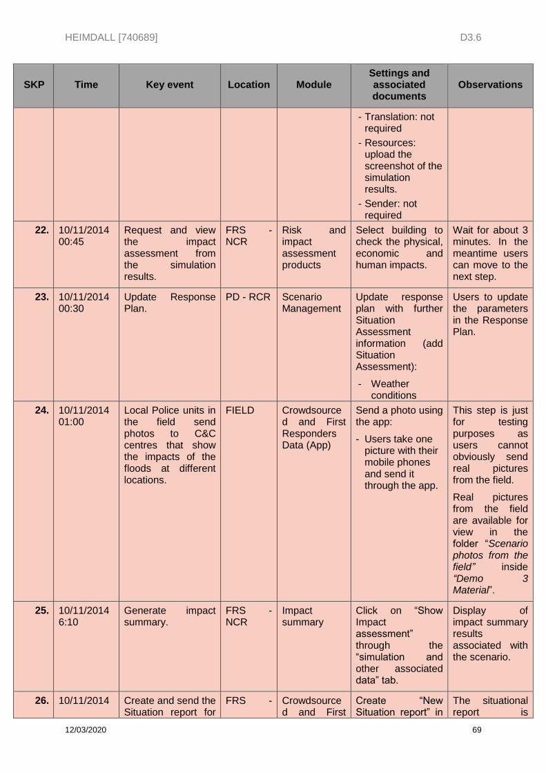
HEIMDALL [740689] D3.6
12/03/2020 69
SKP Time Key event Location Module Settings and associated documents
Observations
- Translation: not required
- Resources: upload the screenshot of the simulation results.
- Sender: not required
22. 10/11/2014 00:45
Request and view the impact assessment from the simulation results.
FRS - NCR
Risk and impact assessment products
Select building to check the physical, economic and human impacts.
Wait for about 3 minutes. In the meantime users can move to the next step.
23. 10/11/2014 00:30
Update Response Plan.
PD - RCR Scenario Management
Update response plan with further Situation Assessment information (add Situation Assessment):
- Weather conditions
Users to update the parameters in the Response Plan.
24. 10/11/2014 01:00
Local Police units in the field send photos to C&C centres that show the impacts of the floods at different locations.
FIELD Crowdsourced and First Responders Data (App)
Send a photo using the app:
- Users take one picture with their mobile phones and send it through the app.
This step is just for testing purposes as users cannot obviously send real pictures from the field.
Real pictures from the field are available for view in the folder “Scenario photos from the field” inside “Demo 3 Material”.
25. 10/11/2014 6:10
Generate impact summary.
FRS - NCR
Impact summary
Click on “Show Impact assessment” through the “simulation and other associated data” tab.
Display of impact summary results associated with the scenario.
26. 10/11/2014 Create and send the Situation report for
FRS - Crowdsourced and First
Create “New Situation report” in
The situational report is
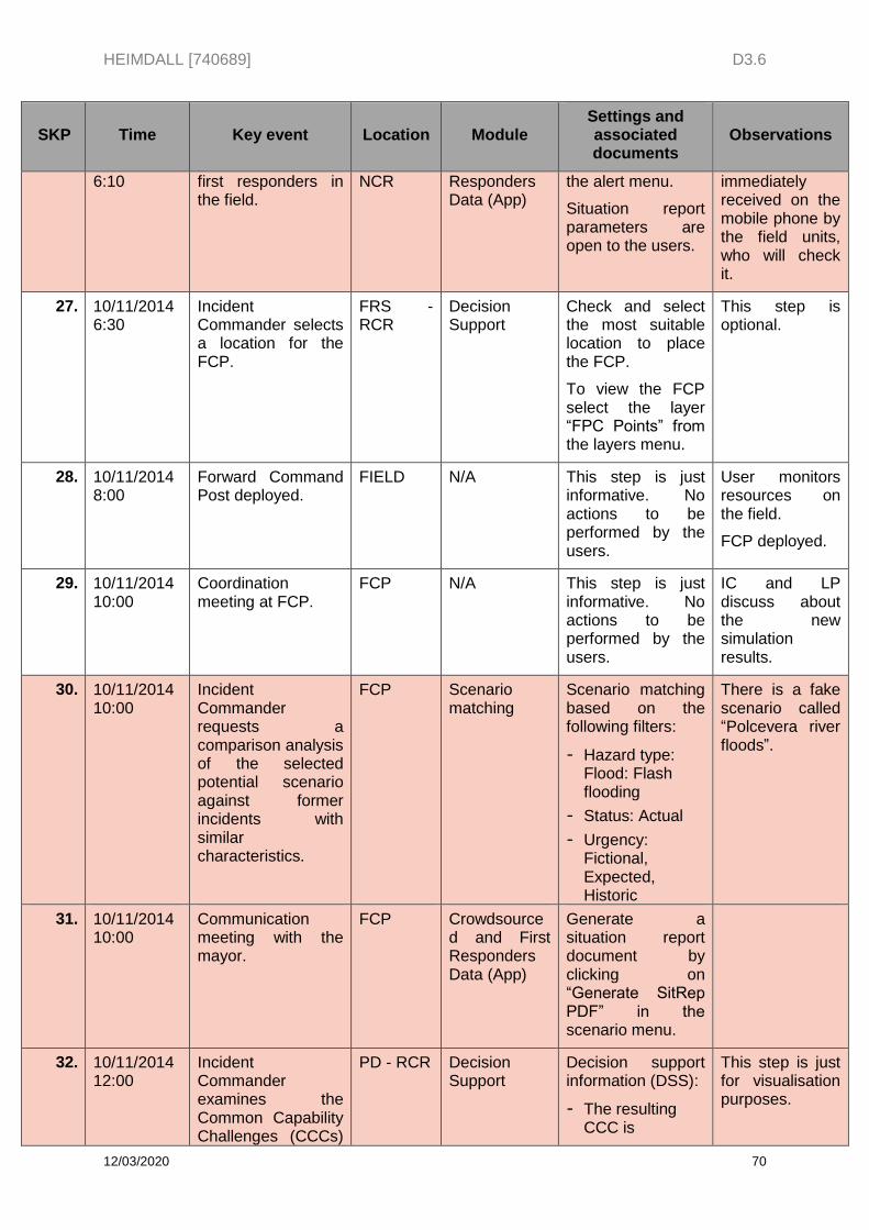
HEIMDALL [740689] D3.6
12/03/2020 70
SKP Time Key event Location Module Settings and associated documents
Observations
6:10 first responders in the field.
NCR Responders Data (App)
the alert menu.
Situation report parameters are open to the users.
immediately received on the mobile phone by the field units, who will check it.
27. 10/11/2014 6:30
Incident Commander selects a location for the FCP.
FRS - RCR
Decision Support
Check and select the most suitable location to place the FCP.
To view the FCP select the layer “FPC Points” from the layers menu.
This step is optional.
28. 10/11/2014 8:00
Forward Command Post deployed.
FIELD N/A This step is just informative. No actions to be performed by the users.
User monitors resources on the field.
FCP deployed.
29. 10/11/2014 10:00
Coordination meeting at FCP.
FCP N/A This step is just informative. No actions to be performed by the users.
IC and LP discuss about the new simulation results.
30. 10/11/2014 10:00
Incident Commander requests a comparison analysis of the selected potential scenario against former incidents with similar characteristics.
FCP Scenario matching
Scenario matching based on the following filters:
- Hazard type: Flood: Flash flooding
- Status: Actual
- Urgency: Fictional, Expected, Historic
There is a fake scenario called “Polcevera river floods”.
31. 10/11/2014 10:00
Communication meeting with the mayor.
FCP Crowdsourced and First Responders Data (App)
Generate a situation report document by clicking on “Generate SitRep PDF” in the scenario menu.
32. 10/11/2014 12:00
Incident Commander examines the Common Capability Challenges (CCCs)
PD - RCR Decision Support
Decision support information (DSS):
- The resulting CCC is
This step is just for visualisation purposes.
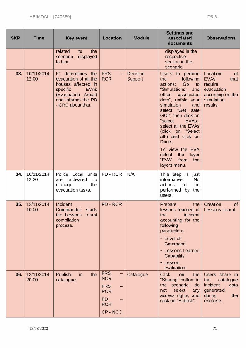
HEIMDALL [740689] D3.6
12/03/2020 71
SKP Time Key event Location Module Settings and associated documents
Observations
related to the scenario displayed to him.
displayed in the respective section in the scenario.
33. 10/11/2014 12:00
IC determines the evacuation of all the houses affected in specific EVAs (Evacuation Areas) and informs the PD - CRC about that.
FRS - RCR
Decision Support
Users to perform the following actions: Go to “Simulations and other associated data”, unfold your simulation and select “Get safe GOI”; then click on “select EVAs”; select all the EVAs (click on “Select all”) and click on Done.
To view the EVA select the layer “EVA” from the layers menu.
Location of EVAs that require evacuation according on the simulation results.
34. 10/11/2014 12:30
Police Local units are activated to manage the evacuation tasks.
PD - RCR N/A This step is just informative. No actions to be performed by the users.
35. 12/11/2014 10:00
Incident Commander starts the Lessons Learnt compilation process.
PD - RCR Prepare the lessons learned of the incident accounting for the following parameters:
- Level of Command
- Lessons Learned Capability
- Lesson evaluation
Creation of Lessons Learnt.
36. 13/11/2014 20:00
Publish in the catalogue.
FRS – NCR
FRS – RCR
PD – RCR
CP - NCC
Catalogue Click on the “Sharing” bottom in the scenario, do not select any access rights, and click on “Publish”.
Users share in the catalogue incident data generated during the exercise.
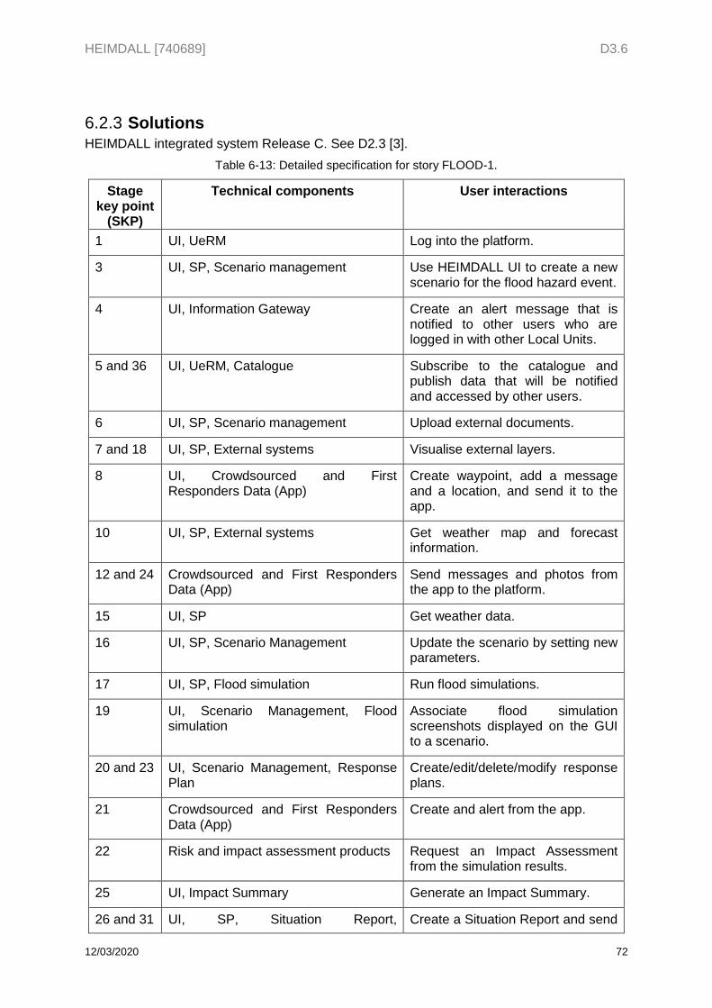
HEIMDALL [740689] D3.6
12/03/2020 72
Solutions 6.2.3HEIMDALL integrated system Release C. See D2.3 [3].
Table 6-13: Detailed specification for story FLOOD-1.
Stage key point
(SKP)
Technical components User interactions
1 UI, UeRM Log into the platform.
3 UI, SP, Scenario management Use HEIMDALL UI to create a new scenario for the flood hazard event.
4 UI, Information Gateway Create an alert message that is notified to other users who are logged in with other Local Units.
5 and 36 UI, UeRM, Catalogue Subscribe to the catalogue and publish data that will be notified and accessed by other users.
6 UI, SP, Scenario management Upload external documents.
7 and 18 UI, SP, External systems Visualise external layers.
8 UI, Crowdsourced and First Responders Data (App)
Create waypoint, add a message and a location, and send it to the app.
10 UI, SP, External systems Get weather map and forecast information.
12 and 24 Crowdsourced and First Responders Data (App)
Send messages and photos from the app to the platform.
15 UI, SP Get weather data.
16 UI, SP, Scenario Management Update the scenario by setting new parameters.
17 UI, SP, Flood simulation Run flood simulations.
19 UI, Scenario Management, Flood simulation
Associate flood simulation screenshots displayed on the GUI to a scenario.
20 and 23 UI, Scenario Management, Response Plan
Create/edit/delete/modify response plans.
21 Crowdsourced and First Responders Data (App)
Create and alert from the app.
22 Risk and impact assessment products Request an Impact Assessment from the simulation results.
25 UI, Impact Summary Generate an Impact Summary.
26 and 31 UI, SP, Situation Report, Create a Situation Report and send
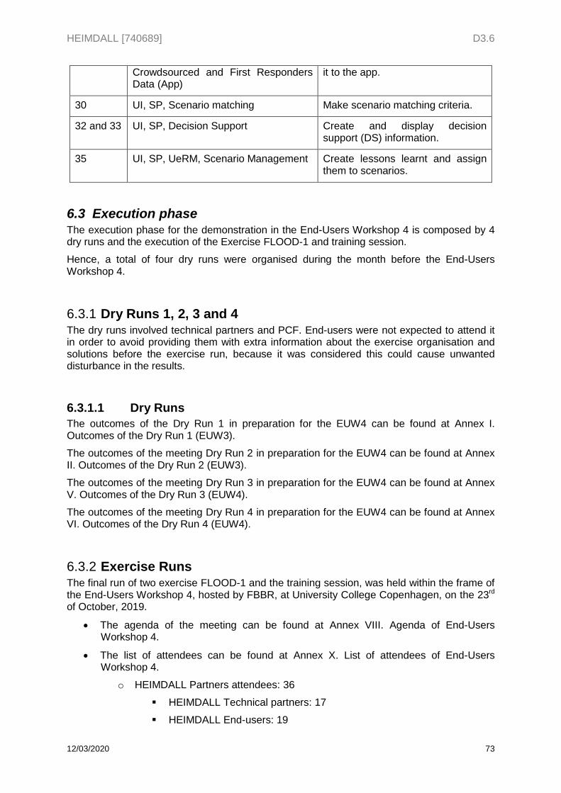
HEIMDALL [740689] D3.6
12/03/2020 73
Crowdsourced and First Responders Data (App)
it to the app.
30 UI, SP, Scenario matching Make scenario matching criteria.
32 and 33 UI, SP, Decision Support Create and display decision support (DS) information.
35 UI, SP, UeRM, Scenario Management Create lessons learnt and assign them to scenarios.
6.3 Execution phase The execution phase for the demonstration in the End-Users Workshop 4 is composed by 4 dry runs and the execution of the Exercise FLOOD-1 and training session.
Hence, a total of four dry runs were organised during the month before the End-Users Workshop 4.
Dry Runs 1, 2, 3 and 4 6.3.1The dry runs involved technical partners and PCF. End-users were not expected to attend it in order to avoid providing them with extra information about the exercise organisation and solutions before the exercise run, because it was considered this could cause unwanted disturbance in the results.
6.3.1.1 Dry Runs
The outcomes of the Dry Run 1 in preparation for the EUW4 can be found at Annex I. Outcomes of the Dry Run 1 (EUW3).
The outcomes of the meeting Dry Run 2 in preparation for the EUW4 can be found at Annex II. Outcomes of the Dry Run 2 (EUW3).
The outcomes of the meeting Dry Run 3 in preparation for the EUW4 can be found at Annex V. Outcomes of the Dry Run 3 (EUW4).
The outcomes of the meeting Dry Run 4 in preparation for the EUW4 can be found at Annex VI. Outcomes of the Dry Run 4 (EUW4).
Exercise Runs 6.3.2The final run of two exercise FLOOD-1 and the training session, was held within the frame of the End-Users Workshop 4, hosted by FBBR, at University College Copenhagen, on the 23rd of October, 2019.
The agenda of the meeting can be found at Annex VIII. Agenda of End-Users Workshop 4.
The list of attendees can be found at Annex X. List of attendees of End-Users Workshop 4.
o HEIMDALL Partners attendees: 36
HEIMDALL Technical partners: 17
HEIMDALL End-users: 19
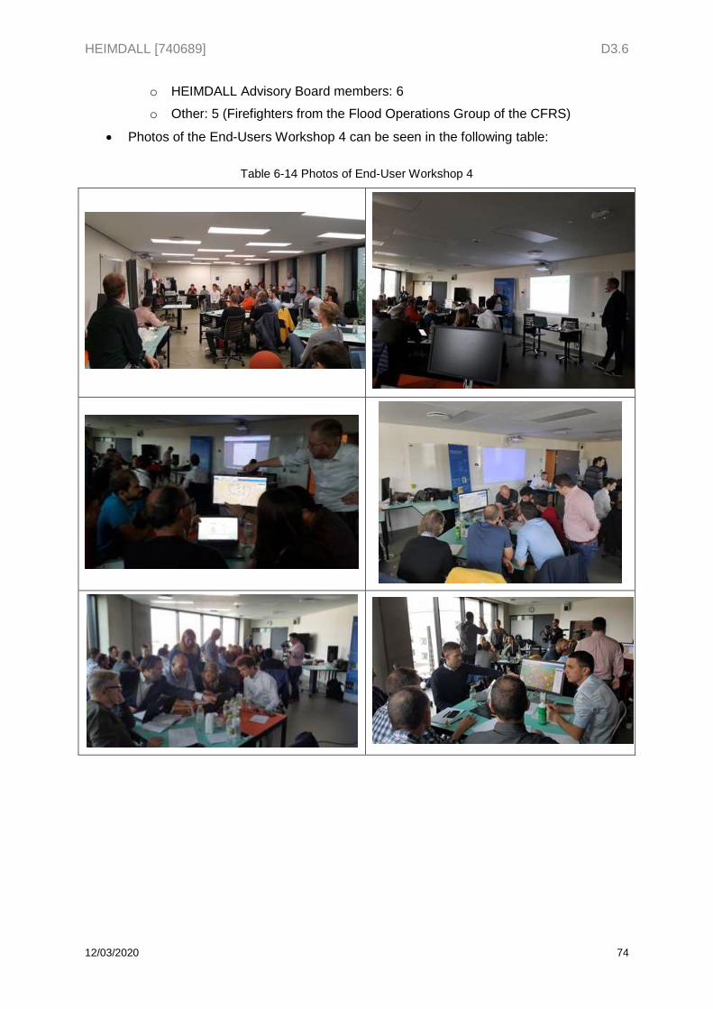
HEIMDALL [740689] D3.6
12/03/2020 74
o HEIMDALL Advisory Board members: 6
o Other: 5 (Firefighters from the Flood Operations Group of the CFRS)
Photos of the End-Users Workshop 4 can be seen in the following table:
Table 6-14 Photos of End-User Workshop 4
HEIMDALL [740689] D3.6
12/03/2020 75
6.4 Evaluation phase This chapter comprises the actions to collect and analyse the feedback from end-users after the demonstration, as well as the information and data collected by technical partners along the exercise sessions.
Data collection 6.4.1Two data collection techniques were employed in order to gather participants’ feedback on the platform features and functionalities:
- Note taking: through the ongoing exercise there was a dedicated note taker to collect all the system’s shortcomings, and key missing capabilities pointed by the participants and the member of the AB as well as other feedback.
- Questionnaire: a questionnaire prepared by EKUT and specifically addressed to the project end-users was prepared in order to assess the fulfilment of user requirements. A sample of this questionnaire can be seen in the Annex XIII. Questionnaire for End-Users Workshop 4.
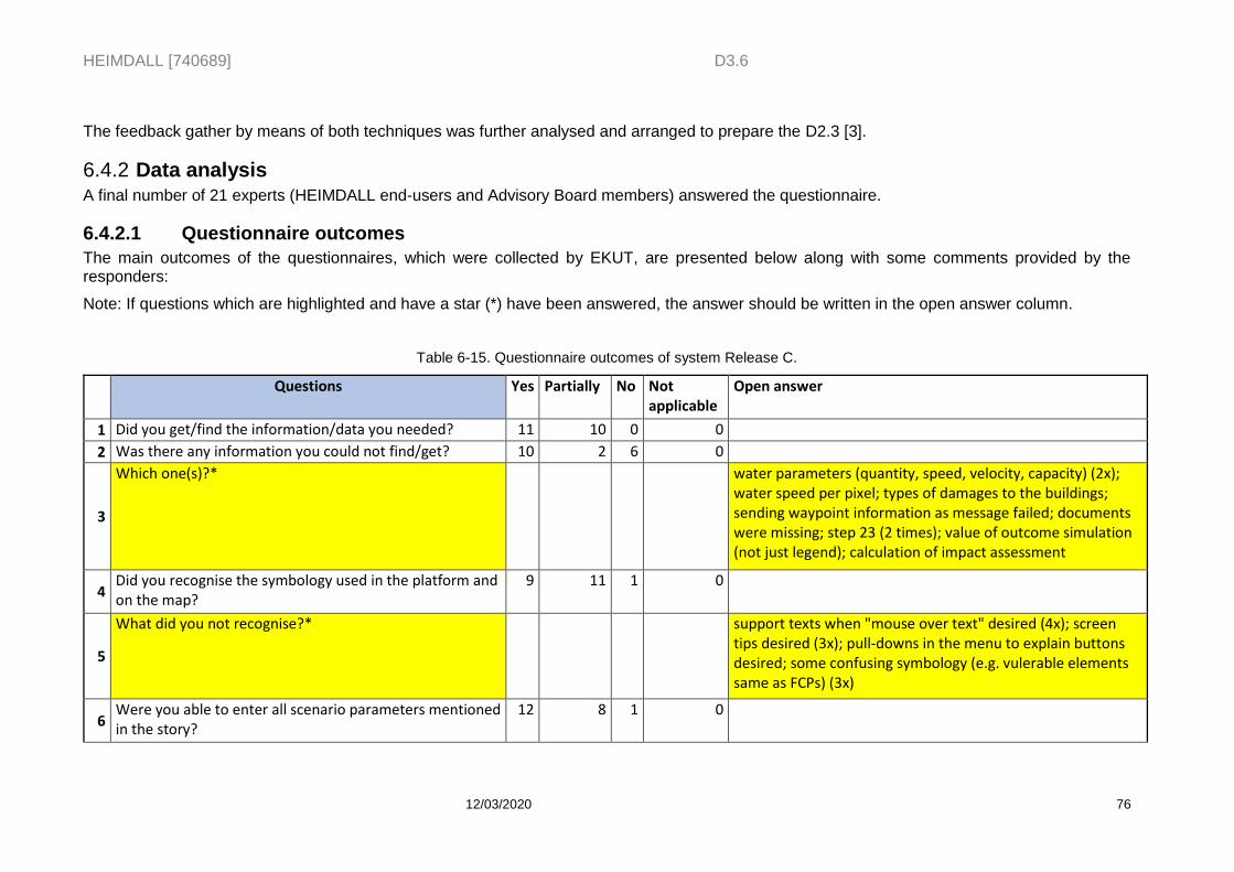
HEIMDALL [740689] D3.6
12/03/2020 76
The feedback gather by means of both techniques was further analysed and arranged to prepare the D2.3 [3].
Data analysis 6.4.2A final number of 21 experts (HEIMDALL end-users and Advisory Board members) answered the questionnaire.
6.4.2.1 Questionnaire outcomes
The main outcomes of the questionnaires, which were collected by EKUT, are presented below along with some comments provided by the responders:
Note: If questions which are highlighted and have a star (*) have been answered, the answer should be written in the open answer column.
Table 6-15. Questionnaire outcomes of system Release C.
Questions Yes Partially No Not applicable
Open answer
1 Did you get/find the information/data you needed? 11 10 0 0
2 Was there any information you could not find/get? 10 2 6 0
3
Which one(s)?* water parameters (quantity, speed, velocity, capacity) (2x); water speed per pixel; types of damages to the buildings; sending waypoint information as message failed; documents were missing; step 23 (2 times); value of outcome simulation (not just legend); calculation of impact assessment
4 Did you recognise the symbology used in the platform and on the map?
9 11 1 0
5
What did you not recognise?* support texts when "mouse over text" desired (4x); screen tips desired (3x); pull-downs in the menu to explain buttons desired; some confusing symbology (e.g. vulerable elements same as FCPs) (3x)
6 Were you able to enter all scenario parameters mentioned in the story?
12 8 1 0
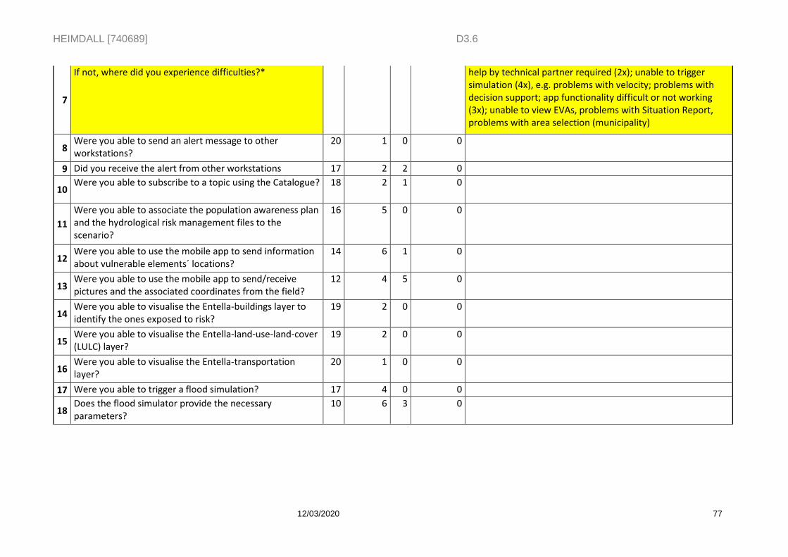
HEIMDALL [740689] D3.6
12/03/2020 77
7
If not, where did you experience difficulties?* help by technical partner required (2x); unable to trigger simulation (4x), e.g. problems with velocity; problems with decision support; app functionality difficult or not working (3x); unable to view EVAs, problems with Situation Report, problems with area selection (municipality)
8 Were you able to send an alert message to other workstations?
20 1 0 0
9 Did you receive the alert from other workstations 17 2 2 0
10 Were you able to subscribe to a topic using the Catalogue? 18 2 1 0
11
Were you able to associate the population awareness plan and the hydrological risk management files to the scenario?
16 5 0 0
12 Were you able to use the mobile app to send information about vulnerable elements´ locations?
14 6 1 0
13 Were you able to use the mobile app to send/receive pictures and the associated coordinates from the field?
12 4 5 0
14 Were you able to visualise the Entella-buildings layer to identify the ones exposed to risk?
19 2 0 0
15 Were you able to visualise the Entella-land-use-land-cover (LULC) layer?
19 2 0 0
16 Were you able to visualise the Entella-transportation layer?
20 1 0 0
17 Were you able to trigger a flood simulation? 17 4 0 0
18 Does the flood simulator provide the necessary parameters?
10 6 3 0
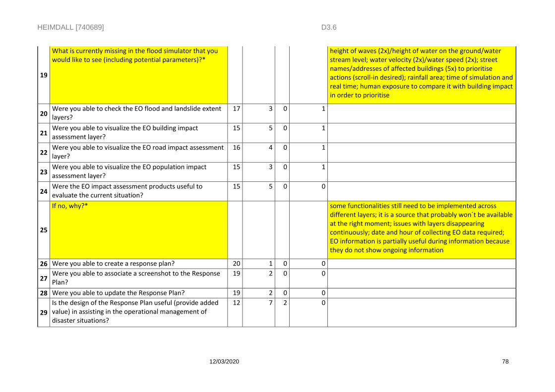
HEIMDALL [740689] D3.6
12/03/2020 78
19
What is currently missing in the flood simulator that you would like to see (including potential parameters)?*
height of waves (2x)/height of water on the ground/water stream level; water velocity (2x)/water speed (2x); street names/addresses of affected buildings (5x) to prioritise actions (scroll-in desired); rainfall area; time of simulation and real time; human exposure to compare it with building impact in order to prioritise
20 Were you able to check the EO flood and landslide extent layers?
17 3 0 1
21 Were you able to visualize the EO building impact assessment layer?
15 5 0 1
22 Were you able to visualize the EO road impact assessment layer?
16 4 0 1
23 Were you able to visualize the EO population impact assessment layer?
15 3 0 1
24 Were the EO impact assessment products useful to evaluate the current situation?
15 5 0 0
25
If no, why?* some functionalities still need to be implemented across different layers; it is a source that probably won´t be available at the right moment; issues with layers disappearing continuously; date and hour of collecting EO data required; EO information is partially useful during information because they do not show ongoing information
26 Were you able to create a response plan? 20 1 0 0
27 Were you able to associate a screenshot to the Response Plan?
19 2 0 0
28 Were you able to update the Response Plan? 19 2 0 0
29
Is the design of the Response Plan useful (provide added value) in assisting in the operational management of disaster situations?
12 7 2 0
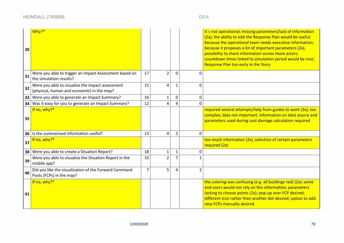
HEIMDALL [740689] D3.6
12/03/2020 79
30
Why?* it´s not operational; missing parameters/lack of information (2x); the ability to edit the Response Plan would be useful; because the operational team needs executive information; because it proposes a lot of important parameters (2x), possibility to share information across more actors; countdown times linked to simulation period would be nice; Response Plan too early in the Story
31 Were you able to trigger an Impact Assessment based on the simulation results?
17 2 0 0
32 Were you able to visualize the impact assessment (physical, human and economic) in the map?
15 4 1 0
33 Were you able to generate an Impact Summary? 16 1 0 0
34 Was it easy for you to generate an Impact Summary? 12 4 4 0
35
If no, why?* required several attempts/help from guides to work (3x); too complex; data not important; information on data source and parameters used during cost damage calculation required
36 Is the summarised information useful? 13 4 2 0
37 If no, why?* too much information (2x), selection of certain parameters
required (2x)
38 Were you able to create a Situation Report? 18 1 1 0
39 Were you able to visualize the Situation Report in the mobile app?
10 2 7 1
40 Did you like the visualization of the Forward Command Posts (FCPs) in the map?
7 5 4 2
41
If no, why?* the coloring was confusing (e.g. all buildings red) (2x); some end users would not rely on this information; parameters lacking to choose points (2x); pop-up over FCP desired; different icon rather than another dot desired; option to add new FCPs manually desired
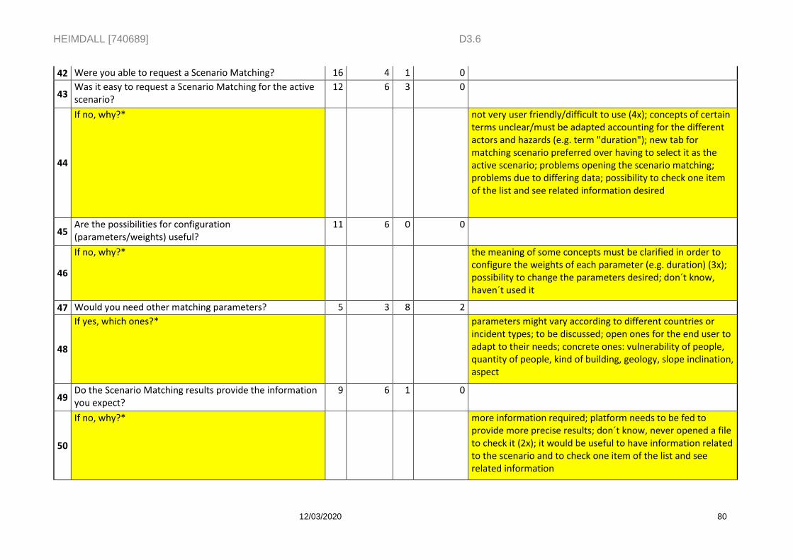
HEIMDALL [740689] D3.6
12/03/2020 80
42 Were you able to request a Scenario Matching? 16 4 1 0
43 Was it easy to request a Scenario Matching for the active scenario?
12 6 3 0
44
If no, why?* not very user friendly/difficult to use (4x); concepts of certain terms unclear/must be adapted accounting for the different actors and hazards (e.g. term "duration"); new tab for matching scenario preferred over having to select it as the active scenario; problems opening the scenario matching; problems due to differing data; possibility to check one item of the list and see related information desired
45 Are the possibilities for configuration (parameters/weights) useful?
11 6 0 0
46
If no, why?* the meaning of some concepts must be clarified in order to configure the weights of each parameter (e.g. duration) (3x); possibility to change the parameters desired; don´t know, haven´t used it
47 Would you need other matching parameters? 5 3 8 2
48
If yes, which ones?* parameters might vary according to different countries or incident types; to be discussed; open ones for the end user to adapt to their needs; concrete ones: vulnerability of people, quantity of people, kind of building, geology, slope inclination, aspect
49 Do the Scenario Matching results provide the information you expect?
9 6 1 0
50
If no, why?* more information required; platform needs to be fed to provide more precise results; don´t know, never opened a file to check it (2x); it would be useful to have information related to the scenario and to check one item of the list and see related information
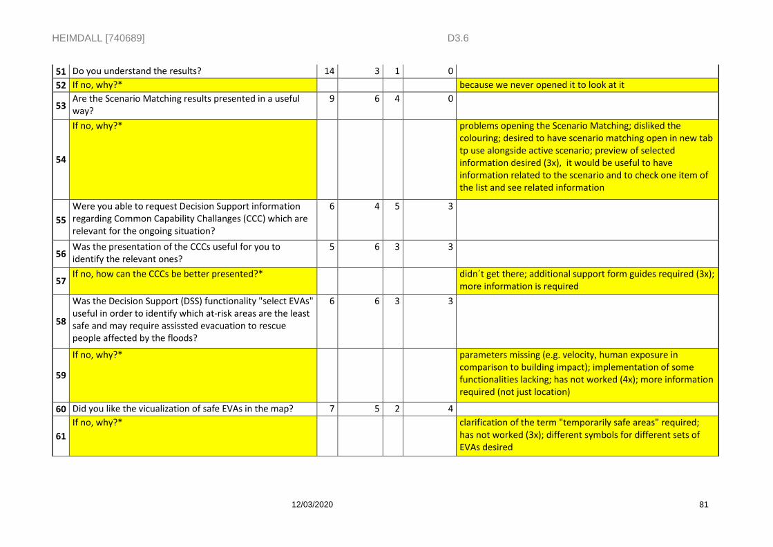
HEIMDALL [740689] D3.6
12/03/2020 81
51 Do you understand the results? 14 3 1 0
52 If no, why?* because we never opened it to look at it
53 Are the Scenario Matching results presented in a useful way?
9 6 4 0
54
If no, why?* problems opening the Scenario Matching; disliked the colouring; desired to have scenario matching open in new tab tp use alongside active scenario; preview of selected information desired (3x), it would be useful to have information related to the scenario and to check one item of the list and see related information
55
Were you able to request Decision Support information regarding Common Capability Challanges (CCC) which are relevant for the ongoing situation?
6 4 5 3
56 Was the presentation of the CCCs useful for you to identify the relevant ones?
5 6 3 3
57 If no, how can the CCCs be better presented?* didn´t get there; additional support form guides required (3x);
more information is required
58
Was the Decision Support (DSS) functionality "select EVAs" useful in order to identify which at-risk areas are the least safe and may require assissted evacuation to rescue people affected by the floods?
6 6 3 3
59
If no, why?* parameters missing (e.g. velocity, human exposure in comparison to building impact); implementation of some functionalities lacking; has not worked (4x); more information required (not just location)
60 Did you like the vicualization of safe EVAs in the map? 7 5 2 4
61
If no, why?* clarification of the term "temporarily safe areas" required; has not worked (3x); different symbols for different sets of EVAs desired
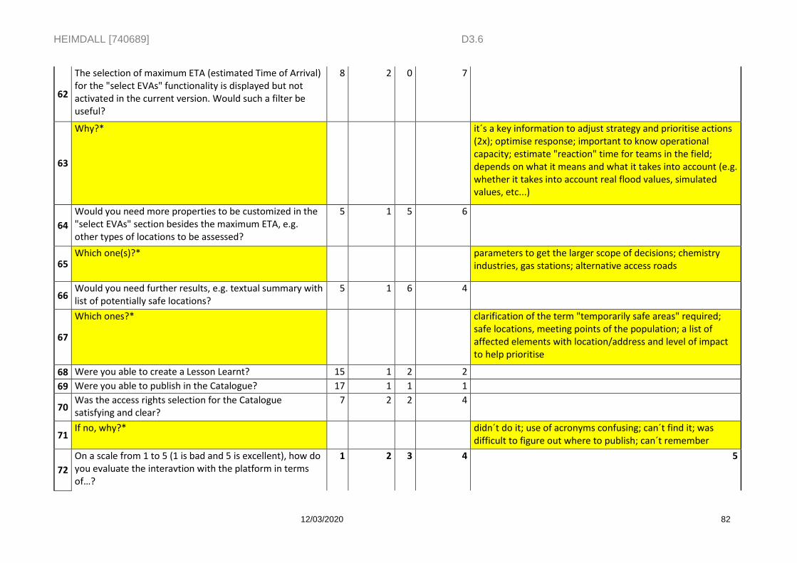
HEIMDALL [740689] D3.6
12/03/2020 82
62
The selection of maximum ETA (estimated Time of Arrival) for the "select EVAs" functionality is displayed but not activated in the current version. Would such a filter be useful?
8 2 0 7
63
Why?* it´s a key information to adjust strategy and prioritise actions (2x); optimise response; important to know operational capacity; estimate "reaction" time for teams in the field; depends on what it means and what it takes into account (e.g. whether it takes into account real flood values, simulated values, etc...)
64
Would you need more properties to be customized in the "select EVAs" section besides the maximum ETA, e.g. other types of locations to be assessed?
5 1 5 6
65 Which one(s)?* parameters to get the larger scope of decisions; chemistry
industries, gas stations; alternative access roads
66 Would you need further results, e.g. textual summary with list of potentially safe locations?
5 1 6 4
67
Which ones?* clarification of the term "temporarily safe areas" required; safe locations, meeting points of the population; a list of affected elements with location/address and level of impact to help prioritise
68 Were you able to create a Lesson Learnt? 15 1 2 2
69 Were you able to publish in the Catalogue? 17 1 1 1
70 Was the access rights selection for the Catalogue satisfying and clear?
7 2 2 4
71 If no, why?* didn´t do it; use of acronyms confusing; can´t find it; was
difficult to figure out where to publish; can´t remember
72
On a scale from 1 to 5 (1 is bad and 5 is excellent), how do you evaluate the interavtion with the platform in terms of…?
1 2 3 4 5
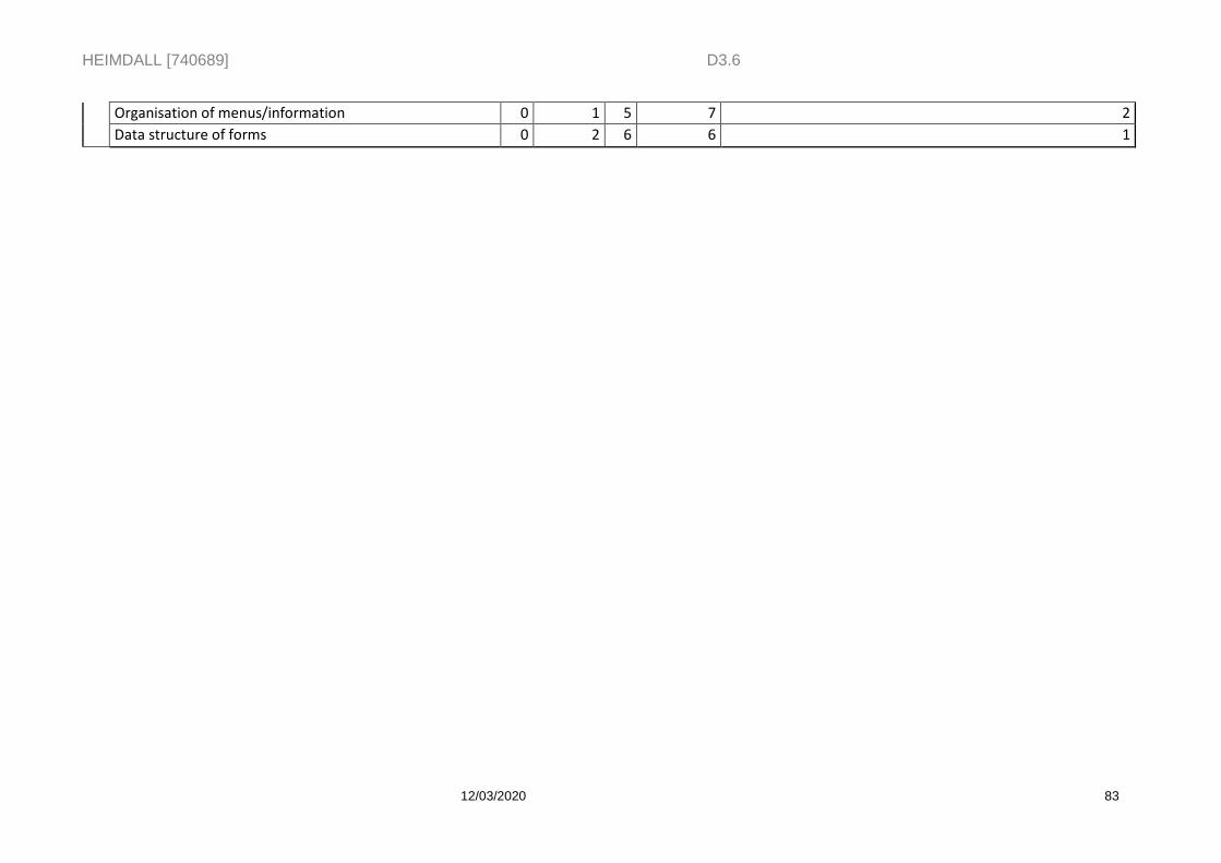
HEIMDALL [740689] D3.6
12/03/2020 83
Organisation of menus/information 0 1 5 7 2
Data structure of forms 0 2 6 6 1
HEIMDALL [740689] D3.6
12/03/2020 84
7 Conclusion
The document provides detailed information on the preparation of the EUW3 and EUW4, which follow the EUW2 described in the HEIMDALL Deliverable D3.5 Demonstrations – Issue 2 [8]. Two stories with two storyboards were prepared by ICGC and PCF to frame the execution and text of HEIMDALL functionalities for Release B; whereas one storyboard and one training session were prepared by PCF to frame the execution and text of HEIMDALL functionalities for Release C. During the course of both EUW3 and EUW4 feedback on the execution of the exercise as well as on the design, features and functionalities of the HEIMDALL platform was collected from the end-users (internal and external to the consortium), the members of the Advisory Board and other participants. This feedback has been taken into consideration in preparation for the final release corresponding with the project Final Demo (March 2020).
Furthermore, the outcomes of the questionnaire that was handed out to the participants at the end of the demo exercise are likewise being used to add new User Requirements that will be fulfilled for the Final Demo. By the end of Release C, participants generally stated that platform functionalities had remarkably improved since the previous releases. Nevertheless, they also highlighted pertinent new requirements to move towards a successful Final Demo.
HEIMDALL [740689] D3.6
12/03/2020 85
8 References
[1] HEIMDALL Deliverable D2.1 System Engineering Report – Issue 1. [2] HEIMDALL Deliverable D2.2 System Engineering Report – Issue 2. [3] HEIMDALL Deliverable D2.3 System Engineering Report – Issue 3. [4] HEIMDALL Deliverable D3.1 Case Studies – Issue 1 [5] HEIMDALL Deliverable D3.2 Case Studies – Issue 2 [6] HEIMDALL Deliverable D3.3 Case Studies – Issue 3 [7] HEIMDALL Deliverable D3.4 Demonstrations – Issue 1 [8] HEIMDALL Deliverable D3.5 Demonstrations – Issue 2 [9] Dubost, L., Giroud, F., Boisnon, J-M., Clémenceau, A., Quéré, B. (2017). Trialing a
Common Operational Picture in simulated environment. In: Proceedings of International Conference on Information and Communication Technologies for Disaster Management, December 2017, available at: http://www.driver-project.eu/wp-content/uploads/2018/01/DRIVER_2017-ICT-DM-paper-on-Expe41.pdf [last accessed in July 2018]
[10] DRIVER (2017). D23.21 - Performance and Effectiveness Metrics in Crisis Management Experiments. Available at: http://driver-project.eu/wp-content/uploads/2017/11/Performance-and-Effectiveness-Metrics-in-Crisis-Management-Experiments.pdf [last accessed in July 2018]
[11] Parmenter, D. (2010). Key Performance Indicators (KPI): Developing, Implementing, and Using Winning KPIs. Hoboken: Wiley & Sons
HEIMDALL [740689]
9 Annex I. Outcomes of the Dry Run 1 (EUW3)
Scenario creation o The necessary input values for creating a scenario needs to be defined and
added to the document. Was performed online. o In scenario a “-1” shall correspond to a “unknown” at the GUI. Issue on
AVA. o The columns in the scenario browser needs to be adapted to the latest version
(status and urgency). Issue on AVA o If a scenario is newly created it should be set as active automatically. If there
is already an scenario active, the user should select. Issue on AVA
Landslide sensor data o Alert thresholds need to be defined ( AI-329 on ICGC ) and will stored at the
SP of the API is ready by next week Issue on SPH.
Alert messages o For private alerting messages the address field needs to have some
predefined values and it should be possible to add multiple ones. Issue on DLR-KN
o The alert receiver is not done yet. Issue on AVA o The predefined alerting areas are needed for the Liguria region for demo B.
Areas already have been selected but need to be implemented in the system, first feedback from end users is needed on the areas. AI-331 on DLR-KN
o Terrain Movement needs to be added as hazard type in the alert message issue on DLR-KN
o A now button for the onset time is needed. issue on AVA o The sender and webpage should be part of the general user preferences and
automatically set by the GUI if an alert message is created. Issue on SPH and AVA
o Screenshots from the GUI need to be associated to the Scenario Issue on GUI
o in a next step the screenshot should be attached to an alert message. A method is needed at the IG that fetches a file from the SM by a URL provided by the GUI. Issue on DLR-KN
Pictures from the app o the geo image field was discussed and if it can be used to store pictures send
from the field by the app. o Metadata should include the location, time and the user Issue on CIMA
Scenario II + Weather o It was agreed that the current lessons learnt structure should be kept and
enhanced with the possibility to attach a file. Issue on CIMA o The possibility and principle of copying and deleting scenarios needs to be
clarified. Are subfields also copied or deleted? What happens to data that is not assigned to a scenario then anymore? After clarification this needs to trigger an issue for the GUI. AI-333 on DLR-DFD
o The scenario area/ hazard area and possibilities of adding the weather per area at the GUI has been discussed
o It was agreed that major discussion on this will be shifted towards the landscape scenario discussion ongoing
o For demo B the weather conditions of the area of interest will be shown only at the GUI and not connected to a scenario. For the scenario an incident point will be selected where then also the current conditions should be loaded into the scenario by the click of a button. Issue on AVA
o For the weather shown on a grid in the AOI the SP can provide a method. Issue on SPH
General

HEIMDALL [740689]
o It should be possible in the user preferences to select the AOI, it will be part of story #1. Issue on SPH
o It should be possible to see who is online, mobile and GUI user. Low priority. Issue on AVA
o Response plan document is needed for the next run AI-334 on PCF o PCF and DLR-KN will have a session next week to check for open points in
story #2. AI-335 on PCF and DLR-KN o Story #1 needs to be reviewed with the updates and lessons learnt today.
AI-336 on PCF
HEIMDALL [740689]
10 Annex II. Outcomes of the Dry Run 2 (EUW3)
General points:
Coordinates could be shown for select hazard location Search for incident area based on coordinates for C
Rainfall simulation missing in the story. Not integrated yet. Will be checked if possible. Issue on SPH and AVA
Provide a folder with all necessary docs that are stored on the workstation machines. AI on PCF
Apk will be provided by AVA to DLR-KN for testing. Issue on DLR-KN
Story Specific:
most points below have an impact and the story and needs to be considered AI on PCF
3 – one mode is missing, colours have been defined
4 – this is automatically set as active
5 - not possible
6 - remove, (more usefeull for lanscpare scenario)
7 - will be removed since it is shown in story 1, by using the hazard location
8 - response plan to be checked by angel if possible Issue on AVA
10 – use the chat function for this instead of alert
11- no private weather data – weather per area, bounding box which be calculated based on the AOI at the GUI Issue on AVA
14 – road network data is there “transportation Monesi” rename and change colour SPH
15 – 3d Building model Monesi layer should be shown
16 – decide in the short term if can be shown (optionally)
17- Sertit landslide delineation what do we do with the associated products? Drop down list for layers, product filter type. Clone layers? Drop down list. SPH Legend needed which explains the layer UNISTRA Workflow for how to request EO data? AI on DLR-KN
19 – upload picture from app -> notification to GUI -> associate to scenario, members of groups needs to be checked SPH
20 - use geoimage until updated with image from field AI DLR-KN
21 - refer to landslide simulator case study #1 or insert parameters in the story, how to do with area?
22- layer was shown before (3d buildings)
23- move before simulation, but how to then provide the info? AI PCF
24 - remove
25 - moved to next week
26 - safety areas EO based what was agreed? Ready for next release DLR-KN
32- not tracked by system, location layer at the teamsite, needs to be forwarded to Spyros PCF
33 and 34 - feature missing AVA
35 - layer to be shown, text adapted layer must be shown SPH
36 – keep but informative
37 – different coloring since will be provided in the next release

HEIMDALL [740689]
39 – only situation report is produced , sharing button AVA
40 - show area grid and remove association to scenario
43 – where to store drawings? Should be in the scenario? AI on DLR-KN
47- 48 use different symbols for critical infrastructure. to be checked with Christan DLR-KN, to provde symbols AI on PCF
49- button for conditions in scenario and for show in the GUI AVA Weather timings as drop down
50 – next release
52 –move show positions of first responder step before, include text as drawing AVA
67 - document is at teamsite, add doc is there but GUI needs to be updated AVA
HEIMDALL [740689]
11 Annex III. Outcomes of the Dry Run 1 (EUW4)
Step 2: remove, will be part of presentation
Step 3: user settings, AOI can be modified. Input parameters
Step 4: to be done either alert or instant messaging. AI on DLR-KN to clarify and provide
Step 6: input parameters to be provided
Incident start time incident end time not mandatory issue on AVA
Use working area as basis for area selection Issue on AVA
Step 7: attachment not working Issue on AVA
Step 8: input (message) needed, user + roles for the recipients needed
Step 9: no login possible Issue on AVA
Step 10: position and text from mobile to vulnerable elements as area or a point as input needed
Combination of text and position would be good, way point feature to be used. Send
point from GUI to App, add text to the point and send it back Issue on AVA
Step 11: landscape might be there, need to be moved to step 6. Scenario
management state and way forward unclear AI DLR-DFD, CIMA, DLR-KN
Step 12: auto assign weather data on button request, incident scenario a point, landscape an area
Hazard location must be created fist Issue on AVA
Step 13: Point must be reformulated since we cannot activate.
VOST are integrated but not sure how to show them
Spyros to send the info that we can receive from VOST before a dedicated telco.
Organize a dedicated telco to clarify the integration and which info to show AI on DLR-KN
Step 14: open issue IG, especially area related issue on DLR-KN, input parameters needed
Step 16: informative
17: input parameters
18: 2nd provider for final, will be prioritized after release C. The provider Info and API
must be send to Spyros, the sooner the better AI on PCF
22: info should be loaded from the system. Contact CIMA for the update DLR-KN
23, depending on the timing can be skipped
24: response plan update missing issue on CIMA, DLR-DFD
25: simulation missing, human impact and flood based, unclear if something needs to
be done at the GUI Issue on DLR-KN
26 - 28: repetition
33 remove since matching is performed in step 40
End users have until the end of the week to update the scenarios in the system. Afterwards, DLR-KN will review and update if necessary.
34 DES missing issue on DLR-KN
35 remove not addressed by HEIMDALL
36 button for fake request Issue on AVA
EO integration missing Issue on SPH
40 Matching buggy Issue on AVA
41 template needed, still ongoing AI on end users
44 informative
45 input parameters needed
46 Load documents lessons learnt bug Issue on AVA
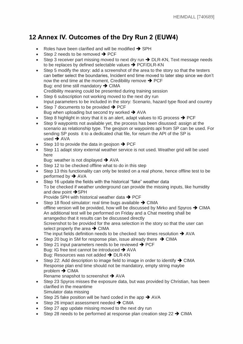
HEIMDALL [740689]
12 Annex IV. Outcomes of the Dry Run 2 (EUW4)
Roles have been clarified and will be modified SPH
Step 2 needs to be removed PCF
Step 3 receiver part missing moved to next dry run DLR-KN, Text message needs to be replaces by defined selectable values PCF/DLR-KN
Step 5 modify the story: add a screenshot of the area to the story so that the testers can better select the boundaries, Incident end time moved to later step since we don’t now the end time at the moment, Credibility remove PCF Bug: end time still mandatory CIMA Credibility meaning could be presented during training session
Step 6 subscription not working moved to the next dry run Input parameters to be included in the story: Scenario, hazard type flood and country
Step 7 documents to be provided PCF Bug when uploading but second try worked AVA
Step 8 highlight in story that it is an alert, adapt values to IG process PCF
Step 9 waypoints not available yet, the process has been disussed: assign at the scenario as relationship type. The geojson or waypoints api from SP can be used. For sending SP posts it to a dedicated chat file, for return the API of the SP is used AVA
Step 10 to provide the data in geojson PCF
Step 11 adapt story external weather service is not used. Weather grid will be used here Bug: weather is not displayed AVA
Step 12 to be checked offline what to do in this step
Step 13 this functionality can only be tested on a real phone, hence offline test to be performed by AVA
Step 16 update the fields with the historical “fake” weather data To be checked if weather underground can provide the missing inputs, like humidity and dew point SPH Provide SPH with historical weather data PCF
Step 18 flood simulator: real time bugs available CIMA offline version will be provided, how will be discussed by Mirko and Spyros CIMA An additional test will be performed on Friday and a Chat meeting shall be arrangedso that it results can be discussed directly Screenshot to be provided for the area selection in the story so that the user can select properly the area CIMA The input fields definition needs to be checked: two times resolution AVA
Step 20 bug in SM for response plan, issue already there CIMA
Step 21 input parameters needs to be reviewed PCF Bug: IG free text cannot be introduced AVA Bug: Resources was not added DLR-KN
Step 22: Add description to image field to image in order to identify CIMA Response plan end time should not be mandatory, empty string maybe problem CIMA Rename snapshot to screenshot AVA
Step 23 Spyros misses the exposure data, but was provided by Christian, has been clarified in the meantime Simulator data missing
Step 25 fake position will be hard coded in the app AVA
Step 26 impact assessment needed CIMA
Step 27 app update missing moved to the next dry run
Step 28 needs to be performed at response plan creation step 22 CIMA

HEIMDALL [740689]
Step 29 DSS missing DLR-DFD
Step 30 rephrase point, show the EO products, no fake data is used. Add the filenames to the story Include in the training the explanation that it was a week after the hazard
Step 32 What if not there CIMA
Step 34 Matching working, default weights by one AVA
inputs still missing, some will be added by Angel AVA, PCF
Steps 35, 36, 37, 38 missing and were not tested
Step 40 level of command needs need to be filed DLR-DFD
Not covered yet but needs to be included in the story: CCC matrix, decisions, and
snapshots PCF
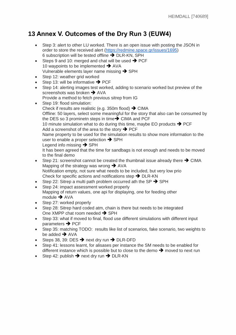
HEIMDALL [740689]
13 Annex V. Outcomes of the Dry Run 3 (EUW4)
Step 3: alert to other LU worked. There is an open issue with posting the JSON in order to store the received alert (https://redmine.space.gr/issues/1695)
6 subscription will be tested offline DLR-KN, SPH
Steps 9 and 10: merged and chat will be used PCF
10 waypoints to be implemented AVA
Vulnerable elements layer name missing SPH
Step 12: weather grid worked
Step 13: will be informative PCF
Step 14: alerting images test worked, adding to scenario worked but preview of the
screenshots was broken AVA Provide a method to fetch previous sitrep from IG
Step 19: flood simulation:
Check if results are realistic (e.g. 350m flood) CIMA Offline: 50 layers, select some meaningful for the story that also can be consumed by
the DES so 3 prominetn steps in time CIMA and PCF
10 minute simulation what to do during this time, maybe EO products PCF
Add a screenshot of the area to the story PCF Name property to be used for the simulation results to show more information to the
user to enable a proper selection SPH
Legend info missing SPH It has been agreed that the time for sandbags is not enough and needs to be moved to the final demo
Step 21: screenshot cannot be created the thumbnail issue already there CIMA
Mapping of the strategy was wrong AVA Notification empty, not sure what needs to be included, but very low prio
Check for specific actions and notifications step DLR-KN
Step 22: Sitrep a multi path problem occurred ath the SP SPH
Step 24: impact assessment worked properly Mapping of return values, one api for displaying, one for feeding other
module AVA
Step 27: worked properly
Step 28: Sitrep hard coded atm, chain is there but needs to be integrated
One XMPP chat room needed SPH
Step 33: what if moved to final, flood use different simulations with different input
parameters PCF
Step 35: matching TODO: results like list of scenarios, fake scenario, two weights to
be added AVA
Steps 38, 39: DES next dry run DLR-DFD
Step 41: lessons learnt, for alisases per instance the SM needs to be enabled for
different instance which is possible but to close to the demo moved to next run
Step 42: publish next dry run DLR-KN
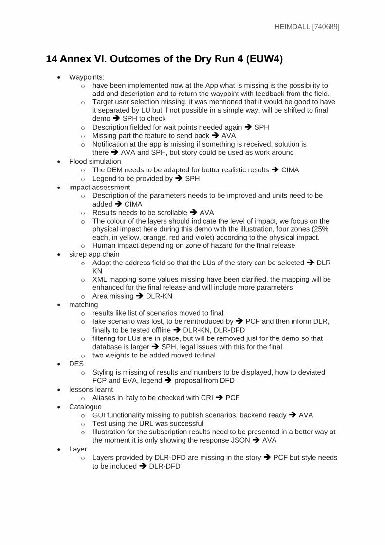
HEIMDALL [740689]
14 Annex VI. Outcomes of the Dry Run 4 (EUW4)
Waypoints: o have been implemented now at the App what is missing is the possibility to
add and description and to return the waypoint with feedback from the field. o Target user selection missing, it was mentioned that it would be good to have
it separated by LU but if not possible in a simple way, will be shifted to final
demo SPH to check
o Description fielded for wait points needed again SPH
o Missing part the feature to send back AVA o Notification at the app is missing if something is received, solution is
there AVA and SPH, but story could be used as work around
Flood simulation
o The DEM needs to be adapted for better realistic results CIMA
o Legend to be provided by SPH
impact assessment o Description of the parameters needs to be improved and units need to be
added CIMA
o Results needs to be scrollable AVA o The colour of the layers should indicate the level of impact, we focus on the
physical impact here during this demo with the illustration, four zones (25% each, in yellow, orange, red and violet) according to the physical impact.
o Human impact depending on zone of hazard for the final release
sitrep app chain
o Adapt the address field so that the LUs of the story can be selected DLR-KN
o XML mapping some values missing have been clarified, the mapping will be enhanced for the final release and will include more parameters
o Area missing DLR-KN
matching o results like list of scenarios moved to final
o fake scenario was lost, to be reintroduced by PCF and then inform DLR,
finally to be tested offline DLR-KN, DLR-DFD o filtering for LUs are in place, but will be removed just for the demo so that
database is larger SPH, legal issues with this for the final o two weights to be added moved to final
DES o Styling is missing of results and numbers to be displayed, how to deviated
FCP and EVA, legend proposal from DFD
lessons learnt
o Aliases in Italy to be checked with CRI PCF
Catalogue
o GUI functionality missing to publish scenarios, backend ready AVA o Test using the URL was successful o Illustration for the subscription results need to be presented in a better way at
the moment it is only showing the response JSON AVA
Layer
o Layers provided by DLR-DFD are missing in the story PCF but style needs
to be included DLR-DFD
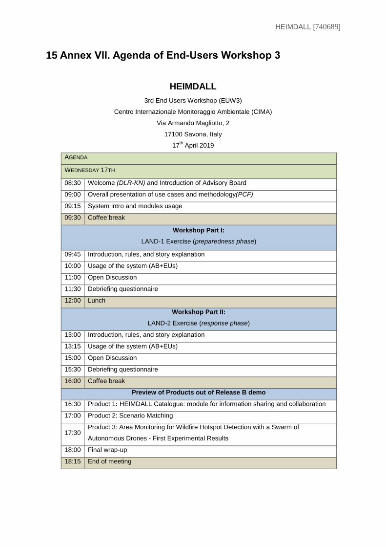
HEIMDALL [740689]
15 Annex VII. Agenda of End-Users Workshop 3
HEIMDALL
3rd End Users Workshop (EUW3)
Centro Internazionale Monitoraggio Ambientale (CIMA)
Via Armando Magliotto, 2
17100 Savona, Italy
17th April 2019
AGENDA
WEDNESDAY 17TH
08:30 Welcome (DLR-KN) and Introduction of Advisory Board
09:00 Overall presentation of use cases and methodology(PCF)
09:15 System intro and modules usage
09:30 Coffee break
Workshop Part I:
LAND-1 Exercise (preparedness phase)
09:45 Introduction, rules, and story explanation
10:00 Usage of the system (AB+EUs)
11:00 Open Discussion
11:30 Debriefing questionnaire
12:00 Lunch
Workshop Part II:
LAND-2 Exercise (response phase)
13:00 Introduction, rules, and story explanation
13:15 Usage of the system (AB+EUs)
15:00 Open Discussion
15:30 Debriefing questionnaire
16:00 Coffee break
Preview of Products out of Release B demo
16:30 Product 1: HEIMDALL Catalogue: module for information sharing and collaboration
17:00 Product 2: Scenario Matching
17:30 Product 3: Area Monitoring for Wildfire Hotspot Detection with a Swarm of
Autonomous Drones - First Experimental Results
18:00 Final wrap-up
18:15 End of meeting
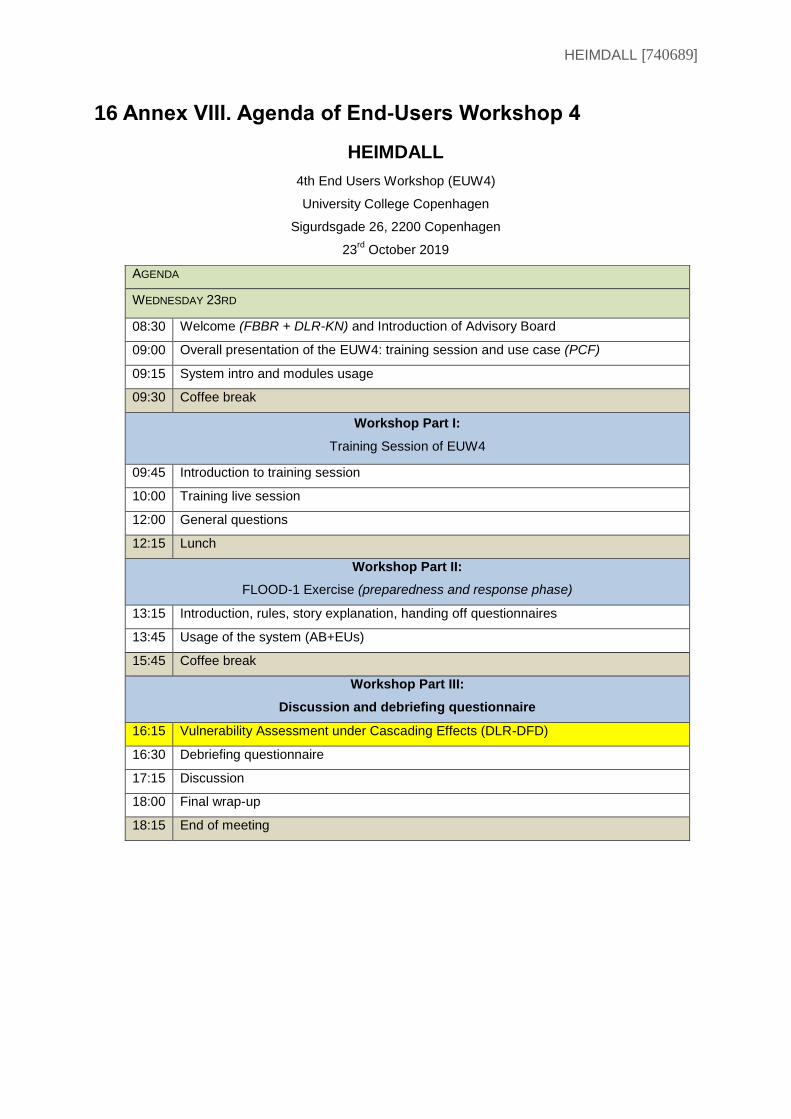
HEIMDALL [740689]
16 Annex VIII. Agenda of End-Users Workshop 4
HEIMDALL
4th End Users Workshop (EUW4)
University College Copenhagen
Sigurdsgade 26, 2200 Copenhagen
23rd
October 2019
AGENDA
WEDNESDAY 23RD
08:30 Welcome (FBBR + DLR-KN) and Introduction of Advisory Board
09:00 Overall presentation of the EUW4: training session and use case (PCF)
09:15 System intro and modules usage
09:30 Coffee break
Workshop Part I:
Training Session of EUW4
09:45 Introduction to training session
10:00 Training live session
12:00 General questions
12:15 Lunch
Workshop Part II:
FLOOD-1 Exercise (preparedness and response phase)
13:15 Introduction, rules, story explanation, handing off questionnaires
13:45 Usage of the system (AB+EUs)
15:45 Coffee break
Workshop Part III:
Discussion and debriefing questionnaire
16:15 Vulnerability Assessment under Cascading Effects (DLR-DFD)
16:30 Debriefing questionnaire
17:15 Discussion
18:00 Final wrap-up
18:15 End of meeting
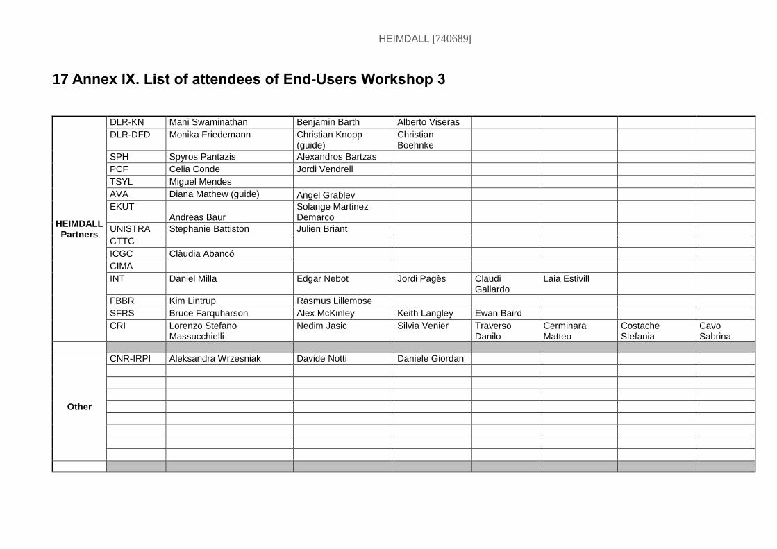
HEIMDALL [740689]
17 Annex IX. List of attendees of End-Users Workshop 3
HEIMDALL Partners
DLR-KN Mani Swaminathan Benjamin Barth Alberto Viseras
DLR-DFD Monika Friedemann Christian Knopp (guide)
Christian Boehnke
SPH Spyros Pantazis Alexandros Bartzas
PCF Celia Conde Jordi Vendrell
TSYL Miguel Mendes
AVA Diana Mathew (guide) Angel Grablev
EKUT Andreas Baur
Solange Martinez Demarco
UNISTRA Stephanie Battiston Julien Briant
CTTC
ICGC Clàudia Abancó
CIMA
INT Daniel Milla Edgar Nebot Jordi Pagès Claudi Gallardo
Laia Estivill
FBBR Kim Lintrup Rasmus Lillemose
SFRS Bruce Farquharson Alex McKinley Keith Langley Ewan Baird
CRI Lorenzo Stefano Massucchielli
Nedim Jasic Silvia Venier Traverso Danilo
Cerminara Matteo
Costache Stefania
Cavo Sabrina
Other
CNR-IRPI Aleksandra Wrzesniak Davide Notti Daniele Giordan
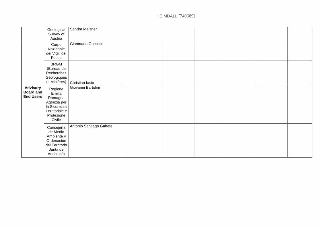
HEIMDALL [740689]
Advisory Board and End Users
Geological Survey of Austria
Sandra Melzner
Corpo Nazionale
dei Vigili del Fuoco
Gianmario Gnecchi
BRGM (Bureau de Recherches Géologiques et Minières) Christian Iasio
Regione Emilia
Romagna Agenzia per la Sicurezza Territoriale e Protezione
Civile
Giovanni Bartolini
Consejería de Medio
Ambiente y Ordenación del Territorio
Junta de Andalucía
Antonio Santiago Gahete
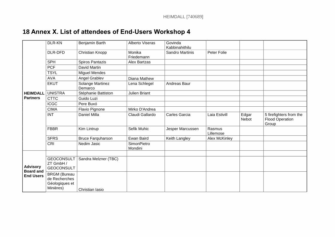
HEIMDALL [740689]
18 Annex X. List of attendees of End-Users Workshop 4
HEIMDALL Partners
DLR-KN Benjamin Barth Alberto Viseras Govinda Kabbinahithilu
DLR-DFD Christian Knopp Monika Friedemann
Sandro Martinis Peter Folie
SPH Spiros Pantazis Alex Bartzas
PCF David Martin
TSYL Miguel Mendes
AVA Angel Grablev Diana Mathew
EKUT Solange Martinez Demarco
Lena Schlegel Andreas Baur
UNISTRA Stéphanie Battiston Julien Briant
CTTC Guido Luzi
ICGC Pere Buxó
CIMA Flavio Pignone Mirko D'Andrea
INT Daniel Milla Claudi Gallardo Carles Garcia Laia Estivill Edgar Nebot
5 firefighters from the Flood Operation Group
FBBR Kim Lintrup Sefik Muhic Jesper Marcussen Rasmus Lillemose
SFRS Bruce Farquharson Ewan Baird Keith Langley Alex McKinley
CRI Nedim Jasic SimonPietro Mondini
Advisory Board and End Users
GEOCONSULT ZT GmbH / GEOCONSULT
Sandra Melzner (TBC)
BRGM (Bureau de Recherches Géologiques et Minières) Christian Iasio
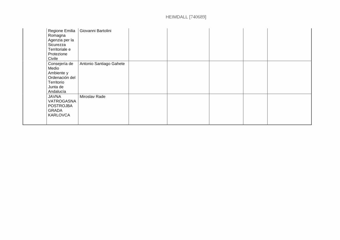
HEIMDALL [740689]
Regione Emilia Romagna Agenzia per la Sicurezza Territoriale e Protezione Civile
Giovanni Bartolini
Consejería de Medio Ambiente y Ordenación del Territorio Junta de Andalucía
Antonio Santiago Gahete
JAVNA VATROGASNA POSTROJBA GRADA KARLOVCA
Miroslav Rade
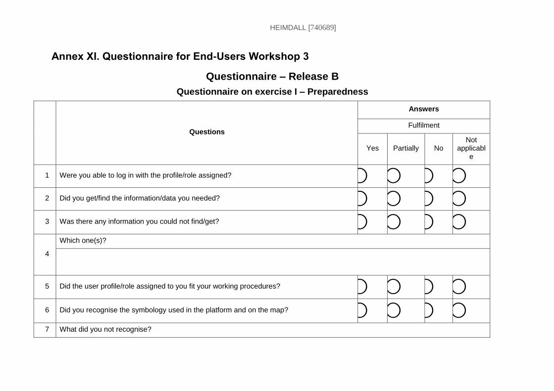
HEIMDALL [740689]
Annex XI. Questionnaire for End-Users Workshop 3
Questionnaire – Release B
Questionnaire on exercise I – Preparedness
Questions
Answers
Fulfilment
Yes Partially No Not
applicable
1 Were you able to log in with the profile/role assigned? ⃝ ⃝ ⃝ ⃝
2 Did you get/find the information/data you needed? ⃝ ⃝ ⃝ ⃝
3 Was there any information you could not find/get? ⃝ ⃝ ⃝ ⃝
4
Which one(s)?
5 Did the user profile/role assigned to you fit your working procedures? ⃝ ⃝ ⃝ ⃝
6 Did you recognise the symbology used in the platform and on the map? ⃝ ⃝ ⃝ ⃝
7 What did you not recognise?
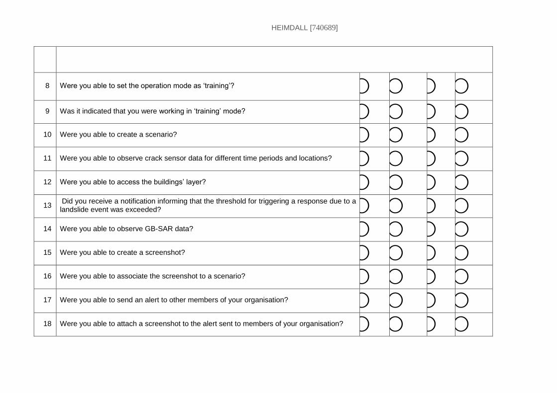
HEIMDALL [740689]
8 Were you able to set the operation mode as ‘training’? ⃝ ⃝ ⃝ ⃝
9 Was it indicated that you were working in ‘training’ mode? ⃝ ⃝ ⃝ ⃝
10 Were you able to create a scenario? ⃝ ⃝ ⃝ ⃝
11 Were you able to observe crack sensor data for different time periods and locations? ⃝ ⃝ ⃝ ⃝
12 Were you able to access the buildings’ layer? ⃝ ⃝ ⃝ ⃝
13 Did you receive a notification informing that the threshold for triggering a response due to a landslide event was exceeded? ⃝ ⃝ ⃝ ⃝
14 Were you able to observe GB-SAR data? ⃝ ⃝ ⃝ ⃝
15 Were you able to create a screenshot? ⃝ ⃝ ⃝ ⃝
16 Were you able to associate the screenshot to a scenario? ⃝ ⃝ ⃝ ⃝
17 Were you able to send an alert to other members of your organisation? ⃝ ⃝ ⃝ ⃝
18 Were you able to attach a screenshot to the alert sent to members of your organisation? ⃝ ⃝ ⃝ ⃝
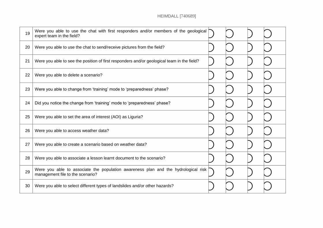
HEIMDALL [740689]
19 Were you able to use the chat with first responders and/or members of the geological expert team in the field? ⃝ ⃝ ⃝ ⃝
20 Were you able to use the chat to send/receive pictures from the field? ⃝ ⃝ ⃝ ⃝
21 Were you able to see the position of first responders and/or geological team in the field? ⃝ ⃝ ⃝ ⃝
22 Were you able to delete a scenario? ⃝ ⃝ ⃝ ⃝
23 Were you able to change from ‘training’ mode to ‘preparedness’ phase? ⃝ ⃝ ⃝ ⃝
24 Did you notice the change from ‘training’ mode to ‘preparedness’ phase? ⃝ ⃝ ⃝ ⃝
25 Were you able to set the area of interest (AOI) as Liguria? ⃝ ⃝ ⃝ ⃝
26 Were you able to access weather data? ⃝ ⃝ ⃝ ⃝
27 Were you able to create a scenario based on weather data? ⃝ ⃝ ⃝ ⃝
28 Were you able to associate a lesson learnt document to the scenario? ⃝ ⃝ ⃝ ⃝
29 Were you able to associate the population awareness plan and the hydrological risk management file to the scenario? ⃝ ⃝ ⃝ ⃝
30 Were you able to select different types of landslides and/or other hazards? ⃝ ⃝ ⃝ ⃝
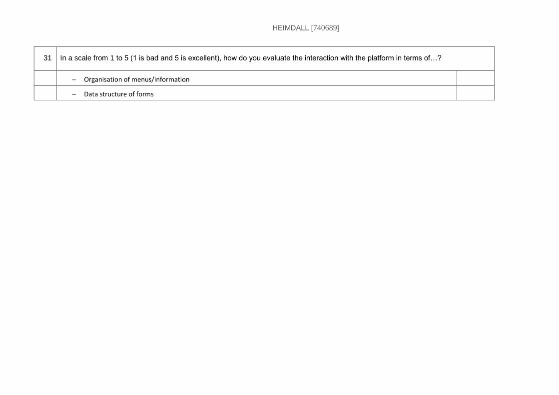
HEIMDALL [740689]
31 In a scale from 1 to 5 (1 is bad and 5 is excellent), how do you evaluate the interaction with the platform in terms of…?
Organisation of menus/information
Data structure of forms

HEIMDALL [740689]
What did you like? What worked well?
What did you not like?
What did you miss?
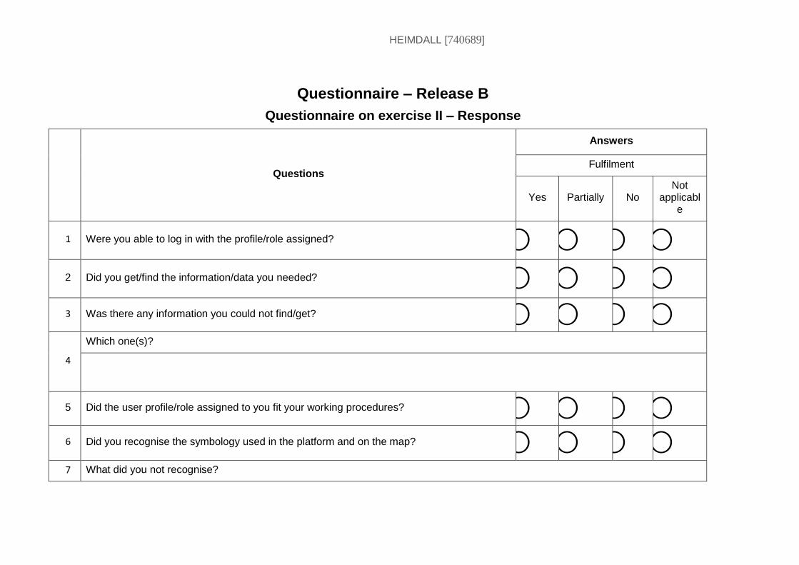
HEIMDALL [740689]
Questionnaire – Release B
Questionnaire on exercise II – Response
Questions
Answers
Fulfilment
Yes Partially No Not
applicable
1 Were you able to log in with the profile/role assigned? ⃝ ⃝ ⃝ ⃝
2 Did you get/find the information/data you needed? ⃝ ⃝ ⃝ ⃝
3 Was there any information you could not find/get? ⃝ ⃝ ⃝ ⃝
4
Which one(s)?
5 Did the user profile/role assigned to you fit your working procedures? ⃝ ⃝ ⃝ ⃝
6 Did you recognise the symbology used in the platform and on the map? ⃝ ⃝ ⃝ ⃝
7 What did you not recognise?
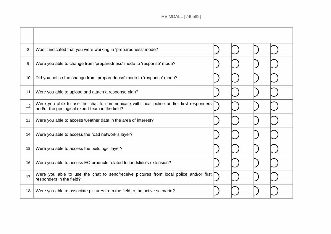
HEIMDALL [740689]
8 Was it indicated that you were working in ‘preparedness’ mode? ⃝ ⃝ ⃝ ⃝
9 Were you able to change from ‘preparedness’ mode to ‘response’ mode? ⃝ ⃝ ⃝ ⃝
10 Did you notice the change from ‘preparedness’ mode to ‘response’ mode? ⃝ ⃝ ⃝ ⃝
11 Were you able to upload and attach a response plan? ⃝ ⃝ ⃝ ⃝
12 Were you able to use the chat to communicate with local police and/or first responders and/or the geological expert team in the field? ⃝ ⃝ ⃝ ⃝
13 Were you able to access weather data in the area of interest? ⃝ ⃝ ⃝ ⃝
14 Were you able to access the road network’s layer? ⃝ ⃝ ⃝ ⃝
15 Were you able to access the buildings’ layer? ⃝ ⃝ ⃝ ⃝
16 Were you able to access EO products related to landslide’s extension? ⃝ ⃝ ⃝ ⃝
17 Were you able to use the chat to send/receive pictures from local police and/or first responders in the field? ⃝ ⃝ ⃝ ⃝
18 Were you able to associate pictures from the field to the active scenario? ⃝ ⃝ ⃝ ⃝
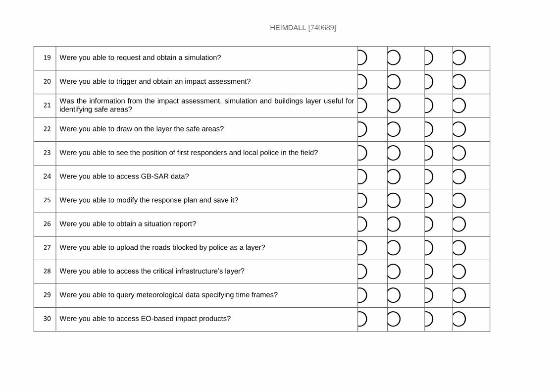
HEIMDALL [740689]
19 Were you able to request and obtain a simulation? ⃝ ⃝ ⃝ ⃝
20 Were you able to trigger and obtain an impact assessment? ⃝ ⃝ ⃝ ⃝
21 Was the information from the impact assessment, simulation and buildings layer useful for identifying safe areas? ⃝ ⃝ ⃝ ⃝
22 Were you able to draw on the layer the safe areas? ⃝ ⃝ ⃝ ⃝
23 Were you able to see the position of first responders and local police in the field? ⃝ ⃝ ⃝ ⃝
24 Were you able to access GB-SAR data? ⃝ ⃝ ⃝ ⃝
25 Were you able to modify the response plan and save it? ⃝ ⃝ ⃝ ⃝
26 Were you able to obtain a situation report? ⃝ ⃝ ⃝ ⃝
27 Were you able to upload the roads blocked by police as a layer? ⃝ ⃝ ⃝ ⃝
28 Were you able to access the critical infrastructure’s layer? ⃝ ⃝ ⃝ ⃝
29 Were you able to query meteorological data specifying time frames? ⃝ ⃝ ⃝ ⃝
30 Were you able to access EO-based impact products? ⃝ ⃝ ⃝ ⃝
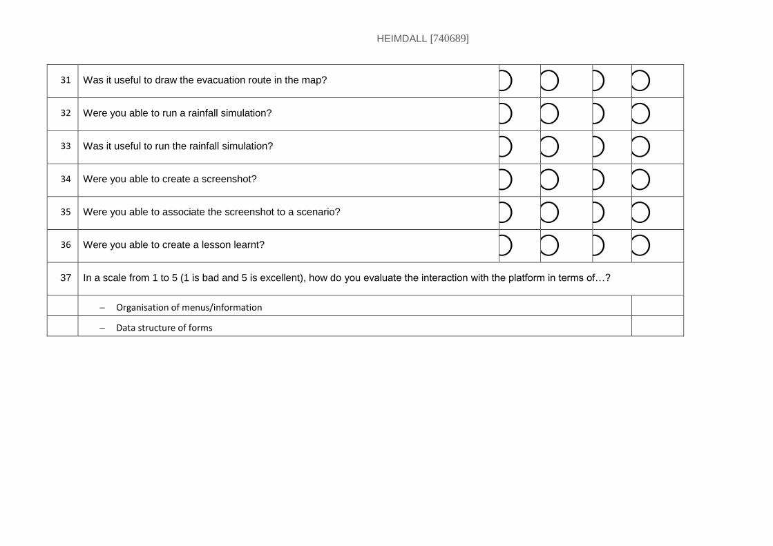
HEIMDALL [740689]
31 Was it useful to draw the evacuation route in the map? ⃝ ⃝ ⃝ ⃝
32 Were you able to run a rainfall simulation? ⃝ ⃝ ⃝ ⃝
33 Was it useful to run the rainfall simulation? ⃝ ⃝ ⃝ ⃝
34 Were you able to create a screenshot? ⃝ ⃝ ⃝ ⃝
35 Were you able to associate the screenshot to a scenario? ⃝ ⃝ ⃝ ⃝
36 Were you able to create a lesson learnt? ⃝ ⃝ ⃝ ⃝
37 In a scale from 1 to 5 (1 is bad and 5 is excellent), how do you evaluate the interaction with the platform in terms of…?
Organisation of menus/information
Data structure of forms

HEIMDALL [740689]
What did you like? What worked well?
What did you not like?
What did you miss?
HEIMDALL [740689]
19 Annex XII. Template for Observations during Release B Exercises
Observations Release B Exercises
Methodology for observations
Characteristics of situation assessment/scenario building/alerting:
Duration (is it fast(er)?)
The information displayed (it is relevant and complete?)
Usability of UI (is it intuitive and complete?)
Misunderstandings and errors (is it understandable, clear?).
HEIMDALL [740689]
FIRE-1 & FIRE-2
Research questions:
How do the Fire Simulator and related UI functionalities facilitate the assessment of potential affected area and conditions (flame length, intensity...) at morning meetings?
How do Release B SP and UI improve the availability of information from additional external data sources and systems to anticipate future scenarios?
How do the Release B Scenario Management solution and related UI functionalities facilitate the building of different possible future scenarios to a potential situation?
How does the Information Gateway solution improve the creation of public awareness and communication with field staff?
Observations:
Information (is it relevant and complete?)
Scenario/Incident Management/Simulations
Risk Assessment:
Usability of UI (is it intuitive and complete?)
First Responders:
Tools (Fire Simulation/Scenario Management/Information Gateway)
Simulation:
HEIMDALL [740689]
Scenario Management:
Scenario matching:
Misunderstandings and Errors
Other
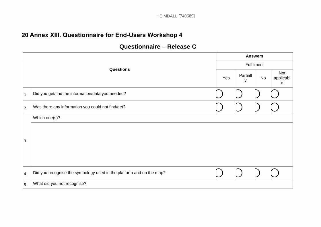
HEIMDALL [740689]
20 Annex XIII. Questionnaire for End-Users Workshop 4
Questionnaire – Release C
Questions
Answers
Fulfilment
Yes Partiall
y No
Not applicabl
e
1 Did you get/find the information/data you needed? ⃝ ⃝ ⃝ ⃝
2 Was there any information you could not find/get? ⃝ ⃝ ⃝ ⃝
3
Which one(s)?
4 Did you recognise the symbology used in the platform and on the map? ⃝ ⃝ ⃝ ⃝
5 What did you not recognise?
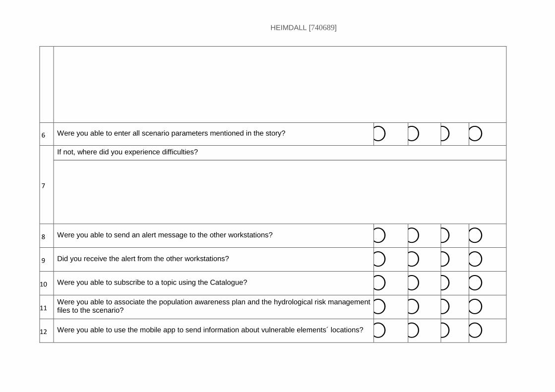
HEIMDALL [740689]
6 Were you able to enter all scenario parameters mentioned in the story? ⃝ ⃝ ⃝ ⃝
7
If not, where did you experience difficulties?
8 Were you able to send an alert message to the other workstations? ⃝ ⃝ ⃝ ⃝
9 Did you receive the alert from the other workstations? ⃝ ⃝ ⃝ ⃝
10 Were you able to subscribe to a topic using the Catalogue? ⃝ ⃝ ⃝ ⃝
11 Were you able to associate the population awareness plan and the hydrological risk management files to the scenario? ⃝ ⃝ ⃝ ⃝
12 Were you able to use the mobile app to send information about vulnerable elements´ locations? ⃝ ⃝ ⃝ ⃝
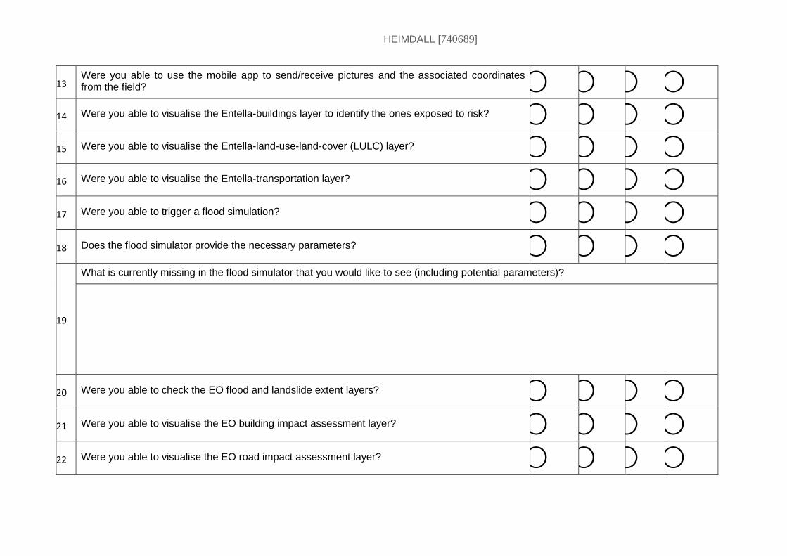
HEIMDALL [740689]
13 Were you able to use the mobile app to send/receive pictures and the associated coordinates from the field? ⃝ ⃝ ⃝ ⃝
14 Were you able to visualise the Entella-buildings layer to identify the ones exposed to risk? ⃝ ⃝ ⃝ ⃝
15 Were you able to visualise the Entella-land-use-land-cover (LULC) layer? ⃝ ⃝ ⃝ ⃝
16 Were you able to visualise the Entella-transportation layer? ⃝ ⃝ ⃝ ⃝
17 Were you able to trigger a flood simulation? ⃝ ⃝ ⃝ ⃝
18 Does the flood simulator provide the necessary parameters? ⃝ ⃝ ⃝ ⃝
19
What is currently missing in the flood simulator that you would like to see (including potential parameters)?
20 Were you able to check the EO flood and landslide extent layers? ⃝ ⃝ ⃝ ⃝
21 Were you able to visualise the EO building impact assessment layer? ⃝ ⃝ ⃝ ⃝
22 Were you able to visualise the EO road impact assessment layer? ⃝ ⃝ ⃝ ⃝
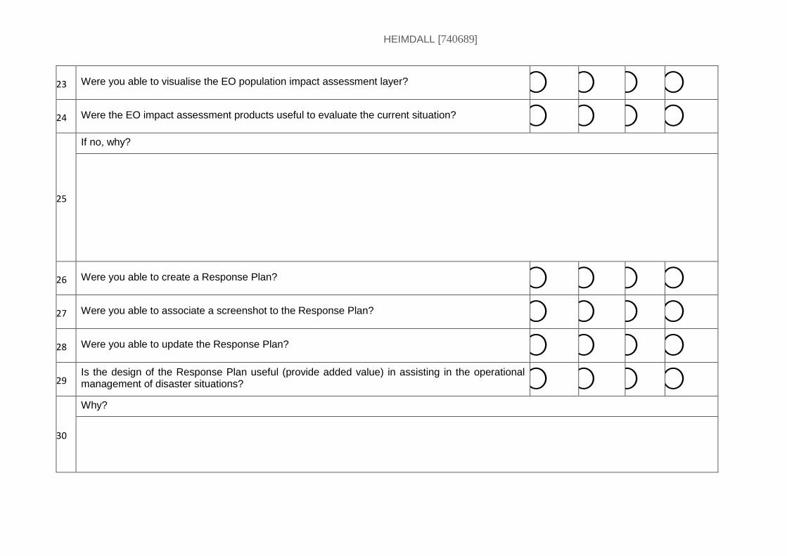
HEIMDALL [740689]
23 Were you able to visualise the EO population impact assessment layer? ⃝ ⃝ ⃝ ⃝
24 Were the EO impact assessment products useful to evaluate the current situation? ⃝ ⃝ ⃝ ⃝
25
If no, why?
26 Were you able to create a Response Plan? ⃝ ⃝ ⃝ ⃝
27 Were you able to associate a screenshot to the Response Plan? ⃝ ⃝ ⃝ ⃝
28 Were you able to update the Response Plan? ⃝ ⃝ ⃝ ⃝
29 Is the design of the Response Plan useful (provide added value) in assisting in the operational management of disaster situations? ⃝ ⃝ ⃝ ⃝
30
Why?
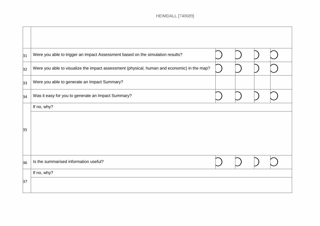
HEIMDALL [740689]
31 Were you able to trigger an Impact Assessment based on the simulation results? ⃝ ⃝ ⃝ ⃝
32 Were you able to visualize the impact assessment (physical, human and economic) in the map? ⃝ ⃝ ⃝ ⃝
33 Were you able to generate an Impact Summary?
34 Was it easy for you to generate an Impact Summary? ⃝ ⃝ ⃝ ⃝
35
If no, why?
36 Is the summarised information useful? ⃝ ⃝ ⃝ ⃝
37
If no, why?
HEIMDALL [740689]
38 Were you able to create a Situation Report? ⃝ ⃝ ⃝ ⃝
39 Were you able to visualise the Situation Report in the mobile app? ⃝ ⃝ ⃝ ⃝
40 Did you like the visualization of the Forward Command Posts (FCPs) in the map? ⃝ ⃝ ⃝ ⃝
41
If no, why?
42 Were you able to request a Scenario Matching? ⃝ ⃝ ⃝ ⃝
43 Was it easy to request a Scenario Matching for the active scenario? ⃝ ⃝ ⃝ ⃝
44
If no, why?
HEIMDALL [740689]
45 Are the possibilities for configuration (parameters/weights) useful? ⃝ ⃝ ⃝ ⃝
46
If no, why?
47 Would you need other matching parameters? ⃝ ⃝ ⃝ ⃝
48
If yes, which ones?
HEIMDALL [740689]
49 Do the scenario matching results provide the information you expect? ⃝ ⃝ ⃝ ⃝
50
If no, why?
51 Do you understand the results? ⃝ ⃝ ⃝ ⃝
52
If no, why?
53 Are the Scenario Matching results presented in a useful way? ⃝ ⃝ ⃝ ⃝
54
If no, why?
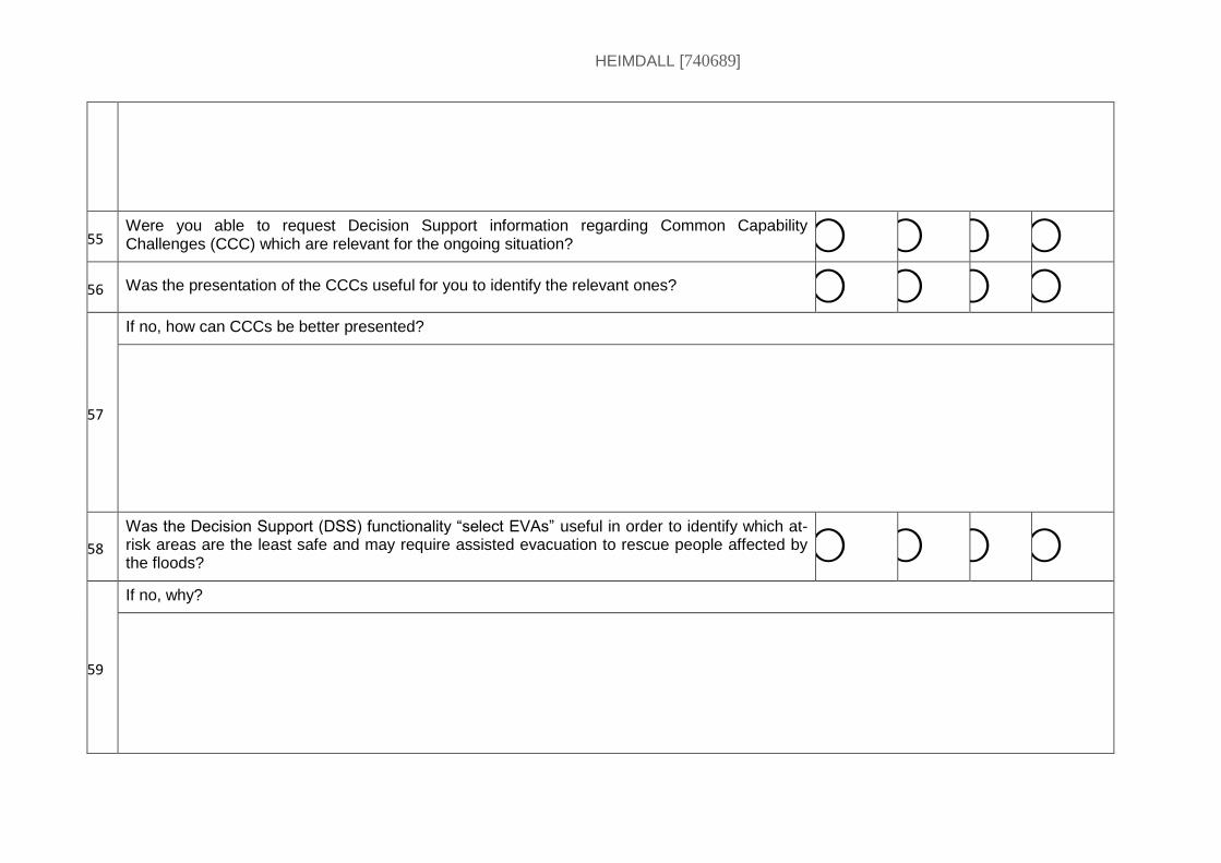
HEIMDALL [740689]
55 Were you able to request Decision Support information regarding Common Capability Challenges (CCC) which are relevant for the ongoing situation? ⃝ ⃝ ⃝ ⃝
56 Was the presentation of the CCCs useful for you to identify the relevant ones? ⃝ ⃝ ⃝ ⃝
57
If no, how can CCCs be better presented?
58
Was the Decision Support (DSS) functionality “select EVAs” useful in order to identify which at-risk areas are the least safe and may require assisted evacuation to rescue people affected by the floods?
⃝ ⃝ ⃝ ⃝
59
If no, why?
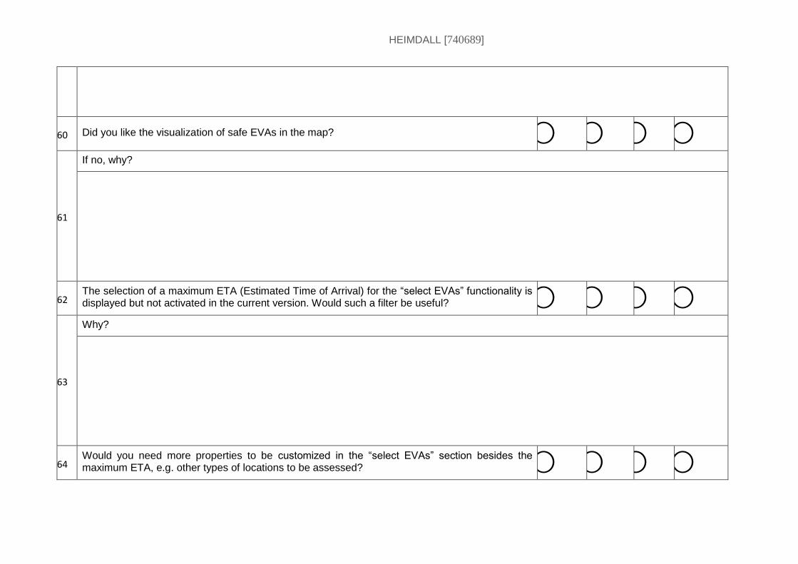
HEIMDALL [740689]
60 Did you like the visualization of safe EVAs in the map? ⃝ ⃝ ⃝ ⃝
61
If no, why?
62 The selection of a maximum ETA (Estimated Time of Arrival) for the “select EVAs” functionality is displayed but not activated in the current version. Would such a filter be useful? ⃝ ⃝ ⃝ ⃝
63
Why?
64 Would you need more properties to be customized in the “select EVAs” section besides the maximum ETA, e.g. other types of locations to be assessed? ⃝ ⃝ ⃝ ⃝
HEIMDALL [740689]
65
Which ones?
66 Would you need further results, e.g. textual summary with list of potentially safe locations? ⃝ ⃝ ⃝ ⃝
67
Which ones?
68 Were you able to create a Lesson Learnt? ⃝ ⃝ ⃝ ⃝
69 Were you able to publish in the Catalogue? ⃝ ⃝ ⃝ ⃝
70 Was the access rights selection for the Catalogue satisfying and clear? ⃝ ⃝ ⃝ ⃝
71 If no, why?
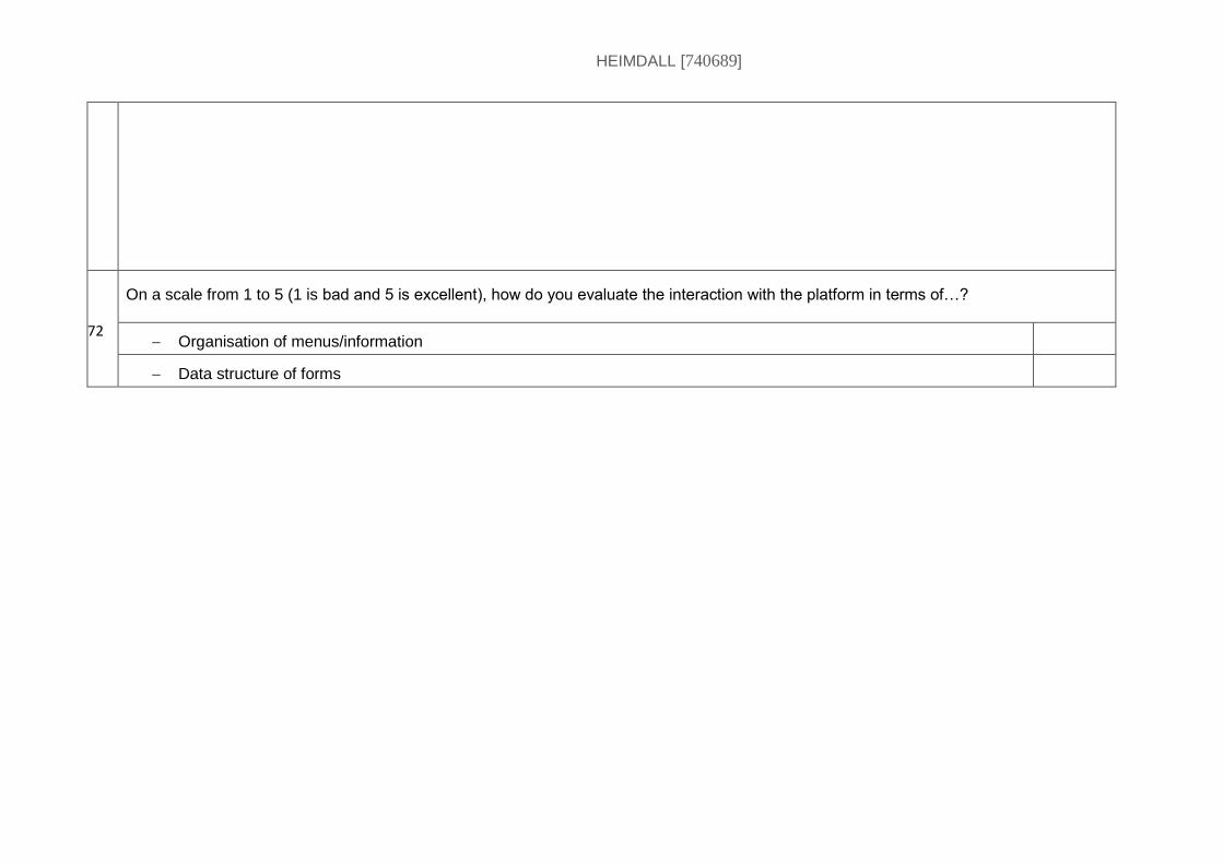
HEIMDALL [740689]
72 6
On a scale from 1 to 5 (1 is bad and 5 is excellent), how do you evaluate the interaction with the platform in terms of…?
Organisation of menus/information
Data structure of forms

HEIMDALL [740689]
End of document
Related Documents