PROHIBITED AREA VH(P)-8 D50.1 D107.9 D 077^ TD D R089^ R089^ D64.8 D64.8 CH CH | JEPPESEN SANDERSON, INC., 2003. ALL RIGHTS RESERVED. Apt Elev 19' VHHH/HKG 10-2 .STAR. HONG KONG INTL HONG KONG, PR OF CHINA D-ATIS 128.2 Alt Set: hPa Trans level: Trans alt: 9000' FL110 - QNH 980 hPa or above FL120 - QNH 979 hPa or below If required request radar assistance to follow correct track. [DOTM1A], [DOTM1B] [ELAT1B] [ELAT1A], From DOTMI to MAGOG, then to ASTRA, then to MELON, then to TD, then to GUAVA, expect ILS approach. Descend as directed by ATC. From DOTMI to MAGOG, then to ASTRA, then to MELON, then to TD, expect ILS approach. Descend as directed by ATC. From ELATO to MAGOG, then to ASTRA, then to MELON, then to TD, then to GUAVA, expect ILS approach. Descend as directed by ATC. From ELATO to MAGOG, then to ASTRA, then to MELON, then to TD, expect ILS approach. Descend as directed by ATC. When TD unserviceable: DOTMI ELATO 32 93 218^ By ATC Under turbulent conditions, when approved by ATC 280 KT or MACH 0.8, whichever is less. Speed Limit Point MAX FL250 SLP (CH R-089/D54.8) (IAF) DOTMI 1 A, 1B ELATO 1A, 1B 250^ 14 (CH R-157/D3.9) (IAF Rwys 25L/R) DOTMI 1A ELATO 1A (IAF Rwys 07L/R) N22 43.1 E116 10.1 LIMES N22 06.4 E113 46.6 SOKOE (Rwys 07L/R) (Rwys 07L/R) N22 04.7 E113 50.6 HOLDINGS OVER ASTRA MAX 250 KT. N22 20.0 E117 30.0 Holdings over ASTRA revised; new format. MSA TD VOR 180^ 4300' 2 60 ^ 3000' 075 ^ 3300' 1 1 1 FROM EAST CHANGES: JEPPESEN RWYS 07L/R, 25L/R ARRIVALS DOTMI 1A DOTMI 1B ELATO 1A ELATO 1B RWY STAR ROUTING DOTMI 1A 07L/R 25L/R DOTMI 1B ELATO 1A 07L/R 25L/R ELATO 1B From MELON proceed to TH. Expect ILS approach via TH. Descend as directed by ATC. ACTUAL DESCENT CLEARANCE WILL BE AS DIRECTED BY ATC. MAGOG ASTRA MELON D N22 14.9 E114 17.6 TUNG LUNG 116.1 TD TD 269^ 270^ 35 10 N22 17.8 E115 49.5 N22 16.5 E115 11.6 R090^ N22 16.2 E115 00.8 269^ 269^ FL260 MHA FL90 D N22 14.3 E114 17.3 115.5 TH TH TATHONG SLP SPEED RESTRICTION DESCENT PLANNING FL260. FL130. 40.1 (CH R-089/D64.8) Rwy 25L/R: Rwy 07L/R: FL150. Pilots should plan to cross, if holding GUAVA N22 09.6 E114 03.6 D CHEUNG CHAU N22 13.2 E114 01.8 112.3 CH CH (CH R-078/D122.5) (TD R-090/D178.5) (CH R-089/D193.2) NOT TO SCALE MAX 250 KT below FL110 or at position (SLP) shown on chart. Cross MELON at Cross MELON at over ASTRA is required, MAGOG at Each flight will be instructed individually. 28 NOV 03 within Hong Kong FIR D64.8/74.8 D64.8/74.8 Licensed to EXECUTIVE JET, . Printed from JeppView disc 26-04. Notice: After 6.1.2005 0901Z this chart should not be used without first checking JeppView or NOTAMs. PROHIBITED AREA VH(P)-8 D D64.8 175^ D193.9 R164^ D64.8 TD | JEPPESEN SANDERSON, INC., 2003. ALL RIGHTS RESERVED. Apt Elev 19' VHHH/HKG .STAR. HONG KONG INTL HONG KONG, PR OF CHINA D-ATIS 128.2 Alt Set: hPa Trans level: Trans alt: 9000' FL110 - QNH 980 hPa or above FL120 - QNH 979 hPa or below Speed Limit Point (IAF) New format. Rwys 25L/R: Rwys 07L/R: From NOMAN to CHERY, then to BAKER, then to MANGO, then to GUAVA, expect ILS approach. Descend as directed by ATC. From NOMAN to CHERY, then to BAKER, then to MANGO, then to TD, expect ILS approach. Descend as directed by ATC. From SABNO to CHERY, then to BAKER, then to MANGO, then to GUAVA, expect ILS approach. Descend as directed by ATC. From SABNO to CHERY, then to BAKER, then to MANGO, then to TD, expect ILS approach. Descend as directed by ATC. When TD unserviceable: SLP (TD R-250/D14) (CH R-157/D3.9) (CH R-145/D45.2) (CH R-152/D69.3) (CH R-153/D124.8) (TD R-160/D120.1) (IAF) 2 8 6 ^ 336^ SABNO 1A, 1B N OM AN 1A, 1B SABNO 1A NOMAN 1A (TD R-158/D213.7) (CH R-154/D218.7) (CH R-133/D198.9) (IAF) 9 3 LIMES SOKOE (Rwys 07L/R) (Rwys 07L/R) N22 04.7 E113 50.6 10-2A NOMAN 1B SABNO 1B If required request radar assistance to follow correct track. From DUMOL to ACORN, then to BAKER, then to MANGO, then to GUAVA, expect ILS approach. Descend as directed by ATC. From DUMOL to ACORN, then to BAKER, then to MANGO, then to TD, expect ILS approach. Descend as directed by ATC. 357^ 79 55 014^ [NOMA1B] [NOMA1A], [SABN1A], [SABN1B] [DUMO1A], [DUMO1B] (TD R-170/D119.4) N22 06.4 E113 46.6 DUMOL 1A DUMOL 1B DUMOL 1A, 1B (TD R-179/D194.4) (CH R-163/D121.7) (TD R-137/D189.4) Under turbulent conditions, when approved by ATC 280 KT MACH 0.8, or whichever is less. MHA FL90 MAX FL240 HOLDING OVER BAKER MAX 250 KT. D64.8/74.8 R164^ MSA TD VOR CHANGES: JEPPESEN D N22 14.9 E114 17.6 TUNG LUNG 116.1 TD TD D N22 14.3 E114 17.3 115.5 TH TH TATHONG SLP SPEED RESTRICTION D CHEUNG CHAU N22 13.2 E114 01.8 112.3 CH CH MAX 250 KT below FL110 or at position (SLP) shown on chart. RWY STAR ROUTING DUMOL 1A NOMAN 1B SABNO 1A SABNO 1B 07L/R 07L/R 25L/R 25L/R From MANGO to GUAVA, establish on TH R-251, expect ILS approach via TH R-251. Descend as directed by ATC. From MANGO to TH. Expect ILS approach via TH. Descend as directed by ATC. SABNO BAKER MANGO N21 13.0 E114 39.1 324^ 344^ 335^ 41 GUAVA CHERY N21 36.8 E114 30.9 39.9 NOMAN N20 00.0 E116 40.3 N22 09.6 E114 03.6 NOT TO SCALE 24.9 94 56 N20 22.8 E115 05.0 N18 59.1 E115 50.7 28 NOV 03 NOMAN 1A DUMOL 1B 07L/R 25L/R RWYS 07L/R, 25L/R ARRIVALS NOMAN 1A NOMAN 1B FROM SOUTHEAST SABNO 1A SABNO 1B DUMOL 1A DUMOL 1B 180^ 4300' 26 0^ 3000' 07 5^ 3300' 1 1 1 within Hong Kong FIR ACORN N20 17.6 E114 44.1 DUMOL N19 00.0 E114 26.8 344^ ACTUAL DESCENT CLEARANCE WILL BE AS DIRECTED BY ATC. DESCENT PLANNING FL260. FL130. Pilots should plan to cross MANGO at If holding over BAKER is required, pilots can expect to cross ACORN or CHERY (as appro- priate) at Each flight will be instruc- ted individually. Licensed to EXECUTIVE JET, . Printed from JeppView disc 26-04. Notice: After 6.1.2005 0901Z this chart should not be used without first checking JeppView or NOTAMs.

Welcome message from author
This document is posted to help you gain knowledge. Please leave a comment to let me know what you think about it! Share it to your friends and learn new things together.
Transcript

PROHIBITEDAREA
VH(P)-8
D50.1
D107.9
D
077^TD
D
R089^R089^
D64.8D64.8CH
CH
| JEPPESEN
SAN
DERSO
N, IN
C., 2003. A
LL RIGHTS RESERV
ED.
Apt Elev
19'
VHHH/H
KG
10-2.STA
R.
HO
NG
KO
NG
INTL
HONG K
ONG, PR O
F CHINA
D-A
TIS
128.2
Alt S
et: h
Pa
Tra
ns le
vel:
Tra
ns a
lt: 9000'
FL110 - Q
NH 9
80 h
Pa o
r above
FL120 - Q
NH 9
79 h
Pa o
r belo
w
If require
d re
quest ra
dar a
ssis
tance to
follo
w c
orre
ct
track.
[DO
TM1A
], [D
OTM
1B]
[ELAT1
B]
[ELAT1
A],
From DOTMI to MAGOG, then to ASTRA, then to MELON, then to TD,then to GUAVA, expect ILS approach. Descend as directed by ATC.
From DOTMI to MAGOG, then to ASTRA, then to MELON, then to TD,expect ILS approach. Descend as directed by ATC.
From ELATO to MAGOG, then to ASTRA, then to MELON, then to TD,then to GUAVA, expect ILS approach. Descend as directed by ATC.
From ELATO to MAGOG, then to ASTRA, then to MELON, then to TD,expect ILS approach. Descend as directed by ATC.
When TD unserviceable:
DOTMI
ELATO
32
93
218^
By ATC
Under turbulent conditions, when approved by ATC280 KT or MACH 0.8, whichever is less.
Speed Limit Point
MAX FL250
SLP
(CH R-089/D54.8)
(IAF)
DOTMI
1A, 1B
ELATO 1A, 1B
250^
14
(CH R-157/D3.9)
(IAF Rwys 25L/R)
DOTMI 1AELATO 1A
(IAF Rwys 07L/R)
N22 43.1 E116 10.1
LIMESN22 06.4 E113 46.6
SOKOE
(Rwys 07L/R)
(Rwys 07L/R)
N22 04.7 E113 50.6
HOLDINGS OVER ASTRAMAX 250 KT.
N22 20.0 E117 30.0
Holdings over A
STRA revised; new
format.
MSA
TD V
OR
180^
4300'260^
3000'075^
3300'
11
1
FROM EA
ST
CHA
NG
ES:
JEPPESEN
RWYS 07L/R, 25L/R A
RRIVALS
DOTM
I 1ADOTM
I 1BELA
TO 1A
ELATO
1B
RWYSTAR ROUTING
DOTMI 1A 07L/R
25L/RDOTMI 1B
ELATO 1A 07L/R
25L/RELATO 1B
From MELON proceed to TH. Expect ILS approach via TH. Descend as directed by ATC.
ACTUAL DESCENT CLEARANCE WILLBE AS DIRECTED BY ATC.
MAGOG
ASTRA
MELON
D
N22 14.9 E114 17.6
TUNG LUNG
116.1 TDTD
269^
270^3510
N22 17.8E115 49.5
N22 16.5E115 11.6
R090^
N22 16.2E115 00.8
269^269^
FL260
MHA FL90
D
N22 14.3 E114 17.3
115.5 THTHTATHONG
SLP
SPEED RESTRICTION
DESCENT PLANNING
FL260.
FL130.
40.1
(CH R-089/D64.8)
Rwy 25L/R:Rwy 07L/R: FL150.
Pilots should plan to cross, if holding
GUAVAN22 09.6 E114 03.6
DCHEUNG CHAU
N22 13.2 E114 01.8
112.3 CHCH
(CH R-078/D122.5)
(TD R-090/D178.5)(CH R-089/D193.2)
NOT TO SCALE
MAX 250 KT below FL110 or at position (SLP)
shown on chart.
Cross MELON atCross MELON at
over ASTRA is required, MAGOG atEach flight will be instructed
individually.
28 NO
V 03
within
Hong K
ong FIR
D64.8/74.8
D64.8/74.8
Licensed to EXECU
TIVE JET, . Printed from JeppView
disc 26-04.N
otice: After 6.1.2005 0901Z this chart should not be used w
ithout first checking JeppView or N
OTA
Ms.
PROHIB
ITEDA
REAVH(P)-8
DD64.8
175^D193.9
R164^ D64.8 TD
| JEPPESEN
SAN
DERSO
N, IN
C., 2003. A
LL RIGHTS RESERV
ED.
Apt Elev
19'
VHHH/H
KG
.STAR.
HO
NG
KO
NG
INTL
HONG K
ONG, PR O
F CHINA
D-A
TIS
128.2
Alt S
et: h
Pa
Tra
ns le
vel:
Tra
ns a
lt: 9000'
FL110 - Q
NH 9
80 h
Pa o
r above
FL120 - Q
NH 9
79 h
Pa o
r belo
w
Speed L
imit P
oin
t
(IAF)
New
format.
Rw
ys 2
5L/R:
Rw
ys 0
7L/R:
Fro
m N
OMAN to
CHERY, th
en to
BAKER, th
en to
MANGO, th
en to
GUAVA, e
xpect IL
S a
ppro
ach. D
escend a
s d
irecte
d b
y A
TC.
Fro
m N
OMAN to
CHERY, th
en to
BAKER, th
en to
MANGO, th
en to
TD,
expect IL
S a
ppro
ach. D
escend a
s d
irecte
d b
y A
TC.
Fro
m S
ABNO to
CHERY, th
en to
BAKER, th
en to
MANGO, th
en to
GUAVA, e
xpect IL
S a
ppro
ach. D
escend a
s d
irecte
d b
y A
TC.
Fro
m S
ABNO to
CHERY, th
en to
BAKER, th
en to
MANGO, th
en to
TD,
expect IL
S a
ppro
ach. D
escend a
s d
irecte
d b
y A
TC.
When T
D u
nservic
eable
:
SLP
(TD R-250/D
14)(C
H R-157/D
3.9)
(CH R-145/D
45.2)
(CH R-152/D
69.3)
(CH R-153/D
124.8)(TD
R-160/D120.1)
(IAF)
286^
336^
SABNO 1A, 1B
NO
MA
N 1
A, 1
B
SABN
O 1A
NOMAN 1A
(TD R-158/D
213.7)(C
H R-154/D
218.7)
(CH R-133/D
198.9)
(IAF)
93
LIMES
SO
KO
E
(Rw
ys 07L/R
)
(Rw
ys 07L/R
)
N22 04.7 E113 50.6
10-2A
NOMAN 1B
SABNO 1B
If require
d re
quest ra
dar a
ssis
tance to
follo
w c
orre
ct tra
ck.
Fro
m D
UMOL to
ACORN, th
en to
BAKER, th
en to
MANGO, th
en to
GUAVA, e
xpect IL
S a
ppro
ach. D
escend a
s d
irecte
d b
y A
TC.
Fro
m D
UMOL to
ACORN, th
en to
BAKER, th
en to
MANGO, th
en to
TD,
expect IL
S a
ppro
ach. D
escend a
s d
irecte
d b
y A
TC.
357^79
55
014^ [NO
MA
1B]
[NO
MA
1A
], [SA
BN
1A
], [SA
BN
1B]
[DUM
O1A
],[D
UM
O1B]
(TD R-170/D
119.4)
N22 06.4 E113 46.6
DUM
OL 1A
DUMOL 1B
DUMOL1A, 1B
(TD R-179/D
194.4)
(CH R-163/D
121.7)
(TD R-137/D
189.4)
Under tu
rbule
nt c
onditio
ns,
when a
ppro
ved b
y A
TC
280 K
TM
AC
H 0
.8,
or
whic
hever is
less.
MHA FL90
MAX FL240HO
LDIN
G O
VER
BA
KER
MA
X 2
50 K
T.
D64.8/74.8
R164^M
SATD
VO
R
CHA
NG
ES:
JEPPESEN
D
N22 14.9 E114 17.6
TUNG LU
NG
116.1 TDTD
D
N22 14.3 E114 17.3
115.5 THTH
TATH
ONG
SLP
SPEED
REST
RIC
TIO
N
D CHEU
NG C
HAU
N22 13.2 E114 01.8
112.3 CH
CH
MAX 2
50 K
T b
elo
w F
L110
or a
t positio
n (S
LP)
shown o
n c
hart.
RW
YST
AR
RO
UT
IN
G
DU
MO
L 1
A
NO
MA
N 1
B
SA
BN
O 1
A
SA
BN
O 1
B
07L/R
07L/R
25L/R
25L/R
Fro
m M
ANGO to
GUAVA, e
sta
blis
h o
n T
H R
-251, e
xpect IL
S a
ppro
ach v
iaTH R
-251. D
escend a
s d
irecte
d b
y A
TC.
Fro
m M
ANGO to
TH. E
xpect IL
S a
ppro
ach v
ia T
H. D
escend a
s d
irecte
d b
y A
TC.
SA
BNO
BA
KER
MA
NG
O
N21 13.0 E114 39.1
324^
344^
335^
41
GUA
VA
CHERY
N21 36.8 E114 30.9
39.9
NO
MA
NN20 00.0
E116 40.3
N22 09.6 E114 03.6N
OT TO
SCA
LE
24.9
94
56
N20 22.8 E115 05.0N
18 59.1 E115 50.7
28 NO
V 03
NO
MA
N 1
A
DU
MO
L 1
B
07L/R
25L/R
RWYS 07L/R, 25L/R A
RRIVALS
NOMAN 1A
NOMAN 1B
FROM SO
UTH
EAST
SABN
O 1A
SABN
O 1B
DUMOL 1A
DUMOL 1B
180^
4300'260^
3000'075^
3300'
11
1w
ithin Hong K
ong FIR
ACO
RN
N20 17.6 E114 44.1D
UM
OL
N19 00.0 E114 26.8
344^
AC
TU
AL D
ESC
EN
T C
LEA
RA
NC
E W
ILL B
E A
S
DIREC
TED
BY
ATC
.
DESC
EN
T P
LA
NN
IN
G
FL260.
FL130.
Pilo
ts s
hould
pla
n to
cro
ss M
ANGO a
tIf h
old
ing o
ver B
AKER is
require
d, p
ilots
can
expect to
cro
ss A
CORN o
r CHERY (a
s a
ppro
-pria
te) a
tEach flig
ht w
ill be in
stru
c-
ted in
div
idually
.
Licensed to EXECU
TIVE JET, . Printed from JeppView
disc 26-04.N
otice: After 6.1.2005 0901Z this chart should not be used w
ithout first checking JeppView or N
OTA
Ms.

VH(P)-8
DD64.8
Speed L
imit P
oin
t
(IAF)
SLP
(TD R-250/D
14)(C
H R-157/D
3.9)
(CH R-152/D
69.3)
(IAF)
111^
Under tu
rbule
nt c
onditio
ns, w
hen a
ppro
ved b
y A
TC
280 K
Tor
MA
CH
0.8
,whic
hever is
less.
081^261^
FL1
80
RNAV e
quip
ped A
CFT
035^
018^
081^083^
066^
DAGON 1A, 1BIDOSI 1A, 1B
(CH R-232/D
145)
(CH R-215/D
96.5)(C
H R-242/D
163.7)(TD
R-244/D177.4)
(TD R-235/D
157.7)
(CH R-215/D
223.3)(TD
R-218/D233.1)
(CH R-205/D
210.8)(TD
R-210/D218.8)
(TD R-221/D
106.8)
(CH R-171/D
71.4)(TD
R-183/D71.9)
DA
GO
N 1
AID
OSI 1
ASIK
OU
1A
SIK
OU
1B
ID
OSI 1
BD
AG
ON
1B
32
60
67
24
1A
, 1B
SIKO
U
116
127
D64.8/74.8 TD
MHA FL90
MAX FL240
(IAF)
LIMES
SO
KO
E
(Rw
ys 07L/R
)
(Rw
ys 07L/R
)
N22 04.7
E113 50.6
[DA
GO
1A
], [D
AG
O1B]
[IDO
S1A
], [SIK
O1A
], [ID
OS1
B]
[SIKO
1B]
MA
X 2
50 K
T.
10 N
M o
utb
ound
Rw
ys 2
5L/R:
Rw
ys 0
7L/R:
| JEPPESEN
SAN
DERSO
N, IN
C., 2004. A
LL RIGHTS RESERV
ED.
Apt Elev
19'
VHHH/H
KG
.STAR.
HO
NG
KO
NG
INTL
HONG K
ONG, PR O
F CHINA
D-A
TIS
128.2
Alt S
et: h
Pa
Tra
ns le
vel:
Tra
ns a
lt: 9000'
If require
d re
quest ra
dar a
ssis
tance to
follo
w c
orre
ct
track.
10-2B
980 h
Pa o
r above - F
L110
979 h
Pa o
r belo
w - F
L120
To G
INJA, th
en to
CORAL, th
en to
ROBIN
, then to
BAKER, th
en to
MANGO,
then to
TD, e
xpect IL
S a
ppro
ach. D
escend a
s d
irecte
d b
y A
TC.
To G
INJA, th
en to
CORAL, th
en to
ROBIN
, then to
BAKER, th
en to
MANGO,
then to
GUAVA, e
xpect IL
S a
ppro
ach. D
escend a
s d
irecte
d b
y A
TC.
To C
ORAL, th
en to
ROBIN
, then to
BAKER, th
en to
MANGO, th
en to
GUAVA, e
xpect IL
S a
ppro
ach. D
escend a
s d
irecte
d b
y A
TC.
To C
ORAL, th
en to
ROBIN
, then to
BAKER, th
en to
MANGO, th
en to
TD,
expect IL
S a
ppro
ach. D
escend a
s d
irecte
d b
y A
TC.
To C
ORAL, th
en to
ROBIN
, then to
BAKER, th
en to
MANGO, th
en to
GUAVA, e
xpect IL
S a
ppro
ach. D
escend a
s d
irecte
d b
y A
TC.
To C
ORAL, th
en to
ROBIN
, then to
BAKER, th
en to
MANGO, th
en to
TD,
expect IL
S a
ppro
ach. D
escend a
s d
irecte
d b
y A
TC.
When T
D u
nservic
eable
:
(CH R-145/
45.2)
2
2
D
N22 06.4 E113 46.6
HO
LDIN
GS O
VER
BA
KER
CO
RA
L
SIKO
U STA
Rs descent planning; new form
at.
R164^
MSA
TD V
OR
D
N22 14.9 E114 17.6
TUNG LU
NG
116.1 TDTD
SLP
SPEED
REST
RIC
TIO
N
D CHEU
NG C
HAU
N22 13.2 E114 01.8
112.3 CH
CH
MAX 2
50 K
T b
elo
w F
L110
or a
t positio
n (S
LP)
shown o
n c
hart.
BA
KER MA
NG
O
324^
344^
41
GUA
VA
N22 14.3 E114 17.3
115.5 THTH
TATH
ONGDESC
EN
T P
LA
NN
IN
G
39.9
NO
T TO SC
ALE
344^ 164^
AC
TU
AL D
ESC
EN
T C
LEA
RA
NC
E W
ILL B
EA
S D
IREC
TED
BY
ATC
.
N22 09.6 E114 03.6
N21 13.0
E114 39.1SIK
OU
DA
GO
NID
OSI
CO
RA
L
RO
BIN
N20 50.6 E111 30.0
N20 51.9 E113 05.1
N19 05.3 E111 51.9
GIN
JA
N20 39.8 E112 02.3
FL130.
FL200
24.9
If hold
ing o
ver B
AKER o
r CORAL is
re-
quire
d, e
ach flig
ht w
ill be in
stru
cte
d in
-div
idually
.
Pilo
ts s
hould
pla
n to
:D
AG
ON
1A
, 1B, I
DO
SI 1
A, 1
B:
Cro
ss
ROBIN
at
FL260
and M
ANGO a
tSIK
OU
1A
, 1B:
Cro
ss R
OBIN
at
FL260
(if traffic
at S
IKOU a
t or a
bove
FL260)
or a
t(if tra
ffic a
t SIK
OU b
elo
wFL260)
FL130.
and M
ANGO a
t
FROM SO
UTH
WEST
DAGON 1A
IDOSI 1A
SIKOU 1A
DAGON 1B
IDOSI 1B
SIKOU 1B
RWYS 07L/R, 25L/RARRIV
ALS
RW
YST
AR
RO
UT
IN
G
180^
4300'260^
3000'075^
3300'
11
1
CHA
NG
ES:
JEPPESEN
within H
ongKong FIR
DA
GO
N 1
A
DA
GO
N 1
B
ID
OSI 1
A
ID
OSI 1
B
SIK
OU
1A
SIK
OU
1B
07L/R
25L/R
07L/R
25L/R
07L/R
25L/R
Fro
m M
ANGO to
GUAVA, e
sta
blis
h o
n T
H R
-251, e
xpect IL
S a
ppro
ach v
iaTH R
-251. D
escend a
s d
irecte
d b
y A
TC.
N21 36.8
E114 30.9
29 OCT 04
Fro
m M
ANGO to
TH. E
xpect IL
S a
ppro
ach v
ia T
H. D
escend a
s d
irecte
d b
y A
TC.
N21 02.8 E114 16.1
N19 00.0 E112 30.0
Licensed to EXECU
TIVE JET, . Printed from JeppView
disc 26-04.N
otice: After 6.1.2005 0901Z this chart should not be used w
ithout first checking JeppView or N
OTA
Ms.
VH(P)-8
244^
D69.3
152^
D64.8
D30
D
190^204^
TD
171^
D53.7D59.3
D71.4
Speed L
imit P
oin
t
(IAF)(IA
F)
| JEPPESEN
SAN
DERSO
N, IN
C., 2004. A
LL RIGHTS RESERV
ED.
Apt Elev
19'
VHHH/H
KG
.STAR.
HO
NG
KO
NG
INTL
HONG K
ONG, PR O
F CHINA
D-A
TIS
128.2
Alt S
et: h
Pa
Tra
ns le
vel:
Tra
ns a
lt: 9000'
If require
d re
quest ra
dar a
ssis
tance to
follo
w c
orre
ct
track.
10-2C
980 h
Pa o
r above - F
L110
979 h
Pa o
r belo
w - F
L120
D
Under tu
rbule
nt c
onditio
ns,
when a
ppro
ved b
y A
TC
280 K
TM
AC
H 0
.8,
or
whic
hever is
less.
SLP
(TD R-250/D
14)(C
H R-157/D
3.9)
(TD R-251/D
44.1)
(CH R-145/D
45.2)
HERO
N
156^
066^
344^
2
24.9
Rw
ys 2
5L/R:
Rw
ys 0
7L/R:
(TD R-183/D
71.9)
131^
066^
SIE
RA 2
A, 2
B
SIE
RA 2
C, 2
D SIERA 2A
, 2CSIERA 2B, 2D
2
44
39
27
24
(IAF)
D64.8/74.8 TD
MHA FL90
MAX FL240
LIMES
N22 06.4 E113 46.6
SO
KO
E
(Rw
ys 07L/R
)
(Rw
ys 07L/R
)
N22 04.7
E113 50.6
N21 19.8 E113 53.6
New
format.
To H
ERON, th
en to
MANGO, th
en to
GUAVA, e
xpect IL
S a
ppro
ach. D
es-
cend a
s d
irecte
d b
y A
TC.
To H
ERON, th
en to
ROBIN
, then to
BAKER, th
en to
MANGO, th
en to
GUAVA, e
xpect IL
S a
ppro
ach. D
escend a
s d
irecte
d b
y A
TC.
To H
ERON, th
en to
ROBIN
, then to
BAKER, th
en to
MANGO, th
en to
TD,
expect IL
S a
ppro
ach. D
escend a
s d
irecte
d b
y A
TC.
To H
ERON, th
en to
MANGO, th
en to
TD, e
xpect IL
S a
ppro
ach. D
escend
as d
irecte
d b
y A
TC.
When T
D u
nservic
eable
:
[SIER2A
], [SIER
2C],
[SIER2B]
[SIER2D
]
HO
LDIN
G O
VER
BA
KER
MA
X 2
50 K
T.
MSA
TD V
OR
R164^
D
N22 14.9 E114 17.6
TUNG LU
NG
116.1 TDTD
SLP
SPEED
REST
RIC
TIO
NDCHEU
NG C
HAU
N22 13.2 E114 01.8
112.3 CH
CH
MAX 2
50 K
T b
elo
w F
L110
or a
t positio
n (S
LP)
shown o
n c
hart.
N22 14.3 E114 17.3
115.5 THTH
TATH
ONG
180^
4300'260^
3000'075^
3300'
11
1
CHA
NG
ES:
JEPPESEN
within H
ongKong FIR
29 OCT 04
AC
TU
AL D
ESC
EN
T C
LEA
RA
NC
E W
ILL B
E A
S
DIREC
TED
BY
ATC
.
SIE
RA
BA
KER
MA
NG
O
324^
41
344^ 164^
GUA
VA
DESC
EN
T P
LA
NN
IN
GFL130.
N21 36.8 E114 30.9
39.9
NO
T TO SC
ALER
WY
ST
AR
RO
UT
IN
G
SIERA
2A
07L/R
25L/R
SIERA
2B
SIERA
2C
SIERA
2D
07L/R
25L/R
RO
BIN
N21 02.8 E114 16.1
FROM W
EST
N21 13.0
E114 39.1
N22 09.6
E114 03.6
Fro
m M
ANGO to
GUAVA, e
sta
blis
h o
n T
H R
-251, e
xpect IL
S a
ppro
ach v
iaTH R
-251. D
escend a
s d
irecte
d b
y A
TC.
Fro
m M
ANGO to
TH. E
xpect IL
S a
ppro
ach v
ia T
H. D
escend a
s d
irecte
d b
y A
TC.
SIERA 2A
SIERA 2B
SIERA 2C
SIERA 2D
RWYS 07L/R, 25L/R A
RRIVALS
Pilo
ts s
hould
pla
n to
cro
ss M
ANGO a
t
If hold
ing o
ver B
AKER is
require
d, e
ach
flight w
ill be in
stru
cte
d in
div
idually
.
N21 59.2 E113 33.2
Licensed to EXECU
TIVE JET, . Printed from JeppView
disc 26-04.N
otice: After 6.1.2005 0901Z this chart should not be used w
ithout first checking JeppView or N
OTA
Ms.

.SID.
34
D7 IS
R
3
2
2
207^
179^
2
(LKC R-110/D
8.5)
LUNG K
WU C
HAU
113.2 LKC
LK
CN22 22.7 E113 53.0
D
D26.4
D30.9
D60
(TD R-224/D
70.3)
ATTOL 1A. 1C
236^
3
FL1
30
3087^
D
ATTO
L 1
C
ATTO
L 1
A
Hong K
ong
Intl
19
42
WA
RN
IN
G
At or above
Due th
e fa
ct th
at a
pre
matu
re tu
rn
may re
sult in
loss o
f terra
in c
leara
nce
South
of th
e a
irport, R
IGHT tu
rn to
Bre
am In
t must N
OT b
e c
ommenced
befo
re p
assin
g P
orp
a In
t or R
oach In
t as a
ppro
pria
te, u
nle
ss d
irecte
d b
y
ATC. If re
quire
d, re
quest ra
dar a
ssis
-ta
nce to
follo
w c
orre
ct tra
ck.
D CHEU
NG C
HAU
N22 13.2 E114 01.8
112.3 CH
CH
BREA
MN21 46.8 E114 03.5
D
N22 17.8 E113 54.2
HONG K
ONG
(109.3) ISRISRILS D
ME
PO
RPA
Clim
b to
5000',
CHA
NG
ES:
TRAN
S ALT: 9000'
TRAN
S LEVEL: FL110 w
hen QN
H is 980 hPa or above
FL120 when Q
NH is 979 hPa or below
HONG K
ONG, PR O
F CHINA
HO
NG
KO
NG
INTL
DEPA
RTURES
MSA
4300'
260^
3900'050^C
H V
OR
1
1w
ithin Hong K
ong FIR
1300'.
N22 20.2
E114 01.3
| JEPPESEN
SAN
DERSO
N, IN
C., 1998, 2002. A
LL RIGHTS RESERV
ED.
SPEED
RESTRIC
TIO
N
D
N22 20.3 E113 58.9
SIU M
O TO
114.8 SMT
SMT
RW
YSID
ATTO
L 1
A
ATTO
L 1
C
07R
Gnd s
peed-K
ts75
100
150
200
250
300
298' p
er n
m372
496
744
992
1241
1489
10-3
(RWYS 07R/L)
07L
RO
ACH
N22 20.5
E114 02.2
JEPPESEN
This
SID
require
s a
min
imum c
limb g
radie
nt
of
298' p
er n
m (4
.9%) u
ntil le
avin
g
Departure
123.8
124.0
5
ATTO
L 1A, A
TTOL 1C
ATTO
LN21 22.0 E113 27.4
ATTO
L 1
A
214^
Only
availa
ble
when S
MT V
ORDME s
erv
iceable
.
D
N22 14.9 E114 17.6
TUNG LU
NG
116.1 TDTD
NO
T TO SC
ALE
RO
UTIN
G
FL130.
35
073^
073^
IN
STRU
CTIO
NC
LIM
B
EXPECT n
otific
atio
n o
f cru
isin
gle
vel a
t least 1
0 m
inute
s p
rior to
cro
ssin
g T
MA b
oundary
.
MAX IA
S 2
20 K
T u
ntil
esta
blis
hed o
n tra
ck
to B
ream In
t, then M
AX
IAS 2
50 K
T b
elo
w F
L110
unle
ss o
therw
ise in
stru
cte
d.
If unable
to c
omply
request d
epartu
re fro
mru
nway 0
7L fro
m H
ong K
ong D
eliv
ery
at le
ast
5 m
inute
s b
efo
re re
ady to
sta
rt-up, s
pecify
ing
reason fo
r the re
quest.
073^ tra
ck to
Porp
a In
t, turn
RIG
HT to
Bre
am In
t, turn
RIG
HT to
Atto
l Int, c
ontin
ue o
n flig
ht p
lanned ro
ute
V9.
FOR TERM
INAL TRA
NSITIO
N RO
UTE V
9REFER TO
CHART 10-3J
FOR SID
S RWYS 25L/R REFER TO
CHART 10-3E
073^ tra
ck to
SMT V
ORDME, in
terc
ept S
MT R
-087 to
Roach In
t, turn
RIG
HT to
Bre
am In
t, turn
RIG
HT to
Atto
l Int, c
ontin
ue o
n flig
ht p
lanned ro
ute
V9.
expect fu
rther
clim
b b
y A
TC to
cro
ss B
ream In
t at
or a
bove
3 MA
Y 02
Warning.
Licensed to EXECU
TIVE JET, . Printed from JeppView
disc 26-04.N
otice: After 6.1.2005 0901Z this chart should not be used w
ithout first checking JeppView or N
OTA
Ms.
PROHIB
ITED A
REAVH(P)-8
.SID.
D7 IS
RHong K
ong
Intl
19
2
16
BEKO
L
2
(LKC R-110/D
8.5)
LUNG K
WU C
HAU
113.2 LKC
LK
CN22 22.7 E113 53.0
DBEKOL 1
A, 1
C
R207^
BEKOL 1E, 1F
BEKOL 1E, 1F
33
3 2
1A
, 1E
BEKO
L
1C, 1
F
D
30.9
(CH R-179/D
26.4)
027^ D20
3087^
D
34
20
335^
Due th
e fa
ct th
at a
pre
matu
re tu
rn m
ay re
sult
in lo
ss o
f terra
in c
leara
nce S
outh
of th
e a
ir-port, R
IGHT tu
rn to
Bre
am In
t or T
D V
ORDME
must N
OT b
e c
ommenced b
efo
re p
assin
g
Porp
a In
t or R
oach In
t as a
ppro
pria
te, u
nle
ss
dire
cte
d b
y A
TC. If re
quire
d, re
quest ra
dar
assis
tance to
follo
w c
orre
ct tra
ck.
NO
T TO SC
ALE
CHA
NG
ES:
TRAN
S ALT: 9000'
TRAN
S LEVEL: FL110 w
hen QN
H is 980 hPa or above
FL120 when Q
NH is 979 hPa or below
HONG K
ONG, PR O
F CHINA
HO
NG
KO
NG
INTL
1300'.
| JEPPESEN
SAN
DERSO
N, IN
C., 1998, 2002. A
LL RIGHTS RESERV
ED.
SPEED
RESTRIC
TIO
N
Gnd s
peed-K
ts75
100
150
200
250
300
298' p
er n
m372
496
744
992
1241
1489
10-3A
D
N22 17.8 E113 54.2
HONG K
ONG
(109.3) ISRISRILS D
ME
PO
RPA
N22 20.2
E114 01.3
D
N22 20.3 E113 58.9
SIU M
O TO
114.8 SMT
SMT
RO
ACH
116^
R296^
15
180^
4300'260^
3000'075^
3300'
11
D
N22 14.9 E114 17.6
TUNG LU
NG
116.1 TDTD
213' p
er n
m266
354
532
709
886
1063
MSA
TD V
OR
within
Hong K
ong FIR
JEPPESEN
Departure
123.8
124.0
5
DEPA
RTURES
(RWYS 07R/L)
BEKOL 1A
, BEKOL 1C
BEKOL 1E, BEK
OL 1F
Clim
b to
5000',
RW
YSID
BEK
OL 1
A
BEK
OL 1
C
07R
CLIM
B I
N-
STRU
CTIO
N
07L
BEK
OL 1
F07L
073^ tra
ck to
SMT V
ORDME, in
terc
ept S
MT R
-087 to
Roach
Int, tu
rn R
IGHT to
Bre
am In
t, turn
LEFT to
TD V
ORDME,
turn
LEFT to
Bekol In
t.
RO
UTIN
G
BEK
OL 1
A, 1
E
298' p
er n
m (4
.9%) u
ntil le
avin
g
When T
D V
ORD
ME u
nservic
eable
:At P
orp
a In
t turn
RIG
HT,
116^ tra
ck, e
xpect ra
dar v
ecto
rs to
Bekol In
t.
When T
D V
ORD
ME u
nservic
eable
:At R
oach In
t turn
RIG
HT,
BEK
OL 1
E07R
When T
D V
ORD
ME u
nservic
eable
:Expect ra
dar v
ecto
rsfro
m B
ream in
t to B
ekol In
t.
When T
D V
ORD
ME u
nservic
eable
:Expect ra
dar v
ecto
rsfro
m B
ream in
t to B
ekol In
t.
2600')
.
116^ tra
ck, e
xpect ra
dar v
ecto
rs to
Bekol In
t (in th
is c
ase
this
SID
require
s a
min
imum c
limb g
radie
nt o
f 213' p
er n
m(3
.5%) u
ntil p
assin
g
Only
availa
ble
when S
MT V
ORDME s
erv
iceable
.
These S
IDs re
quire
a m
inim
um c
limb g
radie
nt
of
N22 20.5 E114 02.2
(BEKOL 1
A, 1
C)
(BEKOL 1
E, 1
F)
BEKO
LN22 32.6 E114 08.0
D CHEU
NG C
HAU
N22 13.2 E114 01.8
112.3 CH
CH
BREA
M
018^
4300'
260^
3900'050^
1
1 MSA
CH V
OR
within
Hong K
ong FIR
35
073^
073^
1
EXPECT n
otific
atio
n o
fcru
isin
g le
vel a
t least 1
0min
ute
s p
rior to
cro
ssin
gTMA b
oundary
.
MAX IA
S 2
20 K
T u
ntil e
sta
blis
hed
on T
D R
-296 in
bound, o
r 116^ tra
ck,
then M
AX IA
S 2
50 K
T b
elo
w F
L110
unle
ss o
therw
ise in
stru
cte
d.
MAX IA
S 2
20 K
T u
ntil e
sta
blis
hed
on tra
ck to
Bre
am In
t, then M
AX
IAS 2
50 K
T b
elo
w F
L110
unle
ss o
therw
ise in
stru
cte
d.
WA
RN
IN
G
N21 46.8 E114 03.5
FOR SID
S RWYS 25L/R REFER TO
CHART 10-3E
073^ tra
ck to
Porp
a In
t, turn
RIG
HT to
Bre
am In
t, turn
LEFT
to T
D V
ORDME, tu
rn L
EFT to
Bekol In
t.
furth
er c
limb
when in
stru
c-
ted b
y A
TC.
073^ tra
ck to
Porp
a In
t, turn
RIG
HT, in
terc
ept T
D R
-296
inbound (1
16^ tra
ck) to
TD V
ORDME, tu
rn L
EFT to
Bekol In
t.
073^ tra
ck to
SMT V
ORDME, in
terc
ept S
MT R
-087 to
Roach
Int, tu
rn R
IGHT, in
terc
ept T
D R
-296 in
bound (1
16^ tra
ck) to
TD V
ORDME, tu
rn L
EFT to
Bekol In
t.
If unable
to c
omply
request d
epartu
re fro
m ru
nway 0
7L fro
m H
ong K
ong D
eliv
ery
at le
ast
5 m
inute
s b
efo
re re
ady to
sta
rt-up, s
pecify
ing re
ason fo
r the re
quest.
3 MA
Y 02
Warning.
Licensed to EXECU
TIVE JET, . Printed from JeppView
disc 26-04.N
otice: After 6.1.2005 0901Z this chart should not be used w
ithout first checking JeppView or N
OTA
Ms.

PROHIB
ITED A
REAVH(P)-8
Hong K
ong
Intl
19
(113.2 LKC
R-110/D8.5)
Due th
e fa
ct th
at a
pre
matu
re tu
rn m
ay
result in
loss o
f terra
in c
leara
nce S
outh
of th
e a
irport, R
IGHT tu
rn to
Bre
am In
t or T
D V
ORDME m
ust N
OT b
e c
ommen-
ced b
efo
re p
assin
g P
orp
a In
t or R
oach
Int a
s a
ppro
pria
te, u
nle
ss d
irecte
d b
y
ATC. If re
quire
d, re
quest ra
dar a
ssis
-ta
nce to
follo
w c
orre
ct tra
ck.
D7 IS
R
2
16
LA
KES
2
LAKES 1
A, 1
C
LAKES 1E, 1F
33
3
2
1A
, 1E
LA
KES
117^
D26.4
38D51.1
D
49
D30.9
078^
3087^
D
1C, 1
F
34
.SID.
These S
IDs re
quire
a m
inim
um c
limb g
radie
nt
of
116^ tra
ck, e
xpect ra
dar c
limb e
nro
ute
(in th
is c
ase th
is S
IDre
quire
s a
min
imum c
limb g
radie
nt o
f 213' p
er n
m (3
.5%) u
n-
til passin
g
MAX IA
S 2
20 K
T u
ntil e
sta
blis
hed
on tra
ck to
Bre
am In
t, then M
AX
IAS 2
50 K
T b
elo
w F
L110
unle
ss o
therw
ise in
stru
cte
d.
MAX IA
S 2
20 K
T u
ntil e
sta
blis
hed
on T
D R
-296 in
bound, o
r 116^ tra
ck,
then M
AX IA
S 2
50 K
T b
elo
w F
L110
unle
ss o
therw
ise in
stru
cte
d.
EXPECT n
otific
atio
n o
fcru
isin
g le
vel a
t least 1
0min
ute
s p
rior to
cro
ssin
gTMA b
oundary
.
If unable
to c
omply
request d
epartu
re fro
m ru
nway 0
7L fro
m H
ong K
ong D
eliv
ery
at le
ast
5 m
inute
s b
efo
re re
ady to
sta
rt-up, s
pecify
ing re
ason fo
r the re
quest.
073^ tra
ck to
Porp
a In
t, turn
RIG
HT, in
terc
ept T
D R
-296 in
-bound (1
16^ tra
ck) to
TD V
ORDME, th
en to
Lakes In
t, con-
tinue o
n flig
ht p
lanned ro
ute
V1.
073^ tra
ck to
Porp
a In
t, turn
RIG
HT to
Bre
am In
t, turn
LEFT
to L
akes In
t, contin
ue o
n flig
ht p
lanned ro
ute
V1.
073^ tra
ck to
SMT V
ORDME, in
terc
ept S
MT R
-087 to
Roach
Int, tu
rn R
IGHT to
Bre
am In
t, turn
LEFT to
Lakes In
t, con-
tinue o
n flig
ht p
lanned ro
ute
V1.
furth
er c
limb
when in
stru
c-
ted b
y A
TC.
073^ tra
ck to
SMT V
ORDME, in
terc
ept S
MT R
-087 to
Roach
Int, tu
rn R
IGHT, in
terc
ept T
D R
-296 in
bound (1
16^ tra
ck) to
TD V
ORDME, th
en to
Lakes In
t, contin
ue o
n flig
ht p
lanned
route
V1.
CHA
NG
ES:
TRAN
S ALT: 9000'
TRAN
S LEVEL: FL110 w
hen QN
H is 980 hPa or above
FL120 when Q
NH is 979 hPa or below
HONG K
ONG, PR O
F CHINA
HO
NG
KO
NG
INTL
1300'.
| JEPPESEN
SAN
DERSO
N, IN
C., 1998, 2002. A
LL RIGHTS RESERV
ED.
SPEED
RESTRIC
TIO
N
Gnd s
peed-K
ts75
100
150
200
250
300
298' p
er n
m372
496
744
992
1241
1489
10-3B
DN22 17.8 E113 54.2
HONG K
ONG
(109.3) ISRISRILS D
ME
PO
RPA
N22 20.2
E114 01.3
D
N22 20.3 E113 58.9
SIU M
O TO
114.8 SMT
SMT
RO
ACH
116^
R296^
15
180^
4300'260^
3000'075^
3300'
1
D
N22 14.9 E114 17.6
TUNG LU
NG
116.1 TDTD
213' p
er n
m266
354
532
709
886
1063
MSA
TD V
OR
Departure
123.8
124.0
5
DEPA
RTURES
(RWYS 07R/L)
LAKES 1A
, LAKES 1C
LAKES 1E, LA
KES 1F
Clim
b to
5000',
RW
YSID
LA
KES 1
C
07R
CLIM
B I
N-
STRU
CTIO
N
07L
LA
KES 1
F07L
RO
UTIN
G
LA
KES 1
A, 1
E
298' p
er n
m (4
.9%) u
ntil le
avin
g
When T
D V
ORD
ME u
nservic
eable
:At P
orp
a In
t turn
RIG
HT,
When T
D V
ORD
ME u
nservic
eable
:At R
oach In
t turn
RIG
HT,
LA
KES 1
E07R
2600')
.
Only
availa
ble
when S
MT V
ORDME s
erv
iceable
.
N22 20.5 E114 02.2
(LAKES 1
A, 1
C)
(LAKES 1
E, 1
F)
D CHEU
NG C
HAU
N22 13.2 E114 01.8
112.3 CH
CH
BREA
M
LAKES
N21 58.7 E114 54.6
4300'
260^
3900'050^
1
1M
SA C
H V
OR
116^ tra
ck, e
xpect ra
dar c
limb e
nro
ute
.
LA
KES 1
A
within H
ong Kong FIR
179^
108^
207^
35
073^
073^
N21 46.8
E114 03.5
1
FOR TERM
INAL TRA
NSITIO
N RO
UTE V
1REFER TO
CHART 10-3H
FOR SID
S RWYS 25L/R REFER TO
CHART 10-3F
WA
RN
IN
G
3 MA
Y 02
Warning.
NO
T TO SC
ALE
JEPPESEN
Licensed to EXECU
TIVE JET, . Printed from JeppView
disc 26-04.N
otice: After 6.1.2005 0901Z this chart should not be used w
ithout first checking JeppView or N
OTA
Ms.
PROHIB
ITED A
REAVH(P)-8
(113.2 LKC
R-110/D8.5)
Hong K
ong
Intl
19
Due th
e fa
ct th
at a
pre
matu
re tu
rn m
ay re
-sult in
loss o
f terra
in c
leara
nce S
outh
of
the a
irport, R
IGHT tu
rn to
Bre
am In
t or T
D
VORDME m
ust n
ot b
e c
ommenced b
efo
re p
as-
sin
g P
orp
a In
t or R
oach In
t as a
ppro
pria
te,
unle
ss d
irecte
d b
y A
TC. If re
quire
d, re
quest
radar a
ssis
tance to
follo
w c
orre
ct tra
ck.
D7 IS
R
2
2
OCEAN 1
A, 1
C
OCEAN 1E, 1F
33
3
2
1A
, 1E
OCEA
N
D26.4
134^
089^
39
D
D50
D30.9
16
3087^
D
42
34
OCEA
N
1C, 1
F
.SID.
These S
IDs re
quire
a m
inim
um c
limb g
radie
nt
of
OC
EA
N1A
OC
EA
N1C
OC
EA
N1E
OC
EA
N1F
116^ tra
ck, e
xpect ra
dar c
limb e
nro
ute
(in th
is c
ase th
is S
IDre
quire
s a
min
imum c
limb g
radie
nt o
f 213' p
er n
m (3
.5%) u
ntil
passin
g
EXPECT n
otific
atio
n o
fcru
isin
g le
vel a
t least 1
0min
ute
s p
rior to
cro
ssin
gTMA b
oundary
.
MAX IA
S 2
20 K
T u
ntil e
sta
blis
hed
on T
D R
-296 in
bound, o
r 116^ tra
ck,
then M
AX IA
S 2
50 K
T b
elo
w F
L110
unle
ss o
therw
ise in
stru
cte
d.
MAX IA
S 2
20 K
T u
ntil e
sta
blis
hed
on tra
ck to
Bre
am In
t, then M
AX
IAS 2
50 K
T b
elo
w F
L110
unle
ss o
therw
ise in
stru
cte
d.
If unable
to c
omply
request d
epartu
re fro
m ru
nway 0
7L fro
m H
ong K
ong D
eliv
ery
at le
ast
5 m
inute
s b
efo
re re
ady to
sta
rt-up, s
pecify
ing re
ason fo
r the re
quest.
furth
er c
limb
when in
stru
c-
ted b
y A
TC.
073^ tra
ck to
Porp
a In
t, turn
RIG
HT, in
terc
ept T
D R
-296 in
-bound (1
16^ tra
ck) to
TD V
ORDME, th
en to
Ocean In
t, contin
ue
on flig
ht p
lanned ro
ute
V2, V
3, V
4 o
r V5.
073^ tra
ck to
Porp
a In
t, turn
RIG
HT to
Bre
am In
t, turn
LEFT
to O
cean In
t, contin
ue o
n flig
ht p
lanned ro
ute
V2, V
3, V
4 o
r V5.
073^ tra
ck to
SMT V
ORDME, in
terc
ept S
MT R
-087 to
Roach In
t,tu
rn R
IGHT to
Bre
am In
t, turn
LEFT to
Ocean In
t, contin
ue o
nflig
ht p
lanned ro
ute
V2, V
3, V
4 o
r V5.
073^ tra
ck to
SMT V
ORDME, in
terc
ept S
MT R
-087 to
Roach In
t,tu
rn R
IGHT, in
terc
ept T
D R
-296 in
bound (1
16^ tra
ck) to
TD
VORDME, th
en to
Ocean In
t, contin
ue o
n flig
ht p
lanned ro
ute
V2, V
3, V
4 o
r V5.
CHA
NG
ES:
TRAN
S ALT: 9000'
TRAN
S LEVEL: FL110 w
hen QN
H is 980 hPa or above
FL120 when Q
NH is 979 hPa or below
HONG K
ONG, PR O
F CHINA
HO
NG
KO
NG
INTL
1300'.
| JEPPESEN
SAN
DERSO
N, IN
C., 1998, 2002. A
LL RIGHTS RESERV
ED.
SPEED
RESTRIC
TIO
N
Gnd s
peed-K
ts75
100
150
200
250
300
298' p
er n
m372
496
744
992
1241
1489
10-3C
DN22 17.8 E113 54.2
HONG K
ONG
(109.3) ISRISRILS D
ME
PO
RPA
N22 20.2
E114 01.3
D
N22 20.3 E113 58.9
SIU M
O TO
114.8 SMT
SMT
RO
ACH
116^
R296^
180^
4300'260^
3000'075^
3300'
1
D
N22 14.9 E114 17.6
TUNG LU
NG
116.1 TDTD
213' p
er n
m266
354
532
709
886
1063
MSA
TD V
OR
Departure
123.8
124.0
5
DEPA
RTURES
(RWYS 07R/L)
OCEA
N 1A
, OCEA
N 1C
OCEA
N 1E, O
CEA
N 1FC
limb to
5000',
RW
YSID
07R
CLIM
B I
N-
STRU
CTIO
N
07L
07L
RO
UTIN
G
OC
EA
N 1
A, 1
E
298' p
er n
m (4
.9%) u
ntil le
avin
g
When T
D V
ORD
ME u
nservic
eable
:At P
orp
a In
t turn
RIG
HT,
When T
D V
ORD
ME u
nservic
eable
:At R
oach In
t turn
RIG
HT,
07R
2600')
.
Only
availa
ble
when S
MT V
ORDME s
erv
iceable
.
N22 20.5 E114 02.2
(OCEAN 1
A, 1
C)
(OCEAN 1
E, 1
F)
OCEA
NN21 48.7 E114 48.8
4300'
260^
3900'050^
1
1M
SA C
H V
OR
116^ tra
ck, e
xpect ra
dar c
limb e
nro
ute
.
within H
ong Kong FIR
179^
207^
121^
15
35
073^
073^D CHEU
NG C
HAU
N22 13.2 E114 01.8
112.3 CH
CH
BREA
MN21 46.8
E114 03.5
REFER TO C
HART 10-3H
FOR SID
S RWYS 25L/R REFER TO
CHART 10-3F
FOR TERM
INAL TRA
NSITIO
N RO
UTES V
2, V3, V
4 & V
5
1
WA
RN
IN
G
3 MA
Y 02
Warning.
NO
T TO SC
ALE
JEPPESEN
Licensed to EXECU
TIVE JET, . Printed from JeppView
disc 26-04.N
otice: After 6.1.2005 0901Z this chart should not be used w
ithout first checking JeppView or N
OTA
Ms.

Hong K
ong
Intl
19
Due th
e fa
ct th
at a
pre
matu
re tu
rn
may re
sult in
loss o
f terra
in c
leara
nce
South
of th
e a
irport, R
IGHT tu
rn to
Bre
am In
t must N
OT b
e c
ommenced
befo
re p
assin
g P
orp
a In
t or R
oach In
t as a
ppro
pria
te, u
nle
ss d
irecte
d b
y
ATC. If re
quire
d, re
quest ra
dar a
ssis
-ta
nce to
follo
w c
orre
ct tra
ck.
34
D7 IS
R
3
2
2
207^
179^
2
(LKC R-110/D
8.5)
SA
NDI 1
C
LUNG K
WU C
HAU
113.2 LKC
LK
CN22 22.7 E113 53.0
D
D26.4
D30.9
SANDI 1A. 1C
3
D114.7
D42.9
D48.7
17.8
67.3
FL1
30
3087^
D
SA
NDI
1A
At or above
D110.2
.SID.
This
SID
require
s a
min
imum c
limb g
radie
nt
of
298' p
er n
m (4
.9%) u
ntil le
avin
g
EXPECT n
otific
atio
n o
f cru
isin
gle
vel a
t least 1
0 m
inute
s p
rior to
cro
ssin
g T
MA b
oundary
.
MAX IA
S 2
20 K
T u
ntil
esta
blis
hed o
n tra
ck
to B
ream In
t, then M
AX
IAS 2
50 K
T b
elo
w F
L110
unle
ss o
therw
ise in
stru
cte
d.
If unable
to c
omply
request d
epartu
re fro
mru
nway 0
7L fro
m H
ong K
ong D
eliv
ery
at le
ast
5 m
inute
s b
efo
re re
ady to
sta
rt-up, s
pecify
ing
reason fo
r the re
quest.
073^ tra
ck to
Porp
a In
t, turn
RIG
HT to
Bre
am In
t, turn
RIG
HT to
Perc
h In
t, turn
LEFT to
Sandi In
t, contin
ue o
nflig
ht p
lanned ro
ute
V6, V
7 o
r V8.
073^ tra
ck to
SMT V
ORDME, in
terc
ept S
MT R
-087 to
Roach In
t, turn
RIG
HT to
Bre
am In
t, turn
RIG
HT to
Perc
hIn
t, turn
LEFT to
Sandi In
t, contin
ue o
n flig
ht p
lanned
route
V6, V
7 o
r V8.
expect fu
rther
clim
b b
y A
TC
to c
ross B
ream
Int a
t or a
bove
D CHEU
NG C
HAU
N22 13.2 E114 01.8
D
N22 14.9 E114 17.6
112.3 CH
CH
TUNG LU
NG
116.1 TDTD
D
N22 17.8 E113 54.2
HONG K
ONG
(109.3) ISRISRILS D
ME
PO
RPA
Clim
b to
5000',
CHA
NG
ES:
TRAN
S ALT: 9000'
TRAN
S LEVEL: FL110 w
hen QN
H is 980 hPa or above
FL120 when Q
NH is 979 hPa or below
HONG K
ONG, PR O
F CHINA
HO
NG
KO
NG
INTL
DEPA
RTURESM
SA
4300'
260^
3900'050^C
H V
OR
1
1w
ithin Hong K
ong FIR
1300'.
N22 20.2
E114 01.3| JEPPESEN
SAN
DERSO
N, IN
C., 2000, 2002. A
LL RIGHTS RESERV
ED.
SPEED
RESTRIC
TIO
N D
N22 20.3 E113 58.9
SIU M
O TO
114.8 SMT
SMT
RW
YSID
SA
ND
I 1
A
SA
ND
I 1
C
07R
Gnd s
peed-K
ts75
100
150
200
250
300
298' p
er n
m372
496
744
992
1241
1489
(RWYS 07R/L)
07L
RO
ACH
Departure
123.8
124.0
5
SANDI 1A
, SANDI 1C
PERCH
N21 30.6 E113 55.4
SA
ND
I 1
A
Only
availa
ble
when S
MT V
ORDME s
erv
iceable
.
10-3D
RO
UTIN
G
190^
N20 23.8 E113 45.0
SA
NDI
197^
BREA
MN21 46.8 E114 03.5F
L130.
35
073^
073^
N22 20.5 E114 02.2
IN
STRU
CTIO
NC
LIM
B
REFER TO C
HART 10-3J
FOR SID
S RWYS 25L/R REFER TO
CHART 10-3G
FOR TERM
INAL TRA
NSITIO
N RO
UTES V
6, V7 &
V8
WA
RN
IN
G
3 MA
Y 02
Warning.
NO
T TO SC
ALE
JEPPESEN
Licensed to EXECU
TIVE JET, . Printed from JeppView
disc 26-04.N
otice: After 6.1.2005 0901Z this chart should not be used w
ithout first checking JeppView or N
OTA
Ms.
Hong K
ong
Intl
19
Due th
e fa
ct th
at a
pre
matu
re tu
rn m
ay
result in
loss o
f terra
in c
leara
nce
South
of th
e a
irport, L
EFT tu
rn to
Tunna In
t must N
OT b
e c
ommenced
befo
re p
assin
g M
alin
Int o
r Pra
wn In
t as a
ppro
pria
te, u
nle
ss d
irecte
d b
y A
TC.
If require
d, re
quest ra
dar a
ssis
tance
to fo
llow c
orre
ct tra
ck.
216^
180^
D7 IF
L
D7 IT
FR
2
TD
3334 2
(SMT R-248/D
10.4)
D32.9
230^
(TD R-224/D
70.3)
NLG
2
D60
D25.9
D49.7
D20
FL1
30
38
ATTOL 1B, 1D
BEKOL 1B, 1D
ATTOL 1B
, 1D
BEKOL 1B, 1D
ATTO
L 1
B
BEKO
L 1
B
BEKO
L 1
DA
TTO
L 1
D
46
014^
At or above
(ATTO
L 1B, 1D
) .SID.
253^ tra
ck to
Malin
Int, tu
rn L
EFT, 1
80^ tra
ck, in
terc
ept
NLG R
-155 to
Tunna In
t, turn
RIG
HT to
Atto
l Int, c
ontin
ue
on flig
ht p
lanned ro
ute
V9.
expect fu
rther
clim
b b
y A
TC
to c
ross T
unna
Int a
t or a
bove
MAX IA
S 2
30 K
T u
ntil e
sta
blis
hed
on tra
ck to
Tunna In
t, then
MAX IA
S 2
50 K
T b
elo
w F
L110
unle
ss o
therw
ise in
stru
cte
d.
EXPECT n
otific
atio
n o
f cru
isin
gle
vel a
t least 1
0 m
inute
s p
rior
to c
rossin
g T
MA b
oundary
.
furth
er c
limb
when in
stru
c-
ted b
y A
TC.
253^ tra
ck to
Malin
Int, tu
rn L
EFT, 1
80^ tra
ck, in
terc
ept
NLG R
-155 to
Tunna In
t, turn
LEFT to
Bekol In
t.
253^ tra
ck to
Pra
wn In
t, turn
LEFT, 1
80^ tra
ck, in
terc
ept
NLG R
-155 to
Tunna In
t, turn
LEFT to
Bekol In
t.
253^ tra
ck to
Pra
wn In
t, turn
LEFT, 1
80^ tra
ck, in
terc
ept
NLG R
-155 to
Tunna In
t, turn
RIG
HT to
Atto
l Int, c
ontin
ue
on flig
ht p
lanned ro
ute
V9.
CHA
NG
ES:
TRAN
S ALT: 9000'
TRAN
S LEVEL: FL110 w
hen QN
H is 980 hPa or above
FL120 when Q
NH is 979 hPa or below
HONG K
ONG, PR O
F CHINA
HO
NG
KO
NG
INTL
DEPA
RTURES
4300'
260^
3900'050^
1
1w
ithin Hong K
ong FIR
10-3E
D CHEU
NG C
HAU
N22 13.2 E114 01.8
112.3 CH
CH DN22 20.3 E113 58.9
SIU M
O TO
114.8 SMT
SMT
MA
LIN
253^5
5253^
PRA
WN
DN22 18.3 E113 55.8
HONG K
ONG
(108.9) IFLIF
LILS D
ME
DN22 19.3 E113 55.6
HONG K
ONG
(110.9) ITFRITF
RILS D
ME
TUNNA
MSA
CH V
OR
(RWYS 25L/R)
116.1
253^
D10.3
Departure
123.8
124.0
5
Clim
b to
5000',
RW
YSID
ATTO
L 1
B
ATTO
L 1
D
25L
25R
RO
UTIN
G
When N
LG
VO
RD
ME u
nservic
eable
:
BEK
OL 1
B25L
BEK
OL 1
D25R
ATTO
L 1B, ATTO
L 1D
BEKOL 1B, BEK
OL 1D
BEKO
L
N21 47.4 E113 57.9
ATTO
LN21 22.0 E113 27.4
155^
NLG
117.7N22 16.1
E113 48.7
N22 32.6
E114 08.0
SPEED
RESTRIC
TIO
N
214^ CH
190^
018^
Clim
b to
5000',
FL130.
CLIM
BIN
STRU
CTIO
N
FOR TERM
INAL TRA
NSITIO
N RO
UTE V
9REFER TO
CHART 10-3J
E113 48.5N22 16.9
WA
RN
IN
G
At P
rawn In
t or M
alin
Int a
s a
ppro
pria
te, tu
rn L
EFT,
180^ tra
ck, e
xpect ra
dar v
ecto
r to T
unna In
t.
3 MA
Y 02
| JEPPESEN
SAN
DERSO
N, IN
C., 2001, 2002. A
LL RIGHTS RESERV
ED.
Warning.
NO
T TO SC
ALE
JEPPESEN
DT
Licensed to EXECU
TIVE JET, . Printed from JeppView
disc 26-04.N
otice: After 6.1.2005 0901Z this chart should not be used w
ithout first checking JeppView or N
OTA
Ms.
Hong KongIntl19
Due the fact that a premature turn may result in loss of terrain clearance South of the airport, LEFT turn to Tunna Int must NOT be commenced before passing Malin Int or Prawn Int as approp-riate, unless directed by ATC. If required, re-quest radar assistance to follow correct track.
2
216^
180^ D7 IFL
D7 ITFR
2
3334
2
(SMT R-248/D10.4)
NLG
D25.9
D49.7
D38D51.1
D50
D39
FL140
At orabove
D32
.9
080^
090^ OCEAN 1B, 1DLAKES 1B, 1D
15
OCEAN 1B
, 1D
LAKES 1B
, 1D
LAKES 1D
OCEAN 1D
LAKES 1B
OCEAN 1B
1530
38
.SID.
2
1FL140At or above
15nm east ofTunna Int
(if CH VORDME u/s)
withinHong Kong FIR
EXPECT notification of cruisinglevel at least 10 minutes priorto crossing TMA boundary.
MAX IAS 230 KT untilestablished on track toTunna Int, then MAX
IAS 250 KT below FL110unless otherwise instructed.
253^ track to Prawn Int, turn LEFT, 180^ track, interceptNLG R-155 to Tunna Int, turn LEFT to Lakes Int, continueon flight planned route V1.
253^ track to Malin Int, turn LEFT, 180^ track, interceptNLG R-155 to Tunna Int, turn LEFT to Lakes Int, continueon flight planned route V1.
253^ track to Prawn Int, turn LEFT, 180^ track, interceptNLG R-155 to Tunna Int, turn LEFT to Ocean Int, continueon flight planned route V2, V3, V4 or V5.
253^ track to Malin Int, turn LEFT, 180^ track, interceptNLG R-155 to Tunna Int, turn LEFT to Ocean Int, continueon flight planned route V2, V3, V4 or V5.
SPEED RESTRICTION
CHA
NG
ES:
TRAN
S ALT: 9000'
TRAN
S LEVEL: FL110 w
hen QN
H is 980 hPa or above
FL120 when Q
NH is 979 hPa or below
HONG K
ONG, PR O
F CHINA
HO
NG
KO
NG
INTL
10-3F
Departure
123.8
124.0
5
DCHEUNG CHAU
N22 13.2 E114 01.8
112.3 CHCH
D
N22 20.3 E113 58.9
SIU MO TO
114.8 SMTSMT
MALIN
253^5
5
253^
PRAWN
D
N22 19.3 E113 55.6
HONG KONG
(110.9) ITFRITFRILS DME
TUNNA
253^
D10.3
N21 47.4 E113 57.9
155^
NLG117.7
N22 16.1E113 48.7
190^
Climb to 5000',
RWYSID
LAKES 1B
LAKES 1D
25L
CLIMB IN-STRUCTION
25R
ROUTING
When NLG VORDME unserviceable:
OCEAN 1B 25L
OCEAN 1D 25R
FL140.
N22 16.9E113 48.5
4300'
260^
3900'050^
1
1MSA CH VOR
OCEANN21 48.7 E114 48.8
LAKES
D
N22 14.9 E114 17.6
TUNG LUNG
116.1 TDTD
DEPA
RTURES
(RWYS 25L/R)
LAKES 1B, LA
KES 1D
OCEA
N 1B, O
CEA
N 1D
117^134^121^
108^
154^
TDCH
TDCH
CH
N21 58.7E114 54.6
D
N22 18.3 E113 55.8
HONG KONG
(108.9) IFLIFLILS DME WARNING
At Prawn Int or Malin Int as appropriate, turn LEFT, 180^track, expect radar vector to Tunna Int.
FOR TERM
INAL TRA
NSITIO
N RO
UTES
V1, V
2, V3, V
4 & V
5REFER TO
CHART 10-3H
| JEPPESEN
SAN
DERSO
N, IN
C., 2001, 2002. A
LL RIGH
TS RESERVED
.
9 AUG
02
NOT TO SCALE
JEPPESEN
Clim
b instruction.
expect furtherclimb by ATC tocross CH R-154(if CH VORDMEu/s: 15nm eastof Tunna Int) ator above
Licensed to EXECU
TIVE JET, . Printed from JeppView
disc 26-04.N
otice: After 6.1.2005 0901Z this chart should not be used w
ithout first checking JeppView or N
OTA
Ms.
Hong K
ong
Intl
19
Due th
e fa
ct th
at a
pre
matu
re tu
rn
may re
sult in
a lo
ss o
f terra
in c
leara
n-
ce S
outh
of th
e a
irport, L
EFT tu
rn to
Tunna In
t must N
OT b
e c
ommenced
befo
re p
assin
g M
alin
Int o
r Pra
wn In
t as a
ppro
pria
te, u
nle
ss d
irecte
d b
y A
TC.
If require
d, re
quest ra
dar a
ssis
tance
to fo
llow c
orre
ct tra
ck.
180^
D7 IF
L
D7 IT
FR
2
3334 2
(SMT R-248/D
10.4)
NLG
2
D49.7
SANDI 1B, 1D
207^
D114.7
D25.9D48.7
67.3
FL1
30
D32.9
116.1 TD
At or above
SA
NDI 1
D
SA
NDI 1
B
17
D42.9
D110.2
.SID.
expect fu
rther
clim
b b
y A
TC
to c
ross T
unna
Int a
t or a
bove
MAX IA
S 2
30 K
T u
ntil e
sta
b-
lished o
n tra
ck to
Tunna In
t,th
en M
AX IA
S 2
50 K
T b
elo
w F
L110
unle
ss o
therw
ise in
stru
cte
d.
EXPECT n
otific
atio
n o
fcru
isin
g le
vel a
t least 1
0min
ute
s p
rior to
cro
ssin
gTMA b
oundary
.
253^ tra
ck to
Pra
wn In
t, turn
LEFT, 1
80^ tra
ck, in
terc
ept
NLG R
-155 to
Tunna In
t, turn
RIG
HT to
Perc
h In
t, then to
Sandi In
t, contin
ue o
n flig
ht p
lanned ro
ute
V6, V
7 o
r V8.
253^ tra
ck to
Malin
Int, tu
rn L
EFT, 1
80^ tra
ck, in
terc
ept
NLG R
-155 to
Tunna In
t, turn
RIG
HT to
Perc
h In
t, then to
Sandi In
t, contin
ue o
n flig
ht p
lanned ro
ute
V6, V
7 o
r V8.
CHA
NG
ES:
TRAN
S ALT: 9000'
TRAN
S LEVEL: FL110 w
hen QN
H is 980 hPa or above
FL120 when Q
NH is 979 hPa or below
HONG K
ONG, PR O
F CHINA
HO
NG
KO
NG
INTL
DEPA
RTURES
4300'
260^
3900'050^
1
1w
ithin Hong K
ong FIR
10-3G
D CHEU
NG C
HAU
N22 13.2 E114 01.8
112.3 CH
CH DN22 20.3 E113 58.9
SIU M
O TO
114.8 SMT
SMT
MA
LIN
253^5
5253^
PRA
WN
DN22 18.3 E113 55.8
HONG K
ONG
(108.9) IFLIF
LILS D
ME
DN22 19.3 E113 55.6
HONG K
ONG
(110.9) ITFRITF
RILS D
ME
MSA
CH V
OR
(RWYS 25L/R)
253^
D10.3
Departure
123.8
124.0
5
Clim
b to
5000',
RW
YSID
SA
ND
I 1
B
SA
ND
I 1
D
25L
25R
RO
UTIN
G
When N
LG
VO
RD
ME u
nservic
eable
:
SANDI 1B, SA
NDI 1D
155^
NLG
117.7 N22 16.9 E113 48.5N
22 16.1E113 48.7
SPEED
RESTRIC
TIO
N
PERCH
N21 30.6 E113 55.4
190^
N20 23.8 E113 45.0
SA
NDI
197^
TUNNA
N21 47.4 E113 57.9
216^
TD
TD
FL130.
CLIM
BIN
STRU
CTIO
N
V6, V
7 & V
8 REFER TO C
HART 10-3J
FOR TERM
INAL TRA
NSITIO
N RO
UTES
WA
RN
IN
G
At P
rawn In
t or M
alin
Int a
s a
ppro
pria
te, tu
rn L
EFT, 1
80^
track, e
xpect ra
dar v
ecto
r to T
unna In
t.
9 AUG
02
| JEPPESEN
SAN
DERSO
N, IN
C., 2001, 2002. A
LL RIGHTS RESERV
ED.
NO
T TO SC
ALE
JEPPESEN
See other side.
Licensed to EXECU
TIVE JET, . Printed from JeppView
disc 26-04.N
otice: After 6.1.2005 0901Z this chart should not be used w
ithout first checking JeppView or N
OTA
Ms.

117^
121^
134^
108^D51.1
D38
D50
D39
| JEPPESEN
SAN
DERSO
N, IN
C., 2004. A
LL RIGHTS RESERV
ED.
Apt Elev
28'
VHHH/H
KG
HO
NG
KO
NG
INTL
HONG K
ONG, PR O
F CHINA
123.8Tra
ns le
vel:
Tra
ns a
lt: 9000'
29 81
71
42
54
43
V 1
V 1
V 2
V 3
V 4
V 5
10-3H.TERMINAL.TRANSITIO
N.ROUTE.
*124.05
980 h
Pa o
r above - F
L110
979 h
Pa o
r belo
w - F
L120
HO
NG
KO
NG
Departure
Restriction; new form
at.
TMA Exit Point Specified LocationDOTMI SOUSA (42 NM before DOTMI)ELATO 20 NM before ELATOENVAR
NOMAN20 NM before KAPLIENVAR
NOMANSABNO SABNO
Expect notification of cruising level at least 10 minutesprior to crossing TMA boundary. Aircraft are required toreach assigned cruising level at or before TMA boundaryas indicated below:
KAPLI
V 5
V 4
V 2V 3
MSATD VOR
MSACH VOR
DCHEUNG CHAU
N22 13.2 E114 01.8
112.3 CHCH
D
N22 14.9 E114 17.6
TUNG LUNG
116.1 TDTD
CHA
NG
ES:
180^
4300'260^
3000'075^
3300'
1 14300'
260^
3900'050^
1
1
TERMINAL TRA
NSITIO
N RO
UTES
MA
X 2
50 K
T B
ELO
W F
L110
UNLE
SS O
THERW
ISE IN
STRUCTED
within Hong Kong FIR
OCEANRASSE
CONGA
GRUPA
ELATO
ENVAR
NOMAN
SABNO
094^050^
071^
185^
143^
65
111
86
N21 59.5E117 30.0
N22 20.0E117 30.0
NOT TO SCALE
N21 48.7 E114 48.8
LAKES
SOUSA
DOTMIN22 43.1 E116 10.1
090^
360^
N22 01.2E116 11.5
N21 58.7E114 54.6
N18 59.1 E115 50.7
N20 50.7 E115 57.0
HONG KONGRADIO
121.30118.92
V1, V2, V3
HONG KONGRADIO128.75132.15
V4, V5
JEPPESEN
3 DEC
04
N21 44.0E116 47.1
N20 00.0E116 40.3
128.12 V1, V
2, V3, V
4, V5
N21 47.6E115 19.8
KAPLIN21 10.0E117 30.0
SPEED:
Licensed to EXECU
TIVE JET, . Printed from JeppView
disc 26-04.N
otice: After 6.1.2005 0901Z this chart should not be used w
ithout first checking JeppView or N
OTA
Ms.
214^224^
197^
190^D114.7
D110
D60D70.3
| JEPPESEN
SAN
DERSO
N, IN
C., 2004. A
LL RIGHTS RESERV
ED.
Apt Elev
28'
VHHH/H
KG
HO
NG
KO
NG
INTL
HONG K
ONG, PR O
F CHINA
123.8Tra
ns le
vel:
Tra
ns a
lt: 9000'
New
format.
10-3J
261^
235^
223^
250^
222^
V 6
.TERMINAL.TRANSITIO
N.ROUTE.
*124.05
TMA E
xit P
oin
tSpecifie
d L
ocatio
nDAGON
EPDOS
IDOSI
HO
NG
KO
NG
Departure
980 h
Pa o
r above - F
L110
979 h
Pa o
r belo
w - F
L120
WAYEL (6
6.7
NM b
efo
re D
AGON)
EPDOS
WAYEL (4
0 N
M b
efo
re ID
OSI)
SIK
OU
DOFIN
(22 N
M b
efo
re S
IKOU)
Expect n
otific
atio
n o
f cru
isin
g le
vel a
t least 1
0 m
inute
sprio
r to c
rossin
g T
MA b
oundary
. Airc
raft a
re re
quire
d to
reach a
ssig
ned c
ruis
ing le
vel a
t or b
efo
re T
MA b
oundary
as in
dic
ate
d b
elo
w:
V 7
V 8
MSA
CH V
OR
D CHEU
NG C
HAU
N22 13.2 E114 01.8
112.3 CH
CH 4300'
260^
3900'050^
1
D
N22 14.9 E114 17.6
TUNG LU
NG
116.1 TDTD
1
CHA
NG
ES:
JEPPESEN
within H
ongKong FIR
MA
X 2
50 K
T B
ELO
W F
L110
UNLE
SS O
THERW
ISE IN
STRUCTED
NO
T TO SC
ALE
SA
NDI
N20 23.8 E113 45.0
ATTO
LN21 22.0 E113 27.4
DO
FIN
N21 04.0 E111 48.8
WA
YEL
N19 30.7 E112 57.2
DA
GO
NN19 05.3 E111 51.9
IDO
SI
N19 00.0 E112 30.0
EPDO
SN19 00.0 E113 33.3
SIK
OU
N20 50.6 E111 30.0
94
22
67
40
84
HONG K
ONG
RADIO
123.7
0127.1
0
V6, V
7, V
8
HONG K
ONG
RADIO
123.7
0123.9
5
V 8
V 7
V 9
V 9
127.5
5
127.5
5134.3
0
TERMINAL TRA
NSITIO
N RO
UTES
3 DEC
04
134.3
0
69
V6, V
7, V8, V
9SPEED: Licensed to EXEC
UTIVE JET, . Printed from
JeppView disc 26-04.
Notice: A
fter 6.1.2005 0901Z this chart should not be used without first checking JeppView
or NO
TAM
s.

FOR PARKING POSITIONSSEE 10-9B
FOR PARKING POSITIONSSEE 10-9B
PASSENGERTERMINAL
FOR PARKING POSITIONSSEE 10-9B
ACA
RS:D
-ATIS
PDC
Flights are expected to vacate the rwy at thefirst available exit twy or as instructed by ATC.Acft vacting rwy are to remain on the TWRfrequency until instructed to change frequency.Under normal circumstances flights vacating therwy must not stop on exit twys until the acft hascompletely passed the rwy holding point. Pilotsmust notify ATC prior to landing if they anticipatenot being able to comply with these requirements.
22-18
22-19
127.05
J1
K1
K2
Z1 Z2
K
KK5
K3
K4
L1
L2
L
AIR CARGOCOMPLEX
12,467'
ARP
ControlTower
Z3
113-54 113-55
113-53 113-54 113-55 113-56
NDB
J2 J3G1
N
G
G1
N
J2
MAINTENANCEJ4
J5
J5
J
H
V
J6J7
J8
J9 J10
H7H8
H9H7
B7 B7B8
B9
W2
W1
W
W
V1V
V
A8
A10AB
J8
HJ
WHW
WH
H6
HV
VH285'
279'
193'
153'
77'
Elev29'
Ground
Tower
HO
NG
KO
NG
Departure
K
J
77'
77'
V4
129.9
*HO
NG
KO
NG
Delivery
121.6118.2
123.8
07L073^
A10
A8
A9A12
A11
A7
A6
A5
A4A3
A2A1
BWAW
WB
VBBV
AV
JW
JV
BA5
A6
12,467'
NHHN
HN
BN
BNNB
Elev22'
Elev23'
122.55South
North
118.4
A
74'
75'
North rw
ySouth rw
y
J
U
U1
U2
D-A
TIS
19'
N22 18.5 E113 54.9
HO
NG
KO
NG
INTL
247.4^/4.1 from SM
T 114.8A
pt Elev10-9
HONG K
ONG, PR O
F CHINA
| JEPPESEN
SAN
DERSO
N, IN
C., 1998, 2003. A
LL RIGHTS RESERV
ED.
22-19
22-18
113-53
VHHH/H
KG
A4
AREA
25L253^
07R073^
Elev27'
25R253^ 02^W
Follow nose-wheel guide lineswhen taxiing on apron and twys,and entering/exiting the rwys.Taxi with extreme caution andminimum engines power only.
AIS+
MET
N
24 JAN
03
Departure
3800m
113-56
3800m
CHA
NG
ES:
5000
1500
1000
1000500
0
0
Feet
Meters
2000 3000 4000
JEPPESEN
D-A
TIS.
Licensed to EXECU
TIVE JET, . Printed from JeppView
disc 26-04.N
otice: After 6.1.2005 0901Z this chart should not be used w
ithout first checking JeppView or N
OTA
Ms.
10-9A
GENERA
L
Pilots shall be informed w
hen:
CA
T II/
III OPERA
TIO
NS
Special procedures and safeguards will be applied during C
AT II/III operations to protect acft
operating in low visibility and to avoid interference to the ILS signals.
conducting any low visibility operations at H
ong Kong International airport.
or a cloudbase of less than 200ft.
a) meteorological reports preclude ILS C
AT I operations;
b) Low V
isibility Procedures are in operation;c) there is any unserviceability in a prom
ulgated facility so that they may
Low V
isibility Procedures are established for operations in a visibility of less than RVR 550m
amend their m
inima.
Pilots who w
ish to carry out an ILS CA
T II/III approach shall inform A
pproach Control on
initial contact. Pilots may carry out a practice ILS C
AT II/III approach at any tim
e, but thefull safeguarding procedures w
ill not be applied and pilots should anticipate the possibility ofILS signal interference.
DEPA
RTURE
Departing acft shall norm
ally only enter:
RWY 07R via Tw
ys J1 or K1
RWY 25L via Tw
ys J9, J10 or K5
Holding positions on taxiw
ays A11 and A
12 are CA
T I/II/III holding positions.
Holding positions on taxiw
ays A1, A
2, J1, J9 and J10 are CA
T I/II holding positions.Separate C
AT II holding positions are provided on taxiw
ays K1 and K
5.
Nosew
heel guidelines from the lead-on tw
ys A1, A
12, J1, J10, K1 and K
5 intersectrw
y centerline 328'/100m from
comm
encement of TO
RA.
twys A
2, A11 and J9 intersect rw
y centerline 653'/199m from
comm
encement of TO
RA.
RWY 25R via Tw
ys A11 or A
12RW
Y 07L via Tw
ys A1 or A
2
Nosew
heel guidelines from lead-on
Aircraft operators m
ust obtain approval from the D
irector-General of C
ivil Aviation prior to
ARRIV
AL
Acft shall only vacate the runw
ay via designated exit taxiways:
RWY 25R via A
1 or A4
RWY 25L via J1, J3, K
1 or K2
All rw
y exits have taxiway centre-line lead off lights that are colour coded (green/yellow
)to indicate the taxiw
ay is within the ILS sensitive area.
Pilots are required to make a "
runway vacated"
call giving due allowance for the size of the
RWY 07L via A
9 or A12
RWY 07R via J7, J10, K
4 or K5
acft to ensure that the entire acft has vacated the ILS sensitive area.Tw
y A has three C
AT II/III holding points, that are used only w
hen LVP are im
plemented.
These holding points are used to regulate traffic after vacating rwy 25R.
TAKE-O
FF
AIR C
ARRIER (FA
R 121)
ABCD
AIR C
ARRIER (JA
A)
2Eng
3 & 4
Eng
any RVR out,
other two req.
AdequateVis Ref
All R
wys
LVP m
ust b
e in
forc
e
250m
(200m
)
400m
RVR
VIS
500m
400m
200m
200m
TDZ RV
RM
id RVR
200m
Roll out RVR
200m
400m
CL
two RV
R req.
All R
wys
HIRL &
CL &
RCLM
HONG K
ONG, PR O
F CHINA
VHHH/H
KG
24 JAN
03
CHA
NG
ES:
HO
NG
KO
NG
INTL
JEPPESEN
| JEPPESEN
SAN
DERSO
N, IN
C., 1998, 2002. A
LL RIGHTS RESERV
ED.
GEN
ERAL
Rwy 07L, 07R and 25L approved for C
AT II operations, rw
y 25R approved for CA
T II/III operations. Special aircrew
and aircraft certification required.Birds in vicinity of airport.
When V
IS is 5km or m
ore and ceiling is 1000' or more, departing acft m
ay be permitted to taxi beyond
CA
T II holding point on twy K
1 to rwy 07R and on tw
y K5 to rw
y 25L. In this case ILS signal fluctuationcan be expected.
HIRL or C
LW
ith HIRL and C
L
RWY
AD
DITIO
NA
L RUN
WA
Y IN
FORM
ATIO
N
ThresholdLA
ND
ING
BEY
ON
DUSA
BLE LEN
GTH
S
WID
THTA
KE-O
FFG
lide Slope07L
25R197'60m
10,866'3312m
10,863'3311m
11,900'3627m
4 3(6
0m
)
1Rw
y grooved
111,896'3
626m
(15m
)CL
HIRL
RVR
HIA
LS SFL TDZ2
212,467' (3800m
)12,467' (3800m
)10,653' (3247m
)10,846' (3306m
)Tw
y A3 int
34
TORA
RWY 07L: From
rwy head
TORA
RWY 25R: From
rwy head
07R25L
197'60m
10,932'3332m
11,457'3492m
11,942'3640m
12,467' (3800m)
12,467' (3800m)
10,499' (3200m)
9449' (2880m)
10,269' (3130m)
8924' (2720m)
Twy K
2 intTw
y J2 int7
Twy J8 int
Twy K
4 int
8
8 7
TORA
RWY 07R: From
rwy head
TORA
RWY 25L: From
rwy head
(60m
)
5Rw
y grooved
5
Twy A
10 int
(30m
)HIRL C
L HIA
LS SFL TDZ
RVR
6
6
Rwy 07L: PA
PI-L (angle 3.0^); Rwy 25R: PA
PI-R (angle 3.0^).
PAPI (angle 3.0^)
See other side.
Licensed to EXECU
TIVE JET, . Printed from JeppView
disc 26-04.N
otice: After 6.1.2005 0901Z this chart should not be used w
ithout first checking JeppView or N
OTA
Ms.

ControlTower
AIR CARGOCOMPLEX
MAINTENANCEAREA
113-55.7
22-18.3
22-18.7
K5V
J7
J8
J9J10
H7
H8
H9
H7
W2
W1
W
W
B
V1
V
A8
A10
A
B
J8
H
J
W
HWWH
HVVH
V4
B7 B7
B9
B8
A
22-18.4
22-18.6
22-18.5
22-19.1
22-19.2
113-56 113-56.2113-55.9113-55.5113-55.2 113-55.3 113-55.4 113-55.6 113-55.7 113-55.8
22-18.4
22-19
22-18.8
22-18.7
22-18.6
22-18.5
22-19.2
113-56.1113-56.2
113-55.9113-55.5113-55.4 113-55.6 113-55.8
RWY 07R/25L
N141
N142N143
N144
N145
N146N147
N148N149
N150
N151
E19
E18
E17
E16
N22N24
N26N28
N30N32
N34N36N60
W61
W40
W42
W44
W46
W48
W50
W125
W124W123
W122
W121
E4
E3
E2
E1
S21S23S25
S27S29
S31S33
S35
S41
S43
S45
S47
S49S111
S110
S109S108
S107 S106
S105
S104S103
S102
S101
KK4
J6
22-19.322-19.3
22-18.3
22-18.2
113-56
J
J
H
H H6
113-56.1
22-19.1
RWY 07L/25R
AW
WBBW
A8
A9
A10
A11A12
JW
BVVB
U
U2
U1
113-55113-55.1
22-18.9
113-55.1113-55
B
A
J
JV
AVA7
V
J
T1
T2
T3
T4
T5
T6
T7
T8
T9
T10
T11
N62
W63
N64
W65
N66
W67
N68
W69
N70
W71
A11A
B
J7
RWY 07R/25L
LL1
KL2
C11C12
C13C14
C15C16C17
C18C19
C20C21C22
C23
KK4
J6
J
TC1
113-55.2 113-55.3 113-55.6 113-55.7
22-18
22-18.1
22-18.3
22-18.2
22-17.9
22-17.8
113-55.7113-55.5113-55.4 113-55.6 113-55.8113-55.3113-55.2113-55.1
22-17.9
22-18
22-18.1
22-18.2
22-17.8
22-18
J2J3G1
N
G
G1
N
J2
J
HNHHN
HN
113-54113-53.9 113-54.1 113-54.2113-54.4
22-18.2
22-18.3
22-18.1
22-18
113-53.9 113-54 113-54.1 113-54.2 113-54.3 113-54.4
22-18.3
22-18.2
22-18.1
22-18
RWY 07R/25L
M10
M1M2
M3 M4M5
M6
M7
M8
M9
HONG K
ONG,PR
OFCHINA
HO
NG
KO
NG
INTL
10-9B| JEPPESEN
SAN
DERSO
N, IN
C., 1998, 2002. A
LL RIGHTS RESERV
ED.
E15
C24C25
C26C27
C28C29
C30C31
13 SEP 02VHHH/H
KG
WC1
+MET
AIS
PASSENGERTERMINAL
CHA
NG
ES:A
pron. Parking stands.
JEPPESEN
Licensed to EXECU
TIVE JET, . Printed from JeppView
disc 26-04.N
otice: After 6.1.2005 0901Z this chart should not be used w
ithout first checking JeppView or N
OTA
Ms.
HONG K
ONG,PR
OFCHINA
HO
NG
KO
NG
INTL
10-9C| JEPPESEN
SAN
DERSO
N, IN
C., 1998, 2002. A
LL RIGHTS RESERV
ED.
13 SEP 02VHHH/H
KG
CHA
NG
ES:
CO
ORDIN
ATES
CO
ORDIN
ATES
STA
ND N
o.
STA
ND N
o.
INS C
OO
RDIN
ATES
PA
SSENG
ER A
PRO
N
CA
RG
O A
PRO
N
MA
INTENA
NCE A
PRO
N
M1
M2
M3 thru M
5M
6, M7
M8
N22 18.0 E113 53.9
N22 18.0 E113 54.0
N22 18.1 E113 54.1
N22 18.2 E113 54.1
N22 18.3 E113 54.1
N22 18.3 E113 54.0
M9, M
10
JEPPESEN
E1, E2E3, E4
E15, E16E17 thru E19
N22, N
24
N26 ,N
28N
30N
32, N34
N36, N
60N
62, N64
N
66, N68
N70
N141, N
142N
143N
144, N145
N
146 thru N150
N151S21S23
S25, S27
S29, S31S33, S35S41, S43
N22 18.8 E113 56.1
N22 18.7 E113 56.1
N22 19.0 E113 56.0
N22 19.1 E113 56.0
N22 18.9 E113 55.9
N22 18.9 E113 55.8
N22 18.8 E113 55.8
N22 18.8 E113 55.7
N22 18.8 E113 55.6
N22 18.9 E113 55.5
N22 18.9 E113 55.4
N22 18.9 E113 55.3
N22 19.0 E113 55.6
N22 18.9 E113 55.7
N22 19.0 E113 55.7
N22 19.0 E113 55.8
N22 19.1 E113 55.8
N22 18.8 E113 56.0
N22 18.9 E113 56.0
N22 18.8 E113 55.9
N22 18.8 E113 55.8
N22 18.8 E113 55.7
N22 18.7 E113 55.6
S45, S47, S49S101
N22 18.6 E113 55.6
N22 18.6 E113 56.0
C25 thru C
27C28, C
29C30, C
31TC
1
N22 18.1 E113 55.5
N22 18.1 E113 55.4
N22 18.1 E113 55.3
N22 18.1 E113 55.7
C11
C12, C
13C14
C15
C16 thru C
18
C19, C
20C21
C22
C23
C24
N22 17.9 E113 55.2
N22 17.9 E113 55.3
N22 17.9 E113 55.4
N22 18.0 E113 55.4
N22 18.0 E113 55.5
N22 18.0 E113 55.6
N22 18.0 E113 55.7
N22 18.1 E113 55.7
N22 18.1 E113 55.8
N22 18.1 E113 55.6
WC1 added.
S102S103 thru S105
S106S107
S108, S109
S110, S111T1T2
T3 thru T5T6, T7
T8T9, T10
T11W
40, W42
W44, W
46, W48
W
50W
61W
63, W65, W
67W
69, W71
W121 thru W
125
WC1
N22 18.7 E113 56.0
N22 18.7 E113 55.9
N22 18.6 E113 56.0
N22 18.6 E113 55.8
N22 18.7 E113 55.8
N22 18.6 E113 55.8
N22 18.8 E113 55.0
N22 18.8 E113 55.1
N22 18.7 E113 55.1
N22 18.6 E113 55.1
N22 18.5 E113 55.1
N22 18.5 E113 55.2
N22 18.4 E113 55.2
N22 18.7 E113 55.6
N22 18.6 E113 55.5
N22 18.5 E113 55.5
N22 18.8 E113 55.6
N22 18.8 E113 55.5
N22 18.9 E113 55.4
N22 18.7 E113 55.4
N22 18.6 E113 55.4
Licensed to EXECU
TIVE JET, . Printed from JeppView
disc 26-04.N
otice: After 6.1.2005 0901Z this chart should not be used w
ithout first checking JeppView or N
OTA
Ms.

Licensed to EXECU
TIVE JET, . Printed from JeppView
disc 26-04.N
otice: After 6.1.2005 0901Z this chart should not be used w
ithout first checking JeppView or N
OTA
Ms.
Licensed to EXECU
TIVE JET, . Printed from JeppView
disc 26-04.N
otice: After 6.1.2005 0901Z this chart should not be used w
ithout first checking JeppView or N
OTA
Ms.

Licensed to EXECU
TIVE JET, . Printed from JeppView
disc 26-04.N
otice: After 6.1.2005 0901Z this chart should not be used w
ithout first checking JeppView or N
OTA
Ms.
Licensed to EXECU
TIVE JET, . Printed from JeppView
disc 26-04.N
otice: After 6.1.2005 0901Z this chart should not be used w
ithout first checking JeppView or N
OTA
Ms.

Licensed to EXECU
TIVE JET, . Printed from JeppView
disc 26-04.N
otice: After 6.1.2005 0901Z this chart should not be used w
ithout first checking JeppView or N
OTA
Ms.
| JEPPESEN
SAN
DERSO
N, IN
C., 1998, 2004. A
LL RIGHTS RESERV
ED.
28 MA
Y 04
Chart reindexed.
CHA
NG
ES:
HONG K
ONG, PR O
F CHINA
HO
NG
KO
NG
INTL
SA
FEG
ATE D
OCKIN
G S
YSTEM
JEPPESEN
10-9J
The d
ispla
y s
cre
en in
dic
ate
s th
e fo
llow
ing in
form
atio
n:
a.
b.
c.AIR
CRA
FT T
YPE IN
DIC
ATIO
N
The safegate docking system consists of a display screen and laser scanner located at the
head of the parking bay to ensure the aircraft stops in the correct location relative to the airbridges.
LATERA
L CENTERLIN
E G
UID
ANCE
B 7
67
B 7
67
B 7
67
B 7
67
B 7
67
B 7
57
WA
IT
Before the aircraft approaches the parking bay the ground crew
will enter
the aircraft type into the system.
The display will then show
the aircraft type and a lead-in arrow to indicate
the system is ready to track an aircraft.
As the aircraft turns into the parking bay the laser scanner w
ill identify the
will begin to function norm
ally.
STO
P G
UID
ANCE
B 7
67
STOP
B 7
67
8.0
B 7
67
1.8
Betw
een 6'/1.8m and 0.7'/0.2m
the distances are shown to the nearest 0.2m
.
GENERA
L
indentified by the system. If the aircraft types correspond the docking system
If the laser unit detects a discrepancy in the data, the message "
WA
IT" w
illbe displayed on the screen.The ground crew
should then enter the correct aircraft type into the system,
where upon the system
will function norm
ally.The pilot should also be aw
are that the correct aircraft type is shown on
the display screen.
Type of the arriving aircraft.Lateral guidance and stop inform
ation with an illum
inated "T"
Digital display of the distance to go w
hen within 30'/9m
of the correct stop point.
An illum
inated "T"
with an associated arrow
indicates the acft's position relative to thecenterline of the parking bay.If not on the centerline, an additional flashingred arrow
indicates the required direction to turn.
aircraft type. The "T"
bar will be displayed w
hen the the acft is caught and
When the aircraft reaches the correct parking position the m
essage"STO
P" replaces the illum
inated "T"
and distance to go information.
The "STO
P" m
essage will be replaced by an "
OK" m
essage to indicatethe aircraft is correctly parked.
All frontal parking bays are equipped w
ith a docking system to enable w
ide-body aircraftto park at the correct position on the parking bays w
ithout the assistance of a marshaller.
Pilots should not exceed a speed of 6 Kt w
hilst using the docking system.
When an aircraft is w
ithin 39'/12m of the correct parking position the
shaft of the illuminated "
T" w
ill reduce in length to indicate the closing rate.W
hen the aircraft is within 30'/9m
of the correct parking position,the distance to go in m
eters will be displayed above the illum
inated "T"
.Betw
een 30'/9m and 7'/2m
the distances are shown in w
hole meters.
VHHH/H
KG
Licensed to EXECU
TIVE JET, . Printed from JeppView
disc 26-04.N
otice: After 6.1.2005 0901Z this chart should not be used w
ithout first checking JeppView or N
OTA
Ms.

Licensed to EXECU
TIVE JET, . Printed from JeppView
disc 26-04.N
otice: After 6.1.2005 0901Z this chart should not be used w
ithout first checking JeppView or N
OTA
Ms.
Licensed to EXECU
TIVE JET, . Printed from JeppView
disc 26-04.N
otice: After 6.1.2005 0901Z this chart should not be used w
ithout first checking JeppView or N
OTA
Ms.

Licensed to EXECU
TIVE JET, . Printed from JeppView
disc 26-04.N
otice: After 6.1.2005 0901Z this chart should not be used w
ithout first checking JeppView or N
OTA
Ms.
VH(D
)-5
VH(P)-8
130^
1000
2000
1000
1000
2000
1000
1000
1000
1000
within H
ongKong FIR
TCH displ
thresh 51'
4300'2
2260^
075^
180^
3300'
3000'
HO
NG
KO
NG
Tower
Ground
HO
NG
KO
NG
INTL
128.2LO
CIZSL
GS
ILSD
A(H
)A
pt Elev19'
118.2121.6
HO
NG
KO
NG
Approach (R)
119.1
ILS DME Rw
y 07L
D4.0
IZSL
111.1
073^
1300'
RW
Y22'
222'(2
00')
2000'1670'
1340'680'
1010'
1
HONG K
ONG, PR O
F CHINA
2
BRIEFING STRIP TM
Gnd speed-K
ts
11-1
MSA
TD V
OR
PANS OPS 4
1 MA
P a
t D1.0
IZSL
70
90
100
120
140
160
ILS GS
3.00^377
484538
646753
861LO
C D
escent Gra
dient5.4%
383492
547656
766875
D8.5
IZSL
350'G
S
D4.0
RW
Y 07
L22'
0.83.0
0.7
1700'
2000'
D8.3
IZSL
1.3
073^
2.30.2
D5.3
IZSL
D6.0
IZSL
ALS out
MD
A(H
)(3
98')
420'
2400
mPRO
HIB
ITED
11
| JEPPESEN
SAN
DERSO
N, IN
C., 1999, 2003. A
LL RIGHTS RESERV
ED.
Final
Apch C
rs
05 5 10 15 20LO
C(G
S o
ut)
LUNG K
WU C
HAU
L K
C113.2 LK
C
073^
073^
D8.5
D8.3
IZSL
(IF)
(IF)
117.7 NLG
NANLA
NG
N L GD
5.3
IZSL
22-20
IZSL
D6.0
425'
L C
390 LCLA
M C
HAU
430'
1122'
1129'
D4.0
IZSL
D27.0
TD070^
113-50114-00
114-10
6.05.0
4.03.0
2.0
I Z S L250^
300013.0
337^7.0
SO
KO
E
D21.0 N
LGR-220 LK
C
2000
040^
IZSL
4500
3
3 1
(R-157 NLG)
22-10
1160'
1017'
4.6
{
VHHH/H
KG
IZSL
GS1300'
1116'
D1.0
IZSL
116.1 TDT D
TUNG LU
NG
D3.0
SMT
D3.0
IZSL
040^
100^
MIS
SED A
PCH:
Alt Set: hPa
Rwy Elev: 1 hPa
Trans level: 980 hPa or above - FL 110979 hPa or below
- FL 120Trans alt: 9000'
on073^
IZSL
HIA
LS
220 K
TM
AX
D3.0
In c
ase o
f radio
com
m fa
ilure
refe
r to 1
1-0
.
1340'
Expect radar vectors. MA
X IA
S 220 KT.
4 JUL 03
.Eff.10.Jul.w
ith T
D V
OR
(1278')
D-A
TIS Arrival
WHEN T
D V
OR U
/S S
EE 1
1-2
.FO
R ILS
& LO
C (G
S o
ut)
MIN
IMUM
S B
ASED O
N A
MIS
SED A
PCH C
LIMB G
RA
DO
F M
IM 2
.5%
SEE 1
1-1
A.
D1.0
IZSL
D6.0
SMT
D10.0
IZSL
MA
X IA
S 220 KT
If unable to comply
inform A
TC
MA
X IA
S180 K
T
LOC IZSL unusable beyond 28^ Right of course.
SPEED C
TL:
ILS: Cross D
4.0 IZSL at 160 KT IA
S.
Clim
b to 5000'. Remain on track 073^ until D
3.0 IZSL East of apt or
114.8 SMT
S M T
SIU M
O TO
(IAF)
GUA
VA
D14.0
/R-2
50 TD
8000'or by A
TC
At or above
crossing R-130 LKC. Turn LEFT to intercept R-040 SM
T not later than D3.0 SM
T(W
hen SMT V
OR not avbl: Turn LEFT onto 040^). A
t D6.0 SM
T/D10.0 IZSL turn
RIGHT onto 100^.
CHA
NG
ES:
(GS o
ut)
ALTITU
DE
AB
FULL
ALS out
ILS
DA
(H)2
22' (2
00')
CD
CIRC
LE-TO-LA
ND
ABCD
Mis
sed a
pch c
limb g
radie
nt m
im 7
.0%
Mis
sed a
pch c
limb g
radie
nt m
im 5
.7%
1200m720m800m
RVR
VIS
550m800m
RVR
VIS
JEPPESEN
STRAIG
HT-IN
LAN
DIN
G RW
Y07L
D1581'
1962'
1919'
1910'
1571'
1527'
1775'
1129'
2303'
1857'1444'
3277'1677'
807'428'
D
LOC
IZSL DM
E
ILS DM
E
D28.0
NLG
LIMES
3068'2851'
1210'
530'
1130'
1072'1266'
1604'1003'
073^ 1
11.1
IZSL
770'
: 3.8 1700 to D8.3 IZSL
: 3.6 2000 to D8.5 IZSL
ILSLO
C
Clim
b gradient up to 4500'.
D
TDZ or C
L out
PAPI
Procedure. Missed apch.
D 489'
Licensed to EXECU
TIVE JET, . Printed from JeppView
disc 26-04.N
otice: After 6.1.2005 0901Z this chart should not be used w
ithout first checking JeppView or N
OTA
Ms.

| JEPPESEN
SAN
DERSO
N, IN
C., 1999, 2002. A
LL RIGHTS RESERV
ED.
11-1AVHHH/H
KG
.Eff.10.Jul.4 JU
L 03
See other side.CHA
NG
ES:
MIS
SED A
PCH C
LIMB G
RA
DIE
NT M
IM 2
.5%
BA
SED O
N:
HONG K
ONG, PR O
F CHINA
HO
NG
KO
NG
INTL
JEPPESEN
ALS out
DA
(H)
ABCD
ILSLO
C (G
S o
ut)
FULL
4800m
4000m
ALS out
3200m
1332'(1
310')
MD
A(H
)1870'(1
848')
2400m
ILS DME &
LOC (G
S out) RWY 07L M
INIM
UMS
Licensed to EXECU
TIVE JET, . Printed from JeppView
disc 26-04.N
otice: After 6.1.2005 0901Z this chart should not be used w
ithout first checking JeppView or N
OTA
Ms.
VH(D
)-5
VH(P)-8
130^
1000
2000
1000
1000
1000
1000
1000
1000
2000
1000
within H
ongKong FIR
4300'2
2260^
075^
180^
3300'
3000'
HO
NG
KO
NG
Tower
Ground
HO
NG
KO
NG
INTL
128.2LO
CIZSL
GS
Apt Elev
19'
118.2121.6
HO
NG
KO
NG
Approach (R)
119.1
D4.0
IZSL
111.1
073^
1300'
RW
Y22'
Alt Set: hPa
1
HONG K
ONG, PR O
F CHINA
2
BRIEFING STRIP TM
Gnd speed-K
ts
MSA
TD V
OR
PANS OPS 4
1
on073^
IZSL
HIA
LS
220 K
TM
AX
70
90
100
120
140
160
3.00^377
484538
646753
861
11-1BCAT II ILS D
ME Rw
y 07L
CA
T II ILSRA
100'
DA
(H)
122'(100')
GS
RA
157'
RA
100'
DA
(H)122'(100')
DA
(H)1
72'(150')
RVR3
50m
RVR5
00m
CA
T II ILS
Final
Apch C
rs
05 5 10 15 20
| JEPPESEN
SAN
DERSO
N, IN
C., 1999, 2003. A
LL RIGHTS RESERV
ED.
Mis
sed a
pch c
limb g
radie
nt m
im 7
.0%1
LUNG K
WU C
HAU
L K
C113.2 LK
C
117.7 NLG
NANLA
NG
N L G
073^
1
1962'
425'
430'
1129'
TCH displ
thresh 51'
SO
KO
ED
27.0 TD
070^4500
113-50114-00
114-10RW
Y 07
L22'
D1.0
IZSL
0.83.0
1.3
073^
1700'
D8.3
IZSL
3.0
D5.3
IZSL
L C
390 LCLA
M C
HAU
073^
250^3000
13.0
337^7.0
D21.0 N
LG
D1.0
D4.0
IZSL
IZSL
I Z S L
R-220 LKC
040^1700
D8.3
IZSL
2000
(IF)
3.8
4.6
(R-157 NLG)
D5.3
IZSL
22-10
22-20
1527'428'
MA
X IA
S 220 KT
If unable to comply
inform A
TC{
VHHH/H
KG1116'
{930'
1122'
GS1300'
GS
350'
T DTU
NG LU
NG
116.1 TD
D4.0
IZSL
100^
040^
D3.0
SMT
D3.0
IZSL
114.8 SMT
S M T
SIU M
O TO
D3.0
4 JUL 03
.Eff.10.Jul.D
-ATIS A
rrival
with
TD V
OR
WHEN T
D V
OR U
/S S
EE 1
1-2
B.
MIS
SED A
PCH C
LIMB
GRA
D M
IM 7
.0%
(1278')
SPEED C
TL:
D10.0 IZ
SLD
6.0
SMT
At 180 K
T IAS
Cross D
4.0 IZSL at 160 KT IA
S.
MIS
SED A
PCH:
In c
ase o
f radio
com
m fa
ilure
refe
r to 1
1-0
.Expect radar vectors. M
AX IA
S 220 KT.
Clim
b to 5000'. Remain on track 073^ until D
3.0 IZSL East of apt orcrossing R-130 LK
C. Turn LEFT to intercept R-040 SM
T not later than D3.0 SM
T(W
hen SMT V
OR not avbl: Turn LEFT onto 040^). A
t D6.0 SM
T/D10.0 IZSL turn
RIGHT onto 100^.
(IAF)
GUA
VA
D14.0/R
-250
TD
8000'or by A
TC
At or above
Trans level: 980 hPa or above - FL 110979 hPa or below
- FL 120Rw
y Elev: 1 hPaTrans alt: 9000'
1. Special Aircrew
and Acft C
ertification Required. 2. LOC IZSL unusable beyond 28^ Right of course.
CHA
NG
ES:
PAPI
JEPPESEN
07L
STRAIG
HT-IN
LAN
DIN
G RW
Y
D
D
1581'
1919'
1571'
2303'
1857'
1444'
3277'1677'
1684'
1210'
D28.0
NLG
LIMES
ILS DM
E
073^ 1
11.1
IZSL
3068'2851'
530'
1160'
1130'
1072'1266'
1129'
1003'
807'
1017'
770'
1604'
1910'1775'
Clim
b gradient up to 4500'.
D
D
Procedure. Missed apch.
489'
Licensed to EXECU
TIVE JET, . Printed from JeppView
disc 26-04.N
otice: After 6.1.2005 0901Z this chart should not be used w
ithout first checking JeppView or N
OTA
Ms.
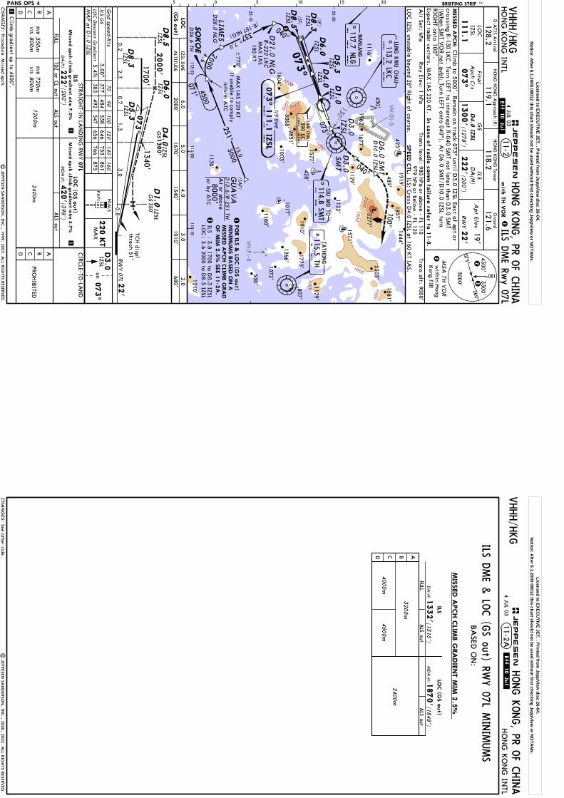
VH(D
)-5
VH(P)-8
130^
1000
2000
1000
1000
2000
1000
1000
1000
1000
within H
ongKong FIR
Trans level: 980 hPa or above - FL 110979 hPa or below
- FL 120TCH displ
thresh 51' 4300'2
2260^
075^
180^
3300'
3000'
HO
NG
KO
NG
Tower
Ground
HO
NG
KO
NG
INTL
128.2LO
CIZSL
GS
ILSD
A(H
)A
pt Elev19'
118.2121.6
HO
NG
KO
NG
Approach (R)
119.1
ILS DME Rw
y 07L
D4.0
IZSL
111.1
073^
1300'
RW
Y22'
SPEED C
TL:
Alt Set: hPa
Rwy Elev: 1 hPa
222'(2
00')
2000'1670'
1340'680'
1010'
1
HONG K
ONG, PR O
F CHINA
2
BRIEFING STRIP TM
Gnd speed-K
ts
11-2
MSA
TH V
OR
Trans alt: 9000'
LOC IZSL unusable beyond 28^ Right of course.
PANS OPS 4
1
on073^
IZSL
MA
P a
t D1.0
IZSL
HIA
LS
220 K
TM
AX
70
90
100
120
140
160
ILS GS
3.00^377
484538
646753
861LO
C D
escent Gra
dient5.4%
383492
547656
766875
D8.5
IZSL
D4.0
RWY 07L
22'
0.83.0
0.7
1340'1700'
2000'
D8.3
IZSL
1.3
073^
2.30.2
D5.3
IZSL
D6.0
IZSL
ALS out
MD
A(H
)(3
98')
420'
2400m
PROHIB
ITED
11
| JEPPESEN
SAN
DERSO
N, IN
C., 1999, 2003. A
LL RIGHTS RESERV
ED.
Final
Apch C
rs
05 5 10 15 20
LOC
(GS o
ut)
LUNG K
WU C
HAU
L K
C113.2 LK
C
073^
073^
D8.5
D8.3
IZSL
(IF)
(IF)
115.5 THT H
117.7 NLG
NANLA
NG
N L GD
5.3
IZSL
22-20
IZSL
D6.0
425'
L C
390 LCLA
M C
HAU
430'
1129'
1962'1677'
D1.0
IZSL
D4.0
IZSL
D26.6
TH113-50
114-00114-10
6.05.0
4.03.0
2.0
FO
R ILS
& LO
C (G
S o
ut)
MIN
IMUM
S B
ASED O
N A
I Z S L
337^7.0
SO
KO
E
D21.0 N
LGR-220 LK
C
2000
040^
IZSL
MIS
SED A
PCH C
LIMB G
RA
D
3
3 1
(R-157 NLG)
22-10
4.6
TATH
ONG
071^
251^3000
13.0
4500
{770'
VHHH/H
KG
IZSL
D1.0
IZSL
GS
350'
GS1300'
1116'
1122'
114.8 SMT
S M T
SIU M
O TO
D3.0
100^040^
D3.0
SMT
D3.0
IZSL
OF M
IM 2
.5%
SEE 1
1-2
A.
.Eff.10.Jul.4 JU
L 03
D-A
TIS Arrival
(1278')
with
TH V
OR
D10.0
IZSL
D6.0
SMT
MA
X IA
S180 K
T
MA
X IA
S 220 KT
If unable to comply
inform A
TC
ILS: Cross D
4.0 IZSL at 160 KT IA
S.
MIS
SED A
PCH:
In c
ase o
f radio
com
m fa
ilure
refe
r to 1
1-0
.Expect radar vectors. M
AX IA
S 220 KT.
Clim
b to 5000'. Remain on track 073^ until D
3.0 IZSL East of apt orcrossing R-130 LK
C. Turn LEFT to intercept R-040 SM
T not later than D3.0 SM
T(W
hen SMT V
OR not avbl: Turn LEFT onto 040^). A
t D6.0 SM
T/D10.0 IZSL turn
RIGHT onto 100^.
(IAF)
GUA
VA
D13.6/R
-251
TH
8000'or by A
TC
At or above
CHA
NG
ES:
PAPI
(GS o
ut)
ALTITU
DE
AB
FULL
ALS out
ILS
DA
(H)2
22' (2
00')
CD
CIRC
LE-TO-LA
ND
ABCD
Mis
sed a
pch c
limb g
radie
nt m
im 7
.0%
Mis
sed a
pch c
limb g
radie
nt m
im 5
.7%
1200m720m800m
RVR
VIS
550m800m
RVR
VIS
JEPPESEN
STRAIG
HT-IN
LAN
DIN
G RW
Y07L
D1581'
1919'
1571'
1527'1129'
2303'
1857'1444'
3277'
807'428'
D
D
LOC
IZSL DM
E
ILS DM
E
D28.0
NLG
LIMES
3068'2851'
1210'
530'
1160'
1130'
1072'
1266'1003'
1017'
073^ 1
11.1
IZSL
ILSLO
C: 3.8 1700 to D
8.3 IZSL: 3.6 2000 to D
8.5 IZSL
Clim
b gradient up to 4500'.
1604'
1910'1775'
D
TDZ or C
L out
489'
Procedure. Missed apch.
Licensed to EXECU
TIVE JET, . Printed from JeppView
disc 26-04.N
otice: After 6.1.2005 0901Z this chart should not be used w
ithout first checking JeppView or N
OTA
Ms.
| JEPPESEN
SAN
DERSO
N, IN
C., 2000, 2002. A
LL RIGHTS RESERV
ED.
11-2AVHHH/H
KG
4 JUL 03
.Eff.10.Jul.
HONG K
ONG, PR O
F CHINA
HO
NG
KO
NG
INTL
CHA
NG
ES:
BA
SED O
N:
JEPPESEN
ALS out
DA
(H)
ABCD
ILSLO
C (G
S o
ut)
FULL
4800m
4000m
ALS out
3200m
1332'(1
310')
MD
A(H
)1870'(1
848')
2400m
MIS
SED A
PCH C
LIMB G
RA
DIE
NT M
IM 2
.5%
ILS DME &
LOC (G
S out) RWY 07L M
INIM
UMS
See other side.
Licensed to EXECU
TIVE JET, . Printed from JeppView
disc 26-04.N
otice: After 6.1.2005 0901Z this chart should not be used w
ithout first checking JeppView or N
OTA
Ms.

VH(D
)-5
VH(P)-8
130^
1000
2000
1000
1000
1000
1000
1000
1000
2000
1000
within H
ongKong FIR
Trans level: 980 hPa or above - FL 110979 hPa or below
- FL 120
TCH displ
thresh 51'
4300'2
2260^
075^
180^
3300'
3000'
HO
NG
KO
NG
Tower
Ground
HO
NG
KO
NG
INTL
128.2LO
CIZSL
GS
Apt Elev
19'
118.2121.6
HO
NG
KO
NG
Approach (R)
119.1
D4.0
IZSL
111.1
073^
1300'
RW
Y22'
Alt Set: hPa
Rwy Elev: 1 hPa
1
HONG K
ONG, PR O
F CHINA
2
BRIEFING STRIP TM
Gnd speed-K
ts
MSA
TH V
OR
Trans alt: 9000'
PANS OPS 4
1
on073^
IZSL
HIA
LS
220 K
TM
AX
70
90
100
120
140
160
3.00^377
484538
646753
861
11-2BCAT II ILS D
ME Rw
y 07L
CA
T II ILSRA
100'
DA
(H)
122'(100')
GS
RA
157'
RA
100'
DA
(H)122'(100')
DA
(H)1
72'(150')
RVR3
50m
RVR5
00m
CA
T II ILS|
JEPPESEN SA
ND
ERSON
, INC., 1999, 2003. A
LL RIGHTS RESERV
ED.
Mis
sed a
pch c
limb g
radie
nt m
im 7
.0%1
RWY 07L
22'
D1.0
IZSL
0.83.0
1.3
073^
1700'
3.0
VHHH/H
KG
GS1300'
GS
350'
D3.0
Final
Apch C
rs
05 5 10 15 20
MIS
SED A
PCH C
LIMB
GRA
D M
IM 7
.0%
MA
X IA
S 220 KT
If unable to comply
inform A
TC
D3.0
SMT
D3.0
IZSL
LUNG K
WU C
HAU
L K
C113.2 LK
C
117.7 NLG
NANLA
NG
N L G
073^
1
1. Special Aircrew
and Acft C
ertification Required. 2. LOC IZSL unusable beyond 28^ Right of course.
1962'1677'
425'
430'
1129'
L C
390 LCLA
M C
HAU
073^
337^7.0
D21.0 N
LG
D1.0
D4.0
IZSL
IZSL
I Z S L
R-220 LKC
040^1700
D8.3
IZSL
(IF)
3.8(R-157 NLG)
D5.3
IZSL
22-10
22-20
251^3000
13.0770'
{
1116'
{930'
1122'
114.8 SMT
S M T
SIU M
O TO
T H115.5 THTA
THONG
100^
040^
SO
KO
ED
26.6
TH113-50
114-00114-10
D8.3
IZSL
D5.3
IZSL 071^
D4.0
IZSL
2000
4.64500
.Eff.10.Jul.4 JU
L 03
D-A
TIS Arrival
(1278')
with
TH V
OR
At 180 K
T IAS
SPEED C
TL:
D10.0
IZSL
D6.0
SMT
Cross D
4.0 IZSL at 160 KT IA
S.
(IAF)
GUA
VA
D13.6/R
-251
TH
8000'or by A
TC
At or above
In c
ase o
f radio
com
m fa
ilure
refe
r to 1
1-0
.Expect radar vectors. M
AX IA
S 220 KT.
crossing R-130 LKC. Turn LEFT to intercept R-040 SM
T not later than D3.0 SM
T(W
hen SMT V
OR not avbl: Turn LEFT onto 040^). A
t D6.0 SM
T/D10.0 IZSL turn
RIGHT onto 100^.
Clim
b to 5000'. Remain on track 073^ until D
3.0 IZSL East of apt orM
ISSED A
PCH:
CHA
NG
ES:
PAPI
07L
STRAIG
HT-IN
LAN
DIN
G RW
Y
Clim
b gradient up to 4500'.
JEPPESEN
D
D
1581'
1919'
1571'
2303'
1444'
3277'
1684'
ILS DM
E
073^ 1
11.1
IZSL
3068'2851'
530'
1160'
1527'
1072'
1266'
1129'
1003' 428'
1017'
1857'
807'
1604'
1775'1910'
DD
1210'
D28.0 N
LGLIM
ES1130'
Procedure. Missed apch.
489'
Licensed to EXECU
TIVE JET, . Printed from JeppView
disc 26-04.N
otice: After 6.1.2005 0901Z this chart should not be used w
ithout first checking JeppView or N
OTA
Ms.
VH(D
)-5
VH(P)-8
1000
1000
1000
20001000
1000
1000
1000
1000
1000
2000
1000
2000
1000
1000
1000
4300'2
2260^
075^
180^
3300'
3000'
Do not turn before PO
RPA/D
7.0 ISR. MA
X IA
S 210 KT until established on 182^.
within H
ongKong FIR
Trans level: 980 hPa or above - FL 110979 hPa or below
- FL 120
ISR
109.3
1308'(1280')
D4.0
ISR
HO
NG
KO
NG
Tower
Ground
HO
NG
KO
NG
INTL
128.2LO
CG
SA
pt Elev19'
118.4122.55
HO
NG
KO
NG
Approach (R)
119.1
ILS DME Rw
y 07R
073^
RW
Y28'
Alt Set: hPa
Rwy Elev: 1 hPa
HONG K
ONG, PR O
F CHINA
2
MIS
SED A
PCH:
BRIEFING STRIP TM
Gnd speed-K
ts
11-3
MSA
TD V
OR
Trans alt: 9000'
PANS OPS 4
MA
P a
t D1.0
ISR
70
90
100
120
140
160
ILS GS
3.00^377
484538
646753
861LO
C D
escent Gra
dient5.4%
383492
547656
766875 ILS
DA
(H)
Minim
ums
Refer to
1
1
PROHIB
ITED
Final
Apch C
rs
05 5 10 15 20
073^
2000'
RWY 07R
28'
TCH displ
thresh 50'
1700'
0.7
D1.0
ISR348'
GS
0.83.0
1.3
D4.0
ISR
D8.5
ISR
D8.3
ISR2.3
0.2
D5.3
ISR
ISRD6.0
| JEPPESEN
SAN
DERSO
N, IN
C., 1998, 2003. A
LL RIGHTS RESERV
ED.
on073^
PO
RPA
HIA
LS
210 K
TM
AX
procedure tracks.SPEED C
TL:
1. LOC ISR unusable beyond 25^ Left and 19^ Right of course. 2. Pilots should adhere strictly to prescribed
D-A
TIS Arrival
VHHH/H
KG
with
TD V
OR1
GS1308' 1340'
Clim
b gradient up to 1300'.
ILS: Cross D
4.0 ISR at 160 KT IA
S.
Clim
b to 5000'. Remain on track 073^ until PO
RPA, then
turn RIGHT onto 182^ to intercept and follow
R-250 TD to SO
KO
E andhold, or as directed.
070^113-50
114-00
T DTU
NG LU
NG
116.1 TD
073^
182^
250^3000
13.0
337^6.0
073^
PO
RPA
SO
KO
ED
27.0 TD
D7.0
ISR
D22.0 N
LGR-2
18 LK
C
2000
D1.0
ISR
D4.0
ISR
4.64500
1962'
(R-157 NLG)
(IF)
D8.3
ISR
(IF)
D8.5
ISR
040^
D5.3
ISR
ISRD6.0
22-10
22-201122'
1129'
{
CA
UTIO
N: G
S signal might be
interfered by ground traffic.
1116'
117.7 NLG
NANLA
NG
N L G
LUNG K
WU C
HAU
L K
C113.2 LK
C
L C
390 LCLA
M C
HAU
MA
X IA
S 220 KT
If unable to comply
inform A
TC
MA
X IA
S180 K
T
I S R3
WHEN T
D V
OR U
/S S
EE 1
1-4
.
114-10
3 1
(IAF)
GUA
VA
D14.0/R
-250 TD
8000'or by A
TC
At or above
8 AUG
03
6.02000'
ISR DM
E5.0
1670'680'
4.03.0
2.01340'
1010'
Mis
sed a
pch c
limb
gra
die
nt m
im 2
.5%
CHA
NG
ES:
LOC
(GS o
ut)
ALTITU
DE
STRAIG
HT-IN
LAN
DIN
G RW
Y
AB
FULL
ALS out
ILSLO
C(G
S o
ut)
Mis
sed a
pch c
limb g
radie
nt
mim
4.0
%
DA
(H)
1200m720m800m
FULL
ALS out
RVR
VIS
RVR
1500m1600m
VIS
DA
(H)
(320')
228' (200')
348'
550m800m
RVR
VIS
900m
07R
ALS out
MD
A(H
)(4
02')
430'
2000m
C/D
CIRC
LE-TO-LA
ND
C/D AB
JEPPESEN
TDZor
CLout
PAPI
PAPI
1581'
D
3068'
1910' 1571'
1130'
1527'
2303'
1604'
2851'
1003'
3277'1677'
1857'
D28.0
NLG
LIMES
428'
430'
770'
489'
D
D
073^ 1
09.3
ISR
ILS DM
E
: 4.0 1700 to D8.3 ISR
: 3.8 2000 to D8.5 ISR
1210'
ILSLO
C
1129'
807'1775'
530'
1160'
1017'
1072'
1266'
Missed approach.
Licensed to EXECU
TIVE JET, . Printed from JeppView
disc 26-04.N
otice: After 6.1.2005 0901Z this chart should not be used w
ithout first checking JeppView or N
OTA
Ms.

VH(D
)-5
VH(P)-8
10001000
1000
1000
2000
2000
10001000
1000
1000
2000
1000
1000
1000
1000
1000
1000
within H
ongKong FIR
260^
075^
180^
3300'
3000'
4300'2
2
RWY 07R
28'
0.83.0
1.33.0
ISR
109.3
1308'(1280')
D4.0
ISR
HO
NG
KO
NG
Tower
Ground
HO
NG
KO
NG
INTL
128.2LO
CG
SA
pt Elev19'
118.4122.55
HO
NG
KO
NG
Approach (R)
119.1
073^
RW
Y28'
HONG K
ONG, PR O
F CHINA
2
BRIEFING STRIP TM
MSA
TD V
OR
PANS OPS 4
CAT II ILS D
ME Rw
y 07R11-3A
1
CA
T II ILS
128'(100')
DA
(H)
RA
99'
1
CA
T II ILS
(150')
178'
DA
(H)
RVR3
50m
RVR5
00m
RA
161'
128'
DA
(H)
(100')
RA
99'
Gnd speed-K
ts70
90
100
120
140
160
3.00^377
484538
646753
861G
S
| JEPPESEN
SAN
DERSO
N, IN
C., 1998, 2003. A
LL RIGHTS RESERV
ED.
on073^
PO
RPA
HIA
LS
210 K
TM
AX
07R
STRAIG
HT-IN
LAN
DIN
G RW
Y
Mis
sed a
pch c
limb g
radie
nt m
im 4
.0%1
Final
Apch C
rs
05 5 10 15 20
Trans level: 980 hPa or above - FL 110979 hPa or below
- FL 120
Do not turn before PO
RPA/D
7.0 ISR. MA
X IA
S 210 KT until established on 182^.
Rwy Elev: 1 hPa
VHHH/H
KG
D-A
TIS Arrival
with
TD V
OR
Clim
b gradient up to 1300'.
MIS
SED A
PCH:
Clim
b to 5000'. Remain on track 073^ until PO
RPA, then
turn RIGHT onto 182^ to intercept and follow
R-250 TD to SO
KO
E andhold, or as directed.
250^3000
13.0
I S R
SO
KO
ED
27.0 TD4500
3. Pilots should adhere strictly to prescribed proc tracks.
1962'1677'
PO
RPA
D7.0
ISR
1. Special Aircrew
and Acft C
ertification Required. 2. LOC ISR unusable beyond 25^ Left and 19^ Right of
course.
D1.0
ISR
D4.0
ISR
073^
L C
390 LCLA
M C
HAU
Trans alt: 9000'
1W
HEN T
D V
OR U
/S S
EE 1
1-4
A.
MIS
SED A
PCH C
LIMB
GRA
D M
IM 4
.0%
(IAF)
GUA
VA
D14.0/R
-250 TD
8000'or by A
TC
At or above
Cross D
4.0 ISR at 160 KT IA
S.SPEED C
TL:
1129'
1122'
182^
T DTU
NG LU
NG
116.1 TD
Alt Set: hPaD
22.0 N
LGR-2
18 LK
C
337^6.0
1700
4.6
(R-157 NLG)
22-10D28.0
NLG
LIMES
{
At 180 K
T IAS
113.2 LKC
L K
CLU
NG K
WU C
HAU
D8.3
(IF)
117.7 NLG
NANLA
NG
N L G
D5.3
ISR
22-20
1116'
073^
040^
ISR
4.0
TCH displ
thresh 50'
073^
D5.3
ISR
D4.0
ISRG
S1308'
113-50114-00
070^
348'G
SD1.0
ISR
114-10
1700'D8.3
ISR MA
X IA
S 220 KT
If unable to comply
inform A
TC 2000
8 AUG
03
CHA
NG
ES:
PAPI
PAPI
JEPPESEN
Missed approach.
1130'
073^ 1
09.3
ISR
ILS DM
E1604'
425'
430'
1527'
1003'
2851'3068'
530'
1072'1160'
1129'
1581'489'
1857'1919'
1571'
1910'
428'
3277'2303'
D
807'
1266'1017'
1775'
770'
D
D
1210'
Licensed to EXECU
TIVE JET, . Printed from JeppView
disc 26-04.N
otice: After 6.1.2005 0901Z this chart should not be used w
ithout first checking JeppView or N
OTA
Ms.
VH(P)-8
VH(D
)-5
1000
2000
1000
2000
1000
1000
2000
1000
1000
1000
1000
1000
1000
1000
10001000
4300'1
1260^
075^
180^
3300'
3000'
within H
ongKong FIR
Trans level: 980 hPa or above - FL 110979 hPa or below
- FL 120
ISR
109.3
1308'(1280')
D4.0
ISR
HO
NG
KO
NG
Tower
Ground
HO
NG
KO
NG
INTL
128.2LO
CG
SA
pt Elev19'
118.4122.55
HO
NG
KO
NG
Approach (R)
119.1
ILS DME Rw
y 07R
073^
RW
Y28'
Alt Set: hPa
Rwy Elev: 1 hPa
HONG K
ONG, PR O
F CHINA
1
BRIEFING STRIP TM
Gnd speed-K
ts
11-4
MSA
TH V
OR
Trans alt: 9000'
PANS OPS 4
MA
P a
t D1.0
ISR
70
90
100
120
140
160
ILS GS
3.00^377
484538
646753
861LO
C D
escent Gra
dient5.4%
383492
547656
766875 ILS
DA
(H)
Minim
ums
Refer to
1
1
PROHIB
ITED
Final
Apch C
rs
05 5 10 15 20
073^
2000'
RWY 07R
28'
TCH displ
thresh 50'
1700'
0.7
D1.0
ISR
0.83.0
1.3 D4.0
ISR
D8.5
ISR
D8.3
ISR2.3
0.2
D5.3
ISR
ISRD6.0
| JEPPESEN
SAN
DERSO
N, IN
C., 1998, 2003. A
LL RIGHTS RESERV
ED.
on073^
PO
RPA
HIA
LS
210 K
TM
AX
1. LOC ISR unusable beyond 25^ Left and 19^ Right of course. 2. Pilots should adhere strictly to prescribed
1340'
VHHH/H
KG
with
TH V
OR
Clim
b gradient up to 1300'.
GS1308'
GS
348'
D-A
TIS Arrival
Do not turn before PO
RPA/D
7.0 ISR. MA
X IA
S 210 KT until established on 182^.
MIS
SED A
PCH:
Clim
b to 5000'. Remain on track 073^ until PO
RPA, then
turn RIGHT onto 182^ to intercept and follow
R-251 TH to SO
KO
E andhold, or as directed.
073^
ISRD8.3
ISR
(IF)
D8.5
ISR
L C
390 LCLA
M C
HAU
113-50114-00
SO
KO
ED
26.6
TH
4500
071^
CA
UTIO
N: G
S signal might be
interfered by ground traffic.
337^6.0
D22.0 N
LGR-2
18 LK
C
20004.6
D28.0
NLG
LIMES
(R-157 NLG) ISR
040^
22-10
251^13.0
3000{
770'
2
MA
X IA
S 220 KT
If unable to comply
inform A
TC
MA
X IA
S180 K
T
I S R
182^
T H115.5 THTA
THONG
114-10
2
D13.6/R
-251
TH
(IAF)
GUA
VA
8000'or by A
TC
At or above
procedure tracks.SPEED C
TL:
ILS: Cross D
4.0 ISR at 160 KT IA
S.
LUNG K
WU C
HAU
L K
C113.2 LK
C
073^
PO
RPA
D7.0
ISR
D1.0
ISR
D4.0
1962'
117.7 NLG
NANLA
NG
N L G
(IF)
D5.3
ISR
D6.0
22-201122'
1129'
8 AUG
03
6.02000'
ISR DM
E5.0
1670'680'
4.03.0
2.01340'
1010'
Mis
sed a
pch c
limb
gra
die
nt m
im 2
.5%
CHA
NG
ES:
LOC
(GS o
ut)
ALTITU
DE
STRAIG
HT-IN
LAN
DIN
G RW
Y
AB
FULL
ALS out
ILSLO
C(G
S o
ut)
Mis
sed a
pch c
limb g
radie
nt
mim
4.0
%
DA
(H)
1200m720m800m
FULL
ALS out
RVR
VIS
RVR
1500m1600m
VIS
DA
(H)
(320')
228' (200')
348'
550m800m
RVR
VIS
900m
07R
ALS out
MD
A(H
)(4
02')
430'
2000m
C/D
CIRC
LE-TO-LA
ND
C/D AB
JEPPESEN
TDZor
CLout
PAPI
PAPI
2851'
3068'
1604'
1003'
073^ 1
09.3
ISR
ILS DM
E
1910' 1571'
1775'
1129'
1857'
1017'
807'
D
530'
1160'
1130'
1072'
1266'1210'
: 4.0 1700 to D8.3 ISR
: 3.8 2000 to D8.5 ISR
ILSLO
C
2303' 1581'
D
1527'
1677'
D
430'
3277'
489'
428'
Missed approach.
Licensed to EXECU
TIVE JET, . Printed from JeppView
disc 26-04.N
otice: After 6.1.2005 0901Z this chart should not be used w
ithout first checking JeppView or N
OTA
Ms.

VH(P)-8
VH(D
)-5
1000
1000
1000
1000
1000
2000
1000
10001000
1000
1000
1000
1000
2000
2000
1000
10001000
TCH displ
thresh 50'
within H
ongKong FIR
Trans level: 980 hPa or above - FL 110979 hPa or below
- FL 1201. Special A
ircrew and A
cft Certification Required. 2. LO
C ISR unusable beyond 25^ Left and 19^ Right of
course.
260^
075^
180^
3300'
3000'
4300'2
2
RWY 07R
28'
0.83.0
1.3
073^
1700'ISR
3.0
D5.3
ISR
ISR
109.3
1308'(1280')
D4.0
ISR
HO
NG
KO
NG
Tower
Ground
HO
NG
KO
NG
INTL
128.2LO
CG
SA
pt Elev19'
118.4122.55
HO
NG
KO
NG
Approach (R)
119.1
073^
RW
Y28'
Alt Set: hPa
Rwy Elev: 1 hPa
HONG K
ONG, PR O
F CHINA
2
BRIEFING STRIP TM
MSA
TH V
OR
Trans alt: 9000'
PANS OPS 4
CAT II ILS D
ME Rw
y 07R11-4A
1
CA
T II ILS
128'(100')
DA
(H)
RA
99'
1
CA
T II ILS
(150')
178'
DA
(H)
RVR3
50m
RVR5
00m
RA
161'
128'
DA
(H)
(100')
RA
99'
Gnd speed-K
ts70
90
100
120
140
160
3.00^377
484538
646753
861G
S
| JEPPESEN
SAN
DERSO
N, IN
C., 1998, 2003. A
LL RIGHTS RESERV
ED.
on073^
PO
RPA
HIA
LS
210 K
TM
AX
07R
STRAIG
HT-IN
LAN
DIN
G RW
Y
Mis
sed a
pch c
limb g
radie
nt m
im 4
.0%1
3. Pilots should adhere strictly to prescribed proc tracks.
Final
Apch C
rs
05 5 10 15 20 VHHH/H
KG
D-A
TIS Arrival
GS1308'
D1.0
ISR348'
GS
Clim
b gradient up to 1300'.
with
TH V
OR
Do not turn before PO
RPA/D
7.0 ISR. MA
X IA
S 210 KT until established on 182^.
MIS
SED A
PCH:
Clim
b to 5000'. Remain on track 073^ until PO
RPA, then
turn RIGHT onto 182^ to intercept and follow
R-251 TH to SO
KO
E andhold, or as directed.
114-10
SPEED C
TL:
1129'
1122'
182^
MIS
SED A
PCH C
LIMB
GRA
D M
IM 4
.0%
Cross D
4.0 ISR at 160 KT IA
S.
1T H115.5 THTA
THONG
D13.6/R
-251
TH
(IAF)
GUA
VA
8000'or by A
TC
At or above
D4.0
ISRD8.3
073^SO
KO
ED
26.6
TH
D22.0 N
LGR-2
18 LK
C
337^6.0
040^1700
4.6
(R-157 NLG)
D8.3
ISR
(IF)
4.0
22-10
113-50 L C
390 LCLA
M C
HAU
113.2 LKC
L K
CLU
NG K
WU C
HAU
D1.0
ISR
117.7 NLG
NANLA
NG
N L G
D4.0
ISR
D5.3
ISR
22-20
071^4500
{770'
MA
X IA
S 220 KT
If unable to comply
inform A
TC
1116'
At 180 K
T IAS
I S R
114-00
1962'1677'
073^
PO
RPA
D7.0
ISR
13.0
3000251^
2000
8 AUG
03
CHA
NG
ES:
PAPI
PAPI
JEPPESEN
Missed approach.
1210'
530'
1072'
1266'
1160'
1017'
489'1857'
1919'
1571'
1775'
1129'
1910'
428'
3277'2303'
1581'
807'
D
073^ 1
09.3
ISR
1604'
D28.0
NLG
LIMES
D
D
3068'1003'
2851'
ILS DM
E
1130'
425'
430'
1527'
Licensed to EXECU
TIVE JET, . Printed from JeppView
disc 26-04.N
otice: After 6.1.2005 0901Z this chart should not be used w
ithout first checking JeppView or N
OTA
Ms.
VH(P)-8
VH(D
)-5
1000
10001000
1000
1000100
0
1000
2000
1000
1000
2000
1000
10001000
1000
1000
within H
ongKong FIR
IFL
108.9
253^
1310'
GS
350'
RW
Y 25L2
7'
TCH 51'
2500'1400'
D3.5
IFL
5.00.5
0.93.0
2.50.8
D1.0
IFL
2.1 D14.1
IFL
253^
1560'
4300'2
2260^
075^
180^
3300'
3000'
HO
NG
KO
NG
Tower
Ground
HO
NG
KO
NG
INTL
128.2LO
CG
SA
pt Elev19'
118.4122.55
HO
NG
KO
NG
Approach (R)
119.1
via
TD V
OR
ILS DME Rw
y 25L
RW
Y27'
HONG K
ONG, PR O
F CHINA
2
MIS
SED A
PCH:
BRIEFING STRIP TM
Gnd speed-K
ts
11-5
MSA
TD V
OR
PANS OPS 4
MA
P a
t D1.0
IFL
70
90
100
120
140
160
3.00^377
484538
646753
861
ILSD
A(H
)
Minim
ums
Refer to
1
1
PROHIB
ITED
253^
PRA
WN
MA
X IA
S 185 KT until established on 165^.
IFLD12.0
D4.0
IFL
| JEPPESEN
SAN
DERSO
N, IN
C., 1998, 2003. A
LL RIGHTS RESERV
ED.
on
HIA
LS
185 K
TM
AX
ILS GS
Final
Apch C
rs
05 5 10 15 20
Trans level: 980 hPa or above - FL 110979 hPa or below
- FL 120
253^
070^
343^343^
163^
IFLD1.0
4500
165^
912'
489'1857'
D3.5
IFL
D18.0 IFL
PRA
WN
D7.0 IFL
D7.0
TD
7.0
L C
390 LC
425'1919'
LAM C
HAU
I F L
IFLD4.0
253^
5.0
4500
D7.0
IFL
IFLD12.0
22-10
22-20
Alt Set: hPa
Rwy Elev: 1 hPa
Trans alt: 9000'
430'
1122'
{
956'
1213'
930'
1116'
717'1129'
T DTU
NG LU
NG
116.1 TD
(IAF)
+
1581'
MIR
RS
1444'
D14.1
IFL
(IF)
LOTUS
D15.0 IFL
113-50114-00
114-10114-204500'
D7.0
IFL
VHHH/H
KG
Clim
b gradient up to 1800'.
GS
2300'
D-A
TIS Arrival
(1283')
1
WHEN T
D V
OR U
/S S
EE 1
1-6
.1
Clim
b to 5000'. Remain on 253^. A
t PRAW
N turn
LEFT onto 165^ to intercept R-250 inbound TD V
OR and hold,
or as directed.
(R-250 TD)
D4.0
IFL
GS1310'
Leave ator above
GS signal unusable beyond 7^
Left of course.CA
UTIO
N: G
S signal might be
interfered by ground traffic.
LOC IFL unusable beyond 28^ Left of course.
SPEED C
TL:
8 AUG
03
ILS: Maintain 180 K
T IAS until D
8.0 IFL. Cross D
4.0 IFL at 160 KT IA
S. LOC: C
ross D8.0 IFL at 160 K
T IAS.
Cross D
15.0 IFL at 180 KT IA
S.
1535'
2303'
Mis
sed a
pch c
limb
gra
die
nt m
im 2
.5%
4000'
LOTUS
D15.0 IFL
CHA
NG
ES:
STRAIG
HT-IN
LAN
DIN
G RW
Y
AB
FULL
ALS out
ILSLO
C(G
S o
ut)
Mis
sed a
pch c
limb g
radie
nt
mim
4.0
%
DA
(H)
1200m720m800m
FULL
ALS out
RVR
VIS
DA
(H)
(410')
227' (200')
437'
550m800m
RVR
VIS
25L
ALS out
MD
A(H
)(403
')430'
2000m
C/D
CIRC
LE-TO-LA
ND
C/D AB13
00m2100m
PAPI
PAPI
JEPPESEN
TDZor
CLout
3068' 1962'
1910'
1571'
530'
1160'
1130'
1527'
1072'
1775'
1266'
807'
1129'
1604'1003'
1677'
2851'
1017'
253^ 1
08.9
IFL
428'
ILS DM
E
770'D
3277'
1210'
8000'or by A
TC
Speed control.
Licensed to EXECU
TIVE JET, . Printed from JeppView
disc 26-04.N
otice: After 6.1.2005 0901Z this chart should not be used w
ithout first checking JeppView or N
OTA
Ms.

VH(D
)-5
VH(P)-8
1000
1000
10001000
20001000
1000
1000
2000
2000
1000
1000
1000
1000
1000
within H
ongKong FIR
Trans level: 980 hPa or above - FL 110979 hPa or below
- FL 1201. Special A
ircrew and A
cft Certification Required. 2. G
S signal unusable beyond 7^ Left of course.3. LO
C IFL unusable beyond 28^ Left of course.
RWY 25L
27'
TCH 51'
7.13.0
0.83.0
D1.0
GS
350' IFL
IFL
108.9
253^
1310'
0.9
260^
075^
180^
3300'
3000'
4300'2
2
HO
NG
KO
NG
Tower
Ground
HO
NG
KO
NG
INTL
128.2LO
CG
SA
pt Elev19'
118.4122.55
HO
NG
KO
NG
Approach (R)
119.1
via
TD V
OR
RW
Y27'
Alt Set: hPa
Rwy Elev: 1 hPa
HONG K
ONG, PR O
F CHINA
2
BRIEFING STRIP TM
MSA
TD V
OR
Trans alt: 9000'
PANS OPS 4
CAT II ILS D
ME Rw
y 25L11-5A
1
CA
T II ILS
127'(100')D
A(H
)
1
CA
T II ILS
STRAIG
HT-IN
LAN
DIN
G RW
Y
(150')177'
DA
(H)
RVR3
50m
RVR5
00m
RA
163'
127'
DA
(H)
(100')
25L
Mis
sed a
pch c
limb g
radie
nt m
im 4
.0%1
Gnd speed-K
ts70
90
100
120
140
160
3.00^377
484538
646753
861G
S
RA
100'
D4.0
IFL
RA
100'
| JEPPESEN
SAN
DERSO
N, IN
C., 1998, 2003. A
LL RIGHTS RESERV
ED.
253^
PRA
WNon
HIA
LS
185 K
TM
AX
1
1581'1535'
1857'
1919'425'
SPEED C
TL:
(IF)
LOTUS
Cross D
15.0 IFL at 180 KT IA
S, maintain until D
8.0 IFL. Cross D
4.0 IFL at 160 KT IA
S.
Final
Apch C
rs
05 5 10 15 20
253^
4500'2300'
LOTUS
D15.0 IFL
D4.0
GS1310'
IFLD7.0
IFLD14.1
113-50114-00
114-10114-20
IFL
070^
912'
489'
MIR
RS
D18.0 IFL
D14.1
4500
430'D
15.0 IFL
T DTU
NG LU
NG
116.1 TD
I F L
253^
343^
165^
PRA
WN
D7.0 IFL
D7.0
TDD4.0
IFL IFLD1.0
253^
0.5
(IAF)
22-10
22-20
D7.0
IFL
L C
390 LCLA
M C
HAU
1122'
1129'
{
1116'
956'
IFL1213'
717'
343^
163^
45007.0
VHHH/H
KG
GS
Clim
b gradient up to 1800'.
D-A
TIS Arrival
WHEN T
D V
OR U
/S S
EE 1
1-6
A.
MIS
SED A
PCH C
LIMB
GRA
D M
IM 4
.0%
(1283')
MIS
SED A
PCH:
MA
X IA
S 185 KT until established on 165^.
Clim
b to 5000'. Remain on 253^. A
t PRAW
N turn
LEFT onto 165^ to intercept R-250 inbound TD V
OR and hold,
or as directed.
Leave ator above
(R-250 TD)
8 AUG
03
CHA
NG
ES:
PAPI
PAPI
JEPPESEN
1210'
1130'
2303'3277'
253^ 1
08.9
IFL
3068'
1962'
1571'
1160'1072'
1003'
1677'
530'
D
1527'
2851'
1017'
428'
ILS DM
E
770'
1604'
1129'
1266'
1910'1775'807'
8000'or by A
TC
See other side.
Licensed to EXECU
TIVE JET, . Printed from JeppView
disc 26-04.N
otice: After 6.1.2005 0901Z this chart should not be used w
ithout first checking JeppView or N
OTA
Ms.
VH(P)-8
VH(D
)-5
087^SM
TVO
R
1000
1000
1000
1000
1000
2000 1000
2000
1000
1000
10001000
1000
1000
1000
within H
ongKong FIR
Trans level: 980 hPa or above - FL 110979 hPa or below
- FL 120
IFL
108.9
253^
1310'
RWY 25L2
7'
TCH 51'
2500'1400'
D3.5
IFL
5.00.5
0.9
4500'
3.02.5
0.82.1 D
14.1
IFL
253^
1560'
4300'1
1260^
075^
180^
3300'
3000'
HO
NG
KO
NG
Tower
Ground
HO
NG
KO
NG
INTL
128.2LO
CG
SA
pt Elev19'
118.4122.55
HO
NG
KO
NG
Approach (R)
119.1
ILS DME Rw
y 25L
RW
Y27'
Alt Set: hPa
Rwy Elev: 1 hPa
HONG K
ONG, PR O
F CHINA
1
BRIEFING STRIP TM
Gnd speed-K
ts
11-6
MSA
TH V
OR
Trans alt: 9000'
PANS OPS 4
MA
P a
t D1.0
IFL
70
90
100
120
140
160
3.00^377
484538
646753
861
ILSD
A(H
)
Minim
ums
Refer to
1
1
PROHIB
ITED
D7.0
IFL
IFLD12.0
D4.0
IFL
113-50114-10
114-20
| JEPPESEN
SAN
DERSO
N, IN
C., 1998, 2003. A
LL RIGHTS RESERV
ED.
253^
PRA
WNon
HIA
LS
185 K
TM
AX
ILS GS
Final
Apch C
rs
05 5 10 15 20
253^
071^
343^343^
163^
4500
165^
912'
489'1857'
D3.5
IFL
425'1919'
SIU M
O TO
S M T
114.8 SMT
298^M
IRRS
D18.0 IFL
I F L
D4.0
IFL IFL
D1.0
4500
11.6
(IAF)
22-10
22-20 IFL
D12.0
1160'
1017'
L C
390 LCLA
M C
HAU
IFLD7.0
430'
1122'
1129'
{
930'
1116'
1213'717'
956'
TATH
ONG
115.5 THT H
PRA
WN
D7.0 IFL
+
253^
1581'1535'
1444'
D14.1
IFL
1648'
D15.0 IFL
(IF)
LOTUS
114-00
VHHH/H
KG
Clim
b gradient up to 1800'.
GS
350'D1.0
IFL
GS
2300'
via
TH V
OR
D-A
TIS Arrival
(1283')
MIS
SED A
PCH:
MA
X IA
S 185 KT until established on 165^.
Clim
b to 5000'. Remain on 253^. A
t PRAW
N turn
LEFT onto 165^ to intercept R-251 inbound TH V
OR and hold,
or as directed.
Leave ator above
GS1310'
D4.0
IFL
(R-251 TH)
LOC IFL unusable beyond 28^ Left of course.
SPEED C
TL:
GS signal unusable beyond 7^
Left of course.CA
UTIO
N: G
S signal might be
interfered by ground traffic.
8 AUG
03
ILS: Maintain 180 K
T IAS until D
8.0 IFL. Cross D
4.0 IFL at 160 KT IA
S. LOC: C
ross D8.0 IFL at 160 K
T IAS.
Cross D
15.0 IFL at 180 KT IA
S.
Mis
sed a
pch c
limb
gra
die
nt m
im 2
.5%
4000'
LOTUS
D15.0 IFL
CHA
NG
ES:
STRAIG
HT-IN
LAN
DIN
G RW
Y
AB
FULL
ALS out
ILSLO
C(G
S o
ut)
Mis
sed a
pch c
limb g
radie
nt
mim
4.0
%
DA
(H)
1200m720m800m
FULL
ALS out
RVR
VIS
DA
(H)
(410')227' (200')
437'
550m800m
RVR
VIS
25L
ALS out
MD
A(H
)(4
03')
430'
2000m
C/D
CIRC
LE-TO-LA
ND
C/D AB13
00m2100m
PAPI
PAPI
JEPPESEN
TDZor
CLout
1210'
3068' 1962'
1910'
1571'
530'
1130'
1527'
1072'
1775'
1266'
807'
1129'
1604'1003'
1677'
2851'
D
253^ 1
08.9
IFL
428'
ILS DM
E
770'D
2303'
3277'
8000'or by A
TC
Speed control.
Licensed to EXECU
TIVE JET, . Printed from JeppView
disc 26-04.N
otice: After 6.1.2005 0901Z this chart should not be used w
ithout first checking JeppView or N
OTA
Ms.
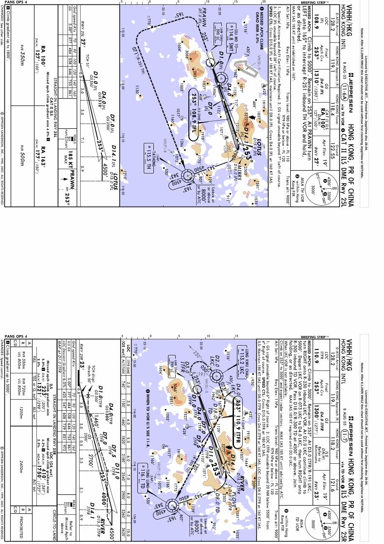
VH(P)-8
VH(D
)-5
SMT
VO
R087^
1000
1000
1000
10001000
1000
1000
2000
2000
1000
1000
1000
1000
00
02
1000
within H
ongKong FIR
Trans level: 980 hPa or above - FL 110979 hPa or below
- FL 120
253^
4500'
RW
Y 2
5L27'
TCH 51'
7.1
LOTUS
D15.0
IFL
3.00.8
3.0
D4.0
GS1
310'
IFL
IFL
108.9
253^
1310'
0.9
260^
075^
180^
3300'
3000'
4300'2
2
HO
NG
KO
NG
Tower
Ground
HO
NG
KO
NG
INTL
128.2LO
CG
SA
pt Elev19'
118.4122.55
HO
NG
KO
NG
Approach (R)
119.1
RW
Y27'
Alt Set: hPa
Rwy Elev: 1 hPa
HONG K
ONG, PR O
F CHINA
2
BRIEFING STRIP TM
MSA
TH V
OR
Trans alt: 9000'
PANS OPS 4
CAT II ILS D
ME Rw
y 25L11-6A
1
CA
T II ILS
127'(100')
DA
(H)
1
CA
T II ILS
STRAIG
HT-IN
LAN
DIN
G RW
Y
(150')
177'
DA
(H)
RVR3
50m
RVR5
00m
RA
163'
127'
DA
(H)
(100')
25L
Mis
sed a
pch c
limb g
radie
nt m
im 4
.0%1
Gnd speed-K
ts70
90
100
120
140
160
3.00^377
484538
646753
861G
S
RA
100'
D4.0
IFL
RA
100'
D7.0
IFLD14.1
Final
Apch C
rs
05 5 10 15 20
IFL
| JEPPESEN
SAN
DERSO
N, IN
C., 1998, 2003. A
LL RIGHTS RESERV
ED.
253^
PRA
WNon
HIA
LS
185 K
TM
AX
MIS
SED A
PCH C
LIMB
GRA
D M
IM 4
.0%
SIU M
O TO
S M T
114.8 SMT
165^
1581'1535'
912'
489'1857'
253^PRA
WN
D7.0
IFL
1919'425'
L C
390 LCLA
M C
HAU
071^
298^
253^
343^4500
163^
343^
MIR
RS
D18.0
IFL
I F L
D4.0
IFL IFL
D1.0
1
IFLD14.1
11.6
4500
(IAF)
SPEED C
TL:
D7.0
IFL
22-10
22-20
113-50114-00
114-10114-20
T H115.5 THTA
THONG
430'
1. Special Aircrew
and Acft C
ertification Required. 2. GS signal unusable beyond 7^ Left of course.
3. LOC IFL unusable beyond 28^ Left of course.
1129'
{
D15.0
IFL
(IF)
LOTUS
Cross D
15.0 IFL at 180 KT IA
S, maintain until D
8.0 IFL. Cross D
4.0 IFL at 160 KT IA
S.
1116'
956'
717'1122'
1213'
VHHH/H
KG
Clim
b gradient up to 1800'.
D1.0
GS
350' IFL
GS
2300'
D-A
TIS Arrival
via
TH V
OR
(1283')
MIS
SED A
PCH:
MA
X IA
S 185 KT until established on 165^.
Clim
b to 5000'. Remain on 253^. A
t PRAW
N turn
LEFT onto 165^ to intercept R-251 inbound TH V
OR and hold,
or as directed.
Leave ator above
(R-251 TH)
8 AUG
03
CHA
NG
ES:
JEPPESEN
PAPI
PAPI
D
3068'
1962'
1571'
1210'
1160'
1130'
1072'
1775'
1266'
2303'
1003'
3277'1677'
530' 1129'
1527'
2851'
1910'
1017'
428'807'
253^ 1
08.9
IFL
ILS DM
E
D770'
1604'
8000'or by A
TC
See other side.
Licensed to EXECU
TIVE JET, . Printed from JeppView
disc 26-04.N
otice: After 6.1.2005 0901Z this chart should not be used w
ithout first checking JeppView or N
OTA
Ms.
VH(P)-8
VH(D
)-5
191^
230^
1000
1000
1000
1000
1000
1000
1000
within H
ongKong FIR
Trans level: 980 hPa or above - FL 110979 hPa or below
- FL 120
MSA
TD V
OR
ITFRD4.0
ITFR
110.9
1300'(1277')
253^
4300'2
2260^
075^
180^
3300'
3000'
HO
NG
KO
NG
Tower
Ground
HO
NG
KO
NG
INTL
128.2LO
CG
SA
pt Elev19'
118.2121.6
HO
NG
KO
NG
Approach (R)
119.1
via
TD V
OR
ILS DME Rw
y 25R
RW
Y23'
HONG K
ONG, PR O
F CHINA
2
MIS
SED A
PCH:
BRIEFING STRIP TM
11-7
PANS OPS 4
ILSD
A(H
)
Minim
ums
Refer to
1
Rwy Elev: 1 hPa
Trans alt: 9000'
MA
X IA
S 185 KT required until D
2.0 LKC.
1
PROHIB
ITED
AB
FULL
ALS out
1200m720m800m
RVR
VIS
550m800m
RVR
VIS
C/DC/D AB
DA
(H)
223'
(200')1321'
(1298')
STRAIG
HT-IN
LAN
DIN
G RW
YILS
25RLO
C (G
S o
ut)
ALS out
Mis
sed a
pch c
limb g
radie
nt m
im
5.0
%
Mis
sed a
pch c
limb g
radie
nt m
im
CIRC
LE-TO-LA
ND
Gnd speed-K
ts
MA
P a
t D1.0
ITFR
70
90
100
120
140
160
3.00^377
484538
646753
861ILS G
SLO
C D
escent Gra
dient6.0%
425547
608729
851972
HIA
LS
RW
Y 2
5R23'
0.8
1460'
3.53.0
4000'
0.9
4500'
2300'3.0
0.5
GS
D7.0
ITFR
3.1
2700'D14.1
ITFR
D11.0
ITFRITFRD7.5
MA
X IA
S 185 KT until advised by A
TC.
Clim
b to 3000'. Remain on 253^. A
t D3.0 ITFR/R-191 LK
C,
When LK
C V
OR is not available:
Clim
b on 253^ to 5000' and expect radar vectors.
DA
(H)
2.5
%
TDZ or C
L out
2400m 253^
Final
Apch C
rs
5
D1.0
ITFR
1M
DA
(H)
410'
(387')
1750'
(1727')4.2
%
MD
A(H
)2.5
%
holding, or as directed.
Refer toM
issed Apch
above
| JEPPESEN
SAN
DERSO
N, IN
C., 1999, 2003. A
LL RIGHTS RESERV
ED.
D2.0
LKC
D4.0
LKC
D18.0
TD
253^
253^
343^
343^
163^
ITFRD1.0
4500
D8.0
TD
8.0
D4.0
ITFR
D7.0
ITFR
ITFRD14.1
D3.0
ITFR
I T F R
T DTU
NG LU
NG
116.1 TD
(IAF)
PLO
VE
D18.0 ITFR
050^
4500
4.5
D7.5
ITFR
ITFRD11.0
073^
120^(R-300 TD
)
22-10
22-20
113-50114-00
114-10114-20
SPEED C
TL:
L C
390 LCLA
M C
HAU
RIV
ER
0 5 10 15
1129'
{
D15.0 ITFR
(IF)
Alt Set: hPa
1. GS signal unusable beyond 6^ Right of course. 2. LO
C ITFR unusable beyond 20 N
M below
5500' from4^ Right of course. VHHH/H
KG
D-A
TIS Arrival
Clim
b gradient up to 5000'.
D4.0
ITFRG
S1300'
GS
350'TC
H displ
thresh 50'
1116'
1122'
1
1W
HEN T
D V
OR U
/S S
EE 1
1-8
.
8000'or by A
TC
turn RIGHT onto R-230 inbound LK
C V
OR. A
t D2.0 LK
C continue clim
b to5000'. D
epart LKC V
OR on R-073 LK
C to D
4.0 LKC, then turn RIG
HT onto
R-300 inbound TD V
OR. Pass D
18.0/R-300 TD at 4500' or above. Join
{930'
LUNG K
WU C
HAU
113.2 LKC
L K
C
Leave ator above
Speed control.
8 AUG
03
ILS: Maintain 180 K
T IAS until D
8.0 ITFR. Cross D
4.0 ITFR at 160 KT IA
S. LOC: C
ross D8.0 ITFR at 160 K
T IAS.
Cross D
15.0 ITFR at 180 KT IA
S.
CHA
NG
ES:
PAPI
RIV
ER
D15.0 ITFR
ITFR DM
E3.0
5.02.0
9.010.0
6.01100'
1820'3260'
3620'2180'
740'LO
C(G
S o
ut)
ALTITU
DE
JEPPESEN
ILS DM
E
253^ 1
10.9
ITFR
3068'
1581'
2851'
1962'
1910'
1571'
530'1160'
1527'
1775'
1266'
1129'
2303'
1535'
912'
1857'1444'
1604'
1003'
3277'1677'
2099'425'
807'428'
1017'
D
1919'
430'
770'
4.01460'
7.08.0
2540'2900'
D
1072'
Licensed to EXECU
TIVE JET, . Printed from JeppView
disc 26-04.N
otice: After 6.1.2005 0901Z this chart should not be used w
ithout first checking JeppView or N
OTA
Ms.

VH(P)-8
VH(D
)-5
191^
230^
1000
1000
100
0
1000
1000
1000
113-50114-00
114-10114-20
within H
ongKong FIR
Trans level: 980 hPa or above - FL 110979 hPa or below
- FL 120
MSA
TD V
OR
ITFRD4.0
ITFR
110.9
1300'(1277')
253^
4300'2
2260^
075^
180^
3300'
3000'
HO
NG
KO
NG
Tower
Ground
128.2LO
CG
SA
pt Elev19'
118.2121.6
HO
NG
KO
NG
Approach (R)
119.1
RW
Y23'
2
MIS
SED A
PCH:
BRIEFING STRIP TMPANS OPS 4
1 Alt Set: hPa
Rwy Elev: 1 hPa
Trans alt: 9000'
MA
X IA
S 185 KT required until D
2.0 LKC.
MA
X IA
S 185 KT until advised by A
TC.
Clim
b to 3000'. Remain on 253^. A
t D3.0 ITFR/R-191 LK
C,
When LK
C V
OR is not available:
Clim
b on 253^ to 5000' and expect radar vectors.
Final
Apch C
rs
5 HO
NG
KO
NG
INTL
via
TD V
OR HONG K
ONG, PR O
F CHINA
CAT II ILS D
ME Rw
y 25R11-7A
1
CA
T II ILSRA
100'
DA
(H)
123'(100')
CA
T II ILS
STRAIG
HT-IN
LAN
DIN
G RW
Y
(150')173'
DA
(H)
RVR3
50m
RVR5
00m
RA
173'
123'
DA
(H)
(100')
25R
Mis
sed a
pch c
limb g
radie
nt m
im 5
.0%1
Gnd speed-K
ts70
90
100
120
140
160
3.00^377
484538
646753
861G
S
RA
100'
D1.0
ITFR
RW
Y 2
5R23'
0.87.1
3.0
4500'253^
3.0
TCH displ
thresh 50'G
S350'
D15.0 ITFR
ITFR
0.9
D14.1
D4.0
ITFR1300'
turn RIGHT onto R-230 inbound LK
C V
OR. A
t D2.0 LK
C continue clim
b to
R-300 inbound TD V
OR. Pass D
18.0/R-300 TD at 4500' or above. Join
holding, or as directed.
HIA
LSRefer to
Missed A
pchabove
| JEPPESEN
SAN
DERSO
N, IN
C., 1999, 2003. A
LL RIGHTS RESERV
ED.
1. Special Aircrew
and Acft C
ertification Required. 2. GS signal unusable 6^ Right of course.
1
L C
390 LCLA
M C
HAU
253^
343^343^
163^
ITFRD1.0
4500
D8.0
TD
8.0
D4.0
ITFR
D7.0
ITFR
I T F R
(IAF)
T DTU
NG LU
NG
116.1 TD
PLO
VE
D18.0 ITFR
4500
4.5
ITFRD14.1
1962' 1677'D
2.0
LKC
D4.0
LKC
D18.0
TD
253^
D3.0
ITFR 050^
073^
120^(R-300 TD
)
22-10
22-20
SPEED C
TL:
0 5 10 15
1122'
1129'
{
RIV
ER
D15.0 ITFR
Cross D
15.0 ITFR at 180 KT IA
S, maintain until D
8.0 ITFR. Cross D
4.0 ITFR at 160 KT IA
S.3. LO
C ITFR unusable beyond 20 N
M below
5500' from 4^ Right of course.
D-A
TIS Arrival
VHHH/H
KG
D7.0
ITFRG
S2300'
GS
Clim
b gradient up to 5000'.
1116'
WHEN T
D V
OR U
/S S
EE11-8
A.
MIS
SED A
PCH C
LIMB
GRA
D M
IM 5
.0%
5000'. Depart LK
C V
OR on R-073 LK
C to D
4.0 LKC, then turn RIG
HT onto
{930'
Leave ator above
LUNG K
WU C
HAU
113.2 LKC
L K
C
8 AUG
03
CHA
NG
ES:
JEPPESEN
RIV
ER
PAPI
ILS DM
E
253^ 1
10.9
ITFR
3068'
1581'
2851'
1919'
1910' 1571'
530'1160'
1527'
1775'
1266'
1129'
2303'
1535'
912'
1857'1444'
1604'1003'
3277'
2099'425'
807'
428'
1017'
D
430'
770'
8000'or by A
TC
1072'
D
See other side.
Licensed to EXECU
TIVE JET, . Printed from JeppView
disc 26-04.N
otice: After 6.1.2005 0901Z this chart should not be used w
ithout first checking JeppView or N
OTA
Ms.
SMT
VO
R084^
VH(P)-8
VH(D
)-5
191^
230^
1000
1000
100
0
1000
1000
1000
1000
within H
ongKong FIR
MSA
TH V
OR
ITFRD4.0
ITFR
110.9
1300'(1277')
253^
4300'1
1260^
075^
180^
3300'
3000'
HO
NG
KO
NG
Tower
Ground
HO
NG
KO
NG
INTL
128.2LO
CG
SA
pt Elev19'
118.2121.6
HO
NG
KO
NG
Approach (R)
119.1
ILS DME Rw
y 25R
RW
Y23'
HONG K
ONG, PR O
F CHINA
1
MIS
SED A
PCH:
BRIEFING STRIP TM
11-8
PANS OPS 4
ILSD
A(H
)
Minim
ums
Refer to
1
1
PROHIB
ITED
AB
FULL
ALS out
1200m
720m800m
RVR
VIS
550m800m
RVR
VIS
C/DC/D AB
DA
(H)
223'
(200')
1321'(1
298')
STRAIG
HT-IN
LAN
DIN
G RW
YILS
25RLO
C (G
S o
ut)
ALS out
Mis
sed a
pch c
limb g
radie
nt m
im
5.0
%
Mis
sed a
pch c
limb g
radie
nt m
im
CIRC
LE-TO-LA
ND
Gnd speed-K
ts
MA
P a
t D1.0
ITFR
70
90
100
120
140
160
3.00^377
484538
646753
861ILS G
SLO
C D
escent Gra
dient6.0%
425547
608729
851972
Clim
b to 3000'. Remain on 253^. A
t D3.0 ITFR/R-191 LK
C,
DA
(H)
2.5
%
TDZ or C
L out
2400m
Final
Apch C
rs
5
1M
DA
(H)
410'
(387
')1750'
(1727')
4.2
%
MD
A(H
)2.5
%
114-10
turn RIGHT onto R-230 inbound LK
C V
OR. A
t D2.0 LK
C continue clim
b to
RW
Y 2
5R23'
0.8
1460'
3.53.0
4000'
0.9
4500'
2300'3.0
0.5
GS
D7.0
ITFR
3.1
350'G
S
2700'D14.1
ITFR
D11.0
ITFRITFRD7.5
253^
HIA
LSRefer to
Missed A
pchabove
| JEPPESEN
SAN
DERSO
N, IN
C., 1999, 2003. A
LL RIGHTS RESERV
ED.
4500
13.9
4500 355^
298^
163^
343^
(IAF)
D2.0
LKC
D4.0
LKC
253^
253^
ITFRD1.0
D4.0
ITFR
D7.0
ITFR
ITFRD14.1
D3.0
ITFR
I T F R
PLO
VE
D18.0
ITFR
050^
D7.5
ITFR
ITFRD11.0
073^
120^
22-10
22-20
113-50114-00
114-20
1775'
1266'L
C390 LCLA
M C
HAU
0 5 10 15
807'
SIU M
O TO
114.8 SMT
SMT
D
D7.0
LKC
1122'
1129'
{
(IF)
RIV
ER
D15.0
ITFR
Trans level: 980 hPa or above - FL 110979 hPa or below
- FL 120Rw
y Elev: 1 hPaTrans alt: 9000'
MA
X IA
S 185 KT required until D
2.0 LKC.
MA
X IA
S 185 KT until advised by A
TC.
When LK
C V
OR is not available:
Clim
b on 253^ to 5000' and expect radar vectors.A
lt Set: hPa 1. G
S signal unusable beyond 6^ Right of course. 2. LOC ITFR unusable beyond 20 N
M below
5500' from4^ Right of course.
D4.0
ITFRG
S1300'
D1.0
ITFR
TATH
ONG
115.5 THT H
VHHH/H
KG
D-A
TIS Arrival
via
TH V
OR
1116'
Clim
b gradient up to 5000'.
TCH displ
thresh 50'
5000'. Depart LK
C V
OR on R-073 LK
C to D
4.0 LKC, then turn RIG
HT onto
120^.Pass D
7.0 LKC at 4500' or above. Expect radar vectors to TH
VO
R.Join holding, or as directed.
{930'
1072'
Leave ator above
LUNG K
WU C
HAU
113.2 LKC
L K
C
Speed control. SPEED C
TL:
8 AUG
03
ILS: Maintain 180 K
T IAS until D
8.0 ITFR. Cross D
4.0 ITFR at 160 KT IA
S. LOC: C
ross D8.0 ITFR at 160 K
T IAS.
Cross D
15.0 ITFR at 180 KT IA
S.
CHA
NG
ES:
JEPPESEN
RIV
ER
D15.0
ITFR
PAPI
ILS DM
E
253^ 1
10.9
ITFR
3068'
1581'
2851'
1962'
1910'
1571'
530'1160'
1527'
1129'
2303'
1535'
912'
1857' 1444'
1604'1003'
3277'1677'
2099'425'
428'
1017'
1919'
430'
770'
D
8000'or by A
TC
ITFR DM
E3.0
5.02.0
9.010.0
6.01100'
1820'3260'
3620'2180'
740'LO
C(G
S o
ut)
ALTITU
DE
4.01460'
7.08.0
2540'2900'
D
Licensed to EXECU
TIVE JET, . Printed from JeppView
disc 26-04.N
otice: After 6.1.2005 0901Z this chart should not be used w
ithout first checking JeppView or N
OTA
Ms.
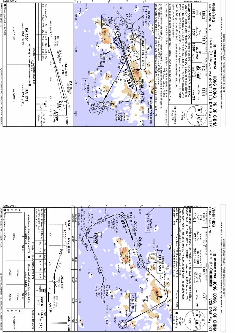
SMT
VO
R084^
VH(P)-8
VH(D
)-5
191^
230^
1000
1000
1000
1000
1000
1000
within H
ongKong FIR
Trans level: 980 hPa or above - FL 110979 hPa or below
- FL 120
MSA
TH V
OR
TCH displ
thresh 50'
Refer toM
issed Apch
above
ITFRD4.0
ITFR
110.9
1300'(1
277')
253^
4300'2
2260^
075^
180^
3300'
3000'
HO
NG
KO
NG
Tower
Ground
128.2LO
CG
S118.2
121.6HO
NG
KO
NG
Approach (R)
119.1
2
MIS
SED A
PCH:
BRIEFING STRIP TMPANS OPS 4
1 Alt Set: hPa
Rwy Elev: 1 hPa
Trans alt: 9000'
MA
X IA
S 185 KT until advised by A
TC.
When LK
C V
OR is not available:
Clim
b on 253^ to 5000' and expect radar vectors.
HO
NG
KO
NG
INTL
via
TH V
OR HONG K
ONG, PR O
F CHINA
CAT II ILS D
ME Rw
y 25R11-8A
1
CA
T II ILSRA
100'
DA
(H)
123'(100')
CA
T II ILS
STRAIG
HT-IN
LAN
DIN
G RW
Y
(150')
173'
DA
(H)
RVR3
50m
RVR5
00m
RA
173'
123'
DA
(H)
(100')
25R
Mis
sed a
pch c
limb g
radie
nt m
im 5
.0%1
Gnd speed-K
ts70
90
100
120
140
160
3.00^377
484538
646753
861G
S
RA
100'
D1.0
ITFR
RW
Y 2
5R23'
0.87.1
3.0
4500'253^
3.0D
15.0
ITFR
ITFR
0.9
D14.1
D4.0
ITFR
Apt Elev
19'
RW
Y23'
Clim
b to 3000'. Remain on 253^. A
t D3.0 ITFR/R-191 LK
C,
turn RIGHT onto R-230 inbound LK
C V
OR. A
t D2.0 LK
C continue clim
b to
120^. Pass D7.0 LK
C at 4500' or above. Expect radar vectors to TH
VO
R.M
AX IA
S 185 KT required until D
2.0 LKC.
HIA
LS
| JEPPESEN
SAN
DERSO
N, IN
C., 1999, 2003. A
LL RIGHTS RESERV
ED.
Final
Apch C
rs
MIS
SED A
PCH C
LIMB
GRA
D M
IM 5
.0%
D2.0
LKC
D4.0
LKC
D7.0
LKC
1. Special Aircrew
and Acft C
ertification Required. 2. GS signal unusable 6^ Right of course.
450013.9
343^4500
163^
298^
355^
1
253^
D4.0
ITFR
D7.0
ITFR
I T F R
PLO
VE
D18.0
ITFR
ITFRD14.1
1962'
1571'
1677'
050^
073^
120^
SPEED C
TL:
10 15
SIU M
O TO
114.8 SMT
SMT
1122'
1129'
TATH
ONG
115.5 THT H
5
L C
390 LCLA
M C
HAU
ITFRD1.0
253^
D3.0
ITFR
0 5
D
{
RIV
ER
D15.0
ITFR
Cross D
15.0 ITFR at 180 KT IA
S, maintain until D
8.0 ITFR. Cross D
4.0 ITFR at 160 KT IA
S.3. LO
C ITFR unusable beyond 20 N
M below
5500' from 4^ Right of course.
22-10
22-20
113-50114-00
114-10114-20
VHHH/H
KG
D-A
TIS Arrival
D7.0
ITFR
Clim
b gradient up to 5000'.
GS
350'
GS
2300'
1116'
GS
1300'
Join holding, or as directed.
{930'
Leave ator above
LUNG K
WU C
HAU
113.2 LKC
L K
C
5000'. Depart LK
C V
OR on R-073 LK
C to D
4.0 LKC, then turn RIG
HT onto
8 AUG
03
CHA
NG
ES:
RIV
ER
PAPI
JEPPESEN
807'
ILS DM
E
253^ 1
10.9
ITFR
1581'
1919'
1910'
530'1160'
1775'1266'
1129'
2303'
1535'
912'
1857'1444'
3277'
2099'425'
428'
1017'
430'
D
3068'2851' 1527'
1604'1003'
770'
1072'
8000'or by A
TC
D
See other side.
Licensed to EXECU
TIVE JET, . Printed from JeppView
disc 26-04.N
otice: After 6.1.2005 0901Z this chart should not be used w
ithout first checking JeppView or N
OTA
Ms.
VH(P)-8
VH(D
)-5
[MD
~7L]
[3.00^]
[FD~7L]
[MD
~7L]
[FD~7L]
[3.00^]
[TCH displ
thresh 51']
10001000
1000
1000
2000
1000
1000
1000
1000
2000
1000
1000
1000
MSA
TD V
OR
Gnd speed-K
ts
073^
70
90
100
120
140
160
HO
NG
KO
NG
Tower
Ground
HO
NG
KO
NG
INTL
128.2VO
RSM
TM
DA
(H)
MIS
SED A
PCH:
118.2121.6
Final
Apch C
rs
HO
NG
KO
NG
Approach (R)
119.1
D11.0
SM
T4300'1
1
1
260^
075^
180^
3300'
3000'
within H
ong
114.8
073^
2000' (1981')
372478
531637
743849
MA
X IA
S 220 KT until established on R-333 inbound TD
VO
R.A
lt Set: hPa
PANS OPS 4
ALS out
4800m
PROHIB
ITED
MA
P a
t D6.5
SMT
1
HONG K
ONG, PR O
F CHINA
Minim
um A
lt
Descent G
radient
Apt Elev
19'
1
MD
A(H
)1340' (13
21')
3.04.5
1.619'
APT
2800m
4000m
2000'
073^
on114.8
SMT
HIA
LS
220 K
TM
AX
2800m
3000m
| JEPPESEN
SAN
DERSO
N, IN
C., 1999, 2003. A
LL RIGHTS RESERV
ED.
Trans level: 980 hPa or above - FL 110Trans alt: 9000'
VOR D
ME Rw
y 07LVHHH/H
KG
D-A
TIS Arrival
.Eff.10.Jul.4 JU
L 03
Clim
b to 5000' on track 073^ to SMT V
OR, then follow
13-1
05 5 10 15 20 BRIEFING STRIP TM
Refer toM
inimum
s
Kong FIR
113-50114-00
114-10
Apt Elev: 1 hPa
979 hPa or below - FL 120
070^
ALTITU
DE
SMT D
ME
2000'11.0
10.01680'
9.01360'
8.01040'
7.0720'
SMT
D14.0
L C
390 LCLA
M C
HAU
1684'
073^
250^3000
13.0
337^7.0
073^
SO
KO
ED
27.0
TD
D21.0 N
LG
D10.0
SMT
047^
153^
R-244 SMT
(R-333 TD)
2000
22-10
22-20
(IF)
4500
114.8
SM
TS M
TSIU
MO TO
116.1 TDT D
TUNG LU
NG
117.7 NLG
NANLA
NG
N L G
(R-157 NLG)
SMT
040^
D14.0
3.3
1129'
SM
T V
OR
1116'
1122'
4.6
+
MA
X IA
S 220 KT
If unable to comply
inform A
TC
{930'
R-047 SMT. A
t D10.0 SM
T turn RIGHT to intercept R-333 inbound TD
VO
R, continue climb on R-250 TD
to SOKO
E and hold, or as directed.
(IAF)
GUA
VA
D14.0
/R-2
50 TD
8000'or by A
TC
At or above
5.24%or D
11.0
SMT
D6.5
SMT
D6.5
SMT
D11.0
SMT
Descent a
ngle
STRAIG
HT-IN
LAN
DIN
G RW
Y07L
CHA
NG
ES:
AB
ALS out
CD
CIRC
LE-TO-LA
ND
ABCD
Mis
sed a
pch c
limb g
radie
nt m
im 2
.5 %
MD
A(H
)580' (561
')M
issed a
pch c
limb g
radie
nt m
im 3
.7 %
PAPI
Clim
b gradient up to 4500'.
JEPPESEN
MA
X IA
S180 K
T
D28.0
NLG
LIMES
3068'
1581'
2851'
1962'
1919'
1910' 1571'
1210'
530'
1160'
1130'
1527'
1072'
1775'
1266'
1129'
2303'
1857'1444'
1604'
1003'
3277'1677'
425'
807'
428'
1017'
D
D
D
770'
430'489'
Procedure. Missed apch. V
NA
V.
Licensed to EXECU
TIVE JET, . Printed from JeppView
disc 26-04.N
otice: After 6.1.2005 0901Z this chart should not be used w
ithout first checking JeppView or N
OTA
Ms.
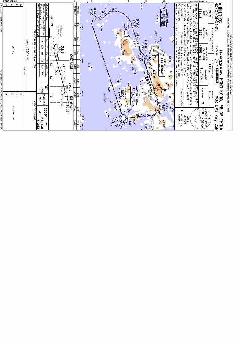
VH(P)-8
VH(D
)-5
[FD25R]
[MD
25R]
[3.32^]
[3.32^]
[FD25R]
[MD
25R]
[TCH displ
thresh 50']
1000
10001000
1000
1000
1000
1000
2000
1000
1000
2000
MSA
TD V
OR
MIS
SED A
PCH:
HONG K
ONG, PR O
F CHINA
13-2HO
NG
KO
NG
INTL
VO
RSM
TM
DA
(H)
Final
Apch C
rs4300'
260^
075^
180^
3300'
3000'
114.8
253^
4000' (3
981')
Minim
um A
lt
Apt Elev
19'
D8.0
SM
T HO
NG
KO
NG
Tower
Ground
128.2118.2
121.6HO
NG
KO
NG
Approach (R)
119.1
11
450' (4
31')
4.0
Gnd speed-K
ts
PANS OPS 4
Descent G
radient
2400m
19'
253^
4000'
1.1A
PT
3.01.0
2.0
SMT
D2.0
253^
D8.0
SMT
D5.0
SMT
D1.0
SMT
2900'
1500'
on3000'
114-20
PROHIB
ITED
SMT D
ME
MA
P a
t D2.0
SMT a
fter VO
R
70
90
100
120
140
160
411529
588705
823940
R-2
53
SMT
114.8
230 K
TM
AX
Clim
b on R-253 to 3000'.
| JEPPESEN
SAN
DERSO
N, IN
C., 1999, 2003. A
LL RIGHTS RESERV
ED.
SM
T V
OR
HIA
LS
163^
within H
ong1
Alt Set: hPa
D8.0
TD
Trans level: 980 hPa or above - FL 110Trans alt: 9000'
VOR D
ME Rw
y 25R
At D
10.0 SMT turn LEFT onto 180^
to intercept R-155 NLG
, then climb to 5000'. A
t D28.0 N
LG turn LEFT
direct to TD V
OR and hold, or as directed.
MA
X IA
S 230 KT until on R-155 N
LG.
VHHH/H
KG
4 JUL 03
.Eff.10.Jul.
D-A
TIS Arrival
BRIEFING STRIP TM05 5 10 15 20
D10.0
SMT
D15.0
SMT
114-10114-00
113-50
L C
390 LCLA
M C
HAU
SMT
D1.0
253^
(IF)
116.1 TD
D2.0
SMT
SMT
D5.0
D8.0
343^4500
22-10
22-20
117.7 NLG
NANLA
NG
N L G
SMT
253^
180^155^
(IAF)
T DTU
NG LU
NG
1684'
Kong FIR
Apt Elev: 1 hPa
979 hPa or below - FL 120
SPEED C
TL:
Cross D
12.0 SMT at 180 K
T IAS and D
5.0 SMT at 160 K
T IAS.
355^
298^45008.0
253^7.0
4000
3.4
SIU M
O TO
S M T
114.8
SM
T
(R-155 NLG)
1122'
1129'
8000'
1116'
or by ATC
+
When N
LG V
OR not available, clim
b on R-253 SMT to 3000'. A
t D10.0 SM
T turn LEFTonto 180^ and clim
b to 5000'. Expect radar vectors to TD V
OR.
{930'
At or above
or5.80%
Descent a
ngle
6.03260'
4.02550'
7.00.0
1150'1.0
1500'3.0
2200'
CHA
NG
ES:
AB
ALS out
CD
CIRC
LE-TO-LA
ND
ABCD
STRAIG
HT-IN
LAN
DIN
G RW
Y25R
MD
A(H
)450' (4
31')
ALTITU
DE
3630'
PAPI
912'
2.01850'
5.02900'
JEPPESEN
D28.0
NLG
1210'
D
3068'2851'
1962'
1571'
530'1160'
1130'
1527'
1072'
1775'
2303'
1857'
1604'1003'
3277'
1677'
428'1017'
1129'D
1581'
1919'425'
1910'
1266'
807'
1444'
D
770'
430'
Missed apch. V
NA
V.
Licensed to EXECU
TIVE JET, . Printed from JeppView
disc 26-04.N
otice: After 6.1.2005 0901Z this chart should not be used w
ithout first checking JeppView or N
OTA
Ms.
Related Documents