1 B OROVOYE D IGITAL S EISMOGRAM A RCHIVE FOR U NDERGROUND N UCLEAR T ESTS DURING 1966–1996 April 2001 Won-Young Kim and Paul G. Richards Lamont-Doherty Earth Observatory of Columbia University Palisades, NY 10964, USA Vitaly Adushkin and Vladimir Ovtchinnikov Institute for Dynamics of Geosphere, Moscow, Russia Summary Seismic waveform data digitally recorded at the Borovoye Geophysical Observatory (BRV), in northern Kazakstan since 1966 are available for analysis. The BRV archive for 711 Under- ground Nuclear Tests 1 (UNT) carried out by five nuclear powers since 1966 are reformatted into CSS 3.0 2 data format. The list of event numbers in the BRV archive for UNTs from various test sites is given in Table 1. A major digital seismogram archive at Borovoye is being reformatted into a modern format suitable for analysis and preservation. Since 1991, the authors at the Lamont-Doherty Earth Ob- servatory (LDEO) and at the Institute for Dynamics of Geosphere (IDG), Moscow have worked hard under the auspices of the IRIS Consortium, the Air Force Office of Scientific Research and Defense Threat Reduction Agency, U.S. Department of Defense, International Science and Technology Center (ISTC), Moscow, and other organizations to preserve the 30 years of digital seismogram archive at BRV (see a feature article in EOS by Richards, Kim and Ekstr¨ om, 1992). This release of the BRV digital seismogram data archive results from nearly 10 years of hard work by many engineers and analysts at IDG, Moscow. Drs. Nadezhda Belyashova and Natalia Mikhailova at the Institute of Geophysical Research, National Nuclear Center (NNC), Republic of Kazakstan helped to complete the BRV archive tape presevation project. Drs. Gregory van der Vink and David Simpson at the IRIS Consortium provided important help during the early years of the BRV archive preservation project. This note describes certain information regarding these waveform data archive and provides basic parameters needed to analyze them. 1 We shall use the distinction between a nuclear test and a nuclear explosion that was adopted in the revised protocol of 1990 for the Threshold Test Ban Treaty. Thus, a single underground nuclear test (UNT) can consist of a number of different underground nuclear explosions (UNEs) provided these are carried out within a time interval not exceeding 0.1 s and within an area delineated by a circle whose diameter is less than 2 km. Explosions with a time interval longer than 0.1 s, or a distance greater than 2 km, are counted as separate tests. We note that this distinction between UNTs and UNEs has been followed in official Russian documentation of the Soviet test program at STS, but with one exception, namely the nuclear test which was conducted at Degelen in a tunnel on January 30, 1974. (see Khalturin et al., 2001). 2 Center for Seismic Studies version 3.0 relational database format.

Welcome message from author
This document is posted to help you gain knowledge. Please leave a comment to let me know what you think about it! Share it to your friends and learn new things together.
Transcript

1
BOROVOYE DIGITAL SEISMOGRAM ARCHIVE FOR
UNDERGROUNDNUCLEAR TESTS DURING1966–1996
April 2001
Won-Young Kim and Paul G. RichardsLamont-Doherty Earth Observatory of Columbia University
Palisades, NY 10964, USA
Vitaly Adushkin and Vladimir OvtchinnikovInstitute for Dynamics of Geosphere, Moscow, Russia
Summary
Seismic waveform data digitally recorded at the Borovoye Geophysical Observatory (BRV),in northern Kazakstan since 1966 are available for analysis. The BRV archive for 711 Under-ground Nuclear Tests1 (UNT) carried out by five nuclear powers since 1966 are reformatted intoCSS 3.02 data format. The list of event numbers in the BRV archive for UNTs from various testsites is given in Table 1.
A major digital seismogram archive at Borovoye is being reformatted into a modern formatsuitable for analysis and preservation. Since 1991, the authors at the Lamont-Doherty Earth Ob-servatory (LDEO) and at the Institute for Dynamics of Geosphere (IDG), Moscow have workedhard under the auspices of the IRIS Consortium, the Air Force Office of Scientific Researchand Defense Threat Reduction Agency, U.S. Department of Defense, International Science andTechnology Center (ISTC), Moscow, and other organizations to preserve the 30 years of digitalseismogram archive at BRV (see a feature article inEOSby Richards, Kim and Ekstrom, 1992).
This release of the BRV digital seismogram data archive results from nearly 10 years of hardwork by many engineers and analysts at IDG, Moscow. Drs. Nadezhda Belyashova and NataliaMikhailova at the Institute of Geophysical Research, National Nuclear Center (NNC), Republicof Kazakstan helped to complete the BRV archive tape presevation project. Drs. Gregory van derVink and David Simpson at the IRIS Consortium provided important help during the early yearsof the BRV archive preservation project. This note describes certain information regarding thesewaveform data archive and provides basic parameters needed to analyze them.
1We shall use the distinction between a nuclear test and a nuclear explosion that was adopted in the revisedprotocol of 1990 for the Threshold Test Ban Treaty. Thus, a single underground nuclear test (UNT) can consist of anumber of different underground nuclear explosions (UNEs) provided these are carried out within a time interval notexceeding 0.1 s and within an area delineated by a circle whose diameter is less than 2 km. Explosions with a timeinterval longer than 0.1 s, or a distance greater than 2 km, are counted as separate tests. We note that this distinctionbetween UNTs and UNEs has been followed in official Russian documentation of the Soviet test program at STS,but with one exception, namely the nuclear test which was conducted at Degelen in a tunnel on January 30, 1974.(see Khalturin et al., 2001).
2Center for Seismic Studies version 3.0 relational database format.

2
Table 1: Borovoye Digital Archive for World-wide Underground Nuclear Tests, 1966–1996
Country Test site Time period BRV data
USSR Semipalatinsk Test Site 1966 Dec 18 – 1989 Oct 19 228Novaya Zemlya 1967 Oct 21 – 1990 Oct 24 31Peaceful Nuclear Explosions1967 Oct 06 – 1988 Sep 06 80
China Lop Nor Test Site 1970 Sep 22 – 1995 May 15 11France Tuamotu Archipelago 1977 Mar 19 – 1996 Jan 27 68United Kingdom Nevada Test Site 1978 Apr 11 – 1989 Dec 08 15United States Nevada Test Site 1967 May 23 – 1992 Mar 26 278
Total number of UNTs in the BRV archive 711
BRV Archive, Underground Nuclear Tests
180˚
180˚
-120˚
-120˚
-60˚
-60˚
0˚
0˚
60˚
60˚
120˚
120˚
180˚
180˚
-90˚ -90˚
-60˚ -60˚
-30˚ -30˚
0˚ 0˚
30˚ 30˚
60˚ 60˚
90˚ 90˚
BRV
Figure 1: The Borovoye archive for world-wide underground nuclear tests (stars) during 1966-1996.

3
1. Borovoye Archive for UNTs carried out by Former Soviet Union
Former Soviet Union (FSU or USSR) conducted its first nuclear test on August 29, 1949and the last – 715th, nuclear test on October 24, 1990. The official publication from the Ministryof Atomic Energy & Ministry of Defense, Russian Federation (Mikhailov et al., 1996) lists atotal of 715 nuclear tests and peaceful nuclear explosions. Among the 715 tests, 219 tests wereatmospheric, underwater and space explosions, and remaining 496 tests were underground tests(see Table 2).
Table 2: Borovoye Archive for USSR Underground Nuclear Tests
Location/Type UNT Air/Surface Underwater total BRV archive
Semipalatinsk Test Site 340 116 456 228Novaya Zemlya Test Site 39 86 5 130 31Peaceful Nuclear Explosions 117 117 80Missile Test Range 10 10Weapons test 2 2
Total 496 214 5 715 339 (68%)
Thus, the BRV archive provide data for about 2/3 of the announced UNTs at various testsites of the FSU.
2. BRV Archive Data from UNTs at Semipalatinsk Test Site, FSU
Official Russian publications (Mikhailov et al., 1996; USSR Nuclear Tests, 1997) have listed340 underground nuclear tests that were conducted during 1961-1989 at the Semipalatinsk TestSite (STS) in Eastern Kazakstan. Only 271 of these nuclear tests appear to have been describedwith well-determined origin time, coordinates and magnitudes in the openly available technicalliterature (Khalturin et al., 2001). Thus, if we count only these 271 UNTs, then the BRV archiveprovide data for nearly 85% of these UNTs at Semipalatinsk Test Site.
In Figure 2, we show a map of the Semipalatinsk Test Site boundaries (as reported by theSoviet Union at the time of TTBT entry-into-force in 1990), together with the locations of 228UNTs with BRV archive data. There are three source regions of the seismic data from UNTs atSemipalatinsk Test Site as shown in Figure 2. These are known as Balapan, Degelen and Murzhiksubareas.
2.1 BRV Archive Data for Balapan Subarea of the Semipalatinsk Test Site
105 UNTs were conducted at Balapan subarea of the STS during 1965-1989. Amongthese, one UNT had yield of less than 1 ton and could not be identified by seismic method (seeMikhailov et al., 1996). BRV archive contains seismic data from 93 UNTs. These are listed inTable A1 and are plotted in Figure 2. Borovoye archive covers seismic data from over 90% of all

4
Semipalatinsk Test Site
77˚ 00'E 77˚ 30'E 78˚ 00'E 78˚ 30'E 79˚ 00'E 79˚ 30'E
49˚ 30'N
50˚ 00'N
50˚ 30'N
51˚ 00'N
0 50 100 km
Balapan
Degelen
Murzhik
KUR
I r t y s h
Kurchatov
60˚E 80˚E
40˚N
50˚N
60˚N
STSBRV
Figure 2: UNTs at Semipalatinsk Test Site (circles) recorded at Borovoye (BRV) during 1966-1989. Kurchatov was a restricted town supporting USSR nuclear testing in the region.

5
Table 3: Underground Nuclear Tests at the Semipalatinsk Test Site
Location/subarea UNT <1 ton Double small Detectable BRV archive
Balapan 105 1 1 3 100 93Degelen 209 14 12 26 155 116Murzhik 26 1 2 23 19
Semipalatinsk Test Site 340 15 14 31 278 228
UNTs conducted at Balapan subarea. For UNTs at Balapan subarea until Dec. 1972, ground truthinformation on location and origin times are taken from Bocharov (1989; see also Vergino, 1989).For UNTs since 1973, the location are from the ground truth information available from NationalNuclear Center, Republic of Kazakstan (NNCRK; 1999), while the origin times are taken fromthe Lilwall and Farthing (1990) of the British Atomic Weapons Establishment (AWE). We takethe body-wave magnitude given in Ringdal et al. (1992), which are the maximum likelihood mb’sdetemined by AWE. All UNTs at the Balapan subarea were carried out in vertical shafts drilleddown to about 500 m from the ground level. The Balapan subarea is nearly flat with an averageelevation of about 300 m. Accurate origin times for 10 UNTs during 1985–1989 are given inAdushkin et al. (1997). These origin times are used to evaluate origin times of other UNTs since1973 given in various catalogs. Our evaluation indicates that the origin times and location biasesin the AWE catalog3 are smallest among the available catalogs. Our analysis indicates that theAWE origin times should be accurate within±0.15 sec.
2.2 BRV Archive Data for UNTs at Degelen Subarea of the Semipalatinsk Test Site
There are waveform data from 116 UNT at Degelen Mt. region of the STS in the BRVarchive. Table A2 lists date, time, location and magnitude of these UNTs. Almost all UNTsin the Degelen subarea have been carried out in horizontal tunnels dug into granitic rocks of theDegelen Mt. For most UNTs till 1972, ground truth data are given in Bocharov (1989). For UNTsbetween 1973-1989, location is given for the portal of the tunnel (Leith, 1998), while the origintimes are taken from Lilwall and Farthing (1990) of the British Atomic Weapons Establishment.Although, the locations are given up to five decimal digits, the accuracy of the actual shot pointscan be away from the given locations by as much as few hundred meters, thus these locationscould be considered GT2 quality4
Notice that BRV waveform data archive contains four pairs of UNTs at STS which wereexploded almost simultaneously, or within a short time interval, less than 10 sec (see Table 4).
The BRV archive also contains waveform data from three small UNTs at Degelen subareawhich were not well documented in the open literature (see Khalturin et al., 2001). These UNTsare; Sep. 02, 1967 (#271), Jan. 29, 1971 (#332) and Dec. 28, 1988 (#707)(see Table A2).
3joint epicenter determination (JED) method described by Douglas (1967) to ISC data are use to obtian origintimes and locations, using several UNTs at STS as master events for which ground truth information was given byBocharov et al. (1989; also Vergino, 1989).
4GT2 is used here to indicate ground truth data with location accuracy of about± 2 km.

6
Table 4: BRV archive for UNTs at STS which were detonated almost simultaneously
Date Time (hh:mm:sec) mb(P) Test id Test site
Dec. 10, 1972 04:27:00.0 5.72 376 Degelen04:27:10.0 5.96 377 Balapan
Oct. 29, 1977 03:06:59.97 5.60 473 Degelen03:07:04.92 5.56 474 Balapan
Aug. 29, 1978 02:36:59.95 5.20 493 Degelen02:37:08.75 5.90 494 Balapan
Nov. 29, 1978 04:33:00.17 5.21 507 Degelen04:33:04.99 5.96 506 Balapan
2.3 BRV Archive Data for UNTs at Murzhik Subarea of the Semipalatinsk Test Site
Waveform data from 19 UNTs from the Murzhik subarea in the STS are included in theBRV archive database (see Table A3). Locations and origin times for 13 UNTs from 1966through 1972, are taken from Bocharov (1989). For UNTs since 1973 at Murzhik subarea, sofar no ground truth data are available and the locations and origin times of six UNTs since 1973through 1980, are take from Lilwall and Farthing (1990). Note that for the UNT on Aug. 4, 1976,location and origin time are taken from Khalturin et al. (2001).
3. Borovoye Archive Data for UNTs at Novaya Zemlya Test Site
There are 39 UNTs at Novaya Zemlya Test Site (see Mikhailov et al., 1996) and the BRVarchive provide seismic records from 31 UNTs. Table A4 lists paramters for BRV archive datafrom UNTs at Novaya Zemlya Test Site. Location, origin time and maximum likelihood body-wave magnitude are taken from Marshall et al. (1994). Note that longitude given in Marshall etal. (1994) is moved to the West by 0.009◦ as indicated by Richards (2000). Most of the UNTsconducted at the NZ Test Site are multiple explosions (see Table A4). In Figure 3, we show a mapof the Northern and Southern Test Site boundaries of the Novaya Zemlya test sites (as reported bythe Soviet Union at the time of TTBT entry-into-force in 1990), together with the locations of 31UNTs with BRV archive data. Most of the UNTs are conducted in tunnels dug in the mountainssouth of the Matochkin Shar Strait as shown in Figure 3. Three UNTs with BRV archive data areconducted in vertical shafts at the southern Novaya Zemlya Test Site (Test No. 388, 392, 430 and431 in Table A4).
4. Borovoye Archive Data for Peaceful Nuclear Explosions in FSU
The Former Soviet Union carried out 117 Peaceful Nuclear Explosions (PNE)5 throughoutits territory as shown in Figure 4. BRV archive contains 80 PNEs which are listed in Table A5.Ground truth data are available for many of these PNEs (see Sultanov et al., 1999). Epicentral
5Here we are taking the definition of a PNE as a nuclear test conducted off recognized test sites.

7
Novaya Zemlya Test Site
54˚E 55˚E 56˚E
73˚ 12'N
73˚ 24'N
73˚ 36'N
73˚ 48'N0 20 40
km
200
200
200
200
200
200
200
200
200
200
400
400
400
400
400
400
400
400
400
400
400400
600
600
600
600
600
600
600
600
600
600600
800
800
800
800
M a t o
c h k
i n S h a r S t r a i t
60˚E 80˚E
50˚N
60˚N
70˚N
BRV
NovayaZemlya
Figure 3: Locations of UNTs (circles) at Northern Novaya Zemlya Test Sites recorded atBorovoye during 1967-1990 are shown on topographic relief map. Southern and Northern TestSites on Novaya Zemlya and great circle path between BRV and NZ test site is indicated (inset).

8
distance ranges from 2.8◦to 29.7◦from BRV and have a wide azimuthal coverage providing ex-celent data for studies of regional seismic wave propagation in Central Asia (see Figure 4). Wewill show an example waveform to illustrate the quality of the BRV archive data.
PNE on Oct. 17, 1978, 14:00:00.16This PNE is conducted in Tyumen region at a location 63.185◦N, 63.432◦E and depth of
burial of 593 meters (Sultanov et al., 1998). The event id is #503 (see Table A5) which is alsocalled “Kraton” shaft KR-1 and had a yield of 22 kt. It was detonated in sandstone/shale materialand had magnitude,mb(P)=5.5. Figure 4 shows the location of the event (#503 in the figure).
The waveform data are recorded by STsR-SS 10-channel system, which has three-component,short-period seismometers (KS channels) and records with sampling rate of 31.25 samples persecond (dt=0.032 s, fN=15.6 Hz) – channel names sZ07, sN08, and sE09. SS system alsohas three-component long-period seismometers (channels lZ02, lN03 and lE04), and a low-gainshort-period vertical-component (channel, sZ01). Three channels (5, 6 and 10) are usually unusedfor recording seismic signals.
The instrument responses of KS channels are nearly flat to ground displacement between0.6 to 5 Hz with a nominal gain of 1268 counts/micrometer at 1.5 Hz (Figure 11; Kim & Ekstrom,1996). The vertical record from this PNE has peak amplitude of 842 counts which yields grounddisplacement of about 0.68 micrometer. Note that maximum digital counts available for theBorovoye digital archive data is 1024 counts (11 bit A/D with a sign bit).
For comparing the regional records from the Borovoye digital archive data with those recordedby recent broadband instrument from IMS and IRIS/GSN stations, it is useful to differentiate theBRV records, since they are recorded with the instrument response which produces nearly grounddisplacement records (see, Richards, Kim & Ekstrom, 1992).
The velocity record from this PNE is plotted in Figure 5. The vertical records in variousfrequency bands - 0.5–2 Hz through 8–10 Hz, are plotted with time axis in group velocity (km/s).Notice that regional characteristic phases,Pn, Pg, SnandLg are all well excited by the test. TheP waves (Pn andPg) as well asSnwaves are energetic at all frequency bands with strong codafollowing the onset arrivals, whileLg waves are relatively weak and show larger amplitude, butshort duration (at around 3.3 km/s). The strong signal arrives at around 3 km/s cannot be easilyidentified. In general, the quality of the record is satisfactory. Notice that one of the short-periodhorizontal component record (sE09) is clipped.
To examine the periodicity of the signal, we calculate the spectrogram (Figure 6). Thespectrogram shows time invariant spectral bands at 3.5, 6, 9.5 and 11.5 Hz which are usuallyassociated with source multiplicity (see e.g., Kim et al, 1994). The average frequency difference(df) between these spectral banding is about 2.7 Hz which suggests a multiple source with timedifference of about 0.4 sec (Figure 7).
In case of ripple fired quarry blasts or underwater explosions, complex interference patternas well as spectral bandings due to source multiplicity and reverberations in the water columnlowers the Pn/Sn ratios as noted by Kim et al. (1993, 1994 and 1996). Hence, relatively lowPn/Sn ratios of this PNE are not unusual. In such case, spectral bandings and cepstral peaksshould be used as additional event screening criteria (see Annex 2 to the CTBT Protocol, Septem-ber 1996).

9
PNE Centered at Borovoye20
˚E
20˚E
30˚E
30˚E
40˚E
40˚E
50˚E
50˚E
60˚E
60˚E
70˚E
70˚E
80˚E
80˚E
90˚E
90˚E
100˚E
100˚E
110˚E
110˚E
120˚E
120˚E130˚E
130˚E
30˚N 30˚N
40˚N 40˚N
50˚N 50˚N
60˚N 60˚N
70˚N 70˚N
274
282
304305
307
313
320
329331
335
342
344
346
352
358
363
366
370
371
372
375
383
384
386
389
390
406
428
438446
452
462
466
469
470
49
492
498 500
502
503
510513523
5
529
533
534
537556
560
570
576
578579
583
592
597
613614615
618619620621622623
639640641
643
649
652653
679681684
686
699
700
ZAL
GEYTTHR
BRVK
KURK
AKTO
MAKZ
TLG
ELT
WMQ
AAK
ABKT
ARU
STS
Lop Nor
K a z a k s t a n
R u s s i a
C h i n aUzbekistanTurkmenistan
Kyrgyzstan
Iran
Tajikistan
Afghanistan Pakistan
Tarim Basin
A l t a i M t s
S a y a n M t s
T i e n - S h a n
Tibet PlateauHindu K
ushPamirsKopet Dag
CaspianSea
U r
a l
s
Figure 4: Soviet PNEs (stars) recorded at Borovoye during 1967-1988. Event id in Table 5Ais indicated for each PNE. IMS primary (double circle), auxiliary (single circle), IRIS/GSN (in-verted triangle) and Kazakstan Broadband Seismographic Network stations are indicated (solidtriangle). Large circles around BRV indicate 1000 and 2000 km distance ranges from the staton.

10
3456789
3456789
Group Velocity (km/sec)
BRV SS, KS 70.580E+04
Velocity record
1198 kmaz= 157.3˚
baz=343.2˚
0.5-2 Hz0.436E+04
2-4 Hz0.598E+03
4-6 Hz0.295E+03
6-8 Hz0.232E+03
8-10 Hz0.274E+03
10/17/78, 14:00:00.16, 63.185˚N, 63.432˚E, h=593 m, PNE, Kraton shaft KR-1, 22 kT, mb=5.5, Sandstone/Shale
Lg?Pn Sn
Figure 5: Vertical, velocity record filtered in various frequency bands – 0.5–2 Hz through 8–10Hz, are plotted with time axis in group velocity (km/s). TheP waves (Pn andPg) as well asSnwaves are energetic at all frequency bands with strong coda following the onset arrivals, whileLg waves are relatively weak.

11
0
5
10
15
frequency (Hz)
120
180
240
300
360
420
480
540
600
time (s
ec)
PNE, Kraton-1, 22 kT10/17/78 14:00, mb=5.5BRV SS-KS, Z, velocity∆=1198 kmφ=157˚
Figure 6: Spectrogram of the velocity record from PNE on 10/17/78. The spectrogram showstime invariant spectral bands at 3.5, 6, 9.5, 11.5 Hz which are usually associated with sourcemultiplicity.
150 151 152 153 154 155
time (sec)
150 151 152 153 154 155
10/17/1978 14:00:00.16, Lat= 63.185, Lon= 63.432, h= 0.6 km
BRV Z, Displacement0.11E+03
1198.0 kmaz=157.3baz=343.2
BRV Z, Velocity0.53E+03 1198.0 km
az=157.3baz=343.2
Pn1Pn2
Pn1Pn2
Figure 7: First few seconds of the records from the PNE on 10/17/78 are plotted to show possiblemultiple Pn arrivals marked asPn1& Pn2.

12
5. Borovoye Archive Data for Chinese Nuclear Tests
Since 1964, China carried out nuclear tests in Xinjiang-Uygru Autonomous Province inwestern China. During 1969 through 1996, 22 UNT are known to have been conducted at theLop Nor Chinese Test Site. Borovoye archive has waveform data from 11 UNTs as listed inTable A6. The epicentral distance from the Chinese Test Site to BRV is about 1800 km. Thelocations and origin times of the UNTs at Lop Nor during 1969-1992 are determined by Douglaset al. (1993) and Gupta (1995) by using JED method. Engdahl (2001) also re-located most of theChinese UNTs by cluster analysis. The locations given by Engdahl are plotted in Figure 8 andare given in Table A6. As noted by Douglas et al. (1993), epicenters of the UNTs at Lop Nor areclustered into three groups; A, B and C (see Figure 8). According to the topography and geology,it was argued that UNTs in subregion A are in vertical shafts, while UNTs in subregions B and Care detonated in horizontal tunnels.
6. Borovoye Archive Data for French Nuclear Test
France carried out over 190 nuclear tests at the Pacific Test Center – Tuamotu Archipelago,French Polynesia, during July 2, 1966 through July, 15, 1996. 137 UNTs were carried out inthe region around Mururoa Atoll, Tuamotu Archipelago, while 10 UNTs were carried out in theregion around Fangataufa Lagoon. The Borovoye archive provides waveform data from 68 testsat the French Polynesia test sites as listed in Table A7.
For seven UNTs at Tuamotu Archipelago, no seismologically determined locations areavailable in open literature. These are listed on official French list with nominal time and lo-cation (22◦S, 139◦W). These UNTs are listed in Table A7 with their “Site” column denoted as“-” (null) entries. Locations of the 61 UNTs of which we have BRV archive data, carried out byFrance at Tuamotu Archipelago, French Polynesia Test Site are plotted in Figure 9.
The distance range from the UNTs at the French Polynesia test sites to Borovoye is about141.7◦with station to event azimuth of about 47◦. At this distance,PKIKP phase, which traveledthrough the inner core of the Earth is the first arrivalP wave.
Note that France carried out four atmospheric nuclear tests at the Reggane, Algeria (26.17◦N,0.08◦E) during 1960-1961. 13 UNTs were carried out at Hoggar, Algeria (24.05◦N, 5.05◦E; Sa-hara Desert) test site during 1961 through 1966. Unfortunately, none of these tests in the SaharaDesert are available in the Borovoye archive.
7. Borovoye Archive Data for U.S. Nuclear Tests
The United States conducted 1,054 nuclear tests of which 815 (plus 24 jointly with U.K.)were UNT (DOE/NV209 REV-15, Dec. 2000) from July 1945 through September 1992 (seeTable 5). The BRV archive has waveform data from a total of 278 nuclear tests conducted by theUS from May 1967 through March 1992. These UNTs are plotted in Figure 10 and are listed inTable A8.
Ground truth information on the nuclear tests in the US were published in 1971 and 1973 foryears 1961–1970 and 1971–1973, respectively by Springer & Kinnaman (1971 & 1973). In thelatest publication by DoE (see DoE/NV209 Rev 15, Dec. 2000), detonation times and locations

13
Lop Nor Test Site
88˚ 00'E 88˚ 30'E 89˚ 00'E
41˚ 30'N
42˚ 00'N
0 50 km
A
B
C
80˚E 100˚E 120˚E
20˚N
30˚N
40˚N
50˚NLop Nor
BRV
Figure 8: Locations of the UNTs at Lop Nor Chinese Test Site . Notice that UNTs are clusteredinto three groups: A, B and C. UNTs not contained in the BRV archive are plotted with crosses.

14
French Nuclear Tests
139˚ 30'W 139˚ 00'W 138˚ 30'W 138˚ 00'W22˚ 30'S
22˚ 00'S
21˚ 30'S
-4000
-4000
-3000
-3000
-3000
-2000
-200
0
-2000
-1000
-10000 20 40 km
Mururoa Atoll
FangataufaLagoon
60˚E 120˚E 180˚
30˚S
0˚
30˚N
Tuamotu
BRV
Figure 9: Locations of the French UNTs at Tuamotu Archipelago, French Polynesia. Notice thatUNTs are clustered into two areas: Mururoa Atoll and Fangataufa Lagoon.

15
(latitude, longitude, and surface elevation) are included and are intended for use in the calibrationof seismic stations that are part of the International Monitoring System (IMS) called for in theComprehensive Nuclear Test Ban Treaty (CTBT).
Table 5: United States Nuclear Tests - Total - By Location
Location US US-UK
Total South Atlantic 3 -
Bikini 23 -Christmas Island 24 -Enewetak 43 -Johnston Island 12 -Pacific 4 -Total Pacific 106 -
Alamogordo, New Mexico 1 -Amchitka, Alaska 3 -Carlsbad, New Mexico 1 -Central Nevada 1 -Fallon, Nevada 1 -Farmington, New Mexico 1 -Grand Valley, Colorado 1 -Hattiesburg, Mississippi 2 -Nellis Air Force Range 5 -Rifle, Colorado 1 -Total Other 17 -
Atmospheric, NTS 100 -Underground, NTS 804 24Total NTS 904 24
TOTAL TESTS 1,030 24
Time calibrations are obtained from the National Institute of Standards and TechnologyWWV radio stations. Tests were typically planned to be detonated on the exact hour, minute, orsecond. However, the firing systems always introduce some delay so that the actual detonationtime could be as much as 150 milliseconds later than intended. When this delay is available, det-onation times are given to the nearest 0.01 second, uncorrected for WWV propagation, otherwisea default value of 0.00 is given.
Latitude and longitude locations are the surface-ground-zero location of the drill hole orother emplacement location. Locations and surface elevations were originally surveyed in the re-spective State Plane Coordinates, North American Datum of 1927. These were then converted tolatitude and longitude using the 1984 reference spheroid and surface elevation corrections. Thesecorrections apply to all U.S. tests except for those in Alaska. These coordinates are presented toan accuracy of 0.001 degree or approximately 100 meters.8. Borovoye Archive Data for British Nuclear Tests

16
Nevada Test Site
117˚ 00'W 116˚ 30'W 116˚ 00'W 115˚ 30'W36˚ 30'N
37˚ 00'N
37˚ 30'N
38˚ 00'N
0 50 km
Pahute Mesa Raini
er M
esa
Yucca Flat
FrenchmanFlat
Beatty
Springdale
NevadaCalifornia
120˚W 110˚W
30˚N
35˚N
40˚N
45˚N
NTS
Figure 10: Locations of the UNTs carried out by the United States and jointly with United King-dom at the Nevada Test Site (crosses). Most of the UNTs were clustered at Pahute Mesa, YuccaFlat and Rainier Mesa.

17
From October 3, 1952 through November 26, 1991, the United Kingdom conducted 45nuclear tests of which 24 were UNTs carried out jointly with the United States at the Nevada TestSite (Table 6; Bolt, 1976). The BRV archive has waveform data from a total of 15 undergroundnuclear tests conducted by the U.K. from 1978 through 1989 at NTS (DOE/NV209 REV-15, Dec.2000). These UNTs are plotted in Figure 10 and are listed in Table A9.
Table 6: United Kingdom Nuclear Tests - Total - By Location
Location Time period Lat. Long. Atmospheric UNT
Monte Bello Island, W. Australia 1952-1956 20.3◦S 115.5◦E 3 -Emu Field, S. Australia 1953 28.7◦S 132.4◦E 2 -Maralinga, S. Australia 1956-1957 30.2◦S 131.2◦E 7 -Malden Island, Line Islands 1957 4.3◦S 154.3◦W 3 -Christmas Island, Line Islands 1957-1958 1.7◦N 157.3◦W 6 -Nevada Test Site 1962-1991 37.0◦N 116.0◦W - 24
TOTAL TESTS 21 24
9. Brief Description on Instrument Responses of the Borovoye STsR-TSG System
Three main seismograph systems have been used at Borovoye since 1965. They are; KODsystem operated from 1966–Nov 1973 and had polarity reversal on all channels; STsR-SS systemwas operating from Feb 1973 to July 1994 and STsR-TSG system operating from Feb 1973 toJuly 1994. An additional system, called ASSTs, has been operated from Apr 1990 to July 1994.Instruments used at BRV during 1966–1996 are given in Table 7.
Instrument responses are included in the CSS 3.0 database. Most of the responses are givenin discrete form as fap (frequency-amplitude-phase) files for particular channels and time period.Channel names, sample rates and nominal gains are also given in Table 7. Figure 11 shows thenominal amplitude response of the 24-channel STsR-TSG system (see Kim & Ekstrom, 1996).
BRV Archive Seismogram Data Format & DropoffsThe original archive tapes at BRV were recorded by LMR-3 (June 1966 - Nov. 1973) and
LMR-6 (Feb 1973 - July 1994) digital recorders (Adushkin & An, 1990), and these data loggerswrote up to 24 channels of digital data in 17 track, wide tape (35 mm). Each data sample is 16 bit(two-byte unsigned integer) and the data values are encoded in the lowest 11 bits (bits 0-11; bit0 being the least significant bit). Therefore, data values range from 0 to 2047 unsigned integers.Four bits (bits 12 through 15) of the two-byte samples are not used, except the first 64 bytes ofthe first blocks, where thetime stampis encoded in bits 12 through 15. The time stamp providesinformation on channel number, digitizing interval, date, record start time (to nearest msec) andtime correction.
Note that there are several drop offs of data points which were represented as “null” valuein the original data. These drop offs were known to be due to the “time stamping” process in theoriginal recording stage at BRV (Shishkevish, 1975). There are also “null” data values towardthe end of the trace, and these are believed to be due to filling “null” values to fill the requested

18
Table 7:Instrument Characteristics at Borovoye (BRV)(∗)
System Seismometer Channel Ts(1) Ds(2) Sm(3) fn(4) dt(5) Channelname type (sec) (counts/µm) (Hz) (msec) number
KOD SKM-3 HG(6) 3.5 1.0 3000 2.0 30 1,3,4LG(Z) 300 2.0 30 -
SKD 30.0 0.71 -STsR-SS SKM-3 HG 2.0 0.5 2000 1.8 24 7,8,9
(76-80) 1000 1.8 32 7,8,9LG(Z) 200 1.8 32 1
20 1.8 96 6SKD HG 25.0 0.71 5 0.14 192 2,3,4
0.5 0.14 192 1,5,10STsR-TSG KS HG 1.5 0.71 4500 2.37 26 7,8,9
(1977) 2000 2.37 26 7,8,91000 2.37 26 4,5
KSM HG 1.5 0.5 100000 1.43 26 10,11,12LG(Z) 1000 1.43 26 3
KSVM HG(Z) 1.5 0.5 4600 1.43 26 2LG(Z) 50 1.43 26 1
DS HG 20.0 0.71 50 0.1 312 19,20,21DSM HG 28.0 0.71 1000 0.07 312 22,23,24
LG 10 0.07 312 15,16,17ASSTs SSM-S 2.0 - 250 - - -
(∗) KOD system operated from 1966–Nov 1973 and had polarity reversal on all channels, STsR system isoperating from Feb 1973 to present, and ASSTs is operating from Apr 1990 to present.(1) Ts = Seismometer natural period in second.(2) Ds = Seismometer damping constant, critical damping = 0.71.(3) Sm = Nominal sensitivity (gain) in count/micron for ground displacement.(4) fn = Normalization frequency where nominal sensitivity is measured.(5) dt = Sampling interval in millisecond.(6) HG is actually the base channel and not necessarily a high-gain; LG = low-gain channels and (Z)indicates that it is only vertical component.N.B., Nominal gains have changed from time to time, for example, during 1976-1980 data on SS-SKMchannels and on 1977 data for TSG-KS channels.

19
time window when data were played back from the original 17-track tape in order to write theADM format files.
It should be noted for these archive data that the data are of variable quality. Some signalsare badly clipped. However, for some examples the data are of excellent quality.
AcknowledgmentsNumerous people at IDG – Vadim An, V. Lampey and D. Krasnoshchekov, among others,
worked hard for many years for the project. Researchers and engineers at the Borovoye Ob-servatory which now belongs to the Institute of Geophysical Research, National Nuclear Center(NNC) of Kazakstan provided logistical supports for the project.
This has been a ten year project which started in the spring of 1991 with earlier supportfrom the Joint Seismic Program (JSP) of the IRIS Consortium (IRIS Subawards #174 and #214to LDEO and Subaward #201 to IDG) for copying aging original 35 mm magnetic tapes followedby reformatting the digital data into more readily useful data format. Throughout 1990’s, we re-ceived partial supports from many agencies such as, AFOSR (under contract F49620-92-J-0497to LDEO) and DTRA (under contracts DSWA01-97-C-0156, DSWA01-98-C-0152 and DTRA-01-00C-0031 all to LDEO). IDG received a major financial support from the International Sci-ence and Technology Center (ISTC) in Moscow through three-year ISTC Project K-063 (Aug.,1997–Aug., 2000).
References
Adushkin, V. V. and V. A. An, Seismic observations and underground nuclear shot monitoring atBorovoye Geophysical Observatory,Izvestiya Akademii Nauk SSSR: Fizika Zemli, 47-59, No.12, (also available in English asPhysics of the Solid Earth, 1023-1031, #12 for 1990), 1990.
Adushkin, V.V., V.A. An, V.M. Ovchinnikov, and D.N. Krasnoshchekov, A jump of the densityon the outer-inner core boundary from the observations of PKiKP waves on the distance about6 deg,Transactions of the Russian Academy of Sciences, 354, No. 3, 382-385, 1997.
Bocharov, V.S., S.A. Selentsov and V.N. Michailov, Characteristics of 96 underground nuclearexplosions at the Semipalatinsk Test Site, Atomaya Energia, (in Russian), Vol. 67, no. 3,210-214, 1989.
Bolt, B.A., Nuclear Explosions and Earthquakes: The Parted Veil, W.H. Freeman and Co., SanFrancisco, 309 pages, 1976.
DOE/NV-209-REV 15, United States Nuclear Tests, July 1945 through September 1992, NevadaOperations Office, U.S. Department of Energy, 162 pages, December 2000.
Douglas, A., Joint epicentre determination,Nature, 215, 47-48, 1967,Douglas, A., P.D. Marshall, and K.H. Jones, Body-Wave Magnitudes and Locations of Explo-
sions at the Chinese Test Site, 1967-1989, Atomic Weapons Establishment, AWE ReportNo.O12/93, HMSO London, 1993.
Engdahl, R., Relocation of the Chinese UNTs by cluster analysis, personnal comm., March, 2001.Gupta, V., Locating nuclear explosions at the Chinese test site near Lop Nor,Science and Global
Security, 5, 205-244, 1995.Khalturin, V.I., T.G. Rautian and P.G. Richards, A study of small magnitude seismic events during
1961-1989 on and near the Semipalatinsk Test Site, Kazakhstan,in press, PAGEOPH, 2001.

20
0.001 0.01 0.1 1 10 100
Frequency (Hz)
0.001
0.01
0.1
1
10
100
1000
10000
100000
Dis
plac
emen
t Am
plitu
de (
coun
ts/m
icro
n)STsR-TSG Seismic System
KSM-H
KS
KSVM-H
KSM-L
KSVM-L
DSM-H
DS
DSM-L
Figure 11: Summary of spectral amplitude responses for all vertical-component seismographs ofthe TSG system. For each seismograph, frequency-amplitude responses given in the log book atBRV (closed circles) and the amplitude responses obtained after the calibration pulse inversion(solid lines) are plotted together for comparison.

21
Kim, Won-Young, D.W. Simpson, and Paul G. Richards, High-frequency Spectra of RegionalPhases from Earthquakes and Chemical Explosions,Bulletin of the Seismological Society ofAmerica, 84, 1365-1386, 1994.
Kim, Won-Young and Goran Ekstrom, Instrument responses of digital seismographs at Borovoye,Kazakhstan by inversion of transient calibration pulses,Bulletin of the Seismological Societyof America, 86, 191-203, 1996.
Leith, W., Degelen Nuclear Test and Tunnel Data, Technical Memorandum dated June 26, 1998to the Defense Threat Reduction Agency, US Geological Survey; and Technical Reports tothe Defense Threat Reduction Agency (formerly Defense Special Weapons Agency; formerlyDefense Nuclear Agency), under Contract DNA001-95-C-1079, 1998.
Lilwall, R.C. and P.D. Marshall, Body Wave Magnitudes and Locations of Soviet UndergroundExplosions at the Novaya Zemlya Test Site, Atomic Weapons Research Establishment, AWREReport NO.O17/86, HMSO London, 1986.
Lilwall, R.C. and J. Farthing, Joint Epicenter Determination of Soviet Underground NuclearExplosions 1973-89 at the Semipalatinsk Test Site, Atomic Weapons Establishment, AWEReport No.O12/90, HMSO London, 1990.
Marshall, P.D., T.C. Bache and Lilwall R.C., Body wave magnitude and location of Soviet Un-derground Explosions at the Semipalatinsk Test Site, AWRE Report No. O 16/84, HMSO,London, 1985.
Marshall, P.D., D. Porter, J.B. Young and P.A. Peachell, Analysis of short-period seismogramsfrom explosions at the Novaya Zemlya test site in Russia, Atomic Weapons EstablishmentReport O 2/94, HMSO London, 1994.
Mikhailov, V. N. editor, USSR Nuclear Weapons Tests and Peaceful Nuclear Explosions, 1949through 1990, Ministry of Atomic Energy and Ministry of Defense, Russian Federation, Mikhailov,V. N., Andryshin, I. A. et al. (eds.), Russian Federation Nuclear Center - VNIEF, Sarov, 63pages, 1996.
NNCRK, Technical documentation, contributed by the National Nuclear Centre of the Republicof Kazakhstan, Oslo Workshop on IMS Location Calibration, Jan 1999, 1999.
Richards, P.G., Accurate estimates of the absolute location of underground nuclear tests at thenorthern Novaya Zemlya Test Site, a paper presented at the workshop in Oslo, Norway, Jan.2000.
Richards, P. G., W.-Y. Kim and G. Ekstrom, The Borovoye Geophysical Observatory, Kaza-khstan,EOS, Transactions of the American Geophysical Union, 73, 201-206, 1992.
Ringdal, F., Marshall, P.D., and Alewine, R.W. (1992), Seismic yield determination of Sovietunderground nuclear explosions at the Shagan River test site,Geophys. J. Int., 109, 65 - 77.
Springer, D.L. and R.L. Kinnaman, Seismic Source Summary for U.S. Underground Nuclear Ex-plosions, 1961-1970,Bulletin of the Seismological Society of America, 61, 1073-1098, 1971.
Springer, D.L. and R.L. Kinnaman, Seismic source summary for U.S. underground nuclear ex-plosions, 1971-1973,Bulletin of the Seismological Society of America, 65, 343-349, 1975.
Shishkevish, C., Soviet Seismographic Stations and Seismic Instruments, Part II, R-1647-ARPA,June 1975 (ARPA ORDER NO 189-1), 1975.
Sultanov, D. D., J.R. Murphy and Kh.D. Rubinstein, A seismic source summary for Soviet peace-ful nuclear explosions,Bulletin of the Seismological Society of America, 89, 640-647, 1999.
Vergino, E.S., Soviet test yield,EOS, Transactions of the American Geophys. Union, 1511 &1524, Nov. 28, 1989.

22
Table A1: Borovoye archive data for underground nuclear test at Balapan subarea of STS, 1968–1988(1)
Test Date Time Latitude Longitude mb Instrument CommentsNo. Year-Mo-Da (hr:mn:sec) (◦N) (◦E) (P) type(2)
285 1968-06-19 05:05:59.8 49.98025 78.98550 5.28 KODB/M Bocharov312 1969-11-30 03:32:59.7 49.92428 78.95575 6.02 KODB/M Bocharov341 1971-06-30 03:56:59.8 49.94600 78.98047 4.94 KODB/M Bocharov355 1972-02-10 05:03:00.0 50.02428 78.87808 5.27 KODB/M Bocharov373 1972-11-02 01:27:00.2 49.92697 78.81725 6.16 KODB Bocharov377 1972-12-10 04:27:10.0 50.02700 78.99556 5.96 KODB/M Bocharov/Double382 1973-07-23 01:23:00.11 49.96889 78.81750 6.17 KODB/M AWE/NNC416 1974-12-27 05:46:59.35 49.96583 79.00333 5.50 TSG AWE/NNC433 1975-10-29 04:46:59.82 49.95389 78.87389 5.61 SS/TSG AWE/NNC435 1975-12-25 05:16:59.65 50.04389 78.82000 5.69 TSG AWE/NNC440 1976-04-21 05:02:59.70 49.90056 78.83083 5.12 SS/TSG AWE/NNC443 1976-06-09 03:02:59.75 49.99361 79.02444 5.07 TSG AWE/NNC444 1976-07-04 02:56:59.94 49.90417 78.89944 5.85 SS/TSG AWE/NNC448 1976-08-28 02:56:59.99 49.97500 78.92639 5.74 SS/TSG AWE/NNC453 1976-11-23 05:02:59.75 50.01306 78.94333 5.79 SS AWE/NNC454 1976-12-07 04:56:59.85 49.94389 78.83917 5.80 SS/TSG AWE/NNC460 1977-05-29 02:57:00.01 49.94639 78.77167 5.75 SS/TSG AWE/NNC461 1977-06-29 03:07:00.35 49.99944 78.86667 5.20 SS/TSG AWE/NNC468 1977-09-05 03:02:59.86 50.05556 78.91417 5.73 SS/TSG AWE/NNC474 1977-10-29 03:07:04.92 50.05222 78.98028 5.56 SS/TSG AWE/NNC/Double478 1977-11-30 04:06:59.85 49.96722 78.87444 5.89 SS/TSG AWE/NNC487 1978-06-11 02:57:00.08 49.91333 78.80194 5.83 SS/TSG AWE/NNC488 1978-07-05 02:46:59.97 49.90000 78.86667 5.77 SS/TSG AWE/NNC494 1978-08-29 02:37:08.75 50.00611 78.96722 5.90 SS AWE/NNC/Double496 1978-09-15 02:36:59.90 49.92833 78.86167 5.89 SS/TSG AWE/NNC505 1978-11-04 05:05:59.81 50.04167 78.94722 5.56 SS/TSG AWE/NNC506 1978-11-29 04:33:04.99 49.95333 78.79528 5.96 SS/TSG AWE/NNC/Double514 1979-02-01 04:13:00.17 50.08083 78.85333 5.29 SS/TSG AWE/NNC521 1979-06-23 02:57:00.02 49.91472 78.84583 6.16 TSG AWE/NNC522 1979-07-07 03:46:59.81 50.03306 78.98917 5.84 SS AWE/NNC526 1979-08-04 03:56:59.97 49.90306 78.88778 6.13 SS/TSG AWE/NNC528 1979-08-18 02:51:59.61 49.94806 78.91889 6.13 SS/TSG AWE/NNC538 1979-10-28 03:16:59.45 49.99667 78.99500 5.98 SS/TSG AWE/NNC540 1979-12-02 04:36:59.95 49.90944 78.78444 5.99 SS/TSG AWE/NNC542 1979-12-23 04:56:59.93 49.93222 78.75278 6.13 SS/TSG AWE/NNC546 1980-04-25 03:57:00.03 49.97639 78.75944 5.45 SS AWE/NNC548 1980-06-12 03:27:00.11 49.98872 78.99108 5.52 SS/TSG AWE/NNC552 1980-06-29 02:33:00.19 49.94861 78.81806 5.69 SS/TSG AWE/NNC554 1980-09-14 02:42:41.63 49.93667 78.79750 6.21 SS AWE/NNC558 1980-10-12 03:34:16.58 49.96750 79.02250 5.88 SS/TSG AWE/NNC564 1980-12-14 03:47:08.91 49.90889 78.91861 5.93 SS/TSG AWE/NNC566 1980-12-27 04:09:10.56 50.06194 78.97528 5.87 SS/TSG AWE/NNC568 1981-03-29 04:03:52.51 50.01806 78.97881 5.49 SS/TSG AWE/NNC
continue on next page

23
Test Date Time Latitude Longitude mb Instrument CommentsNo. Year-Mo-Da (hr:mn:sec) (◦N) (◦E) (P) type(2)
569 1981-04-22 01:17:13.82 49.89889 78.80861 5.94 SS/TSG AWE/NNC571 1981-05-27 03:58:14.82 49.98694 78.97056 5.30 SS/TSG AWE/NNC577 1981-09-13 02:17:20.76 49.91333 78.89444 6.06 SS/TSG AWE/NNC582 1981-10-18 03:57:05.14 49.92806 78.84472 6.00 SS/TSG AWE/NNC585 1981-11-29 03:35:11.11 49.90194 78.84889 5.62 SS/TSG AWE/NNC587 1981-12-27 03:43:16.62 49.93306 78.77833 6.16 SS/TSG AWE/NNC589 1982-04-25 03:23:07.88 49.91694 78.88778 6.03 SS/TSG AWE/NNC591 1982-07-04 01:17:16.65 49.95861 78.81167 6.08 SS/TSG AWE/NNC594 1982-08-31 01:31:03.17 49.91417 78.76139 5.20 SS/TSG AWE/NNC604 1982-12-05 03:37:15.04 49.93083 78.80972 6.08 SS/TSG AWE/NNC606 1982-12-26 03:35:16.68 50.06306 78.99389 5.58 SS/TSG AWE/NNC611 1983-06-12 02:36:46.01 49.92500 78.89806 6.02 SS/TSG AWE/NNC625 1983-10-06 01:47:09.08 49.92458 78.75069 5.95 SS AWE/NNC626 1983-10-26 01:55:07.33 49.91250 78.82167 6.04 SS/TSG AWE/NNC628 1983-11-20 03:27:06.86 50.05083 78.99917 5.33 SS/TSG AWE/NNC632 1984-02-19 03:57:05.85 49.89611 78.74306 5.77 SS AWE/NNC633 1984-03-07 02:39:08.80 50.05000 78.95611 5.56 SS AWE/NNC634 1984-03-29 05:19:10.66 49.91111 78.92694 5.86 SS/TSG AWE/NNC636 1984-04-25 01:09:05.99 49.93583 78.85056 5.90 SS/TSG AWE/NNC637 1984-05-26 03:13:14.85 49.97889 79.00556 6.01 SS/TSG AWE/NNC638 1984-07-14 01:09:12.99 49.90944 78.87722 6.10 SS/TSG AWE/NNC654 1984-10-27 01:50:12.93 49.93472 78.92806 6.19 SS/TSG AWE/NNC656 1984-12-02 03:19:08.85 50.00611 79.00889 5.77 SS/TSG AWE/NNC657 1984-12-16 03:55:05.07 49.94583 78.80861 6.12 SS/TSG AWE/NNC658 1984-12-28 03:50:13.09 49.88028 78.70389 6.00 SS/TSG AWE/NNC659 1985-02-10 03:27:09.98 49.89917 78.78056 5.83 SS AWE/NNC660 1985-04-25 00:57:08.97 49.92667 78.88083 5.84 SS AWE/NNC661 1985-06-15 00:57:03.25 49.90861 78.84278 6.05 SS/TSG IDG/NNC663 1985-06-30 02:39:05.26 49.86444 78.66861 5.92 SS/TSG IDG/NNC667 1985-07-20 00:53:16.91 49.94972 78.78389 5.89 SS/TSG AWE/NNC670 1987-03-12 01:57:19.57 49.93528 78.82889 5.31 SS/TSG AWE/NNC671 1987-04-03 01:17:10.28 49.91806 78.78028 6.12 SS/TSG AWE/NNC673 1987-04-17 01:03:07.09 49.87778 78.66889 5.92 SS/TSG AWE/NNC678 1987-06-20 00:53:07.09 49.93528 78.74417 6.03 SS/TSG AWE/NNC683 1987-08-02 00:58:09.27 49.88056 78.87472 5.83 SS/TSG IDG/NNC688 1987-11-15 03:31:09.08 49.89861 78.75806 5.98 SS AWE/NNC689 1987-12-13 03:21:07.31 49.96306 78.79306 6.06 SS IDG/NNC691 1987-12-27 03:05:07.00 49.87944 78.72500 6.00 SS IDG/NNC693 1988-02-13 03:05:08.327 49.93667 78.86389 5.97 SS/TSG IDG/NNC694 1988-04-03 01:33:08.294 49.90833 78.90833 5.99 SS/TSG IDG/NNC696 1988-05-04 00:57:09.261 49.94944 78.75028 6.09 SS/TSG IDG/NNC698 1988-06-14 02:27:08.98 50.01889 78.96056 4.80 SS/TSG AWE/NNC701 1988-09-14 03:59:59.69 49.87778 78.82306 6.03 SS/TSG AWE/NNC703 1988-11-12 03:30:06.26 50.04306 78.96889 5.24 SS/TSG AWE/NNC706 1988-12-17 04:18:09.291 49.88194 78.92472 5.83 SS/TSG IDG/NNC708 1989-01-22 03:57:09.02 49.93944 78.81944 6.10 SS/TSG AWE/NNC709 1989-02-12 04:15:09.342 49.91861 78.71111 5.86 SS/TSG IDG/NNC711 1989-07-08 03:47:00.03 49.86778 78.78028 5.55 SS/TSG AWE/NNC
continue on next page

24
Test Date Time Latitude Longitude mb Instrument CommentsNo. Year-Mo-Da (hr:mn:sec) (◦N) (◦E) (P) type(2)
712 1989-09-02 04:16:59.85 50.00583 78.98556 4.94 SS/TSG AWE/NNC714 1989-10-19 09:49:59.81 49.92222 78.90833 5.86 SS/TSG AWE/NNC
(1) Test No.=unique test number given in Mikhailov et al. (1996) for 715 nuclear tests in USSR; body-wave mag-nitude, mb(P), from Marshall et al. (1985); Bocharov=ground truth data from Bocharov (1989); NNC=groundtruth location by the National Nuclear Center, RK (1999); AWE=origin time from Lilwall & Farthing (1990); Dou-ble=double tests either proceeded or followed by another test at Degelen by few seconds;(2) Instrument type=instrumentused, KODB= KOD low-gain system; KODM= KOD high-gain system; SS=STsR-SS system; TSG=STsR-TSG sys-tem (see Kim & Ekstrom, 1996); Precision of the seismically determined origin times are indicated by their decimalpoints and the accuracy of the groundtruth information is also indicated by the decimal point.

25
Table A2: Borovoye archive data for underground nuclear test at Degelen subarea of STS, 1967–1989(1)
Test Date Time Latitude Longitude mb Instrument CommentsNo. Year-Mo-Da (hr:mn:sec) (◦N) (◦E) (P) type(2)
264 1967-02-26 03:57:59.8 49.74569 78.08231 6.03 KODB Bocharov266 1967-04-20 04:08:01.0 49.74161 78.10542 5.56 KODB Bocharov267 1967-05-28 04:07:59.6 49.75642 78.01689 5.46 KODB Bocharov268 1967-06-29 02:56:59.9 49.81669 78.04903 5.34 KODB/M Bocharov269 1967-07-15 03:26:59.9 49.83592 78.11817 5.39 KODB Bocharov270 1967-08-04 06:58:00.3 49.76028 78.05550 5.32 KODB/M Bocharov271 1967-09-02 04:04:00.0 49.74194 78.02556 4.10 KODB Khalturin275 1967-10-17 05:04:00.2 49.78089 78.00383 5.63 KODB/M Bocharov277 1967-10-30 06:04:00.0 49.79436 78.00786 5.41 KODB/M Bocharov279 1967-12-08 06:03:59.8 49.81714 78.16378 5.31 KODB Bocharov280 1968-01-07 03:46:59.9 49.75442 78.03094 4.98 KODB Bocharov281 1968-04-24 10:35:59.7 49.84519 78.10322 4.91 KODB Bocharov284 1968-06-11 03:05:59.7 49.79300 78.14508 5.24 KODB/M Bocharov294 1968-11-09 02:54:00.1 49.80053 78.13911 4.75 KODB Bocharov296 1968-12-18 05:01:59.7 49.74594 78.09203 5.04 KODB/M Bocharov297 1969-03-07 08:26:59.8 49.82147 78.06267 5.66 KODB/M Bocharov300 1969-05-16 04:02:59.7 49.75942 78.07578 5.26 KODB/M Bocharov302 1969-07-04 02:46:59.6 49.74603 78.11133 5.24 KODB/M Bocharov303 1969-07-23 02:47:00.2 49.81564 78.12961 5.50 KODB/M Bocharov306 1969-09-11 04:02:00.0 49.77631 77.99669 4.91 KODB/M Bocharov308 1969-10-01 04:02:59.9 49.78250 78.09831 5.26 KODB/M Bocharov315 1969-12-29 04:02:00.0 49.73367 78.10225 4.22 KODB Bocharov316 1970-01-29 07:03:00.0 49.79558 78.12389 5.60 KODB/M Bocharov318 1970-03-27 05:02:59.6 49.74781 77.99897 4.93 KODB/M Bocharov319 1970-05-27 04:03:00.0 49.73131 78.09861 4.20 KODB Bocharov321 1970-06-28 01:58:00.0 49.80150 78.10681 5.87 KODB/M Bocharov324 1970-07-24 03:57:00.0 49.80972 78.12839 5.34 KODB/M Bocharov326 1970-09-06 04:02:59.9 49.78889 77.99750 5.53 KODB/M Bocharov330 1970-12-17 07:01:00.0 49.74564 78.09917 5.43 KODB/M Bocharov332 1971-01-29 05:03:00.0 49.80528 78.16861 4.47 KODB Khalturin333 1971-03-22 04:33:00.3 49.79847 78.10897 5.77 KODB/M Bocharov337 1971-04-25 03:32:59.9 49.76853 78.03392 6.08 KODB/M Bocharov338 1971-05-25 04:03:00.4 49.80164 78.13883 5.05 KODB/M Bocharov350 1971-11-29 06:02:59.9 49.74342 78.07850 5.46 KODB/M Bocharov351 1971-12-15 07:52:59.8 49.82639 77.99731 4.90 KODB Bocharov353 1971-12-30 06:21:00.2 49.74917 78.00611 5.84 KODB/M Bocharov356 1972-03-10 04:56:59.8 49.74531 78.11969 5.45 KODM Bocharov357 1972-03-28 04:22:00.1 49.73306 78.07569 5.18 KODB/M Bocharov360 1972-06-07 01:28:00.0 49.82675 78.11547 5.42 KODB/M Bocharov365 1972-08-16 03:16:59.8 49.76547 78.05883 5.11 KODB/M Bocharov376 1972-12-10 04:27:00.0 49.81939 78.05822 5.72 KODB/M Bocharov/Double378 1972-12-28 04:27:00.0 49.73919 78.10625 4.60 KODB Bocharov379 1973-02-16 05:03:00.0 49.81583 78.10667 5.48 KODB/M AWE/Leith
continue on next page
26
Test Date Time Latitude Longitude mb Instrument CommentsNo. Year-Mo-Da (hr:mn:sec) (◦N) (◦E) (P) type(2)
381 1973-07-10 01:27:00.15 49.79111 78.01278 5.34 KODB AWE/Leith391 1973-10-26 04:27:00.14 49.75222 78.13250 5.23 KODB/M AWE/Leith414 1974-12-16 06:23:00.14 49.76778 78.08167 4.94 TSG AWE/Leith415 1974-12-16 06:41:00.34 49.83306 78.02667 4.89 TSG AWE/Leith434 1975-12-13 04:56:59.99 49.81333 78.10861 5.00 SS/TSG AWE/Leith436 1976-01-15 04:46:59.97 49.81000 78.17139 5.18 SS/TSG AWE/Leith441 1976-04-21 04:58:00.16 49.75472 78.10750 4.94 SS/TSG AWE/Leith442 1976-05-19 02:57:00.2 49.77750 78.01556 4.72 SS AWE/Leith445 1976-07-23 02:33:00.19 49.74333 78.05167 4.96 SS AWE/Leith451 1976-10-30 04:57:00.21 49.83139 78.05722 4.62 SS/TSG AWE/Leith456 1976-12-30 03:57:00.31 49.78028 78.03667 5.09 TSG AWE/Leith457 1977-03-29 03:56:59.95 49.77639 78.01750 5.41 SS/TSG AWE/Leith459 1977-04-25 04:07:00.16 49.81333 78.10861 5.07 SS/TSG AWE/Leith463 1977-07-30 01:57:00.11 49.75056 78.04917 5.13 SS/TSG AWE/Leith465 1977-08-17 04:26:59.97 49.83083 78.11389 5.01 SS/TSG AWE/Leith473 1977-10-29 03:06:59.97 49.83417 78.08028 5.60 SS/TSG AWE/Leith/Double479 1977-12-26 04:03:00.24 49.81083 78.05417 4.91 SS/TSG AWE/Leith482 1978-03-26 03:56:59.96 49.76194 77.98250 5.69 SS/TSG AWE/Leith483 1978-04-22 03:07:00.01 49.75167 78.13167 5.35 TSG AWE/Leith485 1978-05-29 04:56:59.85 49.79139 78.09444 4.68 SS/TSG AWE/Leith489 1978-07-28 02:46:59.89 49.75500 78.14500 5.75 TSG AWE/Leith493 1978-08-29 02:36:59.95 49.81333 78.10861 5.20 SS AWE/Leith/Double501 1978-10-15 05:37:00.14 49.73667 78.11111 5.15 SS/TSG AWE/Leith504 1978-10-31 04:17:00.19 49.78861 78.10750 5.25 SS/TSG AWE/Leith507 1978-11-29 04:33:00.17 49.78333 78.01556 5.21 SS/TSG AWE/Leith/Double509 1978-12-14 04:43:00.03 49.81583 78.10667 4.74 SS/TSG AWE/Leith511 1978-12-20 04:33:00.04 49.81083 78.05417 4.71 SS/TSG AWE/Leith518 1979-05-06 03:17:00.07 49.76194 77.98250 5.22 SS/TSG AWE/Leith519 1979-05-31 05:55:00.05 49.81278 78.05944 5.27 SS/TSG AWE/Leith532 1979-09-27 04:13:00.00 49.75056 78.04917 4.42 SS/TSG AWE/Leith535 1979-10-18 04:17:00.11 49.82417 78.09750 5.23 SS/TSG AWE/Leith539 1979-11-30 04:53:00.58 49.78306 78.08667 4.42 SS/TSG AWE/Leith541 1979-12-21 04:42:00.09 49.79222 78.11300 4.71 SS/TSG AWE/Leith545 1980-04-10 04:07:00.19 49.78250 78.05722 4.98 SS/TSG AWE/Leith547 1980-05-22 03:57:00.14 49.77972 78.03639 5.53 SS/TSG AWE/Leith553 1980-07-31 03:33:00.07 49.79056 78.09083 5.33 SS/TSG AWE/Leith555 1980-09-25 06:21:13.06 49.78333 78.08056 4.83 SS/TSG AWE/Leith573 1981-06-30 01:57:15.34 49.76750 78.08083 5.16 SS/TSG AWE/Leith574 1981-07-17 02:37:18.12 49.80139 78.13139 5.07 TSG AWE/Leith575 1981-08-14 02:27:15.24 49.75222 78.05306 4.88 SS/TSG AWE/Leith584 1981-11-20 04:57:05.07 49.73667 78.10417 5.00 SS AWE/Leith586 1981-12-22 04:31:05.27 49.83417 78.08028 4.96 SS/TSG AWE/Leith588 1982-02-19 03:56:13.42 49.82333 78.03333 5.40 SS/TSG AWE/Leith590 1982-06-25 02:03:07.16 49.77139 78.11083 4.57 SS/TSG AWE/Leith593 1982-08-23 02:43:06.70 49.74028 78.03083 4.44 SS AWE/Leith596 1982-09-21 02:57:03.17 49.77917 78.12472 5.15 SS/TSG AWE/Leith605 1982-12-25 04:23:08.38 49.78111 78.03500 4.47 SS/TSG AWE/Leith608 1983-03-30 04:17:10.22 49.78500 78.04056 4.61 SS/TSG AWE/Leith
continue on next page

27
Test Date Time Latitude Longitude mb Instrument CommentsNo. Year-Mo-Da (hr:mn:sec) (◦N) (◦E) (P) type(2)
609 1983-04-12 03:41:08.26 49.78556 78.08472 4.65 SS/TSG AWE/Leith610 1983-05-30 03:33:47.04 49.74111 78.12028 5.43 SS AWE/Leith612 1983-06-24 02:56:13.85 49.73972 78.03583 4.46 SS/TSG AWE/Leith617 1983-09-11 06:33:13.10 49.78472 78.08417 4.48 SS/TSG AWE/Leith629 1983-11-29 02:19:08.80 49.73028 78.09583 5.31 SS AWE/Leith631 1983-12-26 04:29:09.25 49.79000 78.10917 5.48 SS/TSG AWE/Leith635 1984-04-15 03:17:11.46 49.76056 78.08917 5.72 SS/TSG AWE/Leith648 1984-09-09 02:59:08.85 49.80444 78.08750 4.89 SS/TSG AWE/Leith650 1984-10-18 04:57:08.32 49.72944 78.08639 4.25 SS/TSG AWE/Leith655 1984-11-23 03:55:07.48 49.81250 78.05944 4.38 SS/TSG AWE/Leith668 1985-07-25 03:11:09.23 49.81917 78.14944 4.82 SS/TSG AWE/Leith669 1987-02-26 04:58:24.32 49.83417 78.08111 5.40 SS/TSG AWE/Leith676 1987-05-06 04:02:08.11 49.77583 78.01222 5.60 SS/TSG AWE/Leith677 1987-06-06 02:37:09.25 49.83667 78.06167 5.40 SS/TSG AWE/Leith680 1987-07-17 01:17:09.18 49.77583 78.01972 5.80 SS AWE/Leith685 1987-09-18 02:32:10.01 49.80444 78.08750 4.30 SS AWE/Leith687 1987-10-16 06:06:06.99 49.72972 78.08667 4.60 SS/TSG AWE/Leith690 1987-12-20 02:55:09.14 49.77583 78.01222 4.80 SS/TSG AWE/Leith692 1988-02-06 04:19:09.13 49.77583 78.01972 4.70 SS/TSG AWE/Leith695 1988-04-22 09:30:09.44 49.79028 78.10694 4.90 SS/TSG AWE/Leith702 1988-10-18 03:40:09.16 49.78000 78.01722 4.90 SS/TSG AWE/Leith704 1988-11-23 03:57:08.99 49.77944 78.03722 5.40 SS/TSG AWE/Leith707 1988-12-28 05:28:10 49.80111 78.06861 3.74 SS/TSG Khalturin/Leith710 1989-02-17 04:01:09.22 49.82778 78.05972 5.00 SS/TSG AWE/Leith713 1989-10-04 11:30:00.16 49.74833 78.00944 4.60 SS/TSG AWE/Leith
(1) Test No.=unique test id number given in Mikhailov et al. (1996) for nuclear tests in USSR; Body-wave mag-nitude,mb(P), from Marshall et al. (1985) and Ringdal et al. (1992). Bocharov=ground truth data from Bocharov(1989); Leith=ground truth location by Leith (1998) for entrance to the tunnels; AWE=origin time from Lilwall& Farthing (1990); Khalturin=location and origin time from Khalturin et al. (2000); Double=double tests eitherproceeded or followed by another test at Balapan by few seconds;(2) Instrument type=instrument used, KODB=KOD low-gain system; KODM= KOD high-gain system; SS=STsR-SS system; TSG=STsR-TSG system (see Kim& Ekstrom, 1996); Precision of the seismically determined origin times are indicated by their decimal points and theaccuracy of the groundtruth information is also indicated by the decimal point.

28
Table A3: Borovoye archive data for underground nuclear test at Murzhik subarea of STS, 1967–1980(1)
Test Date Time Latitude Longitude mb Instrument CommentsNo. Year-Mo-Da (hr:mn:sec) (◦N) (◦E) (P) type(2)
262 1966-12-18 04:58:00.0 49.92458 77.74722 5.92 KODB Bocharov272 1967-09-16 04:04:00.3 49.93719 77.72811 5.25 KODB/M Bocharov273 1967-09-22 05:04:00.0 49.95964 77.69106 5.16 KODB Bocharov278 1967-11-22 04:03:59.9 49.94194 77.68683 4.41 KODB Bocharov301 1969-05-31 05:01:59.4 49.95031 77.69422 5.29 KODB/M Bocharov314 1969-12-28 03:47:00.2 49.93733 77.71422 5.79 KODB/M Bocharov323 1970-07-21 03:02:59.7 49.95242 77.67289 5.38 KODB/M Bocharov328 1970-11-04 06:02:59.8 49.98922 77.76244 5.44 KODB/M Bocharov339 1971-06-06 04:02:59.7 49.97542 77.66028 5.53 KODB/M Bocharov340 1971-06-19 04:04:00.1 49.96903 77.64081 5.54 KODB/M Bocharov347 1971-10-09 06:02:59.7 49.97789 77.64144 5.37 KODB/M Bocharov348 1971-10-21 06:02:59.7 49.97381 77.59733 5.58 KODB/M Bocharov367 1972-08-26 03:46:59.7 49.98197 77.71661 5.36 KODB/M Bocharov380 1973-04-19 04:32:59.92 49.984 77.614 5.36 KODB/M AWE447 1976-08-04 02:57:00 49.87 77.70 4.20 SS Khalturin481 1978-03-19 03:46:59.82 49.945 77.704 5.19 SS/TSG AWE515 1979-02-16 04:04:00.50 49.974 77.668 5.39 SS/TSG AWE524 1979-07-18 03:17:04.92 49.919 77.812 5.16 SS/TSG AWE544 1980-04-04 05:32:59.83 50.000 77.823 4.90 SS/TSG AWE
(1) Test No.=nuclear test number given in Mikhailov et al. (1996), which lists 715 nuclear tests conducted by USSR;Bocharov=ground truth data from Bocharov (1989); AWE=origin time and location from Lilwall & Farthing (1990);Khalturin=location and origin time from Khalturin et al. (2000); Body-wave magnitude,mb(P), from Marshall et al.(1985) and Ringdal et al. (1992).(2) Instrument type=instrument used, KODB= KOD low-gain system; KODM=KOD high-gain system; SS=STsR-SS system; TSG=STsR-TSG system.

29
Table A4: Borovoye archive data for underground nuclear test at Novaya Zemlya Test Sites,1967–1990(1)
Test Date Time Lat. Long. mb Inst. CommentsNo. Year-Mo-Da (hr:mn:sec) (◦N) (◦E) (P) type(2)
276 1967-10-21 04:59:58.49 73.390 54.810 5.98 KODB/M salvo exp. in two tunnels293 1968-11-07 10:02:05.49 73.387 54.858 6.13 KODB/M salvo exp. in single tunnel309 1969-10-14 07:00:06.61 73.390 54.787 6.18 KODB/M 3 explosions327 1970-10-14 05:59:57.57 73.304 55.027 6.79 KODB/M 3 explosions 150-1500 kt345 1971-09-27 05:59:55.75 73.393 54.920 6.67 KODB/M 4 explosions 150-1500 kt368 1972-08-28 05:59:56.87 73.388 54.847 6.49 KODB/M 4 explosions385 1973-09-12 06:59:54.81 73.314 55.056 6.97 KODB/M hightest yield Soviet UNT388 1973-09-27 07:00:01.12 70.731 53.827 5.89 KODB/SS Southern Test Site392 1973-10-27 07:00:00.61 70.780 54.026 6.98 KODB/M/SS Southern Test Site427 1975-08-23 08:59:58.25 73.334 54.682 6.55 TSG salvo exp. with 8 explosions430 1975-10-18 08:59:59.40 70.816 53.744 6.75 TSG 2 expls. shaft Yu-6N431 1975-10-18 Single explosion in shaft Yu-7 simultaneously with test #430 both Sothern Test Site432 1975-10-21 11:59:58.03 73.307 55.010 6.60 SS/TSG 5 explosions449 1976-09-29 02:59:57.70 73.360 54.871 5.83 SS/TSG 2 expls. reference for JED450 1976-10-20 07:59:58.07 73.398 54.812 4.98 SS/TSG 4 explosions467 1977-09-01 02:59:57.97 73.339 54.619 5.66 TSG 4 explosions471 1977-10-09 10:59:58.12 73.409 54.927 4.36 SS/TSG single explosion 0.001-20 kt491 1978-08-10 07:59:57.93 73.291 54.883 6.00 SS/TSG 6 explosions499 1978-09-27 02:04:58.60 73.349 54.676 5.63 SS/TSG 7 explosions531 1979-09-24 03:29:59.75 73.343 54.672 5.77 TSG 3 explosions536 1979-10-18 07:09:58.75 73.316 54.816 5.79 SS/TSG 4 explosions557 1980-10-11 07:09:57.47 73.336 54.940 5.76 SS 7 explosions580 1981-10-01 12:14:57.23 73.304 54.818 5.97 TSG 4 explosions599 1982-10-11 07:14:58.63 73.339 54.608 5.58 TSG 4 explosions616 1983-08-18 16:09:58.90 73.354 54.974 5.91 SS 5 explosions624 1983-09-25 13:09:58.22 73.328 54.541 5.77 SS/TSG 4 explosions651 1984-10-25 06:29:58.12 73.355 54.990 5.82 SS/TSG 4 explosions682 1987-08-02 02:00:00.20 73.326 54.602 5.82 SS/TSG 5 explosions697 1988-05-07 22:49:58.34 73.314 54.553 5.58 SS/TSG 3 explosions705 1988-12-04 05:19:53.30 73.366 55.001 5.89 SS/TSG 5 explosions715 1990-10-24 14:57:58.45 73.331 54.757 5.70 SS/TSG 8 expls. last Sovie test
(1) Test No.=unique test id number given in Mikhailov et al. (1996) for nuclear tests in USSR; Body-wave magni-tude,mb(P), from Marshall et al. (1994); location and origin time from Marshall et al. (1994) and Richards (2000).(2) Inst. type= instrument used; KODB= KOD low-gain system; KODM= KOD high-gain system; SS=STsR-SSsystem; TSG=STsR-TSG system.(3) salvo exp.= salvo explosion means two or more separate explosions where aperiod of time between successive individual explosions does not exceed 5 seconds and where the burial points ofall explosive devices can be connected by segments of straight lines, each of them connecting two burial points anddoes not exceed 40 kilometers in length.

30
Table A5: Borovoye archive data for Peaceful Nuclear Explosions in the Former Soviet Union,1967–1988(1)
Test Date Time Latitude Longitude Depth mb Distance Az InstrumentNo. Year-Mo-Da (hr:mn:sec) (◦N) (◦E) (m) (P) (◦) (◦) type
274 1967-10-06 06:59:57.5 57.70 65.20 172 4.7 5.46 330.2 KODB282 1968-05-21 03:59:11.98 38.918 65.032 2440 5.4 14.59 196.4 KODB304 1969-09-02 04:59:58.61 57.220 55.393 1212 4.8 9.45 302.1 KODB305 1969-09-08 04:59:58.70 57.220 55.417 1208 4.8 9.44 302.1 KOD307 1969-09-26 06:59:58.14 45.848 42.600 712 5.6 19.23 259.2 KOD313 1969-12-06 07:02:59.85 43.867 54.800 407 5.8 13.73 234.2 KOD320 1970-06-25 04:59:55.5 52.20 55.70 702 4.9 8.88 270.3 KODB329 1970-12-12 07:00:59.83 43.85 54.80 497 6.0 13.74 234.2 KOD331 1970-12-23 07:00:59.76 44.025 54.933 470 6.0 13.55 234.3 KOD335 1971-03-23 06:59:58.38 61.40 56.20 127 5.5 11.25 323.4 KOD342 1971-07-02 17:00:01.13 67.283 63.467 542 4.7 14.60 349.5 KODB344 1971-09-19 11:00:01.08 57.508 42.643 610 4.5 16.23 296.9 KODB346 1971-10-04 10:00:00.14 61.358 48.092 595 4.6 14.49 313.6 KODB352 1971-12-22 06:59:59.0 47.897 48.133 986 6.0 14.94 258.7 KOD358 1972-04-11 06:00:01.92 37.35 62.05 1720 4.9 16.72 203.3 KODB363 1972-07-09 07:00:01.25 49.80 35.40 2483 4.8 21.77 275.6 KODB366 1972-08-20 03:00:00.01 49.400 48.142 489 5.7 14.28 264.1 KOD370 1972-09-04 07:00:00 67.75 33.10 131 4.6 22.92 324.0 KODB371 1972-09-21 09:00:00.31 52.118 52.068 485 5.0 11.08 272.4 KODB372 1972-10-03 09:00:00.18 46.853 44.938 485 5.6 17.34 259.3 KODB375 1972-11-24 09:00:00.04 51.990 51.867 675 4.5 11.22 271.9 KODB383 1973-08-15 02:00:00.02 42.775 67.408 600 5.3 10.46 191.7 KOD/SS384 1973-08-28 03:00:00.04 50.527 68.323 395 5.2 2.81 206.4 KOD/SS386 1973-09-19 03:00:00.18 45.758 67.825 615 5.1 7.47 193.3 KOD/SS389 1973-09-30 05:00:00.35 51.65 54.55 1145 5.2 9.69 268.0 KODB390 1973-10-26 05:59:59.5 53.65 55.40 2026 4.8 8.89 279.8 KODB406 1974-08-29 15:00:00.39 67.085 62.625 583 5.0 14.51 348.1 SS428 1975-09-29 11:00:00.43 69.578 90.337 834 4.8 18.91 21.7 SS438 1976-03-29 07:00:00.23 47.897 48.133 986 4.3 14.94 258.7 SS/TSG446 1976-07-29 05:00:00.5 47.870 48.150 1000 5.9 14.94 258.6 SS/TSG452 1976-11-05 03:59:59.98 61.458 112.860 1522 5.3 24.00 52.6 SS462 1977-07-26 17:00:00.22 69.575 90.375 850 5.0 18.92 21.7 SS/TSG466 1977-08-20 22:00:00.78 64.108 99.558 600 5.0 18.57 42.1 TSG469 1977-09-10 16:00:00.18 57.251 106.551 550 4.8 20.88 63.9 SS/TSG470 1977-09-30 06:59:58.43 47.897 48.161 1500 5.0 14.92 258.7 SS490 1978-08-09 18:00:00.79 63.678 125.522 567 5.6 29.74 47.3 SS492 1978-08-24 18:00:00.35 65.925 112.338 577 5.1 24.25 41.7 SS/TSG498 1978-09-21 15:00:00.19 66.598 86.210 886 5.2 15.62 23.9 SS/TSG500 1978-10-08 00:00:00.0 61.55 112.85 1545 5.2 23.99 52.4 SS502 1978-10-17 04:59:59.06 47.850 48.120 1040 5.8 14.97 258.6 SS503 1978-10-17 14:00:00.16 63.185 63.432 593 5.5 10.74 343.2 SS510 1978-12-18 07:59:58.5 47.860 48.160 630 5.9 14.94 258.6 SS/TSG513 1979-01-17 07:59:58.5 47.920 48.120 995 6.0 14.93 258.8 SS/TSG
continue on next page

31
Test Date Time Latitude Longitude Depth mb Distance Az InstrumentNo. Year-Mo-Da (hr:mn:sec) (◦N) (◦E) (m) (P) (◦) (◦) type
523 1979-07-14 04:59:58.0 47.880 48.120 849 5.6 14.95 258.7 SS/TSG527 1979-08-12 18:00:00.21 61.803 122.430 982 4.9 28.52 51.4 SS/TSG529 1979-09-06 18:00:00.31 64.110 99.562 599 4.9 18.57 42.1 SS/TSG533 1979-10-04 16:00:00.03 60.675 71.455 837 5.4 7.64 4.3 SS/TSG534 1979-10-07 21:00:00.22 61.85 113.10 1545 5.0 24.12 51.7 SS/TSG537 1979-10-24 05:59:59.0 47.850 48.140 915 5.8 14.96 258.6 SS/TSG556 1980-10-08 06:00:00.29 46.757 48.275 1050 5.2 15.43 254.8 SS560 1980-11-01 13:00:00.42 60.80 97.55 720 5.2 16.60 51.5 TSG570 1981-05-25 05:00:00.32 68.20 53.50 1511 5.5 17.10 338.6 SS576 1981-09-02 03:59:59.99 60.60 55.70 2088 4.4 10.94 319.3 TSG578 1981-09-26 05:00:00.28 46.790 48.313 1050 5.2 15.39 254.8 TSG579 1981-09-26 05:03:59.94 46.771 48.304 1050 5.3 15.41 254.8 TSG583 1981-10-22 14:00:00.36 63.80 97.55 581 5.1 17.64 41.9 TSG592 1982-07-30 21:00:00.00 53.80 104.15 554 5.0 20.00 74.2 TSG597 1982-09-25 18:00:00.18 64.35 91.80 554 5.2 15.74 35.8 TSG613 1983-07-10 04:00:00.00 51.363 53.306 907 5.3 10.51 267.5 SS614 1983-07-10 04:04:59.94 51.367 53.327 917 5.3 10.50 267.5 SS615 1983-07-10 04:09:59.85 51.380 53.340 841 5.3 10.49 267.6 SS618 1983-09-24 05:00:00.03 46.783 48.315 1050 5.2 15.39 254.8 SS619 1983-09-24 05:05:00.03 46.788 48.297 1050 5.1 15.40 254.8 SS620 1983-09-24 05:10:00.08 46.767 48.310 920 5.0 15.40 254.8 SS621 1983-09-24 05:15:00.14 46.749 48.303 1100 5.2 15.42 254.7 SS622 1983-09-24 05:19:59.93 46.754 48.288 950 5.4 15.42 254.8 SS623 1983-09-24 05:25:00.00 46.766 48.274 1100 5.3 15.43 254.8 SS639 1984-07-21 02:59:59.81 51.358 53.319 846 5.4 10.51 267.5 SS640 1984-07-21 03:04:59.71 51.371 53.337 955 5.3 10.49 267.6 SS641 1984-07-21 03:09:59.85 51.391 53.351 844 5.4 10.48 267.6 SS643 1984-08-25 19:00:00.33 61.90 72.10 726 5.3 8.89 5.5 SS649 1984-09-17 21:00:00.03 55.834 87.526 557 5.0 10.37 67.6 TSG652 1984-10-27 06:00:00.10 46.90 48.15 1000 5.0 15.43 255.4 SS/TSG653 1984-10-27 06:05:00.00 46.95 48.10 1000 5.0 15.43 255.6 SS/TSG679 1987-07-07 00:00:00.0 61.50 112.85 1502 5.1 23.99 52.5 SS681 1987-07-24 02:00:00.0 61.45 112.80 1515 5.1 23.97 52.7 SS684 1987-08-12 01:30:00.5 61.45 112.80 815 5.0 23.97 52.7 SS686 1987-10-03 15:15:00.03 47.60 56.20 1002 5.3 10.49 244.3 SS/TSG699 1988-08-22 16:20:00.07 66.280 78.491 829 5.3 13.83 13.9 SS/TSG700 1988-09-06 16:19:59.94 61.361 48.092 820 4.8 14.49 313.7 SS/TSG
(1) Test No.=nuclear test number given in Mikhailov et al. (1996); Date and Time=origin time of the tests givenin Sultanov et al. (1999); Latitude and Lognitude=location the tests given in Sultanov et al. (1999);mb(P)=body-wave magnitude of the tests given in Sultanov et al. (1999); Distance=epicentral distance in degrees from the PNEto Borovoye; Az=azimuth in degrees from the station to PNE; Precision of the origin time6 is indicated by theirdecimal point. Location accuracies are also indicated by the decimal point.
6whole second or one hundredth of a second
32
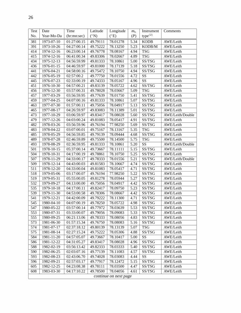
Table A6: Borovoye archive data for Chinese Underground Nuclear Tests at Lop Nor, 1969–1995(1)
N Date Time Latitude Longitude mb Event Instrument CommentsYear-Mo-Da (hr:mn:sec) (◦N) (◦E) (P) id type(2)
01 1969-09-22 16:15:01.57 41.373 88.352 5.2 CH01 KODB C, tunnel02 1976-10-17 05:00:01.37 41.734 88.383 4.9 CH04 SS B, tunnel03 1978-10-14 01:00:00.25 41.511 88.772 4.9 CH05 SS/TSG A, shaft04 1983-10-06 10:00:00.52 41.523 88.705 5.5 CH07 SS/TSG A, shaft05 1984-10-03 06:00:00.58 41.577 88.706 5.4 CH08 SS A, shaft06 1984-12-19 06:00:00.86 41.738 88.365 4.7 CH09 SS/TSG B, tunnel07 1987-06-05 05:00:00.73 41.505 88.709 6.2 CH10 SS/TSG A, shaft08 1990-08-16 05:00:00.16 41.511 88.742 6.2 CH13 SS/TSG A, shaft09 1993-10-05 01:59:58.99 41.593 88.687 5.9 CH16 TSG A, shaft10 1994-10-07 03:26:00.37 41.556 88.736 5.9 CH18 TSG A, shaft11 1995-05-15 04:06:00.31 41.546 88.772 6.1 CH19 TSG A, shaft
(1) location and origin time from Engdahl (2001), teleseismic body-wave magnitude from PDE.(2) Instrumenttype= instrument used, KODB= KOD low-gain system; KODM= KOD high-gain system; SS=STsR-SS system;TSG=STsR-TSG system.

33
Table A7: Borovoye archive data for French Underground Nuclear Tests, 1977–1996(1)
N Date Time Latitude Longitude mb Instrument SiteYear-Mo-Da (hr:mn:sec) (◦N) (◦E) (P) type(2)
01 1977-03-19 23:00:59.89 -21.887 -138.920 5.92 SS Mururoa02 1977-11-24 16:59:59.92 -21.884 -138.886 5.86 SS/TSG Mururoa03 1978-03-22 17:30:00.45 -21.705 -138.934 4.73 SS/TSG Mururoa04 1978-11-30 17:31:59.98 -21.868 -138.950 5.86 TSG Mururoa05 1979-06-18 23:27:00.66 -21.810 -138.809 4.71 SS Mururoa06 1979-07-25 17:57:00.00 -21.880 -138.940 6.11 SS Mururoa07 1980-03-23 19:37:00.00 -21.861 -138.939 5.63 SS Mururoa08 1980-04-01 19:31:00.22 -21.845 -138.758 5.05 SS Mururoa09 1980-07-19 23:47:00.00 -21.861 -138.934 5.73 SS/TSG Mururoa10 1980-12-03 17:33:00.00 -21.875 -138.939 5.58 TSG Mururoa11 1981-07-08 22:23:00.30 -21.791 -139.046 5.14 TSG Mururoa12 1981-12-05 16:58:01.08 -21.685 -138.933 4.68 SS Mururoa13 1981-12-08 16:47:00.23 -21.797 -138.927 5.14 SS Mururoa14 1982-07-01 17:02:00.20 -21.769 -138.946 5.08 SS Mururoa15 1982-07-25 18:02:00.00 -21.836 -138.896 5.60 TSG Mururoa16 1983-04-19 18:53:00.17 -21.819 -138.872 5.70 SS/TSG Mururoa17 1983-05-25 17:31:00.12 -21.861 -138.917 5.87 SS/TSG Mururoa18 1983-06-28 17:46:00.24 -21.767 -138.871 5.32 TSG Mururoa19 1983-07-20 20:30:00 -21.85 -138.90 5.0 SS/TSG -20 1983-08-04 17:14:00.20 -21.835 -138.829 5.13 SS/TSG Mururoa21 1983-12-07 17:28:00.28 -21.829 -138.928 4.89 SS -22 1984-05-08 17:26:00 -21.85 -138.90 5.3 SS -23 1984-05-12 17:31:00.04 -21.863 -138.901 5.57 SS/TSG Mururoa24 1984-06-12 17:17:00 -21.85 -138.90 4.5 TSG -25 1984-06-16 17:43:59.98 -21.849 -138.880 5.28 SS/TSG Mururoa26 1984-11-02 20:45:00.13 -21.857 -138.920 5.64 SS/TSG Mururoa27 1984-12-06 17:29:00.16 -21.837 -138.890 5.56 SS Mururoa28 1985-05-08 20:28:00.24 -21.831 -138.981 5.64 SS/TSG Mururoa29 1985-06-03 17:30:00.61 -21.816 -138.897 4.83 SS/TSG Mururoa30 1985-10-24 17:50:00 -21.85 -138.90 4.5 TSG -31 1985-10-26 16:35:00.24 -21.849 -138.815 5.30 TSG Mururoa32 1985-11-24 16:01:00.66 -21.802 -138.781 4.55 SS/TSG Mururoa33 1985-11-26 17:42:00.06 -21.856 -138.899 5.76 SS/TSG Mururoa34 1986-04-26 17:02:00.67 -21.725 -138.941 4.45 SS/TSG Mururoa35 1986-05-27 17:15:00 -21.85 -138.90 4.7 SS/TSG -36 1986-05-30 17:25:00.11 -21.862 -138.949 5.58 SS/TSG Mururoa37 1986-11-10 16:58:00 -21.85 -138.90 4.9 TSG -38 1986-11-12 17:02:00.32 -21.843 -138.927 5.28 TSG Mururoa39 1986-12-10 17:15:00.18 -21.833 -138.892 5.23 SS/TSG Mururoa40 1987-05-20 17:05:00.12 -21.850 -138.913 5.51 SS Mururoa41 1987-06-06 18:00:00.71 -21.769 -138.874 4.40 SS Mururoa42 1987-06-21 17:55:00.12 -21.865 -138.891 5.10 SS/TSG Mururoa43 1987-10-23 16:50:00.31 -21.845 -138.907 5.54 SS Mururoa44 1987-11-05 17:30:00.36 -21.791 -138.874 5.36 SS Mururoa
continue on next page

34
N Date Time Latitude Longitude mb Instrument SiteYear-Mo-Da (hr:mn:sec) (◦N) (◦E) (P) type(2)
45 1987-11-19 16:31:00.16 -21.845 -138.941 5.74 SS/TSG Mururoa46 1987-11-29 17:59:00 -21.85 -138.90 4.6 TSG Mururoa47 1988-05-11 17:00:00.27 -21.833 -138.945 5.27 SS/TSG Mururoa48 1988-05-25 17:01:00.14 -21.845 -138.961 5.50 SS/TSG Mururoa49 1988-11-23 17:01:00.33 -21.835 -138.954 5.29 TSG Mururoa50 1988-11-30 17:54:59.98 -22.194 -138.737 5.58 TSG Fangataufa51 1989-05-11 16:45:00.52 -21.812 -138.884 5.16 SS/TSG Mururoa52 1989-06-03 17:30:00.20 -21.842 -138.922 5.16 SS/TSG Mururoa53 1989-06-10 17:29:59.86 -22.222 -138.664 5.52 SS/TSG Fangataufa54 1989-10-31 16:57:00.26 -21.793 -138.855 5.30 TSG Mururoa55 1989-11-20 17:29:00.27 -21.793 -138.884 5.19 SS/TSG Mururoa56 1990-06-02 17:29:58.95 -21.820 -138.935 5.30 SS/TSG Mururoa57 1990-06-26 17:59:58.40 -22.204 -138.835 5.50 TSG Fangataufa58 1990-07-04 17:59:58.80 -21.809 -139.120 4.90 TSG Mururoa59 1990-11-14 18:11:58.41 -22.201 -138.835 5.60 TSG Fangataufa60 1990-11-21 16:59:58.42 -21.897 -138.983 5.40 SS Mururoa61 1991-05-18 17:14:58.67 -21.800 -139.033 5.00 SS/TSG Mururoa62 1991-05-29 18:59:58.40 -22.227 -138.803 5.50 SS/TSG Fangataufa63 1991-06-14 17:59:58.47 -21.822 -139.104 5.10 SS/TSG Mururoa64 1991-07-15 18:09:58.69 -21.832 -138.975 5.30 SS/TSG Mururoa65 1995-10-27 21:59:58.43 -21.852 -138.952 5.40 TSG Mururoa66 1995-11-21 21:29:58.62 -21.820 -139.057 4.80 TSG Mururoa67 1995-12-27 21:29:58.46 -21.792 -139.042 5.10 TSG Mururoa68 1996-01-27 21:29:58.16 -22.165 -138.835 5.20 TSG Fangataufa
(1) Time, location and teleseismic body-wave magnitude from Marshall et al. (1993), for tests till 1989. For testssince 1990, hypocenter parameters are taken from ISC Bulletin. The Site column indicate tests conducted at Mu-ruroa Atoll or Fangataufa Lagoon regions in the Tuamotu Archipelago. Seven tests with no known seismologicallydetermined locations are indicated by ”-” in the Site column and a nominal locations are given [center of the Mu-ruroa site].(2) Instrument type= instrument used, KODB= KOD low-gain system; KODM= KOD high-gain system;SS=STsR-SS system; TSG=STsR-TSG system.

35
Table A8: Borovoye archive data for US Underground Nuclear Tests, 1967–1992(1)
Test Date Time Lat. Long. mb Inst. Location/YieldNo. Year-Mo-Da (hr:mn:sec) (◦N) (◦E) (P) type(2)
501 1967-05-23 14:00:00.04 37.275 -116.371 5.7 KODB Scotch/155 kt502 1967-05-26 15:00:01.50 37.248 -116.481 5.5 KODB NTS/76 kt505 1967-06-26 16:00:00.08 37.202 -116.209 5.1 KODB NTS511 1967-08-18 20:12:30.04 37.012 -116.037 4.6 KODB NTS513 1967-08-31 16:30:00.04 37.178 -116.210 5.0 KODB NTS514 1967-09-07 13:45:00.00 37.153 -116.054 0.0 KODB NTS517 1967-09-27 17:00:00.04 37.099 -116.054 5.7 KODB/M NTS518 1967-10-18 14:30:00.08 37.116 -116.059 5.7 KODB NTS519 1967-10-25 14:30:00.06 37.032 -116.027 0.0 KODB NTS525 1967-12-15 15:00:00.04 37.037 -116.003 0.0 KODB NTS526 1968-01-18 16:30:00.13 37.146 -116.067 0.0 KODB NTS/7.4 kt527 1968-01-19 15:00:00.00 37.156 -116.055 0.0 KODB NTS528 1968-01-19 18:15:00.08 38.634 -118.133 6.3 KODB Central Nevada530 1968-01-26 16:00:00.11 37.281 -116.515 0.0 KODB Cabriolet/2.3 kt532 1968-02-21 15:30:00.00 37.117 -116.055 5.8 KODB NTS538 1968-03-22 15:00:00.04 37.333 -116.312 5.6 KODB NTS541 1968-04-10 14:00:00.00 37.154 -116.080 4.6 KODB NTS542 1968-04-18 14:05:00.00 37.152 -116.038 4.9 KODB NTS544 1968-04-26 15:00:00.07 37.295 -116.457 6.3 KODB Boxcar/1.3 Mt545 1968-05-03 16:00:00.04 37.029 -116.021 4.1 KODB NTS547 1968-05-17 13:00:00.00 37.120 -116.060 4.7 KODB NTS551 1968-06-15 13:59:59.97 37.265 -116.316 5.9 KODB NTS571 1968-11-04 15:15:00.09 37.130 -116.087 5.0 KODB NTS575 1968-11-20 18:00:00.03 37.010 -116.207 4.9 KODB NTS577 1968-12-08 16:00:00.14 37.343 -116.567 4.8 KODB NTS/30 kt578 1968-12-12 15:10:00.08 37.121 -116.081 0.0 KODB 6 detonations581 1968-12-19 16:30:00.04 37.231 -116.474 6.3 KODB/M Benham/1.15 Mt582 1969-01-15 19:00:00.07 37.148 -116.067 0.0 KODB NTS/10 kt583 1969-01-15 19:30:00.04 37.209 -116.226 5.3 KODB NTS585 1969-01-30 15:00:00.04 37.053 -116.030 4.8 KODB NTS592 1969-03-20 18:12:00.04 37.022 -116.031 4.6 KODB NTS593 1969-03-21 14:30:00.41 37.133 -116.088 4.9 KODB NTS595 1969-04-30 17:00:00.04 37.090 -116.007 5.3 KODB NTS597 1969-05-07 13:45:00.04 37.283 -116.502 5.8 KODB NTS599 1969-05-27 14:15:00.04 37.075 -115.996 5.0 KODB NTS601 1969-06-12 14:00:00.04 37.009 -116.031 4.4 KODB NTS603 1969-07-16 13:02:30.04 37.119 -116.056 4.7 KODB NTS604 1969-07-16 14:55:00.04 37.139 -116.088 5.6 KODB NTS605 1969-08-14 14:30:00.04 37.160 -116.064 0.0 KODB NTS606 1969-08-27 13:45:00.04 37.021 -116.039 4.7 KODB NTS608 1969-09-10 21:00:00.01 39.356 -107.949 5.0 KODB Grand Valley, CO/Rulison/40 kt609 1969-09-12 18:02:20.42 36.877 -115.929 4.5 KODB NTS610 1969-09-16 14:30:00.04 37.314 -116.462 6.2 KODB/M NTS613 1969-10-02 22:06:00.04 51.403 +179.179 6.5 KODB/M Amchitka, AK/Milow/≈ 1 Mt
continue on next page

36
Test Date Time Lat. Long. mb Inst. Location/YieldNo. Year-Mo-Da (hr:mn:sec) (◦N) (◦E) (P) type(2)
620 1969-11-21 14:52:00.04 37.031 -116.003 5.0 KODB NTS622 1969-12-05 17:00:00.04 37.180 -116.212 5.0 KODB NTS624 1969-12-10 15:30:00.07 37.168 -116.080 0.0 KODB NTS625 1969-12-17 15:00:00.04 37.083 -116.002 5.5 KODB NTS627 1969-12-18 19:00:00.04 37.120 -116.036 5.2 KODB NTS628 1970-01-23 16:30:00.21 37.141 -116.038 4.6 KODB NTS629 1970-01-30 17:00:00.04 37.031 -116.036 4.6 KODB NTS630 1970-02-04 17:00:00.04 37.098 -116.027 5.6 KODB NTS632 1970-02-05 15:00:00.04 37.164 -116.040 4.6 KODB NTS/25 kt633 1970-02-11 19:15:00.04 37.201 -116.206 4.7 KODB NTS634 1970-02-25 14:28:38.04 37.037 -115.999 5.2 KODB NTS635 1970-02-26 15:30:00.04 37.116 -116.062 5.3 KODB NTS636 1970-03-06 14:24:00.94 37.173 -116.093 4.3 KODB NTS/8.7 kt637 1970-03-06 15:00:00.21 37.140 -116.032 4.3 KODB NTS639 1970-03-23 23:05:00.04 37.086 -116.022 5.5 KODB NTS640 1970-03-26 19:00:00.20 37.300 -116.535 6.5 KODB/M NTS641 1970-04-21 14:30:00.04 37.055 -115.989 4.4 KODB NTS/12.7 kt642 1970-04-21 15:00:00.04 37.112 -116.083 4.6 KODB NTS643 1970-05-01 14:13:00.04 37.059 -116.029 4.2 KODB NTS644 1970-05-01 14:40:00.17 37.136 -116.035 4.3 KODB NTS646 1970-05-05 15:30:00.17 37.216 -116.185 5.0 KODB NTS648 1970-05-15 13:30:00.17 37.166 -116.036 5.1 KODB NTS650 1970-05-21 14:15:00.03 37.071 -116.014 5.1 KODB NTS651 1970-05-26 14:16:00.17 37.183 -116.214 5.0 KODB NTS652 1970-05-26 15:00:00.05 37.113 -116.063 5.5 KODB NTS/105 kt/90/35ton655 1970-06-26 13:00:00.04 37.114 -116.087 4.3 KODB NTS657 1970-10-14 14:30:00.04 37.071 -116.006 5.5 KODB NTS659 1970-11-05 15:00:00.04 37.029 -116.013 4.9 KODB NTS662 1970-12-16 16:00:00.09 37.100 -116.009 5.1 KODB NTS665 1970-12-17 16:05:00.16 37.129 -116.084 5.8 KODB NTS/220 kt666 1970-12-18 15:30:00.20 37.173 -116.100 5.1 KODB NTS/10 kt667 1971-06-16 14:50:00.04 37.033 -116.015 4.9 KODB NTS668 1971-06-23 15:30:00.04 37.022 -116.024 4.8 KODB NTS670 1971-06-24 14:00:00.16 37.147 -116.068 4.9 KODB NTS671 1971-06-29 18:30:00.16 37.177 -116.212 4.9 KODB NTS673 1971-07-08 14:00:00.08 37.110 -116.052 5.5 KODB NTS/83 kt679 1971-08-18 14:00:00.03 37.057 -116.037 5.4 KODB NTS681 1971-09-29 14:00:00.04 37.011 -116.008 4.4 KODB NTS683 1971-10-08 14:30:00.15 37.114 -116.038 4.7 KODB NTS684 1971-10-14 14:30:00.16 37.180 -116.054 4.4 KODB NTS685 1971-11-06 22:00:00.06 51.456 +179.102 6.8 KODB/M Amchitka, AK/Cannikin/< 5 Mt687 1971-11-30 15:45:00.15 37.160 -116.071 4.7 KODB NTS688 1971-12-14 21:09:59.16 37.124 -116.090 4.7 KODB NTS698 1972-05-02 19:15:00.04 37.208 -116.210 5.0 KODB NTS700 1972-05-17 14:10:00.16 37.121 -116.089 4.4 KODB NTS701 1972-05-19 17:00:00.05 37.065 -116.003 4.9 KODB NTS706 1972-07-20 17:16:00.16 37.214 -116.184 4.9 KODB NTS707 1972-07-25 13:30:00.06 37.012 -116.016 3.8 KODB NTS
continue on next page

37
Test Date Time Lat. Long. mb Inst. Location/YieldNo. Year-Mo-Da (hr:mn:sec) (◦N) (◦E) (P) type(2)
709 1972-09-21 15:30:00.19 37.082 -116.037 5.7 KODB NTS710 1972-09-26 14:30:00.16 37.121 -116.087 4.4 KODB NTS716 1972-12-21 20:15:00.24 37.140 -116.084 4.8 KODB NTS719 1973-03-08 16:10:00.19 37.104 -116.028 5.4 KODB NTS722 1973-04-25 22:25:00.03 37.005 -116.029 4.7 KODB NTS723 1973-04-26 17:15:00.17 37.123 -116.059 5.6 KODB NTS726 1973-05-17 16:00:00.12 39.793 -108.368 5.1 KODB Rifle, CO/Rio Blanco/3x33 kt729 1973-06-05 17:00:00.17 37.185 -116.216 5.1 KODB NTS730 1973-06-06 13:00:00.08 37.245 -116.347 6.1 KODB/M/SS NTS731 1973-06-21 14:45:00.08 37.092 -116.028 5.1 KODB NTS732 1973-06-28 19:15:12.40 37.148 -116.087 4.9 KODB/SS NTS736 1973-10-12 17:00:00.08 37.200 -116.204 4.8 KODB NTS753 1974-07-10 16:00:00.09 37.075 -116.033 5.7 SS NTS756 1974-08-30 15:00:00.16 37.152 -116.084 5.8 SS NTS758 1974-09-26 15:05:00.17 37.133 -116.069 5.6 SS NTS768 1975-02-28 16:15:00.09 37.106 -116.057 5.7 SS NTS773 1975-05-14 14:00:00.16 37.221 -116.475 6.0 SS/TSG NTS774 1975-06-03 14:20:00.17 37.340 -116.524 5.9 TSG NTS775 1975-06-03 14:40:00.11 37.095 -116.037 5.7 TSG NTS778 1975-06-19 13:00:00.09 37.350 -116.321 6.1 TSG NTS779 1975-06-26 12:30:00.16 37.279 -116.369 6.2 SS NTS782 1975-10-28 14:30:00.16 37.290 -116.412 6.4 SS/TSG NTS784 1975-11-20 15:00:00.09 37.225 -116.368 6.0 SS NTS787 1976-01-03 19:15:00.16 37.297 -116.334 6.2 TSG NTS788 1976-02-04 14:20:00.11 37.069 -116.031 5.8 SS NTS790 1976-02-12 14:45:00.16 37.271 -116.489 6.3 TSG NTS791 1976-02-14 11:30:00.16 37.243 -116.421 6.0 SS/TSG NTS794 1976-03-14 12:30:00.16 37.306 -116.472 6.3 SS NTS795 1976-03-17 14:15:00.09 37.256 -116.329 6.1 SS NTS796 1976-03-17 14:45:00.09 37.107 -116.053 5.8 TSG NTS799 1976-07-27 20:30:00.08 37.075 -116.045 5.3 SS NTS804 1976-12-08 14:49:30.08 37.079 -116.002 4.9 SS/TSG NTS805 1976-12-21 15:09:00.17 37.124 -116.068 4.2 SS NTS807 1976-12-28 18:00:00.08 37.100 -116.037 5.5 SS/TSG NTS808 1977-02-16 17:53:00.16 37.007 -116.032 4.8 SS NTS810 1977-04-05 15:00:00.17 37.120 -116.063 5.6 SS/TSG NTS811 1977-04-27 15:00:00.08 37.095 -116.029 5.4 SS/TSG NTS812 1977-05-25 17:00:00.08 37.094 -116.046 5.3 SS NTS815 1977-08-04 16:40:00.07 37.087 -116.008 5.0 SS/TSG NTS818 1977-08-19 17:55:00.10 37.110 -116.055 5.6 SS/TSG NTS821 1977-09-27 14:00:00.16 37.151 -116.068 4.8 SS NTS822 1977-10-26 14:15:00.08 37.008 -116.018 4.4 SS/TSG NTS824 1977-11-09 22:00:00.08 37.072 -116.051 5.7 SS/TSG NTS825 1977-11-17 19:30:00.08 37.021 -116.026 4.7 SS/TSG NTS826 1977-12-14 15:30:00.07 37.136 -116.087 5.7 SS/TSG NTS829 1978-02-23 17:00:00.16 37.124 -116.065 5.6 SS/TSG NTS830 1978-03-16 15:00:00.07 37.085 -116.082 4.1 SS NTS831 1978-03-23 16:30:00.20 37.102 -116.052 5.6 SS/TSG NTS
continue on next page

38
Test Date Time Lat. Long. mb Inst. Location/YieldNo. Year-Mo-Da (hr:mn:sec) (◦N) (◦E) (P) type(2)
833 1978-04-11 17:45:00.07 37.233 -116.369 5.5 SS NTS839 1978-07-12 17:00:00.08 37.079 -116.045 5.5 SS/TSG NTS840 1978-08-31 14:00:00.16 37.276 -116.358 5.6 SS NTS841 1978-09-13 15:15:00.16 37.209 -116.212 4.6 SS NTS842 1978-09-27 17:00:00.07 37.074 -116.021 5.0 SS NTS843 1978-09-27 17:20:00.08 37.080 -116.052 5.7 SS NTS848 1978-12-16 15:30:00.16 37.273 -116.411 5.5 TSG NTS849 1979-01-24 18:00:00.10 37.105 -116.013 4.5 SS NTS850 1979-02-08 20:00:00.09 37.102 -116.056 5.5 SS/TSG NTS851 1979-02-15 18:05:00.16 37.152 -116.073 4.8 SS NTS852 1979-03-14 18:30:00.10 37.028 -116.041 4.3 SS/TSG NTS854 1979-06-11 14:00:00.17 37.290 -116.456 5.5 SS NTS855 1979-06-20 15:00:13.54 37.108 -116.016 4.0 SS NTS856 1979-06-28 14:44:00.17 37.143 -116.088 5.0 SS NTS857 1979-08-03 15:07:30.16 37.084 -116.071 4.5 SS NTS858 1979-08-08 15:00:00.11 37.015 -116.009 4.8 SS/TSG NTS860 1979-09-06 15:00:00.09 37.088 -116.054 5.8 TSG Hearts/140 kt862 1979-09-26 15:00:00.09 37.229 -116.365 5.6 SS/TSG NTS865 1980-02-28 15:00:00.09 37.127 -116.089 4.4 SS/TSG NTS867 1980-04-03 14:00:00.09 37.150 -116.083 4.7 SS NTS868 1980-04-16 20:00:00.09 37.101 -116.031 5.3 SS NTS872 1980-06-12 17:15:00.09 37.282 -116.455 5.6 SS/TSG NTS874 1980-07-25 19:05:00.08 37.256 -116.478 5.5 SS NTS876 1980-09-25 14:45:00.09 37.056 -116.049 4.6 SS NTS879 1980-10-31 18:00:00.09 37.211 -116.206 4.7 SS NTS880 1980-11-14 16:50:00.08 37.111 -116.020 4.1 SS NTS882 1981-01-15 20:25:00.09 37.087 -116.046 5.7 SS NTS887 1981-06-06 18:00:00.08 37.303 -116.326 5.6 SS NTS894 1981-10-01 19:00:00.10 37.082 -116.010 5.1 SS NTS895 1981-11-11 20:00:09.09 37.076 -116.069 4.9 SS NTS897 1981-12-03 15:00:00.10 37.148 -116.072 4.8 SS NTS898 1981-12-16 21:05:00.09 37.114 -116.124 4.4 SS NTS899 1982-01-28 16:00:00.10 37.091 -116.052 5.6 SS NTS/139 kt900 1982-02-12 14:55:00.08 37.224 -116.464 5.4 SS/TSG NTS901 1982-02-12 15:25:00.09 37.348 -116.317 5.4 SS/TSG NTS902 1982-04-17 18:00:00.09 37.017 -116.011 4.5 SS NTS905 1982-05-07 18:17:00.11 37.069 -116.046 5.7 SS NTS907 1982-06-24 14:15:00.09 37.236 -116.371 5.6 SS NTS908 1982-07-29 20:05:00.08 37.102 -116.076 4.4 TSG NTS909 1982-08-05 14:00:00.09 37.084 -116.007 5.7 TSG NTS/138 kt912 1982-09-23 16:00:00.09 37.212 -116.208 4.9 SS NTS914 1982-09-23 17:00:00.09 37.175 -116.089 4.9 SS NTS916 1982-11-12 19:17:00.10 37.024 -116.033 4.1 SS/TSG NTS917 1982-12-10 15:20:00.09 37.080 -116.073 4.8 SS/TSG NTS918 1983-02-11 16:00:00.10 37.056 -116.046 4.1 SS NTS919 1983-02-17 17:00:00.09 37.163 -116.064 4.0 SS NTS920 1983-03-26 20:20:00.09 37.301 -116.461 5.2 SS/TSG NTS921 1983-04-14 19:05:00.12 37.073 -116.047 5.7 SS/TSG NTS
continue on next page

39
Test Date Time Lat. Long. mb Inst. Location/YieldNo. Year-Mo-Da (hr:mn:sec) (◦N) (◦E) (P) type(2)
923 1983-05-05 15:20:00.08 37.146 -116.090 4.4 SS NTS925 1983-05-26 15:00:00.09 37.103 -116.007 4.5 SS NTS926 1983-06-09 17:10:00.09 37.158 -116.090 4.5 SS NTS927 1983-08-03 13:33:00.10 37.119 -116.090 4.2 SS NTS928 1983-08-11 14:00:00.12 36.998 -116.004 4.4 SS NTS930 1983-09-01 14:00:00.08 37.273 -116.356 5.5 SS NTS/143 kt931 1983-09-21 15:00:00.09 37.210 -116.210 4.1 SS NTS932 1983-09-21 16:25:00.08 37.121 -116.056 4.2 SS NTS933 1983-09-22 15:00:00.12 37.106 -116.050 4.1 SS/TSG NTS935 1983-12-09 16:00:00.11 37.013 -116.047 4.0 SS/TSG NTS936 1983-12-16 18:30:00.09 37.140 -116.073 5.2 SS/TSG NTS937 1984-01-31 15:30:00.08 37.113 -116.123 4.3 SS/TSG NTS938 1984-02-15 17:00:00.11 37.221 -116.182 5.1 SS/TSG NTS939 1984-03-01 17:45:00.09 37.066 -116.047 5.9 SS NTS940 1984-03-31 14:30:00.08 37.146 -116.085 4.5 SS NTS944 1984-05-31 13:04:00.10 37.103 -116.049 5.8 SS/TSG NTS945 1984-06-20 15:15:00.09 37.000 -116.044 4.7 SS NTS947 1984-07-25 15:30:00.08 37.268 -116.412 5.4 SS NTS948 1984-08-02 15:00:00.09 37.017 -116.009 4.6 SS/TSG NTS949 1984-08-30 14:45:00.10 37.090 -116.000 4.5 SS/TSG NTS951 1984-09-13 14:00:00.00 37.087 -116.072 5.0 SS NTS953 1984-11-10 16:40:00.09 37.000 -116.018 4.4 SS/TSG NTS955 1984-12-15 14:45:00.00 37.281 -116.306 5.4 SS/TSG NTS957 1985-03-15 16:31:00.10 37.058 -116.046 4.8 SS NTS958 1985-03-23 18:30:00.08 37.180 -116.090 5.3 SS/TSG NTS959 1985-04-02 20:00:00.09 37.095 -116.033 5.8 SS/TSG NTS960 1985-04-06 23:15:00.09 37.201 -116.208 4.8 SS/TSG NTS961 1985-05-02 15:20:00.08 37.253 -116.326 5.7 SS NTS962 1985-06-12 15:15:00.08 37.248 -116.490 5.5 SS/TSG NTS963 1985-06-12 17:30:00.09 37.088 -116.085 4.6 SS/TSG NTS964 1985-06-26 18:03:00.08 37.124 -116.123 4.3 SS/TSG NTS965 1985-07-25 14:00:00.09 37.297 -116.439 5.2 SS NTS967 1985-08-17 16:25:00.09 37.002 -116.044 4.6 SS NTS968 1985-09-27 14:15:00.08 37.090 -116.003 4.7 SS NTS970 1985-10-09 23:20:00.09 37.210 -116.211 4.2 SS NTS971 1985-10-16 21:35:00.09 37.110 -116.122 4.6 SS/TSG NTS974 1985-12-28 19:01:00.09 37.238 -116.474 5.3 SS/TSG NTS975 1986-03-22 16:15:00.08 37.083 -116.067 5.1 SS/TSG NTS/29 kt976 1986-04-10 14:08:30.10 37.218 -116.184 4.9 SS/TSG NTS978 1986-04-22 14:30:00.09 37.264 -116.441 5.3 SS/TSG NTS979 1986-05-21 13:59:00.08 37.125 -116.061 3.9 SS NTS980 1986-06-05 15:04:00.06 37.098 -116.016 5.3 SS NTS982 1986-07-17 21:00:00.06 37.279 -116.356 5.7 SS NTS/119 kt983 1986-07-24 15:05:00.09 37.143 -116.072 4.4 SS NTS986 1986-09-30 22:30:00.10 37.300 -116.308 5.5 SS/TSG NTS987 1986-10-16 19:25:00.09 37.220 -116.463 5.6 SS/TSG NTS988 1986-11-14 16:00:00.07 37.100 -116.049 5.8 SS/TSG NTS989 1986-12-13 17:50:05.09 37.263 -116.413 5.5 SS/TSG NTS
continue on next page

40
Test Date Time Lat. Long. mb Inst. Location/YieldNo. Year-Mo-Da (hr:mn:sec) (◦N) (◦E) (P) type(2)
990 1987-02-03 15:20:00.08 37.181 -116.049 2.2 SS/TSG NTS991 1987-02-11 16:45:00.07 37.011 -116.046 4.5 SS NTS992 1987-03-18 18:28:00.09 37.210 -116.209 4.3 SS/TSG NTS993 1987-04-18 13:40:00.00 37.248 -116.510 5.5 SS/TSG NTS995 1987-04-30 13:30:00.09 37.233 -116.424 5.5 SS/TSG NTS996 1987-06-18 15:20:00.08 37.194 -116.036 4.1 SS/TSG NTS997 1987-06-20 16:00:00.18 37.220 -116.179 3.5 SS NTS998 1987-06-30 16:05:00.10 36.999 -116.044 4.1 SS/TSG NTS
1000 1987-08-13 14:00:00.09 37.061 -116.046 5.9 SS/TSG Tahoka1001 1987-09-24 15:00:00.06 37.228 -116.376 5.7 SS/TSG NTS1002 1987-10-23 16:00:00.09 37.142 -116.080 5.2 SS/TSG Borate1004 1987-12-02 16:30:00.08 37.235 -116.164 4.1 TSG NTS1005 1988-02-15 18:10:00.09 37.314 -116.472 5.3 SS Kernville1006 1988-04-07 17:15:00.08 37.013 -116.045 4.0 SS NTS1007 1988-05-13 15:35:00.11 37.124 -116.073 4.8 SS/TSG NTS1008 1988-05-21 22:30:00.14 37.032 -115.988 4.3 SS Laredo1009 1988-06-02 13:00:00.09 37.260 -116.442 5.4 SS/TSG NTS1012 1988-07-07 15:05:30.07 37.252 -116.378 5.6 SS NTS1013 1988-08-17 17:00:00.09 37.297 -116.307 5.5 SS Kersage/JVE/100 to 150 kt1015 1988-08-30 18:00:00.09 37.086 -116.069 5.0 SS/TSG NTS1016 1988-10-13 14:00:00.08 37.089 -116.050 5.9 SS NTS1019 1988-12-10 20:30:00.06 37.199 -116.210 5.0 SS/TSG Misty Echo1020 1989-02-10 20:06:00.06 37.077 -116.001 5.2 SS/TSG NTS1021 1989-02-24 16:15:00.08 37.128 -116.123 4.4 SS/TSG NTS1022 1989-03-09 14:05:00.09 37.143 -116.068 5.0 SS/TSG NTS1025 1989-06-22 21:15:00.08 37.283 -116.413 5.3 SS NTS1026 1989-06-27 15:30:00.02 37.275 -116.354 4.9 SS/TSG NTS1028 1989-10-31 15:30:00.09 37.263 -116.492 5.7 TSG NTS1032 1990-03-10 16:00:00.08 37.112 -116.056 5.0 SS NTS1034 1990-06-13 16:00:00.09 37.262 -116.421 5.7 SS/TSG Bullion1035 1990-06-21 18:15:00.00 36.993 -116.005 4.0 TSG NTS1036 1990-07-25 15:00:00.06 37.207 -116.215 4.7 SS/TSG NTS1039 1990-10-12 17:30:00.08 37.248 -116.495 5.6 SS/TSG Tenabo1040 1990-11-14 19:17:00.07 37.227 -116.372 5.4 TSG NTS1041 1991-03-08 21:02:45.08 37.104 -116.075 4.4 TSG NTS1042 1991-04-04 19:00:00.00 37.296 -116.314 5.6 TSG NTS1044 1991-08-15 16:00:00.00 37.087 -116.003 4.2 TSG NTS1045 1991-09-14 19:00:00.08 37.226 -116.429 5.5 TSG Hoya/20 to 150 kt1046 1991-09-19 16:30:00.07 37.236 -116.167 4.0 TSG Distant Zenith/< 20 kt1047 1991-10-18 19:12:00.00 37.063 -116.046 5.2 TSG NTS1048 1991-11-26 18:35:00.07 37.096 -116.070 4.6 TSG NTS1049 1992-03-26 16:30:00.00 37.272 -116.361 5.5 TSG Junction/20 to 150 kt
(1) time, location, yield and test id from DOE/NV-209-REV 15, December 2000.mb(P), body-wave magnitude fromPDE/ISC.(2) KODB= KOD low-gain system; KODM= KOD high-gain system; SS=STsR-SS system; TSG=STsR-TSG system.

41
Table A9: Borovoye archive data for Joint US-UK Nuclear Tests, 1978–1989(1)
Test Date Time Latitude Longitude mb Instrument Test nameNo. Year-Mo-Da (hr:mn:sec) (◦N) (◦E) (P) name(2)
834 1978-04-11 15:30:00.16 37.300 -116.328 5.3 SS Fondutta846 1978-11-18 19:00:00.17 37.127 -116.085 5.1 SS/TSG Quargel859 1979-08-29 15:08:00.17 37.121 -116.067 4.7 SS Nessel869 1980-04-26 17:00:00.08 37.248 -116.423 5.4 SS Colwick878 1980-10-24 19:15:00.12 37.075 -116.000 4.4 SS Dutchess881 1980-12-17 15:10:00.09 37.325 -116.316 5.1 SS Serpa896 1981-11-12 15:00:00.10 37.108 -116.050 5.4 SS Rousanne903 1982-04-25 18:05:00.09 37.256 -116.423 5.4 SS Gibne922 1983-04-22 13:53:00.08 37.111 -116.023 4.0 SS Armada941 1984-05-01 19:05:00.09 37.106 -116.023 5.4 SS/TSG Mundo954 1984-12-09 19:40:00.09 37.270 -116.498 5.5 SS/TSG Egmont973 1985-12-05 15:00:00.07 37.053 -116.046 5.7 SS Kinibito981 1986-06-25 20:27:45.09 37.265 -116.500 5.5 SS Darwin999 1987-07-16 19:00:00.08 37.104 -116.024 4.8 SS/TSG Midland
1030 1989-12-08 15:00:00.09 37.231 -116.410 5.5 SS/TSG Barnwell
(1) time, location, yield and test ids from DOE/NV-209-REV 15, December 2000.mb(P), body-wave magnitudefrom PDE/ISC. From March 01, 1962 through November 26, 1991, a total of 24 unclear tests are conducted at theNevada Test Site for United Kingdom (UK).(2) SS=STsR-SS system and TSG=STsR-TSG system.
Related Documents