Antony Rd Wolf Rd Davis Rd Spr Fr Ru s s lan C o u l e e R d R usslan C o u l e e R d Bost w i c k Cre e k Coulee Experimental State Forest Land Management Areas CESF301P 90 53 53 54 33 71 16 35 93 35 35 108 162 157 162 162 L O C A T O R June, 2009 Master Plan Coulee Experimental State Forest Forest Production Management Area Forest Coulee and Ridges Native Community Management Areas Northeast Forest and Cliffs Southwest Russlan Coulee Woods Berg Prairie and Billy Goat Ridge Stream County or Town Road Permanent State Forest Road (Public Vehicles Allowed) Primitive State Forest Road (No Public Vehicles Allowed) 0.5 Miles 0.5 Kilometers La Crosse II I Aerial photography from National Agriculture Imagery Program (NAIP) 2006 Map 2.7 The data shown on this map have been obtained from various sources, and are of varying age, reliability, and resolution. This map is not an authoritative source of information about legal land ownership or public access. More detailed delineation will be produced at the discretion of the department where authorized activities, management or improved on the ground information is available.

Welcome message from author
This document is posted to help you gain knowledge. Please leave a comment to let me know what you think about it! Share it to your friends and learn new things together.
Transcript
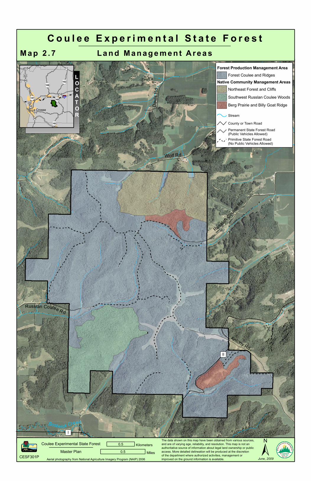
Antony Rd
Wolf RdDa
vis R
d
Sprin
g Cou
lee R
d
Fritz
Schro
eder
Rd
Russlan Coulee Rd
Russlan C
oulee
Rd
Russlan Coulee R d
Bostwi ck Creek
C o u l e e E x p e r i m e n t a l S t a t e F o r e s tLa n d M a n a g e m e n t A r e a s
CESF301P
90
53
53
54
33
71
16
35
93
35
35
108162
157
162
162
LOCATOR
June, 2009Master Plan
Coulee Experimental State Forest
Forest Production Management AreaForest Coulee and Ridges
Native Community Management AreasNortheast Forest and CliffsSouthwest Russlan Coulee WoodsBerg Prairie and Billy Goat Ridge
StreamCounty or Town RoadPermanent State Forest Road(Public Vehicles Allowed)Primitive State Forest Road(No Public Vehicles Allowed)
0.5 Miles0.5 Kilometers
La Crosse
II
I
Aerial photography from National Agriculture Imagery Program (NAIP) 2006
M a p 2 . 7
The data shown on this map have been obtained from various sources,and are of varying age, reliability, and resolution. This map is not anauthoritative source of information about legal land ownership or publicaccess. More detailed delineation will be produced at the discretionof the department where authorized activities, management orimproved on the ground information is available.
Related Documents