CYBERINFRASTRUCTURE FOR THE GEOSCIENCES Implementing a web service for spatial data – Spatial Fusion M.L. Crawford, D. Mirante – Bryn Mawr College Metamorphic Petrology and Tectonics

Welcome message from author
This document is posted to help you gain knowledge. Please leave a comment to let me know what you think about it! Share it to your friends and learn new things together.
Transcript

CYBERINFRASTRUCTURE FOR THE GEOSCIENCES
Implementing a web service for spatial data – Spatial
Fusion
M.L. Crawford, D. Mirante – Bryn Mawr College
Metamorphic Petrology and Tectonics

CYBERINFRASTRUCTURE FOR THE GEOSCIENCES
Project Goals
• To ask meaningful questions – and do ‘new science’
• To retrieve and analyze data from disparate sources in order to address those questions.
• To develop the infrastructure to serve the data analysis needs of scientists, educators, students, and the general public.
• To produce a controlled vocabulary that can be applied to metamorphic and tectonic processes to assist in the goals above.

CYBERINFRASTRUCTURE FOR THE GEOSCIENCES
The Spatial Fusion web mapping application
• Is a product of the CARIS® software company.
• Has an open-architecture concept that permits customization.
• Can combine multiple sources of data into one map view without the need for conversion.
• Is relatively inexpensive for academic users.

CYBERINFRASTRUCTURE FOR THE GEOSCIENCES
Spatial Fusion workflow
Internet
TAO ORB – an open source implementation
Tomcat servlet container

CYBERINFRASTRUCTURE FOR THE GEOSCIENCES
• A Java applet has the commands for map data display.
• Specific properties are stored in a client.xml file, referenced by the applet when needed.
• A wizard is supplied to help construct these applets.

CYBERINFRASTRUCTURE FOR THE GEOSCIENCES
A data display window.
Attributes panel
Map display area.
Legend panel
Overview

CYBERINFRASTRUCTURE FOR THE GEOSCIENCES
Spatial Fusion workflow
Internet
TAO ORB – an open source implementation
Tomcat servlet container

CYBERINFRASTRUCTURE FOR THE GEOSCIENCES
The data services• Configuration files for the map file(s) and
the database file(s) for a specific project.• These Spatial Agent (.saf) files give the
location and the type of the data (map or database) file(s).
• The configuration files can be viewed and edited with a text editor.
• If necessary the data services can be on another computer.

CYBERINFRASTRUCTURE FOR THE GEOSCIENCES
Spatial Agent files (.saf) metafiles contain the information needed to locate, read and display the data.
– The map name– Type of spatial data– Projection used to make the map– Location where the map is stored– Display attributes for a layer.

CYBERINFRASTRUCTURE FOR THE GEOSCIENCES
Available data types
• Shape files• CARIS files• Maplnfo• Oracle 9i• TIFF• DGN• AutoCad (.dxf files)
CYBERINFRASTRUCTURE FOR THE GEOSCIENCES
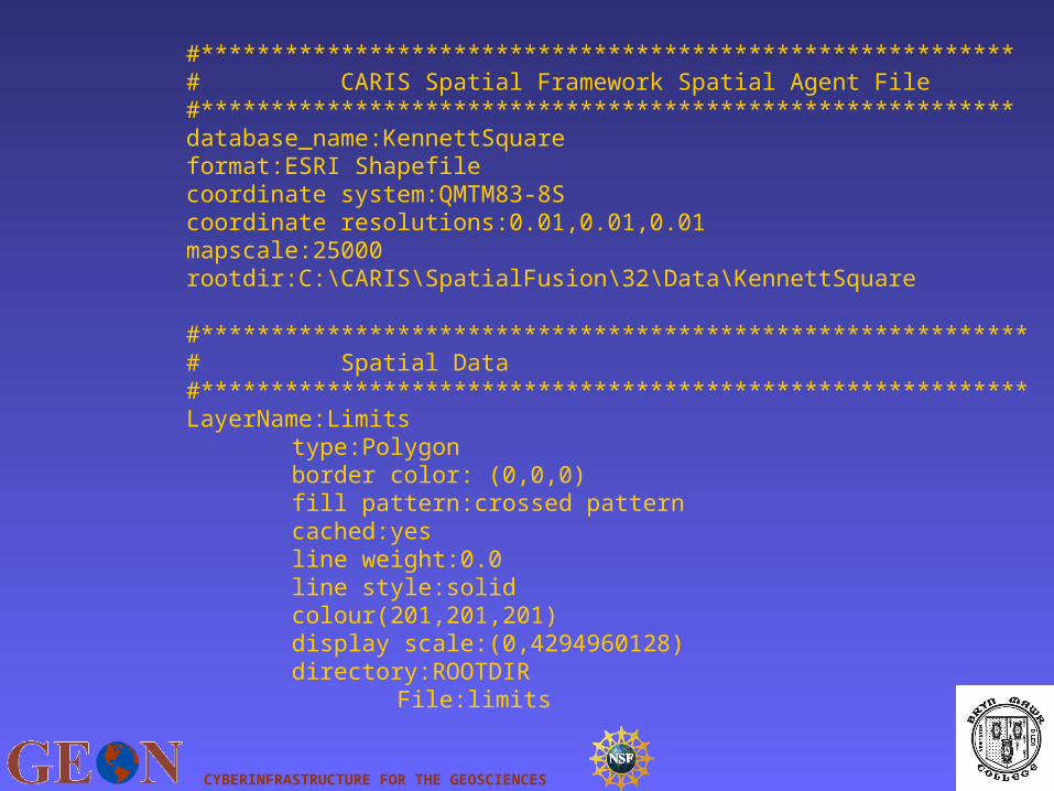
#**********************************************************# CARIS Spatial Framework Spatial Agent File#**********************************************************database_name:KennettSquareformat:ESRI Shapefilecoordinate system:QMTM83-8Scoordinate resolutions:0.01,0.01,0.01mapscale:25000rootdir:C:\CARIS\SpatialFusion\32\Data\KennettSquare
#***********************************************************# Spatial Data#***********************************************************LayerName:Limits
type:Polygonborder color: (0,0,0)fill pattern:crossed patterncached:yesline weight:0.0line style:solidcolour(201,201,201)display scale:(0,4294960128)directory:ROOTDIR
File:limits

CYBERINFRASTRUCTURE FOR THE GEOSCIENCES
.saf files also provide necessary information about the database
associated with a map layer, where necessary.
LayerName:sitestype:Symbolstheme:1000feature codes:ALCH,GCFWS3feature code mode:Inclusive#database table owner:DEFAULT#database table name:MHTest#database key column:Sitedirectory:ROOTDIR
File:geon05b

CYBERINFRASTRUCTURE FOR THE GEOSCIENCES
Among the features that can be programmed in the .saf file is choosing a scale dependency, to display data only at user defined map scales.

CYBERINFRASTRUCTURE FOR THE GEOSCIENCES
Spatial Fusion workflow
Internet
TAO ORB – an open source implementation
Tomcat servlet container

CYBERINFRASTRUCTURE FOR THE GEOSCIENCES
Servlets
• XML files that indicate what data are available for display in a particular web page.
• One or more services comprising different maps and associated databases may be selected.

CYBERINFRASTRUCTURE FOR THE GEOSCIENCES
This web page combines three separate maps, one a shape file and two CARIS files.

CYBERINFRASTRUCTURE FOR THE GEOSCIENCES
Servlets
• The servlet also defines the spatial reference system of the input data, the spatial reference system to use in the display, the layers to be displayed, and the geographic extent of the map coverage.

CYBERINFRASTRUCTURE FOR THE GEOSCIENCES
• Servlets, handled by the Jakarta Tomcat servlet container, send requests to Data Services through the Object Request Broker (ORB).
• When the requested data are retrieved from Data Services they are sent by the servlet to the applet.
• The applet is then updated with the requested changes.

CYBERINFRASTRUCTURE FOR THE GEOSCIENCES
A web archive file contains all the files for each product web page.
– the Java classes for applet operation, – the HTML file with applet tags, – the applet settings chosen, – the servlet configuration file, – and a web XML file that tells Tomcat (the
servlet container) what files to access when data are requested.

CYBERINFRASTRUCTURE FOR THE GEOSCIENCES
GOAL: To retrieve data from disparate sources in order to address questions.
• We want to encourage colleagues to provide data that can be displayed and queried on maps by devising a web-based system of data submission.
• We hope to devise methods for incorporating submitted location and related data into maps served using Spatial Fusion.

CYBERINFRASTRUCTURE FOR THE GEOSCIENCES
GOAL: To develop the infrastructure to serve the data analysis needs of
scientists, educators, students, and the general public.

CYBERINFRASTRUCTURE FOR THE GEOSCIENCES
We plan to develop meaningful diagrams for displaying data obtained using queries from the databases associated with map features using simple user queries.
Related Documents