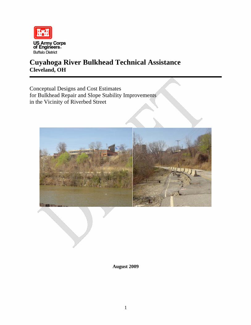
1 Cuyahoga River Bulkhead Technical Assistance Cleveland, OH Conceptual Designs and Cost Estimates for Bulkhead Repair and Slope Stability Improvements in the Vicinity of Riverbed Street August 2009

Welcome message from author
This document is posted to help you gain knowledge. Please leave a comment to let me know what you think about it! Share it to your friends and learn new things together.
Transcript
1
Cuyahoga River Bulkhead Technical Assistance Cleveland, OH
Conceptual Designs and Cost Estimates for Bulkhead Repair and Slope Stability Improvements in the Vicinity of Riverbed Street
August 2009

2
Table of Contents 1. Executive Summary ............................................................................................................ 3 2. Study Authority and Funding ............................................................................................. 3 3. Purpose and Scope .............................................................................................................. 4 4. Project Location .................................................................................................................. 4
4.1. Cuyahoga River .......................................................................................................... 4 4.2. Riverbed Street and Vicinity (Irishtown Bend) .......................................................... 5
5. Background......................................................................................................................... 8 5.1. Bulkhead System ........................................................................................................ 8 5.2. Site Identification........................................................................................................ 8 5.3. Site History ................................................................................................................. 8
6. Existing Conditions........................................................................................................... 11 6.1. General...................................................................................................................... 11 6.2. Geologic History....................................................................................................... 16 6.3. Current Conditions.................................................................................................... 16 6.4. Risks.......................................................................................................................... 17
7. Alternative Selection......................................................................................................... 17 7.1. Existing Condition Briefing...................................................................................... 17 7.2. Performance Objectives ............................................................................................ 17 7.3. Factor of Safety Definition ....................................................................................... 18 7.4. Engineering Methods ................................................................................................ 18
8. Conceptual Alternatives.................................................................................................... 18 8.1. Alternative 0: No Action........................................................................................... 18 8.2. Alternative A: Protect the Cuyahoga River only ...................................................... 21 8.3. Alternative B: Green Bulkhead add-on..................................................................... 27 8.5. Alternative D: Protect Everything (the Cuyahoga River, Riverbed Street plus Franklin Avenue and the structures along West 25th Street) ............................................... 33
9. Summary and Recommendations ..................................................................................... 35 9.1. Prioritization and Alternative Selection.................................................................... 35 9.2. Advancing the Design............................................................................................... 35

3
1. Executive Summary
The bulkhead and slope stability issues in the vicinity of Riverbed Street/Irishtown Bend are documented to date back to at least the 1960s. Currently a landslide is slowly but actively moving towards the river below, as a result of historic geologic processes and relatively recent land use. The height of the slope (over 100 vertical feet) and length of the site (approximately 2,500 linear feet) combine to make this a challenging engineering project due to the size of the failure area and the corresponding magnitude of engineering measures required to stabilize the area. In addition, a number of diverse stakeholder groups have an interest in solving various parts of the overall problem to meet a number of similar, but disparate goals. There is not one agency or entity that has jurisdiction over the site itself, or responsibility for solving the problems that have already caused damage to existing infrastructure and threaten to cause further damage while posing a safety risk to the public. For these reasons the problems have persisted without an entity that has the authority and capability to develop plans to stabilize the area. The US Army Corps of Engineers was granted specific authority to assist with this problem. The Corps was charged to develop conceptual designs (30% design) and cost estimates for measures to address the bulkhead and slope stability issues. Presented in this report is a discussion of the existing condition and how this translates into risks to the public, as well as a number of potential solutions to the existing problems at the site. In general, the failure at the site will continue if not addressed, and continue to impinge on the Cuyahoga River and cause additional damage to Riverbed Street and the sewerline under Riverbed Street. Future damage is possible at the structures at the top of the slope along West 25th Street as well at to Franklin Avenue. The most likely mode of failure is a gradual rotational/translational movement which will continue at a rate of several inches to a few feet per year. The risk of a catastrophic, deep full slope failure that blocks the Cuyahoga River is very small, given the accepted slow rate of movement. A sudden catastrophic deep failure is extremely unlikely because the factors leading to such a failure, such as a complete loss of the toe of the slope and a major increase in the driving forces (soil and water) towards the top of the slope, do not exist Provided with each conceptual design are cost estimates, engineering drawings and a discussion of the alternative. Each conceptual alternative will require additional evaluation and analysis prior to final design, and some alternatives may be determined to be unfeasible during the detailed design phase. The selection of an alternative to pursue for construction, if any, is at the discretion of local non-Federal stakeholders.
2. Study Authority and Funding Section 534 of the Water Resources Development Act of 2000 (Public Law 106-541) directed the Corps to provide technical assistance to non-Federal interests to evaluate the structural integrity of the bulkhead system along the Cuyahoga River including design, plans and specifications and cost estimates for repair.
4
This technical assistance is provided to the city of Cleveland at 100% Federal cost with General Investigations funds appropriated to the US Army Corps of Engineers.
3. Purpose and Scope The purpose of this technical assistance is to develop conceptual design solutions and cost estimates for the bulkhead and slope stability problem in the vicinity of Riverbed Street, adjacent to the Cuyahoga River, in Cleveland, OH. This project site was identified by the city of Cleveland and the USACE team along with a coalition of stakeholders in May 2008 (see section 5.2). Consensus was reached that the Riverbed Street project site was the highest priority bulkhead issue from a public safety and economic perspective. The USACE team was charged with reviewing a number of prior studies that focused on various component issues of the overall bulkhead/slope stability problem in the vicinity of Riverbed Street. Conceptual-level (30%) engineering solutions and cost estimates were developed based on these prior reports as well as the available data and site investigations performed by the team. These conceptual designs were based on input from the city of Cleveland and other stakeholders regarding future land use plans for the project site (see section 7.2). Prioritization and selection of an alternative to pursue, if any, is solely the responsibility of the city of Cleveland and other stakeholders. This report offers guidance on the engineering methods to achieve each alternative, and the feasibility and costs associated for construction. This technical assistance did not include an economic analysis of the costs avoided or benefits associated with each alternative.
4. Project Location
4.1. Cuyahoga River The Cuyahoga River is located in Cuyahoga County in northeast Ohio (Figure 4.1) within the City of Cleveland. The river includes a 5.8 mile-long Federal navigation channel (Figure 4.2) that is dredged twice yearly to an average depth of 23 feet.

5
Figure 4.1 Project Location Map
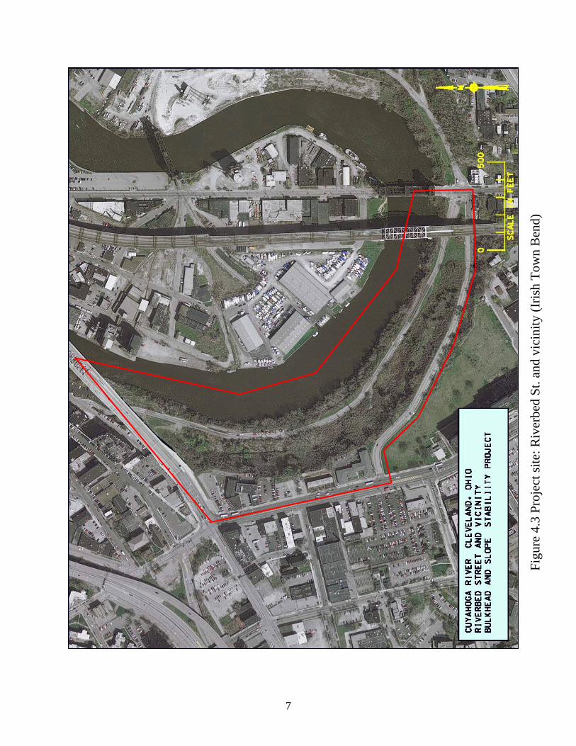
4.2. Riverbed Street and Vicinity (Irishtown Bend)
The project site is along the left descending bank of the Cuyahoga River, bounded downstream by the Detroit-Superior Bridge and upstream by the Columbus Rd. Bridge. The riverward project site boundary is the Federal Navigation channel and the landward boundary is West 25th Street and Franklin Avenue (Figure 4.3). Riverbed Street runs through the center of this site. Historically this area has been referred to as “Irishtown Bend” in reference to a 19th century Irish-American neighborhood.

6
Figu
re 4
.2 L
ocat
ion
of C
uyah
oga
Riv
er (C
leve
land
Har
bor)
, Cle
vela
nd, O
hio
with
pro
ject
loca
tion
indi
cate
d.
7
Figu
re 4
.3 P
roje
ct si
te: R
iver
bed
St. a
nd v
icin
ity (I
rish
Tow
n B
end)

8
5. Background 5.1. Bulkhead System
Vertical sheet pilings, or bulkheads, that were installed in the 1940s and 1950s, stabilize the majority of the navigable portion of the Cuyahoga River. Other types of riverbank along the navigable portion of the river include concrete slabs, stone riprap and natural vegetation. Previous studies and recent inspections by the United States Army Corps of Engineers and others indicate that some bulkheads and surrounding riverbank show indications of potential failure and in one case, the bulkheads have yielded into the Federal channel. If a failed bulkhead, riverbank, or some other impediment obstructs the Federal channel, the Federal government has the authority to remove the obstruction. Field investigations indicate that a concrete cribwall structure exists over much of the Riverbed Street site (see image 6.1.1).
5.2. Site Identification At a meeting in May 2008 the USACE team met with the Cleveland Harbormaster and stakeholders from the city of Cleveland, North-East Ohio Regional Sewer District (NEORSD), Cuyahoga County Municipal Housing Authority, Cuyahoga County Emergency Management, Cuyahoga County Planning, Cleveland-Cuyahoga Port Authority, Flats Oxbow Association, Arcelor Mittal Company and Cuyahoga Remedial Action Plan. The Riverbed Street site was identified as having the highest perceived risk to navigation in the Cuyahoga River Federal Navigation channel as well as additional risks associated with infrastructure on the slope adjacent to the bulkhead. Based on these reasons this site was selected as the focus of the bulkhead technical assistance effort.
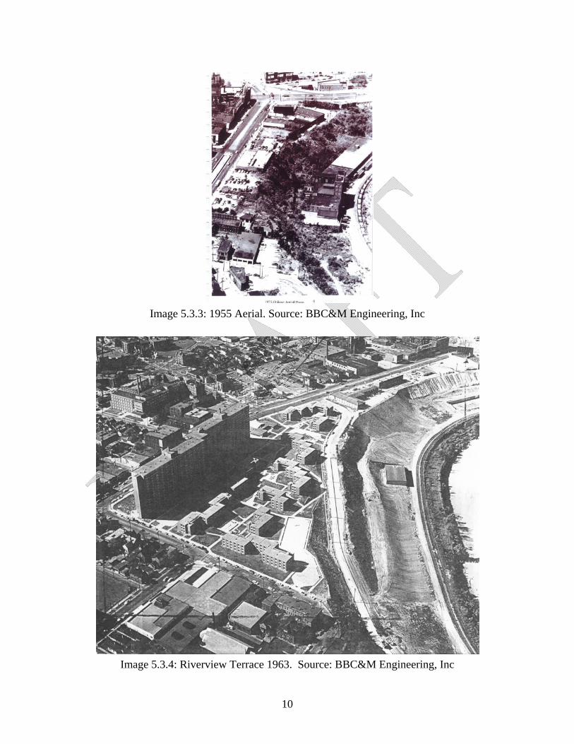
5.3. Site History In the 19th century the project site was the location of an Irish-American neighborhood which was part of a larger Irish-American community on the West side of Cleveland. By the 1950s the majority of these structures had been demolished or destroyed by fire or neglect.

9
Image 5.3.1: Housing structures along Riverbed Street, May 1922,
Source: Cleveland Union Terminal Collection, Cleveland State University Library
Image 5.3.2: Housing structures on Irishtown Bend, Sep 1926,
Source: Cleveland Union Terminal Collection, Cleveland State University Library
10
Image 5.3.3: 1955 Aerial. Source: BBC&M Engineering, Inc
Image 5.3.4: Riverview Terrace 1963. Source: BBC&M Engineering, Inc

11
6. Existing Conditions
6.1. General The project site consists of an active landslide along the slope comprising the west bank of the Cuyahoga River between West 25th Street and the riverbank. This landslide is slowly but actively moving towards the river below, as a result of historic geologic processes and relatively recent land use. Within the slide mass, more abrupt, isolated slope failure has occurred along Riverbed Street, resulting in the failure of that street and movement of soil masses towards the river. Along the upper slope, small scarps and poor drainage are typical in general. The most prominent upslope scarps exist along Franklin Avenue as well as at the top of the slope near West 25th Street. Standing water is visible just upslope of Riverbed Street as well as in other locations where buildings formerly stood and their foundations remain intact.
Image 6.1.1: Existing Cribwall. Source: USACE Field Inspection, 17 Apr 2008
12
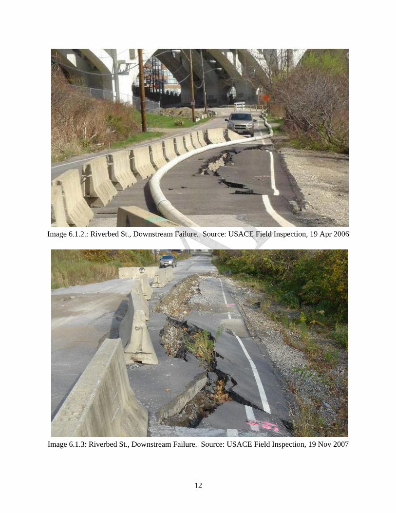
Image 6.1.2.: Riverbed St., Downstream Failure. Source: USACE Field Inspection, 19 Apr 2006
Image 6.1.3: Riverbed St., Downstream Failure. Source: USACE Field Inspection, 19 Nov 2007
13
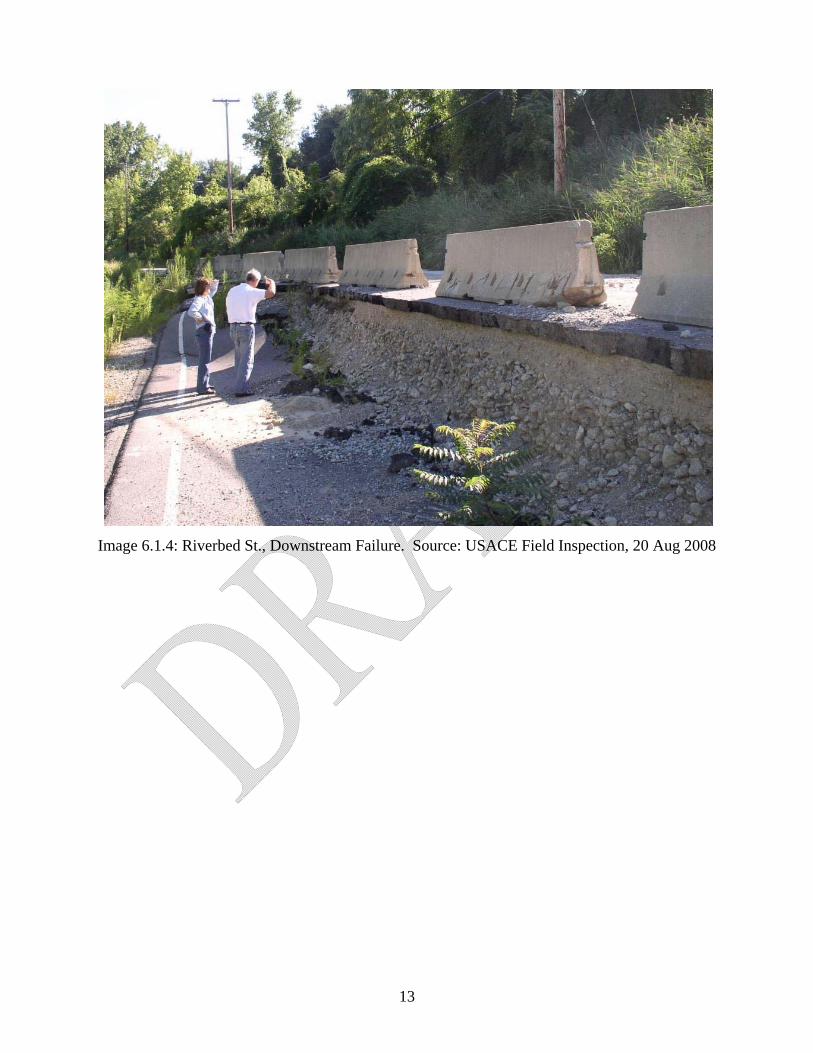
Image 6.1.4: Riverbed St., Downstream Failure. Source: USACE Field Inspection, 20 Aug 2008
14
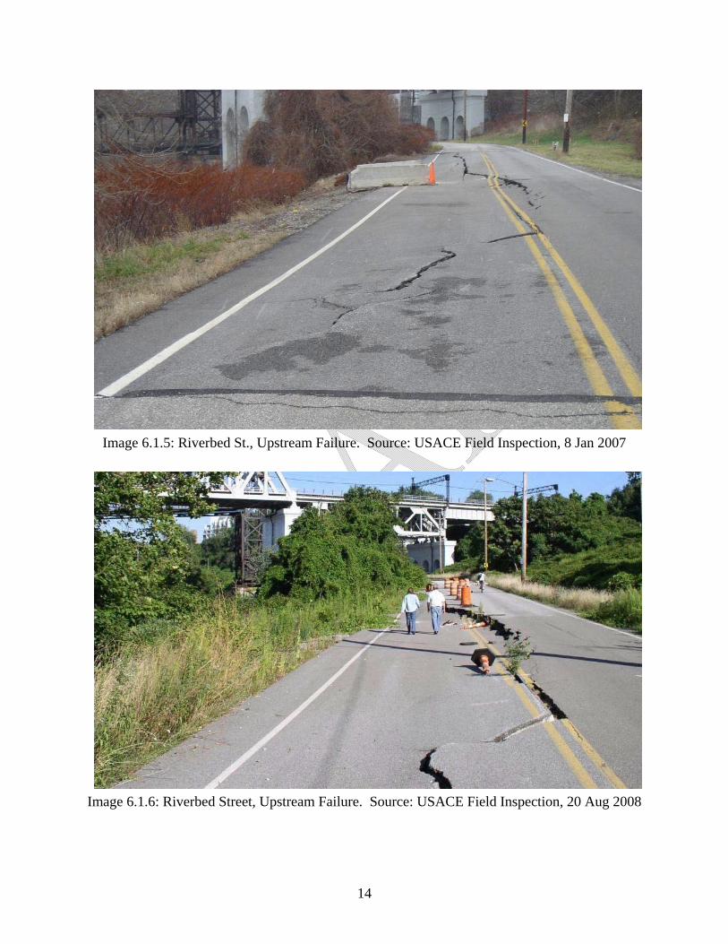
Image 6.1.5: Riverbed St., Upstream Failure. Source: USACE Field Inspection, 8 Jan 2007
Image 6.1.6: Riverbed Street, Upstream Failure. Source: USACE Field Inspection, 20 Aug 2008
15
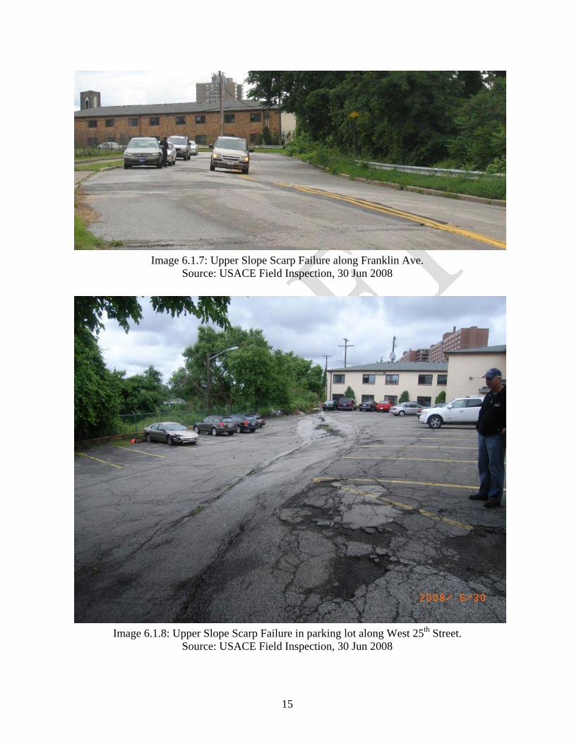
Image 6.1.7: Upper Slope Scarp Failure along Franklin Ave.
Source: USACE Field Inspection, 30 Jun 2008
Image 6.1.8: Upper Slope Scarp Failure in parking lot along West 25th Street.
Source: USACE Field Inspection, 30 Jun 2008

16
6.2. Geologic History
Geologic history of the Cuyahoga river Valley plays a dominant role in the current subsurface conditions of the project site. The current Cuyahoga River flows over the edge of a buried ancient river valley which extends down near sea level. Simply stated, a series of natural processes produced steep slopes which, coupled with a change in the elevation of Lake Erie of 170 feet, caused ancient slope instability/landslides and the potential for continuing landslides in the present time. These ancient slides can be (and have been) reactivated and accelerated by related changes in the project extent, including filling at the top of the slope, poor site drainage, and infrastructure development (such as the large sewer line that runs along Riverbed Street). To attempt to understand the current issues along this reach, the geologic history of the site must be understood and accepted.
6.3. Current Conditions
Current site conditions along the project reach include the Riverbed Street slope failure at the bottom of the slope, scarping along Franklin Avenue as well as behind buildings along the east side of West 25th Street, and poor drainage over much of the site. As previously discussed, geology played a dominant role leading to the current conditions. More recently, man has altered the site, leading to reactivation and acceleration of ancient slides and initiation of some new slides. Based on historic photographs, it appears that extensive fills were placed along the west bank of the Cuyahoga River near West 25th Street in the late 1950’s to early 1960’s. The placement of these fills appears to correspond to the reactivation of the deep slide which had apparently been dormant or moving much more slowly before these fill were placed. These scarps have progressed fairly slowly, as compared to the sudden failure of Riverbed Street along two reaches which occurred several years ago. The Riverbed Street failures are likely the result of a combination of factors, including loss of support in the toe of the slope, at the river, as well as poor drainage which causes an increase in the water table near the bottom of the slope and increases pore pressures in the foundation soils. This loss of the toe is not related to US Army Corps of Engineers dredging activities, as no dredging has been conducted in this area of the river in recent years. Another possible factor in the Riverbed failures is leakage from pipes within the slope, further compounding the existing drainage problem. The Riverbed slope failure is a relatively shallow, localized failure. The overall slope behaves much differently. Based on the available subsurface information, the overall slope appears to be slowly creeping downward, following a deep (on the order of 100 feet) failure plane/slip surface. While this deeper failure is much slower and much less dramatic/sudden than the Riverbed failure, it will continue indefinitely into the future, as it has been documented to occur just upstream near the I-90 bridge. One major consideration is whether or not this deeper failure has a significant impact on the nearby infrastructure, including the Cuyahoga River, the Riverbed Street sewer line, and the development along the top of the slope near West 25th Street and Franklin Avenue.

17
6.4. Risks
Risks associated with this project vary depending on the perception of the user/owner/responsible party. The risk of a catastrophic, deep full slope failure that blocks the Cuyahoga River is very small, given the slow failure mode. A sudden catastrophic deep failure is extremely unlikely because the factors leading to such a failure, such as a complete loss of the toe of the slope and a major increase in the driving forces (soil and water) towards the top of the slope, do not exist. The likelihood of a significant seismic event is extremely low and therefore was not considered. There is no point in discussing the degree of risk to Riverbed Street, since the road has failed in two sections already. More moderate risks can be associated with the likelihood of some material entering the river from the slope, continued loss of parking lots along West 25th Street, progressive scarping along Franklin Avenue and limited damage to buildings along west 25th Street. Perhaps the greatest current risk related to slope instability is to the utilities that run across the site, in particular the major sewer line that runs along Riverbed Street. Risk can be controlled to some extent by alteration of the factors leading to the risk, which is discussed in Section 7.
7. Alternative Selection
7.1. Existing Condition Briefing
The USACE team performed an initial review of prior reports, all available data and conducted a site visit. Based on this initial phase of study the team presented their findings to the city of Cleveland and stakeholders in February 2009. The presentation focused on the existing condition of the Riverbed St. project site, the risks to the Cuyahoga River and all of the infrastructure and the public, as well as a discussion on the methods to address these risks. The content of the presentation is described in section 6, above, and the presentation is attached as appendix D.
7.2. Performance Objectives
Based on the input from the USACE team regarding the existing condition of the project site, in March 2009 the city of Cleveland provided performance objectives to define the alternatives for which the USACE team should design conceptual solutions. These alternatives are: A) Protect just the Cuyahoga River B) Protect the Cuyahoga River with a Green Bulkhead (for larval-fish habitat) C) Protect the Cuyahoga River plus Riverbed Street and the sewerline under it D) Protect everything (the Cuyahoga River, Riverbed St. and the sewerline under it, Franklin Ave. and the structures at the top of the slope, along West 25th St.). Upon further investigation the Green Bulkhead alternative was determined to be a viable add-on for each other alternative, therefore Alternative B was deleted and Alternative A, C and D each have a Green Bulkhead add-on version.

18
7.3. Factor of Safety Definition
The factor of safety is a measure of the likelihood of failure of a given system or entity. In this case, the factor of safety relates to the likelihood of slope failure of a given type. The factor of safety is determined by summing the forces which resist slope failure and dividing by the sum of the forces which promote slope failure. The former include soil mass at the toe of the slope as well as any walls or other reinforcing structures which try to hold the slope back. The latter include soil mass towards the top of the slope as well as a high groundwater table. Both of these factors promote failure of the slope. A third component of the factor of safety is the strength of the soil layer(s) along the most likely failure plane(s) beneath the slope. Depending on the strength of the soil and the failure plane geometry, this factor could either promote a stable slope (resisting force) or promote slope instability (driving force). A factor of safety of 1.0 implies that the slope is on the brink of instability. The Riverbed Street slide has a factor of safety of around unity, since it failed and remains in a state of equilibrium (temporarily). The overall slope also has a factor of safety of around unity as well, since it is in a constant state of movement, which is defined as failure, albeit very slow and almost imperceptible. The factor of safety against a catastrophic slide into the river is something above unity, although its exact value is difficult to calculate/predict because of a lack of subsurface information that would better define it. A factor of safety below unity indicates a pending slope failure. A factor of safety above 1.0 is desirable to provide some assurance of a stable slope. How much above 1.0 is judgmental, depending on consequences of failure and the willingness of the responsible party/client to accept the consequences. The methods discussed in Section 8 involve a variation in acceptable minimum factors of safety (FOS’s) that relate to the degree of confidence/protection afforded by each different scenario. The factor of safety is not a definite parameter, rather it is a probabilistic measure of how likely the slope, in this case, can be expected to be stable/unstable.
7.4. Engineering Methods Several design alternatives which were initially considered during the brainstorming phase of this study were not included in the 30% design. These include a caisson wall and several soil improvement techniques. The caisson wall was dismissed because preliminary analyses indicated it would be infeasible due to its immense size and cost. The soil improvement methods were dropped because they did not provide a sufficient degree of confidence for the structural wall design.
8. Conceptual Alternatives
8.1. Alternative 0: No Action Assumes that the current conditions at the project site will continue indefinitely, with no alterations made to any part of the site.

19
8.1.1. Description The existing site condition consists of a heavily vegetated slope which overlies the partially failed Riverbed Street and a partially failed bulkhead on the Cuyahoga River bank. A major sewer line which runs along Riverbed Street has shown signs of distress in recent years. At various locations at the top of the slope (near West 25th Street) and mid-slope along Franklin Avenue, scarps ranging in height from a few inches to several feet exist. The overall slope has been creeping downward slowly. The localized failures at the bottom of the slope occurred suddenly, the result of a lack of support at the toe of the slope.
If nothing is done to rectify the situation, the following chain of events can be expected to occur:
• Erosion will continue along the bottom of the slope on the river • The existing bulkhead will continue to move (inches to feet per year), with additional
localized movements/failures, internal failures of the cribwall/bulkhead, and unknown but likely impingement on the federal channel anticipated to occur over time
• Riverbed Street will never be reopened, and the situation can only get worse, as existing scarps continue to move and, likely, more failures will initiate
• Cracking and differential settlement will continue along Franklin Avenue, resulting in damage to utilities and increased jeopardy to public safety when driving on Franklin Avenue, with likely road closure
• Mid-slope utilities will be lost and not be recovered, especially sewer lines, and repairs will only be temporary
• The movement of the crest will continue and possibly accelerate, leading to additional damage to buildings due to differential settlement and loss of foundation support
The risk for the events above is very high to certain. It is up to the City of Cleveland to decide whether this risk is acceptable. The No Action method has a zero implementation cost, with the use/value of the project site reduced to virtually none, other than an abandoned open space.
8.1.2. Costs There are no direct costs associated with the No Action alternative.
8.1.3. Cross-section


21
8.2. Alternative A: Protect the Cuyahoga River only
8.2.1. Alternative A1: Bulkhead and mid-slope wall with excavation and retaining wall
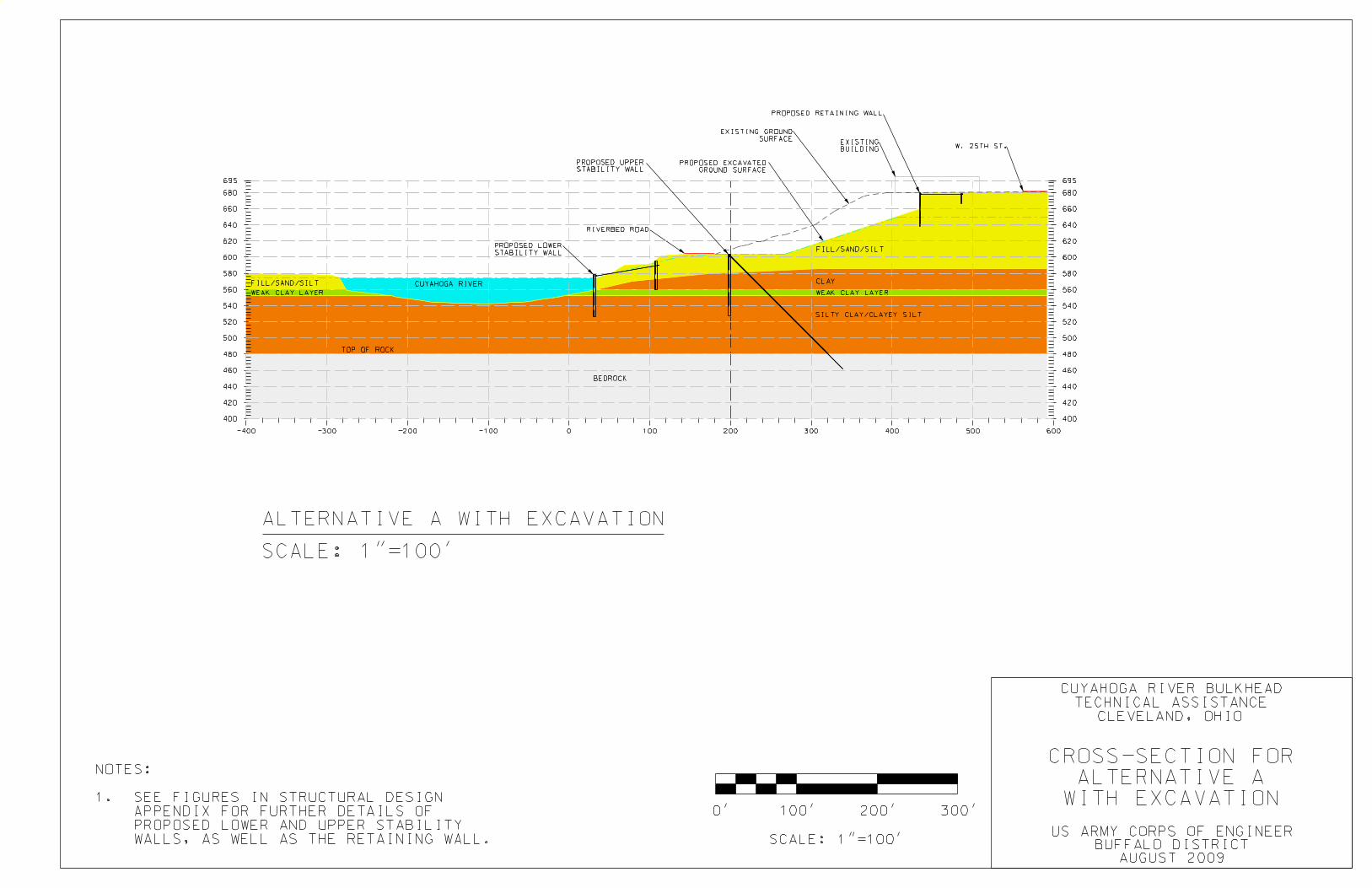
8.2.1.1. Description A steel sheet-pile lower stability wall/bulkhead system and tied back to an anchor wall approximately seventy-five feet landward would be constructed just riverward of the existing crib-wall bulkhead system. An upper stability wall would be constructed up-slope from the existing Riverbed Street right-of-way and tied back to bedrock. Fill would be excavated up-slope from the upper wall and a retaining wall would be constructed at the top of the slope, just riverward from the existing structures. This alternative achieves a slope stability factor of safety of 1.2. For details refer to Appendix B.
8.2.1.2. Costs $80,465,000 total, including mobilization/demobilization and contingencies. Real estate and relocation costs are not included in this estimate. For details refer to Appendix C.
8.2.1.3. Cross section
23
8.2.2. Alternative A2: Bulkhead and mid-slope wall without excavation
8.2.2.1. Description A steel sheet-pile lower stability wall/bulkhead system and tied back to an anchor wall approximately seventy-five feet landward would be constructed just riverward of the existing crib-wall bulkhead system. An upper stability wall would be constructed up-slope from the existing Riverbed Street right-of-way and tied back to bedrock. The upper stability wall would be more robust than for Alternative A1. This alternative achieves a slope stability factor of safety of 1.2. For details refer to Appendix B.
8.2.2.2. Costs $166,715,000 total, including mobilization/demobilization and contingencies. Real estate and relocation costs are not included in this estimate. For details refer to Appendix C.
8.2.2.3. Cross section


25
8.2.3. Alternative A3: Excavation only (theoretical)
8.2.3.1. Description This alternative does not achieve the objectives set forth by the city of Cleveland and is only intended for illustrative purposes. Displayed is the slope excavated back to a stable geometry (achieving a factor of safety of 1.2) without any structural components. This slope would eliminate all infrastructure currently in place on the slope as well as the structures along West 25th Street and both West 25th Street and Franklin Avenues themselves. For details refer to Appendix B.
8.2.3.2. Costs No cost estimate prepared, not a viable alternative.
8.2.3.3. Cross section

27
8.3. Alternative B: Green Bulkhead add-on
8.3.1.1. Description A Green Bulkhead addition to provide larval fish habitat on the riverward side of any constructed bulkhead system is a possible add-on to any of the presented alternatives. For details refer to Appendix B.
8.3.1.2. Costs $3,250,000 additional for each alternative. For details refer to Appendix C.
8.3.1.3. Cross section

29
8.4. Alternative C: Protect the Cuyahoga River plus Riverbed Street
8.4.1. Alternative C1: Bulkhead and mid-slope wall with excavation and retaining wall
8.4.1.1. Description A steel sheet-pile lower stability wall/bulkhead system and tied back to an anchor wall approximately seventy-five feet landward would be constructed just riverward of the existing crib-wall bulkhead system. An upper stability wall would be constructed up-slope from the existing Riverbed Street right-of-way and tied back to bedrock. Fill would be excavated up-slope from the upper wall and a retaining wall would be constructed at the top of the slope, just riverward from the existing structures. The components of this alternative are similar those of alternative A1, but more robust to increase the factor of safety. This alternative achieves a slope stability factor of safety of 1.3. For details refer to Appendix B
8.4.1.2. Costs $153,715,000 total, including mobilization/demobilization and contingencies. Real estate and relocation costs are not included in this estimate. For details refer to Appendix C.
8.4.1.3. Cross section


31
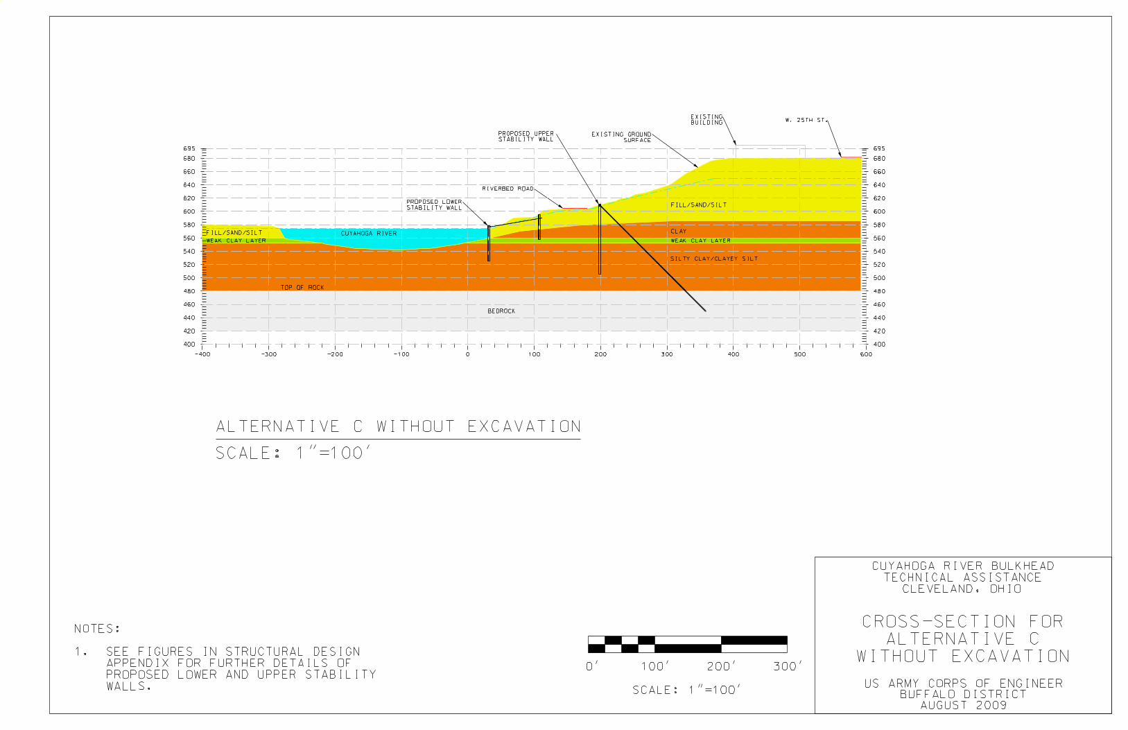
8.4.2. Alternative C2: Bulkhead and mid-slope wall without excavation
8.4.2.1. Description A steel sheet-pile lower stability wall/bulkhead system and tied back to an anchor wall approximately seventy-five feet landward would be constructed just riverward of the existing crib-wall bulkhead system. An upper stability wall would be constructed up-slope from the existing Riverbed Street right-of-way and tied back to bedrock. The components of this alternative are similar those of alternative A2, but more robust to increase the factor of safety. This alternative achieves a slope stability factor of safety of 1.3. For details refer to Appendix C
8.4.2.2. Costs $178,965,000 total, including mobilization/demobilization and contingencies. Real estate and relocation costs are not included in this estimate. For details refer to Appendix C.
8.4.2.3. Cross section

33
8.5. Alternative D: Protect Everything (the Cuyahoga River, Riverbed Street plus Franklin Avenue and the structures along West 25th Street)
8.5.1. Alternative D1: Bulkhead and mid-slope wall without excavation
8.5.1.1. Description The existing crib-wall bulkhead system would be removed and replaced by a steel sheet-pile lower stability wall/bulkhead system and tied back to a wall approximately sixty feet landward. An upper stability wall would be constructed up-slope from the existing Riverbed Street right-of-way and tied back to bedrock. The components of this alternative are similar those of alternative C2, but more robust to increase the factor of safety. This alternative achieves factor of safety of 1.5. For details refer to Appendix C
8.5.1.2. Costs $219,215,000 total, including mobilization/demobilization and contingencies. Real estate and relocation costs are not included in this estimate. For details refer to Appendix C.
8.5.1.3. Cross section


35
9. Summary and Recommendations
9.1. Prioritization and Alternative Selection The intent of the USACE effort was to develop concepts and costs for the presented alternatives in order to provide the city of Cleveland and other stakeholders a basis to select a course of action to remedy the problems at the site. This report does not recommend which of the presented alternatives should be pursued. Alternatives should be evaluated for prioritization based on the cost estimates and risks associated with each alternative as presented in this report and also based on analysis of future land use plans and real estate values in the vicinity of the site.
9.2. Advancing the Design The designs presented in this report are at a conceptual (30%) level and would need to be finalized prior to construction. Advancing the design for one or more of the presented alternatives to 100% design would require additional exploration and data gathering and analysis as well as a significant amount of detailed design work. The conceptual designs presented in this report are based largely on previously gathered data and were developed for the portion of the slope that presented the greatest risk. Detailed designs would apply the selected alternative to the contours and gradient of the site and the existing site conditions.
Related Documents