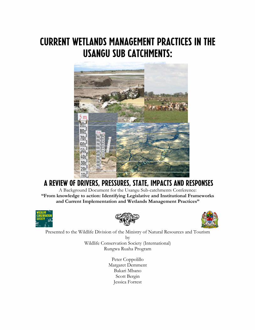
Current Wetlands Management Practices in the Usangu Sub catchments: A Review of Drivers, Pressures, State, Impacts and Responses A Background Document for the Usangu Sub-catchments Conference: “From knowledge to action: Identifying Legislative and Institutional Frameworks and Current Implementation and Wetlands Management Practices” Presented to the Wildlife Division of the Ministry of Natural Resources and Tourism by Wildlife Conservation Society (International) Rungwa Ruaha Program Peter Coppolillo Margaret Demment Bakari Mbano Scott Bergin Jessica Forrest

Welcome message from author
This document is posted to help you gain knowledge. Please leave a comment to let me know what you think about it! Share it to your friends and learn new things together.
Transcript
Current Wetlands Management Practices in the Usangu Sub catchments:
A Review of Drivers, Pressures, State, Impacts and Responses A Background Document for the Usangu Sub-catchments Conference:
“From knowledge to action: Identifying Legislative and Institutional Frameworks and Current Implementation and Wetlands Management Practices”
Presented to the Wildlife Division of the Ministry of Natural Resources and Tourism by
Wildlife Conservation Society (International) Rungwa Ruaha Program
Peter Coppolillo Margaret Demment
Bakari Mbano Scott Bergin
Jessica Forrest
Usangu Catchment DPSIR Submitted October 06 7-March-2006
p.ii
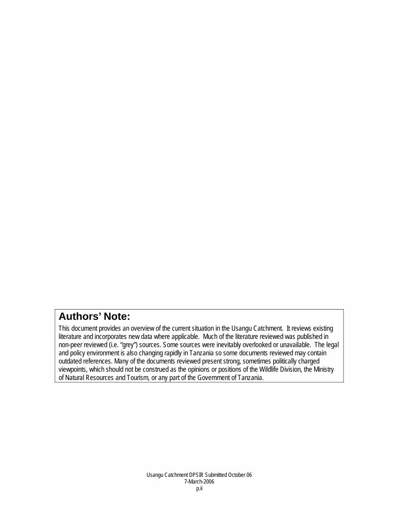
Authors’ Note: This document provides an overview of the current situation in the Usangu Catchment. It reviews existing literature and incorporates new data where applicable. Much of the literature reviewed was published in non-peer reviewed (i.e. “grey”) sources. Some sources were inevitably overlooked or unavailable. The legal and policy environment is also changing rapidly in Tanzania so some documents reviewed may contain outdated references. Many of the documents reviewed present strong, sometimes politically charged viewpoints, which should not be construed as the opinions or positions of the Wildlife Division, the Ministry of Natural Resources and Tourism, or any part of the Government of Tanzania.
Usangu Catchment DPSIR Submitted October 06 7-March-2006
p.iii
Executive Summary • The Usangu Wetlands have enormous value in Tanzania through ecosystem services
that generate electricity, sustain fisheries, promote international tourism, support traditional livelihoods and protect biodiversity.
• Examination of the Drivers, Pressures, State, Impact and Responses (DPSIR) in the Usangu Catchment reveals two principle issues—livestock grazing and water abstraction for rice—on which government and civil society stakeholders should concentrate their efforts.
• The DPSIR analysis also showed that the Usangu Wetlands, which are recognized as nationally and internationally valuable resources, have been severely compromised by local interests with comparatively small economic value (illegal rice farming and livestock grazing) and by inefficiencies resulting from sub-standard irrigation practices.
• The Tanzanian economy is bearing the costs of these problems, a trend which must be reversed. Higher standards must be established for remediation of the existing infrastructure and all future irrigation development.
• The Usangu Catchment was one of the first in Tanzania to experience such problems, but large-scale movements of livestock combined with the need and stated intention to significantly expand irrigated agriculture mean that similar problems could—indeed will, arise elsewhere unless future programs adhere to a higher standard. A better-managed Usangu could therefore, serve as a model for the rest of Tanzania and dryland Africa.
• Dry-season water distributions in the Ruaha River demonstrate that progress has been made in recent years. Setbacks in other sub-catchments may have masked even greater progress, so managers and policy makers should not entertain the criticism that restoration is futile.
• While specific flow targets may be unknown, the direction—toward greater flow—is clear. Identification of targets and better management should proceed simultaneously.
Usangu Catchment DPSIR Submitted October 06 7-March-2006
p.iv
Table of Contents Authors’ Note: ___________________________________________________________ii Executive Summary ______________________________________________________ iii Table of Contents _______________________________________________________ iv 1.Introduction __________________________________________________________ 1
1.1 Geography of Usangu ______________________________________ 1 1.2 Ecological and Economic Values of Usangu Wetlands _____________ 2
1.2.1 Biodiversity Values ______________________________________________ 2 1.2.2 Ecosystem Services ______________________________________________ 3
1.2.2.1 Water for Rice Cultivation _____________________________________ 3 1.2.2.2 Grazing Resources ___________________________________________ 3 1.2.2.3 Water for Hydroelectricity______________________________________ 3 1.2.2.4 Wildlife Habitat: Ruaha National Park and the Mtera Wetlands _________ 4 1.2.2.5 Fisheries in Ihefu, Mtera, Ruaha-Mbuyuni and Ihefu__________________ 4
2. Brief Overview of DPSIR Framework ______________________________________ 4 3. Drivers in Usangu _____________________________________________________ 6
3.1 Increasing Human Population ________________________________ 6 3.1.1 Land Shortage __________________________________________________ 6 3.1.2 “Agropastoral Creep” and weak Pastoral Land Tenure ___________________ 6 3.1.3 Enforcement of Protected Areas and Land Use Plans ____________________ 6
3.2 Poverty and Poor Agricultural Practices_________________________ 6 4. Pressures in Usangu ____________________________________________________ 7
4.1 Water abstraction for Rice cultivation __________________________ 7 4.1.1 Poor infrastructure (and a lack of monitoring) __________________________ 7 4.1.2 Rapid increase in Illegal uses _______________________________________ 7
4.2 Grazing _________________________________________________ 8 4.3 Burning _________________________________________________ 8 4.4 Other contributing factors___________________________________ 9
5. State of Usangu and Beyond______________________________________________ 9 5.1 Ihefu Swamp (Target: Wetland Ecosystem and spp.) ______________ 10 5.2 Ruaha River (Target: Wetland Ecosystem Services) _______________ 10
5.2.1 Dry season water in Ruaha National Park _____________________________10 5.2.2 Hydrology and Mtera Dam ________________________________________11 5.2.3. Highland Wetlands ______________________________________________13
6. Impacts in Usangu and Beyond ___________________________________________13 6.1 Failure of Rice Development Schemes_________________________ 13 6.2 Tourism Revenue in Usangu ________________________________ 14 6.3 Biodiversity in Usangu and Ruaha ____________________________ 15 6.4 Loss of Tourism Potential in Ruaha and Lunda-Mkwambi _________ 18 6.5 Collapse of Mtera Fishery __________________________________ 19 6.6 Loss of Hydropower ______________________________________ 19 6.7 Competition and Conflict among Ecosystem services _____________ 19
Usangu Catchment DPSIR Submitted October 06 7-March-2006
p.v
7. Responses ___________________________________________________________19 7.1 Policy and Legal Framework ________________________________ 20
7.1.1 Water Policy ___________________________________________________20 7.1.1.1 Policy “Pillars” ______________________________________________20 7.1.1.2 Water Policy Priorities: ________________________________________20 7.1.1.3 Principles and Instruments _____________________________________20
7.1.2 Mkukuta (Tanzania Poverty Reduction Strategy) ________________________21 7.1.3 Other Relevant Acts: Tourism, Environmental Management, Wildlife________22
7.2 Proposals for Action:______________________________________ 22 7.2.1 Action 1: Establish Infrastructure for monitoring and management__________23 7.2.2 Action 2: Build sufficient knowledge for monitoring and management _______23 7.2.3 Action 3: Establish Incentives for compliance: _________________________24 7.2.4 Action 4: Raise standards for “improved” irrigation______________________25 7.2.5 Action 5: Restoration of Ihefu Swamp and Natural Ecosystem Services. ______25
Literature Cited _________________________________________________________26
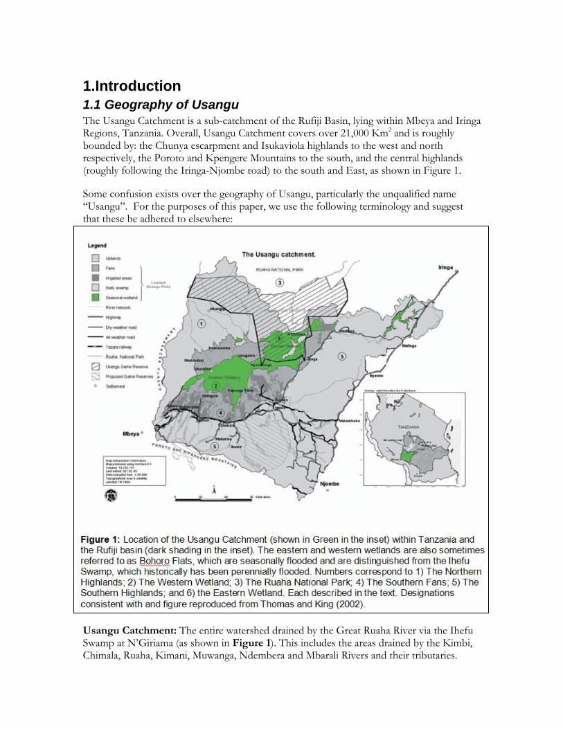
1.Introduction 1.1 Geography of Usangu The Usangu Catchment is a sub-catchment of the Rufiji Basin, lying within Mbeya and Iringa Regions, Tanzania. Overall, Usangu Catchment covers over 21,000 Km2 and is roughly bounded by: the Chunya escarpment and Isukaviola highlands to the west and north respectively, the Poroto and Kpengere Mountains to the south, and the central highlands (roughly following the Iringa-Njombe road) to the south and East, as shown in Figure 1.
Some confusion exists over the geography of Usangu, particularly the unqualified name “Usangu”. For the purposes of this paper, we use the following terminology and suggest that these be adhered to elsewhere:
Usangu Catchment: The entire watershed drained by the Great Ruaha River via the Ihefu Swamp at N’Giriama (as shown in Figure 1). This includes the areas drained by the Kimbi, Chimala, Ruaha, Kimani, Muwanga, Ndembera and Mbarali Rivers and their tributaries.
Usangu Catchment DPSIR Submitted October 06 7-March-2006
p.2
Usangu Game Reserve: The protected area managed by the Wildlife Division for tourist hunting. This area lies mostly, but not entirely, within the Usangu Catchment, but is limited only to the boundaries of the protected area as defined by the Wildlife Act of 1974.
Eastern and Western Wetlands: Two, adjoining seasonally-flooded areas within the Usangu Catchment, separated by the “Nyaluhanga Crossing”, a constriction point between the two larger areas*. The entire Western Wetland lies outside of the Usangu Game Reserve, while most of the Eastern Wetland Lies within it.
Ihefu Swamp: The area within the Eastern Wetland that historically has been perennially flooded and from which “the Outlet” flows at N’Giriama.
It is important to note that some stakeholders opposed to enforcement of the regulations governing Usangu Game Reserve—specifically the prohibition of livestock grazing—have mentioned “eviction of livestock from the Usangu Plaines.” This is not, nor has it ever been accurate. Any discussions of the removal concern only the Ihefu Swamp and portion of the Eastern Wetland lying within Usangu Game Reserve. At it’s 2001 extent (discussed in the “States” section) the Ihefu swamp covered approximately 116 Km2, or just over half of one percent of the Usangu Catchment, and the portion of the Eastern Wetland within UGR covers approximately 1,400 Km2 or around six and one half percent of the Usangu Catchment.
1.2 Ecological and Economic Values of Usangu Wetlands Ecological and economic values of the Usangu wetlands are discussed below. The biodiversity value of the wetlands themselves are presented first, while the biodiversity values of other areas dependent on Usangu water are considered in “Ecosystem Services”, as they are not part of the Usangu wetlands, but they do depend on the hydrological functions provided there. This convention is maintained throughout the paper.
1.2.1 Biodiversity Values A principle objective of Tanzania’s Ministry of Natural Resources and Tourism is to protect and sustainably manage Tanzania’s unparalleled natural heritage. Tanzania is widely recognized as a “megadiversity” country, largely driven by the variety of habitats within the country. Among the most threatened of these are wetlands, which are vulnerable to direct use for cultivation, grazing, fishing, and grass cutting, as well as indirect causes like diversion upstream. On pillar of Tanzania’s wetland protection is the development of a National Wetlands Strategy, which is currently underway. A likely objective of the Strategy will be to conserve representative wetland types across the country. Usangu’s uniqueness and biodiversity values are described below, flowed by its importance for biodiversity elsewhere via ecosystem services.
The Usangu wetlands (Ihefu Swamp and the Eastern and Western Wetlands) are the largest wetlands in Mbeya and Iringa Regions. Within the Rift Valley portions of these Regions * In the past these wetlands have also been called the “Bohoro Flats”, but to avoid confusion and maintain consistency with SMUWC, we use “Eastern /Western Wetlands”.
Usangu Catchment DPSIR Submitted October 06 7-March-2006
p.3
only Ihefu and Part of the Eastern Wetland are protected. Other significant wetlands can be found in Mahuninga, Makifu, Tungamalenga, Mapogoro, Idodi, Malinzanga, Nyamahana, Mafuluto, Isele, Kimande and Kinyika Villages, forming the Ilusi and Pawaga Complexes of Wetlands; however, every one of these wetlands are cultivated by adjacent communities. Therefore, only Ihefu Swamp and part of the Eastern Wetland offer the opportunity to conserve wetlandcommunities inn their natural state.
The Ramsar Convention establishes guidelines for conservation and sustainable use of wetland resources in areas recognized as “Wetlands of International Importance”. The Convention provides eight criteria for inclusion, and Usangu fulfils at least two of these, as greater than 1% of a variety of species are known to use the area, and aggregations of more than 20,000 birds are known to use the area (Rose and Scott 1994; SMUWC 2001). Usangu may qualify under one or more of the other six criteria as well, depending on the biographic units considered.
Finally, The Usangu Wetlands are also recognized as “Important Bird Area” (Baker and Baker 2002). The area boasts more than 500 species, more than double the number found in all of Europe, and provides important breeding habitat for a variety of species, including the wattled crane.
1.2.2 Ecosystem Services 1.2.2.1 Water for Rice Cultivation To date, the most widely recognized financial return from the Usangu Catchment has come in the form of rice cultivation in the southern Fans (see area 4, figure 1), which is made possible by water from the Southern highlands (area 5, figure 1). Historically, water was used through indigenously constructed, “unimproved” irrigation schemes cultivated primarily in the wet season. Starting in the mid 1980s, a number of projects sought to increase the benefits from rice cultivation through the construction of “improved” rice schemes. The efficacy of these schemes and their relationships to other environmental and social outcomes are discussed within the Pressures and Impacts sections.
1.2.2.2 Grazing Resources The Wetlands of the Usangu Catchment also provide a productive source of forage for grazing herbivores. The vast majority of these are cattle (457-541,000 animals; SMUWC 2001), and of these, around 90% are owned by Sukuma herders that have arrived mostly from Rukwa, Tabora and Shinyanga Regions(Charnley 1997). Within the wetlands, the most productive area is the Ihefu Swamp, which contributes the largest amount to carrying capacity (SMUWC 2001) and harbors the highest density of herbivores (SMUWC 2001; Coppolillo, Kashaija et al. 2004).
1.2.2.3 Water for Hydroelectricity More significant economically is the Usangu Wetlands’ importance for the Ruaha River, from which over two thirds of Tanzania’s electricity is produced. The Mtera Hydroelectric facility, constructed over the 11 years spanning 1977-1988, serves two roles: it generates around 80MW of electricity and stores water for Kidatu Hydroelectric facility downstream.
Usangu Catchment DPSIR Submitted October 06 7-March-2006
p.4
(Roberts 2000); Water from the Ruaha River contributes 60% of the water reaching Mtera Reservoir.
The Usangu wetlands accomplish this via two critical services. First, the wetland regulates the flow of the Ruaha River, by filling up slowly throughout the wet season and draining out slowly over the long dry season, a process known as the “sponge effect”. Second, while the water is in the wetlands, particularly Ihefu Swamp, the wetland vegetation shades the water and reduces evaporation, ensuring that more of it passes downstream to the Ruaha River and Mtera Hydroelectric Plant (Mtahiko, Gereta et al. 2006).
1.2.2.4 Wildlife Habitat: Ruaha National Park and the Mtera Wetlands In addition to the biodiversity value of the Usangu Wetlands themselves, water from Usangu provides a dry-season water source for numerous water-dependent species in the Ruaha River, where it has positive ecological and economic effects. These effects are most significant in the 213 km reach from N’Giriama to the point at which the Little Ruaha River meets the Great Ruaha, because it is the principle dry season water source in this area. The Ruaha River is the primary game viewing area within Ruaha National Park, which attracted around 7,000 bed-nights in 2004 (RUNAPA 2005), but this number is increasing steadily.
Mtera Reservoir also has tourism potential. To date, only one tourist facility has opened in the area, but this is expected to increase. Indeed the Tourism Division’s Master Plan places heavy emphasis on development of the Southern Circuit. As this happens, and as the Dodoma-Iringa Road is improved it is likely that the wetlands in Mtera will attract large numbers of tourists, as do many other reservoirs in Africa (e.g. Lake Kariba) and America (Lakes Meade, Powell and Havasu).
1.2.2.5 Fisheries in Ihefu, Mtera, Ruaha-Mbuyuni and Ihefu While small, the Ihefu fishery has proven productive when the swamp is flooded. SMUWC (2001) report catches averaging 700 tonnes† per year. It should be noted however, that fishing is illegal in Usangu Game Reserve, so for these revenues to be captured legally, a multiple use policy would need to be adopted. The Usangu wetlands and their hydrology also support artisanal fisheries in the Ruaha River (for which no catch data are available) and Mtera Reservoir. Catch recorded in Mtera from 1990-95 ranged between 98 and 5,000 metric tones, generating revenues of up to 511 million Tanzania Shillings (Sosovele, Ngwale et al. 2002) through local markets, transport as far away as Dar es Salaam (WorldCare ND) and even exports to Zambia (Nilsson and Kitojo ND).
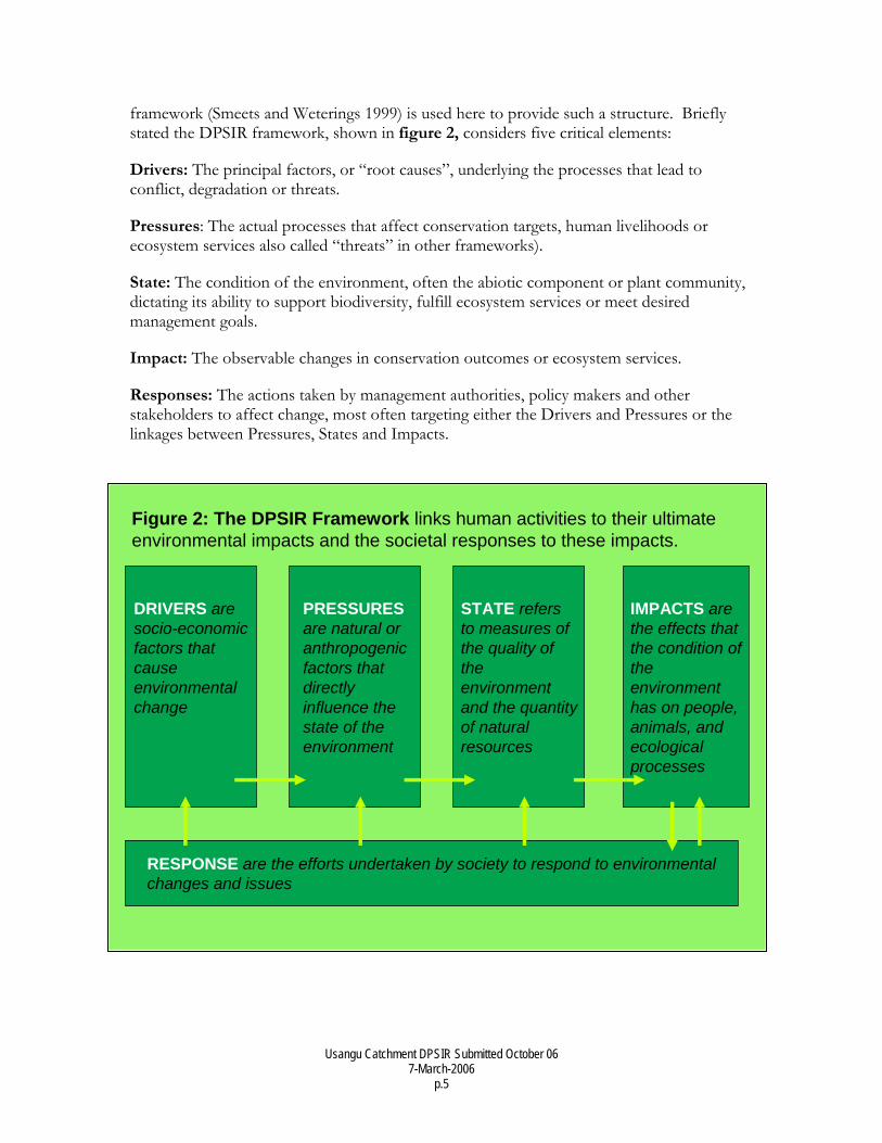
2. Brief Overview of DPSIR Framework Conservation, development and environmental management are all being implemented at increasingly large spatial scales. This trend reflects the growing recognition that large-scale (both spatial and temporal) linkages connect management units that have traditionally been considered independently. Furthermore, both water and environmental issues cross “sectoral” boundaries like agriculture, power, wildlife, and tourism. In the face of such complexity, a structured analytical and planning approach is essential. The DPSIR
† Assessed 1985-98 (range: 400-1200T)
Usangu Catchment DPSIR Submitted October 06 7-March-2006
p.5
Figure 2: The DPSIR Framework links human activities to their ultimate environmental impacts and the societal responses to these impacts.
DRIVERS are socio-economicfactors that cause environmental change
PRESSURESare natural or anthropogenic factors that directly influence the state of the environment
STATE refers to measures of the quality of the environment and the quantity of natural resources
IMPACTS are the effects that the condition of the environment has on people, animals, and ecological processes
RESPONSE are the efforts undertaken by society to respond to environmental changes and issues
framework (Smeets and Weterings 1999) is used here to provide such a structure. Briefly stated the DPSIR framework, shown in figure 2, considers five critical elements:
Drivers: The principal factors, or “root causes”, underlying the processes that lead to conflict, degradation or threats.
Pressures: The actual processes that affect conservation targets, human livelihoods or ecosystem services also called “threats” in other frameworks).
State: The condition of the environment, often the abiotic component or plant community, dictating its ability to support biodiversity, fulfill ecosystem services or meet desired management goals.
Impact: The observable changes in conservation outcomes or ecosystem services.
Responses: The actions taken by management authorities, policy makers and other stakeholders to affect change, most often targeting either the Drivers and Pressures or the linkages between Pressures, States and Impacts.
Usangu Catchment DPSIR Submitted October 06 7-March-2006
p.6
3. Drivers in Usangu 3.1 Increasing Human Population 3.1.1 Land Shortage Tanzania has prospered from the luxury of abundant land, but shortages are increasingly common, especially in areas with high human population growth and high agricultural potential. Critically, these two areas often overlap, exacerbating land conflicts and land shortage. In areas of marginal rainfall like Usangu, farmers are drawn to areas where irrigation is possible, as it minimizes the influence of rainfall on crop agriculture and minimizes the risk of crop failure.
Many households also turn to irrigated agriculture for “business” or cash-crop production, combining it with traditional rain-fed systems for subsistence or as a supplemental form of income for non-farming households. As disposable incomes rise in Tanzania, households’ ability to hire day labor and establish supplemental farms will continue to increase
3.1.2 “Agropastoral Creep” and weak Pastoral Land Tenure Even where the absolute amount of land is not limiting, some conflicts arise over higher quality land. Many of the new farms mentioned above are established at the margins of existing village lands. Livestock often graze in these peri-village areas, whether they are kept by specialized pastoralists or agropastoralists. While the Village Land Act 1999 provides land tenure for customary use and for herding, few pastoralists are aware of these provisions and few village governments recognize them. The result is that despite years of traditional use by livestock if an area is cultivated rights to the use of that area often accrue to the cultivator, effectively displacing livestock from more and more land. This process has been repeated on both large and small scales all over Tanzania (Brandström 1985; Galaty 1988; Lane 1996; Charnley 1997) leading to a “cascade” of pastoralists. Usangu was one of the few remaining areas receiving pastoralists displaced from or fleeing environmental degradation elsewhere.
3.1.3 Enforcement of Protected Areas and Land Use Plans Another factor increasing both actual land shortage and the perception of land shortage is more effective enforcement of protected areas. In some areas, communities took advantage of weak enforcement capacity and were able either seasonally or permanently to use protected areas that are now unavailable to them. Finally, increasing numbers of villages are fulfilling their obligation of land use planning, as specified by the Village Land Act of 1999. This process can also make Village Governments become more aware of their local natural resources and enforce the spatial separation of land uses like grazing and cultivation, or to reduce the number of livestock tolerated within a village. The result is that livestock, most often cattle, leave village areas and flee to “frontier” areas like Usangu.
3.2 Poverty and Poor Agricultural Practices Construction of Kapuga, Mbarali and Madibira Rice schemes was intended to a) increase the amount of rice produced (/ ha), b) decrease the amount of water used per unit of rice produced, and c) increase the equitability of economic benefits from rice. The efficacy of the projects to reach these goals is address later. They are mentioned here because these development schemes and the poverty driving the perception of their necessity are significant drivers of the environmental issues explored in the remainder of this paper.
Usangu Catchment DPSIR Submitted October 06 7-March-2006
p.7
4. Pressures in Usangu 4.1 Water abstraction for Rice cultivation The management issue that has undoubtedly received the most attention in Usangu is the abstraction of water for rice cultivation. This is understandable, as irrigation is the second highest use of water (behind hydropower) in the Rufiji Basin (Mwaruvanda 2004), but unlike hydropower, only 25% of the water is returned for other uses (under the best of circumstances). Two primary pressures are explored within this context: 1) inadequate infrastructure, reducing control of sanctioned uses; and 2) increases in illegal uses.
4.1.1 Poor infrastructure (and a lack of monitoring) Numerous studies have argued that one of the principle problems limiting sustainable water management in Usangu is a lack of or inappropriate infrastructure (FAO and SWMRG 2004; Lankford 2004). This trend is also apparent in other watersheds, where delivery canals are lower than rice fields, making it necessary for water users to flood canals to fill fields and abstract far more water than is actually necessary for irrigation (Kibuga 2006). In other cases “improved” weirs were installed with no capacity to ensure a minimum flow, or without the capacity to allow different users different amounts of water (Lankford and Mwaruvanda 2005). To the extent that fields themselves are considered infrastructure, poor leveling and a lack of return canals also greatly increase the amount of water necessary for irrigation (without leveling), and decrease the amount of water returned to the river after irrigation (no canals). In summary, the infrastructure currently in Usangu allows neither efficient nor sustainable irrigation of water (SMUWC 2001; FAO and SWMRG 2004; Franks, Lankford et al. 2004; Lankford 2004; Kibuga 2006). It is also not sufficient for controlling illegal uses, as is discussed below.
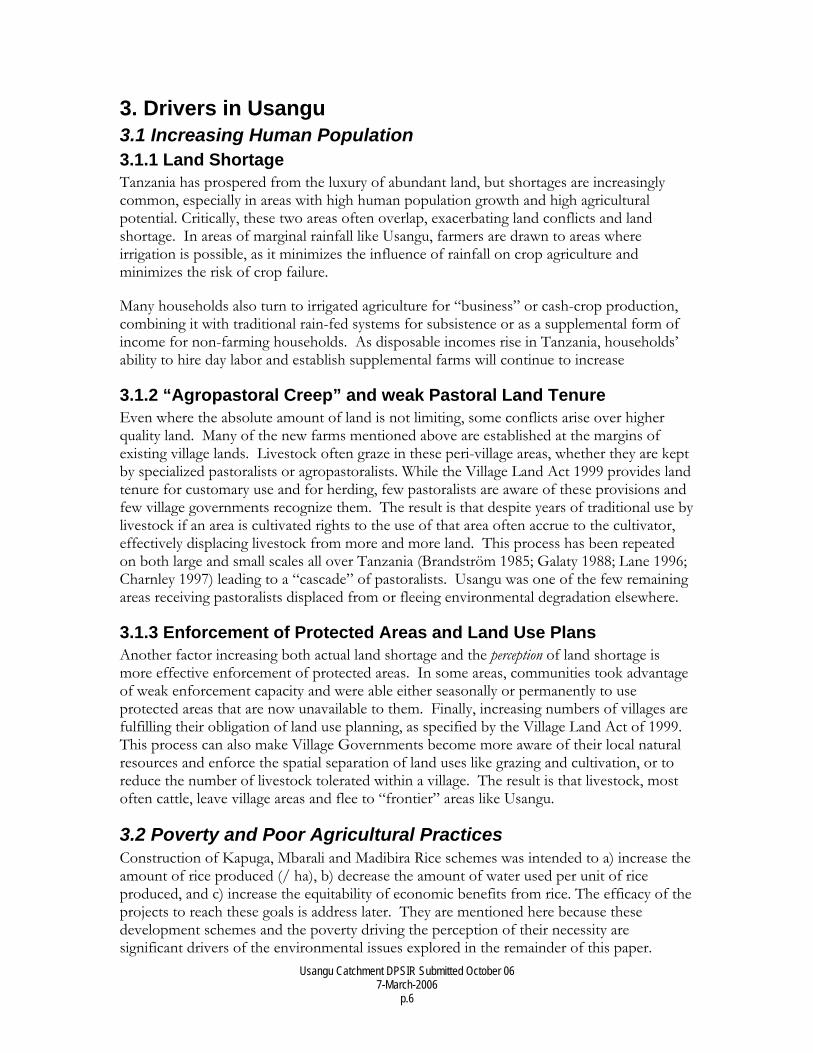
4.1.2 Rapid increase in Illegal uses The delivery of water to the large rice schemes and the capacity to abstract water throughout the year have led to a concomitant rise in unsanctioned (illegal) uses. Unauthorized users, generally smallholders, dig into both delivery and return canals and divert water to cultivate rice adjacent to the canals themselves. The canals vulnerability to this practice has been attributed to the fact that many—especially return canals—are not cement lined. However, it is also clear that many diversions are tolerated by Farm managers. Figure 3 shows a diversion within sight of the Farm Management Compound at Kapunga.
Usangu Catchment DPSIR Submitted October 06 7-March-2006
p.8
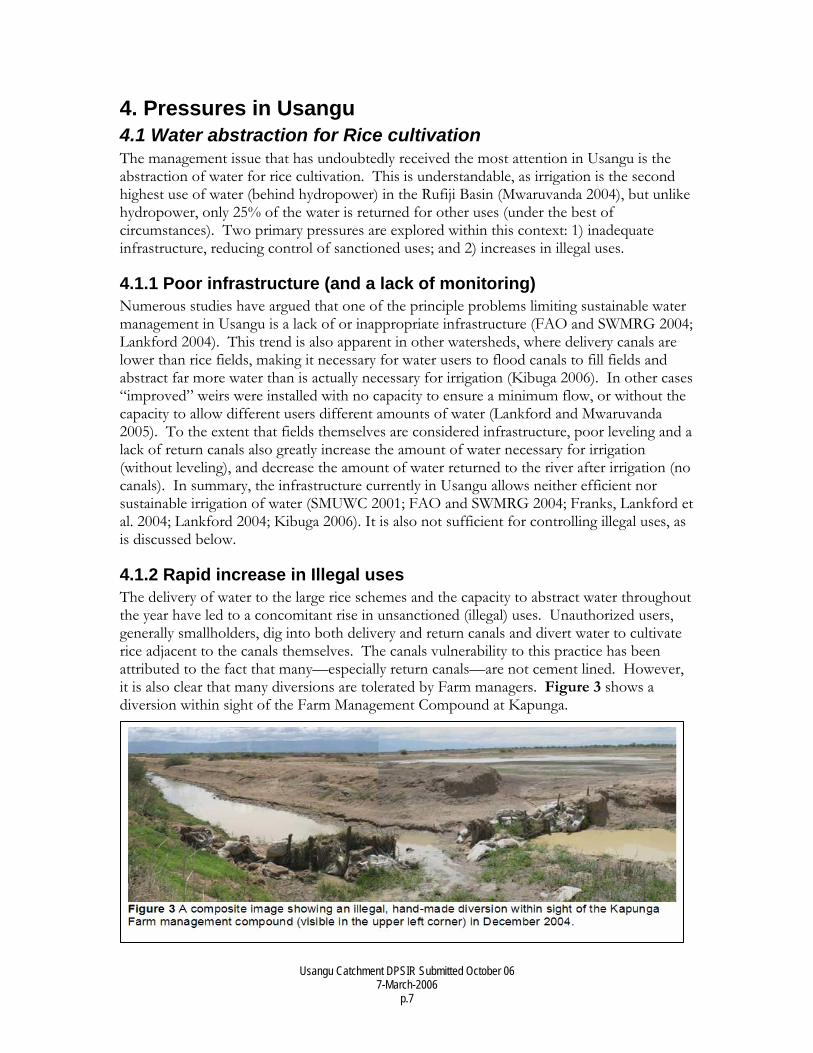
In addition to the known leakage, actual abstraction may be far more extensive than previously recognized. Lankford et al (2004) digitized the areas presumed under irrigation. Comparison with satellite imagery from 2001 however, reveals a much larger area flooded, as is evident in figure 4.
In summary, abstraction for rice constitutes a significant, if not the most significant pressure in Usangu. Sanctioned uses are grossly inefficient due to poorly-timed planting, unleveled fields, inappropriate weirs and a lack of return canals. These inefficiencies are exacerbated by a proliferation of illegal uses, the extent of which is largely unknown. Taken together large scale waste, combined with a rapid spread of irrigated areas constitute an enormous pressure on Usangu’s water resources.
4.2 Grazing The land shortages and lack of pastoral land tenure mentioned earlier (see Drivers) led to a massive influx of cattle into Usangu, a process Charnley described as a “cascade effect” (1997). The vast majority of livestock are cattle (SMUWC 2001; Coppolillo, Kashaija et al. 2004), and the SMUWC Programme estimated between 457-541,000 cattle in Usangu from 1976-87, and around 300,000 in 1999-2000. A survey of Usangu Game Reserve and the Western Wetland in 2003 found approximately 77,000 cattle in the Ihefu Swamp alone (calculated from: Coppolillo, Kashaija et al. 2004).
The recent enforcement operation in Usangu has drastically reduced, possibly even eliminated the amount of illegal grazing in Usangu G.R. This will have important implications for both the state of the resource itself, and its ecosystem function (see section
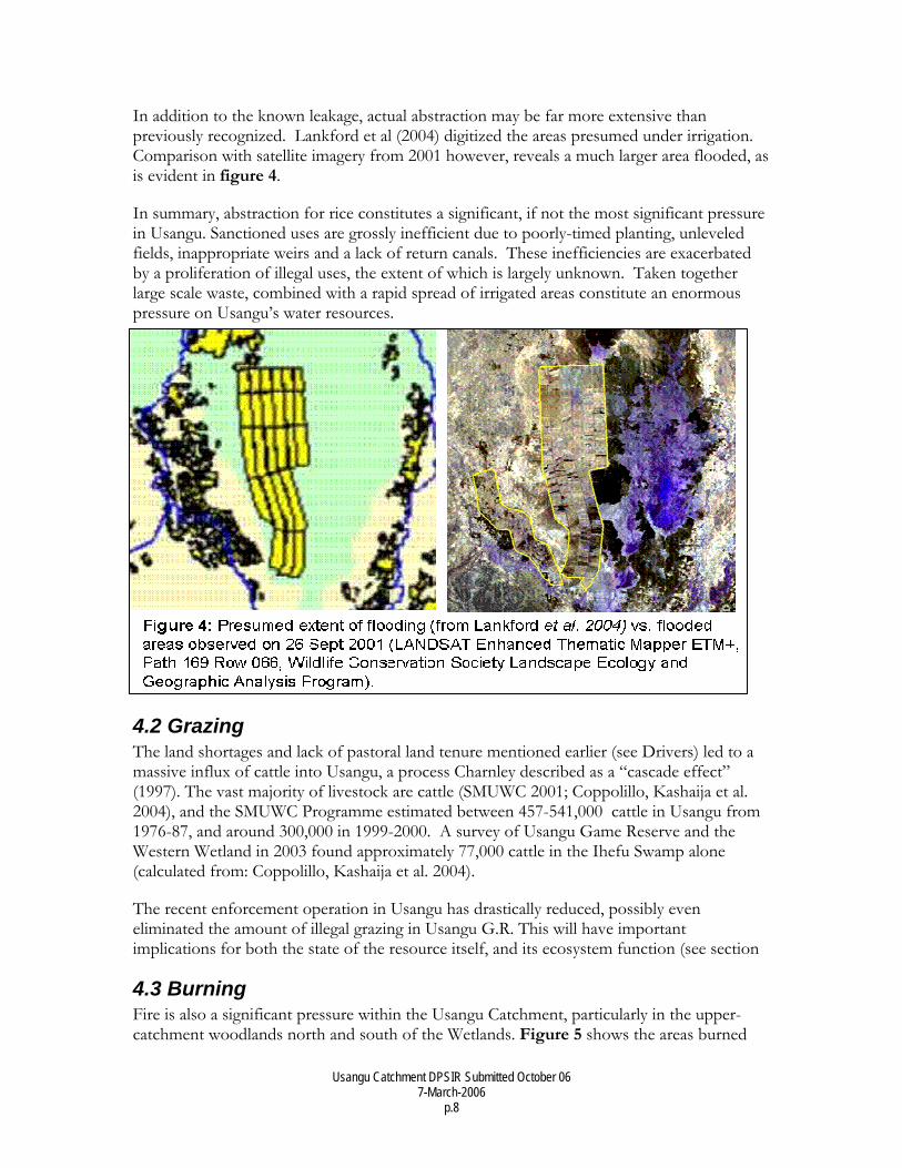
4.3 Burning Fire is also a significant pressure within the Usangu Catchment, particularly in the upper-catchment woodlands north and south of the Wetlands. Figure 5 shows the areas burned
Usangu Catchment DPSIR Submitted October 06 7-March-2006
p.9
from 2000-5. As with grazing, these reductions in biomass likely reduce infiltration and water holding capacity, but their direct effect on hydrology is unknown.
4.4 Other contributing factors A variety of other potential pressures have been noted in Usangu, but their individual and collective effects on the Usangu Catchment are unknown. The first of these is cultivation near and in watercourses. These “winter gardens” generally do not actually divert water away from the river bed; instead, gardens are cultivated right in the bed itself. In absolute terms this practice may not divert large quantities of water, but because this takes place during the dry season, when flows are lowest, it may have a significant proportional effect on dry season flows. In the Usangu Catchment, this practice takes place almost exclusively in the Southern Highlands zone (i.e. upstream from the wetland areas). Earthen blockages and “fish traps” are also placed in channels during the dry season. The former certainly slows the passage of water through the Ihefu Swamp, though the latter probably does not have a significant hydrological effect. Next, it has been suggested that eucalyptus and pine plantations may affect soil moisture and infiltration, a process, and similar effects have been demonstrated in other parts of the world, but it is not clear whether those effects cam be generalized and applied to Usangu (Hofstede, G. M. et al. 2002).
5. State of Usangu and Beyond Water is the most contested resource and the principle determinant of wetland health in Usangu. And because the Usangu Catchment’s ecosystem services are essentially hydrological, it is logical that its State (sensu DPSIR) be measured through water. Water and greenness from soil moisture are therefore used as indicators of the extent of wetland communities. In assessing the ecosystem services provided outside of the Usangu Wetlands, standing water and river flow were used as indicators of the State of these services.
Usangu Catchment DPSIR Submitted October 06 7-March-2006
p.10
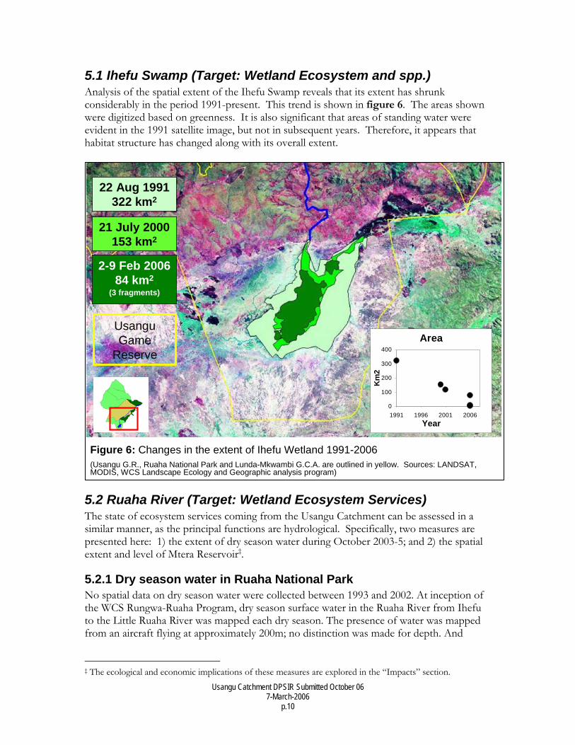
5.1 Ihefu Swamp (Target: Wetland Ecosystem and spp.) Analysis of the spatial extent of the Ihefu Swamp reveals that its extent has shrunk considerably in the period 1991-present. This trend is shown in figure 6. The areas shown were digitized based on greenness. It is also significant that areas of standing water were evident in the 1991 satellite image, but not in subsequent years. Therefore, it appears that habitat structure has changed along with its overall extent.
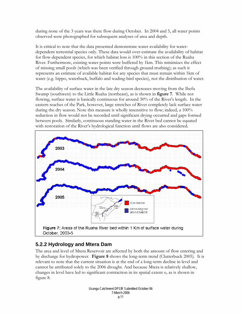
5.2 Ruaha River (Target: Wetland Ecosystem Services) The state of ecosystem services coming from the Usangu Catchment can be assessed in a similar manner, as the principal functions are hydrological. Specifically, two measures are presented here: 1) the extent of dry season water during October 2003-5; and 2) the spatial extent and level of Mtera Reservoir‡.
5.2.1 Dry season water in Ruaha National Park No spatial data on dry season water were collected between 1993 and 2002. At inception of the WCS Rungwa-Ruaha Program, dry season surface water in the Ruaha River from Ihefu to the Little Ruaha River was mapped each dry season. The presence of water was mapped from an aircraft flying at approximately 200m; no distinction was made for depth. And
‡ The ecological and economic implications of these measures are explored in the “Impacts” section.
Figure 6: Changes in the extent of Ihefu Wetland 1991-2006(Usangu G.R., Ruaha National Park and Lunda-Mkwambi G.C.A. are outlined in yellow. Sources: LANDSAT, MODIS, WCS Landscape Ecology and Geographic analysis program)
22 Aug 1991322 km2
21 July 2000153 km2
2-9 Feb 200684 km2
(3 fragments)
Area
0
100
200
300
400
1991 1996 2001 2006Year
Km
2
Usangu Game
Reserve
22 Aug 1991322 km2
21 July 2000153 km2
2-9 Feb 200684 km2
(3 fragments)
Area
0
100
200
300
400
1991 1996 2001 2006Year
Km
2
Usangu Game
Reserve
Usangu Catchment DPSIR Submitted October 06 7-March-2006
p.11
during none of the 3 years was there flow during October. In 2004 and 5, all water points observed were photographed for subsequent analyses of area and depth.
It is critical to note that the data presented demonstrate water availability for water-dependent terrestrial species only. These data would over-estimate the availability of habitat for flow-dependent species, for which habitat loss is 100% in this section of the Ruaha River. Furthermore, existing water points were buffered by 1km. This minimizes the effect of missing small pools (which was been verified through ground-truthing); as such it represents an estimate of available habitat for any species that must remain within 1km of water (e.g. hippo, waterbuck, buffalo and wading-bird species), not the distribution of water.
The availability of surface water in the late dry season decreases moving from the Ihefu Swamp (southwest) to the Little Ruaha (northeast), as is shown in figure 7. While not flowing, surface water is basically continuous for around 30% of the River’s length. In the eastern reaches of the Park, however, large stretches of River completely lack surface water during the dry season. Note this measure is wholly insensitive to flow; indeed, a 100% reduction in flow would not be recorded until significant drying occurred and gaps formed between pools. Similarly, continuous standing water in the River bed cannot be equated with restoration of the River’s hydrological function until flows are also considered.
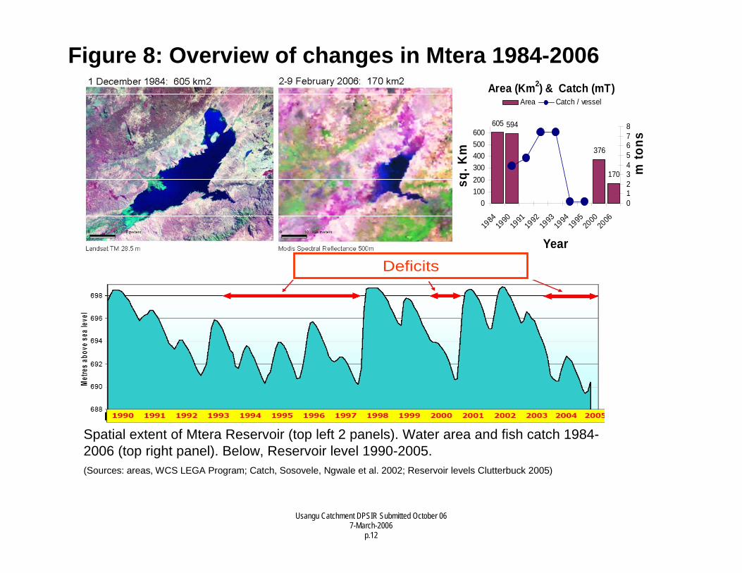
5.2.2 Hydrology and Mtera Dam The area and level of Mtera Reservoir are affected by both the amount of flow entering and by discharge for hydropower. Figure 8 shows the long-term trend (Clutterbuck 2005). It is relevant to note that the current situation is at the end of a long-term decline in level and cannot be attributed solely to the 2006 drought. And because Mtera is relatively shallow, changes in level have led to significant contraction in its spatial extent o, as is shown in figure 8.
Usangu Catchment DPSIR Submitted October 06 7-March-2006
p.12
Area (Km2) & Catch (mT)
605 594
376
170
0100200300400500600
1984
1990
1991
1992
1993
1994
1995
2000
2006
Year
sq. K
m
012345678
m to
ns
Area Catch / vessel
K
Deficits
Spatial extent of Mtera Reservoir (top left 2 panels). Water area and fish catch 1984-2006 (top right panel). Below, Reservoir level 1990-2005. (Sources: areas, WCS LEGA Program; Catch, Sosovele, Ngwale et al. 2002; Reservoir levels Clutterbuck 2005)
Figure 8: Overview of changes in Mtera 1984-2006
Usangu Catchment DPSIR Submitted October 06 7-March-2006
p.13
Attribution of these effects to specific pressures is difficult. Obviously, the two principle drivers are abstraction for rice, and degradation of the Ihefu Swamp and Eastern Wetland, but to apportion the effect between these two is not possible at present. First, the hydrological effect of livestock is not well researched. The SMUWC program (2001) assessed only the amount of water that cattle drink, but not their effect on infiltration, water holding capacity, the rate water moves through Ihefu, or evaporation. However Mtahiko et. al. (2006) demonstrate that the reduced vegetation biomass and the loss of shading, can lead to greater evaporation and loss of water form the wetland. They argue that both abstraction and cattle affect flows in the Ruaha River.
5.2.3. Highland Wetlands Existing information on the highland wetlands in the Usangu Catchment (Sao Hill, Njombe, Kibidula and others) is grossly lacking. With highland cultivation and irrigation expanding, it is likely that these wetlands will be affected. Otters are known to persist in some areas, so the wetlands themselves may be in good condition. Clearly, a rapid assessment followed by more in depth studies are warranted.
6. Impacts in Usangu and Beyond Overall, the State of the Usangu Catchment can be summarized as an increase in water distribution above the Western Wetland, achieved through legal and illegal abstraction, with a concomitant decrease in both flow and spatial extent of water in and below. The Impacts of this redistribution of water are presented from upper catchment downward.
6.1 Failure of Rice Development Schemes The stated goals of the large rice development schemes in Usangu were to increase: 1) yields, 2) efficiency, and 3) equitability. To date, none of these has been realized (Lankford 2004; van Koppen, Sokile et al. 2004). What’s more, these schemes have actually increased conflicts among stakeholders (Maganga, Butterworth et al. 2001), and have precipitated far-reaching and significant negative economic impacts, which are described in subsequent sections.
The lack of increase – indeed many studies demonstrate an actual decrease in efficiency—in rice production is attributed to the inadequate infrastructure mentioned earlier and to the illegal uses. While significant increases in yield were promised early in the projects, it seems most of the intended economic benefits were to be gained by timing of sales, rather than through more rice grown per hectare. Faster maturing and higher yielding varieties have not been adopted in Usangu, so productivity per unit area has remained flat. Equitability of economic benefits from rice has actually decreased, and smallholders have not realized the economic benefits from off-season harvests. Most smallholders have to sell harvested rice immediately to repay loans for seed and labor in production. Middlemen also collude and keep prices down in the villages, and because most smallholders do not have the means to transport their own harvests, they are beholden to the middlemen, who capture the bulk of the profits. These profits are significant, because in many places the price of a sack of rice varies from 5,000 tsh at harvest time, to 30,000 tsh later in the year (Kibuga 2006).
Usangu Catchment DPSIR Submitted October 06 7-March-2006
p.14
Few if any reviews of the rice development schemes in Usangu argue that they have provided an overall net benefit, and economic data presented below support the contention that the three large rice schemes have cost the Government of Tanzania and the Tanzanian economy far more than they have generated.
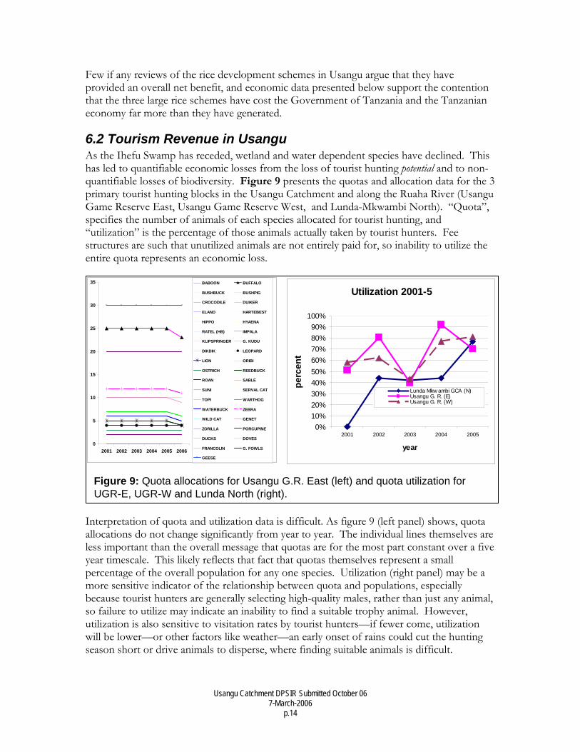
6.2 Tourism Revenue in Usangu As the Ihefu Swamp has receded, wetland and water dependent species have declined. This has led to quantifiable economic losses from the loss of tourist hunting potential and to non-quantifiable losses of biodiversity. Figure 9 presents the quotas and allocation data for the 3 primary tourist hunting blocks in the Usangu Catchment and along the Ruaha River (Usangu Game Reserve East, Usangu Game Reserve West, and Lunda-Mkwambi North). “Quota”, specifies the number of animals of each species allocated for tourist hunting, and “utilization” is the percentage of those animals actually taken by tourist hunters. Fee structures are such that unutilized animals are not entirely paid for, so inability to utilize the entire quota represents an economic loss.
Interpretation of quota and utilization data is difficult. As figure 9 (left panel) shows, quota allocations do not change significantly from year to year. The individual lines themselves are less important than the overall message that quotas are for the most part constant over a five year timescale. This likely reflects that fact that quotas themselves represent a small percentage of the overall population for any one species. Utilization (right panel) may be a more sensitive indicator of the relationship between quota and populations, especially because tourist hunters are generally selecting high-quality males, rather than just any animal, so failure to utilize may indicate an inability to find a suitable trophy animal. However, utilization is also sensitive to visitation rates by tourist hunters—if fewer come, utilization will be lower—or other factors like weather—an early onset of rains could cut the hunting season short or drive animals to disperse, where finding suitable animals is difficult.
Figure 9: Quota allocations for Usangu G.R. East (left) and quota utilization for UGR-E, UGR-W and Lunda North (right).
0
5
10
15
20
25
30
35
2001 2002 2003 2004 2005 2006
BABOON BUFFALO
BUSHBUCK BUSHPIG
CROCODILE DUIKER
ELAND HARTEBEST
HIPPO HYAENA
RATEL (HB) IMPALA
KLIPSPRINGER G. KUDU
DIKDIK LEOPARD
LION ORIBI
OSTRICH REEDBUCK
ROAN SABLE
SUNI SERVAL CAT
TOPI WARTHOG
WATERBUCK ZEBRA
WILD CAT GENET
ZORILLA PORCUPINE
DUCKS DOVES
FRANCOLIN G. FOWLS
GEESE
Utilization 2001-5
0%10%20%30%40%50%60%70%80%90%
100%
2001 2002 2003 2004 2005
year
perc
ent
Lunda Mkw ambi GCA (N)Usangu G. R. (E)Usangu G. R. (W)
Usangu Catchment DPSIR Submitted October 06 7-March-2006
p.15
With these limitations in mind and being careful not to over-interpret limited information, some conclusions may be drawn from the quota and utilization data. First, tourist hunting is only weakly coupled to the ecosystem goods and services (wildlife and the opportunity to hunt) provided by the river and the ecosystem overall. A longer term data set (from pre-river drying) could in theory reveal a more significant relationship, but this seems unlikely. Fortunately, the hunting blocks in the area include woodland areas, so it has been possible for activities to simply shift away from Ihefu and the Eastern Wetland. But this is certainly not without economic cost.
Second, the differences between utilization in hunting blocks may be instructive. First, Lunda-Mkwambi North is the farthest east, where the drying of the Great Ruaha is most severe (figure 7). Lower utilization there may reflect this drying compared to the Usangu blocks, where despite shrinkage of the Ihefu wetland, its role as a water source and surface water remains in the Great Ruaha. This hypothesis could be supported by a trend in trophy quality or an increase in search times for comparable quota qualities; these analyses should be undertaken if possible. The overall increasing trend in utilization may reflect a post-September 11th rebound in visitation or the industry-wide trend of increasing tourism in Tanzania.
In addition to its current potential for generating hunting revenues, Usangu and Ihefu have tremendous photographic tourism potential as well. For example, Amboseli National Park—a protected area also centered on a wetland but less than 1/10th the size of Usangu—generates over $3million per year. Note also that Amboseli is around 4 hours drive from Nairobi, with the last hour on rough dirt road. Usangu is only about an hour’s drive from Mbeya mostly on tarmac. Therefore, when the construction of an international airport is complete, Usangu’s economic potential—and by extension the costs of wetland degradation—will increase significantly.
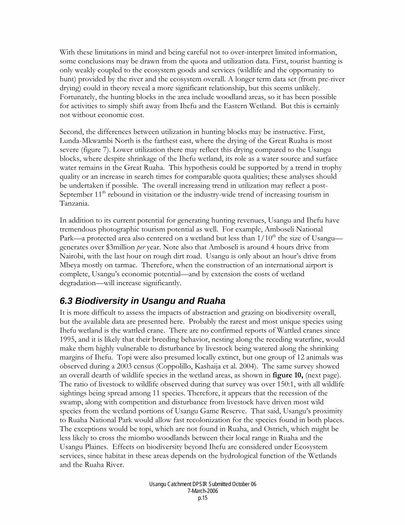
6.3 Biodiversity in Usangu and Ruaha It is more difficult to assess the impacts of abstraction and grazing on biodiversity overall, but the available data are presented here. Probably the rarest and most unique species using Ihefu wetland is the wattled crane. There are no confirmed reports of Wattled cranes since 1995, and it is likely that their breeding behavior, nesting along the receding waterline, would make them highly vulnerable to disturbance by livestock being watered along the shrinking margins of Ihefu. Topi were also presumed locally extinct, but one group of 12 animals was observed during a 2003 census (Coppolillo, Kashaija et al. 2004). The same survey showed an overall dearth of wildlife species in the wetland areas, as shown in figure 10, (next page). The ratio of livestock to wildlife observed during that survey was over 150:1, with all wildlife sightings being spread among 11 species. Therefore, it appears that the recession of the swamp, along with competition and disturbance from livestock have driven most wild species from the wetland portions of Usangu Game Reserve. That said, Usangu’s proximity to Ruaha National Park would allow fast recolonization for the species found in both places. The exceptions would be topi, which are not found in Ruaha, and Ostrich, which might be less likely to cross the miombo woodlands between their local range in Ruaha and the Usangu Plaines. Effects on biodiversity beyond Ihefu are considered under Ecosystem services, since habitat in these areas depends on the hydrological function of the Wetlands and the Ruaha River.
Usangu Catchment DPSIR Submitted October 06 7-March-2006
p.16
Figure 10: Observations of human activities (left) and wildlife (right) inUsangu Game Reserve and the Eastern Wetland.
Usangu Catchment DPSIR Submitted October 06 7-March-2006
p.17
Area of DetailArea of DetailArea of Detail
Barnes & Douglass Hamilton 1982
TAWIRI 1993
TAWIRI 1996
MBOMIPA 1999
MBOMIPA 1999
MBOMIPA 2000
MBOMIPA 2002
WCS 2004
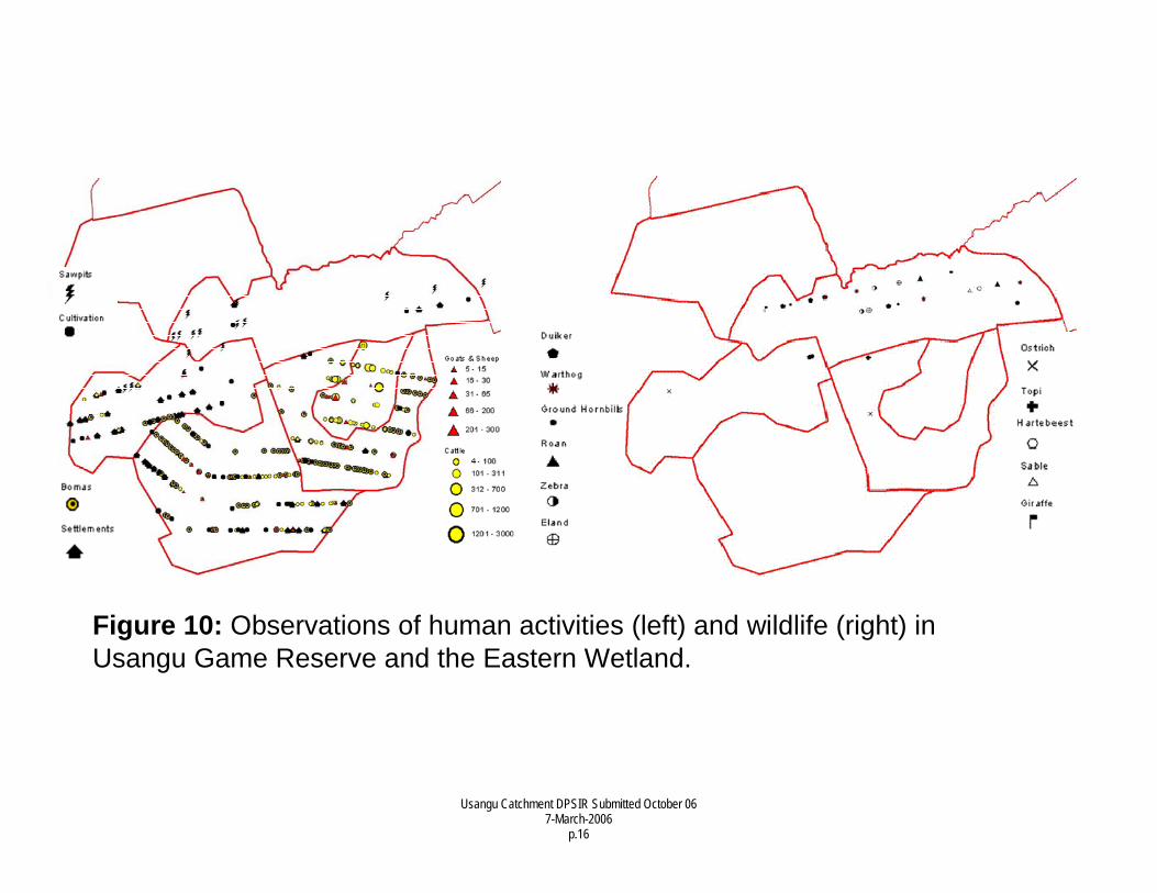
Figure 11: Reductions of buffalo distribution along the Great Ruaha 1982-2004. Sources as cited below each panel
Usangu Catchment DPSIR Submitted October 06 7-March-2006
p.18
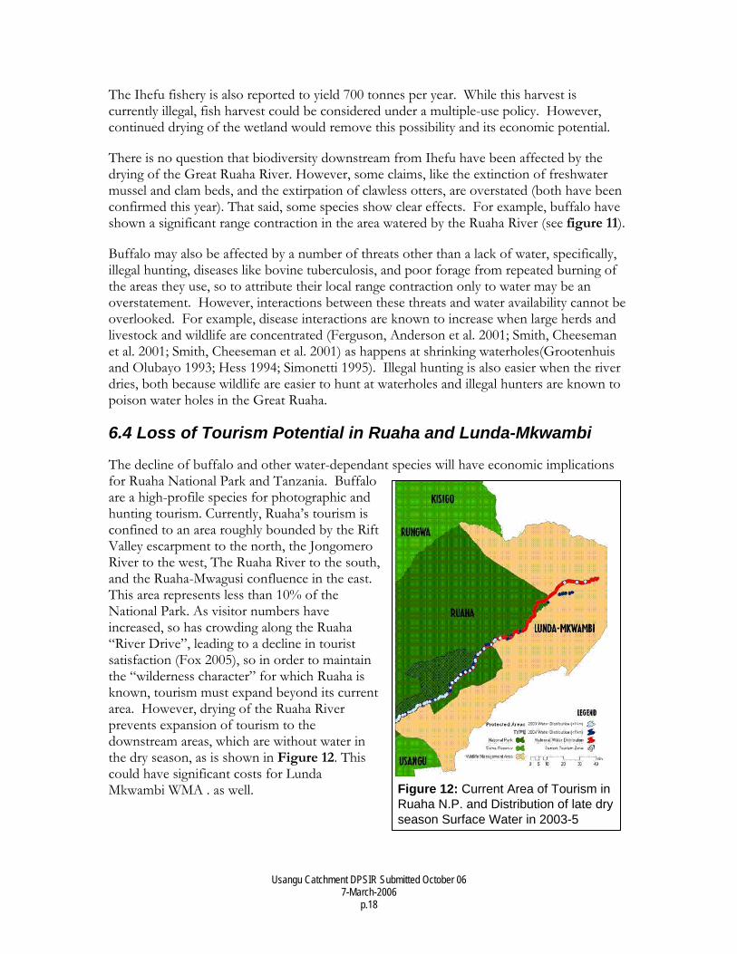
2Figure 12: Current Area of Tourism in Ruaha N.P. and Distribution of late dry season Surface Water in 2003-5
The Ihefu fishery is also reported to yield 700 tonnes per year. While this harvest is currently illegal, fish harvest could be considered under a multiple-use policy. However, continued drying of the wetland would remove this possibility and its economic potential.
There is no question that biodiversity downstream from Ihefu have been affected by the drying of the Great Ruaha River. However, some claims, like the extinction of freshwater mussel and clam beds, and the extirpation of clawless otters, are overstated (both have been confirmed this year). That said, some species show clear effects. For example, buffalo have shown a significant range contraction in the area watered by the Ruaha River (see figure 11).
Buffalo may also be affected by a number of threats other than a lack of water, specifically, illegal hunting, diseases like bovine tuberculosis, and poor forage from repeated burning of the areas they use, so to attribute their local range contraction only to water may be an overstatement. However, interactions between these threats and water availability cannot be overlooked. For example, disease interactions are known to increase when large herds and livestock and wildlife are concentrated (Ferguson, Anderson et al. 2001; Smith, Cheeseman et al. 2001; Smith, Cheeseman et al. 2001) as happens at shrinking waterholes(Grootenhuis and Olubayo 1993; Hess 1994; Simonetti 1995). Illegal hunting is also easier when the river dries, both because wildlife are easier to hunt at waterholes and illegal hunters are known to poison water holes in the Great Ruaha.
6.4 Loss of Tourism Potential in Ruaha and Lunda-Mkwambi
The decline of buffalo and other water-dependant species will have economic implications for Ruaha National Park and Tanzania. Buffalo are a high-profile species for photographic and hunting tourism. Currently, Ruaha’s tourism is confined to an area roughly bounded by the Rift Valley escarpment to the north, the Jongomero River to the west, The Ruaha River to the south, and the Ruaha-Mwagusi confluence in the east. This area represents less than 10% of the National Park. As visitor numbers have increased, so has crowding along the Ruaha “River Drive”, leading to a decline in tourist satisfaction (Fox 2005), so in order to maintain the “wilderness character” for which Ruaha is known, tourism must expand beyond its current area. However, drying of the Ruaha River prevents expansion of tourism to the downstream areas, which are without water in the dry season, as is shown in Figure 12. This could have significant costs for Lunda Mkwambi WMA . as well.
Usangu Catchment DPSIR Submitted October 06 7-March-2006
p.19
6.5 Collapse of Mtera Fishery At the time of construction, Nördstrom and Johansson (1985) estimated approximately 1000 tonnes per year as a sustainable long term catch, which others have noted correlates with the spatial extent of the Reservoir itself (Nilsson and Kitojo ND). However, the figure of 1000 tonnes may have been a conservative estimate, given that records up to 1993 were consistently higher (Sosovele, Ngwale et al. 2002). Not surprisingly though, fish catches have declined precipitously as Mtera Reservoir has fallen, but specific data are not available fur the last few years (see figure 8).
6.6 Loss of Hydropower The current loss of hydroelectric capacity is affecting the entire country, with hydropower production at less than two thirds of national capacity.(CTI 2004) However, the costs of water mis-management in Usangu have been apparent for much longer. The Tanzania Confederation of Industries (CTI 2004) identified expensive and unreliable electricity as major impediments to Tanzania’s industrial development. In other words, the costs of poor water management reach beyond the inefficient use of the investments in Mtera.
The hindrance of industrial development is compounded by the costs of diesel generators which must be installed for backup, and the costs of their operation during outages. Environmental costs of air and noise pollution must also be considered, particularly in high-density areas like Dar es Salaam. Finally, if hydropower becomes (or remains) an inviable option for large-scale power production, less environmentally friendly options like natural gas, diesel or coal must be implemented. Perhaps the worst-case scenario would be continuation of the status quo, in which charcoal and firewood remain the principle fuel sources for the entire country.
6.7 Competition and Conflict among Ecosystem services Thus far, the impacts of management decisions in Usangu have been considered primarily independently. However, water scarcity resulting from over use and inefficiency has also created tradeoffs among ecosystem services. Most noteworthy is the perceived competition between rice and power production. Kadigi et al (2003) demonstrate that:
• Overall, hydropower generates around eight times more revenue that Rice production in the Great Ruaha Catchment
• Water used for hydroelectricity is approximately four-times more valuable that water used for rice (calculated per m3).
It is also important to note that water used for hydropower is discharged downstream and can be used again for other ecosystem services like irrigation, tourism, or hydropower, but even under the most efficient circumstances 75% of the water used for rice is lost. The current efficiencies are far below this level due to the poor infrastructure and illegal uses.
7. Responses The tools available to deal with the current problems in the Usangu Catchment are many and provide ample opportunity to increase efficiency, decrease illegal use of water and wetland resources and to restore the ecological and economic value of the Usangu
Usangu Catchment DPSIR Submitted October 06 7-March-2006
p.20
Catchment. These tools are reviewed briefly below, beginning with the enabling policies and laws and finishing with specific action points.
7.1 Policy and Legal Framework With water, wetland and environmental management issues touching virtually every major sector of economy and Government, an exhaustive or even comprehensive overview is impossible in a document of this scope. The policy and legal issues presented here are a sampling of all the relevant policies and laws, with special emphasis on those most suited to alleviating conflicts, ensuring equitable benefits and improving sustainability in the Usangu Catchment.
7.1.1 Water Policy Tanzania’s Water Policy (Tanzania 2002) is enacted through Water Utilization (Control and Regulation) Act No. 42 of 1974 and its amendments, including Act No. 10 of 1981, which governs pollution control. The policy itself recognizes the limitation of existing legislation, but both provide ample justification for action within the Usangu Catchment. Three fundamental aspects are explored here: the “Pillars”, on which the Policy is grounded, the water use Priorities established by the Policy, and particularly salient Principles that it establishes.
7.1.1.1 Policy “Pillars” Importantly, the water policy establishes three new “Pillars” (elaborated in Mwaruvanda 2004): i) Comprehensiveness, to promote holistic, basin wide planning and management; ii) Subsidiarity, to decentralize decision making lowest practicable level to ensure stakeholder participation, buy-in and consistency with decentralization and local government reform in Tanzania; and iii) Economic, to ensure that the value of water for both public and private sectors is reflected in water pricing, cost sharing, and other mechanism to promote sustainable water use and management.
7.1.1.2 Water Policy Priorities: The water policy (section 4.1.2) establishes the following three principle priorities, along with their ranks in terms of priority: 1) Domestic use, 2) Environmental Flows, 3) Economic Activities. Domestic use in the Usangu Catchment is recognized to be very low and is not a management problem (SMUWC 2001; Franks, Lankford et al. 2004), but if present trends continue, irrigation and its negative effects on water reliability may undermine the ability to provide rural households with water for domestic use (IISD 2005). The term “Environmental Flows” covers all the water dependent species, ecological communities and ecosystem services listed detailed in the “State” and “Impacts” sections (i.e. not consumption for rice and hydropower), and “Economic Activities” include cash crops (which constitutes the vast majority of rice production in Usangu) and hydropower.
7.1.1.3 Principles and Instruments The following principles and instruments are set forth in the Water Policy and are particularly salient to the Usangu Catchment:
Usangu Catchment DPSIR Submitted October 06 7-March-2006
p.21
Financing The water act states that “In order to realize the objectives of water resources management all water uses, especially water use for economic purposes will be charged for.” Currently, water management, particularly in traditional systems, does not adhere to this principle, as pricing is so low in some places that water remains effectively free or revenues remain uncollected.
Scientific management A second critical point is that water resources assessments and water needs for the environment shall be based on sound scientific information. To date, water requirements to sustain the Ruaha River the flow requirements, particularly those of fish and invertebrates, are not known.
Institutional Framework for Targets and Standards of Acceptable Use Related to scientific management, the Water Policy establishes that, “The roles of water resource management, including standard setting and regulatory enforcement, shall be separated institutionally from service provision at all levels.” This is a particularly important issue for the Wildlife Division and TANAPA, which have economic interest to ensure that environmental flows are protected and the institutional expertise to identity flow & target values accurately. In the Usangu Catchment, a suitable mechanism for input in these contexts has been established through the Usangu Catchment Planning Committee.
6 Policy Instruments: The water policy recognizes six “instruments” through which its goals (including the principles outlined above) will be implemented. These are (i) Technical, (ii) Economic. (iii) Administrative (iv) Legal (v) Regulatory (vi) Participatory instruments. Each of these is mentioned below in the Plan of Action.
7.1.2 Mkukuta (Tanzania Poverty Reduction Strategy) The Poverty Reduction Strategy, now commonly known as “Mkukuta” or the National Strategy for Growth and Reduction of Poverty (NSGRP), is one of the most important unifying documents guiding both Government and NGO actors. It is critical in directing foreign aid and in coordinating inter-sectoral initiatives on issues like water and environment. Therefore, the implementers of virtually any initiative seek to ensure that their programs are consistent with the Mkukuta. That said, the Mkukuta recognizes both economic and non-economic poverty, with environmental vulnerability, equitability and sustainable access to natural resources explicitly recognized. Indeed the Mkukuta explicitly mentions “environment” 146 times, sustainability 40 times, water 129 times, and natural resources 48 times. In other words, sustainability, water, environment and natural resources are as central to the Mkukuta as poverty reduction is to environmental and natural resource use.
Another relevant feature of the Mkukuta is the idea of “Spatial Development Initiatives,” (SDI) defined as, “comprehensive and integrated planning and delivery frameworks for development of economic services, especially infrastructure for poverty reduction.” Given Usangu’s enormous significance for the National power supply and its economic potential for tourism, the Usangu Catchment seems an ideal candidate area for an SDI. Such a strategy
Usangu Catchment DPSIR Submitted October 06 7-March-2006
p.22
would also provide a framework for integrating veterinary extension, livestock marketing, protected area management, tourism development and watershed protection, all of which complement each other and provide economic benefits well beyond Usangu.
7.1.3 Other Relevant Acts: Tourism, Environmental Management, Wildlife Clearly, the cross-cutting nature of water and environmental issues create numerous legal and policy linkages which are not explored here. A few are worthy of mention in light of the current situation, though. First, the Environmental Management Act establishes the legal requirement and standards for Environmental Impact Assessments. In light of the problems created by water ‘improvement’ schemes in Usangu, future water development projects should clearly articulate how they will avoid similar problems. Next, the tourism Master Plan for Tanzania places heavy emphasis on development of the Southern Circuit and the tourism industry is growing rapidly, with sustained growth of 15-25% in recent years. With this in mind, assessment of the economic tradeoffs between tourism and other land uses—including water developments in distant areas but which have an impact on tourism—must be reevaluated in light of the increasing value of tourism and Tanzania’s natural attractions. This is consistent with the principle of “best available knowledge” for decision making. Finally, the Wildlife Act and TANAPA regulations both address the issue of grazing in Tanzania’s Protected Areas. Livestock grazing in Usangu must be evaluated according to these regulations independently of its effect on hydrology. Stated another way, much of the written attention paid to the livestock occupying Usangu Game Reserve has concerned their effect on the Ruaha River, but livestock grazing is currently illegal in Game Reserves, so this question will have to be resolved regardless of the effect of livestock on the hydrology of Ihefu and the Ruaha River.
7.2 Proposals for Action:
In light of the described “Drivers, Pressures, States, Impacts” and the policy and legal environment, we suggest the following Responses. Actions are listed generally, without assignment to Government, a particular ministry or administrative unit or civil society organization. Government must obviously take a leading and administrative role in this process, but specific tasks and roles will depend on funding, institutional competencies and politics, so the assignment of tasks falls beyond the scope of this paper. Nevertheless, we strongly encourage all stakeholders to begin acting on these tasks and coordinating activities immediately.
Returning to the idea of Pressures, two processes have known strong effects on the hydrology of Usangu and via the Ruaha River, its provision of ecosystem services. These are abstraction for irrigation, and livestock in the Ihefu Swamp.
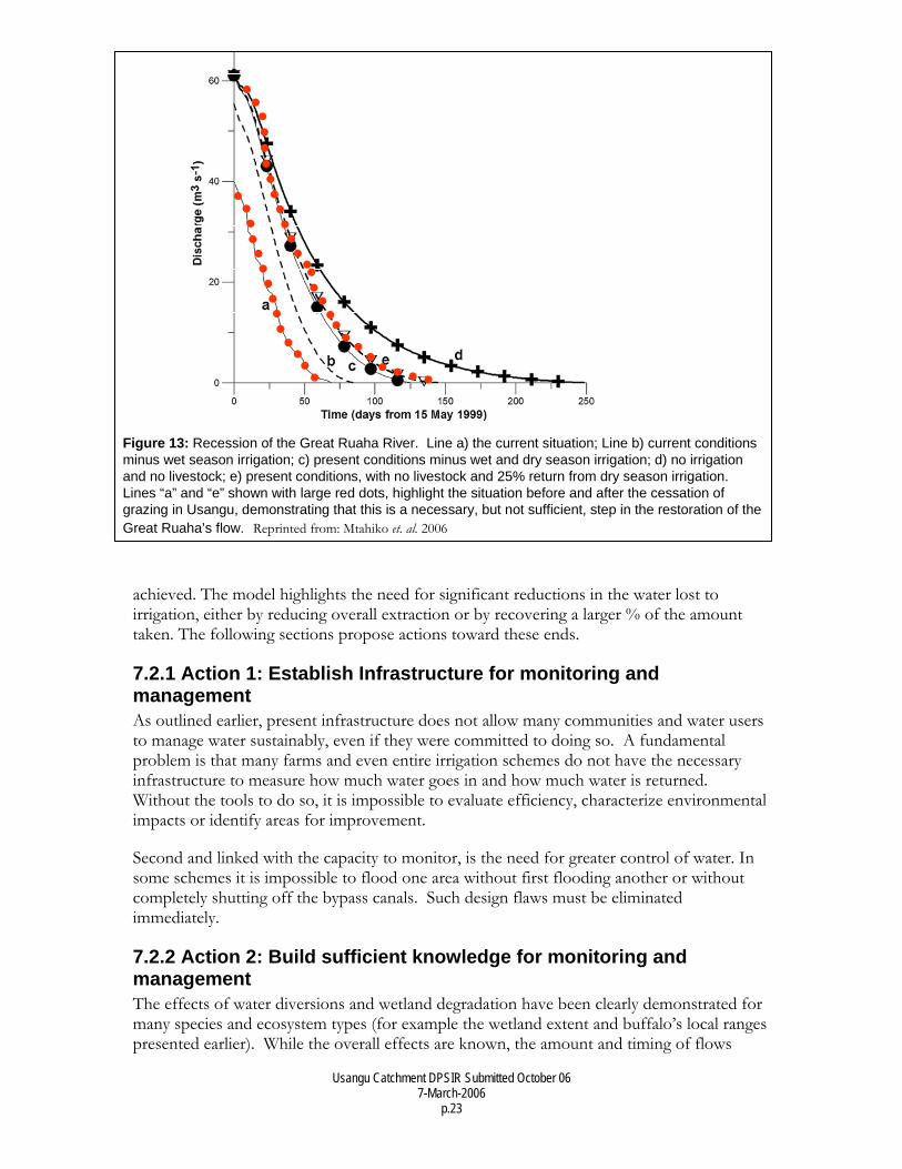
Figure 13, next page, presents the outputs of an ecohydrology model (Mtahiko et al 2006), which predicts that current changes in management, specifically the removal of cattle from the Ihefu Wetlands, will have a significant positive impact by extending the period of dry season flow from approximately 60 days (line “a”), to around 130 days (line “e;” These two scenarios are highlighted with red dots). However, these data also suggest that for the Great Ruaha to flow through the dry season, a significantly longer recession period must be
Usangu Catchment DPSIR Submitted October 06 7-March-2006
p.23
Figure 13: Recession of the Great Ruaha River. Line a) the current situation; Line b) current conditions minus wet season irrigation; c) present conditions minus wet and dry season irrigation; d) no irrigation and no livestock; e) present conditions, with no livestock and 25% return from dry season irrigation. Lines “a” and “e” shown with large red dots, highlight the situation before and after the cessation of grazing in Usangu, demonstrating that this is a necessary, but not sufficient, step in the restoration of the Great Ruaha’s flow. Reprinted from: Mtahiko et. al. 2006
achieved. The model highlights the need for significant reductions in the water lost to irrigation, either by reducing overall extraction or by recovering a larger % of the amount taken. The following sections propose actions toward these ends.
7.2.1 Action 1: Establish Infrastructure for monitoring and management As outlined earlier, present infrastructure does not allow many communities and water users to manage water sustainably, even if they were committed to doing so. A fundamental problem is that many farms and even entire irrigation schemes do not have the necessary infrastructure to measure how much water goes in and how much water is returned. Without the tools to do so, it is impossible to evaluate efficiency, characterize environmental impacts or identify areas for improvement.
Second and linked with the capacity to monitor, is the need for greater control of water. In some schemes it is impossible to flood one area without first flooding another or without completely shutting off the bypass canals. Such design flaws must be eliminated immediately.
7.2.2 Action 2: Build sufficient knowledge for monitoring and management The effects of water diversions and wetland degradation have been clearly demonstrated for many species and ecosystem types (for example the wetland extent and buffalo’s local ranges presented earlier). While the overall effects are known, the amount and timing of flows
Usangu Catchment DPSIR Submitted October 06 7-March-2006
p.24
necessary to alleviate these pressures remains poorly understood. Indeed, even the amount of water needed to keep the river flowing remains contested. Flow requirements (both amount and timing) should be investigated for wetland biodiversity (for which the spatial extent of Ihefu and the Mtera wetlands could serve as an initial proxy), wetland ecosystem functions (which include maintenance of the Ruaha River’s flow, maintenance of its riparian biodiversity, disturbance events that maintain the channel structure, and sufficient wet season flow for operation of Mtera Hydroelectric Plant and the maintenance of the Fishery). Other issues like the spatial distribution of water necessary to minimize disease transmission or to maintain water quality should also be investigated.
It is important to state unequivocally that a lack of knowledge in these contexts should not prevent immediate and concrete action. While the exact flow requirements for individual species or specific ecosystem services may be unknown at the moment, it is undisputed that alleviation of the pressures described here requires more flow than what occurs at presnet. Consequently, actions to increase flow and restore ecosystem services must begin immediately with or without precise flow targets.
Furthermore, we suggest that the Wildlife Division, TANAPA, environmental NGOs, and fishery-related stakeholders should work among themselves and with other stakeholders to promote research identifying these targets. Given its proximity and the wealth of research already conducted, continued involvement from Sokoine University of Agriculture seems critical in this regard. Expatriate researchers should also be encouraged to address such questions as well, especially since many have the potential to leverage external funding and provide opportunities for capacity building in Tanzania.
7.2.3 Action 3: Establish Incentives for compliance: Having the tools to manage water and clear, scientifically-defined targets are both necessary, but not sufficient for restoration of the Usangu Catchment and its ecosystem functions. To be successful, water users must have an incentive structure (including both positive and negative incentives) to promote compliance.
Given the fact that rice is grown primarily as a cash crop, it seems most appropriate that these incentives are economic, and this is consistent with the Water Policy’s recognition of economic instruments. The significant variation in the price of a bag of rice offers tremendous potential to create economic incentives.
We propose that existing water-use committees form the core of water-user groups to be capitalized so that they are able to buy rice from farmers immediately post-harvest. The cooperatives will then hold the rice until prices rise, and the dividends will be shared with those farmers that follow water use regulations and use water sustainably. Dividends could also be used to fund micro-credit program that helps smallholders assemble the necessary labor and inputs to plant their fields on-schedule, which will allow coordinated flooding and greatly reduce water consumption (SMUWC 2001). It has also been suggested that SACCOS assume this role, as it would help poor farmers overcome barriers to entry and ensure greater sustainability.
Usangu Catchment DPSIR Submitted October 06 7-March-2006
p.25
7.2.4 Action 4: Raise standards for “improved” irrigation Clearly, the environmental impact and building standards applied to the Kapunga, Mbarali and Madibira Rice Projects were too low. These large, mostly foreign-funded projects have created more problems than they have solved, and the Government and people of Tanzania have been left with the bill. To date, the economic and environmental problems caused by these projects have not been solved, and it is not in all cases clear what it will take to resolve them.
Resolving these issues locally and establishing higher standards for future irrigation projects are the two most important actions to be taken. The donor agencies that funded the projects should therefore accept the responsibility of fixing the problems they created. Furthermore, and to prevent similar economic and ecological disasters in Tanzania, these standards should be clearly articulated and put in place before new irrigation projects are initiated. Moving forward without these controls in place could replicate equally irresponsible, socially and economically costly and environmentally destructive projects elsewhere in Tanzania. The country and its economy are heavily burdened by the current crisis and can scarcely afford others elsewhere. The importance of these standards cannot be overstated, especially considering Tanzania’s intention to increase the spatial extent of irrigation over six-fold, from 150,000 ha to 1,000,000 (Tanzania 2002).
7.2.5 Action 5: Restoration of Ihefu Swamp and Natural Ecosystem Services. The final action point concerns the re-establishment of the Usangu Wetlands’ ecosystem services. Historically, the wetland regulated flow in the Ruaha River providing water for hydropower and fisheries worth billions of shillings per year and supporting traditional livelihoods like artisanal fishing, pastoralisim and the potential for future economic growth through tourism. Most importantly, the wetlands provided these services for free. Presently, the wetlands state is too compromised to fulfill these services and the Government and economy of Tanzania cannot afford to replace these services industrially.
Fortunately, wetlands are classically resilient ecosystems, recovering quickly when abiotic conditions are restored. Hydrological function will likely return quickly, with plant and animal populations to follow. Many wetland species have managed to persist in small refugia, or like birds, will be able to recolonize quickly, so biodiversity value and tourism potential will also recover within a reasonable timeframe.
Usangu Catchment DPSIR Submitted October 06 7-March-2006
p.26
Literature Cited Baker, N. E. and E. M. Baker (2002). Important Bird Areas of Tanzania: A first inventory,
Wildlife Conservation Society of Tanzania. Brandström, P. (1985). The Agro-Pastoral Dilemma: Underutilization or Overexploitation of
Land Among Sukuma of Tanzania. Uppsala, African Studies Programme, University of Uppsala.
Charnley, S. (1997). "Environmentally-displaced peoples and the cascade effect: Lessons from Tanzania." Human Ecology 25(4): 593-618.
Clutterbuck, P. (2005). Songo Songo Gas Field Operations and Gas Distribution. Presentation to the East Africa Petroleum Conference. Entebbe, Uganda, East Coast Energy Corporation; Pan African Energy Tanzania Limited.
Coppolillo, P., L. Kashaija, et al. (2004). Technical Report on Water Availability in the Ruaha River and the State of Usangu Game Reserve, November 2003: Summary of Aerial Surveys Conducted 25, 26 November 2003, Wildlife Conservation Society (WCS-International), World Wide Fund for Nature Tanzania Program (WWF-Tz): 12.
CTI (2004). The Industrialization of Tanzania: Towards Poverty Alleviation. Dar es Salaam, Economic and Social Research Foundation for the Confederation of Tanzania Industries (CTI); DANIDA: 72.
FAO and S. U. SWMRG (2004). Water Productivity and Vulnerable Groups in the Mkoji Sub-Catchment: A Local Case Study in Integrated Water Resources Management in the United Republic of Tanzania. Rome, FAO - Netherlands Partnership Programme and SOIL WATER MANAGEMENT RESEARCH GROUP, SOKOINE UNIVERSITY OF AGRICULTURE: (v) 47.
Ferguson, N. M., R. M. Anderson, et al. (2001). "Transmission intensity and impact of control policies on the foot and mouth epidemic in Great Britain." Nature 413(6855).
Fox, P. (2005). Tourism Satisfaction Survey Results. c. t. P. Coppolillo. Iringa, Tanzania. Franks, T., B. Lankford, et al. (2004). "Managing Water Amongst Competing Uses: The
Usangu Wetland, Tanzania." Irrigation and Drainage 53: 1-10. Galaty, J. G. (1988). Pastoral and Agropastoral Migration in Tanzania: Factors of Economy,
Ecology and Demography in Cultural Perspective. Production and Autonomy. Bennett and Bower: 163-183.
Grootenhuis, J. G. and R. O. Olubayo (1993). "Disease Research in the Wildlife-Livestock Interface in Kenya." The Veterinary Quarterly 15(2): 55-59.
Hess, G. R. (1994). "Conservation Corridors and Contagious Disease - a Cautionary Note." Conservation Biology 8(1): 256-262.
Hofstede, R., G. G. M., et al. (2002). "Impact of Pine Plantations on Soils and Vegetation in the Ecuadorian High Andes." Mountain Research and Development 22 (2): 159-167.
IISD (2005). Connecting Poverty & Ecosystem Services: Focus on Tanzania, for the United Nations Environment Programme by the International Institute for Sustainable Development.
Kadigi, R. M. J., N. S. Mdoe, et al. (2003). The Value of Water for Irrigated Rice and Hydropower Generation in the Great Ruaha, Tanzania, Sokoine University of

Usangu Catchment DPSIR Submitted October 06 7-March-2006
p.27
Agriculture, University of East Anglia, and the International Water Management Institute.: 13.
Kibuga, K. F. (2006). Study on water use and rice production in Idodi division. Iringa, Tanzania, Wildlife Conservaiton Society (Int'l): 15.
Lane, C. (1996). Ngorongoro Voices, Sveriges Lantbruksuniversitet. Lankford, B. (2004). "Irrigation improvement projects in Tanzania; scale impacts and policy
implications." Water Policy 6. Lankford, B., B. v. Koppen, et al. (2004). "Entrenched views or insufficient science?
Contested causes and solutions of water allocation; insights from the Great Ruaha River Basin, Tanzania." Agricultural Water Management 69: 135-153.
Lankford, B. and W. Mwaruvanda (2005). A framework to integrate formal and informal water rights in river basin management. International workshop on ‘African Water Laws: Plural Legislative Frameworks for Rural Water Management in Africa, Johannesburg, South Africa.
Maganga, F. P., J. A. Butterworth, et al. (2001). Domestic water supply, competition for water resources and IWRM in Tanzania:
a review and discussion paper. 2nd WARFA/Waternet Symposium: Integrated Water Resources Management: Theory, Practice, Cases. Cape Town.
Mtahiko, M. G. G., E. Gereta, et al. (2006). "Towards an ecohydrology-based restoration of the Usangu wetlands and the Great Ruaha River, Tanzania." Wetlands Ecology and Management in press.
Mwaruvanda, W. (2004). Intergrated Water Resources Management in the Rufiji Basin In Tanzania. African Pre-Conference on water for food and ecosystems –. Addis Ababa.
Nilsson, H. and W. Kitojo (ND). Fisheries Management at Mtera Dam, Tanzania, ALCOM. Nördstrom, P.-Å. and D. Johansson (1985). Mtera Reservoir: Ecology of a New Man-Made
Lake in Tanzania. Stockholm, SIDA (Sweedish Development Authority), and SWECO: 153.
Roberts, A. (2000). Review of Environmental Mitigation and Compensation Measures in Sida Financed Hydropower Projects, Department of Landscape Planning Ultuna Swedish University of Agricultural Sciences (SLU): (ii) 25.
Rose, P. M. and D. A. Scott (1994). Waterfowl Population Estimates. Slimbridge, U.K.: International, Waterfowl and Wetlands Research Bureau (IWRB).
RUNAPA (2005). Bed-night totals for Ruaha National Park. P. Coppolillo. Msembe. Simonetti, J. A. (1995). "Wildlife conservation outside parks is a disease-mediated task."
Conservation Biology 9(2): 454-456. Smeets, E. and R. Weterings (1999). Environmental indicators: Typology and overview,
(TNO Centre for Strategy, Technology and Policy, The Netherlands). Smith, G. C., C. L. Cheeseman, et al. (2001). "A model of bovine tuberculosis in the badger
Melesmeles: an evaluation of control strategies." Journal of Applied Ecology 38(3): 509-519.
Smith, G. C., C. L. Cheeseman, et al. (2001). "A model of bovine tuberculosis in the badger Melesmeles: the inclusion of cattle and the use of a live test." Journal of Applied Ecology 38(3): 520-535.
SMUWC (2001). Biodiversity, Sustainable Management of the Usangu Wetland and its Catchment, DFID: 85.
SMUWC (2001). Carrying Capacity, Sustainable Management of the Usangu Wetland and its Catchment, DFID: 62.
Usangu Catchment DPSIR Submitted October 06 7-March-2006
p.28
SMUWC (2001). Environmental Baseline, Sustainable Management of the Usangu Wetland and its Catchment, DFID: (x) 135.
SMUWC (2001). Fisheries, Sustainable Management of the Usangu Wetland and its Catchment, DFID: (vi) 68.
SMUWC (2001). Irrigation: Net and Gross Irrigation Demand Modeling, Sustainable Management of the Usangu Wetland and its Catchment, DFID: (viii) 117.
SMUWC (2001). Livestock, Sustainable Management of the Usangu Wetland and its Catchment, DFID: 70.
SMUWC (2001). Restoring Flows in the Great Ruaha River: The Challenges Ahead, Sustainable Management of the Usangu Wetland and its Catchment, DFID: 76.
Sosovele, H., J. J. Ngwale, et al. (2002). Socio-Economic Root Causes of the Loss of Biodiversity in the Ruaha Catchment Area, WWF- Tanzania.
Tanzania, U. R. o. (2002). National Water Policy – July 2002. M. o. W. L. Development. van Koppen, B., C. S. Sokile, et al. (2004). Formal Water Rights in Rural Tanzania:
Deepening the Dichotomy? Colombo, Sri Lanka, International Water Management Institute: (vii) 26.
WorldCare (ND). Dar es Salaam Marine Ecology Conservation Project.
Related Documents