Journal of the Geological Society, London, Vol. 146, 1989, pp. 427-437,9 figs. Printed in Northern Ireland Crustal structure of the Goban Spur continental margin, Northeast Atlantic, from deep seismic reflection profiling C. PEDDY,, B. PINETz, D. MASSON', R. SCRUTTON4, J. C. SIBUET5, M. R. WARNER1, J. P. LEFORT6 & I. J. SHROEDERT (BIRPSl & ECORSs) l Britkh Institutions' Reflection Profiling Syndicate, Bullard Laboratories, Madingley Road, Cambridge CB3 lEZ, UK 2Institut Francais du Petrole, B.P. 3L1, 92506 Rueil-Malmaison, France 3Insfitute of Oceanographic Sciences, Brook Road, Wormley, Godalming, Surrey GU9 SUB, tlK a Department of Geology, Grant Institute, West Mains Road, Edinburgh EH9 3JW, UK trcnOMER, Centre de Brest, B.P. 337, 29273 Brest, France uCentre Armoricain d'Etude Structurale des Socles, Campus de Beaulieu, i5042 Rennes, France ? Elf-Aquitaine (JK, Knightsbridge, London FW7 1RZ, UK 8 Etude de la Croûte Continentale et Océanique par Réflexion et Réfraction Sismique Abstract: Deep reflection data across the UK continental margin are used to test theories concerning the origin of a pervasive reflective fabric in the lower continental crust seen on many deep reflection profiles worldwide. The origin of the reflections is at present little understood, but clearly represents an important crustal process. The Western Approaches Margin (WAM) line was designed to determine the behaviour of the lower crustal reflections in crust which has undergone significant extension. The \VAM profile across the continental shelf is characterized by bright, continuous lower crustal reflections, some of which reach 30km in length and have minimum reflection coefficients of 0.1. Deep water multiples in the area of the continental slope partially obscure reflections from the lower crust, but detailed analyses show that reflectors are present in the lower crust on the continental slope. Adjacent to the continent-ocean boundary, the lower crust on the WAM profile is well-imaged and free of noise and multiples. This very thin crust exhibits the same reflectivity pattern as is observed on the continental shelf, i.e. the upper half of the crust is blank and the lower half contains sub- horizontal reflections. The lower crustal reflections adjacent to the continent-ocean boundary are less continuous than the reflections seen on the shelf, and are interpreted as being the remnants after extension of the lower crustal reflectors observed on the continental shelf. The lower crustal reflectors are thus interpreted to pre-date the extensional episode that led to the opening of the Atlantic. The preservation of thinned sections of both transparent upper crust and reflective lower crust adjacent to the continent-ocean boundary suggests that extension by pure shear was the mechanism by which the crust was thinned in the Goban Spur area. The IVAM deep seismic reflection profile Deep reflection surveys in northwest Europe often share the same distinctive reflectivity pattern. Profiles in the Southwest Approaches area of the UK continental shelf (BIRPS & ECORS 1986; Cheadle et al. 1987), France (Cazes et al. 1986; Bois et al. 1988), and Germany (DEKORP 1985) show a relatively transparent upper crust and a highly reflective lower crust. Reflections from the upper crust are usually associated with specific structural features such as the Outer Isles fault and the Variscan front. In the lower crust, the reflectivity takes the form of sub-horizontal layered reflections of fairly high amplitude. The lower crust is also more reflective than the upper crust on profiles from many other areas around the world, such as the Basin and Range Province, (Allmendinger et al. 1987), the Eromanga Basin in Australia (Mathur 1983), and the Long Island Platform (Hutchinson er c/. 1985). The reflections have never been traced to the surface, and their origin is at present poorly understood. The presence of well-developed lower crustal layering on the BIRPS data set across the continental shelf of the UK, a Mesozoic rift province, and the similarity to prominent reflections from the lower crust on COCORP data from the extensional Basin and Range province (Klemperer et al. 1986; Hauge et al. 1987), led to the suggestion that the reflectors may be the result of extensional processes (Cheadle et al. L987). To test the hypothesis that extensional processes produce the layered reflections observed on BIRPS surveys such as SWAT (BIRPS & ECORS 1986) and WINCH (Brewer et al. 1983), 645 km of deep seismic reflection data were collected across the continental shelf and slope in the Goban Spur area of the Northeast Atlantic (Fig. 1). The Western Approaches Margin (WAM) line was tunded jointly by BIRPS and ECORS. The WAM profile was acquired by the Geophysical Company of Norway (GECO) using a tuned array of airguns having a capacity of 7235 atbic inches at 2000psi and a streamer 3.0km in length with 60 geophone groups. The record length is 15.0s two-wây travel time (TW'ff). The data were processed by Seismograph Services Ltd. Processing comprised trace mixing to simulate longer source and receiver arrays, spherical divergence correction, velocity analysis, 427

Welcome message from author
This document is posted to help you gain knowledge. Please leave a comment to let me know what you think about it! Share it to your friends and learn new things together.
Transcript

Journal of the Geological Society, London, Vol. 146, 1989, pp. 427-437,9 figs. Printed in Northern Ireland
Crustal structure of the Goban Spur continental margin,Northeast Atlantic, from deep seismic reflection profiling
C. PEDDY,, B. PINETz, D. MASSON', R. SCRUTTON4, J. C. SIBUET5,M. R. WARNER1, J. P. LEFORT6 & I. J. SHROEDERT
(BIRPSl & ECORSs)l Britkh Institutions' Reflection Profiling Syndicate, Bullard Laboratories, Madingley Road,
Cambridge CB3 lEZ, UK2Institut Francais du Petrole, B.P. 3L1, 92506 Rueil-Malmaison, France
3Insfitute of Oceanographic Sciences, Brook Road, Wormley, Godalming, Surrey GU9 SUB, tlKa Department of Geology, Grant Institute, West Mains Road, Edinburgh EH9 3JW, UK
trcnOMER, Centre de Brest, B.P. 337, 29273 Brest, FranceuCentre Armoricain d'Etude Structurale des Socles, Campus de Beaulieu, i5042 Rennes, France
? Elf-Aquitaine (JK, Knightsbridge, London FW7 1RZ, UK8 Etude de la Croûte Continentale et Océanique par Réflexion et Réfraction Sismique
Abstract: Deep reflection data across the UK continental margin are used to test theories concerningthe origin of a pervasive reflective fabric in the lower continental crust seen on many deep reflectionprofiles worldwide. The origin of the reflections is at present little understood, but clearly represents animportant crustal process. The Western Approaches Margin (WAM) line was designed to determinethe behaviour of the lower crustal reflections in crust which has undergone significant extension. The\VAM profile across the continental shelf is characterized by bright, continuous lower crustalreflections, some of which reach 30km in length and have minimum reflection coefficients of 0.1.
Deep water multiples in the area of the continental slope partially obscure reflections from the lowercrust, but detailed analyses show that reflectors are present in the lower crust on the continental slope.Adjacent to the continent-ocean boundary, the lower crust on the WAM profile is well-imaged and
free of noise and multiples. This very thin crust exhibits the same reflectivity pattern as is observed onthe continental shelf, i.e. the upper half of the crust is blank and the lower half contains sub-
horizontal reflections. The lower crustal reflections adjacent to the continent-ocean boundary are less
continuous than the reflections seen on the shelf, and are interpreted as being the remnants afterextension of the lower crustal reflectors observed on the continental shelf. The lower crustal reflectorsare thus interpreted to pre-date the extensional episode that led to the opening of the Atlantic. Thepreservation of thinned sections of both transparent upper crust and reflective lower crust adjacent tothe continent-ocean boundary suggests that extension by pure shear was the mechanism by which thecrust was thinned in the Goban Spur area.
The IVAM deep seismic reflection profile
Deep reflection surveys in northwest Europe often share thesame distinctive reflectivity pattern. Profiles in theSouthwest Approaches area of the UK continental shelf(BIRPS & ECORS 1986; Cheadle et al. 1987), France(Cazes et al. 1986; Bois et al. 1988), and Germany(DEKORP 1985) show a relatively transparent upper crustand a highly reflective lower crust. Reflections from theupper crust are usually associated with specific structuralfeatures such as the Outer Isles fault and the Variscan front.In the lower crust, the reflectivity takes the form ofsub-horizontal layered reflections of fairly high amplitude.The lower crust is also more reflective than the upper cruston profiles from many other areas around the world, such as
the Basin and Range Province, (Allmendinger et al. 1987),the Eromanga Basin in Australia (Mathur 1983), and theLong Island Platform (Hutchinson er c/. 1985). Thereflections have never been traced to the surface, and theirorigin is at present poorly understood.
The presence of well-developed lower crustal layering on
the BIRPS data set across the continental shelf of the UK, aMesozoic rift province, and the similarity to prominentreflections from the lower crust on COCORP data from theextensional Basin and Range province (Klemperer et al.1986; Hauge et al. 1987), led to the suggestion that thereflectors may be the result of extensional processes(Cheadle et al. L987). To test the hypothesis that extensionalprocesses produce the layered reflections observed onBIRPS surveys such as SWAT (BIRPS & ECORS 1986) andWINCH (Brewer et al. 1983), 645 km of deep seismicreflection data were collected across the continental shelfand slope in the Goban Spur area of the Northeast Atlantic(Fig. 1). The Western Approaches Margin (WAM) line wastunded jointly by BIRPS and ECORS.
The WAM profile was acquired by the Geophysical Company ofNorway (GECO) using a tuned array of airguns having a capacity of7235 atbic inches at 2000psi and a streamer 3.0km in length with60 geophone groups. The record length is 15.0s two-wây travel time(TW'ff). The data were processed by Seismograph Services Ltd.Processing comprised trace mixing to simulate longer source andreceiver arrays, spherical divergence correction, velocity analysis,
427
BIRPS & ECORS
150w 130 1 t0 15" loo
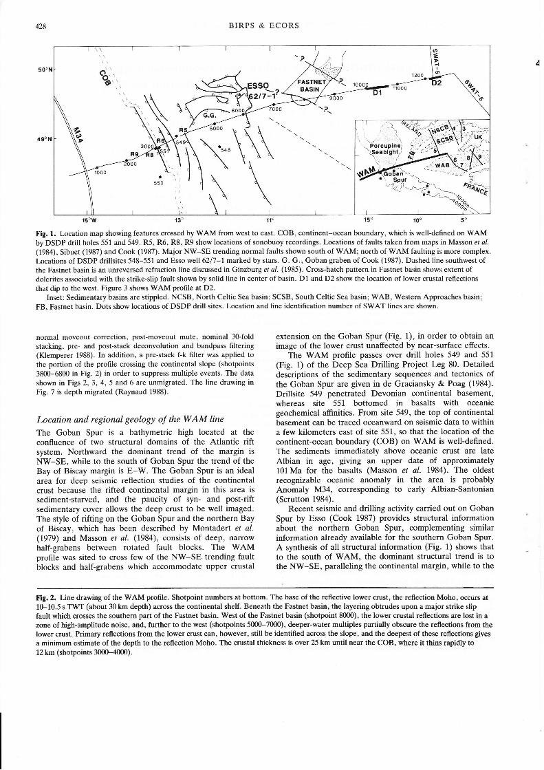
Fig. 1. Location map showing features crossed by WAM from west to eâst. COB, continent-ocean boundary, which is well-defined on WAMby DSDP drill holes 551 and 549. R5, R6, R8, R9 show locations of sonobuoy recordings. Locations of faults taken from maps in Masson et a/.
(1984), Sibuet (1987) and Cook (1987). Major NW-SE trending normal faults shown south of WAM; north of WAM faulting is more complex.Locations of DSDP drillsites 548-551 and Esso well6217-l marked by stars. G. G., Goban graben of Cook (1987). Dashed line southwest ofthe Fastnet basin is an unreversed refraction line discussed in Ginzburg et al. (1985). Cross-hatch pattern in Fastnet basin shows extent ofdolerites associated with the strike-slip fault shown by solid line in center of basin. D1 and D2 show the location of lower crustal reflections
that dip to the west. Figure 3 shows WAM profile at D2.Inset: Sedimentary basins are stippled. NCSB, North Celtic Sea basin; SCSB, South Celtic Sea basin; WAB, Western Approaches basin;
FB, Fastnet basin. Dots show locations of DSDP drill sites. Location and line identification number of SWAT lines are shown.
normal moveout correction, post-moveout mute, nominal 30-foldstacking, pre- and post-stack deconvolution and bandpass filtering(Klemperer 1988). In addition, a pre-stack f-k filter was applied tothe portion of the profile crossing the continental slope (shotpoints
3800-6800 in Fig. 2) in order to suppress multiple events. The data
shown in Figs 2, 3, 4, 5 and 6 are unmigrated. The line drawing inFig. 7 is depth migrated (Raynaud 1988).
Location and regional geology of the WAM line
The Goban Spur is a bathymetric high located at theconfluence of two structural domains of the Atlantic riftsystem. Northward the dominant trend of the margin isNV/-SE, while to the south of Goban Spur the trend of theBay of Biscay margin is E-W. The Goban Spur is an idealarea for deep seismic reflection studies of the continentalcrust because the rifted continental margin in this area issediment-starved, and the paucity of syn- and post-riftsedimentary cover allows the deep crust to be well imaged.The style of rifting on the Goban Spur and the northern Bayof Biscay, which has been described by Montadert et al.(1979) and Masson et al. (1984), consists of deep, narrowhalf-grabens between rotated fault blocks. The WAMprofile was sited to cross few of the NW-SE trending faultblocks and half-grabens which accommodate upper crustal
extension on the Goban Spur (Fig. 1.), in order to obtain animage of the lower crust unaffected by near-surface effects.
The WAM profile passes over drill holes 549 and 55L
(Fig. 1) of the Deep Sea Drilling Project Leg 80. Detaileddescriptions of the sedimentary sequences and tectonics ofthe Goban Spur are given in de Graciansky & Poag (1984).
Drillsite 549 penetrated Devonian continental basement,whereas site 551 bottomed in basalts with oceanicgeochemical afûnities. From site 549, the top of continentalbasement can be traced oceanward on seismic data to withina few kilometers east of site 551, so that the location of thecontinent-ocean boundary (COB) on WAM is well-defined.The sediments immediately above oceanic crust are lateAlbian in age, giving an upper date of approximately101 Ma for the basalts (Masson et al. 1984). The oldestrecognizable oceanic anomaly in the area is probablyAnomaly M34, corresponding to early Albian-Santonian(Scrutton 1984).
Recent seismic and drilling activity carried out on GobanSpur by Esso (Cook 1987) provides structural informationabout the northern Goban Spur, complementing similarinformation already available for the southern Goban Spur.A synthesis of all structural information (Fig. 1) shows thatto the south of WAM, the dominant structural trend is tothe NW-SE, paralleling the continental margin, while to the
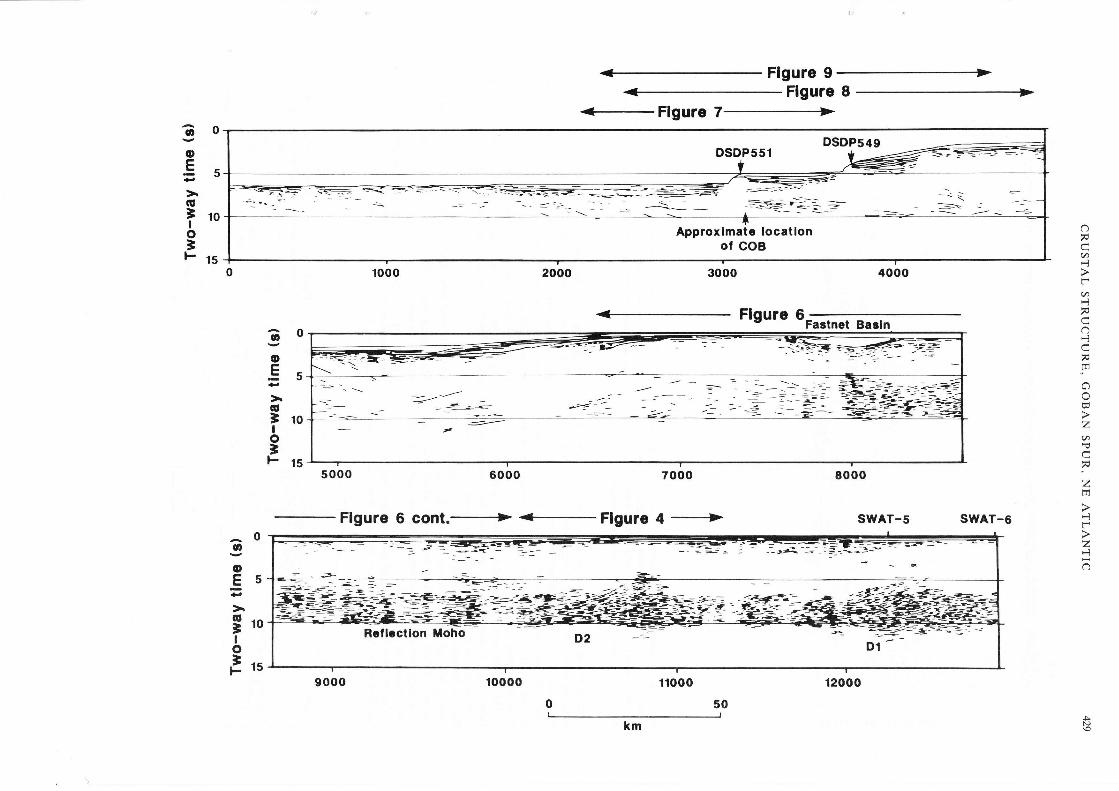
Fig. 2. Line drawing of the WAM profile. Shotpoint numbers at bottom. The base of the reflective lower crust, the reflection Moho, occurs at10-10.5 s TWT (about 30 km depth) across the continental shelf. Beneath the Fastnet basin, the layering obtrudes upon a major strike slipfault which crosses the southern part of the Fastnet basin. West of the Fastnet basin (shotpoint 8000), the lower crustal reflections are lost in azone of high-amplitude noise, and, further to the west (shotpoints 5000-7000), deeper-water multiples partially obscure the reflections from thelower crust. Primary reflections from the lower crust can, however, still be identified across the slope, and the deepest of these reflections gives
a minimum estimate of the depth to the reflection Moho. The crustal thickness is over 25 km until near the COB, where it thins rapidly to12 km (shotpoints 3000-4000).
Flgure 9Flgure I
<- Flgure
1000 2000 3000
Flgure 6 cont.-+ .+Flgure 4 +
aooE
5
ol10Io=Fts
ôFea*.1
-a'l
ôÈ
"lt]
L)o
z(â
"z
EP-l-zÈô
30o-E56;roIo3]- 15
4000
Flgure 6Fastnet Basln
8000
SWAT-5 swAT-6
^0IoE5
§roIoE,u
N)
DSDP549DSDP551 * ---4-==:=-
- -§Approxlmate locatlon
ol COB
4-É.-='J=-
430 BIRPS & ECORS
2Okm
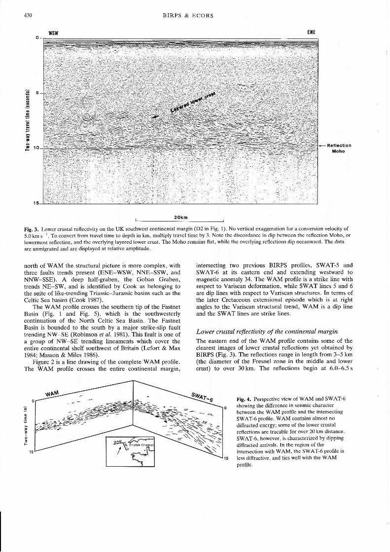
Fig.3. Lower crustal reflectivity on the UK southwest continental margin (D2 in Fig. 1). No vertical exaggeration for a conversion velocity of5.0 km s i. To convert from travel time to depth in km, multiply travel time by 3. Note the discordance in dip between the reflection Moho, orlowermost reflection, and the overlying layered lower crust. The Moho remains flat, while the overlying reflections dip oceanward. The data
are unmigrated and are displayed at relative amplitude.
êé
o
Iêt1()
north of WAM the structural picture is more complex, withthree faults trends present (ENE-WSW, NNE-SSW, andNNW-SSE). A deep half-graben, the Goban Graben,trends NE-SW, and is identified by Cook as belonging tothe suite of like-trending Triassic-Jurassic basins such as theCeltic Sea basins (Cook 1987).
The WAM proflle crosses the southern tip of the FastnetBasin (Fig. 1 and Fig. 5), which is the southwesterlycontinuation of the North Celtic Sea Basin. The FastnetBasin is bounded to the south by a major strike-slip faulttrending NW-SE (Robinson et al. L98l). This fault is one ofa group of NW-SE trending lineaments which cover theentire continental shelf southwest of Britain (Lefort & Max1984; Masson & Miles 1986).
Figure 2 is a line drawing of the complete V/AM profile.The WAM profile crosses the entire continental margin,
intersecting two previous BIRPS profiles, SWAT-5 andSWAT-6 at its eastern end and extending westward tomagnetic anomaly 34. The WAM profile is a strike line withrespect to Variscan deformation, while SWAT lines 5 and 6are dip lines with respect to Variscan structures. In terms ofthe later Cretaceous extensional episode which is at rightangles to the Variscan structural trend, WAM is a dip lineand the SWAT lines are strike lines.
Lower crustal reflectiuity of the continental margin
The eastern end of the WAM profile contains some of theclearest images of lower crustal reflections yet obtained byBIRPS (Fig. 3). The reflections range in length from 3-5 km(the diameter of the Fresnel zone in the middle and lowercrust) to over 30 km. The reflections begin at 6.0-6.5 s
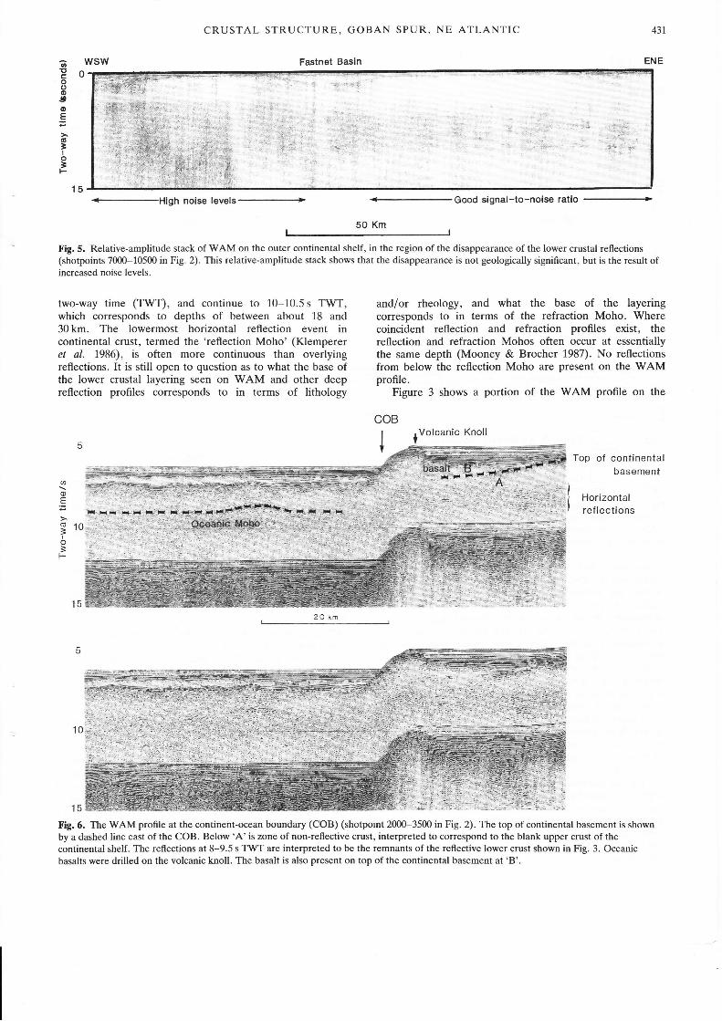
Fig.4. Perspective view of WAM and SWAT-6showing the difference in seismic character
between the WAM profile and the intersecting
SWAT-6 profile. WAM contains almost no
diffracted energy; some of the lower crustal
reflections are tracable for over 20 km distance.
SWAT-6, however, is characterized by dippingdiffracted arrivals. In the region of theintersection with rüAM, the SWAT-6 profile is
less diffractive, and ties well with the WAMprofile.
ao.E
o
'Io;F
ja§S*=--a-Nùi
*n* \%'
/\'
CRUSTAL STRUCTURE, GOBAN SPUR, NE ATLANTIC
Fastnet Basin
431,
oI'trooottoE
(!
'Io'F
o
<--High noise levels ----------------
Good signal-to-noise ratio
50 Km
Fig. 5. Relative-amplitude stack of WAM on the outer continental shelf, in the region of the disappearance of the lower crustal reflections(shotpoints 7000-10500 in Fig. 2). This relative-amplitude stack shows that the disappearance is not geologically significant, but is the result ofincreased noise levels.
wsw
two-way time (TWT), and continue to 10-10.5 s TWT,which corresponds to depths of between about 18 and30 km. The lowermost horizontal reflection event incontinental crust, termed the 'reflection Moho' (Klempereret aL.1986), is often more continuous than overlyingreflections. It is still open to question as to what the base ofthe lower crustal layering seen on WAM and other deepreflection profiles corresponds to in terms of lithology
ENE
and/or rheology, and what the base of the layeringcorresponds to in terms of the refraction Moho. Wherecoincident reflection and refraction profiles exist, thereflection and refraction Mohos often occur at essentiallythe same depth (Mooney & Brocher 1987). No reflectionsfrom below the reflection Moho are present on the WAMprofile.
Figure 3 shows a portion of the WAM profile on the
Top of continentalbasement
15
@
a)E
(!ÈI
=t-
Horizontalref lections
Fig. 6. The WAM profile at the continent-ocean boundary (COB) (shotpoint 2000-3500 in Fig. 2). The top of continental basement is shownby a dashed line east of the COB. Below'A'is zone of non-reflective crust, interpreted to correspond to the blank upper crust of thecontinental shelf. The reflections at 8-9.5 s TWT are interpreted to be the remnants of the reflective lower crust shown in Fig. 3. Oceanicbasalts were drilled on the volcanic knoll. The basalt is also present on top of the continental basement at 'B'.
:i::
15
COB
*Volcanic Knoll
432
(a)
wsw
BIRPS & ECORS
continental shelf. Several observations can be madeconcerning the lower crustal reflections in this area. The firstis that the reflections are extremely continuous. Typicalreflector lengths within the lower crust are 10-15 km, afterallowance for the radius of the Fresnel zone. Often a
two-to-three cycle band of reflections is much morecontinuous than the other lower crustal reflections; thisevent is usually at the base of the reflective lower crust, sothat it forms the reflection Moho (Fig. 3). An analysis of thelength of the reflections seen on WAM shows that thereflection Moho is often two-to-three times longer than thelower crustal reflections above it. The longest singlecorrelatable reflection on the WAM profile is 32 km inlength. With a Fresnel zone 2 km in radius, this means thatthe reflector is at least 28 km in length (assuming a velocityof 6 km s 1, a dominant frequency of 20}{2, and a two-waytime of 10s).
The measurement of these extremely long reflectionsegments is possible because there is essentially no diffractedenergy present in the lower crust on WAM. In contrast,previous BIRPS surveys such as WINCH (Brewer & Smythe1986) and SWAT (BIRPS & ECORS 1986; Cheadle et al.1987) show a lower crustal reflectivity pattern containingdiffractions. A comparison of the WAM profile with
ENE
SWAT-6 (Fig. 1 inset) shows that the character of the lowercrustal reflectivity differs on V/AM and SWAT. Athree-dimensional perspective diagram of the intersection ofWAM with SWAT-6 (Fig. a) shows that on SWAT-6 thehorizontal lower crustal reflections are broken up bydiffracted energy, whereas WAM is characterized by long,continuous sub-horizontal reflections and is almost entirelyfree of diffractions. The difference is seismic characterbetween WAM and the SWAT survey may be related to thefact that the WAM profile trends in the strike direction ofthe Variscan orogenic belt, while the SWAT proûles are diplines, as discussed by Reston (1987).
A second observation concerning the reflections from thelower crust is that some of the lower crustal reflections onWAM dip to the WSW (D1 and D2 in Figs I and2; Fig. 3).The reflections dip 12-16'after migration, at a conversionvelocity of 6.0kms-'. The entire column of reflectionsconsistently dip westwards, with the important exception ofthe reflection Moho, which is flat. The geometry shown inFig. 3 does not suggest that the Moho has truncated theIower crustal reflections, but that the reflections sole into thereflection Moho.
Though the lower crust is extremely well-imaged on theeastern third of Vy'AM, it is not possible to trace the
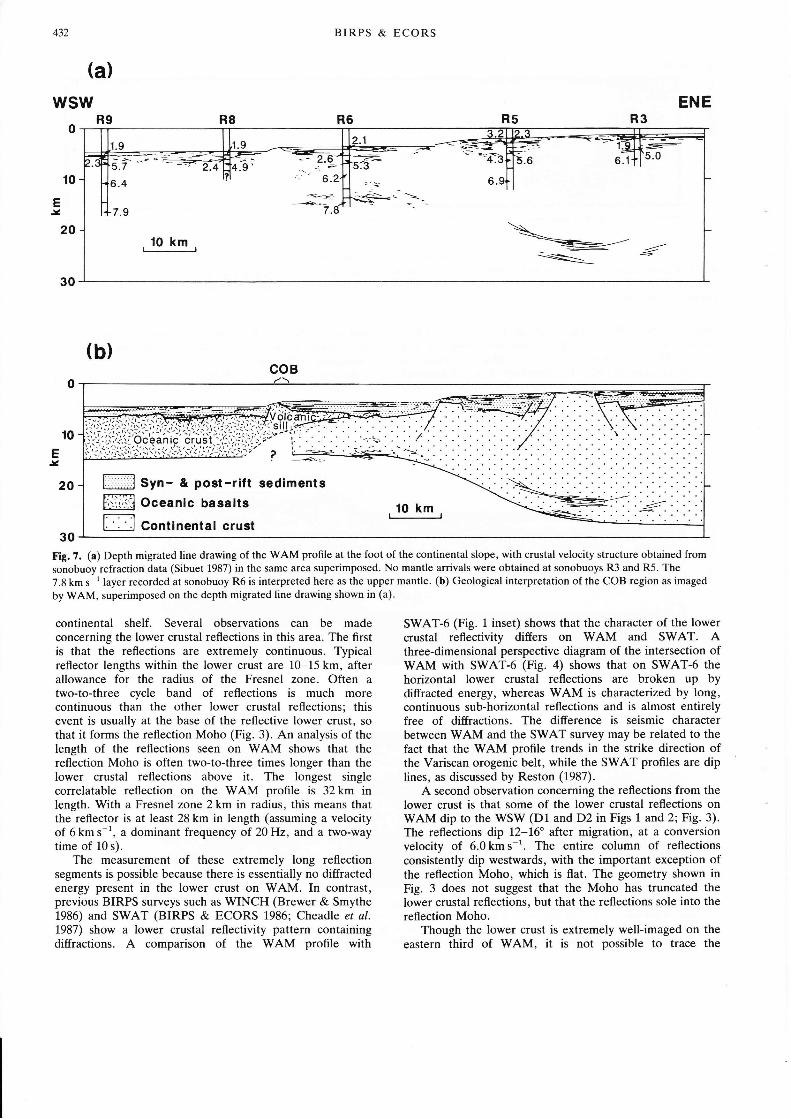
R9
t0
EI
20
30Fig. 7. (a) Depth migrated line drawing of the WAM profile at the foot of the continental slope, with crustal velocity structure obtained fromsonobuoy refraction data (Sibuet 1987) in the same area superimposed. No mantle arrivals were obtained at sonobuoys R3 and R5. The
7.8 km s 1 layer recorded at sonobuoy R6 is interpreted here as the upper mantle. (b) Geological interpretation of the COB region as imaged
by WAM, superimposed on the depth migrated line drawing shown in (a).
coB
CRUSTAL STRUCTURE, GOBAN SPUR, NE ATLANTIC 433
reflections in the lower crust from the shelf into deeperwater due to the presence of noise and water-bottommultiples. West of the Fastnet Basin (Fig. 2), reverberationsfrom within the near-surface sedimentary sequence aresufficiently strong to mask most arrivals from the lowercrust. The onset of this zone of high source-generated noisemay be related to a change in sedimentary facies associatedwith a major strike-slip fault within the Fastnet Basin (C.Evans, per. comm.). The almost perfect correlation betweenincreasing noise levels and the degradation of the reflectionsfrom the lower crust indicate that in all probability, thereflectors continue in the lower crust in this area (Fig. 5)(Peddy & Hobbs 1987).
Further to the west, and unfortunately overlapping withthe zone of high noise, deep-water multiples are present onthe WAM profile. In addition to the easily identifiable sea
floor-surface multiples, there are numerous peg-leg mul-tiples (energy trapped between subsurface layers) the arrivaltimes of which are virtually impossible to predict. In orderto attenuate multiple arrivals, the portion of the WAMprofile containing deep-water multiples (shotpoints 3800-68ffi in Fig. 2) was filtered using a technique which removesevents with the low RMS or stacking velocity of multiplearrivals from the sea-floor and sedimentary layers(1.5-2.0 km s-') and passes those with velocities appropriatefor primary events from the crystalline crust (5.0-6.0 km s-'). This f-k filtering eliminated many of thespurious multiple reflections in the slope area, but manualscreening of the moveout velocities was carried out across
the area affected by multiples in order to ensure that nomultiple events were interpreted as primaries. The linedrawing in Fig. 2 contains only those events with stackingvelocities which indicate a primary arrival. Using thedeepest discernible primary reflection beneath the con-tinental slope as a minimum estimate of the depth to thereflection Moho, crustal thickness beneath the continentalslope is more than 25 km. This is agreement with refractiondata to the south of V/AM (Ginzburg et al. 1985; see Fig. 1)
which indicates that the crust is over 30 km thick in theregion of WAM shotpoint 6500-6800 (Fig. 2).
While it is clear that reflectors are present in the lowercrust of the continental slope, a comparison of thecharacter, continuity and density of these reflectors withthose imaged to the east on the shelf is not possible due tothe interference of multiple arrivals. As the water depthincreases, however, the arrival of the multiples is delayed,and east of shotpoint 3600, the arrival of the first multipleoccurs after the arrival of reflections from the lower crust.Figure 6 shows WAM to the east of shotpoint 3600, in theregion of the continent-ocean boundary. Beneath thetop-of-basement reflection (dashed line in Fig. 6) is a
1.0-1.5 s (3-4.5 km) section which is transparent (A in Fig.6), below which sub-horizontal layered reflections arepresent. The pattern of transparent upper crust overreflective crust is the same as is observed on the continentalshelf, and the reflections shown in Fig. 6 are interpretedhere to be the remnants of an originally much thickerpackage of reflections such as those shown in Fig. 3, aftercrustal extension has taken place.
Reflection cofficients of lower crustal reflections
Deep-water multiples presented severe diffrculties in theinterpretation of the WAM proflle, but they also proved to
be useful in that they provided a means of calibratingamplitudes so that reflection coetûcients could be calculated.Though a full discussion of reflection coefficients is outsidethe scope of this paper, the importance of numericallyquantifying the magnitude of the changes in acousticimpedance across the reflections from the lower crustjustites a brief mention of the results of this study. Themethod used to calibrate the reflections using the multiplearrivals is described by Anstey (1977). Calculations ofreflection coefficients of reflections from the lower crustshow that the minimum coefficients range from 0.05 to 0.12,with the majority being in the range 0.08-0.10. Reflectioncoefficients of reflections from the lower half of the very thincrust east of the continent-ocean boundary (Fig. 6) are also0.08-0.10. In some cases the more laterally continuousreflection at the base of the layering (the reflection Moho)has a higher reflection coeffrcient than the overlyingreflections (0.12 for the reflection Moho and 0.08 for theimmediately overlying reflection), and in some cases thereflection Moho and reflective lower crust have approxim-ately the same reflection coefficients. Several parametersneeded for the exact calculation of the reflection coeffrcientare not known, such as the exact RMS velocity structure ofthe crust (Newman 1973), transmission losses (loss of theenergy reflected back to the surface), and anelasticattenuation. The unknown parameters were chosen to giveminimum reflection coefficients. The errors introducedthrough these unknown parameters are likely to be under257o. The uncertainties in comparing two reflections on asingle trace are much smaller, so that the difference betweenthe reflection coefûcients of the reflection Moho and otherlower crustal events cannot be due to errors in the estimateof the above factors. Constructive and destructiveinterference of the seismic wavelet may also affect thecalculated reflection coefficient.
Crustal thinning on Goban Spur
Estimates of crustal thickness
The interpretation of the WAM deep reflection prof,le wasaided by sonobuoy refraction results (Fig. 7 and see Sibuet1987) and gravity modelling (Fig. 8 and see Scrutton 1984).Assuming that the base of the lowermost reflectionsobserved beneath the Goban Spur corresponds to thecrust-mantle boundary, we calculate estimates of crustalthickness of the transitional crust. Figure 7b shows thateastward of the COB on WAM, the crust is 12-14 km thickwith a fairly flat base for a distance of about 50 km, at whichpoint a zone of rapid crustal thickening occurs. The zone ofthickening is indicated on the Vy'AM profile by a package ofbright, landward-dipping reflections. The gravity modellingagrees well with the crustal thicknesses inferred from WAM,and with the location of the zone of rapid crustal thickening.
Preliminary estimates of the velocity structure of GobanSpur were also obtained from sonobuoy recordings (Sibuet1987). While these data do not provide a good model fordeep crustal and upper mantle structure, they do providesome constraints for the interpretation of WAM. Thevelocity structure obtained from the sonobuoys has beenconverted to two-way travel time and superimposed on theline drawing of WAM in Fig. 7a. Beneath the sedimentarycover, upper crustal velocities ranging between 5.6 and
BIRPS & ECORS
oE60g
=ooËro6ooÈG
3 -roI
6.3 km s-' are associated with the transparent upper crust onWAM, while it is unclear if the 7.8 km s-' velocity recordedat R6 should be associated with the lower, reflective crust orwith the upper mantle. While 7.8 km s ' is slightly low foran arrival from the upper mantle, it is much too high foreither lower crystalline crust in this area (6.5 km s-';Ginzburg et al. t985) or underplated mantle partial melt(7.2-7.4kms-'; LASE 1986; White et al. 1987). The7.8 km s ' layer recorded at sonobuoy R6 is thereforeinterpreted here as the upper mantle. An OBS refractionsurvey was carried out along the WAM profile in 1987, andwhen interpreted will give more precise measurements ofcrustal thickness (R. S. White, pers. comm.).
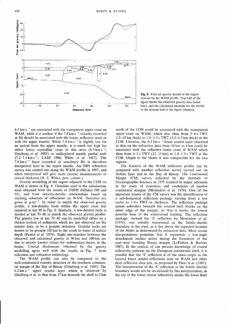
Gravity modelling of the region adjacent to the COB onWAM is shown in Fig. 8. Densities used in the calculationswere obtained from the results of DSDP drillsites 549 and551, and from velocity-density relationships based onstacking velocities of reflections on WAM. Densities aregiven in g cm-3. In order to match the observed gravityprofile, a low-density body within the upper crust wasrequired at km 90 in Fig. 8. Similarly, a low-density body isneeded at km 70-80 to match the observed gravity profile.The gravity low at km 70-80 can be modelled either by athicker section of sediments which are not observed on theseismic data, or by a granitic intrusion. Granitic rocks areknown to be present 100 km to the south in water of similardepth (Pautot et al. 1976). Slight mis-matches between theobserved and calculated gravity at 90 km and 100 km aredue to poorly known values for sedimentary layers in thebasins. Crustal thicknesses obtained by the gravitymodelling agree well with the results in Fig. 7 fromreflection and refraction seismology.
The WAM proflle can also be compared to thewell-constrained velocity structure of the northern continen-tal margin of the Bay of Biscay (Ginzburg et al. 1985). The6.0 km s-1 upper crustal layer which is observed byGinzburg et al. to thin from 17km beneath the shelf to 2km
Fig. E. Free-air gravity model of the regioncrossed by the Vr'AM profile. Top half of thefigure shows the observed gravity data (solidline), and the calculated anomaly for the modelin the bottom half of the figure (dashes).
north of the COB could be associated with the transparentupper crust on WAM, which also thins from 5-6 s TWT(15-18 km thick) to 1.0-1.5 s TW'T (3.0-4.5 km thick) at theCOB. Likewise, the 6.5kms 'lower crustal layer observedto thin on the refraction data from 18 km to 4 km could beassociated with the reflective lower crust of WAM whichthins from 4-5 s TWT (12-15 km) to 1.0-1.5 s TWT at theCOB. Depth to the Moho is also comparable for the tworegions.
The features of the WAM reflection prof,le can becompared with another reflection survey carried out onGoban Spur and in the Bay of Biscay. The ContinentalMargin (CM) survey collected by the Institute ofOceanographic Sciences in 1975 resulted in major advancesin the study of structures and evolutions of passivecontinental margins (Montadert et al. t979). One of theimportant results of the CM survey was the identification ofa sub-horizontal reflection package varying from a fewcycles to 1.0s TWT in thickness. The reflection packagepasses unbroken beneath the rotated fault blocks on theouter edge of the margin, so that it marks the lowestpossible base of the extensional faulting. The reflectionpackage, termed the 'S' reflection by Montadert et al.(1979), was initially interpreted as the brittte-ductileboundary in the crust, as it lies above the expected locationof the Moho as determined by refraction data. More recentinterpretations postulate that it represents a low-angledetachment surface active during the formation of theeast-west trending Biscay margin (LePichon & Barbier1987). In the context of our present knowledge of crustalreflectivity patterns on the European continental shelf, it ispossible that the 'S' reflection is of the same origin as thelayered lower crustal reflections seen on WAM and otherdeep reflection data sets, as proposed by Pinet et al. (1987).The interpretation of the 'S'reflection as the brittle-ductileboundary would not be invalidated by this interpretation, as
the top of the lower crustal reflectivity marks the lower limit
CRUSTAL STRUCTURE, GOBAN SPUR, NE ATLANTIC 435
of many of the crustal faults imaged on the BIRPS data set,such as the Variscan front (BIRPS & ECORS 1986), as
would be expected at the brittle-ductile boundary.
Nature of extension from deep reflection profilingOne of the primary goals of the WAM experiment v/as totrace reflectors observed in the lower crust of thecontinental shelf out onto the more extended crust of theAtlantic passive margin, and thus to examine therelationship of the reflectors to extensional processes. Oneof the primary limitations of the seismic reflection method,however, is that reflections cannot be directly dated andthus it is not known whether the reflectors beneath the shelfare pre- or post-extensional, or whether the reflectors in thecrust adjacent to the COB are of the same age and origin as
those beneath the shelf. We suggest here that the similarityin reflectivity patterns of the crust of the continental shelfand adjacent to the COB leads to the conclusion that thereflectors adjacent to the COB are the remnants of anoriginally much thicker package of reflectors after extension.This interpretation implies that the reflectors were emplacedprior to rifting.
A second possible interpretation of the reflectorsadjacent to the COB is that they represent mantle partialmelt generated and intruded during rifting. Recent modelsfor lithospheric extension predict the production of largeamounts of mantle partial melt during extension (White er
al. 1987). For a given mantle potential temperature, thelarger the amount of extension the greater the volume ofbasalt produced during the extension. The partial melt isthought to be added to the lower part of the crust byunderplating. Layers having velocities in the range of7.2-7.4km s-' are interpreted as evidence for underplatingon both the North American and European Atlanticmargins (LASE 1986; White et al. 1987). The velocitystructure of sonobuoy R6 (Fig. 7a) shows no layer with thisvelocity; the 7.8 km s 1 arrival recorded at R6 is too high tocorrespond to the 7.2-7.4kms 1 velocities which areindicative of underplating on other margins. In addition, thedistribution of layered lower crustal reflections on WAMdoes not agree with a model in which the reflective lowercrust is due to igneous intrusions formed during theCretaceous. Three or four seconds TWT (at least 10-13 kmthickness) of reflective crust is seen on WAM on thecontinental shelf where little or no extension has occurred,whereas only 1-1.5 s TWT (3-5 km thickness) of reflectivelower crust is seen in the highly-extended transitional crustwhere more melt would have been produced. If the layered
lower crustal reflections are due to intruded basalts (Warner& Cheadle 1986), the extensional episode which producedthem must have been prior to the Cretaceous episode whichresulted in the opening of the Atlantic. The intrusions mighthave been formed during the previous period of Triassic and
early Jurassic rifting which occurred on the continentalshelf. Jurassic mafic volcanics have been drilled in theFastnet basin (Caston et al. L98t) and on the Goban Spur(Cook 1987), as well as in many other parts of westernEurope (Ziegler 1982).
The interpretation of the reflectivity in the lower crustobserved on WAM as a pre-rift feature has importantimplications for models of continental margin formation. Ifthe reflective lower crust was emplaced prior to the earlyCretaceous, then the relative abundance of reflective andnon-reflective crust now present can be used to measure theamount of relative upper and lower crustal extension onGoban Spur. Extension by pure shear produces a crust inwhich each crustal level has been thinned by a certainamount, but in which all crustal levels are still present at theend of extension (McKenzie 1978; Royden & Keen 1980).This is the pattern of crustal thinning which is indicated bythe results from the V/AM profile. An alternative model forlithospheric extension, thinning by simple shear along a
detachment fault (Wernicke 1981), would result in the lowerplate margin (identifled by the presence of rotated faultblocks and hence the Goban Spur margin rather than theconjugate Flemish Cap margin) to be almost entirelycomposed of lower crust adjacent to the COB (Lister et a/.
i986). The presence of 3-4.5 km of transparent upper crustimmediately adjacent to the COB is not predicted by thesimple shear model of continental margin formation.
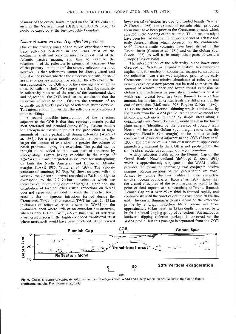
A deep reflection profile across the Flemish Cap on theGrand Banks, Newfoundland (deVoogd & Keen 1987)
which is approximately conjugate to the WAM proflle,provides the means of comparing two conjugate passive
margins. Reconstructions of the pre-Atlantic rift zone,formed by joining the two profiles at their respectivecontinent-ocean boundaries (Keen et al. 1989) shows thatthe crustal structures of the two margins adjacent to thepoint of final rupture are substantially different. BeneathFlemish Cap crust over 25 km thick is thinned rapidly andcontinuously until the onset of oceanic crust about 30 km theeast. The crustal thinning is clearly shown on the reflectionprofile by a bright reflection Moho whose rise fromapproximately 30 km depth to 15 km depth is marked by a
bright landward dipping group of reflections. An analogouslandward dipping reflector package is observed on theWAM profile, but this package is separated from the COB
Flemish Cap Goban Spur
- -=--za2 --.-- --\
71r ansationa I crusi - \ ---=-:-tion Moho
coBt0
É,
J.c, 20CLoo
40
O 50 20% Vertical exaggeration
kmFig. 9. Crustal structure of conjugate Atlantic continental margins from WAM and a deep reflection profile across the Grand Banks
continental margin. From Keen et al.,1988.
436 BIRPS & ECORS
by a distance of 50-60 km. Between the landward dippingreflections on WAM (see Fig. 7. Reflections referred to arethose between 20-25 km in continental lower crust), theWAM profile images a zone some 50-60 km wide which is
characterized by sub-horizontal reflections at 10-15 kmdepth (shotpoints 3000-4200 in Fig. 2). Gravity modellingindicates that the base of the crust in this region is relativelyhorizontal (Fig. 8). The reconstructed rift zone formed byjoining the two seismic profiles at the continent-oceanboundary (Fig. 9) suggests that the zone of flat-bottomedtransitional crust on WAM forms the centre of a
once-symmetrical rift zone which ruptured at its westernedge during final separation of Europe and North America(Keen e/ al., 1989).
Conclusions
The WAM deep seismic reflection profile crosses the entireGoban Spur continental margin. Lower crustal reflectivityon the continental shelf is well-imaged on the WAM profile,with some reflections reaching 20-30 km in length. There islittle or no diffracted energy present on WAM, which is incontrast to other BIRPS surveys, in particular the SWATsurvey to the east of WAM. The lower crustal reflections areobserved to have a significant dip on some portions of theWAM profile, and appear to sole into a flat reflectionMoho. Minimum reflection coefûcients calculated for lowercrustal reflections and the reflection Moho are in the rangeof 0.8 to 1.0. The interpretation of the WAM proflle wascomplicated by the presence of high source-generated noiseand deep water multiples, but reflections from the lowercrust are observed across the entire profile from thecontinental shelf to the continent-ocean boundary. In everypart of the WAM profile which is free of noise andmultiples, the continental crust has a very similar reflectivitysignature; the upper crust is transparent and lower crustcontains sub-horizontal reflections. Because of this similarityin reflection character, we interpret the lower crustalreflectivity observed near the continent-ocean boundary as
being the remnants, after extension, of an originally thickerpackage of reflective lower crust. This interpretation suggeststhat the reflective lower crust pre-dates the opening of theAtlantic.
BIRPS is funded by the Deep Geology Committee of the NaturalEnvironmental Research Council (NERC). The ECORS program is
funded by INSU (Institut National des Sciences de l'Univers-CNRS), IFP (Institut Francais du Petrole), SNEA(P) (Societe
Nationale ElF-Aquitaine, Production), and IFREMER (InstitutFrancais pour la Recherche et l'Exploration de la Mer). The WAMprofile was acquired by the Geophysical Company of Norway(GECO) and processed by Seismograph Services, Ltd (SSL). Wethank these companies for providing the technical expertise that is
the most vital element in producing a successful deep reflectionprofrle. We are grateful to C. Smith, who carried out the carefulevaluation of stacking velocities necessary to identify primaryreflections in the presence of multiples, and to R. Hobbs for his
work on the source-generated noise on WAM. British Petroleumprovided computer time and programs which allowed a betterestimate of reflection lengths to be made. We thank C. Evans of the
BGS for valuable discussions. D. Smythe and D. Hutchinsonprovided reviews which resulted in significant improvements in themanuscript. The seismic sections shown in Figs 3 and 5 were plottedwith the SKS processing package of Merlin Geophysical on the
Bullard Laboratories VAX 11-750 computer. The records and
tapes of the WAM line are available for the cost of reproduction by
writing to the Programme Manager, Marine Geophysics ResearchProgramme, Murchison House, West Mains Road, Edinburgh EH93LA, UK, Telex727343. Cambridge Department of Earth Sciencescontribution 1282.
References
ALLlreNuxcen, R., Haucn, T., Heusen, E., PorrER, C., Kr-Elrrenen, S.,Ner-soN, K., KNEUPFER, P. & Oul'En, J. 1987. Overview of theCOCORP 40oN Transect; western United States: the fabric of anorogenic belt. Geological Society of Ameica Bulletin,98, 308-319.
.dNsrev, N. 1977. Seismic Interprelation: The Physical Aspects. InternationalHuman Resources Development Corporation, Boston.
BIRPS & ECORS 1986. Deep seismic reflection profiling between England,France and keland. Journal of the Geological Sociery, London, 143,45-52.
Bors, C., Cezes, M., HrnN, 4., MASCLE, 4., Marre, P., MoNraoenr, L. &Prrer, B. 1988. Contributions of deep seismic profiling to the knowledgeof the lower crust in France and neighbouring areas. Tectonophysiæ,t45, 253-275.
BREWER, J. & SMyrHE, D. 1986. Deep structure of the foreland to theCaledonian orogen, NW Scotland: results of the BIRPS tir'INCH profile.Tectonics, 5, l7l-194.
-, li[s111q6vv5, D., Werusen, M. Hell, J., Suvrue, D. & WHrrnNGroN,
A. 1983. BIRPS deep seismic reflection studies of the BritishCaledonides. Nature, 305, 206-210.
CasroN, V., DEARNLEY, R., HnnntsoN, R., RUNDLE, C. & SrvlEs, M. 1981.
Olivine-dolerite intrusions in the Fastnet Basin. Journal of the GeologicalSociety, London, 13E' 31-46.
Cazrs, M., MAScLE, A. & ECORS ScIpNrInc P.cnrY 1986. Large Variscanoverthrusts beneath the Paris basin. Nature, 323' 144-1,47.
Cueeols, M., McGn,lnv, S., WenNen, M. & BruNortt, D. 1987.Extensional structures on the western UK continental shelf: a review ofevidence from deep seismic profiling. 1n: Coweno, M., Dpwpv, J. &HeNcocx, P. (ed$ Continental Extercional Tectonis. GeologicalSociety, London, Special Publicatiot, 8, 445-465.
Coox, D. 1987. The Goban Spur-Exploration in a deep water frontier basin.1z: Bnooxs, J. & GTeNNIE, K. (eds) Petroleum Geology of NorthwestEurope. Graham and Trotman, 623-632.
»e Gn.r.creNsxv, P. C. & Poec, P. (eds) 1984. Initial Reports of the Deep Sea
Drilling Project, E0, U.S. Government Printing Offce, Washington,D.C.
DEKORP, 1985. First results and preliminary interpretation of deep-reflection seismic recordings along profile DEKORP Z-Sottlt. Joumal ofGeophysics, 57, 1.37 -163.
DEVoocD, B. & KEEN, C. 1987. Lithoprobe east: results from reflectionprofiling of the continental margin: Grand Banks region. GeophysicalJournal of the Royal Astronomical Sociery, t9, 195-200.
GrNzsunc, A., Wnnrr,ransn, R., Roeenrs, D., MoxrnoEnr, L., Csaus, A. &AvEDrK, F. 1985. The deep seismic structure of the northern continentalmargin of the Bay of Biscay. Annales Geophysicae,3,499-510.
Hluce, T., ALLMENDTNcER, R., Cenuso, C., Hausrn, E., Kleurrnen, S.,OpDyKE, S., Porrpn, C., SeNrono, W., BnowN, L., K-lurueN, S. &Olrven, J. 1987. Crustal structure of western Nevada from COCORPdeep seismic-reflection data. Geoloÿal Socicty of Ameica Bulletin,9t,320-329.
HurcnnsoN, D., KLrrcoRD, K. & Dernrcr, R. 1985. Block Island fault: APaleozoic crustal boundary on the Long Island platform. Geology, 7i,875-879.
KEEN, C., Peoov, C., oeVooco, B. & Merrupws, D. 1989. Conjugatemargins of Canada and Europe: Results from deep reflection profiling.Geology. (In press)
KTEMIERER, S. 1988. Processing BIRPS deep seismic reflection data: a
tutorial review. 1n: CessINIs, R., Noler, G. & Pexzr, G. F. (eds)Digital Seismology and Fine Modelling of the Lithosphere. Proceedingsvolume, Intemational School of Applied Geophysics, Erice. Plenum,New York (in press).
-, Heuce, T., Hnusen, E., Ouven, J. & Porrpn, C. 1986. The Moho in
the northern Basin and Range province, Nevada, along the COCORP,10"N seismic-reflection transect. Geological Society of America Builertn,n, ffi3-618.
LASE SruDy GRoup 1986. Deep structure of the US East Coast passive
margin from large aperture seismic expæriments. Marine and PetroleumGeology, 3, 234-242.
Leronr, J. & Mex, M. 1984. Development of the Porcupine Seabight: use ofmagnetic data to show the direct relationship between early oceanic and
continental structures. Journal of the Geological Society, London, l{1.,63-674.
LEPrcHoN, X. & BARBIER, F. 1987. Passive margin fomation by low-anglefaulting within the upper crust: The northern Bay of Biscay margin.Tectonics,6, 133-150.
Lrsren, G., Errsnroce, M,'& Svt'loNos, P. 1986. Detachment faulting andthe evolution of passive continental margins. Geology,14,246-250.
McKrNzre, D. 1978. Some remarks on the development of sedimentarybasins. Earth and Planetary Science Letters, qr25-32.
MAssoN, D. & MIles, P. 1986. Structure and development of PorcupineSeabight sedimentary basin, ofrshore southwest lreland. AmericanAssocittion of Petroleum Geologists Bulletin, 70, 536-548.
-, MoNTADERT, L. & ScnurroN, R. 1984. Regional geology of the Goban
Spur continental margin. 1n: oe Gn.tctaNsxv, P. C. & Poac, C. (eds)Initial Reports of the Deep Sea Drilling Project, ffi& US GovernmentPrinting Office, Washington DC, 1115-1139.
Menrun, S. 1983. Deep crustal reflection results from the Eromanga basin,Australia. Tectonophysics, 1.lü.ù, 163-173.
MoNraoenr, L., Ronenr, D., DrCHrnrÆ, O. & GuENNoc, P. 1979. Riftingand subsidence of the northern continental margin of the Bay of Biscay.In: lnitial Reporb of the Deep Sea Drilling Project,48, US GovernmentPrinting Office, Washington, DC, 1025-1060.
MooNEy, W. & BRoCHER, T. 1987. Coincident seismic reflection/refractionstudies of the continental lithosphere: A global review. Reuiews ofGeophysics, 25, 723-7 42.
NrwueN, P. 1973. Divergence effects in a layered earth. Geophysits, §,481-488.
Pauror, G., RENARD, V., Aurrnrr, G., PAsrouREr, L. & oe Cnenrel, O.1976. A granite cliff deep in the North Atlantic. Narure, ffi,69-673.
Peooy, C. & Honns, R., 1987. Lower crustal reflectivity of the continentalmargin southwest of Britain. Annalæ Geophysicae, 58,331-338.
PrNrr, 8., MoNrloenr, L., Mascre, A., Cezes, M. & Bols, C. 1987. Newinsights on the structure and the fomation of sedimentary basins fromdeep seismic reflection profiing in Western Europe. In: Bnooxs, J. &
437
Gr-eNNrc, K. (eds), Petoleum Geology of North West Europe. Grahamand Trotman, 11-31.
RAvNAUD, B. 1988. A 2-D, ray-based, depth migration method for deepseismic refl ection s. G eop hy sical J ournal, 93, 163 -77 1.
REsroN, T. 1987. Spatial interference, reflection character and the structureof the lower crust under extension. Results from 2-D seismic modeling.Annalcs Geophysicae, 5E, 339-348.
RoBrNsoN, K., SurNNoN, P. & YouNc, D. 1981. The Fastnet Basin: Anintegrated analysis. In: Iu-nc, L. & Hoesor, G. (eds) PetroleumGeology of the Continental Shelf of North-west Europe, Instit\te ofPetroleum, Ilndon, U4-454.
RoyDEN, L. & KerN, C. 1980. Rifting processes and themal evolution of thecontinental margin of eastern Canada determined from subsidencectles. Earth and Planetary Science Letters,51r343-361,.
ScnurroN, R. 1984. Modeling of magnetic and gravity anomalies at GobanSpur, northeastern Atlantic. 1n: oE GnecIeNsxv, P. C. & Poec, C. (eds)Initial Reporr of the Deep Sea Dilling Project, EO, US GovernmentPrinting Office, Washington, DC, 7141-1152.
SrnuEr, J. C. 1987. Contribution a l'etude meéanismæ de fomation des
mrges continentales possiues. Doctoral these, Universitè de BretagneOccidentale.
WARNER, M. & CnEeor-e , M. 1986. Intrusion and underplating of the lowercontinental crust (abst). Geophysical Joumal of the Royal AstronomicalSocicty, 89,482.
WERNTcKE, B. 1981. Low-angle normal faults in the Basin and Rangeprovince: Nappe tectonics in an extending orogen. Nature, 291,645-648.
WHrrE, R., SreNce, G., FowLER, S., McKrxzts, D., WESTBRooK, G. &BoweN, A. 1987. Magmatism at rifted continental margins. Nature, 330,439-444.
Ztnatea, P. A. 1982. Geoloÿal atl6 of westem and central Europe. ShellInternational Petroleum, Mij BV, The Hague, Elsevier, Amsterdam.
CRUSTAL STRUCTURE, GOBAN SPUR, NE ATLANTIC
Received 17 March 1988; revised typescript accepted 28 November 1988.
Related Documents


