Creating Maps from SRTM Data – Tutorial By Drunkrussian 10 Mar 06

Welcome message from author
This document is posted to help you gain knowledge. Please leave a comment to let me know what you think about it! Share it to your friends and learn new things together.
Transcript
Creating Maps from SRTM Data – Tutorial
By
Drunkrussian 10 Mar 06
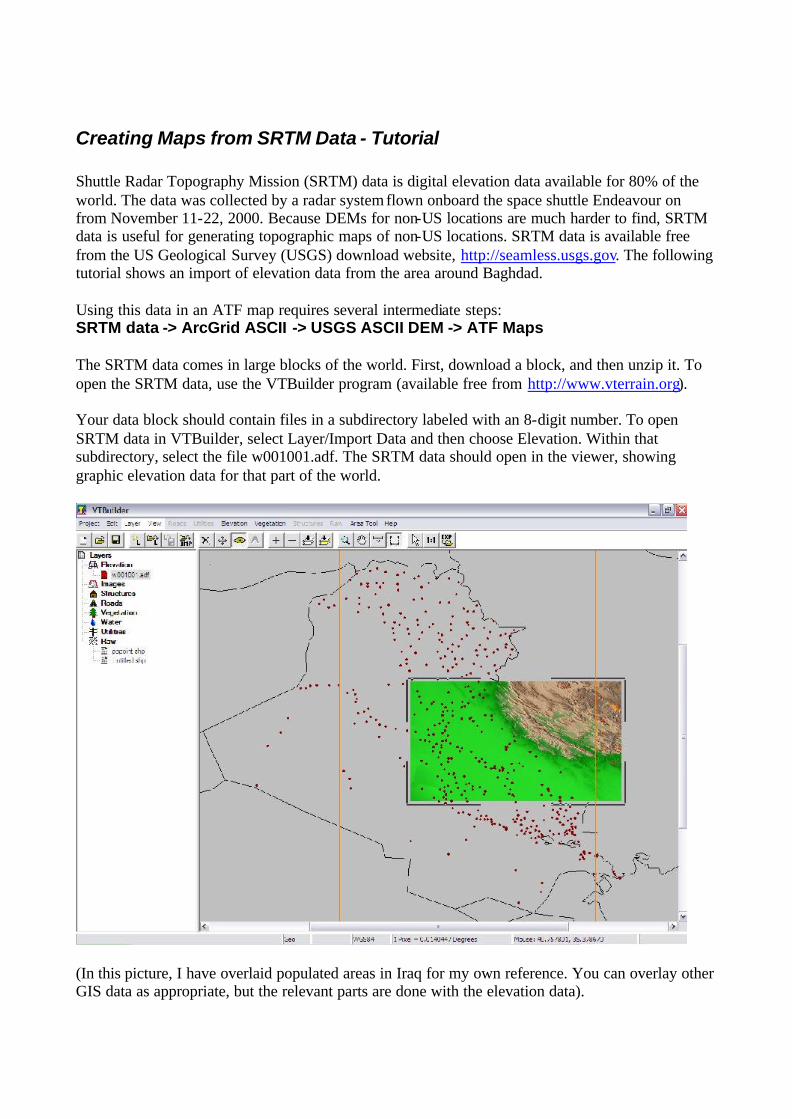
Creating Maps from SRTM Data - Tutorial Shuttle Radar Topography Mission (SRTM) data is digital elevation data available for 80% of the world. The data was collected by a radar system flown onboard the space shuttle Endeavour on from November 11-22, 2000. Because DEMs for non-US locations are much harder to find, SRTM data is useful for generating topographic maps of non-US locations. SRTM data is available free from the US Geological Survey (USGS) download website, http://seamless.usgs.gov. The following tutorial shows an import of elevation data from the area around Baghdad. Using this data in an ATF map requires several intermediate steps: SRTM data -> ArcGrid ASCII -> USGS ASCII DEM -> ATF Maps The SRTM data comes in large blocks of the world. First, download a block, and then unzip it. To open the SRTM data, use the VTBuilder program (available free from http://www.vterrain.org). Your data block should contain files in a subdirectory labeled with an 8-digit number. To open SRTM data in VTBuilder, select Layer/Import Data and then choose Elevation. Within that subdirectory, select the file w001001.adf. The SRTM data should open in the viewer, showing graphic elevation data for that part of the world.
(In this picture, I have overlaid populated areas in Iraq for my own reference. You can overlay other GIS data as appropriate, but the relevant parts are done with the elevation data).

To select an area, select Area Tool/Numeric Values. I recommend entering the southwest corner in the first parentheses at the bottom, and (1.0, 1.0) for the second. Any way you do it, ensure that this area is 1 degree by 1 degree (since that is the only size ATF will accept).

Result:
Select Area Tool/Merge and Resample Elevation. Make sure “Create New Layer” is selected and hit OK. Now you will have a new layer called “Untitled.” Select the layer w001001.adf in the frame on the left side, and then deselect View/Current Layer Visible.
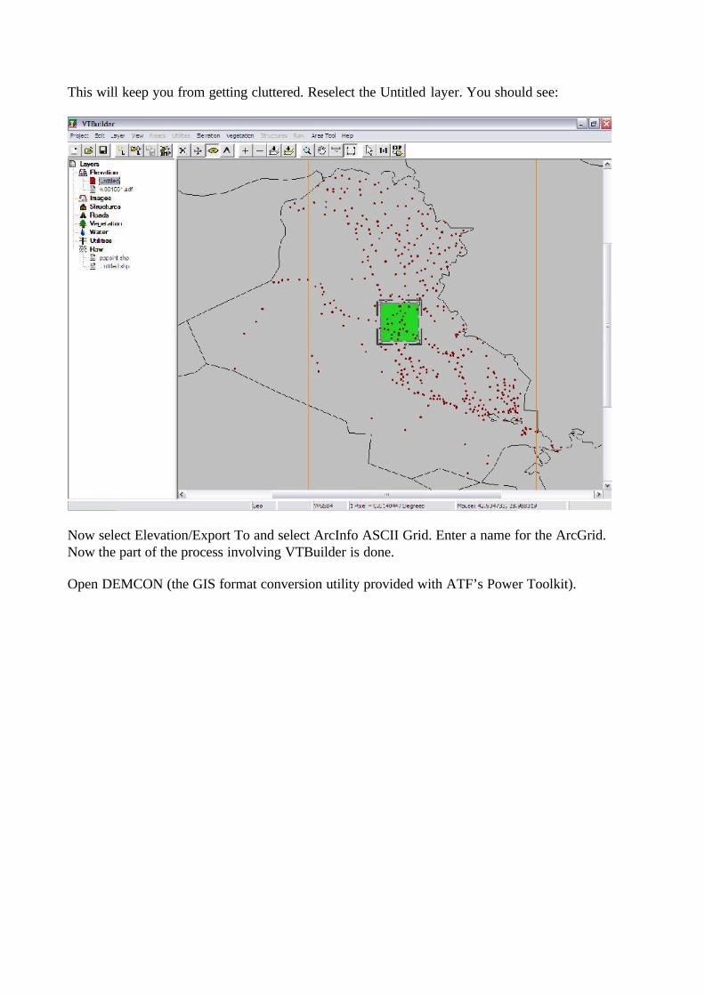
This will keep you from getting cluttered. Reselect the Untitled layer. You should see:
Now select Elevation/Export To and select ArcInfo ASCII Grid. Enter a name for the ArcGrid. Now the part of the process involving VTBuilder is done. Open DEMCON (the GIS format conversion utility provided with ATF’s Power Toolkit).
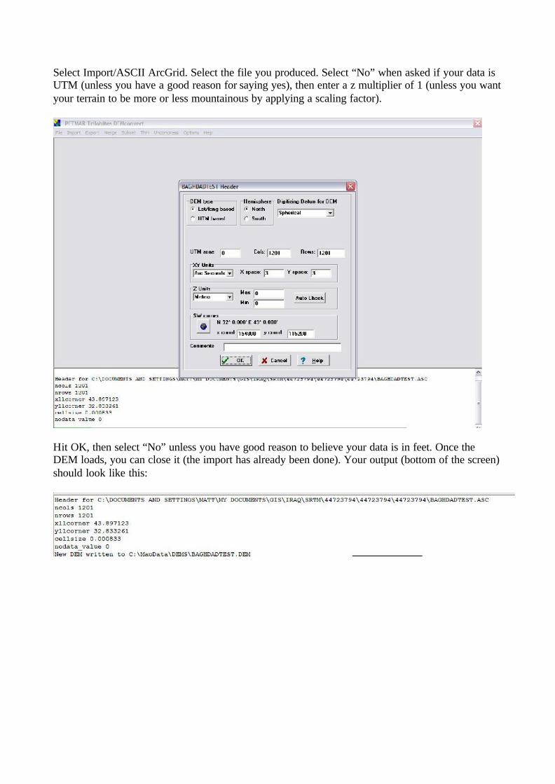
Select Import/ASCII ArcGrid. Select the file you produced. Select “No” when asked if your data is UTM (unless you have a good reason for saying yes), then enter a z multiplier of 1 (unless you want your terrain to be more or less mountainous by applying a scaling factor).
Hit OK, then select “No” unless you have good reason to believe your data is in feet. Once the DEM loads, you can close it (the import has already been done). Your output (bottom of the screen) should look like this:

Select Export/DEM. Go to C:\MapData\DEMS\ and you will find the DEM that DEMCON has exported. This DEM, however, is not in the USGS ASCII DEM format, which is what ATF requires. Select the DEM that DEMCON has created. Then, when the next screen appears, select “USGS ASCII format.”
Enter a name for your new DEM. Do not try to save this new DEM over the old one; it will cause problems. Give it a new filename – I just add “ascii” to the end of the previous filename.
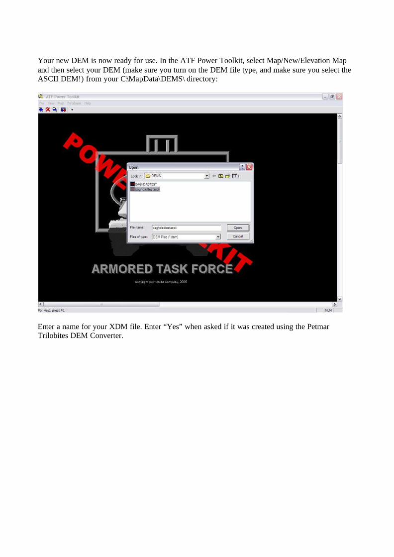
Your new DEM is now ready for use. In the ATF Power Toolkit, select Map/New/Elevation Map and then select your DEM (make sure you turn on the DEM file type, and make sure you select the ASCII DEM!) from your C:\MapData\DEMS\ directory:
Enter a name for your XDM file. Enter “Yes” when asked if it was created using the Petmar Trilobites DEM Converter.
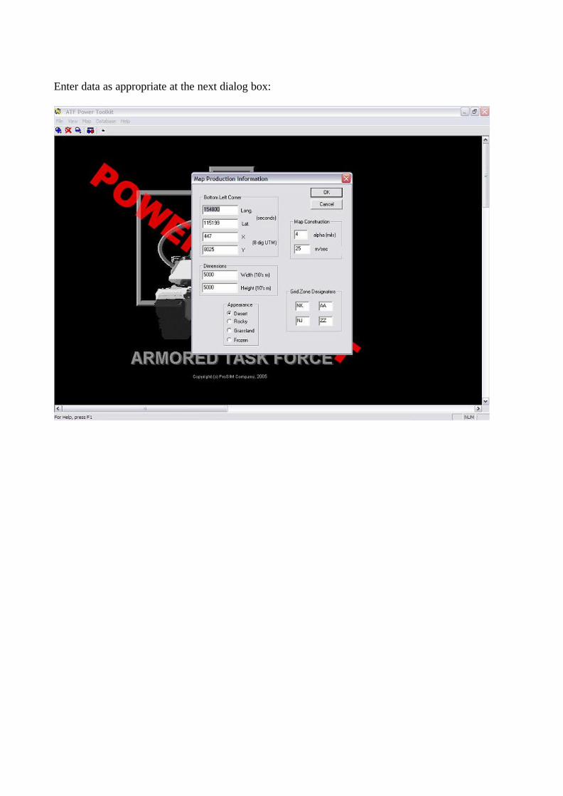
Enter data as appropriate at the next dialog box:
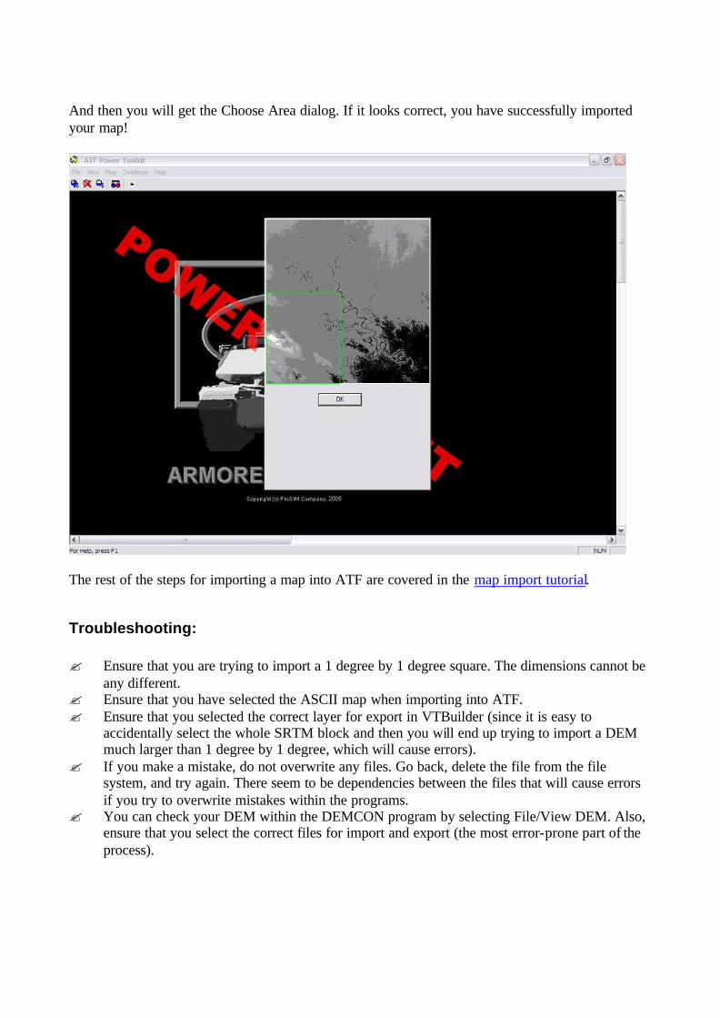
And then you will get the Choose Area dialog. If it looks correct, you have successfully imported your map!
The rest of the steps for importing a map into ATF are covered in the map import tutorial.
Troubleshooting: ? Ensure that you are trying to import a 1 degree by 1 degree square. The dimensions cannot be
any different. ? Ensure that you have selected the ASCII map when importing into ATF. ? Ensure that you selected the correct layer for export in VTBuilder (since it is easy to
accidentally select the whole SRTM block and then you will end up trying to import a DEM much larger than 1 degree by 1 degree, which will cause errors).
? If you make a mistake, do not overwrite any files. Go back, delete the file from the file system, and try again. There seem to be dependencies between the files that will cause errors if you try to overwrite mistakes within the programs.
? You can check your DEM within the DEMCON program by selecting File/View DEM. Also, ensure that you select the correct files for import and export (the most error-prone part of the process).

LINKS: Map Import Tutorial (ProSim) – http://www.prosimco.com/atf/tutorial/5_new_map.htm
DEMCON - http://download.shrapnelgames.com/downloads/demcon.zip
VTBuilder – http://www.vterrain.org
SRTM data from US Geological Survey (USGS) download website - http://seamless.usgs.gov
Related Documents