CRANBOURNE WEST PSP REVIEW OF DESIGNATED LAND USE FOR 690 WESTERN PORT HIGHWAY, 635 HALL ROAD AND PART OF 620 WESTERN PORT HIGHWAY, CRANBOURNE WEST (AMENDMENT C219 CASEY PLANNING SCHEME) Traffic Engineering Assessment Prepared for LEIGHTON PROPERTIES PTY LTD JULY, 2016 OUR REFERENCE: G17786R-02C

Welcome message from author
This document is posted to help you gain knowledge. Please leave a comment to let me know what you think about it! Share it to your friends and learn new things together.
Transcript

CRANBOURNE WEST PSPREVIEW OF DESIGNATED LAND USE
FOR 690 WESTERN PORT HIGHWAY, 635 HALL ROAD AND PART OF620 WESTERN PORT HIGHWAY, CRANBOURNE WEST(AMENDMENT C219 CASEY PLANNING SCHEME)
Traffic Engineering Assessment
Prepared for
LEIGHTON PROPERTIES PTY LTD
JULY, 2016
OUR REFERENCE: G17786R-02C

CRANBOURNE WEST PSPREVIEW OF DESIGNATED LAND USE
FOR 690 WESTERN PORT HIGHWAY, 635 HALL ROAD AND PART OF620 WESTERN PORT HIGHWAY, CRANBOURNE WEST(AMENDMENT C219 CASEY PLANNING SCHEME)
Traffic Engineering Assessment
Study Team: Henry TurnbullB.E. (Civil), M.I.E. Aust., M.I.T.E., F.V.P.E.L.A.
Daniel MilderB.E. (Civil) Hons
Released By:
21st July, 2016
Document Status: Dra� until signed as released.
COPYRIGHT: The ideas and material contained in this document are the property of Traffix Group (Traffix Group Pty Ltd – ABN 32 100 481 570, TraffixSurvey Pty Ltd – ABN 57 120 461 510, Traffix Design Pty Ltd – ABN 41 060 899 443). Use or copying of this document in whole or in part without thewri�en permission of Traffix Group constitutes an infringement of copyright.
LIMITATION: This report has been prepared on behalf of and for the exclusive use of Traffix Group’s client, and is subject to and issued in connectionwith the provisions of the agreement between Traffix Group and its client. Traffix Group accepts no liability or responsibility whatsoever for or inrespect of any use of or reliance upon this report by any third party.

G17786R-02C Page 1
Proposed Cranbourne West Residen�al Rezoning
TABLE OF CONTENTS1 INTRODUCTION........................................................................................................................................................ 2
2 BACKGROUND ......................................................................................................................................................... 3
3 PROPOSED ALTERNATIVE PSP .................................................................................................................................. 5
4 TRAFFIC VOLUME CHANGES..................................................................................................................................... 6
4.1 TRAFFIC GENERATION ASSESSMENTS ...............................................................................................................................64.2 TRAFFIC DISTRIBUTIONASSESSMENTS ..............................................................................................................................74.3 TRAFFIC IMPACTS.........................................................................................................................................................84.4 INTERNAL ROADNETWORK............................................................................................................................................9
5 CURRENTLY ENVISAGED WORKS............................................................................................................................ 11
5.1 WESTERN PORTHIGHWAYUPGRADE.............................................................................................................................115.2 DCP IMPACTS ...........................................................................................................................................................14
6 IMPACT OF PROPOSED CHANGES .......................................................................................................................... 16
7 CONCLUSIONS........................................................................................................................................................ 17

G17786R-02C Page 2
Proposed Cranbourne West Residen�al Rezoning
1 INTRODUCTION
Traffix Group has been engaged by Leighton Properties to undertake a traffic engineeringassessment and to prepare a report for proposed changes to the applied zone for properties47 and 48 and part of property 46 within the Cranbourne West PSP area from Commercial 2 tothe General Residential Zone. The location of the properties (“the subject site”) is shown onFigure 1 below.This report provides a traffic engineering overview of the proposal, with particular attention tochanged traffic generation impacts.
Figure 1: Subject Site
G17786R-02C Page 3
Proposed Cranbourne West Residen�al Rezoning
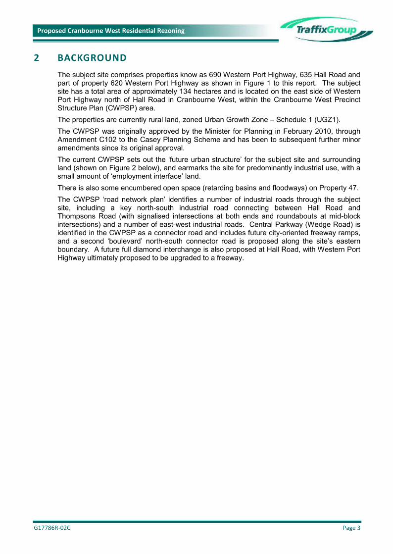
2 BACKGROUND
The subject site comprises properties know as 690 Western Port Highway, 635 Hall Road andpart of property 620 Western Port Highway as shown in Figure 1 to this report. The subjectsite has a total area of approximately 134 hectares and is located on the east side of WesternPort Highway north of Hall Road in Cranbourne West, within the Cranbourne West PrecinctStructure Plan (CWPSP) area.The properties are currently rural land, zoned Urban Growth Zone – Schedule 1 (UGZ1).The CWPSP was originally approved by the Minister for Planning in February 2010, throughAmendment C102 to the Casey Planning Scheme and has been to subsequent further minoramendments since its original approval.The current CWPSP sets out the ‘future urban structure’ for the subject site and surroundingland (shown on Figure 2 below), and earmarks the site for predominantly industrial use, with asmall amount of ‘employment interface’ land.There is also some encumbered open space (retarding basins and floodways) on Property 47.The CWPSP ‘road network plan’ identifies a number of industrial roads through the subjectsite, including a key north-south industrial road connecting between Hall Road andThompsons Road (with signalised intersections at both ends and roundabouts at mid-blockintersections) and a number of east-west industrial roads. Central Parkway (Wedge Road) isidentified in the CWPSP as a connector road and includes future city-oriented freeway ramps,and a second ‘boulevard’ north-south connector road is proposed along the site’s easternboundary. A future full diamond interchange is also proposed at Hall Road, with Western PortHighway ultimately proposed to be upgraded to a freeway.

G17786R-02C Page 4
Proposed Cranbourne West Residen�al Rezoning
Figure 2 shows the current CWPSP ‘future urban structure’ plan.
Figure 2: CWPSP - Urban Structure

G17786R-02C Page 5
Proposed Cranbourne West Residen�al Rezoning
3 PROPOSED ALTERNATIVE PSP
The proposal is to change the applied zone under the existing PSP from Commercial 2 toGeneral Residential to facilitate residential rather than industrial development between HallRoad and Central Parkway, as proposed by the CWPSP. The proposed alternative urbanstructure is shown in Figure 3 below.
Figure 3: Proposed Concept Plan

G17786R-02C Page 6
Proposed Cranbourne West Residen�al Rezoning
4 TRAFFIC VOLUME CHANGES
4.1 Traffic Genera�on AssessmentsIn order to assess the potential traffic impacts of the proposed change to the PSP onthe surrounding road network within the CWPSP area, we have undertaken acomparison assessment of industrial versus residential development of the site.We note that detailed traffic modelling of the CWPSP area was undertaken by GTAConsultants in February 2009 on behalf of Casey Council, to inform the PSP andDevelopment Contributions Plan (DCP). The GTA modelling utilised the MelbourneIntegrated Transport Model (MITM) software.The MITM model adopted the following traffic generation rates:▪ Industrial and Employment Interface: 4.7 trips per job per day▪ Residential:6.8 trips per dwelling per dayAs part of the CWPSP process, Traffix Group reviewed the GTA traffic assessmentsand modelling inputs on behalf of various landowners, and noted the following:▪ The traffic generation rate modelled by the MITM model for industrial and
employment interface uses was approximately 25% lower than the agreed ‘firstprinciples’ rate. One key implication of this is that in our opinion the north-southindustrial road needed to be constructed as a four-lane industrial road (twolanes each way), not a two-lane road, in particular noting the need to separatethe industrial traffic away from the north-south boulevard ‘interface’ road.
▪ The traffic generation rate modelled by the MITM model for residential use issignificantly lower than is currently used in planning for nearby areas, howeverschool and shop trips have been separately counted in the MITM model,whereas the majority of demand for these uses is likely to come from internalresidential areas within the PSP area. When adding the residential, retail andschool trips together, they equate to an average of 9.1 vehicle trip-ends perhousehold per day which is consistent with our experience.
For consistency, we have adopted the same traffic generation rates as used in theMITM model.Industrial UseThe net developable area of the subject site (excluding open space) is 119.23hectares.The MITM model adopted a ratio of 33.9 jobs per net developable hectare for theindustrial land, which corresponds to approximately 4,042 jobs which have beenassumed to be provided on the subject site in the supporting analysis for the CWPSP.At a rate of 4.7 trips per job, this equates to a total traffic generation for the subject siteof 18,997 vehicles per day (vpd).

G17786R-02C Page 7
Proposed Cranbourne West Residen�al Rezoning
Residential UsePreliminary yield analysis for the development of the subject site for residentialpurposes indicates that the site may be able to accommodate in the order of 1,837dwellings, with an average lot size of 393m2.At the MITM model rate of 6.8 vehicle trip-ends per dwelling per day, this equates to atotal traffic generation for the subject site of 12,492 vpd.Traffic Generation SummaryBased on the MITM model rates, by changing the subject site land use from industrialto residential, there is anticipated to be a reduction in the order of 6,505 vpd on theroad network. This reduction in traffic generated by the site will have flow-on benefits,including reduced congestion on Western Port Highway (future freeway).
4.2 Traffic Distribu�on AssessmentsIndustrial UseTraffix Group previously undertook traffic distribution and impact assessments forindustrial development of the subject site, and adopted the following traffic distributionassumptions:▪ 13.8% of daily traffic in the AM peak hour and 15.8% of daily traffic in the PM
peak hour, based on the distribution profile in Table 3.4 of the RTA Guide toTraffic Generating Developments (2002) (RTA Guide),
▪ 80% of traffic entering the site and 20% exiting the site during the AM peakhour, with the reverse distribution in the PM peak hour,
▪ 70% of traffic to/from the north and 30% of traffic to/from the south, and▪ during the road network peak hour, 3% commercial vehicles (CV).Residential UseFor the purposes of estimating the traffic distribution for the proposed residential use,the following assumptions have been adopted:▪ 10% of daily traffic occurring during the road network peak hours,▪ 30% of traffic entering the site and 70% exiting the site during the AM peak
hour,▪ 60% of traffic entering the site and 40% exiting the site during the PM peak
hour, and▪ 70% of traffic to/from the north and 30% of traffic to/from the south.Traffic Distribution SummaryTable 1 below sets out a comparison between the industrial and residential trafficdistribution for the subject site during the road network peak hours, based on thepreceding assumptions.

G17786R-02C Page 8
Proposed Cranbourne West Residen�al Rezoning
Table 1: Traffic Distribution Comparison
MovementAM Peak PM Peak
Industrial Residen�al Difference Industrial Residen�al Difference
Out to North 367 vph 612 vph + 245 vph 1,681 vph 350 vph - 1,331 vph
In from North 1,468 vph 262 vph - 1,206 vph 420 vph 525 vph + 105 vph
Out to South 157 vph 262 vph + 105 vph 720 vph 150 vph - 570 vph
In from South 629 vph 112 vph - 517 vph 180 vph 225 vph + 45 vph
TOTAL 2,621 vph 1,248 vph - 1,373 vph 3,001 vph 1,250 vph - 1,751 vph
4.3 Traffic ImpactsTable 1 indicates the following:▪ significant reduction in traffic entering the site in the AM peak,▪ minor increase in traffic exiting the site in the AM peak,▪ minor increase in traffic entering the site in the PM peak,▪ significant reduction in traffic exiting the site in the PM peak, and▪ an overall net reduction of up to 1,373 vehicles on the surrounding road network
during the AM peak hour and an overall net reduction of up to 1,751 vehicles onthe surrounding road network during the PM peak hour for residential usecompared with industrial use.
In addition, it is noted that the type of traffic generated by the site under the proposedresidential is more compatible with the surrounding land, in particular the land to theimmediate east of the site, being residential in nature. Conversely, under the currentPSP land use for the site, there would be potential for a high volume of commercialvehicle traffic generated by the subject site to travel through the surrounding residentialroad network.

G17786R-02C Page 9
Proposed Cranbourne West Residen�al Rezoning
4.4 Internal Road NetworkFigure 4 below shows the current CWPSP road network plan for the subject site andsurrounding properties.
Figure 4: CWPSP Plan 13 – Road Network
We note that the road layout could be retained, exactly as shown in the PSP, with the‘orange’ industrial roads within the subject site changed to local residential accessstreets.
The proposed MasterPlan concept at Figure 3 above effectively adopts the existinginternal road network.
Key differences between the MasterPlan concept layout compared with the PSP roadlayout for the subject site are as follows:
▪ no need for the wide industrial north-south road through the centre of thesubject site (we note that our previous assessments indicated that this needed
Subject Site

G17786R-02C Page 10
Proposed Cranbourne West Residen�al Rezoning
to be an industrial road with two lanes in each direction so as to accommodatethe industrial development of the subject site without placing high levels ofindustrial traffic on the north-south boulevard connector road along the easternboundary of the site, which shares residential frontage),
▪ an internal “mid-block” north-south connector standard road could satisfy trafficdemands for the residential concept,
▪ the function of the currently planned north-south boulevard connector roadlocated at the eastern boundary of the site would be simplified as it would nolonger split industrial and residential land uses,
▪ the MasterPlan concept proposes no change to roads outside of the subjectsite.
The proposed change to the applied zoning under the PSP in relation to the subjectsite will substantially reduce the potential for conflict between industrial traffic and theCranbourne West residential area. The proposed residential extension to the existingCranbourne West neighbourhood will generate compatible residential traffic on theeast-west roads within the subject site which connect directly (via cross-intersections)to the residential land to the east.

G17786R-02C Page 11
Proposed Cranbourne West Residen�al Rezoning
5 CURRENTLY ENVISAGED WORKS
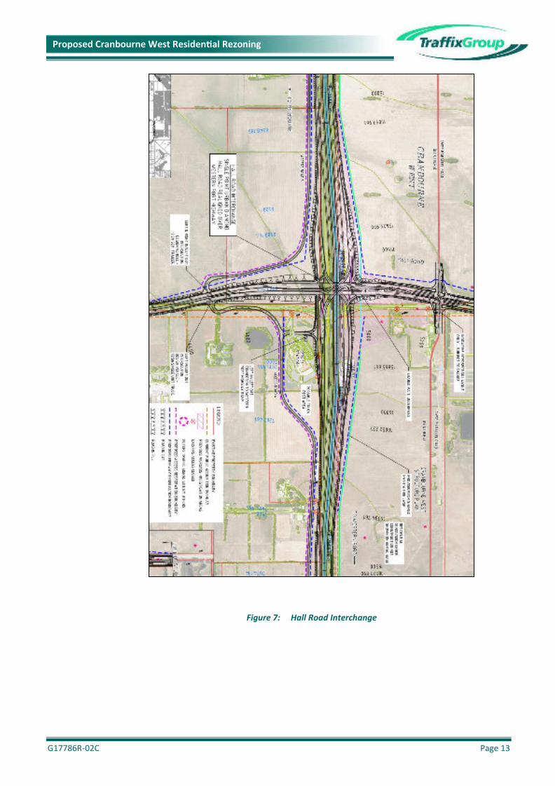
5.1 Western Port Highway UpgradeDetails of the proposed Western Port Highway upgrade designs are available onVicRoads’ web site. In particular, interchanges are proposed at Thompsons Road,Central Parkway (Wedge Road) and Hall Road in the vicinity of the site. Therespective interchange layouts are presented in Figures 5, 6 & 7 below.
Figure 5: Thompsons Road Interchange

G17786R-02C Page 12
Proposed Cranbourne West Residen�al Rezoning
Figure 6: Central Parkway (Wedge Road) Interchange
G17786R-02C Page 13
Proposed Cranbourne West Residen�al Rezoning
Figure 7: Hall Road Interchange

G17786R-02C Page 14
Proposed Cranbourne West Residen�al Rezoning
5.2 DCP ImpactsThe Development Contributions Plan (DCP) for the Cranbourne West PSP arearequires that all internal roads and intersections are to be funded by the developer (orshared by adjacent developers where intersection treatments are on the boundarybetween two properties), and are not DCP items. Accordingly the proposed change tothe internal road network and intersections within the site does not have any adversecost implications for adjacent land.
The DCP includes a number of road and intersection infrastructure projects which thesubject site and surrounding land are required to contribute towards.The projects proximate to the site are detailed on Figure 8 below as follows:
▪ RD01: Signalised Intersection – intersection of Thompsons Road and EvansRoad
▪ RD02a: Interim 2 lane roundabout intersection of Hall Road and Evans Road
▪ RD02b: Road connection/signalisation at Cranbourne-Frankston Road frominterim 2 lane roundabout at intersection of Hall Road and Evans Road
▪ RD03: Pedestrian Operated Signals on Evans Road (near Montrose Way)
▪ RD04: Land for Evans Road widening▪ RD05: Land for Hall Road widening▪ RD06: Hall Road bridge and culvert▪ RD07: Central Parkway Extension▪ RD08: Urbanisation of Evans Road▪ RD09: Urbanisation of Hall Road▪ RD10: Volk Road extension▪ RD11: North-south residential collector road extension▪ RD12: Land for Missens Road widening▪ RD13: Construction of Missens Road▪ RD14: Construction of signalised intersection at Thompsons & Missens Roads

G17786R-02C Page 15
Proposed Cranbourne West Residen�al Rezoning
Figure 8: DCP Road Projects

G17786R-02C Page 16
Proposed Cranbourne West Residen�al Rezoning
6 IMPACT OF PROPOSED CHANGES
The DCP notes that … ‘the infrastructure included in it is directly required to service the widerdevelopment of the area. However infrastructure that relates specifically to the needs of anindividual developer has not been included in the DCP’. Items of this nature include localroads, collector roads and intersections with arterial roads.
A number of properties within the Cranbourne West PSP area have been or are currently inthe process of being developed and accordingly some DCP funds have already beencollected, and some of the DCP road projects have already been funded/delivered through theDCP process.
We note that if the subject site is developed for residential purposes, all of the road projectslisted in the DCP are still required and thus the proposed change to the PSP would not impactupon the road related projects in the DCP.
Overall, the traffic generated by the proposed residential zoning of the land (and the impacts,including heavy vehicle impacts) will be less than was assumed for the purposes of preparingsupporting documents for the DCP (which was based on the subject site being industrialdevelopment), and accordingly no additional road infrastructure items are required external tothe site as a result of the proposed change to the PSP.
We note that the DCP does not allow for ‘ultimate’ construction of Hall Road, Evans Road andThompsons Road intersections. The DCP provides ‘interim’ treatments as well as the landcomponent for ultimate treatments, with the construction of ultimate treatments being theresponsibility of the road authority, taking into account external through traffic demands notattributable to the Cranbourne West PSP area.
By changing the zoning of the subject site from industrial to residential, with correspondingreduced traffic volumes contributing to the surrounding arterial road network and intersectionsfrom the subject site (including substantially reduced truck traffic volumes), the ultimate arterialroad duplication and intersection treatments may be able to be delayed for some years.

G17786R-02C Page 17
Proposed Cranbourne West Residen�al Rezoning
7 CONCLUSIONS
Having undertaken traffic engineering assessments of the proposed rezoning, we are of theopinion that: -(a) based on the traffic generation rates adopted in MITM model, residential development
of the land would generate in the order of 6,505 fewer vehicle trip-ends per day on thesurrounding road network, compared with industrial development of the land,
(b) there will be an overall net reduction in the order of 1,373 and 1,751 vehicle trip-endson the surrounding road network during the AM and PM peak hours respectively,
(c) there will be substantially less heavy vehicle traffic generated by the site under theresidential development scenario compared with industrial development of the land,with the type of traffic generated by the proposed residential development of the sitebeing more compatible with the surrounding land uses, particularly the residential landto the immediate east of the site,
(d) the reduced traffic generated by the site under the ‘residential’ scenario will have flow-on benefits, including reduced congestion on Western Port Highway (future freeway),
(e) all of the road infrastructure projects included in the Cranbourne West DCP will berequired regardless of whether the subject site is developed for industrial or residentialpurposes, and the proposed residential development of the subject site does notincrease the scope or costs of any of the DCP road projects,
(f) no additional road infrastructure items are required external to the site as a result of theproposed residential development,
(g) as a result of changing the site from industrial to residential zoning, the ultimate arterialroad duplication and intersection treatments may be able to be delayed for some years,
(h) the proposed concept layout demonstrates that an efficient road network layout withinthe subject site can be achieved which also responds to the adjacent residential area.
(i) There would no longer be a need for the wide industrial north-south road connectingfrom Hall Road up to Thompsons Road through the centre of the site, and
(j) there are traffic engineering benefits if the subject site were to be residential rather thanindustrial development.

Prop
osed
Develop
men
tPlans

Subject Site
Related Documents