ENVIRONMENTAL ASSESSMENT LAKE PLEASANT REGIONAL PARK AGUA FRIA CONSERVATION AREA MANAGEMENT PLAN Maricopa and Yavapai Counties, Arizona U.S. Department of the Interior Bureau of Reclamation Phoenix Area Office, Lower Colorado Region January 2010

Welcome message from author
This document is posted to help you gain knowledge. Please leave a comment to let me know what you think about it! Share it to your friends and learn new things together.
Transcript

ENVIRONMENTAL ASSESSMENT
LAKE PLEASANT REGIONAL PARK AGUA FRIA CONSERVATION AREA MANAGEMENT PLAN Maricopa and Yavapai Counties, Arizona
U.S. Department of the Interior Bureau of Reclamation Phoenix Area Office, Lower Colorado Region January 2010

Mission Statements
The mission of the Department of the interior is to protect and provide access to our Nation’s natural and cultural heritage and honor our trust responsibilities to Indian
Tribes and our commitments to island communities.
The mission of the Bureau of Reclamation is to manage, develop, and protect water and related resources in an environmentally and economically sound manner in the
interest of the American public.
AGUA FRIA CONSERVATION AREA MANAGEMENT PLAN ENVIRONMENTAL ASSESSMENT
TABLE OF CONTENTS
TABLE OF CONTENTS................................................................................................................. i ABBREVIATIONS and ACRONYMS .......................................................................................... iii UNIT CONVERSION GUIDE ....................................................................................................... iv 1.0 PURPOSE AND NEED ..................................................................................................... 1
1.1 Introduction ..................................................................................................................... 1 1.2 General Background ....................................................................................................... 4 1.3 AFCA Background .......................................................................................................... 5 1.3 Purpose and Need .......................................................................................................... 8 1.4 Location .......................................................................................................................... 9 1.5 Public Involvement and Scoping .................................................................................... 9
2.0 DESCRIPTION OF ALTERNATIVES .............................................................................. 12
2.1 No Action ...................................................................................................................... 12 2.2 Proposed Action, or the “Partners’ Consensus Plan” ................................................... 12 2.3 Minimum Development Alternative ............................................................................... 19 2.4 Alternatives Considered but Eliminated from Further Evaluation ................................. 19
3.0 DESCRIPTION OF THE AFFECTED ENVIRONMENT, AND ENVIRONMENTAL
CONSEQUENCES OF THE PROPOSED PROJECT .................................................... 22 3.1 Climate and Air Quality ................................................................................................. 23 3.2 Water Resources .......................................................................................................... 29 3.3 Biological Resources .................................................................................................... 36 3.4 Land Ownership and Use ............................................................................................. 48 3.5 Socioeconomic Resources ........................................................................................... 54 3.6 Cultural Resources ....................................................................................................... 59 3.7. Resources Considered But Not Affected ...................................................................... 64
4.0 ENVIRONMENTAL LAWS AND DIRECTIVES CONSIDERED ...................................... 65 5.0 AGENCIES AND PERSONS CONSULTED ................................................................... 69 6.0 LITERATURE CITED ...................................................................................................... 70
January 2010 i
AGUA FRIA CONSERVATION AREA MANAGEMENT PLAN ENVIRONMENTAL ASSESSMENT
FIGURES 1. General Location Map ........................................................................................................... 2 2. Lake Pleasant Regional Park, with Agua Fria Conservation Area ......................................... 3 3. Management Plan Components .......................................................................................... 16 4. South Side Route Alternative Eliminated from Further Consideration ................................. 20 5. Visitor Population and Lake Pleasant Bald Eagle Closure Violations.................................. 45 TABLES 1. National Ambient Air Quality Standards .............................................................................. 24 2. North Maricopa County Air Quality Data for 2008 ............................................................... 26 3. Estimated Ozone Precursor Emissions from Construction-Related Activities, Phase 1 ...... 27 4. Water Quality Agua Fria River and Lake Pleasant-Selected Constituents 2009 ................. 33 5. Fish Collected in Lake Pleasant 1987 - 2004 ...................................................................... 41 6. Productivity of the Lake Pleasant Bald Eagle Breeding Area .............................................. 43 7. Lake Pleasant Regional Park Visitation for Years 2005, 2006, 2007, and 2008 ................. 50 8. Arizona, Maricopa and Yavapai Counties Population Change 1990 - 2000 ........................ 54 9. 2000 and 2007 Populations for Targeted Communities in the Project Area ........................ 55 10. Historic and Projected Populations, Targeted Communities ............................................... 55 11. Minority and Low Income Populations for Targeted Communities ...................................... 56 12. Economic Attributes for Targeted Communities in Maricopa and Yavapai Counties .......... 57 13. 2001 Fish and Hunting Related Spending in Arizona .......................................................... 57 APPENDICES A. Recreation Opportunity Spectrum – Class Description Definitions and Example B. Air Emissions – Assumptions and Calculations C. Common Species Found at Lake Pleasant Regional Park D. Fish and Wildlife Service Concurrence Letter
January 2010 ii

AGUA FRIA CONSERVATION AREA MANAGEMENT PLAN ENVIRONMENTAL ASSESSMENT
ABBREVIATIONS and ACRONYMS ADEQ Arizona Department of Environmental Quality ADOC Arizona Department of Commerce ADWR Arizona Department of Water Resources AFCA Agua Fria Conservation Area AGFD Arizona Game and Fish Department amsl above mean sea level ASLD Arizona State Land Department B-H RMP Bradshaw-Harquahala Resource Management Plan BLM Bureau of Land Management bls below land surface CAP Central Arizona Project CAWCS Central Arizona Water Control Study CO carbon monoxide County Maricopa County EA environmental assessment EO Executive Order EPA U.S. Environmental Protection Agency ESA Endangered Species Act F Fahrenheit FR Federal Register I-17 Interstate Highway 17 LOC Levels of acceptable change LPMP Lake Pleasant Master Recreation Plan LPRP Lake Pleasant Regional Park MAG Maricopa Association of Governments MCPRD Maricopa County Parks and Recreation Department MCSO Maricopa County Sheriff's Office mg/L milligrams per liter MWD Maricopa County Municipal Water Conservation District #1 NAAQS National Ambient Air Quality Standards NEPA National Environmental Policy Act NHPA National Historic Preservation Act OHV off-highway vehicle P.L. Public Law PM10 particulate matter with a diameter of 10 microns or less PM2.5 particulate matter with a diameter of 2.5 microns or less RAMP Recreation Area Management Plan Reclamation Bureau of Reclamation USGS U.S. Geological Survey WRCC Western Regional Climate Center
January 2010 iii

AGUA FRIA CONSERVATION AREA MANAGEMENT PLAN ENVIRONMENTAL ASSESSMENT
January 2010 iv
UNIT CONVERSION GUIDE
For the reader’s convenience, the following table has been included to serve as a guide in converting measurements found in this document between U.S. measurements and metric.
CONVERSION OF U.S. TO METRIC MEASUREMENTS
U.S. Measurement Metric Measurement
DISTANCE
1 inch 2.54 centimeters
1 foot 0.31 meter
1 mile 1.61 kilometers
AREA
1 square foot 0.09 square meter
1 acre 0.41 hectare
CONVERSION OF METRIC TO U.S. MEASUREMENTS
Metric Measurement U.S. Measurement
DISTANCE
1 centimeter 0.39 inch
1 meter 3.28 feet
1 kilometer 0.62 mile
AREA
1 square meter 10.76 square feet
1 hectare 2.47 acres
AGUA FRIA CONSERVATION AREA MANAGEMENT PLAN ENVIRONMENTAL ASSESSMENT
1.0 PURPOSE AND NEED
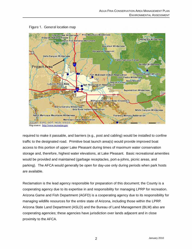
1.1 Introduction Lake Pleasant Regional Park (LPRP) encompasses approximately 23,361 acres of land located
in Maricopa and Yavapai counties, Arizona, and includes Lake Pleasant, a man-made reservoir
formed by New Waddell Dam (Figure 1). The land is owned by the Bureau of Reclamation
(Reclamation), and operated as a regional park by the Maricopa County Parks and Recreation
Department (MCPRD) under a 1990 Recreational Management Agreement (1990 Agreement;
Reclamation 1990) between Reclamation and Maricopa County (County). Consistent with
requirements of the 1990 Agreement, MCPRD developed a Lake Pleasant Master Plan (LPMP;
Cella Barr 1995) that was approved by Reclamation.1 The LPMP established guidelines for
developing LPRP and outlined future desired conditions for, among other things, recreation and
resource protection. MCPRD is now proposing to amend the LPMP by incorporating a
management plan for the Agua Fria Conservation Area (AFCA). Under the amendment to the
LPMP, MCPRD would designate a road, develop certain improvements, and implement a higher
level of management oversight within the AFCA. Under the terms of the 1990 Agreement,
Reclamation must approve any amendments to the LPMP; therefore, prior to approving this
amendment, Reclamation must comply with the National Environmental Policy Act (NEPA),
Endangered Species Act (ESA), and National Historic Preservation Act (NHPA), and other
applicable environmental rules and regulations, including recent amendments to the Department
of the Interior’s regulations for implementing NEPA (73 Federal Register [FR] 61292;
October 15, 2008).
This environmental assessment (EA) has been prepared to describe and assess the
environmental consequences that are likely to result from implementing the proposed
Management Plan for the AFCA. The AFCA is located in the north-easternmost portion of
LPRP, in Maricopa and Yavapai counties, Arizona (Figure 2). It is isolated from more developed
areas of LPRP by rugged terrain, and presently contains no recreational improvements.
Currently, minimal to no staff presence is provided to this area of LPRP. In recent years,
conditions within the AFCA have degraded to the point where public health and safety concerns
have become relevant issues. Under the proposed management plan, Table Mesa Road would
be designated as a low maintenance park road. It would be maintained only to the degree
1 In 1997, Reclamation prepared an EA on the LPMP and issued a FONSI, before approving the LPMP (Reclamation 1997).
January 2010 1
AGUA FRIA CONSERVATION AREA MANAGEMENT PLAN ENVIRONMENTAL ASSESSMENT
required to make it passable, and barriers (e.g., post and cabling) would be installed to confine
traffic to the designated road. Primitive boat launch area(s) would provide improved boat
access to this portion of upper Lake Pleasant during times of maximum water conservation
storage and, therefore, highest water elevations, at Lake Pleasant. Basic recreational amenities
would be provided and maintained (garbage receptacles, port-a-johns, picnic areas, and
parking). The AFCA would generally be open for day-use only during periods when park hosts
are available.
Reclamation is the lead agency responsible for preparation of this document; the County is a
cooperating agency due to its expertise in and responsibility for managing LPRP for recreation.
Arizona Game and Fish Department (AGFD) is a cooperating agency due to its responsibility for
managing wildlife resources for the entire state of Arizona, including those within the LPRP.
Arizona State Land Department (ASLD) and the Bureau of Land Management (BLM) also are
cooperating agencies; these agencies have jurisdiction over lands adjacent and in close
proximity to the AFCA.
January 2010 2

AGUA FRIA CONSERVATION AREA MANAGEMENT PLAN ENVIRONMENTAL ASSESSMENT
Figure 2. Lake Pleasant Regional Park, with Agua Fria Conservation Area
January 2010 3

AGUA FRIA CONSERVATION AREA MANAGEMENT PLAN ENVIRONMENTAL ASSESSMENT
1.2 General Background The original Waddell Dam, which formed Lake Pleasant, was built between 1925 and 1927 by a
company that is now the Maricopa County Municipal Water Conservation District #1 (MWD). In
1969, an operating agreement was signed by MWD and the County, under which Lake Pleasant
and the area around it would be managed by the County as a regional park (Cella Barr 1995).
The Colorado River Basin Project Act of 1968 (Public Law [P.L.] 90-537) authorized
Reclamation to develop and build the Central Arizona Project (CAP).2 Section 301(a)(3) of that
Act addressed storage and regulated delivery of CAP water, and flood control of the Salt and
Gila Rivers through the Phoenix, Arizona, metropolitan area. This aspect of the Act was called
the CAP Regulatory Storage Division. During the planning phase for the CAP Regulatory
Storage Division, Reclamation also was authorized under the 1978 Reclamation Safety of Dams
Act (P.L. 95-578) to conduct dam safety-related studies at some of the same facilities involved in
the CAP study. The two projects were combined into a comprehensive effort called the Central
Arizona Water Control Study (CAWCS).
One of the objectives of the CAWCS was to develop a means of increasing operating efficiency
of the CAP through conservation of local surface waters and regulation of Colorado River water
deliveries from the CAP canal system. To meet that objective, Reclamation proposed
constructing a new and higher Waddell Dam about ¼ mile downstream of the original Waddell
Dam, primarily to store Colorado River water for CAP use, and to provide incidental flood control
on the Agua Fria River. Because the New Waddell Dam would result in higher lake levels that
would inundate the majority of the recreational facilities at Lake Pleasant, the CAWCS
recognized these facilities would need to be replaced. Under authority of the Federal Water
Project Recreation Act of 1965 (P.L. 89-72), Reclamation also was able to consider
opportunities to enhance recreational development at the future expanded Lake Pleasant. As
part of the CAWCS planning process, Reclamation coordinated with the County’s Recreation
Services (now MCPRD) and others to develop a conceptual recreational development plan for
Lake Pleasant.
Reclamation prepared the CAP Regulatory Storage Division Final Environmental Impact
Statement (EIS) which included the New Waddell Dam feature as part of an alternative referred
2 The primary purpose of the CAP is to provide water for irrigation, and municipal and industrial uses, in central and southern Arizona and western New Mexico, through importation of Colorado River water and conservation of local surface waters.
January 2010 4
AGUA FRIA CONSERVATION AREA MANAGEMENT PLAN ENVIRONMENTAL ASSESSMENT
ake
to as “Plan 6.”3 Plan 6 was identified as the Agency-Proposed Action in the Final EIS. The
Final EIS envisioned there would be four reservoir-oriented recreation developments at L
Pleasant, all on the western shore of the reservoir. The EIS concluded the effects on reservoir
recreation would be beneficial, due primarily to the increased water surface area of the lake
(Reclamation 1984a). A more detailed description of the conceptual recreation plan for the New
Waddell Dam feature was included in a technical appendix to the Final EIS (Appendix C)
(Reclamation 1984b). This appendix identified existing LPRP recreational facilities that would
need to be replaced and recreational enhancements that could be developed at the LPRP.
Recognizing the limited accessibility to the north and east sides of the reservoir, the conceptual
recreation plan recommended preserving the north and east portions of the LPRP as limited
development areas.
A Record of Decision was signed by the Secretary of the Interior on April 3, 1984, approving
implementation of Plan 6. Among other things, the Record of Decision included construction of
New Waddell Dam for storage of CAP water, flood control, and recreation (Reclamation 1984c).
In 1985, Reclamation initiated construction of New Waddell Dam downstream of the original
Waddell Dam. The major structural features were completed in 1992, and the original Waddell
Dam was breached. Lake Pleasant reached its new maximum water conservation storage pool
elevation of 1,702 feet above mean sea level (amsl) in Spring 1994.
1.3 AFCA Background As mentioned above, Reclamation and the County entered into the 1990 Contract under which
the County agreed to manage recreation at LPRP. MCPRD later hired Cella Barr Associates to
develop the LPMP. The LPMP established guidelines for development of the expanded LPRP,
based upon the initial conceptual plan developed during the CAWCS and described in Appendix
C of the Plan 6 EIS (Cella Barr 1995). In 1997, Reclamation completed a final EA that
compared the impacts anticipated to result from implementation of the County’s LPMP with
those described as part of Plan 6. The purpose of that EA (Reclamation 1997), which was
programmatic in nature, was to address the degree to which implementation of the County’s
LPMP would result in environmental impacts that are different from what was originally
3 Plan 6 originally included construction of New Waddell Dam on the Agua Fria River to provide regulatory storage of CAP water, flood control, and recreation; modification of Roosevelt Dam on the Salt River to provide flood control, water conservation, recreation, and dam safety; modification of Stewart Mountain Dam on the Salt River to ensure its safety; and construction of Cliff Dam on the Verde River to provide flood control and water conservation, and for dam safety purposes. Cliff Dam was subsequently eliminated from Plan 6.
January 2010 5

AGUA FRIA CONSERVATION AREA MANAGEMENT PLAN ENVIRONMENTAL ASSESSMENT
contemplated and described in the 1984 Final EIS on Plan 6. Reclamation determined a
Finding of No Significant Impact was appropriate for approval of the LPMP.
In addition to establishing guidelines for park development, the LPMP outlined future desired
conditions for, among other things, recreation and resource protection. The LPMP indicates
certain areas within the LPRP would be designated “conservation areas,” defined as “natural,
environmentally sensitive areas intended to remain relatively undisturbed to preserve the native
environment.” The LPMP identified several conservation areas, indicating these areas would
have relatively limited access and development; therefore, it was envisioned there would be
minimal operation and maintenance costs associated with these areas. One such conservation
area, the AFCA, contains about 2,405 acres; it was designated as a conservation area in
recognition of the special assemblages of natural and cultural resources that occurred there.
Recreational uses of the lake include fishing, picnicking and camping. Where these activities
occur in the developed areas of LPRP, the presence of facilities and enforcement staff direct the
behavior of park visitors. Recreational uses at the upper (northern) end of the lake, accessed
by Table Mesa Road, are generally unregulated. In late 2006, MCPRD and Reclamation
became concerned about destructive activities occurring within the AFCA. During October
2006, 32 tons of trash were removed from the AFCA and surrounding area; trash dumping
continues to be a problem. Unlawful shooting and off-highway vehicle (OHV) uses in the area
were creating an unsafe environment and causing damage to cultural resources, the desert, and
riparian areas in and adjacent to the AFCA.
In December 2006, Reclamation, MCPRD, and other agencies with resource and/or land
management responsibilities in the general vicinity met to discuss the current condition of the
AFCA. These agencies included AGFD, Maricopa County Sheriff’s Office (MCSO) and BLM.
ASLD also attended several initial meetings. These agencies (referred to as “the Partners”)
agreed the AFCA had become an area where shooting, trash dumping, off-road vehicle travel,
vandalism, and criminal activity were degrading cultural and natural resources and creating a
public hazard. The Partners recognized the surrounding lands owned by ASLD and BLM also
were degrading, and that any management actions taken within the AFCA could affect these
adjacent lands as well. It became apparent that coordination among the Partners would be
needed to ensure protection of the area’s cultural and biological resources, and to maintain the
area as a viable and enjoyable recreational area.
January 2010 6

AGUA FRIA CONSERVATION AREA MANAGEMENT PLAN ENVIRONMENTAL ASSESSMENT
Interim Solution. Due to concerns raised both by the public at large and relevant public
agencies, about the increasing levels of unlawful activities occurring within the AFCA (e.g.,
dumping, shooting and off-road vehicle travel), the Partners met over the course of several
months in early to mid-2007. These meetings were focused on how best to address these
public safety issues. As an interim measure, the group agreed that enforcement of the existing
policy banning motorized vehicules within the AFCA needed to occur. Gates were installed at
the northernmost entrance to LPRP at Table Mesa Road, and a coordinated multiple-agency
public information effort was implemented to inform the public about the vehicle closure. The
vehicle closure became effective July 1, 2007; the AFCA continues to be accessible by foot,
bicycle, or horseback. MCPRD has continued to maintain the barricades and enforce the
vehicle restriction; however, vandalism of the gates has been a consistent problem, and
unlawful vehicle entry continues to occur, although to a much lesser degree.
Towards a Long-term Solution. The Partners agreed a long-term solution was needed for
managing the AFCA, which would allow controlled access and recreational opportunities for
responsible users while providing protection to the natural and cultural resources of the area.
Three public meetings were held in September 2007, to gather information about use of the
AFCA area including the constraints and benefits that could result from continued enforcement
of the motorized vehicle ban. Those attending the meetings indicated they wanted to see the
natural resources within the AFCA protected and restored; however, they also indicated
responsible users should be allowed to access the upper reaches of the lake from the north via
vehicles.
There was opposition to maintaining the gate closure at Table Mesa Road by fishing enthusiasts
that used this existing access to reach Lake Pleasant at the mouth of the river. When the
reservoir level is high and the Bald Eeagle closure is in effect (December 15 through June 15),
access to the mouth of the Agua Fria River is cut off from the reservoir itself. This area of the
reservoir is one of the best fishing spots (A. Jontz, pers. comm. 2007). Although it is a rugged
and primitive road, access into the AFCA from Table Mesa Road is oftentimes the most
convenient means of transporting a boat to this part of the reservoir.
Others attending these meetings indicated their desire for vehicle access into LPRP from Table
Mesa Road for kayaking, hiking, and bird-watching. Most acknowledged and/or echoed
concern for public safety and damage to this sensitive and relatively undeveloped area.
January 2010 7

AGUA FRIA CONSERVATION AREA MANAGEMENT PLAN ENVIRONMENTAL ASSESSMENT
Practically everyone agreed that increased agency presence and/or law enforcement was
needed to provide for public safety and protection against environmental damage.
1.3 Purpose and Need The purpose of the proposed project is to amend the LPMP to incorporate a management plan
for the AFCA. This management plan would provide visitors with watercraft access to the upper
portion of Lake Pleasant, when the water level is below (downstream of) existing launch areas
in the vicinity of the existing Table Mesa Road parking area, and access from the south is
blocked due to a Bald Eagle Closure. This would provide visitors with the opportunity to enjoy
recreating in a relatively undeveloped and natural setting within the AFCA, while ensuring
protection of the AFCA’s sensitive natural and cultural resources. This northernmost area of
LPRP has been visited for decades by many residents. Restricting motor vehicles from entering
the LPRP at the Table Mesa Road entrance makes the majority of the AFCA inaccessible to
those who cannot hike in, and also makes it impossible for boaters to access the upper portion
of Lake Pleasant during the Bald Eagle Closure.
Urbanization in central Arizona continues to expand, reducing opportunities for people seeking a
relatively natural and undeveloped outdoor recreation experience, especially in northern
Maricopa and southern Yavapai counties. As more pressure is placed upon all types of
recreational activities, it becomes even more important to protect and maintain these sensitive
and undeveloped areas. The proposed management plan would allow MCPRD to construct,
operate and maintain a defined level of recreational development that would enable the
recreating public to enjoy this type of natural setting while at the same time ensure there is
adequate agency presence and/or law enforcement oversight to protect the natural and cultural
resources within the AFCA.
Among other things, the 1990 Contract indicates any amendment to the LPMP requires a
written agreement between Reclamation and the County, provided such amendment does not
otherwise violate the terms of the 1990 Contract. In addition, amendments are subject to review
by Reclamation and any other entities Reclamation deems appropriate (Reclamation 1990).
Reclamation is preparing this EA to describe the environmental impacts that are anticipated to
occur as a result of approving the amendment to the LPMP to include the proposed AFCA
Management Plan, and the plan’s subsequent implementation.
January 2010 8

AGUA FRIA CONSERVATION AREA MANAGEMENT PLAN ENVIRONMENTAL ASSESSMENT
1.4 Location LPRP is located in northern Maricopa and southern Yavapai counties in central Arizona, about
30 miles northwest of downtown Phoenix (Figure 1). The AFCA is located in the northeastern
portion of LPRP (Figure 2). The boundary between Maricopa and Yavapai counties within the
AFCA generally follows the centerline of the Agua Fria River. The AFCA is typically reached by
Table Mesa Road, a County-designated primitive road which comes into the park from the east.
The AFCA also can and is accessed by vehicles from the west via a series of rugged dirt trails;
however, this access is against Park rules because these trails are not designated roads.
1.5 Public Involvement and Scoping Public Involvement. As mentioned above, three public meetings were held in September 2007
after the vehicle restrictions had been in effect for a while. The purpose of these public
meetings was to hear from the people who recreate in the AFCA, and obtain their input as the
Partners began the process of developing a long-term plan for managing the area.
At these meetings, the public expressed a desire for protection and restoration of the natural
resources within the AFCA, as well as access for responsible users of the area. However, the
commenters felt without increased oversight, especially additional agency and enforcement
presence, no changes should be made to the original recreation management plan for the
AFCA, and enforcement of the existing vehicle closure should continue. There was a
consensus that for the time being, the area should remain a conservation area with limited
access.
An issue raised by some agencies and the affected public was a desire to maintain vehicular
access along Table Mesa Road, mainly for fishing enthusiasts during the winter and spring.
This is when boat access to the upper portion of the lake from downstream is not allowed due to
a Bald Eagle Closure on the lake. During the Bald Eagle Closure, boat access to this popular
fishing spot is prevented by the vehicle closure. Maintaining partial vehicle access during this
time of year became the focus of much discussion.
The input obtained from these three public meetings, as well as a fourth public “wrap-up”
session in November 2007, was included for consideration in the development of the proposed
management plan.
January 2010 9
AGUA FRIA CONSERVATION AREA MANAGEMENT PLAN ENVIRONMENTAL ASSESSMENT
Scoping. MCPRD finalized the “Agua Fria Conservation Area Proposed Management Plan”
which presents the Partners’ Consensus Management Plan, as well as describes the process
by which it was developed. This is the preferred alternative for managing the AFCA.
Reclamation issued a notice of intent to prepare an environmental assessment for this proposed
project to the general public on January 21, 2008. A copy of this notice was made available on
the Phoenix Area Office’s website, www.usbr.gov/lc/phoenix on that day. A press release
notifying 16 news media also was issued.
On February 4, 2009, Reclamation held a public scoping meeting at the MCPRD Desert
Outdoor Center, at Lake Pleasant. Six members of the public attended, in addition to
representatives from MCPRD, Reclamation, and AGFD. After MCPRD provided a brief
description of the proposed management plan, members of the public were given an opportunity
to identify issues or concerns that should be addressed in the EA, and/or other alternatives that
should be considered. Fifteen written comment forms, letters, and e-mails were received during
the 31-day public scoping period.
The major comments, concerns, and/or issues identified during scoping that are addressed in
the EA include the following.
Alternatives:
• The EA should include a range of alternatives that consider varying components of the
proposed plan, to provide for a better comparison of options, including a cost analysis;
• The “open season” for the AFCA should coincide with the time during which fishing in
the upper Lake Pleasant is the best;
• The area should be open only during times when the water level is high enough to
launch boats from one of the proposed boat launches; and
• The Partners should consider an alternative that is similar to that used at Saguaro Lake
(e.g., combination locks on the entry gate, designated permitted users, fee system).
January 2010 10
AGUA FRIA CONSERVATION AREA MANAGEMENT PLAN ENVIRONMENTAL ASSESSMENT
January 2010 11
Issues:
• Identify potential impacts from the proposed plan on adjacent private property, the
Bradshaw Mountains Coalition trail plans, air quality, water quality, and the bald eagle
nesting area;
• Identify mitigation for damage to vegetation and water resources;
• Define the terms used in the proposed plan regarding “levels of acceptable change”
(LOC) and “substantial damage;”
• Describe how the proposed plan does or does not maintain the goal of “conservation
area” and how the proposed developments affect the purpose of the conservation area;
• Identify regulatory requirements related to air quality and water quality that apply to the
implementation of the plan;
• Describe the potential loss of economic benefit to surrounding communities if the area
remains closed; and
• Address the financial requirements for each part of the recommendations and how areas
would be patrolled and monitored effectively under the proposed plan.

AGUA FRIA CONSERVATION AREA MANAGEMENT PLAN ENVIRONMENTAL ASSESSMENT
2.0 DESCRIPTION OF ALTERNATIVES
This chapter describes the No Action alternative, the Proposed Action, and a Minimum
Development alternative. It also briefly describes other alternatives that were initially studied
but eliminated from further consideration.
2.1 No Action The No Action alternative describes the conditions that are assumed to exist into the future in
the absence of the proposed Federal action, and provides a basis for comparing the impacts
that are anticipated to result from implementing the Proposed Action. In the case of the AFCA,
under the No Action, no improvements would be made within the AFCA. Foot traffic would
continue to be allowed, but the vehicle restriction would remain in effect. No park host
compound would be installed; boat ramp(s), parking areas, restroom and picnicking amenities
would not be provided. Because the current vehicle prohibition would not be lifted, the portion
of Table Mesa Road inside the LPRP would not become a designated Park road, and no
physical barriers would be installed to restrict vehicles that might gain unlawful entry. The
existing level of MCPRD and enforcement presence would continue. Over time, it is anticipated
urbanization of the surrounding areas would result in increased pressure on the AFCA, resulting
in trespass into, and unrestricted use of, the AFCA and surrounding public lands. This is
expected to result in undesirable and unsafe conditions similar to or worse than those existing
when the current efforts were initiated to develop a management plan. Damage to the
environmental and cultural resources within and adjacent to the AFCA would continue. This
alternative would not meet the purpose and need for the proposed action.
2.2 Proposed Action, or the “Partners’ Consensus Plan” The proposed management plan is the culmination of a 26-month process that involved
gathering and considering public input from users of the AFCA, and developing a management
plan upon which all the Partner agencies—agencies having resource and/or land management
responsibilities in the area—could agree. This process is described in detail in the document,
“Agua Fria Conservation Area Proposed Management Plan” dated January 15, 2009, which was
made available on MCPRD’s website on January 20, 2009 (MCPRD 2009).
The proposed management plan consists of providing improvements within the AFCA, in three
phases as described below.
January 2010 12
AGUA FRIA CONSERVATION AREA MANAGEMENT PLAN ENVIRONMENTAL ASSESSMENT
Phase I:
• designate Table Mesa Road within the AFCA as a low maintenance park road, including
installation of barriers along the north and south sides of the portion of the road that
crosses the river, to keep the public from traveling off the designated route--the road would
be maintained with no permanent improvements and only to the level that makes it
passable, as determined by MCPRD;
• develop a park host compound and infrastructure to house two to four couples;
• construct a primitive parking lot and information kiosk at the entry;
• reinforce existing entry gates;
• construct a primary launch ramp at the high-water mark (elevation 1695 feet amsl);
• provide alternative launch ramps for use as the water level drops; and,
• provide parking, portable restrooms (dependent upon whether or not vendors would
service), picnic area and signage in areas of launch ramps.
Phase II:
• erect a portable structure to serve as a visitor contact station for visitors;
• construct a storage facility for maintenance equipment and vehicles; and,
• install port-a-johns, portable picnic tables, grills and fire rings at day-use areas.
Phase III:
• install a multi-agency entry station with offices including permanent restrooms;
• construct ramadas and covered picnic areas with limited recreational amenities near entry;
• provide, with minimal enhancements and improvements, an area for “pack it in, pack it out,”
permit-only camping (south of the Agua Fria River, near an old air strip);
• develop interpretive areas for archaeology, natural history, cultural history, etc.; and
January 2010 13
AGUA FRIA CONSERVATION AREA MANAGEMENT PLAN ENVIRONMENTAL ASSESSMENT
• complete the trails master plan to include multiple use of the AFCA.
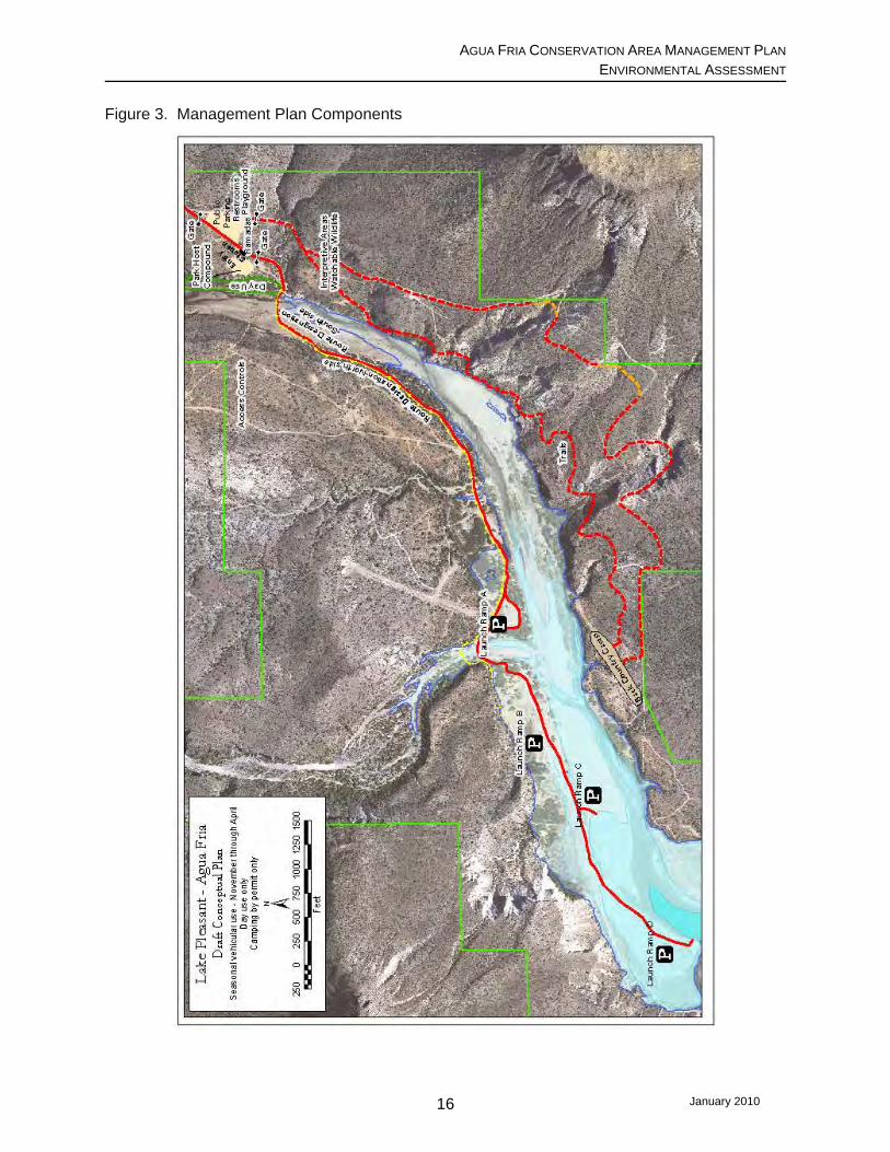
2.2.1. Improvements. Following is a brief description of the major components of the
proposed management plan and the types of activities that would be associated with them (see
Figure 3). Park Host Compound. A park host compound would be constructed to accommodate a
minimum of two, and potentially up to four, host sites, affecting up to three acres. A concrete
slab would be poured for each host site (25’ x 45’). Utilities (electricity, water, telephone and
septic) would be provided. Beyond the slab, a parking area would be cleared and covered with
decomposed granite. Each host site also would include shade structures, picnic table, grill,
mobile mini-storage unit for equipment, trash can or dumpster, and fencing.
Entry Station. An entry station would be established just inside the Park boundary off Table
Mesa Road. This station would include an area that is graded and fenced for public parking; the
parking area would be covered with decomposed granite. An information kiosk would be
installed, and port-a-johns and trash cans would be provided. The existing gates into the Park
would be reinforced and/or upgraded. In Phase II of the plan, a temporary portable visitors’
station would be installed, and a maintenance/storage building would be erected. In Phase III, a
permanent structure would replace the portable entry and would include joint agency offices and
restrooms connected to an onsite wastewater treatment system.
Table Mesa Road Designation. Table Mesa Road would officially be designated as a single
lane, low maintenance park road from the eastern boundary of the AFCA westward
approximately 2.5 miles, where it would dead-end. Pull-outs would be strategically located
along the road. No permanent improvements would be made to this road; improvements would
be made only to the degree needed to make it passable. Speed limit signs would be installed.
Vehicle barriers, such as pipe rail uprights with double strand cabling, would be installed on
either side of this designated road. Road signs also would be installed to direct travel and keep
vehicles on the designated route. Use of the road within the AFCA would be monitored to
determine if additional barriers are needed to keep vehicles on the designated road.
Boat Launch Ramps. A boat launch area (Launch Ramp A) would be established that coincides
with the top of conservation (highest water storage level) of Lake Pleasant at the mouth of the
January 2010 14

AGUA FRIA CONSERVATION AREA MANAGEMENT PLAN ENVIRONMENTAL ASSESSMENT
Agua Fria River, which is at approximately elevation 1695 feet amsl. This elevation is generally
reached in March. The ramp would be a maximum of 20 feet wide and would extend below the
conservation pool by 20 feet. A second alternate ramp also may be established at this boat
launch area; this ramp would be unimproved. The launch area would also include port-a-
john(s), picnic area, trash cans. If funding is available, the parking area at Boat Launch A also
could be graded and topped with decomposed granite.
Additional primitive launch areas would be established further west along Table Mesa Road, at
lower elevations (up to three more are contemplated: Launch Ramps B, C, and D), to provide
access to the Lake as the water level of the Lake recedes. These would be unimproved, with
route designations. Parking, port-a-john, and picnic areas would be provided at each launch;
these would be moved as waters recede or rise. If monitoring indicates the need, additional
barriers would be installed along this portion of Table Mesa Road.
Recreational Amenities. Basic recreational amenities such as picnic tables and grill/fire rings
would be provided in the Boat Launch A area. Near the entry, additional recreational amenities
for family or group gatherings would be provided, as well as playground components that blend
with the natural setting in Phase III (e.g., boulders for rock climbing).
Permit-Only Camping. A back-country camp area would be established on the south side of the
Agua Fria River near an old abandoned airfield strip; there would be minimal improvements
made. Campers would need to park their vehicles at the Table Mesa Road entrance to LPRP,
and “pack it in; pack it out; leave no trace.” This would be the only area within the AFCA that
would not be restricted to day-use only.
Interpretive Areas. Areas of special interest, such as archaeological and/or cultural sites of
importance or significance to the history or development of the area, or natural resources of
concern, would be developed into interpretive sites, for protection and educational purposes.
Trails. A trails plan would be developed by MCPRD. This plan would evaluate the appropriate
locations which would provide unique visual and wildlife experiences but also would protect
cultural resources. Trail(s) to cultural site(s) for interpretation would be considered. MCPRD
would follow its existing policies and guidelines regarding development of multi-use trails.
January 2010 15
AGUA FRIA CONSERVATION AREA MANAGEMENT PLAN ENVIRONMENTAL ASSESSMENT
Figure 3. Management Plan Components
January 2010 16
AGUA FRIA CONSERVATION AREA MANAGEMENT PLAN ENVIRONMENTAL ASSESSMENT
2.2.2. Operation and Management. MCPRD would implement the management guidelines
and enforce the specific operation restrictions identified in the proposed management plan.
Based upon comments received during scoping, the proposed plan has been modified to make
the “open season” flexible. The open season is when vehicle access into the AFCA would be
allowed. The majority of those commenting preferred an open season from January through
June; however, it would ultimately depend upon water elevations and the availability of park
hosts to staff the AFCA. These guidelines and restrictions are briefly described as follows.
Access into AFCA. The AFCA would be open for day-use only, with the exception of permit-
only camping, which would be initiated in Phase III. During the designated “open season,”
vehicles would be allowed into the AFCA when the AFCA is staffed with a minimum of two park
host teams, and the water level is at least at elevation 1,680 feet, but below the designated
Table Mesa Road crossing at the Agua Fria River (about elevation 1,702 feet). The lower
elevation allows access to the Boat Launch B, C, and D area; above elevation 1,702 feet, the
Table Mesa Road crossing of the Agua Fria would be inundated. Hosts would visit the parking
and launch areas along Table Mesa Road to educate visitors regarding LPRP and AFCA rules
and redirect them onto the designated road, as appropriate. When resident park hosts are not
present, entry to the AFCA may be allowed for day-use only if at least two formally MCPRD-
designated staff are available, and water elevations are between elevations 1,680 and 1,702
feet. This would be at MCPRD’s discretion; MCPRD would develop a public notification system
for informing the public when the AFCA Table Mesa Road entrance is open for visitation.
Services. Regularly scheduled trash pick-up would continue as is the current practice. Portable
restroom servicing would be dependent upon finding a willing vendor. Table Mesa Road would
be minimally maintained and only to a level to make it passable. Launch Ramp A and the
alternate unimproved ramp would be closed when water levels are too low. Launch Ramps B,
C, and D would be closed when water levels are too high for their safe use.
Monitoring. The Management Plan incorporates an adaptive management approach to
monitoring and evaluating the effect of implementing the Plan on the natural and cultural
resources within the AFCA. The adaptive management approach will enable resource
managers to determine how well management actions meet their objectives and whether or not
changes need to be made or additional steps are needed to modify activities to increase
successful management of the area, or improve protection of sensitive resources. Prior to
January 2010 17

AGUA FRIA CONSERVATION AREA MANAGEMENT PLAN ENVIRONMENTAL ASSESSMENT
implementing the Management Plan, staff would inventory and document baseline conditions of
the AFCA, to determine the Recreation Opportunity Spectrum (ROS) class description(s)4
currently found within the AFCA. In consultation with Reclamation and the Partners, MCPRD
would establish standards and limits of acceptable change using indicators such as the
following: access; remoteness; visual characteristics; site management; visitor management;
social encounters; and visitor impacts. MCPRD staff would then monitor the AFCA on an
ongoing basis and document any changes to these indicators which result from implementing
the Management Plan. An annual review of the AFCA area would be conducted by a Resource
Management Team comprised of MCPRD, Reclamation and AGFD staff. Should the team
determine that the limits of acceptable change have been exceeded, the Resource
Management Team would determine what, if any, adaptations or changes should be
recommended to achieve the initial goals established for the plan, or to further refine the
management plan to determine additional steps to be undertaken to achieve the objectives of
the plan. All recommendations from the Resource Management Team would be presented to
and evaluated by the MCPRD Director, in concert with Reclamation’s Phoenix Area Office
Manager, for approval and implementation. In addition, MCPRD would coordinate with MCSO
and AGFD on law enforcement activities in the area. If problems with unlawful use are noted,
MCPRD would ensure proper action is taken to mitigate the issue.
Funding/Resources. Funding would be required to construct and maintain the improvements
envisioned in this proposed plan. The construction of the developments included in the
proposed management plan is phased in recognition of limited resources and to provide
flexibility in utilizing known funding opportunities.
Funding is currently available for constructing the boat access and related improvements
through the AGFD Boating Access Program, which utilizes Federal boating access grants.
4 ROS is a classification system in which the type (or class) of existing or desired recreational experience is defined along a continuum (or spectrum) ranging from a very primitive setting with little or no facilities, to a highly urbanized and developed setting with high concentrations of people and activities. ROS planning guidelines were developed by the U.S. Department of Agriculture, Forest Service (FS), for use in recreational planning on the various national Forests. Although less suited for smaller tracts of land at the state and county levels (Bulmer et al. 2002), the ROS class descriptions are used in this document as a tool for discussing the monitoring aspect of the management plan, with respect to the level of acceptable change that will be considered. See Appendix A for definitions of the ROS class descriptions and an example of a ROS that was modified and tailored to fit site-specific planning of a unique area.
January 2010 18
AGUA FRIA CONSERVATION AREA MANAGEMENT PLAN ENVIRONMENTAL ASSESSMENT
To ensure long-term success in implementing and maintaining the management plan for the
AFCA, a permanent, long-term funding source(s) would be needed to cover the ongoing
operation and maintenance costs, such as those associated with the volunteer park host
program and routine services (e.g., trash and septic). MCPRD has indicated it would shift
resources within the LPRP as needed to ensure sufficient support is available to implement the
proposed Management Plan.
2.3 Minimum Development Alternative An action alternative was added for evaluation in this EA, as a result of scoping comments
received recommending inclusion of a range of alternatives to provide for a better comparison of
options. This alternative consists of a scaled down version of the Partners Consensus Plan. It
would provide improvements for lake access when water levels are high enough, but would
maintain the primitive setting of the area by limiting the degree of development within the AFCA.
This alternative would differ from the Proposed Plan as follows:
• Portable picnic tables, grills and fire rings at day-use areas would be omitted;
• Multi-agency entry station with permanent restrooms would not be constructed;
• Ramadas and covered picnic areas with limited recreational components near the entry
would not be provided;
• The “pack it in, pack it out,” permit-only camping south of the Agua Fria River would not
be developed;
• Interpretive areas for archaeology, natural history, cultural history, etc., would not be
developed; and
• Extension of the trails master plan to facilitate multiple use within the AFCA would not be
implemented.
This alternative would meet the purpose and need for the project, but would not provide an
increased level of enhanced passive recreational opportunities for non-fishing enthusiasts.
2.4 Alternatives Considered but Eliminated from Further Evaluation South Side Route Alternative. Another route was initially considered to provide access to the
northern end of Lake Pleasant when the water elevation is at its higher stages. This route
would have the same entrance as the Preferred Alternative, but would continue west from the
Table Mesa Road park entrance into the AFCA without crossing the Agua Fria River, using an
January 2010 19
AGUA FRIA CONSERVATION AREA MANAGEMENT PLAN ENVIRONMENTAL ASSESSMENT
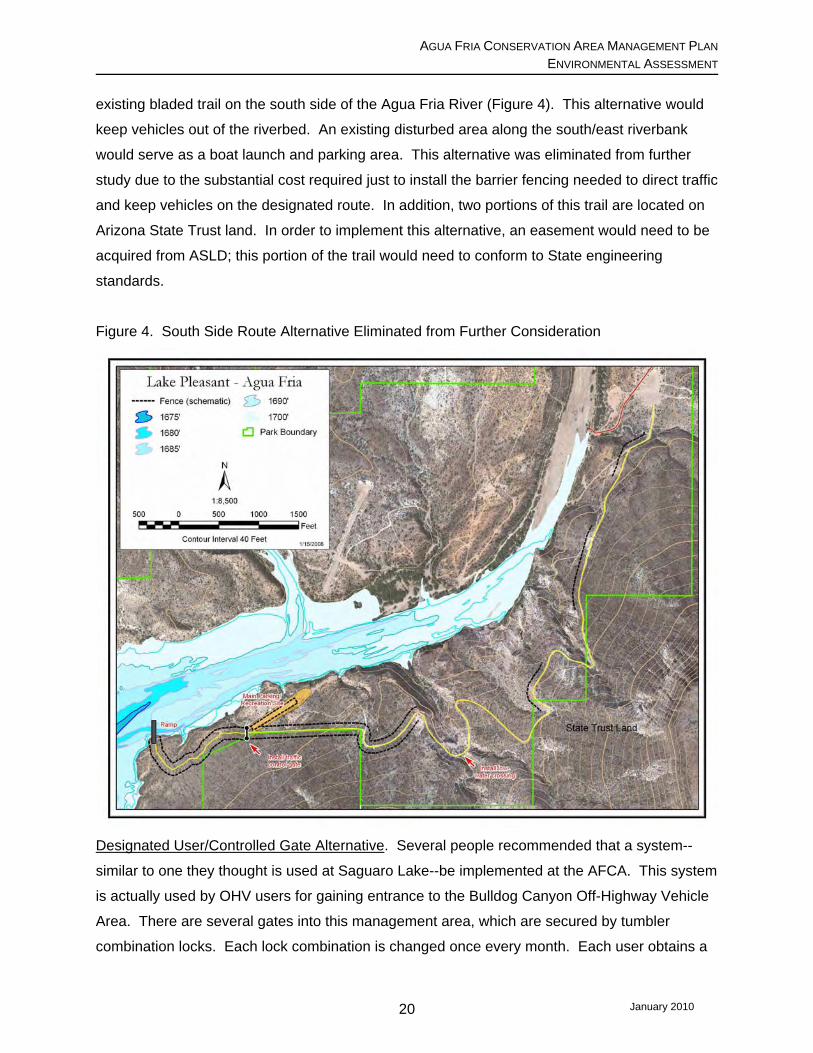
existing bladed trail on the south side of the Agua Fria River (Figure 4). This alternative would
keep vehicles out of the riverbed. An existing disturbed area along the south/east riverbank
would serve as a boat launch and parking area. This alternative was eliminated from further
study due to the substantial cost required just to install the barrier fencing needed to direct traffic
and keep vehicles on the designated route. In addition, two portions of this trail are located on
Arizona State Trust land. In order to implement this alternative, an easement would need to be
acquired from ASLD; this portion of the trail would need to conform to State engineering
standards.
Figure 4. South Side Route Alternative Eliminated from Further Consideration
Designated User/Controlled Gate Alternative. Several people recommended that a system--
similar to one they thought is used at Saguaro Lake--be implemented at the AFCA. This system
is actually used by OHV users for gaining entrance to the Bulldog Canyon Off-Highway Vehicle
Area. There are several gates into this management area, which are secured by tumbler
combination locks. Each lock combination is changed once every month. Each user obtains a
January 2010 20

AGUA FRIA CONSERVATION AREA MANAGEMENT PLAN ENVIRONMENTAL ASSESSMENT
January 2010 21
free six-month permit, which gives the permittee six months’ worth of combinations. The area is
monitored on a regular basis by three Forest staff, plus law enforcement personnel (D. Bray,
pers. comm. 2010).
This alternative was eliminated from further consideration because logistically there would be no
way to guarantee the gate would remain closed and lock combination information would remain
secured. MCPRD staff concluded this system would not be any more effective than what
existed prior to installation of the vehicular barrier.
AGUA FRIA CONSERVATION AREA MANAGEMENT PLAN ENVIRONMENTAL ASSESSMENT
3.0 DESCRIPTION OF THE AFFECTED ENVIRONMENT, AND ENVIRONMENTAL
CONSEQUENCES OF THE PROPOSED PROJECT This section describes the existing affected environment and environmental impacts anticipated
to result from implementing the Proposed Project. The analysis is focused on resource areas
that may be impacted. The consequences of the No Action scenario are described for these
same resources as a basis for comparison. Under No Action, the proposed amendment to the
LPMP would not be approved and the AFCA management plan would not be implemented. The
resources that are anticipated not to be affected by this proposed project are briefly discussed
at the end of this Chapter.
Background for Considering Cumulative Effects. Part of the analysis of environmental
consequences of a proposed project includes the consideration of cumulative effects. This
involves evaluation of the incremental impacts of the proposed action when added to the
impacts of past, present, and reasonably foreseeable future actions. Cumulative effects can
vary both geographically and temporally, depending upon the nature of the resource.
Regarding the proposed management plan, the past and ongoing action that has the greatest
effect is the enforcement of the AFCA vehicle closure policy that went into effect in July 2007
and continues to be enforced. A reasonably foreseeable future action is completion and
implementation of BLM’s Table Mesa Recreation Plan. BLM’s objective is to develop a
functional, feasible recreation plan for the Table Mesa Recreation Area, consistent with its
recently approved Bradshaw-Harquahala Resource Management Plan (B-H RMP). Portions of
BLM’s project area for the Table Mesa Recreation Plan are located directly east and north of the
AFCA.
A portion of the AFCA also falls within the Bradshaw Foothills Coalition Area of Interest, which
extends north, from State Highway 74 roughly between Morristown and the eastern boundary of
LPRP, up to the southern boundary of Prescott National Forest. The Bradshaw Foothills
Coalition is made up of a group of citizens that are concerned with issues related to the
interface between rapidly expanding urban areas and the remaining wild lands in this vicinity.
These wild land/urban interface areas are particularly challenging, since the jurisdiction for
planning and management of these lands is held by many governmental and private entities.
Because of the recreational interests and the rapid development in this area, the interest and
visibility of the outcomes (both short- and long-term) are important. One of the specific
objectives of the Bradshaw Foothills Coalition is to develop a motorized trail system within the
January 2010 22

AGUA FRIA CONSERVATION AREA MANAGEMENT PLAN ENVIRONMENTAL ASSESSMENT
Bradshaw Foothills Coalition Area of Interest to join up with those of the Table Mesa Recreation
Area, Prescott National Forest, and Wickenburg areas, as well as protect and maintain the
natural resources in the area. The Coalition also represents the interest of property owners and
area users in planning efforts undertaken by the land management agencies adjacent to the
Coalition’s Area of Interest. The Coalition is currently working with the Bureau of Land
Management in providing input into the Table Mesa Recreation Area Plan, and will soon begin
the planning process for the Castlegate Planning Area, which is the BLM Planning Area that
surrounds the Bradshaw Foothills area.
3.1 Climate and Air Quality 3.1.1 Affected Environment. The climate in the vicinity of Lake Pleasant is typical of deserts
of the arid southwestern United States. It is characterized by hot, long summers; short, mild
winters; sparse rainfall; low relative humidity; and high evaporation rates. The elevation of the
AFCA is between 1,600 and 2,815 feet amsl. There are two Western Regional Climate Center
(WRCC) monitoring stations, both of which are within 9.5 miles of the AFCA. Castle Hot
Springs Station #021353 is about 9 miles west of the AFCA and is located at about elevation
1,900 feet amsl. The Lake Pleasant Station is closer in elevation to that of the AFCA; however,
because missing data for this station resulted in the use of daily data averages, there are only
unofficial values for the Lake Pleasant Station (WRCC 2009b).
As measured at the Castle Hot Springs Station, the average annual temperature in the vicinity
of the project area is about 70° Fahrenheit (F). The highest average temperature is about
92° F, and the lowest average temperature is just over 46° F (WRCC 2009a); however,
temperatures above 100° F are not uncommon from mid-June through the end of August
(WRCC 2009c). The average annual rainfall in the project area vicinity is about 7.5 inches at
the Lake Pleasant Station, occurring during October, December, and January (WRCC 2009b);
at the Castle Hot Springs Station the average annual rainfall is 15.5 inches, occurring during
February, March, and August (WRCC 2009a).
The U.S. Environmental Protection Agency (EPA) has established National Ambient Air Quality
Standards (NAAQS) for six criteria pollutants. These include carbon monoxide, nitrogen oxide,
sulfur dioxide, lead, ozone, and particulate matter (less than 10 microns in diameter [PM10] and
less than 2.5 microns in diameter [PM2.5]. The standards are designed to protect public health
January 2010 23
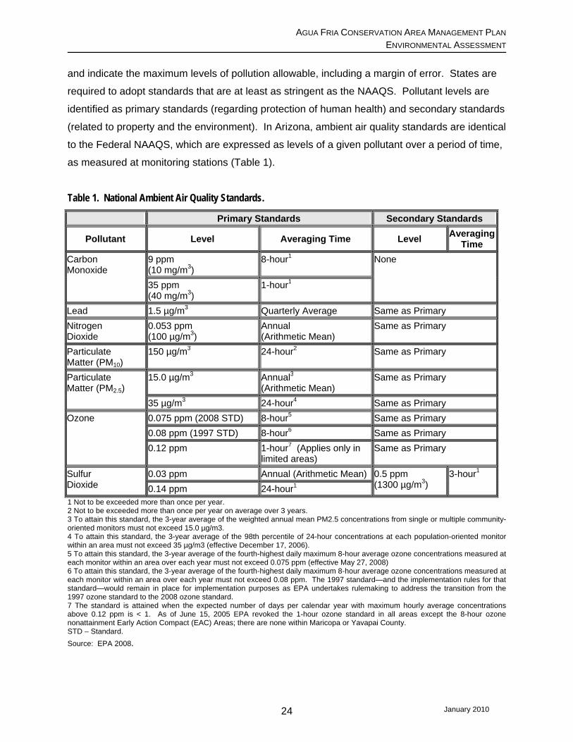
AGUA FRIA CONSERVATION AREA MANAGEMENT PLAN ENVIRONMENTAL ASSESSMENT
and indicate the maximum levels of pollution allowable, including a margin of error. States are
required to adopt standards that are at least as stringent as the NAAQS. Pollutant levels are
identified as primary standards (regarding protection of human health) and secondary standards
(related to property and the environment). In Arizona, ambient air quality standards are identical
to the Federal NAAQS, which are expressed as levels of a given pollutant over a period of time,
as measured at monitoring stations (Table 1).
Table 1. National Ambient Air Quality Standards.
Primary Standards Secondary Standards
Pollutant Level Averaging Time Level Averaging Time
Carbon Monoxide
9 ppm (10 mg/m3)
8-hour1 None
35 ppm (40 mg/m3)
1-hour1
Lead 1.5 µg/m3 Quarterly Average Same as Primary Nitrogen Dioxide
0.053 ppm (100 µg/m3)
Annual (Arithmetic Mean)
Same as Primary
Particulate Matter (PM10)
150 µg/m3 24-hour2 Same as Primary
Particulate Matter (PM2.5)
15.0 µg/m3 Annual3 (Arithmetic Mean)
Same as Primary
35 µg/m3 24-hour4 Same as Primary Ozone 0.075 ppm (2008 STD) 8-hour5 Same as Primary
0.08 ppm (1997 STD) 8-hour6 Same as Primary 0.12 ppm 1-hour7 (Applies only in
limited areas) Same as Primary
Sulfur Dioxide
0.03 ppm Annual (Arithmetic Mean) 0.5 ppm (1300 µg/m3)
3-hour1 0.14 ppm 24-hour1
1 Not to be exceeded more than once per year. 2 Not to be exceeded more than once per year on average over 3 years. 3 To attain this standard, the 3-year average of the weighted annual mean PM2.5 concentrations from single or multiple community-oriented monitors must not exceed 15.0 µg/m3. 4 To attain this standard, the 3-year average of the 98th percentile of 24-hour concentrations at each population-oriented monitor within an area must not exceed 35 µg/m3 (effective December 17, 2006). 5 To attain this standard, the 3-year average of the fourth-highest daily maximum 8-hour average ozone concentrations measured at each monitor within an area over each year must not exceed 0.075 ppm (effective May 27, 2008) 6 To attain this standard, the 3-year average of the fourth-highest daily maximum 8-hour average ozone concentrations measured at each monitor within an area over each year must not exceed 0.08 ppm. The 1997 standard—and the implementation rules for that standard—would remain in place for implementation purposes as EPA undertakes rulemaking to address the transition from the 1997 ozone standard to the 2008 ozone standard. 7 The standard is attained when the expected number of days per calendar year with maximum hourly average concentrations above 0.12 ppm is < 1. As of June 15, 2005 EPA revoked the 1-hour ozone standard in all areas except the 8-hour ozone nonattainment Early Action Compact (EAC) Areas; there are none within Maricopa or Yavapai County. STD – Standard. Source: EPA 2008.
January 2010 24

AGUA FRIA CONSERVATION AREA MANAGEMENT PLAN ENVIRONMENTAL ASSESSMENT
The AFCA is included in the Maricopa Association of Governments (MAG) planning area for air
quality. The project area itself is in attainment for all NAAQS criteria pollutants (PM2.5, PM10,
carbon monoxide, nitrogen oxide, sulfur dioxide, and lead) except ozone. The portion of the
project area located within the nonattainment area for the 8-hour ozone NAAQS falls within
Maricopa County. The northern boundary of both the CO maintenance area and PM10
nonattainment area (along the northern edge of Township 6 North) is about two miles south of
the southern boundary of the AFCA. The proposed developments themselves would be located
about 5 to 5.5 miles north of this CO maintenance/PM10 nonattainment boundary.
Most, if not all, of the AFCA is located within the State-designated “Area A.” Area A is one of
two areas within Arizona that have been delineated in Arizona Revised Statute §49-541, and
defined as “Vehicle Emissions Control Areas.”5 Area A encompasses all of the greater Phoenix
metropolitan area, as well as a small portion of Yavapai County just north and west of LPRP.
Area A was designated in an attempt to address nonattainment with NAAQS in the greater
Phoenix area (ADEQ 2003; p. 4).
The air monitoring stations closest to the project area include Cave Creek, Coyote Lakes, and
Dysart monitoring sites; they are located approximately 14.7 miles southeast, 22.5 miles
southwest, and 24.8 miles southwest, of the proposed AFCA river crossing, respectively. The
Cave Creek site monitors seasonally for ozone; the Dysart site monitors seasonally for CO,
ozone and PM10. The Coyote Lakes site became operational in April 2007 and monitors
specifically for PM10 emissions related to nearby sand and gravel mining; therefore, data from
this monitoring site were not used for this assessment.
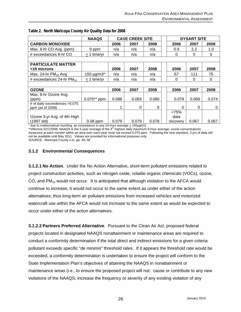
Monitoring data from the Cave Creek and Dysart sites indicate the air quality in the northern
portion of Maricopa County has been relatively good, with the exception of ozone (see Table 2).
During 2005-2007, although there were no violations of the ozone 8-hour primary NAAQS within
Maricopa County, several sites within the Maricopa planning area were very close to violating
the standard. The NAAQS for ozone was lowered as of May 27, 2008. This standard will not
become effective until May 2011; however, if it was to be applied to the last three years’ worth of
data, both the Cave Creek and Dysart monitoring stations would show violations of the ozone
NAAQS. The Dysart monitoring station consistently has low PM10 and CO measurements.
5 The other area is “Area B,” which is located in the Tucson metropolitan area.
January 2010 25
AGUA FRIA CONSERVATION AREA MANAGEMENT PLAN ENVIRONMENTAL ASSESSMENT
Table 2. North Maricopa County Air Quality Data for 2008
NAAQS CAVE CREEK SITE
DYSART SITE CARBON MONOXIDE 2006 2007 2008 2006 2007 2008 Max. 8-hr CO Avg. (ppm) 9 ppm n/a n/a n/a 0.9 2.2 1.0 # exceedances 8-hr CO < 1 time/yr n/a n/a n/a 0 0 0
PARTICULATE MATTER <10 microns 2006 2007 2008
2006 2007 2008 Max. 24-hr PM10 Avg 150 µg/m3* n/a n/a n/a 67 111 75 # exceedances 24-hr PM10 < 1 time/yr n/a n/a n/a 0 0 0
OZONE 2006 2007 2008
2006 2007 2008 Max. 8-hr Ozone Avg. (ppm) 0.075** ppm 0.088 0.083 0.080 0.079 0.069 0.074# of daily exceedences >0.075 ppm (as of 2008) 1 0 8 0 0 0
Ozone 3-yr Avg. of 4th High (1997 std) 0.08 ppm 0.079 0.079 0.078
<75% data
recovery 0.067 0.067* due to mathematical rounding, an exceedance in any 24-hour average > 155µg/m3 **effective 5/27/2008, NAAQS is the 3-year average of the 4th highest daily maximum 8-hour average; ozone concentrations measured at each monitor within an area over each year must not exceed 0.075 ppm. Following the new standard, 3 yrs of data will not be available until May 2011. Values are provided for informational purposes only SOURCE: Maricopa County n.d.; pp. 46; 58
3.1.2 Environmental Consequences
3.1.2.1 No Action. Under the No Action Alternative, short-term pollutant emissions related to
project construction activities, such as nitrogen oxide, volatile organic chemicals (VOCs), ozone,
CO, and PM10 would not occur. It is anticipated that although visitation to the AFCA would
continue to increase, it would not occur to the same extent as under either of the action
alternatives; thus long-term air pollutant emissions from increased vehicles and motorized
watercraft use within the AFCA would not increase to the same extent as would be expected to
occur under either of the action alternatives.
3.1.2.2 Partners Preferred Alternative. Pursuant to the Clean Air Act, proposed federal
projects located in designated NAAQS nonattainment or maintenance areas are required to
conduct a conformity determination if the total direct and indirect emissions for a given criteria
pollutant exceeds specific “de minimis” threshold rates. If it appears the threshold rate would be
exceeded, a conformity determination is undertaken to ensure the project will conform to the
State Implementation Plan’s objectives of attaining the NAAQS in nonattainment or
maintenance areas (i.e., to ensure the proposed project will not: cause or contribute to any new
violations of the NAAQS; increase the frequency or severity of any existing violation of any
January 2010 26
AGUA FRIA CONSERVATION AREA MANAGEMENT PLAN ENVIRONMENTAL ASSESSMENT
standard in a given area; or delay timely attainment of any standard or interim emission
reductions or other State Implementation Plan milestones).
The AFCA is located within an area that is in attainment for all criteria pollutants, with one
exception—the portion of the project area located within Maricopa County falls within an area of
nonattainment for the 8-hour ozone NAAQS.
To determine whether or not a conformity determination for ozone would be needed, ozone
precursor emissions (VOCs, and nitrogen oxides [NOx]) that are anticipated to result from
implementing the proposed plan were estimated (M. Poppen, pers. comm. 2009). These would
include short-term construction-related ozone precursor emissions resulting from operation of
motorized construction-related vehicles and equipment, and recurring emissions related to
recreational traffic and use of motorized boats.
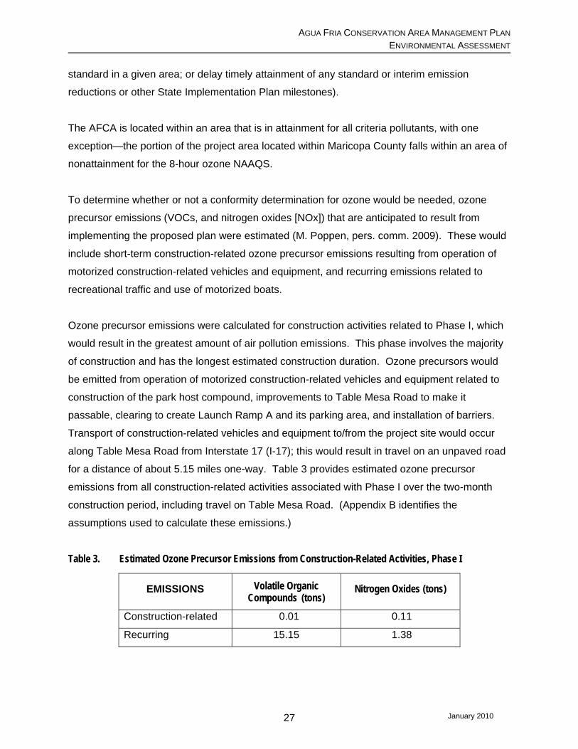
Ozone precursor emissions were calculated for construction activities related to Phase I, which
would result in the greatest amount of air pollution emissions. This phase involves the majority
of construction and has the longest estimated construction duration. Ozone precursors would
be emitted from operation of motorized construction-related vehicles and equipment related to
construction of the park host compound, improvements to Table Mesa Road to make it
passable, clearing to create Launch Ramp A and its parking area, and installation of barriers.
Transport of construction-related vehicles and equipment to/from the project site would occur
along Table Mesa Road from Interstate 17 (I-17); this would result in travel on an unpaved road
for a distance of about 5.15 miles one-way. Table 3 provides estimated ozone precursor
emissions from all construction-related activities associated with Phase I over the two-month
construction period, including travel on Table Mesa Road. (Appendix B identifies the
assumptions used to calculate these emissions.)
Table 3. Estimated Ozone Precursor Emissions from Construction-Related Activities, Phase I
EMISSIONS Volatile Organic Compounds (tons)
Nitrogen Oxides (tons)
Construction-related 0.01 0.11
Recurring 15.15 1.38
January 2010 27

AGUA FRIA CONSERVATION AREA MANAGEMENT PLAN ENVIRONMENTAL ASSESSMENT
Because a portion of the project area falls within an area of nonattainment for ozone, a
conformity determination would need to be conducted if the ozone precursor emissions are
expected to approach the de minimis threshold level for ozone, which is 100 tons per year. The
ozone precursor emissions, which are anticipated to be generated by the greatest amount of
construction and for longest construction duration, are estimated to be negligible; therefore, no
conformity determination is needed.
Long-term impacts to air quality that are anticipated to result from the proposed project would
include pollution from two principal sources. The first source would be emissions generated
from increased vehicular traffic using Table Mesa Road to recreate within the AFCA; the same
distance and travel assumptions used for short-term impacts were used to estimate long-term
air emissions resulting from recreation-related travel to/from the AFCA, i.e., a 5.15-mile one-way
trip from I-17 on Table Mesa Road. The second source of long-term air emissions would be
from operation of additional motorized boats that would access Lake Pleasant from the boat
ramps established within the AFCA.
Visitation data gathered from a six-week AGFD pilot project which occurred between April 11
and May 18, 2008, were used in developing assumptions about the numbers of vehicles and
boats that are likely to use the new facilities (see Appendix B). Even under a “worst-case”
scenario for purposes of calculating air emissions,6 long-term impacts from recurring ozone
precursor emissions would be very minimal, and would not contribute to violations of the 8-hour
ozone standard (see Table 3). The AFCA open season would be January through June; the
long-term emissions anticipated to occur as a result of this proposed project would generally
occur outside the peak ozone season which, for Maricopa County, is July 1 through
September 30 (MCAQD 2006; p. 2). This would further diminish any impacts to air quality
resulting from increased vehicular traffic and motor boat use within the project area.
3.1.2.3 Minimum Development Alternative. Construction that would occur under this
alternative would result in generation of the same types and amounts of air pollutants, with the
exception of those related to development and maintenance of the day-use recreational
amenities, permanent entry station, and any trail system(s) developed on the south/east side of
the Agua Fria River. The amount of pollution resulting from this alternative, as well as additional
6 To present a “worst case” scenario, actual weekend (high use) visitation numbers from the pilot project were assumed to occur daily during the entire six-month open season.
January 2010 28

AGUA FRIA CONSERVATION AREA MANAGEMENT PLAN ENVIRONMENTAL ASSESSMENT
traffic to and from the AFCA associated with long-term use of the minimal amenities provided
under this alternative, would be similar to but less than those occurring under the Proposed
Action.
3.1.3 Cumulative Effects. As briefly discussed at the beginning of section 3.0 regarding
cumulative impacts, BLM is in the process of developing the Table Mesa Recreation Area
Management Plan (RAMP), which will identify how areas within the Table Mesa Recreation
Area are to be managed, including what and where activities are allowed or restricted, and
improvements that are proposed to be developed. Implementation of the Table Mesa RAMP
and visitation to this area would generate air pollution from increased traffic and recreational
vehicular use. Emissions associated with the proposed project which would be generated from
additional traffic along Table Mesa Road, as well as any boat motor emissions, would add to the
cumulative impacts of air emissions resulting from use of the Table Mesa Recreation Area.
Both projects would generate additional amounts of PM10 within Area A, one of two “Vehicle
Emissions Control Areas” in Arizona. Long-term PM10 emissions resulting from vehicular traffic
to/from the AFCA and I-17 are estimated to be about 24 tons per year under a worst-case
scenario (see Appendix B).
The proposed project’s gaseous exhaust emissions (including greenhouse gases) would add
cumulatively to pollutants emitted from other natural and human-caused sources into the
atmosphere. The relatively minute quantities of pollutants released during construction, and
from visitation and use of the AFCA as a result of implementation of the management plan,
would have a negligible cumulative effect on local air quality or global processes that lead to
climate change.
3.2 Water Resources 3.2.1 Affected Environment 3.2.1.1 Groundwater. Lake Pleasant itself, the AFCA, and the Agua Fria River are located
within the Agua Fria Basin, which is part of Arizona Department of Water Resource’s (ADWR)
Central Highlands Planning Area. The Agua Fria Basin covers a little less than 1,300 square
miles in central Arizona, mostly within Yavapai County, but includes a small portion of northern
Maricopa County as well. Its main drainage is the Agua Fria River, which forms Lake Pleasant.
There are four major rock units in the Agua Fria Basin: basin-fill and alluvial sands and gravels;
January 2010 29
AGUA FRIA CONSERVATION AREA MANAGEMENT PLAN ENVIRONMENTAL ASSESSMENT
volcanic rocks; sedimentary conglomerates; and igneous and metamorphic rocks. Water occurs
in all four rock units; however, the main water-bearing unit is the conglomerates, and the rock
unit that yields the smallest volumes is the volcanic rocks located in the northeastern section of
the basin (ADWR 2007; p. 5).
The average annual natural recharge for the Agua Fria Basin is estimated to be 9,000 acre-feet.
The estimated water storage in the basin is 3.5 million acre-feet to an unknown depth. ADWR
monitors seven wells within this basin; of these, the closest to the project area is located in
Black Canyon City, Arizona. Beginning 1979, water depth changes have been measured
annually. Initially the depth to water was about 37 feet below land surface (bls). Since then, the
depth to water generally has been measured within a range of 36 to 44 feet bls, with the
exception of declines to 52 and 50 feet bls twice between 2000 and 2004. In 2004, the most
current year for which measurements are available, the depth to water bls was 44 feet, which
was a rise of about 6 feet from the previous year’s measurement.
Since 1971, groundwater use within the Agua Fria Basin has increased from an average of
2,000 acre-feet per year to an average of 3,400 acre-feet per year from 2001 to 2003. The
highest average annual groundwater use occurred between 1981 and 1985, when it was 5,000
acre-feet per year. The primary use of this water is for municipal and agricultural purposes
(ADWR 2007).
Groundwater of the Central Highlands Planning Area generally meets drinking water standards,
although there are wells, springs and mine sites that have been tested and found to equal or
exceed Federal drinking water standards. Altogether, 603 wells, springs, or mine sites were
tested in the five basins that make up the Central Highlands Planning Area (ADWR 2007).
Within the Agua Fria Basin, water quality sampling conducted at 49 wells or springs between
1978 and 2003, indicate water quality for one or more constituents equaled or exceeded
Federal drinking water standards. Arsenic was the drinking water standard that was most
frequently equaled or exceeded at the sites measured; other constituents equaled or exceeded
for which samples were taken include fluoride, cadmium, and radionuclides. The highest
concentration of sites found to be contaminated is in the area of Black Canyon City, where
testing indicated eight sites were contaminated with arsenic, five sites were contaminated by
January 2010 30

AGUA FRIA CONSERVATION AREA MANAGEMENT PLAN ENVIRONMENTAL ASSESSMENT
fluoride, and one site was contaminated with both. One site had elevated levels of
radionuclides (ADWR 2007; pp. 92-95).7
3.2.1.2 Surface Water. The Agua Fria River drains an area approximately 2,700 square miles;
the watershed boundaries include the Black Hills to the north and northeast, Humboldt and
Maverick Butte mountains to the east; and the Bradshaw, Hieroglyphic and White Tank
mountains to the west. The Agua Fria River main stem begins near Prescott, Arizona, in the
Prescott Active Management Area. The Agua Fria River has several perennial reaches
between that point and Lake Pleasant. In the northern portion of the Basin, several creeks that
flow into the Agua Fria River also have perennial reaches. These include Ash, Dry, Yellow
Jacket, Sycamore, Indian, Silver, and Big Bug creeks. In the southern portion of the Basin the
creeks that flow into the Agua Fria River include Squaw, Black Canyon, and Cottonwood
creeks. Humbug Creek, which has a short perennial reach at its upstream end, also flows into
the Agua Fria River; however, it enters Lake Pleasant just west of the AFCA.
Stream flow in the Agua Fria River is measured at three locations: The furthest upstream
station is near Humboldt, Arizona (“Humboldt” Station 9512450); heading downstream, the next
station is just south of where Big Bug Creek drains into the Agua Fria River (“Mayer” Station
9512500); the third and furthest downstream station is located near Rock Springs, Arizona
(“Rock Springs” Station 9512800), about 10 miles upstream of Lake Pleasant. These stations
have drainage areas of 175 square miles, 585 square miles, and 1,111 square miles,
respectively, and measure stream flow data in real-time.8 The Humboldt station is operated by
the United States Geological Survey (USGS) in cooperation with the ADWR; the other two
stations are operated by USGS in cooperation with the Central Arizona Water Conservation
District (CAWCD) (USGS 2007).
Data from all three stations indicate flows along the Agua Fria River typically increase beginning
in December and decrease after February, with the highest flows occurring in January and
February; however, there have been years when little or no flow has been measured at both the
7 Not all parameters were measured at all sites. 8 Real-time data typically are recorded at 15-60 minute intervals, stored onsite, and then transmitted to USGS offices every 1 to 4 hours. Data from real-time sites are relayed to USGS offices via satellite, telephone, and/or radio and are available for viewing within minutes of arrival (USGS 2009).
January 2010 31
AGUA FRIA CONSERVATION AREA MANAGEMENT PLAN ENVIRONMENTAL ASSESSMENT
Mayer and Rock Springs stations. The months of lowest or no flows typically occur during May
and June (USGS 2007). Entering Lake Pleasant, the Agua Fria River is intermittent.
The majority of the project area falls within what are called “Special Flood Hazard Areas” by the
Federal Emergency Management Agency (FEMA; 2001, 2005). These are areas where a flood
has a one percent chance of being equaled or exceeded in any given year. This type of flood is
called the “base flood” or the 100-year flood event. Some washes within the project area, that
would be crossed by the hiking trail proposed for Phase III, are also classified as 100-year flood
zones. On the south side of the Agua Fria River, the great majority of the AFCA falls within an
area classified as “Other Flood Areas,” where there is a one percent chance of experiencing a
flood averaging a depth of one foot or less, or where the drainage area is less than one square
mile.
The maximum conservation storage elevation of Lake Pleasant is 1,702 feet amsl. At this
elevation, Lake Pleasant stores about 812,100 acre-feet of water. MWD’s right to Agua Fria
River flows for irrigation purposes are stored in Lake Pleasant. CAWCD pumps CAP water from
the Colorado River into Lake Pleasant during periods of low demand (generally the winter
months), where it is stored for release into the CAP canal system during high demand periods
(generally the summer months). Using Lake Pleasant to store CAP water results in an annual
average lake elevation fluctuation of about 40 to 60 feet. Releases also are made downstream
into the Agua Fria River when large volumes of flood flow into the lake must be passed
downstream in order to maintain adequate storage capacity behind the dam. Since the
completion of New Waddell Dam, floodwater releases into the Agua Fria River downstream of
New Waddell Dam have only occurred once, in 2005 (D. Johnson, pers. comm., 2009).
During dry years, the reservoir storage is mostly Colorado River water; during wet years with
substantial inflows, the reservoir has a blend of Colorado River and Agua Fria River water.
CAWCD tests the water quality of Lake Pleasant quarterly, typically for 136 or more
constituents. CAWCD also tests the water quality of the Agua Fria River at the inlet to the lake
during flow events. Table 4 compares water quality measurements for selected constituents
taken from samples from both the Agua Fria River and Lake Pleasant on March 30, and
February 5, 2009, respectively (CAWCD 2009).
January 2010 32

AGUA FRIA CONSERVATION AREA MANAGEMENT PLAN ENVIRONMENTAL ASSESSMENT
Table 4. Water Quality Agua Fria River and Lake Pleasant-Selected Constituents 2009
CONSTITUENT (mg/L unless otherwise noted)
Agua Fria Sample
03/30/2009
Lake Pleasant Sample
02/05/2009
USEPA MCL* Health Secondary
Common Constituents (mg/L unless otherwise noted) Calcium, Total 50 71 none none Magnesium, Total 23 30 none none Sodium, Total 39 100 none none Potassium, Total 2.5 5.3 none none Chloride 24 92 none 250 Sulfate 51 270 none 250 Nitrate (as Nitrogen) ND ND 10 none Alkalinity (as CaCO3) 190 121 none none Total Dissolved Solids 320 684 none 500 Turbidity (NTU) 0.55 0.85 5 none Field Parameters Dissolved oxygen Not measured 10.9 none none Temperature (°F) Not measured 53.2 none none pH (Standard Units) Not measured 8.05 none 6.8 – 8.5 Trace Constituents Arsenic 0.011 0.0042 0.010 none Barium, Total 0.036 0.15 2 none Cadmium, Total ND ND 0.005 none Copper, Total ND ND 1.3 (AL**) 1.0 Iron, Total 0.049 ND none 0.3 Manganese, Total 0.031 ND none 0.05 Mercury ND 0.000318 0.002 none
*MCL = Maximum Contaminant Level; **AL= Alert Level Source: CAWCD 2010
The samples of both the Agua Fria River and Lake Pleasant water indicate the water quality is
generally good, meeting water quality standards in most cases.
3.2.2 Environmental Consequences 3.2.2.1 No Action. Under the No Action Alternative, the vehicle restriction into the AFCA would
continue to be enforced. There would be no land-disturbing activities resulting from construction
activities within the Agua Fria River flood channel and flood plain; therefore, there would be no
temporary construction-related bank erosion that could result in water quality impairment. In the
long-term, there would be little to no traffic crossing the Agua Fria River channel and very few, if
January 2010 33
AGUA FRIA CONSERVATION AREA MANAGEMENT PLAN ENVIRONMENTAL ASSESSMENT
any, boats launching from within the AFCA (such activity would be unlawful). Unlawful entry by
vehicles, including off-road vehicles, would be expected to increase over time, as metropolitan
Phoenix continues to expand northward and its growing population seeks out areas for
recreation. These activities within the Agua Fria River floodplain and surrounding uplands
would cause vegetation loss, resulting in increased erosion. There would be increased
sediment transport with rain and flood events; during flood events, flow velocities would
increase and flooding impacts would become more severe.
3.2.2.2 Partners Preferred Alternative. With this alternative, there would be short-term
construction-related traffic across and along the Agua Fria River channel and other drainages to
deliver materials and equipment for establishing the boat ramp at Parking Area A. Vehicle
barriers would be installed across the Agua Fria River, resulting in temporary disturbance within
the floodplain, and potentially permanent structures (most likely posts) being installed within the
streambed. Additional construction may occur to replace barriers that may be lost during flood
events. Construction-related activities, especially those occurring within the river channel, could
result in temporary water quality degradation due to erosion and increased turbidity. These
activities would be timed to avoid crossing or working in the river when flows are present, to the
degree practicable. Work within washes, which is associated with trail creation and/or
improvement on the south side of the Agua Fria River during Phase III, also could result in a
minor amount of short-term water quality impairment during initial runoff events following
completion of trail work.
Construction activities would comply with all applicable Clean Water Act regulations, including
Section 402 regarding storm water discharges from construction sites, and Section 404
regarding the discharge of dredged or fill material into waters of the U.S. The contractor would
be prohibited from stockpiling or depositing excavated materials, or other construction materials,
near or on stream banks, lake shorelines, or other watercourse perimeters where they can be
washed away by high water or storm runoff, or can, in any way, encroach upon the watercourse.
Storage of petroleum products would not be allowed within 20 feet of any drainage or wet or dry
watercourse. The contractor would be required to have a suitable spill response kit on site
during construction.
With implementation of the proposed action, on a seasonal basis vehicle access would extend
further downstream adjacent to the Agua Fria River, and vehicles (many hauling boats) would
January 2010 34
AGUA FRIA CONSERVATION AREA MANAGEMENT PLAN ENVIRONMENTAL ASSESSMENT
cross the Agua Fria River throughout the open season. Except for Launch Ramp A, any
additional designated ramps would be unimproved. As lake levels recede, vehicles and boats
would be allowed to access the lake via parking areas B, C, and D. These parking and
associated boat ramp areas would be designated, but not improved, which would result in
additional erosion and sedimentation. There also would be on-going traffic through the river
channel and along the floodplain during the open season associated with maintenance,
monitoring, and enforcement activities, and relocation of portable facilities as lake levels
fluctuate. Disturbance to the soil within the floodplain resulting from these activities also would
contribute to water quality impairment during runoff events.
Under the proposed plan, an onsite wastewater facility would be constructed and operated as
part of the park host compound. The facility would consist of a septic tank(s) and disposal field
or evapotranspiration bed. MCPRD would ensure design, construction, and operation of these
facilities are consistent with all applicable state and/or local requirements. This should ensure
there are no adverse impacts to ground or surface water quality from operation of the
wastewater facility.
Portable toilets are planned to be made available at the entry station area, Parking Area A, and
in the vicinity of Launch Ramps B, C, or D when appropriate; however, it is currently not known
whether or not there is a company that would service these facilities (due to distance and
access considerations). Should service not be available, the area would become “pack it in,
pack it out; leave no trace.” During Phase II or III, more permanent facilities would be provided,
either by increasing the capacity of the existing wastewater facility or constructing a second
wastewater facility.
During Phase I, potable water for the host compound would be hauled and stored onsite.
Eventually, a permanent water system would be established, presumably by drilling a
groundwater well.
3.2.2.3 Minimum Development Alternative. Both construction-related and long-term impacts
related to this alternative would be essentially the same as those of the proposed action. This is
because elements from the Proposed Action that would be omitted under this alternative do not
or only minimally affect water resources.
January 2010 35

AGUA FRIA CONSERVATION AREA MANAGEMENT PLAN ENVIRONMENTAL ASSESSMENT
3.2.3 Cumulative Effects. Into the future there would be increased traffic along Table Mesa
Road into the AFCA and from use of the Table Mesa Recreation Area, resulting in a cumulative
impact to this portion of the watershed. This, in turn, could result in greater degradation of the
water quality of the Agua Fria River upstream of Lake Pleasant. The primary impact of
increased sedimentation, erosion, and turbidity would be localized and would diminish when
inflows reach the major body of Lake Pleasant, where some of the suspended matter would
settle to the lake bottom.
3.3 Biological Resources 3.3.1 Affected Environment. Elevations within the LPRP range from approximately 1,300 to
3,000 feet amsl. Topography varies from gently rolling to steep hills, which are heavily
dissected by small arroyos and several major washes. The varied topography and proximity to
water support a diverse biological community.
3.3.1.1 Vegetation. The Arizona Upland subdivision of the Sonoran Desertscrub biome is the
dominant vegetative community within the LPRP. Where soil and topographic features are
present, plants typical of the Lower Colorado River Valley subdivision can be found. Many of
the trees found throughout the Arizona Uplands are confined to rivulets and washes in the more
arid Lower Colorado River Valley subdivision in western Arizona. A comprehensive list of the
plant species that can be found within each biome is presented in Brown (1994).
The creosote-white bursage series of the Lower Colorado River Valley subdivision occupies the
lower elevation gradients and valleys within LPRP. These two plants, creosotebush (Larrea
tridentata) and white bursage (Ambrosia dumosa), normally decrease in importance as the
elevation increases upslope onto the bajadas. White bursage barely extends above the valley
floors; however, creosotebush can be found up into the mountains. Because of its open nature
and sparse vegetation, this biome supports a relatively poor avifauna.
The paloverde-cacti-mixed scrub series of the Arizona Upland subdivision occurs at higher
elevations on rocky hills and bajadas. The primary plant species are foothill paloverde
(Cercidium microphyllum), saguaro (Carnegiea gigantea), catclaw (Acacia gregii), ocotillo
(Fouquieria columnaris), ironwood (Olneya tesota), jojoba (Simmondsia chinensis), barrel
cactus (Ferocactus spp.), brittlebush (Encilia farinosa), triangle-leaf bursage (Ambrosia
January 2010 36
AGUA FRIA CONSERVATION AREA MANAGEMENT PLAN ENVIRONMENTAL ASSESSMENT
deltoidea), and various cholla (Opuntia spp.) species. Higher up the slopes the vegetation
becomes sparser and the dominant plant species change to crucifixion thorn (Canotia
holocantha), creosotebush, and triangle leaf bursage (creostebush-crucifixion-thorn series;
Brown 1994). This community is noted for its rich diversity of bird species.
Along the many desert washes found throughout the LPRP (e.g. Humbug, Cottonwood, Castle
and Boulder creeks), vegetation composition and structure overlap considerably with those of
the surrounding desert uplands (Levick et al. 2008) and consist primarily of small, xerophytic
shrubs and trees. Stem and leaf succulents and perennial grasses often are present, and
annual grasses and forbs become seasonally abundant during wet periods. As water
availability increases, the vegetation becomes taller and tree canopy can increase. This
drought tolerant community, which borders ephemeral streams, is commonly referred to as
xeroriparian vegetation (Johnson et al. 1984). Plants within the xeroriparian community include
blue paloverde (Cercidium floridum), catclaw, mesquite (Prosopis spp.), white thorn acacia
(Acacia constricta), desert hackberry (Celtis pallida), desert willow (Chilopsis linearis), wolfberry
(Lycium spp.), seepwillow (Baccharis salicifolia), and desert broom (Baccharis sarathroides).
The Sonoran Riparian Deciduous Forest is the third significant vegetative subdivision found
within LPRP. The term “riparian” refers to vegetation, habitats, or ecosystems that are
associated with bodies of water or are dependent on the existence of perennial (occurring year-
round), intermittent (not continuous) or ephemeral (lasting only a short time) surface water or
subsurface water drainage (Arizona Riparian Council 1994). Riparian habitat, although limited
in LPRP, has the greatest wildlife value. Riparian communities at LPRP are found
predominately along the Agua Fria River and are characterized by cottonwood (Populus
fremontii), saltcedar (Tamarisk spp.), willow (Salix spp.), mesquite, seepwillow, desert broom,
catclaw, and tree tobacco (Nicotiana glauca). Portions of major drainages also contain vestiges
of riparian vegetation depending upon the availability of a reliable water source.
Prior to the construction of New Waddell Dam, the Agua Fria inflow supported a healthy riparian
community along the channel. Much of this habitat was inundated and lost after New Waddell
Dam was completed, which resulted in an increase in the water levels at Lake Pleasant. The
yearly cycle of rising and lowering lake levels that now occurs within Lake Pleasant is not
conducive to establishing a healthy riparian community. At present, cottonwoods, willows, and
the nonnative saltcedar are confined to relatively wide channel edges in the upper reaches of
January 2010 37

AGUA FRIA CONSERVATION AREA MANAGEMENT PLAN ENVIRONMENTAL ASSESSMENT
the Agua Fria River inflow to Lake Pleasant. In cases where the active channel has shifted in
response to flood flows, small stringers of riparian plants can be found; however, because of the
rocky substrate and continual exposure to flood flows it is anticipated these stringers will be
subject to scour in the future. Little regeneration is evident within the AFCA, likely due to
livestock grazing and recreational activities that occurred prior to enforcement of the vehicle
restrictions in July 2007.
The upland vegetation within the AFCA is primarily of the palo verde-cacti-mixed scrub series of
the Arizona Upland subdivision. On the east south/east side of the river, an old road bed leads
to the former Avis homestead. Natural re-vegetation is occurring along the route as well as at
the homestead although it will likely take years to completely heal. The north/west side of the
river exhibits numerous roads and trails on the ridge tops and in some of the valleys as a result
of unlawful OHV use; there also is an old airstrip associated with the Boulder Creek Ranch.
These activities likely have had a significant negative impact on wildlife habitat over the years.
However, due to the lack of pre- and post-disturbance data, this impact cannot be quantified.
The existing tall eucalyptus trees are associated with the Brown homestead.
The mesquite bosque that is located within the area proposed for Parking Area A shows very
little vegetative regeneration, likely due to a combination of vehicular use and grazing. The
current understory is dominated by Bermuda grass (Cynodon dactylon). When the lake recedes
from the area associated with Launch Ramps B, C, and D, the formerly inundated lake bed
becomes vegetated by monotypic stands of cocklebur (Xanthium spp.).
3.3.1.2 Wildlife. The diversity of wildlife species in the LPRP area is directly correlated to the
diversity of habitat types discussed above. This diversity supports a wide variety of wildlife
species that are listed in Appendix C.
Lake Pleasant increases avian diversity of LPRP by providing wintering and migratory habitat
for large numbers of waterfowl and shorebirds. The associated riparian community is host to
numerous permanent resident species such as Abert’s towhee (Pipilo aberti) and the Northern
cardinal (Cardinalis cardinalis), as well as summer nesting species such as the yellow breasted
chat (Icteria virens) and Bell’s vireo (Vireo bellii). It is unlikely that riparian habitat within the
AFCA serves as breeding habitat for the endangered Southwestern willow flycatcher
January 2010 38

AGUA FRIA CONSERVATION AREA MANAGEMENT PLAN ENVIRONMENTAL ASSESSMENT
(Empidonax extimus traillii) because it lacks the density and structure favored by these birds;
however, it could provide adequate stopover habitat during migration.
The paloverde-cacti-mixed scrub series provides important wintering habitat for passerine birds
such as white-crowned and Brewer’s sparrows (Zonotrichia leucophrys; Spizella breweri).
Common residents of the uplands desert include Gambel’s quail (Callipepla gambelii), cactus
wren (Campylorhynchus), verdin (Auriparus flaviceps), curve-billed thrasher (Toxostoma
curvirostre), Gila and ladder-backed woodpeckers (Melanerpes uropygialis; Picoides scalaris),
as well as Harris and red-tailed hawks (Parabuteo unicinctus; Buteo jamaicensis).
Mammal populations also reflect the diversity found within LPRP. Medium-sized mammals such
as coyote (Canis latrans) and gray fox (Urocyon cinereoargenteus) are common. The mountain
lion (felis concolor) and bobcat (felis rufus) also have been sited within the LPRP. Game
species found within LPRP include desert mule deer (Odocoileus hemionus) and collared
peccary (Dicotyles tajacu). Common species of small mammals include black-tailed jackrabbit
(Lepus californicus), desert cottontail (Sylvilagus audubonii), white-throated woodrat (Neotoma
albigula), Merriam’s kangaroo rat (Dipodomys merriami), deer mouse (Peromyscus
maniculatus), and California leaf-nosed, big brown, and Mexican free-tailed bats (Myotis
californicus; Eptesicus fuscus; and Tadarida brasiliensis).
LPRP lies within the greater Lake Pleasant Herd Management Area for wild burros administered
by the BLM. BLM manages the herd in order to maintain an ecological balance where there is
food available for the burros to remain healthy, while allowing livestock and other wildlife to
thrive. When the burrow population exceeds the “Appropriate Management Level” of 208
burros, some animals are removed and offered to the public through BLM’s Adopt a Wild Horse
or Burro Program (see 3.4.1. Land Ownership and Use below for more information).
The Sonoran desert also supports a wide variety of reptiles and amphibians. LPRP provides
habitat for some of the more common species such as Couch’s spadefoot toad (Scaphiopus
couchi), nonnative bullfrog (Rana catesbiana), Great Plains toad (Bufo cognatus), leopard frog
(Rana pipiens), desert iguana (Dipsosaurus dorsalis), western whiptail (Cnemidophorus tigris),
western patch-nosed snake (Salvadora hexalepis), western diamondback rattlesnake (Crotalus
atrox), and black-tailed rattlesnake (Crotalus molossus). Other amphibians and reptiles that
occur in lower densities include the tiger salamander (Ambystoma tigrinum), canyon tree frog
January 2010 39

AGUA FRIA CONSERVATION AREA MANAGEMENT PLAN ENVIRONMENTAL ASSESSMENT
(Hyla arenicolor), Sonora mud turtle (Kinosternon sonorienses), Sonoran lyre snake
(Trimorphodon lambda), Arizona coral snake (Micruroides euryxanthus), and Mohave
rattlesnake (Crotalus scutulatus).
Reclamation conducted a desert tortoise (Gopehrus agassizii) habitat quality assessment and
survey of LPRP in 2003 (Goodlet 2003). A large portion of the AFCA, especially at the
upstream end, was categorized as likely being of low density and was not surveyed for sign.
However, four areas within the AFCA were categorized as having a high density of desert
tortoise sign: “River Bend,” “Agua Fria,” “Tule Creek”, and “Indian Mesa.”
3.3.1.3 Fish. Only two native fish species, the longfin dace (Agosia chrysogaster) and desert
sucker (Pantosteus clarki), occur within the LPRP boundaries, as well as in perennial tributary
waters outside LPRP. The federally endangered Gila topminnow (Poeciliopsis occidentalis) can
be found in perennial portions of tributaries to the Agua Fria River (Cella Barr 1995; p. VI-11).
Lake Pleasant has historically been regarded as one of the premier largemouth bass
(Micropteus salmoides) fisheries in Arizona. Up to an estimated 150 largemouth bass
tournaments per year have occurred on Lake Pleasant (Bryan 2005; p. 56) and the spring
drawdown of the reservoir is timed to enhance spawning and nesting by bass. The quality of
the largemouth bass fishery has decreased however, and it has been hypothesized this is due
to the recent invasion of striped bass (Morone saxatilis) resulting from the importation of
Colorado River water into Lake Pleasant through the CAP system.
The AFCA is within what was the “upper basin” as defined by Bryan (2005). Because the upper
basin is influenced primarily by flows from the Agua Fria River and runoff from various washes
and creeks, it tends to be more productive than the major deep portion of the reservoir. AFCA’s
diverse habitat and high productivity create excellent fishing opportunities and, as a result,
experiences a large portion of the total angling pressure on the reservoir (Bryan 2005; p.3).
Although anglers pursue white and large mouth bass and some channel catfish (Ictalurus
punctatus), the majority of anglers now are fishing for striped bass within the AFCA (N. Robb,
pers. comm. 2009). An AGFD study suggested that the upper end of the Agua Fria River
provides spawning habitat for striped bass, especially after substantial spring flows (Stewart et
al. 2008; p. 29). The majority of tagged striped bass remained in the Agua Fria from September
January 2010 40

AGUA FRIA CONSERVATION AREA MANAGEMENT PLAN ENVIRONMENTAL ASSESSMENT
to May. Because of temperature and dissolved oxygen constraints, the striped bass move
further downstream into Lake Pleasant from June to September (Stewart et al. 2008; p. 28).
Table 5 lists the fish collected in Lake Pleasant between 1987 and 2004.
Table 5. Fish collected in Lake Pleasant 1987 – 2004
Species Scientific Name Species Scientific Name
Yellow bullhead Ameiurus natalis Redear sunfish Lepomis microlophus Goldfish Carassius auratus Sunfish hybrid Lepomis spp. Sonora sucker Catostomus insignis Largemouth bass Micropterus salmoides Common carp Cyprinus carpio White bass Morone chrysops Red shiner Cyprinella lutrensis Striper bass Morone saxatilis Threadfin shad Dorosoma petenense Golden shiner Notemigonus crysoleucas Mosquitofish Gambusia affinis White crappie Pomoxis annularis Channel catfish Ictalurus punctatus Black crappie Pomoxis nigromaculatus Green sunfish Lepomis cyanellus Flathead catfish Pylodicitis olivaris Bluegill Lepomis macrochirus Tilapia Tilapia spp. Source: Bryan 2005; pg. vi.
Recently, two additional nonnative species have been documented in the reservoir--the inland
silverside fish (Menidia beryllina) and quagga mussel (Dreissena rostiformes bugensis).
Impacts to the sport fisheries from these organisms are currently unknown.
3.3.1.4 Special Status Species. After review of FWS’s list of threatened and endangered
species potentially found within Maricopa and Yavapai counties, Reclamation determined three
species should be addressed in a biological assessment as required under Section 7 (a)(2) of
the Endangered Species Act: bald eagle (Haliaeetus leucocephalus), southwestern willow
flycatcher (Empidonax trailli extimus), and lesser long-nosed bat (Leptonycteris curasoae
yerbabuenae).
Only the bald eagle is known to occur within the AFCA. This species was down-listed from
endangered to threatened on July 12, 1995 (Federal Register Vol. 60, p. 35999, July 12, 1995).
The bald eagle was de-listed nationwide in the lower 48 states in July 2007. As a result of a
subsequent lawsuit and court ruling, the FWS was ordered to conduct a status review of the
Sonoran desert area bald eagle to determine whether listing that population as a distinct
population segment (DPS) was warranted and, if determined to qualify as a DPS, whether the
January 2010 41
AGUA FRIA CONSERVATION AREA MANAGEMENT PLAN ENVIRONMENTAL ASSESSMENT
eagle should remain on the endangered species list. While the status review is being
conducted, the Sonoran desert area bald eagles were Court-ordered listed under the
Endangered Species Act (ESA) as a threatened DPS.
Since Reclamation first began its studies, one bald eagle pair has utilized three nests within the
AFCA. The Lake Pleasant bald eagle breeding area was first identified in 1979 through the
discovery of a cottonwood tree nest (Nest #1) along the Agua Fria River. This nest was
inundated as a result of the reservoir expansion in 1993 but was never known to have been
active. In 1984, a second nest (Nest #2) was discovered on a cliff downstream from the tree
nest. This nest was utilized by the bald eagles from 1984-1985, 1992-1995, and1997-2003.
The bald eagle pair constructed a second cliff nest (Nest #3) in 1996 between Nest #1 and Nest
#2; this is the closest nest to the AFCA. This nest was utilized during the 1996, 2004, and
2007-2009 breeding seasons. Although eagles mate for life (average pair bond is 4.9 years),
there has been considerable turnover in pair bonds at this breeding area.
Before the completion of the dam in 1993, the bald eagle pair only laid eggs twice, and
sporadically occupied the breeding area six times. Nest #2 was active in 1984 and 1985, but
the eggs failed to hatch. Eagles were sighted in the area from 1986 through 1991, but no
evidence of nesting was found. In 1992, eggshell fragments were found in nest #2, and it was
theorized the eggs had been predated. The first successful nesting of bald eagles at Lake
Pleasant was recorded in 1993 when one young fledged from Nest #2. The Lake Pleasant pair
successfully fledged two young during the 1994 and 1995 breeding seasons from Nest #2. In
1996, however, the nest (Nest #3) was not successful and it is theorized that the nestlings died
of heat stress. The breeding pair successfully fledged young each year from 1997 through 2004
(Nest #3) with a total of 11 nestlings fledged. The breeding pair double clutched in 2005, but
was unsuccessful on both nesting attempts (Nest #2). In 2006, the breeding area was
occupied, but no eggs were laid. The pair was once again successful in 2007 through 2009
(Nest #3), fledging a total of four nestlings. Table 6 summarizes the productivity of the Lake
Pleasant Bald Eagle breeding area.
January 2010 42

AGUA FRIA CONSERVATION AREA MANAGEMENT PLAN ENVIRONMENTAL ASSESSMENT
Table 6. Productivity of the Lake Pleasant Bald Eagle Breeding Area
YEAR NEST # STATUS TOTAL
FLEDGED YEAR NEST # STATUS TOTAL
FLEDGED YEAR NEST # STATUS TOTAL FLEDGED
1979 0 U 1990 2 O 2001 2 S 2
1980 0 U 1991 2 O 2002 2 S 1
1981 0 U 1992 2 F 0 2003 2 S 1
1982 0 U 1993 2 S 1 2004 3 S 1
1983 0 U 1994 2 S 2 2005 2 F 0
1984 2 F 0 1995 2 S 2 2005 2 F 0
1985 2 F 0 1996 3 F 0 2006 0 O
1986 0 U 1997 2 S 2 2007 3 S 1
1987 2 O 1998 2 S 1 2008 3 S 2
1988 0 U 1999 2 S 1 2009 3 S 1
1989 2 O 2000 2 S 2 Source: Driscoll et al. 2006; AGFD unpublished data Status: U=unoccupied; F=Failed; O=Occupied; S=Successful
Over the last decade, Arizona has been one of the fastest growing states in the United States.
Along with this increase in population has come an increased demand for water-based
recreation opportunities that are limited in this largely desert state. The Arizona Bald Eagle
Nestwatch Program has recorded a three-fold increase in the average number of human
activities within 1 kilometer (0.62 mile) of all monitored bald eagle breeding areas in the last 16
years (Driscoll et al. 2006; p. 16).
A closure of the Lake Pleasant Breeding Area is enforced from December 15 to June 15
annually and all entry on foot or by watercraft is prohibited. The AGFD also staffs a team of
nestwatchers at the Breeding Area to record the eagles’ response to human activity and to help
enforce the closure restriction. The upper boundary of the Breeding Area is located on the east
side of the Agua Fria approximately four miles downstream from the proposed Agua Fria River
crossing.
The Lake Pleasant breeding area eagles are susceptible to two main threats: disturbance from
human activity and indirect effects from monofilament discarded by anglers. Prior to the
completion of New Waddell Dam, the eagle nest site received little human impact, as vehicular
access to the breeding area was difficult. The completion of New Waddell Dam resulted in
January 2010 43
AGUA FRIA CONSERVATION AREA MANAGEMENT PLAN ENVIRONMENTAL ASSESSMENT
access to the breeding area by watercraft from the main body of the reservoir. In 1999, over
8,000 incidents were recorded where watercraft approached the southern closure buoy line.
Largely as a result of an intensive public education program, the number of incidents decreased
to less than 500 in 2006 (the last year the southern buoy was monitored). According to the
AGFD (J. Driscoll, pers. comm. 2009), the number of violators averages around five percent
(Figure 5). In 2006, of the 24 boats that did not comply with the closure, one boat caused the
eagles to flush from their perch. In 2007, the eagles were documented as flushing in response
to a boat, agency workers, and to an ultra-light plane. However, to date, none of the observed
disturbances has been tied to a nesting failure.
Fishing line and tackle are a common threat to bald eagles in Arizona. Most encounters derive
from eagles becoming entangled in monofilament attached to dead fish or used for nest material
(Driscoll et al. 2006; p. 17). Eagles have become ensnared in monofilament discarded on the
shoreline and by swallowing fishing line while feeding on fish. In the course of conducting its
banding program, AGFD biologists retrieved monofilament line and lures from the Lake
Pleasant Breeding Area nest in 1994, 1995, and 1997; however, no mortalities or nest failures
have been directly attributed to monofilament entanglement at the breeding area to date. In
2002, AGFD launched a Monofilament Recovery Program to reduce discarded fishing line in the
environment. The program concentrates on recreation areas near bald eagle habitat.
Monofilament receptacles are established at key recreational areas where anglers can discard
broken line. All of the developed boat launches within the LPRP have monofilament collection
receptacles.
January 2010 44
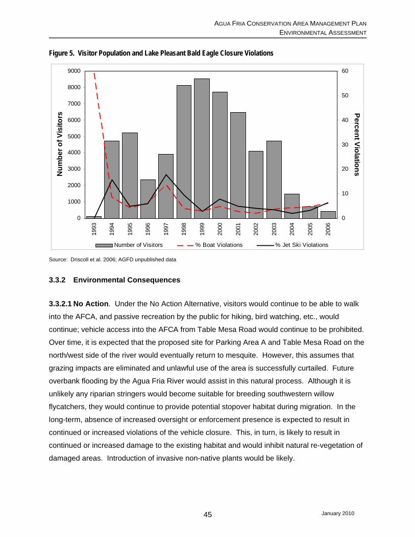
AGUA FRIA CONSERVATION AREA MANAGEMENT PLAN ENVIRONMENTAL ASSESSMENT
Figure 5. Visitor Population and Lake Pleasant Bald Eagle Closure Violations
0
1000
2000
3000
4000
5000
6000
7000
8000
9000
1993
1994
1995
1996
1997
1998
1999
2000
2001
2002
2003
2004
2005
2006
Num
ber o
f Vis
itors
0
10
20
30
40
50
60
Percent Violations
Number of Visitors % Boat Violations % Jet Ski Violations
Source: Driscoll et al. 2006; AGFD unpublished data
3.3.2 Environmental Consequences
3.3.2.1 No Action. Under the No Action Alternative, visitors would continue to be able to walk
into the AFCA, and passive recreation by the public for hiking, bird watching, etc., would
continue; vehicle access into the AFCA from Table Mesa Road would continue to be prohibited.
Over time, it is expected that the proposed site for Parking Area A and Table Mesa Road on the
north/west side of the river would eventually return to mesquite. However, this assumes that
grazing impacts are eliminated and unlawful use of the area is successfully curtailed. Future
overbank flooding by the Agua Fria River would assist in this natural process. Although it is
unlikely any riparian stringers would become suitable for breeding southwestern willow
flycatchers, they would continue to provide potential stopover habitat during migration. In the
long-term, absence of increased oversight or enforcement presence is expected to result in
continued or increased violations of the vehicle closure. This, in turn, is likely to result in
continued or increased damage to the existing habitat and would inhibit natural re-vegetation of
damaged areas. Introduction of invasive non-native plants would be likely.
January 2010 45

AGUA FRIA CONSERVATION AREA MANAGEMENT PLAN ENVIRONMENTAL ASSESSMENT
Lack of boat access from the north end of Lake Pleasant could potentially increase violations of
the southern boundary of the Bald Eagle Closure Area, by boaters trying to reach favorite
fishing spots.
3.3.2.2 Partners Preferred Alternative. Table Mesa Road and Parking Area A would remain in
their present cleared state; Parking Area A may also be further stabilized to provide dust control
if deemed desirable and funding is available. Installation of vehicle barriers would be placed to
inhibit off-road vehicle use of the remainder of the mesquite bosque, xeroriparian washes, the
Boulder Creek drainage, and numerous undesignated trails that have degraded the uplands. If
grazing can be eliminated from the area, it is expected the understory within the mesquite
bosque and the riparian stringers would be able to re-vegetate naturally for the benefit of all
wildlife species. Parking Areas B, C, and D are located in areas that are seasonally inundated;
as water levels recede they become vegetated with cocklebur. Although it provides important
habitat for fish, any loss of the cocklebur as a result of designating Parking Areas B-D for
temporary seasonal access to the river would not affect the sports fishery due to the large
expanse of cocklebur that would remain. Additionally, cocklebur is not considered significant to
any wildlife species. Increased sedimentation caused by vehicles crossing the Agua Fria River
and boats launching could impact spawning; this is because fish eggs that have been deposited
could be suffocated by sediment; however, the project area is somewhat isolated from the larger
water body further downstream and sedimentation impacts, if any, are anticipated to be minor
(R. Clarkson, pers. comm. 2009).
Primitive camping and trail development, which would occur in Phase III, may result in
disturbance to wildlife, including game species. This disturbance is anticipated to be minimal
and would not affect any sensitive (e.g. federally-listed) species. Development of a primitive
camping site would result in the loss of a relatively small amount of upland habitat. However, if
it could be integrated into the already disturbed airstrip as recommended in the proposed
Management Plan, these impacts would be reduced.
Similar to the No Action alternative, the riparian stringers would likely not become suitable for
breeding southwestern willow flycatchers, but would continue to be potential stopover habitat for
use during migration. Based upon past AGFD data, it is anticipated that five percent of boats
would annually violate the Bald Eagle Closure boundary, and that monofilament would be
discarded by anglers or lost to fish or snags.
January 2010 46
AGUA FRIA CONSERVATION AREA MANAGEMENT PLAN ENVIRONMENTAL ASSESSMENT
On June 10, 2009, Reclamation received a letter from the U.S. Fish and Wildlife Service (FWS)
concurring with the biological assessment’s findings that the amended Master Plan and
associated facilities would have no effect on the bat and may affect, but is not likely to adversely
affect the flycatcher and bald eagle (Appendix D).
The following Conservation Measures would be included in the Management Plan.
• The AFCA boat launch facilities would be for day-use and would be open to the public
only when facility hosts or designated staff are present;
• Hosts at the Table Mesa Road entrance to the AFCA would distribute maps of the Bald
Eagle Closure area and advise visitors to stay outside the closed area when applicable;
• Informational signs would be posted in Parking Area A that delineate the Bald Eagle
closure;
• The AGFD would set out receptacles for discarded used monofilament, which poses a
hazard to the breeding bald eagles;
• Communication would be established between nestwatchers and facility hosts to convey
information concerning boating densities;
• The existing Bald Eagle Closure would be maintained and monitored by LPRP and
AGFD law enforcement staff; and
• The Lake Pleasant breeding area would continue to be monitored by a team of nest
watchers unless or until the program is discontinued.
In addition, surveys would be conducted during the 2010 breeding season for both the
flycatcher and the yellow-billed cuckoo. The yellow-billed cuckoo is a riparian obligate species
that is a candidate for federal listing.
3.3.2.3 Minimum Development Alternative. Overall impacts to biological resources
anticipated to occur under this alternative would be similar to the Proposed Action, except that
January 2010 47

AGUA FRIA CONSERVATION AREA MANAGEMENT PLAN ENVIRONMENTAL ASSESSMENT
the potential for disturbance to wildlife within the AFCA would be somewhat diminished,
especially on the south/east side of the AFCA, since the primitive camping and trail
development would not occur. Because the recreational enhancements and interpretive areas
would be dropped from this alternative, it is anticipated there would be a reduction in the amount
of use of the AFCA as compared to that occurring under the Proposed Action, resulting in a
lesser degree of wildlife disturbance and habitat destruction.
3.3.3 Cumulative Effects. As the Phoenix metropolitan area continues to expand northward,
existing recreational developments will receive more use, and there will be a greater demand for
additional recreational opportunities that are within driving distance from the nearby
metropolitan area. Increased use of BLM’s Table Mesa Recreation Area is anticipated to occur.
Lawful and/or unlawful activities within the AFCA also are expected to continue or increase.
This additional recreational use could put increased pressure on the biological resources within
the AFCA; however, the hope and expectation is that these biological resources would receive
increased protection due to the higher level of management that would occur under the
proposed project.
3.4 Land Ownership and Use 3.4.1 Affected Environment. As noted earlier, the AFCA is located within LPRP, which
consists of 23,361 acres of land owned by Reclamation. MCPRD manages LPRP as one of its
regional parks. Maricopa County Municipal Water Conservation District #1 (MWD), previous
owner of Waddell Dam and its associated Lake Pleasant, retains ownership of 225 acres
adjacent to the eastern abutment of New Waddell Dam and below the dam. The majority of the
recreational developments constructed within LPRP are located within Maricopa County;
however, over half of LPRP itself is located within Yavapai County. The portion of LPRP within
Maricopa County falls within the city limits of the city of Peoria, Arizona. The County is
responsible for the operation and management of LPRP, including its recreational facilities and
activities, and has law enforcement authority within the Park itself. The MCSO provides law
enforcement both on land and water within LPRP, and has about 10 officers assigned to Lake
Pleasant full time. MCSO’s operation and management responsibility and law enforcement
authority also extends to the portion of the Park that is located within Yavapai County, based
upon an intergovernmental agreement for which Maricopa County makes payment to Yavapai
County. The city of Peoria has jurisdiction outside the LPRP boundary within Maricopa County;
Yavapai County has jurisdiction outside LPRP within Yavapai County.
January 2010 48

AGUA FRIA CONSERVATION AREA MANAGEMENT PLAN ENVIRONMENTAL ASSESSMENT
The vast majority of the land surrounding the AFCA consists of vacant desert, most of which is
federal land managed by BLM. There also are State trust lands managed by ASLD, and some
privately-owned land parcels adjacent to portions of the AFCA, as well. In the vicinity of LPRP,
BLM manages its lands according to its recently approved Bradshaw-Harquahala Resource
Management Plan (B-H RMP; BLM 2008). Unless otherwise designated, the following activities
are allowed on BLM lands in accordance with BLM rules: casual use mining; dispersed
camping; OHV use on existing and/or designated numbered roads; recreational shooting; and
resource collecting (BLM n.d.-2). Vehicular travel is limited to existing roads and trails, unless
otherwise designated or restricted. Cattle grazing is permitted on some of the BLM and ASLD
lands in the general vicinity surrounding the AFCA. During public meetings associated with this
project, many people complained land ownership is not clearly marked on the ground, and that
there is much confusion as to what specific activities are allowed on each of the various public
lands.
As mentioned earlier, LPRP lies within BLM’s Lake Pleasant Herd Management Area. This
area, containing 80,800 acres, is used for managing burros to achieve an ecological balance
between a healthy burro herd and a stable source of forage (BLM 2008; p. 443). BLM’s Hells
Canyon Wilderness Area is located mostly within Yavapai County, just west of the northern
portion of LPRP. This 9,900-acre federally designated wilderness area is accessed via the
Castle Hot Springs Road turnoff from State Route 74. The Hells Canyon Wilderness provides
opportunities for hiking, sightseeing, and primitive camping in a wilderness setting that provides
a sense of solitude (BLM n.d.-3). Implementation of BLM’s 1995 Hell’s Canyon Wilderness
Management Plan resulted in a number of vehicular routes being closed and reclaimed,
allowing the land to re-vegetate naturally. Castle Hot Springs Road, located west of Lake
Pleasant, also serves as the main access to LPRP.
The B-H RMP identifies the general vicinity of the AFCA as having a moderate potential for
locatable metallic and nonmetallic minerals. Most existing mines, such as placer gold, lode
gold, and some industrial minerals, have been inactive for many years due to the cost to mine
and the expected market value for those minerals (BLM 2008, p. 441 & Map 3-15). Although
mining is not allowed within the LPRP, some individuals with mining claims on land adjacent to
the AFCA have accessed these claims by using primitive roads within the AFCA, which are
more convenient than going around the Park.
January 2010 49

AGUA FRIA CONSERVATION AREA MANAGEMENT PLAN ENVIRONMENTAL ASSESSMENT
3.4.1.2. Recreation. LPRP provides regional recreational opportunities to residents of the
metropolitan Phoenix area, Yavapai County, and out-of-state visitors. Recreational activities
within LPRP are administered by MCPRD. Although AGFD is responsible for administering and
providing boating law enforcement statewide, the MCSO Lake Patrol and Mountain Patrol
provide the majority of the day-to-day law enforcement on the lake itself (J. Waller, pers. comm.
2009). Socioeconomic aspects of recreation are discussed in section 3.5.
Water-based recreational opportunities are limited in the Phoenix metropolitan area. Within
Maricopa County there are four reservoirs besides Lake Pleasant that offer water-oriented
recreation. These other reservoirs are all located in the northeastern corner of Maricopa County
on the Tonto National Forest. Bartlett Reservoir is located on the Verde River; Apache, Canyon,
and Saguaro reservoirs are located on the Salt River.
Due to the operation of New Waddell Dam and use of the reservoir to store and release CAP
water to meet downstream demands, the water elevation of Lake Pleasant fluctuates about 40
to 60 feet annually. This corresponds to an estimated total water surface area of between 6,477
and 9,970 surface acres during typical annual operations (at water elevations 1,648 feet and
1,702 feet amsl, respectively). Typically, the highest water levels occur between mid-March to
mid-May (CAP 2008).
LPRP offers various forms of public recreation including, but not limited to, boating and
operation of personal watercraft, swimming, fishing, hiking, picnicking, sunbathing, camping,
and wildlife viewing. Visitation during 2005, 2006, 2007, and 2008, both in terms of vehicles
and number of visitors are provided in Table 7.
Table 7. Lake Pleasant Regional Park Visitation for Years 2005, 2006, 2007 and 2008
Year Vehicles People % Change in
visitation (people) over previous year
July 2004-June 2005 180,255 586,235 n/a July 2005-June 2006 196,190 646,598 10% July 2006-June 2007 211,195 699,057 8% July 2007-June 2008 203,688 674,210 (4%)
* Source of Information: MCPRD
January 2010 50

AGUA FRIA CONSERVATION AREA MANAGEMENT PLAN ENVIRONMENTAL ASSESSMENT
Based upon input gathered during three public meetings held in September 2007, specifically
about public use of the AFCA, this area is used primarily for fishing, non-motorized boating,
hunting, hiking, OHV use, horseback riding, camping, and bird watching.9 Many of the public
attending these meetings have been visiting the AFCA area regularly for 10 to 15 years; they
noted that over the years there has been a sense of increased crowdedness, an increase in
trash and noise, increased motorized vehicle traffic, shooting, and criminal activity. Several
members of the public expressed concern regarding unlawful activities occurring in the area
including, but not limited to, trash dumping, target and indiscriminate shooting, and vandalism.
As noted above in section 3.3, Biology, fishing is a popular activity within the AFCA, especially
during spring when the lake levels are up and fish are spawning at the head of Lake Pleasant.
Because the upper reaches of the AFCA are influenced primarily by flows from the Agua Fria
River and runoff from various washes and creeks, this area tends to be more productive for
spawning and foraging than the major deep portion of the reservoir. This productivity creates
excellent fishing opportunities within the AFCA and, as a result, a large portion of the total
angling pressure on the reservoir occurs here (Bryan 2005; pg.3). Although anglers pursue
white and large mouth bass and some channel catfish (Ictalurus punctatus), the majority of
anglers are fishing for striped bass within the AFCA (N. Robb, pers. comm. 2009).
The seasonal Bald Eagle Closure at Lake Pleasant, discussed earlier, was established on
recommendation by the Southwestern Bald Eagle Management Committee, to protect a pair of
nesting bald eagles. This closure prevents boat access upstream from the main lake body to
the head of the lake from December 15 to June 15 each year. Thus, during times when fishing
in the upper reaches of the AFCA is best, boat access is not allowed to these areas from the
main lake due to the Bald Eagle closure. During this time of year, the most convenient access
to this part of the Lake is from Table Mesa Road.
Prior to July 2007, the existing main access gate to LPRP from Table Mesa Road was only
closed when there were flood flows in the Agua Fria River. There was no gate on the existing
bladed trail on the south/east side of the Agua Fria River. Vehicle and OHV access into and
within the AFCA was unimpeded. With limited resources available, there was little to no
9 It should be noted that within LPRP the following applies: OHV use is allowed only on designated roadways and only with proper licensing and insurance; hunting is allowed with proper permits but target shooting is not; and, camping is allowed only with a permit.
January 2010 51
AGUA FRIA CONSERVATION AREA MANAGEMENT PLAN ENVIRONMENTAL ASSESSMENT
MCPRD staff or law enforcement presence on a regular basis within the AFCA. As described in
section 1.3, AFCA Background, increasing use of the AFCA over the years resulted in the area
becoming a place where shooting, trash dumping, off-road vehicle travel, vandalism, and
criminal activities were degrading cultural and natural resources and creating unsafe conditions
for public use. For example, in October 2006, 32 tons of trash were removed from the AFCA
and surrounding area.
MWD operates a Recreational Vehicle resort park on its 225 acres. There also is a marina
located on MWD’s property that is operated by a concessionaire through an agreement with
MWD.
3.4.2 Environmental Consequences
3.4.2.1 No Action. Under the No Action Alternative, enforcement of the vehicle restriction
would continue. No vehicular access would be allowed beyond the existing barriers. It is
anticipated that in the foreseeable future the barriers would be respected for the most part;
however, the occasional vandalism of the barriers which currently occurs is expected to
continue. In the long-term, absence of increased oversight or enforcement presence is
expected to result in continued or increased violations of the vehicle closure. It is also
anticipated that individuals would continue to create unauthorized access into the AFCA from
various locations, and Park staff would need to continually repair the gates and attempt to
restore damage created by these unlawful incursions.
Over time it is anticipated many of the people who visit the AFCA to enjoy the these types of
outdoor activities--but who want or need easier vehicular access--would seek other areas and
would have to travel farther distances to find secluded primitive recreational opportunities that
have vehicular access. Visitation and use by recreationists desiring or requiring vehicular
access to AFCA and/or the upper portion of Lake Pleasant would decrease.
3.4.2.2 Partners Preferred Alternative. With the proposed project, Table Mesa Road
would be stabilized; signage and/or vehicular barriers would be installed and vehicular traffic
within the AFCA would be required to remain on the designated Table Mesa Road. When open,
the AFCA would be monitored daily by park hosts and/or staff to ensure vehicles remain within
January 2010 52

AGUA FRIA CONSERVATION AREA MANAGEMENT PLAN ENVIRONMENTAL ASSESSMENT
the designated areas. This would reduce soil erosion, sedimentation, and turbidity resulting
from increased vehicle traffic using the area.
This alternative would provide more direct and convenient access to the uppermost portion of
Lake Pleasant when fishing is best but there is no access from downstream due to the Bald
Eagle Closure. It would allow convenient access to the water for those with boats or who are
unable to walk in several miles with rafts or kayaks, etc. Based upon the results of AGFD’s six-
week pilot program, it is anticipated the presence of the park hosts and higher visibility of
MCPRD staff and law enforcement would ensure that impacts from increased visitation would
be minimized. In addition, this alternative would provide day-use amenities that would enable
non-fishing recreationists the opportunity to enjoy a more primitive and secluded recreational
setting.
3.4.2.3 Minimum Development Alternative. MCPRD has a mission and vision to provide a
multitude of recreational opportunities for all of its users; however, this alternative would provide
recreational opportunities primarily for fishing enthusiasts. Although MCPRD is a recognized
leader regarding its trail system, LPRP is the only County park without an approved trail plan.
Elimination of the trails under this alternative would reduce the opportunities available to visitors,
including but not limited to activities such as bird and wildlife viewing, sight-seeing, and
camping. This would be especially true of visitors that are unable to walk for long distances.
3.4.3 Cumulative Effects. During the public meetings held on this proposed project, many
individuals expressed confusion and frustration about the lack of signage regarding property
boundaries and allowable and/or restricted activities associated with each public landowner. It
is anticipated increased visitation to and use of the Table Mesa Recreation Area will result in
spillover onto neighboring public lands, including the AFCA. Implementation of the proposed
AFCA management plan could provide additional physical presence that would facilitate
assisting the recreating public in staying within designated areas and adhering to LPRP rules
and policies while within the LPRP. The Prescott National Forest and Tonto National Forest,
located within 15 miles north and east of the AFCA, respectively, also provide the public with a
relatively undisturbed, primitive recreational setting. There currently are no known plans for
changing the management of these lands in the future.
January 2010 53

AGUA FRIA CONSERVATION AREA MANAGEMENT PLAN ENVIRONMENTAL ASSESSMENT
3.5 Socioeconomic Resources 3.5.1 Affected Environment. The social and economic conditions that would be affected by
the proposed project include Yavapai County, specifically Black Canyon City; in Maricopa
County, the cities and communities that are expected to be affected would include New River,
which is just east of the project area; Wickenburg, which is about 25 miles west of Lake
Pleasant; and the northern Phoenix metropolitan area as represented by the cities and
communities of Cave Creek, Peoria, and Surprise.
Arizona has experienced a population explosion since the early 1990s. Between the 1990 and
2000 censuses, Arizona’s population grew by 40 percent, while both Maricopa and Yavapai
counties grew at an even faster rate (45 and 56 percent, respectively) (Table 8).
Table 8. Arizona, Maricopa and Yavapai Counties Population Change 1990-2000
POPULATION 1990 2000 %
Change Arizona 3,665,228 5,130,632 40 Maricopa County 2,122,101 3,072,149 45 Yavapai County 107,714 167,517 56
Source: Census 2000
In 2006, Arizona was the fastest growing State in the country, with a State population increase of
3.6 percent between July 2005 and July 2006 (Bowers 2006). This trend has continued, with
average growth rates between 3.7 percent and 5.7 percent from 2000 to 2007 for both Maricopa
and Yavapai counties and the communities listed above, with the exception of Surprise, which
experienced an exponential population increase between 2000 and 2007 of 240 percent, or the
equivalent yearly average of 34.3 percent (Census 2000; ADOC 2008) (Table 9). Over the next
20 years, this growth rate is expected to slow down considerably (Table 10).
January 2010 54
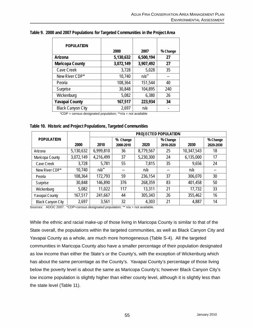
AGUA FRIA CONSERVATION AREA MANAGEMENT PLAN ENVIRONMENTAL ASSESSMENT
Table 9. 2000 and 2007 Populations for Targeted Communities in the Project Area
POPULATION 2000 2007 % Change
Arizona 5,130,632 6,500,194 27 Maricopa County 3,072,149 3,907,492 27 Cave Creek 3,728 5,028 35 New River CDP* 10,740 n/a** -- Peoria 108,364 151,544 40 Surprise 30,848 104,895 240 Wickenburg 5,082 6,380 26 Yavapai County 167,517 223,934 34 Black Canyon City 2,697 n/a -
*CDP = census designated population; **n/a = not available
Table 10. Historic and Project Populations, Targeted Communities
POPULATION 2000
PROJECTED POPULATION
2010 % Change 2000-2010 2020
% Change 2010-2020 2030
% Change 2020-2030
Arizona 5,130,632 6,999,810 36 8,779,567 25 10,347,543 18 Maricopa County 3,072,149 4,216,499 37 5,230,300 24 6,135,000 17 Cave Creek 3,728 5,781 55 7,815 35 9,656 24 New River CDP* 10,740 n/a** -- n/a -- n/a -- Peoria 108,364 172,793 59 236,154 37 306,070 30 Surprise 30,848 146,890 376 268,359 83 401,458 50 Wickenburg 5,082 11,022 117 13,311 21 17,732 33 Yavapai County 167,517 241,667 44 305,343 26 355,462 16 Black Canyon City 2,697 3,561 32 4,303 21 4,887 14
Sources: ADOC 2007. *CDP=census designated population; ** n/a = not available.
While the ethnic and racial make-up of those living in Maricopa County is similar to that of the
State overall, the populations within the targeted communities, as well as Black Canyon City and
Yavapai County as a whole, are much more homogeneous (Table S-4). All the targeted
communities in Maricopa County also have a smaller percentage of their population designated
as low income than either the State’s or the County’s, with the exception of Wickenburg which
has about the same percentage as the County’s. Yavapai County’s percentage of those living
below the poverty level is about the same as Maricopa County’s; however Black Canyon City’s
low income population is slightly higher than either county level, although it is slightly less than
the state level (Table 11).
January 2010 55
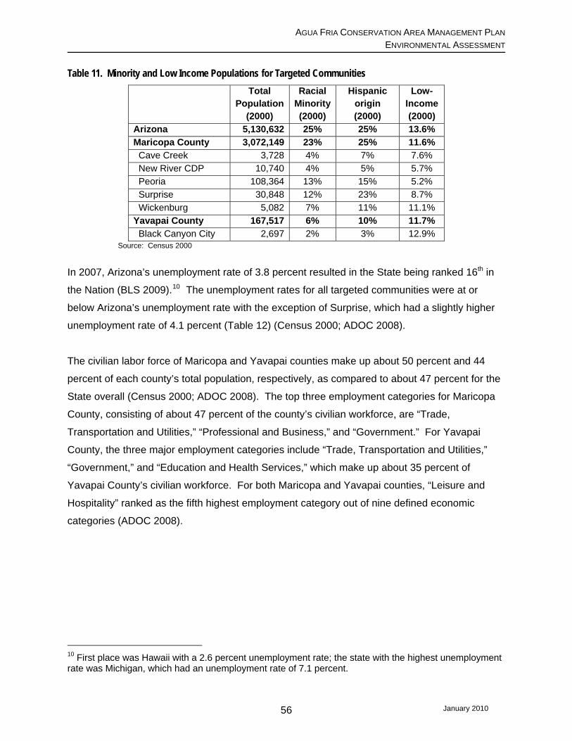
AGUA FRIA CONSERVATION AREA MANAGEMENT PLAN ENVIRONMENTAL ASSESSMENT
Table 11. Minority and Low Income Populations for Targeted Communities
Total Population
(2000)
Racial Minority (2000)
Hispanic origin (2000)
Low-Income (2000)
Arizona 5,130,632 25% 25% 13.6% Maricopa County 3,072,149 23% 25% 11.6% Cave Creek 3,728 4% 7% 7.6% New River CDP 10,740 4% 5% 5.7% Peoria 108,364 13% 15% 5.2% Surprise 30,848 12% 23% 8.7% Wickenburg 5,082 7% 11% 11.1% Yavapai County 167,517 6% 10% 11.7% Black Canyon City 2,697 2% 3% 12.9%
Source: Census 2000
In 2007, Arizona’s unemployment rate of 3.8 percent resulted in the State being ranked 16th in
the Nation (BLS 2009).10 The unemployment rates for all targeted communities were at or
below Arizona’s unemployment rate with the exception of Surprise, which had a slightly higher
unemployment rate of 4.1 percent (Table 12) (Census 2000; ADOC 2008).
The civilian labor force of Maricopa and Yavapai counties make up about 50 percent and 44
percent of each county’s total population, respectively, as compared to about 47 percent for the
State overall (Census 2000; ADOC 2008). The top three employment categories for Maricopa
County, consisting of about 47 percent of the county’s civilian workforce, are “Trade,
Transportation and Utilities,” “Professional and Business,” and “Government.” For Yavapai
County, the three major employment categories include “Trade, Transportation and Utilities,”
“Government,” and “Education and Health Services,” which make up about 35 percent of
Yavapai County’s civilian workforce. For both Maricopa and Yavapai counties, “Leisure and
Hospitality” ranked as the fifth highest employment category out of nine defined economic
categories (ADOC 2008).
10 First place was Hawaii with a 2.6 percent unemployment rate; the state with the highest unemployment rate was Michigan, which had an unemployment rate of 7.1 percent.
January 2010 56

AGUA FRIA CONSERVATION AREA MANAGEMENT PLAN ENVIRONMENTAL ASSESSMENT
Table 12. Economic Attributes for Targeted Communities in Maricopa and Yavapai Counties
Population
(2000)
Civilian Labor Force
(2007)
Unemploy-ment Rate
(2007)
Household median income (1999)
Per capita income (1999)
Families below
poverty level (1999)
Arizona 5,130,632 3,029,090 3.8% $40,558 $20,275 9.9% Maricopa County 3,072,149 1,947,563 3.2% $45,358 $22,251 8.0% Cave Creek 3,728 2,583 1.5% $59,937 $38,070 6.0% New River CDP 10,740 n/a n/a $62,307 $25,932 3.6% Peoria 108,364 67,433 2.3% $52,199 $22,726 3.3% Surprise 30,848 32,623 4.1% $44,156 $21,451 5.6% Wickenburg 5,082 2,636 1.4% $31,716 $19,772 6.9% Yavapai County 167,517 98,390 3.7% $34,901 $19,727 7.9% Black Canyon City 2,697 1,700 3.8% $32,908 $20,116 7.6%
Source: Census 2000; ADOC 2008
In a 2002 Arizona State University study, fishing and hunting contributed $58.2 million in state
tax revenues in 2001. Maricopa and Yavapai counties’ fishing- and hunting-related state tax
revenues for this same period were an estimated $21.1 million and $2.3 million, or about 36
percent and 4 percent of the state total, respectively (Silberman 2002; p. 10). According to this
study, fishing and hunting recreation activities created a statewide economic impact in 2001 of
$1.34 billion. This estimate takes into consideration spending by anglers and hunters in the
pursuit of these activities, including activity expenditures, equipment purchased or rented,
travel-related expenses, and the “ripple” effect these expenditures have on the economy, such
as related retail income and employment (Silberman 2002; p. 4-5). Total estimated spending
related to these two activities was just short of $1 billion statewide in 2001, with Maricopa and
Yavapai counties accounting for just under 50 percent of the State’s total expenditures
(Table 13).
Table 13. 2001 Fish and Hunting Related Spending in Arizona 2001
Expenditures Fishing Hunting Total % of AZ
Arizona $831,493,493 $126,628,825 $958,122,318 Maricopa $366,786,326 $42,244,142 $409,030,468 43% Yavapai $30,240,099 $9,643,530 $39,883,629 4%
Source: Silberman 2002 (p. 12)
3.5.2. Environmental Consequences. Under any of the alternatives it is anticipated that
in the short-term, population growth will continue but at a slower rate than that projected in
Table 10. Unemployment rates may climb up to 10 percent by the end of 2009, before
January 2010 57

AGUA FRIA CONSERVATION AREA MANAGEMENT PLAN ENVIRONMENTAL ASSESSMENT
decreasing (Beard 2009).11 Assuming the economy recovers, over the longer term it is
expected development will pick back up within the northwestern Maricopa County and
metropolitan Phoenix areas and expand up into southern Yavapai County.
3.5.2.1 No Action. Fishing and hunting are activities whose enjoyment and related
knowledge and skills are passed down from generation to generation. The recent economic
downturn has resulted in more residents participating in outdoor recreational activities in-State
rather than going out of town for vacations (Dungan 2009). It is anticipated in the short-term,
these activities would continue at about the same levels or increase until economic conditions
improve; tax revenues and spending related to fish and hunting would be about the same as in
previous years or increase accordingly. In the longer term, expanded development in northern
Maricopa and southern Yavapai counties would put additional pressure on LPRP to provide
both developed and passive recreational opportunities for the growing populations in the
general vicinity. Without a management plan in place that provides both resources and
monitoring, the AFCA would be subject to degradation from increased unlawful entry and
misuse. Lack of agency and/or law enforcement presence eventually could result in increased
trespass and deterioration of the area’s natural resources. Misuse and unlawful activities within
the AFCA, similar to those occurring prior to July 2007, could resume, resulting in the
subsequent return of safety and public health issues.
3.5.2.2 Partners Preferred Alternative. Implementation of the proposed management plan
is expected to avoid or deter increased damage to the natural and cultural resources of the
AFCA in the wake of the additional pressure that would be placed on these recreational
resources into the future. With the proposed management plan, the primitive improvements and
monitoring would occur within the AFCA to ensure that public access is restricted to designated
areas, and adverse impacts to the natural resources are minimized. The recreational
improvements provided by the proposed project would help limit people’s use to these minimally
improved areas. Ongoing monitoring that would be implemented as part of the management
plan would provide early detection of any deterioration or degradation from recreational use so
that remedial steps could be taken to prevent continued damage to the natural and cultural
resources within the AFCA. The purpose of these measures would be to ensure this primitive
11 Arizona’s unemployment rate in December 2009 was 9.1 percent (BLS 2010).
January 2010 58
AGUA FRIA CONSERVATION AREA MANAGEMENT PLAN ENVIRONMENTAL ASSESSMENT
recreational setting continues to be available to the recreating public within a reasonable
distance of the Phoenix metropolitan area.
3.5.2.3 Minimum Development Alternative. Impacts from this alternative would be similar to
those of the Partners Preferred Alternative, except day-use amenities such as picnic areas,
ramadas, fire rings, and passive recreational developments would not be included. Primitive
camping would be eliminated, as would development of trails and interpretive areas. A
permanent entry station also would not be constructed. The south/east side of the Agua Fria
River within the AFCA would continue to be accessible by foot, bicycle or horseback for day-use
only.
3.5.3 Cumulative Effects. Use of the AFCA, in combination with increased recreational use
of the Table Mesa Recreation Area would result in additional recreation-related spending and
tax revenues beyond those of fishing and hunting (e.g., OHV use; rock climbing; camping; etc.).
ASLD lands east of the AFCA could be auctioned off.
3.6 Cultural Resources 3.6.1 Affected Environment. The area encompassing LPRP has a long history of human
occupation and association. Cultural resources identified within LPRP boundaries during
cultural resource surveys (REF) cover the gambit of periods of human progress within the
Southwest--Archaic, Prehistoric, Protohistoric and Historic, underscoring the importance of
water in the arid Southwest. The Aqua Fria River, a perennial water source, is a central
component of the cultural framework of the region.
Archaic Period. The Archaic period represents the earliest occupation period within LPRP.
Archaic period occupation dates from 8000 B.C. to A.D. 300. This period is represented by a
less-expansive mobile lifestyle, which may have been limited to a geographical region. As the
period progressed, mobility decreased further, resulting in a tendency toward sedentism and
experimentation with plant domestication (Slaughter et al. 1992). The identification of Archaic
period sites is rare, in part because of a distinctive trait--the absence of ceramic artifacts.
Several Archaic sites were previously recorded in the northern periphery (Crownover 1994) and
possible sites along New River (Ferg 1977). A single Archaic period site was identified within
LPRP; however, there is additional potential for evidence of occupation dating to the Archaic
January 2010 59

AGUA FRIA CONSERVATION AREA MANAGEMENT PLAN ENVIRONMENTAL ASSESSMENT
period at unidentified sites within LPRP, and in some of the thousands of chipped stone flakes
that blanket LPRP, specifically the AFCA.
Prehistoric Period. Not surprisingly, cultural resource investigations have shown that areas
adjacent to the main tributaries of the Aqua Fria River, and Humbug, Castle, and French creeks,
were key locations for prehistoric habitation and agriculture. During the prehistoric occupation
of the LPRP area, sites remained small (Doyel and Elson 1985); however, larger villages did
occur, such as the Beardsley Canal site. The Beardsley Canal site provides the earliest reliable
date for prehistoric use of the area. Ceramic analysis from the site indicates the Hohokam
culture occupied the area from the late Pioneer period through the Sedentary periods
(A.D. 675-1000) (Fish 1971; Huckell 1973; Weed 1972).
The Hohokam culture is best known for its desert farmers, who engineered a wide-ranging
system of irrigation canals in both central and southern Arizona (Haury 1976). A large part of
the Hohokam’s sustenance came from agricultural activities, such as cultivation of corn, squash,
beans, tobacco, cotton and amaranth. Hunting and gathering also were essential to survival,
especially in the LPRP area, which was on the northern periphery of more densely populated
agricultural areas to the south. Evidence gathered at habitation sites established along various
drainages leading into the Aqua Fria River suggests occupation lasted well into A.D. 1450.
(Green 1989). Hohokam sites identified within LPRP include: pithouse villages, agricultural
field houses, farmsteads, agricultural resource extraction, petroglyphs, quarries, cleared areas
and artifact scatters (Moreno 2001).
Protohistoric Period. Four Yavapai sites, a rock shelter, artifacts scatter and a resource
exploitation site have been identified within the LPRP. The Yavapai are believed to have
occupied or utilized the area from about A.D. 1450 to the late 19th century (Gifford 1932, Pilles
1981). Cultural resource surveys were able to identify some characteristically Yavapai artifacts
such as marked ceramics and small projectile points call Pai (Dobyns and Euler 1958; Baumhoff
and Byrne 1959).
Historic (Euro-American) Period. Historic utilization and occupation of the LPRP area dates
from the 1880s, with early land uses by nonnative peoples including prospecting, mining, sheep
and goat heading, ranching, and homesteading (Introcaso 1988:6; Fenicle et al. 1994; Soliday
2008). Interest in the river’s potential to provide water for irrigation, mining and other uses
January 2010 60
AGUA FRIA CONSERVATION AREA MANAGEMENT PLAN ENVIRONMENTAL ASSESSMENT
began with the formation of the Aqua Fria Water and Land Company in 1888, doing little more
then producing plans. William Beardsley, who later invested his own money in the company,
started construction of a storage dam upstream from Frog Tanks, which was previously a stage
coach stop, and 50 miles of canal to provide water to the valley below. The lack of additional
investments, construction problems and water ownership issues delayed the project until the
1930s. The water control project started by William Beardsley was completed in 1935 under the
direction of Carl Pleasant, making it the only privately-owned and operated dam in central
Arizona at the time (Introcaso 1988).
Water from the Agua Fria was not only used for agriculture. From approximately 1893 until the
early 1920s, Humbug Creek was the site of a full-scale hydraulic mining operation called the
Humbug Creek Hydraulic Mining Company (Ayres et al. 1992). Although prospecting and small
scale mining were conducted elsewhere in what is now LPRP, the mining operation along
Humbug Creek was the largest mining operation in what is now LPRP. Homesteading, for the
most part, was relegated to the northern end of LPRP along the Aqua Fria River. The more
notable homesteads identified within LPRP, including the AFCA, were the Brown, Solo Springs
Ranch (Two Shoes), Avis, and Tyler. Along with homesteading, ranching and herding both
sheep and goats were common historically.
Around the turn of the 20th century, several large cattle ranches were established in the areas
north of the current boundaries of LPRP--Champie/Lazy UT, JL Bar and the TP Ranch, to name
a few. These ranches were located outside the current boundaries of LPRP, but utilized the
areas around the Aqua Fria River for grazing. Later in the 20th century, a few ranches were
established within the current park boundary such as the Solo Springs Ranch and Boulder
Creek Ranch. Both sheep and goats were raised, goats being the predominant stock animal in
the early part of the 20th century. Basque sheep herders also would herd stock down to this
area from the Flagstaff area on a seasonal basis.
The Federal Government purchased Lake Pleasant Park and, between 1987 and 1992,
Reclamation constructed a higher dam about ¼ mile downstream of the original dam, thus
increasing storage capacity within Lake Pleasant behind New Waddell Dam.
Aqua Fria Conservation Area. The area of LPRP known as the AFCA is an isolated snapshot of
the cultural resources identified throughout LPRP. Cultural resources identified within the AFCA
January 2010 61

AGUA FRIA CONSERVATION AREA MANAGEMENT PLAN ENVIRONMENTAL ASSESSMENT
represent the expanse of cultural environment in LPRP--from the earliest human interaction,
utilization, and occupation--throughout the Archaic, Hohokam, Yavapai and Historic periods.
There are approximately 44 previously identified cultural resource sites located within the AFCA;
it must be noted that identification of additional sites within this area is possible. Historically, the
rugged terrain and lack of recreational improvements provided a level of protection for these
cultural resources; however, in recent years the conditions within the AFCA have deteriorated,
putting the cultural resources at risk.
Initially, after construction of New Waddell Dam, the AFCA experienced minimal to no
enforcement oversight. The impact to cultural resources within the AFCA, caused by the
increasing recreational use and the rise in the popularity of all-terrain vehicles and OHVs,
included both deliberate and unintentional destruction of entire cultural sites and individual
artifacts. Although there is always a possibility of pedestrian traffic impacting a site or artifact,
unrestricted traffic within the AFCA has been highly destructive to cultural resources. These
activities have left some sites with broken or destroyed artifacts, disturbing the surface of the
site beyond recognition and scattering artifacts across the site, thus destroying any contextual,
or spatial information they could have provided.
Since July 2007, public access to the AFCA has been limited to pedestrian, bicycle and
horseback entry through use of a locked gate at the Table Mesa Road entrance to LPRP. Since
implementation of this policy, impacts to cultural resources within the AFCA have been
substantially reduced but not entirely eliminated. Access to the area is still available by several
difficult and lengthy trails, originating from BLM lands north of the park and via the Aqua Fria
riverbed itself. Reclamation has been actively locating previously recorded cultural resource
sites within the ACFA, to complete condition assessments and establish current baselines for
future evaluation of effectiveness of future management actions.
3.6.2.1 No Action. Under the No Action Alternative it is anticipated that visitation to LPRP, and
to the AFCA specifically, would continue to increase in the next few years. This is anticipated to
occur partly due to increasing populations both in the Valley and adjacent to LPRP, and partly
due to the current economic situation which makes LPRP a more financially viable destination
for recreational activities. It is anticipated the current gate system would not withstand the
pressures that are expected to be placed on the AFCA in the near future; the irreplaceable and
January 2010 62

AGUA FRIA CONSERVATION AREA MANAGEMENT PLAN ENVIRONMENTAL ASSESSMENT
significant cultural resources within the AFCA would not be able to withstand the pressure and
many would likely be lost forever.
3.6.2.2 Partners Preferred Alternative. The proposed management actions, if implemented,
are anticipated to reduce impacts to the recorded cultural resources within the AFCA. The
following measures are proposed to mitigate adverse impacts to cultural resources.
• Vehicular access into the AFCA would occur only when park hosts are available;
• Park hosts would provide handouts to and advise visitors regarding specific Federal, State
and local laws pertaining to cultural resources in the AFCA;
• Park hosts would provide information to visitors regarding adhering to the access road and
the boundaries;
• Park hosts would provide information concerning cultural resources and applicable federal,
state and local protection laws in Parking Area A;
• Appropriate vehicle barriers along the designated road would be installed at to be
determined (TBD) locations to prevent vehicular access to cultural resources;
• MCPRD and its partners would identify access points leading into the AFCA from the north
end of the park and take appropriate measures to restrict vehicular traffic from these
points, including signage or barriers;
• MCPRD would install vehicle barriers at TBD locations along the Boulder Creek to restrict
vehicular access to cultural resources; and
• MCPRD would provide brochures to visitors that highlight cultural resources, their
significance and applicable Federal, State and local protection laws.
3.6.2.3 Minimum Development Alternative. Without the development of the additional day-
use amenities, primitive camping areas, and trails, overall public use of the AFCA may be
somewhat reduced and less dispersed than under the Proposed Action which, in turn, could
January 2010 63

AGUA FRIA CONSERVATION AREA MANAGEMENT PLAN ENVIRONMENTAL ASSESSMENT
January 2010 64
result in a reduction in the degree of human intrusion and potential disturbance to the cultural
and natural resources within the AFCA. Under this alternative, interpretation of selected natural
history, archaeological and cultural resource sites would be eliminated. Without interpretation,
the location of these sites would not be identified which could assist in their continued
protection; however, without the protection provided by developing them into interpretive sites,
these sites also could be discovered and looted or damaged.
3.6.3 Cumulative Effects. The B-H RMP identifies BLM’s intent to select sites (e.g.,
prehistoric hilltop structures, rock art, and mining camps) within the Table Mesa Recreation
Area and develop them for public use, including heritage tourism (BLM 2008; p. 200-201).
Reclamation would coordinate with BLM to determine whether or not BLM and Reclamation
cultural resource program activities could be designed to mutually benefit the goals of each
program, especially with regard to sites that are similar or connected.
3.7. Resources Considered But Not Affected
3.7.1. Geology. There would be no impact to the geology of the region or local area from
implementation of the management plan because no alteration of geologic resources or
conditions would occur from construction, use, and maintenance of any of the features
proposed.
3.7.2. Environmental Justice. No Environmental Justice issues would result from
implementing the proposed Management Plan. This is because the project area is not located
in an area where there are a disproportionate amount of minority and/or low-income
populations, nor would the implementation of the proposed Management Plan cause significant
adverse impacts that could adversely affect these same populations.
AGUA FRIA CONSERVATION AREA MANAGEMENT PLAN ENVIRONMENTAL ASSESSMENT
4.0 ENVIRONMENTAL LAWS AND DIRECTIVES CONSIDERED
National Environmental Policy Act of 1969, as amended (NEPA) (P.L. 91-190). This law
requires Federal agencies to evaluate the potential consequences of major Federal actions. An
action becomes “federalized” when it is implemented by a Federal agency, wholly or partially
funded with Federal monies, or requires authorization from a Federal agency. The intent of
NEPA is to promote consideration of environmental impacts in the planning and decision-
making processes prior to project implementation. NEPA also encourages full public disclosure
of the proposed action, any action alternatives, potential environmental effects, and mitigation.
This EA was prepared consistent with the requirements of NEPA. On January 20, 2009,
Reclamation distributed a memorandum to over 75 interesting agencies, organizations, and
individuals informing the public about a 31-day public scoping and comment period. This
memorandum was also posted on the Reclamation Phoenix Area Office’s website
(http://www.usbr.gov/lc/phoenix/). The memorandum briefly described the events leading up to
the development of the proposed management plan for the AFCA, and included a link to
MCPRD’s website where the proposed management plan was posted. A public scoping
meeting was held on February 4, 2009, that was attended by about six members of the pubic.
Fifteen comments were received during the scoping period. Relevant issues have been
addressed in the EA as appropriate.
Fish and Wildlife Coordination Act (FWCA) (P.L. 85-624). This Act requires coordination
with Federal and State wildlife agencies (FWS and AGFD) for the purpose of mitigating project-
caused losses to wildlife resources from water development projects. Reclamation completed
coordination with FWS and AGFD in compliance with the FWCA for New Waddell Dam, as part
of the Regulatory Storage Division of the CAP.
Endangered Species Act of 1973 (ESA) (P.L. 93-205). Section 7 of the ESA requires Federal
agencies to consult with FWS to ensure that undertaking, funding, permitting or authorizing an
action is not likely to jeopardize the continued existence of listed plant or animal species or
destroy or adversely modify designated critical habitat. The list of species maintained by FWS
for Maricopa County was reviewed and three listed species are known or likely to occur within
the AFCA: bald eagle; southwestern willow flycatcher; and lesser long-nosed bat. Reclamation
prepared a biological assessment and determined the proposed project would not affect the
January 2010 65
AGUA FRIA CONSERVATION AREA MANAGEMENT PLAN ENVIRONMENTAL ASSESSMENT
lesser long-nosed bat; however, the proposed project may affect but is not likely to adversely
affect the bald eagle and southwestern willow flycatcher. FWS concurred with this finding (see
Appendix D.
Wild and Scenic Rivers Act of 1968 (P.L. 90-542). This act designated the initial components
of the National Wild and Scenic River System. It established procedures for including other
rivers or reaches of rivers that possess outstanding scenic, recreational, geologic, fish-and-
wildlife, historic, cultural, or other similar resources, and preserving these rivers in a free-flowing
condition. There are no rivers designated or proposed for designation as wild or scenic within or
near the AFCA.
Wilderness Act of 1964 (P.L. 88-577, as amended). This act established the National
Wilderness Preservation System to preserve certain Federal lands for the public purposes of
recreation, scenic, scientific, educational, conservation, and historical use by current and future
generations of Americans. The closest designated Wilderness Area is Hells Canyon
Wilderness, which is managed by BLM. It is located mostly within Yavapai County, just west of
the northern portion of LPRP. It covers 9,900 acres, and is accessed via Castle Hot Springs
Road, off State Route 74, which is also the main entrance to LPRP. Implementation of the
Management Plan is not expected to affect the use of this Wilderness Area.
Clean Water Act (CWA) (P.L. 92-500, as amended). The CWA is intended to direct the
restoration and maintenance of the chemical, physical, and biological integrity of the Nation’s
waters by controlling the discharge of pollutants. The basic means to achieving the goals of the
CWA is through a system of water quality standards, discharge limitations, and permits. Section
404 of the CWA identifies conditions under which a permit is required for actions that result in
placement of fill or dredged material into waters of the U.S. In addition, 401 water quality
certification and a 402 Arizona Pollutant Discharge Elimination System permit are required for
activities that discharge pollutants to waters of the US. Installing posts in the Agua Fria River
channel and developing Launch Ramp A are activities that would be required to comply with
Section 404 regulations.
National Historic Preservation Act (NHPA) (P.L. 89-665). NHPA establishes, as Federal
policy, the protection of historic sites and values in cooperation with States, Tribes, and local
governments. The entire LPRP, including the AFCA, has been intensively surveyed for cultural
January 2010 66
AGUA FRIA CONSERVATION AREA MANAGEMENT PLAN ENVIRONMENTAL ASSESSMENT
resources. Forty-four sites have been located within the AFCA. Prior to land-disturbing
activities associated with installation of recreational developments, areas would be re-surveyed
for cultural resources. Any properties located as part of this proposed project would be avoided,
have data recorded prior to initiation of construction activities, or be developed as an interpretive
site.
Farmland Protection Policy Act (P.L. 97-98). This act requires identification of proposed
actions that would adversely affect any lands classified as prime and unique farmlands with the
intent of minimizing the unnecessary and irreversible conversion of farmland to nonagricultural
uses. The U.S. Department of Agriculture’s Natural Resources and Conservation Service
administers this act. The proposed action would not directly impact lands classified as prime
and unique farmlands.
Executive Order 11988 (Floodplain Management). This Presidential directive encourages
Federal agencies to avoid the short- and long-term adverse impacts associated with floodplain
development, where practicable alternatives exist. Federal agencies are required to reduce the
risk of flood loss and minimize the impacts of floods on human safety, health, and welfare. In
carrying out their responsibilities, agencies must also restore and preserve the natural and
beneficial values served by floodplains. The proposed project is located within the100-year
floodplain for the Agua Fria River. The County will acquire any required permits from the Flood
Control District of Maricopa County prior to work within a designated 100-year floodplain.
Executive Order 12898 (Environmental Justice) (EO 12898). This executive order requires
Federal agencies to identify and address, as appropriate, disproportionately high and adverse
human health or environmental effects of Federal actions on minority and/or low-income
populations. Low-income populations include communities or individuals living in proximity to
one another and meeting the U.S. Census Bureau statistical thresholds for poverty. Minority
populations are identified where the percentage of minorities in the affected area exceeds 50
percent, or where the minority population percentage of the affected area is meaningfully
greater than the minority population’s percentage of a much broader area. There would no
adverse human health or environmental effects resulting from the proposed management plan;
therefore, there would be none that would affect a minority and/or low- income population to a
greater degree than the general public.
January 2010 67
AGUA FRIA CONSERVATION AREA MANAGEMENT PLAN ENVIRONMENTAL ASSESSMENT
January 2010 68
Executive Order 11990 (Wetlands) (EO 11990). This executive order requires Federal
agencies, in carrying out their land management responsibilities, to take action that will minimize
the destruction, loss, or degradation of wetlands, and take action to preserve and enhance the
natural and beneficial values of wetlands. Any wetlands that occur within the project area have
minimal value due to the fluctuating water elevation. Implementation of the proposed
Management Plan would not adversely affect the functions and values of any wetlands in the
project area.
Department of Interior, Secretarial Order, Indian Trust Assets (ITAs). ITAs are legal
interests in assets held in trust by the U.S. Government for Indian Tribes or individual Indians.
These assets can be real property or intangible rights and include water rights, hunting rights,
money, lands, minerals, and other natural resources. The trust responsibility requires that all
Federal agencies take actions reasonably necessary to protect ITAs. No known ITAs would be
affected by the proposed Management Plan.

AGUA FRIA CONSERVATION AREA MANAGEMENT PLAN ENVIRONMENTAL ASSESSMENT
5.0 AGENCIES AND PERSONS CONSULTED
5.1 List of Preparers
Reclamation
Sandra Eto, NEPA Specialist Bryan Lausten, Archaeologist Henry Messing, Lead Supervisory Wildlife Biologist
5.2 Other Contributors and Reviewers
Andrew Ashby, Engineer, P.E. Bruce D. Ellis, Environmental Resource Management Division Chief, Reclamation R. J. Cardin, Director, MCPRD Dawna Taylor, Public Information Officer, MCPRD Jennifer Waller, Westside Regional Superintendent, MCPRD Darci Kinsman, former LPRP Supervisor, MCPRD Don Harris, LPRP Supervisor, MCPRD Pat Crouch, Field Supervisor, AGFD Ron Christofferson, Boating Facilities Program Manager, AGFD James Driscoll, Raptor Management Coordinator, AGFD Teresa Makinen, facilitator, MakPro Services
5.3. Cooperating Agencies
Bureau of Land Management, Department of the Interior Arizona Game and Fish Department Arizona State Land Department Maricopa County Parks and Recreation Department
January 2010 69

AGUA FRIA CONSERVATION AREA MANAGEMENT PLAN ENVIRONMENTAL ASSESSMENT
6.0 LITERATURE CITED ADEQ (Arizona Department of Quality). 2003. Arizona Air Quality Designations, Boundary
Recommendations for the 8-Hour Ozone national Ambient Air Quality Standard. July 21. Available at: http://www.azdeq.gov/environ/air/plan/download/report2.pdf. Last accessed: March 10, 2009.
ADOC (Arizona Department of Commerce). 2008. Arizona Profiles. Available at:
http://www.azcommerce.com/SiteSel/Profiles/. Last accessed April 3, 2009. ADWR (Arizona Department of Water Resources). 1994. Arizona Water Resources
Assessment, Volume II – Hydrological Summary. August. _____. 2007. Draft Arizona Water Atlas Volume 5 -Central Highlands Planning Area. June.
Available at http://www.azwater.gov/Dwr/Content/Find_by_Program/Rural_Programs/content/water_atlas/default.htm. Last accessed April 10, 2009.
AGFD (Arizona Game and Fish Department). Unpublished data on eagle closure violations and
nest success. Arizona Riparian Council. 1994. Riparian. Fact Sheet #1. Center for Environmental Studies,
Tempe, Arizona. Ayres, J., A. Rogge, E. Bassett, M. Keane, and D. Douglas. 1992. Humbug!: The Historical
Archaeology of Placer Mining on Humbug Creek in Central Arizona. Prepared for U.S. Bureau of Reclamation. Dames and Moore, Inc., Phoenix, AZ.
Baumhoff , M. A. and J. S. Byrne. 1959. Desert side-notched points as a time-marker. In
Reports of the University of California Archaeological Survey; No 48; Papers on California Archaeology 70-73. University of California, Berkeley, CA.
Beard, B. 2009. Arizona jobless benefit claims jump. Arizona Republic. April 17. Available at:
http://www.azcentral.com/12news/news/articles/2009/04/17/20090417biz-jobs0417-CP.html. Last accessed: April 22, 2009.
Bowers, F. 2006. Arizona No. 1 in Population Rise. The Christian Science Monitor.
December 22. Available at: http://www.csmonitor.com/2006/1222/p03s03-ussc.html. Last accessed January 14, 2007.
Bray, D. 2010. Mesa Ranger District, Tonto National Forest. Personal communication with
Sandra Eto, Bureau of Reclamation. January 20. BLS (Bureau of Labor Statistics). 2009. Unemployment Rates for States-Annual Average
Rankings Year: 2007. February 27. Available at: http://stats.bls.gov/lau/lastrk07.htm. Last accessed April 8, 2009.
_____. 2010. Economic News Release – Regional and State Employment and Unemployment
Summary. January 22. Available at http://www.bls.gov/news.release/laus.nr0.htm. Last accessed: January 26, 2010.
January 2010 70
AGUA FRIA CONSERVATION AREA MANAGEMENT PLAN ENVIRONMENTAL ASSESSMENT
BLM (Bureau of Land Management). n.d.-1. Table Mesa Recreation Area website home page.
Available at: http://www.blm.gov/az/st/en/info/nepa/environmental_library/rec_mgmt_plans/table_mesa.html. Last accessed: January 25, 2010.
_____. n.d.-2. Arizona Phoenix District Rules and Etiquette for the Outdoors (pamphlet).
Phoenix, AZ. _____. n.d.-3. Hells Canyon Wilderness Area. Available at:
http://www.blm.gov/az/st/en/prog/blm_special_areas/wildareas/hellscanyon.html. Last accessed: March 24, 2009.
_____. 2008. Agua Fria National Monument and Bradshaw-Harquahala Proposed Resource
Management Plans and Final Environmental Impact Statement. Phoenix, AZ. June. Brown, D.E. (editor). 1994. Biotic Communities, Southwestern United States and Northwestern
Mexico. University of Utah Press. Bryan. S. 2005. Phase II: Limnological and Fisheries Investigations of Lake Pleasant. Final
Report to Reclamation, Cooperative Agreement 00-FC-32-0160, Arizona Game and Fish Department, Research Branch.
Bulmer, S., L. Henzel, A. Mates, M. Moore, and T. More. 2002. Adapting the Recreation
Opportunity Spectrum for States Lands Planning. In: Todd, S., comp., ed. 2002. Proceedings of the Department of Agriculture, Forest Service, Northeastern Research Station. 447-451. Available at: www.treesearch.fs.fed.us/pubs/19574. Last accessed December 10, 2009.
CAWCD (Central Arizona Water Conservation District). 2010. Water Quality Data-Lake
Pleasant and Agua Fria 2009. Available at http://www.cap-az.com/operations/water-quality/lake-pleasant-water-quality/. Last accessed: January 22.
Cella Barr Associates. 1995. Lake Pleasant Regional Park Master Plan (prepared for Maricopa
County Recreation Services Department). Phoenix, AZ. Census (U.S. Bureau of the Census). 2000. Census 2000 Summary File 1 (SF 1) 100-Percent
Data. Available at: http://factfinder.census.gov/servlet/DatasetMainPageServlet?_program=DEC&_submenuId=datasets_1&_lang=en. Last accessed: April 7, 2009.
Clarkson, R. Fish Biologist, Reclamation Phoenix Area Office. 2009. Personal communication
with Sandra Eto, Reclamation Phoenix Area Office. December 23. Cohn, S. 2009. Bradshaw-Harquahala Field Manager, Hassayama Field Office, BLM.
Personal communication with Sandra Eto, NEPA Specialist, Reclamation. January 14. Crownover, C. S. 1994. An Archaeological Assessment of the North Landfill Project, Biscuit
Flat, Maricopa County, Arizona. Manuscript on file. Archaeological Consulting Services, Ltd., Tempe, AZ.
January 2010 71

AGUA FRIA CONSERVATION AREA MANAGEMENT PLAN ENVIRONMENTAL ASSESSMENT
Dobyns, H., and R. Euler. 1958. Tizon Brown Ware: A Descriptive Revision. In Pottery Types
of the Southwest, edited by Harold S. Colton. Ceramic Series No. 3D, Northern Arizona Society of Science and Arts, Flagstaff., AZ
Doyel, D., and M. Elson (editors). 1985. Hohokam Settlement and Economic Systems in the
Central New River Drainage, Arizona. Prepared for: U.S. Army Corps of Engineers, Los Angeles Office. ACOE contract no. DACW-09-82-C-0028. Publications in Archaeology No. 4, Soil Systems, Inc., Phoenix, AZ. 237
Driscoll, J. 2009. Raptor Management Coordinator, Arizona Game and Fish Department.
Personal communication with Henry Messing, Biologist, Reclamation. February 24. Driscoll, J., K. Jacobson, G. Beatty, J. Canaca, and J. Koloszar. 2006. Conservation
Assessment and Strategy for the Bald Eagle in Arizona. Nongame and Endangered Wildlife Program Technical Report 173. Arizona Game and Fish Department. Phoenix, AZ.
Dungan, R. 2009. “Sluggish Economy has Vacationers Hitting the Great Outdoors.” The
Arizona Republic. September 19. Available at: http://www.azcentral.com/arizonarepublic/news/articles/2009/09/19/20090919camping.html. Last accessed: September 29, 2009.
FEMA (Federal Emergency Management Agency). 2001. Flood Insurance Rate Map-Yavapai
County, Arizona and Incorporated Areas, Map Number 04025C3925F. Available at: http://msc.fema.gov/webapp/wcs/stores/servlet/CategoryDisplay?catalogId=10001&storeId=10001&categoryId=12001&langId=-1&userType=G&type=1. Last accessed: April 20, 2009.
FEMA (Federal Emergency Management Agency). 2005. Flood Insurance Rate Map-Maricopa
County, Arizona and Incorporated Areas, Map Number 04013C0355G. Available at: http://msc.fema.gov/webapp/wcs/stores/servlet/CategoryDisplay?catalogId=10001&storeId=10001&categoryId=12001&langId=-1&userType=G&type=1. Last accessed: April 20, 2009.
Fenicle, D. L., J. E. Ayres, E. J. Bassett, C. L. Myers, A. E. Rogge, M. Keane, and D. L.
Douglas. 1994. The Historical Archaeology of Dam Construction Camps in Central Arizona: Sites in the New Waddell Dam Area. vol. 2B, Intermountain Cultural Resource Services Research Paper No. 12. Dames and Moore, Inc., Phoenix, AZ.
Ferg, A. 1977. Archaeological Survey of the Westwing to Deer Valley Transmission Line,
Maricopa County. Archaeological Series No. 111. Cultural Resource Management Section, Arizona StateMuseum, University of Arizona, Tucson, AZ.
Fish, Paul R. 1971. The Lake Pleasant Project: A Preliminary Report on the Excavation of the
Beardsley Canal Site-A Colonial Hohokam Village on the Agua Fria River, Central Arizona. Manuscript. Arizona State Museum, Tucson, AZ.
Forstall, R.L. 1995. Arizona Population of Counties by Decennial Census: 1900 to 1990.
March 27. Available at: http://www.census.gov/population/www/censusdata/cencounts/files/az190090.txt. Last accessed: April 6, 2009.
January 2010 72
AGUA FRIA CONSERVATION AREA MANAGEMENT PLAN ENVIRONMENTAL ASSESSMENT
Gifford, E. W. 1936. Northeastern and Western Yavapai. University of California Publications in
American Archaeology and Ethnology, Vol. 34, No. 4. University of California Press, Berkeley, CA. 238.
Goodlet. G. 2003. Desert Tortoise Habitat Quality Assessment for Lake Pleasant Regional
Park, Arizona, Fall 2003. Report to Reclamation, Phoenix, AZ Green, M. 1989. Interdrainage Adaptations. In Settlement, Subsistence, and Specialization in
the Northern Periphery: The Waddell Project, vol. 1, edited by M. Green, pp. 1071–1088. Report No. 65, Archaeological Consulting Services, Ltd. Tempe, AZ.
Haury, E. W. 1976. The Hohokam, Desert Farmers, & Craftsmen. Excavations at Snaketown,
1964–1965. University of Arizona Press, Tucson, AZ. Huckell, B. 1973. Lake Pleasant II: A Preliminary Report on the Second Excavation at the
Beardsley Canal Site-A Pioneer and Colonial Hohokam Site on the Lower Agua Fria River, Central Arizona. Manuscript on file. Arizona State Museum, Tucson, AZ.
Introcaso, D. 1988. Waddell Dam, Maricopa County, Arizona: Photographs, Written Historical
and Descriptive Data, Reduced Copies of Drawings. Salt River Project, Research Archives. Historic American Engineering Record No. AZ-11. Historic American Building Survey, National Park Service, Western Region, Department of the Interior, San Francisco. Copies available from NTIS, Springfield, VA.
Johnson, D. 2009. Engineer, Reclamation Phoenix Area Office. Personal communication with
Sandra Eto, NEPA Specialist, Reclamation. October 20. Johnson, R., S. Carothers, and J. Simpson. 1984. A Riparian Classification System. Pp. 375-
382, In R.E. Werner and K.M. Hendrix, eds., California Riparian Systems: Ecology, Conservation, and Productive Management. University of California Press, Berkeley, CA.
Jontz. A. 2007. Wildlife Manager, Arizona Game and Fish Department. Personal
communication with Henry Messing, Biologist, Reclamation. May 17. Levick, L., J. Fonseca, D. Goodrich, M. Hernandez, D. Semmens, J. Stromberg, R. Leidy,
M. Scianni, D. Guertin, M. Tluczek, and W. Kepner. 2008. The Ecological and Hydrological Significance of Ephemeral and Intermittent Streams in the Arid and Semi-arid American Southwest. US Environmental Protection Agency and USDA/ARS Southwest Watershed Research Center. 116 pp.
MCAQD (Maricopa County Air Quality Department). 2006. Periodic Ozone Emission Inventory.
Available at http://www.maricopa.gov/aq/divisions/planning_analysis/docs/2005_Ozone/2005%20Ozone%20Chap%201.pdf. Last accessed: December 22, 2009.
_____. n.d. 2008 Air Monitoring Network Review, Appendix I-Monitoring Site Details. Available
at
January 2010 73
AGUA FRIA CONSERVATION AREA MANAGEMENT PLAN ENVIRONMENTAL ASSESSMENT
http://www.maricopa.gov/aq/divisions/monitoring/docs/pdf/REVIEW08_Appendices.pdf. Last accessed: January 27, 2010.
MCPRD (Maricopa County Parks and Recreation Department). 2009. Agua Fria Conservation
Area Proposed Management Plan. January 15. Available at http://www.maricopa.gov/parks/lake_pleasant/Agua%20Fria%20Information/AFCA_Proposed_Plan.pdf). Last Accessed: December 22, 2009.
Moreno, J. 2001. Intensive Cultural Resources Survey of Lake Pleasant Regional Park,
Maricopa and Yavapai Counties, Arizona. Prepared for U.S. Bureau of Reclamation. Archaeological Consulting Services, Tempe, AZ.
Pilles, P. 1981. A Review of Yavapai Archaeology. In The Protohistoric Period in the North
AmericanSouthwest, A.D. 1450-1700, edited by David, R. Wilcox and W. Bruce Masse. Anthropological Research Papers No. 24, Department of Anthropology, Arizona State University, Tempe, AZ.
Poppen, M. 2009. Air Quality Planner, Maricopa County Air Quality Department. Personal
communication with Andrew Ashby, Professional Engineer, Reclamation. December 22. Reclamation (Bureau of Reclamation). 1984a. Final Environmental Impact Statement,
Regulatory Storage Division - Central Arizona Project (INT FES-84-4). Boulder City, NV. _____. 1984b. Final Environmental Impact Statement, Regulatory Storage Division - Central
Arizona Project Stage III Report Addendum, Appendix C, Boulder City, NV. _____. 1984c. Record of Decision, Central Arizona Project – Regulatory Storage Division.
Boulder City, NV. _____. Reclamation. 1990. Recreational Management Agreement between the United States
Department of the Interior and Maricopa County, Arizona, Contract No. 9-07-30-L-0298. Phoenix, AZ.
_____. 1997. Final Environmental Assessment, New Waddell Dam Lake Pleasant Regional
Park Master Recreation Plan. Phoenix, AZ. Robb, N. 2009. Mesa District Regional Fisheries Program Manager, Arizona Game and Fish
Department. Personal communication with Henry Messing, Biologist, Reclamation. February 20.
Scalzo, W.C. 1997. Letter dated January 24, 1997, from William C. Scalzo, Director, Maricopa
County Recreation Services Department, to Mr. Dennis Schroeder, Area Manager, Bureau of Reclamation Phoenix Area Office. Phoenix, AZ.
Silberman, J., PhD. 2002. The Economic Importance of Fishing and Hunting. School of
Management, Arizona State University West. Available at: http://www.azgfd.gov/pdfs/w_c/FISHING_H`UNTING%20Report.pdf. Last accessed: March 25, 2009.
January 2010 74
AGUA FRIA CONSERVATION AREA MANAGEMENT PLAN ENVIRONMENTAL ASSESSMENT
January 2010 75
Slaughter, M., C., K. C. Anderson., R. V. Ahlstrom, and L. Fratt. 1992. Making and using Stone Artifacts: A Context for Evaluating Lithic Sites in Arizona. SWCA Archaeological Report; No. 92-5. Tucson, Arizona, AZ.
Soliday, S. 2008. Homesteading and Ranching in the Vicinity of Lake Peasant Regional Park,
Maricopa and Yavapai Counties, Arizona. Prepared for U.S. Bureau of Reclamation. Archaeological Consulting Services, Tempe, AZ.
Stewart, B., M. Meding, and D. Rogers. 2008. Lake Pleasant Striped Bass. Arizona Game and
Fish Department. Technical Guidance Bulletin 11, Phoenix, AZ. USGS (United States Geological Survey). 2009. USGS Real-Time Water Data for the Nation.
Last modified April 16, 2009. Available at: http://waterdata.usgs.gov/nwis/rt. Last accessed: April 16, 2009.
Waller, Jennifer. 2009. Westside Regional Superintendent, Maricopa County Parks and
Recreation Department. Personal communication with Sandra Eto, Environmental Protection Specialist, Reclamation. June 30.
Weed, Carol S. 1972. The Beardsley Canal Site. Kiva 38(2):57–94. WRCC (Western Regional Climate Center). 2009a. Castle Hot Springs, Arizona, NCDC 1971-
2000 Monthly Normals. Available at: http://www.wrcc.dri.edu/cgi-bin/cliMAIN.pl?az1353. Last accessed: March 6, 2009.
WRCC (Western Regional Climate Center). 2009b. Lake Pleasant, Arizona, 1971-2000
Monthly Climate Summary. Available at: http://www.wrcc.dri.edu/cgi-bin/cliMAIN.pl?az4770. Last accessed: March 6, 2009.
WRCC (Western Regional Climate Center). 2009c. Castle Hot Springs, Arizona, Period of
Record-Daily Temperature Averages and Extremes. Available at http://www.wrcc.dri.edu/cgi-bin/cliMAIN.pl?az1353. Last accessed: March 9, 2009.
Related Documents