EUREF TWG Meeting, Budapest, Hungary, March 22-23, 2004 COST-716, EUMETNET and possible role of EUREF Hans VAN DER Hans VAN DER MAREL, Elmar BROCKMANN MAREL, Elmar BROCKMANN Delft University of Technology, Delft University of Technology, swisstopo swisstopo Aerospace Engineering (DEOS/MGP) Aerospace Engineering (DEOS/MGP) Wabern, Switzerland Wabern, Switzerland Netherlands Netherlands

Welcome message from author
This document is posted to help you gain knowledge. Please leave a comment to let me know what you think about it! Share it to your friends and learn new things together.
Transcript

EUREF TWG Meeting, Budapest, Hungary, March 22-23, 2004
COST-716, EUMETNET and
possible role of EUREF
Hans VAN DER Hans VAN DER MAREL, Elmar BROCKMANNMAREL, Elmar BROCKMANN
Delft University of Technology, Delft University of Technology, swisstoposwisstopo
Aerospace Engineering (DEOS/MGP)Aerospace Engineering (DEOS/MGP) Wabern, SwitzerlandWabern, Switzerland
NetherlandsNetherlands

EUREF TWG Meeting, Budapest, Hungary, March 22-23 2004
COST-716 Action
Exploitation of GroundExploitation of Ground--Based GPS for Climate and Numerical Based GPS for Climate and Numerical
Weather Prediction Applications for EuropeWeather Prediction Applications for Europe
�� Action in force September 1998 (duration 5 yearsAction in force September 1998 (duration 5 years))
�� Austria, Belgium, Czech Republic, Denmark, Finland, France, Austria, Belgium, Czech Republic, Denmark, Finland, France,
Germany, Hungary, Italy, Netherlands, Norway, Spain, Sweden, Germany, Hungary, Italy, Netherlands, Norway, Spain, Sweden,
Switzerland and UK. Switzerland and UK.
�� 4 working groups:4 working groups:
1. State1. State of the art…. of the art…. 2. Demonstration2. Demonstration project… project…
3. Applications…3. Applications… 4. Towards4. Towards operational…operational…
�� Workshops:Workshops:
�� 11stst Workshop 10Workshop 10--12 July, 2000, Oslo, Norway12 July, 2000, Oslo, Norway
�� 22ndnd Workshop 28Workshop 28--29 January, 2002, Potsdam, 29 January, 2002, Potsdam, GermanyGermany
�� 33rdrd Workshop 1Workshop 1--3 December, 2003, De Bilt, Netherlands3 December, 2003, De Bilt, Netherlands
�� Action finished April 2004Action finished April 2004

EUREF TWG Meeting, Budapest, Hungary, March 22-23 2004
NRT demonstra-tion
Started March 2001
Status March 2004:
• 420 stations
• 10 operational ACs:
GFZ, GOPE, IEEC,
ASI, LPT, NKG, NKGS, ACRI, SGN, BKG
http://www.knmi.nl/samenw/
cost716.html

EUREF TWG Meeting, Budapest, Hungary, March 22-23 2004

EUREF TWG Meeting, Budapest, Hungary, March 22-23 2004
NRT analysis centers
GPS analysis GPS analysis centers centers which contribute to the NRT which contribute to the NRT demonstrationdemonstration are:are:
ACRIACRI ACRI Sciences de Terre, ValbonneACRI Sciences de Terre, Valbonne, France , France
ASI_ASI_ Agenzia Spaziale ItalianaAgenzia Spaziale Italiana,, MateraMatera, , ItalyItaly
BKG_BKG_ Bundesamt fBundesamt füür Kartographie und Geodr Kartographie und Geodääsie, Frankfurt, Germanysie, Frankfurt, Germany
GOPE GOPE Geodetic Observatory,Geodetic Observatory, PecnyPecny, Czech Republic, Czech Republic
GFZ_ GFZ_ GeoForschungsZentrumGeoForschungsZentrum, Potsdam, Germany, Potsdam, Germany
IEEC IEEC IEEC, Barcelona, SpainIEEC, Barcelona, Spain
LPT_ LPT_ Federal Office of Topography,Federal Office of Topography, WabernWabern, Switzerland, Switzerland
NKG_ NKG_ Nordic Geodetic Commission Nordic Geodetic Commission -- StatensStatens KartverkKartverk, , NorwayNorway
NKGS NKGS Nordic Geodetic Commission Nordic Geodetic Commission -- OnsalaOnsala SpaceSpace ObsObs. . SwedenSweden
SGN_SGN_ Institut Geographique Institut Geographique National, ParisNational, Paris, , FranceFrance
Different processing strategies and software are usedDifferent processing strategies and software are used

EUREF TWG Meeting, Budapest, Hungary, March 22-23 2004
NRT GPS data providers
GPS GPS datadata providersproviders which contribute to the NRT which contribute to the NRT demonstrationdemonstration are:are:
�� International GPS Service (IGS)International GPS Service (IGS)
�� EUREFEUREF Permanent GPS Network (EPN)Permanent GPS Network (EPN)
�� National Mapping Agencies (OS,BKG,SAPOS,SWEPOS,NMA,LPT,…)National Mapping Agencies (OS,BKG,SAPOS,SWEPOS,NMA,LPT,…)
�� National Meteorological Services (Met.Office, DWD, …)National Meteorological Services (Met.Office, DWD, …)
�� Universities and research networksUniversities and research networks
�� Private companies Private companies
GPS data collection is handled by the analysis centers:GPS data collection is handled by the analysis centers:
�� uses IGS and EPN data centers, completed with several local datauses IGS and EPN data centers, completed with several local data centers, centers, resulting in a dense network resulting in a dense network
�� analysis centers often have access to unique sources of data whianalysis centers often have access to unique sources of data which are ch are otherwise not available to the publicotherwise not available to the public
�� analysis independent from EPN and IGSanalysis independent from EPN and IGS

EUREF TWG Meeting, Budapest, Hungary, March 22-23 2004
COST716 Data Flow
�� AC’s compute ZTD (Zenith Total Delays) in hourly batchesAC’s compute ZTD (Zenith Total Delays) in hourly batches
�� Download GPS data from various data providers (15 Download GPS data from various data providers (15 ––20 min)20 min)
�� Processing, each AC use different strategies/software (20Processing, each AC use different strategies/software (20--25 min)25 min)
�� ZTD within 1h45m ZTD within 1h45m to UK Met Officeto UK Met Office in the COST format (ftp)in the COST format (ftp)
�� Acts as a gateway to participating meteorological institutesActs as a gateway to participating meteorological institutes
�� Converted into BUFR format (used on the GTSConverted into BUFR format (used on the GTS))
�� Operational since beginning of March 2004!Operational since beginning of March 2004!
�� ZTD data is filtered (only IGS, EPN and those stations w/ permisZTD data is filtered (only IGS, EPN and those stations w/ permission)sion)
�� FtpFtp--mirror at TUD/Delft (holds the full archive)mirror at TUD/Delft (holds the full archive)
�� The ZTD is converted to IWV at KNMI usingThe ZTD is converted to IWV at KNMI using
�� Measured pressure and temperature at GPS siteMeasured pressure and temperature at GPS site
�� Pressure and temperature interpolated from nearby synoptic sitesPressure and temperature interpolated from nearby synoptic sites
Displayed on the WWW; IWV data available by ftpDisplayed on the WWW; IWV data available by ftp
http://www.knmi.nl/samenw/cost716.html
�� The ZTD are used for NWP assimilation trials by WG/3The ZTD are used for NWP assimilation trials by WG/3

EUREF TWG Meeting, Budapest, Hungary, March 22-23 2004
Number of COST 716 stations

EUREF TWG Meeting, Budapest, Hungary, March 22-23 2004
Delay for 75% of Observations to Arrive

EUREF TWG Meeting, Budapest, Hungary, March 22-23 2004
COST 716 conclusions
�� Demonstration experiment exceeded expectations!!Demonstration experiment exceeded expectations!!
�� Shown to meet operational requirement in terms of Shown to meet operational requirement in terms of
timeliness and accuracytimeliness and accuracy
�� ZTD’s are used directly for NWP (no combination), must ZTD’s are used directly for NWP (no combination), must
be available in 1h 45m (> 70% of the data)be available in 1h 45m (> 70% of the data)
�� TimelyTimely available GPS data is essential for successavailable GPS data is essential for success
�� on a continental or global scale (NRT reference network)on a continental or global scale (NRT reference network)
�� on a local scale for the necessary on a local scale for the necessary densitydensity
But improvenent still needed (gaps in network, reliability and lBut improvenent still needed (gaps in network, reliability and latency)atency)
�� Slight positive impact in case of heavy precipitationSlight positive impact in case of heavy precipitation
�� Extremely valuable data for validation and monitoringExtremely valuable data for validation and monitoring
�� New nowcasting applicationsNew nowcasting applications

EUREF TWG Meeting, Budapest, Hungary, March 22-23 2004
The way ahead…
�� Research continued within TOUGH project (2003Research continued within TOUGH project (2003--2006)2006)
�� EUMETNET project proposed at COST final workshopEUMETNET project proposed at COST final workshop�� Organisation of National Meteorological ServicesOrganisation of National Meteorological Services
�� Special project proposed to take actions to prepare the EuropeanSpecial project proposed to take actions to prepare the EuropeanGPS water vapour network to function operationallyGPS water vapour network to function operationally
�� Proposal written by John Nash (Met.Office)Proposal written by John Nash (Met.Office)
�� 3 year project to be started in 20053 year project to be started in 2005
�� Organise a geodetic interface to the EUMETNET project*)Organise a geodetic interface to the EUMETNET project*)�� Task given to Hans van der Marel, Elmar Brockmann, HansTask given to Hans van der Marel, Elmar Brockmann, Hans--Peter Peter
Plag and Gerd Gendt by the COST 716 MCPlag and Gerd Gendt by the COST 716 MC
�� Suggested to contact EUREF and IGS firstSuggested to contact EUREF and IGS first
�� Letter of COST 716 chair to EUREF/TWG chairLetter of COST 716 chair to EUREF/TWG chair*) the mandate is a liitle broader: the complete meteorological *) the mandate is a liitle broader: the complete meteorological communitycommunity

EUREF TWG Meeting, Budapest, Hungary, March 22-23 2004
TOUGH
�� Targeting Optimal Use of GPS Humidity Measurements in Targeting Optimal Use of GPS Humidity Measurements in MeteorologyMeteorology
�� SharedShared--cost project cocost project co--funded by EU (5funded by EU (5thth framework programme)framework programme)
�� ObjectivesObjectives
�� Optimise assimilation of GPS ZTD into NWPOptimise assimilation of GPS ZTD into NWP
�� Methods for derivation and use of GPS slant delaysMethods for derivation and use of GPS slant delays
�� Run a research mode data collection (cont’ of COST 716)Run a research mode data collection (cont’ of COST 716)
�� Investigate benefit of using GPSInvestigate benefit of using GPS--data into NWPdata into NWP
�� Partners:Partners:
�� Met.Services: DMI (DK), SMHI (SE), Met Office (UK), INM (ES), KNMet.Services: DMI (DK), SMHI (SE), Met Office (UK), INM (ES), KNMI MI (NL), FMI (F)(NL), FMI (F)
�� Analysis Centers: ACRIAnalysis Centers: ACRI--ST (F), Chalmers (SE), NMA (N), ASI (I), IEEC ST (F), Chalmers (SE), NMA (N), ASI (I), IEEC (ES), Swiss Topo (CH), GOP (CZ)(ES), Swiss Topo (CH), GOP (CZ)
�� Universities: L’Aquila (I), Delft (NL) and Purdue (US) Universities: L’Aquila (I), Delft (NL) and Purdue (US)
�� Started February 2003 and runs through January 2006Started February 2003 and runs through January 2006
EUREF TWG Meeting, Budapest, Hungary, March 22-23 2004
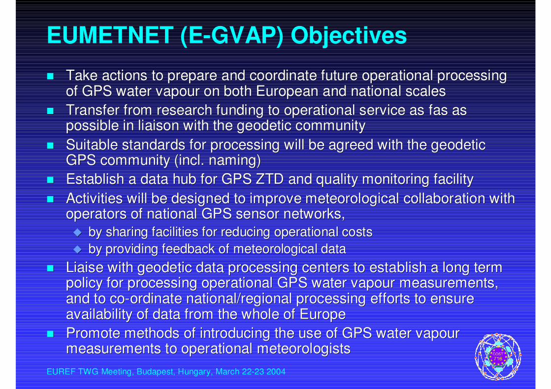
EUMETNET (E-GVAP) Objectives
�� Take actions to prepare and coordinate future operational procesTake actions to prepare and coordinate future operational processing sing of GPS water vapour on both European and national scalesof GPS water vapour on both European and national scales
�� Transfer from research funding to operational service as fas as Transfer from research funding to operational service as fas as possible in liaison with the geodetic communitypossible in liaison with the geodetic community
�� Suitable standards for processing will be agreed with the geodetSuitable standards for processing will be agreed with the geodetic ic GPS community (incl. naming)GPS community (incl. naming)
�� Establish a data hub for GPS ZTD and quality monitoring facilityEstablish a data hub for GPS ZTD and quality monitoring facility
�� Activities will be designed to improve meteorological collaboratActivities will be designed to improve meteorological collaboration with ion with operators of national GPS sensor networks, operators of national GPS sensor networks,
�� by sharing facilities for reducing operational costsby sharing facilities for reducing operational costs
�� by providing feedback of meteorological databy providing feedback of meteorological data
�� Liaise with geodetic data processing centers to establish a longLiaise with geodetic data processing centers to establish a long term term policy for processing operational GPS water vapour measurements,policy for processing operational GPS water vapour measurements,and to coand to co--ordinate national/regional processing efforts to ensure ordinate national/regional processing efforts to ensure availability of data from the whole of Europeavailability of data from the whole of Europe
�� Promote methods of introducing the use of GPS water vapour Promote methods of introducing the use of GPS water vapour measurements to operational meteorologistsmeasurements to operational meteorologists

EUREF TWG Meeting, Budapest, Hungary, March 22-23 2004
EUMETNET (E-GVAP) Organisation
�� Run by a responsible member providing a PMRun by a responsible member providing a PM
�� Operational liaison group to manage interaction with the Operational liaison group to manage interaction with the
wider GPS sensing communitywider GPS sensing community
�� Expert team on data processing and standardsExpert team on data processing and standards
�� Expert team on promoting the use of the observations Expert team on promoting the use of the observations
�� Financial costs per yearFinancial costs per year
PMPM 30k30k
Liason group meetingsLiason group meetings 15k15k
Expert team meetingsExpert team meetings 10k10k
Contract to support hub/central processingContract to support hub/central processing 30k30k
Project travelProject travel 10k10k

EUREF TWG Meeting, Budapest, Hungary, March 22-23 2004
Potential benefits for GPS community
�� Cost sharingCost sharing
�� Common stationsCommon stations
�� Communications Communications
�� NRT quality monitoring hubNRT quality monitoring hub
�� Use of meteorological productsUse of meteorological products
�� Pressure for atmospheric loading effectsPressure for atmospheric loading effects
�� Pressure to compute aPressure to compute a--priori ZTD for GPS processingpriori ZTD for GPS processing
�� Mapping functions from numerical weather modelsMapping functions from numerical weather models
�� Atmospheric delay corrections for Network RTK Atmospheric delay corrections for Network RTK
�� Use of meteorological servicesUse of meteorological services
�� Calibration of pressure sensorsCalibration of pressure sensors
�� Management of meteo equipment at GPS sites by NMSManagement of meteo equipment at GPS sites by NMS

EUREF TWG Meeting, Budapest, Hungary, March 22-23 2004
What could be EUREF’s role?
�� Several areas of shared interest have been identifiedSeveral areas of shared interest have been identified
�� Possible benefits for EUREF and the contributing partnersPossible benefits for EUREF and the contributing partners
�� EUREF has been progressing as wellEUREF has been progressing as well�� EUREF is already going towards (Near) RealEUREF is already going towards (Near) Real--timetime
�� EUREF is already “densifying” (Certification initiative)EUREF is already “densifying” (Certification initiative)
�� EUREF is becoming the reference for GPS in Europe at large, EUREF is becoming the reference for GPS in Europe at large, implicit and explicit standardizationimplicit and explicit standardization
�� Should there be a role for EUREF?, how to do it?Should there be a role for EUREF?, how to do it?�� EUREF TWG could play a coordinating role and liaise with the EUREF TWG could play a coordinating role and liaise with the
analysis centers (Special WG? Troposphere WG? role of AC analysis centers (Special WG? Troposphere WG? role of AC workshops?)workshops?)
�� At the symposium most of the major GPS providers (NMA, others) At the symposium most of the major GPS providers (NMA, others) are representedare represented
�� Open for discussionOpen for discussion
Related Documents