Cornell University Landscape Architecture Portfolio - March 20, 2012

Cornell Landscape Architecture Portfolio 2012
Mar 30, 2016
Here are some project samples from my work at Cornell 2008-2011. Work included is both solo work as well as group projects.
Welcome message from author
This document is posted to help you gain knowledge. Please leave a comment to let me know what you think about it! Share it to your friends and learn new things together.
Transcript

Cornell University Landscape Architecture Portfolio - March 20, 2012

2
Education: Cornell University - Ithaca, NY - 08/2008 – 05/2011
Masters in Landscape Architecture
NC State University - Raleigh, NC - 08/2004 – 05/2008
BS in Technology - Horticultural Science, Landscape Design
Double Minor in Biological Sciences and Agricultural Business Management
activities & honors: Vice President for Cornell’s Design and Planning Club
Active member of Cornell’s Design Connect for Elmira, NY
T.A. for Woody Plant ID and Site Maintenance Class
Awarded Cornell Council of the Arts grant to build an outdoor art installation
NCSU Certified Permaculture Design Consultant 2007 (Professor: Will Hooker)
T.A. for Landscape Design Graphics Studio
Experience:Entry Level Landscape Architect, Sustainable Life Designs - Washington, DC - 08/2011 - Current
Responsible for conceptual design of several schoolyard greening projects
Developed construction documents for stormwater management implementations
Worked directly with lead designer on client relations and design development
Fallingwater Landscape Design Intern – Mill Run, PA - 05/2010 – 08/2010
Designed and installed planting beds and trail connections on site
Performed trained maintenance on and around Fallingwater grounds
Learned landscape preservation and restoration techniques
Landscape Construction, Thompson’s Landscaping – Oxford, NC - 06/2009 – 07/2009
Installed landscape for high-end residential community
Learned installation and propagation techniques for ornamental grasses
Installed stone and mortar seating wall and patio and drip irrigation
Viticulture Technician, Y-Oaks Vineyard – Yadkin Valley, NC - 05/2009 – 06/2009
Acquired viticulture knowledge for trimming, scouting, and spraying grape vines
Designed and installed planting plan for owner’s residence
Designed and installed stone and mortar walkway for owner’s residence
Research Assistant, NCSU Plant Genetics – Clayton, NC - 05/2008 – 07/2008
Performed controlled pollinations for field trial corn
Scored field trial corn for Southern Leaf Blight disease resistance
Collected tissue samples for genetic analysis
Bamboo Art Exhibition, Cornell Public Exhibition – Ithaca, NY - 10/2010 – 4/2011
Harvested and crafted bamboo into illustrative outdoor exhibit
Studied social behavior changes from the piece in relation to the site
Art Installation, North Carolina Museum of Art – Raleigh, NC - 09/2007
Harvested and prepared bamboo for art installation
Worked with classmates to install Professor Hooker’s outdoor art-installation
Nursery Sales Associate, Homewood Nursery – Raleigh, NC - 06/2007 – 12/2007
Assisted customers with plant selection
Maintained trees and shrubs in the nursery
Answered customer horticultural questions
skillsPermaculture landscape design
Woody plant identification
Site engineering and construction
Interdisciplinary group leadership
Community involved design
Auto CAD
Adobe Photoshop
Adobe Illustrator
Adobe InDesign
Google Sketchup
Manifold GIS
Hand graphics
Resume Arnold Borden Edgerton [email protected] 252.671.1468

3
Cover Letter

4
Contact Info Arnold Borden Edgerton [email protected] 252.671.1468
ULI COMPETITION, 2010
ULI COMPETITION, 2010
ULI COMPETITION, 2010
ULI COMPETITION, 2010

5
Contents
Studio Projects6-7 //Biomimetic Development___Philadelphia, PA8-9 //G.A.P. ___Brooklyn, NY10-11 //Villa Polio felix___Sorrento, Italy12-15 //Waste Resource Development___Buffalo, NY
humanitarian work16-17 //Haiti Disaster relief___Port au Prince, Haiti18-19 //brand park___elmira, NY
additional works20-21 //olin green roof___ithaca, NY
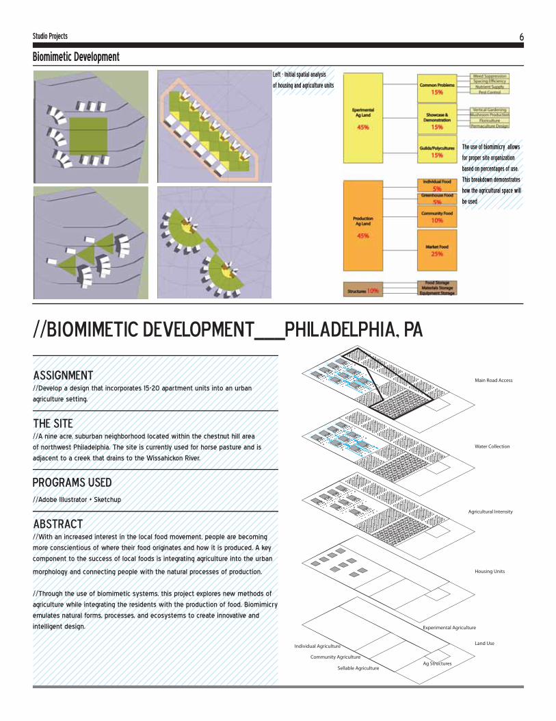
6
assignment//Develop a design that incorporates 15-20 apartment units into an urban
agriculture setting.
the site//A nine acre, suburban neighborhood located within the chestnut hill area
of northwest Philadelphia. The site is currently used for horse pasture and is
adjacent to a creek that drains to the Wissahickon River.
Programs used//Adobe Illustrator + Sketchup
abstract//With an increased interest in the local food movement, people are becoming
more conscientious of where their food originates and how it is produced. A key
component to the success of local foods is integrating agriculture into the urban
morphology and connecting people with the natural processes of production.
//Through the use of biomimetic systems, this project explores new methods of
agriculture while integrating the residents with the production of food. Biomimicry
emulates natural forms, processes, and ecosystems to create innovative and
intelligent design.
Biomimetic Development
//Biomimetic Development___Philadelphia, PA
Studio Projects
Land UseIndividual Agriculture
Experimental Agriculture
Community Agriculture
Sellable AgricultureAg Structures
Housing Units
Agricultural Intensity
Water Collection
Main Road Access
Left - Initial spatial analysis
of housing and agriculture units
The use of biomimicry allows
for proper site organization
based on percentages of use.
This breakdown demonstrates
how the agricultural space will
be used
7
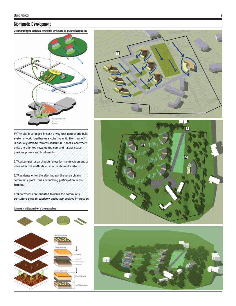
Biomimetic Development
Studio Projects
Diagram showing the relationship between site services and the greater Philadelphia area
1//The site is arranged in such a way that natural and built
systems work together as a cohesive unit. Storm runoff
is naturally drained towards agricultural spaces, apartment
units are oriented towards the sun, and natural space
provides privacy and biodiversity.
2//Agricultural research plots allow for the development of
more effective methods of small-scale food systems.
3//Residents enter the site through the research and
community plots; thus encouraging participation in the
farming.
4//Apartments are oriented towards the community
agriculture plots to passively encourage positive interaction.
Examples of efficient methods of urban agriculture.
2
4
1
3
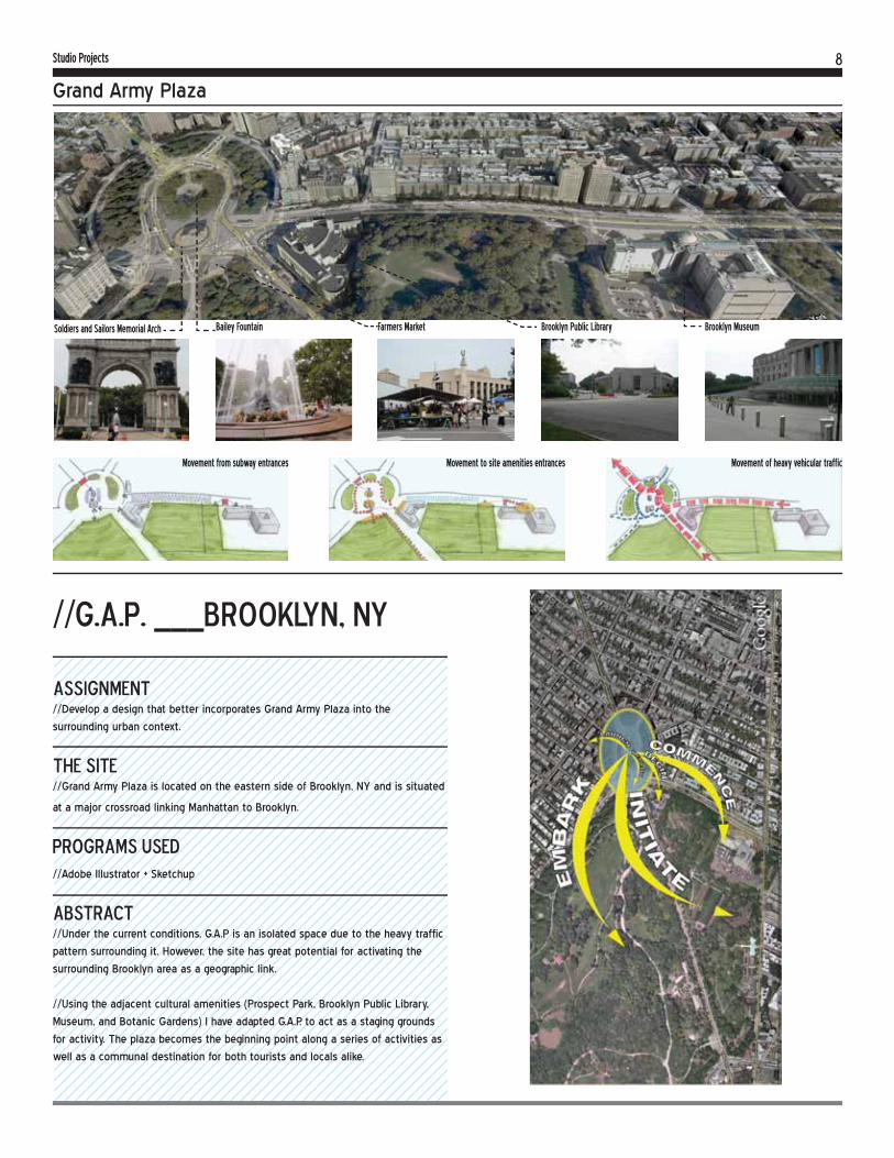
8Studio Projects
Grand Army Plaza
assignment//Develop a design that better incorporates Grand Army Plaza into the
surrounding urban context.
the site//Grand Army Plaza is located on the eastern side of Brooklyn, NY and is situated
at a major crossroad linking Manhattan to Brooklyn.
Programs used//Adobe Illustrator + Sketchup
abstract//Under the current conditions, G.A.P is an isolated space due to the heavy traffic
pattern surrounding it. However, the site has great potential for activating the
surrounding Brooklyn area as a geographic link.
//Using the adjacent cultural amenities (Prospect Park, Brooklyn Public Library,
Museum, and Botanic Gardens) I have adapted G.A.P. to act as a staging grounds
for activity. The plaza becomes the beginning point along a series of activities as
well as a communal destination for both tourists and locals alike.
//G.A.P. ___Brooklyn, NY
Soldiers and Sailors Memorial Arch
Movement from subway entrances Movement to site amenities entrances Movement of heavy vehicular traffic
Bailey Fountain Farmers Market Brooklyn Public Library Brooklyn Museum

9Studio Projects
Grand Army PlazaProposed Master Plan for G.A.P.
//New rectilinear street layout
simplifies traffic patterns and
aids in pedestrian access
1//Visitors have views to landmarks which assists in way finding.
2//A permanent farmers market structure activates the plaza making G.A.P. a
destination for locals and visitors alike.
3//The Soldiers and Sailors Memorial has been improved to better display
information and emulate the feelings of a memorial.
4//Historical icons have been relocated
to help connect distant amenities such
as the Brooklyn Museum and Brooklyn
Botanic Gardens
2
4
1
3

10Studio Projects
Villa Polio Felix
assignment//Develop a design that is sensitive to both local and non-local visitors while
retaining the character of an archaeological site.
the site//Located along the Bay of Naples, Sorrento features a unique archeological
roman ruin (Villa Polio Felix) amidst the stunning beauty of the Mediterranean
landscape.
Programs used//Adobe Illustrator, Photoshop + Sketchup
abstract//Villa Polio Felix is situated at the tip of a scenic peninsula with somewhat
difficult accessibility. Unlike other archaelogical villas of the area, the remains of
V.P.F. were not buried by the eruption of the nearby Mount Vesuvius.
//In order to retain the site’s unique character, I have chosen a minimalist
approach with strategic interventions. Improved paths and accessibility serve
visitors and locals alike; while simple structures and markers complement the
history of the ruins.
Primary and secondary ruins
Archaeology dig zone
Vegetative zones Existing dirt paths
Proposed path accessibility improvements
Existing view overlooking the villa site remains
Existing view of the villa site remains and olive orchard
Existing view of seaside remains of the villa apartments
//Villa Polio felix___Sorrento, Italy
//When overlaying the two maps of ruins
+ vegetation, a correlation is found be-
tween the zones of secondary ruins and
scrub grass. This correlation is partially
caused by the soil conditions created by
the decaying ruins and provides some
indication of where to excavate

11Studio Projects
Villa Polio Felix
Close-up of new access routes
Overview of site features
Site markerkers - stacked stone
Educational site furnishing demonstrates the process of decaying ruins
Time line entrance introduces visitors to the history of the site
Concept details of tree planters and site furnishings

12Studio Projects
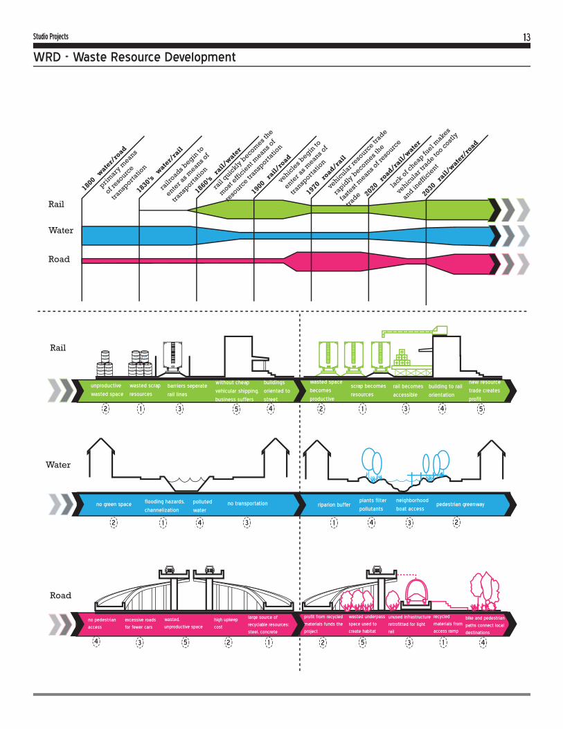
WRD - Waste Resource Development
assignment//Develop a design scenario that rethinks transportation and responds to a post-
carbon New York State.
the site//Buffalo, NY is currently a post-industrial shrinking city adjacent to Lake Erie and
the western most point of the erie canal.
Programs used//Adobe Illustrator, Photoshop + Sketchup
abstract//In a post-carbon scenario, transportation will change drastically with the scarcity
of cheap oil. Global resource trade will become increasingly expensive while
local and regional trade will become more necessary and efficient. Our post-
carbon scenario imagines that the use of heavy rail and waterways will serve to
connect regional cities, while light rail, bicycle, and pedestrian travel will connect
communities within the city
//Resources will become more difficult to obtain and alternative resources will
become more vital. My partner and I chose to examine waste as a possible resource
and how it might be repurposed for further use. Additionally, we examined the role
of greenspace and how it might shift to help connect people with commodities.
//Waste Resource Development___Buffalo, NY
CO
NN
EC
TI
NG
C
OM
MU
NI
TI
ES
CO
NN
EC
TI
NG
C
IT
IE
S
+
+
+
+
+
+
+
connected cities via rail corridors
isolated city resources connected corridors facilitates supportive trade
isolated city communities connection of communities via heavy rail, light rail, and water
isolated community resources
connected community resources via edge markets
+
+
++
+
+
+
++
inner community
community to communitylarge open space connection& resource market
open space connection& resource market
citywide
light rail light rail
heavy rail
green space & transportation connect people and resources
isolated cities
Rail as linking system
Rail as no-man’s land
Rail stations face tracks
Industry faces tracks
Discard DisposeTransport
Waste Resources
+
++ +
+
W.R.D. Concept
13Studio Projects
WRD - Waste Resource Development
Rail
Rail
Water
Water
Road
Road
1800 wate
r/ro
ad
1830’s w
ater/
rail
1860’s r
ail/wate
r
1900 rail/
road
1970 road/r
ail
2020 road/r
ail/wate
r
2030 rail/
water/
road
primary
means
of reso
urce
transp
ortatio
n
railr
oads begin
to
enter a
s means o
f
transp
ortatio
n
rail
quickly
becom
es the
most
efficie
nt means o
f
reso
urce tr
ansporta
tion
vehic
les b
egin to
enter a
s means o
f
transp
ortatio
n
vehic
ular r
esourc
e trade
rapid
ly b
ecomes t
he
faste
st m
eans of r
esourc
e
trade
lack o
f cheap fu
el makes
vehic
ular t
rade to
o costly
and ineffi
cient
wasted scrap
resources
unproductive
wasted space
large source of
recyclable resources:
steel, concrete
no green space polluted
waterriparion buffer pedestrian greenway
neighborhood
boat access
plants filter
pollutantsflooding hazards,
channelizationno transportation
buildings
oriented to
street
scrap becomes
resources
rail becomes
accessible
barriers seperate
rail linesbuilding to rail
orientation
new resource
trade creates
profit
wasted space
becomes
productive
without cheap
vehicular shipping,
business suffers
1 12 23 35 54
1 12 23 35 54 4
1 12 23 34 4
4
high upkeep
cost
recycled
materials from
access ramp
bike and pedestrian
paths connect local
destinations
unused infrastructure
retrofitted for light
rail
wasted underpass
space used to
create habitat
profit from recycled
materials funds the
project
wasted,
unproductive space
excessive roads
for fewer cars
no pedestrian
access

14Studio Projects
WRD - Waste Resource Development
Buffalo River
NORTH
Canada
Grand Island
City of Buffalo
Lake Erie
BuffaloBuBu
Roads
Waterways
RailMajor Roads
Rail
Major Parks
Buffalo City Limits
Buffalo River
Rail Resource Drop Off Point
Resource Distribution Area
Light Rail Access Point
Light Rail Access Point
Resource Market
Resource Market
Crafting Shops
Waterway Access Point
light rail
light rail
light ra
il
heavy railw
aterway
heavy rail
Ra i l1) Rail provides means of resource transportation
2) Scrap yards found adjacent to rail lines provide recylable resources for collection
3) Abandoned industrial buildings are converted to sorting and processing plants
4) Open/Green space adjacent to rails are utilized as resource hubs for processed materials
5) Processed resources are transported via light rail to “Resource Markets” located in accessible open/green space
+++
+++++
1 2 3 54
Context Map for Improvements
Redevelopment of Urban Rail Systems

15Studio Projects
WRD - Waste Resource Development
Water
Waste -paper, plastics, glass,
metals
Air Sorter
Metal (cans)Magnetic Seperator
GlassHeavy PlasticsPaper
Glass Remains
Hammer Mill
Air Blower
Iron
Iron
Cork, Paper, Plastics
Seive
1) Along with heavy rail, waterways are an existing method of transport that should be utilized
2) Many cities have seen industrial areas outsourced when cheap oil allows for long distance shipping. These abandoned manufactoring buildings provide great opportunity for adaptive reuse.
3) Industrial buildings provide a perfect place for resource reconstitution plants, and waterways and heavy rail are the means for easy transport
4) Resource Reconstitution Plants seperate components of waste, sort them, and process them to be used again
+++++
Roads1) Many green space communities are not adjacent to waterways or heavy rail, and lack the ability to access vital resources.
2) Outdated vehicular infrastructure does connect these communities, but is not accessible to the vast majority of people.
3) Roads can be retrofitted to provide affordable means of transport if converted into: Light Rail, Cycling Paths, Pedestrian Greenways
4) Roads to be considered must be wide enough to allow for: 2 or more vehicular lanes, 2 or more light rail tracks, 1 bicycle and pedestrian lane
5) Additionally, these transportation networks assist in creating green corridors for ecological habitat and recreation
+ ++ ++
Redevelopment of Urban Waterways
Redevelopment of Urban Road Systems

16Humanitarian Work
Haiti Disaster Relief
assignment//Develop an easily implemented emergency settlement plan for 6,000 displaced
Haitians in only 51,000sq/m
the site//Situated adjacent to the ocean, the site is very prone to flooding and is flanked
by two open air sewage canals. While not an ideal location, choices were very
limited.
Programs used//AutoCAD + Sketchup + Adobe Illustrator
abstract//When the 2010 earthquake devastated Haiti, thousands of residents were left
homeless. Cornell’s AIDS Clinic (GHESKIO) requested help in creating a document
to guide the development of a feasible emergency settlement.
//With the help of several student organizations, such as the Design & Planning
Club, initial strategies were brainstormed and compiled. Throughout the
semester, the group was distilled into several key members and a comprehensive
implementation strategy was created. The following excerpts are examples of my
contributions.
//Haiti Disaster relief___Port au Prince, Haiti
Phases 1-3 Phases 4-6 Phases 7-9 Repeat phases 1-9 starting here
//The above diagrams represent phasing strategies for laying
infrastructure in an orderly manner.
//Phases 1-3 show the implementation of resource facilities,
temporary tent dwellings, and finally the laying of a foundation.
//Phases 4-6 show the implementation of more permanant
dwellings and the introduction of new residents. Here, new
residents are taught construction methods by the first.
//Phases 7-9 show the implementation of small vendors, clinics,
and other resource buildings in addition to more residents.

17Humanitarian Work
Haiti Disaster Relief
Construction Considerations
Final Site Plan
Design Considerations
Site Specific Phasing

18Humanitarian Work
Brand Park
assignment//Work with the community of South Elmira to develop a new master plan of
Brand Park
the site//Brand Park is located on the South side of Elmira and is adjacent to the
Chemung River. Contextually, the park borders residential housing as well as the
Riverside Elementary School.
Programs used//Adobe Illustrator, Photoshop + Sketchup
abstract//For two semesters, I was an active member in Design Connect, a
multidisciplinary student run organization that provides pro bono design work for
local New York towns.
//My team and I worked directly with the community of South Elmira by holding
a series of design charrettes. This form of public outreach allowed us to better
understand the community’s needs as well as how to meet them. Over the
course of two semesters, we were able to provide a reinvisioned master plan to
the City of Elmira.
//brand park___elmira, NYPhoto of Borden speaking with community members during our charrette
Photo of Borden helping students present their ideas for the park
Existing view of 1)splash park 2)basketball court 3)Riverside Elementary
Existing View of 1)nonoperational pool 2)ball fields
2
2
1
1
3

19Humanitarian Work
Brand Park
Proposed view of plaza and ball fields
Blue - existing elements Orange - proposed elements
Proposed Master Plan for Brand Park
Paths and Goals
Programmed Spaces Passive (green) Active (orange)
Primary Paths (red) Secondary Paths (orange)
Proposed view of ball fields and skate park
Proposed view of childrens garden and demonstration gardens

20Additional Works
Olin Green Roof
assignment//Develop a green roof design with a full set of construction documents suitable
for contractors.
the site//Olin Library has a roof deck overlooking the agriculture quad of Cornell’s
campus.
Programs used//AutoCAD + Sketchup
abstract//Olin Library is situated at a particularly scenic point of Cornell’s historic campus.
Currently, the roof deck is an out of place eyesore in need of programmatic and
aesthetic revision.
//My goal for this project was to create a site sensitive design while providing a
complete set of construction documents including site details, demolition, layout,
lighting, and planting plans.
//olin green roof___ithaca, NY
Olin Library
Study ‘Rooms’ Wire/Cable TrellaceWire/Cable Trellace
Olin Library

21Additional Works
Olin Green Roof
2" Layer Decomposed Granite1" Crushed Aggregate Base3/8" Filter FabricZinCo Floridrain 605/8" Protection BoardWaterproof Membrane
Existing Roof Deck
6" x 10" Wide Granite CurbWeep Hole 1/4"
10" Soil Substrate
A DG WALK CONNECTION501 TO PLANTING BED SCALE: 1" = 1'-0"
6" Expansion Bolt
6" Wide Granite Curb
12" x 12" Zinco Drain AccessTOP is 2" Above Soil Line
DG Walkway
Soil Substrate 10" Depth
D DRAIN ACCESS EDGE501 OF DG PATH SCALE: 1" = 1'-0"
2" Layer Decomposed Granite
4" Crushed Aggregate Base3/8" Filter FabricZinCo Floridrain 605/8" Protection BoardWaterproof Membrane
Existing Roof Deck
6" Wide Granite Curb
10" Soil Substrate 12" x 12" Zinco Drain AccessTOP is 2" Above Soil Line
D DRAIN ACCESS EDGE501 OF DG PATH SCALE: 1" = 1'-0"
42" High Hand Rail w/Vertical SS Cables
3/8" Parapet Cover3/8" Filter FabricZinCo Floridrain 60
5/8" Protection BoardWaterproof Membrane
Existing Roof Deck
10" Soil Substrate
6" Wide x 12" Tall Granite Curb
1" x 5" Lag Bolt into Granite Curb
H ROOF EDGE 501 CONNECTION SCALE: 1" = 1'-0"
6" Expansion Bolt
DG Walkway
4" Wide Granite Curb
1/4" Spacing for Weep Hole
C GRANITE CURB 501 CORNER CONNECTION SCALE: 1" = 1'-0"
6" Expansion Bolt
6" Expansion Bolt
10" Tall Granite Curb
1/4" Spacing for Weep Hole
C GRANITE CURB 501 CORNER CONNECTION SCALE: 1" = 1'-0"
Scale 1” = 2’-0”
Scale 1” = 2’-0”
Scale 1” = 2’-0”
Scale 1” = 2’-0”
Scale 1” = 2’-0”
Scale 1” = 2’-0”
Related Documents