Copyright © 2010 Pearson Education, In The Saffir-Simpson scale is numbered 1–5 with: a) Smaller numbers indicating bigger hurricanes. b) Larger numbers indicating bigger hurricanes. c) Numbers indicating the strength of tornadoes. d) Numbers indicating the scale of thunderstorms. e) None of the above. 11.01

Copyright © 2010 Pearson Education, Inc. The Saffir-Simpson scale is numbered 1–5 with: a)Smaller numbers indicating bigger hurricanes. b)Larger numbers.
Dec 17, 2015
Welcome message from author
This document is posted to help you gain knowledge. Please leave a comment to let me know what you think about it! Share it to your friends and learn new things together.
Transcript

Copyright © 2010 Pearson Education, Inc.
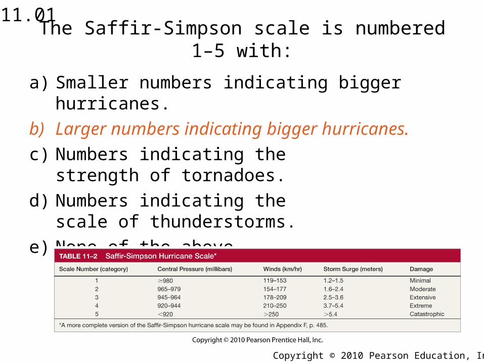
The Saffir-Simpson scale is numbered 1–5 with:
a) Smaller numbers indicating bigger hurricanes.
b) Larger numbers indicating bigger hurricanes.
c) Numbers indicating the strength of tornadoes.
d) Numbers indicating the scale of thunderstorms.
e) None of the above.
11.01
Copyright © 2010 Pearson Education, Inc.
The Saffir-Simpson scale is numbered 1–5 with:
a) Smaller numbers indicating bigger hurricanes.
b) Larger numbers indicating bigger hurricanes.
c) Numbers indicating thestrength of tornadoes.
d) Numbers indicating thescale of thunderstorms.
e) None of the above.
11.01
Copyright © 2010 Pearson Education, Inc.
Rank the following in order of increasing strength:
a) Tropical depression, tropical storm, tropical disturbance, hurricane.
b) Hurricane, tropical depression, tropical storm, tropical disturbance.
c) Tropical disturbance, tropical depression, tropical storm, hurricane.
d) Hurricane, tropical depression, tropical disturbance, tropical storm.
e) Tropical storm, tropical depression, tropical disturbance, hurricane.
11.02
Copyright © 2010 Pearson Education, Inc.
The reason almost all hurricanes occur in the equatorial regions of the Earth is because:
a) Temperature gradients are largest in this region.
b) There are stronger ocean currents and tides.
c) It has the largest source of warm water.
d) Of strong upper-level winds.
e) Of the frequency of showers and thunderstorms.
11.03
Copyright © 2010 Pearson Education, Inc.
The reason almost all hurricanes occur in the equatorial regions of the Earth is because:
a) Temperature gradients are largest in this region.
b) There are stronger ocean currents and tides.
c) It has the largest source of warm water.
d) Of strong upper-level winds.
e) Of the frequency ofshowers andthunderstorms.
11.03

Copyright © 2010 Pearson Education, Inc.
Hurricanes gain most of their energy from:
a) The upper-level jet stream.
b) Latent heat released by condensation.
c) The high winds that develop within them.
d) Ocean currents and tides.
e) All of the above are correct.
11.04
Copyright © 2010 Pearson Education, Inc.
Hurricanes gain most of their energy from:
a) The upper-level jet stream.
b) Latent heat released bycondensation.
c) The high winds that developwithin them.
d) Ocean currents and tides.
e) All of the above are correct.
11.04
Copyright © 2010 Pearson Education, Inc.
The primary overriding requirement for hurricane development is:
a) The presence of an easterly wave.
b) The presence of the jet stream.
c) Warm land surface.
d) Water that is at least 27°C (81°F).
e) None of the above.
11.05
Copyright © 2010 Pearson Education, Inc.
The primary overriding requirement for hurricane development is:
a) The presence of an easterly wave.
b) The presence of the jet stream.
c) Warm land surface.
d) Water that is at least 27°C (80°F).
e) None of the above.
11.05
Copyright © 2010 Pearson Education, Inc.
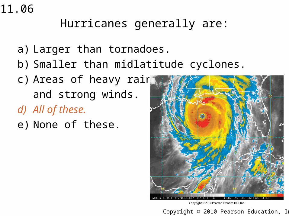
Hurricanes generally are:
a) Larger than tornadoes.
b) Smaller than midlatitude cyclones.
c) Areas of heavy rainfall and strong winds.
d) All of these.
e) None of these.
11.06
Copyright © 2010 Pearson Education, Inc.
Hurricanes generally are:
a) Larger than tornadoes.
b) Smaller than midlatitude cyclones.
c) Areas of heavy rainfall
and strong winds.
d) All of these.
e) None of these.
11.06
Copyright © 2010 Pearson Education, Inc.
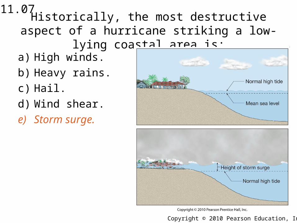
Historically, the most destructive aspect of a hurricane striking a low-lying coastal area is:
a) High winds.
b) Heavy rains.
c) Hail.
d) Wind shear.
e) Storm surge.
11.07
Copyright © 2010 Pearson Education, Inc.
Historically, the most destructive aspect of a hurricane striking a low-lying coastal area is:
a) High winds.
b) Heavy rains.
c) Hail.
d) Wind shear.
e) Storm surge.
11.07

Copyright © 2010 Pearson Education, Inc.
Typical weather within the eye of a hurricane consists of:
a) Large hail.
b) Strong winds but clear skies.
c) Fair skies and light winds.
d) Thunder and lightning.
e) Tornadoes.
11.08

Copyright © 2010 Pearson Education, Inc.
Typical weather within the eye of a hurricane consists of:
a) Large hail.
b) Strong winds but clear skies.
c) Fair skies and light winds.
d) Thunder and lightning.
e) Tornadoes.
11.08

Copyright © 2010 Pearson Education, Inc.
Most Northern Hemisphere hurricanes occur:
a) In late winter.
b) From June through November.
c) From December through April.
d) In spring.
e) In early summer.
11.09
Copyright © 2010 Pearson Education, Inc.
Most Northern Hemisphere hurricanes occur:
a) In late winter.
b) From June 1st through November 30th.
c) From December through April.
d) In spring.
e) In early summer.
11.09
Copyright © 2010 Pearson Education, Inc.
Choose the answer that places the hurricane at its proper position with respect to overall storm size:
a) Tornado, midlatitude cyclone, hurricane, thunderstorm.
b) Midlatitude cyclone, hurricane, thunderstorm, tornado.
c) Hurricane, midlatitude cyclone, tornado, thunderstorm.
d) Thunderstorm, midlatitude cyclone, hurricane, tornado.
e) None of the above.
11.10
Copyright © 2010 Pearson Education, Inc.
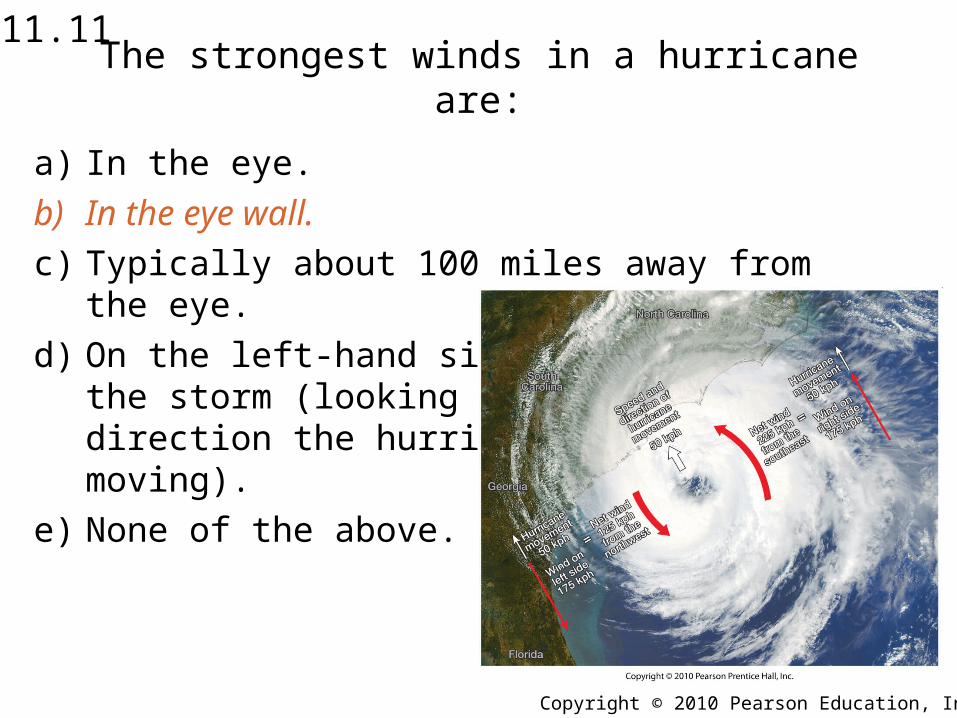
The strongest winds in a hurricane are:
a) In the eye.
b) In the eye wall.
c) Typically about 100 miles away from the eye.
d) On the left-hand side of the storm (looking in the direction the hurricane is moving).
e) None of the above.
11.11
Copyright © 2010 Pearson Education, Inc.
The strongest winds in a hurricane are:
a) In the eye.
b) In the eye wall.
c) Typically about 100 miles away from the eye.
d) On the left-hand side ofthe storm (looking in thedirection the hurricane ismoving).
e) None of the above.
11.11

Copyright © 2010 Pearson Education, Inc.
Most hurricane-related fatalities are caused by:
a) Associated tornadoes.
b) Strong surface winds.
c) Lightning.
d) Coastal and inland flooding.
e) Spin-up vortices.
11.12

Copyright © 2010 Pearson Education, Inc.
Most hurricane-related fatalities are caused by:
a) Associated tornadoes.
b) Strong surface winds.
c) Lightning.
d) Coastal and inland flooding.
e) Spin-up vortices.
11.12
Copyright © 2010 Pearson Education, Inc.
As a hurricane tracks inland, its:
a) Winds diminish.
b) Central pressure rises.
c) Rains continue.
d) Horizontal pressure gradient weakens.
e) All of the above are correct.
11.13

Copyright © 2010 Pearson Education, Inc.
As a hurricane tracks inland, its:
a) Winds diminish.
b) Central pressure rises.
c) Rains continue.
d) Horizontal pressure gradientweakens.
e) All of the above are correct.
11.13

Copyright © 2010 Pearson Education, Inc.
The hurricane threat to the Southeast United States is serious because:
a) Most residents have never experienced a hurricane.
b) Of rapid population growth in coastal areas.
c) Of the vulnerability of low-lying coastal areas to a storm surge.
d) All of the above are correct.
e) None of the above is correct.
11.14
Copyright © 2010 Pearson Education, Inc.
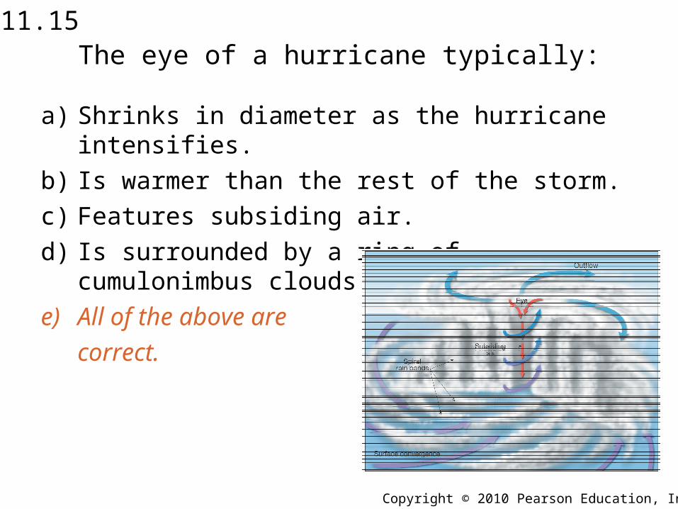
The eye of a hurricane typically:
a) Shrinks in diameter as the hurricane intensifies.
b) Is warmer than the rest of the storm.
c) Features subsiding air.
d) Is surrounded by a ring of cumulonimbus clouds (the eye wall).
e) All of the above are correct.
11.15
Copyright © 2010 Pearson Education, Inc.
The eye of a hurricane typically:
a) Shrinks in diameter as the hurricane intensifies.
b) Is warmer than the rest of the storm.
c) Features subsiding air.
d) Is surrounded by a ring of cumulonimbus clouds (the eye wall).
e) All of the above are
correct.
11.15
Copyright © 2010 Pearson Education, Inc.
In general, hurricanes are:
a) Larger than tornadoes.
b) Smaller than midlatitude cyclones.
c) Areas of heavy rainfall and strong winds.
d) Intense tropical cyclones.
e) All of these.
11.16

Copyright © 2010 Pearson Education, Inc.
In general, hurricanes are:
a) Larger than tornadoes.
b) Smaller than midlatitude cyclones.
c) Areas of heavy rainfall and strong winds.
d) Intense tropical cyclones.
e) All of these.
11.16
Copyright © 2010 Pearson Education, Inc.
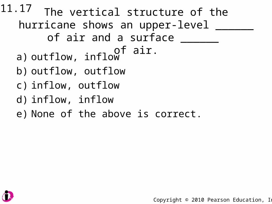
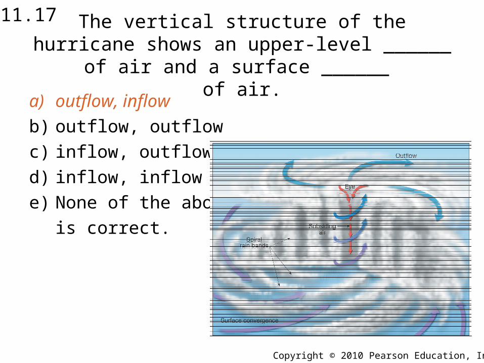
The vertical structure of the hurricane shows an upper-level ______ of air and a surface ______
of air.a) outflow, inflow
b) outflow, outflow
c) inflow, outflow
d) inflow, inflow
e) None of the above is correct.
11.17
Copyright © 2010 Pearson Education, Inc.
The vertical structure of the hurricane shows an upper-level ______ of air and a surface ______
of air.a) outflow, inflow
b) outflow, outflow
c) inflow, outflow
d) inflow, inflow
e) None of the above
is correct.
11.17
Copyright © 2010 Pearson Education, Inc.
Hurricane winds rotate in a clockwise direction:
a) In the Northern Hemisphere only.
b) In the Southern Hemisphere only.
c) In both the Northern and Southern hemispheres.
d) In neither hemisphere.
e) In the Polar regions.
11.18

Copyright © 2010 Pearson Education, Inc.
Hurricane winds rotate in a clockwise direction:
a) In the Northern Hemisphere only.
b) In the Southern Hemisphere only.
c) In both the Northern and Southern hemispheres.
d) In neither hemisphere.
e) In the Polar regions.
11.18
Copyright © 2010 Pearson Education, Inc.
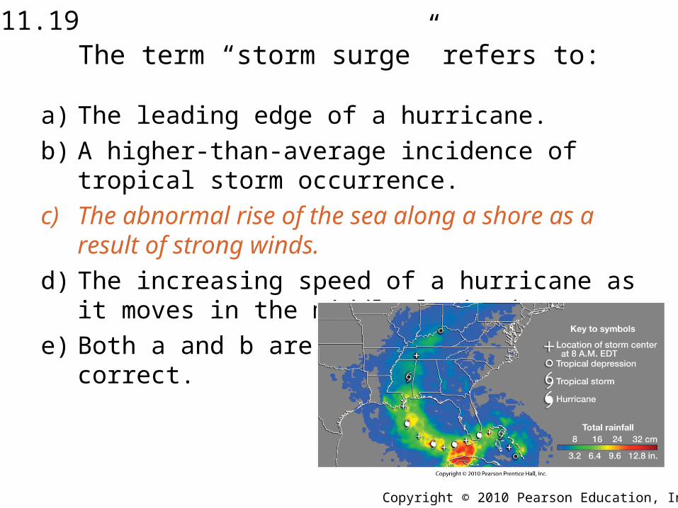
The term “storm surge” refers to:
a) The leading edge of a hurricane.
b) A higher-than-average incidence of tropical storm occurrence.
c) The abnormal rise of the sea along a shore as a result of strong winds.
d) The increasing speed of a hurricane as it moves in the middle latitudes.
e) Both a and b are correct.
11.19
Copyright © 2010 Pearson Education, Inc.
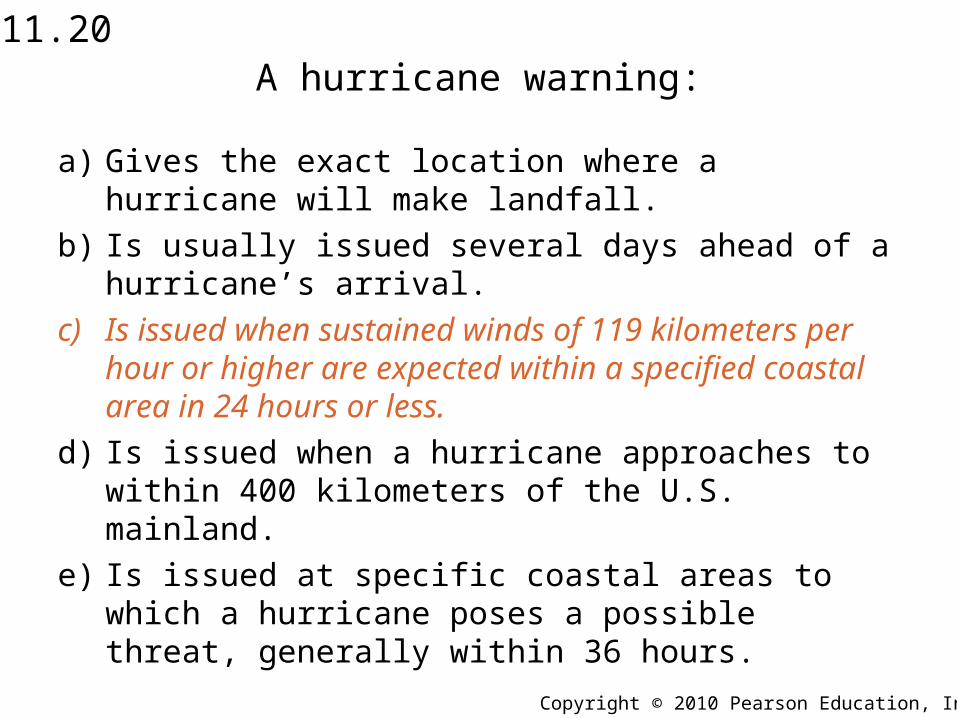
A hurricane warning:
a) Gives the exact location where a hurricane will make landfall.
b) Is usually issued several days ahead of a hurricane’s arrival.
c) Is issued when sustained winds of 119 kilometers per hour or higher are expected within a specified coastal area in 24 hours or less.
d) Is issued when a hurricane approaches to within 400 kilometers of the U.S. mainland.
e) Is issued at specific coastal areas to which a hurricane poses a possible threat, generally within 36 hours.
11.20
Copyright © 2010 Pearson Education, Inc.
The most hurricane-prone location in theUnited States is:
a) Michigan.
b) Florida.
c) Chicago, IL.
d) San Diego, CA.
e) Tucson, AZ.
11.21
Copyright © 2010 Pearson Education, Inc.
The most hurricane-prone location in theUnited States is:
a) Michigan.
b) Florida.
c) Chicago, IL.
d) San Diego, CA.
e) Tucson, AZ.
11.21
Related Documents


