Global Register of Migratory Species - GROMS http://www.groms.de A Relational database of Migratory Species: GIS mapping Klaus Riede and Eva Gerstner, Zoological Reseach Museum Alexander Koenig, Adenauerallee 160, D-53113 Bonn, Germany contact: [email protected] Additional Activities: The GROMS webserver maintains a discussion list with approximately 500 members. Subscribe to Migration by sending an email to: majordomo @ listserv .uni- bonn .de subject: leave blank, text: subscribe migration Publications: Results from the GROMS project were publised as books with CDs containing all GIS files (shapes). The full list of scientific publications, additional technical reports and presentations can be downloaded at http://www.groms.de/groms/publications.html Riede, K. (ed.) (2001) New Perspectives for Monitoring Migratory Animals - Improving Knowledge for Conservation. Proceedings of an International Workshop on behalf of the 20th Anniversary of the Bonn Convention. - Münster (Landwirtschaftsverlag), 166 pp. Riede, K. (2001) Global Register of Migratory Species. Weltregister wandernder Tierarten. Database, GIS Maps and Threat Analysis. With bird species accounts by Katja Kunz. 404 pp. + CD-ROM. Riede K. (2003) Biodiversity Informatics in Germany: ongoing projects and their possible contribution to the Global Taxonomy Initiative (GTI). In: Junko Shimura (ed): Global Taxonomy Initiative in Asia. National Institute for Environmental Studies, Japan, pp. 294-300. Riede, K. (2004) Global Register of Migratory Species - from Global to Regional Scales. Final Report of the R&D-Projekt 808 05 081.329 pp. + CD-ROM. Riede, K. (2005) Migration within and out of Africa: Identifying knowledge gaps by data-mining the Global Register of Migratory Species. In: B.A. Huber et al. (eds.): African Biodiversity. Springer. Printed in the Netherlands. pp. 245-252. Under the auspices of the Secretariat and with funds from the German Ministry of the Environment, the GROMS was developed by three subsequent LoAs with the Zoological Research Museum, Bonn. The Museum and the University of Bonn is hosting the GROMS website (www.groms.de), interactive database and mapservers. Up to now, GROMS contains 4,344 vertebrate species, 5,600 references and 1,300 GIS-maps. All information can be retrieved by simple and expert QUERY interfaces, accessible on the Internet and programmed using Open Source tools. The OUTPUT species report contains scientific name and authority, common names in CMS languages, International Red List status, classification of migratory behaviour (inter- continental, potamodromous etc), a short text from a key reference on the species´ migratory behaviour, and links to other informative websites. For all fishes, living links to Fishbase (http://www.fishbase.org) provide a picture and extensive further information about the species´ biology Migratory species identified by the GROMS belong to the following groups: 298 mammals (131 bats, 83 whales and dolphins, 39 seals and sirenia, 45 terrestrial mammals) 2,203 birds 10 reptiles (incl 7 sea turtles) 1,926 migratory fishes (1,795 ray-finned fishes, 93 sharks, 19 lampreys) OUTPUT species report The Species Report links to other databases, GBIF maps, and GROMS fact sheets. http://www.fishbase.org GROMS GIS map of Anser anser, represented by GOOGLE EARTH) Combining all available GIS maps allows to calculate the distribution and number of migrants per administrative unit. Note elevated diversity of migrants in temperate zones Migrants will be lost if conservation is limited to tropical Hot Spots. QUERY Interface Global distribution maps from the literature (e.g. del Hoyo et al.: Handbook of the Birds of the World: http://www.hbw.com/) were digitised using a Desktop Geographic Information System (ESRI Arcview3.2). Attribute tables contain information about the migratory status (feeding, wintering, staging, breeding), months of presence (if available), and the reference. Maps were intersected with boundaries of territories (countries and administrative units). GIS intersection generates a table of 183,500 entries (Species/Province), which was integrated into a relational geo-database. Once integrated into the SQL-database, users can generate species lists for each Country/Province, or retrieve Range State Lists for each mapped species. Range State listing using a GIS is a transparent procedure, which allows to get back to the original amp with reference. Raange State Lists can be updated quickly when political boundaries change. For example, it was immediately possible to list migrants occuring in the new state of East Timor. Once available in GIS format, maps can be transferred easily to other applications, such as GOOGLE EARTH, or combined with other GIS layers, such as CMS or agreements member states, Ramsar sites or oilspills. A direct link to point data from museum specimens and observations launches an additional map from the Global Biodiversity Species facility (http://www.gbif.org). GROMS species fact sheet (Anser anser) The GROMS database server was used to organise the CMS Thesis Award. Allicants could submit their online-application. Users can update the literature database, and a variety of other ap ´plications could easily be implemented. Intersection with WWF ecoregions( www- eco.shp file provided by ArcView/ESRI) and GROMS distribution maps. The resulting map indicates the number of migratory species per ecosystem. These data could be combined with threats to ecosystems, as analysed by the Millenium Ecosystem Assessment.

Welcome message from author
This document is posted to help you gain knowledge. Please leave a comment to let me know what you think about it! Share it to your friends and learn new things together.
Transcript
Global Register of Migratory Species - GROMS
http://www.groms.de
A Relational database of Migratory Species: GIS mapping
Klaus Riede and Eva Gerstner, Zoological Reseach Museum Alexander Koenig, Adenauerallee 160, D-53113 Bonn, Germany contact: [email protected]
Additional Activities:The GROMS webserver maintains a discussion list with approximately 500 members. Subscribe to Migration by sending an email to: [email protected]: leave blank, text: subscribe migration
Publications:
Results from the GROMS project were publised as books with CDs containing all GIS files (shapes). The full list of scientific publications, additional technical reports and presentations can be downloaded at http://www.groms.de/groms/publications.htmlRiede, K. (ed.) (2001) New Perspectives for Monitoring Migratory Animals - Improving Knowledge for Conservation. Proceedings of an International Workshop on behalf of the 20th Anniversary of the Bonn Convention. - Münster (Landwirtschaftsverlag), 166 pp.
Riede, K. (2001) Global Register of Migratory Species. Weltregister wandernder Tierarten. Database, GIS Maps and Threat Analysis. With bird species accounts by Katja Kunz. 404 pp. + CD-ROM.
Riede K. (2003) Biodiversity Informatics in Germany: ongoing projects and their possible contribution to the Global Taxonomy Initiative (GTI). In: Junko Shimura (ed): Global Taxonomy Initiative in Asia. National Institute for Environmental Studies, Japan, pp. 294-300.
Riede, K. (2004) Global Register of Migratory Species - from Global to Regional Scales. Final Report of the R&D-Projekt 808 05 081.329 pp. + CD-ROM.
Riede, K. (2005) Migration within and out of Africa: Identifying knowledge gaps by data-mining the Global Register of Migratory Species. In: B.A. Huber et al. (eds.): African Biodiversity. Springer. Printed in the Netherlands. pp. 245-252.
Under the auspices of the Secretariat and with funds from the German Ministry of the Environment, the GROMS was developed by three subsequent LoAs with the Zoological Research Museum, Bonn. The Museum and the University of Bonn is hosting the GROMS website
(www.groms.de), interactive database and mapservers.
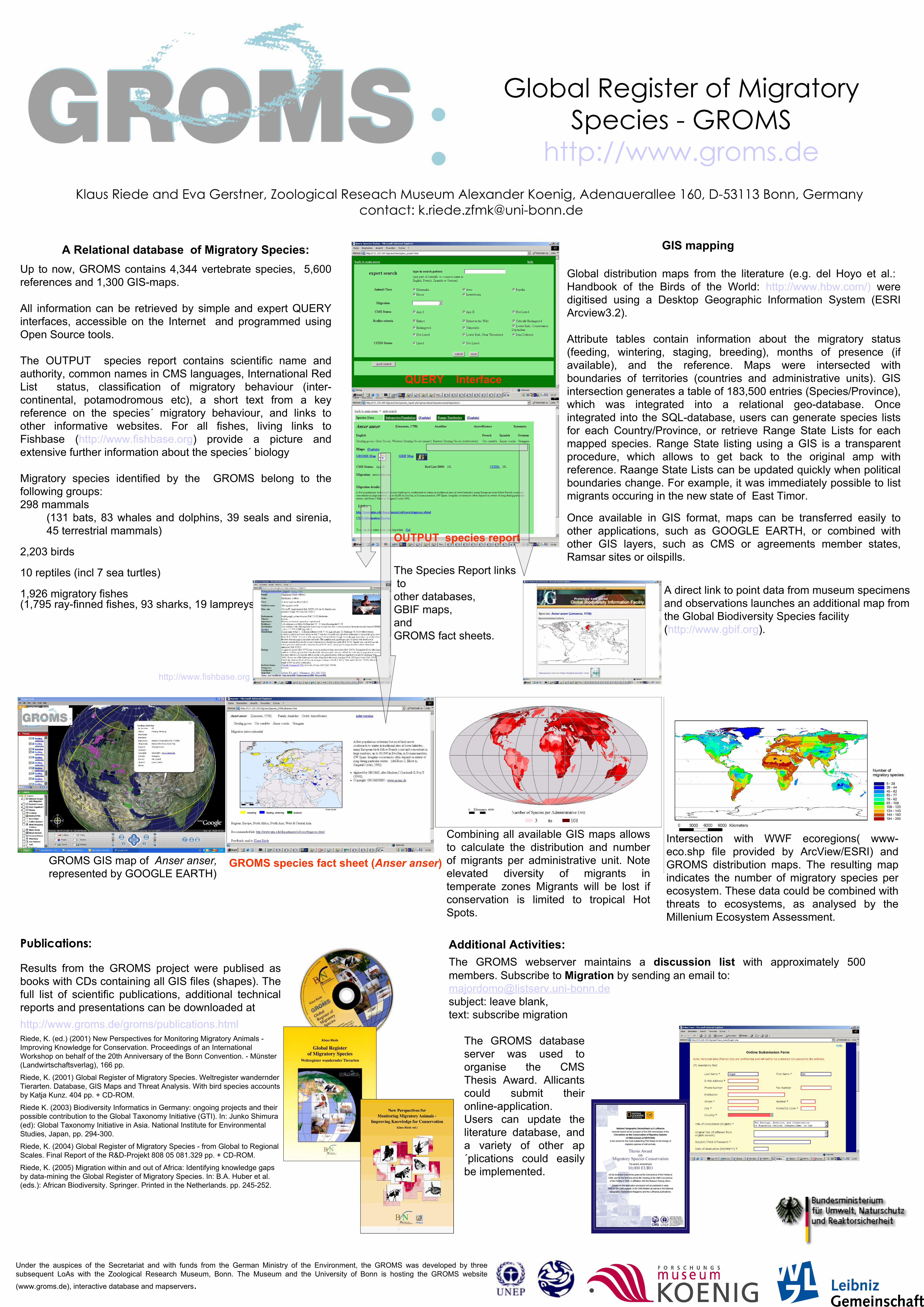
Up to now, GROMS contains 4,344 vertebrate species, 5,600 references and 1,300 GIS-maps.
All information can be retrieved by simple and expert QUERY interfaces, accessible on the Internet and programmed using Open Source tools.
The OUTPUT species report contains scientific name and authority, common names in CMS languages, International Red List status, classification of migratory behaviour (inter-continental, potamodromous etc), a short text from a key reference on the species´ migratory behaviour, and links to other informative websites. For all fishes, living links to Fishbase (http://www.fishbase.org) provide a picture and extensive further information about the species´ biology
Migratory species identified by the GROMS belong to the following groups:298 mammals
(131 bats, 83 whales and dolphins, 39 seals and sirenia, 45 terrestrial mammals)
2,203 birds
10 reptiles (incl 7 sea turtles)
1,926 migratory fishes (1,795 ray-finned fishes, 93 sharks, 19 lampreys)
OUTPUT species report
The Species Report links to other databases,GBIF maps,andGROMS fact sheets.
http://www.fishbase.org
GROMS GIS map of Anser anser, represented by GOOGLE EARTH)
Combining all available GIS maps allows to calculate the distribution and number of migrants per administrative unit. Note elevated diversity of migrants in temperate zones Migrants will be lost if conservation is limited to tropical Hot Spots.
QUERY Interface
Global distribution maps from the literature (e.g. del Hoyo et al.: Handbook of the Birds of the World: http://www.hbw.com/) were digitised using a Desktop Geographic Information System (ESRI Arcview3.2).
Attribute tables contain information about the migratory status (feeding, wintering, staging, breeding), months of presence (if available), and the reference. Maps were intersected with boundaries of territories (countries and administrative units). GIS intersection generates a table of 183,500 entries (Species/Province), which was integrated into a relational geo-database. Once integrated into the SQL-database, users can generate species lists for each Country/Province, or retrieve Range State Lists for each mapped species. Range State listing using a GIS is a transparent procedure, which allows to get back to the original amp with reference. Raange State Lists can be updated quickly when political boundaries change. For example, it was immediately possible to list migrants occuring in the new state of East Timor.
Once available in GIS format, maps can be transferred easily to other applications, such as GOOGLE EARTH, or combined with other GIS layers, such as CMS or agreements member states, Ramsar sites or oilspills.
A direct link to point data from museum specimensand observations launches an additional map from the Global Biodiversity Species facility (http://www.gbif.org).
GROMS species fact sheet (Anser anser)
The GROMS database server was used to organise the CMS Thesis Award. Allicants could submit their online-application.Users can update the literature database, and a variety of other ap´plications could easily be implemented.
Intersection with WWF ecoregions( www-eco.shp file provided by ArcView/ESRI) and GROMS distribution maps. The resulting map indicates the number of migratory species per ecosystem. These data could be combined with threats to ecosystems, as analysed by the Millenium Ecosystem Assessment.
Related Documents