presented by: Tim Haithcoat University of Missouri Columbia Coordinate Systems

Welcome message from author
This document is posted to help you gain knowledge. Please leave a comment to let me know what you think about it! Share it to your friends and learn new things together.
Transcript

presented by:
Tim HaithcoatUniversity of Missouri
Columbia
CoordinateSystems

2
Introduction
Coordinates are used to identify locationson the earth’s surface
Are based on measurements ofdisplacement from a given location
Two types:– Plane
– global

3
Plane Coordinate SystemsCartesian Coordinates: Determining Coordinates
Cartesian coordinates are determined asfollows:– Locate an origin– Set two axes through origin in fixed direction, at
right angles to each otherBy convention these are usually:
– Identified as x (horizontal) and y (vertical)– i.e., y is anti-clockwise from x– X is east, y is north
– Measure linear displacement from the origin indirections defined by the two axes
– Produce an ordered pair (x,y)
x
y
4
Plane Coordinate SystemCartesian Coordinates: Measuring Distance
Euclidean (Pythagorean) Distance– Distance defined in a straight line from point
(x1,y1) to point (x2,y2):D2 = (x1 - x2)2 + (y1 - y2)2
Cartesian coordinates can be used directlyto calculate distance between two points.
x
yD
(x1,y1)
(x2,y2)

5
Plane Coordinate SystemCartesian Coordinates: Measuring Distance
Manhattan Metric– Assumes a rectilinear route paralleling the x
and y axes:D = |x1 - x2| + |y1 - Y2|
– Alternate routes all have the same length
– Assumes travel is parallel to the axesIf not parallel, error in distance can be as muchas 41% (√2-1)
D
(0,0)
(0.7,0.7)
6
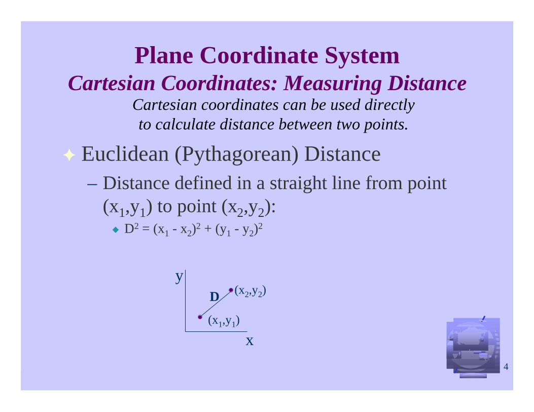
Plane Coordinate SystemCartesian Coordinates: Measuring Distance
Distance with Barriers– In this case, distance is calculated assuming
there are barriers to go around
– Barrier may be areal (i.e. lake) or linear (river)
– Is difficult to solve if there are many barriersand may alternate routes
B
A
LakeRiver
Bridge

7
Storing Coordinates
Since in a GIS, coordinates must be storedin the computer as numbers, there are twoimportant concepts that need to beconsidered:
– Integer vs. real number
– Questions of precision

8
Integer vs. Real NumbersIntegers are whole numbers, optionally preceded by“-” to indicate negation– Are discrete since mathematically there is a distance of 1
between consecutive numbers
Real numbers can be expressed as decimals– Are continuous– Often expressed as floating point numbers– Usually expressed as two sets of digits (a,b)
the first set gives the significant digitsThe 2nd set gives the exponent, which determines the position ofthe decimal placeThe number is the product (a x 10b)
Example: 1234+2 would indicate .1234 x 102 or 12.34

9
Computer Precision
In the computer, the number of digits whichcan be stored for each value is limited bythe hardwareIntegers are normally stored using 16 bits ofmemory– Can have a range from -32767 to +32767
Floating point numbers can use single ordouble precision– Single & double precision are used to refer to
the number of digits that can be stored for asingle value

10
Computer Precision ~ Continued
– Single precision commonly allocates 32 bits or 4bytes of memory for each value
Equivalent to 7 significant decimal placesActual numeric ranges vary between computer implementationsIn QuickBasic the exponent range is -435 to +38
– Double precision commonly allocates 64 bits or8 bytes
Equivalent to 15 or 16 decimal digits and in QuickBasic, anexponent range from -324 to +308
Questions of precision are important when doingcalculations since extra digits produced bydivision & multiplication operations mayexceed the precision capacity of the system

11
Precision of Cartesian Coordinates
The number of significant digits required for aspecific project when using Cartesiancoordinates depends on two measures:– Size of study area– Resolution (accuracy) of measurement
For example, if the study area is 10 km acrossand the resolution of measurement is 10 cm:– This would create a range of values from 0 to 105
– Requires 5 significant decimal digits or approximately 15binary digits
– Can calculate approximate number of binary digits bymultiplying number of decimal digits by 3 (log210)

12
Precision of Cartesian Coordinates(continued)
Since the computer system usually offersmore resolution than needed by the data– Data is stored at higher precision than is justified by its
accuracy
GIS designers are reluctant to throw awayextra significant digits– Because designers may not be aware of the resolution of
the data that will be used– People are reluctant to throw away “data”, even if it is
spurious
13
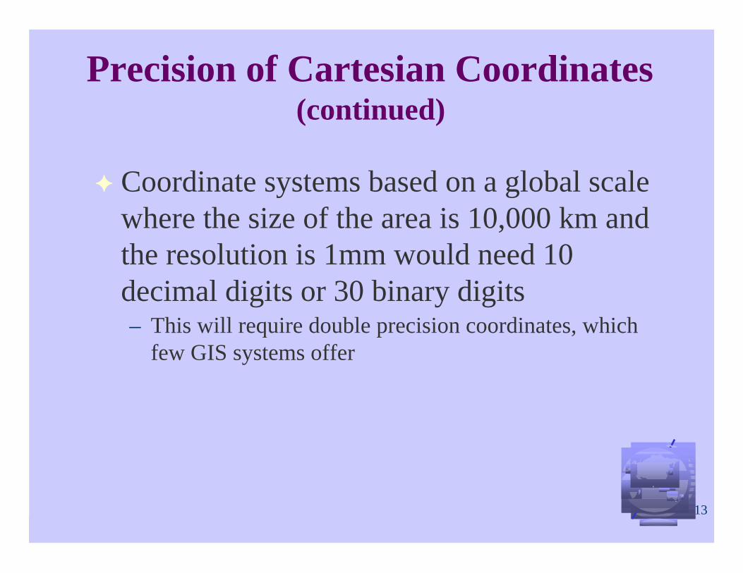
Precision of Cartesian Coordinates(continued)
Coordinate systems based on a global scalewhere the size of the area is 10,000 km andthe resolution is 1mm would need 10decimal digits or 30 binary digits– This will require double precision coordinates, which
few GIS systems offer
14
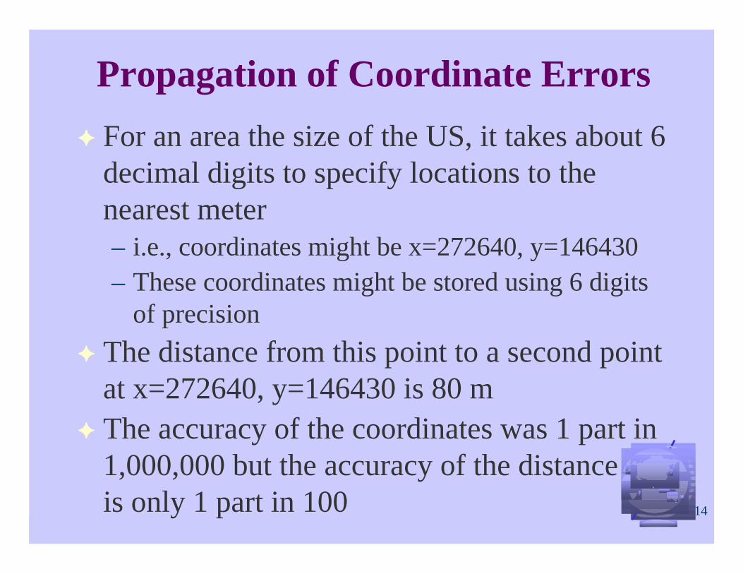
Propagation of Coordinate Errors
For an area the size of the US, it takes about 6decimal digits to specify locations to thenearest meter– i.e., coordinates might be x=272640, y=146430– These coordinates might be stored using 6 digits
of precision
The distance from this point to a second pointat x=272640, y=146430 is 80 mThe accuracy of the coordinates was 1 part in1,000,000 but the accuracy of the distanceis only 1 part in 100

15
Propagation of Coordinate Errorscontinued
If distance is also stored as a floating pointnumber with 6 digits of precision, the last 4digits will be meaninglessIn GIS operations, it is important to keep trackof how results, like distances, are affected bydatabase accuracy– In this example, distance is much more uncertain,
in proportional terms, than the coordinates
16
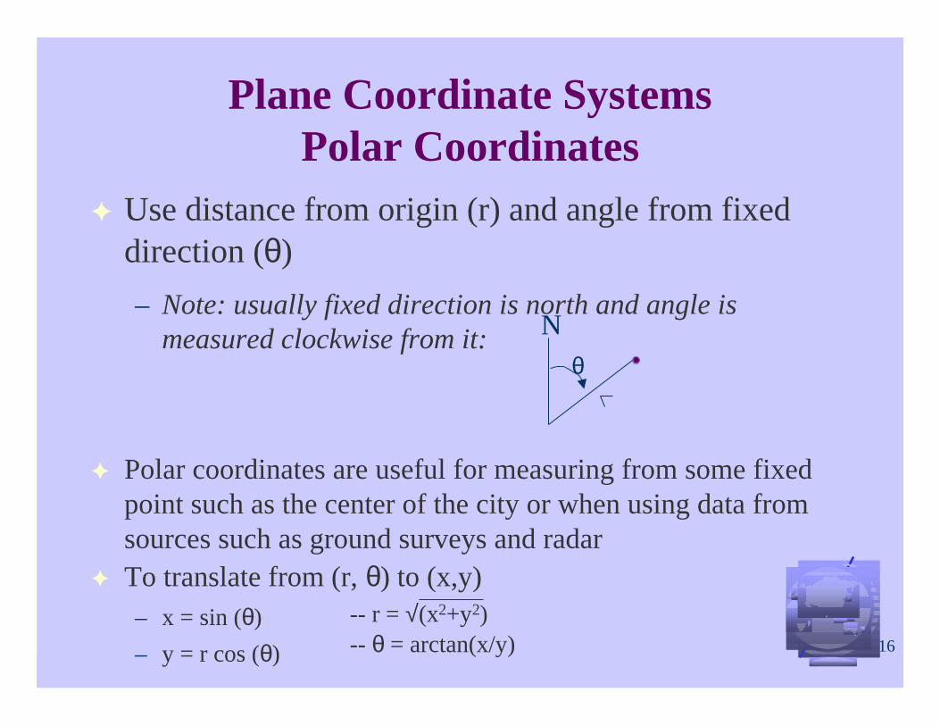
Plane Coordinate SystemsPolar Coordinates
Use distance from origin (r) and angle from fixeddirection (θ)
– Note: usually fixed direction is north and angle ismeasured clockwise from it:
Polar coordinates are useful for measuring from some fixedpoint such as the center of the city or when using data fromsources such as ground surveys and radarTo translate from (r, θ) to (x,y)– x = sin (θ)
– y = r cos (θ)
-- r = √(x2+y2)-- θ = arctan(x/y)
θ
N
17
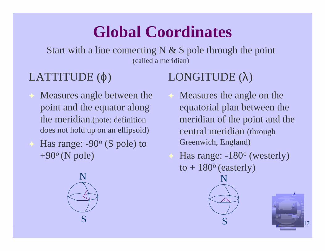
Global Coordinates
LATTITUDE (ϕ)
Measures angle between thepoint and the equator alongthe meridian.(note: definitiondoes not hold up on an ellipsoid)
Has range: -90o (S pole) to+90o (N pole)
LONGITUDE (λ)
Measures the angle on theequatorial plan between themeridian of the point and thecentral meridian (throughGreenwich, England)
Has range: -180o (westerly)to + 180o (easterly)
Start with a line connecting N & S pole through the point(called a meridian)
N
S
N
S

18
Global CoordinatesImportant Terms
Meridian: line ofconstant longitudeMeridian: line ofconstant longitude
Parallel: line ofconstant latitude
Parallel: line ofconstant latitude
Small Circle:Imaginary circle madeon the earth’s surface
by a plane that does notpass through the center
of the earth.
Small Circle:Imaginary circle madeon the earth’s surface
by a plane that does notpass through the center
of the earth.
Great Circle:Imaginary circle
made on the earth’ssurface by a plane
passing through thecenter of the earth
Great Circle:Imaginary circle
made on the earth’ssurface by a plane
passing through thecenter of the earth

19
Global CoordinatesMeasuring Distance
Using latitude and longitude, can calculatethe great circle distance between two pointsas follows:– d = R arccos(sin(ϕ1) * sin(ϕ2) + cos (ϕ1) * cos (λ1 - λ2))
– Where R is the radius of the earth
This assumes the earth is a sphere

20
Global CoordinatesQuestion of Precision
Since latitude and longitude are measured in degrees,minutes and seconds– Have problems storing dms units; therefore, often store lat/long as
decimals of degrees
One second of latitude = about 30 mHow many bits are needed to store global data at one-second resolution?– On the globe there are 60 x 60 x 36 = 107 seconds of longitude
This requires 7 decimal digits or 21 bit precisionTherefore, with 32 bit precision can get resolution better than 30 m
Since lines of longitude converge at the poles, precisionof longitude will increase toward the poles– Each km on the ground equals more and more seconds of
longitude as you approach the poles

21
Determining Position
It is often necessary to establish the location of somepoint on the earth’s surface (i.e., it’s coordinates)
The most common method is to identify a nearbyobject, and find a map which shows the object (note: themap must also show the coordinate system (i.e., with a lat/longgird))
In surveying, we measure the distance and directionfrom some object whose location is known precisely,i.e. a monument, then use coordinate geometry(COGO) to compute the location of the desired point
22
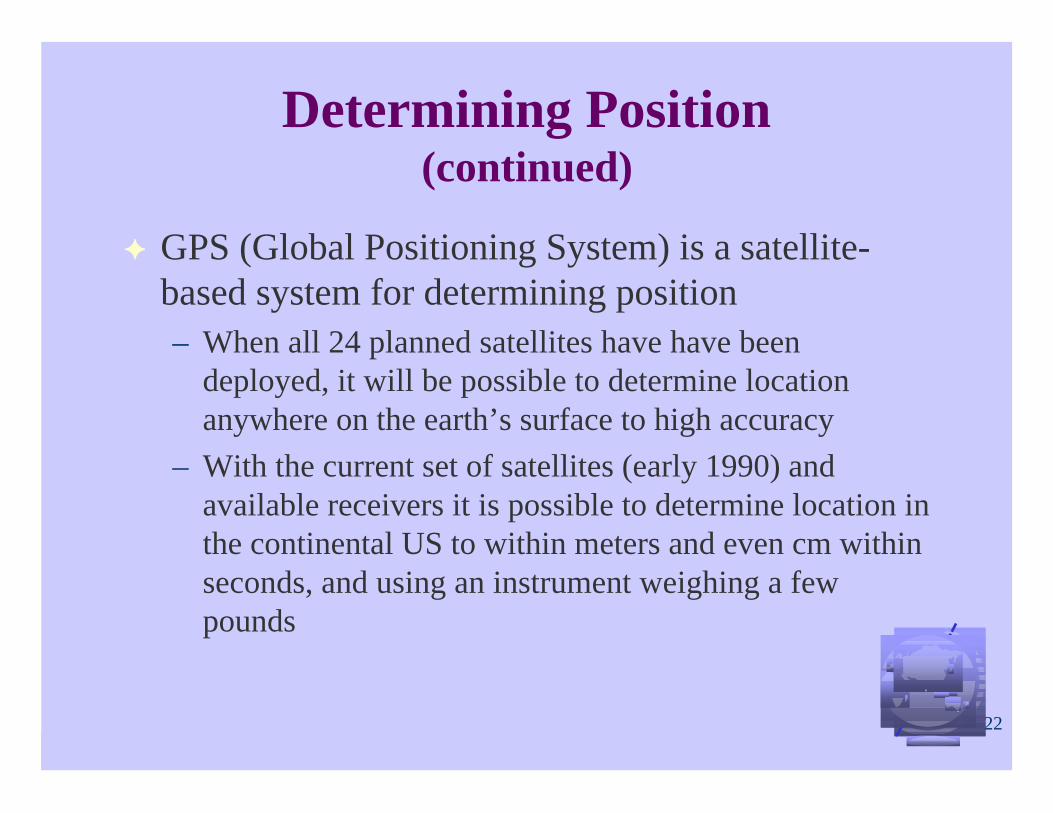
Determining Position(continued)
GPS (Global Positioning System) is a satellite-based system for determining position– When all 24 planned satellites have have been
deployed, it will be possible to determine locationanywhere on the earth’s surface to high accuracy
– With the current set of satellites (early 1990) andavailable receivers it is possible to determine location inthe continental US to within meters and even cm withinseconds, and using an instrument weighing a fewpounds
Related Documents