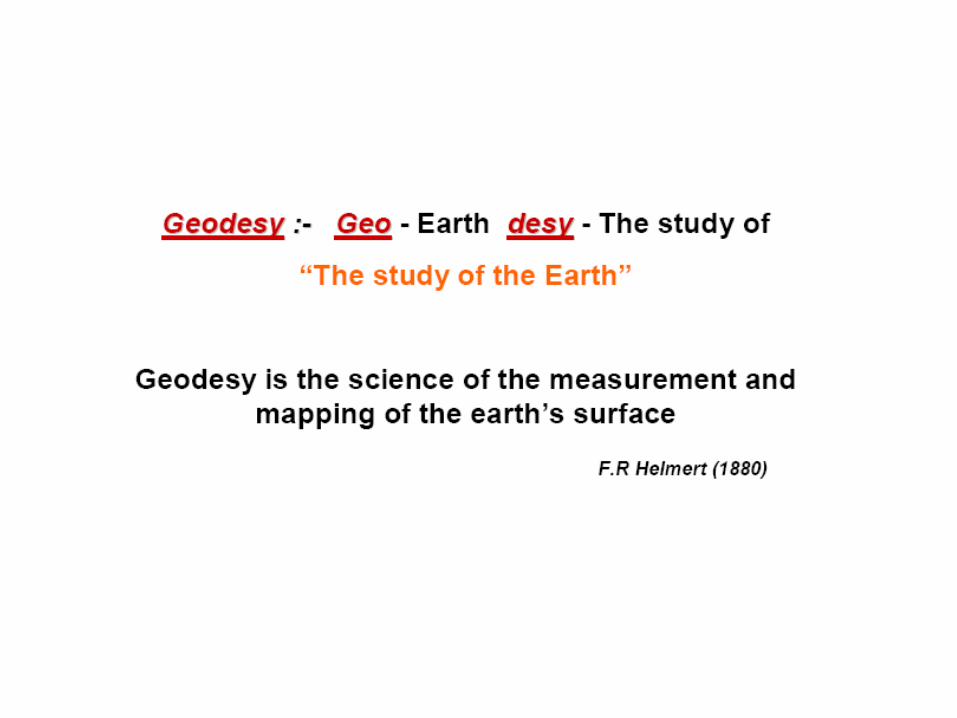
Control Surveys and Coordinate Systems The Earth…… is Round Basic Shape of the Earth: Oblate Spheroid of Revolution The length of the equatorial axis is approximately 27 miles greater than the polar axis. Average value of the Earth’s radius: 20,906,000 ft GEODESY…..

Welcome message from author
This document is posted to help you gain knowledge. Please leave a comment to let me know what you think about it! Share it to your friends and learn new things together.
Transcript
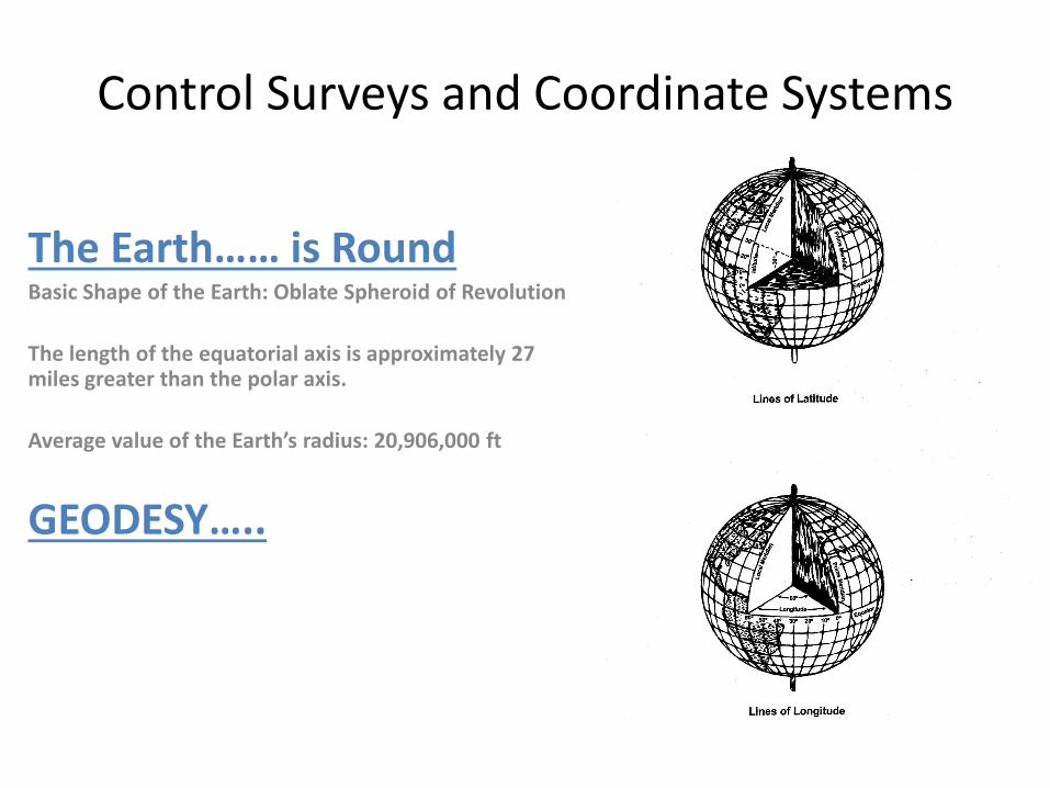
Control Surveys and Coordinate Systems
The Earth…… is RoundBasic Shape of the Earth: Oblate Spheroid of Revolution
The length of the equatorial axis is approximately 27 miles greater than the polar axis.
Average value of the Earth’s radius: 20,906,000 ft
GEODESY…..
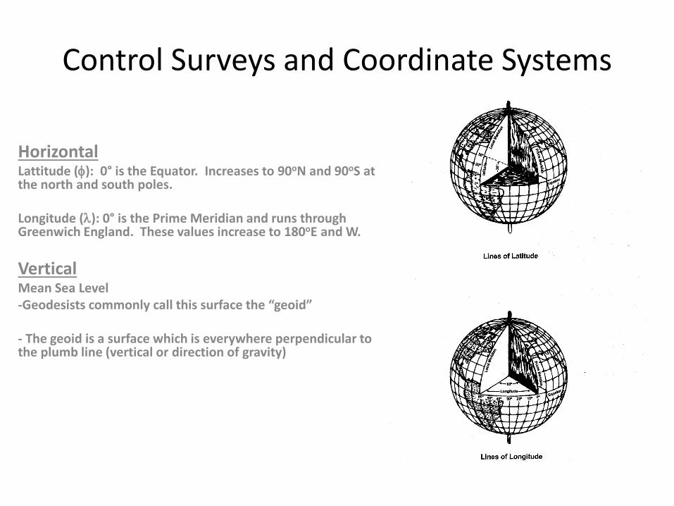
Control Surveys and Coordinate Systems
HorizontalLattitude (φ): 0° is the Equator. Increases to 90oN and 90oS at the north and south poles.
Longitude (λ): 0° is the Prime Meridian and runs through Greenwich England. These values increase to 180oE and W.
VerticalMean Sea Level-Geodesists commonly call this surface the “geoid”
- The geoid is a surface which is everywhere perpendicular to the plumb line (vertical or direction of gravity)

The Vertical Reference
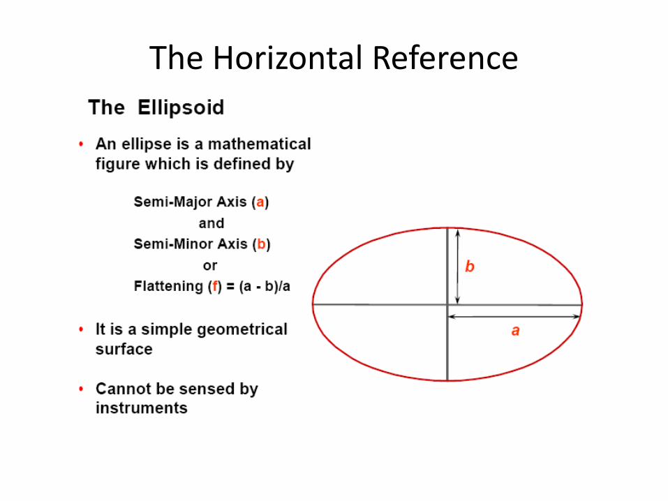
The Horizontal Reference
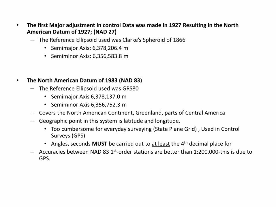
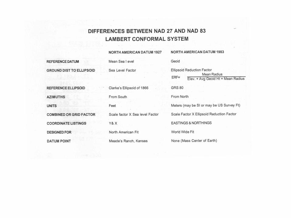
• The first Major adjustment in control Data was made in 1927 Resulting in the North American Datum of 1927; (NAD 27)
– The Reference Ellipsoid used was Clarke’s Spheroid of 1866• Semimajor Axis: 6,378,206.4 m• Semiminor Axis: 6,356,583.8 m
• The North American Datum of 1983 (NAD 83)– The Reference Ellipsoid used was GRS80
• Semimajor Axis 6,378,137.0 m• Semiminor Axis 6,356,752.3 m
– Covers the North American Continent, Greenland, parts of Central America– Geographic point in this system is latitude and longitude.
• Too cumbersome for everyday surveying (State Plane Grid) , Used in Control Surveys (GPS)
• Angles, seconds MUST be carried out to at least the 4th decimal place for – Accuracies between NAD 83 1st-order stations are better than 1:200,000-this is due to
GPS.

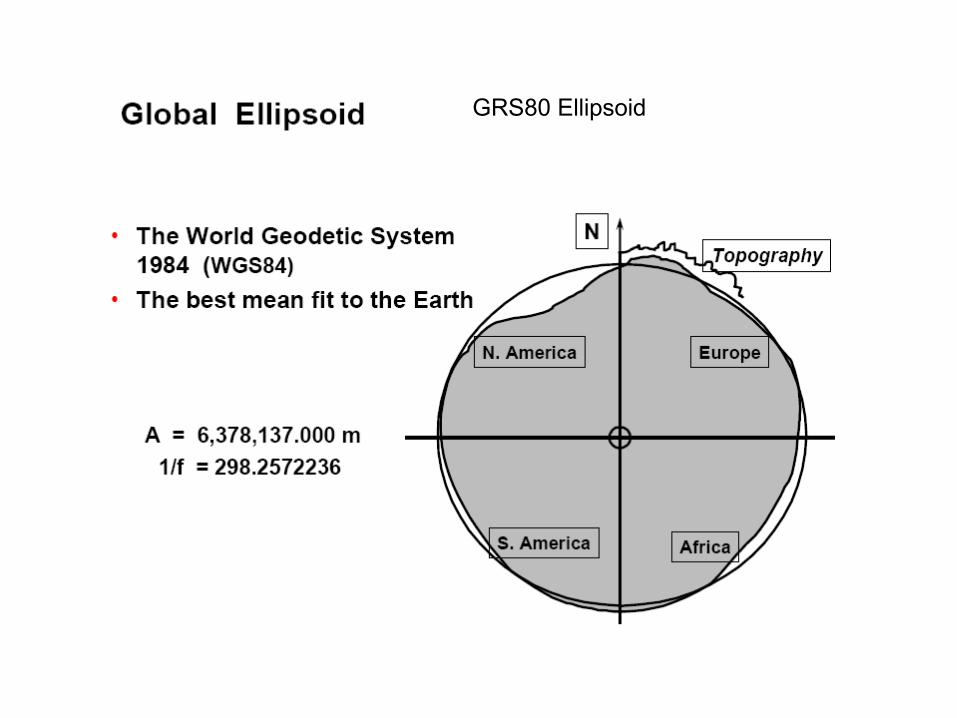
GRS80 Ellipsoid

NAD27
WGS84 and NAD83 share the GRS80 ellipsoid but the origin differs by about 2mNAD27 uses the Clark spheroid of 1866, the origin is 236 m from WGS84
NAD83
GEOID
Earth MassCenter
Approximately236 meters
Approximately2 meters
NAD27, NAD83, WGS84
WGS84

Principal Vertical Datums
• National Geodetic Vertical Datum of 1929 (NGVD 29)– Superseded by NAVD 88– Normal Orthometric Heights
• North American Vertical Datum of 1988 (NAVD 88)– Principal vertical datum for CONUS/Alaska– Helmert Orthometric Heights

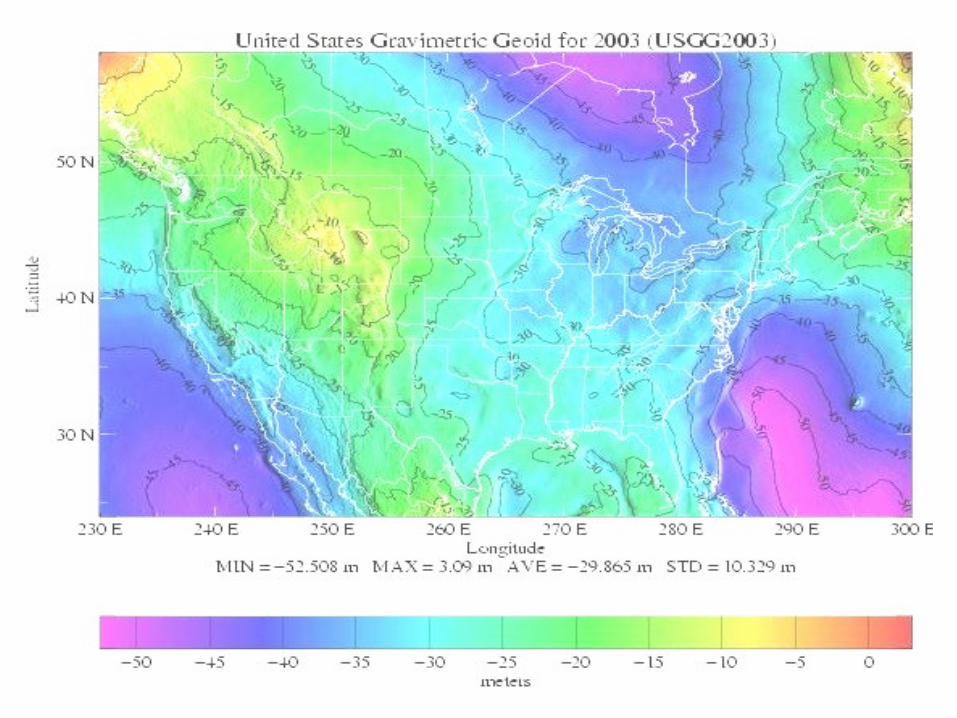
Geoid• “The equipotential surface of the Earth’s gravity field which best
fits, in the least squares sense, (global) mean sea level.”*
• Geoid surface is neither visible or directly measureable.
• Geoid is mathematically related to and modeled from gravity data.
• A geoid height is the ellipsoidal height from an ellipsoidal datum to a geoid.
• Hence, geoid height models are directly tied to the geoid and ellipsoid that define them (i.e., geoid height models are notinterchangeable).
*Definition from the Geodetic Glossary, September 1986
Daniel R. Roman, National Geodetic Survey, National Oceanic and Atmospheric Administration
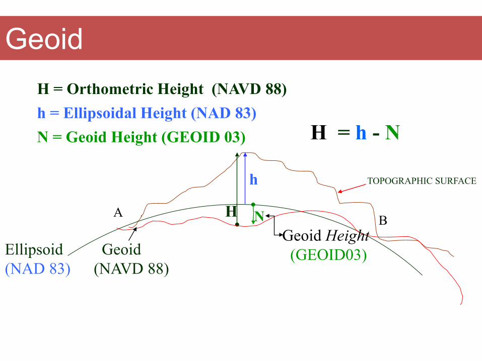
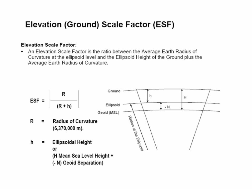
H
H = Orthometric Height (NAVD 88)
H = h - N
TOPOGRAPHIC SURFACE
h = Ellipsoidal Height (NAD 83)N = Geoid Height (GEOID 03)
h
Ellipsoid(NAD 83)
N
Geoid(NAVD 88)
Geoid Height(GEOID03)
A B
Geoid
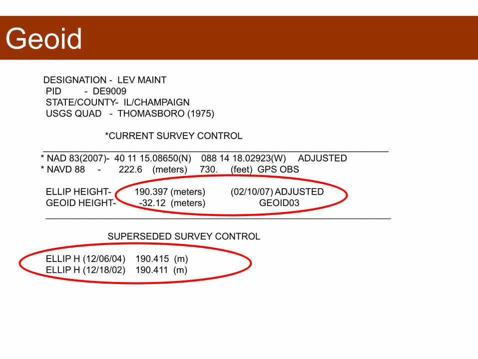
GeoidDESIGNATION - LEV MAINTPID - DE9009STATE/COUNTY- IL/CHAMPAIGNUSGS QUAD - THOMASBORO (1975)
*CURRENT SURVEY CONTROL___________________________________________________________________* NAD 83(2007)- 40 11 15.08650(N) 088 14 18.02923(W) ADJUSTED * NAVD 88 - 222.6 (meters) 730. (feet) GPS OBS
ELLIP HEIGHT- 190.397 (meters) (02/10/07) ADJUSTEDGEOID HEIGHT- -32.12 (meters) GEOID03___________________________________________________________________
SUPERSEDED SURVEY CONTROL
ELLIP H (12/06/04) 190.415 (m) ELLIP H (12/18/02) 190.411 (m)
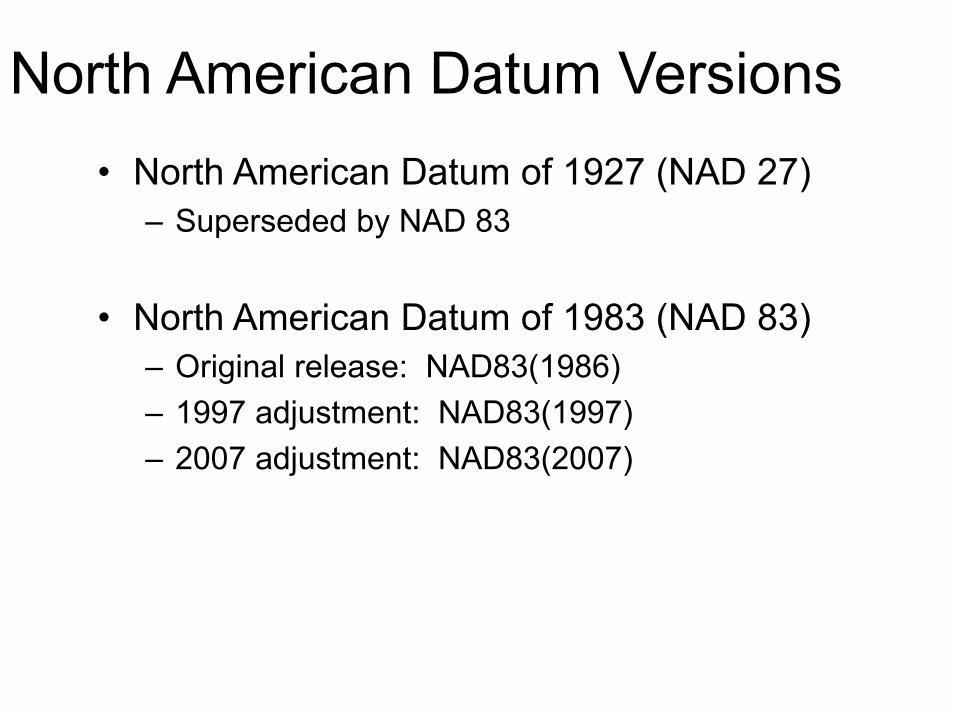
North American Datum Versions • North American Datum of 1927 (NAD 27)
– Superseded by NAD 83
• North American Datum of 1983 (NAD 83)– Original release: NAD83(1986)– 1997 adjustment: NAD83(1997)– 2007 adjustment: NAD83(2007)
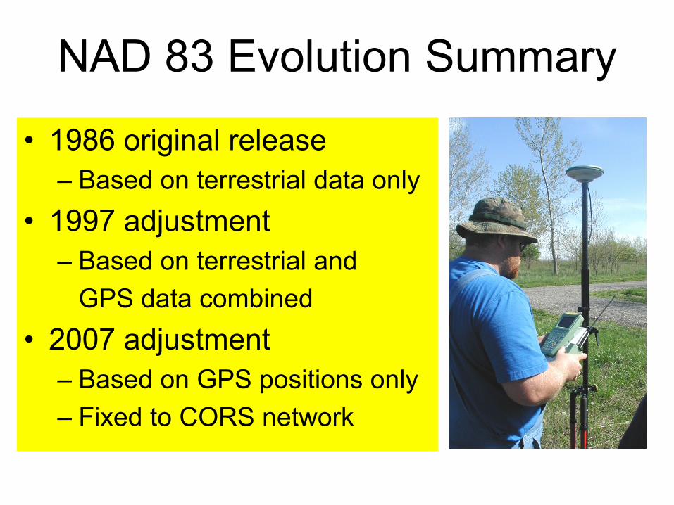
NAD 83 Evolution Summary
• 1986 original release– Based on terrestrial data only
• 1997 adjustment– Based on terrestrial and
GPS data combined• 2007 adjustment
– Based on GPS positions only– Fixed to CORS network
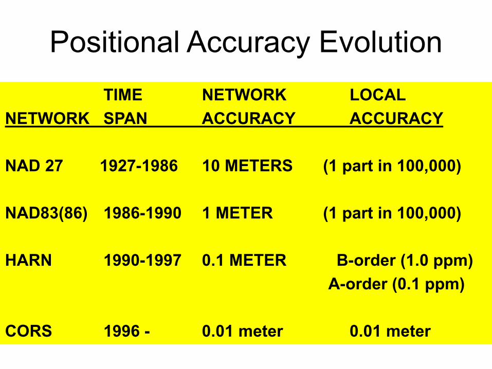
Positional Accuracy EvolutionTIME NETWORK LOCAL
NETWORK SPAN ACCURACY ACCURACY
NAD 27 1927-1986 10 METERS (1 part in 100,000)
NAD83(86) 1986-1990 1 METER (1 part in 100,000)
HARN 1990-1997 0.1 METER B-order (1.0 ppm)A-order (0.1 ppm)
CORS 1996 - 0.01 meter 0.01 meter
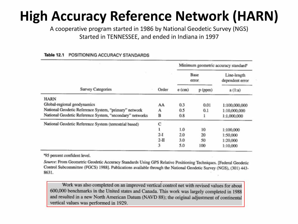
High Accuracy Reference Network (HARN)A cooperative program started in 1986 by National Geodetic Survey (NGS)
Started in TENNESSEE, and ended in Indiana in 1997

Control “Network”Redundancy!
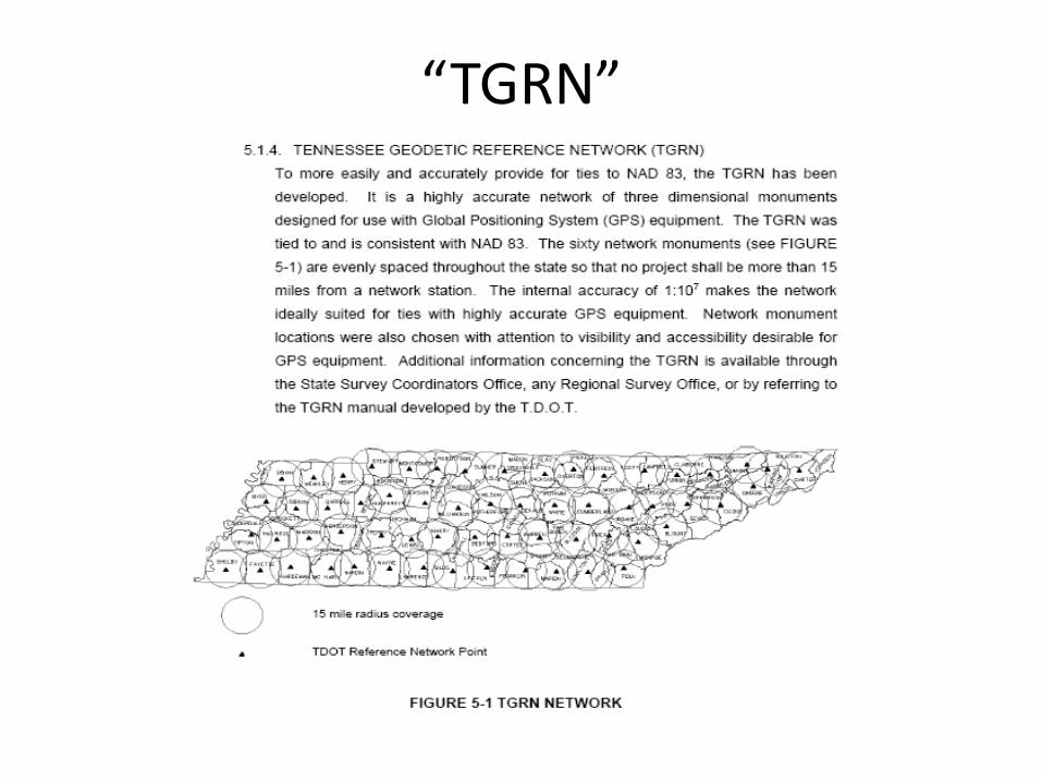
“TGRN”
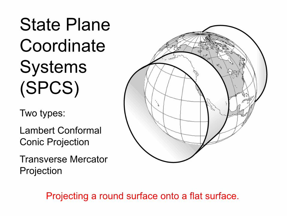
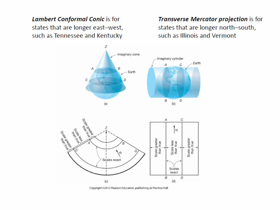
Two types:
Lambert Conformal Conic Projection
Transverse Mercator Projection
State Plane Coordinate Systems(SPCS)
Projecting a round surface onto a flat surface.
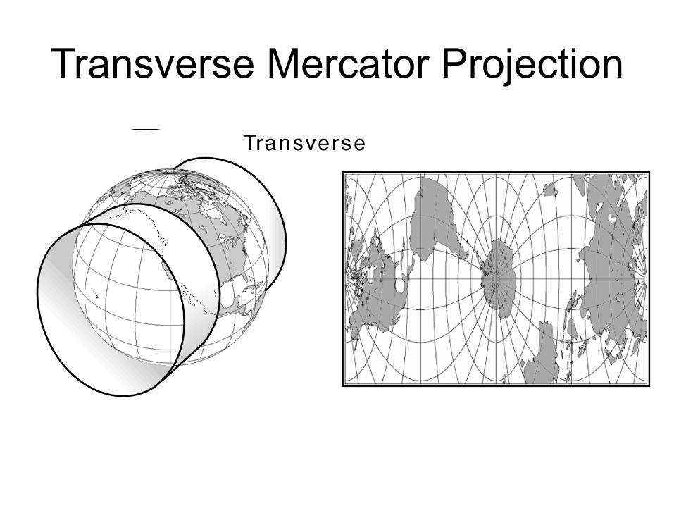
Transverse Mercator Projection
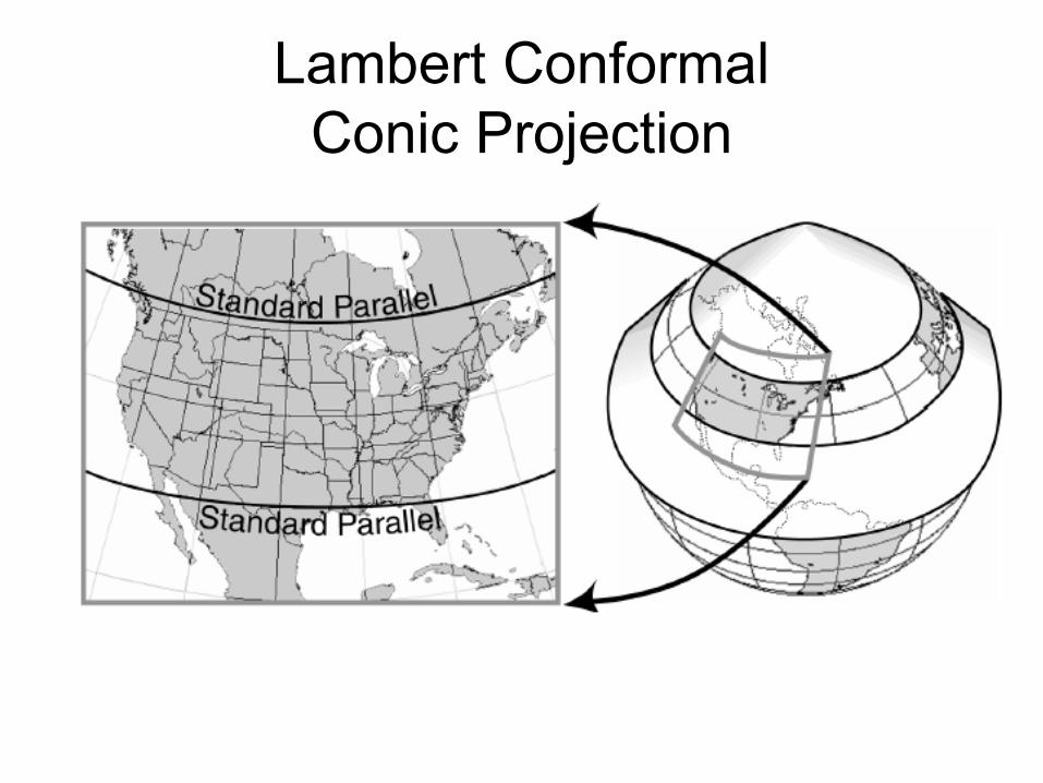
Lambert Conformal Conic Projection
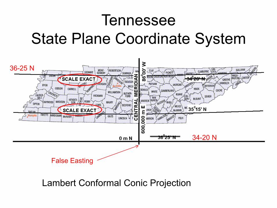
TennesseeState Plane Coordinate System
Lambert Conformal Conic Projection
34-20 N
36-25 N
False Easting
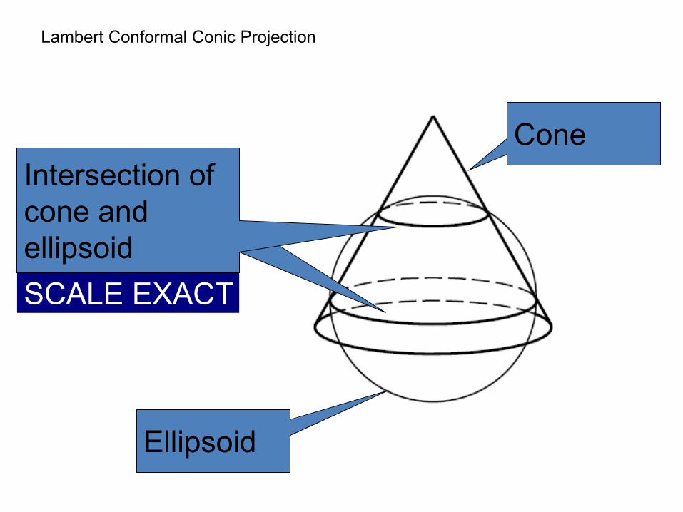
Lambert Conformal Conic Projection
Intersection of cylinder and ellipsoid
Ellipsoid
ConeIntersection of cone and ellipsoidSCALE EXACT

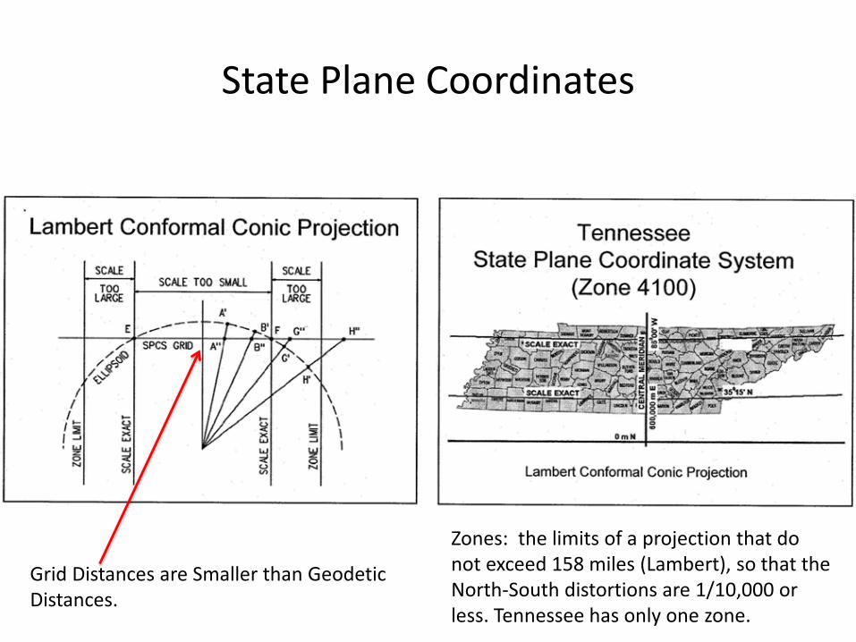
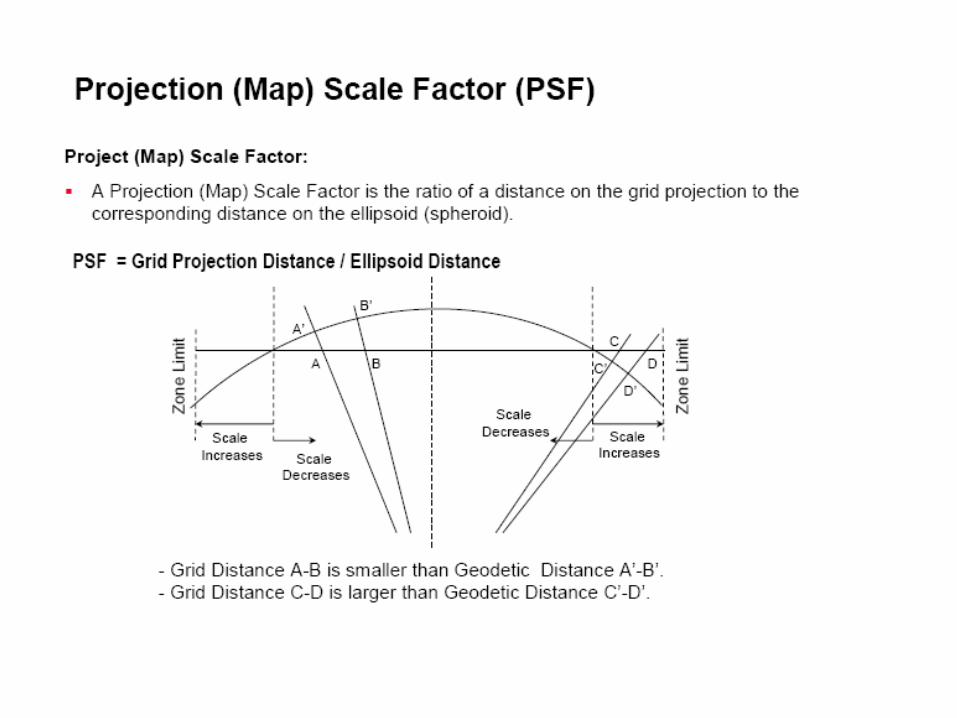
State Plane Coordinates
Zones: the limits of a projection that do not exceed 158 miles (Lambert), so that the North-South distortions are 1/10,000 or less. Tennessee has only one zone.
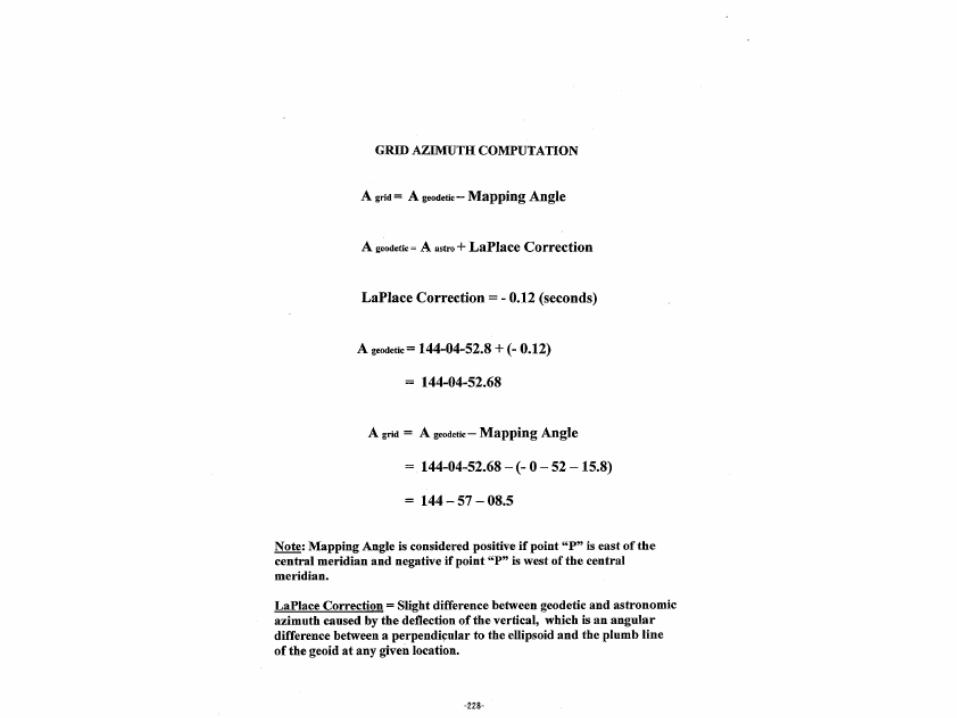
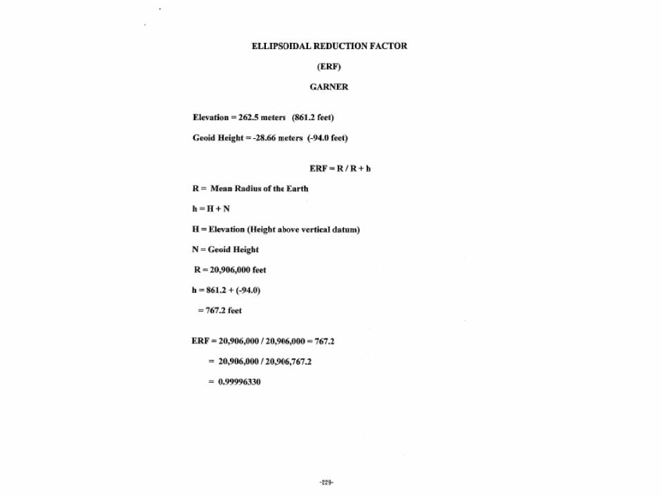
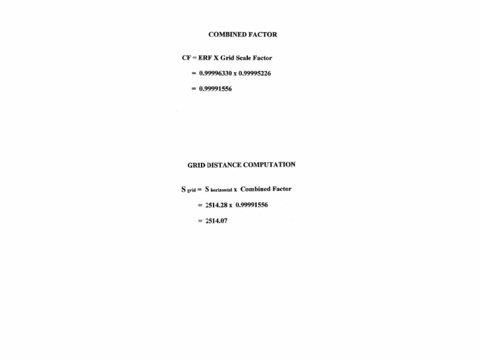
Grid Distances are Smaller than Geodetic Distances.
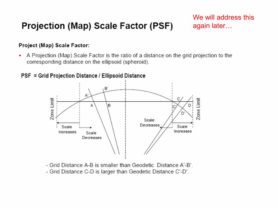
We will address this again later…
Lambert Conformal Conic Projection
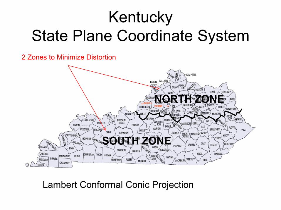
KentuckyState Plane Coordinate System
2 Zones to Minimize Distortion

MississippiState Plane Coordinate SystemTransverse Mercator Projection
2 Zones to Minimize Distortion
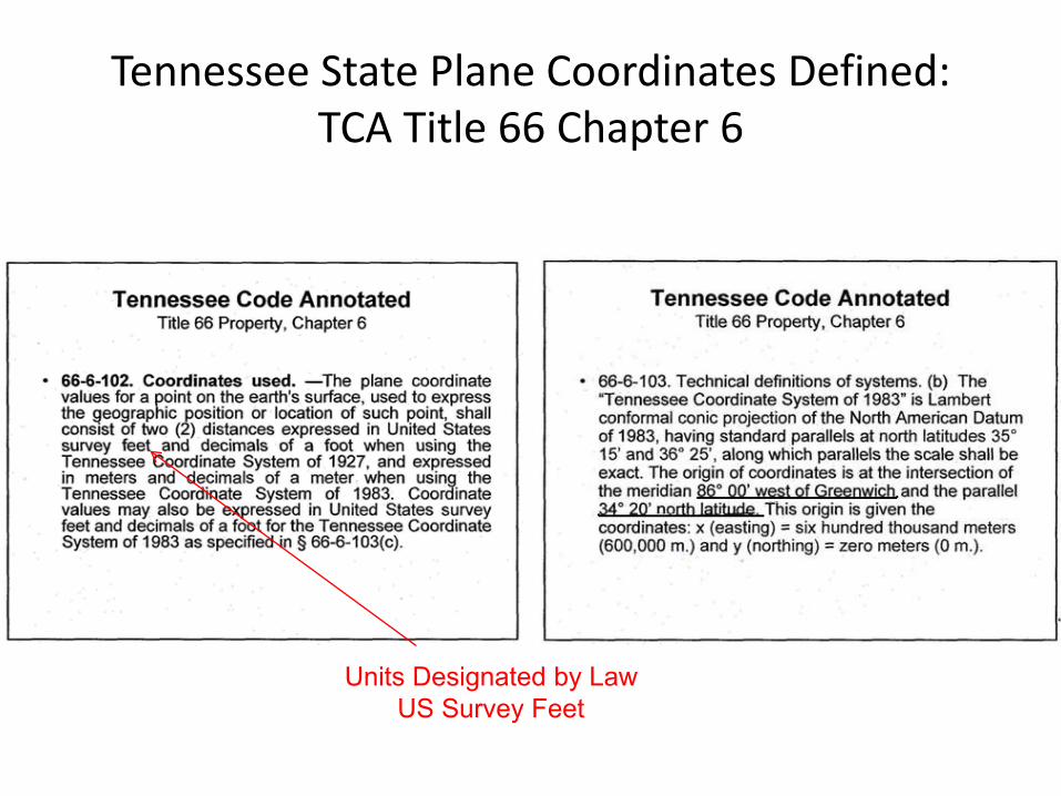
Tennessee State Plane Coordinates Defined:TCA Title 66 Chapter 6
Units Designated by LawUS Survey Feet
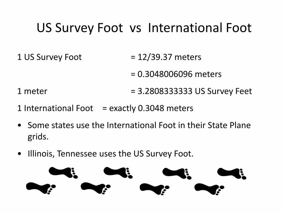
US Survey Foot vs International Foot
1 US Survey Foot = 12/39.37 meters
= 0.3048006096 meters
1 meter = 3.2808333333 US Survey Feet
1 International Foot = exactly 0.3048 meters
• Some states use the International Foot in their State Plane grids.
• Illinois, Tennessee uses the US Survey Foot.
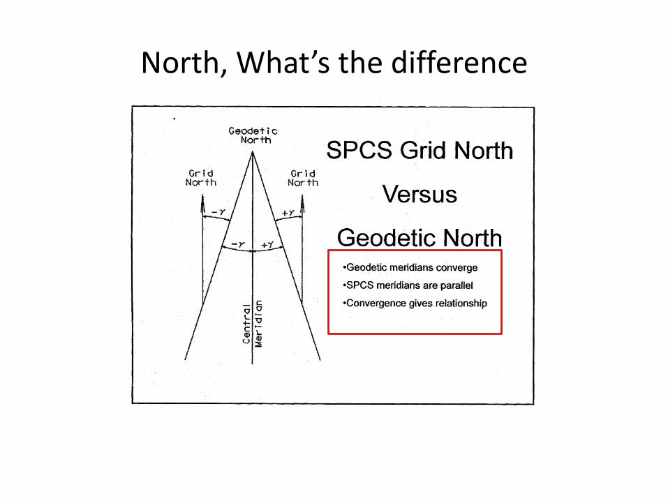
North, What’s the difference


Scale = 1at SCALE EXACT line
Scale < 1between SCALE EXACT lines
Scale > 1outside SCALE EXACT lines
Lines of Lat and Lon and SPCS Grid Lines are Not the Same Distance: “Scale Factor”
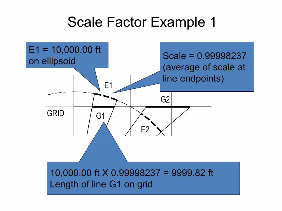
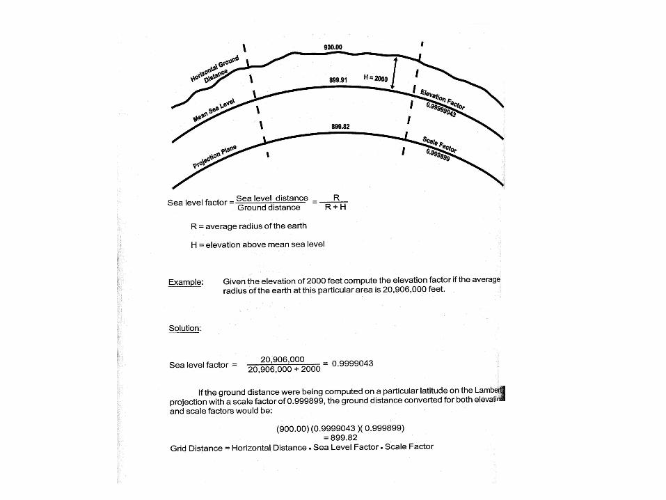
Scale Factor Example 1
Scale = 0.99998237 (average of scale at line endpoints)
E1 = 10,000.00 ft on ellipsoid
10,000.00 ft X 0.99998237 = 9999.82 ftLength of line G1 on grid
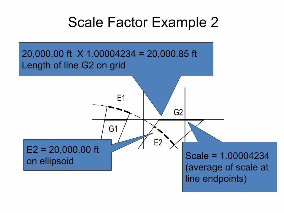
Scale Factor Example 2
Scale = 1.00004234 (average of scale at line endpoints)
E2 = 20,000.00 ft on ellipsoid
20,000.00 ft X 1.00004234 = 20,000.85 ftLength of line G2 on grid
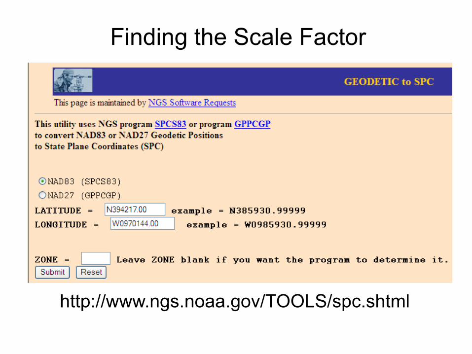
Finding the Scale Factor
http://www.ngs.noaa.gov/TOOLS/spc.shtml

Finding the Scale Factor
http://www.ngs.noaa.gov/TOOLS/spc.shtml

Grid to Ground Coordinates
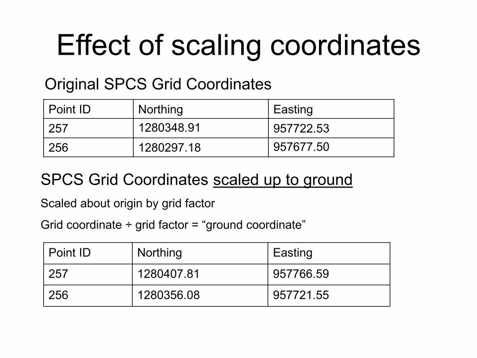
Point ID Northing Easting
257 1280407.81 957766.59
256 1280356.08 957721.55
Point ID Northing Easting257 1280348.91 957722.53256 1280297.18 957677.50
SPCS Grid Coordinates scaled up to groundScaled about origin by grid factor
Grid coordinate ÷ grid factor = “ground coordinate”
Original SPCS Grid Coordinates
Effect of scaling coordinates

Effect of scaling coordinates
Distance too small to see the effect of scaling, although coordinates are scaled to be ground coordinates.
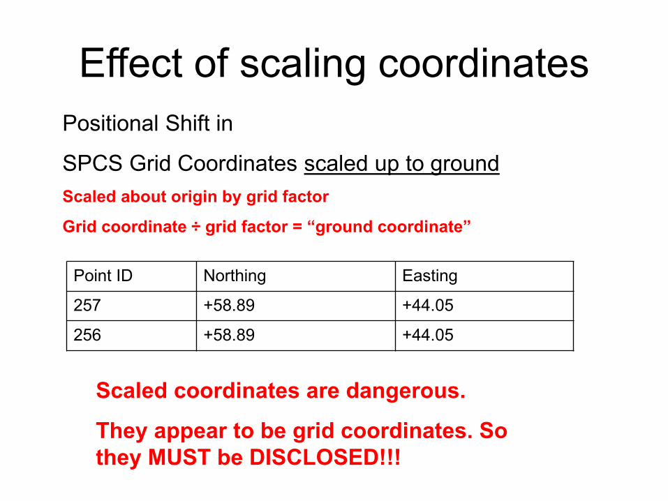
Point ID Northing Easting
257 +58.89 +44.05
256 +58.89 +44.05
Positional Shift in
SPCS Grid Coordinates scaled up to groundScaled about origin by grid factor
Grid coordinate ÷ grid factor = “ground coordinate”
Effect of scaling coordinates
Scaled coordinates are dangerous.
They appear to be grid coordinates. So they MUST be DISCLOSED!!!
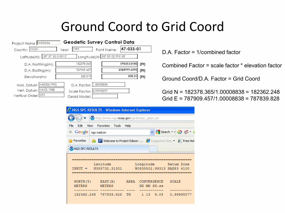
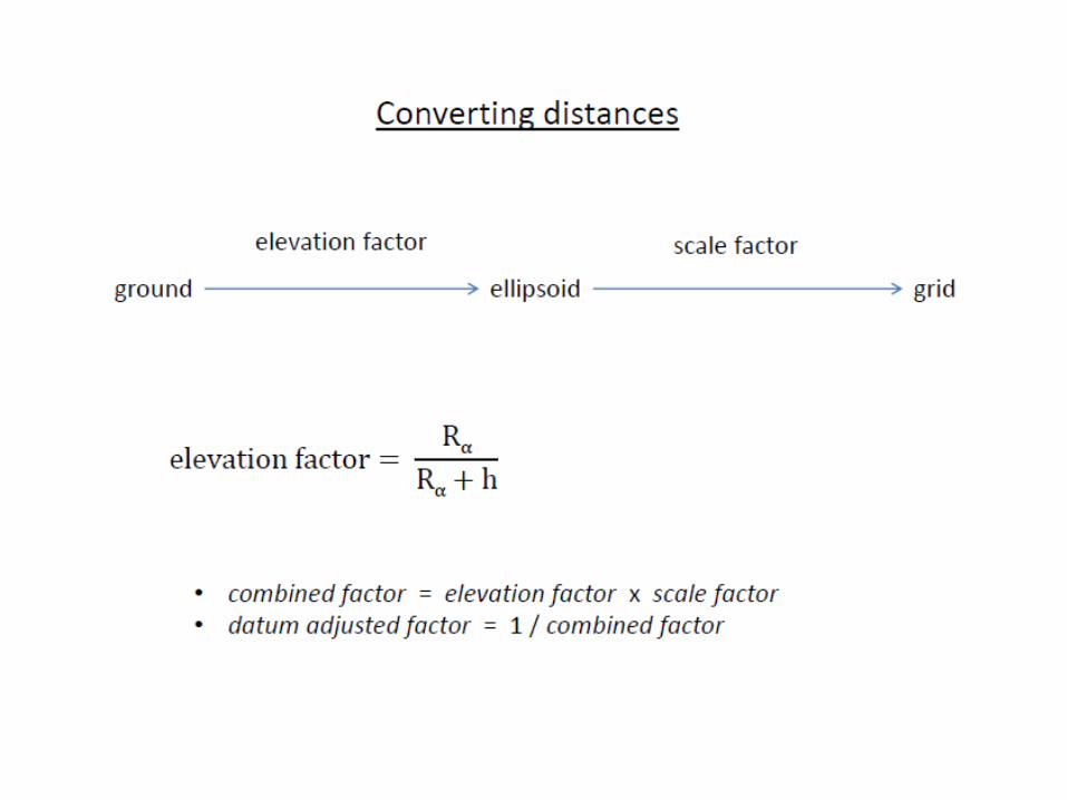
Ground Coord to Grid Coord
D.A. Factor = 1/combined factor
Combined Factor = scale factor * elevation factor
Ground Coord/D.A. Factor = Grid Coord
Grid N = 182378.365/1.00008838 = 182362.248Grid E = 787909.457/1.00008838 = 787839.828


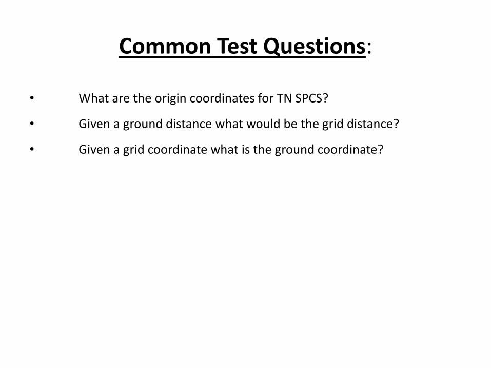
Common Test Questions:
• What are the origin coordinates for TN SPCS?
• Given a ground distance what would be the grid distance?
• Given a grid coordinate what is the ground coordinate?
Related Documents