Top Banner
Contour Maps AKA Topographic Maps
40

Contour Maps AKA Topographic Maps. Contour Map: (topograpic map) shows elevation of various points on the Earth’s surface.

Dec 18, 2015

Download

Documents

Percival Porter
Welcome message from author
This document is posted to help you gain knowledge. Please leave a comment to let me know what you think about it! Share it to your friends and learn new things together.
Transcript
Page 1: Contour Maps AKA Topographic Maps. Contour Map: (topograpic map) shows elevation of various points on the Earth’s surface.

Contour Maps

AKA Topographic Maps

Page 2: Contour Maps AKA Topographic Maps. Contour Map: (topograpic map) shows elevation of various points on the Earth’s surface.

Contour Map: (topograpic map)

shows elevation of various points on

the Earth’s surface.

Page 3: Contour Maps AKA Topographic Maps. Contour Map: (topograpic map) shows elevation of various points on the Earth’s surface.
Page 4: Contour Maps AKA Topographic Maps. Contour Map: (topograpic map) shows elevation of various points on the Earth’s surface.

•Maps show physical features of land, such as cliffs, valleys, hills, and depressions.

Page 5: Contour Maps AKA Topographic Maps. Contour Map: (topograpic map) shows elevation of various points on the Earth’s surface.
Page 6: Contour Maps AKA Topographic Maps. Contour Map: (topograpic map) shows elevation of various points on the Earth’s surface.

•Contour Lines: lines that connect points of equal elevation above sea level.

Page 7: Contour Maps AKA Topographic Maps. Contour Map: (topograpic map) shows elevation of various points on the Earth’s surface.
Page 8: Contour Maps AKA Topographic Maps. Contour Map: (topograpic map) shows elevation of various points on the Earth’s surface.
Page 9: Contour Maps AKA Topographic Maps. Contour Map: (topograpic map) shows elevation of various points on the Earth’s surface.

Are BOLDED Lines—they show the numerical values of the lines. All other lines are unlabeled.

Page 10: Contour Maps AKA Topographic Maps. Contour Map: (topograpic map) shows elevation of various points on the Earth’s surface.

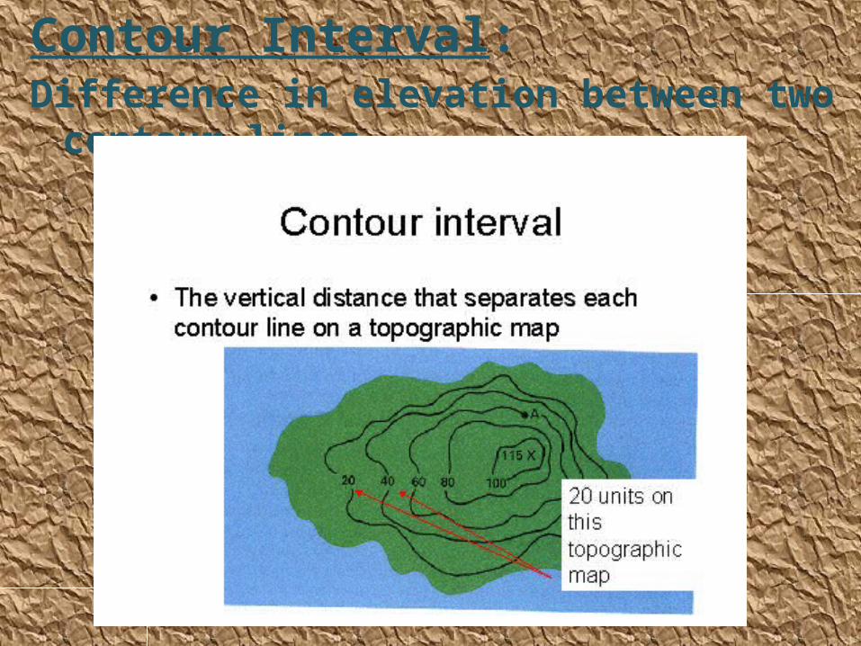
Contour Interval: Difference in elevation between two contour lines

Page 11: Contour Maps AKA Topographic Maps. Contour Map: (topograpic map) shows elevation of various points on the Earth’s surface.
Page 12: Contour Maps AKA Topographic Maps. Contour Map: (topograpic map) shows elevation of various points on the Earth’s surface.

What is the contour interval of this map?

Page 13: Contour Maps AKA Topographic Maps. Contour Map: (topograpic map) shows elevation of various points on the Earth’s surface.

Points on contour lines

Page 14: Contour Maps AKA Topographic Maps. Contour Map: (topograpic map) shows elevation of various points on the Earth’s surface.

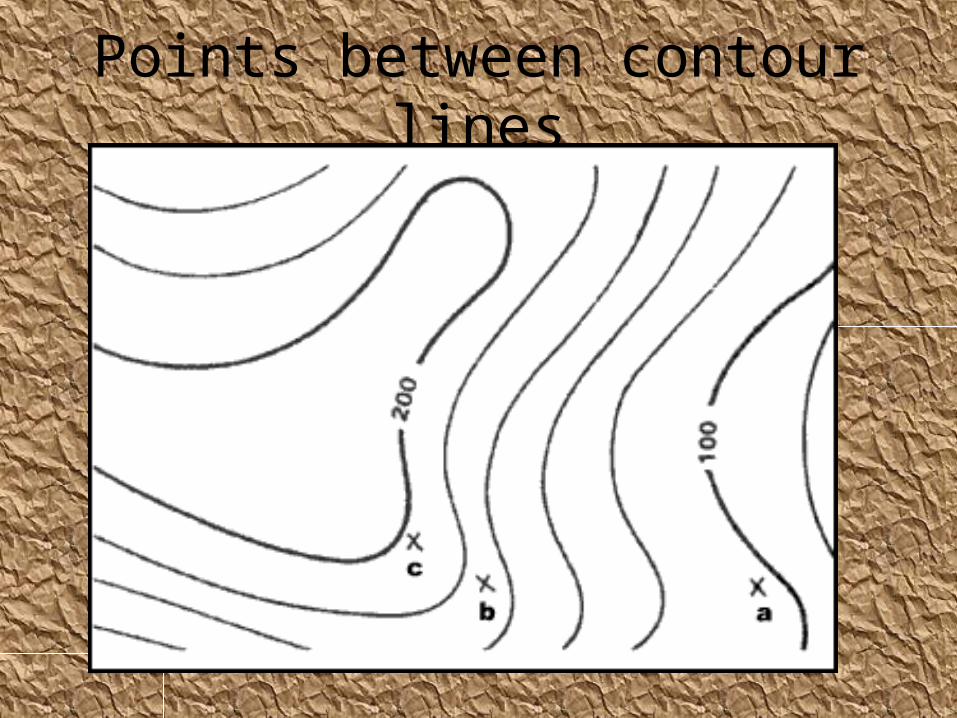
Points between contour lines

Page 15: Contour Maps AKA Topographic Maps. Contour Map: (topograpic map) shows elevation of various points on the Earth’s surface.

•Depression: hole or crater on the Earth’s surface, shown on a contour map by Hachured Lines

Page 16: Contour Maps AKA Topographic Maps. Contour Map: (topograpic map) shows elevation of various points on the Earth’s surface.

•• The first hachured line has the same elevation of the lowest contour lines between which it was found.

Page 17: Contour Maps AKA Topographic Maps. Contour Map: (topograpic map) shows elevation of various points on the Earth’s surface.
Page 18: Contour Maps AKA Topographic Maps. Contour Map: (topograpic map) shows elevation of various points on the Earth’s surface.
Page 19: Contour Maps AKA Topographic Maps. Contour Map: (topograpic map) shows elevation of various points on the Earth’s surface.

Highest possible points

This location is between 220 and 240

So the highest possible elevation at this point would be 239 m

Page 20: Contour Maps AKA Topographic Maps. Contour Map: (topograpic map) shows elevation of various points on the Earth’s surface.

Contour lines crossing a river

Contour lines bend upstream when crossing a river

Page 21: Contour Maps AKA Topographic Maps. Contour Map: (topograpic map) shows elevation of various points on the Earth’s surface.

Time to Practice!

Page 22: Contour Maps AKA Topographic Maps. Contour Map: (topograpic map) shows elevation of various points on the Earth’s surface.

Topographic Profiles

Page 23: Contour Maps AKA Topographic Maps. Contour Map: (topograpic map) shows elevation of various points on the Earth’s surface.

•Profile: Shows the Hills and Valleys (ups and downs) on a line across any part of a contour map.

Page 24: Contour Maps AKA Topographic Maps. Contour Map: (topograpic map) shows elevation of various points on the Earth’s surface.

b

Page 25: Contour Maps AKA Topographic Maps. Contour Map: (topograpic map) shows elevation of various points on the Earth’s surface.
Page 26: Contour Maps AKA Topographic Maps. Contour Map: (topograpic map) shows elevation of various points on the Earth’s surface.
Page 27: Contour Maps AKA Topographic Maps. Contour Map: (topograpic map) shows elevation of various points on the Earth’s surface.
Page 28: Contour Maps AKA Topographic Maps. Contour Map: (topograpic map) shows elevation of various points on the Earth’s surface.
Page 29: Contour Maps AKA Topographic Maps. Contour Map: (topograpic map) shows elevation of various points on the Earth’s surface.

How to recognize a profile

Page 30: Contour Maps AKA Topographic Maps. Contour Map: (topograpic map) shows elevation of various points on the Earth’s surface.

How to Draw a Topographic Profile

Page 31: Contour Maps AKA Topographic Maps. Contour Map: (topograpic map) shows elevation of various points on the Earth’s surface.
Page 32: Contour Maps AKA Topographic Maps. Contour Map: (topograpic map) shows elevation of various points on the Earth’s surface.
Page 33: Contour Maps AKA Topographic Maps. Contour Map: (topograpic map) shows elevation of various points on the Earth’s surface.

Notice how the line curves above the 40 mark, but below the 50

Page 34: Contour Maps AKA Topographic Maps. Contour Map: (topograpic map) shows elevation of various points on the Earth’s surface.
Page 35: Contour Maps AKA Topographic Maps. Contour Map: (topograpic map) shows elevation of various points on the Earth’s surface.

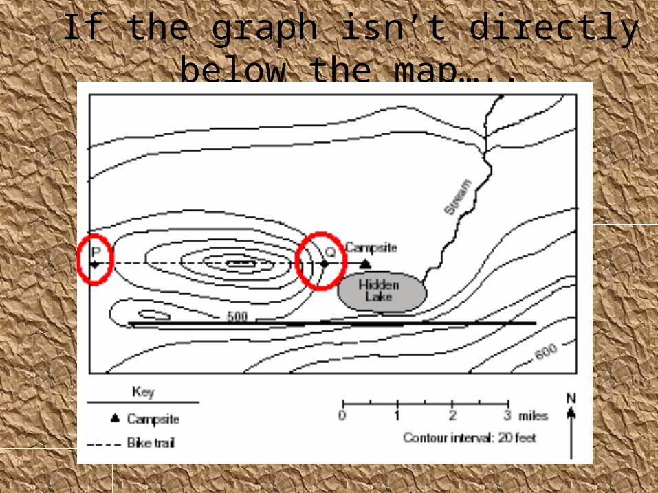
If the graph isn’t directly below the map…..

Page 36: Contour Maps AKA Topographic Maps. Contour Map: (topograpic map) shows elevation of various points on the Earth’s surface.
Page 37: Contour Maps AKA Topographic Maps. Contour Map: (topograpic map) shows elevation of various points on the Earth’s surface.
Page 38: Contour Maps AKA Topographic Maps. Contour Map: (topograpic map) shows elevation of various points on the Earth’s surface.
Page 39: Contour Maps AKA Topographic Maps. Contour Map: (topograpic map) shows elevation of various points on the Earth’s surface.
Page 40: Contour Maps AKA Topographic Maps. Contour Map: (topograpic map) shows elevation of various points on the Earth’s surface.

Time to make your profi les!