Context-aware Navigation Model supporting Way-finding of Vision Impaired People in Indoor Environments Nimalika Fernando*, David A. McMeekin**, Iain Murray** * Sri Lanka Institute of Information Technology, Sri Lanka **Curtin University, Australia Abstract. An indoor navigation model for vision impaired people, which would support (a) path planning and (b) orientation establishment, based on a user centric approach is proposed in this study. Building structures, the environmental factors and individual characteristics related to mobility of the people with vision impairment are identified as influential contexts for the proposed model. The contributions from these contexts for indoor navigation of vision impaired people are analyzed. The building structures will be assigned with an orientation and mobility ranking and this infor- mation will be dynamically passed to a path planning engine. The engine will handle the optimum path planning integrated with orientation estab- lishment support via visual and nan-visual landmarks meaningful for VI people, considering individual user characteristics. The model can be used by electronic travel aids for a better indoor path planning for vision im- paired users. Keywords. vision impairment, indoor navigation, orientation & mobility Introduction 1. With the different perceptual capabilities to sense the environment, estab- lishing the orientation and independent navigation becomes a difficult task for people with vision impairment (Golledge 1993; Loomis et al. 1998). Different travel aids such as white canes and guide dogs are commonly adopted by people with vision impairments (VI) to strengthen their orienta- tion and mobility capabilities. Electronic travel aids (ETAs) for people with VI are meant to provide complementary support for conventional travel aids used by them. Navigation aids for people with VI can play a vital role LBS 2014 Page 54

Welcome message from author
This document is posted to help you gain knowledge. Please leave a comment to let me know what you think about it! Share it to your friends and learn new things together.
Transcript
Context-aware Navigation Model supporting Way-finding of Vision Impaired People in Indoor Environments
Nimalika Fernando*, David A. McMeekin**, Iain Murray**
* Sri Lanka Institute of Information Technology, Sri Lanka **Curtin University, Australia
Abstract. An indoor navigation model for vision impaired people, which would support (a) path planning and (b) orientation establishment, based on a user centric approach is proposed in this study. Building structures, the environmental factors and individual characteristics related to mobility of the people with vision impairment are identified as influential contexts for the proposed model. The contributions from these contexts for indoor navigation of vision impaired people are analyzed. The building structures will be assigned with an orientation and mobility ranking and this infor-mation will be dynamically passed to a path planning engine. The engine will handle the optimum path planning integrated with orientation estab-lishment support via visual and nan-visual landmarks meaningful for VI people, considering individual user characteristics. The model can be used by electronic travel aids for a better indoor path planning for vision im-paired users.
Keywords. vision impairment, indoor navigation, orientation & mobility
Introduction 1.
With the different perceptual capabilities to sense the environment, estab-lishing the orientation and independent navigation becomes a difficult task for people with vision impairment (Golledge 1993; Loomis et al. 1998).
Different travel aids such as white canes and guide dogs are commonly adopted by people with vision impairments (VI) to strengthen their orienta-tion and mobility capabilities. Electronic travel aids (ETAs) for people with VI are meant to provide complementary support for conventional travel aids used by them. Navigation aids for people with VI can play a vital role
LBS 2014
Page 54
carto
New Stamp
Huang
Typewritten Text
Published in “Proceedings of the 11th International Symposium on Location- Based Services”, edited by Georg Gartner and Haosheng Huang, LBS 2014, 26–28 November 2014, Vienna, Austria.
in indoor environments as loss of orientation is more prominent in indoor than the outdoor areas (Huang and Gartner 2010). Even though the ETAs are meant to assist people with VI to overcome a major mobility barrier and increase independence, their popularity is quite low (Legge et al. 2013) and no single acceptable solution is currently available (Ivanov 2012). Not considering user’s perspective and how they move around an unknown en-vironment are identified as some of the main weaknesses of present genera-tion of indoor navigation systems for blinds (Ivanov 2012). Bradley and Dunlop (2004) had summarized some important findings related to the context of a user with VI and the clues they use. They had identified that the clues (landmarks) use by VI people vary with the level of impairment and questions they ask vary when considering indoor and outdoor navigation.
The importance of user centric design is highlighted in different models for assistive technology development such as human activity assistive technol-ogy (HAAT) model (Cook and Hussey 2002) and comprehensive assistive technology model (CAT)(Hersh 2008). According to Hersh (2008), context, human person, activity and the assistive technology are the main compo-nents of HATT model and its extension CAT model both. Huang and Gart-ner (2010) have recommended that context awareness needs to be incorpo-rated to indoor navigation aids.
Path planning or route calculation is a main component of indoor naviga-tion aid tools, with other components being related to localization, repre-sentation and interaction (Fallah et al. 2013; Huang and Gartner 2010). Fallah et al. (2013) have highlighted in their survey on indoor navigation systems, that many indoor navigation systems do not pay enough attention to the path planning aspect while localization becomes the main concern. The difficulty in locating the user with the limited presence of GPS signals in the indoors may be the main reason which draws attention towards posi-tioning aspect of indoor navigation systems.
There are well established path planning methods commonly used in ETAs, which are mainly based on criteria such as travel distance and travel time. Dijkstra algorithm is used by four of the 12 ETAs analyzed by Fallah et al. (2013), in their survey on Indoor Navigation aids while the remaining eight have used A* algorithm. Minimizing the travel time is the goal of eight of them. However, when an ETA is aimed at people with VI, it is questionable whether the path calculated based on such criteria are actually useful for the intended user; paths suitable for people who use normal vision as the primary perception may have little relevance for people who have little or no vision. For example, maximizing safety may be more important than minimizing the travel time for a person with VI. The least hazard path (Helal et al. 2001), ease of travel (Koide and Kato 2005; Petrie et al. 1996) , obstacle and hazard avoidance combined with other criteria such as less
LBS 2014
Page 55
turns (Ivanov 2012) are attempts to use parameters more suitable for peo-ple with VI.
Landmarks, when combined with route determination methods, can sup-port establishing orientation while navigating. The environmental clues and landmarks implicitly picks up by people with normal vision might not be helpful for people with VI to establish the orientation. In the absence of, or having only lower level ability to use the vision clues as the main reference information they would use other perceptions such as hearing, touch and smell as identification of reference points for movements. Sound and smell become the main clues used by people with VI when navigating in a city (Afrooz et al. 2012). RSNAVI, an application where path planning is done based on multiple criteria, considers count of landmarks available in a route in path planning (Ivanov 2012). Building Navigator, which supports the orientation of users with voice description of building features within their immediate surrounding using a custom made building feature database, is an attempt to integrate visual landmarks in meaningful manner in an ETA (Kalia et al. 2010). A new algorithm is proposed by (Hua et al. 2007), which combines shortest path algorithm with multiple parameters namely user’s speed, stride length and position of furniture to derive a visibility graph for path planning.
We propose to develop a novel path planning mechanism, which would ad-dress the limitations related to path planning suitable for people with VI by matching the navigation capabilities of them with the navigation support provided by structures and features of the indoor environment.
The study is being conducted in three stages, (1) recognize the path plan-ning strategies, their success and limitations in available indoor navigation support systems for people with VI (2) Identify and classify contexts useful for determine user centric path planning (3) Develop a multi-criteria navi-gation model for VI people which can propose optimum paths based on contexts identified in (2) above, while negotiating safety and convenience factors.
Exploratory research, where features of an indoor environment important to the navigation by people with VI are to be investigated is designed. The-se experiments are being conducted in Western Australia and Sri Lanka currently, considering two variation of buildings (complex and simple) and two variations of user familiarity (already familiar, not familiar). Authors work closely with Guide Dogs WA and their Orientation & Mobility instruc-tors and the clients with varying levels of visual abilities are providing input to this study. Interviewing and observational methods are being used to gather information.
In this work-in progress paper, the derivation of the initial idea of the pro-posed navigational model and the identification of the useful contexts to
LBS 2014
Page 56
consider for path planning, namely (a) user and (b) the building environ-ment are presented.
Design of the Proposed Model 2.
2.1. The activities of a path planning component
The activities of a path planning component of an ETA for a VI person are defined as follows for this study.
1. Calculate the optimum path to travel from a known start location to known destination
2. Monitor the movements and provide orientation support while fol-lowing the proposed path by the user
3. In the event of deviating from the path , identify the change and re-calculate the path to reach the destination from the known re-start position
4. Identify that the user has reached the destination
The second activity, the orientation support, is an important aspect ex-pected by an ETA as loss of sense of orientation is reported as a major con-cern of VI people when navigating inside a building. In order to monitor the user, the support of a Location component would be necessary.
2.2. Limitations of generic path planning
The proposed indoor navigation model for VI people would support path planning and orientation establishment based on a user centric approach, considering individual capabilities and limitations to negotiate with the environment. Instead of generalizing the notion of vision impairment, the possible differences between how individuals with different levels of vision loss perceive the environment and thereby selecting the most suitable path to travel is to be considered.
In a user centric approach, more research is needed to understanding how an individual user with VI would perform the activity of navigation in an indoor environment, negotiating with different entities. It is expected that the navigational capability and the cognitive load expected from a user to not exceed the facilities provided by the indoor environment(Gorwood 2014). For example, in a scenario where an individual with VI is having difficulty in identifying the steps of a staircase (and no aid is provided to support this identification) then it is not recommended for the individual to use the staircase; he may be better to get the support of another person or use an alternative means such as use of an escalator or a lift . However, the same staircase can be used safely by another person with vision impair-
LBS 2014
Page 57

ment. This is due to the differences in capabilities of different VI people. Alternatively, if the individual is getting the support of a guide dog, as guide dogs do not like to travel using escalators, the choice of escalator may not be suitable. The proposed model combines the user centric approach with context awareness.
2.3. Selecting contexts affecting indoor navigation of people with VI
We assume that the optimum path should be a one comfortable and safe for the individual with VI and may vary for each user. In an indoor environ-ment, the possible paths would be constituted of connection of routes be-tween building structures. These structures and the features may act as landmarks for way finding as well. The suitability of the routes can be de-termined by the suitability of them (routes) to be used by people with dif-ferent degree of vision loss. The proposed model assumes that the path suitable for indoor navigation of VI people would be better determined con-sidering the,
1. Individual’s capability to negotiate with the indoor environment. (individual user context)
2. The support and restrictions related to building structures and fea-tures within the indoor environment for navigation of people with VI.( building environment context)
The environmental factors such as lighting levels can affect both of the above parameters. Based on the individual’s capability to perceive a name board placed in a corridor, that corridor can be a supportive or non-supportive structure for navigation. The same corridor can be less or more supportive depending on the corridor’s lighting level. If more people are around or a temporary hording is there on the corridor, it can be non-supportive for many navigators with vision loss.
Therefore, with initial findings, we argue that the information for deciding the optimum path and orientation establishment for people with VI can be extracted from the following four main contextual domains;
User characteristics (Eg: vision related attributes, use a white cane or not)
Building structures (Eg: Corridors, light switches)
Physical environment features ( Eg: Tables, aisles in a supermarket)
Ambient environment (Eg: Lighting, Noise).
The last three are sub domains of building environment context.
LBS 2014
Page 58
2.4. Overview of the proposed path planning model
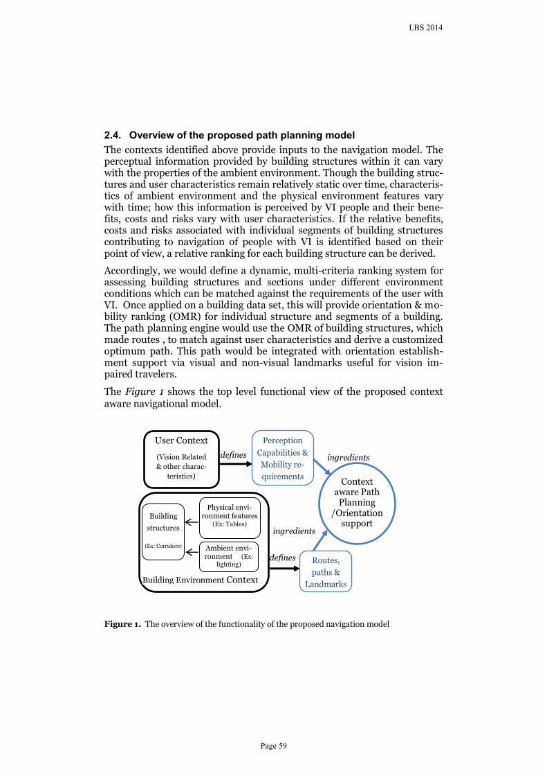
The contexts identified above provide inputs to the navigation model. The perceptual information provided by building structures within it can vary with the properties of the ambient environment. Though the building struc-tures and user characteristics remain relatively static over time, characteris-tics of ambient environment and the physical environment features vary with time; how this information is perceived by VI people and their bene-fits, costs and risks vary with user characteristics. If the relative benefits, costs and risks associated with individual segments of building structures contributing to navigation of people with VI is identified based on their point of view, a relative ranking for each building structure can be derived.
Accordingly, we would define a dynamic, multi-criteria ranking system for assessing building structures and sections under different environment conditions which can be matched against the requirements of the user with VI. Once applied on a building data set, this will provide orientation & mo-bility ranking (OMR) for individual structure and segments of a building. The path planning engine would use the OMR of building structures, which made routes , to match against user characteristics and derive a customized optimum path. This path would be integrated with orientation establish-ment support via visual and non-visual landmarks useful for vision im-paired travelers.
The Figure 1 shows the top level functional view of the proposed context aware navigational model.
Figure 1. The overview of the functionality of the proposed navigation model
defines
defines
Context
aware Path Planning
/Orientation support
User Context
(Vision Related
& other charac-
teristics)
Building
structures
(Ex: Corridors)
Physical envi-ronment features
(Ex: Tables)
Ambient envi-ronment (Ex:
lighting)
Perception
Capabilities &
Mobility re-
quirements
Routes,
paths &
Landmarks Building Environment Context
ingredients
ingredients
LBS 2014
Page 59
Analysis of Contexts considered 3.
3.1. Indoor Environment Characteristics
Visual access, differentiation and layout complexity are identified as main environmental factors affecting way finding and navigation (Weisman 1981). As per Daniel and Corina (2006), these parameters can be defined as follows.
Visual access: degree to which the building parts of a building are seen by a particular viewpoint.
Differentiation: degree to which different parts of the environment look same or different. More differentiation with the environment supports greater mobility for users.
Layout complexity: more complex layouts make way finding differ-ent; As per Daniel and Corina (2006) ,what increases the complexity of a layout needs further research.
“The effectiveness with which the vision can be used for safe travelling” is defined as visual accessibility (Legge,2010-as cited in (Kallie et al. 2012) and how easily and safely the objects in the spaces can be detectable by people with VI is a main issue related to visual accessibility. According to the same authors, distance, colour, height, shape of objects and interactions between illumination, colour, and shape contributes significantly to object identification by people with VI (Kallie et al. 2012). Further they conclude that the perception of distance, colour, shape and height are affected by the individual’s degree of vision impairment (which is measured in term of vis-ual acuity). The differentiation can be affected by the illumination and other factors as well. For people with VI, non-visual access also can be a major contributing factor. The presence of tactile objects and sound in the envi-ronment supports non-visual access. Therefore, not only the visual accessi-bility but non-visual accessibility also needed to be considered for safe trav-eling of people with poor vision. Presence of visual or non-visual land-marks would be an additional strength to support orientation and thereby navigating with confidence. The possibility of perceiving such landmarks would be affected by other parameters such as visual access and differentia-tion.
Accordingly, at this stage of our study, six parameters, visual access, differ-entiation, layout, lightning, non-visual access and presence of landmarks are identified as parameters affecting navigation support of a building structure. The last three parameters can be defined as follows.
Lightning: the illumination level presence in the building structure.
LBS 2014
Page 60
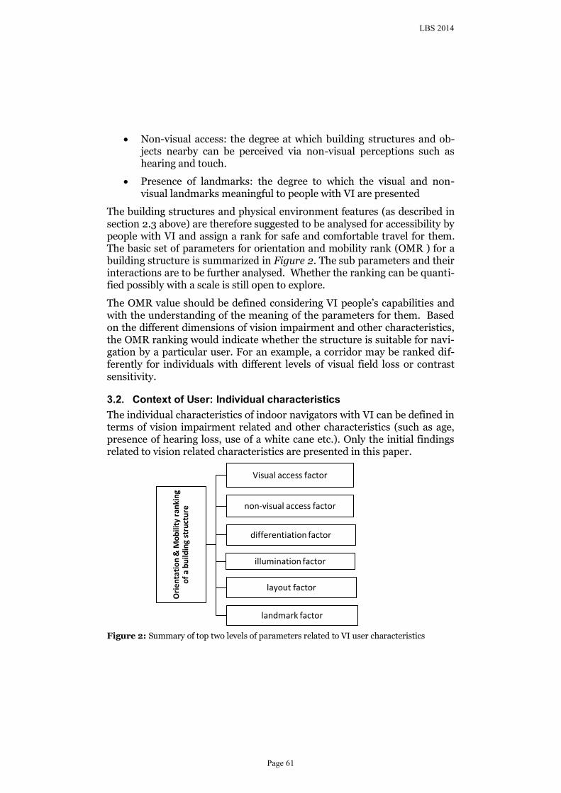
Non-visual access: the degree at which building structures and ob-jects nearby can be perceived via non-visual perceptions such as hearing and touch.
Presence of landmarks: the degree to which the visual and non-visual landmarks meaningful to people with VI are presented
The building structures and physical environment features (as described in section 2.3 above) are therefore suggested to be analysed for accessibility by people with VI and assign a rank for safe and comfortable travel for them. The basic set of parameters for orientation and mobility rank (OMR ) for a building structure is summarized in Figure 2. The sub parameters and their interactions are to be further analysed. Whether the ranking can be quanti-fied possibly with a scale is still open to explore.
The OMR value should be defined considering VI people’s capabilities and with the understanding of the meaning of the parameters for them. Based on the different dimensions of vision impairment and other characteristics, the OMR ranking would indicate whether the structure is suitable for navi-gation by a particular user. For an example, a corridor may be ranked dif-ferently for individuals with different levels of visual field loss or contrast sensitivity.
3.2. Context of User: Individual characteristics
The individual characteristics of indoor navigators with VI can be defined in terms of vision impairment related and other characteristics (such as age, presence of hearing loss, use of a white cane etc.). Only the initial findings related to vision related characteristics are presented in this paper.
Figure 2: Summary of top two levels of parameters related to VI user characteristics
Ori
enta
tio
n &
Mo
bili
ty r
anki
ng
of
a b
uild
ing
stru
ctu
re
Visual access factor
non-visual access factor
differentiation factor
illumination factor
layout factor
landmark factor
LBS 2014
Page 61
Vision Impairment Parameters
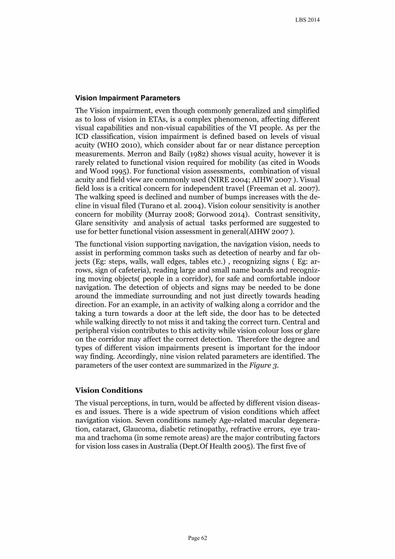
The Vision impairment, even though commonly generalized and simplified as to loss of vision in ETAs, is a complex phenomenon, affecting different visual capabilities and non-visual capabilities of the VI people. As per the ICD classification, vision impairment is defined based on levels of visual acuity (WHO 2010), which consider about far or near distance perception measurements. Merron and Baily (1982) shows visual acuity, however it is rarely related to functional vision required for mobility (as cited in Woods and Wood 1995). For functional vision assessments, combination of visual acuity and field view are commonly used (NIRE 2004; AIHW 2007 ). Visual field loss is a critical concern for independent travel (Freeman et al. 2007). The walking speed is declined and number of bumps increases with the de-cline in visual filed (Turano et al. 2004). Vision colour sensitivity is another concern for mobility (Murray 2008; Gorwood 2014). Contrast sensitivity, Glare sensitivity and analysis of actual tasks performed are suggested to use for better functional vision assessment in general(AIHW 2007 ).
The functional vision supporting navigation, the navigation vision, needs to assist in performing common tasks such as detection of nearby and far ob-jects (Eg: steps, walls, wall edges, tables etc.) , recognizing signs ( Eg: ar-rows, sign of cafeteria), reading large and small name boards and recogniz-ing moving objects( people in a corridor), for safe and comfortable indoor navigation. The detection of objects and signs may be needed to be done around the immediate surrounding and not just directly towards heading direction. For an example, in an activity of walking along a corridor and the taking a turn towards a door at the left side, the door has to be detected while walking directly to not miss it and taking the correct turn. Central and peripheral vision contributes to this activity while vision colour loss or glare on the corridor may affect the correct detection. Therefore the degree and types of different vision impairments present is important for the indoor way finding. Accordingly, nine vision related parameters are identified. The parameters of the user context are summarized in the Figure 3.
Vision Conditions
The visual perceptions, in turn, would be affected by different vision diseas-es and issues. There is a wide spectrum of vision conditions which affect navigation vision. Seven conditions namely Age-related macular degenera-tion, cataract, Glaucoma, diabetic retinopathy, refractive errors, eye trau-ma and trachoma (in some remote areas) are the major contributing factors for vision loss cases in Australia (Dept.Of Health 2005). The first five of
LBS 2014
Page 62
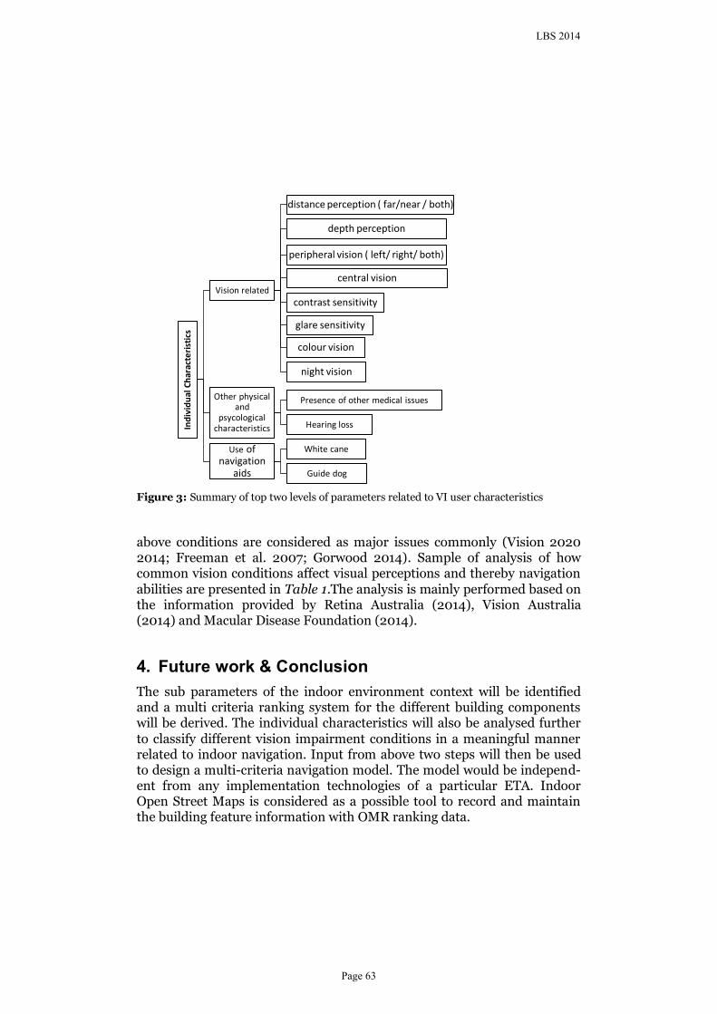
Figure 3: Summary of top two levels of parameters related to VI user characteristics
above conditions are considered as major issues commonly (Vision 2020 2014; Freeman et al. 2007; Gorwood 2014). Sample of analysis of how common vision conditions affect visual perceptions and thereby navigation abilities are presented in Table 1.The analysis is mainly performed based on the information provided by Retina Australia (2014), Vision Australia (2014) and Macular Disease Foundation (2014).
Future work & Conclusion 4.
The sub parameters of the indoor environment context will be identified and a multi criteria ranking system for the different building components will be derived. The individual characteristics will also be analysed further to classify different vision impairment conditions in a meaningful manner related to indoor navigation. Input from above two steps will then be used to design a multi-criteria navigation model. The model would be independ-ent from any implementation technologies of a particular ETA. Indoor Open Street Maps is considered as a possible tool to record and maintain the building feature information with OMR ranking data.
Ind
ivid
ual
Ch
arac
teri
stic
s
Vision related
distance perception ( far/near / both)
depth perception
peripheral vision ( left/ right/ both)
central vision
contrast sensitivity
glare sensitivity
colour vision
night vision
Other physical and
psycological characteristics
Presence of other medical issues
Hearing loss
Use of navigation
aids
White cane
Guide dog
LBS 2014
Page 63
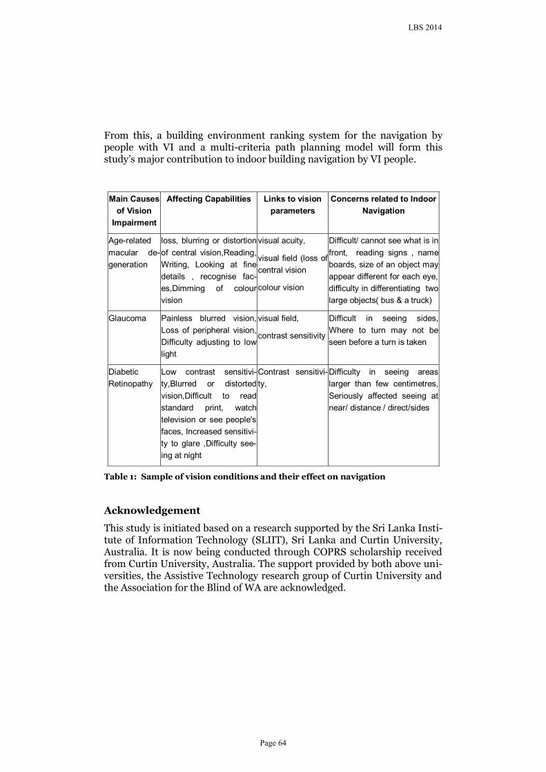
From this, a building environment ranking system for the navigation by people with VI and a multi-criteria path planning model will form this study’s major contribution to indoor building navigation by VI people.
Table 1: Sample of vision conditions and their effect on navigation
Acknowledgement
This study is initiated based on a research supported by the Sri Lanka Insti-tute of Information Technology (SLIIT), Sri Lanka and Curtin University, Australia. It is now being conducted through COPRS scholarship received from Curtin University, Australia. The support provided by both above uni-versities, the Assistive Technology research group of Curtin University and the Association for the Blind of WA are acknowledged.
Main Causes
of Vision
Impairment
Affecting Capabilities Links to vision
parameters
Concerns related to Indoor
Navigation
Age-related
macular de-
generation
loss, blurring or distortion
of central vision,Reading,
Writing, Looking at fine
details , recognise fac-
es,Dimming of colour
vision
visual acuity,
visual field (loss of
central vision
colour vision
Difficult/ cannot see what is in
front, reading signs , name
boards, size of an object may
appear different for each eye,
difficulty in differentiating two
large objects( bus & a truck)
Glaucoma
Painless blurred vision,
Loss of peripheral vision,
Difficulty adjusting to low
light
visual field,
contrast sensitivity
Difficult in seeing sides,
Where to turn may not be
seen before a turn is taken
Diabetic
Retinopathy
Low contrast sensitivi-
ty,Blurred or distorted
vision,Difficult to read
standard print, watch
television or see people's
faces, Increased sensitivi-
ty to glare ,Difficulty see-
ing at night
Contrast sensitivi-
ty,
Difficulty in seeing areas
larger than few centimetres,
Seriously affected seeing at
near/ distance / direct/sides
LBS 2014
Page 64
References
Afrooz AE, Hanaee T, Parolin B Wayfinding Performance of Visually Impaired Pedestrians in an Urban Area. In: International Conference on Urban & Regional Development and Spatial Planning, Schwechat, 14-16 May 2012 2012. p 1081-1091
AIHW (2007 ) A guide to Australian eye health data Cat. no. PHE 86. Canberra
Daniel RM, Corina S (2006) Human Factors of Wayfinding in Navigation. In: International Encyclopedia of Ergonomics and Human Factors, Second Edition - 3 Volume Set. CRC Press. doi:10.1201/9780849375477.ch394
Dept.Of Health A (2005) Eye health in Australia. A background paper to the National Framework for Action to Promote Eye Health and Prevent Avoidable Blindness and Vision Loss. Department of Health, Australia,
Fallah N, Apostolopoulos I, Bekris K, Folmer E (2013) Indoor Human Navigation Systems: A Survey. Interacting with Computers 25 (1):21-33. doi:10.1093/iwc/iws010
Freeman KF, Cole RG, Faye EE, Freeman PB, Goodrich GL, Stelmack JA (2007) Optometric Clinical Practice Guideline American Optometric Association, St. Louis USA
Golledge RG (1993) Geography and the Disabled: A Survey with Special Reference to Vision Impaired and Blind Populations. Transactions of the Institute of British Geographers 18 (1):63-85. doi:10.2307/623069
Gorwood P (2014) Factors affecting navigation of VI people in building Association of Blinds, Western Australia, Personal Communication with N.Fernando
Helal A, Moore SE, Ramachandran B Drishti: an integrated navigation system for visually impaired and disabled. In: Wearable Computers, 2001. Proceedings. Fifth International Symposium on, 2001 2001. pp 149-156. doi:10.1109/ISWC.2001.962119
Hua W, Marshall A, Yu W Path Planning and Following Algorithms in an Indoor Navigation Model for Visually Impaired. In: Internet Monitoring and Protection, 2007. ICIMP 2007. Second International Conference on, 1-5 July 2007 2007. pp 38-38. doi:10.1109/ICIMP.2007.31
Huang H, Gartner G (2010) A Survey of Mobile Indoor Navigation Systems. In: Gartner G, Ortag F (eds) Cartography in Central and Eastern Europe. Lecture Notes in Geoinformation and Cartography. Springer Berlin Heidelberg, pp 305-319. doi:10.1007/978-3-642-03294-3_20
Ivanov R (2012) RSNAVI: an RFID-based context-aware indoor navigation system for the blind. Paper presented at the Proceedings of the 13th International Conference on Computer Systems and Technologies, Ruse, Bulgaria,
Kalia AA, Legge GE, Roy R, Ogale A (2010) Assessment of Indoor Route-finding Technology for People with Visual Impairment. J Vis Impair Blind 104 (3):135–147
Kallie CS, Legge GE, Yu D (2012) Identification and Detection of Simple 3D Objects with Severely Blurred Vision. Investigative Ophthalmology & Visual Science 53 (13):7997-8005. doi:10.1167/iovs.12-10013
Koide S, Kato M 3-D human navigation system considering various transition preferences. In: Systems, Man and Cybernetics, 2005 IEEE International Conference on, 10-12 Oct. 2005 2005. pp 859-864 Vol. 851. doi:10.1109/ICSMC.2005.1571254
LBS 2014
Page 65
Legge GE, Beckmann PJ, Tjan BS, Havey G, Kramer K, Rolkosky D, Gage R, Chen M, Puchakayala S, Rangarajan A (2013) Indoor navigation by people with visual impairment using a digital sign system. PloS one 8 (10):e76783. doi:10.1371/journal.pone.0076783
Loomis JM, Golledge RG, Klatzky RL (1998) Navigation System for the Blind: Auditory Display Modes and Guidance. Presence: Teleoper Virtual Environ 7 (2):193-203. doi:10.1162/105474698565677
Macular Disease Foundation (2014) Macular Degeneration. Retina Australia (WA) Inc. http://retinaaustraliawa.com/about-2/macular-degeneration/. Accessed 15 th July 2014
Murray I (2008) Instructional eLearning technologies for the vision impaired. PhD Thesis, Curtin University, Curtin University Library
NIRE (2004) Distance & Depth Perception The National Institute for Rehabilitation Engineering
Petrie H, Johnson V, Strothotte T, Raab A, Fritz S, Michel R (1996) MOBIC: Designing a Travel Aid for Blind and Elderly People. The Journal of Navigation 49 (01):45-52. doi:doi:10.1017/S0373463300013084
Retina Australia (2014) Macular Degeneration. http://retinaaustraliawa.com/about-2/macular-degeneration/. Accessed 12 June 2014
Turano KA, Broman AT, Bandeen-Roche K, Munoz B, Rubin GS, West SK, Team TSP (2004) Association of Visual Field Loss and Mobility Performance in Older Adults: Salisbury Eye Evaluation Study. Optometry & Vision Science 81 (5):298-307
Vision 2020 (2014) Eye health in Australia. Victorian Government http://www.visioninitiative.org.au/common-eye-conditions/eye-health-in-australia.
Vision Australia (2014). http://www.visionaustralia.org/eye-health/eye-conditions. Accessed 20 June 2014
Weisman J (1981) Evaluating Architectural Legibility: Way-Finding in the Built Environment. Environment and Behavior 13 (2):189-204. doi:10.1177/0013916581132004
WHO (2010) ICD-10 Version:2010 Chapter VII Diseases of the eye and adnexa World Health Organization,
Woods RL, Wood JM (1995) The role of contrast sensitivity charts and contrast letter charts in clinical practice. Clinical and Experimental Optometry 78 (2):43-57
LBS 2014
Page 66
Related Documents


![ASSIST: Personalized indoor navigation via multimodal ...openaccess.thecvf.com/content_ECCVW_2018/papers/... · lion blind & visually impaired (BVI) individuals worldwide [22] and](https://static.cupdf.com/doc/110x72/5ec470c187b6177b0d6860a0/assist-personalized-indoor-navigation-via-multimodal-lion-blind-visually.jpg)


