Page | 0 Construct twelve dwellings, use and development of four commercial premises, construction of buildings and works under a Design and Development Overlay, create/alter vehicular access to a Category 1 Road. and reduction of three on-site car parking spaces (1 for the commercial visitor users and 2 for residential visitors) at 200-204 Point Lonsdale Road, Point Lonsdale

Welcome message from author
This document is posted to help you gain knowledge. Please leave a comment to let me know what you think about it! Share it to your friends and learn new things together.
Transcript

Page | 0
Construct twelve dwellings, use and development of four commercial premises, construction of buildings and works under a Design and Development Overlay,
create/alter vehicular access to a Category 1 Road. and reduction of three on-site car parking spaces (1 for the commercial visitor users and
2 for residential visitors)
at
200-204 Point Lonsdale Road, Point Lonsdale
Page | 1
1. Introduction
Sincock Planning has been engaged to prepare a planning report for the development of a mixed use
development comprising 4 commercial spaces & 12 dwellings, use as shop exceeding 150m² of floor
space and partial reduction in car parking (2 residential visitor spaces & 1 visitor retail space at 200-
204 Point Lonsdale Road Point Lonsdale.
The property comprises three parcels of land with two street frontage to Lawrence Road and Point
Lonsdale Road at the town entry. The site has an area of 2465m² and is fairly flat.
The site is developed with a BP petrol station that fronts Point Lonsdale Road and has vehicle access
from both streets.
The site is within the Mixed Use Zone and is affected by the design and Development Overlay Schedule
3 and vegetation protection overlay schedule 1.
The site has a frontage of 48.46m to Point Lonsdale Road and 50.88m to Lawrence Road. The site is
in an area of Cultural Heritage Significance and is a designated bushfire prone area as designated by
the Building Regulations 2018.
This proposal is consistent with the zone, overlay and policy framework of the planning scheme, and
the development complies with the standards and objectives of Clause 55.
A full assessment of all planning scheme controls is provided in the following sections and the
application should be read in conjunction with the expert reports and plans including the following:
Architectural plans prepared by SPL Architects
Waste management plan prepared by Leigh Design;
Traffic & parking assessment prepared by O’Brien Traffic;
Landscape design prepared by Perry Mills & Associates;
Contamination Assessment Contaminated Land and Water Environmental Risk Assessment Pty Ltd;
The proposal provides a well-designed, site responsive mixed use development and will achieve the
policy outcomes within the Queenscliffe Planning Scheme and meet with the various character, siting
and amenity provisions within Clause 55 and the design and development overlay schedule 3.
Page | 2
2. Proposal
The application proposes the following:
• Use and development of four shops;
• Development of 12 dwellings;
• Partial waiver of car parking (1 visitor commercial space and 2 visitor residential spaces);
• Create or alter access to land in a Road Zone Category 1.
Three distinct building forms are proposed. The commercial shops are proposed at the ground floor
level with frontage to Point Lonsdale Road, whilst five dwellings are proposed above. Entry to the
car park is also proposed at the northern end of this building, whilst bin storage rooms are located
to the north and east of the basement car park entry.
The building is setback from Point Lonsdale Road 12.905 and partially constructed on the Lawrence
Road boundary for a length of 11.942m. At the front of this building is an at grade car park for the
commercial visitors comprising 13 parking spaces, two of which provide disabled access with shared
space between.
The basement level comprises 24 parking spaces for the dwellings (two each) and four parking spaces
for the commercial shops (one each). Storage for each dwelling is also provided within the basement
in storage units.
Each of the shops has an area of 115m² with pedestrian access from the Point Lonsdale Road frontage.
The shop frontages are glazed with large windows and surrounded by timber cladding. This is also
reflected in the opening to the basement car park to provide a cohesive and consistent finish.
At the first floor above the shops are five dwellings that are accessed via a lift or stair from the
basement car park, along with a pedestrian access from Lawrence Road. The dwellings at shop top
level have two bedrooms, two bathrooms and an open plan living area. Each has a balcony to Point
Lonsdale Road, whilst unit 12 also has a balcony to Lawrence Road. These dwellings use highlight
windows to provide privacy to the north and east facades. Each dwelling also has a small rooftop
garden area that is accessed from the living space via a roof hatch. These terraces are screened to
the north side to provide privacy within the development and protect amenity of the neighbouring
property to the north.
At the rear of the site are 7 two storey townhouses with rooftop terraces. Three of the dwellings
have frontage to Lawrence Road and are setback between 2.1-4.33m from the street. Each dwelling
has two bedrooms and bathrooms at the lower level, with a third bedroom, bathroom and open plan
living are at the first floor. The dwellings have balconies at the first floor facing Lawrence Road,
whilst ground floor courtyards are also provided and accessed via the master bedroom. The roof top
terraces are screened on the east side to provide privacy between dwellings and the eastern
neighbour.
To the north are four further dwellings in an attached form. These are accessed via a common
walkway from Lawrence Road. These dwellings also have two bedrooms and bathrooms at the lower
level, a third bedroom and open plan living at the first floor and a roof terrace above. Each dwelling
has a balcony that is accessed via the living room along with a large courtyard accessed via the master
bedroom.
Each dwelling is less than 8.5m in height including screens to the roof top terraces. The dwellings
have narrow frontages with pitched roof forms, lightweight cladding including timber at the lower
level and extensive glazing.
The internal entry courtyard from Lawrence road is landscaped and provides a safe and secure entry
to the development.
Page | 3
3. Site and surrounds
Site
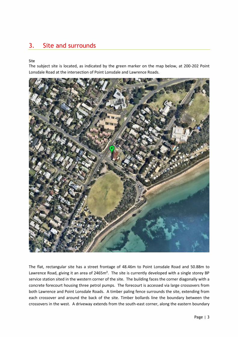
The subject site is located, as indicated by the green marker on the map below, at 200-202 Point
Lonsdale Road at the intersection of Point Lonsdale and Lawrence Roads.
The flat, rectangular site has a street frontage of 48.46m to Point Lonsdale Road and 50.88m to
Lawrence Road, giving it an area of 2465m². The site is currently developed with a single storey BP
service station sited in the western corner of the site. The building faces the corner diagonally with a
concrete forecourt housing three petrol pumps. The forecourt is accessed via large crossovers from
both Lawrence and Point Lonsdale Roads. A timber paling fence surrounds the site, extending from
each crossover and around the back of the site. Timber bollards line the boundary between the
crossovers in the west. A driveway extends from the south-east corner, along the eastern boundary
Page | 4
to a concrete slab on the north of the site, passing another concrete slab towards the north eastern
corner, where a large tree is also sited.
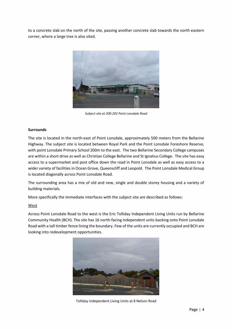
Subject site at 200-202 Point Lonsdale Road
Surrounds
The site is located in the north-east of Point Lonsdale, approximately 500 meters from the Bellarine
Highway. The subject site is located between Royal Park and the Point Lonsdale Foreshore Reserve,
with point Lonsdale Primary School 200m to the east. The two Bellarine Secondary College campuses
are within a short drive as well as Christian College Bellarine and St Ignatius College. The site has easy
access to a supermarket and post office down the road in Point Lonsdale as well as easy access to a
wider variety of facilities in Ocean Grove, Queenscliff and Leopold. The Point Lonsdale Medical Group
is located diagonally across Point Lonsdale Road.
The surrounding area has a mix of old and new, single and double storey housing and a variety of
building materials.
More specifically the immediate interfaces with the subject site are described as follows:
West
Across Point Lonsdale Road to the west is the Eric Tolliday Independent Living Units run by Bellarine
Community Health (BCH). The site has 16 north-facing independent units backing onto Point Lonsdale
Road with a tall timber fence lining the boundary. Few of the units are currently occupied and BCH are
looking into redevelopment opportunities.
Tolliday independent Living Units at 8 Nelson Road
Page | 5
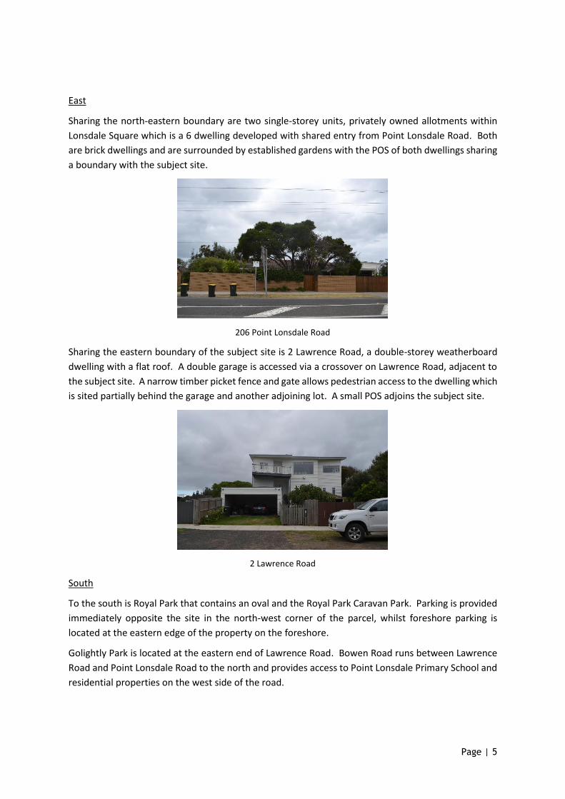
East
Sharing the north-eastern boundary are two single-storey units, privately owned allotments within
Lonsdale Square which is a 6 dwelling developed with shared entry from Point Lonsdale Road. Both
are brick dwellings and are surrounded by established gardens with the POS of both dwellings sharing
a boundary with the subject site.
206 Point Lonsdale Road
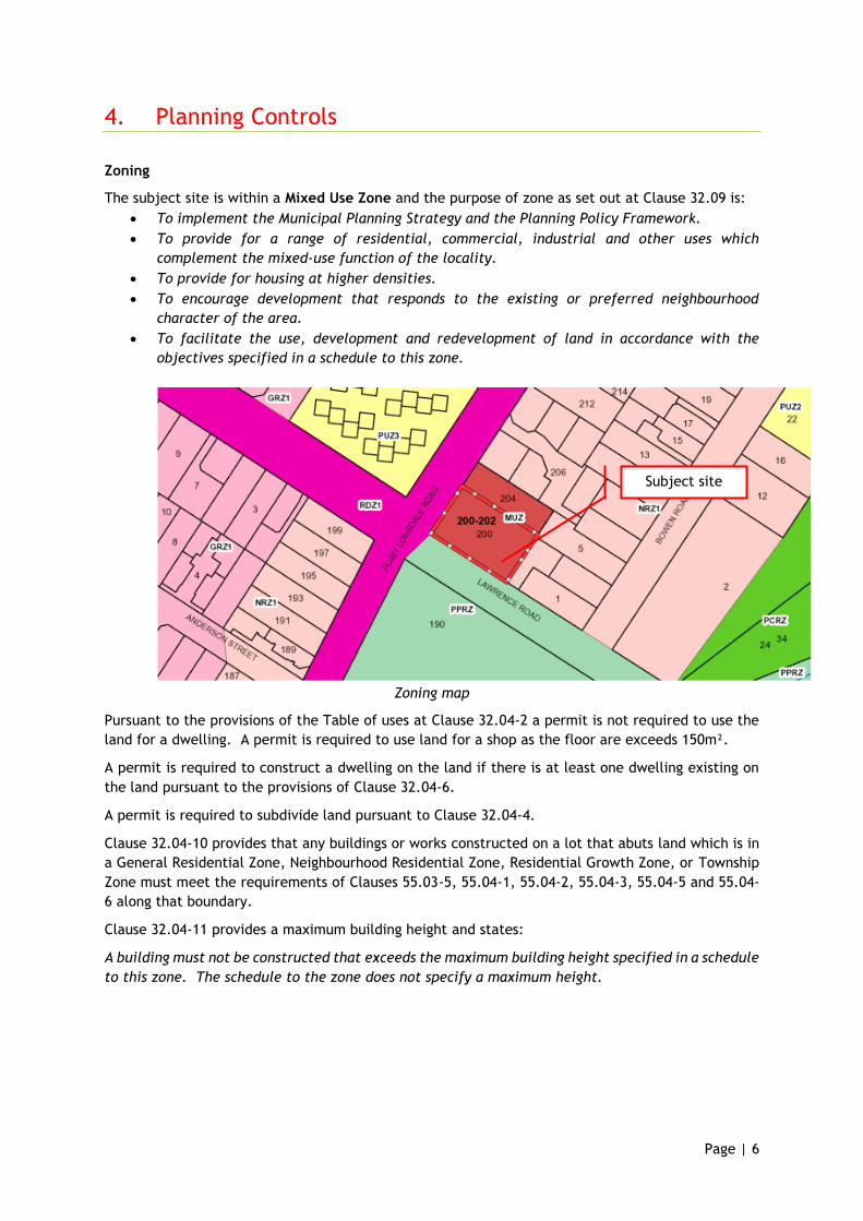
Sharing the eastern boundary of the subject site is 2 Lawrence Road, a double-storey weatherboard
dwelling with a flat roof. A double garage is accessed via a crossover on Lawrence Road, adjacent to
the subject site. A narrow timber picket fence and gate allows pedestrian access to the dwelling which
is sited partially behind the garage and another adjoining lot. A small POS adjoins the subject site.
2 Lawrence Road
South
To the south is Royal Park that contains an oval and the Royal Park Caravan Park. Parking is provided
immediately opposite the site in the north-west corner of the parcel, whilst foreshore parking is
located at the eastern edge of the property on the foreshore.
Golightly Park is located at the eastern end of Lawrence Road. Bowen Road runs between Lawrence
Road and Point Lonsdale Road to the north and provides access to Point Lonsdale Primary School and
residential properties on the west side of the road.
Page | 6
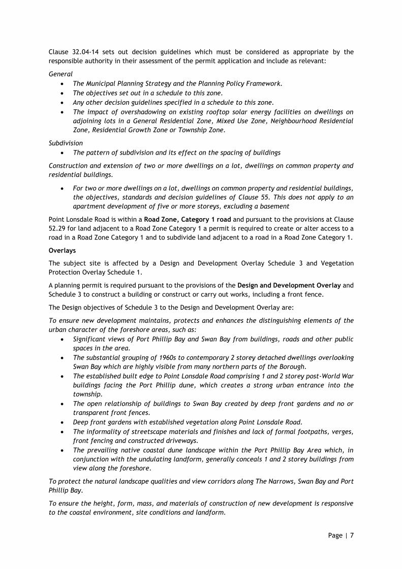
4. Planning Controls
Zoning
The subject site is within a Mixed Use Zone and the purpose of zone as set out at Clause 32.09 is:
• To implement the Municipal Planning Strategy and the Planning Policy Framework.
• To provide for a range of residential, commercial, industrial and other uses which
complement the mixed-use function of the locality.
• To provide for housing at higher densities.
• To encourage development that responds to the existing or preferred neighbourhood
character of the area.
• To facilitate the use, development and redevelopment of land in accordance with the
objectives specified in a schedule to this zone.
Zoning map
Pursuant to the provisions of the Table of uses at Clause 32.04-2 a permit is not required to use the
land for a dwelling. A permit is required to use land for a shop as the floor are exceeds 150m².
A permit is required to construct a dwelling on the land if there is at least one dwelling existing on
the land pursuant to the provisions of Clause 32.04-6.
A permit is required to subdivide land pursuant to Clause 32.04-4.
Clause 32.04-10 provides that any buildings or works constructed on a lot that abuts land which is in
a General Residential Zone, Neighbourhood Residential Zone, Residential Growth Zone, or Township
Zone must meet the requirements of Clauses 55.03-5, 55.04-1, 55.04-2, 55.04-3, 55.04-5 and 55.04-
6 along that boundary.
Clause 32.04-11 provides a maximum building height and states:
A building must not be constructed that exceeds the maximum building height specified in a schedule
to this zone. The schedule to the zone does not specify a maximum height.
Subject site
Page | 7
Clause 32.04-14 sets out decision guidelines which must be considered as appropriate by the
responsible authority in their assessment of the permit application and include as relevant:
General
• The Municipal Planning Strategy and the Planning Policy Framework.
• The objectives set out in a schedule to this zone.
• Any other decision guidelines specified in a schedule to this zone.
• The impact of overshadowing on existing rooftop solar energy facilities on dwellings on
adjoining lots in a General Residential Zone, Mixed Use Zone, Neighbourhood Residential
Zone, Residential Growth Zone or Township Zone.
Subdivision
• The pattern of subdivision and its effect on the spacing of buildings
Construction and extension of two or more dwellings on a lot, dwellings on common property and
residential buildings.
• For two or more dwellings on a lot, dwellings on common property and residential buildings,
the objectives, standards and decision guidelines of Clause 55. This does not apply to an
apartment development of five or more storeys, excluding a basement
Point Lonsdale Road is within a Road Zone, Category 1 road and pursuant to the provisions at Clause
52.29 for land adjacent to a Road Zone Category 1 a permit is required to create or alter access to a
road in a Road Zone Category 1 and to subdivide land adjacent to a road in a Road Zone Category 1.
Overlays
The subject site is affected by a Design and Development Overlay Schedule 3 and Vegetation
Protection Overlay Schedule 1.
A planning permit is required pursuant to the provisions of the Design and Development Overlay and
Schedule 3 to construct a building or construct or carry out works, including a front fence.
The Design objectives of Schedule 3 to the Design and Development Overlay are:
To ensure new development maintains, protects and enhances the distinguishing elements of the
urban character of the foreshore areas, such as:
• Significant views of Port Phillip Bay and Swan Bay from buildings, roads and other public
spaces in the area.
• The substantial grouping of 1960s to contemporary 2 storey detached dwellings overlooking
Swan Bay which are highly visible from many northern parts of the Borough.
• The established built edge to Point Lonsdale Road comprising 1 and 2 storey post-World War
buildings facing the Port Phillip dune, which creates a strong urban entrance into the
township.
• The open relationship of buildings to Swan Bay created by deep front gardens and no or
transparent front fences.
• Deep front gardens with established vegetation along Point Lonsdale Road.
• The informality of streetscape materials and finishes and lack of formal footpaths, verges,
front fencing and constructed driveways.
• The prevailing native coastal dune landscape within the Port Phillip Bay Area which, in
conjunction with the undulating landform, generally conceals 1 and 2 storey buildings from
view along the foreshore.
To protect the natural landscape qualities and view corridors along The Narrows, Swan Bay and Port
Phillip Bay.
To ensure the height, form, mass, and materials of construction of new development is responsive
to the coastal environment, site conditions and landform.
Page | 8
To protect areas where substantial vegetation cover is a dominant visual and environmental feature
by ensuring new development retains the natural or established vegetation, and provides substantial
areas for new landscaping and open space.
To protect the natural landscape qualities of the coastline by ensuring new development does not
visually dominate the coastal landscape.
To ensure an appropriate setting and context for buildings, sites or objects listed in the Heritage
Overlay.
To require all new development to have regard to the urban character policies contained in the MPS
and to the Building Siting and Design Guidelines contained in the Borough of Queenscliffe Urban
Character Study.
The Schedule also provides the following relevant building and works requirements:
Building height
No building can exceed a height of:
• two storeys; and
• 8.5 metres above natural ground level.
Despite the maximum building height stated above, a lesser building height may be necessary in
order to:
Reflect a ‘bottom up’ rather than ‘top down’ approach to building design.
Satisfy the objectives contained in Clause 21.04.
Satisfy the Building Siting and Design Guidelines contained in the Queenscliffe Urban Character
Study.
Reflect the prevailing building height in the immediate area, especially in streets that are
predominantly single storey in character.
Prevent buildings protruding above the ridgeline of the dunes along Port Phillip Bay so as to form a
silhouette against the sky when viewed from the foreshore or any significant public viewing point.
Prevent buildings significantly protruding above the vegetation canopy of an area.
Take into consideration the reasonable sharing of views.
Building setbacks
New buildings must also meet the following requirements:
• The front setback should be at least 6 metres, or may match the setback of adjacent
buildings or be between their setbacks (where they are setback different distances),
whichever is the lesser.
• Side and rear setbacks are to be a minimum of 1.2 metres for a single storey building (up to
a wall height of 3.6 metres) and a minimum of 1.92 metres for a two storey building with a
wall height of up to 6.0 metres (i.e. an additional 100 millimetres setback for every 300
millimetres above 3.6 metres).
• Buildings should not be built on side and rear boundaries, except where:
• The building is sited alongside an existing building on an adjoining property which is built
on the boundary.
• The proposed building replaces an existing building which is sited closer than 1.2 metres
from the side or rear boundary
An outbuilding, garage or carport should not be constructed on a boundary, except in the following
circumstances:
• The building height on the boundary does not exceed 3.6 metres.
• The average height of the wall does not exceed 3 metres.
• The length of the wall on the boundary is not greater than 10 metres.
Page | 9
Site coverage
Buildings should not occupy more than 40% of the area of a site.
The following decision guidelines are also set out within the Schedule at Clause 6.0:
The following decision guidelines apply to an application for a permit under Clause 43.02, in addition
to those specified in Clause 43.02 and elsewhere in the scheme which must be considered, as
appropriate, by the responsible authority:
• The design objectives of this schedule.
• The urban character policies contained in Clause 22.03 of the Planning Scheme.
• The Building Siting and Design Guidelines contained in the Borough of Queenscliffe Urban
• Character Study.
• The impact of the proposed development on the appearance, amenity and environmental
qualities
• of the foreshore areas.
It should be noted that the Building Siting and Design Guidelines contained in the Borough of
Queenscliffe Urban Character Study were primarily prepared for residential development on
conventional sized lots. In relation to non-residential development or development on major
development sites, some elements of the guidelines may not be relevant. Council will exercise its
discretion in the application of the guidelines in those situations.
A planning permit is not required pursuant to the provisions of the Vegetation Protection Overlay
Schedule 1 to remove, destroy or lop vegetation as there is no native vegetation on the site.
The Design objectives of Schedule 3 to the Design and Development Overlay are:
Planning Policy
Policy as set out within the Planning Scheme provides strategic direction and guidance in decision
making to achieve good planning outcomes. Of relevance to this proposal are the following relevant
Municipal Planning Strategy policies:
• Clause 11 Settlement
• Clause 13 Environmental Risks and Amenity
• Clause 15 Built environment and heritage
• Clause 16 Housing
• Clause 18 Transport
Particularly relevant objectives and strategies within these policies include:
Clause 13.04-1S Contaminated and potentially contaminated land
Objective - To ensure that potentially contaminated land is suitable for its intended future use and
development, and that contaminated land is used safely.
Strategies
• Require applicants to provide adequate information on the potential for contamination to
have adverse effects on future land use if the subject land is known to have been used for
industry, mining or the storage of chemicals, gas, wastes or liquid fuel.
• Facilitate the remediation of contaminated land, particularly on sites in developed areas with
potential for residential development.
Clause 15.01-1S Urban design
Objective - To create urban environments that are safe, healthy, functional and enjoyable and that
contribute to a sense of place and cultural identity.
Strategies
Page | 10
• Require development to respond to its context in terms of character, cultural identity,
natural features, surrounding landscape and climate.
• Ensure development contributes to community and cultural life by improving the quality of
living and working environments, facilitating accessibility and providing for inclusiveness.
• Ensure the interface between the private and public realm protects and enhances personal
safety.
• Ensure development supports public realm amenity and safe access to walking and cycling
environments and public transport.
• Ensure that the design and location of publicly accessible private spaces, including car
parking areas, forecourts and walkways, is of a high standard, creates a safe environment
for users and enables easy and efficient use.
• Ensure that development provides landscaping that supports the amenity, attractiveness and
safety of the public realm.
• Ensure that development, including signs, minimises detrimental impacts on amenity, on
the natural and built environment and on the safety and efficiency of roads.
Clause 16.01-1S Housing Supply
Objective - To facilitate well-located, integrated and diverse housing that meets community needs.
Relevant strategies –
• Increase the proportion of housing in designated locations in established urban areas
(including under-utilised urban land) and reduce the share of new dwellings in greenfield,
fringe and dispersed development areas.
• Encourage higher density housing development on sites that are well located in relation to
jobs, services and public transport. Identify opportunities for increased residential densities
to help consolidate urban areas.
• Facilitate diverse housing that offers choice and meets changing household needs by
widening housing diversity through a mix of housing types.
• Increase the supply of housing in existing urban areas by facilitating increased housing yield
in appropriate locations, including under-utilised urban land.
More specifically, the following local planning policy provisions are applicable:
• Clause 21.01 Borough of Queenscliffe Key Issues and Strategic Vision
• Clause 21.02 Settlement, Housing and Residential Development
• Clause 21.04 Built Environment and Heritage
• Clause 22.02 Heritage Policy
• Clause 22.03 Urban Character Policy
Relevant details within these policies include:
Clause 21.01 Borough of Queenscliffe Key Issues and Strategic Vision
The Borough’s population is expected to grow marginally from 3,058 to 3,360 by 2031. The Borough
is experiencing an aging population, decreasing household sizes, substantial numbers of temporary
residents and the limited opportunities for housing growth.
The Borough’s population swells considerably during seasonal holiday periods through tourist stays
and part time residents. There is a considerable non-permanent population who own property and
holiday or live part-time in the Borough.
Of relevance to this proposal are the following key issues and influence facing the Borough:
Settlement, housing and residential development
• Minimising the impact of urban development on the natural environment.
• Limited opportunity for urban expansion and urban redevelopment, as the Borough is
constrained by the coast and the municipal boundary with the City of Greater Geelong.
Page | 11
• Managing seasonally fluctuating population from tourists and part-time residents.
• Managing demographic changes and demand for variety in housing choice for existing and
future households.
Built environment and heritage
• Protecting the unique character of the Bellarine Peninsula and the Borough’s townships.
• The importance of cultural, military and maritime heritage.
• The protection and enhancement of the Borough’s unique physical character, in particular:
- Queenscliff’s historic buildings, heritage areas and formal streets;
• The conservation, protection and enhancement of heritage places and heritage areas.
Economic development
• Providing retail, commercial and health services for an aging population.
• The importance of the natural environment, the built environment and cultural heritage to
the Borough’s economy.
Strategic vision
The Borough of Queenscliffe Council Plan 2013-2017 describes the following vision for the
municipality.
A vibrant, safe and welcoming community that draws inspiration and life from its heritage,
unique environment and connection to the sea.
Council is committed to:
• Supporting a healthy involved and creative community.
• Developing a vibrant local economy.
• Protecting the Borough’s unique natural environment.
• Ensuring the Borough is a well-planned and attractive place to live and visit.
Clause 21.02 Settlement, Housing and Residential Development
Settlement
The townships of Queenscliff and Point Lonsdale form the Borough’s urban area, which is
predominately residential.
The Borough’s physical size and its environmental assets and constraints limit the capacity for
growth. The urban areas of the townships comprise the extent of developable land.
The opportunity for new development is limited to some infill development and redevelopment,
which must be sensitive to the Borough’s valued heritage and urban character.
Key Issues
• An ageing population and a decline in household size are correlating with a decrease in the
permanent population. A stable population is required to sustain the current level of
infrastructure and community services.
• The impact of new development needs to be managed to maintain liveability, amenity,
heritage and character.
• The Point Lonsdale Structure Plan provides for an expansion of the township within the City
of Greater Geelong. This will impact upon the structure of the township, and the demand
for services.
Objective 1
• To maintain a stable permanent residential population.
Strategies
• Encourage innovative housing solutions and designs that accommodate smaller households,
whilst respecting the established urban and heritage character.
Objective 2
• To avoid inappropriate development that compromises areas of acknowledged natural,
aesthetic, built, cultural or environmental sensitivity.

Page | 12
Strategies
• Contain development within existing urban areas.
• Avoid the adverse impacts of new use and development proposals on environmental, heritage
and urban character values.
Implementation
• These strategies will be implemented by:
Policy Guidelines
• Applying Clause 22.03 (Urban Character) in considering applications that trigger a Planning
Permit.
Clause 21.02-4 Point Lonsdale
The township of Point Lonsdale straddles the municipal boundary.
Within the Borough, the township principally comprises established residential properties on lots
with relatively low site coverage and an informality respectful of the coastal setting and lifestyle
enjoyed by residents.
The opportunities for residential growth, additional services and tourist facilities and services exist
on land to the west of Fellows Road within the City of Greater Geelong.
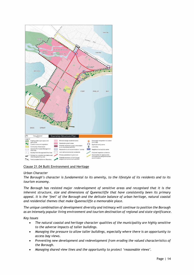
Point Lonsdale Structure Plan
The Point Lonsdale Structure Plan has been prepared in conjunction with the City of Greater Geelong
to guide the future use and development of the township. The structure plan map illustrates the
key land use components and provides a focus for development in Point Lonsdale (refer to the Point
Lonsdale Structure Plan – Map 2).
Key Issues
• Maintaining the coastal village character of the township, including green vistas, vegetated
character and unspoilt coastal views.
Objective
• To reinforce the coastal village character of Point Lonsdale by maintaining a compact urban
form, and protecting the surrounding rural landscape and setting of the township.
Strategies
• Provide for use and development consistent with the Point Lonsdale Structure Plan and as
shown on the Point Lonsdale Structure Plan - Map 2.
• Require that urban development does not occur outside the Point Lonsdale Settlement
Boundary as shown on the Point Lonsdale Structure Plan - Map 2.
• Facilitate appropriate infill residential development in Point Lonsdale that reflects the
coastal village character of the township.
Clause 21.02-5 Housing and Residential Development
The Borough provides an attractive and sought-after living environment accommodating permanent
and occasional residents. These different groups have a diverse range of requirements.
The majority of housing in the Borough is in the form of single detached houses on medium sized
lots. There are few medium density housing developments.
Key Issues
• Maintaining the liveability, amenity and character of residential areas, and ensuring that
new development does not adversely impact upon heritage and urban character.
• Protecting the rural character of the McDonald Road/Burnt Point area from further
subdivision or more intensive residential development.
• The Borough is experiencing a decline in household size, with potential to create a demand
for an increased number and greater diversity of dwellings in order to maintain the present
Page | 13
population. A stable population is required to sustain the current level of infrastructure and
community services.
• Preserving the natural environment and minimising the off-site environmental effects of
new housing.
Objective 1
• To protect the character and appearance of residential areas that are of heritage
significance and/or have urban character value.
Strategies
• Require housing design to have regard and respond to the predominant character of the area,
including important heritage features/characteristics and key elements of urban character.
• Require that new residential development retains significant vegetation.
• Require that new residential development and redevelopment of existing dwellings achieves
high quality design standards.
Objective 2
• To improve the range and diversity of housing options to meet the needs of residents, the
temporary population and tourists.
Strategies
• Support increased housing diversity and density that complements existing built form and
character, and does not compromise identified natural, built heritage, landscape and
cultural values.
Objective 3
• To protect the foreshore environment from inappropriate residential development and
subdivision.
Strategies
• Avoid the adverse impacts of residential developments on foreshore areas through the use
of appropriate design standards.
Page | 14
Clause 21.04 Built Environment and Heritage
Urban Character
The Borough’s character is fundamental to its amenity, to the lifestyle of its residents and to its
tourism economy.
The Borough has resisted major redevelopment of sensitive areas and recognised that it is the
inherent structure, size and dimensions of Queenscliffe that have consistently been its primary
appeal. It is the ‘feel’ of the Borough and the delicate balance of urban heritage, natural coastal
and residential themes that make Queenscliffe a memorable place.
The unique combination of development diversity and intimacy will continue to position the Borough
as an intensely popular living environment and tourism destination of regional and state significance.
Key Issues
• The natural coastal and heritage character qualities of the municipality are highly sensitive
to the adverse impacts of taller buildings.
• Managing the pressure to allow taller buildings, especially where there is an opportunity to
access bay views.
• Preventing new development and redevelopment from eroding the valued characteristics of
the Borough.
• Managing shared view lines and the opportunity to protect ‘reasonable views’.
Page | 15
Objective
• To require that new development in the Borough protects, enhances and harmonises with
the following distinguishing elements of the Borough’s urban character:
- The significant view lines to and from the sea, coastal dune environments and the
Queenscliff townscape skyline;
- The unique and intact building, landscape heritage, and natural foreshore qualities of
the Borough;
- The distinguishing cultural heritage identity of the township of Queenscliff, including
the prevailing Victorian and Edwardian built form and scale of development;
- The sense of seclusion and intimacy of Point Lonsdale, which is created through its low-
rise, recessive built form and informal, narrow streets in a natural landscape dominant
environment; and
- The distinctive natural coastal settings of Queenscliff and Point Lonsdale, including
significant areas of intact native and remnant indigenous vegetation.
Strategies
• Require new development in Queenscliff to have regard to the prevailing scale, style, height,
siting, fencing, and palate of building materials and finishes in the core heritage centre of
the town.
• Require new development in Point Lonsdale to have regard to the retention of existing
vegetation and to the prevailing scale, height, siting, fencing, driveway design, materials
and finishes of buildings and works in the natural coastal areas.
• Ensure that buildings in the Point Lonsdale activity centre are designed to contribute to
street level ambience and activity.
• Minimise the visual impact of new development in foreshore areas, having regard to building
height and topographical features of the land, bulk, site coverage, external materials and
finishes, and the removal of vegetation.
Sustainable Development
There is an increasing preference for new urban development to be environmentally responsive and
sustainable. Sustainable design may call for the inclusion of features, built form and infrastructure
which, if not carefully considered, has the potential to detract from the established character of
the Borough.
Key Issues
• Minimising the adverse impact of sustainable development infrastructure and built form on
heritage and urban character values.
Objective
• To encourage environmentally sustainable development, while ensuring that the valued
heritage and urban character values of the Borough are protected.
Strategies
• Facilitate sustainable development initiatives, including the appropriate installation of
solar panels and water tanks on buildings within the Heritage Overlay.
• Support environmentally sustainable housing and subdivision designs, particularly those that
improve energy efficiency and storm, and wastewater disposal mechanisms.
Clause 21.05 Economic Development
Commercial and retail opportunities are primarily located in the Queenscliff and Point Lonsdale
town centres. There are also a number of neighbourhood convenience centres that provide
opportunities for corner-store style shops. The retail centres provide a range of essential goods and
services to meet the basic needs of the community and visitors. They also provide additional tourist
and leisure services and facilities, and have an important role for social interaction.
Key Issues
Page | 16
• Retail and commercial enterprises provide significant levels of local employment and
investment within the Borough.
• A healthy retail centre based on both local and visitor patronage allows the community to
have a wide range of goods and services available.
Objective
• To encourage new retail and commercial development that meets the communities’ needs
for retail, entertainment, tourism, office and other commercial services, which
complements the character and amenity of the Borough.
Strategies
Ensure that land is available for commercial and retail development, to meet the needs of the local
and temporary populations and tourists.
Avoid new commercial development in residential neighbourhoods, unless designated for tourist
accommodation or neighbourhood retail.
Focus commercial and retail development in the existing Point Lonsdale commercial centre and
retain the neighbourhood role of this centre, to provide basic services and retail shops for the local
community.
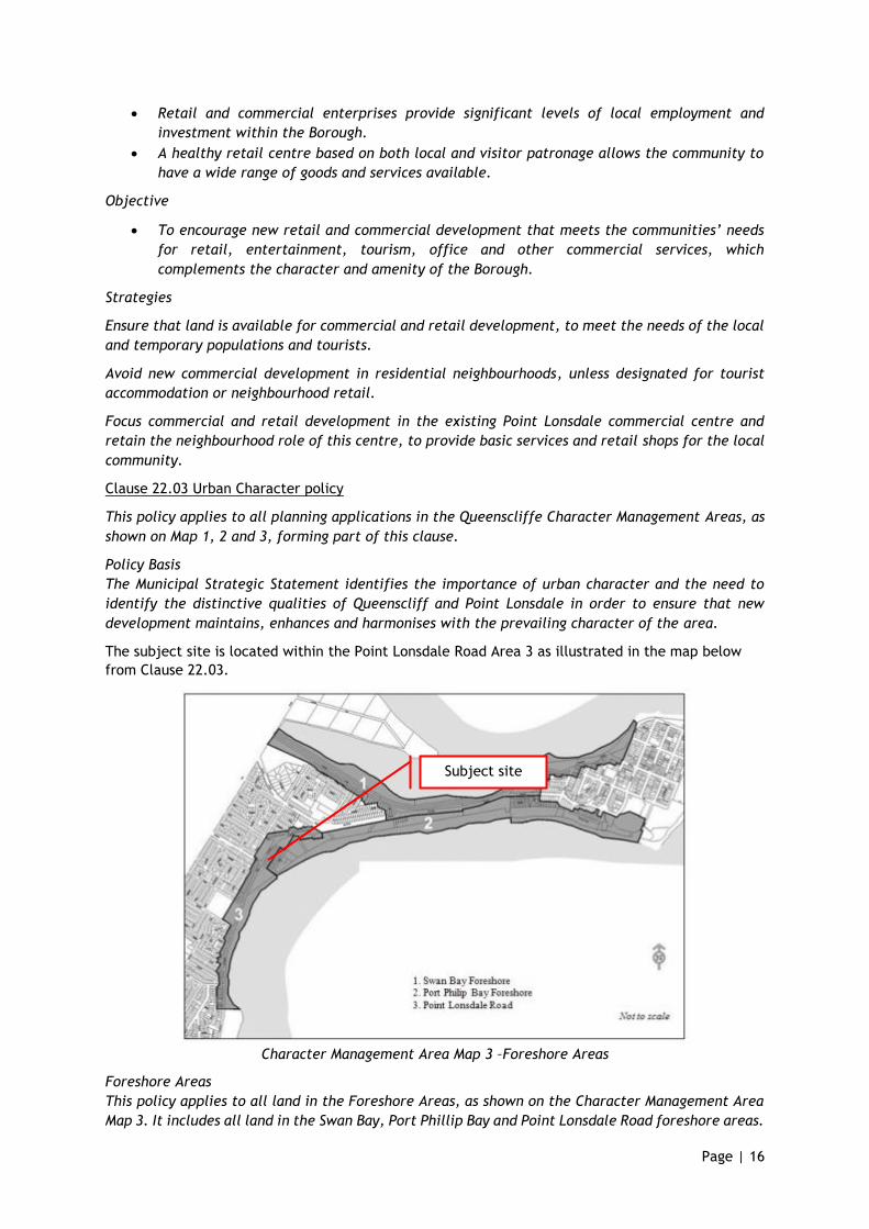
Clause 22.03 Urban Character policy
This policy applies to all planning applications in the Queenscliffe Character Management Areas, as
shown on Map 1, 2 and 3, forming part of this clause.
Policy Basis
The Municipal Strategic Statement identifies the importance of urban character and the need to
identify the distinctive qualities of Queenscliff and Point Lonsdale in order to ensure that new
development maintains, enhances and harmonises with the prevailing character of the area.
The subject site is located within the Point Lonsdale Road Area 3 as illustrated in the map below
from Clause 22.03.
Character Management Area Map 3 –Foreshore Areas
Foreshore Areas
This policy applies to all land in the Foreshore Areas, as shown on the Character Management Area
Map 3. It includes all land in the Swan Bay, Port Phillip Bay and Point Lonsdale Road foreshore areas.
Subject site
Page | 17
Design and Development Overlay Schedule 3 (Foreshore Areas) applies to this Character Management
Area.
Policy
Site Layout
It is policy that:
• The layout of new development minimises any visual intrusion of buildings or any other
elements into the natural foreshore and dune setting.
• The layout of new development is consistent in terms of the location of existing buildings
on the site or associated adjacent buildings.
• The layout of new buildings, paved areas, and driveways, car parking, active outdoor living
areas and landscape areas has regard to the site’s physical, historic and environmental
features, and the location of buildings on adjacent land.
• The layout of new development provides a high quality of living for its occupants and
maintains an appropriate standard of amenity for the occupants of adjoining dwellings.
• On sites where vegetative screens are insubstantial, the layout of new development should
provide opportunities for landscaped areas in appropriate locations to be planted with tea
tree and Moonah to screen buildings from view, extend the roadside vegetation corridor,
and reinstate the natural environment.
• The layout of new development minimises the removal of any existing native coastal
vegetation on the site and along the adjacent road reserve.
• New development is sited on the flattest portion of the land, wherever possible, to minimise
the need for earthworks and significant disturbance of the land.
• New development should:
- where possible, provide north facing indoor and outdoor living areas, to maximise solar
access;
- provide a frontage to the street and sense of address;
- be sited to minimise views to the building from the street and other public places, and
to provide opportunities for native coastal planting in front of the building and between
adjacent buildings;
- avoid siting buildings on, or near ridgelines or more prominent or visible parts of the
site, especially as viewed from along the Port Phillip Bay foreshore.
Building Design
It is policy that:
• The design of new development blends in with the prevailing coastal character of the area
and expresses an appropriate coastal design that interprets and reflects the architectural
style, massing, scale, proportion, materials and finishes of established resort/holiday-style
buildings in the area.
• The design of new development has regard for any features on the land, any sensitivities
associated with coastal environments, and any view corridors from the streets, public places,
surrounding properties, foreshore areas and the bay.
• New building design makes efficient use of the site, especially natural ventilation, daylight
and solar energy, without compromising the natural coastal quality of the area.
• New development has regard to the style, form and scale of any primary existing building
on the land, and minimises its visual impact within the foreshore setting.
• New development should:
- use staggered and varied roof lines (including pitches or curves) and vary the setback of
walls to reduce the visual bulk and impact of buildings on the natural coastal
surroundings;
Page | 18
- adopt innovative coastal design themes, including the use of lightweight, glazed and
metallic materials, open decks and balconies, curved roofs and refreshing coastal
colours;
- use spilt level design to better integrate the development on sloping sites and minimise
the need for earthworks;
- use robust coastal building materials, including horizontal and vertical weatherboard
wall cladding, light tone rendered brickwork, Colourbond roofs, timber and stainless
steel verandahs, doors and windows, and painted finishes where appropriate;
- adopt innovative building design techniques and materials that reduce energy use, and
are responsive to coastal conditions;
- avoid direct overlooking into neighbouring properties and minimise the loss of significant
views across the site from neighbouring properties; and
- in the Port Phillip Bay and Point Lonsdale Road Foreshore Areas, incorporate a palate of
colour finishes which are non-reflective and of natural tones, which blend in with the
- vegetated coastal setting.
Building Heights and Setbacks
It is policy that:
• The height and setback of new development retains the existing prevailing rhythm, height
and setback of the street and the foreshore.
• The height and setback of new development ensures that no individual building or building
addition dominates the streetscape, dune or coastal landscape.
• The height of new development does not protrude above the ridgeline of the dunes, or in
particularly sensitive locations, project above the coastal tree canopy to form a silhouette
against the sky when viewed from the foreshore or any significant public viewing point.
• The height and setback of new development ensures adequate daylight to all habitable
rooms and private open spaces on the land.
• The siting of new development, where appropriate, provides the opportunity for the
foundation of established gardens in front setbacks to contribute to the coastal and
streetscape setting.
• The height of new development is not significantly higher than the height of adjoining
buildings or other buildings in the street;
• A front setback is provided which matches the setback of adjoining buildings, and where
these setbacks are different, a front setback which is between the setbacks of adjoining
buildings or equal to the average setback of buildings in the street, whichever is the lesser
of the two.
• Avoid building across the width of the site, from boundary to boundary.
Fencing, Driveways and Landscaping
It is policy that:
• Fencing, particularly to the site's front or coastal boundary in the Swan Bay Foreshore Area,
relates strongly to the open and transparent character of the coastal setting.
• New driveways and paths provide adequate access and minimises surface drainage run-off in
coastal or dune environments.
• New driveways and parking areas are not visually dominant at the street or from public
spaces, or are screened by appropriate frontage landscaping.
• The design of outbuildings demonstrates regard for the style and form, roof shape, wall and
roof materials and finishes of existing buildings on the site, and is screened from street or
foreshore view.
• New landscaping opportunities are provided which complement existing site landscaping
with appropriate new native or indigenous planting to assist in blending-in new development
into the coastal setting.
Page | 19
• Where appropriate, landscaped setbacks to side boundaries are provided to minimise the
potential for overlooking, whilst providing a visual landscape link to rear garden and private
open space areas.
• New development should
- include curved, narrow and unsealed driveways (use gravel and other permeable
pavement
- materials), which limit impact upon existing vegetation;
- use the natural slope of the land or mounding to screen buildings from view in the Port
Phillip Bay Foreshore Area and from roads;
- use visually permeable fencing treatments to the site’s foreshore boundary (where
applicable);
- use coastal heath and Moonah in landscaping of private gardens;
- limit front fences in the Point Lonsdale Foreshore Area;
- use lightly structured timber post and wire front fences to a maximum height of 1.2
metres,
- or no fences in the Swan Bay Foreshore Area; and
- retain existing native coastal vegetation, wherever possible.
Particular & General Provisions
The following particular and general provisions are relevant to the proposal:
• Clause 52.06 Car parking
• Clause 52.29 Land adjacent to a Road Zone, Category 1, or a Public acquisition Overlay for
a Category 1 Road
• Clause 53.18 Stormwater Management in Urban Development
• Clause 55 Two or more dwellings on a lot and residential buildings
• Clause 65 Decision Guidelines
• Clause 65.01 Approval of an Application or Plans
Clause 52.06 Car parking
In relation to the proposed development, the provisions at Table 1 of Clause 52.06-5 require one car
space to each two bedroom dwelling and two car parking spaces to each three or more bedroom
dwelling.
Clause 52.06-9 identifies design standards for car parking including accessway requirements, car
parking space / garage dimensions, accessway gradients, urban design, safety and landscaping.
Clause 52.29 Land adjacent to a Road Zone, Category 1, or a Public acquisition Overlay for a
Category 1 Road
This clause applies to land adjacent to a Road Zone, Category 1, or a Public Acquisition Overlay if
the purpose of acquisition is for a Category 1 road. As previously mentioned in this report, pursuant
to the provisions of this clause a permit is required to create access to a road in a Road Zone Category
1 and to subdivide land adjacent to a road in a Road Zone Category 1.
Clause 52.34 Bicycle facilities
Table 1 to Clause 52.34-5 requires bicycle parking to be provide as follows:
Retail 1 to each 300 sq m of leasable floor area for employees and 1 to each 500 sq m of leasable
floor area for visitors.
Dwelling In developments of four or more storeys, 1 to each 5 dwellings for residents
Page | 20
Clause 53.18 Stormwater Management in Urban Development
The purpose of Clause 53.18 is ‘To ensure that stormwater in urban development, including
retention and reuse, is managed to mitigate the impacts of stormwater on the environment,
property and public safety, and to provide cooling, local habitat and amenity benefits.’
This clause applies to an application under a provision of a zone to subdivide land, construct a
building, or construct or carry out works.
Clause 53.18-5 sets out the following stormwater objectives for buildings and works:
• To encourage stormwater management that maximises the retention and reuse of
stormwater.
• To encourage development that reduces the impact of stormwater on the drainage
system and filters sediment and waste from stormwater prior to discharge from the
site.
• To encourage stormwater management that contributes to cooling, local habitat
improvements and provision of attractive and enjoyable spaces.
• To ensure that industrial and commercial chemical pollutants and other toxicants do
not enter the stormwater system.
Clause 55 – Two or more dwellings on a lot and residential buildings
The provisions of Clause 55 apply to an application to construct a new dwelling where there is at
least one dwelling existing on the lot in the Neighbourhood Residential Zone. The proposed
development must meet all of the objectives of this Clause that apply to the application and should
meet all of the standards that apply to the application. This Clause also specifies that ‘If a zone or
a schedule to a zone specifies a requirement of a standard different from a requirement set out in
this clause, the requirement in the zone or a schedule to the zone applies.’
The purpose of Clause 55 is:
• To implement the Municipal Planning Strategy and the Planning Policy Framework.
• To achieve residential development that respects the existing neighbourhood character or
which contributes to a preferred neighbourhood character.
• To encourage residential development that provides reasonable standards of amenity for
existing and new residents.
• To encourage residential development that is responsive to the site and the neighbourhood.
Clause 65 Decision Guidelines
Clause 65.01 sets our matters that must be considered by the responsible authority prior to
deciding on application and include (inter alia):
• The matters set out in Section 60 of the Act.
• The Municipal Planning Strategy and the Planning Policy Framework.
• The purpose of the zone, overlay or other provision.
• Any matter required to be considered in the zone, overlay or other provision.
• The orderly planning of the area.
• The effect on the amenity of the area.
• Whether the proposed development is designed to maintain or improve the quality of
stormwater within and exiting the site.
Page | 21
6. Assessment
The assessment of the application has regard for the various planning permit triggers including the
Design and Development Overlay, Clause 52.06 (Car parking), Clause 52.0Clause 52.29 (Road Zone),
Clause 52.34 (Bike Parking) and Clause 55 (ResCode) provisions, along with the various policy
matters at both state and local levels.
Overall the proposal, which provides for a mixed use medium density scale proposal along with a
mix of 2 and 3 bed dwellings in both attached and shop top housing styles, is one which responds
well to the planning provisions and achieves an appropriate housing density given the designation of
the site within a mixed use zone.
The small commercial tenancies are appropriate within a mixed use zone, with their floor areas
limited to prevent unacceptable impacts on the commercial centres of Point Lonsdale and
Queenscliff.
The development generally responds well to the various planning provisions and achieves the
relevant built form and design outcomes sought by planning policy as outlined below.
Strategic policy considerations
The proposed development has been designed with regard for the strategic direction of the
planning policies within the Queenscliffe Planning Scheme and in particular the proposal:
• The potential or land contamination has been assessed in a contamination report prepared
by experts in this field. This report identifies that reported concentrations in soil samples do
not present an unacceptable risk to any beneficial use that may be made of land. (Clause
13.04-1S Contaminated and Potentially Contaminated Land)
• Provides an appropriate two storey scale that achieves the desire for higher density in this
location without compromising the preferred low level built form and scale outcomes
reflected throughout the municipality. (Clause 32.04)
• Provides for housing diversity and good access to services, public transport option, the
primary school, open space and sports grounds and is walkable to the Point Lonsdale activity
centre. (Clause 16 Housing)
• Delivers an increase in the supply of housing density and diversity within the township and
delivers an increase in housing yield in an appropriate residential location that is defined for
such density. (Clause 16.01-1S Housing Supply)
• Delivers two bedroom shop top housing options as well as attached three bed townhouses
that provide for a range of housing types and sizes to meet the needs of the community and
provides greater housing diversity. (Clause 16.01-1S Housing Supply)
• Provides for housing choice and diversity on an under-utilised appropriately zoned parcel of
land in the mixed use zone. (Clause 16.01-3S Housing diversity)
• Delivers new housing and commercial spaces that are appropriately designed and have regard
to the context in terms of character and landscape. (Clause 15.01-1S Urban design)
• Delivers access to car parking spaces for the residential dwellings and shared spaces for the
commercial units that have been designed around the provision of safe and efficient access
and is of a high standard. (Clause 15.01-1S Urban design)
• Allocates the necessary land to car parking to accommodate the demand for off-street
parking, along with easy and efficient use of the spaces. (Clause 18.02-4S Car parking)
• Landscaping is designed to enhance the amenity of the spaces and its attractiveness for both
visitors and within the public realm. (Clause 15.01-1S Urban design)
• Provides for housing at a medium density scale on a site that is not constrained by native
vegetation. (Clause 21.01 Borough of Queenscliffe Key Issues and Strategic Vision)
Page | 22
• Provides housing for tourist and part time residents on small er footprints and within walking
distance to the beach, commercial facilities and open spaces. (Clause 21.01 Borough of
Queenscliffe Key Issues and Strategic Vision)
• Provides a small commercial/retail floor area on an appropriately zoned parcel of land that
will offer more choice to residents. (Clause 21.01 Borough of Queenscliffe Key Issues and
Strategic Vision)
• Provides innovative housing solutions and designs that accommodate smaller households
without impacting the established character of the township and within the town boundaries.
(Clause 21.02 Settlement, Housing and Residential Development)
• Provides an appropriate level of housing density that the zone aspires to, in a built form that
appropriately considers the scale and form of the traditional housing of the Borough and
within the preferred two storey height even though no maximum heights apply to the zone.
(Clause 21.02 Settlement, Housing and Residential Development)
• Provides infill development that is suitable to accommodate smaller households, whilst
respecting the established urban and heritage character, and encouraging the maintenance
of a stable permanent residential population. (Clause 21.02 Settlement, Housing and
Residential Development)
• Delivers increased housing diversity and density in a design response that is contemporary
without compromising any identified natural, built heritage, landscape and cultural values of
the surrounding area. (Clause 21.02 Settlement, Housing and Residential Development)
• Provides infill development that maintains the compact urban form of Point Lonsdale.
(Clause 21.04 Built Environment and Heritage)
• Provides new dwellings that can implement sustainability measures, including good north
orientation for all open spaces, attached design, and on site stormwater detention, whilst
neighbouring properties are not impacted by shadow from the proposal. (Clause 21.04 Built
Environment and Heritage)
• The development seeks to reflect the low scale character of Point Lonsdale through two
storey forms, pitched roofing, timber cladding and articulated forms with large setbacks to
Point Lonsdale Road. (Clause 21.04 Built Environment and heritage)
With respect to the outcomes sought by Clause 22.03 Urban Character Policy, it is submitted that:
• The buildings proposed to be demolished and removed from the land are of no heritage value
and do not positively contribute to the neighbourhood. Their removal should be encouraged.
• The height and scale of the proposal ensures that the buildings will not result in visual
intrusion into the foreshore setting.
• The layout of the site has sought to ensure car parking is visible to the public and easily
accessible at the front of the site, whilst the residential development has been sited to
protect adjacent residential dwellings from overshadowing or overlooking due to physical
setbacks proposed.
• Each dwelling is provided with a high level of internal and external amenity with open space
available in ground floor spaces, first floor balconies and large rooftop terraces. These
options provide users with spaces that suit various times of the day and weather conditions.
• Internal living spaces are large enough for the 2-3 bed housing provided with three primary
floor plans available, with each floor plan having a different aspect and orientation.
• The redevelopment does not result in the removal of any native vegetation, and the
development provides a well-considered landscape design outcome that will further enhance
the site.
Page | 23
• Each dwelling has a sense of address, with a communal access to the shop top housing via lift
and stair access, therefore accommodating people with more limited mobility.
• The design of the buildings seeks to reflect the low two storey form with pitched roofing and
lightweight materials, therefore acknowledging the historic character and the coastal nature
of the township. The buildings are articulated and use neutral colours and textures to further
soften the built form whilst the two main buildings are detached and provide separation
through the site. The use of front balconies to each dwelling provides further articulation
and also activity within the site.
• Setbacks to Lawrence Road are staggered to create interest and maintain space, whilst
having regard to the purpose of the zone which is to provide for higher densities.
• There are no heritage dwellings adjacent or opposite to the sit, and a contemporary
development with traditional finishes provides an appropriate design response.
• Opportunity is provided for low level landscaping at the front of the site along Point Lonsdale
Road and Lawrence Road, whilst landscaping within the common areas is maximised.
• Three dwellings are orientated to face Lawrence Road to provide for casual surveillance over
the public realm and to provide a more cohesive streetscape.
• Only low fencing is proposed in front of the three dwelling facing Lawrence Road and the
fencing is a traditional slat design with a low height that maintains visibility between the
street and the front door. The fence is used to define the boundary whilst maintaining an
open transparent streetscape.
• Hard surfaces are designed to drain to an onsite detention system that will limit discharge to
pre-developed rates, therefore not adding further pressure to the existing limited systems.
• Whilst the car parking area is not informal in design or finishes, this is critical to the long-
term use of the car park given the nature of the mixed use development and the desire to
provide a more efficient and safe car parking area.
Neighbourhood Character
The Design and Development Overlay and relevant local policies provide guidance and inform the
built form neighbourhood character outcomes sought within the Queenscliff township, as is
addressed above.
Overall the proposed new dwelling is considered to be of scale, height and design appearance that
will sit comfortably within the Point Lonsdale Road streetscape. Whilst the DDO3 applies to the
entire area, the site, being in a Mixed Use Zone, was not intended to meet with all of the DDO
standards as the intention of this zone is for a higher density form of development than that
proposed in the surrounding residential area. Regardless, the development has been designed to be
generally compliant with the standards.
Clause 15.01-1S seeks to create urban environments that are safe, healthy, functional and
enjoyable and contribute to a sense of place and cultural identity. Development needs to respond
to its context and landscape, improve the quality of living and working environments and provide
for improved personal safety through design.
The proposal seeks to achieve all of the above in a well-considered, architecturally designed
development that maintains a low scale to both streets and to neighbours, such that the
development is not visually intrusive from beyond the site.
The architectural design response has provide for a traditional building forms and scales, with
recessive elements and good articulation through setbacks and materials to provide for distinct
narrow building forms.
Page | 24
Specifically in response to the buildings and works requirements set out within the Design and
Development Overlay which inform the neighbour character outcomes for the area, the following
response is provided:
Building height
• The proposed dwellings have an overall building height of less than 8.5m, with the screens
to the roof top decks also falling below the preferred maximum height. The development is
two storey.
Building setbacks
• The front setback exceeds 6m given the mixed use zoning of the site and the desire to
accommodate car parking within the frontage to best manage off site amenity impacts and
maximise parking numbers in general. An increased setback is considered to be an
appropriate response given the site context and development outcomes intended by this zone.
• The setbacks to Lawrence Road (side street) are staggered, providing for a small wall on
boundary for the commercial development and recessing back to 4.33m at the eastern end
of the site. Residential setbacks are not intended to be sued in the mixed use zone however
the substantial setbacks proposed exceed normal requirements and reflect a development
that has had appropriate regard to the context and character of Point Lonsdale generally.
• Side setbacks to the north exceed the required 1.2m at single storey and 1.92m at first floor
level.
• Rear setbacks to the east exceed the 1.2m single storey setback and generally exceed the
1.92m requirement quite substantially given the proposed courtyards for units 1-4 adjoin the
eastern boundary and provide a 9m setback. Unit 7 proposes a reduced setback to the first
floor of 1.84m which reflects a very small variation to the standards. The reduced setback
would not be discernible to the eye.
• Only one wall is proposed on a side boundary and this adjoins a road. The wall is associated
with the commercial shop and a zero setback in this context is considered to be appropriate
given the wide road reserve, the mixed use zone and the lack of development to the south
(open space).
Site coverage
• Overall the development provides for a site coverage of 42.5% and whilst higher than the
preferred 40% site coverage of the DDO3, it reflects a very minor increase in site coverage.
The mixed use zone is not intended to be developed in the same low density manner as the
residential zones elsewhere in the municipality, and as such this standard should not apply
to the proposal. We would encourage the Borough to use their discretion in this regard.
Adjacent to a heritage overlay
• The site is not located adjacent or opposite any heritage property and therefore the
development will not impact the heritage value of any other property.
The proposed development provides a high quality and well-considered design response for the site
in terms of neighbourhood character considerations of built form, having regard to the intent of the
mixed use zone and its application in the township.
The architectural design is innovative yet uses pitched roof forms and traditional materials to
reflect the coastal character of this town. The development successfully maximises the amenity
for residents and minimises conflict for neighbouring parcels.
The design and materials respects the coastal setting by the timber cladding at the ground floor
and lightweight cladding above and extensive glazing, combined with the recessed facades of the
apartments behind balconies.
Simple detailing and forms are used and this results in a clean, crisp building that is open and well-
articulated.
Page | 25
Use
A permit is required for the commercial space as this exceeds 150m². This permit trigger is used to
consider impacts and ensure the use is compatible with the area and can function without causing a
loss of amenity.
The mixed use zone is designed to provide for a range of uses that complements the mixed use
function of the locality. The four commercial spaces are designed to provide for flexible use by
small business, with each space having a floor area of 115m² that could accommodate a shop,
office or café. Permission is sought for shop as this has the highest parking ratio and therefore the
assessment of car parking accommodates the worst case scenario.
The site previously had approval for a supermarket that did not provide for any other uses on site,
the permit having expired on 11th August 2013. The supermarket had a floor area of 889m² being
almost double the floor area of the proposed shops. The proposed smaller commercial uses is
considered to be more appropriate to a mixed use zone , particularly given the commercial and
residential mix being proposed.
Clause 55 – Two Or More Dwellings On A Lot
The proposal demonstrates a high level of compliance with the provisions of Clause 55, as set out in
the table on the following pages:
Page | 26
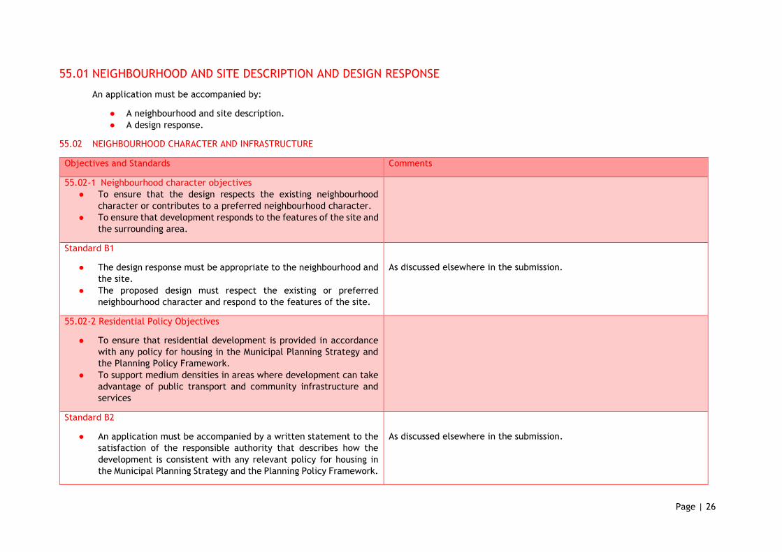
55.01 NEIGHBOURHOOD AND SITE DESCRIPTION AND DESIGN RESPONSE
An application must be accompanied by:
● A neighbourhood and site description.
● A design response.
55.02 NEIGHBOURHOOD CHARACTER AND INFRASTRUCTURE
Objectives and Standards Comments
55.02-1 Neighbourhood character objectives
● To ensure that the design respects the existing neighbourhood
character or contributes to a preferred neighbourhood character.
● To ensure that development responds to the features of the site and
the surrounding area.
Standard B1
● The design response must be appropriate to the neighbourhood and
the site.
● The proposed design must respect the existing or preferred
neighbourhood character and respond to the features of the site.
As discussed elsewhere in the submission.
55.02-2 Residential Policy Objectives
● To ensure that residential development is provided in accordance
with any policy for housing in the Municipal Planning Strategy and
the Planning Policy Framework.
● To support medium densities in areas where development can take
advantage of public transport and community infrastructure and
services
Standard B2
● An application must be accompanied by a written statement to the
satisfaction of the responsible authority that describes how the
development is consistent with any relevant policy for housing in
the Municipal Planning Strategy and the Planning Policy Framework.
As discussed elsewhere in the submission.
Page | 27
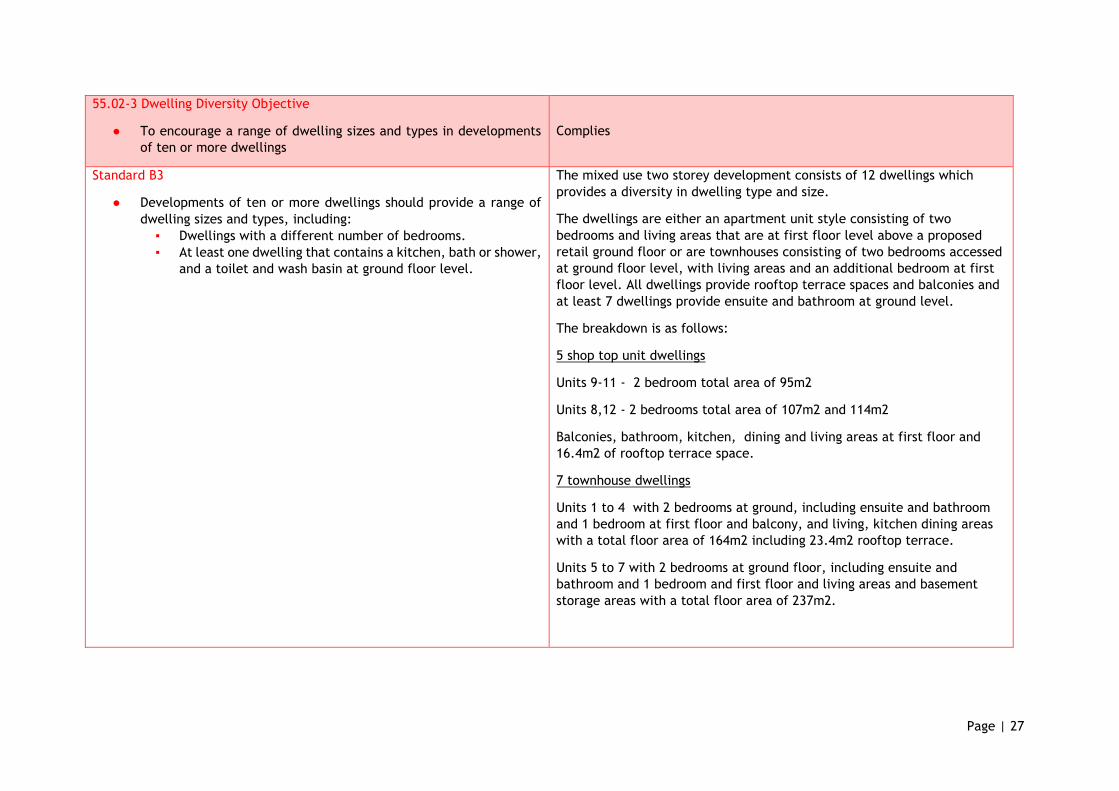
55.02-3 Dwelling Diversity Objective
● To encourage a range of dwelling sizes and types in developments
of ten or more dwellings
Complies
Standard B3
● Developments of ten or more dwellings should provide a range of
dwelling sizes and types, including:
▪ Dwellings with a different number of bedrooms.
▪ At least one dwelling that contains a kitchen, bath or shower,
and a toilet and wash basin at ground floor level.
The mixed use two storey development consists of 12 dwellings which
provides a diversity in dwelling type and size.
The dwellings are either an apartment unit style consisting of two
bedrooms and living areas that are at first floor level above a proposed
retail ground floor or are townhouses consisting of two bedrooms accessed
at ground floor level, with living areas and an additional bedroom at first
floor level. All dwellings provide rooftop terrace spaces and balconies and
at least 7 dwellings provide ensuite and bathroom at ground level.
The breakdown is as follows:
5 shop top unit dwellings
Units 9-11 - 2 bedroom total area of 95m2
Units 8,12 - 2 bedrooms total area of 107m2 and 114m2
Balconies, bathroom, kitchen, dining and living areas at first floor and
16.4m2 of rooftop terrace space.
7 townhouse dwellings
Units 1 to 4 with 2 bedrooms at ground, including ensuite and bathroom
and 1 bedroom at first floor and balcony, and living, kitchen dining areas
with a total floor area of 164m2 including 23.4m2 rooftop terrace.
Units 5 to 7 with 2 bedrooms at ground floor, including ensuite and
bathroom and 1 bedroom and first floor and living areas and basement
storage areas with a total floor area of 237m2.
Page | 28
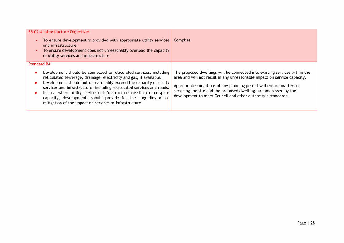
55.02-4 Infrastructure Objectives
▪ To ensure development is provided with appropriate utility services
and infrastructure.
▪ To ensure development does not unreasonably overload the capacity
of utility services and infrastructure
Complies
Standard B4
● Development should be connected to reticulated services, including
reticulated sewerage, drainage, electricity and gas, if available.
● Development should not unreasonably exceed the capacity of utility
services and infrastructure, including reticulated services and roads.
● In areas where utility services or infrastructure have little or no spare
capacity, developments should provide for the upgrading of or
mitigation of the impact on services or infrastructure.
The proposed dwellings will be connected into existing services within the
area and will not result in any unreasonable impact on service capacity.
Appropriate conditions of any planning permit will ensure matters of
servicing the site and the proposed dwellings are addressed by the
development to meet Council and other authority’s standards.
Page | 29
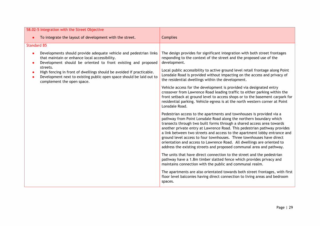
58.02-5 Integration with the Street Objective
● To integrate the layout of development with the street.
Complies
Standard B5
● Developments should provide adequate vehicle and pedestrian links
that maintain or enhance local accessibility.
● Development should be oriented to front existing and proposed
streets.
● High fencing in front of dwellings should be avoided if practicable.
● Development next to existing public open space should be laid out to
complement the open space.
The design provides for significant integration with both street frontages
responding to the context of the street and the proposed use of the
development.
Local public accessibility to active ground level retail frontage along Point
Lonsdale Road is provided without impacting on the access and privacy of
the residential dwellings within the development.
Vehicle access for the development is provided via designated entry
crossover from Lawrence Road leading traffic to either parking within the
front setback at ground level to access shops or to the basement carpark for
residential parking. Vehicle egress is at the north western corner at Point
Lonsdale Road.
Pedestrian access to the apartments and townhouses is provided via a
pathway from Point Lonsdale Road along the northern boundary which
transects through two built forms through a shared access area towards
another private entry at Lawrence Road. This pedestrian pathway provides
a link between two streets and access to the apartment lobby entrance and
ground level access to four townhouses. Three townhouses have direct
orientation and access to Lawrence Road. All dwellings are oriented to
address the existing streets and proposed communal area and pathway.
The units that have direct connection to the street and the pedestrian
pathway have a 1.8m timber slatted fence which provides privacy and
maintains connection with the public and communal realm.
The apartments are also orientated towards both street frontages, with first
floor level balconies having direct connection to living areas and bedroom
spaces.
Page | 30
55.03 SITE LAYOUT AND BUILDING MASSING
Objectives and Standards Comments
55.03-1 Street Setback Objective
● To ensure that the setbacks of buildings from a street respect the
existing or preferred neighbourhood character and make efficient
use of the site
Complies with objective
Standard B6
● Walls of buildings should be set back from streets:
▪ At least the distance specified in a schedule to the zone, or
▪ If no distance is specified in a schedule to the zone, the
distance specified in Table B1.
● Porches, pergolas and verandahs that are less than 3.6 metres high
and eaves may encroach not more than 2.5 metres into the setbacks
of this standard.
The new development has a front setback of 12.095 metre at Point
Lonsdale Road. The abutting property at 210 Point Lonsdale Road is set
back 7 metres. The standard requires that a 7 metre setback be used to
set the benchmark for development.
A variation to this standard is warranted as the setback of the new
building is to be set further back than the front setback of the adjacent
property. This additional 5 metres provides for a staggered setback
treatment between two very different built forms and provides a visual
separation and distinction between the building forms facing the street.
The increased setback also makes the most efficient use of the site,
providing for car park areas that are visually connected with the road and
therefore more likely to be better utilised, whilst providing visual relief to
the two storey form when seem from Point Lonsdale Road.
Lawrence Road forms the side street of the corner allotment. The abutting
development facing the side street is setback over 11 metres from
Lawrence Road. The standard provides that front walls of new
development facing a side street can have a front setback of 3 metres.
The new development has setback distances as 2.1 metres, 3.21 metres
and 4.3 metres for three attached units facing the side street. The
average setback for this built form with staggered setbacks is 3.2 metres,
which meets the requirements of the standard.
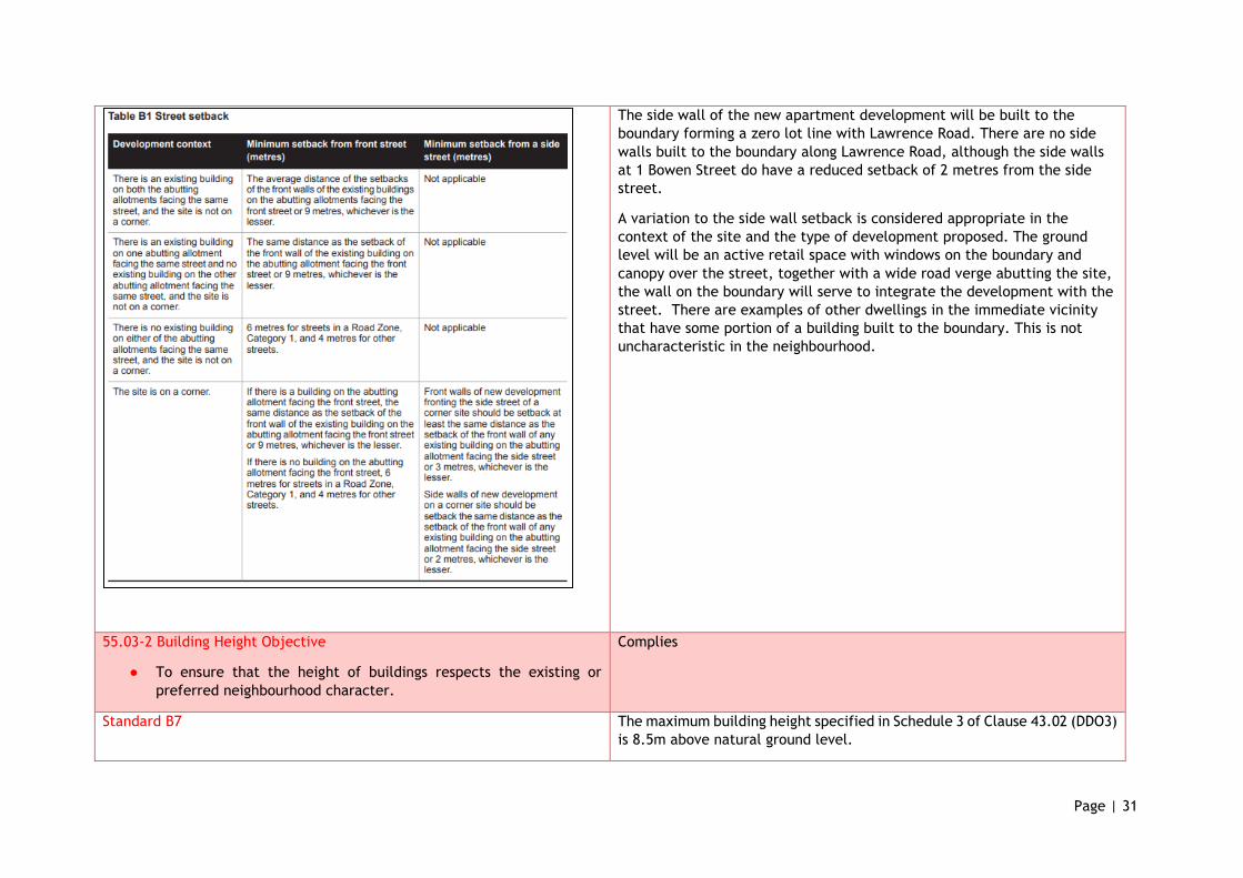
Page | 31
The side wall of the new apartment development will be built to the
boundary forming a zero lot line with Lawrence Road. There are no side
walls built to the boundary along Lawrence Road, although the side walls
at 1 Bowen Street do have a reduced setback of 2 metres from the side
street.
A variation to the side wall setback is considered appropriate in the
context of the site and the type of development proposed. The ground
level will be an active retail space with windows on the boundary and
canopy over the street, together with a wide road verge abutting the site,
the wall on the boundary will serve to integrate the development with the
street. There are examples of other dwellings in the immediate vicinity
that have some portion of a building built to the boundary. This is not
uncharacteristic in the neighbourhood.
55.03-2 Building Height Objective
● To ensure that the height of buildings respects the existing or
preferred neighbourhood character.
Complies
Standard B7 The maximum building height specified in Schedule 3 of Clause 43.02 (DDO3)
is 8.5m above natural ground level.
Page | 32
● The maximum building height should not exceed the maximum
height specified in the zone, schedule to the zone or an overlay that
applies to the land.
● If no maximum height is specified in the zone, schedule to the zone
or an overlay, the maximum building height should not exceed 9
metres, unless the slope of the natural ground level at any cross
section wider than 8 metres of the site of the building is 2.5 degrees
or more, in which case the maximum building height should not
exceed 10 metres
● Changes of building height between existing buildings and new
buildings should be graduated.
The development complies with this standard as the maximum overall
building height is 8.5m. The development presents as a double storey form
with a pitched roof. There are two storey dwelling forms found in the
immediate neighbourhood area.
55.03-3 Site Coverage Objective
● To ensure that the site coverage respects the existing or preferred
neighbourhood character and responds to the features of the site.
Complies with the objective - minor variation.
Standard B8
● The site area covered by buildings should not exceed:
▪ The maximum site coverage specified in a schedule to the
zone, or
▪ If no maximum site coverage is specified in a schedule to the
zone, 60 per cent.
The development complies with the maximum site coverage requirement
of 60% as it proposes a total of 42.5% of site coverage across the site area
of 2465m2.
DDO3 requires that a site coverage should not exceed 40% of the area.
The minor variation is considered appropriate in response to the site
context. As a mixed use development, and a major development site, the
amount of the site to be covered by buildings is generally higher as it
serves more than one use as opposed to a residential dwelling on one lot.
The Building and Siting Design Guidelines prepared for the Borough of
Queenscliffe were primarily prepared for residential development on
conventional sized lots. The existing use and development is a petrol
station and convenience store and predominantly a commercial
development.
Page | 33
The proposed development archives the objective of this standard in
relation to building footprint and finding a balance between the built form
and open areas. The lot is a corner allotment which affords the design to
provide adequate separation between built forms through the use of
ground level open spaces, internal accessways, car parking and
landscaping areas.
55.03-4 Permeability and stormwater management objectives
● To reduce the impact of increased stormwater run-off on the
drainage system.
● To facilitate on-site stormwater infiltration.
● To encourage stormwater management that maximises the
retention and reuse of stormwater.
Complies with objective
Standard B9
● The site area covered by the pervious surfaces should be at least:
▪ The minimum area specified in a schedule to the zone, or
▪ If no minimum is specified in a schedule to the zone, 20
percent of the site.
● The stormwater management system should be designed to:
▪ Meet the current best practice performance objectives for
stormwater quality as contained in the Urban Stormwater -
Best Practice Environmental Management Guidelines
(Victorian Stormwater Committee, 1999).
▪ Contribute to cooling, improving local habitat and providing
attractive and enjoyable spaces.
There is no minimum site area specified in the schedule to the zone,
therefore 20% of the site should provide previous surfaces.
The proposed development will allow 21% of its site to have pervious
surfaces.
The proposed development provides a compact form of design with double
storey elements, reducing the extent of surface covered by buildings. The
open space in between and around the built forms contribute to cooling
and provides attractive spaces to live in.
Typically parking areas create more run-off and in this instance the car
park area has been designed to remove surface run off with drains as well
as sloping the car parking area towards the grass areas of the existing road
verge to provide for filtration into the existing permeable surfaces.
Using both rainwater tanks and water re-use within the buildings, along
with 2 Enviss Sentinel pits https://www.enviss.com.au/sentinel-pits/ the
proposal is able to achieve the required minimum STORM rating of 100%.
A WSUD Report and sketch layout plans for stormwater are enclosed with
the application.
Page | 34
55.03-5 Energy Efficiency Guidelines
● To achieve and protect energy efficient dwellings and residential
buildings.
● To ensure the orientation and layout of development reduce fossil
fuel energy use and make appropriate use of daylight and solar
energy.
Complies
Standard B10
● Buildings should be:
▪ Oriented to make appropriate use of solar energy.
▪ Sited and designed to ensure that the energy efficiency of
existing dwellings on adjoining lots is not unreasonably
reduced.
▪ Sited and designed to ensure that the performance of existing
rooftop solar energy facilities on dwellings on adjoining lots
in a General Residential Zone, Neighbourhood Residential
Zone or Township Zone are not unreasonably reduced. The
existing rooftop solar energy facility must exist at the date
the application is lodged.
● Living areas and private open space should be located on the north
side of the development, if practicable.
● Developments should be designed so that solar access to north-
facing windows is maximised.
The lot is orientated to maximise the use of solar energy and the proposed
design demonstrates a layout that provides maximum solar access to open
space, balconies, rooftop terraces and living areas.
The apartment living areas enjoy solar access through windows sited on
the north-western side of the development. The balconies enjoy the same
amenity, while the rooftop terraces are located on the south-eastern side
to enjoy access to daylight and relief from western heat.
The residential units are sited to have access to eastern light, with
ground level courtyard areas and first floor balconies that abut living areas
having amenable access to daylight and solar energy. The rooftop terraces
are located in the middle of their respective units and enjoy unfettered
access to solar energy and light.
The retail areas similarly have their windows facing on the north-western
side and also enjoy the same solar access as the apartments above.
The energy efficiency of abutting dwellings is not impacted by the
proposal with minimal shadowing cast as shown in the shadow assessment
of TP.16-TP18.
Page | 35
55.03-6 Open Space Objective
● To integrate the layout of development with any public and
communal open space provided in or adjacent to the development.
Complies
Standard B11
● If any public or communal open space is provided on site, it should:
▪ Be substantially fronted by dwellings, where appropriate.
▪ Provide outlook for as many dwellings as practicable.
▪ Be designed to protect any natural features on the site.
▪ Be accessible and useable.
The development provides for communal open space areas and private
open space areas. The communal open space is well integrated with the
development with four units and the apartment entrance fronting on to
this area.
Unfettered outlook to the communal open space is also achieved by the
open space terraces on the roof of the apartment building.
The communal space is wide enough to accommodate trees and
landscaping as well as seated areas to be used by the occupants of the
dwellings. It provides many elements including a circuit walkway,
entrance area to apartments and 4 units, vegetative landscape areas and
facilities for outdoor showers and a rain garden.
The retail spaces have strong connectivity to the communal space of the
public car park area as they have fully glazed frontages.
Pathways are connected to the carpark and also overhead canopies serve
to provide shelter and shade for the public.
55.03-7 Safety Objective
● To ensure the layout of development provides for the safety and
security of residents and property.
Complies
Standard B12
● Entrances to dwellings and residential buildings should not be
obscured or isolated from the street and internal accessways.
● Planting which creates unsafe spaces along streets and accessways
should be avoided.
● Developments should be designed to provide good lighting, visibility
and surveillance of car parks and internal accessways.
The entry to the apartment building provides safety and security for the
future residents.
The access to the apartment building and 4 units is via an internal
accessway which is to be accessed via two private entry points. The
landscaping proposed in this area will be local landscape rock set into
gravel with indigenous tufting plants, such as tussock grasses and
groundcovers, which will not create unsafe spaces.
Page | 36
● Private spaces within developments should be protected from
inappropriate use as public thoroughfares.
The private open spaces of the units will be protected as the rear
courtyard gardens will have elevated beds and screening planting, and the
front courtyards that have an interface with the street or internal
accessway will have 1800mm high timber semi-permeable fencing.
55.03-8 Landscaping Objective
● To encourage development that respects the landscape character
of the neighbourhood.
● To encourage development that maintains and enhances habitat for
plants and animals in locations of habitat importance.
● To provide appropriate landscaping.
● To encourage the retention of mature vegetation on the site.
Complies
Standard B13
● The landscape layout and design should:
▪ Protect any predominant landscape features of the
neighbourhood.
▪ Take into account the soil type and drainage patterns of the
site.
▪ Allow for intended vegetation growth and structural
protection of buildings.
▪ In locations of habitat importance, maintain existing habitat
and provide for new habitat for plants and animals.
▪ Provide a safe, attractive and functional environment for
residents.
● Development should provide for the retention or planting of trees,
where these are part of the character of the neighbourhood.
● Development should provide for the replacement of any significant
trees that have been removed in the 12 months prior to the
application being made.
In accordance with the DDO Schedule 3 an application must provide a
landscape plan that clearly indicates existing vegetation on the site, the
extent of proposed clearing of vegetation, the type, density and location
of trees and other vegetation to be planted, and the location and
material of the vehicular accessway.
A landscape design has been prepared by Perry Mills and Associates
provides for planting throughout the site in communal and private open
space areas.
The proposed landscaping design is well considered and provides for
screen planting along the north east and south east boundary, planting of
new trees, removal of environmental weeds, planting of coastal species
such as tussocks and groundcovers and indigenous planting. The design
also provides for a green screen, feature tree planting as well as using
local landscaping rocks.
The landscape design also identifies the protection of existing street trees
and the proposed planting of additional roadside vegetation along Point
Lonsdale Road.

Page | 37
● The landscape design should specify landscape themes, vegetation
(location and species), paving and lighting.
● Development should meet any additional landscape requirements
specified in a schedule to the zone.
55.03-9 Access Objective
● To ensure the number and design of vehicle crossovers respects the
neighbourhood character.
Complies
Standard B14
● The width of accessways or car spaces should not exceed:
▪ 33 per cent of the street frontage, or
▪ if the width of the street frontage is less than 20 metres, 40
per cent of the street frontage.
● No more than one single-width crossover should be provided for
each dwelling fronting a street.
● The location of crossovers should maximise the retention of on-
street car parking spaces.
● The number of access points to a road in a Road Zone should be
minimised.
● Developments must provide for access for service, emergency and
delivery vehicles.
The width of the accessway on Lawrence Road near the western corner of
the site will be 4.4 metres wide and provide for single lane entry. This is
approximately 8.6% of the Lawrence Road frontage which meets the
standard.
The width of the accessway on Point Lonsdale Road is 4 metres near the
north west corner of the site, providing for single lane exit. This is
approximately 8.2% of the Point Lonsdale frontage which meets the
standard.
The proposal reduces the width of the existing crossovers, providing
increased areas for planting and/or on-street car parking. The number of
access points to the Road Zone are also reduced to one.
The development has appropriate access for service, emergency and
delivery vehicles.
It is not anticipated to provide an on-site loading facility as the size of the
retail tenancies would likely be serviced by vans to medium sized trucks.
A traffic report prepared by O’Brien Traffic indicates that these service
delivery vehicles would be able to park on site or on street adjacent to
Lawrence Road. The Waste Management Plan prepared by Leigh Design
indicates that Council would collect waste at Point Lonsdale Road
frontage.
Page | 38
Private collection of waste from the retail use can occur outside busy
times from the proposed car park by a medium sized rear lift vehicle. The
traffic report indicates that a long 8.8 metre truck would be able to enter
and exit the site in a forward direction.
55.03-10 Parking Location Objective
● To provide convenient parking for resident and visitor vehicles.
● To protect residents from vehicular noise within developments.
Complies
Standard B15
● Car parking facilities should:
▪ Be reasonably close and convenient to dwellings and
residential buildings.
▪ Be secure.
▪ Be well ventilated if enclosed.
● Shared accessways or car parks of other dwellings and residential
buildings should be located at least 1.5 metres from the windows
of habitable rooms. This setback may be reduced to 1 metre where
there is a fence at least 1.5 metres high or where window sills are
at least 1.4 metres above the accessway.
The proposed car parking facilities for the residents of the unit and
apartment dwellings are to be located in the secure basement of the
development. 2 car parking spaces are allocated to each two bedroom
apartment and to each 3 bedroom townhouse. The basement also includes
a car space for each retail tenancies. The location of the carpark will not
impact on the amenity or the residents.
Access to the basement is via an internal stairwell and lift accessed in the
apartment complex. Three units have direct access to double garages from
their townhouses.
Page | 39
55.04 AMENITY IMPACTS
Objectives and Standards Comments
55.04-1 Side and Rear Setbacks Objectives
● To ensure that the height and setback of a building from a boundary
respects the existing or preferred neighbourhood character and
limits the impact on the amenity of existing dwellings.
Complies with objective
Standard B17
● A new building not on or within 200mm of a boundary should be set
back from side or rear boundaries:
▪ At least the distance specified in a schedule to the zone, or
▪ If no distance is specified in a schedule to the zone, 1 metre,
plus 0.3 metres for every metre of height over 3.6 metres up
to 6.9 metres, plus 1 metre for every metre of height over
6.9 metres.
● Sunblinds, verandahs, porches, eaves, fascias, gutters, masonry
chimneys, flues, pipes, domestic fuel or water tanks, and heating
or cooling equipment or other services may encroach not more than
0.5 metres into the setbacks of this standard.
● Landings having an area of not more than 2 square metres and less
than 1 metre high, stairways, ramps, pergolas, shade sails and
carports may encroach into the setbacks of this standard.
Unit 1 dwelling at ground level is setback 1.955m from the northern site
boundary and 2.05m at first floor level. A significant portion of the
building on this boundary is contained within the side setback envelope
with a small encroachment, approximately 0.5m from the proposed 1.7m
screening to prevent overlooking from the roof terrace area.
The shop top housing building at ground level is setback 1.62m from the
northern site boundary and 1.82m at first floor level. Most of the building
on the boundary is contained within the side setback envelope with a
minor encroachment of 0.3m of the box gutter and fascia into the setback.
Unit 7 dwelling is setback 1.693m from the eastern site boundary which is
entirely contained within the side setback envelope.
Units 1 to 4 are setback 9m from the eastern site boundary .
Aside from the minor encroachments which are allowed by the standard
the wall heights to boundary ratios all meet the standard.
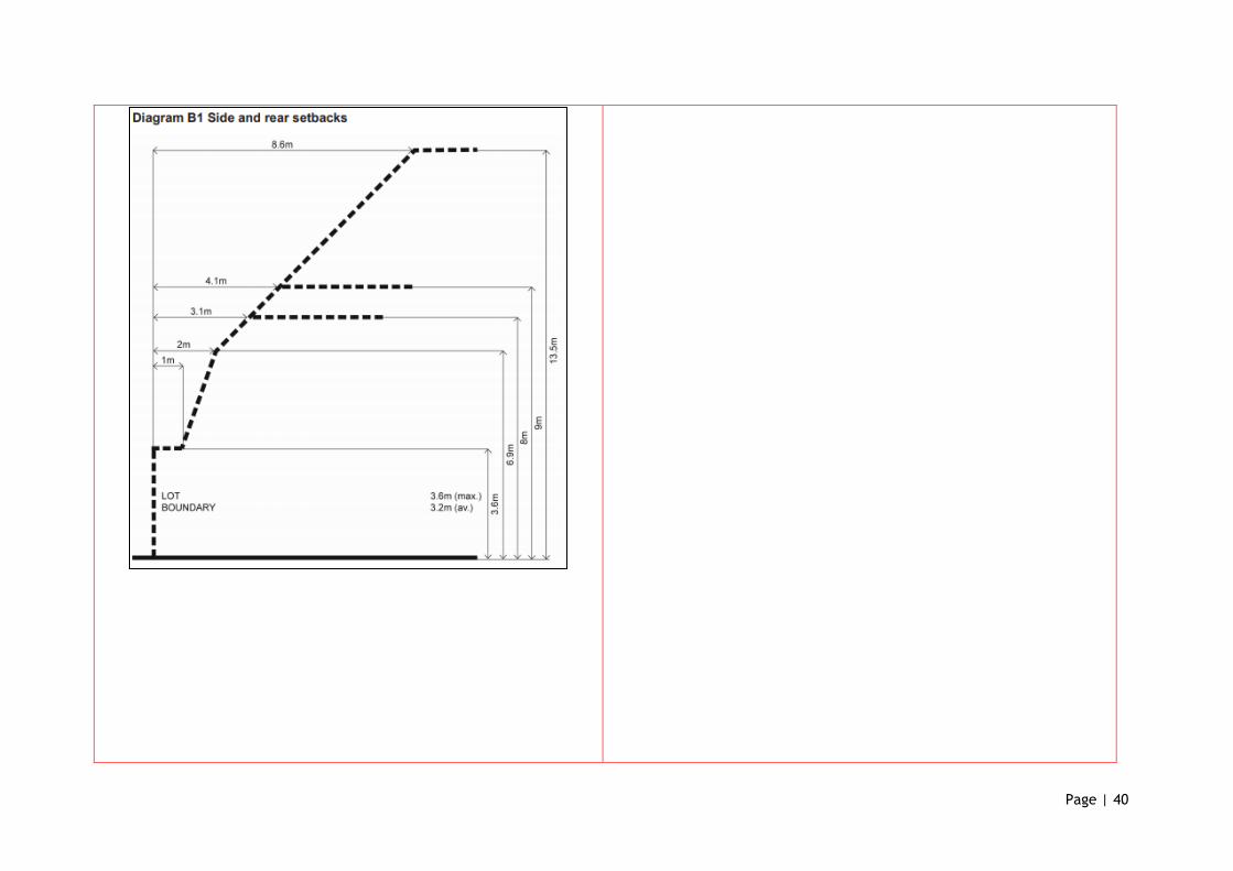
Page | 40
Page | 41
55.04-2 Walls on Boundaries Objectives
● To ensure that the location, length and height of a wall on a
boundary respects the existing or preferred neighbourhood
character and limits the impact on the amenity of existing
dwellings.
Complies with objective.
Standard B18
● A new wall constructed on or within 200mm of a side or rear
boundary of a lot or a carport or constructed on or within 1 metre
of a side or rear boundary of lot should not abut the boundary:
▪ For a length of more than the distance specified in a schedule
to the zone; or
▪ If no distance is specified in a schedule to the zone, for a
length of more than:
● 10 metres plus 25 per cent of the remaining
length of the boundary of an adjoining lot, or
● Where there are existing or simultaneously
constructed walls or carports abutting the
boundary on an abutting lot, the length of the
existing or simultaneously constructed walls
or carports whichever is the greater.
● A new wall or carport may fully abut a side or rear boundary where
slope and retaining walls or fences would result in the effective
height of the wall or carport being less than 2 metres on the
abutting property boundary.
● A building on a boundary includes a building set back up to 200mm
from a boundary.
● The height of a new wall constructed on or within 200mm of a side
or rear boundary or a carport constructed on or within 1 metre of
a side or rear boundary should not exceed an average of 3.2 metres
with no part higher than 3.6 metres unless abutting a higher
existing or simultaneously constructed wall.
There are no new walls to be constructed on the boundary as part of the
unit dwelling development.
A new wall is to be constructed on the southern side boundary for a length
of 11.942m for the retail component of the apartment development,
calculations based on this standard would allow for a wall length of 20.22m
on the southern boundary.
The height of the boundary wall is approximately 4.7m, although this
exceeds the maximum allowed by this standard, the variation is considered
an appropriate response for the mixed use development where the retail
component has a strong interface connection with the street.
The fenestration detail of the wall is such that it will not impact on the
amenity or neighbourhood character as it will provide an active street
frontage and the wall is not located opposite any other dwellings.
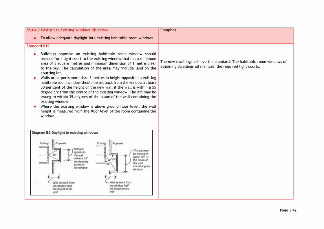
Page | 42
55.04-3 Daylight to Existing Windows Objective
● To allow adequate daylight into existing habitable room windows
Complies
Standard B19
● Buildings opposite an existing habitable room window should
provide for a light court to the existing window that has a minimum
area of 3 square metres and minimum dimension of 1 metre clear
to the sky. The calculation of the area may include land on the
abutting lot.
● Walls or carports more than 3 metres in height opposite an existing
habitable room window should be set back from the window at least
50 per cent of the height of the new wall if the wall is within a 55
degree arc from the centre of the existing window. The arc may be
swung to within 35 degrees of the plane of the wall containing the
existing window.
● Where the existing window is above ground floor level, the wall
height is measured from the floor level of the room containing the
window.
The new dwellings achieve the standard. The habitable room windows of
adjoining dwellings all maintain the required light courts.
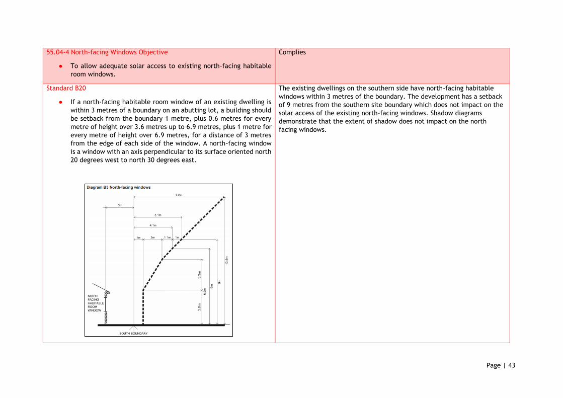
Page | 43
55.04-4 North-facing Windows Objective
● To allow adequate solar access to existing north-facing habitable
room windows.
Complies
Standard B20
● If a north-facing habitable room window of an existing dwelling is
within 3 metres of a boundary on an abutting lot, a building should
be setback from the boundary 1 metre, plus 0.6 metres for every
metre of height over 3.6 metres up to 6.9 metres, plus 1 metre for
every metre of height over 6.9 metres, for a distance of 3 metres
from the edge of each side of the window. A north-facing window
is a window with an axis perpendicular to its surface oriented north
20 degrees west to north 30 degrees east.
The existing dwellings on the southern side have north-facing habitable
windows within 3 metres of the boundary. The development has a setback
of 9 metres from the southern site boundary which does not impact on the
solar access of the existing north-facing windows. Shadow diagrams
demonstrate that the extent of shadow does not impact on the north
facing windows.
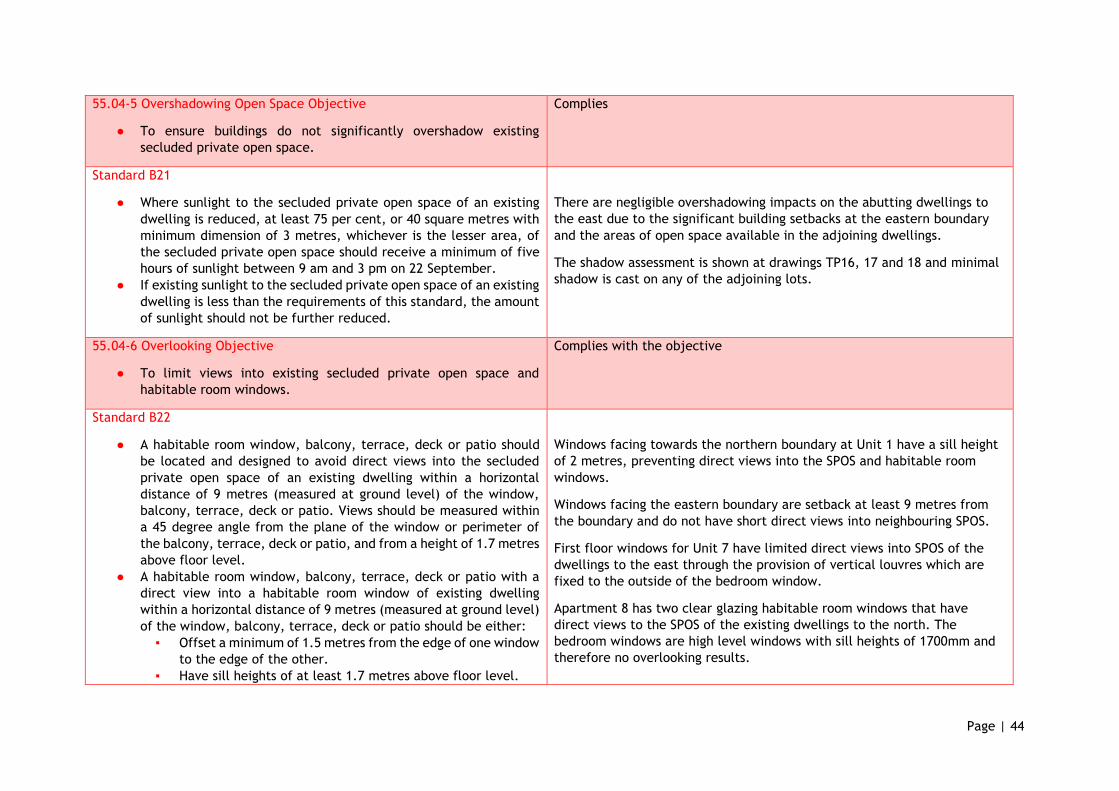
Page | 44
55.04-5 Overshadowing Open Space Objective
● To ensure buildings do not significantly overshadow existing
secluded private open space.
Complies
Standard B21
● Where sunlight to the secluded private open space of an existing
dwelling is reduced, at least 75 per cent, or 40 square metres with
minimum dimension of 3 metres, whichever is the lesser area, of
the secluded private open space should receive a minimum of five
hours of sunlight between 9 am and 3 pm on 22 September.
● If existing sunlight to the secluded private open space of an existing
dwelling is less than the requirements of this standard, the amount
of sunlight should not be further reduced.
There are negligible overshadowing impacts on the abutting dwellings to
the east due to the significant building setbacks at the eastern boundary
and the areas of open space available in the adjoining dwellings.
The shadow assessment is shown at drawings TP16, 17 and 18 and minimal
shadow is cast on any of the adjoining lots.
55.04-6 Overlooking Objective
● To limit views into existing secluded private open space and
habitable room windows.
Complies with the objective
Standard B22
● A habitable room window, balcony, terrace, deck or patio should
be located and designed to avoid direct views into the secluded
private open space of an existing dwelling within a horizontal
distance of 9 metres (measured at ground level) of the window,
balcony, terrace, deck or patio. Views should be measured within
a 45 degree angle from the plane of the window or perimeter of
the balcony, terrace, deck or patio, and from a height of 1.7 metres
above floor level.
● A habitable room window, balcony, terrace, deck or patio with a
direct view into a habitable room window of existing dwelling
within a horizontal distance of 9 metres (measured at ground level)
of the window, balcony, terrace, deck or patio should be either:
▪ Offset a minimum of 1.5 metres from the edge of one window
to the edge of the other.
▪ Have sill heights of at least 1.7 metres above floor level.
Windows facing towards the northern boundary at Unit 1 have a sill height
of 2 metres, preventing direct views into the SPOS and habitable room
windows.
Windows facing the eastern boundary are setback at least 9 metres from
the boundary and do not have short direct views into neighbouring SPOS.
First floor windows for Unit 7 have limited direct views into SPOS of the
dwellings to the east through the provision of vertical louvres which are
fixed to the outside of the bedroom window.
Apartment 8 has two clear glazing habitable room windows that have
direct views to the SPOS of the existing dwellings to the north. The
bedroom windows are high level windows with sill heights of 1700mm and
therefore no overlooking results.
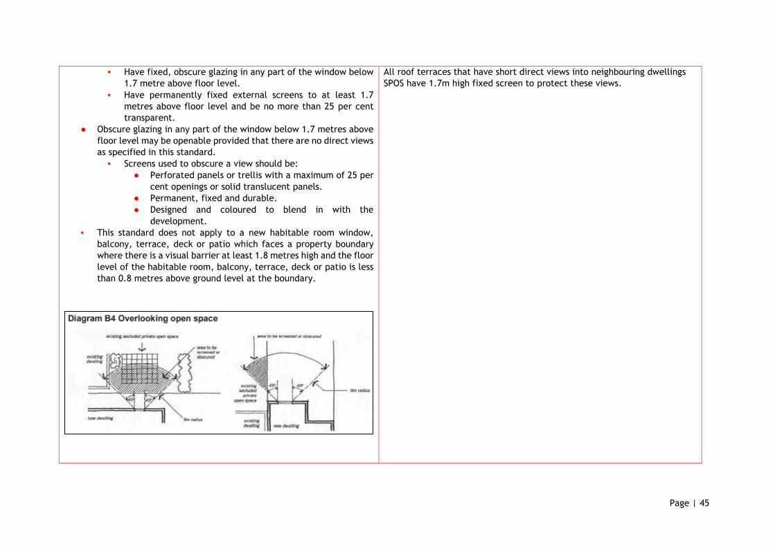
Page | 45
▪ Have fixed, obscure glazing in any part of the window below
1.7 metre above floor level.
▪ Have permanently fixed external screens to at least 1.7
metres above floor level and be no more than 25 per cent
transparent.
● Obscure glazing in any part of the window below 1.7 metres above
floor level may be openable provided that there are no direct views
as specified in this standard.
▪ Screens used to obscure a view should be:
● Perforated panels or trellis with a maximum of 25 per
cent openings or solid translucent panels.
● Permanent, fixed and durable.
● Designed and coloured to blend in with the
development.
▪ This standard does not apply to a new habitable room window,
balcony, terrace, deck or patio which faces a property boundary
where there is a visual barrier at least 1.8 metres high and the floor
level of the habitable room, balcony, terrace, deck or patio is less
than 0.8 metres above ground level at the boundary.
All roof terraces that have short direct views into neighbouring dwellings
SPOS have 1.7m high fixed screen to protect these views.
Page | 46
55.04-7 Internal View Objective
● To limit views into the secluded private open space and habitable
room windows of dwellings and residential buildings within a
development.
Complies
Standard B23
● Windows and balconies should be designed to prevent overlooking
of more than 50 per cent of the secluded private open space of a
lower-level dwelling or residential building directly below and
within the same development.
The development has been designed to limit the internal views from
balconies and windows to lower level SPOS within the development.
This is achieved through the use of 1.7m screening around roof terrace
areas, louvres and recessed balconies. Although lower level open space
areas will be in direct view, it is not more than 50% of the SPOS.
55.04-8 Noise Impacts Objectives
● To contain noise sources in developments that may affect existing
dwellings.
● To protect residents from external noise.
Complies
Standard B24
● Noise sources, such as mechanical plant, should not be located near
bedrooms of immediately adjacent existing dwellings.
● Noise sensitive rooms and secluded private open spaces of new
dwellings and residential buildings should take account of noise
sources on immediately adjacent properties.
● Dwellings and residential buildings close to busy roads, railway lines
or industry should be designed to limit noise levels in habitable
rooms.
The proposed unit and apartment dwellings will not generate any significant
noise other than what is typical for a dwelling. No noise impacts are
required to be mitigated as part of this proposal.
Potential noise sources from retail use, such as bin storage areas are
separated from the residential dwellings.
Page | 47
55.05 ON-SITE AMENITY AND FACILITIES
Objectives and Standards Comments
55.05-1 Accessibility Objective
● To encourage the consideration of the needs of people with limited
mobility in the design of developments.
Complies with standard.
Standard B25
● The dwelling entries of the ground floor of dwellings and residential
buildings should be accessible or able to be easily made accessible
to people with limited mobility.
The apartment will have a lift to provide access to first floor dwellings
and also to the basement car park, meeting the needs of people with
limited mobility.
The townhouse dwellings have ground floor bedrooms and first floor
living areas accessed via stairways, these dwelling types do not afford
the same mobility amenity.
The overall development provides for a mixture of housing type and
style.
55.05-2 Dwelling Entry Objective
● To provide each dwelling or residential building with its own sense
of identity.
Complies
Standard B26
● Entries to dwellings and residential buildings should:
▪ Be visible and easily identifiable from streets and other public
areas.
▪ Provide shelter, a sense of personal address and a transitional
space around the entry.
The entries are easily identifiable and have been designed to provide
shelter, a sense of personal address and a transitional space.
Page | 48
55.05-3 Daylight to new Windows Objective
● To allow adequate daylight into new habitable room windows.
Complies
Standard B27
● A window in a habitable room should be located to face:
▪ An outdoor space clear to the sky or a light court with a
minimum area of 3 square metres and minimum dimension of
1 metre clear to the sky, not including land on an abutting lot,
or
▪ A verandah provided it is open for at least one third of its
perimeter, or
▪ A carport provided it has two or more open sides and is open
for at least one third of its perimeter.
All habitable room windows within the proposed dwellings are provided
with access to appropriate daylight provision.
55.05-4 Private Open Space Objective
● To provide adequate private open space for the reasonable
recreation and service needs of residents.
Complies
Standard B28
● A dwelling or residential building should have private open space of
an area and dimensions specified in a schedule to the zone.
● If no area or dimensions are specified in a schedule to the zone, a
dwelling or residential building should have private open space
consisting of:
▪ An area of 40 square metres, with one part of the private open
space to consist of secluded private open space at the side or
rear of the dwelling or residential building with a minimum
area of 25 square metres, a minimum dimension of 3 metres
and convenient access from a living room, or
▪ A balcony of 8 square metres with a minimum width of 1.6
metres and convenient access from a living room, or
▪ A roof-top area of 10 square metres with a minimum width of
2 metres and convenient access from a living room.
All townhouses exceed the open space requirements with ground floor
open spaces of 57m2, balcony of 6m2 and a rooftop terrace area of
23m2. The unit developments meet the required standard.
The balcony requirements for the shop-top housing also exceed the
standard with 16.4m² at roof top level and west facing front balconies of
approximately 12m². These open space areas are more than adequate
and exceeds the standard of this Clause.
The dwellings provide well in excess of the required open space area on
site.
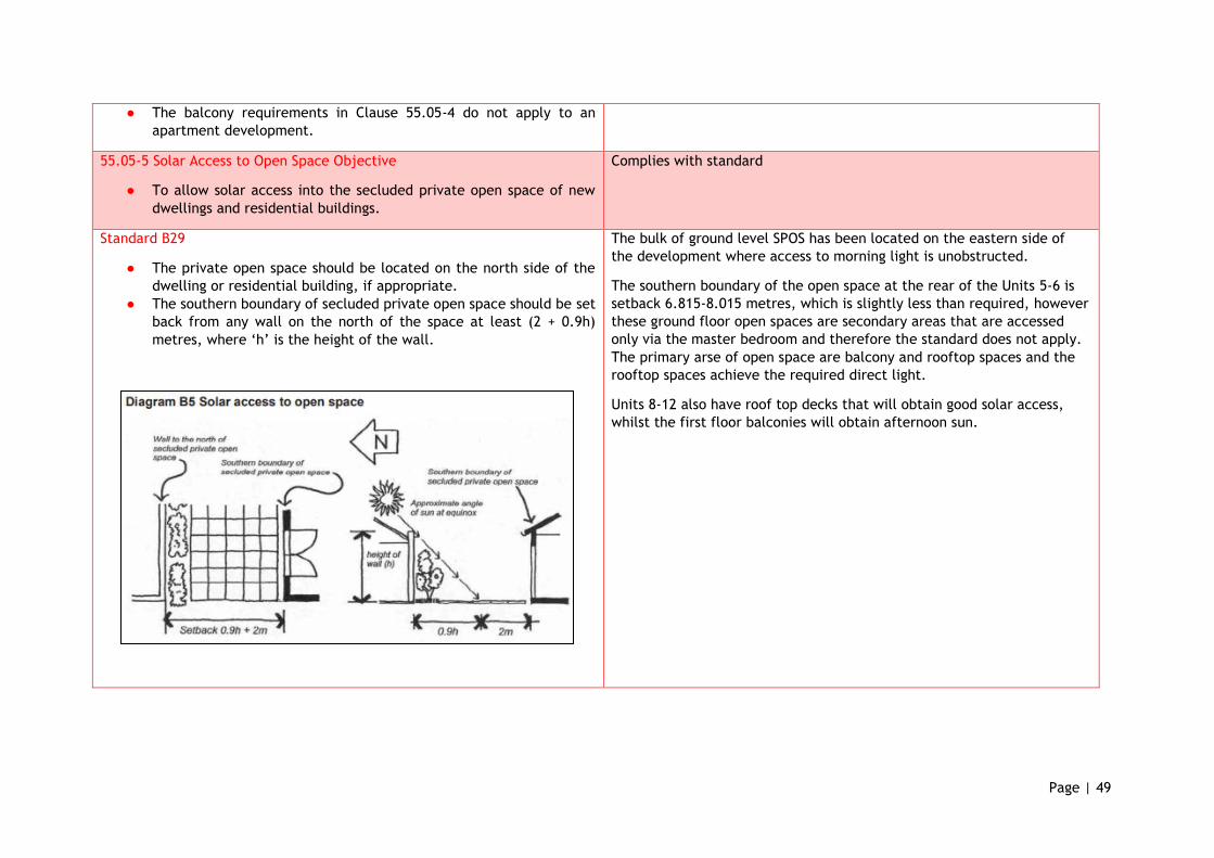
Page | 49
● The balcony requirements in Clause 55.05-4 do not apply to an
apartment development.
55.05-5 Solar Access to Open Space Objective
● To allow solar access into the secluded private open space of new
dwellings and residential buildings.
Complies with standard
Standard B29
● The private open space should be located on the north side of the
dwelling or residential building, if appropriate.
● The southern boundary of secluded private open space should be set
back from any wall on the north of the space at least (2 + 0.9h)
metres, where ‘h’ is the height of the wall.
The bulk of ground level SPOS has been located on the eastern side of
the development where access to morning light is unobstructed.
The southern boundary of the open space at the rear of the Units 5-6 is
setback 6.815-8.015 metres, which is slightly less than required, however
these ground floor open spaces are secondary areas that are accessed
only via the master bedroom and therefore the standard does not apply.
The primary arse of open space are balcony and rooftop spaces and the
rooftop spaces achieve the required direct light.
Units 8-12 also have roof top decks that will obtain good solar access,
whilst the first floor balconies will obtain afternoon sun.
Page | 50
55.05-6 Storage Objective
● To provide adequate storage facilities for each dwelling.
Complies with standard
Standard B30
● Each dwelling should have convenient access to at least 6 cubic
metres of externally accessible, secure storage space.
All units will have access to at least 4-5 cubic metres of secure storage in
the basement. Whilst this is slightly below the standard each townhouse
could also accommodate further storage within the rear yards. Units 5 -
7 have more than the required amount in a secure enclosed garage area
within the basement.
55.06 DETAILED DESIGN
Objectives and Standards Comments
55.06-1 Design Detail Objective
● To encourage design detail that respects the existing or preferred
neighbourhood character.
Standard B31
● The design of buildings, including:
▪ Facade articulation and detailing,
▪ Window and door proportions,
▪ Roof form, and
▪ Verandahs, eaves and parapets,
should respect the existing or preferred neighbourhood character.
● Garages and carports should be visually compatible with the
development and the existing or preferred neighbourhood
character.
As previously discussed earlier in the submission.
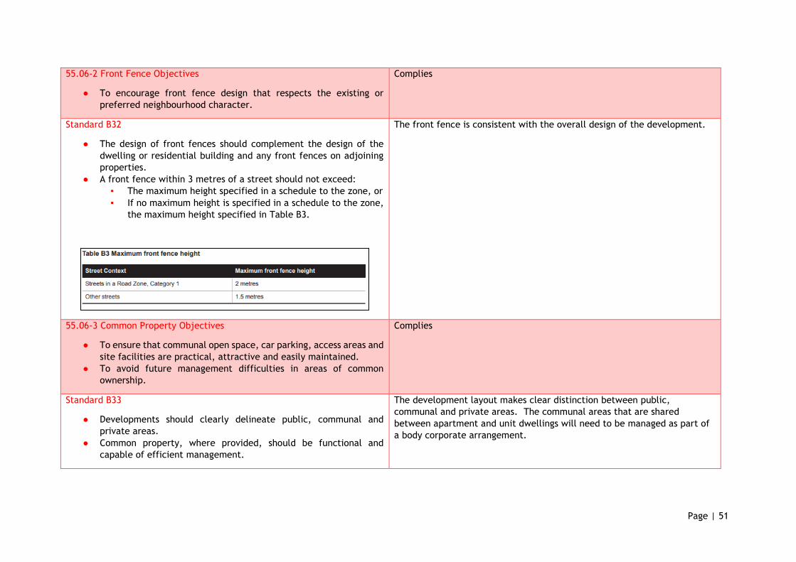
Page | 51
55.06-2 Front Fence Objectives
● To encourage front fence design that respects the existing or
preferred neighbourhood character.
Complies
Standard B32
● The design of front fences should complement the design of the
dwelling or residential building and any front fences on adjoining
properties.
● A front fence within 3 metres of a street should not exceed:
▪ The maximum height specified in a schedule to the zone, or
▪ If no maximum height is specified in a schedule to the zone,
the maximum height specified in Table B3.
The front fence is consistent with the overall design of the development.
55.06-3 Common Property Objectives
● To ensure that communal open space, car parking, access areas and
site facilities are practical, attractive and easily maintained.
● To avoid future management difficulties in areas of common
ownership.
Complies
Standard B33
● Developments should clearly delineate public, communal and
private areas.
● Common property, where provided, should be functional and
capable of efficient management.
The development layout makes clear distinction between public,
communal and private areas. The communal areas that are shared
between apartment and unit dwellings will need to be managed as part of
a body corporate arrangement.
Page | 52
55.06-4 Site-Services Objectives
● To ensure that site services can be installed and easily maintained.
● To ensure that site facilities are accessible, adequate and
attractive.
Complies
Standard B34
● The design and layout of dwellings and residential buildings should
provide sufficient space (including easements where required) and
facilities for services to be installed and maintained efficiently and
economically.
● Bin and recycling enclosures, mailboxes and other site facilities
should be adequate in size, durable, waterproof and blend in with
the development.
● Bin and recycling enclosures should be located for convenient
access by residents.
● Mailboxes should be provided and located for convenient access as
required by Australia Post.
Sufficient areas are provided for the on-site location of site services
associated with the proposed dwellings.
Bin store areas are contained within an enclosed space and have
convenient access by residents.
Letterboxes are located on the south side of the property adjacent to the
pedestrian entry to provide convenience to Australia Post and residents.
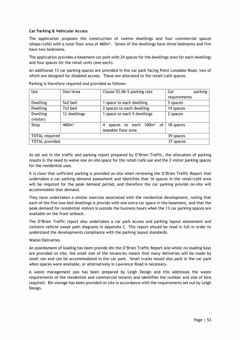
Page | 53
Car Parking & Vehicular Access
The application proposes the construction of twelve dwellings and four commercial spaces
(shops/café) with a total floor area of 460m². Seven of the dwellings have three bedrooms and five
have two bedrooms.
The application provides a basement car park with 24 spaces for the dwellings (two for each dwelling)
and four spaces for the retail units (one each).
An additional 13 car parking spaces are provided in the car park facing Point Lonsdale Road, two of
which are designed for disabled access. These are allocated to the retail/café spaces.
Parking is therefore required and provided as follows:
Use Size/Area Clause 52.06-5 parking rate Car parking
requirements
Dwelling 5x2 bed 1 space to each dwelling 5 spaces
Dwelling 7x3 bed 2 spaces to each dwelling 14 spaces
Dwelling
(visitor)
12 dwellings 1 space to each 5 dwellings 2 spaces
Shop 460m² 4 spaces to each 100m² of
leasable floor area
18 spaces
TOTAL required 39 spaces
TOTAL provided 37 spaces
As set out in the traffic and parking report prepared by O’Brien Traffic, the allocation of parking
results in the need to waive one on site space for the retail/café use and the 2 visitor parking spaces
for the residential uses.
It is clear that sufficient parking is provided on site when reviewing the O’Brien Traffic Report that
undertakes a car parking demand assessment and identifies that 16 spaces in the retail/café area
will be required for the peak demand period, and therefore the car parking provide on-site will
accommodate that demand.
They have undertaken a similar exercise associated with the residential development, noting that
each of the five two-bed dwellings is provide with one extra car space in the basement, and that the
peak demand for residential visitors is outside the business hours when the 13 car parking spaces are
available on the front setback.
The O’Brien Traffic report also undertakes a car park access and parking layout assessment and
contains vehicle swept path diagrams in Appendix C. This report should be read in full in order to
understand the developments compliance with the parking layout standards.
Waste/Deliveries
An asse4ssment of loading has been provide din the O’Brien Traffic Report and whilst no loading bays
are provided on site, the small size of the tenancies means that many deliveries will be made by
small van and can be accommodated in the car park. Small trucks would also park in the car park
when spaces were available, or alternatively in Lawrence Road is necessary.
A waste management pan has been prepared by Leigh Design and this addresses the waste
requirements of the residential and commercial tenants and identifies the number and size of bins
required. Bin storage has been provided on site in accordance with the requirements set out by Leigh
Design.
Page | 54
Access to a Road Zone
Permission is necessary from VicRoads to alter or create access to a main road, and permission or
this is sought. The access and egress to the site has been designed in conjunction with O’Brien
Traffic having regard to traffic distribution, volumes and overall impacts. This assessment is
contained within Section 8 of their report and interestingly concludes that traffic impacts
associated with the proposed development will be lower than the peak hour traffic volumes of the
existing BP service station.
The development seeks to maintain only a single access point to the main road, with the vehicle
entry to the site to be gained via Lawrence Road. The provisions of Clause 52.29 discourage
multiple access points to a main road, whilst the design has sought to provide vehicle access and
egress at the most appropriate locations having regard to visibility, vehicle speed and vehicle
numbers.
Stormwater Management in Urban Development
An effective stormwater management plan will be able to be prepared for the development to
meet the objectives and standards of Clause 53.18 if required, and in particular:
• Will be designed and drained in accordance with the requirements and to the satisfaction of the
responsible authority to meet current best practice performance for stormwater quality (Clause
53.18-4).
• Have incorporated a STORM report for the new dwellings to identify appropriate Water
Sensitive Urban Design measures that can be implemented (Clause 53.18-5).
• Can include appropriate on-site management requirements to be implemented prior to and
during construction to address erosion / sediment loss from the site, stormwater runoff and
rubbish / construction waste (Clause 53.18-6).
Page | 55
6. Conclusion
The application is consistent with the strategic outcomes sought by the Queenscliffe Planning
Scheme, and the proposal provides for a well-designed mixed-use development that will respect
and complement the coastal character of the town whilst providing a medium density development
and greater housing choice for residents. This site is the only mixed-use zone in the municipality
and the desire to provide a high-quality form of housing and appropriate density without under
developing the land has been achieved.
The site was nominated for mixed-use development given its two street abuttals and convenient
access to the beach, other shops and services and public bus transport within the township. The
height and massing of the development fits the low scale character of the town whilst the use of
traditional forms and materials is an appropriate nod to the town history and the character traits
desired and enjoyed by the community.
The mix of uses is appropriate having regard to the purpose of the zone, and the development
results in no loss of amenity to any other property due to building bulk, overshadowing or
overlooking.
The proposal demonstrates a high level of compliance with the provisions of Clause 55 (ResCode)
and delivers a high-quality design response to the Boroughs Urban Character Policy.
The provision of the new crossover to Point Lonsdale Road will not impact on the operation or
safety of the road, whilst car parking is provided above the residential requirements, with a very
small number of parking spaces waived for the commercial visitors (one) and the residential visitors
(two).
Given all of the above we look forward to the grant of a planning permit in due course.
SINCOCK PLANNING
Related Documents