Constraints on the Sediments Constraints on the Sediments and Geologic Framework of and Geologic Framework of Delaware Bay from Delaware Bay from Sub Sub - - bottom Imaging bottom Imaging John Madsen John Madsen Department of Geological Sciences, University of Delaware Department of Geological Sciences, University of Delaware Bartholomew Wilson and David Carter Bartholomew Wilson and David Carter Delaware Coastal Management Program, Delaware Coastal Management Program, Division of Soil and Water Conservation Division of Soil and Water Conservation Delaware Department of Natural Resources and Delaware Department of Natural Resources and Environmental Control Environmental Control

Welcome message from author
This document is posted to help you gain knowledge. Please leave a comment to let me know what you think about it! Share it to your friends and learn new things together.
Transcript
Constraints on the Sediments Constraints on the Sediments and Geologic Framework of and Geologic Framework of
Delaware Bay from Delaware Bay from SubSub--bottom Imagingbottom Imaging
John MadsenJohn MadsenDepartment of Geological Sciences, University of DelawareDepartment of Geological Sciences, University of Delaware
Bartholomew Wilson and David CarterBartholomew Wilson and David CarterDelaware Coastal Management Program, Delaware Coastal Management Program, Division of Soil and Water ConservationDivision of Soil and Water Conservation
Delaware Department of Natural Resources and Delaware Department of Natural Resources and Environmental ControlEnvironmental Control
Funding for Funding for BenthicBenthic Mapping ProjectMapping Project•• Funding from NOAA, the Office of Ocean and Funding from NOAA, the Office of Ocean and
Coastal Resource Management (OCRM); under Coastal Resource Management (OCRM); under award numbers NA17OR1243, NA04NOS419003, award numbers NA17OR1243, NA04NOS419003, NA04NOS4190034, NA03NOS4200133, and NA04NOS4190034, NA03NOS4200133, and NA04NOS4200072, NA05NOS4201098, NA04NOS4200072, NA05NOS4201098, NA05NOS4191169NA05NOS4191169
•• Pilot Study in 2003 Pilot Study in 2003 –– OnOn--goinggoing BenthicBenthic Mapping Mapping Project 2004, 2005, 2006, 2007Project 2004, 2005, 2006, 2007
Current information on the benthos is lacking. Additional Current information on the benthos is lacking. Additional information is necessary to properly and effectively information is necessary to properly and effectively
manage themanage the benthicbenthic habitats of Delaware Bayhabitats of Delaware Bay

Existing Needs for Benthic Data IncludeExisting Needs for Benthic Data Include•• Identifying Essential Fish HabitatIdentifying Essential Fish Habitat
–– Preferred sedimentary environmentsPreferred sedimentary environments–– Mapping oyster beds and habitatMapping oyster beds and habitat–– Information for horseshoe crab habitat Information for horseshoe crab habitat
managementmanagement–– Marine protection areasMarine protection areas
•• Identifying Sand Resources for Beach Identifying Sand Resources for Beach Replenishment and Monitoring of Dredge Replenishment and Monitoring of Dredge SitesSites
•• Investigating Sediment Dynamics and Investigating Sediment Dynamics and Geologic Evolution of the EstuaryGeologic Evolution of the Estuary

Technologies for Benthic MappingTechnologies for Benthic Mapping•• RoxAnn Seabed Classification SystemRoxAnn Seabed Classification System
–– RoxmapRoxmap®® w/w/NobeltecNobeltec navigation softwarenavigation software•• Chirp SubChirp Sub--bottom Profiling Systembottom Profiling System
–– EdgeTechEdgeTech Sonar w/Sonar w/NobeltecNobeltec navigation softwarenavigation software•• Multibeam Bathymetry SystemMultibeam Bathymetry System
–– Reson Reson 8124 w/8124 w/HypackHypack navigation navigation and and Fledermaus Fledermaus imaging softwareimaging software
•• Field VerificationField Verification–– Ponar sediment grab samplesPonar sediment grab samples–– VibraVibra--coringcoring–– PushPush--coringcoring–– Underwater VideoUnderwater Video
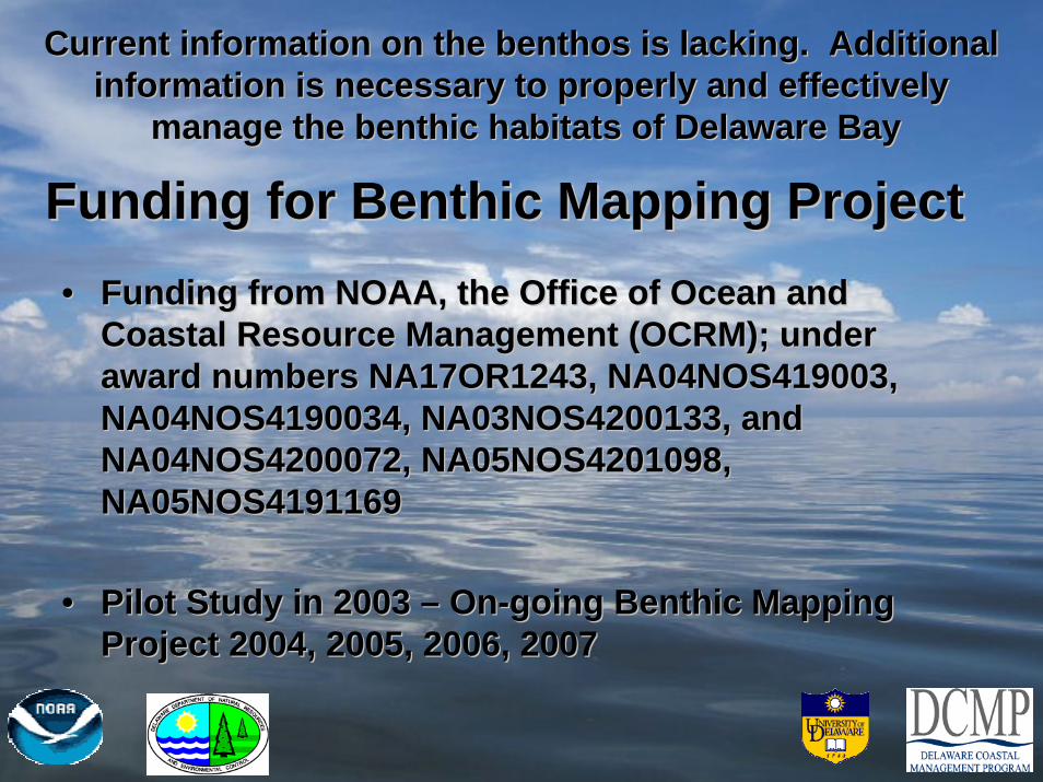
Chirp SubChirp Sub--bottom Profiling Systembottom Profiling System•• EdgetechEdgetech XX--Star and 3200S Star and 3200S
systems with SB216systems with SB216--S S towfishtowfishgenerating a swept 2generating a swept 2--12 kHz 12 kHz ““chirpchirp”” sound pulsesound pulse
•• Acoustic reflections (due to Acoustic reflections (due to changes in sound velocity changes in sound velocity and/or density) recorded as a and/or density) recorded as a function of time generating function of time generating ““imagesimages”” of subof sub--bottom to 15 bottom to 15 meters depth meters depth
•• Identify characteristics and Identify characteristics and thicknesses of bottom thicknesses of bottom sediments and underlying sediments and underlying subsub--bottom layersbottom layers

Constraints on the Sediments and Constraints on the Sediments and Geologic FrameworkGeologic Framework
Off Port Penn, DE Off Port Penn, DE –– Artificial Island, NJArtificial Island, NJ
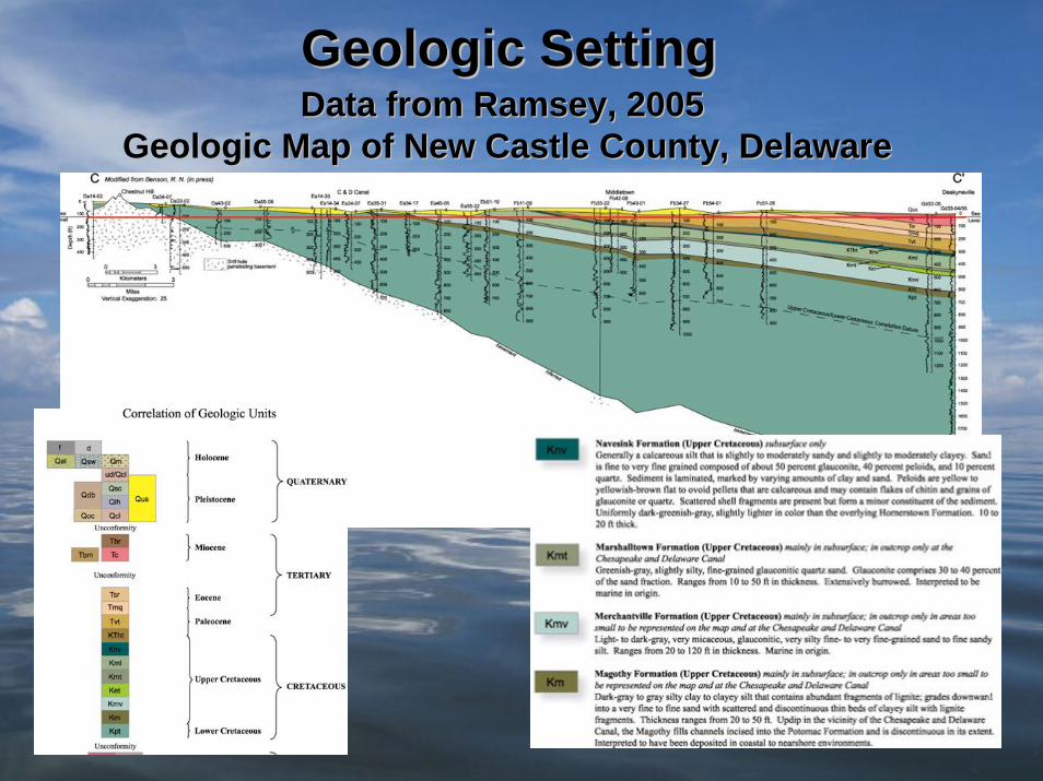
Geologic SettingGeologic SettingData from Ramsey, 2005 Data from Ramsey, 2005
Geologic Map of New Castle County, DelawareGeologic Map of New Castle County, Delaware

Geologic SettingGeologic SettingPotential for Bay Bottom Outcropping Potential for Bay Bottom Outcropping
of Upper Cretaceous Sedimentsof Upper Cretaceous Sediments
Data From Ramsey, 2005
This has implications for potential groundwater discharge into the Bay and may have an effect on benthic habitats

Benthic Mapping Survey Benthic Mapping Survey TracklinesTracklines
Along-Bay Tracklines Spaced~200 m apart
Across-Bay Tracklines Spaced~400 m apart

Chirp SubChirp Sub--bottom Profilebottom ProfileIndicates Indicates ““OutcropOutcrop”” of Upper Cretaceous Sedimentsof Upper Cretaceous Sediments
Southward Dipping Sediment Layers Interpreted as Upper Cretaceous Sediments

Chirp SubChirp Sub--bottom Profilesbottom ProfilesExtent of Upper Cretaceous SedimentsExtent of Upper Cretaceous Sediments
ReedyIsland
Southward Dipping Layers ofUpper Cretaceous Sediments
Line 6Line 32
Line 14 - ~400 m to the south of Line 6

RoxannRoxann Sediment ClassificationSediment Classification

RoxannRoxann –– Upper Cretaceous SedimentsUpper Cretaceous Sediments
silty-fine sands to fine-sandy silts, glauconitic, burrows,highly compacted, dewatered
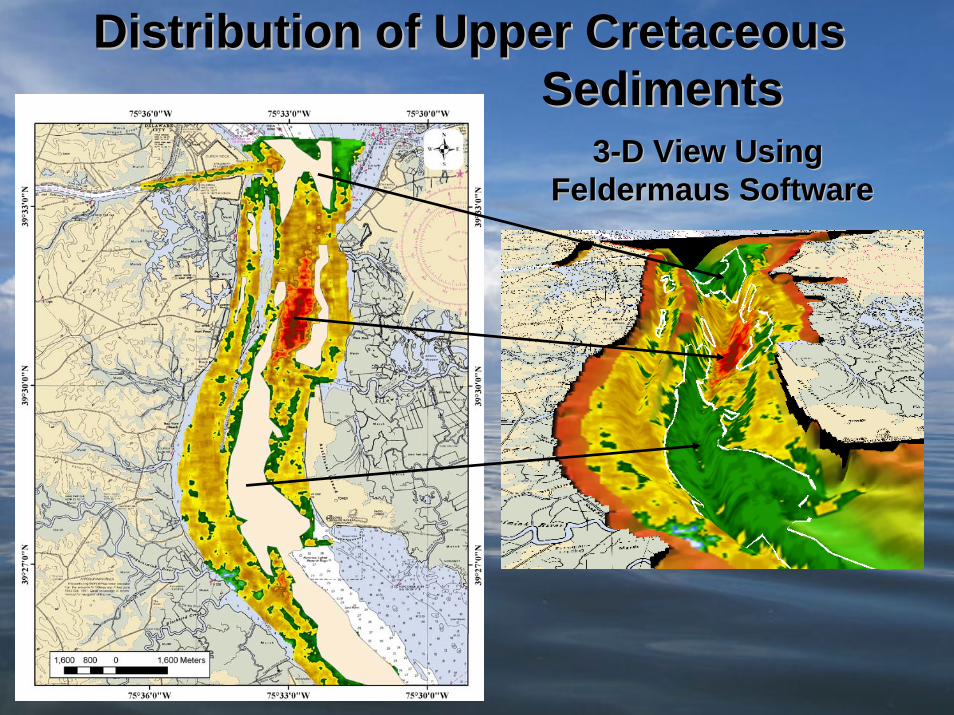
Distribution of Upper CretaceousDistribution of Upper CretaceousSedimentsSediments
33--D View Using D View Using FeldermausFeldermaus SoftwareSoftware

Chirp SubChirp Sub--bottom Profiles bottom Profiles Upper Cretaceous SedimentsUpper Cretaceous Sediments
Integrating Bottom Sediment Mapping using Roxann with Sub-bottom Imaging from Chirp is an effective Tool for Constraining the Distribution of Bay Sediments
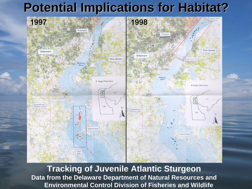
Potential Implications for Habitat?Potential Implications for Habitat?
Tracking of Juvenile Atlantic SturgeonData from the Delaware Department of Natural Resources and
Environmental Control Division of Fisheries and Wildlife
Questions and/or Comments?Questions and/or Comments?
Dave Carter will present a talk this afternoon onDave Carter will present a talk this afternoon onimplications of the Delaware Bay Benthic implications of the Delaware Bay Benthic Mapping Project for coastal managementMapping Project for coastal management
Bart Wilson will present a talk on Tuesday afternoonBart Wilson will present a talk on Tuesday afternoonusing results from the project to address using results from the project to address
issues of oyster habitat issues of oyster habitat
Related Documents