HOLDENHURST VILLAGE CONSERVATION AREA APPRAISAL MARCH 2014 Borough Council

Welcome message from author
This document is posted to help you gain knowledge. Please leave a comment to let me know what you think about it! Share it to your friends and learn new things together.
Transcript
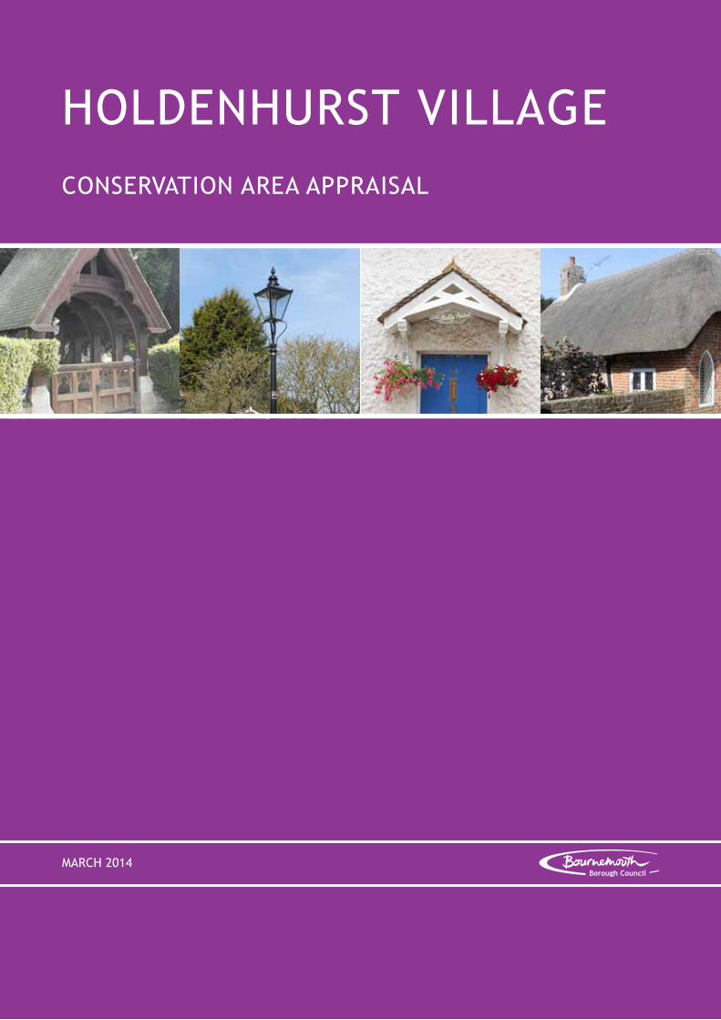
HOLDENHURST VILLAGECONSERVATION AREA APPRAISAL
MARCH 2014Borough Council
Produced by:
Bournemouth Borough CouncilConservation and Urban DesignTown Hall AnnexeSt Stephen’s RoadBournemouthBH2 6EA
Tel: 01202 451323
Email: conservation&[email protected]
All maps within this document, with the exception of those on pages 13 and 14, are reproduced from Ordnance Survey material with the permission of Ordnance Survey on behalf of the Controller of Her Majesty’s Stationery Office. © Crown copyright. Bournemouth Borough Council 100019829. 2013
All oblique aerial photographs in this document copyright © BLOM Pictometry 2009.

iHoldenhurst Village Conservation Area Appraisal - March 2014
Contents
Page No.
1 Introduction 1
2 The Planning Policy Context 6
Primary Legislation National Planning Policy Framework (NPPF) Bournemouth Local Plan
3 Summary of Special Interest 8
4 Location and Setting 9
Context General Character and Plan Form
5 Historic Development 12
Origins and Historic Development Activity and Uses Archaeology
6 Spatial Analysis 25
Relationship of Spaces Key Views and Vistas Landmarks
7 Character Analysis 32
Definition of character areas Architectural and historic qualities of the buildings Local qualities Contribution of vegetation and green spaces The public realm General condition of buildings
8 Issues and Challenges 43
Extent of Intrusion or Damage Challenges

ii Holdenhurst Village Conservation Area Appraisal - March 2014
9 Contribution of Buildings 47
Positive buildings Neutral buildings Negative buildings An Audit of Heritage Assets
10 Assessment of Existing Boundary 58
Extended Area 1 Extended Area 2 Christchurch Controlled Conservation Area
11 Community Involvement 63
12 Management Proposals 64
Managing Change Positively
Appendices
Appendix 1 - Properties within the Conservation Area Appendix 2 - Relevant Legislation and Policy Documents Appendix 3 - Policy Wording Appendix 4 - Tree Preservation Orders (TPOs) Appendix 5 - English Heritage Checklist Appendix 6 - Listed Buildings within the Conservation Area Appendix 7 - Bibliography Appendix 8 - Glossary
List of Figures
1 Bournemouth’s Conservation Areas 22 Boundary of Holdenhurst Village Conservation Area 43 Aerial View of the Conservation Area 104 Milne’s Map of Hampshire 1791 135 Copy of the Tithe Map (1841) of the Eastern Part of Holdenhurst 146 Map of Holdenhurst in 1870 167 Map of Holdenhurst in 1924 188 Proposed New Road and Sewerage Works for Holdenhurst 1959 199 Map of the Eastern Part of the Village with overlay of 1898 2210 Examples of Demolished Cottages Across the Eastern Part of the Village 2311 Map of Archaeological Finds 2412 Key Views and Vistas 26 13 Location of Historic Walling to Former Farmsteads 3714 Contribution of Buildings to the Conservation Area 4815 Changes to the Conservation Area Boundary 61

Holdenhurst Village Conservation Area Appraisal - March 2014 1
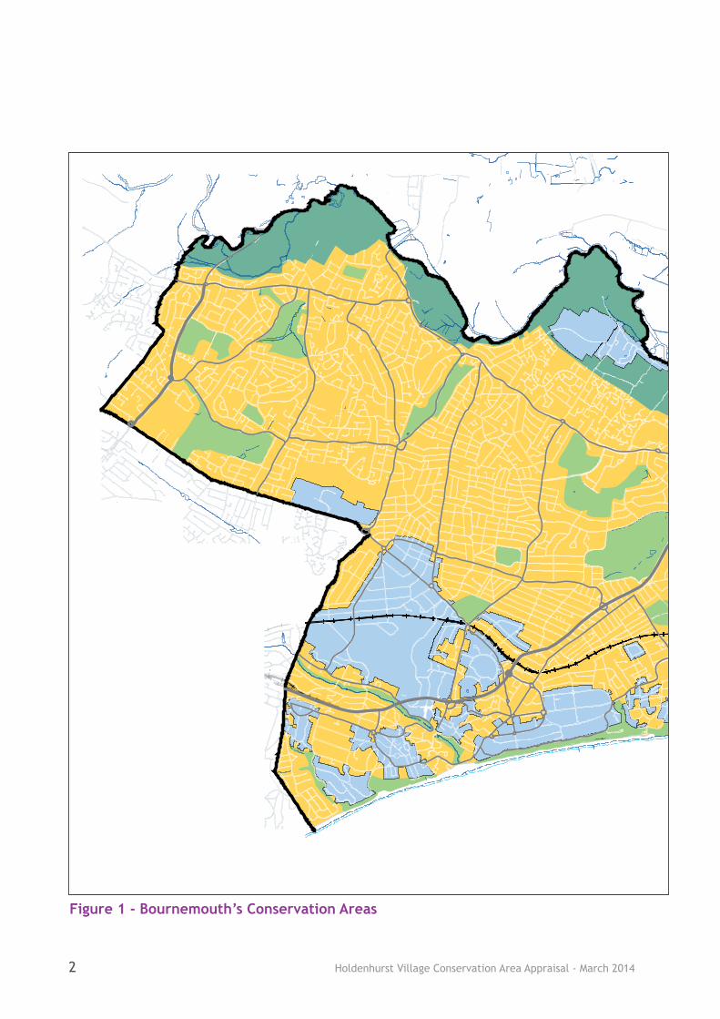
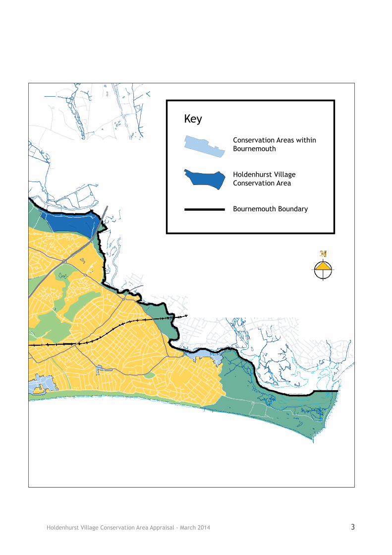
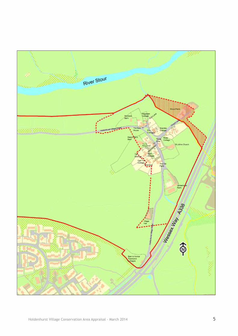
1.1 Holdenhurst Village Conservation Area is one of the 20 Conservation Areas that Bournemouth Council has designated in the Borough (Figures 1 and 2).
1.2 The original conservation areas of Holdenhurst Village East and Holdenhurst Village West were the first conservation areas to be designated in Bournemouth on the 18th June 1974. Following an assessment, undertaken as part of this Conservation Area Appraisal, the boundary of these two separate conservation areas was revised resulting in the formation of a single larger conservation area - Holdenhurst Village Conservation Area. This assessment also took into account the fact that the boundary of the original Holdenhurst East Conservation Area included land which lay within the Borough of Christchurch. As a result the boundary was revised to follow the Bournemouth Borough boundary line reflecting the fact that Bournemouth Borough Council has no legal jurisdiction over the land which lies within the administrative boundary of Christchurch. The reasoning behind all of the boundary changes is detailed in Chapter 10.
1.3 The purpose of this Conservation Area Appraisal is to identify the key elements which contribute to the significance of the Holdenhurst Village Conservation Area which warranted its
designation and those which detract from it. Having established these elements a clearer understanding of the forms of development that may or may not be appropriate can be established. From this opportunities for preservation and future enhancement can be identified.
1.4 It is noted that no appraisal can ever be completely comprehensive and the omission of any particular building, feature or space should not be taken to imply that it is of no interest. It is the quality and interest of areas as a whole, rather than that of individual buildings or features, which should be the prime consideration in identifying Conservation Areas.
1.5 The survey and appraisal of the Conservation Area was carried out between May 2011 and September 2012 based on the format suggested by English Heritage in their guidance - Understanding Place: Conservation Area Designation, Appraisal and Management (2011).
1.6 Public consultation with the local community and other interested parties took place for six weeks between 16th August and 27th September 2013. Following consideration of all of the comments received the Conservation Area Appraisal was then adopted by the Council on 4th March 2014.
1 Introduction
Picturesque view towards Vicarage Cottages from the junction of Throop Road and Holdenhurst Village Road
Holdenhurst Village Conservation Area Appraisal - March 20142
Figure 1 - Bournemouth’s Conservation Areas
Conservation Areas within Bournemouth
Holdenhurst Village Conservation Area
Bournemouth Boundary
Key
Holdenhurst Village Conservation Area Appraisal - March 2014 3
Conservation Areas within Bournemouth
Holdenhurst Village Conservation Area
Bournemouth Boundary
Key

Holdenhurst Village Conservation Area Appraisal - March 20144
Figure 2 - Boundary of Holdenhurst Village Conservation Area
Holdenhurst Village Conservation Area Appraisal - March 2014 5
Holdenhurst Village Conservation Area Appraisal - March 20146
Primary Legislation
2.1 The concept of Conservation Areas was introduced by the Civic Amenities Act 1967, in recognition of the need to look beyond the listing of individual buildings, and to secure the protection for groupings of buildings.
2.2 Government legislation is set out in the Planning (Listed Buildings and Conservation Areas) Act, 1990, and notes that ‘every local planning authority shall from time to time determine which parts of their area are areas of special architectural or historic interest the character or appearance of which it is desirable to preserve or enhance, and shall designate those areas as conservation areas’ (section 69). It also states that ‘special attention shall be paid to the desirability of preserving or enhancing the character or appearance of that area’ (section 72). It is also a duty of local planning authorities to formulate and publish proposals for the preservation and enhancement of conservation areas (section 71).
National Planning Policy Framework (NPPF)
2.3 The NPPF sets out Government planning policies and how these are expected to be applied. It notes that the purpose of the planning system is to contribute to the achievement of sustainable development, expressed as: economic, social and environmental roles. The environmental role includes “contributing to protecting and enhancing our natural, built and historic environment...” (p2).
2.4 The NPPF refers to ‘designated heritage assets’ and ‘heritage assets’. Designated heritage assets are those protected under primary legislation
and or registered by English Heritage and include Conservation Areas (p51). Heritage assets are those buildings, monuments, sites, places or landscapes identified as having a degree of significance meriting consideration in planning decisions because of their heritage interest. The term ‘heritage asset’ includes designated heritage assets (p52).
2.5 The NPPF defines ‘significance’ as ‘The value of a heritage asset to this and future generations because of its heritage interest. That interest may be archaeological, architectural, artistic or historic. Significance derives not only from a heritage asset’s physical presence, but also from its setting’ (p56).
2.6 Not all elements of a Conservation Area will necessarily contribute to its significance (para 138) and when considering the designation of Conservation Areas, local planning authorities should ensure that an area justifies such status because of its special architectural or historic interest (para 127).
2.7 The NPPF must be taken into account in the preparation of local and neighbourhood plans, and is a material consideration in planning decisions.
Bournemouth Local Plan
2.8 The Local Plan for Bournemouth consists of several documents. The primary document is the Core Strategy which provides the spatial strategy for the Borough for the period 2006 to 2026 and was adopted in October 2012. Other documents are geographically specific e.g the Town Centre Area Action Plan or cover a particular topic e.g Affordable Housing. Some policies within the Bournemouth District Wide Local Plan 2002 are ‘saved’
2 The Planning Policy Context
Holdenhurst Village Conservation Area Appraisal - March 2014 7
within it. The South East Dorset Green Belt is long established and seeks to protect the physical identity of the town, by retaining areas of open land between built up areas. It also continues to protect the separate identity of the village of Holdenhurst.
District Wide Local Plan (2002)
2.11 Policy 4.4 of the Bournemouth District Wide Local Plan 2002 is still relevant to planning decisions affecting Conservation Areas. The policy ensures that development has regard for features that affect the character of Conservation Areas e.g scale, density, height form, massing and layout. The policy remains a material consideration in determining planning applications until superseded by polices in the Development Management DPD.
2.12 Policy 4.11 of the Bournemouth District Wide Local Plan 2002 (relating to Holdenhurst East) is also still relevant to planning decisions (see Appendix 3). This policy seeks to ensure that any new development is of a simple rural character and the siting of any new agricultural building is within an existing group.
2.13 Other ‘saved’ District Wide policies that are also still relevant are 3.6, 3.7, 3.9 and 3.12 which relate to development in the countryside and 3.28 which relates to flood zones. These policies will remain a material consideration in determining planning applications in Holdenhurst Village until superseded by polices in the Development Management DPD.
and therefore still remain relevant. They will be superseded in time by policies in other new development plan documents (DPDs) e.g detailed policies for Development Management. For detailed wording of relevant Local Plan policies, see Appendix 3. For a full schedule of current policies, see the Council’s website.
Core Strategy (2012)
2.9 The Core Strategy acknowledges the NPPF requirement to have a proactive strategy for the conservation and enjoyment of the historic environment. It states that the Council is producing a set of Conservation Area Appraisals that provide information on each Conservation Area and advice to prospective developers on how they should be maintained. The Core Strategy states that opportunities to continue to understand, preserve and enhance Bournemouth’s historic assets will be sought through a range of initiatives including Conservation Area Appraisals. Core Strategy Policy CS39 seeks to protect designated heritage assets, which includes Conservation Areas (see Appendix 3).
2.10 Other relevant Core Strategy Policies include Policy CS1, CS12, CS36 and CS37. Policy CS1 states that in making planning decisions the Council will reflect the presumption in favour of sustainable development and will encourage use of the pre-application process to find appropriate solutions. Policy CS12 protects community facilities such as allotments, places of worship and community halls. Policy CS36 refers to the Stour Valley Project and relates to the importance of the Stour Valley as a significant recreation and habitat resource. Policy CS37 is concerned with the Green Belt and seeks to resist inappropriate development, including uses of land,

Holdenhurst Village Conservation Area Appraisal - March 20148
3.1 Every Conservation Area has a distinctive character and appearance. The importance of the Holdenhurst Village Conservation Area is derived primarily from the survival of both historic farmhouses, barns and dwellings and the agricultural landscape which surrounds it.
3.2 The Conservation Area is of historic and architectural interest and represents an important part of the history of Bournemouth. Although now contained within the Borough of Bournemouth, Holdenhurst has had its own separate identity since Saxon times. It is mentioned in the Domesday Book (1086) and at one time was more important than neighbouring Christchurch.
3.3 Holdenhurst is a visible reminder of one of the villages that pre-dates the town of Bournemouth and is one of only four surviving villages of interest within the conurbation, the others being Throop, Wick and Talbot Village. Prior to the expansion of north Bournemouth the village would have been self sufficient, with a bus service, village post office, school and at one time even a smithy.
3.4 The historic core of the Conservation Area is reinforced by the number of listed buildings. This includes three of a handful of historic thatched cottages left within Bournemouth and one of the last remaining timber framed cottages. The Conservation Area also contains a number of listed gas lamps which by virtue of still being powered by gas are a rare survival.
3.5 The interest of the area also derives from the age of the core properties which range from the 1500s to the early 1900s. The varying use and age of these buildings results in a range of architectural styles and materials (which further typify this area and add
to its interest). In general the buildings are small in scale, reflective of their village location.
3.6 The pattern of development is also part of the special interest of the village and remains relatively intact, with informal groups of buildings distinctly clustered into two pockets - focused around the village green to the east and around the junction of Throop Road and Holdenhurst Village Road to the west.
3.7 Although many of the original buildings have been converted, their original form remains as an important reminder of the area’s historic past. The village character and appearance is further reinforced by the continued use of several buildings for the purpose for which they were originally intended, such as the church and village hall, along with the farm buildings and continued use of the agricultural land.
3.8 Despite the proximity of urban Bournemouth the Conservation Area retains its rural setting and contains many elements traditionally associated with a rural area. Within the Conservation Area the lanes are generally narrow with mature hedgerows and grassed banks bordering the lanes and fields beyond. The village green and the setting of the properties, surrounded by open fields adds to the overriding rural and agricultural character of the Conservation Area.
3 Summary of Special Interest

Holdenhurst Village Conservation Area Appraisal - March 2014 9
Context
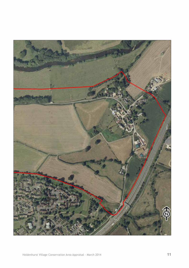
4.1 The village is located to the north-east of the Borough of Bournemouth, amid flat agricultural land, approximately 3 miles from the town centre. The Conservation Area abuts the boundary with the Borough of Christchurch, with the north-east tip of the village (encompassing Wood Farm) falling within the Borough of Christchurch.
4.2 The Conservation Area covers an area of approximately 53.13 hectares and is dominated by agricultural land, with two clusters of development to the east and west. These two clusters are approximately ½ mile apart as evident in the aerial photo overleaf (Figure 3).
4.3 Just beyond the western boundary of the Conservation Area (along Throop Road) lies the Throop and Muccleshell Village Conservation Area. Throop and Muccleshell were originally attendant hamlets to Holdenhurst and also have Saxon origins.
4.4 The Conservation Area lies within part of the South East Dorset green belt that forms a narrow strip to the northern edge of Bournemouth. The River Stour itself lies to the north of the Conservation Area.
General Character and Plan Form
4.5 The Conservation Area is rural in nature and is characterised by residential and agricultural buildings surrounded by agricultural land. Holdenhurst is a small settlement containing a total of 45 dwellings, along with a church, village hall and several agricultural barns/sheds. The age of buildings in the Conservation Area spans a considerable period of time and is reflected in the unique architectural style of each of the historic properties.
4.6 The Conservation Area features traditional buildings of which the residential buildings are principally small scale semi-detached or terraced properties, however, there are a few examples of small historic cottages and barn conversions that are detached. The non-residential buildings (church, village hall, agricultural buildings) are all detached.
4.7 The form of the Conservation Area has been established by physical constraints, administrative and road boundaries. The Conservation Area incorporates the length of Holdenhurst Village Road and this curving line partly gives the Conservation Area its linear form; taking in the two residential clusters and the expanse of fields in between.
4.8 The plot sizes vary but are on the whole relatively generous. The historic terrace cottages lie within the smallest plots, having rather narrow rear gardens. The village has evolved organically and several of the dwellings constructed in the last century replaced thatched cottages or farm buildings that had fallen into disrepair. In general these replacement dwellings are within good sized plots.
4.9 The eastern cluster of residential properties reflects the pattern of a medieval village with a cluster of agricultural dwellings forming a nucleated settlement surrounded by open fields. In many English villages the traditional cottages surrounded a village green and contained a church and ancient manor house. Holdenhurst encompasses all these elements apart from a manor house.
4.10 The properties in the Conservation Area are listed in Appendix 1.
4 Location and Setting

Holdenhurst Village Conservation Area Appraisal - March 201410
Figure 3 - Aerial View of the Conservation Area
Holdenhurst Village Conservation Area Appraisal - March 2014 11
Holdenhurst Village Conservation Area Appraisal - March 201412
5 Historic Development and Archaeology
Origins and Historic Development
5.1 Historically much of the land between Poole and Christchurch was covered by a heathland of gorse, ferns and heather. It was also dotted with remains of the area’s rich prehistoric past, but uninhabited apart from the occasional village or hamlet such as Holdenhurst, Throop, Kinson and Iford along the fertile valley of the River Stour.
5.2 It is the location of Holdenhurst, on the edge of the flood plain of the Stour, close to a crossing point, and bounded by heath to the west, that made it an ideal spot for early settlers. The large number of archaeological finds in the Bournemouth area, suggest that Holdenhurst was occupied from the prehistoric era onwards.
5.3 It is also likely that the Romans settled or passed by the area as Roman coins have been found in Holdenhurst. A hoard was found buried in a vessel in 1911.
5.4 At the time of the Domesday survey (1086) Holdenhurst was known as ‘Holeest’ meaning ‘holly copse’. The survey reveals that Holdenhurst had a chapel, a mill, 181 acres of meadow and three fisheries supplying a substantial hall. The number of fisheries and the extent of the meadows was large and, prior to the building of the Priory in Christchurch (then Twynham) in 1094, Holdenhurst would have been more important than the neighbouring Saxon Port of Twynham. The decline of Holdenhurst from its importance in the Domesday period is reflected in a lack of later expansion of the village.
5.5 The administrative history of
Holdenhurst is complicated as it moves in and out of crown ownership, and that of the Manor of Christchurch (of which Holdenhurst became a part). It passed regularly between absentee landlords who paid it little attention and consequently Holdenhurst developed slowly as a nucleated settlement according to the needs of the tenant farmers.
5.6 Historically the Holdenhurst area was a part of the ‘Liberty of Westover’ (possibly derived from being ‘west of the Stour’), as the 1791 map in Figure 4 demonstrates. The Liberty of Westover was divided into six tythings: Muscliff, Muccleshell, Throop, Iford, Tuckton and Wick and Holdenhurst. Holdenhurst tything covered a much larger area than the village as we know it today.
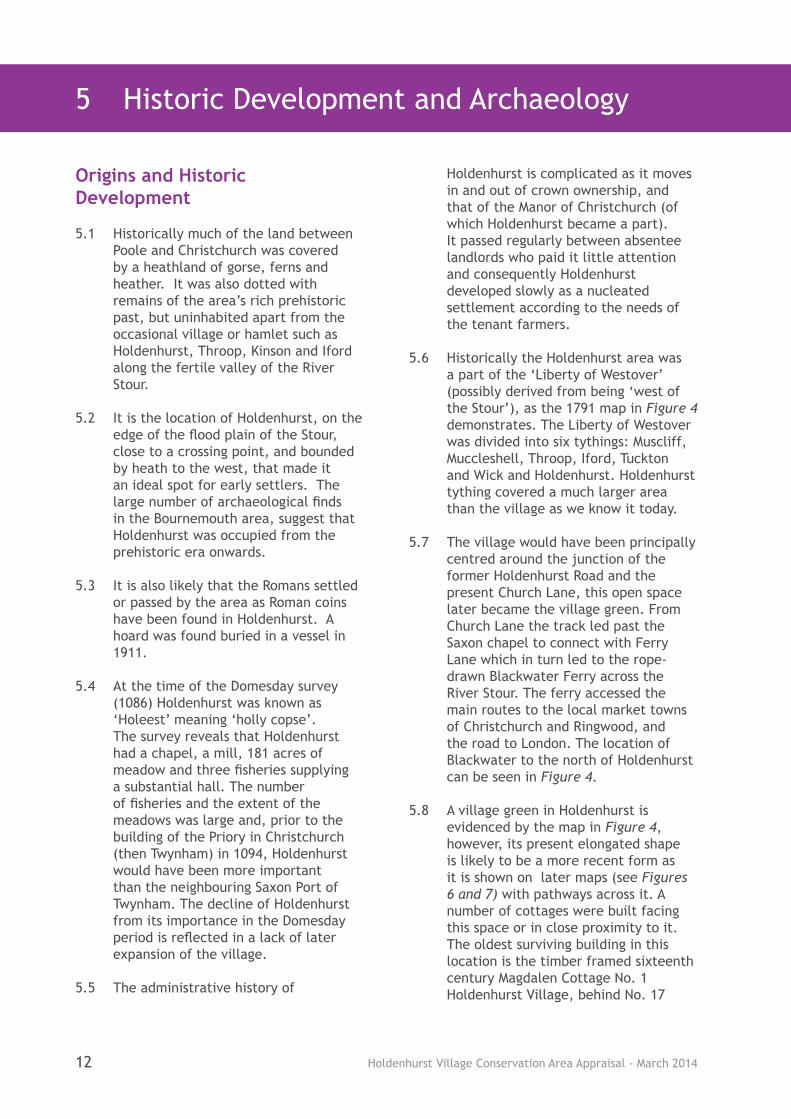
5.7 The village would have been principally centred around the junction of the former Holdenhurst Road and the present Church Lane, this open space later became the village green. From Church Lane the track led past the Saxon chapel to connect with Ferry Lane which in turn led to the rope-drawn Blackwater Ferry across the River Stour. The ferry accessed the main routes to the local market towns of Christchurch and Ringwood, and the road to London. The location of Blackwater to the north of Holdenhurst can be seen in Figure 4.
5.8 A village green in Holdenhurst is evidenced by the map in Figure 4, however, its present elongated shape is likely to be a more recent form as it is shown on later maps (see Figures 6 and 7) with pathways across it. A number of cottages were built facing this space or in close proximity to it. The oldest surviving building in this location is the timber framed sixteenth century Magdalen Cottage No. 1 Holdenhurst Village, behind No. 17
Holdenhurst Village Conservation Area Appraisal - March 2014 13
Holdenhurst Village. Of the surviving early dwellings around the village green, No. 17 and The New House (No. 16 Holdenhurst Village) of the 1600s stand prominently to the north of the green and the thatched cottage Holly Hurst, No. 20 Holdenhurst Village of the 1800s stands to the west of the green.
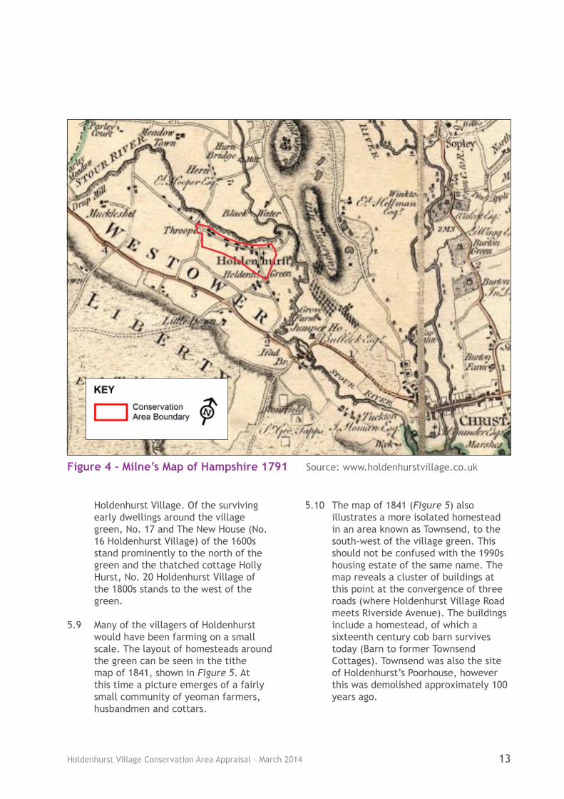
5.9 Many of the villagers of Holdenhurst would have been farming on a small scale. The layout of homesteads around the green can be seen in the tithe map of 1841, shown in Figure 5. At this time a picture emerges of a fairly small community of yeoman farmers, husbandmen and cottars.
5.10 The map of 1841 (Figure 5) also illustrates a more isolated homestead in an area known as Townsend, to the south-west of the village green. This should not be confused with the 1990s housing estate of the same name. The map reveals a cluster of buildings at this point at the convergence of three roads (where Holdenhurst Village Road meets Riverside Avenue). The buildings include a homestead, of which a sixteenth century cob barn survives today (Barn to former Townsend Cottages). Townsend was also the site of Holdenhurst’s Poorhouse, however this was demolished approximately 100 years ago.
Figure 4 - Milne’s Map of Hampshire 1791 Source: www.holdenhurstvillage.co.uk
Holdenhurst Village Conservation Area Appraisal - March 201414
Figu
re 5
- C
opy
of t
he T
ithe
Map
(18
41)
of t
he E
aste
rn p
art
of H
olde
nhur
st
Cons
erva
tion
Are
a Bo
unda
ry
Loca
tion
of
hom
este
ads
N

Holdenhurst Village Conservation Area Appraisal - March 2014 15
5.11 Prior to the Inclosure Act (1802) Holdenhurst would have had an open field system divided into strips of arable and pastoral land. However, the Inclosure Act resulted in heathland surrounding Holdenhurst which was previously open to common access being parcelled up by appointed commissioners and sold to several local landowners. The enclosure of the fields
encouraged speculative development on the heathland, ultimately resulting in the development of Bournemouth and the shrinking of Holdenhurst.
5.12 A significant portion of the land in and around Holdenhurst was bought at this time by William Dean, a descendant of the Yeoman farmers of Holdenhurst. The Dean family built Littledown House and until the death of Alice Ellen Cooper-Dean in the 1980s, the direct descendants of the family continued to manage their land holdings in the Bournemouth area. Today this is managed by the Trustees of the Alice Ellen Cooper-Dean Charitable Foundation and a large portion of the land within the Conservation Area remains with their control.
5.13 Throughout the eighteenth and nineteenth centuries the village appears to have developed organically with new buildings added when required, as opposed to the fashion for estate villages at this time.
5.14 A significant number of the existing buildings in Holdenhurst date from the period 1800-1900, particularly in the western residential pocket. During this period The River Barn and The Old Dairy appeared, along with the Village School (now known as The Old School) and School House (1840), Vicarage Cottages (1867) and the Vicarage (now known as The Old Vicarage) (1883).
5.15 To the eastern part of Holdenhurst
a number of dwellings and barns were also constructed during this period. Hockeys Barn and Manor Farm Barn (extended in the 1990s) were built, along with Rose Cottage, Bramble Cottage and Nos. 21 and 22 Holdenhurst Village.
5.16 In the nineteenth century (1800-1900) a new church was constructed as the population of the village far exceeded the capacity of the Saxon chapel. In 1834 a new church for Holdenhurst was opened, close to the old chapel (reusing some of the materials of the chapel in it’s construction). The site of the Saxon chapel is marked by a commemorative stone with an inscription.
5.17 Whilst Holdenhurst remained an agricultural based settlement, as neighbouring Bournemouth grew so did the opportunities for villagers within the building trade. In the mid nineteenth century Holdenhurst housed many bricklayers, carpenters and general labourers, as well as those involved with service and cottage industries such as laundry, dressmaking and glove knitting.
5.18 In the nineteenth century the village was linked to Townsend to the south and Throop to the west. It was once described as ‘one long winding street
Commemorative Stone to Saxon Chapel

Holdenhurst Village Conservation Area Appraisal - March 201416
Figu
re 6
- M
ap o
f H
olde
nhur
st in
187
0

Holdenhurst Village Conservation Area Appraisal - March 2014 17
of thatched cottages adorned with umbrageous elms’ (Chilver, 1980 p61). The linear pattern of the village along the road between Townsend and Throop can be seen in the map of 1870 (Figure 6). At this time the main village consisted of dwellinghouses, farm buildings, an inn and a church; and to the west a pocket of development consisting of a terrace of cottages, a smithy, school, school house and some farm buildings.
5.19 The agricultural depression of the nineteenth century would have impacted upon many of the yeoman farmers of Holdenhurst. Whilst the agrarian pattern of land use continued into the twentieth century, the decline and subsequent replacement of farms with residential dwellings slowly brought about changes throughout the century. This is reflected in the character of the village, with a move away from a farming community towards a semi-rural residential area.
5.20 Looking at the map of Holdenhurst in 1924 (Figure 7) it can be seen that expansion has occurred principally to the western residential pocket. At the entrance to the driveway of Hurn Court a lodge has appeared (marked as P.O. on the map [post office], but now known as South Lodge). A Vicarage and 2 pairs of semi-detached cottages (1-4 Throop Rd) have been built, but conversely buildings have disappeared from the site next to The Old Dairy to the north-west tip of the Conservation Area. To the east, the only obvious changes are the replacement of the original thatched Elm Cottages with the current terrace and the addition of a hall (now known as The Old Billiard Room) next to Holly Hurst (No. 20 Holdenhurst Village).
5.21 Having passed through many changes of owner and administrative
districts, Holdenhurst was eventually incorporated into Bournemouth in 1931, when it fell under the control of Bournemouth Borough Council. The village fell within the county of Hampshire at this time, although this would later change to Dorset under the reorganisation of local government in the 1970s. It seems that in the hundred or so years it took for the town of Bournemouth to develop from a fledgling watering hole to a fashionable seaside resort, Holdenhurst had effectively disappeared, swallowed up by the town’s expansion. Indeed this led to one observer describing Bournemouth as ‘the monstrous child that Holdenhurst sired!’ (Fry, 1971).
5.22 In the 1940s and 1950s the agricultural land around Holdenhurst was under serious threat with the need for roads and housing around north Bournemouth. Opposing the destruction of the historic fabric of England’s towns at this time were some early moves towards conservation. In 1952 St John’s Church and Nos. 16 (The New House) and 17 Holdenhurst Village became some of the first buildings in Bournemouth to be listed.
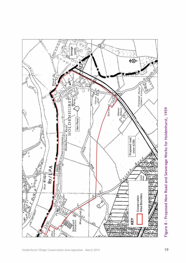
5.23 In the 1950s a new road and a sewage works were proposed next to the eastern residential area. When these were built in the 1960s this development, particularly the road, had a major impact upon Holdenhurst, as Figure 8 demonstrates.
5.24 The new road (A338) severed the road from Bournemouth to Holdenhurst at Townsend. This cut off the through route from Littledown resulting in the only vehicle access to the properties in Holdenhurst Village being via Throop Road to the west of Holdenhurst. The loss of the through route to Holdenhurst left the settlement as a terminal village, destroying some of

Holdenhurst Village Conservation Area Appraisal - March 201418
Figu
re 7
- M
ap o
f H
olde
nhur
st in
192
4
Holdenhurst Village Conservation Area Appraisal - March 2014 19
Figu
re 8
- P
ropo
sed
New
Roa
d an
d Se
wer
age
Wor
ks f
or H
olde
nhur
st,
1959
Sew
age
wor
ksH
en P
ond
Prop
osed
roa
d (n
ow A
338)
Holdenhurst Village Conservation Area Appraisal - March 201420
the historical association of the area.
5.25 Figure 8 not only demonstrates the impact of the new road on the landscape, but also illustrates properties that have been built since this time to the eastern part of the village, and those which have been lost. The western part of the settlement remained unchanged at this time, but to the east a number of building recognisable today have been built, the Village Hall and Nos. 24 and 25 Holdenhurst Village (in place of the old Dairyman’s Cottage at Manor Farm).
5.26 In the 1970s local authorities were given a duty to designate Conservation Areas and the properties within Holdenhurst and the setting of the village were duly given some protection under the designation of the original Holdenhurst East and Holdenhurst West Conservation Areas.
5.27 Further protection for the setting of the village came with the establishment of the South East Dorset Green Belt which includes the whole of the Conservation Area within it.
5.28 Since its designation the Conservation Area has continued to change. In the 1980s a new dwelling, No. 18, was
built on the site of Nos. 18 and 19 Holdenhurst Village. In the 1990s a trio of listed cottages that were in poor condition were repaired, extended and converted into two dwellings (Nos. 21 and 22 Holdenhurst Village). Also several barns were converted to dwellings (The River Barn, The Old Dairy and Hockeys Barn). At this time a small infill development to an area known as Manor Farm (eastern part of Holdenhurst) was constructed to provide additional housing in place of several redundant agricultural barns/sheds.
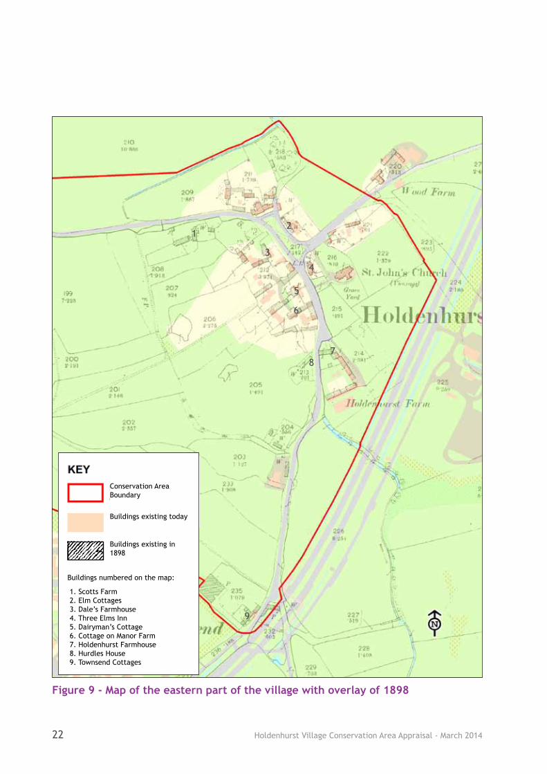
5.29 During the twentieth century several of the historic thatched cottages and agricultural buildings were demolished to the eastern half of the village. Figure 9 illustrates part of the village today with an overlay of 1898 to highlight the cottages and agricultural buildings that have been demolished since this time, Figure 10 contains photographs of examples of the lost cottages.
5.30 As Bournemouth has expanded, Holdenhurst has gradually lost some of the essential characteristics of a village such as its independence. For example
the post office and bus service. Today the village is supported by the
The Village Green in 1973

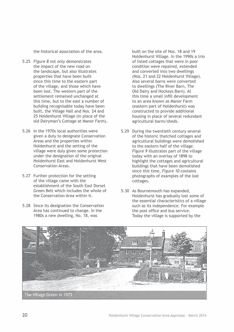
Holdenhurst Village Conservation Area Appraisal - March 2014 21
neighbouring services on the northern fringes of Bournemouth.
Activity and Uses
5.31 The aerial photo (Figure 3) shows there is some variation in the land use today across the eastern and western parts of the village. To the western part the land use is dominated by residential curtilages with only a cluster of small fields (which appear to be used as paddocks). The section of land connecting the two residential areas of the village contains a narrow strip of woodland, South Lodge, Longbarrow Allotments, several fields and the road itself. To the east agricultural land surrounds the residential heart of the village, with the only other land uses being the religious site of St Johns Church and the community facility of the village hall.
5.32 The overwhelming activities in the Conservation Area are residential and agricultural. Many of the former farm buildings that survive have been converted into residential accommodation. Where once there were many small farms now only the agricultural buildings of the former Holdenhurst Farm are in agricultural use.
5.33 The earliest buildings in the Conservation Area are the timber framed Magdalen Cottage (No. 1 Holdenhurst Village) and the cob barn to the former Townsend Cottages. Magdalen Cottage gets its name from ancient links to the Magdalen Charity that ran the leper hospital at Christchurch and rented out the cottage to help fund the hospital. The cottage would have originally been very small and despite a nineteenth century extension, being single storey it is still on a smaller scale than most of the properties in the Conservation Area.
5.34 Agriculture has been one of the biggest influences on the plan form of Holdenhurst. The farmsteads that once surrounded the village green (shown in the Tithe map Figure 5) have long gone. Modern buildings now sit in the place of former farmhouses (such as No. 18 Holdenhurst Village) and the large gardens of some of the Manor Farm development are made up of the former agricultural plots of the farmsteads.
5.35 Many of the yeomen farmers in Holdenhurst would have kept animals and at one time a village pound to enclose stray animals was in use. The site of the old village pound is shown on old maps in Church Lane close to Wood Farm, see Figure 6.
5.36 The past use of the land for farming was assisted by ponds and drainage ditches across the eastern part of the village. Some of the old wayside rills (small streams) that ran in front of the cottages on the green can still be identified by ditches. The site of one of the old ponds, ‘hen pond’ is identifiable on the ground in the garden of Manor Farm Barn (see Figure 8). The importance of the watery landscape which once assisted the community of Holdenhurst is also identified in paragraphs 5.41 and 10.7.
5.37 Whilst the majority of the buildings are currently in residential use, several dwellings are conversions of properties built for another purpose. The former village school, smithy and several of the barns have changed use to residences. In general the village has suffered the loss of a number of services in recent years, such as the post office, vicarage, bus service and telephone box.
Holdenhurst Village Conservation Area Appraisal - March 201422
12
3
4
5
6
78
9
Figure 9 - Map of the eastern part of the village with overlay of 1898
Buildings numbered on the map:
1. Scotts Farm 2. Elm Cottages 3. Dale’s Farmhouse 4. Three Elms Inn 5. Dairyman’s Cottage 6. Cottage on Manor Farm 7. Holdenhurst Farmhouse 8. Hurdles House 9. Townsend Cottages
Buildings existing today
Buildings existing in 1898
Conservation Area Boundary

Holdenhurst Village Conservation Area Appraisal - March 2014 23
1. Scotts Farm
9. Townsend Cottages
2. The Original Elm CottagesSource: Bournemouth Then & Now (1978)
7. Holdenhurst Farmhouse
8. Hurdles House (left) and 7. Holdenhurst Farmhouse [rear](right) Source: www.holdenhurstvillage.co.uk
Figure 10 - Examples of demolished cottages across the eastern part of the village

Holdenhurst Village Conservation Area Appraisal - March 201424
Archaeology
5.38 Links to prehistoric activity in the area around Holdenhurst has been uncovered in the past with the discovery of a long barrow to the south in 1926, on what is now Barrow Road (approximately 460m SSW of the southern corner of the Longbarrow Allotments, see Figure 11). Originally 90m long, the barrow was destroyed during the construction of a housing estate in the 1930s. However, it was the subject of a rescue excavation January 1936, when Neolithic inhumations as well as Neolithic and Bronze Age pottery were uncovered.
5.39 There is also evidence of Roman activity in the area with an archaeological find of coins of this
date. The hoard was found west of the present village hall, approximately 170m away (see Figure 11).
5.40 There is likely to be undiscovered archaeology in the fields surrounding the village, being a settlement that dates back to Saxon times, within an area that has been inhabited since prehistoric times.
5.41 The site of the old hen pond (in the garden of the Manor Farm Barn, as shown in Figure 8) is clearly shown on historic maps and although now drained it is marked in the landscape by a clump of trees and vegetation. It is possible that the site of this pond is a remnant of the fisheries mentioned in the Domesday Survey.
Figure 11 - Map of Archaeological Finds
●
Coin Find
Site of Longbarrow
Site of Hen Pond
Conservation Area Boundary

Holdenhurst Village Conservation Area Appraisal - March 2014 25
Relationship of Spaces
6.1 The Conservation Area is characterised by the grouping of historic buildings within an agricultural landscape. This arises in part from the continued agricultural base of the settlement and the remaining isolation from the town of Bournemouth through physical distance, land use and in recent years the protection of the open landscape through green belt policy.
6.2 Despite some recent infilling and the conversion of several buildings to residential use, the spaciousness and rural character of Holdenhurst is still evident. The sense of spaciousness across the Conservation Area is derived from the expanse of fields, the clusters of trees and the seclusion of the buildings. This openness allows significant views towards properties, adding to the visual prominence of several of the dwellings and farm buildings.
6.3 A key gap within the Conservation Area is the space between the two residential clusters of properties. This parcel of land contributes to the Conservation Area by virtue of its openness and verdant land use incorporating arable crop growing, mature trees and hedgerows.
6.4 The village green forms an important open public space. The grass of the green is bounded by low timber posts to designate the communal open area from the highway. This space is significant not only for its visual contribution to the eastern part of the village but as evidence of the evolution of the original pattern of development as a traditional English agricultural based village.
6.5 The plots sizes are principally generous in size and many dwellings have large gardens. The gardens are important as the vegetation in them contributes to the greenery of the settlement. In addition, the space between the buildings allows for views from the street between properties.
Key Views and Vistas
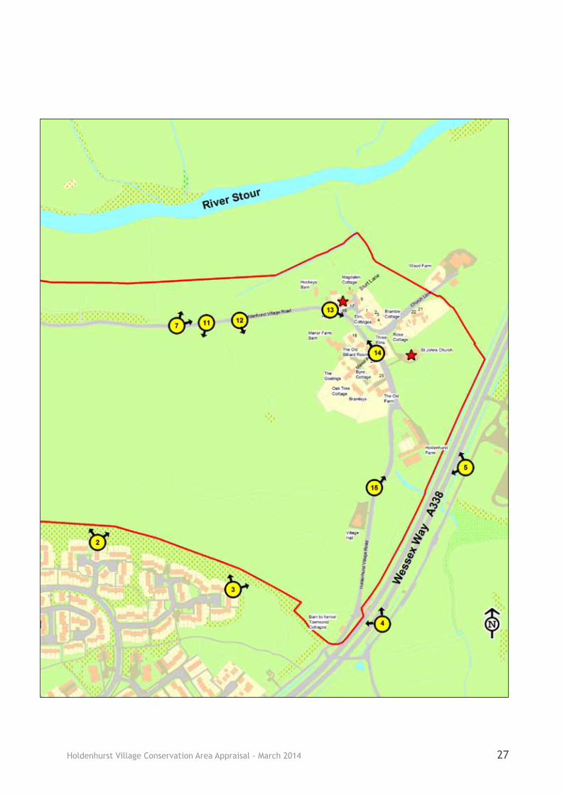
6.6 In addition to the general street scene views there are several important views into, out of and within the Holdenhurst Conservation Area, as Figure 12 demonstrates.
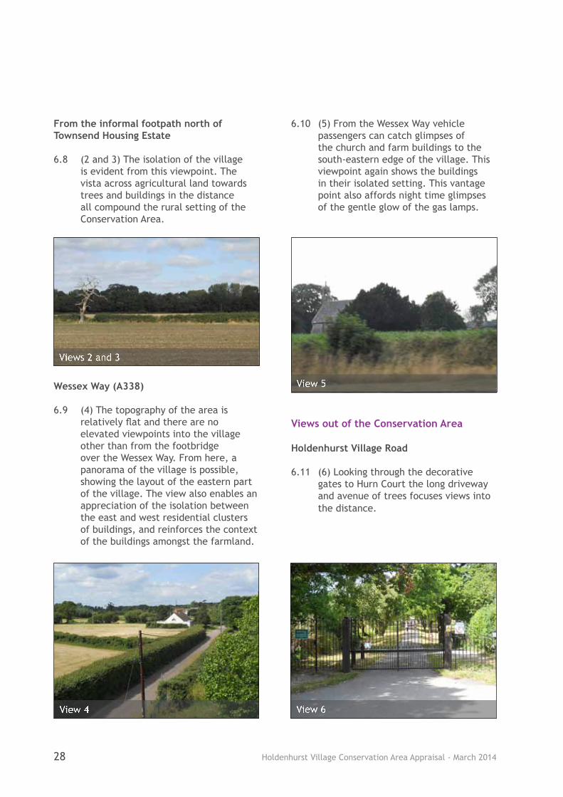
Views into the Conservation Area Throop Road
6.7 (1) On leaving the suburbs of north Bournemouth a transition point is reached between the urban area and a rural scene. The road narrows, the pavement disappears and the road becomes lined by trees and hedges.
6 Spatial Anaylsis
View 1

Holdenhurst Village Conservation Area Appraisal - March 201426
Figure 12 - Key Views and Vistas
Holdenhurst Village Conservation Area Appraisal - March 2014 27
Holdenhurst Village Conservation Area Appraisal - March 201428
From the informal footpath north of Townsend Housing Estate
6.8 (2 and 3) The isolation of the village is evident from this viewpoint. The vista across agricultural land towards trees and buildings in the distance all compound the rural setting of the Conservation Area.
Wessex Way (A338)
6.9 (4) The topography of the area is relatively flat and there are no elevated viewpoints into the village other than from the footbridge over the Wessex Way. From here, a panorama of the village is possible, showing the layout of the eastern part of the village. The view also enables an appreciation of the isolation between the east and west residential clusters of buildings, and reinforces the context of the buildings amongst the farmland.
6.10 (5) From the Wessex Way vehicle passengers can catch glimpses of the church and farm buildings to the south-eastern edge of the village. This viewpoint again shows the buildings in their isolated setting. This vantage point also affords night time glimpses of the gentle glow of the gas lamps.
Views out of the Conservation Area
Holdenhurst Village Road
6.11 (6) Looking through the decorative gates to Hurn Court the long driveway and avenue of trees focuses views into the distance.
Views 2 and 3
View 4 View 6
View 5
Holdenhurst Village Conservation Area Appraisal - March 2014 29
6.12 (7) The floodplain of the Stour is evident to the north of the Conservation Area. The River Stour itself is not visible, but the land is different in appearance to the surrounding farmland by virtue of being flat and low lying.
Views within the Conservation Area
Throop Road
6.13 (8) A view of a historic gas lamp and a pair of semi-detached cottages (Stockwell Cottage and Springfield) is the first glimpse of the village and sets the historic context for the Conservation Area.
6.14 (9) There are sufficient trees in the village to create a funnelling effect in places. On Throop Road the eye is drawn towards the pretty cottage, with the white of The Old Forge (No. 14 Holdenhurst Village) standing out against the green of the trees.
Holdenhurst Village Road
6.15 (10) The view below of Vicarage Cottages characterises the Conservation Area; pretty cottages set amongst greenery that line the village road.
View 7
View 8
View 9
View 10
Holdenhurst Village Conservation Area Appraisal - March 201430
6.16 (11) Along Holdenhurst Village Road views across fields in the direction of Bournemouth adds to a sense of separation of the village.
6.17 (12) On approach to the eastern part of the village the rooftops of the Manor Farm development are visible above the hedgerows. The palette of materials used helps the buildings to blend into the environment.
6.18 (13) As you reach The New House (No. 16 Holdenhurst Village) the road opens out to give a view of the village green. The green is bounded by cottages and hedging and the whole scene adds to a sense of arrival at this point.
6.19 (14) The village green contributes to the character of the Conservation Area by adding to the sense of a rural location. Not only does it create a focal point for the village but it enhances the setting of the listed buildings and gives an impression of continuity in the landscape, with the village retaining its historic form.
View 11
View 12
View 13
View 14

Holdenhurst Village Conservation Area Appraisal - March 2014 31
6.20 (15) Views of the original farm buildings reinforce the rural nature of the Conservation Area, both those in agricultural use at Holdenhurst Farm and those converted to dwellings.
Landmarks
6.21 St John’s Church is a noticeable landmark building within the village as its scale, height and materials set it apart from the brick built buildings that characterise the village. The church can be seen from various vantage points both within and outside of the Conservation Area.
6.22 No. 17 Holdenhurst Village and The New House (No. 16 Holdenhurst Village) on the village green are landmarks within the eastern half of Holdenhurst. The buildings are prominently sited on the green and are highly visible on approach from the south. They are a backdrop to the open space of the green and although the buildings are not as tall as the church, their scale is large within the village and they are distinctive within Holdenhurst. The dwellings can be seen in View 14 on the adjacent page.
View 15
St John’s Church
Holdenhurst Village Conservation Area Appraisal - March 201432
7 Character Analysis
Definition of Character Areas 7.1 In terms of its built form the overall
character and appearance of the area is defined by the various phases and forms of development which occurred through its evolution. From its origins as an agricultural based village dating back to the Domesday period, to Victorian additions in the nineteenth century and a number of replacement buildings across the twentieth century.
7.2 Development has tended to be gradual and piecemeal in nature. This has meant that as the area evolved over time the buildings represented by the various periods and forms of development are generally spread throughout the Conservation Area, either isolated or located together in small groups of similar aged buildings.
7.3 Geographically the village is split into two residential pockets. However, the land use, building type and historic origins are interlinked to such a degree that these have not been separated out in the assessment of the character of the Conservation Area.
7.4 There is a clear distinction between the built up character of the buildings and their softer landscape surroundings. The character and importance of the vegetation and green spaces is considered in detail in the following paragraphs, 7.44-7.55.
Architectural and Historic Qualities of the Buildings
7.5 Although the buildings are of unique designs they reflect the materials, styles and techniques of the periods in which they were built. Across the Conservation Area the architecture of the buildings is principally reflective of vernacular techniques in the local
tradition of the pre 1800s buildings, through to the more standard design and machine made brick of the nineteenth (1800s) and twentieth century (1900s).
Vernacular Techniques - pre 1800s
7.6 Vernacular architecture is used in this instance to represent buildings constructed using locally sourced materials and following traditional building practices. The use of thatch is an example of a vernacular material and the original thatched cottages of the village would have been roofed using locally grown straw and utilising local craftsmanship. Early vernacular buildings in Holdenhurst would have been of timber framed or of cob walled construction, although few examples survive. In the seventeenth century hand-made bricks would have started to replace the ancient cob and timber frame construction techniques.
Nineteenth Century - 1800s
7.7 With advances in technology, improved transportation links and the mass production of materials resulting in cheaper building materials, later properties such as School House (1840) would have been built of standard materials such as factory produced brick and to a more standard design.
7.8 The Victorian era (1837-1901) is renowned for its variety of architectural styles, but in Holdenhurst a simple style in keeping with the small scale dwellings prevails. The main exception to the simple styling is the former vicarage which is very much reflective of the late Victorian period and incorporates a number of characteristic architectural features such as bay windows and decorative roof tiles.
Holdenhurst Village Conservation Area Appraisal - March 2014 33
Twentieth Century - 1900s
7.9 Whilst some European architects were experimenting with new materials and construction techniques, in the early part of the twentieth century Britain’s domestic architecture was influenced by a more backwards looking architectural tradition. Cottages, such as South Lodge (early 1920s), are reflective of the Arts and Craft movement, a style that reflects earlier vernacular traditions, utilising features such as heavy chimney stacks and sweeping catslide roofs.
7.10 The interwar period (1920s and 1930s) was also influenced by the Art Deco style of the Modern Movement. This architecture with its bold shapes and smooth surfaces was usually associated with the leisure and entertainment industry. However, it did filter down to influence the design of more modest buildings including domestic dwellings. The Village Hall in Holdenhurst dates from this period.
7.11 In the immediate post second world war period there was a great demand for new dwellings and a focus was placed on fast construction techniques that could mass produce housing quickly with less emphasis on architecture detailing. A shift from private individuals towards mass produced local authority housing was also seen at this time. Properties of this period such as Nos. 24 and 25 Holdenhurst Village reflect the slightly plainer architecture detailing of the post war period.
7.12 In more recent years architecture in the village has tended to reflect earlier styles but in a less exuberant way. For example, Bramleys (to the Manor Farm development) utilises a mix of past styles and materials associated with older dwellings (i.e. thatch) to add
interest to the building.
Local Qualities
7.13 Holdenhurst contains a number of buildings of architectural merit (both listed and unlisted). These buildings contain a mixed palette of traditional materials including several examples of thatch roofing. As well as the materials used, the architectural detailing (for example the fine decorated windows to the church and the use of decorative door porches to dwellings) all adds visual interest contributing a richness to the character of Holdenhurst.
Roof Coverings
7.14 Dorset thatch has a style that is distinct from that of many other counties. A lot like Hampshire thatch roofing, typically Dorset thatch is very plain with little or no ornamentation to the ridge (as illustrated by Holly Hurst, No. 20 Holdenhurst Village; No. 17 Holdenhurst Village; and Magdalen Cottage, No. 1 Holdenhurst Village). The normal practice of thatching in Dorset is to re-coat the roof, this means that many historic properties have an important series of layers of thatched material.
Thatch Roof of Holly Hurst, No. 20 Holdenhurst Village
Holdenhurst Village Conservation Area Appraisal - March 201434
7.15 Thatch is a vernacular material and historically would have been locally sourced. However, over the last 40 years or so imports of water reed have been used instead of the produce of local farmers. Longstraw thatch was once perhaps the most widely used material across the country, with the other main technique being combed water reed. Changes in material results in a noticeable change in appearance of thatched roofs.
7.16 Other traditional roof finishes include stone slate (as at St John’s Church), natural grey slate and plain red clay tiles. A couple of the Victorian properties with tiled rather than slate roofs utilise decorative fish scale tiling, this can be seen on The Old Vicarage and The Coach House. Ridge tiles across the Conservation Area are plain rather than decorative.
Roof Form
7.17 Whilst there are similarities, no two houses or terraces of dwellings are completely alike in Holdenhurst. The general roof form is either hipped or gabled and these two forms are evident in both the more historic and more recent dwellings. It is also noted that of the nineteenth century buildings there are both hipped and gabled examples, such as The Old School and School House. Roof pitches vary according to the roofing material used. The slate roofs are shallow pitched, whilst the tiled and thatched roofs are more steeply pitched.
7.18 A number of properties incorporate exposed rafters with decorative timber rafter feet to the eaves; this can be seen at Springfield and Stockwell Cottage, Vicarage Cottages, The Old Vicarage, South Lodge, School House and No. 5 Holdenhurst Village. Decorative brick eaves are
characteristic of a few properties in the Conservation Area, including The Old Forge, No. 14 Holdenhurst Village; The New House, No. 16 Holdenhurst Village; and The Old School. A slight overhang of the roof to the eaves is also characteristic of the thatched dwellings and those with a slate roof covering. The tiled roofs don’t tend to have an overhang, although South Lodge is a clear exception with its overhanging eaves to the gables.
Chimneys
7.19 The majority of chimney stacks remain, adding interest to the skyline within the Conservation Area. Most chimney stacks are simple with painted brick or render to match in with the property, however, there are some interesting examples of decorative brick stacks such as the tall angled stacks at South Lodge. The majority of chimney stacks also retain their (clay) chimney pots.
Walling
7.20 The earliest buildings in the Conservation Area are rare survivors in Bournemouth of their construction type. The barn of the former Townsend Cottages utilises the early building method of clay mixed with straw, gravel and sand (known as cob). Magdalen Cottage (No. 1 Holdenhurst Village) is of another ancient building method - timber frame construction (with later brick infilling).
7.21 Nos. 21 and 22 Holdenhurst Village are unusual (and important) in that the cottages incorporate materials from the Saxon church that originally stood on this site. Originally three cottages, they are windowless to the north, west and east sides, and are of random ironstone.

Holdenhurst Village Conservation Area Appraisal - March 2014 35
7.22 The predominant construction material in the Conservation Area is brick. From the ancient hand made bricks of No. 17 Holdenhurst Village to the recent brick buildings of the Manor Farm development. Whilst a few properties are rendered or painted, exposed brick is characteristic of the village. Apart from the yellow buff brick of Bramble Cottage, Oak Tree Cottage, The Three Elms, The River Barn and The Old Dairy, the predominant brickwork colour is red.
7.23 The brickwork bond across the Conservation Area varies, however there are similarities relating to the age and type of building. The predominant bond is Stretcher Bond and is principally visible on the nineteenth and twentieth century dwellings, although the barns and the oldest dwelling utilise Flemish, Header, English and English Garden Wall Bond.
7.24 A number of properties utilise simple brick dressings as a decorative feature. The most common is the use of brick headers above the windows, this is illustrated by both agricultural and domestic buildings. Brick headers are also featured on dwellings across the age range and can be seen at both The New House, No. 16 Holdenhurst Village of the 1700s and Nos. 24 and 25 Holdenhurst Village of the 1940s.
7.25 Decorative gabled kneelers are characteristic of a handful of properties, principally twentieth century dwellings rather than historic buildings. Brick gabled kneelers can be seen at The New House and at Springfield and Stockwell Cottage, the Three Elms and No. 18 Holdenhurst Village. Decorative stone gabled kneelers can be seen at St John’s Church.
Windows
7.26 The characteristic window framing material in the Conservation Area is timber. There is some variation in window design across the different ages and types of properties although the predominant design is outward opening casements with plain glazing or leaded lights. Windows are a key characteristic of a building and where original windows are lost this can detract from the building’s appearance.
7.27 Historically glass was an expensive material and large panes were costly and difficult to produce. The oldest properties in the Conservation Area have windows with small panes of glass set within leaded divisions (leaded lights). This is illustrated by the (outward opening) casements at Magdalen Cottage (No.1 Holdenhurst Village), No. 17 Holdenhurst Village), The New House (No. 16 Holdenhurst Village) and The Old Forge (No. 14 Holdenhurst Village).
Contrasting brickwork of Header Bond of The New House, no 16 Holdenhurst Village (left) and the English Bond of No. 17 (right)
Walling of Saxon church incorporated into Nos. 21 and 22 Holdenhurst Village
Holdenhurst Village Conservation Area Appraisal - March 201436
7.28 An exception to the casement windows across the Conservation Area are the few examples of nineteenth century sash windows. These utilise slender glazing bars to divide the panes of glass and incorporate decorative horns and this can be seen at The Old Vicarage, School House and Rose Cottage. The Three Elms of the 1960s also benefits from attractive timber framed sash windows with slender glazing bars.
7.29 Particularly interesting windows can be seen at St John’s Church. The decorative stained glass windows depict agricultural scenes, which add to the rural feel of the Conservation Area.
Entrances and Porches
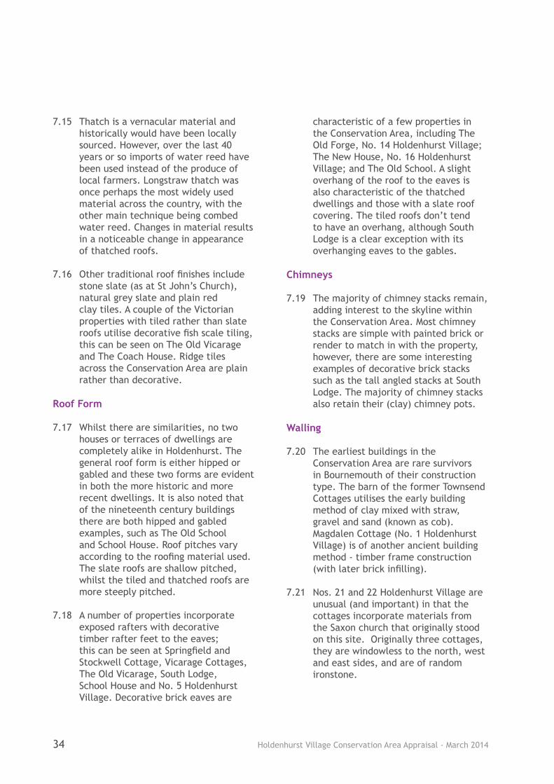
7.30 Entrances are important architectural features of the properties within Holdenhurst Village. The majority of dwellings in the Conservation Area benefit from some sort of entrance porch. Tiled or slated door canopies in particular are a characteristic feature and serve to emphasise the importance of the home entrance as a key feature of the dwellings. There are many examples within the Conservation Area such as the projecting canopies at No. 17 Holdenhurst Village (below), The New House (No. 16), Holly Hurst (No. 20), Elm Cottages and The Three Elms.
7.31 Doorway treatments within the Conservation Area include fully enclosed porches (The Old Billiard Room, The Old School, Nos. 24 and 25 Holdenhurst Village and The Coach House), open sided porches with timber framing or timber brackets (The Old Forge, Manor Farm Barn, The River Barn, Hockeys Barn, Bramleys, The Goslings), as well as recessed entrances (the Village Hall, No.18 Holdenhurst Village).
Doors
7.32 Painted timber panelled or tongue and groove front doors are characteristic of the Conservation Area. Doors are generally solid, although there are a few examples of glazing within the door (very small panes to older properties).
Ironmongery
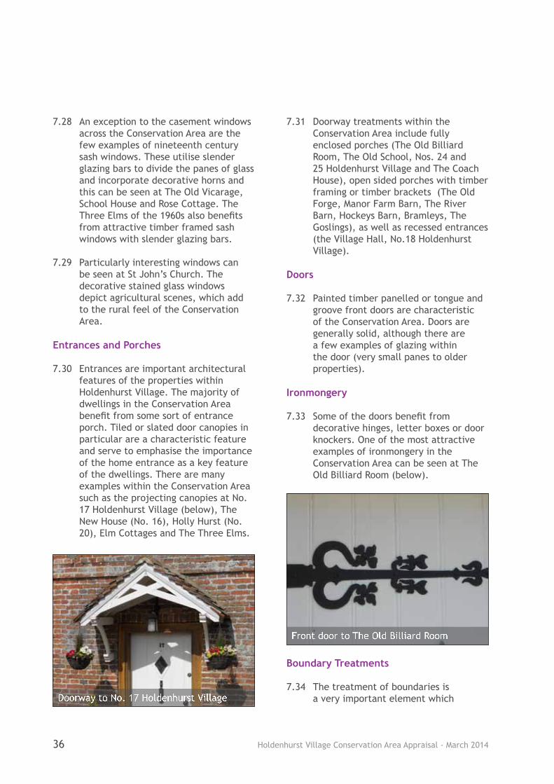
7.33 Some of the doors benefit from decorative hinges, letter boxes or door knockers. One of the most attractive examples of ironmongery in the Conservation Area can be seen at The Old Billiard Room (below).
Boundary Treatments
7.34 The treatment of boundaries is a very important element which Doorway to No. 17 Holdenhurst Village
Front door to The Old Billiard Room
Holdenhurst Village Conservation Area Appraisal - March 2014 37
contributes to the overall character and appearance of the Conservation Area. There are a range of boundary treatments within Holdenhurst and a notable variation between the eastern and western parts of the Conservation Area.
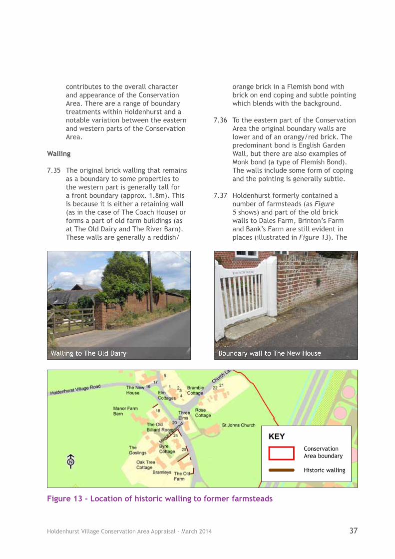
Walling
7.35 The original brick walling that remains as a boundary to some properties to the western part is generally tall for a front boundary (approx. 1.8m). This is because it is either a retaining wall (as in the case of The Coach House) or forms a part of old farm buildings (as at The Old Dairy and The River Barn). These walls are generally a reddish/
orange brick in a Flemish bond with brick on end coping and subtle pointing which blends with the background.
7.36 To the eastern part of the Conservation Area the original boundary walls are lower and of an orangy/red brick. The predominant bond is English Garden Wall, but there are also examples of Monk bond (a type of Flemish Bond). The walls include some form of coping and the pointing is generally subtle.
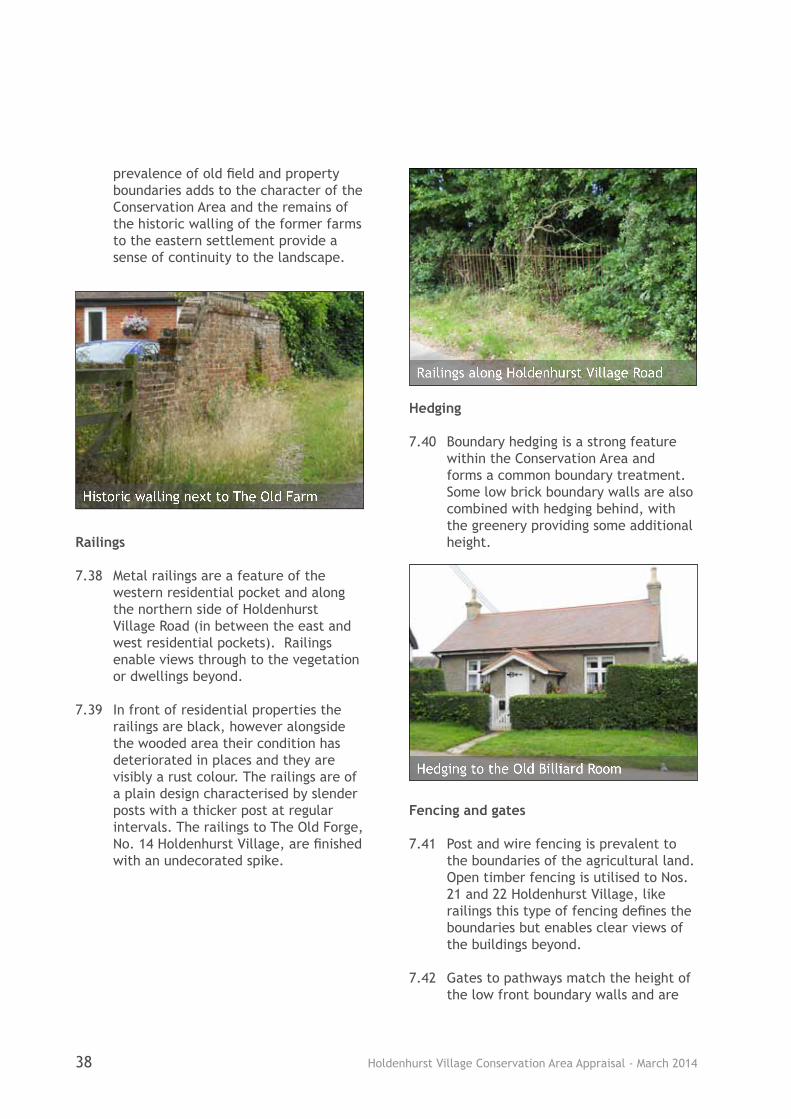
7.37 Holdenhurst formerly contained a number of farmsteads (as Figure 5 shows) and part of the old brick walls to Dales Farm, Brinton’s Farm and Bank’s Farm are still evident in places (illustrated in Figure 13). The
Walling to The Old Dairy Boundary wall to The New House
Figure 13 - Location of historic walling to former farmsteads
Conservation Area boundary
Historic walling
Holdenhurst Village Conservation Area Appraisal - March 201438
prevalence of old field and property boundaries adds to the character of the Conservation Area and the remains of the historic walling of the former farms to the eastern settlement provide a sense of continuity to the landscape.
Railings
7.38 Metal railings are a feature of the western residential pocket and along the northern side of Holdenhurst Village Road (in between the east and west residential pockets). Railings enable views through to the vegetation or dwellings beyond.
7.39 In front of residential properties the railings are black, however alongside the wooded area their condition has deteriorated in places and they are visibly a rust colour. The railings are of a plain design characterised by slender posts with a thicker post at regular intervals. The railings to The Old Forge, No. 14 Holdenhurst Village, are finished with an undecorated spike.
Hedging
7.40 Boundary hedging is a strong feature within the Conservation Area and forms a common boundary treatment. Some low brick boundary walls are also combined with hedging behind, with the greenery providing some additional height.
Fencing and gates
7.41 Post and wire fencing is prevalent to the boundaries of the agricultural land. Open timber fencing is utilised to Nos. 21 and 22 Holdenhurst Village, like railings this type of fencing defines the boundaries but enables clear views of the buildings beyond.
7.42 Gates to pathways match the height of the low front boundary walls and are
Hedging to the Old Billiard Room
Railings along Holdenhurst Village Road
Historic walling next to The Old Farm
Holdenhurst Village Conservation Area Appraisal - March 2014 39
of timber. In the few instances where a vehicle access is gated this is via a 5 bar gate in timber. This type of gate is of an open nature and again allows views through to the dwelling beyond.
Open boundaries
7.43 Vicarage Cottages and No. 5 Holdenhurst Village are set adjacent to the road and do not have a front boundary treatment.
Contribution of Vegetation and Green Spaces
7.44 The private front gardens, the agricultural land, the trees and hedges and the village green make an important contribution to the character and appearance of the Conservation Area.
Contribution of domestic gardens
7.45 Front gardens tend to be small and generally set behind a wall, although some are behind a hedge or railings, or a combination. Gardens are generally well kept and the planting and hedging contribute to the verdant setting of the Conservation Area.
Landscape and Agricultural Land
7.46 The Lower Stour Valley that Holdenhurst lies within is considered to be of landscape value. The river runs north of the village and is a haven for wildlife. There are many trees dotted along the river bank, particularly to the northern side. With the area being low lying views are afforded from the northern boundaries of the Conservation Area towards the river, and visa versa. Despite the proximity of Bournemouth the area retains a valuable landscape that is worthy of its green belt status.
7.47 Views of agricultural land are afforded in between dwellings to both residential parts of the Conservation Area and when travelling along all roads in the village where the hedging is not too high or too dense. Whilst there is agricultural land within the Conservation Area itself, the patchwork of fields visible beyond is also important to the setting of the Conservation Area. All of this land helps to reinforce the historic connections and context of Holdenhurst which was originally an agricultural based village.
7.48 The landscape around Holdenhurst contains a patchwork of agricultural land that contributes to the setting. The crops in the fields are generally low to the ground and views are afforded across fields and into the Conservation Area. The sense of openness greatly adds to the rural nature of the setting of the Conservation Area and contributes to the character. The importance of the agricultural use of the land is also noted in paragraphs 10.8 and 10.9.
Importance of trees, hedgerows and the village green
Trees
7.49 Trees make a particularly valuable contribution as they provide a structure and mature landscape to the village. Within the Conservation Area there are several large mature street trees as well as dense tree lines and small wooded areas. The village contains many of our native trees consisting of the following species: Ash, Alder, Crack Willow, Downy Birch, Silver Birch, Goat Willow, Pendunculate Oak, Sessile Oak, Rowan and Yew.
7.50 The large mature trees add a sense of age to the settlement and the

Holdenhurst Village Conservation Area Appraisal - March 201440
two particularly fine Beech trees at the junction of Throop Road and Holdenhurst Village Road make a key visual contribution at the heart of the western residential part of Holdenhurst. Also within this part of the Conservation Area the garden of The Old Vicarage is very well treed with a substantial number of mature trees.
7.51 Beyond The Old School on the northern side of Holdenhurst Village Road there is a fine quality strip of woodland that stretches for a considerable distance in between the western and eastern residential parts of the village. The importance of this is also noted in paragraph 10.13. The trees are mainly middle-aged specimens that are densely planted, the species here being mainly Pendunculate Oak and Scots Pine.
7.52 Beyond Magdalen Cottage on Sturt Lane is a small pocket of woodland. Little has changed for centuries, and this wood is annotated on old maps and preserved in the old field name ‘wood’.
7.53 The concentration of Yew trees (both native and Irish) around the church adds to the setting of this listed
building and goes some way towards shielding the noise and visual intrusion of the A338. The front boundary of the church has a good quality and well established native box hedge.
Hedgerows
7.54 The Holdenhurst area contains many fine and established native, rural hedgerows. The hedgerows provide an excellent wildlife habitat due to their dense nature and form corridors in which wildlife can travel. The current retention, maintenance and improvement of these agricultural land hedgerows should be encouraged. The species of trees in these hedgerows are the native ones, in the main Blackthorn, Hawthorn, Field Maple, Hazel and Holly.
Village Green
7.55 The village green with its group of three large Horse Chestnut trees and Rowan tree forms a focal point for the eastern settlement. A sense of enclosure is created at this point with the open area framed by the buildings, boundary hedging and trees. The buildings around the green add to the ambience, and this coupled with the
The village green

Holdenhurst Village Conservation Area Appraisal - March 2014 41
green of the grass and the group of mature trees seek to create a sense of place at this point.
The Public Realm
7.56 The treatment of the public realm makes an important contribution to the character and appearance of the Conservation Area.
7.57 The road through the village is generally devoid of pavement and road marking, this greatly adds to a sense of a rural area. The road surfaces are generally tarmac however, there are some unmade roads that are more reminiscent of country lanes/farm tracks such as the lane leading from the village green to Wood Farm. Historic style road signs (Church Lane and Sturt Lane) also add to the historic character of the Conservation Area.
7.58 The most notable examples of street furniture in Holdenhurst are the numerous grade II listed gas lamps that line the main Holdenhurst Village Road and Throop Road. The village is one of the few places in the country still to retain its old gas lamps with its Sugg Windsor lanterns, mounted on the original columns. The listed status of the lamps is of greater significance than their inclusion within the Conservation Area Appraisal.
7.59 The lanterns are not just reflective of the area’s historic past but are important in providing illumination throughout the village. The gentle glow of the gas is less harsh than modern street lamps and contributes to a sense of antiquity in the village, positively adding to the character of the Conservation Area.
7.60 Two red post boxes add interest to the street scene. To the eastern part of the village is a narrow Victorian box set into the wall of Holly Hurst, No. 20 Holdenhurst Village. To the western part is a slightly later post box with the initials G.R. (probably dating from the 1930s or 1940s) that is built into a brick pier outside the former post office (The Old Forge, No. 14 Holdenhurst Village). With both boxes set into a wall rather then free standing (as would generally be found in towns and cities) they add to the rural feel of the village.
7.61 The village green is surrounded by wooden posts to prevent vehicles eroding the grass. Whilst these are modern they are subtle being modest in size and of a material sympathetic to this location. A timber bench on the village green underneath the canopy of three large trees provides a place to sit and admire the view. A bench in this location emphasises the fact that A Gas Lamp at Dusk
Victorian Post Box, Holly Hurst
Holdenhurst Village Conservation Area Appraisal - March 201442
this is an important public space with a character and appearance worthy of note.
General Condition of Buildings
7.62 Following something of a resurgence of the fortunes of the village over the last 30 years a number of the properties have been modernised, existing agricultural buildings converted to residential use and some new dwellings constructed.
7.63 The properties are generally very well maintained and many retain a wealth of original architectural features such as timber framed windows and chimney stacks. This may be a result of some of the dwellings being owned by large landowners in Bournemouth and perhaps it is as a consequence of these being rented out rather
than owner occupied that they have remained well maintained but little altered, as opposed to being subject to modification as fashions change.
7.64 Whereas Holdenhurst was once an isolated village, today it is within a short drive of the town centre and neighbouring employment hubs and the village accommodates professionals as well as offering a peaceful haven for retired people. The village provides a popular alternative to town centre or traditional suburban living. It is a desirable place to live and has the appearance of an affluent area, this is reflected in the properties being well maintained and benefitting from well tended gardens.
Holly Hurst, No. 20 Holdenhurst Village; and The Old Billiard Room
Holdenhurst Village Conservation Area Appraisal - March 2014 43
Extent of Intrusion or Damage
8.1 It is unfortunate that some development within the Conservation Area has been carried out under permitted development and therefore was exempt from planning control. It is also unfortunate that some recent developments, which occurred after the designation of the Conservation Area, have failed to preserve or enhance its character or appearance.
Highway Intrusions and Services
8.2 Highway modifications such as unsympathetically designed modern plastic road signs, plastic bollards and speed limit signs are features of an urban environment. These are considered to add clutter to the village and distract from it’s simple rural character. In addition, whilst some overhead telephone wires might be expected, in some parts of the village their density increases their visibility.
Unsympathetic Alterations
8.3 One of the most common threats to the Conservation Area is from inappropriate or unsympathetic alterations to properties. Some of these may be more obvious than others, but even small alterations can have a cumulative
impact that erodes the character of the Conservation Area, such as the gradual replacement of original timber windows in PVCu or the replacement of a roof in a different material.
8.4 It is difficult to replicate the moulded profile and slender glazing divisions of timber in PVCu. Often the type of opening is not matched (i.e. a sliding sash is replaced with an outward opening casement) and the opening parts of the frame are much thicker than the fixed parts, leading to an unbalanced appearance. Horns and other decorative features also are often not matched in PVCu.
8.5 The introduction of urban elements
such as hardstanding, gates or outbuildings, can all have a negative impact on the appearance of the Conservation Area. In this semi-rural area, the loss of gardens to parking is particularly visually prominent as a large expanse of hard standing is not expected and this coupled with a lack of vegetation makes for a stark appearance that is out of keeping with the Conservation Area.
8 Issues and Challenges
Urban traffic sign
Undesirable replacement PVCu windows
Holdenhurst Village Conservation Area Appraisal - March 201444
Changes to Boundary Treatment
8.6 One of the most visually prominent alterations is the changing of boundary treatment, particularly where the height is increased or a new material introduced. The loss of original fabric and vegetation is detrimental to the Conservation Area. Uncharacteristic materials, heights and designs all draw attention to these changes.
Car Parking
8.7 The parking of cars has also caused some harm to the Conservation Area as the grass verges to the side of the roads or the grass in front or to the side of properties has been eroded by unsympathetic parking.
Changes to and Loss of Vegetation
8.8 There are a number of gardens in the vicinity of the church yard that have planted trees and shrubs that are non-native and non-naturalised specimens that are not in keeping with the rural nature of this area.
8.9 Unfortunately most of the internal field boundary hedgerows have been lost in the past due to mechanised farm methods, however the reforming of these hedgerows would be highly desirable if possible in the future.
External Intrusions
8.10 As well as unattractive features located within the area there are also those in close proximity which can be viewed from within the Conservation Area. These include the line of electricity pylons running parallel with the Stour and the busy A338, both detract from the rural setting of the Conservation Area. The A338 is not only highly visible from the south-eastern part of the Conservation Area but also clearly audible across the eastern residential part.
8.11 Beyond the Conservation Area is also the sewage works which at certain times can emit an unpleasant smell across the village. In addition close
Erosion of grass verges by the parking of carsLoss of garden to parking
Tall front boundary treatment uncharacteristic of the Conservation Area
Holdenhurst Village Conservation Area Appraisal - March 2014 45
to the western residential pocket of Holdenhurst Village, but lying just outside the conservation area, is Roffey Brothers – an horticultural business. This occupies a visually prominent location by the sharp bend in Throop Road and the site includes a number of large sheds and a large expanse of hardstanding. Although there is some screening from trees and hedging the site is open to views from its entrance and detracts from the setting of the village.
Challenges
Traffic
8.12 One of the key pressures within the western part of the Conservation Area is traffic. The neighbouring settlement of Throop can be accessed along Throop Road, and the road is also a through route from the busy Castle Lane West. In addition the roads throughout the Conservation Area are narrow and the presence of lorries and other large vehicles makes it difficult for cars to negotiate the road and less safe for those on foot or travelling by bicycle.
New Road
8.13 A significant concern in recent years has been the proposal for a Castle Lane West Relief Road. This was detailed in the Bournemouth District Wide Local Plan (2002) but omitted from the Bournemouth Local Plan: Core Strategy (2012). Historically a parcel of land has been reserved between the A338 and the A347 at Northbourne, including an area of land to the south of Holdenhurst to the southern edge of the conservation area. If the provision of this road were to be reconsidered in the future, unless careful consideration is given to mitigate it, it would be
visually apparent and its construction would introduce significantly more road noise across the village.
New Junction to A338
8.14 Another concern is the provision of a new junction to the A338. This relates to two separate schemes at Riverside Avenue (Park and Ride and an office development) both of which were granted planning permission but this has now expired. However, if either of these schemes were to be granted planning consent in the future they may require a road junction south of the village hall at the most southerly point of the conservation area. An additional junction on the edge of the conservation area would again result in a significant increase in traffic noise and visual intrusion.
8.15 A junction at this location may also result in the loss of or impact on the setting of the ancient cob barn to the former Townsend Cottages. Any future proposals should seek to mitigate against sound and visual intrusion via measures such as embankments and planting and retain the barn which is important as the last remaining building of the original settlement of Townsend.
New Housing
8.16 One of the most damaging impacts on the setting of the conservation area would be if new housing were permitted. Holdenhurst lies within the green belt and as such continues to be protected by green belt policy.
Flooding
8.17 The Conservation Area partially falls within the designated flood plain of the River Stour. The properties are protected by a flood alleviation
Holdenhurst Village Conservation Area Appraisal - March 201446
scheme of the early 1990s to provide a 1 in 65 years standard of protection. The banking and walling of the flood defences are visible in the landscape, particularly on approach to the eastern part of the village and to the rear of The New House, No. 16 Holdenhurst Village. Flooding should hopefully be a rare occurrence, however if it does happen there could be damage to the properties within the Conservation Area.
Inappropriate land uses
8.18 Inappropriate land uses within the Conservation Area or just outside of it could potentially cause damage. For example, the use of the neighbouring fields for events such as car boot sales could result in traffic problems and further erosion of the grass verges, as well as noise issues. In addition further expansion of neighbouring businesses such as Roffey Brothers on Throop Road, could have implications for traffic levels or visual amenity. Any land use which results in the loss of farm land or farm buildings would significantly impact on the character and appearance of the Conservation Area.
Unsympathetic alterations to dwellings
8.19 There is constant pressure for
alterations and redevelopment within a desirable residential area such as Holdenhurst. With the majority of the properties within the Conservation Area being single dwellinghouses there are a number of permitted development rights associated with them. It is possible for householders to undertake certain works without the requirement for planning permission. It is noted the Local Planning Authority has already removed permitted development rights on certain recent developments in an attempt to minimise unsympathetic changes to properties.
8.20 Even minor alterations such as changes involving painting, rendering or cladding over a brick property can dramatically alter its appearance within the street scene. In addition, changes to original boundary walls could be visually prominent and culminate in an erosion of the character of the Conservation Area.
New planting
8.21 As the majority of the trees in Holdenhurst are species native or naturalised to this country, future planting of these species in this area should be encouraged as there is a lack of young trees growing to replace the mainly middle-aged and mature specimens present. The planting of non-native species in Holdenhurst should be discouraged and replacement with native species sought as the opportunity arises. There are also some hedges of Laurel and Leyland Cypress that should be discouraged.
8.22 Unfortunately the Horse Chestnut trees on the green are showing signs of disease and the Rowan is in poor condition. If these trees need to be felled in the future it is important that they are replaced with native species.
Flood defences holding back the water in November 2012
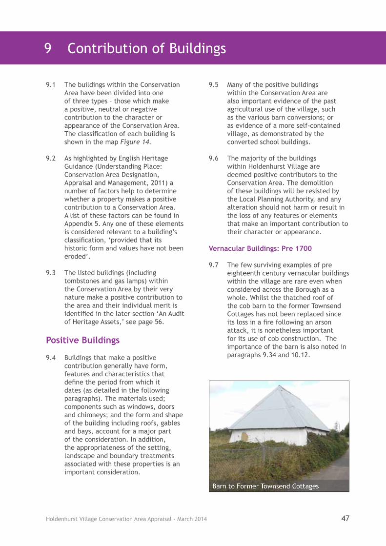
Holdenhurst Village Conservation Area Appraisal - March 2014 47
9 Contribution of Buildings
9.1 The buildings within the Conservation Area have been divided into one of three types – those which make a positive, neutral or negative contribution to the character or appearance of the Conservation Area. The classification of each building is shown in the map Figure 14.
9.2 As highlighted by English Heritage Guidance (Understanding Place: Conservation Area Designation, Appraisal and Management, 2011) a number of factors help to determine whether a property makes a positive contribution to a Conservation Area. A list of these factors can be found in Appendix 5. Any one of these elements is considered relevant to a building’s classification, ‘provided that its historic form and values have not been eroded’.
9.3 The listed buildings (including tombstones and gas lamps) within the Conservation Area by their very nature make a positive contribution to the area and their individual merit is identified in the later section ‘An Audit of Heritage Assets,’ see page 56.
Positive Buildings
9.4 Buildings that make a positive contribution generally have form, features and characteristics that define the period from which it dates (as detailed in the following paragraphs). The materials used; components such as windows, doors and chimneys; and the form and shape of the building including roofs, gables and bays, account for a major part of the consideration. In addition, the appropriateness of the setting, landscape and boundary treatments associated with these properties is an important consideration.
9.5 Many of the positive buildings within the Conservation Area are also important evidence of the past agricultural use of the village, such as the various barn conversions; or as evidence of a more self-contained village, as demonstrated by the converted school buildings.
9.6 The majority of the buildings within Holdenhurst Village are deemed positive contributors to the Conservation Area. The demolition of these buildings will be resisted by the Local Planning Authority, and any alteration should not harm or result in the loss of any features or elements that make an important contribution to their character or appearance.
Vernacular Buildings: Pre 1700
9.7 The few surviving examples of pre eighteenth century vernacular buildings within the village are rare even when considered across the Borough as a whole. Whilst the thatched roof of the cob barn to the former Townsend Cottages has not been replaced since its loss in a fire following an arson attack, it is nonetheless important for its use of cob construction. The importance of the barn is also noted in paragraphs 9.34 and 10.12.
Barn to Former Townsend Cottages

Holdenhurst Village Conservation Area Appraisal - March 201448
Figure 14 - Contribution of Buildings to the Conservation Area

Holdenhurst Village Conservation Area Appraisal - March 2014 49
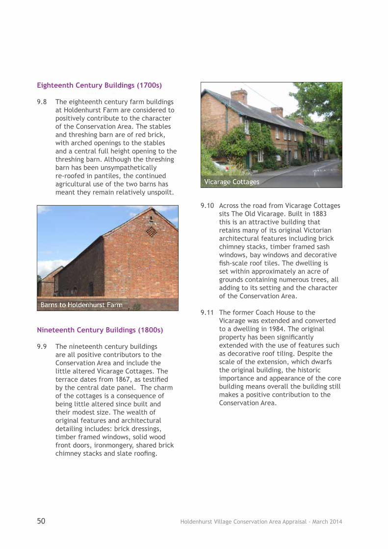
Holdenhurst Village Conservation Area Appraisal - March 201450
Eighteenth Century Buildings (1700s)
9.8 The eighteenth century farm buildings at Holdenhurst Farm are considered to positively contribute to the character of the Conservation Area. The stables and threshing barn are of red brick, with arched openings to the stables and a central full height opening to the threshing barn. Although the threshing barn has been unsympathetically re-roofed in pantiles, the continued agricultural use of the two barns has meant they remain relatively unspoilt.
Nineteenth Century Buildings (1800s)
9.9 The nineteenth century buildings are all positive contributors to the Conservation Area and include the little altered Vicarage Cottages. The terrace dates from 1867, as testified by the central date panel. The charm of the cottages is a consequence of being little altered since built and their modest size. The wealth of original features and architectural detailing includes: brick dressings, timber framed windows, solid wood front doors, ironmongery, shared brick chimney stacks and slate roofing.
9.10 Across the road from Vicarage Cottages sits The Old Vicarage. Built in 1883 this is an attractive building that retains many of its original Victorian architectural features including brick chimney stacks, timber framed sash windows, bay windows and decorative fish-scale roof tiles. The dwelling is set within approximately an acre of grounds containing numerous trees, all adding to its setting and the character of the Conservation Area.
9.11 The former Coach House to the Vicarage was extended and converted to a dwelling in 1984. The original property has been significantly extended with the use of features such as decorative roof tiling. Despite the scale of the extension, which dwarfs the original building, the historic importance and appearance of the core building means overall the building still makes a positive contribution to the Conservation Area.
Barns to Holdenhurst Farm
Vicarage Cottages

Holdenhurst Village Conservation Area Appraisal - March 2014 51
9.12 At the entrance to Sturt Lane sits No. 5 Holdenhurst Village, a modest nineteenth century dwelling that appears virtually untouched externally since built. The simplicity of the dwelling is part of its charm, as is the weathered brickwork and the original features it displays. There is no door to the road elevation, just timber framed casement windows with slender horizontal glazing bars. The overhanging of the eaves with exposed rafters and the solid brick chimney stack adds to the character of the building.
9.13 Fronting Church Lane are two small nineteenth century cottages, Bramble Cottage and Rose Cottage. Bramble Cottage is modest in scale and is of yellow brick with a slate roof with brick
stack and timber framed casement windows. Rose cottage is also modest in scale although it has a significant two storey rear extension. Despite the later addition the cottage retains a number of original features including fine sash windows to the road façade. Both cottages are considered to contribute positively to the street scene within the Conservation Area.
9.14 Hockeys Barn was converted to a dwelling in the late 1980s. The conversion introduced domestic elements such as rooflights and the infilling of the large barn doors. However, the building is clearly recognisable as a former agricultural barn and contributes positively to the character and appearance of the Conservation Area.
The Coach House from Throop Road
No. 5 Holdenhurst Village
Rose Cottage
Hockeys Barn
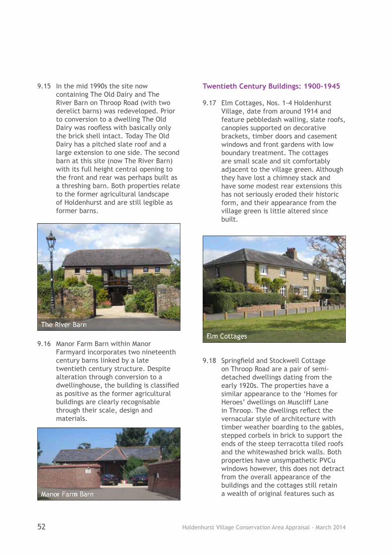
Holdenhurst Village Conservation Area Appraisal - March 201452
9.15 In the mid 1990s the site now containing The Old Dairy and The River Barn on Throop Road (with two derelict barns) was redeveloped. Prior to conversion to a dwelling The Old Dairy was roofless with basically only the brick shell intact. Today The Old Dairy has a pitched slate roof and a large extension to one side. The second barn at this site (now The River Barn) with its full height central opening to the front and rear was perhaps built as a threshing barn. Both properties relate to the former agricultural landscape of Holdenhurst and are still legible as former barns.
9.16 Manor Farm Barn within Manor Farmyard incorporates two nineteenth century barns linked by a late twentieth century structure. Despite alteration through conversion to a dwellinghouse, the building is classified as positive as the former agricultural buildings are clearly recognisable through their scale, design and materials.
Twentieth Century Buildings: 1900-1945
9.17 Elm Cottages, Nos. 1-4 Holdenhurst Village, date from around 1914 and feature pebbledash walling, slate roofs, canopies supported on decorative brackets, timber doors and casement windows and front gardens with low boundary treatment. The cottages are small scale and sit comfortably adjacent to the village green. Although they have lost a chimney stack and have some modest rear extensions this has not seriously eroded their historic form, and their appearance from the village green is little altered since built.
9.18 Springfield and Stockwell Cottage on Throop Road are a pair of semi-detached dwellings dating from the early 1920s. The properties have a similar appearance to the ‘Homes for Heroes’ dwellings on Muscliff Lane in Throop. The dwellings reflect the vernacular style of architecture with timber weather boarding to the gables, stepped corbels in brick to support the ends of the steep terracotta tiled roofs and the whitewashed brick walls. Both properties have unsympathetic PVCu windows however, this does not detract from the overall appearance of the buildings and the cottages still retain a wealth of original features such as
The River Barn
Elm Cottages
Manor Farm Barn
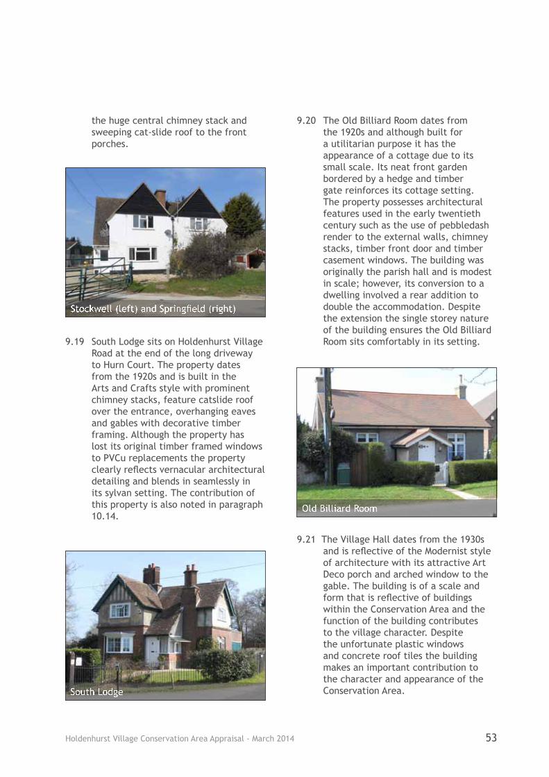
Holdenhurst Village Conservation Area Appraisal - March 2014 53
the huge central chimney stack and sweeping cat-slide roof to the front porches.
9.19 South Lodge sits on Holdenhurst Village Road at the end of the long driveway to Hurn Court. The property dates from the 1920s and is built in the Arts and Crafts style with prominent chimney stacks, feature catslide roof over the entrance, overhanging eaves and gables with decorative timber framing. Although the property has lost its original timber framed windows to PVCu replacements the property clearly reflects vernacular architectural detailing and blends in seamlessly in its sylvan setting. The contribution of this property is also noted in paragraph 10.14.
9.20 The Old Billiard Room dates from the 1920s and although built for a utilitarian purpose it has the appearance of a cottage due to its small scale. Its neat front garden bordered by a hedge and timber gate reinforces its cottage setting. The property possesses architectural features used in the early twentieth century such as the use of pebbledash render to the external walls, chimney stacks, timber front door and timber casement windows. The building was originally the parish hall and is modest in scale; however, its conversion to a dwelling involved a rear addition to double the accommodation. Despite the extension the single storey nature of the building ensures the Old Billiard Room sits comfortably in its setting.
9.21 The Village Hall dates from the 1930s and is reflective of the Modernist style of architecture with its attractive Art Deco porch and arched window to the gable. The building is of a scale and form that is reflective of buildings within the Conservation Area and the function of the building contributes to the village character. Despite the unfortunate plastic windows and concrete roof tiles the building makes an important contribution to the character and appearance of the Conservation Area.
Stockwell (left) and Springfield (right)
Old Billiard Room
South Lodge
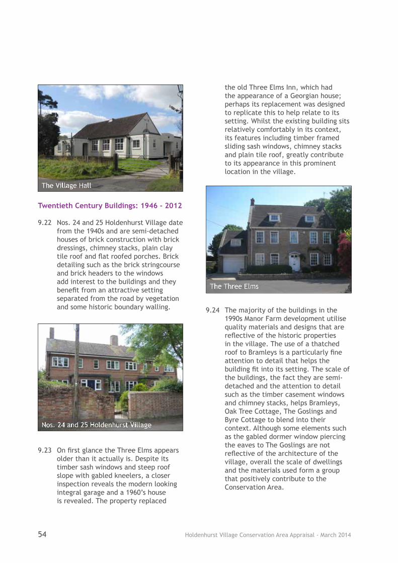
Holdenhurst Village Conservation Area Appraisal - March 201454
Twentieth Century Buildings: 1946 - 2012
9.22 Nos. 24 and 25 Holdenhurst Village date from the 1940s and are semi-detached houses of brick construction with brick dressings, chimney stacks, plain clay tile roof and flat roofed porches. Brick detailing such as the brick stringcourse and brick headers to the windows add interest to the buildings and they benefit from an attractive setting separated from the road by vegetation and some historic boundary walling.
9.23 On first glance the Three Elms appears older than it actually is. Despite its timber sash windows and steep roof slope with gabled kneelers, a closer inspection reveals the modern looking integral garage and a 1960’s house is revealed. The property replaced
the old Three Elms Inn, which had the appearance of a Georgian house; perhaps its replacement was designed to replicate this to help relate to its setting. Whilst the existing building sits relatively comfortably in its context, its features including timber framed sliding sash windows, chimney stacks and plain tile roof, greatly contribute to its appearance in this prominent location in the village.
9.24 The majority of the buildings in the 1990s Manor Farm development utilise quality materials and designs that are reflective of the historic properties in the village. The use of a thatched roof to Bramleys is a particularly fine attention to detail that helps the building fit into its setting. The scale of the buildings, the fact they are semi-detached and the attention to detail such as the timber casement windows and chimney stacks, helps Bramleys, Oak Tree Cottage, The Goslings and Byre Cottage to blend into their context. Although some elements such as the gabled dormer window piercing the eaves to The Goslings are not reflective of the architecture of the village, overall the scale of dwellings and the materials used form a group that positively contribute to the Conservation Area.
The Three Elms
The Village Hall
Nos. 24 and 25 Holdenhurst Village
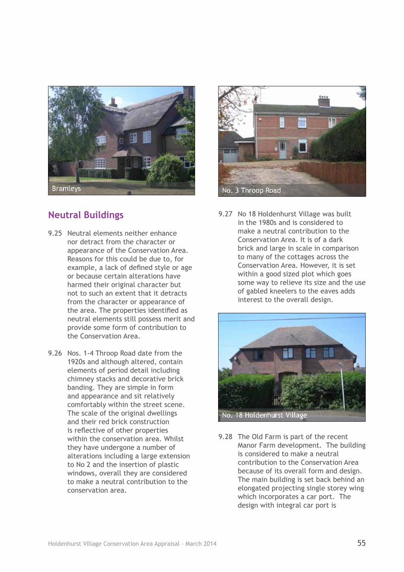
Holdenhurst Village Conservation Area Appraisal - March 2014 55
Neutral Buildings
9.25 Neutral elements neither enhance nor detract from the character or appearance of the Conservation Area. Reasons for this could be due to, for example, a lack of defined style or age or because certain alterations have harmed their original character but not to such an extent that it detracts from the character or appearance of the area. The properties identified as neutral elements still possess merit and provide some form of contribution to the Conservation Area.
9.26 Nos. 1-4 Throop Road date from the 1920s and although altered, contain elements of period detail including chimney stacks and decorative brick banding. They are simple in form and appearance and sit relatively comfortably within the street scene. The scale of the original dwellings and their red brick construction is reflective of other properties within the conservation area. Whilst they have undergone a number of alterations including a large extension to No 2 and the insertion of plastic windows, overall they are considered to make a neutral contribution to the conservation area.
9.27 No 18 Holdenhurst Village was built in the 1980s and is considered to make a neutral contribution to the Conservation Area. It is of a dark brick and large in scale in comparison to many of the cottages across the Conservation Area. However, it is set within a good sized plot which goes some way to relieve its size and the use of gabled kneelers to the eaves adds interest to the overall design.
9.28 The Old Farm is part of the recent Manor Farm development. The building is considered to make a neutral contribution to the Conservation Area because of its overall form and design. The main building is set back behind an elongated projecting single storey wing which incorporates a car port. The design with integral car port is
Bramleys
No. 18 Holdenhurst Village
No. 3 Throop Road

Holdenhurst Village Conservation Area Appraisal - March 201456
uncharacteristic of the older properties in the conservation area. The change in scale of the main building from two to single storey to accommodate the lower wing results in a large expanse of roof. The position of the front wing also dominates the streetscene rather than the main dwelling itself. The insertion of unsympathetic white PVCu windows further reduces the contribution of the property.
9.29 Holdenhurst Farm has several modern barns/sheds associated with the agricultural use of the site. Although they do not reflect the historic construction of farm buildings evident elsewhere on the farm they are typical of their context, utilitarian in style and use and do not cause harm to the setting. Overall these agricultural barns/sheds whilst not enhancing the Conservation Area, equally are not deemed to detract from it.
Negative Buildings
9.30 A building which makes a negative contribution to the conservation area is one which detracts from its character and appearance. One such building has been identified in the Conservation Area – the Longbarrow Allotment building. Although the allotment site itself makes an important and valuable
contribution to the conservation area as part of the landscape setting, the large modern green shed that is of a utilitarian design does not. Its appearance, form and materials are not reflective of the other agricultural buildings which characterise the area. The use of metal rather than timber for the facing material is not sympathetic to the landscape setting. If this building were to be altered or replaced in the future then any scheme would need to give careful consideration to the sensitive location of the building to ensure that it was of a high quality design which respected its site and surroundings.
An Audit of Heritage Assets
9.31 There are 11 individual listings within the Conservation Area covering 1 church, 3 tombstones, 9 dwellings and 17 gas lamps (the rest of the group of 28 lamps are beyond the Conservation Area). See Figure 14 for their location within the Conservation Area. A schedule of each of the individual listed buildings can be found in Appendix 6.
Longbarrow Allotments
The Old Farm
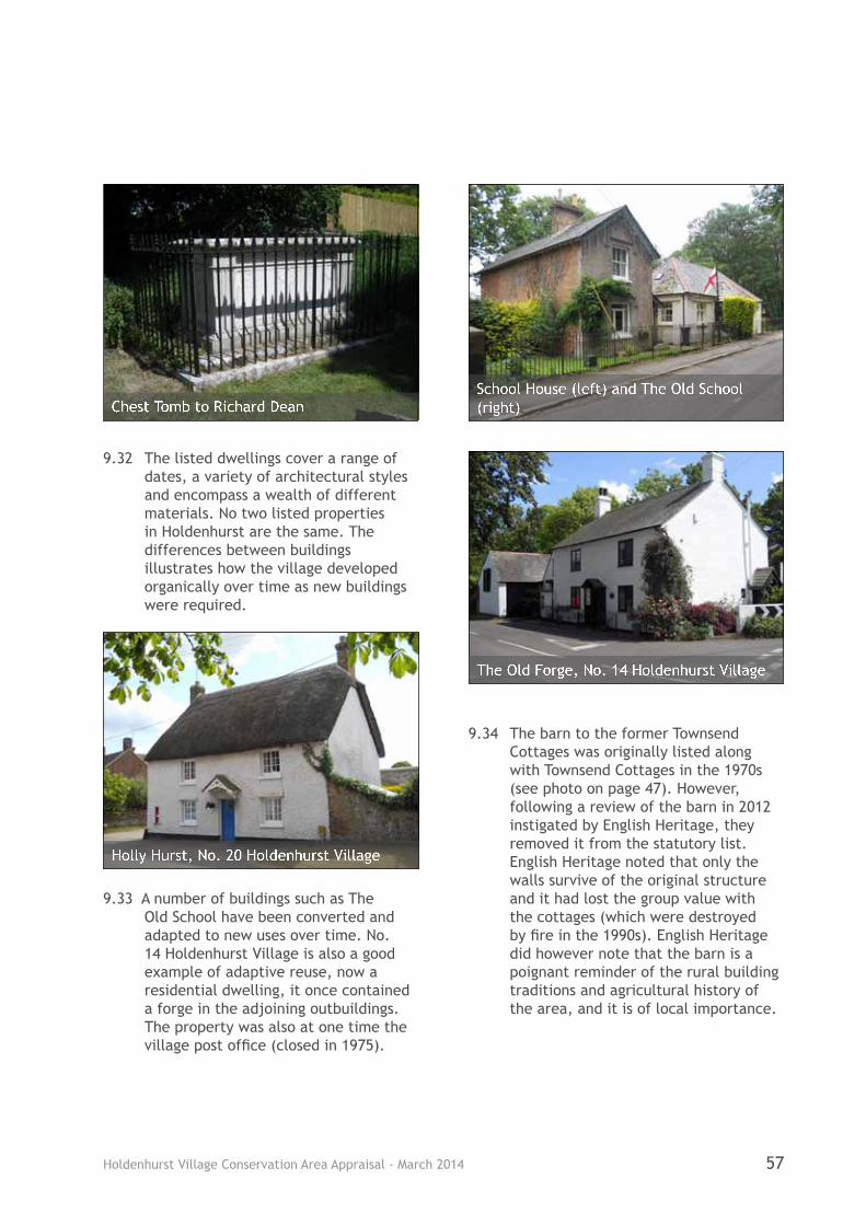
Holdenhurst Village Conservation Area Appraisal - March 2014 57
9.32 The listed dwellings cover a range of dates, a variety of architectural styles and encompass a wealth of different materials. No two listed properties in Holdenhurst are the same. The differences between buildings illustrates how the village developed organically over time as new buildings were required.
9.33 A number of buildings such as The Old School have been converted and adapted to new uses over time. No. 14 Holdenhurst Village is also a good example of adaptive reuse, now a residential dwelling, it once contained a forge in the adjoining outbuildings. The property was also at one time the village post office (closed in 1975).
9.34 The barn to the former Townsend Cottages was originally listed along with Townsend Cottages in the 1970s (see photo on page 47). However, following a review of the barn in 2012 instigated by English Heritage, they removed it from the statutory list. English Heritage noted that only the walls survive of the original structure and it had lost the group value with the cottages (which were destroyed by fire in the 1990s). English Heritage did however note that the barn is a poignant reminder of the rural building traditions and agricultural history of the area, and it is of local importance.
The Old Forge, No. 14 Holdenhurst Village
Holly Hurst, No. 20 Holdenhurst Village
Chest Tomb to Richard DeanSchool House (left) and The Old School (right)
Holdenhurst Village Conservation Area Appraisal - March 201458
10.1 An important aspect of the appraisal process is to assess whether or not the existing Conservation Area boundary should be revised. In response to this and upon completion of the detailed assessment of the significance of the area it was considered that east and west Holdenhurst were so closely linked that it would be a natural progression to combine the two Conservation Areas.
10.2 The original boundary of the two separate Conservation Areas focused on the buildings in determining character as opposed to looking more widely at the historical integrity and significance of the landscape as a whole.
10.3 It was also decided to revise the north east boundary of the conservation area, to follow the Bournemouth Borough boundary line, reflecting the fact that a small area of Holdenhurst Village lies within the Borough of Christchurch.
10.4 The adoption of this Appraisal confirmed the revised boundary of the conservation area and the boundary changes are shown in Figure 15.
Extended Area 1
10.5 As well as there being close connections between the two residential clusters of properties today, historically the two parts of the village would have been interlinked. For example, with the church to the east and vicarage to the west.
10.6 The original Holdenhurst East boundary was drawn up in the 1970s before the Manor Farmyard development was constructed. The boundary followed the edges of various farm buildings that have long since been demolished. As Figure 15 demonstrates, the original boundary ran straight through the gardens of Manor Farm Barn, The Goslings, Oak Tree Cottage, Bramleys
and The Old Farm. This resulted in a slightly unusual situation whereby the dwellings were in the Conservation Area but the majority of the rear gardens were excluded.
10.7 It is also considered important to
include landscape features beyond the residential properties. Extending the boundary beyond the Manor Farm Development allows for the inclusion of the remains of the watery landscape that once assisted the farming community in Holdenhurst. In the past Holdenhurst regularly flooded and the ditches of former streams (now cut off) and ponds they fed are evident in places.
10.8 The importance of the agricultural and grazing land in and around the village to the setting of the dwellings should not be underestimated. The swathe of fields contributes to a sense of openness and facilitates views towards the village from the urban fringes of north Bournemouth.
10.9 The remaining field boundaries most likely date to the Inclosure Act, however the patchwork of fields could contain a remnant of the medieval open field system. Comparing the aerial photo (Figure 3) with the historic map of 1924 (Figure 7) it can be seen that several of the fields have been increased in size over the last century. It was considered important to retain the remaining field boundaries and to this end it was a natural step to extend the Conservation Area across the fields.
10.10 The Longbarrow Allotments were established in Holdenhurst in 1999 following the sale of the land to the Council from the Cooper Dean Estate (with covenants). They form an important community asset for residents in the surrounding area. The allotments are well used and there is
10 Assessment of Existing Boundary

Holdenhurst Village Conservation Area Appraisal - March 2014 59
scope to erect small sheds. The Local Planning Authority considers that the erection of sheds on allotment sites is the same – irrespective of whether or not the site lies within a conservation area.
10.11 The allotments cover 3.2 hectares and were worthy of inclusion in the extended Conservation Area as they are a use sympathetic to the openness and agricultural nature of the surrounding environment. In view of the inclusion of the fields to the east and the fact that the allotment site directly abuts part of the Conservation Area boundary it was logical to include this site, not only because of its landscape value but because it enabled the re-linking of the east and west parts of the village as a single conservation area.
10.12 The southwards extension of the Conservation Area below the Village Hall allowed for the inclusion of the cob barn to Townsend Cottages. This is one of the oldest buildings in
Holdenhurst and is of local importance to Bournemouth.
10.13 The extended area also contains
elements of interest along Holdenhurst Village Road between the two residential pockets. The road is picturesque in places with tree branches overhanging the road causing a pleasing tunnelling effect. Part of the road is lined by railings and the many gas lamps along the route contribute to a sense of history. Views and vistas are afforded across the Conservation Area from sections of the road.
10.14 Inclusion of more of Holdenhurst Village Road also allowed for South Lodge to fall within the Conservation Area. This is an attractive property of a modest scale that is very much in keeping with this semi-rural area. The dwelling has been assessed as positively contributing to the character and appearance of the Conservation Area.
Land that links the two residential parts of the Conservation Area (South Lodge is just visible amongst the trees in distance)
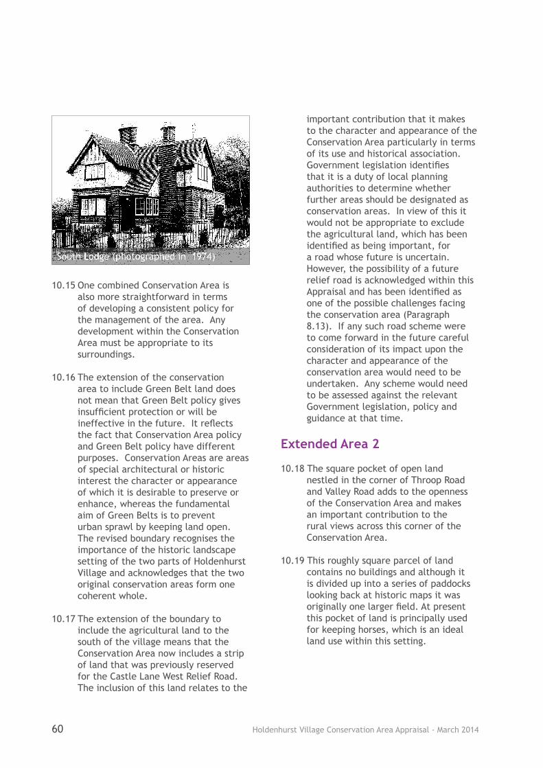
Holdenhurst Village Conservation Area Appraisal - March 201460
10.15 One combined Conservation Area is also more straightforward in terms of developing a consistent policy for the management of the area. Any development within the Conservation Area must be appropriate to its surroundings.
10.16 The extension of the conservation area to include Green Belt land does not mean that Green Belt policy gives insufficient protection or will be ineffective in the future. It reflects the fact that Conservation Area policy and Green Belt policy have different purposes. Conservation Areas are areas of special architectural or historic interest the character or appearance of which it is desirable to preserve or enhance, whereas the fundamental aim of Green Belts is to prevent urban sprawl by keeping land open. The revised boundary recognises the importance of the historic landscape setting of the two parts of Holdenhurst Village and acknowledges that the two original conservation areas form one coherent whole.
10.17 The extension of the boundary to include the agricultural land to the south of the village means that the Conservation Area now includes a strip of land that was previously reserved for the Castle Lane West Relief Road. The inclusion of this land relates to the
important contribution that it makes to the character and appearance of the Conservation Area particularly in terms of its use and historical association. Government legislation identifies that it is a duty of local planning authorities to determine whether further areas should be designated as conservation areas. In view of this it would not be appropriate to exclude the agricultural land, which has been identified as being important, for a road whose future is uncertain. However, the possibility of a future relief road is acknowledged within this Appraisal and has been identified as one of the possible challenges facing the conservation area (Paragraph 8.13). If any such road scheme were to come forward in the future careful consideration of its impact upon the character and appearance of the conservation area would need to be undertaken. Any scheme would need to be assessed against the relevant Government legislation, policy and guidance at that time.
Extended Area 2
10.18 The square pocket of open land nestled in the corner of Throop Road and Valley Road adds to the openness of the Conservation Area and makes an important contribution to the rural views across this corner of the Conservation Area.
10.19 This roughly square parcel of land contains no buildings and although it is divided up into a series of paddocks looking back at historic maps it was originally one larger field. At present this pocket of land is principally used for keeping horses, which is an ideal land use within this setting.
South Lodge (photographed in 1974)
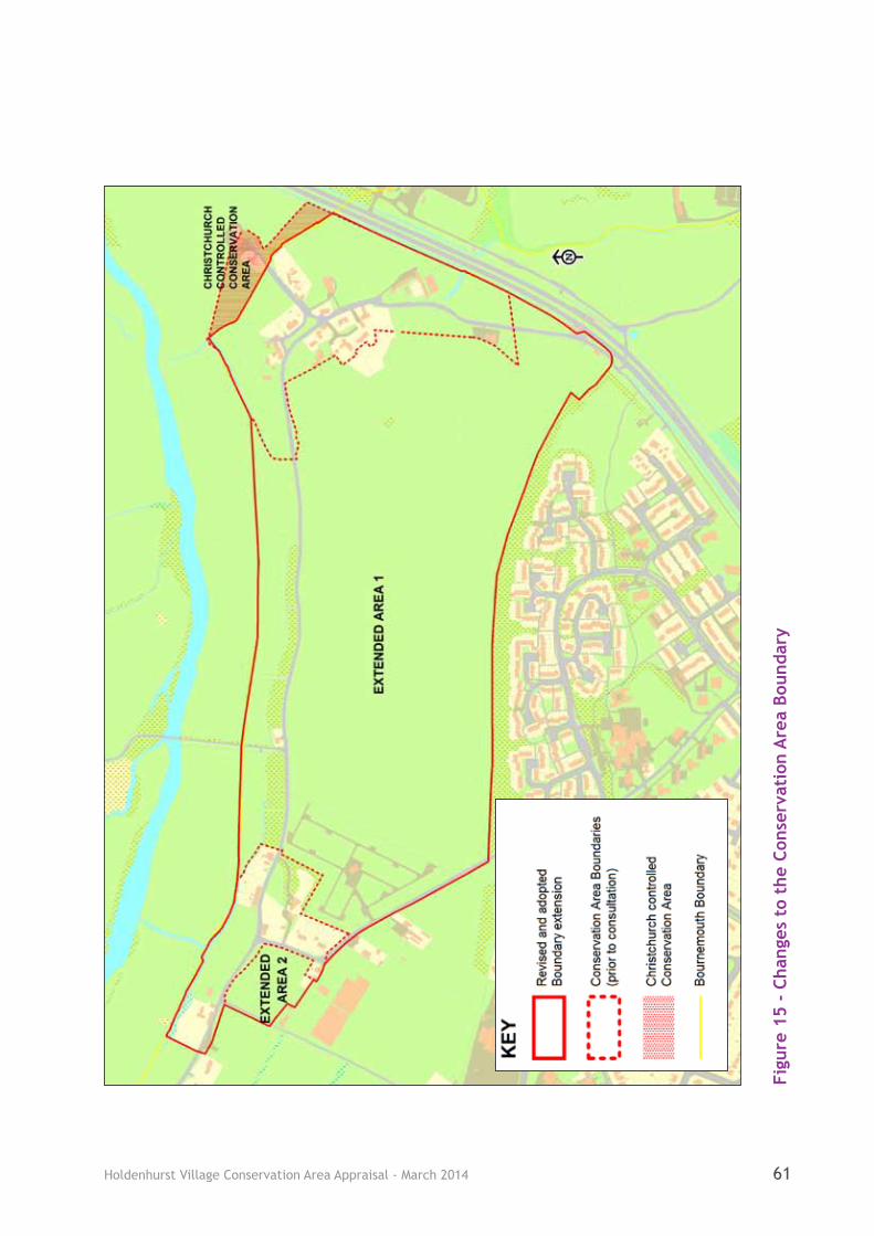
Holdenhurst Village Conservation Area Appraisal - March 2014 61
Figu
re 1
5 -
Chan
ges
to t
he C
onse
rvat
ion
Are
a Bo
unda
ry
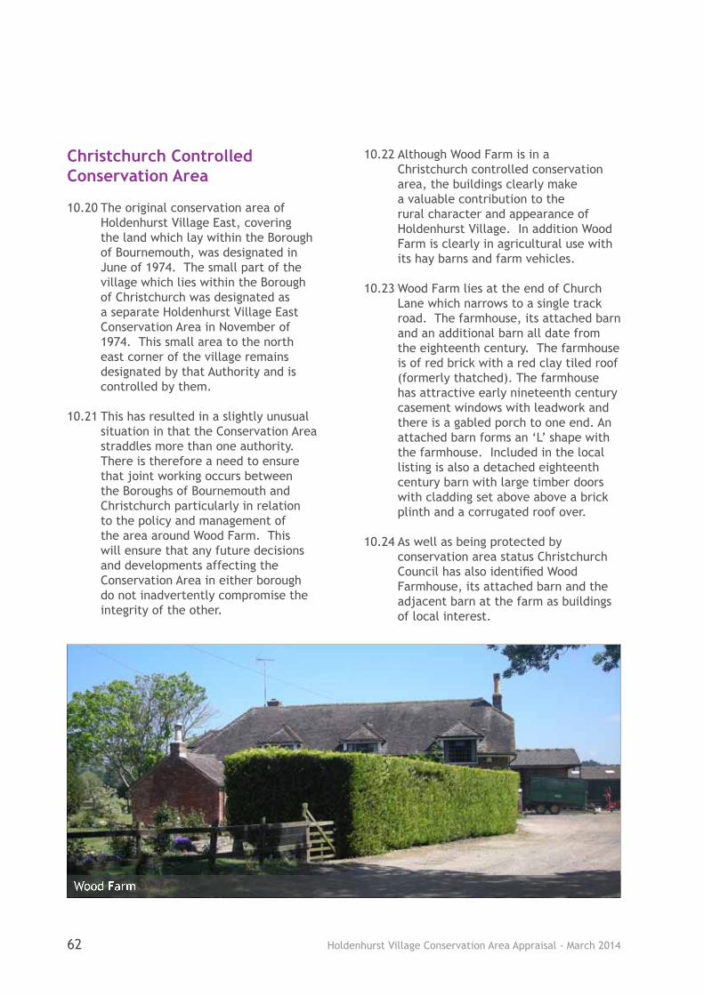
Holdenhurst Village Conservation Area Appraisal - March 201462
Christchurch Controlled Conservation Area
10.20 The original conservation area of Holdenhurst Village East, covering the land which lay within the Borough of Bournemouth, was designated in June of 1974. The small part of the village which lies within the Borough of Christchurch was designated as a separate Holdenhurst Village East Conservation Area in November of 1974. This small area to the north east corner of the village remains designated by that Authority and is controlled by them.
10.21 This has resulted in a slightly unusual situation in that the Conservation Area straddles more than one authority. There is therefore a need to ensure that joint working occurs between the Boroughs of Bournemouth and Christchurch particularly in relation to the policy and management of the area around Wood Farm. This will ensure that any future decisions and developments affecting the Conservation Area in either borough do not inadvertently compromise the integrity of the other.
10.22 Although Wood Farm is in a Christchurch controlled conservation area, the buildings clearly make a valuable contribution to the rural character and appearance of Holdenhurst Village. In addition Wood Farm is clearly in agricultural use with its hay barns and farm vehicles.
10.23 Wood Farm lies at the end of Church Lane which narrows to a single track road. The farmhouse, its attached barn and an additional barn all date from the eighteenth century. The farmhouse is of red brick with a red clay tiled roof (formerly thatched). The farmhouse has attractive early nineteenth century casement windows with leadwork and there is a gabled porch to one end. An attached barn forms an ‘L’ shape with the farmhouse. Included in the local listing is also a detached eighteenth century barn with large timber doors with cladding set above above a brick plinth and a corrugated roof over.
10.24 As well as being protected by conservation area status Christchurch Council has also identified Wood Farmhouse, its attached barn and the adjacent barn at the farm as buildings of local interest.
Wood Farm

Holdenhurst Village Conservation Area Appraisal - March 2014 63
11.1 Involving the local community and raising public awareness is an essential part of the process when producing an Appraisal. As well as their use for planning, Appraisals also have a much wider application as educational and informative documents for the local community.
11.2 In December 2006 the Council adopted a Statement of Community Involvement that sets out how the Council will ensure that all sections of the local community will have the opportunity to be actively involved in the process of policy development.
11.3 In line with the Statement of Community Involvement public consultation was undertaken on the Draft Holdenhurst Village Conservation Area Appraisal for a six week period between the middle of August and the end of September 2013.
11.4 A letter, questionnaire and summary document were sent to all properties located within the conservation area as well as to those in the proposed extended area. Letters or emails were also sent to key stakeholders, statutory consultees and property/land owners to notify them of the consultation and to provide them with the opportunity to comment upon the draft Appraisal. Council Officers also attended a Holdenhurst Village Parish Meeting during the consultation period to raise awareness of the draft Appraisal, to present key points and to answer any questions. Site notices were put up within the Conservation Area and copies of the draft Appraisal were made available at Castlepoint Library, at the Council’s Customer Service Centre and on the Council’s website.
11.5 All of the comments received during the consultation period were evaluated and, where appropriate, changes
were made to the document. Full consideration was given to all of the comments received prior to the adoption of this Appraisal by the Council.
11.6 A total of twenty responses were received following the public consultation. There was a positive response in relation to the fact that the Appraisal had been well researched and was a thorough and holistic document, contributing to an authoritative understanding of the area’s historic significance.
11.7 The comments expressed a strong support (70-75%) that both the key elements that make the area special and those that detract from it had been identified. There was also a strong agreement (70%) for both the suggested contribution of each of the buildings (positive, neutral or negative contributor) and the broad management proposals identified. Additional comments raised illustrated that there were significant concerns in relation to traffic and road safety with rat-running and the presence of large vehicles being of particular concern.
11.8 In relation to the proposed boundary changes although only 50% of respondents directly supported the proposed boundary changes, an additional 25% wanted the Conservation Area boundary to be extended further. Only 20% did not want any extension/change to the boundary at all.
11.9 Details of the consultation process and the comments received can be viewed in the Holdenhurst Village Consultation Statement which is available on the Council’s website www.bournemouth.gov.uk/conservation.
11 Community Involvement

Holdenhurst Village Conservation Area Appraisal - March 201464
12 Management Proposals
Managing Change Positively
12.1 Understanding the character and appearance of the Conservation Area is clearly the starting point when making decisions about its management. It is important that the designation of a Conservation Area is not seen as an end in itself. The number of positive elements identified in this Appraisal clearly illustrates that the Conservation Area has much that needs to be preserved.
12.2 The designation of a Conservation Area does not preclude new development or the change of use of existing buildings. However, it does mean that there are stricter controls in relation to building works, alterations and demolition and when undertaking tree works.
12.3 In order for Conservation Areas to stay alive and prosperous they must adapt to meet the changing needs of people who live and work in them. The aim of positive conservation is to achieve this while at the same time preserving or enhancing those special architectural and historic elements which give the area its unique character and appearance.
12.4 This Appraisal will therefore form the basis for establishing whether there is a need to formulate management
proposals and this can be aided through the completion of a management plan for the Conservation Area.
12.5 Management proposals could include: regular monitoring of change with a view to pursuing enforcement action against unauthorised works; providing local generic guidance such as policy or design guides; undertaking enhancement schemes to reinforce the area’s special qualities; or removing permitted development rights through the use of Article 4 Directions.
12.6 Minor development such as domestic alterations and extensions can often be carried out without planning permission under the provisions of The Town and Country Planning General Permitted Development Order and are classed as ‘permitted development’. However, an Article 4 direction gives the local planning authority the power to restrict these ‘permitted development rights’ where they have the potential to undermine protection of the historic environment. The removal of permitted development would require owners/occupiers to submit an application to the local planning authority, for the particular development restricted, who would consider the impact of these works upon the character and appearance of the conservation area.
The Churchyard A traditional gas lamp

Holdenhurst Village Conservation Area Appraisal - March 2014 65
12.7 As most of the buildings and land within the Conservation Area are within private ownership the scope to implement management schemes proposed by the local authority is limited.
12.8 It must be remembered that not all works within a Conservation Area need formal planning consent and therefore owners, occupiers and developers are encouraged to undertake development in a manner that is sympathetic to and in keeping with the original property and the Conservation Area as a whole.
12.9 The purpose of this Appraisal is to understand the importance of the area from a heritage perspective, highlighting what is positive and negative, and to involve the local community and interested parties in that process. It does not commit individuals or organisations to costly works or require them to undertake
works to their land or property. However, it gives advice and highlights what they could do, if they wanted to make improvements to their land or property, which would be of benefit to them and also help to enhance the conservation area as a whole. This Appraisal also gives guidance on what could be done to enhance the area if finance becomes available and there are projects that are desirable to implement in the future, for example, from any external sources/organisations.
12.10 The next stage of work would be to produce a management plan setting out what works or projects could be undertaken to enhance the area and ensure that its special interest is not harmed by inappropriate development. This would require further consultation.
Houses in the Manor Farm development
Holdenhurst Village Conservation Area Appraisal - March 201466
APPENDIX 1: PROPERTIES WITHIN THE CONSERVATION AREA
Church Lane
Nos. 21, 22, Rose Cottage, Bramble Cottage - see entries under Holdenhurst Village.
Holdenhurst Village
No. 1 Magdalen Cottage (now known as Forget-Me-Not Cottage), No. 5, No. 14 The Old Forge (formerly the Post Office), No. 16 The New House, No. 17, No. 18, No. 20 Holly Hurst, No. 21, No. 22, No. 24, No. 25, Barn to former Townsend Cottages, Bramble Cottage, Bramleys, Byre Cottage, Elm Cottages 1-4, The Goslings, Hockeys Barn, Holdenhurst Farm, Manor Farm Barn, Oak Tree Cottage, Rose Cottage, School House, South Lodge, St John’s Church, The Coach House, The Old Billiard Room, The Old Farm, The Old School (formerly the Village School), The Old Vicarage, Three Elms, Vicarage Cottages 1-6, Village Hall.
Sturt Lane
No.1 - see entry under No.1 Holdenhurst Village
Throop Road
No. 1, No. 2, No. 3, No. 4, Springfield, Stockwell Cottage, The Old Dairy, The River Barn, Longbarrow Allotments.
APPENDIX 2: RELEVANT LEGISLATION AND POLICY DOCUMENTS
Bournemouth District Wide Local Plan (Feb 2002)
Bournemouth Local Plan: Core Strategy (Oct 2012)
Dorset Thatching Report: Code of Practice (2012)
English Heritage - Understanding Place: Conservation Area Designation, Appraisal and Management (2011)
National Planning Policy Framework (March 2012)
Planning (Listed Buildings and Conservation Areas) Act 1990 (and subsequent amendments)
South East Dorset Structure Plan, Dorset County Council (1980)
South East Dorset Green Belt, Dorset County Council (1988)
Statement of Community Involvement (2006)
The Town and Country Planning (General Permitted Development) Order 1995 (and subsequent amendments)
Appendices

Holdenhurst Village Conservation Area Appraisal - March 2014 67
APPENDIX 3: POLICY WORDING
Core Strategy Policy CS1: Presumption in Favour of Sustainable Development
When considering development proposals the Council will take a positive approach that reflects the presumption in favour of sustainable development contained in the National Planning Policy Framework. It will always work proactively with applicants jointly, in particular through the pre-application process, to find solutions which mean that proposals can be approved wherever possible, and to secure development that improves the economic, social and environmental conditions in the area.
Planning applications that accord with the policies in this Local Plan (and, where relevant, with polices in neighbourhood plans) will be approved without delay, unless material considerations indicate otherwise.
Where there are no policies relevant to the application or relevant policies are out of date at the time of making the decision then the Council will grant permission unless material considerations indicate otherwise – taking into account whether:
a. any adverse impacts of granting permission would significantly and demonstrably outweigh the benefits, when assessed against the policies in the National Planning Policy Framework taken as a whole; or
b. specific policies in that Framework indicate that development should be restricted.
Core Strategy Policy CS12: Retaining Community Uses
Proposals for development which would lead to the loss of premises or sites used, or last used, for a community use will not be permitted unless:
• the development is the same, similar or related to that use;
• adequate alternative facilities and services are available locally;
• replacement facilities and services are proposed nearby; or
• it can be demonstrated that there is no demand for the use and that there is a greater benefit to the area resulting from the proposed use.
Core Strategy Policy CS36: Stour Valley Project
The Stour Valley has the potential to act as a sub-regionally significant recreation and habitat resource. The Council and partners will promote sustainable public access and implement a management plan that considers the following:
• Sustainable access from the urban area, to a continuous walking, cycling and bridleway route through the valley, including links to the north of the River Stour;
• Gateway points in the valley offering education, interpretation and other public facilities;
• A demonstration farm and visitor centre at Hick‘s Farm, Muscliffe;
• Habitat restoration including floodplain grazing marsh, reed beds, wet woodland and in- stream corridor habitats;
Holdenhurst Village Conservation Area Appraisal - March 201468
• Opportunities for flood water attenuation and storage; and
• Creating a valley landscape that performs the function of a Suitable Alternative Natural Greenspace‘ (SANG).
Core Strategy Policy CS37: Green Belt
The South East Dorset Green Belt will continue to be designated in the Borough. Within the Green Belt inappropriate development, including uses of land, will not be permitted. Inappropriate development will include any development which does not maintain the openness of the land or which conflicts with the purposes of including land within the Green Belt.
Core Strategy Policy CS39: Designated Heritage Assets
The Local Planning Authority will seek to protect designated heritage assets from demolition, inappropriate alterations, extensions or other proposals that would adversely affect their significance. Proposals for development likely to result in substantial harm to, or loss of, Grade II listed buildings or parks and gardens will only be approved in wholly exceptional circumstances.
Where a proposal for alteration, extension or demolition is likely to affect a designated heritage asset or its setting, the developer will be required to submit an assessment of that assess and indicate the impact of the proposal on the asset.
Bournemouth District Wide Local Plan (2002) Policy 3.6: Development in the Countryside
Development that is acceptable in the countryside will be approved providing:
(i) The design of any building is of a high standard and the siting, scale and materials are appropriate and sympathetic to its setting and to neighbouring buildings;
(ii) It will not damage the amenities of neighbouring residential properties;
(iii) It will not result in excessive traffic generation;
(iv) It is, wherever possible and when appropriate, sited to form part of an existing group of buildings;
(v) It does not involve the loss of any significant tree cover and is accompanied by a landscaping scheme;
(vi) It is enclosed by boundaries which will prevent or substantially deter trespass onto neighbouring farmland or sites of ecological importance;
(vii) Any extension does not materially change the impact of the building on the countryside.
Bournemouth District Wide Local Plan (2002) Policy 3.7: Conversion of Rural Buildings
Planning permission will be granted for the conversion of rural buildings to other uses where the following criteria are met:
(i) The building is of permanent and substantial construction;
(ii) The proposed conversion does not harm the character or appearance of the building as it exists or of the area in which it is located;
(iii) Vehicular access is already available, being convenient and safe to use and either already of
Holdenhurst Village Conservation Area Appraisal - March 2014 69
adequate width, alignment and construction, or readily capable of being made so without adversely affecting the appearance of the area;
(iv) Any proposed use should not have an adverse effect on traffic movement levels within the countryside area and its adjoining access road;
(v) That the new use proposed for the converted building does not harm the amenities of existing dwellings in the area.
In applying this policy, priority will be given to uses that generate employment.
Bournemouth District Wide Local Plan (2002) Policy 3.9: Non Agricultural Activities
Non-agricultural activities linked to farm business diversification will be permitted, provided these are appropriate in the countryside and green belt, and are compatible with continuing farming operations.
Bournemouth District Wide Local Plan (2002) Policy 3.12: Camping, Touring or Static Caravan Sites
Within the green belt the development of new camping sites and sites for touring or static caravans or the extension and intensification of existing sites for such uses will not be permitted. Elsewhere planning permission will be granted where:
(i) It would not result in visual intrusion;
(ii) There is adequate and satisfactory vehicular access both to and from the site itself and on roads leading to and from the site; and,
(iii) It would not adversely affect the amenities of nearby residents.
Bournemouth District Wide Local Plan (2002) Policy 3.28: Flooding
Development will not be permitted in, or in the vicinity of, areas liable to flood, watercourses or flood defence works where it would impede floodwater flows, reduce the capacity of washlands or increase flooding risks elsewhere, lead to danger to life, damage to property or where it could interfere with drainage authorities ability to carry out maintenance work, and neither should development lead to wasteful expenditure on remedial work.
Bournemouth District Wide Local Plan (2002) Policy 4.4: Development in Conservation Areas
Development proposals in Conservation Areas should preserve or enhance the character or appearance of the area. In determining applications for development, the local planning authority will have regard to the following:
i) Scale, density, height, form, massing, layout, materials, colours, vertical or horizontal emphasis, and detailed design of the proposed development in relation to the predominant character of buildings in the area or, in the case of extension, to the character of the principal building;
ii) Retention of the original building plots where their relationship with the pattern of development and other plots makes a contribution to the character or appearance of the Conservation Area.
Holdenhurst Village Conservation Area Appraisal - March 201470
iii) Protection of existing street patterns, open spaces, trees, hedgerows, walls, views and other elements which are an integral part of the Conservation Area.
Bournemouth District Wide Local Plan (2002) Policy 4.11: Holdenhurst East
Where proposals for development are submitted in Holdenhurst East Conservation Area, they will also be assessed against the following criteria:
i) The development shall be of a simple rural character reflecting that of the existing historic buildings within the settlement.
ii) The siting of any new agricultural building shall be within an existing group and be positioned so as to avoid interference with into, out from or within the village.
APPENDIX 4: TREE PRESERVATION ORDERS (TPOS)
There are a number of TPOs covering the Conservation Area, and these protect all trees that were present in 1977, when the orders were made. Any trees younger than this are protected by virtue of their position within the Conservation Area if they have a stem diameter greater than 7.5cm, when measured 1.5m above ground level. Permission must be sought from the Local Planning Authority before carrying out any work to protected trees.
APPENDIX 5: ENGLISH HERITAGE CHECKLIST
Check list to identify elements in a Conservation Area which may contribute to the special interest (English Heritage, Understanding Place: Conservation Area Designation, Appraisal and Management, 2011).
A positive response to one or more of the following may indicate that a particular element within a Conservation Area makes a positive contribution provided that its historic form and values have not been eroded.
• Is it the work of a particular architect or designer of regional or local note?
• Does it have landmark quality?
• Does it reflect a substantial number of other elements in the Conservation Area in age, style, materials, form or other characteristics?
• Does it relate to adjacent designated heritage assets in age, materials, or in any other historically significant way?
• Does it contribute positively to the setting of adjacent designated heritage assets?
• Does it contribute to the quality of recognisable spaces including exteriors or open spaces with a complex of public buildings?
• Is it associated with a designed landscape e.g. a significant wall, terracing or garden building?
• Does it individually, or as part of a group, illustrate the development of the settlement in which it stands?
• Does it have significant historic association with features such as the historic road layout,

Holdenhurst Village Conservation Area Appraisal - March 2014 71
burgage plots, a town park or a landscape feature?
• Does it have historic associations with local people or past events?
• Does it reflect the traditional functional character or former uses in the area?
• Does its use contribute to the character or appearance of the area?
APPENDIX 6: LISTED BUILDINGS WITHIN THE CONSERVATION AREA
All Grade II
St John’s Church, Holdenhurst Village 3 Tombstones in Churchyard of St John’s, Holdenhurst Village 28 Gas Street Lamps, Holdenhurst and Throop No. 1 Magdalen Cottage Holdenhurst Village (now known as Forget-Me-Not Cottage)No. 14 The Old Forge, Holdenhurst Village (formerly known as the Post Office)No. 16 The New House, Holdenhurst Village No. 17 Holdenhurst Village No. 20 Holly Hurst, Holdenhurst Village No. 21 Holdenhurst VillageNo. 22 Holdenhurst VillageSchool House, Holdenhurst Village The Old School, Holdenhurst Village
The full list description for each can be read on the statutory list compiled by English Heritage
(see http://list.english-heritage.org.uk/).
APPENDIX 7: BIBLIOGRAPHY
Bruce, G. A Fortune and A Family: Bournemouth and the Cooper Deans (1987)
Chilver, K. Holdenhurst Mother of Bournemouth (1980)
English Heritage. Understanding Place: Conservation Area designation, Appraisal and Management (2011)
Fleming, J., Honour, H. and Pevsner, N. The Penguin Dictionary of Architecture and Landscape Architecture (1999)
Fry, A. The Forgotten Village (1971)
Jenner, M. The Architectural Heritage of Britain and Ireland: An Illustrated A-Z of Terms and Styles (1993)
May, V. and Marsh J. (ed) Bournemouth 1810-2010: From Smugglers to Surfers (2010)
Perrin, L. Study of Holdenhurst Village (unpublished) (1994)
Peters, J, Coulding, D. and Ridley, M. Bournemouth Then and Now (1978)
Scott, J. S. A Dictionary of Building, Penguin (1964)
Young, D. S. The Story of Bournemouth, S.R. Publications Ltd (1970)
Holdenhurst Village Conservation Area Appraisal - March 201472
APPENDIX 8: GLOSSARY
Art Deco A style of the 1920s and 1930s characterised by unfunctional ‘modernism’ e.g. streamlining in architecture. Usually associated with leisure and entertainment buildings.
Arts and Crafts A late C19 English movement to revive handicrafts and reform architecture by using traditional building crafts and local materials.
Bay window A window or series of windows projecting outwards from the main wall of a building.
Bond The layering of bricks regularly in a wall according to a pattern for strength.
Casements Windows which are hinged at the side.
Catslide roof A roof that extends down from the ridge of a two storey building to single storey level.
Cob Building method utilising clay mixed with straw, gravel and sand.
Corbel Brick, masonry or concrete projection from a wall face, usually as a support for a beam or roof truss.
Cottars Farm-labourer having free use of a cottage.
Eaves The edge of the roof that overhangs the wall below.
Estate Village Purpose built model village for workers on a country house estate.
Farmstead A farm together with its buildings.
Fish-Scale Tiles Decorative tiles with the appearance of fish scales.
Frieze A decorative band.
Gable The triangular section of wall enclosing the end of a pitched roof from cornice or eaves to ridge.
Gabled Kneelers The block of stone or brick set at the top of the gables to finish the eaves of a parapet or coping.
Georgian Period of architecture 1714-1830 (reign of George I, II, II and IV) which reflects the Classical style of architecture.

Holdenhurst Village Conservation Area Appraisal - March 2014 73
Half-timbered or timber framing
A method of construction in which walls are built of interlocking vertical and horizontal timbers.
Homes for Heroes Post World War One initiative by the Government to appease working-class grievances about the acute shortage of affordable homes to rent. It required local councils to build houses that were fit for the heroes returning from the battlefields.
Homestead House or cottage and adjoining land.
Husbandman A tenant farmer.
Ironstone Rock consisting of mainly iron-bearing ore.
Leaded lights Rectangular or diamond shaped panes of glass set in leaded cames to form a window.
Rafter Sloping beams which form the framework of a roof.
Sash window Vertical sliding timber window.
Tithe map A map of the parish produced to identify land ownership to facilitate payment of one tenth of produce to the church.
Vernacular Architecture
Construction using local materials and traditional building techniques.
Victorian Of the period of reign of Queen Victoria, 1837-1901.
Weatherboarding External cladding composed of overlapping horizontal wooden boards.
Yeoman A man holding and cultivating a small landed estate.


Borough Council
Related Documents


