CONNECTICUT DEPARTMENT OF TRANSPORTATION VEGETATION MANAGEMENT GUIDELINES Prepared by: Bureau of Highway Operations – Office of Maintenance February 2018

Welcome message from author
This document is posted to help you gain knowledge. Please leave a comment to let me know what you think about it! Share it to your friends and learn new things together.
Transcript

CONNECTICUT DEPARTMENT OF
TRANSPORTATION
VEGETATION MANAGEMENT GUIDELINES
Prepared by:
Bureau of Highway Operations – Office of Maintenance
February 2018

2

3
OVERVIEW
The Connecticut Department of Transportation (CTDOT) Vegetation Management Guidelines have
been established by the Bureau of Highway Operations and Maintenance to provide personnel with
the necessary information for maintaining an efficient and effective vegetative landscape along
CTDOT highways. A significant objective is continuing the management of overgrowth along the State
highway system. Vegetation management activities are required for the maintenance of
transportation infrastructure including roadways, bridges, drainage systems, signage, traffic control
systems, and guiderail and barrier systems.
Vegetation management has several positive impacts that improve the movement and safety of the
motoring public. Tree removal and limb management help decrease the overall failure of trees and
limbs falling onto the roadways and decreases the likelihood of vehicle strikes. Tree management
activities such as elevating vertical clearances help to improve sunlight onto road surfaces and as a
result, safer driving conditions during the winter months are achieved. Brush management and
roadside mowing, including herbicide use on targeted invasive plant species, manages vegetation
growth and improves the line of sight distances. By managing growth, the reduction to the exposure
of wildlife, particularly deer along CTDOT highway systems, makes travel safer for the highway user.
The Federal Highway Administration enacted legislation in December 2015 encouraging states to
integrate vegetation management practices on roadsides and other transportation rights-of-way,
including reduced mowing; and to develop habitat and forage for pollinating insects through
plantings of native forbs (e.g. flowering plants) and grasses. CTDOT has implemented a pilot program
in 2017 in accordance with CT Public Act 16-17 establishing several highway median and bowl areas
throughout the state as pollinator corridors. Planned vegetation management will permit
regeneration of naturalized flowering grasses and create cultivated replacement plots with the goal
of reestablishing habitats for pollinators, such as insects, meadow birds and other species.
CTDOT will continue to make reasonable efforts to preserve the overall aesthetic appeal of the
highway landscape. Special consideration will be given to preserve the roadsides of scenic highways
and roads provided that the safety and efficiency of the highway system is not compromised by doing
so. During natural disaster events affected vegetation may impede travel along state highways.
CTDOT is committed to manage storm debris operations in order to facilitate a prompt and efficient
recovery of the highway system.
The following information will provide guidance in CTDOT’s approach to manage vegetation along its
highway system.

4
TABLE OF CONTENTS
1. Glossary of Terms – Abbreviations……………………………………………………………………………………….…5
2. Tree Removal…………………………………………………………………………………………………………………………10
3. Limb Management – Sightline Maintenance…………………………………………………………………….……18
4. Brush Management…………………………………………………………………………………………………………….…21
5. Roadside Mowing……………………………………………………………………………………………………………….…24
6. Herbicide Program…………………………………………………………………………………………………………………28
7. Pollinator Corridors……………………………………………………………………………………………………………….30
8. Scenic Roads……………………………………………………………………………………………….………………………...33
9. Storm Debris Management……………………………………………………………………………………………………35
10. Encroachment Permits………….……………………………………………………………………………………………...39
11. Summary…………………………………………………………………………………………………………………………….…40
12. Appendix…………………………………………………………………………………………………………………………….…41

5
GLOSSARY OF TERMS – ABBREVIATIONS
When used in this manual, the following words and phrases shall have the meaning that is designated
herein:
Bond
A written obligation which binds the signatory to answer for the debt, default, or miscarriage of the
terms of the permit
Boundary Line Tree
A tree growing in whole, or in part, on a boundary line between abutting property owners
Bounded Highway
A highway Right of Way whose limits are set by monuments and shown on a highway map
Clear Zone
AASHTO definition: a region around the roadway of sufficient width to allow 80 percent of vehicles
that inadvertently leave the roadway to safely recover to the roadway
Compromised Tree
A tree that has substantial visible decay or substantial visible damage that renders the tree, or a part
of the tree, structurally unsound
Cultivated Pollinator Corridor
Locations intentionally established as a Pollinator Corridor by mechanical means
Dead Tree
A tree that has no leaves or foliage on it during the summer months (June to September)
Emergency
An unexpected and sudden event that must be dealt with urgently
Encroachment
An intrusion or use of a highway right of way for purposes other than for traveling
Encroachment Permit
A permit issued by the District Maintenance Director, or his assignee allowing the use of highway
right of way to a permittee who has met certain qualifications, herein referred to as a “permit”

6
Herbicide
A substance that is toxic to targeted plants and is used to control unwanted vegetation
Highway
A highway, bridge, or appurtenance to a highway or bridge designated as part of the state highway
system; see also “State Highway System”
Major Traffic Generator (MTG)
With the context of CGS 14-311, any open air theater, shopping center or other development
generating large volumes of traffic, shall mean any development providing two hundred or more
parking spaces, or a gross floor area of 100,000 square feet or more which substantially affects state
highway traffic within this state, and as provided for in the Administrative Regulations promulgated
by the Office of the State Traffic Administration (OSTA)
Merritt Parkway Advisory Committee (MPAC)
The MPAC is comprised of representatives from the 8 towns the Parkway traverses, DOT disciplines,
Metropolitan Planning Organizations, Federal Highway Administration (FHWA), State Police Troop G
Commander, CT Chapter of the American Institute of Architects, CT Chapter of American Society of
Landscape Architects, CT Trust for Historic Preservation, and the Merritt Parkway Conservancy (MPC).
The committee’s purpose is to advise CTDOT on all matters relative to the Merritt Parkway
Merritt Parkway Conservancy (MPC)
A program of the Connecticut Trust for Historic Preservation which aims to revitalize the Merritt
Parkway
Naturalized Pollinator Corridor
Locations where native, non-invasive plants are allowed to grow with minimal intervention
Non-Recoverable Slope
A slope which is considered traversable but on which an errant vehicle will continue to the bottom;
such as slopes that are steeper than 4:1. Most drivers will not be able to recover and return to the
highway on this degree of slope
Permittee
An individual, firm, public utility company, municipality, or other state agency to which a permit is
issued
Pollinator
An agent (insect or animal) that pollinates flowers

7
Pollinator Corridor
A designated location to create an environment to promote pollination
Right of Way
Real property, reserved for highway purposes, obtained by CTDOT either in fee or through line
establishment and containing the travelway, roadside, drainage systems and other appurtenances
necessary for public travel
Roadway
The portion of the highway, including shoulders, intended for the movement of vehicles
Safety Data Sheet (SDS)
A document that contains information on the potential health effects of exposure to chemicals, or
other potentially dangerous substances, and on safe working procedures when handling chemical
products
Scenic Road
A designated CT state highway, or portion of it, that (1) passes through agricultural land, or abuts land
on which stands an historic building or structure listed on either the federal or state register of
historic places, or (2) affords a view of marshes, shoreline, forests with mature trees, or notable
geologic or other natural features that, singly or in combination, distinguish the highway
Sightline
A line of sight along a specific orientation or plane; refer to CTDOT’s Highway Design Manual, as
revised for additional information
Shoulder
The part of the roadway between the travelway and edge of pavement, gutter or ditch
Shrub Bed
An area containing vegetation; usually one continuous prepared soil area
Sight Distance
The length of roadway visible to the driver of a vehicle at a given point on the roadway when the view
is unobstructed

8
State Highway System
A system of highways which includes state primary highways, state secondary highways, state special
service highways, and all highways in the interstate highway system, pursuant to the Connecticut
General Statutes, as revised
Swath
A term that refers to the cutting widths as applied to mowing and brush removal
Target
People, property or activities that could be injured, damaged, or disrupted by a tree failure
Travelway
The portion of the roadway for the through movement of vehicles, exclusive of shoulders and
auxiliary lanes
Unbounded Highway
A section of highway which is not set by monuments or mapping to show its width or highway lines
Volunteer Woody Vegetation
Plants that have begun growing in an area borne by air, water or by birds
ABBREVIATIONS
AASHTO
American Association of State Highway and Transportation Officials; a nonprofit, nonpartisan
association representing Highway and transportation departments in the 50 states, the District of
Columbia, and Puerto Rico
ADT
Average Daily Traffic
CAES
Connecticut Agricultural Experiment Station
CGS
Connecticut General Statute
Commissioner
The CTDOT Commissioner of Transportation

9
CTDOT
Connecticut Department of Transportation
DBH
Diameter Breast Height; diameter of tree measured 4.5 feet up from soil surface
DEEP
Department of Energy and Environmental Protection
GIS
Geographic Information System; a system designed to capture, store, manipulate, analyze, manage,
and present spatial or geographical data
IRMS
Image Records Management System; a CTDOT map records program
Maint. 37
Right of Entry form; used whenever state personnel or equipment need to enter upon private
property
Maint. 89
Tree Report; used to evaluate and document condition of tree(s)
PCMP
Pest Control Management Plan
UCONN
The University of Connecticut

10
TREE REMOVAL
PURPOSE
Trees within the state highway right of way are to be maintained to provide for the safe and
convenient movement of the travelling public. CGS 13a-140 grants the Commissioner exclusive
authority over all CTDOT rights of way by stating “the Commissioner may cut, remove or prune any
tree, shrub or other vegetation situated wholly or partially within the limits of any state highway so
far as is reasonably necessary for safe and convenient travel thereon.” The guidelines set forth below
are only applicable to areas within the state highway right of way unless expressly stated otherwise.
GUIDELINES
Tree removal activity may be performed at any time during the year, and vegetation may be removed
as deemed necessary. Maintenance forces will engage in a continuing program of selective removal
of woody vegetation situated within the state right of way. Trees within the state highway right of
way that are determined to be dead or compromised and in need of corrective action will be either
removed or maintained as deemed necessary. Clear zones along the roadway in areas unprotected by
barrier should also be maintained to provide motorists an unobstructed, traversable roadside area
that will allow a driver to stop safely, or regain control of a vehicle that has left a roadway. The width
of the clear zone (Fig. 1) should be based on key factors such as traffic volume (ADT), design speed,
and slopes.
In instances when a tree falls from state property onto private property, the following position
statement is to be applied: It is the Department's position that when a tree falls from State property
onto private property, it is the responsibility of the private property owner for the removal of the
tree(s). The only exception to this is if it is determined that special, unique circumstances exist; in
such case the details are to be given to the Maintenance Manager of the section who will determine
a course of action. In the event the complainant requests claim information, the Office of the Claims
Commissioner website is available to them for filing instructions.
Figure 1
All distances are to be measured from the edge of travelway (shoulder line)

11
The Connecticut Highway Design Manual, February 2013 revision, incorporates AASHTO and FHWA
specifications for clear zones. Clear zone distances based on design speed, ADT, and slope ratios are
as follows: (Fig. 2)
In areas protected by barrier there is no clear zone application. Each area is cut to meet or exceed the
deflection zone corresponding to the installed guiderail system.
Figure 2
2

12
When determining the distance to cut beyond the deflection zone, considerations may be the
lean of the trees, falling distance, previous cut distances, and sunlight onto the roadway.
When the area behind the barrier is steep or a non-recoverable slope, the cutting distance
should be determined by the District Landscape Designer. (Fig. 3 and 3a)
Trees outside the
limit of the deflection
zone on a non-
recoverable slope
Figure 3
Figure 3a

13
When clearing large areas of wooded vegetation along state highways, the Maintenance
General Supervisor and/or Maintenance Crew Leader will flag the area and depth to be cut
every 100-200 ft., depending on the length of job. Flagged areas will be evaluated and
approved by the District Landscape Designer before work commences.
Contracted tree crews may be employed to remove and properly dispose of trees with
contract-approved equipment. Specialized equipment, such as a crane, feller buncher or
whole tree chipper may be utilized. In tree clearing operations, the feller buncher operator
will place all the butt ends of trees and limbs on an angle facing away from the direction of
travel. The District Landscape Designer, Maintenance General Supervisor, or their designee
will have oversight of contracted tree crew operations to ensure that the defined tree or area
where trees are to be removed is strictly adhered to and the terms of the contract are
followed. Non-conformance with either may result in the termination of the contractor.
Maintenance General Supervisors and Landscape Designers may exercise discretion in
establishing cutting limits in relation to abutting property owners or environmentally
sensitive areas such as watercourse crossings, or areas adjacent to water bodies or wetland
areas. Coordination with the Office of Environmental Planning is recommended for reviewing
cutting limits proposed within and directly adjacent to environmentally senstive areas as
described above.
[Specialized Equipment]
Route 9 Deep River - Feller buncher placing tree butts on an angle away from the direction of travel
Feller buncher removing trees within the clear zone along the Merritt Parkway

14
Trees that are removed should be cut at ground level with a clean cut, including flush cutting
stumps at the angle of the slope. Stumps may be removed by excavation or stump grinding.
In the event that the stump is located on a lawn or other developed area, it will be removed
to a minimum of 6” below the ground. Stumps in cleared wooded areas may be removed to a
minimum of two inches below ground, depending on the location and the need. Areas where
stumps are excavated will require grading and erosion control measures in accordance with
the Department’s Best Management Practices as identified in the Form 817.
To the extent necessary for bridge inspection and maintenance, bridge sites should be free of
non-ornamental trees for the entire length of the bridge from the right of way.
Substantial wood debris such as large logs or limbs that remain after the removal of a tree
should be removed as soon as practical. Exceptions may occur during extreme weather
events.
Prior to the commencement of tree work in the highway right of way, notifications may be
made to the abutting property owners when practical. When notifying an abutting property
owner, a notification card or business card may be left in the doorway or other conspicuous
location (not in a mailbox), to advise the abutter of the work to be done and offer contact
information in the case of questions or concerns related to the work.
A right of entry form (Maint. 37) should be used whenever state personnel or equipment will
need to enter upon private property to address a tree on state property. The form is to be
signed by the abutting property owner granting access to their property for the specific
purpose of removing / trimming trees on state property. Unless absolutely necessary as
determined by the Maintenance General Supervisor or the District Landscape Designer, no
work should take place until the form is signed and returned to the respective District
Landscape Designer or Maintenance General Supervisor. Extra care should be exercised to
prevent damage whenever entering upon private property.
Highway boundary line trees may be removed without the abutting property owner’s consent
if they pose an immediate danger and warrant immediate action.

15
When, in the course of his/her routine highway patrol activities, a Maintenance General
Supervisor notices a tree that appears to be dead or compromised, the Maintenance General
Supervisor should document such tree by completing the front page of a Preliminary Tree
Report (Maint. 89) and send the form to the District Landscape Designer for evaluation of the
tree and completion of the back page of the Maint. 89 form and issuance of a work order as
needed. If deemed necessary by the Maintenance General Supervisor, this information may
be communicated orally to the District Landscape Designer. In the event the District
Landscape Designer is unavailable and/or conditions warrant immediate action, the
Maintenance General Supervisor may contact the maintenance tree crew or maintenance
forces directly and request whatever action is deemed necessary.
Dead or compromised trees identified by the Maintenance General Supervisor, as noted
above, and that are located on private property immediately adjacent to the highway right of
way, generally require the District office to initiate a certified letter addressed to the property
owner. Notification should include that it has been determined that the tree poses a risk to
the state right of way and that it is the property owner’s responsibility to prune and/or
remove the tree. In cases where the District Landscape Designer determines that immediate
corrective action is necessary for the safety of the traveling public, the District Maintenance
Director may establish an immediate course of action including the authorization of state
forces to remove the dead or compromised tree(s).
Complaints and requests received for tree evaluations will be reviewed by the District
Landscape Designer as soon as practicable. If pruning or removal is deemed necessary, the
District Landscape Designer should determine the location of the tree in relation to the state
highway right of way and take the appropriate action depending on whether the tree is within
or outside the state highway right of way. The District Landscape Designer will complete the
Tree Risk Assessment form (Maint. 89, page 2) and, if it is determined that work is needed,
will complete a work order and any other documents (notification card, Right of Entry–Maint.
037) and forward them to the applicable Section Maintenance Manager for completion of the
recommended action.
Complaints requiring right of way research to determine ownership of the tree(s) are
accomplished by using right of way mapping (IRMS) in cases of bounded highways, or, in cases
of unbounded highways, town (GIS) mapping. The District Survey Unit may also assist in
determining the location of the state highway right of way line.

16
Tree removal operations on designated scenic roads should be reviewed and approved by a
member of the Scenic Roads Advisory Committee in advance of the work. Generally, the
committee member to be contacted is the Landscape Designer in the Office of Staff
Maintenance.
Special considerations should be given to large-scale tree removal operations on the Merritt
Parkway in accordance with Connecticut State Regulations Sections 13b-31e-1 through 13b-
31e-4. CTDOT should apprise the MPAC and MPC of proposed alterations and improvements
in accordance with the Landscape Master Plan for the Merritt Parkway and the Merritt
Parkway Guidelines for General Maintenance and Transportation Improvements.
(Refer to Scenic Roads chapter for further guidelines)
[Utility Wires]
ALL UTILITY WIRES ALONG THE HIGHWAYS SHALL BE CONSIDERED TO BE “LIVE” WIRES.
Employees shall not attempt to differentiate between live wires, dead wires, and wires
carrying high or low voltage, insulated wires, telephone wires, or the like. Employees shall not
work in proximity to downed wires, broken wires, low wires, hanging wires, etc. Wires of this
sort shall not be touched and if possible, spotters may be posted to prevent others from
approaching these wires. NOTE: no CTDOT employee should enter near or make contact with
any downed wires unless the utility company explicitly states that the wires are “dead” and
“grounded”. No other person or company is qualified to determine this. The utility company
shall be immediately notified of the condition so that action may be taken with a minimum of
delay. Treat all downed wires as live.
CTDOT crew removing compromised
tree on Route 87, Lebanon

17
Whenever state crews are operating bucket trucks in the vicinity of wires, it is imperative that
each supervisor of a bucket truck crew personally review the safe operation of this equipment
with the crew, placing special emphasis on the following:
a) Always keep the bucket, boom, tools, and all debris a minimum of 10’ away from all wires.
b) Dispel any ideas of the crew members that they are perfectly safe because the bucket and
upper boom of the truck are insulated.
c) Whenever operating near wires, the ground man shall constantly observe the position of the
boom and shall signal its position to the operator in the bucket.
[Contractor Utility Work]
Whenever utility wires (wires) are involved, the Maintenance General Supervisor shall contact
the appropriate public utility company acting as custodian of the lines to arrange for the utility
company’s participation in the removal of the tree parts in proximity to their wires.
Route 17 Portland - Contractor crane removing
tree over utility wires

18
LIMB MANAGEMENT – SIGHTLINE MAINTENANCE
PURPOSE
Limb management and sightline maintenance will be performed within the state right of way to
provide for overhead clearance and clear sight distances along all state highways. Limbs that are
obstructing sight distances, dead or structurally compromised, or are below the minimum overhead
height requirement will be removed or elevated as necessary (Figures 4, 5, 5a).
GUIDELINES
CTDOT may perform limb management and sightline maintenance at any time during the year.
Branch stubs should not be left if at all possible and final trimming cuts are to be made at the branch
collar leaving a clean, neat cut. Slope mowers will not be used in the vertical position to perform tree
trimming.
Maintenance forces will engage in a continuing program of limb management and sightline
maintenance as the following conditions are observed:
The highway users’ sightline to warning or directional signs, traffic control signals and
established school bus stops is obstructed;
Limbs overhanging the highway travelway encroach upon the minimum vertical clearance
requirement of 16 feet (Figure 4);
Dead limbs overhanging the highway and originating from state or privately owned trees;
The standard sightline is restricted on the inside of horizontal curves, vertical curves, at
intersections, crossovers or grade crossings; refer to the CTDOT Highway Design Manual (rev.
2013) for sightline distances;
Curb and shoulder encroachments are found; and,
The free flow of water is restricted in drainage channels.
Substantial wood debris such as large logs or limbs that remain after the trimming of a tree should be
removed as soon as practicable. Exceptions may occur during extreme weather events.
Whenever possible, limbs shall be chipped and blown off to the side of the road or onto a slope, or
properly disposed for re-use at a location approved by the Department’s Office of Environmental
Planning. Wood chips shall not be blown onto rock ledge areas, wetlands/watercourses, and
stormwater drainage systems.

19
Prior to the commencement of tree work in the highway right of way, notifications may be made to
the abutting property owners when practicable. When notifying an abutting property owner, a
notification card or business card may be left in the doorway or other conspicuous location (not in a
mailbox), to advise the abutter of the work to be done and offer contact information in the case of
questions or concerns related to the work.
Tree trimming operations on scenic roads must be reviewed and approved by a member of the Scenic
Roads Advisory Committee in advance of the work unless an emergency condition exists. Generally,
the committee member to be contacted for this purpose is the Landscape Designer in the Office of
Staff Maintenance.
Sight Distances: In accordance with CGS 13a-99a, the town is responsible for sight distances at an
intersecting, town-owned roadway onto a state road. Similarly, when exiting a private drive onto a
state road, the responsibility to provide and maintain adequate intersectional sight distance is placed
upon the owner of the private drive. An encroachment permit must be obtained for any work within
the state right of way.
Prune to remove long
lateral branches
extending over the
travelway to provide a
minimum height
clearance of 16 feet
Figure 4

20
Tree trimming performed to elevate limbs over the roadway on Route 364 Berlin, for the purpose of
increasing vertical height clearances, sight distances, and sunlight onto road surface
Figures 5 and 5a
(See CTDOT Highway Design Manual for calculating all sight distance criteria)
Before
After

21
BRUSH MANAGEMENT
PURPOSE
Brush management is the removal or trimming of woody trees and shrubs. Without continued
management activities small shrubs and trees become large and overgrown. This activity may only be
performed in areas that predominately consist of brush and may not be performed in locations that
predominately contain grasses or other herbaceous vegetation.
GUIDELINES
Brush management may be performed at any time during the year. This activity may also be used to
restore desired vegetative cover to protect soil from erosion. Brush is defined as woody plants that
may have several stems and have a diameter or caliper, measured single stem, of six inches or less at
a height of eight feet above the ground surface. Brush needs to be cut flush with the existing ground.
Maintenance activities will be continued on a regular basis to suppress the growth of volunteer
woody vegetation. When the diameter of woody vegetation exceeds six inches and mechanical
control is desired, use the activity for tree removal. Depending on the terrain and scale of work, a
track-mounted Bobcat equipped with a brush mower may be utilized. On a contract basis, an
excavator equipped with a large flail mower (Brontosaurus) may also be utilized.
Refer to the CGS; Section 13a-99a.; Town roads lying within, intersecting or crossing state highway
rights of way.
Brush management may be used in the following locations:
Primary and Secondary Routes: Begins at the outermost limit established for routine mowing
and extends to the right of way line or the tree line, whichever is less, regardless of slopes or
ditches.
DOT brush crew
Rocky Hill

22
Interstate Routes: Along interstate shoulders and medians to maintain areas beyond the
routine mowing limits that are included in the actual calculated clear zone. See Figure 2, page
10 for clear zone distances.
Drainage Areas: Along clearly defined interstate drainage ditches in order to maintain proper
drainage. This activity is generally performed annually. This will consist of cutting vegetation
as required on each side of the ditch regardless of the slope.
Bobcat with forestry attachment
clearing vegetation adjacent to
drainage system within bowl area
Excavator with flail attachment
clearing small trees within clear zone
Route 8 Torrington
Interstate 95 Stonington

23
Fences and Sound Barriers: Brush removal is performed along fences/sound barriers to
protect the integrity, performance and life of the fence/sound barrier along primary,
secondary and interstate routes. When performing this activity, access to the work area shall
be obtained from the frontage road when possible.
Rock Cut/Ledge Areas: Brush in front of rock cut/ledge areas is to be removed for safety and
inspection purposes. Trees growing within the rock cut/ledge area may be susceptible to
failure due to poor root system establishment and should be removed when it is determined
to pose a risk to the highway system.
Bridge Structures: Brush management at bridges will be accomplished regardless of slope,
guide rails or CTDOT structures to allow for maintenance and inspection. Vegetation may be
managed from ten feet beyond the end of the bridge deck to the toe of the slope beneath the
bridge.
Slopes cleared of brush at Bridge 04731, Stone Mill Road over Fenton River, Mansfield

24
ROADSIDE MOWING
PURPOSE
The primary purpose for mowing is to provide a stabilized turf area adjacent to the highways of the
state. This stabilized area helps prevent wind and water erosion adjacent to the highways, allows a
safe area for errant vehicles, provides for safe sightline, reduces a possible fire hazard; and maintains
reasonable aesthetics by providing a transition area from the Highway to the surrounding vegetation.
GUIDELINES
Roadside mowing is conducted for approximately 24 weeks beginning around May 1st or when the
grass reaches an average height of (8) inches. To maintain this turf area in a healthy condition,
mowers shall be set at a minimum cutting height of three (3) inches. This shall be attained by setting
all mowers at a minimum cutting height of three (3) inches before each mowing season and
periodically checking all the mowers during the mowing season to be sure this minimum height is
being maintained. Litter should be removed prior to each mowing.
In an effort to prevent overworking mowing equipment, mower operators should utilize lower gears
when mowing tall grass during the late season.
Secondary Roads:
Roadside mowing on secondary roads will consist of all required sightline areas and generally two (2)
swaths along the roadways made two (2) or three (3) times during the growing season. In urban areas
and in keeping with maintenance practices on adjacent property, mowing may extend to a width that
will blend neatly with the established surroundings. Mowing for brush control will be scheduled as
required to protect drainage systems and prevent brush encroachment.
(Mowing sight lines at intersecting town roads may include the swath return up to the end of the
Right of Way. Refer to the CGS; Section 13a-99a.; Town roads lying within, intersecting or crossing
state highway rights of way.)

25
Multi-lane Roads:
Roadside mowing of the multi-lane highways will consist of all required sightline areas and up to
fifteen (15) feet alongside the highway. Exceptions would be:
Mow to the drainage ditches if it is within two (2) additional swaths of the fifteen (15) feet. In this case, mow one additional swath beyond the ditch.
In urban areas mowing may be extended to blend in neatly with the established surroundings or to the right of way line if practical.
Frequency of mowing on multi-lanes areas will be when the grass reaches the average height of eight
(8) inches. During exceptional growing seasons, mowing frequency may be increased to prevent
overworking mowing equipment. Mowing for brush control will be scheduled during the late growing
season (preferably after October 1st ) or as required to protect drainage systems and prevent brush
encroachment.
Medians:
The entire median will be mowed where possible, except in extremely wide areas, and will terminate
at the pronounced tree line. Extremely wide median areas may generally be defined as wider than 60
feet.
60’ wide or less: mowed entirely
60’ wide or more: 15’ cut will be mowed on either side of the median. Example: A median area with a 15’ shoulder cut E/B and a 15’ shoulder cut W/B and with a resulting uncut area of 20’ – will be mowed completely. Exceptions may be made for established pollinator corridors.
Full cut in a center median less than 60’ wide on Route 9 New Britain

26
Ramps:
The entire area between the ramp and the mainline roadway will be mowed where possible.
Note: On tapered ramps when the average width becomes greater than 60 feet, consideration may
be given to defer until late season mowing.
Bowl Areas:
In urban or other areas where adjacent properties are well maintained, the bowl area will be mowed
to the extent that provides a pleasing appearance, proper sightline and maintains adequate drainage
paths. Each District will maintain a list of all expressways’ bowl areas that are not mowed in their
entirety with information pertaining to the limits of mowing at each location.
Frequency for mowing all medians, ramps and bowl areas will be when the grass height reaches an
average height of (8) inches. Mowing for brush control will be scheduled as required to protect
drainage systems and prevent brush encroachment along the ramp.
Slopes:
Slope mowers will be utilized in areas that conventional mowers are unable to maintain. This type of
mower has the ability to remove small brush and undergrowth year round.
Mowing vegetation behind guiderail, Route 66 East Hampton

27
Merritt Parkway:
Careful attention will be given to roadsides of specially landscaped highways. Tall grass and weeds
growing close to such plantings produce an unkempt appearance and detract from the aesthetics of
the area. Additional mowing cycles may be needed in these areas to maintain a park-like
appearance. When shrub beds or trees are within the area of a swath, cutting will end as neatly as
possible at the edge of the shrub bed or tree, being careful to keep the tractor mower far enough
away from the tree to prevent injury to employees, equipment and the tree. Reference should be
made to the Merritt Parkway Master Landscape Plan for details in maintaining a park-like setting
along scenic roads, the Merritt Parkway, and other specially landscaped highways.
When mowing near approved planted shrub beds or trees within the area of a swath, cutting will end
as neatly as possible at the edge of the shrub beds or trees, being careful to keep the tractor mower
far enough away from the trees to prevent damage to the trees and equipment.
James Farm Road Overpass, Stratford

28
HERBICIDE PROGRAM
PURPOSE
To assure a safe, accessible, and efficient highway network by chemically controlling vegetation
within the state right of way. Control of vegetation is imperative to insuring the visibility of the
guiderail systems, signs, and barriers, maintain sightlines on curves and intersections, reduce fire
hazards, maintain drainage systems, control invasive plants, and preclude the growth of woody
vegetation.
GUIDELINES
CTDOT employs an integrated approach to vegetation management utilizing manual, mechanical, and
chemical methods. The herbicide program, including the herbicides used in the program is
incorporated into an Integrated Pest Management Plan (IPMP) which is reviewed and approved by
the Department of Energy and Environmental Protection (DEEP). Specific application dates, work
descriptions, and approved materials are available in the most current IPMP entitled “Pest Control
Management Plan” and on file in the Office of Staff Maintenance.
Program Description:
CTDOT utilizes contractors for the application of herbicides on multilane roads, secondary roads, and
for spot spray applications. Contractors utilized for all multilane herbicide applications are directed
by the Landscape Designer in the Office of Staff Maintenance. Contractors utilized for all secondary
road applications are directed by the District Landscape Designer when working in their respective
District. Upon completion of the secondary roads, this contractor may also be utilized for spot spray
applications as directed by the individual District Landscape Designers, and as described in the
“Methods of Control”. Herbicides typically utilized by CTDOT have the signal word – CAUTION, which
is the lowest toxicity label. Respective herbicide labels and safety data sheets (SDS) are kept in the
contractor vehicles and the state inspector vehicles at all times. The District Landscape Designer may
determine “No Spray Areas” in areas where vegetation is maintained and does not present a concern
with standard maintenance practices. The District Landscape Designer, and/or another approved
CTDOT CT licensed pesticide applicator may also apply approved herbicides via backpack sprayer or
truck-mounted spray rig. These are spot spray applications to control stump regrowth, vines,
Japanese knotweed, and other invasive vegetation.
Stump treatment with backpack sprayer Secondary road herbicide application

29
Control Areas:
Along a 3-foot width under guiderail systems on multilane and secondary highways
Along capped medians dividers, capped islands and at the base of jersey barriers
Along wood-chipped earth berms / In front of sound barrier walls
Around light standards, sign supports, delineators, and other appurtenances within the
highway right of way
Regrowth of brush cut the previous season
Specific undesirable and invasive plant species within the right of way; i.e. poison ivy
Pollinator corridor areas (naturalized median areas)
Methods of Control:
Vegetation control under guiderail systems will be accomplished with one herbicide
application per calendar year normally between May 1st and August 25th.
Herbicides used on divided highways shall be determined by the Staff Maintenance Landscape
Designer
Herbicides used on secondary highways shall be determined by the District Landscape
Designer
Within designated watershed areas, an approved aquatic label product will be used.
Herbicides used are a tank mix of the approved aquatic label product, a nonionic surfactant,
and a drift control agent at the rates recommended on the labels. No chemicals are to be
applied directly to any water source.
The spot application program requires one application per year of the herbicides determined
by the District Landscape Designer. Basal or foliar applications may be performed January 1 to
April 1 and from August 15 to December 31. No applications will be made to snow-covered or
frozen ground. Brownout should be minimized.
Programs requiring special consideration:
The control of some invasive plants such as mile-a-minute, Japanese knotweed, phragmite and
kudzu may require broadcast foliar applications of herbicides.
Review all product labels for the best and most effective applications of herbicides. The label may
require special consideration, “the label is the law”.

30
POLLINATOR CORRIDORS
PURPOSE
CTDOT has implemented a pilot program in accordance with Public Act 16-17 to establish pollinator
corridors in selected locations within the highway system. These locations provide areas for
pollinator habitats consisting of grasses, native wildflowers, and low-growing vegetation. CTDOT
currently is coordinating with DEEP, UCONN, and CAES to implement best management practices in
the establishment and monitoring of these locations for potential future expansion of the program.
GUIDELINES
The two types of pollinator corridors that may be established are naturalized and cultivated corridors.
Pollinator corridor sites shall be selected based on the existing roadside conditions and shall have
sufficient space for various types of pollinator friendly plants.
Naturalized Pollinator Corridor in median – Route 2 Exit 21 area, Colchester
This area was mowed in late season 2017 – plugs were planted to establish pollinators in this corridor
31
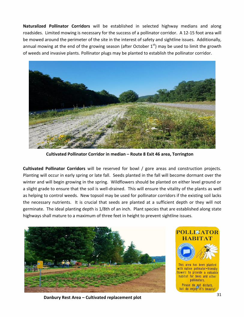
Naturalized Pollinator Corridors will be established in selected highway medians and along
roadsides. Limited mowing is necessary for the success of a pollinator corridor. A 12-15 foot area will
be mowed around the perimeter of the site in the interest of safety and sightline issues. Additionally,
annual mowing at the end of the growing season (after October 1st) may be used to limit the growth
of weeds and invasive plants. Pollinator plugs may be planted to establish the pollinator corridor.
Cultivated Pollinator Corridors will be reserved for bowl / gore areas and construction projects.
Planting will occur in early spring or late fall. Seeds planted in the fall will become dormant over the
winter and will begin growing in the spring. Wildflowers should be planted on either level ground or
a slight grade to ensure that the soil is well-drained. This will ensure the vitality of the plants as well
as helping to control weeds. New topsoil may be used for pollinator corridors if the existing soil lacks
the necessary nutrients. It is crucial that seeds are planted at a sufficient depth or they will not
germinate. The ideal planting depth is 1/8th of an inch. Plant species that are established along state
highways shall mature to a maximum of three feet in height to prevent sightline issues.
Cultivated Pollinator Corridor in median – Route 8 Exit 46 area, Torrington
Danbury Rest Area – Cultivated replacement plot

32
To promote biodiversity and a healthy pollinator habitat, a variety of plants shall be selected.
Pollinator plants shall have staggered bloom times to ensure the survival of pollinators in the area. At
a minimum, three species shall be flowering at any given time during the growing season. Plants of
the same variety shall be grouped within the corridor, as pollinating insects generally visit one type of
flower at a time.
Biodiversity of Pollinators

33
SCENIC ROADS
PURPOSE
Maintenance activities on scenic roads require special consideration to preserve the roads’ notable
features including vegetation distinctions. Designated CT scenic roads abut significant natural or
cultural features such as agricultural land or historic buildings and structures which are listed on the
National or State Register of Historic Places. These roads may also afford vistas of marshes,
shoreline, forests with mature trees, or other notable natural or geologic feature which singularly or
in combination set the highway apart from other state Highways as being distinct.
GUIDELINES
Routine maintenance of trees along scenic roadways will be performed in accordance with
Connecticut State Regulations Sections 13b-31e-1 through 13b-31e-4. The Scenic Roads Advisory
Committee Chairperson will be apprised of significant pre-planned maintenance activities in advance
of the work. In some instances, alternative means and/or methods will be recommended. In
addition, a press release will be issued to advise the public of the upcoming operations, dates, and
termini.
All work on scenic roads requiring an encroachment permit, regardless of the type of work, is to be in
accordance with current state statutes and regulations.

34
Scenic Road vistas throughout Connecticut
Route 146, Guilford Route 169, Woodstock
Route 7 @ Route 128 jct., West Cornwall Route 160, Glastonbury
Refer to the Appendix for a link to the CTDOT scenic roads web page.
Refer also to the CT Highway Design Manual 2003 - Criteria for Designation of Scenic Highways:
http://www.ct.gov/dot/lib/dot/documents/dpublications/Highway/cover.pdf

35
STORM DEBRIS MANAGEMENT
PURPOSE
The State of Connecticut has established Debris Management Plans for proper management of debris
generated by a natural disaster, with the goal of facilitating prompt and efficient recovery that is cost
effective, eligible for FEMA reimbursement, and protective of the environment. The types of natural
disasters may be flooding, hurricanes, tornadoes, and extreme winter events.
GUIDELINES
The State has executed monitoring and removal contracts to assist in the state’s recovery efforts
resulting from a natural disaster debris-producing event.
The State Natural Disaster Plan, signed by the Governor in 2009, was prepared by the Department of
Emergency Services and Public Protection (DESPP). The Plan establishes the mission assignments of
State agencies in responding to natural disasters of a severity and magnitude typical for Connecticut.
The Plan describes the interaction of state government with local governments, private response
organizations (e.g., utilities, the American Red Cross) and the federal government in natural disaster
situations.

36
The State Disaster Debris Management Plan, June 2013 (Annex to the State Natural Disaster Plan)
establishes the framework for proper management of debris generated by a natural disaster, with the
goal of facilitating prompt and efficient recovery that is cost effective, eligible for FEMA
reimbursement, and protective of the environment.
The Plan is an important planning document for all levels of government – federal, state and local and
describes the state contracts that are in place to use in response to a catastrophic natural disaster;
the contracts are for both debris removal operations and the monitoring of these types of operations
(see below for more information on the state contracts).
Further, included in the Plan are the planning and operation functions for temporary debris storage,
reduction sites, the two phases of clean-up, and a number of appendices that provide references to
waste management resources.
The State Concept of Operations Plan (ConOps) for Disaster Debris Management, Activation and
Use of the State Debris Removal and Monitoring Contracts is a companion document to the State
Disaster Debris Management Plan, June 2013. This Plan details the steps that will be taken by the
state, its contractors, and other parties to facilitate the removal, management, collection and
disposal or recycling of all debris generated from a catastrophic natural disaster, such as a Category 3
hurricane. This ConOps is tied to the activation and use of the state contracts for disaster debris
removal and monitoring.
Hurricane Sandy – October 28, 2012 Storm Irene – August 28, 2011
F1 Tornado – June 1, 2011 Snow Storm – October 29, 2011

37
The debris management strategy for the state is divided into four major operational time periods:
pre-landfall phase; phase 1; phase 2; and post-recovery. The pre-landfill phase involves planning for
the particular storm. Phase 1 is the initial response, typically occurring during the first 24 to 70 hours
following an event, and consists primarily of “pushing” the debris along major roadways to the right
of way shoulders that would otherwise hinder immediate life-saving actions and that pose an
immediate threat to public health and safety. Phase 2, which can last up to a year or longer, consists
of removing, segregating, and disposing or recycling of the debris that hinders the orderly recovery of
the community and poses less immediate threats to health and safety. The state contracts may be
initiated as early as Phase 1 if it is determined that the storm event may overwhelm state and local
emergency response resources. The final phase is post-recovery which involves restoration and
reestablishment of the affected debris management areas.
A state contract for the monitoring of the disaster debris removal operations was executed, June
2014 and a contract for the removal of disaster debris was executed July 2014. These are pre-need
and pre-event contracts that can assist the state in disaster debris recovery operations. These
contracts:
assure the immediate availability of coordinated debris removal support following a debris
producing incident.
will be used on an as-needed basis; and,
will be activated on a state-wide basis only by the Governor, typically in the context of an
emergency declaration.
Current Contracts: (see the DAS website http://das.ct.gov/sp1.aspx?page=432; State Contracting
Portal tab)
Debris Removal: provides for clearing, collecting and transporting debris, establishing and operating
temporary debris management sites, and ensuring ultimate recycling or disposal of debris.
Debris Monitoring (Reimbursement Documentation): provides for monitoring of debris removal
operations and debris site management. The monitoring contract also provides comprehensive
oversight, guidance and documentation services. This monitoring is required to receive potential
federal reimbursement for disaster debris management expenditures under Federal Emergency
Management Agency (FEMA) Public Assistance programs, as applicable.

38
Additional Resources for Disaster Debris Management Preparedness
Department of Emergency Management and Homeland Security (DEMHS)
Department of Energy and Environmental Protection (DEEP)
Federal Emergency Management Agency (FEMA)
US Environmental Protection Agency (EPA)
Northeast Recycling Coalition (NERC)
CT Department of Public Health (DPH)
Contacts
Technical Assistance - DEEP, Bureau of Materials Management and Compliance Assurance, Solid
Waste Enforcement, 860-424-3130 or [email protected]
CTDOT personnel opening roadway
due to an extreme weather event
39
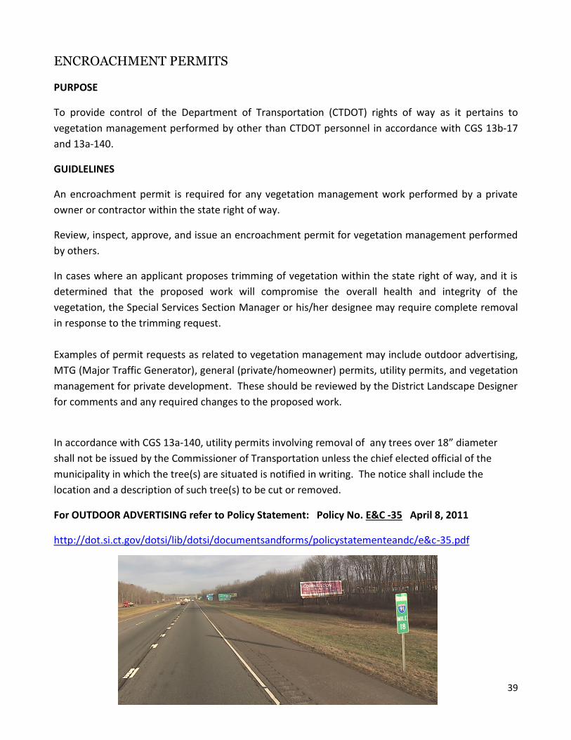
ENCROACHMENT PERMITS
PURPOSE
To provide control of the Department of Transportation (CTDOT) rights of way as it pertains to
vegetation management performed by other than CTDOT personnel in accordance with CGS 13b-17
and 13a-140.
GUIDLELINES
An encroachment permit is required for any vegetation management work performed by a private
owner or contractor within the state right of way.
Review, inspect, approve, and issue an encroachment permit for vegetation management performed
by others.
In cases where an applicant proposes trimming of vegetation within the state right of way, and it is
determined that the proposed work will compromise the overall health and integrity of the
vegetation, the Special Services Section Manager or his/her designee may require complete removal
in response to the trimming request.
Examples of permit requests as related to vegetation management may include outdoor advertising,
MTG (Major Traffic Generator), general (private/homeowner) permits, utility permits, and vegetation
management for private development. These should be reviewed by the District Landscape Designer
for comments and any required changes to the proposed work.
In accordance with CGS 13a-140, utility permits involving removal of any trees over 18” diameter
shall not be issued by the Commissioner of Transportation unless the chief elected official of the
municipality in which the tree(s) are situated is notified in writing. The notice shall include the
location and a description of such tree(s) to be cut or removed.
For OUTDOOR ADVERTISING refer to Policy Statement: Policy No. E&C -35 April 8, 2011
http://dot.si.ct.gov/dotsi/lib/dotsi/documentsandforms/policystatementeandc/e&c-35.pdf
40
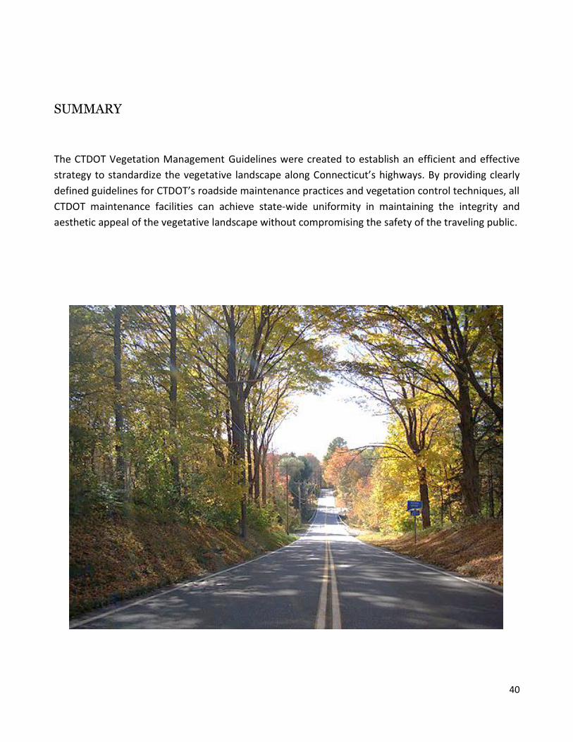
SUMMARY
The CTDOT Vegetation Management Guidelines were created to establish an efficient and effective
strategy to standardize the vegetative landscape along Connecticut’s highways. By providing clearly
defined guidelines for CTDOT’s roadside maintenance practices and vegetation control techniques, all
CTDOT maintenance facilities can achieve state-wide uniformity in maintaining the integrity and
aesthetic appeal of the vegetative landscape without compromising the safety of the traveling public.

41
APPENDIX
A Landscape Master Plan for the Merritt Parkway; Milone & MacBroom, Inc.; October 1994 American Association of State Highway and Transportation Officials; “Roadside Design Guide”, 4th Edition, 2011
CGS 13a-140 Removal of Trees Along State Highways. Penalties Established by Municipalities
Connecticut Department of Transportation “An Overview of Snow and Ice Control Operations on
State Highways in Connecticut”, June 2015
Connecticut Department of Transportation Bureau of Engineering and Highway Operations “Manual
of Organization, Functions and Procedures, 1997
Connecticut Department of Transportation “Connecticut Scenic Roads”
http://www.ct.gov/dot/cwp/view.asp?a=2094&q=305520
Connecticut Department of Transportation, FORM 816 and 817 – Standard Specifications for Roads,
Bridges, Facilities, and Incidental Construction, 2004 and 2016
Connecticut Department of Transportation “Guidelines for Tree Maintenance and Removal”, rev.
November 2000
Connecticut Department of Transportation - Encroachment Permit Regulations 1992
Connecticut Department of Transportation “Highway Design Manual 2003 Edition”, rev. to February
2013
Connecticut Department of Transportation “Merritt Parkway Guidelines” For General Maintenance
and Transportation Improvements, June 1994
Manual on Uniform Traffic Control Devices for Streets and Highways 2009 Edition
http://mutcd.fhwa.dot.gov/pdfs/2009r1r2/mutcd2009r1r2edition.pdf
Maintaining Roadsides for Pollinators Establishment, Restoration, Management and Maintenance, A
Guide for State DOT Managers and Staff, Technical Manual, Mary Galea, Vicki Wojcik, Ph.D., Laurie
Davies Adams, and Evan Cote, 2016
Merritt Parkway Guidelines For General Maintenance and Transportation Improvements; The Merritt
Parkway Working Group; June 1994

42
Report of the Committee on Management of Roadside Trees, John Jasinski, Bradford Robinson, Chris
Donnelly, February 22, 2012
“Report of the Two Storm Panel” presented to Governor Dannel P. Malloy, January 2013
http://www.ctsprague.org/resources/two_storm_panel_final_report.pdf
State of Connecticut “Substitute Senate Bill No. 231: Public Act No. 16-17”
https://cga.ct.gov/2016/act/pa/pdf/2016PA-00017-R00SB-00231-PA.pdf
The Xerces Society for Invertebrate Conservation in collaboration with ICF International “Pollinator
Habitat Enhancement and Best Management Practices in Highway Rights-of-Way”, May 2015
Related Documents