Form 31(i0-3 SUBMIT IN TRIPLICATE* Form approved. (December 1990) . (Otherinstructions Budget Bureau No. 1004-0136 U I'ED STATES reverse side) Expires: December 31, 1991 DEPARTMENT OF THE INTERIOR 5. LEASE DESIGNATION AND SERIAL NO. BUREAU OF LAND MANAGEMENT -UTE ??252 fYl,Û $9SS APPLICATION FOR PERMIT TO DRILL OR DEEPEN 6.IFNIAN,ALLOTTEEORTRIBENAME la. TYPE OF WORK 7. UNIT AGREEMENT NAME DRILL lä! DEEPEN N/A b. TYPE OF WELL OIL GAS SINGLE MULTIPLE 8. FARM OR LEASE NAME,WELL NO. WELL WELL OTHER ZONE ZONE Q ((Q --USA 26-267 2. NAME OF OPERATOR 9. API WELL NO. 3. ADDRESS AND TELEPHONE NO. 10. FIELD AND POOL, OR WILDCAT 1305 So. 100 E. Price, Utah 84501 (435) 637-8876 Undesignated 4. LOCATION OF WELL (Report location clearly and in accordance with any State requirements.*) 11. SEC.,T.,R.,M, OR BLK. AAtpsrurfpmeed prod. zone Ú836' FNL, 2130' FWL Jt3 5 ' 6 SSLE W , e 26, Tl5S, R9E, 14.. DISTANCE IN MILES AND DIRECTION FROM NEAREST TOWN OR POST OFFICE* 12. COUNTY OR PARISH 13. STATE 8.2 miles southwest of Price, Utah Carbon UTAH 15. DISTANCE FROM PROPOSED* 16.NO. OF ACRES IN LEASE 17. NO. OF ACRES ASSIGNED LOCATION TO NEAREST TO THI : WELL PROPERTYORLEASELINE,FT. 500' 760 acres 160 acres (Also to nearest drig. unit line, if any) 18. DISTANCE FROM PROPOSED 19. PROPOSED DEPTH 20. ROTARY OR CABLE TOOLS LOCATION TO NEAREST WELL, DRILLING, COMPLETED, OR 2500' 3100' Rotary APPLIED FOR, ON THIS LEASE,FT. 21. ELEVATIONS (Show whether DF,RT,GR,etc.) 22. APPROX. DATE WORK WILL START* GR 5967' March 1999 23. PROPOSED CASING AND CEMENTING PROGRAM SIZE OF HOLE GRADE, SIZE OF CASING WEIGHT PER FOOT SETTING DEPTH QUANTITYDF CEMENT 14" 12-3/4" Conductor 25' 11" 8-5/8" 24 #/ft 310' 137 sks. G+2% CaCl+1/4# per sack flocel 7- 7/8" 5-1/2" 17 #/tt 3100' 306 sks 50/50 POZ +8%gel+2%CaCl+10%extender. 75 sks "G thixotropic CONFllENTIA gy È 1996 COPY DIV. OF OIL, GAS & MIN\NG IN ABOVE SPACE DESCRIBE PROPOSED PROGRAM: If proposal is to deepen, give data present productive zone and proposed new productive zone. If proposal is to drill or deepen directionally, give pertinent data on subsurface locations and measured and true vertical depths. Give blowout preventer program, if any. 24. SIGNED . O TITLE DATE 11/24/98 (This space for Federal or State - APPROVAL DATE Application approval does not warrant or certi e applicant holds legal or equitable title to those rights in the subject lease which would entitle the applicant to conduct operations thereon. CONDITION PROVAL, IF ANY: BRADLEYG. HILL APPROVED BY , TITLE RECLAMATIONSPECIALISTIll DATE *See Instructions On Reverse Side Title 18 U.S.C. Section 1001, makes it a crime for any person knowingly and willfully to make to any department or agency or the United States any false, fictitious or fraudulent statements or representations as to any matter within its

Welcome message from author
This document is posted to help you gain knowledge. Please leave a comment to let me know what you think about it! Share it to your friends and learn new things together.
Transcript
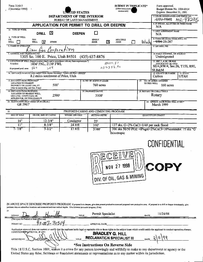
Form31(i0-3 SUBMIT IN TRIPLICATE* Form approved.(December 1990) . (Otherinstructions Budget Bureau No. 1004-0136
U I'ED STATES reverse side) Expires: December 31, 1991DEPARTMENT OF THE INTERIOR 5. LEASE DESIGNATION AND SERIAL NO.
BUREAU OF LAND MANAGEMENT -UTE ??252 fYl,Û $9SSAPPLICATION FOR PERMIT TO DRILLOR DEEPEN 6.IFNIAN,ALLOTTEEORTRIBENAME
la. TYPE OF WORK7. UNIT AGREEMENT NAME
DRILL lä! DEEPEN N/Ab. TYPE OF WELL
OIL GAS SINGLE MULTIPLE 8. FARM OR LEASE NAME,WELL NO.WELL WELL OTHER ZONE ZONE Q ((Q --USA 26-2672. NAME OF OPERATOR 9. API WELL NO.
3. ADDRESS AND TELEPHONE NO. 10. FIELD AND POOL, OR WILDCAT
1305 So. 100 E. Price, Utah 84501 (435) 637-8876 Undesignated4. LOCATION OF WELL (Report location clearly and in accordance with any State requirements.*) 11. SEC.,T.,R.,M, OR BLK.
AAtpsrurfpmeed
prod. zone
Ú836'FNL, 2130' FWLJt3 5 ' 6 SSLE W , e 26, Tl5S, R9E,
14.. DISTANCE IN MILES AND DIRECTION FROM NEAREST TOWN OR POST OFFICE* 12. COUNTY OR PARISH 13. STATE8.2 miles southwest of Price, Utah Carbon UTAH
15.DISTANCE FROM PROPOSED* 16.NO. OF ACRES IN LEASE 17. NO. OF ACRES ASSIGNEDLOCATION TO NEAREST TO THI : WELLPROPERTYORLEASELINE,FT. 500' 760 acres 160 acres(Also to nearest drig. unit line, if any)
18. DISTANCE FROM PROPOSED 19. PROPOSED DEPTH 20. ROTARY OR CABLE TOOLSLOCATION TO NEAREST WELL,
DRILLING, COMPLETED, OR 2500' 3100' RotaryAPPLIED FOR, ON THIS LEASE,FT.
21. ELEVATIONS (Show whether DF,RT,GR,etc.) 22. APPROX. DATE WORK WILL START*
GR 5967' March 1999
23. PROPOSED CASING AND CEMENTING PROGRAMSIZE OF HOLE GRADE, SIZE OF CASING WEIGHT PER FOOT SETTING DEPTH QUANTITYDF CEMENT
14" 12-3/4" Conductor 25'11" 8-5/8" 24 #/ft 310' 137 sks. G+2% CaCl+1/4# per sack flocel
7- 7/8" 5-1/2" 17 #/tt 3100' 306 sks 50/50 POZ +8%gel+2%CaCl+10%extender. 75 sks "Gthixotropic
CONFllENTIAL
gy È 1996 COPYDIV.OFOIL,GAS&MIN\NG
IN ABOVE SPACE DESCRIBE PROPOSED PROGRAM: If proposal is to deepen, give data present productive zone and proposed new productive zone. If proposal is to drill or deepen directionally, givepertinent data on subsurface locations and measured and true vertical depths. Give blowout preventer program, if any.
24.
SIGNED . O TITLE DATE11/24/98
(This space for Federal or State
- APPROVAL DATE
Application approval does not warrant or certi e applicant holds legal or equitable title to those rights in the subject lease which would entitle the applicant to conduct operations thereon.CONDITION PROVAL, IF ANY: BRADLEYG. HILLAPPROVED BY , TITLE RECLAMATIONSPECIALISTIll DATE
*See Instructions On Reverse SideTitle 18 U.S.C. Section 1001, makes it a crime for any person knowingly and willfully to make to any department or agency or theUnited States any false, fictitious or fraudulent statements or representations as to any matter within its
Tl5S, R9E, S.L.B.&M.S 89°59'58" W 2644.60' (Measured) N 90°00'00" W 2644.77' (Measured) Basis of Bearing:WEST 2643.30' (Record) WEST 2643.30' (Record) Basis of Bearing is WEST between the NE Cornerand the North QuarterCorner of Secton 26, Township15 South, Range 9 East, Salt Lake Base and Meridian.
Basis of Elevation:Basis of Elevation of 5928' as indicated at the NorthQuarterCorner of Section26, Township 15 South,Range 9 East, Salt Lake Base and Meridian, as shownon the Poison Spring Bench Quadrangle7.5 Minute- - - -
- - Series Map.
Description of Location:Proposed Drill Hole located in the SE 1/4, NW 1/4 of
2130.12'Section 26; 2130.12' East from the West Line and1836.01' South from the North Line of Section 26,TISS, R9E, Salt Lake Base and Meridian.
DRILL HOLE 26-267ELEVATION 5966.78'
Surveyor's Certificate:I, Daniel W. Peatross, a Registered Licensed LandSurveyor,holding Certificate #259966, State of Utah,do hereby certify that the information on this drawingis true and accurate to the best of my knowledge andbelief,and was conducted bymyself, as shown hereon.
No. 259966 y
N 89°59'46" W 2656.74' (Measured) S 89°53'52" W 2660.68' (Measured)N 89°59' W 2655.18' (Record) S 89°54' W 2659.80' (Record) N RIVER GAS CORPORATIONWELL #26-267
E Section 26, Tl5S, R9E, S.L.B.&M.LEGEND:
Carbon County, UtahDrill Hole LocationS DANIEL W. PEATROSSFound Section Corner monumented with GLO SCALE r -iooo' REGISTERED LAND SURVEYORBrass cap unless indicated otherwise.
P.O. BOX 564 - DUCHESNE UTAH, 84021 (435) 738-2718JOB #98025 SURVEYED BY: D.P. D.F. DATE SURVEYED: I 1-16-98
Section Corner (Searched for, Not Found)SilEET I OF 4 DRAFTED BY: Bruce Peatrons DATE DRAFTED:
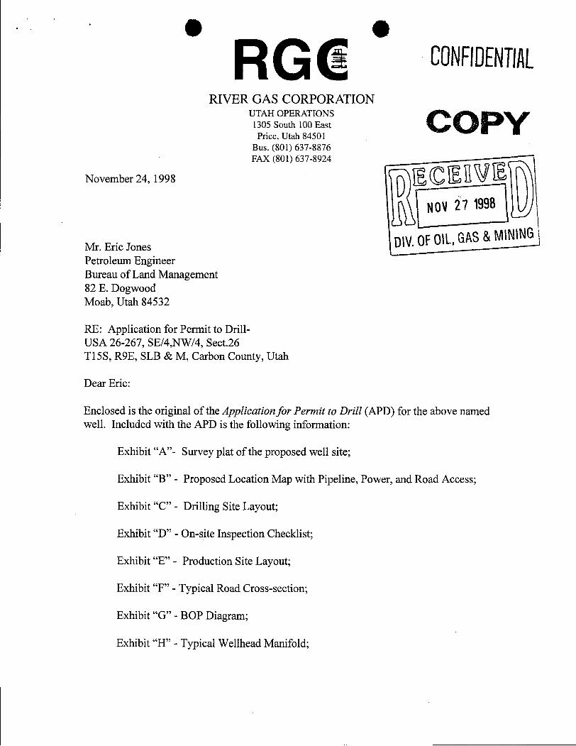
RIVER GAS CORPORATIONUTAH OPERATIONS
1305 South 100 EastPrice, Utah 84501
Bus. (801) 637-8876
November 24, 1998
FAX (801) 637-8924
NOV27 1998
Mr. Eric JonesPetroleum Engineer
DIV.OFOIL,GAS&MINING
Bureau of Land Management82 E. DogwoodMoab, Utah 84532
RE: Application for Permit to Drill-USA 26-267, SE/4,NW/4, Sect.26Tl5S, R9E, SLB & M, Carbon County, Utah
Dear Eric:
Enclosed is the original of the ApplicationforPermit to Drill (APD) for the above namedwell. Included with the APD is the following information:
Exhibit "A"- Survey plat of the proposed well site;
Exhibit "B" - Proposed Location Map with Pipeline, Power, and Road Access;
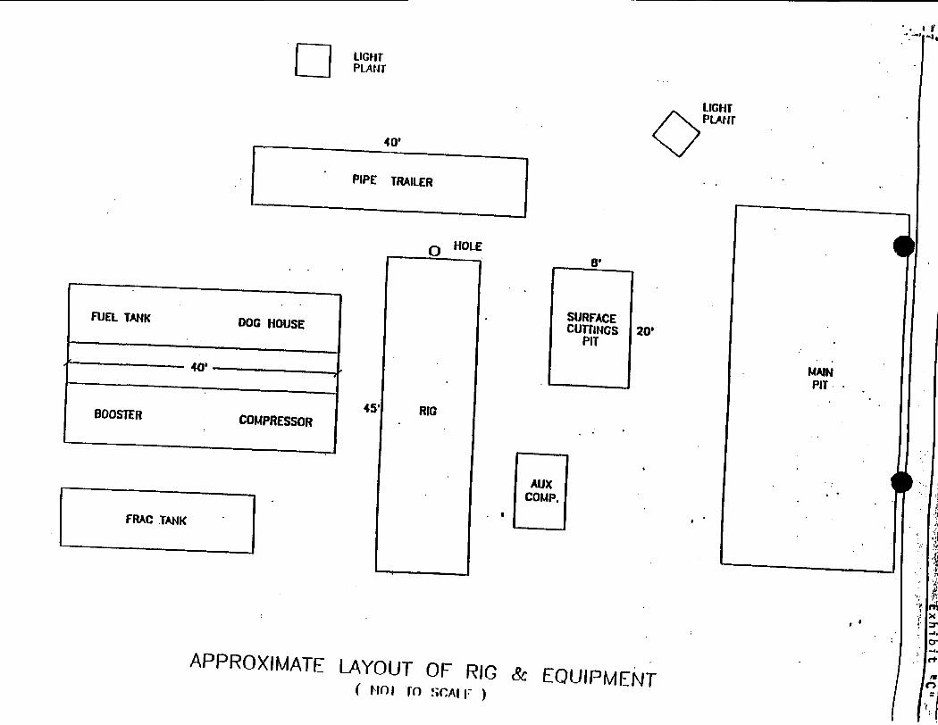
Exhibit "C" - Drilling Site Layout;
Exhibit "D" - On-site Inspection Checklist;
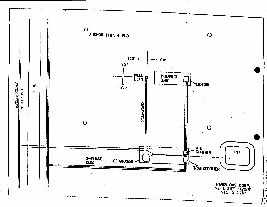
Exhibit "E" - Production Site Layout;
Exhibit "F" - Typical Road Cross-section;
Exhibit "G" - BOP Diagram;
Exhibit "H" - Typical Wellhead
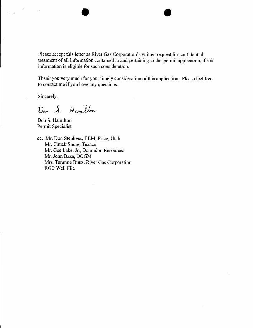
Please accept this letter as River Gas Corporation's written request for confidentialtreatment of all information contained in and pertaining to this permit application, if saidinformation is eligible for such consideration.
Thank you very much for your timely consideration of this application. Please feel freeto contact me if you have any questions.
Sincerely,
Don S. HamiltonPermit Specialist
cc: Mr. Don Stephens, BLM, Price, UtahMr. Chuck Snure, TexacoMr. Gee Lake, Jr., Dominion ResourcesMr. John Baza, DOGMMrs. Tammie Butts, River Gas CorporationRGC Well
Exhibit "D" 1 of 10
OUT-060-3160-1
December, 1992
Bureau of Land ManagementMoab District
Application for Permit to DrillOn-Site Inspection Checklist
Company River Gas Corporation Well No. USA 26-267
Location: Sec. 26, TJ S, R 9 E, Lease No. UTU-77352
On-Site Inspection Date: 11-12-98
All operations will be conducted in such a manner that full compliance is made with applicable laws,regulations (43 CFR 3100), Onshore Oil and Gas Orders, the approved plan of operations and theconditions of approval. The operator is fully responsible for the actions of his subcontractors. A copy ofthese conditions will be furnished to the field representative to ensure compliance.
A. DRILLING PROGRAM
1. Surface Formation and Estimated Formation Tops:Surface formation: Upper Mancos ShaleEstimated top of Ferron Formation: 2,200'
2. Estimated Depth at Which Oil, Gas, Water or Other Mineral Bearine Zones are Expected tobe Encountered
Depth Formation
Expected Oil Zones: noneExpected Gas Zones: Ferron Coal Interval: 2,220'-2,350'Expected Water Zones: 2,220'-2,350'Expected Mineral Zones: none
All fresh water and prospectively valuable minerals encountered during drilling will berecorded by depth and will be cased and cemented. When possible, water flow rates will bemeasured and samples will be taken and analyzed. All oil and gas shows will be tested todetermine commercial potential.
3. Pressure Control Equipment- include schematics of the BOP and choke manifold, anddescribe testing procedures: QuickTest is contracted to test the manifold, blind rams, andB.O.P to 2000 psi. Surface casing is tested to 1 psi/ft. See attachment.
BOP systems will be consistent with API RP 53 and Onshore Oil and Gas Order No. 2,with variances previously granted. Pressure tests of the surface casing and all BOPequipment potentially subject to pressure will be conducted before drilling the surfacecasing shoe. Blowout preventer controls will be installed prior to drilling the surface casingshoe and will remain in use until the well is completed or abandoned. Ram preventers shallbe inspected and operated each trip (no more than once a day is necessary), and annularpreventers shall be inspected and operated weekly to ensure good mechanical workingorder. These inspections shall be recorded in the drilling log and in the daily drillingreport.
4. Casing Program and Auxiliary Equipment - include casing size, weight, grade, thread andcoupling, setting depth and condition (new or acceptably reconditioned): Approximately3100' of 5 ½", 17#/ft,N-80, LT&C production casing will be installed approximately 10%of the above setting depth will be 8 5/8", 24#/ft J-55 surface casing.
5. Cement-include the cement type, density, yield, additives and amount used in setting eachcasing string. Also include the anticipated cement fill-up. If stage cementing, describetechniques: See cement design.
6. Mud Program and Circulating Medium- include mud components and weights. When airdrilling, also include: length and location of blooie line; description of the auto ignitor;description of the deduster equipment; and amounts, types and characteristics of stand-bymud: Hole will be drilled with air.
7. Coring, Logging and Testing Program: Bulk Density, Gamma, Neutron Density, Resistivityand Caliper logs will be ran.Initial opening of drill stem test tools will be restricted to daylight hours.
8. Abnormal Conditions, Bottom Hole Pressures and Potential Hazards- include anticipatedbottomhole pressure and/or pressure gradient: No abnormal conditions are anticipated.Formation is slightly over-pressured. Estimated BHP: 1552 psi.
9. Any Other Aspects of this Proposal that should be Addressed:
B. THIRTEEN POINT SURFACE USE PLANThe dirt contractor will be provided with an approved copy of the surface use plan of operationsbefore initiating construction.
1. Existing Roads:
a. Proposed route to location (submit a map depicting access and well location).
b. Location of proposed well in relation to town or other reference point: 8.2 milessouthwest of Price, Ut.
c. Contact the County Road Department for use of county roads. The use of San JuanCounty roads will require an encroachment permit from the San Juan Road Department.
d. Plans for improvement and/or maintenance of existing roads:
e. Other:
2. Planned Access Roads:
a. Location (centerline): Existing USA 26-255 approximately: 1250' FNL, 800' FEL,Section 26
b. Length of new access top be constructed: 2600'
c. Length of existing roads to be upgraded: 0'
d. Maximum total disturbed width: 45'
O Oe. Maximum travel surface width: 20'
f. Maximum grades: 8%
g. Turnouts: N/A
h. Surface materials: In-place residual of Mancos Shale
i. Drainage (crowning, ditching, culverts, etc): Roads will be crowned with bar ditches onboth sides & 6 culverts placed along new road.
j. Cattleguards: N/A
k. Length of new and/or existing roads which lie outside the lease boundary for which aBLM right-of-way is required: N/A
I. Other:
Surface disturbance and vehicular travel will be limited to the approved location access road.Any additíonal area needed must be approved by the Area Manager advance.
If a right-a-way is necessary, no surface disturbing activities shall take place on the subjectright-of-way until the associated APD is approved. The holder will adhere to conditions ofapproval in the Surface Use Program of the approved APD, relevant to any right-of-wayfacilities.
If a right-of-way is secured, boundary adjustments in the lease or unit shall automaticallyamend this right-of-way to include that portion of the facility no longer contained within thelease or unit. In the event of an automatic amendment to this right-of-way grant, the prioron-lease/unit conditions of approval of this facility will not be affected even though they wouldnow apply to facilities outside of the lease/unit as a result of a boundary adjustment. Rentalfees, if appropriate shall be recalculated based on the conditions of this grant and theregulations in effect at the time of an automatic amendment.
If the well is productive, the access road will be rehabilitated or brought to Resource (ClassIII) Road Standards within 60 days of dismantling the rig. If upgraded, the access road mustbe maintained at these standards until the well is properly abandoned. If this time framecannot be met, the Area Manager will be notified so that temporary drainage control can beinstalled along the access road.
3. Location of Existing Wells-on a map, show the location of all water, injection, disposal,producing and drilling wells within a one mile radius of the proposed well, and describe thestatus of each: See Attachment "B"
4. Location of Production Facilities:
a. On-site facilities: See Attachment "E"
b. Off-site facilities: none
c. Pipelines: N/A
All permanent (in place for six months or longer) structures constructed or installed(including oil well pump jacks) will be painted a flat, nonreflective color to match the
O Ostandard environmental colors, as determined by the Rocky Mountain Five-State InteragencyCommittee. All facilities will be painted within six months of installation. Facilities requiredby comply with the Occupational Safety and Health Act (OSHA) may be excluded. Colorswill be as follows:tan
All site security guidelines identified in 43 CFR §3163.7-5 and Onshore Oil and Gas OrderNo. 3 Colors will be as follows: tan
If a gas meter run is constructed, it will be located on lease within 500 feet of the wellhead.The gas flowline will be buried from the wellhead to the meter and will be burieddownstream of the meter until it leaves the pad. Meter runs will be housed and/or fenced.The gas meter shall be calibrated prior to first sales and shall be calibrated quarterlythereafter. All gas production and measurement shall comply with the provisions of 43 CFR§3162. 7-3, Onshore Oil and Gas Order No. 5, and American Gas Association (AGA) ReportNoat3ank
battery is constructed on this lease, it will be surrounded by a dike of sufficientcapacity to contain 1 ½ times the storage capacity of the largest tank. All loading lines andvalves will be placed inside the berm surrounding the tank battery. All oil production andmeasurement shall conform to the provisions of 43 CFR §3162.7-3 and Onshore Oil and GasOrder No. 4
Production facilities on location may include a lined or unlined produced water pit asspecified in NTL-2B. If water is produced from the well, an NTL-2B application must besubmitted.
5. Location and Type of Water Supply:
All water needed for drilling purposes will be obtained from (describe location and/or showon a map): PRWID(a local public water source)
6. Source of Construction Material:
Pad construction material will be obtained from (if the source is Federally owned, showlocation on a map): Private owner in East PriceThe use of materials under BLM jurisdictionwill conform to 43 CFR 3610.2-3.
7. Methods of Handline Waste Disposal:
Describe the methods and locations proposed for safe containment and disposal of wastematerial, e.g. cuttings, produced water, garbage, sewage, chemicals, etc.
The reserve pit will be lined with (native material, bentonite, synthetic material): Pit will belined with native material unless designated otherwise by BLM officers prior to construction.
The reserve pit will be located: on the south end of the location,and the pit walls will besloped at no greater than 2to I.
The reserve pit shall be located in cut material, with at least 50% of the pit volume beingbelow original ground level. Three sides of the reserve pit will be fenced before drillingstarts. The fourth side will be fenced as soon as drilling is completed, and shall remain until
the pit is dry. As soon as the reserve pit has dried, all areas not needed for production will berehabilitated.
Trash must be contained in a trash cage and hauled away to an approved disposal site asnecessary but no later than at the completion of drilling operations.
8. Ancillary Facilities: Garbage Containers and Portable Toilets
9. Well Site Layout - depict the pit, rig, cut and fill, topsoil, etc. on a plat with a scale of atleast I" = 50'.
All well, whether drilling, producing, suspended, or abandoned, will be identified inaccordance with 43 CFR 3162.6.
Access to the well pad will be from: north
The blooie line will be located: on the south ,at least 100 feet from the well head.
To minimize the amount of fugitive dust and spray escaping from the blooie pit, the followingblooie line deflection method will be employed: Water Injection.
10. Plans for Restoration of the Surface:
The top 6 inches of topsoil material will be removed from the location and stockpiledseparately on: Adjacent land.
Topsoil along the access road will be reserved in place adjacent to the road.
Immediately upon completion of drilling, all equipment that is not necessary for productionshall removed.
The reserve pit and that portion of the location not needed for production will be reclaimed.
Before any dirt work to restore the location takes place, the reserve pit must be completelydry.
Reclaimed roads will have the berms and cuts reduced and will be closed to vehicle use.
All disturbed areas will be recontoured to replicate the natural slope.
The stockpiled topsoil will be evenly distributed over the disturbed area.
Prior to reseeding, all disturbed areas, including the access roads, will be scarified and leftwith a rough surface.
Seed will be broadcast or drilled between Sept. and Nov., or at a time specified by the BLM.If broadcast, a harrow or some other implement will be dragged over the seeded area to assureseed coverage.
The following seed mixture will be used:
BLM-recommended mixture.
The abandonment marker will be one of the following, as specified by BLM:
O O1) at least four feet above ground level,2) at restored ground level, or3) below ground level.
In any case the marker shall be inscribed with the following: operator name, lease number,well name and surveyed description (township, range, section and either quarter-quarter orfootages).
Additional requirements:
11. Surface and Mineral Ownership: BLM
12. Other Information:
a. Archeological Concerns: None that RGC is aware of.
The operator is responsible for informing all persons in the area who areassociated with this project that they will be subject to prosecution forknowingly disturbing historic or archaeological sites, or for collecting artifacts.If historic or archaeological materials are uncovered during construction, the operatoris to immediately stop work that might further disturb such materials, and contact theauthorized officer (AO). Wíthin five (5) working days, the AO will inform the operatoras to:
• whether the materials appear eligible for the National Register of HistoricPlaces;
• the mitigation measures the operator will likely have to undertake before thesite can be used (assuming in situ preservation is not necessary); and
• a time frame for the AO to complete an expedited review under 36 CFR800.11 to confirm, through the State Historic Preservation Officer, that thefindings of the AO are correct and that mitigation is appropriate.
If the operator wishes, at any time, to relocate activities to avoid the expense ofmitigation and/or the delays associated with this process, the AO will assumeresponsibility for whatever recordation and stabilization of the exposed materials may berequired. Otherwise, the operator will be responsible for mitigation costs. The AO willprovide technical and procedural guidelines for the conduct of mitigation. Uponverification from the AO that the required mitigation has been completed, the operatorwill then be allowed to resume construction.
b. Threatened and Endangered Species Concerns: No
c. Wildlife Seasonal Restrictions (yes/no): See EIS
d. Off Location Geophysical Testing: N/A
e. Drainage crossings that require additional State or Federal approval: N/A
f. Other: N/A
13. Lessee's or Operator's Representative and Certification
Representative:
Name: Don S. Hamilton
Title: Permitting Specialist
Address: 1305 South 100 EastPrice, Utah 84501
Phone No: (435)637-8876
Certification:
I hereby certify that I, or persons under my direct supervision, have inspected the proposeddrill site and access route; that I am familiar with the conditions which currently exists; thatthe statements make in this APD package are, to the best of my knowledge, true and correct;and that the work associated with the operations proposed herein will be performed by RGCand its contractors and subcontractors in conformity with this APD package and the terms and
conditions under which it is approved. I also certify responsibility for the operationsconducted on that portion of the leased lands associated with this application, with bondcoverage being provided under BLM bond no. S304604. This statement is subject to theprovisions of 18 U.S.C. 1001 for the filing of a false statement.
Signature
Permit Specialist November 24, 1998Title Date
g eC. REQUIRED APPROVALS, REPORTS AND NOTIFICATIONS
Required verbal notifications are summarized in Table 1, attached.
Building Location- Contact the Resource Area, Natural Resource Protection Specialist at least 24hours prior to commencing construction of location.
SpJ- The spud date will be reported to the Resource Area Office 24 hours prior to spudding.Written notification in the form of a Sundry Notice (Form 3160-5) will be submitted the DistrictOffice within 24 hours after spudding, regardless of whether spud was made with a dry holedigger or big rig.
Daily Drilling Reports- Daily drilling reports shall detail the progress and status of the well andshall be submitted to the District Office on a weekly basis.
Monthly Reports of Operations- In accordance with Onshore Oil and Gas Order No. 1, this wellshall be reported on Minerals Management Service (MMS) Form 3160, "Monthly Report ofOperations," starting the month in which operations commence and continuing each month untilthe well is physically plugged and abandoned. This report will be filed directly with MMS.
Sundry Notices- There will be no deviation from the proposed drilling and/or workover programwithout prior approval from the Assistant District Manager. "Sundry Notices and Reports onWells: (Form 3160-5) will be filed for approval for all changes of plans and other operations inaccordance with 43 CFR 3162.3-2. Safe drilling and operating practices must be observed.
Drilling Suspensions- Operations authorized by this permit shall not be suspended for more than30 days without prior approval of the Authorized Officer. All conditions of this approval shall beapplicable during any operations conducted with a replacement rig.
Undesirable Events- Spills, blowouts, fires, leaks, accidents, or any other unusual occurrencesshall be immediately reported to the Resource Area in accordance with requirements of NTL-3A.
Cultural Resources- If cultural resources are discovered during construction, work that mightdisturb the resources is to stop, and the Area Manager is to be notified.
First Production- Should the well be successfully completed for production, the Assistant DistrictManager, Minerals Division will be notified when the well is placed in producing status. Suchnotification may be made by phone, but must be followed by a sundry notice or letter not laterthan five (5) business days following the date on which the well is placed into production.
A first production conference will be scheduled as soon as the productivity of the well is apparent.This conference should be coordinated through the Resource Area Office. The Resource AreaOffice shall be notified prior to the first sale.
g eWell Completion Report- Whether the well is completed as a dry hole or as a producer, "WellCompletion and Recompletion Report and Log" (Form 3160-4) will be submitted to the DistrictOffice not later than thirty (30) days after completion of the well or after completion of operationsbeing performed, in accordance with 43 CFR 3162.4-1. Two copies of all logs, core descriptions,core analysis, well test data, geologic summaries, sample description, and all other surveys or dataobtained and compiled during the drilling, workover, and/or completion operations, will be filedwith Form 3160-4. Samples (cuttings and/or samples) will be submitted when requested by theAssistant District Manager.
Venting/Flaring of Gas-NTL-4A allows venting/flaring of gas during the initial well evaluationperiod not to exceed 30 days or 50 MMcf. Venting/flaring beyond the initial test period thresholdmust be approved by the District Office.
Produced Water- Produced waste water may be confined to an unlined pit for a period not toexceed 90 days after initial production. During the 90 day period, an application for approval of apermanent disposal method and location, along with the required water anlysis, will be submittedto the Assistant District Manager for approval pursuant to NTL-2B.
Off-Lease Measurement, Storage, Commingling- Prior approval must be obtained from theAssistant District Manager for off-lease measurement, off-lease storage and/or commingling(either down-hole or at the surface).
Plugging and Abandonment- If the well is completed as a dry hole, plugging instructions must beobtained from the BLM, Moab District Office prior to initiating plugging operations. Table 1 ofthis document provides the after-hours phone numbers of personnel who are authorized to giveplugging instructions.
A "Subsequent Report of Abandonment" (Form 3160-5) will be filed with the Assistant DistrictManager, Minerals Divisions within thirty (30) days following completion of the well forabandonment. This report will indicate where plugs were placed and the current status of surfacerestoration. Upon completion of approved plugging, a regulation marker will be erected inaccordance with 43 CFR 3162.6. Final abandonment will not be approved until the surfacereclamation work required by the approved APD or approved abandonment notice has beencompleted to the satisfaction of the Area Manager or his representative, or the appropriate surfacemanaging agency.
O OTABLE 1
NOTIFICATIONS
Notify Don Stephens of the Resource Area, at (435)636-3608 for the following:
2 days prior to commencement of dirt work, construction or reclamation;
1 day prior to spudding;
50 feet prior to reaching surfàce and intermediate casing depths;
3 hours prior to testing BOPE;
12 hours prior to reaching kickoff point depth (if applicable).
If the person at the above number cannot be reached, notify the Moab District Office at (435) 259-6I l I. If unsuccessful, notify one of the people listed below.
Well abandonment operations require 24 hour advance notice and prior approval. In the case ofnewly drilled dry holes, verbal approval can be obtained by calling the Moab District Office,Branch of Fluid Minerals at (435) 259-6111. If approval is needed after work hours, you maycontact the following:
Eric Jones, Petroleum Engineer Office: (435) 259-6111Home: (435) 259-2214
If unable to reach the above individuals, please call:
Lynn Jackson, Office: (435) 259-6111Chief, Branch of Fluid Minerals Home: (435) 259-7990
ACCESSROAD
F
4.8'
4' BERM
WELL# 6-267CUT ELEV.5 6.8'
0.5' iso' 100· \UT 125 90. ILL.5|
| 12"NAIL12"NAILREFERENCE
REFERENCE10' 0' X 6' * POINTPOINT
C3FILL o1.4'
ELEVATION NATURAL GROUNDAT LOCATION STAKE = 5966.78'
ELEVATION GRADED GROUNDAT LOCATION STAKE = 5966.3'
N RIVER GAS CORPORATIONso•xb x 1o'LOCATION LAYOUT
W E Section 26, T15S, R9E, S.L.B.&M.WELL #26-267
S DANIEL W. PEATROSSSCALE 1" = 50' REGISTERED LAND SURVEYORP.O. BOX 564 - DUCHESNEUTAH, 84021 (435) 738-2718
JOB#98025 SURVEYEDBY: D.P. D.F. DATESURVEYED: I1-16-98NilERT 2OF4 DRAFTED!!Y: UnwoPeatnm DATE DitAVrBD:
100 .0
' 75 .0
'
LOCATION SLOPE = 1-l/2:1-
PIT SLOPE = 1:1FINAL FILLGRADE
100 .0
' 75 .0
' 25 '-50
.0
'
STA E ------
FILL SECTIONB-B CUT
cuTORIGINAL 'GROUND
100 .0
' 75 .0 -
'
1" = 40'CUT SECTION A-A CUTCROSSSCSECETION
N RIVER GAS CORPORATIONAPPROXIMATE YARDAGESCROSS SECTIONS
W E Section 26, Tl5S, R9E, S.L.B.&M.WELL #26-267CUT 6" TOPSOIL STRIPPING = 750 Cu. Yds.
S DANIEL W. PEATROSSREMAINING LOCATION CUT = 3017 Cu. Yds. SCALE l"-40' REGISTERED LAND SURVEYORP.O. DOX S64 -Ot iCIIESNE llTAll, 84021 (435) 738-2718TOTAL CUT = 3767 Cu. Yds.
J UlI98025 NifHVEYEDHY: D.P. D.V. DATEstiRVEYED: !!-16-98TOTAI, F1]I = 1663 Co Yds,ary, ,,m e,,,4.,,,, y,,, o,aiwo ,,
hi t " 1 of '2
re
p2
Fe er al
owerlin'
pe ne
7 2 25
ed al
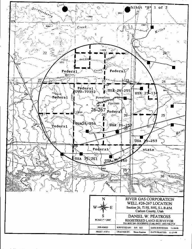
N RIVER GAS CORPORATIONWELL #26-267 LOCATION
E Section 26, T15S, R9E, S.L.B.&M.Carbon County, Utah
S DANIEL W. PEATROSSSCALE 1" = 2000' REGISTEREDLAND SURVEYOR
P.O. BOX 564 - DUCHESNE UTAH, 84021 (435) 738-2718
JOB #98025 SURVEYED BY: D.P. D.F. DATE SURVEYED: 11-16-98
SHEET 4 OF 4 DRAFTED BY: Bruce Peatross DATE DRAFTED:
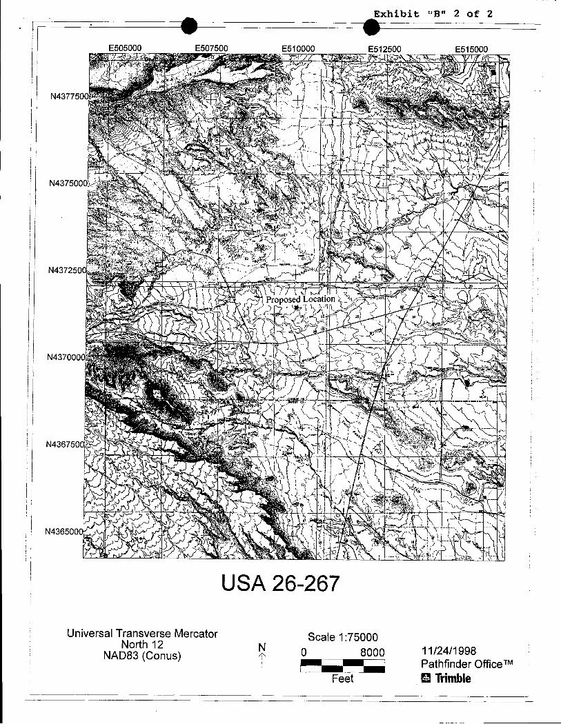
Exhibit "B" 2 of 2
E505000 E507500 E510000 E512500 E515000
N437750
N437500
N4372500
N436500
USA 26-267
Universal Transverse Mercator Scale 1:75000North 12 N O 8000 11/24/1998NAD83 (Conus)Pathfinder Office
Feet B
UGHTPLANT
UGHT
40'
PIPE TRAILER
HOLE8'
SURFACECUffiNGS 20'
FUEL TANK OOG HOUSEp¡y
MAINPIT -
40'
45' RIGBOOSTER COMPRESSOR
AUX••COMP.
FRACTANK
APPROXIMATE LAYOUT OF RIG &
OANCHOR(1YP, 4 PL.) O
125' - --a 90*754
.
MOTORtaa•
o. o
O..........------------ NTU
.STARTER3--PHASE
SEPARATORELEC.TRANSFORMER
RIVERGAS CORP.WE1.1.SITE LAYOUT r215' X
RIVER GAS CORPORATION
4'4'27'
0 03-PHASEGAS & WATER
POWER UNESPIPELINES
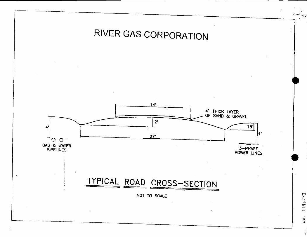
TYPICAL ROAD CROSS-SECTIONNOT TO SCALE
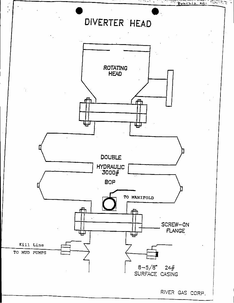
O.DIVERTERHEAD
ROTATING -
HEAD
L.J J
DOUBLE
HYORAUUC3000#
BOP
TO MANIFOLD
SCREW-ONFIANGE
rKill Line
TO MUD PUMPS
8-5/8" 24#SURFACE CASING
RIVER GAS
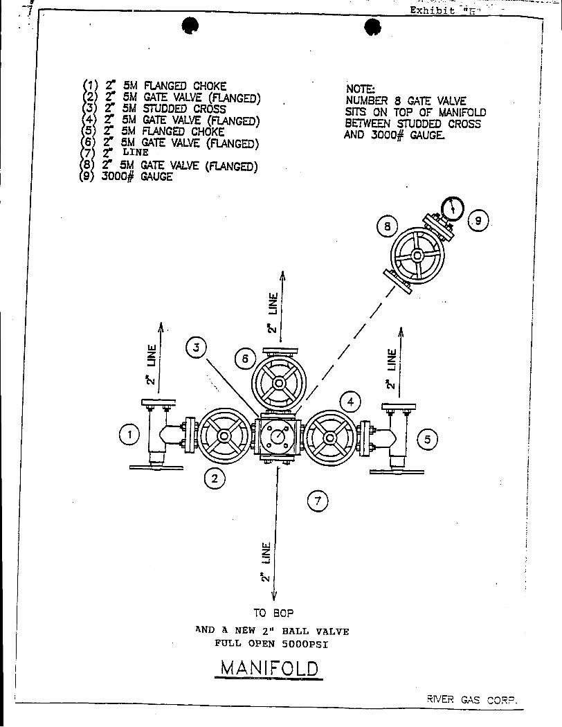
Exhibit E"
1 2" 5M FIANGEDCHOKE NOTE:2 2" 5M GATEVALVE(FIANGED). NUMBER8 GATEVALVE3 2" 5M STUDDEDCROSS SITS ON TOP OF MANIFOLD4 2" 5M GATEVALVE(FIANGED) BETWEENETUDDEDCROSS5 2" 5M FIANGEDCHOKE AND3000# GAUGE.6 2" 5M GATEVALVE(FIANGED)
7 2" LINE8 2" 5M GATEVALVE(FIANGED)9 3000# GAUGE
O
It
il
TO BCPAND A NEW 2" BALL VALVE
FULL OPEN 5000PSI
MANIFOLDRIVER GAS
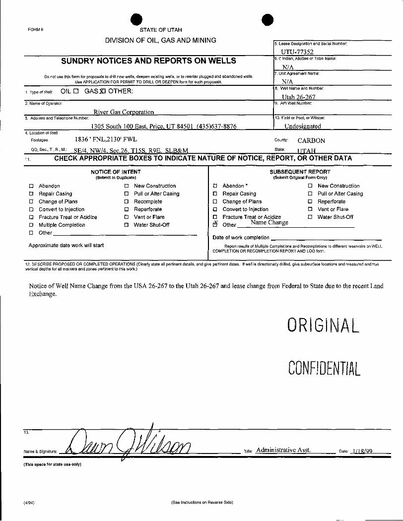
O OFORM 9 STATE OF UTAH
DIVISION OF OIL, GAS AND MINING5. Lease Designation and Serial Number:
UTU-77352
SUNDRY NOTICES AND REPORTS ON WELLS 6. If Indian, Allottee or Tribe Name:
N/ADo not use this form for proposals to drill newwells,deepen existingwells, or to reenter plugged and abandoned wells. 7. Unit Agreement Name:
Use APPLICATION FOR PERMIT TO DRILL OR DEEPEN form for such proposals. N/A1. Type of Well: OIL O GASIl OTHER: 8. Well Name and Number:
Utah 26-2672. Name of Operator: 9. API Well Number:
River Gas Corporation3. Address and Telephone Number: 10. Field or Pool, or Wildcat:
1305 South 100 East, Price, UT 84501 (435)637-8876 Undesignated4. Location ofWell
Footages: 1836 ' FNL,2130' FWL County: CARBONQQ, Sec., T., R., M.: SE/4, NW/4, Sec.26, Tl5S, R9E, SLB&M St6te UNH
11. CHECK APPROPRIATE BOXES TO INDICATE NATURE OF NOTICE, REPORT, OR OTHER DATA
NOTICE OF INTENT SUBSEQUENT REPORT(Submit in Duplicate) (Submit Original Form Only)
O Abandon O New Construction O Abandon * O New Construction0 Repair Casing O Pull or Alter Casing O Repair Casing O Pull or Alter CasingO Change of Plans O Recomplete O Change of Plans O ReperforateO Convert to injection O Reperforate O Convert to Injection O Vent or FlareO Fracture Treat or Acidize O Vent or Flare O Fracture Treat or Acidize O Water Shut-Off
O Multiple Completion O Water Shut-Off 6 Other Name Change
O OtherDate of work completion
Approximate date work will start Report results of Multiple Completions and Recompletions to different reservoirs on WELLCOMPLETION OR RECOMPLETION REPORT AND LOG form.
12. DESCRIBE PROPOSED OR COMPLETED OPERATIONS (Clearly state all pertinent details, and give pertinent dates. Ifwell is directionally drilled, give subsurface locations and measured and truevertical depths for all markers and zones pertinent to this work.)
Notice of Well Name Change from the USA 26-267 to the Utah 26-267 and lease change from Federal to State due to the recent LandExchange.
ORIGlNAL
CONFllENTIAL
13.
Name & Signature: Title: Administrative Asst. Date: 1/Î
(This space for state use only)
(4/94) (See Instructions on Reverse
isossouszooaRiñer ŒssŒrporattän 'Price,Utah84501-9637
(435)637-8876(435)637-8924
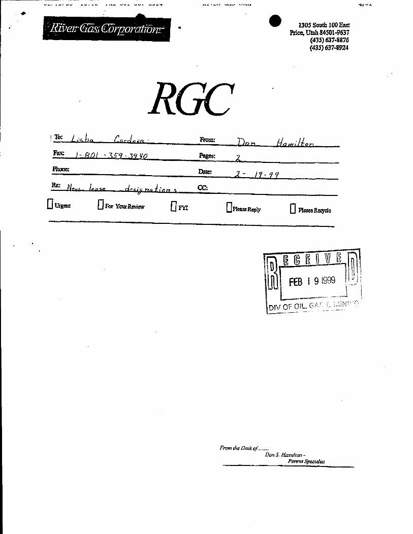
Fax: ) p() y - gg . yÿ f(p Pages:
Phone: Og:
N- l-o 4-e os A, , cc:
0«- O-v- O= 0a-- 0a-
DIVOF OIL G
FromtheDerkoC......Don S Hamdton -
Permrt
P. 02
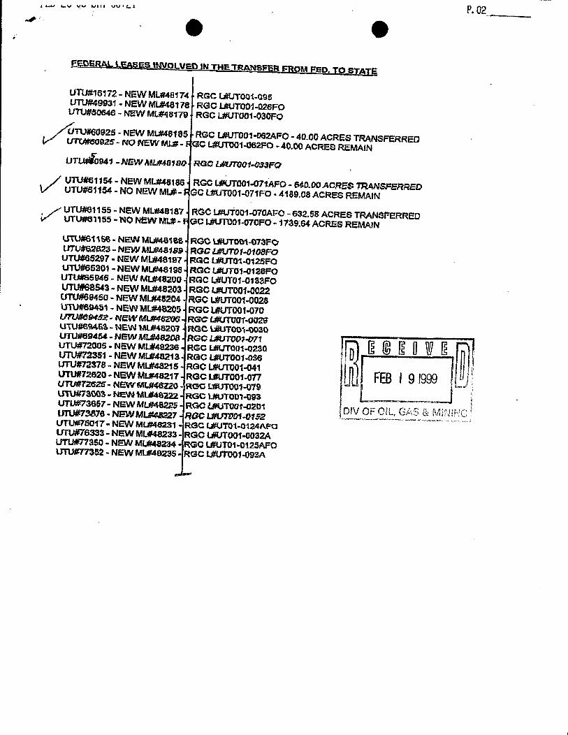
FSDERAL LSAllES H4VOLVED IN THE TRANSPER FROM FED. TO STATE
UTU#16172- NEW MLa48174 RGC L#UTOOLOSSUTU#49931 - NEW ML#48178 RGO lÆUTOO1-026FOUTU#50646 - NEW ML#48179 RGC L#UTOO1-030FO
UTU#60925 - NEW ML#48185 RGC L#UTOO1-062AFO- 40.00 ACRES TRANSFERREDUTCMOOS25- NO NEW MLa- GC LBUTUO1-062FO -40,00 ACRES REMAINUTÄ941-NEW AAL#48180 RGO L#UTOOf•Q33FO
/ UTU#61154 - NEW ML*40186 RGG L#UTOO1-07tAFO - 840.00 ACRES TRANSFERREDV UTu#e1154 - NO NEW MI,#- GC L#UTOOT-071Fo . 4189.08 ACRES REMAIN
UTU#01155 - NEW ML#48187 RGC L#UTOO1-070AFO - 632.58 ACRES TRANSFERREDV UTUN63155 - NO NEW ML#- GC L#UTOOi-070FO - 1739 64 ACRES REMAINUTU#S1156 - NEW ML#48104 RGO L#UTOOi-073FOUTU#62823- NEW MLF44189 RGC &#UTOf-010SFOUTU#65297 - NEW ML#48197 ROC LAUTG1-0125FOUTU#66201 - NEW ML#48198 RGC L#UTO1.0120FOUTU¾S5946 - NEW ML#48200 RGC L#UTOT-0133FOUTU#68S43-NEWML#48203 RGC L#UTOOi-0022UTU#69460 - NEW ML#48204 RGC L#UTOO1-0028UTU#69451 - NEW ML#48205 RGC L#UTOOT-070UTU#0&f3£- NEWML@46206 RGC C#UTOUT-GO29UTU#BRE3- NEW ML#48207 RGC kWUTOO1-0030UTU#69454 - NEW MLt482DS RGC L#UTOpt-071
2 R fl WI RUTU#72005.NEWML#48236 RGCL#UT001-0230 L4 5 5 UWE aUTU#72351 - NEW ML#48218 RGC L#UTOO1-DSBUTU#72378 - NEW ML#48215 RGC L#UTOO1-041 nUTU#72520 - NEW ML#48217 RGC LÆUTOOT-Orr FEBi 9 1999UTU#T2626- NEW ML#48220 - ROC LMUTOO1-079UTU#73003 - NEW idLB46222 RGC L#UTOOl•093UTU#73657-NewML#48225 RGOL#UToot-0201 DIVOF CIL, GAS & MININGUTU#73876 - NEW MLV48227 ROC Lav70Di-Off2
---------UTU#75017- NEW ML#48231 - RGC LAUTOt-0124AFOUTU#76333 - NEW ML#48233- RGC URITOGT-0032AUTU#77350 - NEW ML#48234•RGO L#UTO1-0125AFOUTU#TT352 - NEW ML#40235• RGC
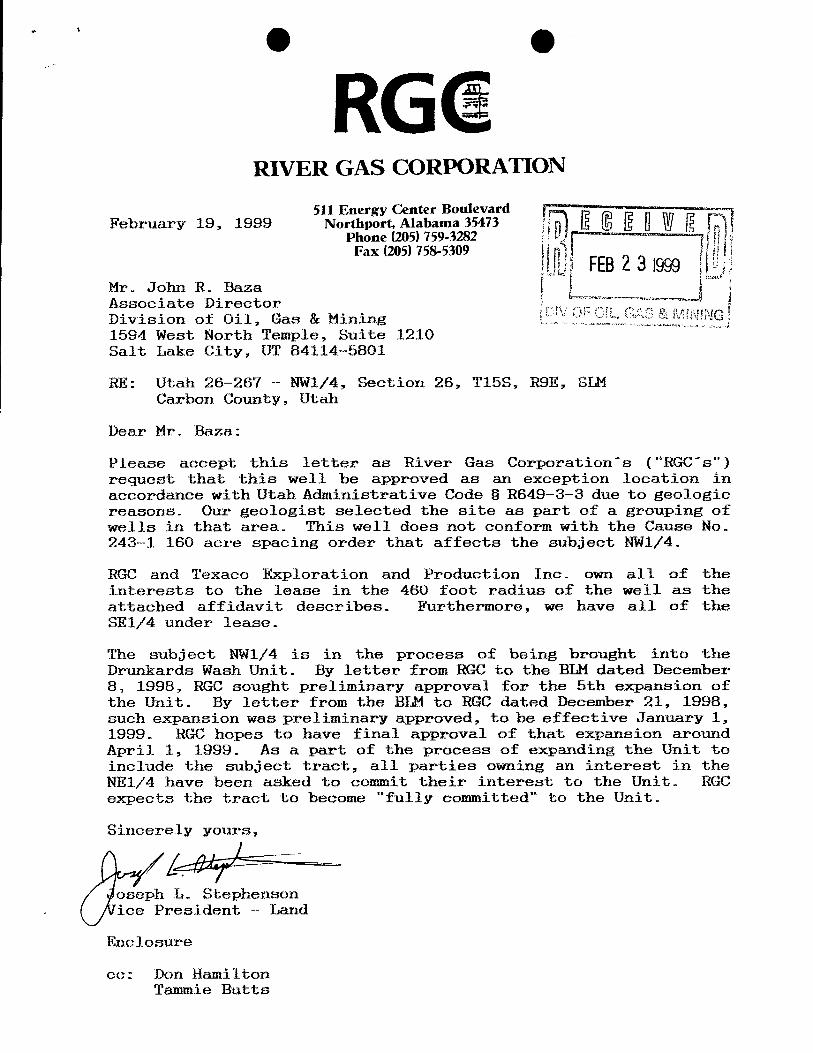
RGGRIVER GAS CORPORATION
511 Energy Center BoulevardFebruary 19, 1999 Northport, Alabama 35473
Phone (205) 759-3282Fax (205) 758-5309
FEB2 3 1999Mr. John R. BazaAssociate DirectorDivision of Oil, Gas & Mining S & MN NG1594 West North Temple, Suite 1210Salt Lake City, UT 84114-5801
RE: Utah 26-267 - NW1/4, Section 26, T15S, R9E, SLMCarbon County, Utah
Dear Mr. Baza:
Please accept this letter as River Gas Corporation's ("RGC's")request that this well be approved as an exception location inaccordance with Utah Administrative Code § R649-3-3 due to geologicreasons. Our geologist selected the site as part of a grouping ofwells in that area. This well does not conform with the Cause No.243-1 160 acre spacing order that affects the subject NW1/4.
RGC and Texaco Exploration and Production Inc. own all of theinterests to the lease in the 480 foot radius of the well as theattached affidavit describes. Furthermore, we have all of theSE1/4 under lease.
The subject NW1/4 is in the process of being brought into theDrunkards Wash Unit. By letter from RGC to the BLM dated December8, 1998, RGC sought preliminary approval for the 5th expansion ofthe Unit. By letter from the BLM to RGC dated December 21, 1998,such expansion was preliminary approved, to be effective January 1,1999. RGC hopes to have final approval of that expansion aroundApril 1, 1999. As a part of the process of expanding the Unit toinclude the subject tract, all parties owning an interest in theNE1/4 have been asked to commit their interest to the Unit. RGCexpects the tract to become "fully committed" to the Unit.
Sincerely yours,
oseph L. Stephensonice President - Land
Enclosure
ce: Don HamiltonTammie
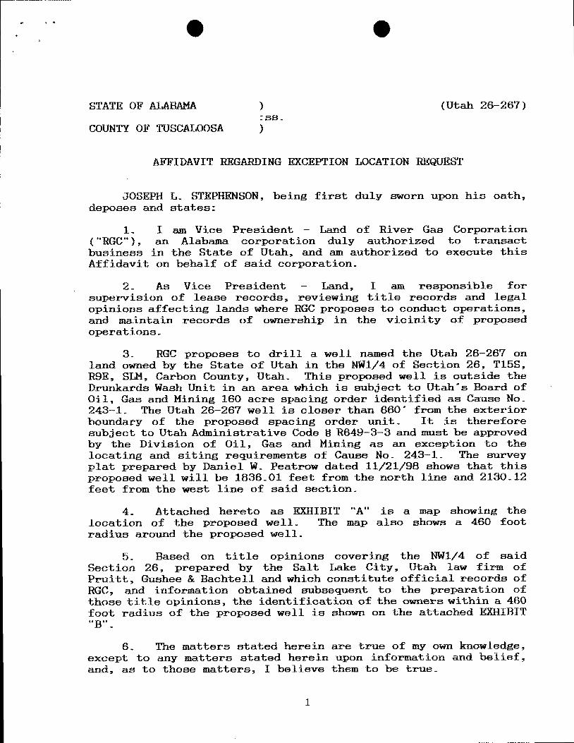
STATE OF ALABAMA ) (Utah 26-267):ss.
COUNTY OF TUSCALOOSA )
AFFIDAVIT REGARDING EXCEPTION LOCATION REQUEST
JOSEPH L. STEPHENSON, being first duly sworn upon his oath,deposes and states:
1- I am Vice President - Land of River Gas Corporation("RGC"), an Alabama corporation duly authorized to transactbusiness in the State of Utah, and am authorized to execute thisAffidavit on behalf of said corporation.
2. As Vice President - Land, I am responsible forsupervision of lease records, reviewing title records and legalopinions affecting lands where RGC proposes to conduct operations,and maintain records of ownership in the vicinity of proposedoperations.
3- RGC proposes to drill a well named the Utah 26-287 onland owned by the State of Utah in the NW1/4 of Section 26, T15S,RSE, SLM, Ca bon County, Utah. This proposed well is outside theDrunkards Wash Unit in an area which is subject to Utah's Board ofOil, Gas and Mining 160 acre spacing order identified as Cause No.243-1. The Utah 26-267 well is closer than 860" from the exteriorboundary of the proposed spacing order unit. It is thereforesubject to Utah Administrative Code § RS49-3-3 and must be approvedby the Division of Oil, Gas and Mining as an exception to thelocating and siting requirements of Cause No. 243-1. The surveyplat prepared by Daniel W. Peatrow dated 11/21/98 shows that thisproposed well will be 1836.01 feet from the north line and 2130.12feet from the west line of said section.
4. Attached hereto as EXHIBIT "A" is a map showing thelocation of the proposed well. The map also shows a 460 footradius around the proposed well.
5. Based on title opinions covering the NW1/4 of saidSection 26, prepared by the Salt Lake City, Utah law firm ofPruitt, Gushee & Bachtell and which constitute official records ofRGC, and information obtained subsequent to the preparation ofthose title opinions, the identification of the owners within a 460foot radius of the proposed well is shown on the attached EXHIBIT"B".
6. The matters stated herein are true of my own knowledge,except to any matters stated herein upon information and belief,and, as to those matters, I believe them to be true.
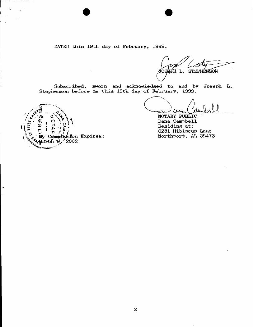
DATED this 19th day of February, 1999.
O' H L.
Subscribed, sworn and acknowledged to and by Joseph L.Stephenson before me this 19th day of February, 1999.
NOTARY PUBLICDana CampbellResiding at:6231 Hibiscus Lane
y cond añÈon Expires: Northport, AL 35473afbÈ '2002
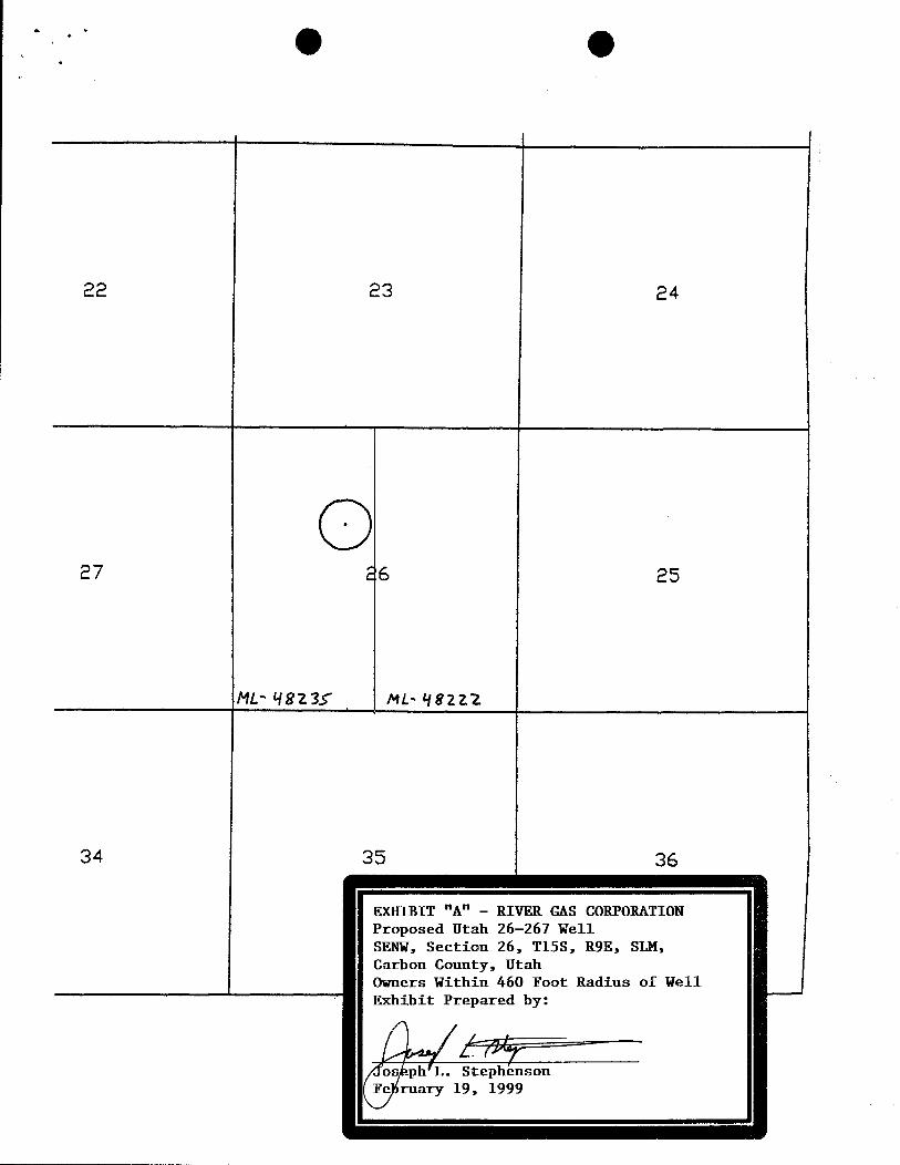
22 23 24
27 26 25
ML- 4823f NL- 48212
34 35 36
EXHIBIT "A" - RIVER GAS CORPORATIONProposed Utah 26-267 WellSENW, Section 26, T153, R9E, SLM,Carbon County, UtahOwners Within 460 Foot Radius of WellExhibit Prepared by:
os .ph L. StephensonFe ruary 19,
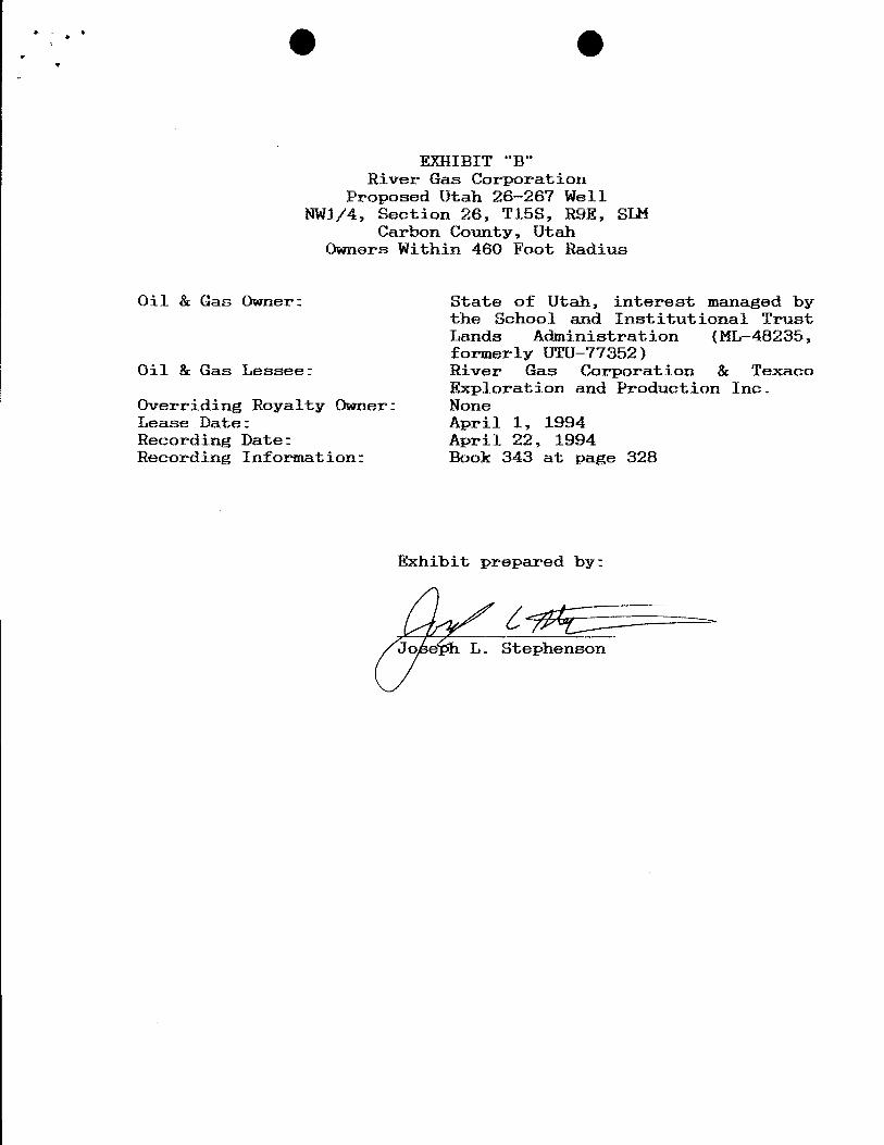
EXHIBIT "B"River Gas Corporation
Proposed Utah 28-267 WellRW1/4, Section 26, T15S, R9E, SLM
Carbon County, UtahOwners Within 460 Foot Radius
Oil & Gas Owner: State of Utah, interest managed bythe School and Institutional TrustLands Administration (ML-48235,formerly UTU-77352)
Oil & Gas Lessee: River Gas Corporation & TexacoExploration and Production Inc.
Overriding Royalty Owner: NoneLease Date: April 1, 1994Recording Date: April 22, 1994Recording Information: Book 343 at page 328
Exhibit prepared by:
Jo e L.
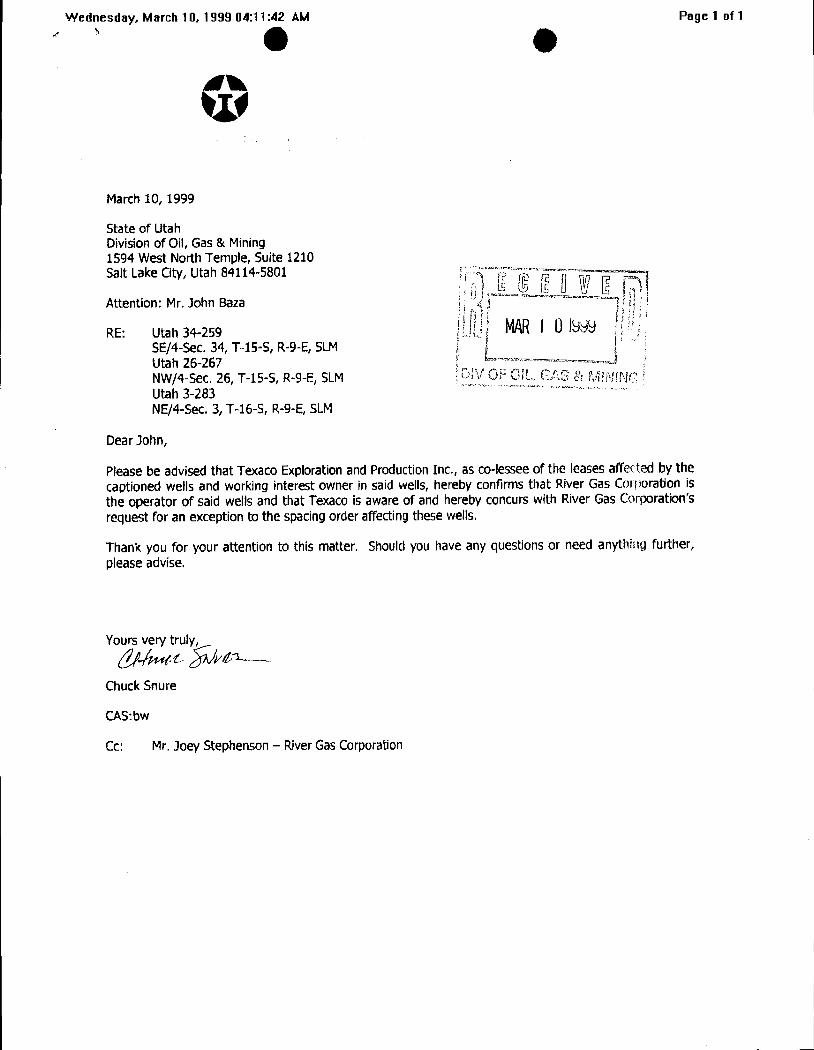
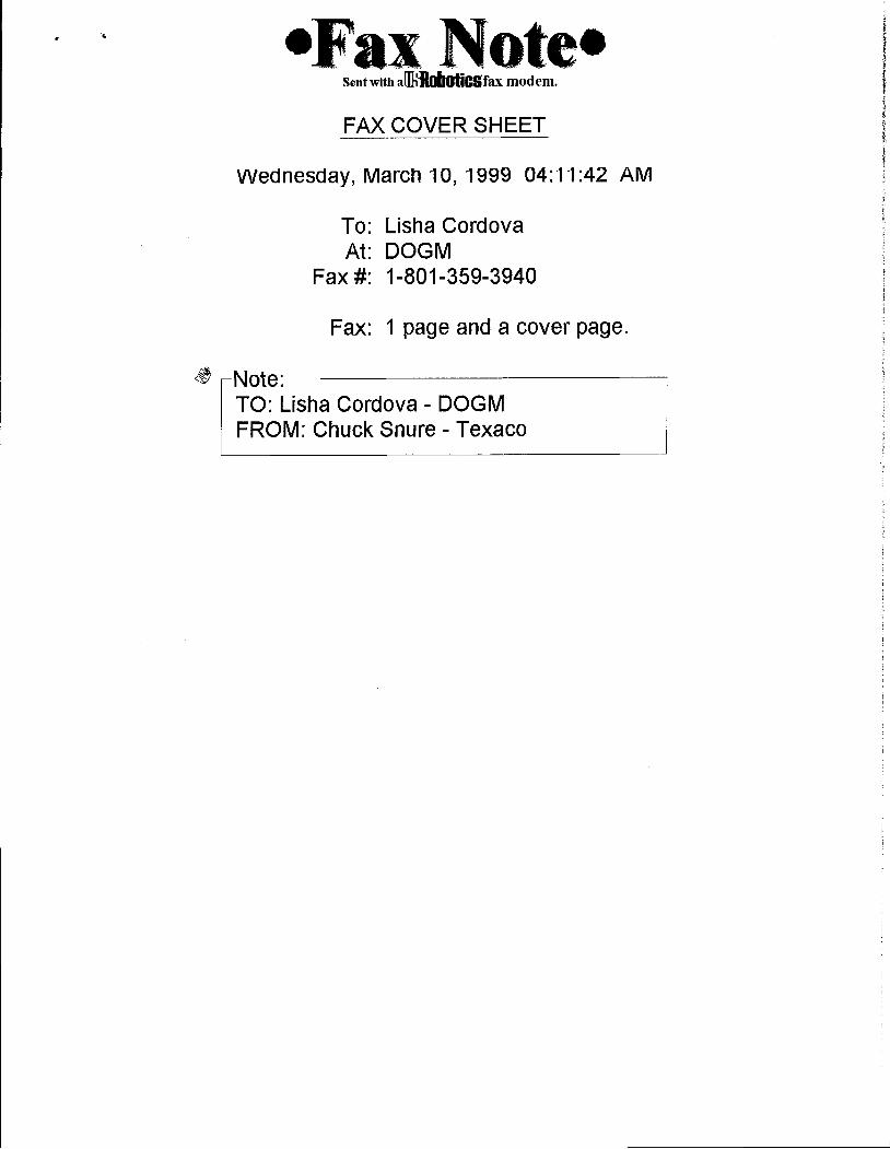
Wednesday, March 10, 1999 04:11:42 AM Page 1 of 1' O O
March 10, 1999
State of UtahDivisionof Oil, Gas & Mining1594 West North Temple, Suite 1210Salt Lake City, Utah 84114-5801
Attention: Mr. John Baza
RE: Utah 34-259SE/4-Sec.34, T-15-S, R-9-E, SLMUtah 26-267NW/4-Sec. 26, T-15-S, R-9-E, SLM GS MIMNGUtah 3-283NE/4-Sec. 3, T-16-5, R-9-E, SLM
Dear John,
Please be advised thatTexaco Explorationand Production Inc., as co-lesseeof the leases affected by thecaptioned wells and working interest owner in said wells, hereby confirms that River Gas Corporation isthe operator of saidwells and that Texaco is aware of and hereby concurswith River Gas Corporation'srequest for an exception to the spacingorder affectingthesewells.
Thank you for your attention to thismatter. Should you have any questions or need anything further,please advise.
Yoursvery truly
ChuckSnure
CAS:bw
Cc: Mr. Joey Stephenson - RiverGas
•Fax Note•Sent with ai IIIÀlCifax modem.
FAX COVER SHEET
Wednesday, March 10, 1999 04:11:42 AM
To: Lisha CordovaAt: DOGM
Fax #: 1-801-359-3940
Fax: 1 page and a cover page.
Note:TO: Lisha Cordova - DOGMFROM: Chuck Snure -
WORKSHEETAPPLICATION FOR PERMIT TO DRILL
APD RECEIVED: 11/27/1998 API NO. ASSIGNED: 43-007-30514
WELL NAME:--U·8A 26-267OPERATOR: RIVER GAS CORPORATION (N1605)CONTACT: Ûtro to -WŸ
PROPOSED LOCATION: INSPECT LOCATN BY: / /SENW 26 - T15S - RO9ESURFACE: 1836-FNL-2130-FWL TECH REVIEW Initials DateBOTTOM: 1836-FNL-2130-FWL
CARBON COUNTY EngineeringUNDESIGNATED FIELD (002)
GeologyLEASE TYPE: FEBLEASE NUMBER: UTU- mL 8 35 - SurfaceSURFACE OWNER: LM
PROPOSED FORMATION: FRSD
RECEIVED AND/OR REVIEWED: LOCATION AND SITING:
Plat R649-2-3. UnitBond: Federal[] Statef Fee[]
¯
(No. Sgg ) R649-3-2. GeneralPotash (Y/N)
il Shale (Y/N) *190-5(B) R649-3-3. ExceptionWater Permit
(No. (gmjl)/ 6 pi ) Drilling UnitRDCC Review (Y/ ) Board Cause No: - 09
(Date: ) Date:
Fee Surf Agreement (Y/N)
STIPULATIONS: TA- Fr (TV St
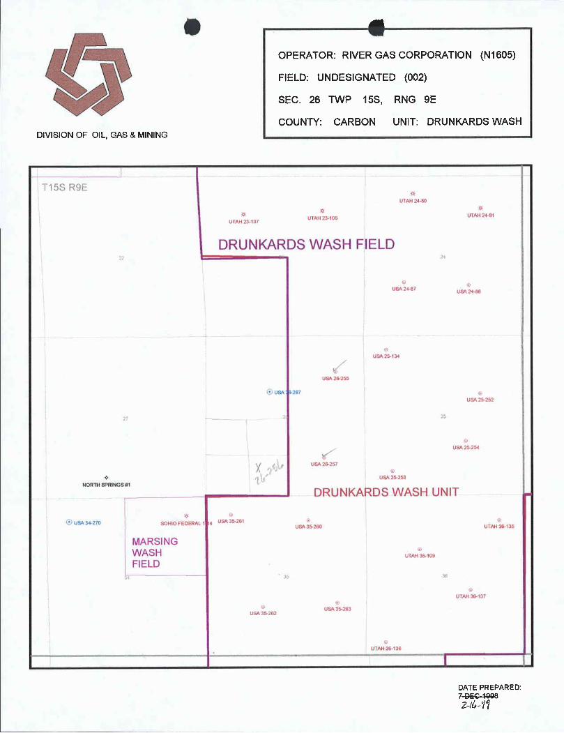
O OPERATOR: RIVER GAS CORPORATION (N1605)
FIELD: UNDESIGNATED (002)
SEC. 26 TWP 15S, RNG 9E
COUNTY: CARBON UNIT: DRUNKARDSWASHDIVISION OF OIL, GAS & MINING
I 165 R9iUÎAH 24-80
0UTAH?3108 UTAH2481
UTAH 23-107
DRUNKARDSWASH FIELD
USA 24-57 24-Bô
USA 2G-255
USA r267
USA 25·252
NORTHSPRINGS #1
DRUNKARDS WASH UNIT .
I' US43070 SOHIOFEDERAL 1 .4
USA35.2\ IUSA35-260 UTAH36 Ils
MARSINGWASH es,Lo,FIELD
UTMf 36-137
USA 35263USA35212
DATE PREPARED:7-GEC-49082-/6
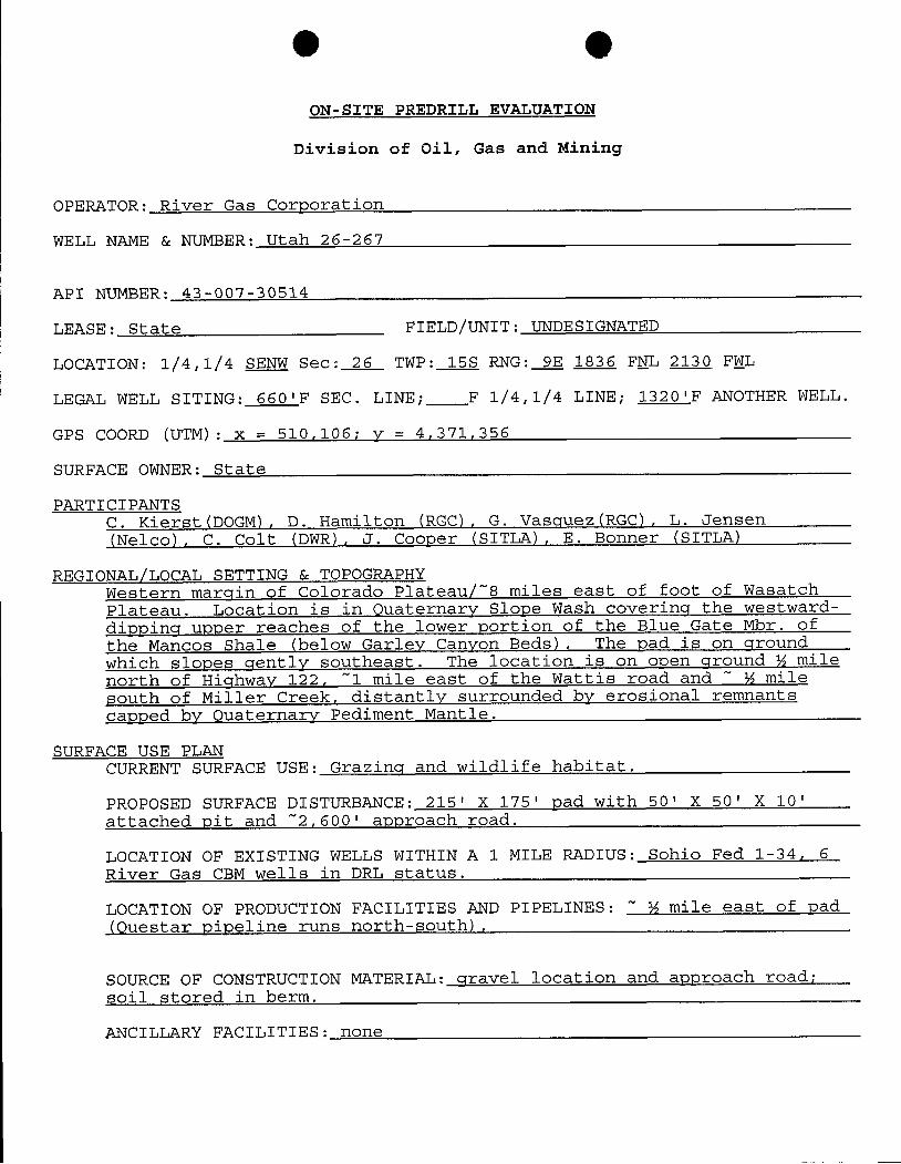
OON-SITE PREDRILL EVALUATION
Division of Oil, Gas and Mining
OPERATOR: River Gas Corporation
WELL NAME & NUMBER: Utah 26-267
API NUMBER: 43-007-30514
LEASE: State FIELD/UNIT: UNDESIGRATED
LOCATION: 1/4,1/4 SENW Sec: 26 TWP: 15S RNG: 9E 1836 FNL 2130 FWL
LEGAL WELL SITING: 660'F SEC. LINE; F 1/4,1/4 LINE; 1320'F ANOTHER WELL.
GPS COORD (UTM): x = 510,106; y = 4,371,356
SURFACE OWNER: State
PARTICIPANTSC. Kierst(DOGM), D. Hamilton (RGC), G. Vasquez(RGC), L. Jensen(Nelco), C. Colt (DWR), J. Cooper (SITLA), E. Bonner (SITLA)
REGIONAL/LOCAL SETTING & TOPOGRAPHYWestern margin of Colorado Plateau/~8 miles east of foot of WasatchPlateau. Location is in Quaternary Slope Wash covering the westward-
dieping upper reaches of the lower portion of the Blue Gate Mbr. ofthe Mancos Shale (below Garley Canyon Beds). The vad is on ground
which slopes gently southeast. The location is on oven ground ¾ milenorth of Highway 122, ~1 mile east of the Wattis road and ~ ¾ milesouth of Miller Creek, distantly surrounded by erosional remnantscapped by Quaternary Pediment Mantle.
SURFACE USE PLANCURRENT SURFACE USE: Grazing and wildlife habitat.
PROPOSED SURFACE DISTURBANCE: 215' X 175' pad with 50' X 50' X 10'attached pit and ~2,600' approach road.
LOCATION OF EXISTING WELLS WITHIN A 1 MILE RADIUS: Sohio Fed 1-34, 6River Gas CBM wells in DRL status.
LOCATION OF PRODUCTION FACILITIES AND PIPELINES: ~ ½ mile east of pad(Questar pipeline runs north-south).
SOURCE OF CONSTRUCTION MATERIAL: gravel location and approach road;soil stored in berm.
ANCILLARY FACILITIES:
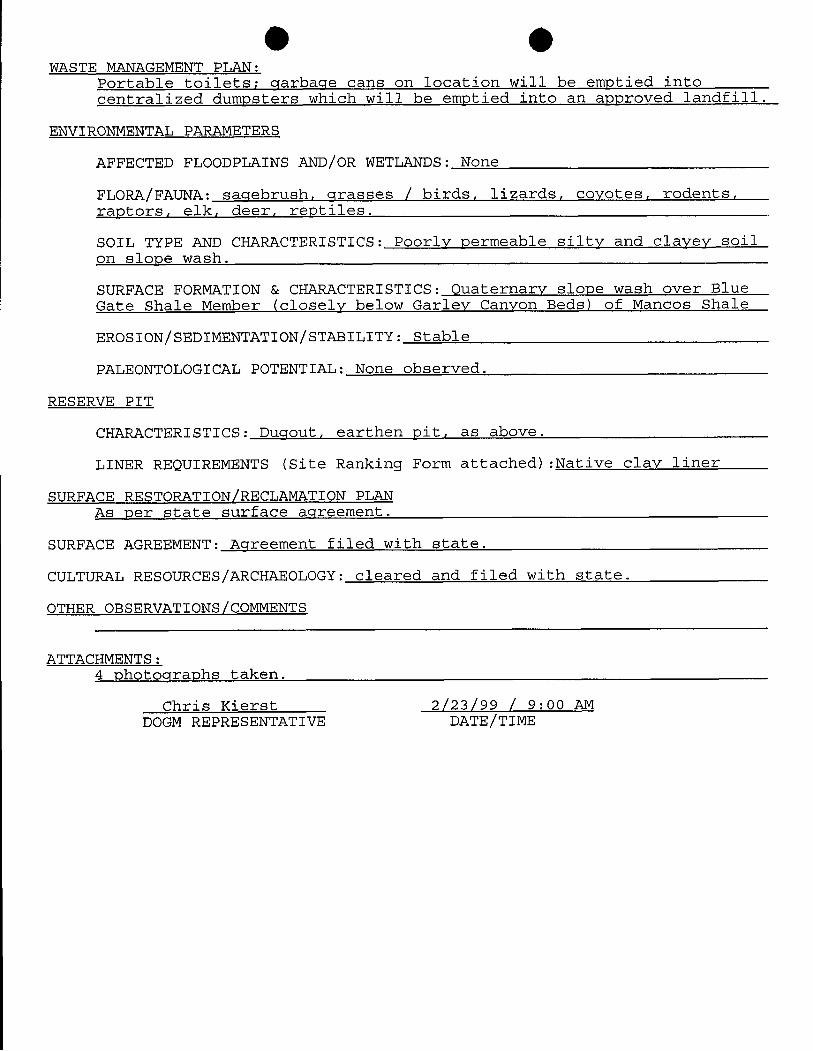
O OWASTE MANAGEMENT PLAN:
Portable toilets; garbage cans on location will be emptied intocentralized dumpsters which will be emotied into an approved landfill.
ENVIRONMENTAL PARAMETERS
AFFECTED FLOODPLAINS AND/OR WETLANDS: None
FLORA/FAUNA: sagebrush, grasses / birds, lizards, covotes, rodents,ractors, elk, deer, reptiles.
SOIL TYPE AND CHARACTERISTICS: Poorly permeable silty and clavey soilon slope wash.
SURFACE FORMATION & CHARACTERISTICS: Quaternary slope wash over BlueGate Shale Member (closely below Garley Canyon Beds) of Mancos Shale
EROSION/SEDIMENTATION/STABILITY: Stable
PALEONTOLOGICAL POTENTIAL: None observed.
RESERVE PIT
CHARACTERISTICS: Dugout, earthen pit, as above.
LINER REQUIREMENTS (Site Ranking Form attached):Native clay liner
SURFACE RESTORATION/RECLAMATION PLANAs per state surface agreement.
SURFACE AGREEMENT: Agreement filed with state.
CULTURAL RESOURCES/ARCHAEOLOGY: cleared and filed with state.
OTHER OBSERVATIONS/COMMENTS
ATTACHMENTS:4 chotographs taken.
Chris Kierst 2/23/99 / 9:00 AMDOGM REPRESENTATIVE
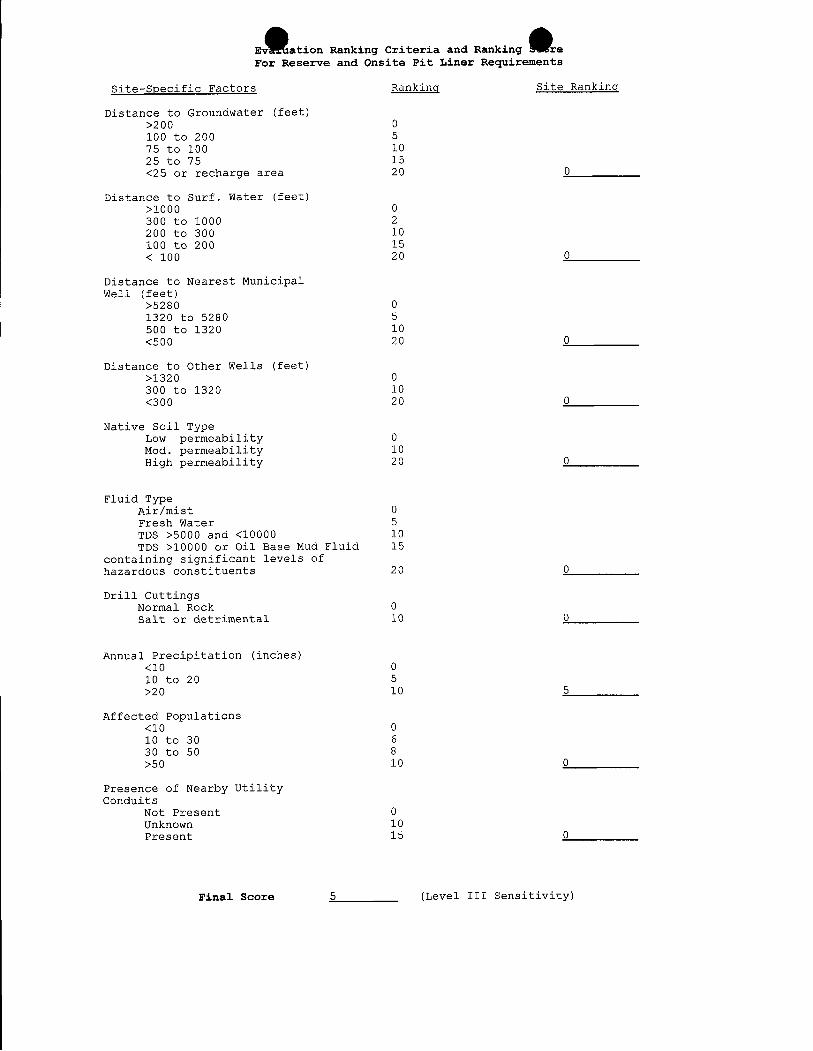
Ev ation Ranking Criteria and Ranking reFor Reserve and Onsite Pit Liner Requirements
Site-Specific Factors Ranking Site Ranking
Distance to Groundwater (feet)>200 0100 to 200 575 to 100 1025 to 75 15<25 or recharge area 20 0
Distance to Surf. Water (feet)>1000 0300 to 1000 2200 to 300 10100 to 200 15< 100 20 0
Distance to Nearest MunicipalWell (feet)
>5280 01320 to 5280 5500 to 1320 10<500 20 0
Distance to Other Wells (feet)>1320 0300 to 1320 10<300 20 0
Native Soil TypeLow permeability 0Mod. permeability 10High permeability 20 0
Fluid TypeAir/mist 0Fresh Water 5TDS >5000 and <10000 10TDS >10000 or Oil Base Mud Fluid 15
containing significant levels ofhazardous constituents 20 0
Drill CuttingsNoarmaorRodetkrimental 010
0
Annual Precipitation (inches)<10 010 to 20 5>20 10 5
Affected Populations<10 010 to 30 630 to 50 8>50 10 0
Presence of Nearby UtilityConduits
Not Present 0Unknown 10Present 15 0
Final Score 5 (Level III
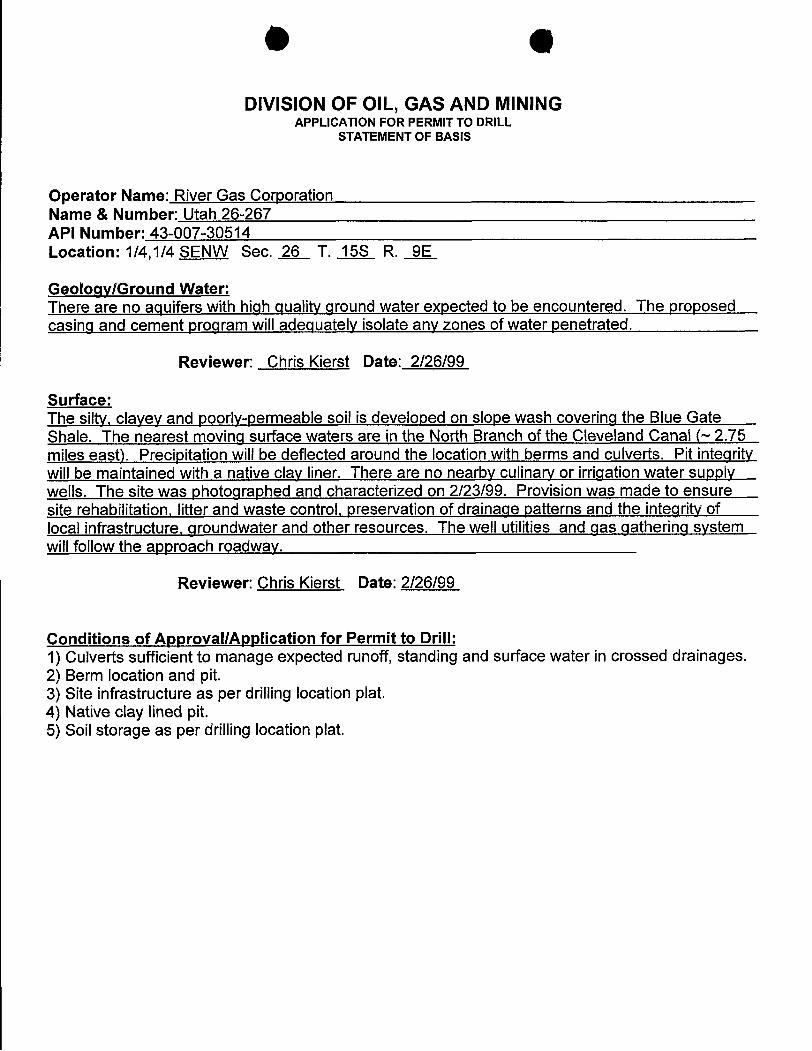
DIVISION OF OIL, GAS AND MININGAPPLICATION FOR PERMIT TO DRILL
STATEMENT OF BASIS
Operator Name: River Gas CorporationName & Number: Utah 26-267API Number: 43-007-30514Location: 1/4,1/4 SENW Sec. 26 T. 15S R. 9E
Geology/Ground Water:There are no aquifers with high quality ground water expected to be encountered. The proposedcasing and cement program will adequately isolate any zones of water penetrated.
Reviewer: Chris Kierst Date: 2/26/99
Surface:The silty, clayey and poorly-permeable soil is developed on slope wash covering the Blue GateShale. The nearest moving surface waters are in the North Branch of the Cleveland Canal (~2.75miles east). Precipitation willbe deflected around the location with berms and culverts. Pit integritywill be maintained with a native clay liner. There are no nearby culinary or irrigation water supplywells. The site was photographed and characterized on 2/23/99. Provision was made to ensuresite rehabilitation, litter and waste control, preservation of drainage patterns and the integrity oflocal infrastructure, groundwater and other resources. The well utilities and qas gathering systemwill follow the approach roadway.
Reviewer: Chris Kierst Date: 2/26/99
Conditions of ApprovallApplication for Permit to Drill:1) Culverts sufficient to manage expected runoff, standing and surface water in crossed drainages.2) Berm location and pit.3) Site infrastructure as per drilling location plat.4) Native clay lined pit.5) Soil storage as per drilling location
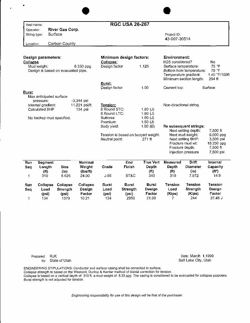
Well name: RGC USA 26-267Operator: River Gas Corp.String type: Surface Project ID:
43-007-30514Location: Carbon County
Design parameters: Minimum design factors: Environment:Collapse Collapse: H2S considered? No
Mud weight: 8.330 ppg Design factor 1.125 Surface temperature: 75 °FDesign is based on evacuated pipe. Bottom hole temperature: 79 °F
Temperature gradient: 1.40 °F/100ftMinimum section length: 294 ft
Burst:Design factor 1.00 Cement top: Surface
BurstMax anticipated surface
pressure: -3,344 psiInternal gradient: 11.221 psilft Tension: Non-directional string.Calculated BHP 134 psi 8 Round STC: 1.80 (J)
8 Round LTC: 1.80 (J)No backup mud specified. Buttress: 1.60 (J)
Premium: 1.50 (J)Body yield: 1.50 (B) Re subsequent strings:
Next setting depth: 7,500 ftTension is based on buoyed weight. Next mud weight: 9.000 ppgNeutral point: 271 ft Next setting BHP: 3,506 psi
Fracture mud wt: 19.250 ppgFracture depth: 7,500 ftinjection pressure 7,500 psi
Run Segment Nominal End True Vert Measured Drift InternalSeq Length Size Weight Grade Finish Depth Depth Diameter Capacity
(ft) (in) (Ibs/ft) (ft) (ft) (in) (ft3)1 310 8.625 24.00 J-55 ST&C 310 310 7.972 14.9
Run Collapse Collapse Collapse Burst Burst Burst Tension Tension TensionSeq Load Strength Design Load Strength Design Load Strength Design
(psi) (psi) Factor (psi) (psi) Factor (Kips) (Kips) Factor1 134 1370 10.21 134 2950 21.99 7 244 37.48 J
Prepared RJK Date: March 1,1999by: State of Utah Salt Lake City, Utah
ENGINEERING STIPULATIONS: Conductor and surface casing shall be cemented to surface.Collapse strength is based on the Westcott, Dunlop & Kemler method of biaxial correction for tension.Collapse is based on a vertical depth of 310 ft, a mud weight of 8.33 ppg The casing is considered to be evacuated for collapse purposes.Burst strength is not adjusted for tension.
Engineering responsibility for use of thisdesign willbe thatof the
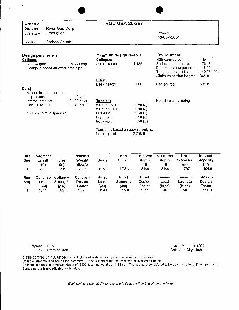
O OWell name: RGC USA 26-267Operator: River Gas Corp.String type: Production Project lo:
43-007-30514Location: Carbon County
Design parameters: Minimum design factors: Environment:Collapse Collapse: H2S considered? No
Mud weight: 8.330 ppg Design factor 1.125 Surface temperature: 75 °F
Design is based on evacuated pipe. Bottom hole temperature: 118 °FTemperature gradient: 1.40 °F/100ftMinimum section length: 368 ft
Burst:Design factor 1.00 Cement top: 591 ft
BurstMax anticipated surface
pressure: 0 psiinternal gradient: 0.433 psilft Tension: Non-directional string.Calculated BHP 1,341 psi 8 Round STC: 1.80 (J)
8 Round LTC: 1.80 (J)No backup mud specified. Buttress: 1.60 (J)
Premium: 1.50 (J)Body yield: 1.50 (B)
Tension is based on buoyed weight.Neutral point: 2,708 ft
Run Segment Nominal End True Vert Measured Drift InternalSeq Length Size Weight Grade Finish Depth Depth Diameter Capacity
(ft) (in) (Ibs/ft) (ft) (ft) (in) (ft3)1 3100 5.5 17.00 N-80 LT&C 3100 3100 4.767 106.8
Run Collapse Collapse Collapse Burst Burst Burst Tension Tension TensionSeq Load Strength Design Load Strength Design Load Strength Design
(psi) (psi) Factor (psi) (psi) Factor (Kips) (Kips) Factori 1341 6290 4.69 1341 7740 5.77 46 348 7.56 J
Prepared RJK Date: March 1,1999by: State of Utah Salt Lake City, Utah
ENGINEERINGSTIPULATIONS: Conductor and surface casing shall be cemented to surface.Collapse strength is based on the Westcott, Dunlop & Kemler method of biaxial correction for tension.Collapse is based on a vertical depth of 3100 ft, a mud weight of 8.33 ppg The casing is considered to be evacuated for collapse purposes.Burst strength is not adjusted for tension.
Engineering responsibility for use of thisdesign willbe thatof the
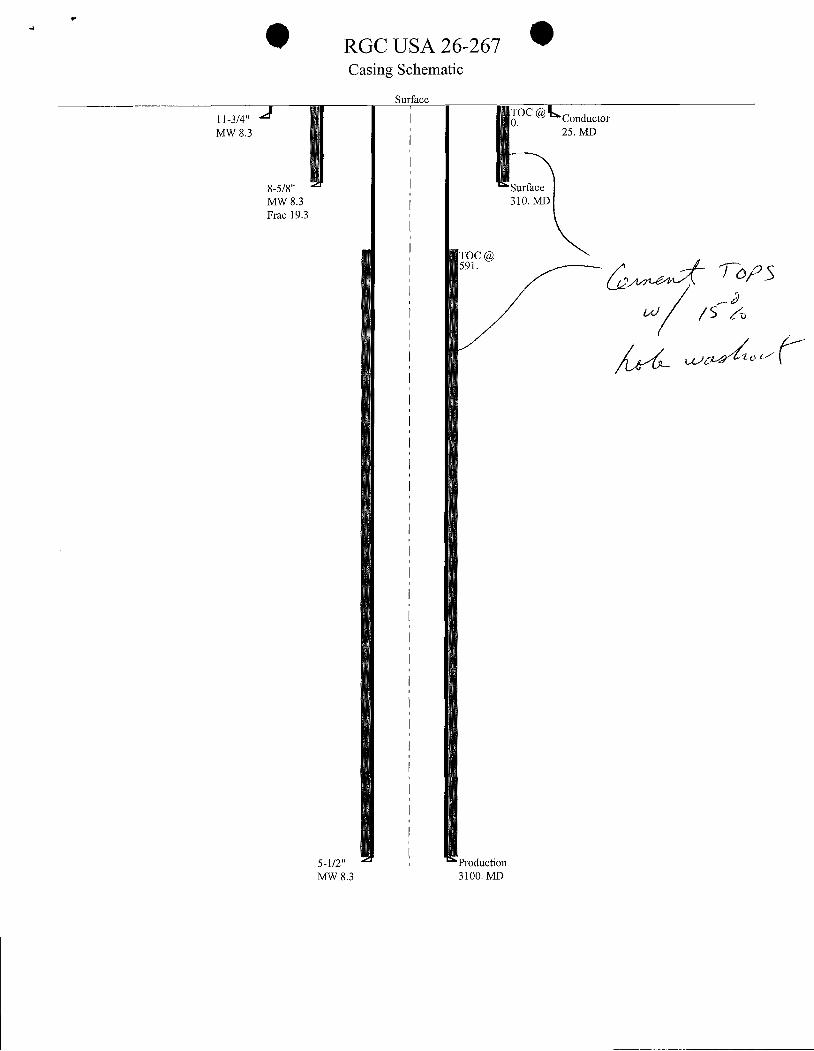
RGC USA 26-267Casing Schematic
Surface11-3/4" TOC @ ConductorMW 8.3 25. MD
8-5/8" SurfaceMW 8.3 310. MDFrac 19.3
01C@
\\\
\l
III
I
III
5-1/2" , ProductionMW 8.3 3100.
B eSCHOOL AND INSTITUTIONAL TRUST LANDS ADMINISTRATION
OIL AND GAS CONDITIONS OF APPROVAL
PRICE COALBED METHANE PROJECT
FINAL ENVIRONMENTAL IMPACT STATEMENT
Well: Ú - O Ú 7
Mineral Lease No: FI L 4 Û936
API No.: 3-007 - 30 TISLocation: SE Alal, &c ZG - Í/f.S, & 96
County: 9/2¿.sog
The Bureau of Land Management has prepared an Environmental Impact Statement forthe River Gas portion of the Price Coalbed Methane area and a Record of Decision has beenissued with respect to certain actions considered in the Environmental Impact Statement.
Pursuant to the Utah Schools and Land Exchange Act of 1998, Pub. L. 105-335, l 12 Stat.3139, which ratified the May 8, 1998, "Agreement to Exchange Utah School Trust LandsBetween the State of Utah and the United States of America" entered into between the State ofUtah and the United States of America, the School and Institutional Trust Lands Administration("SITLA") has agreed to adopt all conditions, mitigation measures and restrictions imposed onlessees by the Record of Decision in the administration of Federal Mineral Leases acquired inTownships 14, 15, 16 South and Ranger 8 and 9 East, SLBM.
Accordingly, SITLA's approval of the Application for Permit to Drill shall beconditioned upon the following:
Location of Facilities and Timing of Construction
Final well locations and transportation corridor alignments shall be selected and designedto avoid or minimize disturbances to sensitive areas, including areas of high wildlife value orcritical habitat, grazing, and/or recreational value, including wetlands and riparian areas; andareas with high erosion potential, highly saline soils, rugged topography, and/or poor reclamationpotential (i.e., steep slopes, eroded lands, floodplains, unstable soils), where possible.
O O
New roads shall be constructed so as to avoid areas with high erosion potential. Whereroads must be allowed, new roads shall be graded tp spread drainage instead of channelingrunoff. No road on excess of 15 percent shall be allowed on slopes greater than 15 percent. Novehicle access shall be allowed across slopes on excess of 25 percent.
Construction shall not occur on frozen or saturated soils, or when watershed damage islikely, unless an adequate plan is submitted to SITLA that demonstrates potential impacts will bemitigated. SITLA may limit cross- country travel or construction activity at times when soils aredry or frozen or have snow cover. SITLA will determine what is "wet," "muddy," or "frozen'based on weather and field conditions at the time. The limitation does not apply to maintenanceand operation of producing wells.
Occupancy or other surface disturbance shall not be allowed within 330 feet of thecenterline or within the 100-year recurrence interval floodplain of perennial steams, except whereauthorized in writing by the SITLA (e.g., road crossings).
Occupancy or other surface disturbance shall not be allowed within 660 feet of springs,whether flowing or not. No vibroseis, drilling or blasting associated with seismic explorationshall be allowed withing 0.25 mile of any spring or water well.
During project construction, surface disturbance and vehicle travel shall be limited to theapproved location and access routes. Any additional area needed must be approved by SITLAprior to use.
Vegetation removal necessitated by a construction project shall be confined to the limitsof actual construction. Removed vegetation will be stockpiled for use in reclamation or removedform the construction site at the direction of SITLA.
Reclamation
The reclamation plan shall be a part of the surfàce use plan of operations. The followingare generally components of the reclamation plan.
All pits must be reclaimed to a natural condition similar to the rest of the reclaimed area,and must be restored to a safe and stable condition.
Reclamation shall start immediately upon completion of construction, unless preventedby weather conditions. Disturbed areas shall be restored to approximately the original contour.
Disturbed areas shall be revegetated after the site has been satisfactorily prepared. Sitepreparation may include ripping, contour furrowing, terracing, reduction of steep cut and fillslopes, waterbarring, or other procedures.
O O
Revegetation seed mixes have been established for the Project Area, and are provided inAppendix 2F. They are based on erosion control, forage production, elevation, soils, vegetationcommunity composition, and precipitation requirements. Different seed mixes have beendeveloped for temporary seedlings, and for final reclamation of sited in salt desert,sagebrush/grass, pinyon-juniper, mountain brush, and riparian habitats. Reclamation in riparianhabitat shall also involve sedge and rush root plugs, willow cuttings, and cottonwood bare rootstock plantings. All seed mixes shall be free of noxious weeds.
Seedling shall be done by drilling on the contour whenever practical, or by otherapproved method. Where broadcast seeding is used, seeding shall take place after the soilsurface is recontoured and scarified. A harrow or similar implement shall be dragged over thearea to assure seed cover.
On all cut slopes, the seeding must extend from the bottom of the ditch to the top of thecut slope. On embankment slopes, the seeding must extend from the roadway shoulder to the toeof the slope. Seeding shall also be done on all borrow pit areas and on all sidecast slopes in areasof full bench construction.
Seeding and/or planting shall be repeated until satisfactory revegetation is accomplished,as determined by SITLA. Mulching, fertilizing, fencing or other practices may be required.
Seeding shall be done from October 1 to November 15, and from February 1 to March 31(requires SITLA prior approval).
Sufficient topsoil to facilitate revegetation shall be segregated from subsoils during allconstruction operations and shall be returned to the surfàce upon completion of operations, wherefeasible. Topsoil stockpiles shall be revegetated or otherwise protected to prevent erosion andmaintain some soil microflora and microfauna. Stockpiled topsoil shall be spread evenly over therecontoured area. All disturbed areas and vehicle tracks form overland access shall be ripped 4to 12 inches deep within the contour.
Bonds are required for oil and gas operations on federal leases for protection pf theenvironment, including surface reclamation. Revegatation must be successfully established forrelease for the bond.
Reclamation and abandonment of pipelinesand flowlinesmay require replacing fill onthe original cuts, reducing and grading cut and fill slopes to conform to the adjacent terrain,replacement of surface soil material, waterbarring, and revegetating in accordance in accordancewith a reclamation plan.
Wellsite reclamation shall include recounturing to re-establish natural contours wheredesirable and practical.
O O
After well plugging and abandonment, roads constructed by the operator not required forSITLA transportation system use shall be closed and obliterated. Reclamation may includeripping, scarifying, waterbarring, and barricading Stockpiled soil, debris and fill materials shallbe replaced on the road bed to conform to the approved reclamation plan.
Water bars shall be constructed on road grades or slopes, if require by SITLA. Spacing ofwaterbreaks is dependent on slope and soil type. For most soil types, the following spacing shallbe used:
Slope Spacing2% 200 feet2-4% 100 feet4-5% 75 feet>5% 50 feet
Revegetation on big game critical winter range shall include hand-planting of seedlingbrowse plants and use of seedling protectors to provide protection against browsing in the firsttwo years after planting.
Temporary erosion control measures such as mulch, jute netting, or other appropriatemethods shall be used on unstable soils, steep slopes, and wetland areas to prevent erosion andsedimentation until vegetation becomes established.
General Requirements
Precautions must be taken at all times to prevent wildfire. Operators shall be heldresponsible for suppression costs for any fires on public lands caused by operator's negligence.No burning of debris shall be allowed without specific authorization from SITLA.
Any campfires must be kept to a minimum size and utilize only downed dead wood.
Road construction must meet class II standards (Appendix 2C).
With SITLA approval, existing roads or trails may be improved (bladed) if impassable byvehicles or equipment. No widening or realignment shall be allowed unless approved by SITLA.Maintenance of roads outside lease or unit boundaries will require a SITLA right-of-way.
New trails may be constructed only when vehicle and equipment passage is impossible,and only with the concurrence of the SITLA. Any pushed trees are to be readily retrievablewithout additional disturbance, if needed for reclamation.
Reserve pits for oil and gas drillingoperations may be required to be lined with
.. O O
commercial-grade bentonite or plastic liners sufficient to prevent seepage. At least half of thecapacity shall be in a cut.
Prior to the use of insecticides, herbicides, fungicides, rodenticides, and other similarsubstances, and operator must obtain from SITLA approval of a written plan. The plan mustdescribe the type and quantity of material to be used, the pest to be controlled, the method ofapplication, the location for storage and disposal of containers, and other information that SITLAmay require. A pesticide may be used only in accordance with it's registered uses and withinother agency limitations. Pesticides must not be permanently stored on public lands.
Water Resources
Existing fords shall be used for drainage crossings where possible. Low-water crossingsshall use a cut-and-fill process or upgrade existing crossings unless use of culverts is specificallyauthorized.
Bridges and culverts shall allow adequate fish passage where applicable. Take-down (orfree-floating) panels or water gates shall be installed on all fences that cross intermittent orperennial steam channels.
For construction projects lasting more than 30 days, portable chemical toilets shall beprovided at all staging areas, bases of operations, and storage areas.
Soaps, detergents, or other nondegradable foreign substances shall not be used forwashing in streams or rivers. Biodegradable soap may be used.
No oil, lubricants, or toxic substances may be drained onto the ground surface. Pads shallbe designed so that any oil, lubricants, etc., shall drain into a collection system.
Wetlands and Riparian Areas
Construction, development, and right-of-way in riparian areas shall be minimized. Wherethese areas must be disturbed, stipulations shall minimize impacts and require post-disturbancereclamation. Reclamation shall be closely monitored, and not considered complete until thedesired vegetation is established.
Wildlife
Superseded by restrictions on construction phase activities as exerpted below from PriceCoalbed Methane Project Final Environmental Impact Statement page 2-48 through 2-49.Construction phase activity shall be permitted from April 16 to November 30 in critical and high
O O
value big game winter range. This limitation does not apply to maintenance and operation ofproducing wells. Construction phase activity is considered to include all work associated withinitial drilling and construction of facilities through completion including installation of pumpingequipment, connection with ancillary facilities and tie-in with pipelines necessary for productdelivery.
Where disturbance exceeds 10 acres in elk, mule deer or moose critical winter range, anequivalent acreage of adjacent habitat shall be enhanced to accommodate increased use, and is tobe completed commensurate with surfàce disturbing activity. All costs associated with projectplanning through completion shall be the obligation of the lease holder.
Exploration, drillingor other development activity shall only be allowed from June 16 toMarch 31 in sage grouse strutting/nesting areas. This limitationdoes not apply to maintenanceand operation of producing wells.
Permanent surfàce disturbance and occupancy (i.e., oil and gas production facilities) isprohibited within 0.5 miles of raptor nests which have been documented as occupied within a 3-year period, and temporary surface disturbance and occupancy (i.e., seismic lines, oil and gasexploration, road construction) is prohibited within one-half mile buffer zones during the criticalnesting period. Site-specific evaluations in coordination with the USFWS may allow formodifications to this requirement. This requirement does not apply to maintenance and operationof existing producing wells and access roads constructed prior to occupancy of nest(s). Theproponent shall be required to submit (at least 5 days in advance of proposed work) a sundrynotice for all workover or maintenance operations requiring use of heavy equipment during theraptor breeding season (February I to July 15) and within the 0.5 mile buffer zone of any knownraptor nest site. Upon receipt of this notification, SITLA, in consultation with USFWS andUDWR, shall conduct a field evaluation and issue a determination on the activity status of theaffected nest site. If the nest site is found to be occupied (defined below), site specific protectionmeasures shall be developed to protect the nesting raptors and prevent conditions or actions thatmay result or contribute to a "taking" as defined under the Bald Eagle Protection Act andMigratory Bird Treaty Act.
An occupied raptor nest is defined for the purpose of this stipulation as any nest siteexhibiting physical evidence of current use by raptors. Evidence may include but is to notlimited to: presence of raptors (adults, eggs young) at the nest or within the nesting territory,presence or greenery in the nest, and/or presence of current year's whitewash at the nest or in theimmediate vicinity of the nest.
Raptor surveys shall be required to determine the status of known nests and verifypresence of additional nests for all federal leases within the Project Area. Surveys shall beconducted by consultants qualified to conduct such surveys and approved by the authorizedofficer. All surveys shall be conducted by helicopter during May of each year, prior to theproposed drillingand prior to APD approval. The surveys shall be done in the same year as the
O 6
proposed drilling so that current nest activity status data are available. Costs for surveys andpreparation of a report of the findings of the survey shall be the obligation of the lease holder.
In order to protect bald eagle winter roost sites, a 0.5 mile radius buffer zone of nosurface occupancy shall be established around all winter night roost sites. This buffer zoneapplies to all above ground facilities such as wells, compressor stations, and roads, that require orencourage human visitation during the winter period. Exceptions to this stipulation shall beconsidered on a case by case basis through consultation with the USFWS. Upon request for anexception to this stipulation, SITLA shall coordinate with the USFWS and UDWR to jointlydevelop a site-specific buffer zone based on topography and visual sight distances around thenight roost site.
Cultural Resources
All areas subject to surface disturbance, or Areas of Potential Effect (APE), which havenot been previously inventoried for cultural resources to SITLA standards, must be inventoriedprior to approval of an APD or other actions. The APE is defined as any area that may be subjectto direct or indirect impacts to cultural resources by elements of the development project. Thezone of the APE shall vary in size in accordance with the projected levels of sensitivity forcultural resources at the location of any development. In low sensitivity areas, the APE shall bedefined as the area subject to direct impacts through surfàce disturbing activities. In areas ofmedium sensitivity, the APE shall be expanded to account for potential indirect impacts:intensive inventory shall occur on all well pads plus additional 10 acres surrounding each pad; a150- foot corridor center on roads, flowlines, and other facilities shall be inventoried as the APE.In high sensitivity areas, the APE shall include the well pad and 10 acres surrounding the welllocation' and the APE for roads, flowlines, and other facilitiesshall be area of direct grounddisturbance and a 300-foot zone on all sides of the facility.
Cultural resource inventories shall be conducted in consultation with SITLA byauthorized cultural resource professionals. Prior to field work, a records check must beconducted to identify previous inventories ans recorded properties. During the course ofinventories, previously unrecorded sites must be recorded on standard forms, photographed, andmapped. Cultural resources shall be evaluated , and a recommendation on eligibility to theNational Register of Historic Places shall be made. SITLA shall make all Determinations ofEligibility. A report shall be prepared for eachdevelopment or series of developmentsdocumenting the inventory methods, results, description of the sites within the APE,recommendations on National Register eligibility, and shall include proposed mitigatingmeasures.
SITLA shall consult with the State Historic Preservation Officer (SHPO) and thePresident 's Advisory Council on Historic Preservation (ACHP) as mandated by the NationalHistoric Preservation Act of 1966 (as amended), in accordance with guidelines set forth in aProgrammatic Agreement among BLM, SHPO, ACHP, and RGC. This document has been
O O
completed as a legally binding agreement and is referenced in the Record of Decision for theoverall project. Site avoidance, detailed site recordation, and site protection shall be the preferredtreatments, but mitigation of National register eligible properties through date recovery may takeplace where avoidance is not prudent or feasible, after consultation as specified in theProgrammatic Agreement. SITLA shall submit a treatment plan to SHPO, ACHP and to otheraffected parties as may be appropriate for a 30-day consultation prior to implementation of datarecovery efforts.
SITLA shall notify, consult , and/ or coordinate with Indian tribes, traditional leaders, andother interested parties as required by various statues (NEPA, American Indian ReligiousFreedom Act [AIRFA], National Historic Preservation Act [NHPA], Federal Land Policy andManagement Act [FLPMA], Archaeological Resources Protection Act [ARPA], and the NativeAmerican Graves Protection act [NAGPRA)). In particular, SITLA shall attempt to elicitinformationconcerning the potential effects of any action resulting from the Proposed Action ontradition cultural properties, including areas of traditional use and areas of religious or culturalimportance to tribes. Indian tribes shall be afforded a minimum of 30 days for review , commentsand consultation prior to issuance of a decision; under certain circumstances additional time mustbe afforded. A 30- day notification period is required by ARPA prior to issuance of any CulturalResource Use Permits of r the excavation and removal; of cultural resources from public landsadministered by SITLA. NAGPRA requires notification and consultation with affected tribesregarding the potential to encounter human remains during the course of a project, and providesfor cessation of work, and the notification and consultation with tribes should inadvertentdiscovery of human remains occur during the course of a project. SITLA shall assure adherenceto these statues.
If a previously unknown property is encountered during construction or operation of thefacilities, or is a previously planned undertaking shall affect a known historic property in anunanticipated manner, all work that might adversely affect the property shall cease until SITLAcan evaluate the significance of the property and assess the effect of the undertaking. SITLAshall consult with SHPO on both a determination of eligibility and the assessment of effect on anexpeditious manner. If the site is determined eligible and shall be affected by the undertaking,SITLA shall ensure that RGC prepares an avoidance or treatment plan for the property.
If humans remains are discovered at any point during the project, they shall be treatedaccording to state and federal law, and according to the wishes of concerned Native Americantribes, pursuant to the Native American Graves Protection and Repatriation Act. The countysheriff coroner, land-managing official, and State Archaeologist shall be notified. The remainsshall not be disturbed until the appropriate officials have examined them
Land Use
O O
On split estate lands, where the surface is privately owned and the subsurface is owned bySITLA, SITLA will recommend the same environmental protection standards as shall be used forSITLA surface. The operator is responsible for making a good faith effort ro reach an agreementwith the privates surface owner which considers the recommended SITLA protection measuresand formalizes requirements for the protection of surface resources and/or damages.
Each application for permit to drill or application to conduct other surface disturbingactivities shall contain the name, address and telephone number of the surfàce owner. TheSITLA shall invite the surfàce owner to participate in any on-site inspection that is held. Theoperator is responsible for making access arrangements with the private surface owner prior toentry.
Incorporated cities are categorized by BLM as no Lease. Within the Project Area, BLMleases do not permit surfàce occupancy or other activity for Carbon County Airport, CarbonCounty Recreation Complex, and Carbon County sanitary landfill.
Livestock Management
Existing range and livestock management facilities, such as fences wells, reservoirs,watering pipelines, troughs and trailing systems, shall not be disturbed without prior approval ofSITLA. Where disturbance is necessary, the facility shall be returned to its original condition.
Newly constructed range improvements such as fences and reservoirs must meet SITLAstandards. When it is necessary to gain access across a fenceline for construction purposes, thefence must be braced. Four-inch timber or equivalent must be installed and the gateway keptclosed when not in actual use.
All gates found closed during the course of the operation must be reclosed after eachpassage of equipment and personnel. Cattle guards shall be installed in fences on all collectorroads. Either a cattle guard or a gate shall be required on local and resource to roads to controllivestock movement or vehicular access.
If road construction cuts through natural topography that serves as a livestock barrier, afence shell be constructed to replace it. The fence shall be installedwith a cattle guard or gate tocontrol livestock and vehicle movement or access.
Access to grazing areas shall be maintained at all times. Livestock operators shall haveaccess to grazing and trailing areas where road closures are implementedduring periods ofauthorized livestock use.
Visual Resources
O O
Roads through timbered areas shall take a curvilinear path to reduce sight distances.
Upon completion of the project the area and access roads shall be reclaimed to as near theoriginal condition as possible. All disturbed areas shall be recontoured to blend as nearly aspossible with te natural topography. All berms shall be removed and all cuts (including roads)filled.
Construction areas and access roads shall be kept liter-free. The operator must provide atrash pit or trash cage, and trash must be collected and contained during the operation. Allgarbage, trash, flagging, lath, etc., shall be removed from the area and hauled to an authorizeddump site.
Construction and facilities shall be in conformance with Visual Resource Management(VRM) objectives for the VRM classes in the Project Area. All surface facilities in the ProjectArea shall be located to minimize disturbance of the visual horizon and painted to blend in withthe surrounding landscape.
Colors shall be specified by the SITLA.
MISC. ITEMS
MUD PIT: Lined Unlined Determine at construction
Comments:
.. O O
APPENDIX 2F
SEED MIXTURES FOR THE PRICE COALBED METHANE PROJECT
Seed mixtures have been developed for general land types throughout the project area.They are based on erosion control, forage production, elevation, soils, vegetation communitiesand average annual precipitation zones. The mixtures show the plant species and the pounds peracre of pure live seed (PLS) to be planted.
The following seed mixture will be planted along service road borrow ditches, around theedge of drill pads with a production well, and surrounding other production and maintenancefacilities. The purpose of this seeding is to provide a "greenstrip" buffer to minimize firehazards and prevent invasion and establishment of noxious weeds in areas that will receivecontained disturbance for the life of these project areas.
Green Strip Area
NOTES:
Common Plant Name Scientific Name Pounds per acre/PLS*
Forage kochia Kochia prostra 2Wyoming big sagebrush Artemisia tridentata wyominggensis 1
Var. Gordon CreekDouglas low rabbitbrush Chivsothamnus viscidiflorus 1Yellow sweetclover Melilotus officinalis 1Smallburnet Sanduisorba minor 1Bottlebrush squirreltail Elymus elvmoides 1Inertmediate wheatgrass Thinopyrum intermedium 1
Total 8
The following seed mixtures are for areas that will receive final reclamation. Areaswould be planted to protect them form soil erosion and to restore forage production.
. O O
Salt Desert Areas
NOTES:
Common Plant Name Scientific Name Pounds per acre/PLS*
GrassesIndian ricegrass Oryzopsis hymenoides 2Squirreltail Elvmus elvmoides 2Galleta Hilaria jamesii 2
ForbsLewis flax Linum perenne lewisii 1Palmer penstemon Penstemon palmerii 1Gooseberryleaf glodemallow Sphaeralcea grossulariifolia 0.5
ShrubsForage kochia Kochia prostrata 2Rubber rabbitbrush Chrysothamnusnauseosus 1Fourwing saltbush Atriplex canescens 2Winterfat Krascheninnikovai (Eurotia) lanta 2
Total 15.5
Sagebrush/ Grass Areas
NOTES:
Common Name Scientific Name Pounds per acre/PLS*GrassesIndian ricegrass Oryzopsis hymenoides 2Squirreltail Elymus elymoides 2Thickspike wheatgrass Elymus lanceolatus 1Crested wheatgrass Aeropyron desertorum 2
ForbsLewis flax Linum perenne lewisii lPalmer penstemon Penstemon palmerii 1Small burnet Sanguisorba minor 1
O O
ShrubsForage kochia Kochia prostrata 2Whitestem rabbitbrush Chrysothamnus nauseosus albicaulis 1Fourwing saltbush Atriplex canescens 2Wyoming big sagebrush Artmesia tridentata 1
Total 16
Pinyon/Juniper Areas
NOTES:
Common Name Scientific Name Pounds per acre/PLS*GrassesThickspike wheatgrass Elymus lanceolatus 1.5Inertmediate wheatgrass Thinopyrum intermedium 1.5Squirreltail Elymus elymoides 2Crested wheatgrass Aeropyron desertorum 2
ForbsLewis flax Linum perenne lewisii 1Palmer penstemon Penstemon palmerii lSmall burnet Sanguisorba minor I
ShrubsForage kochia Kochia prostrata 2Fourwing saltbush Atriplex canescens 2Wyoming big sagebrush Artmesia tridentata wvominemensis 1
var. Gordon CreekAntelope bitterbrush Purshia tridentata 1True Mt. mahogany Cercocarpus montanus 1
Total 17
Mountain Brush Areas
NOTES:
Common Name Scientiñc Name Pounds per acre/PLS*GrassesSheep fescue Festuca ovina 2Smooth brome Bromus inermis 2Slender wheatgrass Elymus trachycaulus 2Intermediate wheatgrass Elytiraia intermedia 1.5Russian wildrye Psathyrostachys juncea 1
ForbsLewis flax Linum perenne lewisii lRocky Mt. penstemon Penstemon strictus 1Sainfoin Onobrychis viciifolia 0.5
ShrubsForage kochia Kochia prostrata 2Wyoming big sagebrush Artmesia tridentata wyominggensis 0.5
var. Gordon CreekAntelope bitterbrush Purshia tridentata 1Mountain big sagebrush Artemisia tridentata var. vasevana 0.5True Mt. mahogany Cercocarpus montanus l
Total 16
Riparian Areas
NOTES:
Common Plant Name Scientiñc Name Pounds per acre/PLS*Grasses and GrasslikeReed canarygrass Phalaris arundinacea 2Streambank wheatgrass Elymus lanceolatus riparium 4**Nebraska sedge Carex nebrascensis**Baltic rush Juncus balticus
Shrubs**Coyote pillow Salix exquaSkunkbush sumac Rhus trilobata var. trilobata 2
Total 8
O O
Tress** Narrowleaf cottonwood Populus augustifolia* Seeding rate is listed as pounds per acre of pure live seed (PLS) drilled. Rate is increased by 50percent if broadcast seeded.Formula: pure live seed (PLS) =%seed purity x %seed gemination.** Sedge and rush root mass plugs, willow cuttings and cottonwood bare stock plantings will bedone in the spring, within one month after water flows, when the riparian water table and soilmoisture will ensure planting success.
0 6O State of UtahDEPARTMENT OF NATURAL RESOURCESDIVISION OF OIL, GAS AND MINING1594 West North Temple, Suite 1210
Michael O. Leavitt PO Box 145801GovernorKathleen Clarke Salt Lake City, Utah 84114-5801
Executive Director 801-538-5340
Lowell P. Braxton 801-359-3940 (Fax)Division Director 801-538-7223 (TDD)
March 11, 1999
River Gas Corporation1305 South 100 EastPrice, Utah 84501
Re: Utah 26-267 Well, 1836' FNL, 2130' FWL, SE NW, Sec. 26, T. 15 S., R. 9 E.Carbon County, Utah
Gentlemen:
Pursuant to the provisions and requirements of Utah Code Ann. 40-6-1 et seq., UtahAdministrative Code R649-3-1 et seq., and the attached Conditions of Approval, approval to drillthe referenced well is granted.
This approval shall expire one year from the above date unless substantial and continuousoperation is underway, or a request for extension is made prior to the expiration date. The APIidentification number assigned to this well is 43-007-30514.
Sincerely,
hn R. BazaAssociate Director
lwpEnclosurescc: Carbon County Assessor
Bureau of Land Management, Moab District
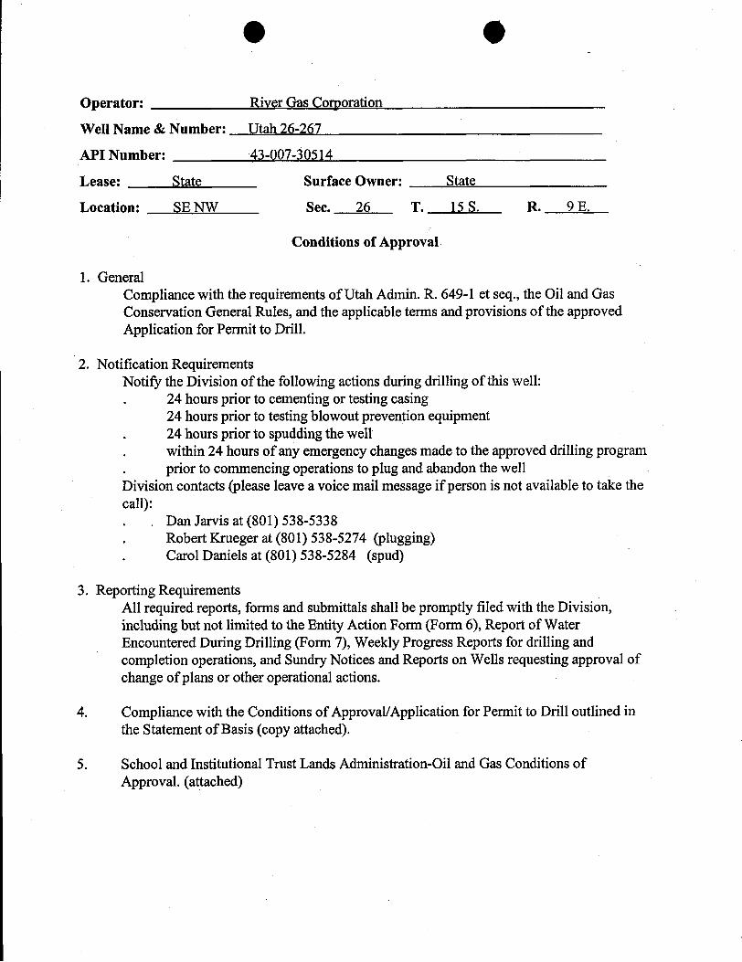
O O
Operator: River Gas Corporation
Well Name & Number: Utah 26-267
API Number: 43-007-30514
Lease: State Surface Owner: State
Location: SE NW Sec. 26 T. 15 S. R. 9 E.
Conditions of Approval
1. GeneralCompliance with the requirements of Utah Admin. R. 649-1 et seq., the Oil and GasConservation General Rules, and the applicable terms and provisions of the approvedApplication for Permit to Drill.
2. Notification RequirementsNotify the Division of the following actions during drilling of this well:. 24 hours prior to cementing or testing casing
24 hours prior to testingblowout prevention equipment. 24 hours prior to spudding the well. within 24 hours of any emergency changes made to the approved drilling program. prior to commencing operations to plug and abandon the wellDivision contacts (please leave a voice mail message if person is not available to take thecall):. . Dan Jarvis at (801) 538-5338. Robert Krueger at (801) 538-5274 (plugging). Carol Daniels at (801) 538-5284 (spud)
3. Reporting RequirementsAll required reports, forms and submittals shall be promptly filed with the Division,including but not limited to the Entity Action Form (Form 6), Report of WaterEncountered During Drilling (Form 7), Weekly Progress Reports for drilling andcompletion operations, and Sundry Notices and Reports on Wells requesting approval ofchange of plans or other operational actions.
4. Compliance with the Conditions of Approval/Application for Permit to Drill outlined inthe Statement of Basis (copy attached).
5. School and Institutional Trust Lands Administration-Oil and Gas Conditions ofApproval.
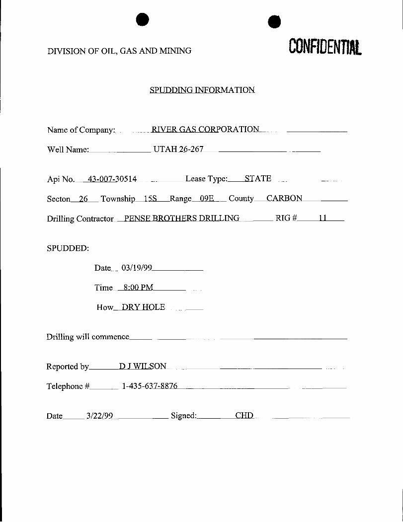
DIVISION OF OIL, GAS AND MINING
SPUDDING INFORMATION
Name of Company: RIVER GAS CORPORATION
Well Name: UTAH 26-267
Api No. 43-007-30514 Lease Type: STATE
Secton 26 Township 15S Range 09E County CARBON
Drilling Contractor PENSE BROTHERS DRILLING RIG # 11
SPUDDED:
Date 03/19/99
Time 8:00 PM
How DRY HOLE
Drilling will commence
Reported by DJ WILSON
Telephone# 1-435-637-8876
Date 3/22/99 Signed:
FORM 9 STATE OF UTAH
DIVISION OF OIL, GAS AND MININGS. Lease Designation and Serial Number:
ML-48235
SUNDRY NOTICES AND REPORTS ON WELLS "fan,AllotteeorTribeName:
7. Unit Agreement Name:Do not use this form for proposals to drill new wells,deepen existing wells, or to reenter plugged and abandoned wells. N/A
River Gas Corporation3. Address and Telephone Number: 10. Field or Pool, or Wildcat:
undesignated1305 South 100 East, Price, UT 84501 (435)637-88764. Location of Well
Footages: 1836' FNL, 2130' FWL County: CarbonQQ, Sec., T., R., M.: SE/4, NW/4, SEC.26, Tl5S, RO9E, SLB&M state: UTAH
ii. CHECK APPROPRIATE BOXES TO INDICATE NATURE OF NOTICE, REPORT, OR OTHER DATA
NOTICE OF INTENT SUBSEQUENT REPORT(Submit in Duplicate) (Submit Original Form Only)
O Abandon O New Construction O Abandon * O New ConstructionO Repair Casing O Pull or Alter Casing O Repair Casing O Pull or Alter CasingO Change of Plans O Recomplete O Change of Plans O ReperforateO Convert to Injection O Reperforate O Convert to Injection O Vent or FlareO Fracture Treat or Acidize O Vent or Flare O Fracture Treat or Acidize O Water Shut-OffO Multiple Completion O Water Shut-Off 10 Other Weekly ReportO Other
Date of work completionApproximate date work will start Report results of Multiple Completions and Recompletions to different reservoirs on WELL
COMPLETION OR RECOMPLETION REPORT AND LOG form.
12. DESCRIBE PROPOSED OR COMPLETED OPERATIONS (Clearly state allpertinent details, and give pertinent dates. Ifwell is directionally drilled, give subsurface locations and measured and truevertical depths for all markers and zones pertinent to this work.)
See attached
CONFllENTIAL
13.
Dawn J. Wilson Title:Administrative Assistant
Date: 3/26/99Name & Signature:
(This space for state use only)
(4/94) (See Instructions on Reverse
DAILY WELL REPORT
River Gas CorporationUtah 26-2671836' FNL, 2130' FWLSE/4, NW/4, Sec.26, Tl5S,RO9ECARBON COUNTY, UTAHSURVEYED ELEVATION:5967'API# 43-007-30514DRILLING CONTRACTOR: Pense Bros. Rig#11
PAGE 1DRILLING
Day 1. 3/20/99. Current Depth: 335'. Present Operations: WOC.Drilled in 24 hrs: 335'. Total rotating hrs: 4-1/2. Drilled from O' to 7' with 15"hammer bit#1. Drilled from 7' to 335' with 11" hammer bit#2. Move on andRU. SPUD Time & Date: 8:00pm 3/19/99. 8:00-9:00pm Drill 15" hole &set 7' 12 ¾" conductor. 9:00-1:45am Drill 11" hole to 335'. 1:45-2:15am Pullout of hole to run casing. 2:15-3:00am Run 319.5' of 8-5/8" 24# J-55. Rig upDowell. Cement Surface Casing. RD Dowell. WOC.
Day 2. 3/21/99. Current Depth: 800'. Present Operations: Rig down formaintenance. Drilled in 24 hrs: 465'. Total rotating hrs: 8-1/2. Drilled from319.5' to present with 7-7/8" hammer bit#3. WOC. Break loose and nipple upBOP and manifold. Test BOP. 12:00-1:00pm Set up to drill 7-7/8" hole andTIH. 1:00-5:00pm Drill 319.5'-800'. Booster (Clutch) broke. Pull up intocasing. Shut rig down. Work on booster. Shut down rig.
Day 3. 3/22/99. Current Depth: 800'. Present Operations: Working on rig.Drilled in 24 hrs: 0'. Total rotating hrs: 11. Drilled from 335' to present with 7-7/8" hammer bit #3. 7:00am-7:00am Working on rig.
Day 4. 3/23/99. Current Depth: 800'. Present Operations: Working on rig.Drilled in 24 hrs: 0'. Total rotating hrs: I1. Drilled from 335' to present with 7-7/8" hammer bit #3. 7:00am-7:00am Working on rig.
Day 5. 3/24/99. Current Depth: 1950'. Present Operations: Drilling. Drilled in24 hrs: 1150'. Total rotating hrs: 20. Drilled from 335' to present with 7-7/8"hammer bit #3. 7:00am-10:00pm Working on rig. TIH and start drilling 7-7/8"hole 830' at ll:00pm. ll:00-1:00am Drilling at 1280' at 1:00am. 1:00-2:00amDrilling at 1670'. 2:00-5:00am Drilling at 1700' at 5:00am. 5:00-7:00amDrilling 1950' at 7:00am.
O ODAILY WELL REPORT
River Gas CorporationUtah 26-2671836' FNL, 2130' FWLSE/4, NW/4, Sec.26, Tl5S,RO9ECARBON COUNTY, UTAHSURVEYED ELEVATION:5967'API# 43-007-30514DRILLING CONTRACTOR: Pense Bros. Rig#11
PAGE 1DRILLINGDay 6. 3/25/99. Current Depth: 2577'. Present Operations: Waiting to make ascraper run. Drilled in 24 hrs: 627'. Total rotating hrs: 26-1/4. Drilled from335' to 2577' with 7-7/8" hammer bit #3. 7:00-9:00am Drilling 2210' at9:00am. 9:00-l l:00am Drilling 2390' at l l:00am. 11:00-12:30pm Drilling2510' at 12:30pm. 12:30-1:15pm TD at 2577' at 1:15pm on 3/24/99.Circulate hole clean. TOOH. RU loggers. Log well. RD logger. Finishmoving rig. Rig up work over. Set racks. Unload casing and tally. Make up 5-1/2" float shoe and run in with 57 joints and shoe. Land casing at 2513.28'. RUDowell and cement long string. RD Dowell. Waiting to make scraper
STATE OF UTAH OPERATOR River Gas Corporation OPERATOR ACCT. NO.DIVISloN OF OIL, GAS AND MINING ADDRESS 1305 South 100 EastENTITY ACTION FORM - FORM 6 Price UT 8450]
ACT10N CURRENT NEW API NUMBER WELL NAME WELL LOCATION SPUD DATE EFFECTIVECODE ENTITY NO. ENTITY NO- QQ SC TP RG COUNTY DATE
43-007-30514 Utah 26-267 SE/NW 26 15S 09E Carbon 3/19/99
WELL 1 COMMENTS:
CONFllENTIAL43-007-30452 USA 30-289 W/NE 30 15S 10E Carbon 3/24/99
WELL 2 COMMENTS: ÑOQfÇ(§ i f
43-007-30451 USA 20-288 W/SW 20 15S 10E 9
WELL3COMMENTS: """""^ CONFllENTIALA
WELL 4 COMMENTS:
A | UWELL 5 COMMENTS:
ACTION CODES (See Instructions on back uiio m)A - Establish new entity for new well (single well only)B - Add new wellto existing entity (groupor unit well) SignatureC - Re-assign well from one existing entity to another existing entityD - Re-assign well from one existing entity to a new entity Administrative ssistant 3/29/99E - Other (explain in comments section) Title Date
NOTE: Use COMMENT section to explain why each Action Code was selected. CONFllENTlAL Phone No. (435)
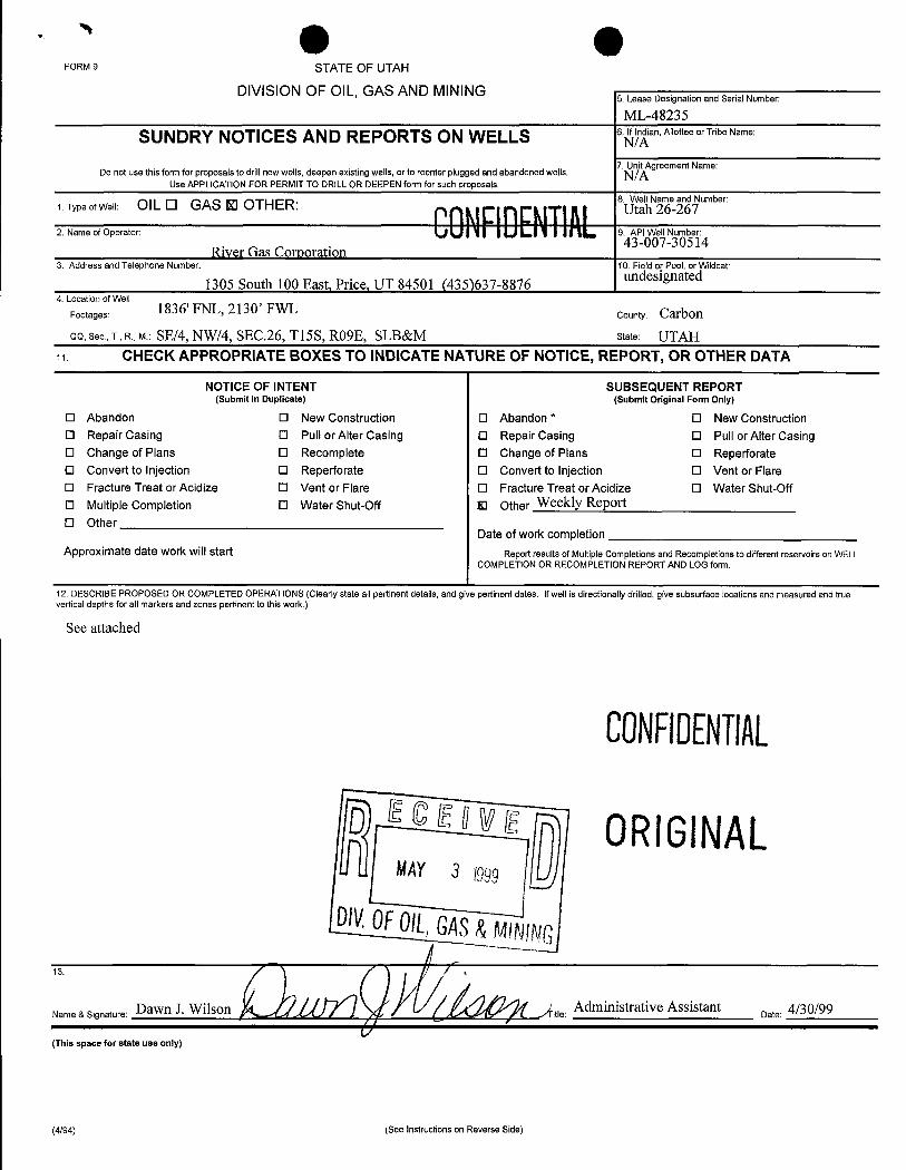
FORM 9 STATE OF UTAH
DIVISION OF OIL, GAS AND MINING 5 Lease Designation and Serial Number:
ML-48235
SUNDRY NOTICES AND REPORTS ON WELLS 6. In an,AllotteeorTribeName:
7. Unit Agreement Name:Do not use this form for proposals to drill newwells,deepen existingwells, or to reenter plugged and abandoned wells N/A
8
43-007-30514River Gas Corporation
3. Address and Telephone Number: 10. Field or Pool, or WIdcat:undesignated
1305 South 100 East, Price, UT 84501 (435)637-88764. Location ofWell
Footages: 1836' FNL, 2130' FWL County: CarbonQQ, Sec., T., R., M.: SE/4, NW/4, SEC.26, Tl5S, RO9E, SLB&M state: UTAH
a CHECK APPROPRIATE BOXES TO INDICATE NATURE OF NOTICE, REPORT, OR OTHER DATA
NOTICE OF INTENT SUBSEQUENT REPORT(Submit in Duplicate) (Submit Original Form Only)
O Abandon O New Construction O Abandon * O New ConstructionO Repair Casing O Pull or Alter Casing O Repair Casing 0 Pull or Alter CasingO Change of Plans O Recomplete O Change of Plans O ReperforateO Convert to Injection O Reperforate O Convert to Injection O Vent or FlareO Fracture Treat or Acidize O Vent or Flare O Fracture Treat or Acidize O Water Shut-OffO Multiple Completion O Water Shut-Off Kl Other Weekly ReportO Other
Date of work completionApproximate date work will start Report results of Multiple Completions and Recompletions to different reservoirs on WELL
COMPLETION OR RECOMPLETION REPORT ANDLOG form.
12. DESCRIBE PROPOSED OR COMPLETED OPERATIONS (Clearly state all pertinent details, and give pertinent dates. Ifwell is directionally drilled, give subsurface locations and measured and truevertical depths for all markers and zones pertinent to this work.)
See attached
CONFilENTIAL
D Ecs"YE Q ORIGINALMAY 3 1999 U
DW.0F0/L,GAS&MINING
ame a signature:Dawn J. Wilson Administrative AssistantDate: 4/30/99
(This space for state use only)
(4/94) (See Instructions on Reverse
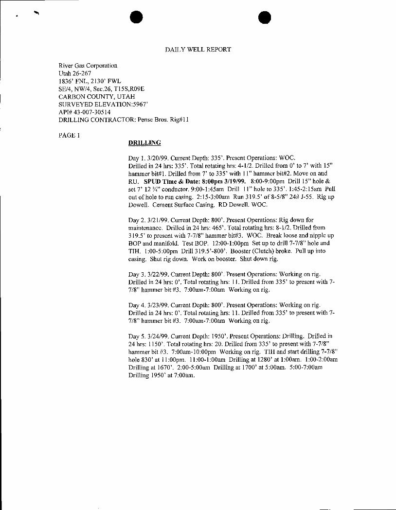
O ODAILY WELL REPORT
River Gas CorporationUtah 26-2671836' FNL, 2130' FWLSE/4, NW/4, Sec.26, Tl5S,RO9ECARBON COUNTY, UTAHSURVEYED ELEVATION:5967'API# 43-007-30514DRILLING CONTRACTOR: Pense Bros. Rig#ll
PAGE 1DRILLING
Day 1. 3/20/99. Current Depth: 335'. Present Operations: WOC.Drilled in 24 hrs: 335'. Total rotating hrs: 4-1/2. Drilled from O' to 7' with 15"hammer bit#1. Drilled from 7' to 335' with 11" hammer bit#2. Move on andRU. SPUD Time & Date: 8:00pm 3/19/99. 8:00-9:00pm Drill 15" hole &set 7' 12 ¾" conductor. 9:00-1:45am Drill 11" hole to 335'. 1:45-2:15am Pullout of hole to run casing. 2:15-3:00am Run 319.5' of 8-5/8" 24# J-55. Rig upDowell. Cement Surface Casing. RD Dowell. WOC.
Day 2. 3/21/99. Current Depth: 800'. Present Operations: Rig down formaintenance. Drilled in 24 hrs: 465'. Total rotating hrs: 8-1/2. Drilled from319.5' to present with 7-7/8" hammer bit#3. WOC. Break loose and nipple upBOP and manifold. Test BOP. 12:00-1:00pm Set up to drill 7-7/8" hole andTIH. 1:00-5:00pm Drill 319.5'-800'. Booster (Clutch) broke. Pull up intocasing. Shut rig down. Work on booster. Shut down rig.
Day 3. 3/22/99. Current Depth: 800'. Present Operations: Working on rig.Drilled in 24 hrs: 0'. Total rotating hrs: 11. Drilled from 335' to present with 7-7/8" hammer bit #3. 7:00am-7:00am Working on rig.
Day 4. 3/23/99. Current Depth: 800'. Present Operations: Working on rig.Drilled in 24 hrs: 0'. Total rotating hrs: 11. Drilled from 335' to present with 7-7/8" hammer bit #3. 7:00am-7:00am Working on rig.
Day 5. 3/24/99. Current Depth: 1950'. Present Operations: Drilling. Drilled in24 hrs: 1150'. Total rotating hrs: 20. Drilled from 335' to present with 7-7/8"hammer bit #3. 7:00am-10:00pm Working on rig. TIH and start drilling 7-7/8"hole 830' at ll:00pm. ll:00-1:00am Drilling at 1280' at 1:00am. 1:00-2:00amDrilling at 1670'. 2:00-5:00am Drilling at 1700' at 5:00am. 5:00-7:00amDrilling 1950' at
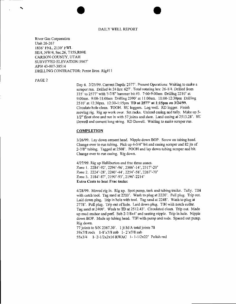
' O ODAILY WELL REPORT
River Gas CorporationUtah 26-2671836' FNL, 2130' FWLSE/4, NW/4, Sec.26, T15S,RO9ECARBON COUNTY, UTAHSURVEYED ELEVATION:5967'API# 43-007-30514DRILLING CONTRACTOR: Pense Bros. Rig#ll
PAGE 2Day 6. 3/25/99. Current Depth: 2577'. Present Operations: Waiting to make ascraper run. Drilled in 24 hrs: 627'. Total rotating hrs: 26-1/4. Drilled from335' to 2577' with 7-7/8" hammer bit #3. 7:00-9:00am Drilling 2210' at9:00am. 9:00-11:00am Drilling 2390' at 11:00am. 11:00-12:30pm Drilling2510' at 12:30pm. 12:30-1:15pm TD at 2577' at 1:15pm on 3/24/99.Circulate hole clean. TOOH. RU loggers. Log well. RD logger. Finishmoving rig. Rig up work over. Set racks. Unload casing and tally. Make up 5-
1/2" float shoe and run in with 57 jointsand shoe. Land casing at 2513.28'. RUDowell and cement long string. RD Dowell. Waiting to make scraper run.
COMPLETION
3/26/99. Lay down cement head. Nipple down BOP. Screw on tubing head.Change over to run tubing. Pick up 4-3/4" bit and casing scraper and 82 jts of2-7/8" tubing. Tagged at 2508'. POOH and lay down tubing scraper and bit.Change over to run casing. Rig down.
4/27/99. Rig up Halliburton and frac three zones.Zone 1. 2284'-92', 2294'-96', 2306'-14', 2317'-20'Zone 2, 2224'-28', 2240'-44', 2254'-58', 2267'-70'Zone 3. 2184'-87', 2190'-93', 2196'-2214'Extra Costs to heat Frac tanks:
4/28/99. Moved rig in. Rig up. Spot pump, tank and tubing trailer. Tally. TIHwith catch tool. Tag sand at 2210'. Wash to plug at 2220'. Pull plug. Trip out.Laid down plug. Trip in hole with tool. Tag sand at 2248'. Wash to plug at2778'. Pull plug. Trip out of hole. Laid down plug. TIH with notch collar.Tag sand at 2400'. Wash to TD at 2512.43'. Circulated clean. Trip out. Madeup mud anchor and perf. Sub 2-7/8x4' and seating nipple. Trip in hole. Nippledown BOP. Made up tubing head. TIH with pump and rods. Spaced out pump.Rig down.77 joints to S/N 2367.30'. 1 jt M/A total joints7839x7/8 rods 1-8'x7/8 sub 1- 2'x7/8 sub55x3/4 1- 2-l/2x2x16 RWAC 1- l-l/2x22' Polish
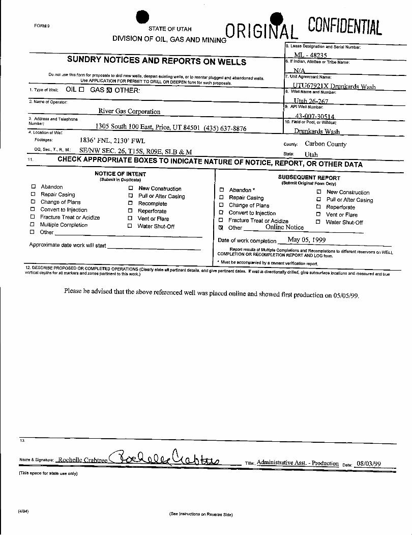
CONFilENTIALFORM9STATEOFUTAH 0RIGlNTALDIVISION OF OIL,GASAND MINING
5. Lease Designation and Serial Number:
ML - 48235SUNDRY NOTICES AND REPORTS ON WELLS 6.lfindian,AllotteeorTribeName:
N/A7. Unit Agreement Name:
Do not use this form for proposals to drill new wells,deepen existing wells,or to reenter pluggedand abandoned wells.Use APPLICATIONFOR PERMIT TO DRILL OR DEEPEN form for such proposals. UTU67921X Drunkards Wash1. Type of Well: OIL O GAS RI OTHER: 8. Well Name and Number:
TItah 76-2672. Name of Operator:9. API Well Number:
River Gas Corporation 41-007-305143. Address and Telephone 10. Field or Pool, or Wildcat:Number: 1305 South 100 East, Price, UT 84501 (435) 637-8876 Drunkards Wash4. Location of Well
Footages: 1836' FNL, 2130' FWL county: Carbon CountyQQ, Sec., T., R., M.: SE/NW SEC. 26, T15S, R09E, SLB & M state: Utah
11. CHECK APPROPRIATE BOXES TO INDICATENATURE OF NOTICE, REPORT, OR OTHER DATANOTICEOF INTENT SUBSEQUENT REPORT(Submit in Duplicate)
(Submit Original Form Only)O Abandon O New Construction O Abandon * O New ConstructionO Repair Casing O Pull or Alter Casing O Repair Casing O Pull or AlterCasingO Change of Plans O Recomplete O Change of Plans O ReperforateO Convert to injection O Reperforate O Convert to injection O Vent or FlareO Fracture Treat or Acidize O Vent or Flare O Fracture Treat or Acidize O Water Shut-OffO Multiple Completion O Water Shut-Off IX Other Online NoticeO Other
Date of work completion May 05, 1999Approximate date work willstart
Report results of Multiple Completions and Recompletionsto different reservoirs on WELLCOMPLETION OR RECOMPLETION REPORTAND LOG form.* Must be accompaniedby a cementverificationreport.
12. DESCRIBE PROPOSED OR COMPLETED OPERATIONS (Clearlystate all pertinent details, and give pertinent dates. Ifwell is directionally drilled, give subsurface locations and measured and truevertical depths for all markersand zones pertinent to this work.)
Please be advised that the above referenced well was placed online and showed first production on 05/05/99.
13.
Name & Signature: Rochelle Crabtree Title:, Administrative Asst. - Production Date: 08/03/99(This space for state use only)
(4/94) (See Instructions on Reverse Side)
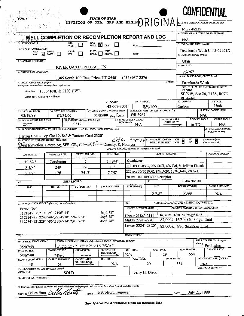
0 e CONFIDENTig.FORM 8 STATE OF UTAH
DIVISION OF OIL, GAS AND MINI 5.LEASEDESIGNATIONANDSERIALNO.
ML - 482356. IF INDIAN, ALLOTTEE OR TRIBE NAME
WELL COMPLETION OR RECOMPLETION REPORT AND LOGN/A
la TYPEOFWELL OIL GASWELL WELL DRY Other 7. UNIT AGREEMENT NAME
b. TYPE OF COMPLETION:NEW WORK DEEP- PLUG DIFF. Drunkards Wash UTU-67921XWELL OVER EN BACK RESVR. O her 8. FARM OR LEASE NAME
2. NAME OF OPERATOR UtahRIVER GAS CORPORATION 9. WELL NO.
3. ADDRESS OF OPERATOR 26-267
1305 South 100 East, Price, UT 84501 (435) 637-8876 10.FIELDANDPOOL,ORWILDCAT
4. LOCATION OF WELL (Report location Drunkards Washclearly and in accordance with any State requirements)
11. SEC., T., R., M., OR BLOCK AND SURVEY
At surface 1836' FNL & 2130' FWL ORAREA
SE/NW, Sec 26, T15S, RO9E,At top prod. interval reported below
SI R&M14.API NO. DATE ISSUED 12. COUNTY 13. STATE
43-007-30514 03/11/99 Carbon Utah15. DATE SPUDDED 16. DATE T.D. REACHED 17. DATE COMPL. (Readv toprod.) 18. ELEVATIONS (DF, REB, RT, GR, ETC.) 19. ELEV. CASINGHEAD
03/19/99 03/24/99 05/05/99 reingÍAbd.) GR 5967' N/A20. TOTAL DEPTH, MD & TVD 21. PLUG BACK T.D., MD & TVD 22. IF MULTIPLE COMPL., 23. INTERVALS ROTARY TOOLS CABLE TOOLS
2577' 2512' HOW MANYN/A
DRILLED BY>10 TD N/A
24. PRODUCING INTERVAI/S), OF THIS COMPLETION--TOP, BOTTOM, NAME (MD OR TVD) 5. WAS DIRECTIONALSURVEY MADE
Ferron Coal - Top Coal 2184' & Bottom Coal 2320' ---
26. TYPE ELECTRIC AND OTHER LOGS RUN gg i, jŸgg 27. WAS WELL CORED YES NO (Submitanalysis)
al Induction, Laterolog, SFF, GR, Caliper mp Density, & NeutronDRILL STEM TEST YES NO g (See reverse side)
28. CASINGRECORD (Reportall strings set in well)
CASING SIZE WEIGHT, LB./FT. DEPTH SET (MD) HOLE SIZE CEMENT RECORD AMOUNT PULLED
12 3/4" Conductor 7' 14 3/4" Conductor
8 5/8" 24# 320' 11" 110 sxs Class G, 2% CaCl, 4% Gel, & 1/4#/sx Flocele
5 1/2" 17# 2512' 7 7/8" 225 sxs 50/50 POZ, 8% D-20, 10% D-44, 2% S-1,
70 sxs 10-1 RFC (Thixotropic)29. LINER RECORD 30. TUBINGRECORD
SIZE TOP (MD) BOTTOM (MD) SACKS CEMENT SCREEN (MD) SIZE DEPTH SET (MD) PACKER SET (MD)
2-7/8" 2399' N/ A
31. PERFORATION RECORD (lnterval, size andnumber) 32. ACID, SHOT, FRACTURE, CEMENT SQUEEZE,ETC.
Ferron Coal DEFTH INTERVAL (MD) AMOUNT AND KIND OF MATERIAL USED
1) 2184'-87',2190'-93',2196'-14' 4spf .78"
2) 2224'-28',2240'-44',2254'-58',226T-70' 4spf .78"I IPPRT El 84'-El l 4' 82,300#, 16/30; 34,296 gal fluid
3) 2284'-92',2294'-96',2306'-14',2317'-20' 4spf .78"Middle 2224'-2270' 82,000#, 16/30; 36,434 gal fluidLower 2284'-2320' 82,000# 16/30·34.938 val fluid
33. PRODUCTION
DATE FIRST PRODUCTION PRODUCTION METHOD (Flowing,gas hyt,pumping-alze andtype ofpump) WELL STATUS (Producingor
05/07/99 | Pumping - 2 1/2" x 2" x 16' RWAC | ProducingDATE OF TEST HOURS TESTED CHOKE SIZE PRODW. FOR OIL-BBL. GAS-MCF. WATER-BBL GAS-OIL RATIO
TEST PERIOD I I '05/07/99 24hrs. --- > | N/A 29 | 554
FLOW. TUBING PRESS. CASING PRESSURE CALCULATED OIL-BBL GAS-MCF. WATER-BBL OIL GRAVITI - API (CORlt)24-HOUR RATE I i I
48 51 > N/A | 29 | 554 N/A34. DISPOSITION OF GAS (Sold,used for fuel, TEST WITMESSED BY
"" '''°> SOLD Jerry H. Dietz35. LIST OF ATTACHMENTS
36 Ihereby certify that the forego tached mplete and correct as determined fromne av 11able records
DATE JUlf Î , ÎÛÛÛ
See Spaces for Additional Data on Reverse
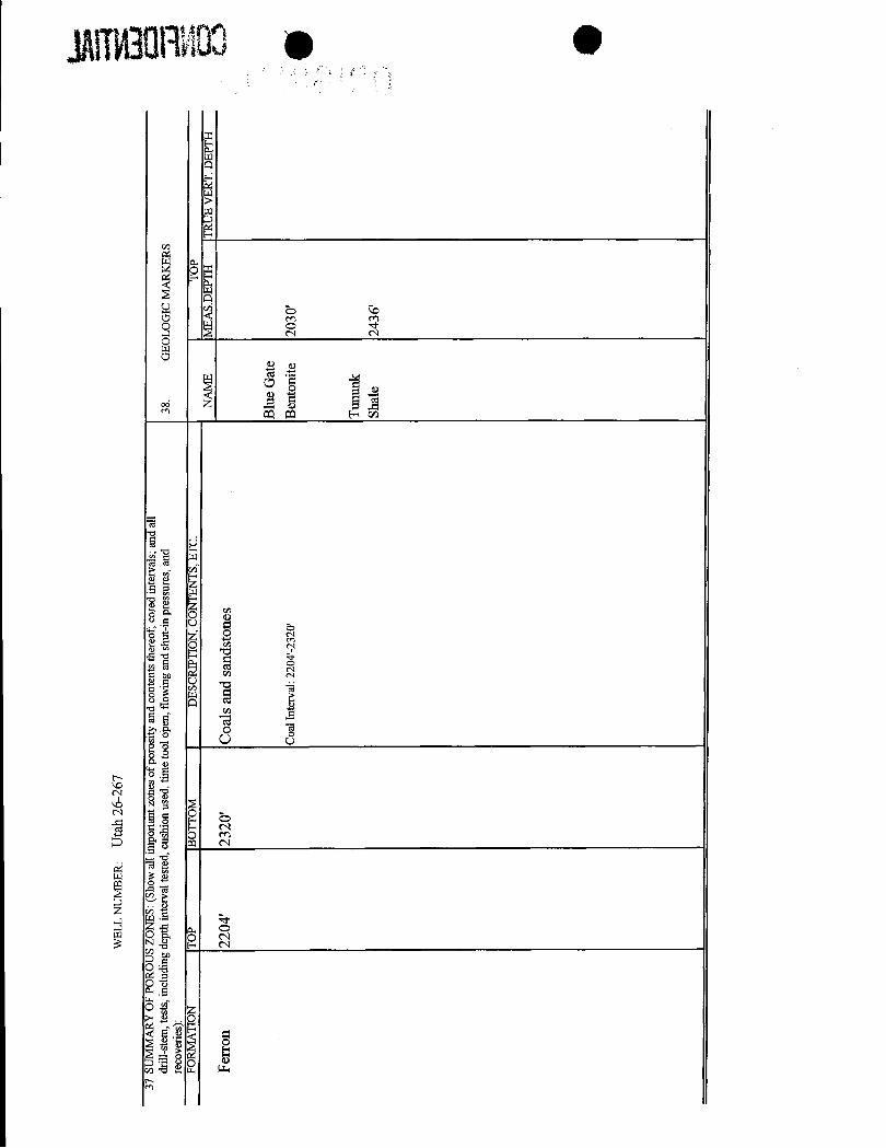
WEL
LN
UM
BER
:U
tah
26-2
67
37SU
MM
AR
YO
FPO
RO
US
ZON
ES: (
Show
all
impo
rtant
zone
sof
poro
sity
and
cont
ents
ther
eof;
core
din
terv
als;
and
all
drill
-ste
m, t
ests
, inc
ludi
ngde
pth
inte
rval
test
ed,c
ushi
onus
ed,
time
tool
open
, flo
win
gan
dsh
ut-in
pres
sure
s,an
d38
.G
EOLO
GIC
MA
RK
ERS
reco
verie
s):
FOR
MA
TIO
NTO
PB
OTT
OM
DES
CR
IPTI
ON
, CO
NTE
NTS
,ETC
.TO
PN
AM
EM
EAS.
DEP
THTR
UE
VER
T.D
EPTH
Ferr
on22
04'
2320
'C
oals
and
sand
ston
es
Blu
eG
ate
Coa
lInt
erva
l:22
04'-2
320'
Ben
toni
te20
30'
Tunu
nkSh
ale
e 0RIGRAMONFllENTIALSTATE OF UTAHFORM9
DIVISION OF OlL, GAS AND MINING5. Lease Designation and Serial Number:
ML - 48235SUNDRY NOTICES AND REPORTS ON WELLS 6.Ifindian,AllotteeorTribeName:
N/A7. UnitAgreement Name:
Do not use this form for proposals to drill newwells,deepen existing wells, or to reenter plugged and abandoned wells.Use APPLICATION FOR PERMIT TO DRILL OR DEEPEN form for such proposals. UTU67921X Drunkards Wash
8. WellName and Number:1.TypeofWell: OIL O GAS El OTHER:
TIt h 76-7672. Name of Operator: 9. API Well Number:
River Gas Corporation 43-007-305143. Address and Telephone
10. Field or Pool, or Wildcat:
Number: 1305 South 100 East, Price, UT 84501 (435) 637-8876 Drunkards Wash4. Location of Well
Footages: 1836' FNL, 2130' FWL County: Carbon County
QQ, Sec., T., R., M.: SE/NW SEC. 26, T15S, RO9E, SLB & M state: Utah
u. CHECK APPROPRIATE BOXESTO INDICATE NATURE OF NOTICE, REPORT, OR OTHER DATA
NOTICE OF INTENT SUBSEQUENT REPORT(Submit in Duplicate) (Submit Original Form Only)
OAbandon ONew Construction OAbandon * ONew Construction
ORepair Casing OPull or Alter Casing ORepair Casing OPull or Alter Casing
OChange of Plans ORecomplete OChange of Plans OReperforate
OConvert to Injection OReperforate OConvert to injection OVent or Flare
OFracture Treat or Acidize OVent or Flare OFracture Treat or Acidize OWater Shut-Off
OMultiple Completion OWater Shut-Off I¾ther Chemical/Flush Treatment
OOther Date of work completion 09/29/99Approximate date work will start Report results of Multiple Completions and Recompletions to different reservoirs on WELL
COMPLETION OR RECOMPLETION REPORT ANDLOG form.
12. DESCRIBE PROPOSED OR COMPLETED OPERATIONS (Clearly state all pertinent details, and give pertinent dates. Ifwell is directionally drilled, give subsurface locations and measured and truevertical depths for all markersand zones pertinent to this work.)
Please be advised that the above referenced well was chemically treated with 4000 gallons of low Ph fluid and250 gallons of 7 1/2% HCL on 09/29/99.
13.ma
A Signature Rochell CrahiTee per .I Try Title: Field Supervisor/Engineer Date: 10/07/99
(This space for state use only)
(4/94) (See Instructions on Reverse
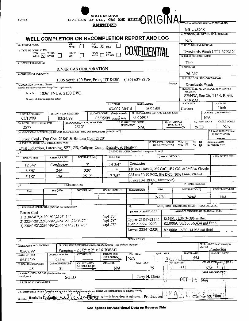
STATE OF UTANFORM8 DIVISION OF OIL, GAS AND MININ
AMENDED'
.EASEDESIGNATIONANDSERIALNO.
ML - 482356. IF INDIAN, ALLOTTEE OR TRIBE NAME
WELL COMPLETION OR RECOMPLETION REPORT AND LOG N/Ala. TYPE OF WELL: OIL GAS
WELL WELL DRY 7. UNIT AGREEMENT NAME
b. TYPE OF COMPLETION:NEW WORK DEEP- PLUG DIFF. Drunkards Wash UTU-67921XWELL OVER EN BACK RESVK 8. FARM ORLEASE NAME
2. NAME OF OPERATOR Utah
RIVER GAS CORPORATION 9. WELL NO.
3. ADDRESS OF OPERATOR 26-267
1305 South 100 East, Price, UT 84501 (435) 637-8876 10. FIELD AND POOL, OR WILDCAT
4. LOCATION OF WELL (Report location Drunkards Washclearly and in accordance with any State requirements)
11. SEC., T., R., M., OR BLOCK AND SURVEY
At surface 1836' FNL & 2130' FWL ORAREA
SE/NW, Sec 26, T15S, RO9E,At top prod. interval reported below
14. API NO. DATE ISSUED 12. COUNTY 13. STATE
43-007-30514 03/11/99 Carbon Utah15.DATE SPUDDED 16. DATE T.D. REACHED 17. DATE COMPL. (Ready toprod.) 18. ELEVATIONS (DF, REB, RT, GR, ETC.) 19. ELEV. CASINGHEAD
03/19/99 03/24/99 05/05/99 (PingÍAbd.) GR 5967' N/A20. TOTAL DEPTH, MD & TVD 21. PLUG BACK T.D., MD & TVD 22. IF MULTIPLE COMPL., 23. INTERVALS ROTARY TOOLS CABLE TOOLS
2577' 2512' HOW MANYN/A
DRILLED BY>10 TD N/A
24. PRODUCING INTERVAL(S), OF THIS COMPLETION-TOP, BOTTOM, NAME (MD OR TVD) 25. WAS DIRECTIONALSURVEY MADE
Ferron Coal - Top Coal 2184' & Bottom Coal 2320' ----
26. TYPE ELECTRIC AND OTHER LOGS RUN 27. WAS WELL CORED YES NO E (Submitanalysis)
Dual Induction, Laterolog, SFF, GR, Caliper, Comp Density, & Neutron DRILL STEM TEST YES NO g (See reverse side)
28. CASING RECORD (Reportall strings set in well)
CASING SIZE WEIGHT, LB./FT. DEPTH SET (MD) HOLE SIZE CEMENT RECORD AMOUNT PULLED
12 3/4" Conductor 7' 14 3/4" Conductor
8 5/8" 24# 320' 11" 110 sxs Class G, 2% CaCl, 4% Gel, & 1/4#/sxFlocele
5 1/2" 17# 2512' 7 7/8" 225 sxs 50/50 POZ, 8% D-20, 10% D-44, 2% S-1,
70 sxs 10-1 RFC (Thixotropic)29. LINER RECORD 30. TUBING RECORD
SIZE TOP (MD) BOTTOM (MD) SACKS CEMENT SCREEN (MD) SIZE DEPTH SET (MD) PACKER SET (MD)
2-7/8" 2404' N/ A
31. PERFORATION RECORD (Interval, size andnumber) 32. ACID, SHOT, FRACTURE, CEMENT SQUEEZE,ETC.
Ferron Coal DEPTH INTERVAL (MD) AMOUNT AND KIND OF MATERIAL USED
1) 2184'-87',2190'-93',2196'-14' 4spf .78"
2) 2224'-28',2240'-44',2254'-58',2267'-70' 4spf.78" TIpper 2184'-7114' 82,300#, 16/30; 34,296 gal fluid
3) 2284'-92',2294'-96',2306'-14',2317'-20' 4spf .78"Middle 2224'-2270' 82,000#, 16/30; 36,434 gal fluidLower 2284'-2320' 82.000#, 16/30; 34.938 gal fluid
33. PRODUCTION
DATE FIRST PRODUCTION PRODUCTION METHOD (Flowing,gas hft, pumping-size andtype ofpump) WELL STATUS (Producing or
05/07/99 Pumping - 2 1/2" x 2" x 16' RWACshut-in)
ProducingDATE OF TEST HOURS TESTED CHOKE SIZE PROD'N. FOR OID--BBL. GAS-MCF. WATER-BBL. GAS-OIL RATIO
TEST PERIOD I r
05/07/99 24hrs. ------ > | N/A | 29- 554FLOW. TUBING PRESS. CASING PRESSURE CALCULATED OIL-BBL. GAS-MCF. WATER---BBL OIL GRAVITI C RR.)
24-HOURRATE I i
48 51 > N/A | 29 554 NÏA34. DISPOSITION OF GAS (Sold,used for fuel, TEST WITNESSEI
vented, etc.) SOLD Jerry H. Dietz35. LIST OF ATTACHMENTS
36 I hereby certify that the fi ing and a tached informati is complete and correct as determined from all availablerecords
SIGNED Rochelle dministrative Assistant - Production tb
See Spaces for Additional Data on Reverse
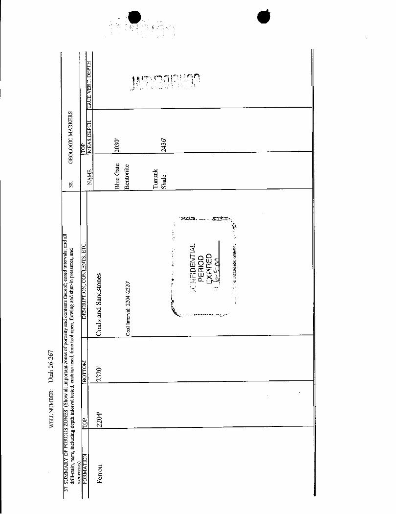
WEL
LN
UM
BER
:U
tah
26-2
67
37SU
MM
AR
YO
FPO
RO
US
ZON
ES:(
Show
alli
mpo
rtant
zone
sof
poro
sity
and
cont
ents
ther
eof;
core
din
terv
als;
and
all
drill
-ste
m, t
ests
,inc
ludi
ngde
pth
inte
rval
test
ed,c
ushi
onus
ed,
time
tool
open
,flo
win
gan
dsh
ut-in
pres
sure
s,an
d38
.G
EOLO
GIC
MA
RK
ERS
reco
verie
s):
FOR
MA
TIO
NTO
PB
OTT
OM
DES
CR
IPTI
ON
,CO
NTE
NTS
,ETC
.TO
PN
AM
EM
EAS.
DEP
THTR
UE
VER
T.D
EPTH
Ferr
on22
04'
2320
'C
oals
and
Sand
ston
es
Blu
eG
ate
2030
'C
oalI
nter
val:
2204
'-232
0'B
ento
nite
Tunu
nkSh
ale
2436
'
NFI
DEN
TIA
LPE
RIO
D
FORM9 TATEOFUTAH 0Rl$lNALDIVISION OF OIL, GAS AND MINING
5. Lease Designation and Serial Number:
ML - 48235
SUNDRY NOTICES AND REPORTS ON WELLS 6.Ifindian,AllotteeorTribeName:
N/A7. Unit Agreement Name:
Do not use this form for proposals to drill new we11s,deepen existing wells, or to reenter plugged and abandoned wells.Use APPLICATION FOR PERMIT TO DRILL OR DEEPEN form for such proposals. UTU67921X Drunkards Wash
1.TypeofWell:OILO GAS O OTHER: 8. Wel1NameandNumber:
Utah 26-2672. Name of Operator: 9. AP1 Well Number:
River Gas Corporation 43-007-305143. Address and Telephone Number: 10. Field or Pool, or Wildcat:
6825 South 5300 West, P.O. Box 851, Price, UT 84501 (435) 613-9777 Drunkards Wash4. Location of WellFootages: County: 1836' FNL, 2130' FWL Carbon CountyQQ, Sec., T., R., M.: State: SE/SW SEC. 26, Tl5S, RO9E, SLB & M Utah
11. CHECK APPROPRIATE BOXES TO INDICATE NATURE OF NOTICE, REPORT, OR OTHER DATA
NOTICE OF INTENT SUBSEQUENT REPORT(Submit in Duplicate) (Submit Original Form Only)
O Abandon O New Construction O Abandon * O New Construction
O Repair Casing O Pull or Alter Csg O Repair Casing O Pull or Alter CsgO Change of Plans O Recomplete O Change of Plans O ReperforateO Convert to injection O Reperforate O Convert to Injection O Vent or FlareO Fracture Treat or Acidize O Vent or Flare O Fracture Treat or Acidize O Water Shut-Off
O Multiple Completion O Water Shut-Off U Other Chemical/Flush Treatment
O Other Date of work completion 0 //13/2000
Approximate date work will startReport results of Multiple Completions and Recompletions to different reservoirs on WELL
COMPLETION OR RECOMPLETION REPORT AND LOG form.
* Must be accompanied by a cement verification report.
12. DESCRIBE PROPOSED OR COMPLETED OPERATIONS (Clearly state all pertinent details, and give pertinent dates. Ifwell is directionally drilled, give subsurface locations and measured and truevertical depths for all markers and zones pertinent to this work.)
Please be advised that the above referenced well was chemically treated with 4000 gallons of low Ph fluid &250 gallons of 7 1/2% HCL on 07/13/00.
13.
Name & Signature: Rochelle Crabtre Title Administrative Assistant Date: 07/19/2000
(This space for state use only)
(4/94) (See Instructions on Reverse
FORM S STATE OF UTAH ALDIVISION OF OIL, GAS AND MINING
5. Lease Designation and Serial Number:
ML - 48235SUNDRY NOTICES AND REPORTS ON WELLS 6.Ifindian,AllotteeorTribeName:
N/A7. Unit Agreement Name:Do not use this form for proposals to drill newwells,deepen existingwells, or to reenter plugged and abandoned wells.
Use APPLICATION FOR PERMIT TO DRILL OR DEEPEN form for such proposals UTU67921X Drunkards Wash1. Type of Well: OlL O GAS OTHER: 8. Well Name and Number:
Utah 26-2672. Name of Operator; 9. API Well Number:
River Gas Corporation 43-007-305143. Address and Telephone Number: 10. Field or Pool, otWildcat:
6825 South 5300 West, P.O. Box 851, Price, UT 84501 (435) 613-9777 Drunkards Wash4. Location of Well .
Footages: County: 1836' FNL, 2130' FWL Carbon CountyQQ, Sec., T., R., M.:State: SE/SW SEC. 26, T15S, RO9E, SLB & M Utah
11. CHECK APPROPRIATE BOXES TO INDICATE NATURE OF NOTICE, REPORT, OR OTHER DATA
NOTICE OF INTENT SUBSEQUENT REPORT(Submit in Duplicate) (Submit Original Form Only)
O Abandon O New Construction O Abandon * O New ConstructionO Repair Casing O Pull or Alter Csg O Repair Casing O Pull or Alter CsgO Change of Plans O Recomplete O Change of Plans O ReperforateO Convert to lnjection O Reperforate O Convert to injection O Vent or FlareO Fracture Treat or Acidize O Vent or Flare O Fracture Treat or Acidize O Water Shut-Off
O Multiple Completion O Water Shut-Off U Other Chemical/Flush TreatmentO Other Date of work completion 0 0ÜÛApproximate date work will start
Report results of Multiple Completions and Recompletions to different reservoirs on WELLCOMPLETION OR RECOMPLETION REPORT AND LOG form.* Must be accompanied by a cement verification report.
12. DESCRIBE PROPOSED OR COMPLETED OPERATIONS (Clearly state allpeltinent details, and give pertinent dates. Ifwellis directionally drilled, give subsurface locations and measured and truevertical depths for all markersand zones pertinent to this work.)
Please be advised that the above referenced well was chemically treated with 4000 gallons of low Ph fluid &250 gallons of 7 1/2% HCL on 07/13/00.
13.
Name & Signature: Rochelle Crabtre L vitie Administrative Assistant Date: 07/19/2000
(This space for state use only)
(4/94) (See Instructions on Reverse
FORM 9 STATE OF UTAH
DIVISION OF OIL, GAS AND MINING5 LeaseDesignationandSerialNumber
SUNDRY NOTICES AND REPORTS ON WELLS 6 Ifindian,AllotteeorTribeName:
Do not use this form for proposals to drill new wells, deepen existingwells, or to reenter plugged and abandoned wells 7 Unit Agreement Name:
Use APPLICATION FOR PERMIT TO DRILL OR DEEPEN form for such proposals
1 Type of Well: OlL O GAS El OTHER: 8 Well Name and Number:
2 Name of Operatot 9 AP) Well Number:
River Gas Corporation3 Address and 10 Field or Pool, or Wildcat:TelephoneNumber: 6825 S. 5300 W. P.O. Box 851 Price, Utah 84501 (435) 613-97774 Location of Well
Footages: County Carbon CountyQQ,See , T , R , M : State:
SLB & M Utaha CHECK APPROPRIATE BOXES TO INDICATE NATURE OF NOTICE, REPORT, OR OTHER DATA
NOTICE OF INTENT SUBSEQUENT REPORT(Submit in Duplicate) (Submit Original Form Only)
O Abandon O New Construction O Abandon * O New ConstructionO Repair Casing O Pull or Alter Casing O Repair Casing O Pull or Alter CasingO Change of Plans O Recomplete O Change of Plans O ReperforateO Convert to Injection O Reperforate O Convert to injection D Vent or FlareO Fracture Treat or Acidize O Vent or Flare O Fracture Treat or Acidize O Water Shut-OffO Multiple Completion O Water Shut-Off O Other
Other Change of Operator Date of work completionApproximate date work will start
Report results of Multiple Completions and Recompletions to different reservoirs on WELLCOMPLETiON OR RECOMPLETION REPORT AND LOG form* Must be accompanied by a cement verification report
12 DESCRIBE PROPOSEDOR COMPLETED OPERATIONS (Clearly state allpertinent details, and give pertinent dates if wellis directionally drilled, give subsurface locations and measured and truevertical depths for all markersand zones pertinent to thiswork )
Please be advised that River Gas Corporation is transferring ownership of the attached list of wells to Phillips PetroleumCompany 9780 Mt. Pyramid Court, Englewood, CO 80112.Please direct all correspondence and reports to: Phillips Petroleum Company P.O. Box 3368, Englewood, CO 80155-3368.Effective 1/1/01
ame a signature:Cal Hurtt Title: Development Manager oate: A
(This space for state use only)
(4/94} (See Instructions on Reverse
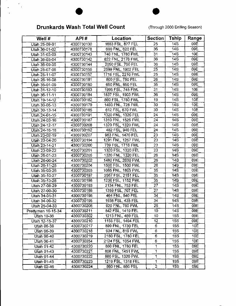
O ODrunkards Wash Total Well Count (Through 2000 Drilling Season)
Well # API # Location Section Tship RangeUtah 25-09-01 4300730130 1683 FSL, 877 FEL 25 14S 09EUtah 36-01-02 4300730178 600 FNL, 620 FEL 36 14S 09EUtah 31-03-03 4300730143 740 FNL, 1780 FWL 31 14S 10EUtah 36-03-04 4300730142 822 FNL, 2176 FWL 36 14S 09EUtah 36-09-05 4300730144 2050 FSL, 700 FEL 36 14S 09EUtah 25-07-06 4300730156 2599 FNL, 1902 FEL 25 14S 09EUtah 25-11-07 4300730157 1718 FSL, 2210 FWL 25 14S 09EUtah 26-16-08 4300730181 800 FSL, 750 FEL 26 14S 09EUtah 35-01-09 4300730180 650 FNL, 850 FEL 35 14S 09EUtah 31-12-10 4300730183 1995 FSL, 745 FWL 31 14S 10EUtah 36-11-11 4300730184 1837 FSL, 1903 FWL 36 14S 09EUtah 19-14-12 4300730182 860 FSL, 1780 FWL 19 14S 10EUtah 30-05-13 4300730179 1493 FNL, 728 FWL 30 14S 10EUtah 30-13-14 4300730185 612 FSL, 670 FWL 30 14S 10EUtah 24-01-15 4300730191 1320 FNL, 1320 FEL 24 14S 09EUtah 24-03-16 4300730187 1310 FNL, 1525 FWL 24 14S 09EUtah 24-12-17 4300730208 1320 FSL, 1320 FWL 24 14S 09EUtah 24-16-18 4300730192 482 FSL, 940 FEL 24 14S 09EUtah 23-02-19 4300730207 963 FNL, 1470 FEL 23 14S 09EUtah 23-04-20 4300730194 1291 FNL, 1257 FWL 23 14S 09EUtah 23-14-21 4300730200 739 FSL, 1716 FWL 23 14S 09EUtah 23-09-22 4300730201 1320 FSL, 1320 FEL 23 14S 09EUtah 26-01-23 4300730205 1320 FNL, 1320 FEL 26 14S 09EUtah 26-06-24 4300730202 1480 FNL, 2000 FWL 26 14S 09EUtah 26-11-25 4300730204 1500 FSL, 1500 FWL 26 14S 09EUtah 35-03-26 4300730203 1085 FNL, 1805 FWL 35 14S 09EUtah 35-10-27 4300730197 2567 FSL, 2151 FEL 35 14S 09EUtah 35-13-28 4300730198 1236 FSL, 1152 FWL 35 14S 09EUtah 27-08-29 4300730193 2134 FNL, 753 FEL 27 14S 09EUtah 27-09-30 4300730186 1359 FSL, 707 FEL 27 14S 09EUtah 34-01-31 4300730196 464 FNL, 540 FEL 34 14S 09EUtah 34-09-32 4300730195 1938 FSL, 435 FEL 34 14S 09EUtah 25-04-33 4300730206 920 FNL, 780 FWL 25 14S 09E
Prettyman 10-15-34 4300730211 842 FSL, 1419 FEL 10 14S 09EUtah 10-36 4300730302 1213 FNL, 469 FEL 10 15S 09E
Utah 12-15-37 4300730210 1158 FSL, 1494 FEL 12 15S 09EUtah 06-38 4300730217 899 FNL, 1730 FEL 6 15S 10EUtah 06-39 4300730218 934 FNL, 819 FWL 6 15S 10EUtah 06-40 4300730219 2180 FSL, 1780 FEL 6 15S 10EUtah 06-41 4300730254 2124 FSL, 1054 FWL 6 15S 10EUtah 01-42 4300730220 860 FNL, 1780 FEL 1 15S 09EUtah 01-43 4300730221 808 FNL, 1451 FWL 1 15S 09EUtah 01-44 4300730222 860 FSL, 1320 FWL 1 15S 09EUtah 01-45 4300730223 1219 FSL, 1318 FEL 1 15S 09EUtah 02-46 4300730224 860 FNL, 860 FEL 2 15S
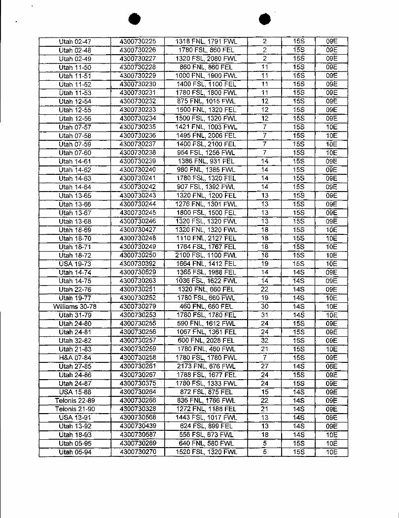
Utah02-47 4300730225 1318FNL,1791 FVVL 2 15S 09EUtah 02-48 4300730226 1780 FSL,860FEL 2 15S 09EUtah 02-49 4300730227 1320FSL,2080 FVVL 2 15S 09ELitah 11-50 4300730228 860FNL,860FEL 11 15S 09EUtah 11-51 4300730229 1000 FNL,1900 FVVL 11 15S 09EUtah 11-52 4300730230 1400 FSL,1100 FEL 11 15S 09EUtah 11-53 4300730231 1780FSL,1800 FVVL 11 15S 09EUtah 12-54 4300730232 875FNL,1015FVVL 12 15S 09EUtah 12-55 4300730233 1500FNL,1320 FEL 12 15S 09EUtah 12-56 4300730234 1500FSL,1320 FVVL 12 15S 09EUtah07-57 4300730235 1421 FNL,1003 FVVL 7 15S 10EUtah 07-58 4300730236 1495FNL,2006 FEL 7 15S 10EJtah07-59 4300730237 1400 FSL,2100 FEL 7 156: 10EJtah07-60 4300730238 954 FSL,1256 FVVL 7 15S 10EUtah 14-61 4300730239 1386FNL,931 FEL 14 15S 09EJtah 14-62 4300730240 980 FNL,1385 FVVL 14 15S 09EUtah 14-63 4300730241 1780 FSL,1320FEL 14 15S 09EUtah 14-64 4300730242 907 FSL,1392 FVVL 14 15S 09EJtah 13-65 4300730243 1320FNL,1200 FEL 13 156; 09EUtah 13-66 4300730244 1276FNL,1301 FVVL 13 15S 09EUtah 13-67 4300730245 1800 FSL,1500 FEL 13 15S 09EUtah 13-68 4300730246 1320 FSL,1320 FVVL 13 15S 09EJtah 18-69 4300730427 1320FNL,1320 FVVL 18 15S 10EJtah 18-70 4300730248 1110FNL,2127 FEL 18 15S 10EUtah 18-71 4300730249 1764FSL,1767 FEL 18 156; 10EUtah 18-72 4300730250 2100 FSL,1100 FVVL 18 15S: 10EUS:A19-73 4300730392 1664FNL,1412 FEL 19 15S 10EUtah 14-74 4300730529 1365FSL,1988 FEL 14 14S 09EUtah 14-75 4300730263 1036FSL,1622 FVVL 14 14S 09EUtlah22-76 4300730251 1320 FNL,660 FEL 22 146; 09EUtah 19-T7 4300730252 1780 FSL,660FVVL 19 14S 10E
VVillianys30-78 4300730279 460 FNL,660FEL 30 14S 10ELitah 31-79 4300730253 1780 FSL,1780 FEL 31 14S 10EUtah24-80 4300730255 590FNL,1612 FVVL 24 15S 09ELitah24-81 4300730256 1067FNL,1361 FEL 24 15S 09EUtah 32-82 4300730257 600FNL,2028 FEL 32 15S 09EUtah21-83 4300730259 1780FNL,460 FVVL 21 15S 10EH.&A07-84 4300730258 1780 FSL,1780 FVVL 7 15S 09EUtah27-85 4300730261 2173 FNL,676 FVVL 27 14S 08EUtah24-86 4300730267 1788FSL,1677 FEL 24 15S 09EJtah24-87 4300730375 1780FSL,1333FVVL 24 15S 09EUSA15-88 4300730264 872 FSL,875 FEL 15 14S 09E
Telonis22-89 4300730266 836FNL,1766FVVL 22 14S 09ETelonis21-90 4300730328 1272FNL,1188FEL 21 14S 09E
USA13-91 4300730568 1443 FSL,1017 FVVL 13 146; 09EJtah 13-92 4300730439 624 FSL,899 FEL 13 14S 09EUtah 18-93 4300730587 556FSL,673FVVL 18 14S 10EUtah05-95 4300730269 640FNL,580 FVVL 5 156: 10EUtah 05-94 4300730270 1520FSL,1320 FVVL 5 15S
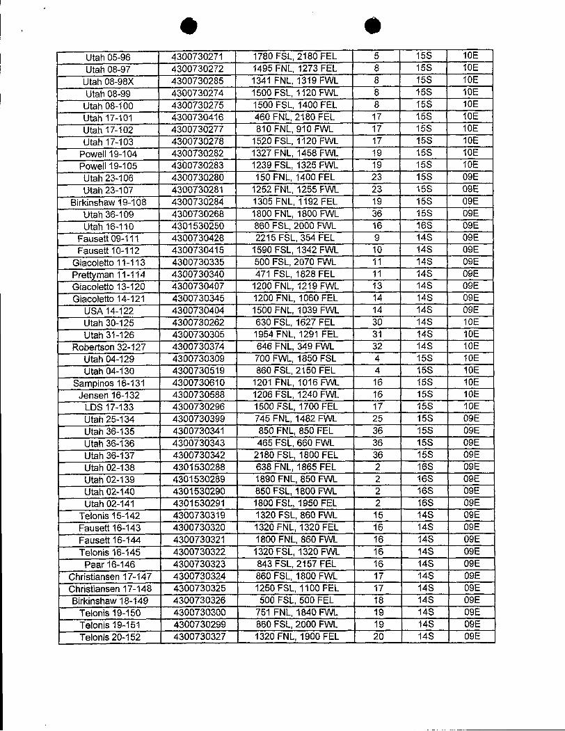
O OUtah05-96 4300730271 1780FSL,2180FEL 5 15S 10EUtah08-97 4300730272 1495 FNL,1273 FEL 8 15S 10EJtah08-98X 4300730285 1341 FNL,1319 FVVL 8 15S 10EUtah08-99 4300730274 1500FSL,1120 FVVL 8 15S 10E
Utah08-100 4300730275 1500 FSL,1400FEL 8 158: 10EUtah 17-101 4300730416 460FNL,2180FEL 17 15S 10ELitah 17-102 4300730277 810 FNL,910 FVVL 17 15S 10EUtah 17-103 4300730278 1520FSL,1120 FVVL 17 15S 10E
Powell19-104 4300730282 1327FNL,1458FVVL 19 15S 10EPowell19-105 4300730283 1239 FSL,1325FVVL 19 15S 10EUtah23-106 4300730280 150FNL,1400 FEL 23 15S 09EUtah23-107 4300730281 1252Fbu.,1255FVVL 23 15S 09E
Birkinshaw19-108 4300730284 1305 FNL,1192FEL 19 15S 09EUtah36-109 4300730268 1800 FNL,1800FVVL 36 15S 09EUtah 16-110 4301530250 860FSL,2000 FVVL 16 16S 09E
Fauseu09-111 4300730428 2215FSL,354FEL 9 14S 09EFaused10-112 4300730415 1590 FSL,1342FVVL 10 14S 09E
Giacxaleto 11-113 4300730335 500FSL,2070 FVVL 11 14S 09EPretynyan 11-114 4300730340 471 FSL,1828 FEL 11 14S 09EGliacoleño 13-120 4300730407 1200 FNL,1219 FVVL 13 14S 09EGiacoleño 14-121 4300730345 1200FNL,1060FEL 14 14S 09E
LISA14-122 4300730404 1500FNL,1039 FVVL 14 14S 09ELitah30-125 4300730262 630FSL,1627 FEL 30 14S 10EUtah31-126 4300730305 1954FNL,1291 FEL 31 14S 10E
Robenson32-127 4300730374 646 FNL,349FVVL 32 14S 10ELitah04-129 4300730309 700 FVVL,1850FSL 4 15S 10ELitah04-130 4300730519 860FSL,2150 FEL 4 15S 10E
Sampinos16-131 4300730610 1201 FNL,1016FVVL 16 15S 10EJensen 16-132 4300730588 1206 FSL,1240 FVVL 16 15S 10E
LDS 17-133 4300730296 1500FSL,1700FEL 17 15S 10ELitah25-134 4300730399 745 FNL,1482 FVVL 25 15S 09ELitah 36-135 4300730341 850FNL,850 FEL 36 15S 09EUtah36-136 4300730343 465 FSL,660 FVVL 36 158; 09ELitah36-137 4300730342 2180FSL,1800FEL 36 15S 09ELitah02-138 4301530288 638 FNL,1865FEL 2 16S 09EUtah02-139 4301530289 1890 FNL,850FVVL 2 16S 09EUtah02-140 4301530290 850FSL,1800 FVVL 2 16S 09ELitah02-141 4301530291 1800FSL,1950 FEL 2 16S 09E
Telonis15-142 4300730319 1320FSL,860 FVVL 15 14S 09EFauseû16-143 4300730320 1320FNL,1320 FEL 16 14S 09EFauseu16-144 4300730321 1800 FNL,860FVVL 16 14S 09ETelonis16-145 4300730322 1320FSL,1320FVVL 16 14S 09E
Paar16-146 4300730323 843FSL,2157 FEL 16 14S 09EChristiansen 17-147 4300730324 860FSL,1800 FVVL 17 14S 09EChristiansen 17-148 4300730325 1250FSL,1100FEL 17 14S 09EBirkinshawi8-149 4300730326 500 FSL,500 FEL 18 14S 09E
Te\onis19-150 4300730300 751 FNL,1840FVVL 19 14S 09ETelonis 19-151 4300730299 860FSL,2000FVVL 19 14S 09ETelonis20-152 4300730327 1320FNL,1900FEL 20 14S

73elonis21-153 4300730329 860 FNL,1800 FVVL 21 14S 09ETelonis29-154 4300730330 800FNL,1500 FVVL 29 14S 09E13alonis29-155 4300730331 1800FSL,1250FVVL 29 14S 09ETelonis30-156 4300730301 910 FNL,868 FEL 30 14S 09ETelonis 30-157 4300730332 1800 FSL, 580 FEL 30 14S 09E
Utah32-158 4300730333 1038FNL,1768 FEL 32 14S 09EUtah32-159 4300730334 2011 FNL,1426 FVVL 32 14S 09EUtah32-160 4300730398 1500FSL,1780FVVL 32 14S 09EUtah32-161 4300730336 415FSL,1408 FEL 32 14S 09EUtah36-162 4300730315 2053 FNL,685 FEL 36 14S 08EUtah36-163 4300730316 860FNL,2100FVVL 36 14S 08EUtah 36-164 4300730317 1070FSL,2000FVVL 36 14S 08EUtah36-165 4300730318 1100FSL,1500 FEL 36 14S 08EUtah02-166 4300730337 1219FNL,1738FEL 2 15S 08EUtah02-167 4300730338 660FNL,2075FVVL 2 15S 08EUtah02-168 4300730339 1800 FSL,2100 FVVL 2 15S 08EUtah 02-169 4300730308 754 FSL,1000 FEL 2 15S 08E
Seanions32-170 4300730291 700FNL,500FVVL 32 13S 09EPinnacle Peak 19-171 4300730117 1320FSL,1320 FEL 19 14S 09E
Telonis20-172 4300730107 1980FSL,660 FEL 20 14S 09EPowell30-173 4300730346 1200FNL,1200FVVL 30 15S. 10E
Stella-Hamaker 10-174 4300730116 852 FNL, 1971 FWL 10 15S 08ELitah 31-175 4301530317 897 FNL,1731 FVVL 31 16S 09EUSA15-176 4300730450 2588FNL,1155FEL 15 14S 09EUSA09-178 4300730419 428 FSL,2527FVVL 9 14S 09E
LR3A17-180A 4300730622 2563FNL,1383 FVVL 17 14S 09ELNBA18-182 4300730417 1068FSL,1972 FVVL 18 14S 09EUSA24-183 4300730469 828FNL,624 FEL 24 14S 08EUtah27-187 4300730395 1400FNL,1400 FVVL 27 146. 09EUtah27-188 4300730292 477FSL,518 FVVL 27 14S 09EUtah28-189 4300730396 1707FNL,868FEL 28 14S 09EUtah28-190 4300730397 1969FNL,1324FVVL 28 14S 09EUtah28-191 4300730293 693FSL,1623 FVVL 28 14S 09EUtah28-192 4300730294 1407 FNL,1940FVVL 28 14S 09EUtah29-193 4300730405 693 FNL,1029FEL 29 14S 09EUtah29-194 4300730427 951 FSL,370FEL 29 14S 09EUtah 30-195 4300730265 1407 FNL,1940 FVVL 30 14S 09EUtah 30-196 4300730344 1056FSL,1984FVVL 30 14S 09E
Kakatsidas31-197 4300730420 619 FNL,1361 FEL 31 14S 09EUtah31-198 4300730406 1403FNL,1540FVVL 31 14S 09EUtah 31-199 4300730480 1125 FSL,928 FVVL 31 14S 09EUtah31-200 4300730385 2118FSL,549FEL 31 14S 09EUtah33-201 4300730386 317FNL,1815FEL 33 14S 09EUtah 33-202 4300730387 1939FNL,1593 FVVL 33 14S 09EUtah33-203 4300730388 1373FSL,1140FVVL 33 14S 09ELitah 33-204 4300730389 2024FSL,1525 FEL 33 14S 09EUtah 05-205 4300730384 1485FNL,760 FEL 5 15S 09EUtah05-206 4300730390 1300FNL,1352FVVL 5 15S 09EUtah06-;207 4300730391 825FNL,928 FEL 6 15S
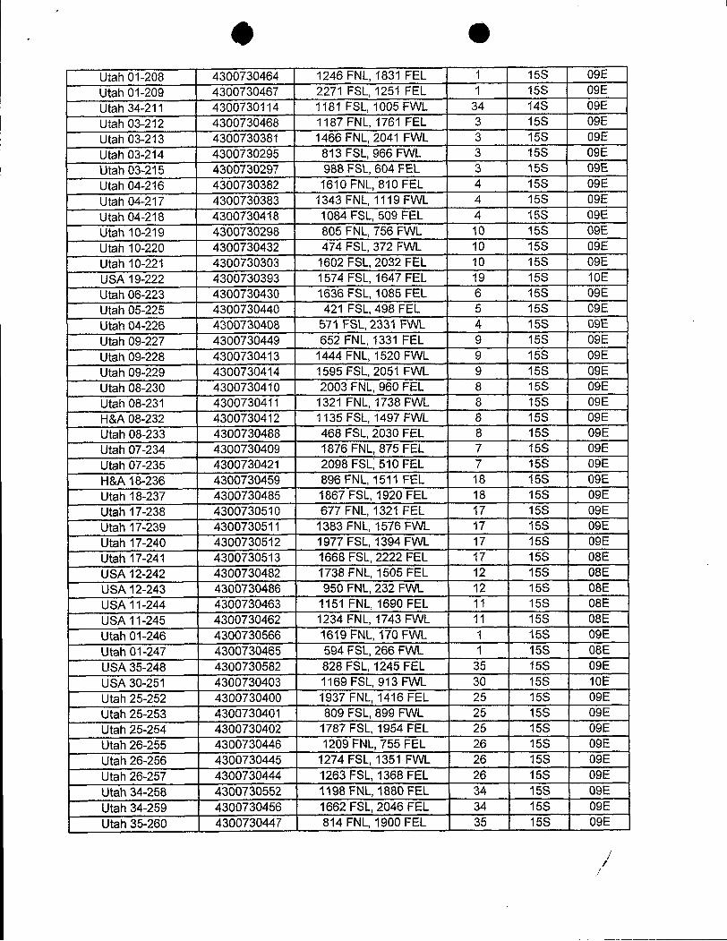
Utah01-208 4300730464 1246 FNL,1831 FEL 1 15S 09EUtah01-209 4300730467 2271 FSL,1251 FEL 1 15S: 09EUtah 34-211 4300730114 1181 FSL,1005 FVVL 34 14S 09EUtah Cl3-212 4300730468 1187 FNL,1761 FEL 3 15S 09EUtah 03-213 4300730381 1466 FNL,2041 FVVL 3 15S 09ELitah03-214 4300730295 813 FSL,966 FVVL 3 15S 09EUtah03-215 4300730297 988FSL,604FEL 3 15S 09EUtah Cl4-216 4300730382 1610FNL,810 FEL 4 15S 09EUtah 04-217 4300730383 1343 FNL,1119 FVVL 4 15S 09EUtah04-218 4300730418 1084 FSL,509FEL 4 15S 09EUtah 10-219 4300730298 805 FNL,756 FVVL 10 15S 09EUtah 10-220 4300730432 474FSL,372 FVVL 10 15S 09EUtah 10-221 4300730303 1602 FSL,2032 FEL 10 15S 09EUS;A19-222 4300730393 1574 FSL,1647 FEL 19 15S 10ELitah06-223 4300730430 1636FSL,1085 FEL 6 15S 09EUtah05-225 4300730440 421 FSL,498 FEL 5 15S 09EUtah04-226 4300730408 571 FSL,2331 FVVL 4 15S 09EUtah09-227 4300730449 652FNL,1331 FEL 9 15S 09EUtah09-228 4300730413 1444 FNL,1520FVVL 9 15S 09EUtah09-229 4300730414 1595FSL,2051 FVVL 9 15S 09EJtah08-230 4300730410 2003FNL,960 FEL 8 15S 09EUtah 08-231 4300730411 1321 FNL,1738 FVVL 8 15S 09EH&A08-232 4300730412 1135 FSL, 1497 FWL 8 15S 09EUtah08-233 4300730488 468FSL,2030FEL 8 15S 09EUtah07-234 4300730409 1876FNL,875FEL 7 15S 09ELitah07-235 4300730421 2098FSL,510FEL 7 15S 09EH8JA18.-236 4300730459 896 FNL,1511 FEL 18 15S 09EUtah 18-237 4300730485 1867 FSL,1920FEL 18 15S 09EUtah 17-238 4300730510 677 FNL,1321 FEL 17 15S 09EUtah 17-239 4300730511 1383 FNL,1576FVVL 17 15S 09EUtah 17-240 4300730512 1977 FSL,1394 FVVL 17 15S 09EUtah 17-241 4300730513 1668 FSL,2222FEL 17 15S 08EUEL412-242 4300730482 1738 FNL,1505 FEL 12 156; 08EDELA12-243 4300730486 950FNL,232FVVL 12 15S 08EUS:A11-244 4300730463 1151 FNL,1690FEL 11 15S 08EUELA11-245 4300730462 1234 FNL,1743 FVVL 11 15S 08EUtah01-246 4300730566 1619FNL,170 FVVL 1 15S 09EJtah01-247 4300730465 594FSL,266FVVL 1 15S 08EUSA35-248 4300730582 828 FSL,1245 FEL 35 15S 09EUSA 30-251 4300730403 1169 FSL, 913 FWL 30 15S 10EUtah 25-252 4300730400 1937 FNL,1416 FEL 25 15S 09EUtah 25-253 4300730401 809 FSL,899 FVVL 25 15S 09EUtah25-254 4300730402 1787FSL,1954FEL 25 15S 09EUtah26-255 4300730446 1209FNL,755FEL 26 15S 09EJtah26;-256 4300730445 1274FSL,1351 FVVL 26 15S 09EUtah26-257 4300730444 1263 FSL,1368 FEL 26 15S 09EUtah34-258 4300730552 1198FNL,1880FEL 34 15S 09EUtah 34-259 4300730456 1662 FSL,2046FEL 34 15S 09EUtah35-260 4300730447 814 FNL,1900FEL 35 15S
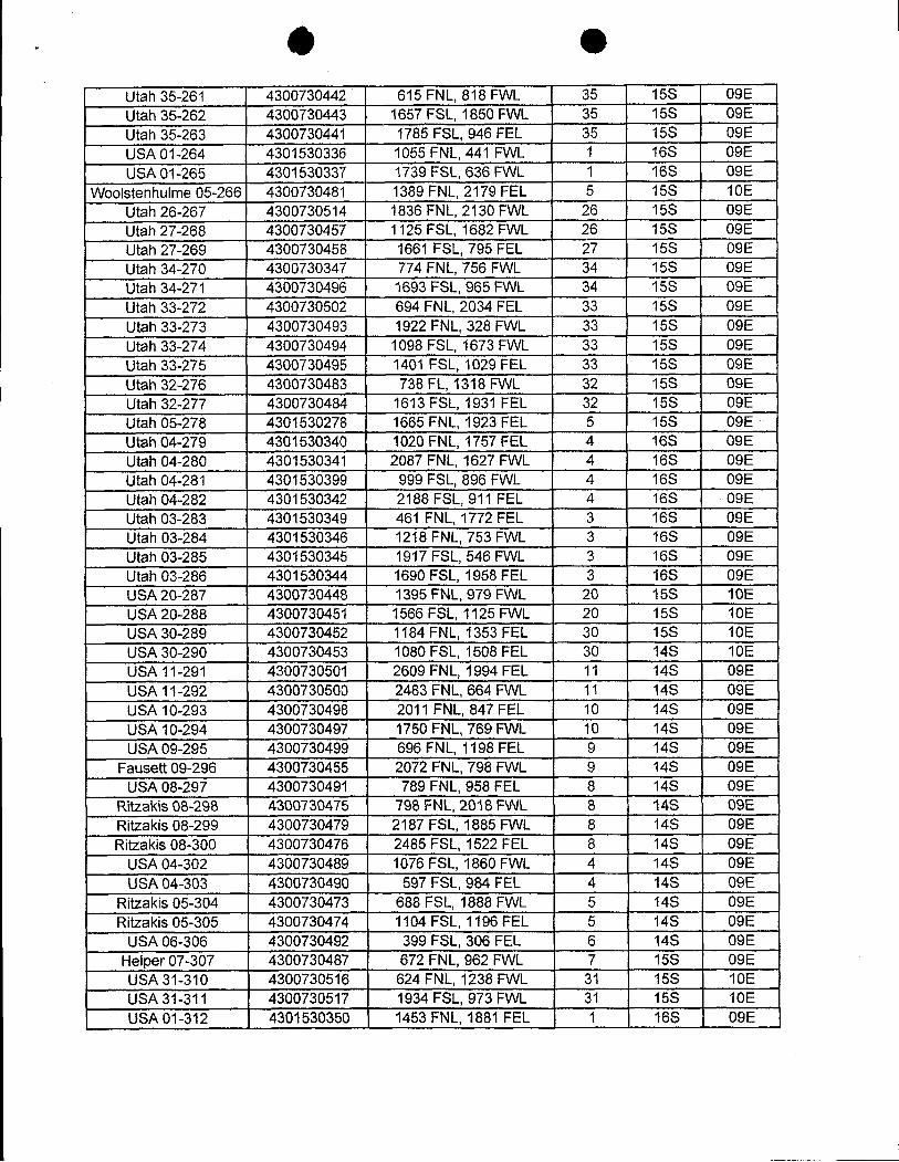
Utah 35-261 4300730442 615 FNL,818 FVVL 35 15S 09EUtah35-:262 4300730443 1657FSL,1850FVVL 35 15S 09EUtah 35-263 4300730441 1785 FSL,946FEL 35 15S 09EUSA01-264 4301530336 1055 FNL,441 FVVL 1 16S 09EUSA01-265 4301530337 1739FSL,636FVVL 1 16S 09E
Woolstenhulme 05-266 4300730481 1389 FNL, 2179 FEL 5 15S 10EUtah26-267 4300730514 1836FNL,2130FVVL 26 15S 09EUtah 27-268 4300730457 1125FSL,1682 FVVL 26 15S 09EUtah27-269 4300730458 1661 FSL,795 FEL 27 15S 09EUtah34-270 4300730347 774 FNL,756 FVVL 34 15S 09EUtah34-271 4300730496 1693FSL,965FVVL 34 15S 09EUtah 33-272 4300730502 694 FNL,2034 FEL 33 15S 09EUtah33-273 4300730493 1922 FNL,328FVVL 33 15S 09EUtah 33-274 4300730494 1098FSL,1673FVVL 33 15S 09EUtah 33-275 4300730495 1401 FSL,1029FEL 33 15S 09EUtah32-276 4300730483 738FL,1318FVVL 32 15S 09EUtah 32-277 4300730484 1613FSL,1931 FEL 32 15S 09EUtah05-278 4301530278 1665FNL,1923FEL 5 15S 09EUtah04-279 4301530340 1020FNL,1757FEL 4 16S 09EUtah04-280 4301530341 2087FNL,1627FVVL 4 16S 09EUtah 04-281 4301530399 999 FSL,896 FVVL 4 16S 09EUtah04-282 4301530342 2188FSL,911 FEL 4 16S 09EUtah03-283 4301530349 461 FNL,1772FEL 3 16S 09EUtah 03-284 4301530346 1218 FNL,753 FVVL 3 16S 09EUtah 03-285 4301530345 1917FSL,546FVVL 3 16S 09EUtah03-286 4301530344 1690FSL,1958FEL 3 16S 09EUSA20-287 4300730448 1395FNL,979FVVL 20 15S 10EUSA 20-288 4300730451 1566 FSL, 1125 FWL 20 15S 10EUSA30-289 4300730452 1184FNL,1353FEL 30 15S 10EUSA30-290 4300730453 1080FSL,1508FEL 30 14S. 10EUSA11-291 4300730501 2609FNL,1994FEL 11 14S 09EUSA11-292 4300730500 2483FNL,664FVVL 11 14S 09EUSA10-293 4300730498 2011FNL,847FEL 10 14S 09EUSA10-294 4300730497 1750FNL,769FVVL 10 14S 09EUSUA09-295 4300730499 696 FNL,1198FEL 9 14S 09E
Fauseñ09-296 4300730455 2072FNL,798FVVL 9 14S 09EUSut08.-297 4300730491 789 FNL,958FEL 8 14S 09E
Ritzakis08-298 4300730475 798FFR.,2016FVVL 8 14S 09ERitzakis08-299 4300730479 2187FSL,1885FVVL 8 14S 09ERitzakis08-300 4300730476 2485FSL,1522 FEL 8 14S 09E
USA04-302 4300730489 1076 FSL,1860 FVVL 4 14S 09EUSA04-303 4300730490 597 FSL,984FEL 4 14S 09E
Ritzakis 05-304 4300730473 688 FSL, 1888 FWL 5 14S 09ERitzakis05-305 4300730474 1104 FSL,1196FEL 5 14S 09E
USA06-306 4300730492 399FSL,306FEL 6 14S 09EFkalper07-307 4300730487 672 FNL,962 FVVL 7 15S: 09EUSA31-310 4300730516 624FNL,1238FVVL 31 15S 10EUS:A31-311 4300730517 1934FSL,973FVVL 31 15S 10EUSIA01-312 4301530350 1453FNL,1881FEL 1 16S
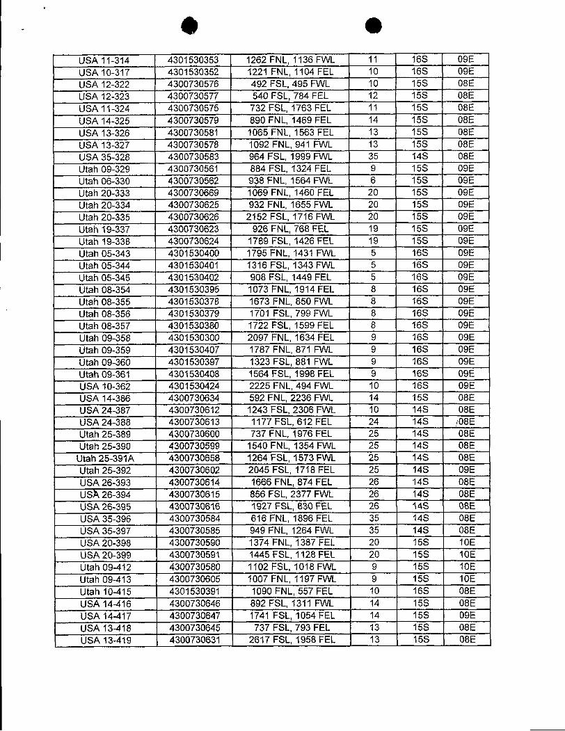
US411-314 4301530353 1262FNL,1136FVVL 11 16S 09EUSAs10-317 4301530352 1221 FNL,1104 FEL 10 16S 09ELULA12-322 4300730576 492 FSL,495 FVVL 10 15S 08EUELA12-323 4300730577 540 FSL,784 FEL 12 15S 08EUSJt11-324 4300730575 732FSL,1763FEL 11 15S 08EUSir14-325 4300730579 890 FNL,1469FEL 14 15S 08EUSJt13-326 4300730581 1065FNL,1563FEL 13 15S 08EUEL413-327 4300730578 1092 FNL,941 FVVL 13 15S 08EUELA35-328 4300730583 964 FSL,1999FVVL 35 14S 08EUtah 09-329 4300730561 884 FSL,1324FEL 9 15S 09EUtah 06-330 4300730562 938FNL,1564FVVL 6 15S 09EUtah 20-333 4300730669 1069FNL,1460FEL 20 15S 09EUtah20-334 4300730625 932 FNL,1655FVVL 20 15S 09EUtah 20-335 4300730626 2152 FSL,1716FVVL 20 15S 09EUtah 19-337 4300730623 926FNL,768FEL 19 15S 09EUtah 19-338 4300730624 1789FSL,1426FEL 19 15S 09EUtah 05-343 4301530400 1795FNL,1431 FVVL 5 16S 09EUtah 05-344 4301530401 1316 FSL,1343FVVL 5 16S 09EUtah 05-345 4301530402 908 FSL,1449 FEL 5 16S 09EUtah08-354 4301530395 1073FNL,1914FEL 8 16S 09ELitah 08-355 4301530378 1673 FNL,850FVVL 8 16S 09EUtah CRI-356 4301530379 1701 FSL,799FVVL 8 16S 09EUtah CMi-357 4301530380 1722FSL,1599FEL 8 16S 09EUtah (51-358 4301530300 2097 FNL,1634 FEL 9 16S 09EUtah 09-359 4301530407 1787 FNL,871 FVVL 9 16S 09EUtah 09-360 4301530397 1323 FSL,881 FVVL 9 16S 09EUtah09-361 4301530408 1564FSL,1998FEL 9 16S 09EUSA 10-362 4301530424 2225 FNL, 494 FWL 10 16S 09EUSA 14-386 4300730634 592 FNL, 2236 FWL 14 15S 08EUELA24-387 4300730612 1243FSL,2306FVVL 10 14S 08EUSA24-388 4300730613 1177 FSL,612 FEL 24 14S TO8EUtah25-389 4300730600 737 FNL,1976FEL 25 14S 08EUtah2.5-390 4300730599 1540FNL,1354FVVL 25 14S 08E
Utah25-391A 4300730658 1264 FSL,1573FVVL 25 14S 08EUtah25-392 4300730602 2045FSL,1718FEL 25 14S 09EUSA26-393 4300730614 1666 FNL,874 FEL 26 14S 08EUSA26-394 4300730615 856 FSL,2377 FVVL 26 14S 08EUSA26-395 4300730616 1927 FSL,830FEL 26 14S 08EUEL435-396 4300730584 616 FT4L,1896 FEL 35 14S 08EUSA35-397 4300730585 949 FNL,1264FVVL 35 14S 08EUSDA20-398 4300730590 1374FNL,1387FEL 20 15S 10EUEhk20-399 4300730591 1445FSL,1128FEL 20 15S 10EUtah 09-412 4300730580 1102 FSL,1018 FVVL 9 15S 10EUtah CI9-413 4300730605 1007FNL,1197FVVL 9 15S 10ELitah 10-415 4301530391 1090FNL,557 FEL 10 16S 08EUELA14-416 4300730646 892 FSL,1311 FVVL 14 15S 08EUS.A14-417 4300730647 1741 FSL,1054FEL 14 15S 09EUSA13-418 4300730645 737FSL,793FEL 13 15S 08EUELA13-419 4300730631 2617FSL,1958FEL 13 15S
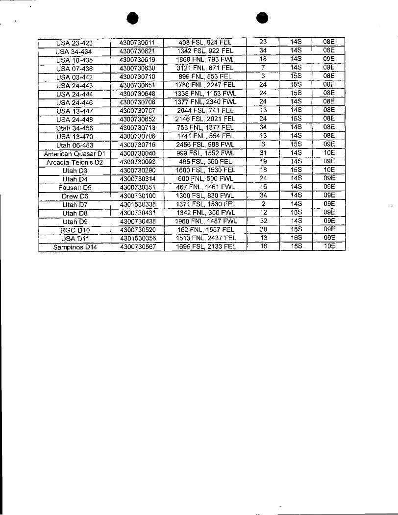
US/423-423 4300730611 408FSL,924FEL 23 14S 08EUSJr34-434 4300730621 1342FSL,922 FEL 34 14S 08EUELA18-435 4300730619 1868 FNL,793 FVVL 18 14S: 09EUSA07-436 4300730630 3121 FNL,871 FEL 7 14S 09EU6L403-442 4300730710 899FNL,553 FEL 3 158· 08EUSA24-443 4300730651 1780FNL,2247FEL 24 15S 08EUSA24-444 4300730648 1338FNL,1153FVVL 24 15S 08EU6L424-446 4300730708 1377 FNL,2340 FVVL 24 148 08EUSJt13-447 4300730707 2044FSL,741 FEL 13 14S 08EU.SA24-448 4300730652 2146 FSL,2021 FEL 24 156 08EUtah34-456 4300730713 755FNL,1377FEL 34 14S 08EUS;A 13-470 4300730706 1741 FNL,554FEL 13 14S 08EUtah 06-483 4300730716 2456 FSL,988 FVVL 6 15S 09E
American QuasarD1 4300730040 999 FSL,1552 FVVL 31 14S 10EArcadia-TelonisD2 4300730093 465FSL,560 FEL 19 14S 09E
Utah D3 4300730290 1600 FSL,1530 FEL 18 15S 10EUtahD4 4300730314 600FNL,500FVVL 24 14S 09E
FauseñD5 4300730351 467FNL,1461 FVVL 16 14S 09EDrewD6 4300730100 1300FSL,830FVVL 34 14S 09EUtah D7 4301530338 1371 FSL,1530FEL 2 14S 09EUtah D8 4300730431 1342FNL,350FVVL 12 15S 09ELitah D9 4300730438 1960FNL,1487FVVL 32 14S 09E
RGCD10 4300730520 162FNL,1557FEL 28 15S 09EUELAD11 4301530356 1513FNL,2437 FEL 13 16S 09E
Sany3inosD14 4300730567 1695FSL,2133FEL 16 15S
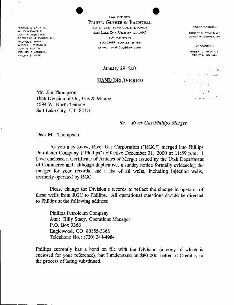
O OLAW OFFICES
PRUTTT, GUSHEE ßf ßACHTELLTHOMAS W BACHTELL SUITE isso BENEFICIAL LIFE TOWER SENIOR COUNSEL:
A JOHN DAVIS, lilSALT LAKE CITY, UTAH 84111-1495 ROBERT G PRUITT, JR
JOHN W ANDERSONFREDERICK M MACDONALD (801) 531-8446 OLIVER W GUSHEE, JR
GEORGE S YOUNG TELECOPIER (SOO 531-8468ANGELA L FRANKLIN OF COUNSEL:JOHN S FLITTON E-MAIL: mail@pgblaw com
MICHAEL S JOHNSON ROBERT G PRUITT, Ill
WILLIAM E WARD BRENT A BOHMAN
January 29, 2001
HAND DELIVERED
Mr. Jim ThompsonUtah Division of Oil, Gas & Mining1594 W. North TempleSalt Lake City, UT 84116
Re: River Gas/Phillips Merger
Dear Mr. Thompson:
As you may know, River Gas Corporation ("RGC") merged into PhillipsPetroleum Company ("Phillips") effective December 31, 2000 at 11:59 p.m. Ihave enclosed a Certificate of Articles of Merger issued by the Utah Departmentof Commerce and, although duplicative, a sundry notice formally evidencing themerger for your records, and a list of all wells, including injection wells,formerly operated by RGC.
Please change the Division's records to reflect the change in operator ofthese wells from RGC to Phillips. All operational questions should be directedto Phillips at the following address:
Phillips Petroleum CompanyAttn: Billy Stacy, Operations ManagerP.O. Box 3368Englewood, CO 80155-3368Telephone No.: (720) 344-4984
Phillips currently has a bond on file with the Division (a copy of which isenclosed for your reference), but I understand an $80,000Letter of Credit is inthe process of being
Mr. Jim ThompsonJanuary 29, 2001Page 2
On behalf of Phillips, I thank you for your cooperation. Should you haveany further questions or concerns, please do not hesitate to contact me.
Y y truly,
Frederick M. MacDonaldFMM:cs2078.16Enclosurescc: W. H. Rainbolt
Billy
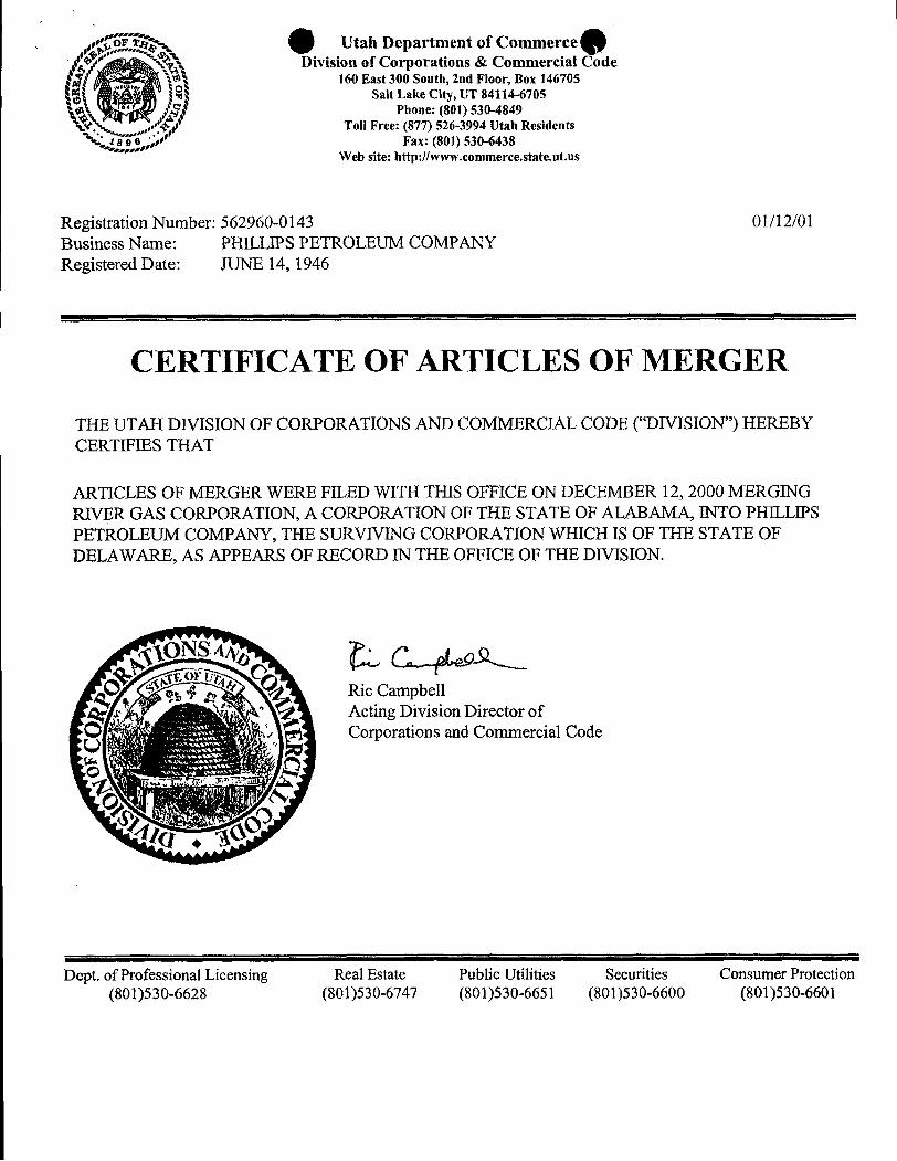
Utah Department of CommerceDivision of Corporations & Commercial Code
160 East 300 South, 2nd Floor, Box 146705Salt Lake City, UT 84114-6705
Phone: (801) 530-4849-.
, Toll Free: (871) 526-3994 Utah Residentssee Fax: (801) 530-6438
Web site: http:llwww.commerce.state.ut.us
Registration Number: 562960-0143 01/12/01Business Name: PHILLIPS PETROLEUM COMPANYRegistered Date: JUNE 14, 1946
CERTIFICATE OF ARTICLES OF MERGER
THE UTAH DIVISION OF CORPORATIONS AND COMMERCIAL CODE ("DIVISION") HEREBYCERTIFIES THAT
ARTICLES OF MERGER WERE FILED WITH THIS OFFICE ON DECEMBER 12, 2000 MERGINGRIVER GAS CORPORATION, A CORPORATION OF THE STATE OF ALABAMA, INTO PHILLIPSPETROLEUM COMPANY, THE SURVIVING CORPORATION WHICH IS OF THE STATE OFDELAWARE, AS APPEARS OF RECORD IN THE OFFICE OF THE DIVISION.
L & Ric CampbellActing Division Director ofCorporations and Commercial Code
Dept. of Professional Licensing Real Estate Public Utilities Securities Consumer Protection(801)530-6628 (801)530-6747 (801)530-6651 (801)530-6600
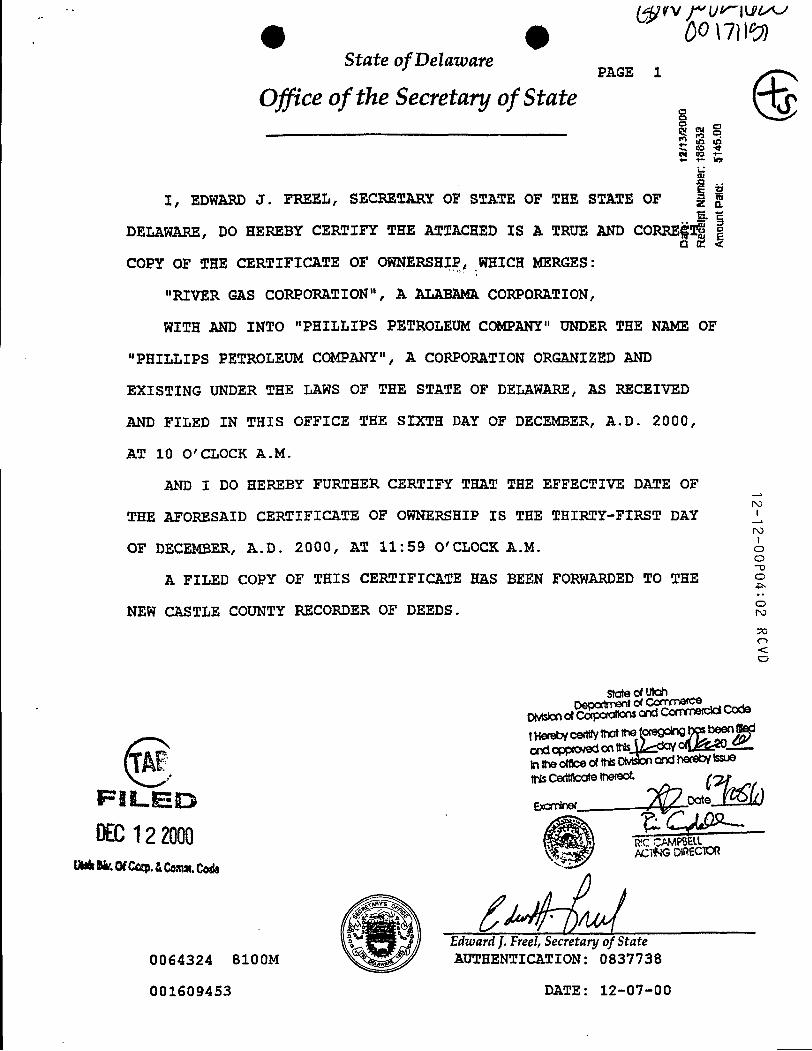
State of DelatoarePAGE 1
Office of the Secretary of State
I, EDWARD J. FREEL, SECRETARY OF STATE OF TEE STATE OF
DELAWARE, DO HEREBY CERTIFY THE ATTACHED IS A TRUE AND CORRE
COPY OF THE CERTIFICATE OF OWNERSHIP, WHICH MERGES:
"RIVER GAS CORPORATION", A ALABAMACORPORATION,
WITH AND INTO "PHILLIPS PETROLEUM COMPANY" UNDER THE NAME OF
"PHILLIPS PETROLEUM COMPANY", A CORPORATION ORGANIZED AND
EXISTING UNDER THE LAWS OF TEE STATE OF DELAWARE, AS RECEIVED
AND FILED IN THIS OFFICE THE SIXTH DAY OF DECEMBER, A.D. 2000,
AT 10 O' CLOCK A.M.
AND I DO HEREBY FURTEER CERTIFY THAT THE EFFECTIVE DATE OF
THE AFORESAID CERTIFICATE OF OWNERSHIP IS THE THIRTY-FIRST DAY iOF DECEMBER, A.D. 2000, AT 11:59 O'CLOCK A.M. o
o
A FILED COPY OF THIS CERTIFICATE HAS BEEN FORWARDED TO THE
NEW CASTLE COUNTY RECORDER OF DEEDS.
State d Uloh
UhkNr.0fCap. AComm.Code
Edward J.Freel, Secretary of State0064324 8100M AUTHENTICATION: 0837738
001609453 DATE:
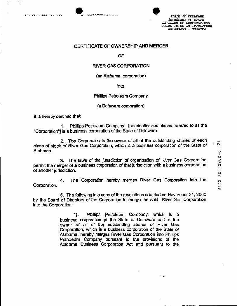
O Oszcarraar or srara
DIVISION OF CORPORATIONSFILZD 10: 00 AM 12/06/2000
001509453 - 0064324
CERTIFICATEOF OWNERSHIPAND MERGER
OF
RIVERGAS CORPORATION
(an Alabama corporation)
into
PhillipsPetroleum Company
(a Delaware corporation)
It is hereby certified that:
1. Phillips Petroleum Company [heminafter sometimes referredto as the"Corporation"] is a business corporationof theState of Delaware.
2. The Corporation is the owner of all of the outstanding shares of each -
class of stock of River Gas Corporation, which is a business corporationof the State ofAlabama.
3. The laws of the Jurisdictionof organizationof River Gas Corporation o
permit the merger of a business corporationofthat jurisdictionwith a business corporation o
of another jurisdiction. --
4. The Corporation hereby merges River Gas Corporation into theCorporation.
5. The following is a copyof the resolutionsadoptedon November 21, 2000by the Boarti of Directors of the Corporation to merge the said River Gas Corporationinto the Corporation:
"1. Phillips Petroleum Company, which is abusiness corporation of the State of Delaware and is theowner of all of the outstanding shares of River GasCorporation, which is a business corporation of the State ofAlabama, hereby merges River Gas Corporation into PhillipsPetroleum Company pursuant to the provisions of theAlabama Business Corporation Act and pursuant to
provisions of Section 253 of the General Corporation Law ofDelaware.
"2. The separate existence of River Gas Corporation shallcease at the effectivetime and date of the merger pursuant tothe provisions of the Alabama Business Corporation Act; andPhillips Petroleum Company shallcontinueits existence as thesurvivingcorporationpursuant tothe provisions of Section 253of the General Corporation Law of Delaware.
"3. The Articles of incorporation of Phillips PetroleumCompany are not amended In any respect by this Plan ofMerger.
"4. The issued shares of River Gas Corporation shall notbe converted or exchanged in any manner, but each saidshare which is issued immediately prior to the effectivetimeand date of the mergershall be surrenderedand extinguished.
"5. Each share of Phillips Petroleum Company outstandingimmediately prior to the effective timeand date of the mergeris to be an identical outstanding share of Phillips PetroleumCompany at the effectivetimeand date of the merger.
"6. No shares of Phillips Petroleum Company and noshares, securities, or obligationsconvertibleinto such sharesare to be issued or deliveredunder thisPlan of Merger.
"7. The Board of Directors and the proper officers ofPhillips Petroleum Company are hereby authorized,empowered, and directed to do any and all acts and things,and to make, execute, deliver, file, and/or record any and allInstruments, papers, and documents whichshall be or becomenecessary, proper, or convenlentto carryout or put into effectany of the provisions of thisPlan of Merger or of the mergerherein provided for. "
" This Company approves that the effectivetime and date ofthe merger herein provided for in the State of Alabama shallbe 11:59 p.m. on December 31, 2000."
"Any Vice President, the Treasurer, any Assistant Treasurer,the Secretary, any Assistant Secretary, and each of themseverally, be and hereby is authorized to make,
deliver, file, and/orrecord anyandaffinstruments, papers, anddocuments which shall be or become necessary, proper, orconvenientto carryout or put into effectany of the provisionsof these resolutionsand to do or cause to be done all suchacts as are necessaryto giveeffecttothe purpose and intentof theapprovalherein set forth."
6. ThisCertificate of Ownership and Merger shallbe effectiveat 11:59 p.m.on December 31, 2000.
Executed on November .27, 2000
PhillipsPetroleum Company
N.A. Lottis,Assistant Secretary
ed States Department of t InteriorBUREAU OF LAND MANAGEMENT
Utah State OfficeP.O. Box 45155
Salt Lake City,UT 84145-0155
in Reply Refer To:3106 g 3 () gyUTU-47157 et al(UT-932)
NOTICE
Phittips Petroleum Company : Oil and GasAttn: W. H. Rainbolt, Rocky Mtn. Region-Land :Box 1967Houston, TX 77251-1967
Merger Recognized
Acceptable evidence has been filed in thisoffice concerning themergerof River Gas Corporation into PhillipsPetroleum Company with Phillips Petroleum Company being the surviving entity.
The oiland gas lease files and rights-of-way files identified on the enclosed exhibithave been noted as to themerger. The exhibit is the list suppliedby therepresentative ofthecompanies, and verifiedby our computerizedrecords. We have not adjudicated the case files to determine if the entity affected by the merger holds aninterest in the leases identified, nor have we attempted toidentify leases where theentity is the operator on theground, maintaining no vested record title or operating rights interest. We are notifying the MineralsManagement Service and all applicable BLM offices of the merger by a copy of this notice. If additionaldocumentation for a change of operator is required by our Field Offices, you will be contacted by them.
By recognition of the merger the obligor is automatically changed by operation of law from River GasCorporation to Phillips Petroleum Company on Letter of Credit No. P-207337 (BLM Bond No. UTO829). A riderto BLM Bond No. ESOO48 assuming any and all iiabilities of BLMBond No. UTO829 must be submitted forapproval tothe Eastern States Office,Attn: BillForbes, 7450 Boston Boulevard, Springfield, VA22153. Afterthe rider is approved, the Letter of Credit will be returned to the financial institution that issued it.
ROBERT LOPEZ
Robert LopezChief, Branch ofMinerals Adjudication
Enclosure b -
Exhibit of
O Occ: Moab Field OfficeVernal Field OfficePrice Field OfficeMMS--Reference Data Branch, MS 3130, P.O. Box 5860, Denver, CO 80217State of Utah, DOGM, Attn: Jim Thompson (Ste. 1210), Box 145801, SLC, UT 84114The Chase Manhattan Bank, Attn:Standby Letterof Credit Dept., 4 Chase Metrotech Center, 8"'Floor
Brooklyn, NY 11245Teresa Thompson (UT-931)LaVerne Steah (UT-942)Pruitt, Gushee & Bachtell, Attn: Frederick M. MacDonald, Suite 1850 Beneficial Life Tower,
Salt Lake City, Utah 84111-1495BLM, Eastern States Office (Attn: Bill
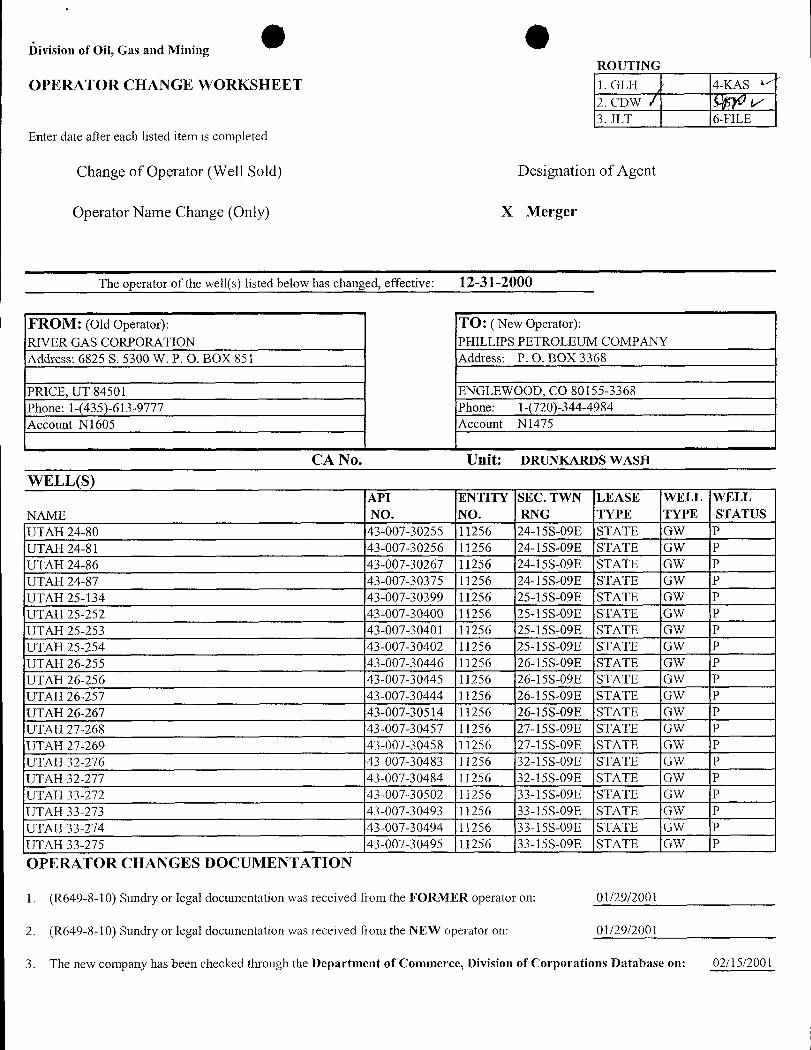
I)ivision of Oil, Gas and MiningROUTING
OPERATOR CHANGE WORKSHEET l. GLH 4-KAS
2. CDW / V3. JLT 6-FILE
Enter date after each listed item is completed
Change of Operator (Well Sold) Designation of Agent
Operator Name Change (Only) X Merger
The operator of the well(s) listed below has changed, effective: 12-31-2000
FROM: (oldOperator): TO: ( New Operator):RIVER GAS CORPORATION PHILLIPS PETROLEUM COMPANYAddress: 6825 S. 5300 W. P. O. BOX 851 Address: P. O. BOX 3368
PRICE, UT 84501 ENGLEWOOD, CO 80155-3368Phone: 1-(435)-613-9777 Phone: 1-(720)-344-4984Account N1605 Account N1475
CA No. Unit: DRUNKARDS WASHWELL(S)
API ENTITY SEC. TWN LEASE WELL WELLNAME NO. NO. RNG TYPE TYPE STATUSUTAH 24-80 43-007-30255 11256 24-15S-09E STATE GW PUTAH 24-81 43-007-30256 11256 24-15S-09E STATE GW PUTAH 24-86 43-007-30267 11256 24-15S-09E STATE GW PUTAH 24-87 43-007-30375 11256 24-15S-09E STATE GW PUTAH 25-134 43-007-30399 11256 25-15S-09E STATE GW PUTAH 25-252 43-007-30400 11256 25-15S-09E STATE GW PUTAH 25-253 43-007-30401 11256 25-15S-09E STATE GW PUTAH 25-254 43-007-30402 11256 25-15S-09E STATE GW PUTAH 26-255 43-007-30446 11256 26-15S-09E STATE GW PUTAH 26-256 43-007-30445 11256 26-15S-09E STATE GW PUTAH 26-257 43-007-30444 11256 26-15S-09E STATE GW PUTAH 26-267 43-007-30514 11256 26-15S-09E STATE GW PUTAH 27-268 43-007-30457 11256 27-15S-09E STATE GW PUTAH 27-269 43-007-30458 11256 27-15S-09E STATE GW PUTAH 32-276 43-007-30483 11256 32-15S-09E STATE GW PUTAH 32-277 43-007-30484 11256 32-15S-09E STATE GW PUTAH 33-272 43-007-30502 11256 33-15S-09E STATE GW PUTAH 33-273 43-007-30493 11256 33-15S-09E STATE GW PUTAH 33-274 43-007-30494 11256 33-15S-09E STATE GW PUTAH 33-275 43-007-30495 11256 33-15S-09E STATE GW POPERATOR CHANGES DOCUMENTATION
1. (R649-8-10) Sundry or legal documentation was received from the FORMER operator on: 01/29/2001
2. (R649-8-10) Sundry or legal documentation was received from the NEW operator on: 01/29/2001
3. The new company has been checked through the Department of Commerce, Division of Corporations Database on:
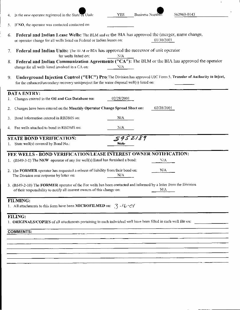
4. Is the new operator registered in the State Utah: YES Business Numbe -: 562960-0143
5. If NO, the operator was contacted contacted on:
6. Federal and Indian Lease Wells: The BLM and or the BIA has approved the (merger, name change,or operator change for all wells listed on Federal or Indian leases on: 01/30/2001
7. Federal and Indian Units: The BLM or BIA has approved the successor of unit operatorfor wells listed on: N/A
8. Federal and Indian Communization Agreements ("CA"): The BLM or the BIA has approved the operatorchange for all wells listed involved in a CA on: N/A
9. Underground Injection Control ("UIC") Pro The Division has approved UIC Form 5, Transfer of Authority to Inject,
for the enhanced/secondary recovery unit/project for the water disposal well(s) listed on:
DATA ENTRY:1. Changes entered in the Oil and Gas Database on: 02/28/2001
2. Changes have been entered on the Monthly Operator Change Spread Sheet on: 02/28/2001
3. Bond information entered in RBDMS on: N/A
4. Fee wells attached to bond in RBDMS on: N/A
STATE BOND VERIFICATION: Jý Jf~2-/f ¶1. State well(s) covered by Bond No.: N/A-
FEE WELLS - BOND VERIFICATION/LEASE INTEREST OWNER NOTIFICATION:1. (R649-3-1) The NEW operator of any fee well(s) listed has furnished a bond: N/A
2. The FORMER operator has requested a release of liability from their bond on: N/AThe Division sent response by letter on: N/A
3. (R649-2-10) The FORMER operator of the Fee wells has been contacted and informed by a letter from the Divisionof their responsibility to notify all interest owners of this change on: N/A
FILMING:1. All attachments to this form have been MICROFILMED on: -/6-c(
FILING:1. ORIGINALS/COPIES of all attachments pertaining to each individual well have been filled in each well file on:
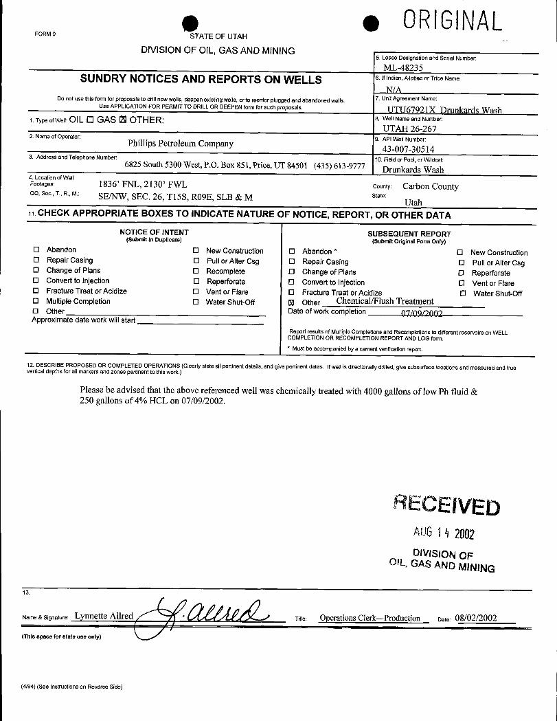
e e ORIGlNALFORM 9 STATE OF UTAH
DIVISION OF OlL, GAS AND MINING5. Lease Designation and Serial Number:
ML-48235SUNDRY NOTICES AND REPORTS ON WELLS 6.lfindian,AllotteeorTribeName:
NM7. UnitAgreement Name:Do not use this form for proposals to drill newwells, deepen existingwells, or to reenter plugged and abandoned wells.
Use APPLICATION FOR PERMIT TO DRILL OR DEEPEN form for such proposals. UTU67921X Drunkards Wash1. TypeofWell:OILO GAS 13 OTHER: 8. WelI Nameand Number:
UTAH 26-2679. API Well Number:2. Name of Operator:
Phillips Petroleum Company 43-007-305143. Address and Telephone Number: 10. Field or Pool, or Wildcat:6825 South 5300 West, P.O. Box 851, Price, UT 84501 (435) 613-9777
Drunkards Wash4. Location of WellFootages: 1836' FNL, 2130' FWL county: Carbon CountyQQ, Sec., T., R., M.: SE/NW, SEC. 26, Tl5S, RO9E, SLB & M state:
Utaha CHECK APPROPRIATE BOXES TO INDICATE NATURE OF NOTICE, REPORT, OR OTHER DATA
NOTICE OF INTENT SUBSEQUENT REPORT(Submit in Duplicate) (Submit Original Form Only)
O Abandon O New Construction O Abandon * O New ConstructionO Repair Casing O Pull or Alter Csg O Repair Casing O Pull or Alter CsgO Change of Plans O Recomplete O Change of Plans O ReperforateO Convert to Injection O Reperforate O Convert to Injection O Vent or FlareO Fracture Treat or Acidize O Vent or Flare O Fracture Treat or Acidize 0 Water Shut-OffO Multiple Completion O Water Shut-Off U Other Chemical/Flush TreatmentO Other Date of work completion go gg/copoApproximate date work will start
Report results of Multiple Completionsand Recompletions to different reservoirson WELLCOMPLETION OR RECOMPLETION REPORT AND LOG form.* Must be accompanied by a cement verificationreport
12. DESCRIBE PROPOSED OR COMPLETED OPERATIONS(Clearly state allpertinent details, and give pertinent dates, if well is directionally drilled, give subsurface locations and measured and truevertical depths for allmarkersand zones pertinent to this work.)
Please be advised that the above referenced well was chemically treated with 4000 gallons of low Ph fluid &250 gallons of 4% HCL on 07/09/2002.
AECEIVEDAU614 2002DIVISION OF
OIL, GAS AND MINING
ame & Signature: Lynnette Allred title: Operations Clerk-Production Date: 08/02/2002
(This space for state use only)
(4/94) (See Instructions on Reverse
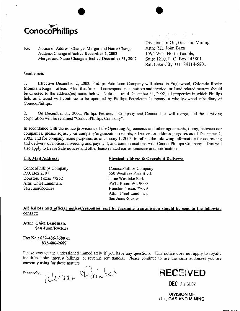
O
ConocoPhillipsDivisions of Oil, Gas, and Mining
Re: Notice of Address Change, Merger and Name Change Attn: Mr. John BazaAddress Change effective December 2, 2002 1594 West North Temple,Merger and Name Change effective December 31, 2002 Suite 1210, P. O. Box 145801
Salt Lake City, UT 84114-5801
Gentlemen:
1. Effective December 2, 2002, Phillips Petroleum Company will close its Englewood, Colorado RockyMountain Region office. After that time, all correspondence, notices and invoice for Land related matters shouldbe directed to the address(es) noted below. Note that until December 31, 2002, all properties in which Phillipsheld an interest will continue to be operated by Phillips Petroleum Company, a wholly-owned subsidiary ofConocoPhillips.
2. On December 31, 2002, Phillips Petroleum Company and Conoco Inc. will merge, and the survivingcorporation will be renamed "ConocoPhillips Company".
In accordance with the notice provisions of the Operating Agreements and other agreements, if any, between ourcompanies, please adjust your company/organization records, effective for address purposes as of December 2,2002, and for company name purposes, as of January 1, 2003, to reflect the following information for addressingand delivery of notices, invoicing and payment, and communications with ConocoPhillips Company. This willalso apply to Lease Sale notices and other lease-related correspondence and notifications.
U.S. Mail Address: Physical Address & Overnight Delivery:
ConocoPhillips Company ConocoPhillips CompanyP.O. Box 2197 550 Westlake Park Blvd.Houston, Texas 77252 Three Westlake ParkAttn: Chief Landman, 3WL, Room WL 9000San Juan/Rockies Houston, Texas 77079
Attn: Chief Landman,San Juan/Rockies
All ballots and official notices/responses sent by facsimile transmission should be sent to the followingcontact:
Attn: Chief Landman,San Juan/Rockies
Fax No.: 832-486-2688 or832-486-2687
Please contact the undersigned immediately if you have any questions. This notice does not apply to royaltyinquiries, joint interest billings, or revenue remittances. Please continue to use the same addresses you arecurrenr lymusi attters
RECE IVEDDECO22002DIVISIONOF
DIL, GAS AND
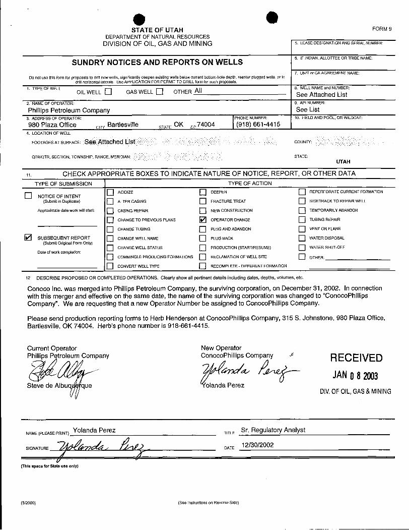
OSTATEOFUTAH FORM9
DEPARTMENT OF NATURALRESOURCESDIVISIONOF OIL, GAS AND MINING 5. LEASEDESIGNATIONANDSERIALNUMBER:
SUNDRY NOTICES AND REPORTS ON WELLS 6. IFINDIAN,ALLOTTEEORTRIBENAME:
7. UNITor CA AGREEMENT NAME:Do not use this form for proposals to drillnewwells, significantly deepen existing wells below current bottom-hole depth, reenter plugged wells, or to
drill horizontal laterals. Use APPLICATION FOR PERMIT TO DRILLform for such proposals.
1. TYPE OF WELL i 8. WELLNAME and NUMBER:OIL WELL GAS WELL OTHER I See Attached List
2.NAMEOFOPERATOR: 9.APINUMBER:
Phillips Petroleum Company See List3. ADDRESS OF OPERATOR: PHONE NUMBER: 10. FIELD AND POOL, OR WILDCAT:
980 Plaza Office civv Bartlesville sy,,, OK ,,,74004 (918) 661-44154. LOCATION OF WELL
FOOTAGES AT SURFACE: See Attached Icist COUNTY:
QTR/QTR, SECTION, TOWNSHIP, RANGE, MERIDIAN: STATE:UTAH
19. CHECK APPROPRIATE BOXES TO INDICATE NATURE OF NOTICE, REPORT, OR OTHER DATATYPE OF SUBMISSION TYPE OF ACTION
ACIDIZE DEEPEN REPERFORATE CURRENT FORMATIONO NOTICE OF INTENT(Submit in Duplicate) ALTER CASING FRACTURE TREAT SIDETRACK TO REPAIR WELL
Approximate date work willstart: CASING REPAIR NEW CONSTRUCTION TEMPORARILY ABANDON
O CHANGE TO PREVIOUS PLANS OPERATOR CHANGE TUBING REPAIR
O CHANGE TUBING PLUG AND ABANDON VENT OR FLARE
SUBSEQUENT REPORT CHANGE WELL NAME PLUG BACK WATER DISPOSAL(Submit Original Form Only)
O CHANGE WELL STATUS PRODUCTION (STARTIRESUME) WATER SHUT-OFFDate of work completion:
COMMINGLEPRODUCING FORMATIONS RECLAMATIONOF WELL SITE OTHER:
O CONVERT WELL TYPE RECOMPLETE - DIFFERENT FORMATION
12. DESCRIBE PROPOSED OR COMPLETED OPERATIONS. Clearly show all pertinent details including dates, depths, volumes, etc.
Conoco Inc. was merged into Phillips Petroleum Company, the surviving corporation, on December 31, 2002. In connectionwith this merger and effective on the same date, the name of the surviving corporation was changed to "ConocoPhillipsCompany". We are requesting that a new Operator Number be assigned to ConocoPhillips Company.
Please send production reporting forms to Herb Henderson at ConocoPhillips Company, 315 S. Johnstone, 980 Plaza Office,Bartlesville, OK 74004. Herb's phone number is 918-661-4415.
Current Operator New OperatorPhillips Petroleum Company ConocoPhillips Company * RECEIVED
Steve de Albug que olanda PerezDIV.OFOIL,GAS&MINING
NAME (PLEASE PRINT) Yolanda Perez TITLE Sr. Regulatory Analyst
SIGNATURE DATE
(This space for State use only)
(5/2000) (See instructions on Reverse

ConocoPhillips
SECRETARY'S CERTIFICATE
I, the undersigned, Jennifer M. Garcia, Assistant Secretary of ConocoPhillips Company,formerly Phillips Petroleum Company, organized and existing under and by virtue of the laws ofthe State of Delaware (the "Corporation"), hereby certify that:
1. As Assistant Secretary I am authorized to execute this certificateon behalf of the Corporation.
2. The attached photocopy of the Certificate of Amendment to theRestated Certificate of Incorporation of Phillips PetroleumCompany (to be renamed ConocoPhillips Company) is a trueand correct copy as filed in the office of the Secretary of State ofDelaware on the 12th day of December 2002, with an effectivedate of January 1, 2003 and such Certificate of Amendment hasnot been modified, amended, rescinded or revoked and is in fullforce and effect as of the date hereof.
3. The attached photocopy of the Certificate of Merger of ConocoInc. with and into ConocoPhillips Company is a true and correctcopy as filed in the office of the Secretary of State of Delawareon the 12 day of December 2002, with an effective date ofDecember 31, 2002 and such Certificate of Merger has not beenmodified, amended, rescinded or revoked and is in full force andeffect as of the date hereof.
IN WITNESS WHEREOF, I have hereunto set my hand as Assistant Secretary andaffixed the corporate seal of the Corporation this 7th day of January 2003.
Ass ecretaryo ocoPhillips Company
STATEOFTEXAS §§
COUNTY OF HARRIS §
This instrument was acknowledged before me on January 7, 2003, by Jennifer M. Garcia,Assistant Secretary of ConocoPhillips Company, a Delaware corporation, on behalf of said
RECEIVED No y PubÌÍc '
DIV.OFOIL,GAS&
PAGE 1
'The irst State
I, HARRIET SMITH WINDSOR, SECRETARY OF STATE OF THE STATE OF
DELAWARE, DO HEREBY CERTIFY THE ATTACHED IS A TRUE AND CORRECT
COPY OF THE CERTIFICATE OF AMENDMENT OF "PHILLIPS PETROLEUM
COMPANY", CHANGING ITS NAME FROM "PHILLIPS PETROLEUM COMPANY" TO
"CONOCOPHILLIPS COMPANY", FILED IN THIS OFFICE ON THE TWELFTH
DAY OF DECEMBER, A.D. 2002, AT 1:41 O'CLOCK P.M.
AND I DO HEREBY FURTHER CERTIFY THAT THE EFFECTIVE DATE OF
THE AFORESAID CERTIFICATE OF AMENDMENT IS THE THIRTY-FIRST DAY
OF DECEMBER, A.D. 2002, AT 11 O'CLOCK P.M.
RECEIVEDJANO8 2003
DIV.OF OIL,GAS&MINING
Harriet Smith Windsor, Secretary of State
0064324 8100 AUTHENTICATION: 2183360
030002793 DATE:
O OST TE OF DELANARE
FROMEL&F#1 (THU)12.12 02 13:32/ST.13:¾ 4ô6WWr39E )DIVISION OF CORPORATIONSFILED 01:41 PM 12/12/2002
020763238 - 0064324
CERTIPICATE OF AMENDMENT
to the
RESTATED CERTIFICATE OF INCORPORATION
of
PRILLIPS PETROLEUM COMPANY(to be renamed ConocoPhillips Company)
Phillips Petroleum Company ("Phillips"), a corporation organized and existing
under the General CorporationLaw of the State of Delaware (the "DGCL"), hereby certides that:
1. The amendments to Phillips' Restated Certificate of Incorporation set
forth below were duly adopted in accordance with the provisions of Section 242 of the DGCLand have been consented to in writing by the sole stockholder of Phillips in accordance with
Section 228 of the DGCL
2. Phillips' Restated Certificate of lucorporation is hereby amended by
deletingArticle [ thereof and replacing in lieu thereof a new Article I reading in its entirety a.«
follows:
"The narne of the corporation (which is hereinafter referred to as the"Corporation")is ConocoPhillipsCompany."
3. Phillips' Restated Certificate of Incorporation is - hereby amended by
deleting Section 1 of Article IV thereof and replacing in lieu thereof a new Section 1 reading in
its entiretyas follows:
"Section 1. The Corporationshall be authorized to issue 2,100 shares of capital
stock, of which 2,100 shares shall be shares of CommonStock, $.01par value ("CommonStock")."
4. Pursuantto Section 103(d) of the DGCL, this amen ent will become
effective at 11:00 p.m., Eastem time, on December 31, 2002.
HOUO3;35¾04.1 RECE IVEDJANO82003
DIV.OFOIL,GAS&
OFROMRL&i#1 (THU)12.12 2 13°:32ST.13:31NO.4864756279P 6
IN WITNESS WHEREOF,Phillips has caused this certificate to be executed this12th day of December, 2002.
PHILLIPS PETROLEUMCOMPANY
By: ,
Name: ok A. HarringtonTitle: SeniorVice President, Legal,
and GeneralCounsel
RECEIVEDJANO8 2003
DIVOFOIL,GAS&
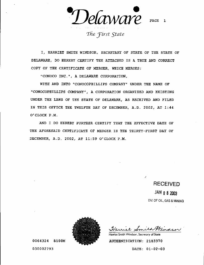
PAGE 1
'The írst State
I, HARRIET SMITH WINDSOR, SECRETARY OF STATE OF THE STATE OF
DELAWARE, DO HEREBY CERTIFY THE ATTACHED IS A TRUE AND CORRECT
COPY OF THE CERTIFICATE OF MERGER, WHICH MERGES:
"CONOCO INC. ", A DELAWARE CORPORATION,
WITH AND INTO "CONOCOPHILLIPS COMPANY" UNDER THE NAME OF
"CONOCOPHILLIPS COMPANY", A CORPORATION ORGANIZED AND EXISTING
UNDER THE LAWS OF THE STATE OF DELAWARE, AS RECEIVED AND FILED
IN THIS OFFICE THE TWELFTH DAY OF DECEMBER, A.D. 2002, AT 1:44
O'CLOCK P.M.
AND I DO HEREBY FURTHER CERTIFY THAT THE EFFECTIVE DATE OF
THE AFORESAID CERTIFICATE OF MERGER IS THE THIRTY-FIRST DAY OF
DECEMBER, A.D. 2002, AT 11:59 O'CLOCK P.M.
RECEIVEDJANO8 20.93
DIV.OFOIL,GAS&MINING
Harriet Smith Windsor, Secretary of State
0064324 8100M AUTHENTICATION: 2183370
030002793 DATE:
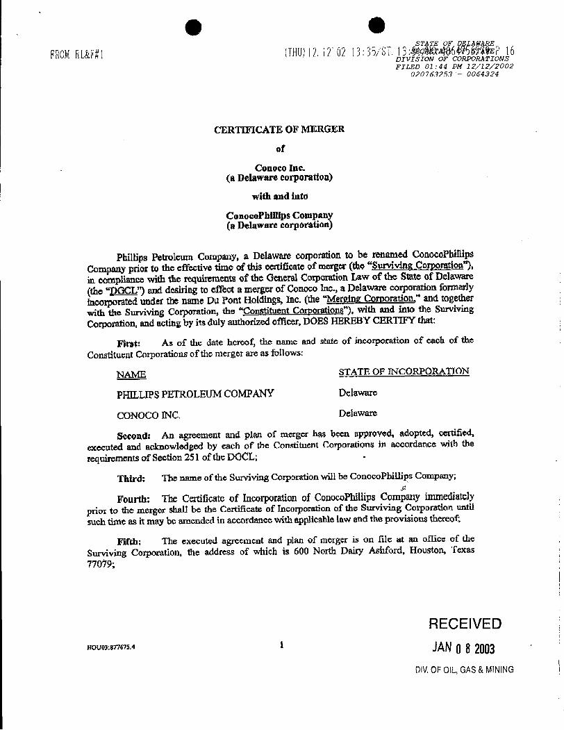
O OST TE OF DELANARE
FROMRL&F#1 (THU)12.12'02 13:35/ST.13:M 486W5WWE 16DIVISION OF CORPORATIONSFILED 01:44 PM 12/12/2002
020763253 - 0064324
CERTEFICATE OF MERGER
of
Conoco Inc.(a Delaware corporation)
with and into
ConocoPhillips Company(a Delaware corporation)
Phillips Petroleum Company, a Delaware corporation to be renamed ConocoPhillipsCompany prior to the effective time of this eerdficate of merger(the"SurvivingCorpomtion"),in compliance with the requhements of the General CorporationLaw of the State of Delaware(the "DGCL") and desiring to effect a merger of Conoco Inc., a Delawarecorporation fonnerlyincorporated under the name Du Pont Holdings, Inc. (the "Merging Corporation," and togetherwith the Surviving Corporation, the "¶'onstituentCorporations"), with and into the SurvivingCorporation, and acting by its duly authorized officer, DOESHEREBY CERTIFY that:
First: As of the date hereof, the name and state of incorporation of each of theConstituent Corporations of the merger are as follows:
NAME STATE OF INCORPORATION
PHILLIPSPETROLEIJMCOMPANY Delaware
CONOCO INC. Delaware
Second: An agreement and plan of merger has been approved, adopted, certified,executed and acknowledged by each of the Constituent Corporations in accordance with therequimments of Section 251 of the DOCL; -
Third: The narne of the Surviving Corporation will be ConocoPhillips Company;
Fourth: The Certificateof Incorporation of ConocoPhillipsCompany immediatelyprior to the merger shall he the Certificate of Incorporation of the Surviving Corporation until
such time as it may be amended in accordance with applicable law and the provisions thereof.
Fifth: The executed agr¢ement and plan of merger is on file at an office of thesurvivingCorporation, the address of which is 600 North Dairy Ashford, Houston, Texas77019;
RECElVEDnovos:mes.4 1
DIV.0FOIL,GAS&
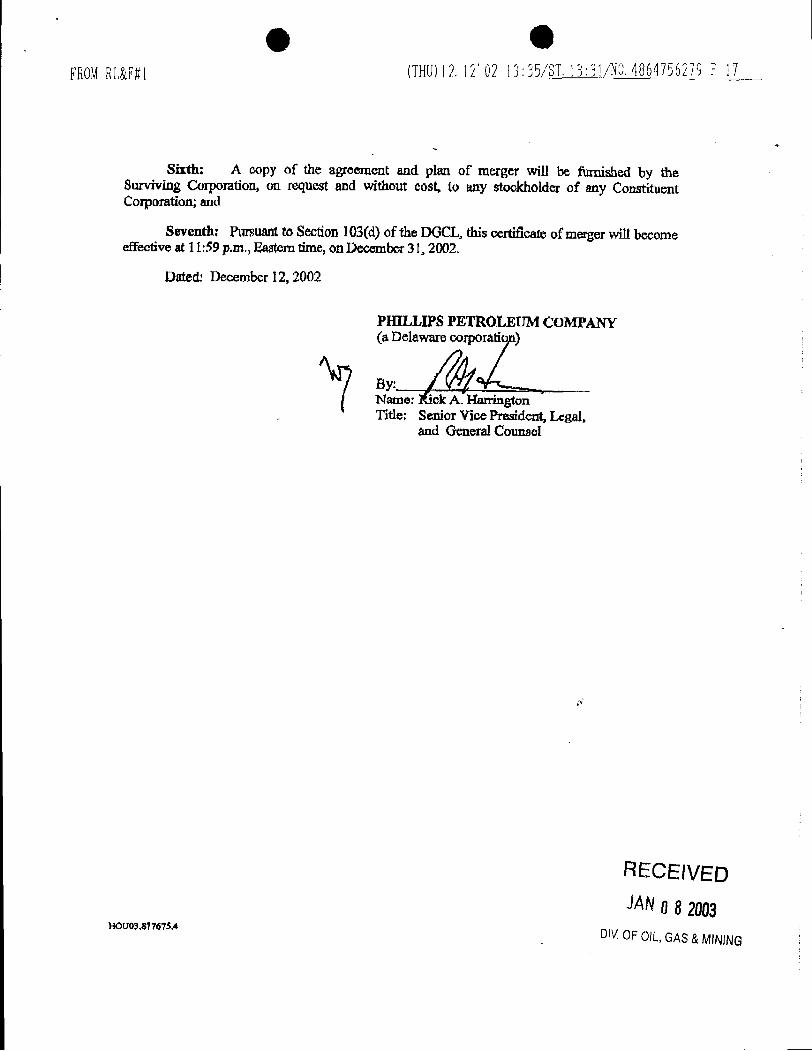
OFROMRL&F#l (THU)12.12'02 13:35ST.13:3ym 4864756279 17
Sixth: A copy of the agreement and plan of merger will be fumished by theSurviving Corporation, on request and without cost, to any stockholderof any ConstituentCorporation;and
Seventh: Pursuantto Section 103(d)of the DGCL, this certificate of merger will becomeeffective at 11:59 p.m., Easterntime, onDecember31, 2002.
Dated: December 12,2002
PHILLIPS PETROLEUM COMPANY(a Delaware corporati
By:Name: A. HarringtonTitle; Senior Vice President, Legal,
and GeneralCounsel
RECEIVEDJANO8 2003
aouotsosa OlVOF OIL,GAS&
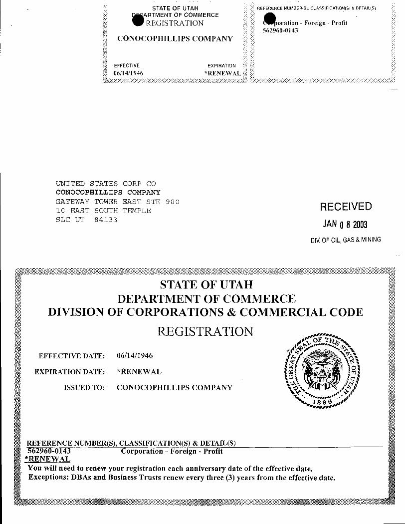
STATE OF UTAH REFERENCE NUMBER(S), CLASSIFICATION(S) & DETAIL(S)
ARTMENT OF COMMERCEREGISTRATION oration - Foreign - Profit
562960-0143CONOCOPHILLIPS COMPANY
EFFECTIVE EXPIRATION
06/14/1946 RENE L
UNITED STATES CORP COCONOCOPHILLIPS COMPANYGATEWAY TOWER EAST STE 900 RECEIVED10 EAST SOUTH TEMPLESLC UT 84133 JANO82003
DIV.0FOIL,GAS&MINING
STATE OF UTAHDEPARTMENT OF COMMERCE
DIVISION OF CORPORATIONS & COMMERCIAL CODE
EFFECTIVE DATE: 06/14/1946
REGISTRATION
EXPIRATION DATE: *RENEWAL
ISSUED TO: CONOCOPHILLIPS COMPANY
REFERENCE NUMBER(S), CLASSIFICATION(S) & DETAIL(S)562960-0143 Corporation - Foreign - Profit
*RENEWALYou will need to renew your registration each anniversary date of the effective date.Exceptions: DBAs and Business Trusts renew every three (3) years from the effective
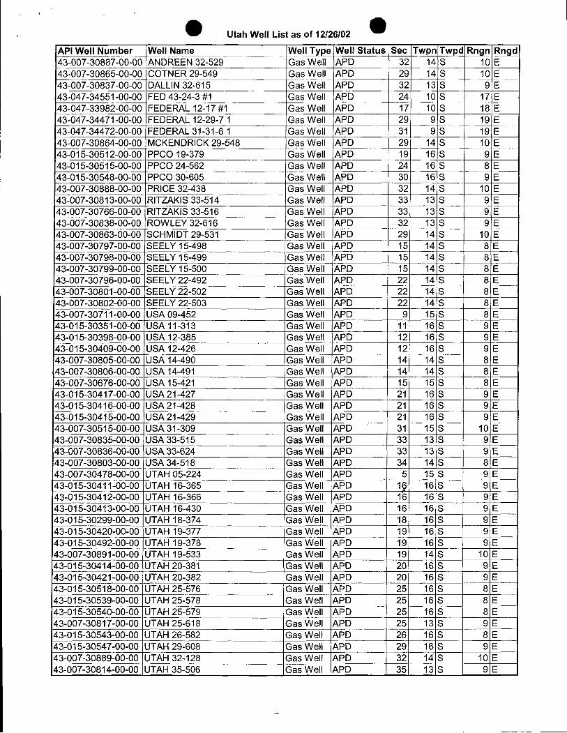
Utah Well List as of 12/26/02
API Well Number Well Name Well Type Well Status ISec Twpn Twpd Rngn Rngd43-007-30887-00-00 ANDREEN 32-529 Gas Well APD 32 14 S 10 E43-007-30865-00-00 COTNER 29-549 Gas Well APD 29 14 S 10 E43-007-30837-00-00 DALLIN32-615 Gas Well APD 32 13 S 9 E43-047-34551-00-00 FED 43-24-3 #1 Gas Well APD 24 10 S 17 E43-047-33982-00-00 FEDERAL 12-17 #1 Gas Well APD 17 10 S 18 E43-047-34471-00-00 FEDERAL 12-29-7 1 Gas Well APD 29 9 S 19 E43-047-34472-00-00 FEDERAL 31-31-6 1 Gas Well APD 31 9 S 19 E43-007-30864-00-00 MCKENDRICK29-548 Gas Well APD 29 14 S 10 E43-015-30512-00-00 PPCO 19-379 Gas Well APD 19 16 S 9 E43-015-30515-00-00 PPCO 24-562 Gas Well APD 24 16 S 8 E43-015-30548-00-00 PPCO 30-605 Gas Well APD 30) 16 S 9 E43-007-30888-00-00 PRICE 32-438 Gas Well APD 32 14 S 10 E43-007-30813-00-00 RITZAKIS 33-514 Gas Well APD 33 13 S 9 E43-007-30766-00-00 RITZAKIS 33-516 Gas Well APD 33 13 S 9 E43-007-30838-00-00 ROWLEY 32-616 Gas Well APD 32 13 S 9 E43-007-30863-00-00 SCHMIDT 29-531 Gas Well APD 29 14 S 10 E43-007-30797-00-00 SEELY 15-498 Gas Well APD 15 14 S 8 E43-007-30798-00-00 SEELY 15-499 Gas Well APD 15 14 S 8 E43-007-30799-00-00 SEELY 15-500 Gas Well APD 15 14 S 8 E43-007-30796-00-00 SEELY 22-492 Gas Well APD 22 14 S 8 E43-007-30801-00-00 SEELY 22-502 Gas Well APD 22 14 S 8 E43-007-30802-00-00 SEELY 22-503 Gas Well APD 22 14 S 8 E43-007-30711-00-00 USA 09-452 Gas Well APD 9 15 S 8 E43-015-30351-00-00 USA 11-313 Gas Well APD 11 16 S 9 E43-015-30398-00-00 USA 12-385 Gas Well APD 12 Ñ S 9 E43-015-30409-00-00 USA 12-426 Gas Well APD 12 16 S 9 E43-007-30805-00-00 USA 14-490 Gas Well APD 14 14 S 8 E43-007-30806-00-00 USA 14-491 Gas Well APD 14 14 S 8 E43-007-30676-00-00 USA 15-421 Gas Well APD 15 15 S 8 E43-015-30417-00-00 USA 21-427 Gas Well |APD 21 16 S 9 E43-015-30416-00-00 USA 21-428 Gas Well APD 21 16 S 9 E43-015-30415-00-00 USA 21-429 Gas Well APD 21 16 S 9 E43-007-30515-00-00 USA 31-309 |Gas Well APD 31 15 S 10 E43-007-30835-00-00 USA 33-515 IGas Well APD 33 13 S 9 E43-007-30836-00-00 USA 33-624 Gas Well APD 33 13 S 9 tE43-007-30803-00-00 USA 34-518 Gas Well APD 34 14 S 8 E43-007-30478-00-00 UTAH 05-224 Gas Well AP 5 15 S 9 E43-015-30411-00-00 UTAH 16-365 Gas Well APD 19 16 S 9 E43-015-30412-00-00 UTAH 16-366 Gas Well APD 15 16 S 9 E43-015-30413-00-00 UTAH 16-430 Gas Well APD 16 16 S 9 E43-015-30299-00-00 UTAH 18-374 Gas Well APD 18 16 S 9 E43-015-30420-00-00 UTAH 19-377 Gas Well APD 19 16 S 9 E43-015-30492-00-00 UTAH 19-378 Gas Well APD 19 16 S 9 E43-007-30891-00-00 UTAH 19-533 Gas Well APD 19 14 S 10 E43-015-30414-00-00 UTAH 20-381 Gas Well APD 20 16 S 9 E43-015-30421-00-00 UTAH 20-382 Gas Well APD 20 16 S 9 E43-015-30518-00-00 UTAH 25-576 Gas Well APD 25 16 S 8 E43-015-30539-00-00 UTAH 25-578 Gas Well APD 25 16 S 8 E43-015-30540-00-00 UTAH 25-579 Gas Well APD 25 16 S 8 E43-007-30817-00-00 UTAH 25-618 Gas Well APD 25 13 S 9 E43-015-30543-00-00 UTAH 26-582 Gas Well APD 26 16 S
¯8E
43-015-30547-00-00 UTAH 29-608 Gas Well APD 29 16 S 9 E43-007-30889-00-00 UTAH 32-128 Gas Well APD 32 14 S 10 E43-007-30814-00-00 UTAH 35-506 Gas Well APD 35 13 S 9
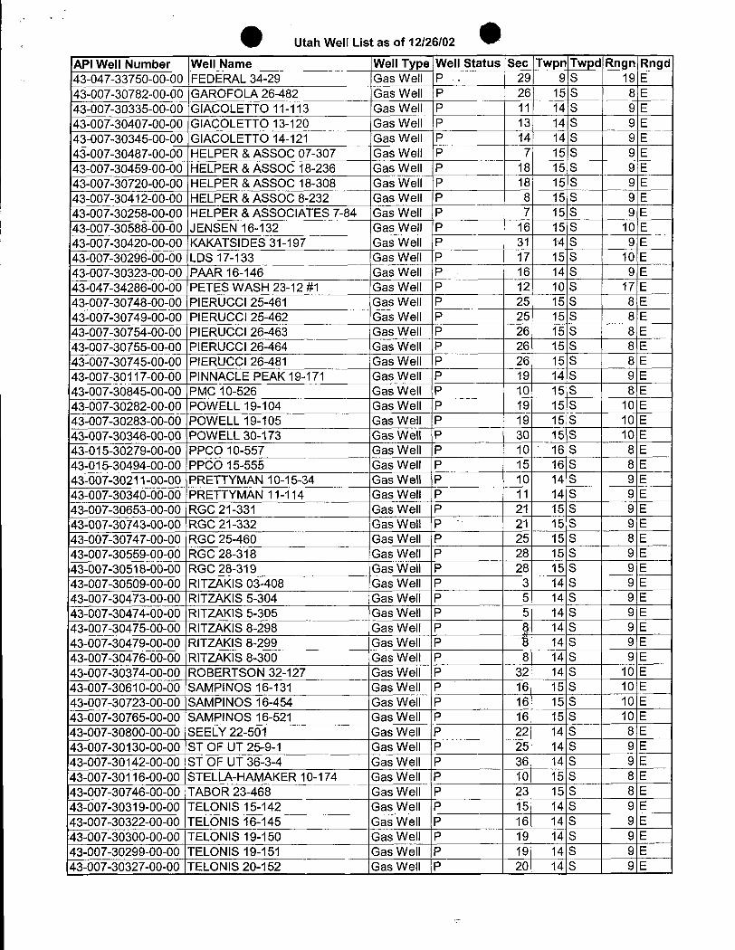
Utah Well List as of 12/26/02
'API Well Number Well Name Well Type Well Status Sec Twpn Twpd Rngn Rngd43-047-33750-00-00 FEDERAL 34-29 Gas Well P - 29 9 S 19 E43-007-30782-00-00 GAROFOLA 26-482 Gas Well P 26 15 S 8 E43-007-30335-00-00 GIACOLETTO 11-113 Gas Well P 11 14 S 9 E43-007-30407-00-00 GIACOLETTO 13-120 Gas Well P 13 14 S 9 E43-007-30345-00-00 GIACOLETTO 14-121 Gas Well P 14 14 S 9 E43-007-30487-00-00 HELPER & ASSOC 07-307 Gas Well P 7| 15 S 9 E43-007-30459-00-00 HELPER & ASSOC 18-236 Gas Well P 18 15 S 9 E43-007-30720-00-00 HELPER & ASSOC 18-308 Gas Well P 18 15 S 9 E43-007-30412-00-00 HELPER &ASSOC 8-232 Gas Well P 8 15 S 9 E43-007-30258-00-00 HELPER & ASSOCIATES 7-84 Gas Well P 7 15 S 9 E43-007-30588-00-00 JENSEN 16-132 Gas Well P 16 15 S 10 E43-007-30420-00-00 KAKATSIDES 31-197 Gas Well P 31 14 S 9 E43-007-30296-00-00 LDS 17-133 Gas Well P 17 15 S 10 E43-007-30323-00-00 PAAR 16-146 Gas Well P 16 14 S 9 E43-047-34286-00-00 PETES WASH 23-12 #1 Gas Well P 12 10 S 17 E43-007-30748-00-00 PIERUCCl 25-461 Gas Well P 25 15 S 8 E43-007-30749-00-00 PIERUCCI 25-462 Gas Well P 25 15 S 8 E43-007-30754-00-00 PIERUCCl 26-463 Gas Well P 26 15 S 8 E43-007-30755-00-00 PIERUCCI 26-464 Gas Well P 26 15 S 8 E43-007-30745-00-00 PIERUCCI 26-481 Gas Well P 26 15 S 8 E43-007-30117-00-00 PINNACLE PEAK 19-171 Gas Well P 19 14 S 9 E43-007-30845-00-00 PMC 10-526 Gas Well P 10 15 S 8 E43-007-30282-00-00 POWELL 19-104 Gas Well P 19 15 S 10 E43-007-30283-00-00 POWELL 19-105 Gas Well P 19 15 S 10 E43-007-30346-00-00 POWELL 30-173 Gas Well P 30 15 S 10 E43-015-30279-00-00 PPCO 10-557 Gas Well P 10 16 S 8 E43-015-30494-00-00 PPCO 15-555 Gas Well P 15 16 S 8 E43-007-30211-00-00 PRETTYMAN 10-15-34 Gas Well P 10 14 S 9 E43-007-30340-00-00 PRETTYMAN 11-114 Gas Well P 11 14 S 9 E43-007-30653-00-00 RGC 21-331 Gas Well P 21 15 S 9 E43-007-30743-00-00 RGC 21-332 Gas Well P 21 15 S 9 E43-007-30747-00-00 RGC 25-460 Gas Well P 25 15 S 8 E43-007-30559-00-00 RGC 28-318 Gas Well P 28 15 S 9 E43-007-30518-00-00 RGC 28-319 Gas Well P 28 15 S 9 E43-007-30509-00-00 IRITZAKIS 03-408 Gas Well P 3 14 S 9 E43-007-30473-00-00 RITZAKIS 5-304 Gas Well P 5 14 S 9 E43-007-30474-00-00 RITZAKIS 5-305 Gas Well P 5 14 S 9 E43-007-30475-00-00 RITZAKIS 8-298 Gas Well P 8 14 S 9 E43-007-30479-00-00 RITZAKlS 8-299 Gas Well P É 14 S 9 E43-007-30476-00-00 RITZAKIS 8-300 Gas Well P 8 14 S 9 E43-007-30374-00-00 ROBERTSON 32-127 Gas Well P 32 14 S 10 E43-007-30610-00-00 SAMPINOS 16-131 Gas Well P 16 15 S 10 ElŠ 007-30723-00-00 SAMPINOS 16-454 Gas Well P 16 15 S 10 E43-007-30765-00-00 SAMPINOS 16-521 Gas Well P 16 15 S 10 ETŠ007-30800-00-00 SEELY 22-501 Gas Well P 22 14 S 8 E43-007-30130-00-00 ST OF UT 25-9-1 Gas Well P 25 14 S 9 E43-007-30142-00-00 ST OF UT 36-3-4 Gas Well P 36 14 S 9 E43-007-30116-00-00 STELLA-HAMAKER 10-174 Gas Well P 10 15 S 8 EiŠ 007-30746-00-00 TABOR 23-468 Gas Well P 23 15 S 8 E43-007-30319-00-00 TELONIS 15-142 Gas Well P 15 14 S 9 E43-007-30322-00-00 TELONIS 16-145 Gas Well P 16 14 S 9 E43-007-30300-00-00 TELONIS 19-150 Gas Well P 19 14 S 9 E43-007-30299-00-00 TELONIS 19-151 Gas Well P 19 14 S 9 E43-007-30327-00-00 TELONIS 20-152 Gas Well P 20 14 S 9
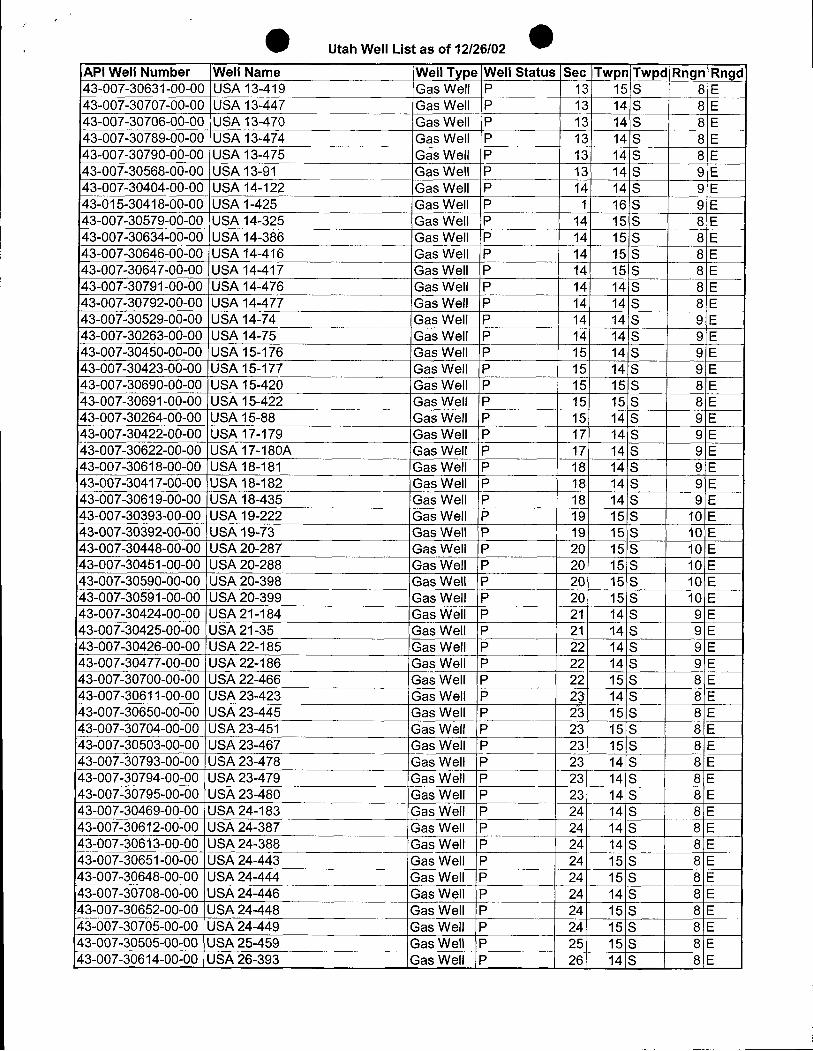
Utah Well List as of 12/26/02
API Well Number Well Name Well Type Well Status Sec Twpn Twpd Rngn Rngd43-007-30631-00-00 LRSA13-419 Gas VVell P 13 15 S 8 E43-007-30707-00-00 UELA13-447 Gas VVell P 13 14 S 8 E43-007-30706-00-00 LM3A13-470 Gas Miell P 13 14 S 8 E43-007-30789-00-00 UELA13-474 Gas VVell P 13 14 S 8 E43-007-30790-00-00 UEL413-475 Gas VVell P 13 14 S 8 E43-007-30568-00-00 UELA13-91 GasVVell P 13 14 S 9 E43-007-30404-00-00 LESA14-122 Gas VVell P 14 14 S 9 E43-015-30418-00-00 LRSA1-425 GasVVell P 1 16 S 9 E43-007-30579-00-00 LESA14-325 GasVVell P 14 15 S 8 E43-007-30634-00-00 LESAs14-386 Gas VVell P 14 15 S 8 E43-007-30646-00-00 USA 14-416 Gas Well P 14 15 S 8 E43-007-30647-00-00 UELA14-417 Gas VVell P 14 15 S 8 E43-007-30791-00-00 UELA14-476 Gas VVell P 14 14 S 8 E43-007-30792-00-00 ,LhsA 14-477 GasVVell P 14 14 S 8 E43-007-30529-0Õ00 UELA14-74 Gas VVell P 14 14 S 9 E43-007-30263-00-00 LDSA14-75 Gas VVell P 14 14 S 9 E43-007-30450-00-00 LMSA15-176 Gas VVell P 15 14 S 9 E43-007-30423-00-00 USA 15-177 Gas Well P 15 14 S 9 E43-007-30690-00-00 UEL$15-420 GasVVell P 15 _ 15|S 8 E43-007-30691-00-00 LNBA15-422 GasVVell P 15 15 S 8 E43-007-30264-00-00 USA 15-88 Gas Well P 15 14 S 9 E43-007-30422-00-00 LMSA17-179 GasVVell P 17 14 S 9 E43-007-30622-00-00 LMSA17-180A Gas VVell P 17 14 S 9:E43-007-30618-0Ö00 LMSA18-181 GasVVell P 18 14 S: 9 E43-007-30417-00-00 USA18-182 GlasVVell P 18 14 S 9 E43-007-30619-00-00 UELA18-435 Gas VVell P 18 14 S 9 E43-007-30393-00-00 USA 19-222 GLasVVell P 19 15 S 10 E43-007-30392-00-00 USA 19-73 Gas Well P 19 15 S 10iE43-007-30448-00-00 USA 20-287 Gas Well P 20 15 S 10 E43-007-30451-00-00 U.SA20-288 GasVVell P 20 15 S 10lE43-007-30590-00-00 LMSA20-398 GasVVell P 20 15 S 10 E43-007-30591-00-00 USA 20-399 Gas Well P 20 15 S 10 E43-007-30424-00-Õ0UEL421-184 GasVVell P 21 14 S 9 E43-007-30425-00-00 LMSAs21-35 (Bas VVell P 21 14 S 9 E43-007-30426-00-00 USA22-185 Gas VVell P 22 14 S 9 E43-007-30477-00-00 USA22-186 Gas VVell P 22 14 S 9 E43-007-30700-00-00 LESA22-466 Gas VVell P 22 15 S 8 E43-007-30611-00-00 LMSA23-423 GLas VVell P 2þ 14 S 8 E43-007-30650-00-00 LhŠA23-445 Gas VVell P i3 15 S 8 E43-007-30704-00-00 LMSA23-451 Gas VVell P 23 15 S 8 E43-007-30503-00-00 USA23-467 Gas VVell P 23 15 S 8 E43-007-30793-00-00 USA23-478 GasVVell P 23 14 S 8 E43-007-30794-00-00 USA 23-479 Gas Well P 23 14 S 8 E43-007-30795-00-00 LESA23-480 Gas VVell P 23 14 S 8 E43-007-30469-00-00 USA24-183 GasVVell P 24 14 S 8 E43-007-30612-00-00 UEL424-387 Gas VVell P 24 14 S 8 E43-007-30613-00-00 LESA24-388 Gas VVell P 24 14 S 8 E43-007-30651-00-00 USA24-443 Gas VVell P 24 15 S 8 E43-007-30648-00-00 LESA24-444 Gas VVell P 24 15 S 8 E43-007-30708-00-00 LDSA24-446 GasVVell P 24 14 S 8 E43-007-30652-00-00 USA 24-448 Gas Well P 24 15 S 8 E43-007-30705-00-00 LASA24-449 Glas\Nell
P¯24 15 S 8 E
43-007-30505-00-00 USA 25-459 Gas Well P 25 15 S 8 E43-007-30614-00-00 LESA26-393 Gas VVell P 26 14 S 8
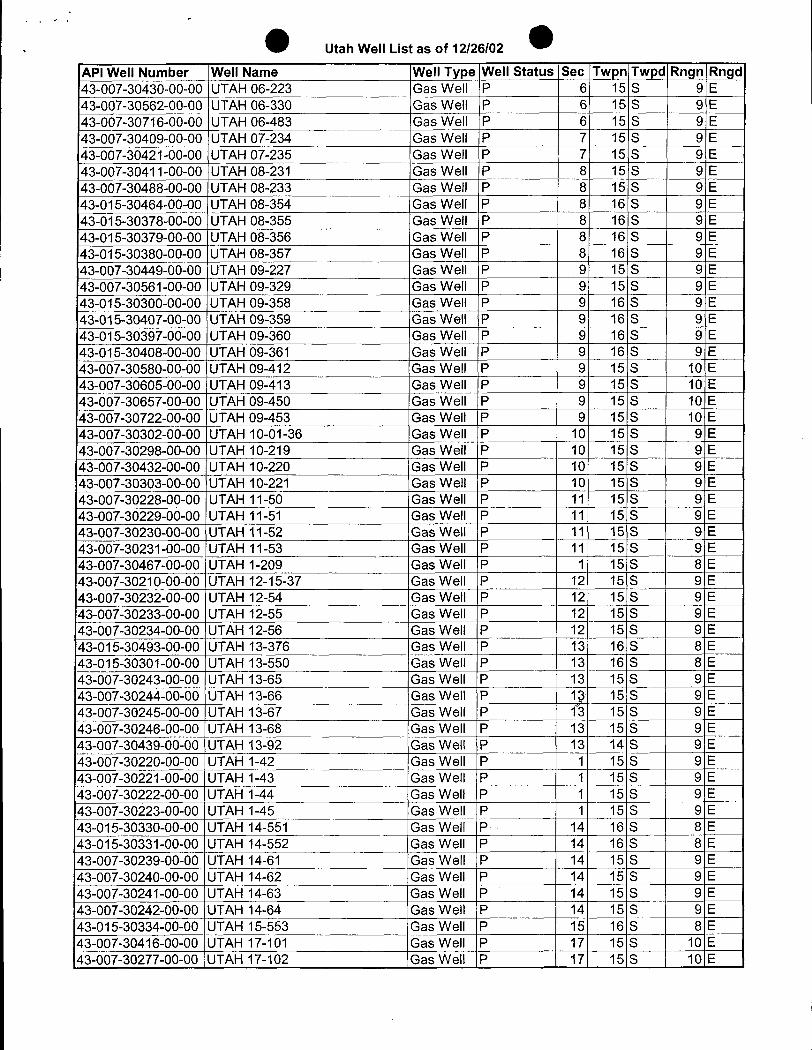
Utah Well List as of 12/26/02
API Well Number Well Name Well Type Well Status Sec Twpn Twpd Rngn Rngd43-007-30430-00-00 UTAH 06-223 Gas Well P 6 15 S 9 E43-007-30562-00-00 UTAH 06-330 Gas Well P 6 15 S 9 E43-007-30716-00-00 UTAH 06-483 Gas Well P 6 15 S 9 E43-007-30409-00-00 UTAH 07-234 Gas Well P 7 15 S 9 E43-007-30421-00-00 UTAH 07-235 Gas Well P 7 15 S 9 E43-007-30411-00-00 UTAH 08-231 Gas Well P 8 15 S 9 E43-007-30488-00-00 UTAH 08-233 Gas Well P 8 15 S 9 E43-015-30464-00-00 UTAH 08-354 Gas Well P 8 16 S 9 E43-015-30378-00-00 UTAH 08-355 Gas Well P 8 16 S 9 E43-015-30379-00-00 UTAH 08-356 Gas Well P 8 16 S 9 E43-015-30380-00-00 UTAH 08-357 Gas Well P 8 16 S 9 E43-007-30449-00-00 UTAH 09-227 Gas Well P 9 15 S 9 E43-007-30561-00-00 UTAH 09-329 Gas Well P 9 15 S 9 E43-015-30300-00-00 UTAH 09-358 Gas Well P 9 16 S 9 E43-015-30407-00-00 UTAH 09-359 Gas Well P 9 16 S 9 E43-015-30397-00-00 UTAH 09-360 Gas Well P 9 16 S 9 E43-015-30408-00-00 UTAH 09-361 Gas Well P 9 16 S 9 E43-007-30580-00-00 UTAH 09-412 Gas Well P 9 15 S 10 E43-007-30605-00-00 UTAH 09-413 Gas Well P 9 15 S 10 E43-007-30657-00-00 UTAH 09-450 Gas Well P 9 15 S 10 E43-007-30722-00-00 UTAH 09-453 Gas Well P 9 15 S 10 E43-007-30302-00-00 UTAH 10-01-36 Gas Well P 10 15 S 9 E43-007-30298-00-00 UTAH 10-219 Gas Well P 10 15 S 9 E43-007-30432-00-00 UTAH 10-220 Gas Well P 10 15 S 9 E43-007-30303-00-00 UTAH 10-221 Gas Well P 10 15 S 9 E43-007-30228-00-00 UTAH 11-50 Gas Well P 11 15 S 9 E43-007-30229-00-00 UTAH 11-51 Gas Well P 11 15 S 9 E43-007-30230-00-00 UTAH 11-52 Gas Well P 11 15 S 9 E43-007-30231-00-00 UTAH 11-53 Gas Well P 11 15 S 9 E43-007-30467-00-00 UTAH 1-209 Gas Well P 1 15 S 8 E43-007-30210-00-00 UTAH 12-15-37 Gas Well P 12 15 S 9 E43-007-30232-00-00 UTAH 12-54 Gas Well P 12 15 S 9 E43-007-30233-00-00 UTAH 12-55 Gas Well P 12 15 S 9 E43-007-30234-00-00 UTAH 12-56 Gas Well P 12 15 S 9 E43-015-30493-00-ÕÕUTAH 13-376 Gas Well P 13 16 S 8 E43-015-30301-00-00 UTAH 13-550 Gas Well P 13 16 S | 8 E43-007-30243-00-00 UTAH 13-65 Gas Well P 13 15 S 9 E43-007-30244-00-00 UTAH 13-66 Gas Well P 1g 15 S 9 E43-007-30245-00-00 UTAH 13-67 Gas Well P 13 15 S 9 E43-007-30246-00-00 UTAH 13-68 Gas Well P 13 15 S 9 E43-007-30439-00-00 UTAH 13-92 Gas Well P 13 14 S 9 E43-007-30220-00-00 UTAH 1-42 Gas Well P 1 15 S 9 E43-007-30221-00-00 UTAH 1-43 Gas Well P 1 15 S 9 E43-007-30222-00-00 UTAH 1-44 Gas Well P 1 15 S 9 E43-007-30223-00-00 UTAH 1-45 Gas Well P 1 15 S 9 E43-015-30330-00-00 UTAH 14-551 Gas Well P 14 16 S 8 E43-015-30331-00-00 UTAH 14-552 Gas Well P 14 16 S 8 E43-007-30239-00-00 UTAH 14-61 Gas Well P 14 15 S 9 E43-007-30240-00-00 UTAH 14-62 Gas Well P 14 15 S 9 E43-007-30241-00-00 UTAH 14-63 Gas Well P 14 15 S 9 E43-007-30242-00-00 UTAH 14-64 Gas Well P 14 15 S 9 E43-015-30334-00-00 UTAH 15-553 Gas Well P 15 16 S 8 E43-007-30416-00-00 UTAH 17-101 Gas Well P 17 15 S 10 E43-007-30277-00-00 UTAH 17-102 Gas Well \P 17 15 S \
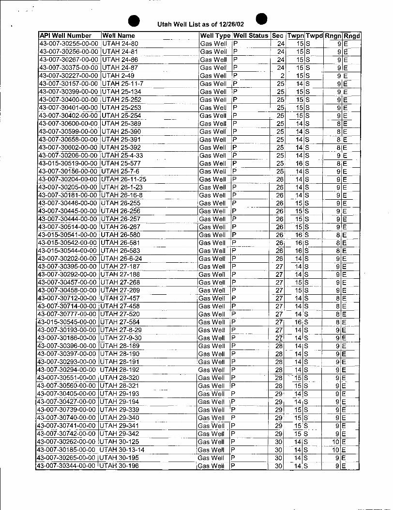
Utah Well List as of 12/26/02
API Well Number Well Name Well Type Well Status Sec Twpn Twpd Rngn Rngd43-007-30255-00-00 UTAH 24-80 Gas Well P 24 15 S 9 E43-007-30256-00-00 |UTAH 24-81 Gas Well P 24 15 S 9 E43-007-30267-00-00 UTAH 24-86 Gas Well P 24 15 S 9 E43-007-30375-00-00 UTAH 24-87 Gas Well P 24 15 S 9 E43-007-30227-00-00 UTAH 2-49 Gas Well P 2 15 S 9 E43-007-30157-00-00 UTAH 25-11-7 Gas Well P 25 14 S 9 E43-007-30399-00-00 UTAH 25-134 Gas Well P 25 15 S 9 E43-007-30400-00-00 UTAH 25-252 Gas Well P 25 15 S 9 E43-007-30401-00-00 UTAH 25-253 Gas Well P 25 15 S 9 E43-007-30402-00-00 UTAH 25-254 Gas Well P 25 15 S 9 E43-007-30600-00-00 UTAH 25-389 Gas Well P 25 14 S 8 E43-007-30599-00-00 UTAH 25-390 Gas Well P 25 14 S 8 E43-007-30658-00-00 UTAH 25-391 Gas Well P 25 14 S 8 E43-007-30602-00-00 UTAH 25-392 Gas Well P 25 14 S 8 E43-007-30206-00-00 UTAH 25-4-33 Gas Well P 25 14 S 9 E43-015-30519-00-00 UTAH 25-577 Gas Well P 25 16 S 8 E43-007-30156-00-00 UTAH 25-7-6 Gas Well P 25 14 S 9 E43-007-30204-00-00 UTAH 26-11-25 Gas Well P 26 14 S 9 E43-007-30205-00-00 UTAH 26-1-23 Gas Well P 26 14 S 9 E43-007-30181-00-00 UTAH 26-16-8 Gas Well P 26 14 S 9 E4¯3-007-30446-00-00
UTAH 26-255 Gas Well P 26 15 S 9 E43-007-30445-00-00 UTAH 26-256 Gas Well P 26 15 S 9 E43-007-30444-00-00 UTAH 26-257 Gas Well P 26 15 S 9 E43-007-30514-00-00 UTAH 26-267 Gas Well P 26 15 S 9 E43-015-30541-00-00 UTAH 26-580 Gas Well P 26 16 S 8 E43-015-30542-00-00 UTAH 26-581 Gas Well P 26 16 S 8 E43-015-30544-00-00 UTAH 26-583 Gas Well P 26 16 S 8 E43-007-30202-00-00 UTAH 26-6-24 Gas Well P 26 14 S 9 E43-007-30395-00-00 UTAH 27-187 Gas Well P 27 14 S 9 E43-007-30292-00-00 UTAH 27-188 Gas Well P 27 14 S 9 E43-007-30457-00-00 UTAH 27-268 Gas Well P 27 15 S 9 E43-007-30458-00-00 UTAH 27-269 Gas Well P 27 15 S 9 E43-007-30712-00-00 UTAH 27-457 Gas Well P 27 14 S 8 E43-007-30714-00-00 UTAH 27-458 Gas Well P 27 14 S 8 E43-007-30777-00-00 UTAH 27-520 Gas Well P 27 14 S 8 E43-015-30545-00-00 UTAH 27-584 Gas Well P 27 16 S 8 E43-007-30193-00-00 UTAH 27-8-29 Gas Well P 27 14 S 9 E43-007-30186-00-00 UTAH 27-9-30 Gas Well P 2p 14 S 9 E43-007-30396-00-00 UTAH 28-189 Gas Well P 28 14 S 9 E43-007-30397-00-00 UTAH 28-190 Gas Well P 28 14 S 9 E43-007-30293-00-00 UTAH 28-191 Gas Well P 28 14 S 9 E43-007-30294-00-00 UTAH 28-192 Gas Well P 28 14 S 9 E43-007-30551-00-00 UTAH 28-320 Gas Well P 28 15 S 9 E43-007-30560-00-00 UTAH 28-321 Gas Well P 28 15 S 9 E43-007-30405-00-00 UTAH 29-193 Gas Well P 29 14 S 9 E43-007-30427-00-00 UTAH 29-194 Gas Well P 29 14 S 9 E43-007-30739-00-00 UTAH 29-339 Gas Well P 29 15 S 9 E43-007-30740-00-00 UTAH 29-340 Gas Well P 29 15 S 9 E43-007-30741-00-00 UTAH 29-341 Gas Well P 29 15 S 9 E43-007-30742-00-00 UTAH 29-342 Gas Well P 29 15 S 9 E43-007-30262-00-00 UTAH 30-125 Gas Well P 30 14 S 10 E43-007-30185-00-00 UTAH 30-13-14 Gas Well P 30 14 S 10 E43-007-30265-00-00 UTAH 30-195 Gas Well P 30 14 S 9 E43-007-30344-00-00 UTAH 30-196 Gas Well P 30) 14 S 9
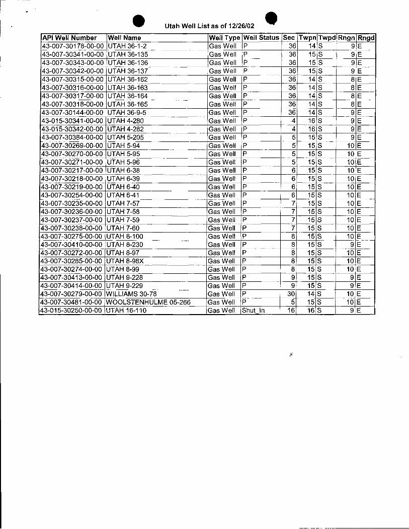
e OUtah Well List as of 12/26/02
API Well Number Well Name Well Type Well Status Sec Twpn Twpd Rngn Rngd43-007-30178-00-00 UTAH 36-1-2 Gas Well P 36 14 S 9 E43-007-30341-00-00 UTAH 36-135 Gas Well P 36 15 S 9 E43-007-30343-00-00 UTAH 36-136 Gas Well P 36 15 S 9 E43-007-30342-00-00 UTAH 36-137 Gas Well P 36 15 S 9 E43-007-30315-00-00 UTAH 36-162 Gas Well P 36 14 S 8 E43-007-30316-00-00 UTAH 36-163 Gas Well P 36 14 S 8 E43-007-30317-00-00 UTAH 36-164 Gas Well P 36 14 S 8 E43-007-30318-00-00 UTAH 36-165 Gas Well P 36 14 S 8 E43-007-30144-00-00 UTAH 36-9-5 Gas Well P 36 14 S 9 E43-015-30341-00-00 UTAH4-280 Gas Well P 4 16 S 9 E43-015-30342-00-00 UTAH 4-282 Gas Well P 4 16 S 9 E43-007-30384-00-00 UTAH 5-205 Gas Well P 5 15 S 9 E43-007-30269-00-00 UTAH 5-94 Gas Well P 5 15 S 10 E43-007-30270-00-00 UTAH 5-95 Gas Well P 5 15 S 10 E43-007-30271-00-00 UTAH 5-96 Gas Well P 5 15 S 10 E43-007-30217-00-00 UTAH 6-38 Gas Well P 6 15 S 10 E43-007-30218-00-00 UTAH 6-39 Gas Well P 6 15 S 10 E43-007-30219-00-00 UTAH 6-40 Gas Well P 6 15 S 10 E43-007-30254-00-00 UTAH 6-41 Gas Well P 6 15 S 10 E43-007-30235-00-00 UTAH 7-57 Gas Well P 7 15 S 10 E43-007-30236-00-00 UTAH 7-58 Gas Well P 7 15 S 10 E43-007-30237-00-00 UTAH 7-59 Gas Well P 7 15 S 10 E43-007-30238-00-00 UTAH 7-60 Gas Well P 7 15 S 10 E43-007-30275-00-00 UTAH 8-100 Gas Well P 8 15 S 10 E43-007-30410-00-00 UTAH 8-230 Gas Well P 8 15 S 9 E43-007-30272-00-00 UTAH 8-97 Gas Well P 8 15 S 10 E43-007-30285-00-00 UTAH 8-98X Gas Well P 8 15 S 10 E43-007-30274-00-00 UTAH 8-99 Gas Well P 8 15 S 10 E43-007-30413-00-00 UTAH 9-228 Gas Well P 9 15 S 9 E43-007-30414-00-00 UTAH 9-229 Gas Well P 9 15 S 9 E43-007-30279-00-00 WILLIAMS30-78 Gas Well P 30 14 S 10 E43-007-30481-00-00 WOOLSTENHULME 05-266 Gas Well P 5 15 S 10 E43-015-30250-00-00 \UTAH 16-110 Gas Well Shut in 16 16 S 9
e OgNT OR
United States Department of the InteriorBUREAU OF LAND MANAGEMENT
CH 2 Eastern States Office7450 Boston Boulevard
Springfield, Virginia 22153
IN REPLY REFER TO3106.8(932.34)WF January 16, 2003
NOTICE
ConocoPhillips Company : Oil & Gas LeasesP.O. Box 7500Bartlesville, Oklahoma 74005
Merger/Name Change Recognized
Acceptable evidence was received in this office on January 14, 2003, concerning the change ofname of Phillips Petroleum Company to ConocoPhillips Company and the merger of ConocoIncorporated into ConocoPhillips Company on Federal oil and gas leases, withConocoPhillips Company being the surviving entity.
The Secretary of the State of Delaware certified the effective date of this merger effectiveDecember 31, 2002.
The oil and gas lease files identified on the enclosed exhibit have been noted to the merger. Theexhibit was compiled from a list of leases obtained from your list of leases. Eastern States hasnot abstracted the lease files to determine if the entities affected by this megger hold an ititerest inthe leases identified nor have we attempted to identify leases where the entities are the operatoron the ground maintaining no vested record title or operating rights interest. We are notifying theMinerals Management Service and all applicable Bureau of Land Management offices of thismerger and name change by a copy of this notice. If additional documentation for changes ofoperator are required by our Field Offices, you will be contacted by them.
If you identify other leases in which the merging entity maintain an interest, please contact thisoffice and we will appropriately document those files with a copy of this Notice.
By Operation of law the name of the principal on Nationwide Oil and Gas Bond held by ConocoIncorporated (ES0085) has been changed to ConocoPhillips
,
FEB-03-2003NON11.15AN FAXNO. P. 03
If you have any questions,pleasecontact Bill Forbes at 703-440-1536.
Wilbert 8. ForbesLand LawExaminerBranchof Use AuthorizationDivisionof ResourcesPlanning, Useand Protection
be: JFO. BLM State Offices, MMS, SS RF, 930 RF, ES-932:Oforbes:wbf:01/16/03:440-1536/ConocoPhillips
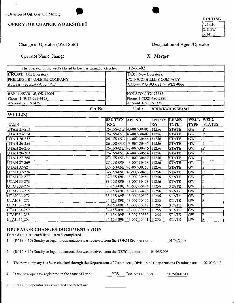
Division of Oil, Gas and MiningROUTING
OPERATOR CHANGE WORKSHEET 1. GLH2. CDW3. FILE
Change of Operator (Well Sold) Designation of Agent/Operator
Operator Name Change X Merger
The operator of the well(s) listed below has changed, effective: 12-31-02FROM: (Old Operator): TO: ( New Operator):PHILLIPS PETROLEUM COMPANY CONOCOPHILLIPS COMPANYAddress: 980 PLAZA OFFICE Address: PO BOX 2197, WL3 4066
BARTLESVILLE, OK 74004 HOUSTON, TX 77252Phone: 1-(918)-661-4415 Phone: 1-(832)-486-2329Account No. N1475 Account No. N2335
CA No. Unit: DRUNKARDS WASH
WELL(S)SEC TWN API NO ENTITY LEASE WELL WELL
NAME RNG NO TYPE TYPE STATUSUTAH 25-253 25-15S-09E 43-007-30401 11256 STATE GW PUTAH 25-254 25-15S-09E 43-007-30402 11256 STATE GW PUTAH 26-257 26-15S-09E 43-007-30444 11256 STATE GW PUTAH 26-256 26-15S-09E 43-007-30445 11256 STATE GW PUTAH 26-255 26-15S-09E 43-007-30446 11256 STATE GW PUTAH 26-267 26-15S-09E 43-007-30514 11256 STATE GW PUTAH 27-268 27-15S-09E 43-007-30457 11256 STATE GW PUTAH 27-269 27-15S-09E 43-007-30458 11256 STATE GW PUTAH 32-82 32-15S-09E 43-007-30257 11256 STATE GW PUTAH 32-276 32-15S-09E 43-007-30483 11256 STATE GW PUTAH 32-277 32-15S-09E 43-007-30484 11256 STATE GW PUTAH 33-273 33-15S-09E 43-007-30493 11256 STATE GW PUTAH 33-274 33-15S-09E 43-007-30494 11256 STATE GW PUTAH 33-275 33-15S-09E 43-007-30495 11256 STATE GW PUTAH 33-272 33-15S-09E 43-007-30502 11256 STATE GW PUTAH 34-271 34-15S-09E 43-007-30496 11256 STATE GW PUTAH 34-270 34-15S-09E 43-007-30347 11256 STATE GW PUTAH 34-259 34-15S-09E 43-007-30456 11256 STATE GW PUTAH 34-258 34-15S-09E 43-007-30552 11256 STATE GW PUTAH 35-263 35-15S-09E 43-007-30441 11256 STATE GW P
OPERATOR CHANGES DOCUMENTATIONEnter date after each listed itemis completed
1. (R649-8-10) Sundry or legal documentation was received from the FORMER operator on: 01/08/2003
2. (R649-8-10) Sundry or legal documentation was received from the NEW operator on: 01/08/2003
3. The new company has been checked through the Department of Commerce, Division of Corporations Database on: 02/03/2003
4. Is the new operator registered in the State of Utah: YES Business Number: 562960-0143
5. If NO, the operator was contacted contacted
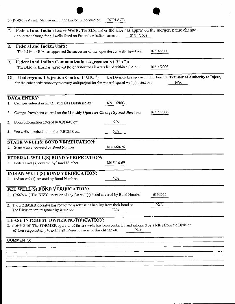
e e6. (R649-9-2)Waste Management Plan has been received on: IN PLACE
7. Federal and Indian Lease Wells: The BLM and or the BIA has approved the merger, name change,or operator change for all wells listed on Federal or Indian leases on: 01/14/2003
8. Federal and Indian Units:The BLM or BIA has approved the successor of unit operator for wells listed on: 01/14/2003
9. Federal and Indian Communization Agreements ("CA"):The BLM or BIA has approved the operator for all wells listed within a CA on: 01/14/2003
10. Underground Injection Control ("UIC") The Division has approved UIC Form 5, Transfer of Authority to Inject,
for the enhanced/secondary recovery unit/project for the water disposal well(s) listed on: N/A
DATA ENTRY:1. Changes entered in the Oil and Gas Database on: 02/11/2003
2. Changes have been entered on the Monthly Operator Change Spread Sheet on: 02/11/2003
3. Bond information entered in RBDMS on: N/A
4. Fee wells attached to bond in RBDMS on: N/A
STATE WELL(S) BOND VERIFICATION:1. State well(s) covered by Bond Number: 8140-60-24
FEDERAL WELL(S) BOND VERIFICATION:1. Federal well(s) covered by Bond Number: 8015-16-69
INDIAN WELL(S) BOND VERIFICATION:1. Indian well(s) covered by Bond Number: N/A
FEE WELL(S) BOND VERIFICATION:1. (R649-3-1) The NEW operator of any fee we11(s) listed covered by Bond Number 6196922
2. The FORMER operator has requested a release of liability from their bond on: N/AThe Division sent response by letter on: N/A
LEASE INTEREST OWNER NOTIFICATION:3. (R649-2-10) The FORMER operator of the fee wells has been contacted and informed by a letter from the Division
of their responsibility to notify all interest owners of this change on: N/A
COM
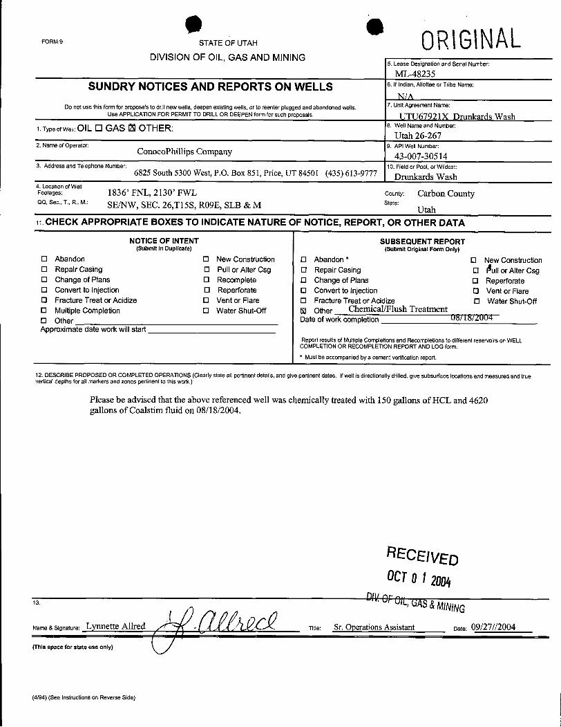
FORMS STATEOFUTAH 0R\G\NALDIVISION OF OIL, GAS AND MINING
5. Lease Designation and Serial Number:
ML-48235
SUNDRY NOTICES AND REPORTS ON WELLS 6.Ifindian,AllotteeorTribeName:
N/A7. Unit Agreement Name:Do not use this form for proposals to drill newwells, deepen existingwells,or to reenter plugged and abandoned wells.
Use APPLICATION FOR PERMIT TO DRILL OR DEEPEN form for such proposals UTU67921X Drunkards Wash1.TypeofWell:OILO GAS 13 OTHER: 8. WellNameandNumber:
Utah 26-2672. Name of Operator: 9. API Well Number:
ConocoPhillips Company 43-007-305143. Address and Telephone Number: 10. Field or Pool, or Wildcat:
6825 South 5300 West, P.O. Box 851, Price, UT 84501 (435) 613-9777Drunkards Wash
4. Location ofWellFootages: 1836' FNL, 2130' FWL County: Carbon CountyQQ. Sec., T., R., M.: SE/NW, SEC. 26,T15S, RO9E, SLB & M state:
Utah19.CHECK APPROPRIATE BOXES TO INDICATE NATURE OF NOTICE, REPORT, OR OTHER DATA
NOTICE OF INTENT SUBSEQUENT REPORT(Submit in Dupilcate) (Submit Original Form Only)
O Abandon O New Construction O Abandon * O New ConstructionO Repair Casing O Pull or Alter Csg O Repair Casing O Aullor Alter CsgO Change of Plans O Recomplete O Change of Plans O ReperforateO Convert to Injection O Reperforate O Convert to injection O Vent or FlareO Fracture Treat or Acidize O Vent or Flare O Fracture Treat or Acidize O Water Shut-OffO Multiple Completion O Water Shut-Off 5|| Other Chemical/Flush TreatmentO Other Date of work completion 08/18/AÛ04Approximate date work willstart
Report results of Multiple Completionsand Recompletions to different reservoirson WELLCOMPLETlON OR RECOMPLETION REPORT AND LOG form.* Must be accompaniedby a cement verificationreport.
12. DESCRIBE PROPOSED OR COMPLETED OPERATIONS (Clearly state all pertinent details, and give pertinent dates. Ifwell is directionally drilled, give subsurface locations and measured and trueverticaldepths for all markers and zones pertinent to this work.)
Please be advised that the above referenced well was chemically treated with 150 gallons of HCL and 4620gallons of Coalstim fluid on 08/18/2004.
RECEIVEDOCTO12004
13. A OfOIL,GAS&MININGName & Signature: Lynnette Allred Titie: Sr. Operations Assistant Date: 09/27//2004
(This space for state use only)
(4/94) (See Instructions on Reverse
Related Documents


