Comprehensive Study Report November 2011 Detour Lake Gold Mine Canadian Environmental Assessment Agency Agence canadienne d’évaluation environnementale Canadian Environmental Assessment Agency

Welcome message from author
This document is posted to help you gain knowledge. Please leave a comment to let me know what you think about it! Share it to your friends and learn new things together.
Transcript
Comprehensive Study Report
November 2011
Detour Lake Gold Mine Canadian Environmental Assessment Agency
Agence canadienned’évaluation environnementale
Canadian EnvironmentalAssessment Agency

Photos are credited to Detour Gold
© Her Majesty the Queen in Right of Canada
This publication may be reproduced for personal use without permission, provided the source is fully acknowledged. However, multiple copy reproduction of this publication in whole or in part for purposes of distribution requires the prior written permission of the Minister of Public Works and Government Services Canada, Ottawa, Ontario. To request permission, contact [email protected].
Catalogue No.: En106-105/2011E
ISBN: 978-1-100-19543-8
This document has been issued in French under the title Rapport d’étude approfondie de la mine d’or de Detour Lake
Alternative formats may be requested by contacting [email protected]
CEAA— Comprehensive Study Report: Detour Lake Gold Mine i
Executive Summary
Detour Gold Corporation (the proponent) proposes to redevelop an open pit gold mine with a production capacity of approximately 61,200 tonnes per day. The proposed Detour Lake project (the Project) will be located 185 kilometres by road northeast of Cochrane, Ontario. The Project consists of an open pit mine, an ore processing plant, and tailings and waste rock storage facilities. It also includes site access roads, power transmission lines, an explosives factory and storage areas, water management facilities, buildings, ancillary mine infrastructure, and associated activities.
An environmental assessment (EA) of the Project under the Canadian Environmental Assessment Act (the Act) has been conducted because regulatory decisions by Fisheries and Oceans Canada (DFO) and Natural Resources Canada (NRCan) are required. In addition, the listing of water bodies as tailings impoundment areas is required under the Metal Mining Effluent Regulations.
A comprehensive study type environmental assessment was necessary since the project’s metal mill, gold mine, and groundwater extraction elements fall under requirements listed in the Comprehensive Study List Regulations. The proposed project is considered a major resource project and is therefore subject to the provisions of the Cabinet Directive on Improving the Performance of the Regulatory System for Major Resource Projects.
The Project also underwent environmental assessments under Ontario’s Environmental Assessment Act. In accordance with the Canada–Ontario Agreement on Environmental Cooperation, cooperative environmental assessment processes involving both jurisdictions were conducted.
The Canadian Environmental Assessment Agency (the Agency) prepared this comprehensive study report in consultation with DFO and NRCan following a technical review of the proponent’s environmental assessment report and an evaluation of the environmental effects of the Project. Environment Canada, Transport Canada, Health Canada, and Aboriginal Affairs and Northern Development Canada provided additional expert advice.
Valued ecosystem components (VECs) and valued socioeconomic components (VSECs) are notable features of the natural and human environments that are likely to be impacted by the Project. The key components were selected and examined during the environmental assessment process. The EA identified and assessed the following project VECs: air quality, local watercourses and their associated lakes and wetlands, groundwater system, vegetation communities and their relation to terrestrial habitats, wildlife and migratory birds, and species at risk. The following VSECs were identified and assessed: land and resources use, traditional land use, and public health and safety.
Based on the analysis of the nature of the Project and the predicted effects on the VECs and VSECs, the Agency assessed the potential for the proposed project to have significant adverse impacts on the environment. This review was completed on the basis of the technical information provided by the proponent, advice provided by federal and provincial experts, and comments provided by Aboriginal groups and public stakeholders through various consultations exercises.
Certain environmental effects were determined to have the greatest severity and elicited the
ii CEAA—Comprehensive Study Report: Detour Lake Gold Mine
most concern during the comprehensive study process; these include impacts to surface and groundwater resources, impact of acid rock drainage, protection of fish and fish habitat, and loss of wildlife habitat.
The key issues raised during public and Aboriginal consultations include the protection of wildlife habitat, water quality, site closure and rehabilitation, and the need for monitoring and environmental management.
The following mitigation measures have been proposed to reduce the predicted severity of the adverse effects of this project:
• in-plant effluent treatment for mill effluent and extensive process water recycle and associated water management strategies to protect receiving water aquatic communities
• fish habitat compensation plans to mitigate the potential harmful alteration, disruption, and destruction of fish habitat
• seepage and runoff collection systems to collect and monitor the quality and quantity of mine effluent prior to discharge into waters frequented by fish
• adaptive management of potentially acid-generating (PAG) waste rock to prevent and mitigate potential impacts to water quality as a result of acid rock drainage (ARD)
• air quality and noise control measures to reduce offsite impacts to local wildlife and forests
• mine infrastructure design and placement to reuse previously disturbed areas and minimize the overall project footprint
• relocation of the operations camp facility to avoid important wildlife habitat and cultural sites
A follow-up program is required under the Act to verify the accuracy of the environmental assessment and to determine the effectiveness of the proposed mitigation measures. In addition, the follow-up program will support environmental management systems and support the assessment of future projects within the boreal forest.
Taking into account the implementation of the mitigation proposed, including commitments made by the proponent in this report, the Canadian Environmental Assessment Agency concludes that the Project is not likely to cause significant adverse environmental effects.
CEAA— Comprehensive Study Report: Detour Lake Gold Mine iii
Executive Summary............................................................................................i List of Acronyms and Short Forms .................................................................. vii 1. Introduction ................................................................................................. 1
1.1 Project Overview ............................................................................................................1 1.2 Environmental Assessment Context and Process ..........................................................1 1.2.1 Purpose of the Comprehensive Study Report .......................................................1 1.2.2 Federal EA Process ...............................................................................................2 1.2.3 Cooperative EA Process ........................................................................................3
2. Scope of the Project ................................................................................... 3
2.1 Scope of the Project .......................................................................................................3 2.2 Project Components .......................................................................................................4 2.2.1 Activities .................................................................................................................4 2.2.2 Schedule ................................................................................................................4
3. Scope of the Environmental Assessment ................................................... 5 3.1 Factors to be Considered ................................................................................................5 3.2 Scope of the Valued Ecosystem and Socioeconomic Components ...............................6 3.3 Spatial and Temporal Boundaries ...................................................................................7 3.4 Purpose of and Need for the Project ..............................................................................8
4. Project Alternatives ..................................................................................... 8 4.1 Alternatives to the Project ...............................................................................................9 4.2 Alternative Means of Carrying out the Project .................................................................9
5. Consultation ..............................................................................................11 5.1 Public Consultation Activities ........................................................................................11 5.2 Aboriginal Consultation Activities ..................................................................................11 5.3 Summary of Comments Received ................................................................................12 5.4 Consultation Follow-Up .................................................................................................13
Table of Contents
iv CEAA—Comprehensive Study Report: Detour Lake Gold Mine
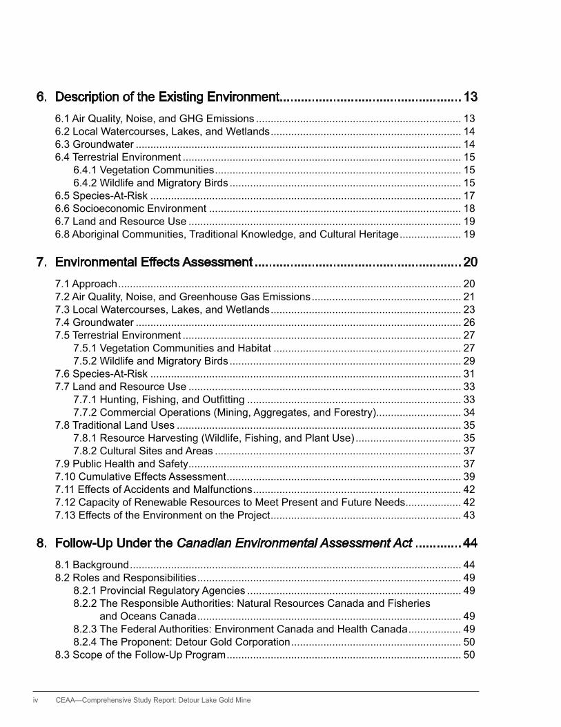
6. Description of the Existing Environment ................................................... 13 6.1 Air Quality, Noise, and GhG Emissions ...................................................................... 13 6.2 Local Watercourses, Lakes, and Wetlands ................................................................. 14 6.3 Groundwater ............................................................................................................... 14 6.4 Terrestrial Environment ............................................................................................... 15 6.4.1 Vegetation Communities .................................................................................... 15 6.4.2 Wildlife and Migratory Birds ............................................................................... 15 6.5 Species-At-Risk .......................................................................................................... 17 6.6 Socioeconomic Environment ...................................................................................... 18 6.7 Land and Resource Use ............................................................................................. 19 6.8 Aboriginal Communities, Traditional Knowledge, and Cultural heritage ..................... 19
7. Environmental Effects Assessment .......................................................... 20 7.1 Approach ..................................................................................................................... 20 7.2 Air Quality, Noise, and Greenhouse Gas Emissions ................................................... 21 7.3 Local Watercourses, Lakes, and Wetlands ................................................................. 23 7.4 Groundwater ............................................................................................................... 26 7.5 Terrestrial Environment ............................................................................................... 27 7.5.1 Vegetation Communities and habitat ................................................................ 27 7.5.2 Wildlife and Migratory Birds ............................................................................... 29 7.6 Species-At-Risk .......................................................................................................... 31 7.7 Land and Resource Use ............................................................................................. 33 7.7.1Hunting,Fishing,andOutfitting ......................................................................... 33 7.7.2 Commercial Operations (Mining, Aggregates, and Forestry) ............................. 34 7.8 Traditional Land Uses ................................................................................................. 35 7.8.1 Resource harvesting (Wildlife, Fishing, and Plant Use) .................................... 35 7.8.2 Cultural Sites and Areas .................................................................................... 37 7.9 Public health and Safety ............................................................................................. 37 7.10 Cumulative Effects Assessment ................................................................................ 39 7.11 Effects of Accidents and Malfunctions ....................................................................... 42 7.12 Capacity of Renewable Resources to Meet Present and Future Needs ................... 42 7.13 Effects of the Environment on the Project ................................................................. 43
8. Follow-Up Under the Canadian Environmental Assessment Act ............. 44 8.1 Background ................................................................................................................. 44 8.2 Roles and Responsibilities .......................................................................................... 49 8.2.1 Provincial Regulatory Agencies ......................................................................... 49 8.2.2 The Responsible Authorities: Natural Resources Canada and Fisheries
and Oceans Canada .......................................................................................... 49 8.2.3 The Federal Authorities: Environment Canada and health Canada .................. 49 8.2.4 The Proponent: Detour Gold Corporation .......................................................... 50 8.3 Scope of the Follow-Up Program ................................................................................ 50
CEAA— Comprehensive Study Report: Detour Lake Gold Mine v
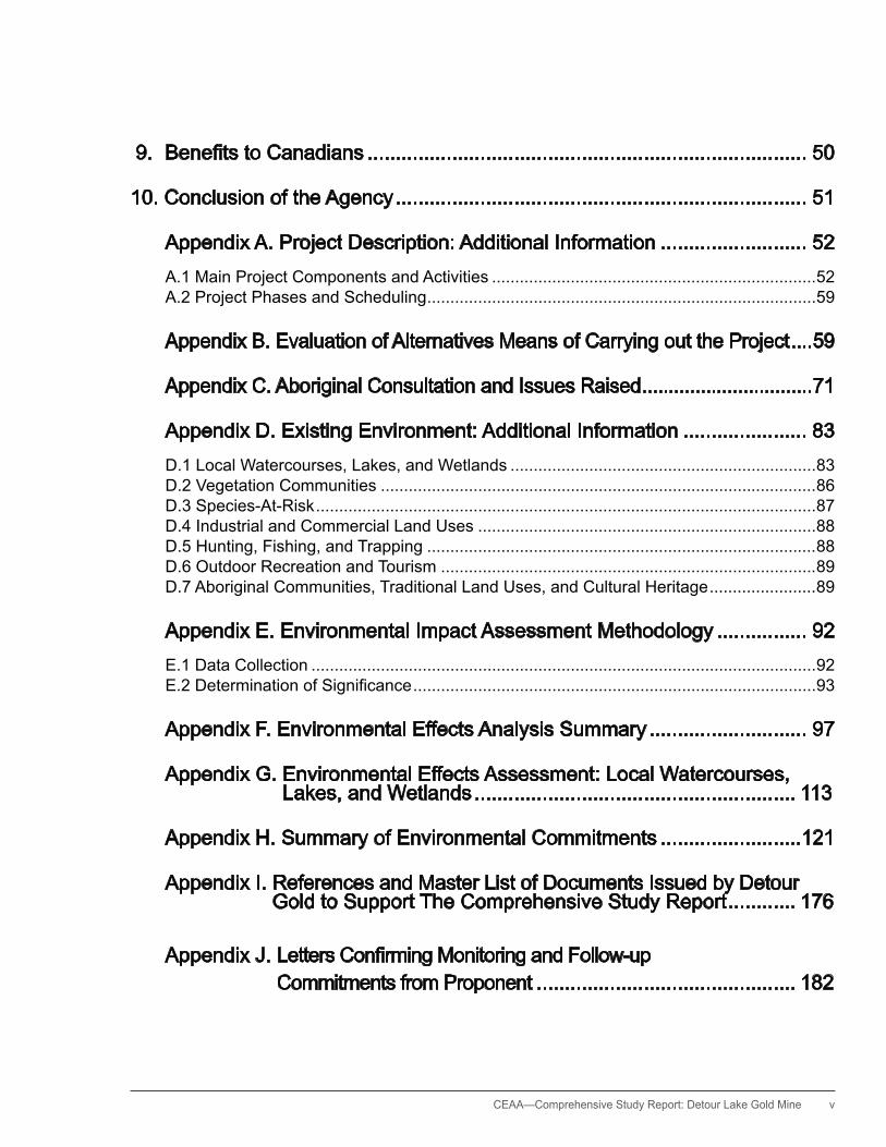
9. BenefitstoCanadians .............................................................................. 50
10. Conclusion of the Agency ......................................................................... 51
Appendix A. Project Description: Additional Information .......................... 52 A.1 Main Project Components and Activities ......................................................................52 A.2 Project Phases and Scheduling ....................................................................................59
Appendix B. Evaluation of Alternatives Means of Carrying out the Project ....59
Appendix C. Aboriginal Consultation and Issues Raised ................................71
Appendix D. Existing Environment: Additional Information ...................... 83 D.1 Local Watercourses, Lakes, and Wetlands ..................................................................83 D.2 Vegetation Communities ..............................................................................................86 D.3 Species-At-Risk ............................................................................................................87 D.4 Industrial and Commercial Land Uses .........................................................................88 D.5 hunting, Fishing, and Trapping ....................................................................................88 D.6 Outdoor Recreation and Tourism .................................................................................89 D.7 Aboriginal Communities, Traditional Land Uses, and Cultural heritage .......................89
Appendix E. Environmental Impact Assessment Methodology ................ 92 E.1 Data Collection .............................................................................................................92 E.2DeterminationofSignificance .......................................................................................93
Appendix F. Environmental Effects Analysis Summary ............................ 97
Appendix G. Environmental Effects Assessment: Local Watercourses, Lakes, and Wetlands ......................................................... 113
Appendix h. Summary of Environmental Commitments .........................121
Appendix I. References and Master List of Documents Issued by Detour Gold to Support The Comprehensive Study Report ............ 176
Appendix J. LettersConfirmingMonitoringandFollow-up Commitments from Proponent .............................................. 182
vi CEAA—Comprehensive Study Report: Detour Lake Gold Mine
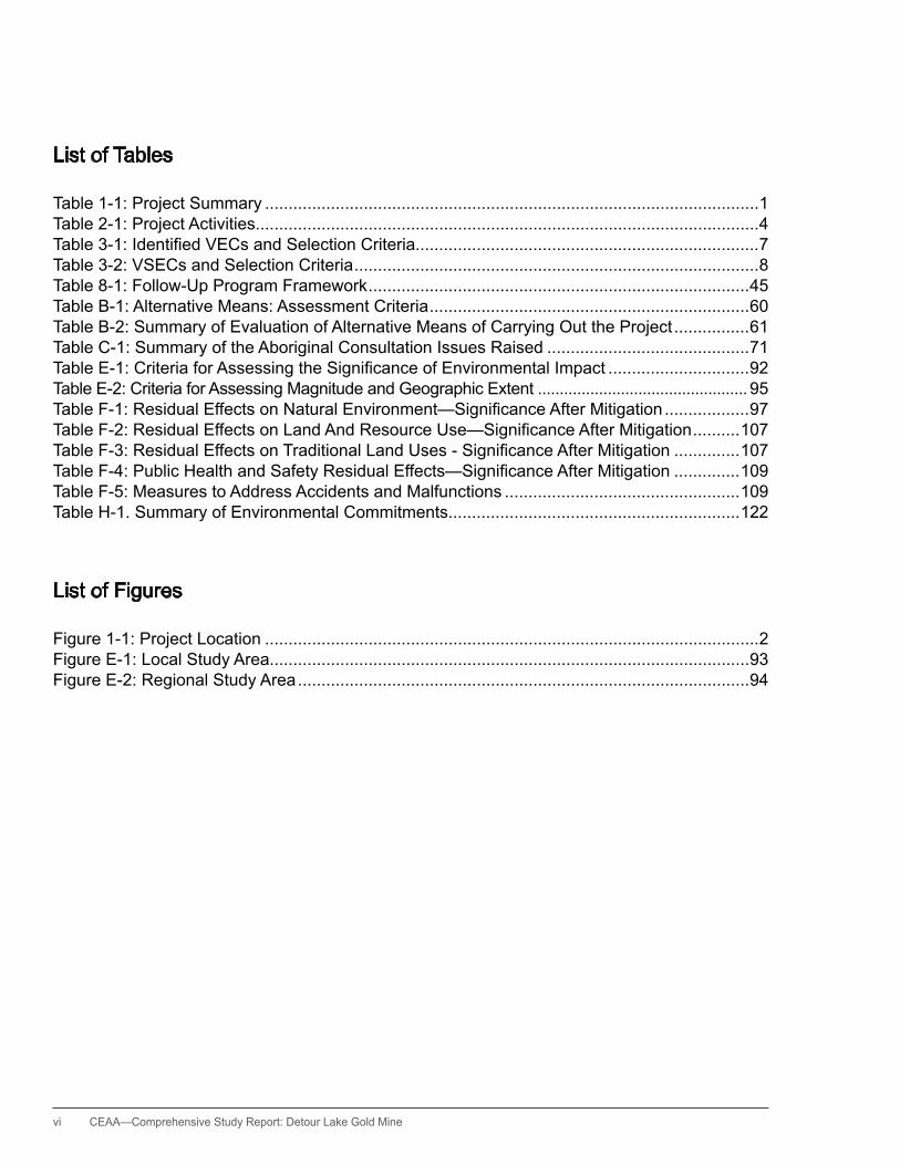
List of Tables
Table 1-1: Project Summary .........................................................................................................1Table 2-1: Project Activities...........................................................................................................4Table3-1:IdentifiedVECsandSelectionCriteria.........................................................................7Table 3-2: VSECs and Selection Criteria ......................................................................................8Table 8-1: Follow-Up Program Framework .................................................................................45Table B-1: Alternative Means: Assessment Criteria ....................................................................60Table B-2: Summary of Evaluation of Alternative Means of Carrying Out the Project ................61Table C-1: Summary of the Aboriginal Consultation Issues Raised ...........................................71TableE-1:CriteriaforAssessingtheSignificanceofEnvironmentalImpact ..............................92Table E-2: Criteria for Assessing Magnitude and Geographic Extent ................................................ 95TableF-1:ResidualEffectsonNaturalEnvironment—SignificanceAfterMitigation ..................97TableF-2:ResidualEffectsonLandAndResourceUse—SignificanceAfterMitigation ..........107TableF-3:ResidualEffectsonTraditionalLandUses-SignificanceAfterMitigation ..............107TableF-4:PublicHealthandSafetyResidualEffects—SignificanceAfterMitigation ..............109Table F-5: Measures to Address Accidents and Malfunctions ..................................................109 Table h-1. Summary of Environmental Commitments..............................................................122
List of Figures
Figure 1-1: Project Location .........................................................................................................2Figure E-1: Local Study Area......................................................................................................93Figure E-2: Regional Study Area ................................................................................................94

CEAA— Comprehensive Study Report: Detour Lake Gold Mine vii
List of Acronyms and Short Forms
A annum AAND Aboriginal Affairs and Northern DevelopmentAAQC ambient air quality criteria AMEC AMEC Earth and EnvironmentalAmsl above mean sea levelANFO ammonium nitrate fuel oilANSI area of natural and scientific interestARD acid rock drainageCDSSAB Cochrane District Social Services Administration BoardCEA Agency Canadian Environmental Assessment AgencyCEAA Canadian Environmental Assessment ActCEAR Canadian Environmental Assessment RegistryCEQG Canadian Environmental Quality GuidelinesCNWAD weak acid dissociable cyanideCO carbon monoxideCO2 carbon dioxideCSQG Canadian sediment quality guidelinesCSR comprehensive study reportCEQG Canadian environmental quality guidelinesdBA A-weighted decibelsDetour Gold Detour Gold CorporationDFO Fisheries and Oceans CanadaDLP Detour Lake ProjectDLM Detour Lake Mine (historical operations)EA environmental assessmentEAG Environmental Applications GroupEC Environment CanadaEPP environmental protection planEPT Ephemeroptera–Plecoptera–TrichopteraERS emergency response strategyESA Endangered Species ActESR Environmental Study ReportFA federal authorityFWCA Fish and Wildlife Conservation Act
viii CEAA—Comprehensive Study Report: Detour Lake Gold Mine
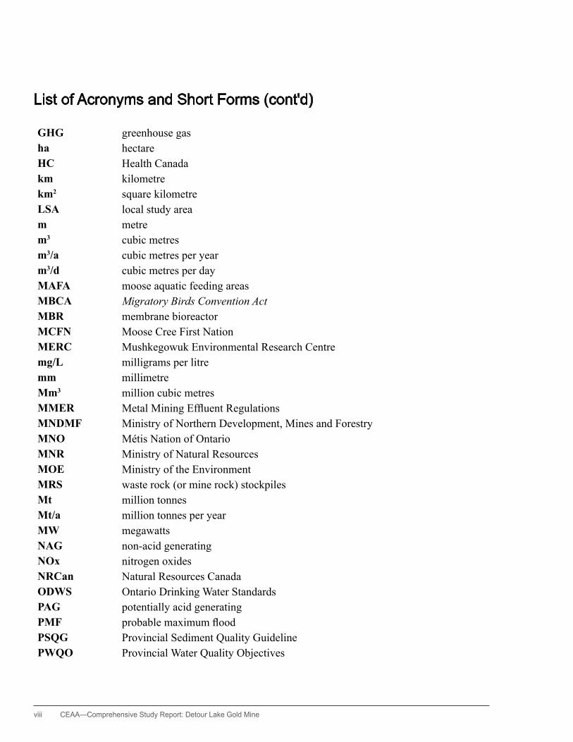
GHG greenhouse gasha hectareHC Health Canadakm kilometre km2 square kilometre LSA local study area m metre m3 cubic metres m3/a cubic metres per year m3/d cubic metres per day MAFA moose aquatic feeding areas MBCA Migratory Birds Convention ActMBR membrane bioreactor MCFN Moose Cree First Nation MERC Mushkegowuk Environmental Research Centre mg/L milligrams per litre mm millimetre Mm3 million cubic metres MMER Metal Mining Effluent RegulationsMNDMF Ministry of Northern Development, Mines and ForestryMNO Métis Nation of OntarioMNR Ministry of Natural Resources MOE Ministry of the Environment MRS waste rock (or mine rock) stockpiles Mt million tonnes Mt/a million tonnes per year MW megawatts NAG non-acid generating NOx nitrogen oxides NRCan Natural Resources Canada ODWS Ontario Drinking Water Standards PAG potentially acid generating PMF probable maximum flood PSQG Provincial Sediment Quality Guideline PWQO Provincial Water Quality Objectives
List of Acronyms and Short Forms (cont'd)
CEAA— Comprehensive Study Report: Detour Lake Gold Mine ix
RA responsible authority ROW right-of-way RSA regional study area SAR species-at-risk SARA Species at Risk Act SO2 sulphur dioxide t tonne TC Transport Canada TIA tailings impoundment (or tailings management) area TEK traditional ecological knowledge TK traditional knowledge TLU traditional land use tpa tonnes per annum (year) tpd tonnes per day TS transformer station TSS total suspended solids TTN Taykwa Tagamou Nation VEC valued ecosystem component VSEC valued socioeconomic component WFN Wahgoshig First Nation WHS Woodland Heritage Services Limited WMU wildlife management unit WSA White Spruce ArchaeologyWSC Water Survey of Canada

1 CEAA—Comprehensive Study Report: Detour Lake Gold Mine
1. Introduction
1.1 Project Overview
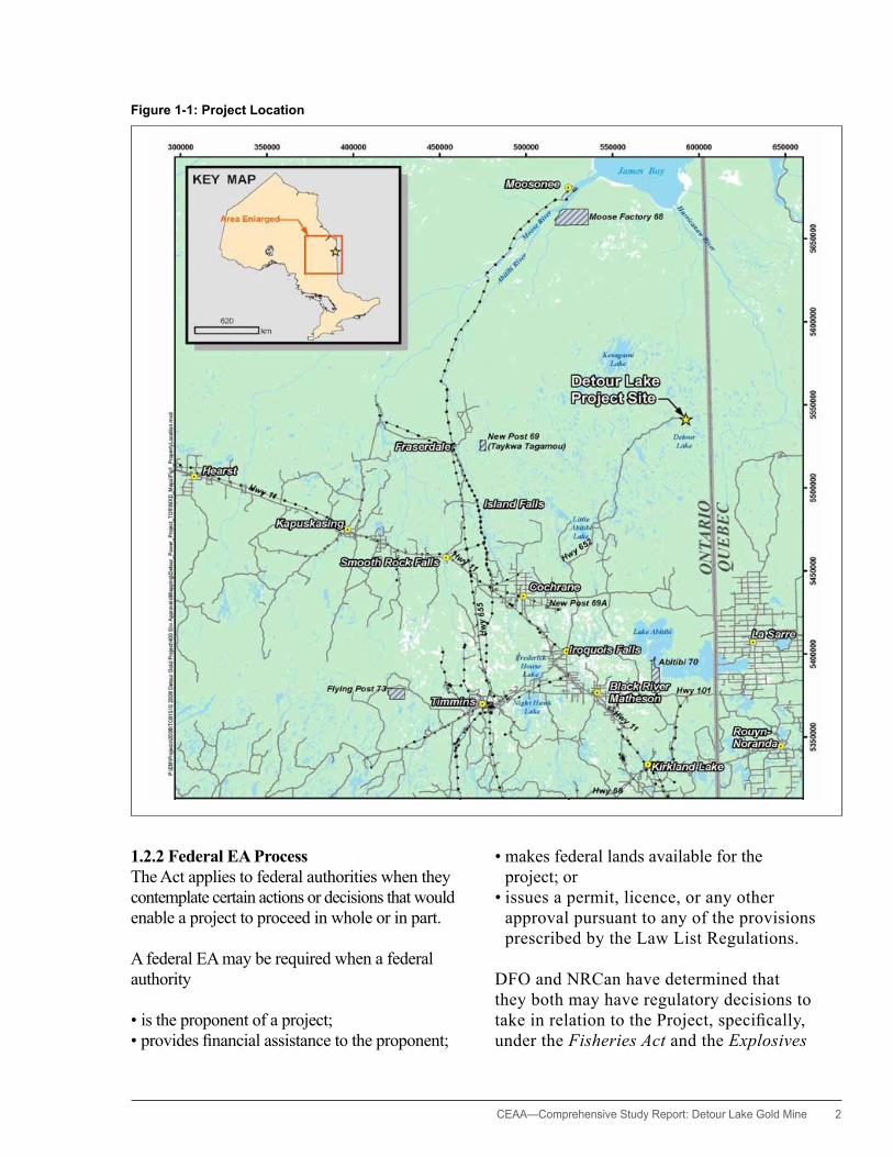
The Detour Gold Corporation (the proponent) is proposing to develop an open pit gold mine located on the northern edge of the Canadian Shield in northeastern Ontario. As shown in Figure 1, the proposed Detour Lake Project (the Project) site is located approximately 185 kilometres by road northeast of Cochrane, Ontario.
1.2 Environmental Assessment Context and Process
1.2.1 Purpose of the Comprehensive Study Report The purpose of this comprehensive study report (CSR) is to provide a summary of the information and analysis that the Canadian
Environmental Assessment Agency (the Agency) considered in reaching its conclusion on whether the Project is likely to cause significant adverse environmental effects. The Minister of the Environment will consider this report and comments received from the public and Aboriginal groups when issuing the environmental assessment (EA) decision statement.
The Minister may request additional information or require that public concerns be addressed further before issuing the EA decision statement. Following the EA decision statement, the Minister will refer the Project back to Fisheries and Oceans Canada (DFO) and Natural Resources Canada (NRCan) to allow them to make the appropriate course of action decision.
Table 1-1: Project Summary
Project Summary The Project will consist of an open pit mine with a production capacity of approximately 61,200 tonnes per day, an ore processing plant, tailings and waste rock storage facilities, site access roads, power transmission lines, explosives factory and magazines, water management facilities, buildings, ancillary mine infrastructure, and associated activities.
Proponent Detour Gold CorporationMr. Gerald S. Panneton, President, CEO, and Director2200–200 Bay Street, Box #23Toronto, ON M5J 2J1www.detourgold.com
Location UTM 594000E, 5542000N (NAD 83 Zone 17) (latitude 50° 01' 10.85', longitude 79° 42' 09.90' W)
Environmental Assessment Contact
Canadian Environmental Assessment Agency Project Manager, Steven WoolfendenSuite 907, 55 St. Clair Avenue EastToronto, ON M4T 1M2Telephone: 416-952-7006Fax: [email protected]
Canadian Environmental Assessment Registery
http://www.ceaa-acee.gc.ca/050/index-eng.cfm File number: 10-03-52262
Provincial Environmental Assessment (Ontario)
http://www.ene.gov.on.ca/environment/en/industry/assessment_and_approvals/environmental_assessments/projects/STDPROD_082739?page=2
http://www.ene.gov.on.ca/environment/en/industry/assessment_and_approvals/environmental_assessments/projects/STDPROD_082738.html?page=3
CEAA— Comprehensive Study Report: Detour Lake Gold Mine 2
Figure 1-1: Project Location
1.2.2 Federal EA ProcessThe Act applies to federal authorities when they contemplate certain actions or decisions that would enable a project to proceed in whole or in part.
A federal EA may be required when a federal authority
• is the proponent of a project; • provides financial assistance to the proponent;
• makes federal lands available for the project; or
• issues a permit, licence, or any other approval pursuant to any of the provisions prescribed by the Law List Regulations.
DFO and NRCan have determined that they both may have regulatory decisions to take in relation to the Project, specifically, under the Fisheries Act and the Explosives

3 CEAA—Comprehensive Study Report: Detour Lake Gold Mine
Act respectively. DFO and NRCan are thus designated as responsible authorities for the EA and the regulatory phases. Also, pursuant to section 36(5)(a–e) of the Fisheries Act, the Governor in Council may amend Schedule 2 of the Metal Mining Effluent Regulations (MMER) to add one or more water bodies as tailings impoundment areas. These decisions, which would enable this project to proceed, trigger the requirement for an EA of the Project in accordance with the Act.
The proposed project is subject to a comprehensive study type EA because components of the Project are described in sections 10 and 16 (b) and (c) of the Act’s Comprehensive Study List Regulations. These items include the construction, decommissioning, or abandonment of
• a facility for the extraction of 200,000 cubic metres per year or more of ground water;
• a metal mill with an ore input capacity of 4,000 tonnes per day or more; and
• a gold mine, other than a placer mine, with an ore production capacity of 600 tonnes per day or more.
The Agency is responsible for the conduct of the
comprehensive study…
The Agency is responsible for the conduct of the comprehensive study and prepared this CSR in consultation with DFO and NRCan. Environment Canada (EC), Health Canada (HC), and Aboriginal Affairs and Northern Development Canada (AAND) also provided advice in relation to their respective mandates and areas of expertise. This CSR takes into account the results of the proponent’s technical supporting documentation (Appendix H) along with input from stakeholders and Aboriginal groups in the evaluation of the potential environmental effects of the Project.
1.2.3 Cooperative EA ProcessCertain components of the Project were subject to specific environmental assessments under Ontario’s Environmental Assessment Act. These assessments included two Individual EA processes (for the permanent and contingency power supplies), one Class EA process (for Resource Stewardship and Facility Development Projects), and one Electricity Screening process (for the temporary power supply).
As a result of these EAs, the province of Ontario has issued approvals for the permanent power supply, temporary power supply, and the use of provincial Crown land for additional mine facilities. A provincial EA decision on the contingency power supply is still outstanding and is expected in January 2012. For further information, please refer to the links provided in Table 1-1, under Provincial Environmental Assessment (Ontario).
The governments of Canada and Ontario conducted the necessary
EAs cooperatively
The governments of Canada and Ontario conducted the necessary EAs cooperatively according to conditions of the Canada–Ontario Agreement on Environmental Assessment Cooperation (Cooperation Agreement).
2. Scope of the Project
2.1 Scope of the Project
The scope of this project for the purposes of the comprehensive study includes all physical works and activities associated with the construction, operation, modification, decommissioning, abandonment, and reclamation of the Project.
CEAA— Comprehensive Study Report: Detour Lake Gold Mine 4
These are described in Section 2 and Appendix A of this report.
2.2 Project Components
The proposed project includes the following components:
• open pit mine and supporting infrastructure o overburden and waste rock management o ore processing facility o mine effluent and tailings management,
including the proposed tailings impoundment area (TIA)
o mine site infrastructure o water supply and drainage works and
facilities o aggregate mining and stockpiles o explosives, manufacturing, handling, and
storage o domestic sewage treatment and disposal o solid waste management, industrial waste
handling and treatment, including hazardous materials
o onsite power supply and power infrastructure, including temporary diesel generation
o onsite access roads and infrastructure o Fisheries Act compensation works to offset
the loss of fish habitat
• transmission line and permanent power supply
o poles or towers and 230 kV overhead line between the Pinard transformer station and the project site
o project site substation o connection facilities at Pinard and Island Falls
transformer stations
2.2.1 ActivitiesActivities required to build and operate the Project are outlined in Table 2-1 and Appendix A.
2.2.2 ScheduleThe construction phase is expected to take about 27 months between 2010 and 2013. The start of production is projected for the first quarter of 2013. Mining and processing will likely be carried out over 16 years. The decommissioning plan provides for most of the reclamation activities to occur within two years after the end of operations.
Table 2-1: Project Activities Construction Operation Decommissioning
•Siteclearingandpreparation
•Constructionoffacilities(on site access roads, processing plant, accommodations, administration complex, truck shop, maintenance building, warehouse, fuel tank farm, and offsite transmission line)
•Dewatering•Overburdenmanagement•Fishhabitat
compensation works•Tailingsandwater
management facilities•Wastemanagementand
disposal
•Mining•Oreprocessing•Miningeffluentand
tailings management•Wasterockmanagement•Fuelandmaterials
management•Explosivesmanufacturing
and handling•Domesticsewage
treatment and disposal•Solidwastemanagement
•Sitereclamation•Floodingofopenpit•Stabilizationandrevegetationofopenpitedge•Constructionofalimetreatmentplant
if required•Disposaloflimesludgefromtreatmentplantwithinflooded
pit at depth•Establishlandfillfordisposalofnon-hazardousdemolition
wastes•Dismantling,cleaning,anddisposalofbuildings,
machinery, equipment, and surface pipelines•Scarificationofheavilycompactedareas•Applicationofoverburden•Revegetation•Establishditches(withsuitablearmouring)withinTIAcells
for runoff management•Sealorremoveweirstructureandemergencyspillway•DismantletransmissionlinesegmentfromIslandFallsto
the project site•Ongoingmonitoringandmanagement
of acid rock drainage and TIA dams

5 CEAA—Comprehensive Study Report: Detour Lake Gold Mine
3. Scope of the Environmental Assessment
The limits of an environmental assessment are established by a process called scoping. This focuses the study on relevant factors and concerns, which are later reported in a project scoping document.
The scope of the federal EA for this project was prepared and published for public comment on the Canadian Environmental Assessment Registry (CEAR) website under the title Description of Factors Considered in the Environmental Assessment (September 1, 2010). The Agency also provided the proponent with guidelines for preparing the technical supporting documentation (December 7, 2010) and a draft comprehensive study report (January 7, 2011).
3.1 Factors to be Considered
Pursuant to subsections 16(1) and 16(2) of the Act, the following factors must be considered as part of a comprehensive study:
• purpose of the project• alternative means of carrying out the project
that are technically and economically feasible, and the environmental effects of any such alternative means
• environmental effects of the project, including the environmental effects of malfunctions or accidents that may occur in connection with the project, and any cumulative environmental effects that are likely to result from the project in combination with other projects or activities that have been or will be carried out
• effects on the capacity of potentially affected renewable resources to meet present and future needs
• significance of the effects• comments received from the public in
accordance with the Act and the regulations
Drill core
Open pit of former mine and proposed for use in the Project
CEAA— Comprehensive Study Report: Detour Lake Gold Mine 6
• technically and economically feasible measures that would mitigate any significant adverse environmental effects of the project
• need for and requirements of any follow-up program in respect of the project
In accordance with paragraph 16(1)(e) of the Act, the Agency determined that the assessment would include a description of the need for the project, an evaluation of alternatives to the project, and an articulation of the benefits to Canadians as a result of the EA process.
3.2 Scope of the Valued Ecosystem and Socioeconomic Components
In determining significant environmental effects, the environmental assessment focuses on aspects of the natural and human environment that have particular value or importance and are likely to be impacted by the project. These aspects are termed valued ecosystem components (VECs) and valued socioeconomic components (VSECs).
The Agency determined the scope of the VECs and VSECs to be considered in this comprehensive study based on data from a variety of sources: baseline studies (including Aboriginal traditional knowledge studies), literature sources, and an analysis of the potential for the proposed works and activities to cause adverse environmental effects prior to mitigation being applied. An initial evaluation of the likely project-environment interactions, based on individual ecosystem components, was carried out and compiled within Table 1.0 of the Comprehensive Study Report Guidelines for Detour Gold Corporation; this is available on the CEAR website.
Based on the proponent’s assessment of the individual ecosystem components, the Agency identified six VECs and three VSECs that are likely to be impacted by the Project. Each of these VECs
and VSECs may encompass more than one of the ecosystem components as studied by the proponent. For example, the VEC of local watercourses, lakes, and wetlands includes the individual drainage systems, physical changes in surface waters, and the effects on the aquatic biology.
VECs have been identified on the basis of meeting one or more of the following criteria:
• area of notable biological diversity • important habitat for locally valued species • important habitat for uncommon, rare or
unusual species • important corridor or linkage for fish or wildlife
movement • sensitive receiving-water environment• species-at-risk (SAR) • notable species or species groups • indicator of environmental health• important component to the function of other
ecosystem elements or functions• component with economic or cultural
significance• component with educational, scientific,
aesthetic, or legislative significance• component with provincial, national, or
international significance
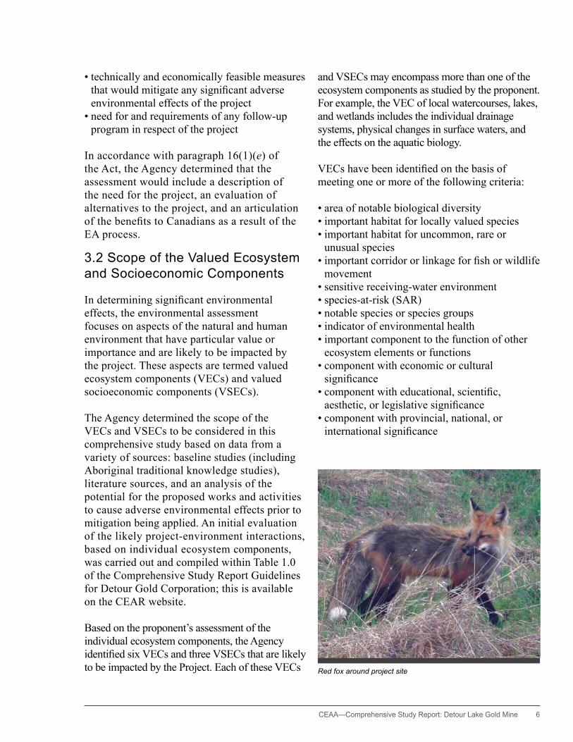
Red fox around project site
7 CEAA—Comprehensive Study Report: Detour Lake Gold Mine
VSECs are aspects of the socioeconomic environment that are significant to people’s values and quality of life. Key VSECs were selected based on whether they were identified or valued
• by the public, Aboriginal groups and stakeholders who will be potentially affected by the Project and are therefore consulted in project planning and implementation,
• by government agencies reviewing the environmental assessment, and
• based on professional judgment.
The selected VECs and VSECs for this project are identified in Table 3-1 and Table 3-2, and the
potential environmental effects of the Project on them are described in Sections 6 and 7 respectively.
3.3 Spatial and Temporal Boundaries
In general, the spatial boundary for the comprehensive study reflects the geographic range over which the project’s environmental effects may occur. Specific spatial boundaries were considered for each of the VECs and VSECs.
The VEC natural environment baseline local study area (LSA) includes all the subwatersheds that drain from the project site and could contain planned facilities, adjacent portions of the Detour
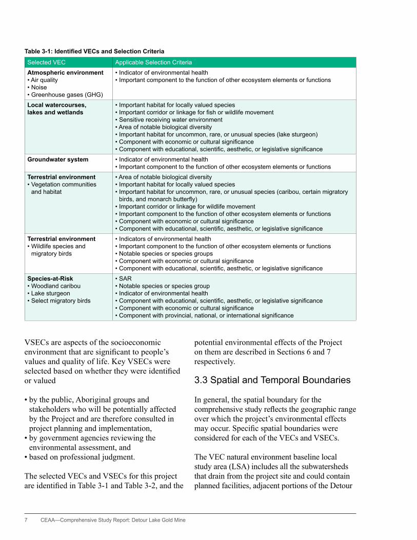
Table 3-1: Identified VECs and Selection Criteria
Selected VEC Applicable Selection Criteria
Atmospheric environment•Air quality•Noise•Greenhouse gases (GhG)
•Indicator of environmental health•Important component to the function of other ecosystem elements or functions
Local watercourses, lakes and wetlands
•Importanthabitatforlocallyvaluedspecies•Importantcorridororlinkageforfishorwildlifemovement•Sensitivereceivingwaterenvironment•Areaofnotablebiologicaldiversity•Importanthabitatforuncommon,rare,orunusualspecies(lakesturgeon)•Componentwitheconomicorculturalsignificance•Componentwitheducational,scientific,aesthetic,orlegislativesignificance
Groundwater system •Indicatorofenvironmentalhealth•Importantcomponenttothefunctionofotherecosystemelementsorfunctions
Terrestrial environment•Vegetationcommunities
and habitat
•Areaofnotablebiologicaldiversity•Importanthabitatforlocallyvaluedspecies•Importanthabitatforuncommon,rare,orunusualspecies(caribou,certainmigratorybirds,andmonarchbutterfly)
•Importantcorridororlinkageforwildlifemovement•Importantcomponenttothefunctionofotherecosystemelementsorfunctions•Componentwitheconomicorculturalsignificance•Componentwitheducational,scientific,aesthetic,orlegislativesignificance
Terrestrial environment•Wildlifespeciesand
migratory birds
•Indicatorsofenvironmentalhealth•Importantcomponenttothefunctionofotherecosystemelementsorfunctions•Notablespeciesorspeciesgroups•Componentwitheconomicorculturalsignificance•Componentwitheducational,scientific,aesthetic,orlegislativesignificance
Species-at-Risk•Woodlandcaribou•Lakesturgeon•Selectmigratorybirds
•SAR•Notablespeciesorspeciesgroup•Indicatorofenvironmentalhealth•Componentwitheducational,scientific,aesthetic,orlegislativesignificance•Componentwitheconomicorculturalsignificance•Componentwithprovincial,national,orinternationalsignificance

CEAA— Comprehensive Study Report: Detour Lake Gold Mine 8
River (see Figure E1), and a 1 kilometre buffer on either side of the proposed transmission line route. Caribou were assessed within Woodland Caribou Range 7 which extends from south James Bay in the north to Lake Abitibi in the south, and from the Québec border in the east to near Kapuskasing in the west (MNR 2009, 2010).
The VSEC regional study area (RSA) for the socioeconomic components includes the communities that are likely to experience direct and indirect employment and economic benefits (see Figure E2). It also includes the overlapping traditional territories of the Moose Cree First Nation (MCFN), Taykwa Tagamou Nation (TTN), and Wahgoshig First Nation (WFN), as well as areas used by local Métis communities. This area includes the reserves of MCFN, TTN, and the WFN, and the local communities of Iroquois Falls, Moosonee, Cochrane, and Smooth Rock Falls.
The temporal boundaries will encompass the entire lifespan of the Project. Most of the abandonment and reclamation work is planned to be completed within two years following closure, some aspects of the project reclamation, such as filling of the pit with water may extend up to 120 years depending on environmental conditions and successful completion of the plan.
3.4 Purpose of and Need for the Project
The purpose of the Project is to develop a gold resource by means of an open pit mine and onsite processing to produce doré bars that will be shipped to market. The need for the Project is to enable the proponent to meet its business objectives and mandate to produce and sell gold that will be used for jewellery and industrial purposes.
4. Project Alternatives
Based on paragraph 16(1)(3) of the Act, the Agency required that the proponent assess alternatives to the project as part of a comprehensive study. Alternatives to the project are functionally different ways to meet the Project’s need and purpose. As well, in accordance with paragraph 16(2)(b) of the Act, the comprehensive study process included consideration of the alternative means of carrying out the project that are technically and economically feasible and the environmental effects of any such alternative means. The evaluation of both of these factors is presented in the following sections, based on evaluations conducted by the proponent.
Table 3-2: VSECs and Selection Criteria
Selected VSEC Applicable Selection Criteria
Land and resource use 1.Hunting,fishing,andoutfitting
2. Commercial operations
•Identifiedorvaluedbythepublic,Aboriginalgroups,andotherstakeholderswhowillpotentially be affected by the Project and are therefore consulted in project planning and implementation
•Identifiedorvaluedbygovernmentagenciesreviewingtheenvironmentalassessment•IdentifiedaspotentiallyaffectedbytheProjectbasedonprofessionaljudgment
Traditional land use1. harvesting2. Cultural sites and areas
•Identifiedorvaluedbythepublic,Aboriginalgroups,andotherstakeholderswhowillpotentially be affected by the Project and are therefore consulted in project planning and implementation
•Identifiedorvaluedbygovernmentagenciesreviewingtheenvironmentalassessment•IdentifiedaspotentiallyaffectedbytheProjectbasedonprofessionaljudgment
Public health and safety •Identifiedorvaluedbythepublic,Aboriginalgroups,andotherstakeholderswhowillpotentially be affected by the Project and are therefore consulted in project planning and implementation
•Identifiedorvaluedbygovernmentagenciesreviewingtheenvironmentalassessment

9 CEAA—Comprehensive Study Report: Detour Lake Gold Mine
Alternatives to the project are functionally different ways to meet the
Project’s need and purpose.
4.1 Alternatives to the Project
The proponent has indicated that alternatives to the proposed project are constrained by the location of the ore body and by the proponent’s purpose, which is to develop a gold resource. The proponent has determined that there are three project alternatives:
1. proceed with the Project in the near-term, as planned
2. delay the Project until circumstances for its development are more favourable
3. abandon the Project
The environmental effects associated with the first two alternatives would be essentially the same, with the exception of the timeframes. The proponent has indicated that delaying the Project is not practical given the particular conditions needed to proceed— that is, favourable gold prices and overall
project economics. Any delay may result in unfavourable conditions in the demand for or price of gold.
The third alternative would have no adverse natural or socioeconomic environmental effects. However, there would be a loss of the positive socioeconomic effects associated with the project’s development: specifically, employment, business and training opportunities, and additional benefits through Aboriginal agreements. Opportunities to compare the project alternatives are limited, but abandoning the Project would not fulfill the proponent’s purpose.
In considering all of the above, the proponent has advised that proceeding with the Project in the near-term, as planned, is the preferred alternative, and is the only alternative that fulfills the project purpose.
4.2 Alternative Means of Carrying Out the Project
The proponent considered alternative means of carrying out this project in relation to the following project activities:
Birds present around project site

CEAA— Comprehensive Study Report: Detour Lake Gold Mine 10
• mining methods• explosives use• waste rock and overburden management• waste rock and tailings disposal• mining effluent management• mill effluent treatment and tailings
management• site infrastructure• water requirements and supply• aggregates• domestic sewage treatment and disposal• solid waste management• onsite power supply• transmission line and permanent power supply• road access• airstrip• reclamation alternatives
The proponent used performance objectives and acceptability criteria to evaluate the alternative means for carrying out specific project activities. These are described in Appendix B. The following rationale was then used to determine an overall assessment of each alternative:
…theproponenthasidentified the technically and economically
viable alternative means of carrying out the project activities and
considered the environmental effects of the alternatives…
• All performance objectives are essential to the success of the Project.
• An alternative identified as preferred must, as a minimum, obtain preferred or acceptable ratings for all performance objectives.
• An alternative is rejected if it attains an unacceptable rating for any single performance objective.
• The alternative that receives the greatest number of preferred ratings is not necessarily the most preferred overall; because the
performance objectives are not of equal value, such that certain ones are more important than others, which contributes to the overall assessment.
A summary of the evaluation of the alternative means for specific activities is provided in Appendix B.
The Agency is satisfied that, based on Environment Canada’s acceptance of the assessment of alternatives for mine waste disposal required for the Metal Mining Effluent Regulations (DLP-53, DLP-57) and according to the results of the evaluation of alternative means, the proponent has identified the technically and economically viable alternative means of carrying out the project activities and considered the environmental effects of the alternatives and their acceptability in identifying preferred alternatives.
Exploration drill rigs

11 CEAA—Comprehensive Study Report: Detour Lake Gold Mine
5. Consultation
The federal and provincial government agencies have worked cooperatively throughout the consultation process and have collaborated with the proponent on public, project stakeholder, and Aboriginal consultation activities related to the various EAs and environmental approval processes for the Project.
5.1 Public Consultation Activities
The Act requires that the public be provided with three formal participation opportunities: one at the outset of the process, one during the comprehensive study, and a final opportunity to review and comment on this report.
The Act requires that the public be provided with three formal participation
opportunities…
For this project, the formal public consultation periods were held to solicit comments on (a) the project and the conduct of the comprehensive study (July–August 2010) and (b) a summary of environmental effects (April–May 2011). For the third public consultation opportunity, the Agency invites the public to provide comments on the content, conclusions, and recommendations of this comprehensive study report. A summary of the comments received will be provided to the Minister of the Environment to inform the EA decision statement.
Notices of these opportunities for participation were posted on the Canadian Environmental Assessment Registry website, and individuals and groups who had indicated an interest in the Project at earlier phases were notified directly.
The public and Aboriginal groups have also had opportunity to review and provide comments on the scoping document, the technical supporting
documentation guideline, the comprehensive study report guideline, and when requested, the technical supporting documentation and the proponent’s draft CSR report.
The Agency supported public participation in the EA through its
Participant Funding Program (PFP).
The Agency supported public participation in the EA through its Participant Funding Program (PFP). Funding was provided to Northwatch Coalition for Environmental Protection to facilitate their involvement in the EA review process.
5.2 Aboriginal Consultation Activities
The federal government has a duty to consult and, where appropriate, to accommodate, when it has knowledge that its proposed conduct might adversely impact an established or potential Aboriginal or Treaty right. Aboriginal consultation is also undertaken more broadly as an important part of good governance and sound policy development and decision making. In addition to the federal government’s broader obligations, the Act requires that all federal EAs consider the effect of any project-related change in the environment, and also the effect of that change on current use of land and resources for traditional purposes by Aboriginal peoples. The Act also requires consideration of the effect of any project-related change in the environment on physical and cultural heritage, as well as “any structure, site, or thing that is of historical, archaeological, paleontological or architectural significance,” such as sites historically occupied by Aboriginal peoples.
For the purposes of this comprehensive study, the Agency served as Crown consultation coordinator and conducted the Aboriginal consultation in a manner that was integrated with the EA process.
Aboriginal groups that were contacted and invited to participate in the consultation activities

CEAA— Comprehensive Study Report: Detour Lake Gold Mine 12
had been identified as having an interest in the Project. Their interests were related to their proximity to the project site, their past or current interest in similar projects, and the potential or existing Aboriginal or Treaty rights. Six groups participated in the consultations: Moose Cree First Nation (MCFN), Taykwa Tagamou Nation (TTN), Wahgoshig First Nation (WFN), Métis Nation of Ontario (MNO), Timmins Métis, and Northern Lights Métis Community Councils.
In addition to the three public consultation opportunities noted in Section 5.1, the Agency contacted Aboriginal groups on several occasions to clarify issues and obtain information through phone calls, email, letters, and face to face meetings.
Through the federal government’s Participant Funding Program, funds were allocated to Aboriginal communities—MCFN, WFN, TTN, MNO, and Waskaganish First Nation—to assist them in their participation in the EA process. The proponent also led many engagement and consultation processes with Aboriginal groups, including the support and coordination of traditional land use and traditional knowledge
studies. The proponent also provided financial and in-kind support to communities, organization, individuals, and Aboriginal groups. In particular, community liaison and environmental monitoring opportunities have been established with three First Nations communities: MCFN, WFN, and TTN. The proponent has negotiated Impact and Benefit Agreements with the MCFN, TTN, and WFN communities, and a memorandum of understanding is in place with the Métis Nation of Ontario. Information collected by the proponent during its consultations was considered in the Agency’s determination of any potential adverse impacts of the Project and the appropriate mitigation measures.
5.3 Summary of Comments Received
This comprehensive study and the summary of the consultation efforts has considered comments received during the federal comment and consultation processes, and, where relevant, comments received during provincial processes.
Comments received from the public and Aboriginal groups generally related to the methodology of the EA process as well as
Consultation activities

13 CEAA—Comprehensive Study Report: Detour Lake Gold Mine
specific environmental concerns. The following key issues were raised:
• need to ensure Aboriginal traditional use is assessed
• concern about project impacts to moose and woodland caribou
• need to ensure cumulative effects are assessed appropriately
• concerns about contamination of watersheds and local wildlife
• concerns about construction on site being completed prior to the finalization of the federal EA
• concern that new access to the area will result in over-hunting
• concern that accidents (fuel spills) will impact water and fish
• concern about water management• concern about air quality and noise• need for habitat rehabilitation at mine closure• Aboriginal participation in environmental
monitoring
Comments received from the public and Aboriginal groups generally
related to the methodology of theEAprocessaswellasspecific
environmental concerns.
Appendix C provides additional information on issues raised by Aboriginal groups.
5.4 Consultation Follow-Up
Aboriginal groups and the public will have the opportunity to review and comment on the follow-up program (in Section 8.0) as part of the consultation on this Comprehensive Study Report. The responsible authorities (Natural Resources Canada and Fisheries and Oceans Canada) are required to ensure the implementation of the proposed mitigation measures and ensure the implementation of a
follow-up program based on the framework recommended in this report. After the EA conclusion, responsible authorities may also need to address any residual Aboriginal consultation requirements associated with their respective regulatory approvals.
6. Description of the Existing Environment
This section provides a summary of the project site environment; for more detailed information see Appendix D. The Agency obtained this environmental baseline data from reports of the former Detour Lake Mine and recent project studies. Additional baseline data were gathered through traditional knowledge and traditional land use studies, which were carried out by, or on behalf of, First Nations communities: in particular, the Moose Cree First Nation, Taykwa Tagamou Nation, and Wahgoshig First Nation. The traditional knowledge studies relating to the Métis Nation of Ontario are ongoing.
The local study area and the regional study area are as described in Section 3.3.2.
6.1 Air Quality, Noise, and GhG Emissions
The project site and most of the transmission line route is remote from anthropogenic air emission sources and, therefore, exhibits an air quality profile typical of the region’s background condition. Air quality data obtained from the Thunder Bay and Sault Ste. Marie monitoring stations were used to estimate concentrations of background air quality parameters for the project area. All of the background air quality values were identified as well below the applicable Ontario ambient air quality criteria (AAQC) (DLP-24).
CEAA— Comprehensive Study Report: Detour Lake Gold Mine 14
Background noise levels are consistent with rural areas dominated by natural sounds (MOE Class 3 Area) (DLP-6, DLP-24). In the absence of the sounds of wind and local animals, such areas would typically have a background noise level of 20 to 30 dBA.
6.2 Local Watercourses, Lakes, and Wetlands
The size of watershed catchments in the project area—with the exception of the Detour River—range from 15 to 100 square kilometres. Most of the small watercourses drain into the Detour River, which has a watershed area of 831 square kilometres near the project site at the outlet from Lower Detour Lake, and a total watershed area of 1,153 square kilometres at its confluence with the Turgeon River (DLP-7).
A comparison of recent and historical data from surface water quality sampling indicates that concentrations of copper, cadmium, cobalt, phosphorus, lead, and iron downstream from the existing tailings impoundment area have become elevated relative to federal and provincial water quality criteria. These levels are likely due to a combination of past mining activity in the area as well as natural background conditions (DLP-24). Further information is provided in Appendix D-1.
Local creek and river systems and their associated lakes provide significant habitat for locally important species (mainly fish). Most of the aquatic habitats in the local project area are commonplace and widespread within the region. These habitats support a wide range of aquatic species throughout their life stages (DLP-7, DLP-16, DLP-24). Slow-to-moderately flowing waters are typical for the aquatic habitats and watercourses of the project area. Based on the type of fish communities and the thermal characteristics of the watercourses, most local lakes and watercourses have been classified as cool water habitat, with the exception of Karel Creek, which is classified as a cold water system.
Regional fish communities are generally diverse. The larger lakes and river systems host sport species, such as northern pike, brook trout, whitefish, lake sturgeon, and walleye (pickerel). In addition, fish such as yellow perch, burbot and white sucker, as well as a variety of small-bodied species (e.g. minnows), inhabit these systems. Due to habitat limitations, the small creeks and pond systems typically contain a forage and coarse fish community. The Karel Creek system is noteworthy because it is the only local creek system known to support brook trout. Regarded as a sensitive species, this fish has specific habitat requirements.
Muskeg ponds are scattered throughout the project area. Of particular interest relative to MMER legislative requirements are a small muskeg pond and its outlet drainages that occur within the bounds of TIA Cell 2 and support brook stickleback (DLP-24). Also noteworthy, two muskeg drainage features that are frequented by fish will be buried under waste rock stockpile number 2. Detailed information for specific creek and river systems is provided in Appendices D and G.
6.3 Groundwater
In the area, landforms known as glaciofluvial deposits were formed and left behind by glacial erosion and further sorted by runoff from melting glaciers. These deposits are of greatest interest in terms of groundwater-surface water interactions in the project site area. These features are important because they have a greater ability to store and convey groundwater than do other components of the groundwater system. Stream flows are expected to be higher in the project site than in surrounding regional watersheds because of the extensive groundwater discharge generated within the glaciofluvial deposits found in the project area. Low-flow periods occur in late winter and late summer or early fall (DLP-7, DLP-24). Groundwater sampled in local wells often
15 CEAA—Comprehensive Study Report: Detour Lake Gold Mine
contains higher concentrations of dissolved minerals and metals than surface waters, due to natural background conditions (DLP-24). In the vicinity of the existing tailings impoundment area, elevated cyanide and sulphate may be attributal to the past mining activities. There are no other groundwater users in the general vicinity of the Project.
6.4 Terrestrial Environment
6.4.1 Vegetation CommunitiesVegetation communities that exist in the project area, including along the transmission line right-of-way, are widespread and common throughout the region (DLP-9, DLP-24). Black spruce conifer woodlands dominate, as well as black spruce-dominated treed bog and, to a lesser extent, black spruce–jack pine forest communities. Important vegetation communities include riparian zones bordering
watercourses and black spruce–jack pine communities that provide important local habitat for woodland caribou. There are no rare or unusual plant communities in the local study area.
Extensive habitat disturbance already exists in the proposed mine site area and also along the transmission line route due to former mining and forestry operations (DLP-9, DLP-22, DLP-24).
Traditional knowledge studies indicate that members of the Taykwa Tagamou Nation currently harvest plants for medicine and food, and their preferred area for harvesting is along the existing roads (DLP-24; Mushkegowuk Environmental Research Centre, 2010). They also stated that medicinal plants and food plants are common and widespread throughout the region, and therefore not limited to a small area.
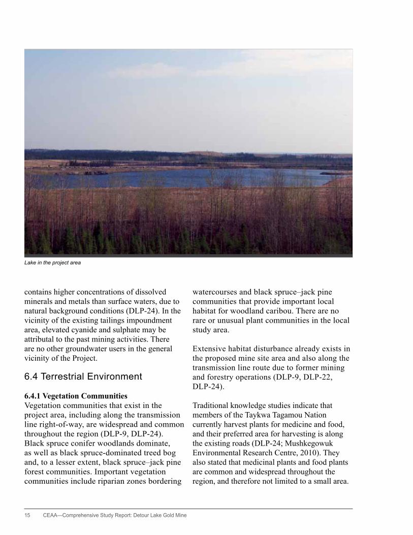
Lake in the project area
CEAA— Comprehensive Study Report: Detour Lake Gold Mine 16
6.4.2 Wildlife and Migratory BirdsThe project study area provides boreal forest habitat for numerous mammal species, including caribou (see Section 6.5) moose, beaver, black bear, wolf, and lynx (DLP-9, DLP-24). The moose population is relatively large in the study area because the habitat quality is relatively high and the level of disturbance is low. The size of the moose population appears to be stable, and moose benefit from activities such as forest harvesting. This activity creates early succession habitats that are favourable to moose. Moose tend to be associated with riverbank and creek margin forests, open-canopy mixed forest habitats, and cutover areas that provide adequate food and shelter for moose. Such habitats are widely distributed throughout the region and the project area, especially the second growth areas derived from former logging operations. Preferred calving spots for the moose are located in densely covered areas near water, particularly on islands and the peninsulas into lakes, fens, and bogs.
Currently, no moose aquatic feeding areas have been identified within the project site. The Natural Resources and Values Information System of the Ministry of Natural Resources indicates that no early or late overwintering areas have been identified for moose within the project area; however, one overwintering area has been identified directly west of the project site (DLP-9).
Wolves feed mainly on moose, caribou, and beaver and occur in habitats where these species are found. Wolves were regularly sighted during winter surveys of caribou in years when caribou and moose were abundant (in 2008 and 2010, but not in 2009). During helicopter surveys of caribou, moose, and wolves in the winter of 2008–2009, wolf tracks were observed within about 5 kilometres of the mine site (DLP-24). The distribution and abundance of wolves within the project area will likely continue to mirror that of caribou and moose.
Black bears are frequently observed at the project site. They tend to prefer mixed forest habitats, well-drained coniferous forests that support blueberry plants—an important late summer and fall food source—, and riparian-successional forests.
The principal furbearers within the project area are beaver, muskrat, marten, fisher, mink, river otter, red fox, and lynx (AMEC 2009c). Beaver, muskrat, mink, and otter tend to be associated with watercourses. Marten, lynx, and fisher are associated with forested habitats. Red fox and short-tailed weasel are associated with both forested and more open habitats.
Traditional knowledge studies show that Aboriginal people continue to trap in the project area, but these studies provide few specifics on animal distributions, abundances, or concentration areas. This may reflect the fact that habitats within the overall project area are common and widespread (DLP-24).
Recent surveys have recorded a total of 86 bird species, which indicates a relatively diverse avian community (DLP-9). Species that are usually associated with breeding in the boreal forest have been frequently recorded, including palm warbler, blackpoll warbler, white-throated sparrow, black-throated blue warbler, and boreal chickadee.
Waterfowl are commonly observed, including Canada geese, black duck, buffleheads, green-winged teals, ring-necked ducks, and common loons. Sandhill cranes and shorebirds, including the spotted sandpiper and greater yellowlegs, were also frequently observed.
Raptor communities are diverse and characteristic of the boreal region. These include the northern hawk owl, great horned owl, northern harrier, osprey, northern goshawk, and broad-winged hawk (DLP-9).
Traditional knowledge data from the Taykwa Tagamou Nation has identified the general
17 CEAA—Comprehensive Study Report: Detour Lake Gold Mine
nesting areas of geese, duck, bald eagle, and great blue heron (Mushkegowuk Environmental Research Centre, 2010). These nesting areas are concentrated along the Abitibi River corridor between Island Falls and Abitibi Canyon, along portions of Highway 652 and nearby logging roads to the west of Highway 652, and south of the proposed transmission line right-of-way. Partridge hunting areas are widespread across the region, but are concentrated along the Abitibi River corridor, including the area of the New Post reserve.
6.5 Species-At-Risk
A number of rare and endangered species may exist within the project study area. Species considered in this assessment have been classified by the Committee on the Status of Endangered Wildlife in Canada (COSEWIC). Some species are listed as species-at-risk (SAR) according to federal or provincial acts.
The following species-at-risk have been identified on the project site, or exist within the drainage basin, or may pass through the area during migration periods: woodland caribou, lake sturgeon, bald eagle, rusty blackbird, common nighthawk, olive-sided flycatcher, and monarch butterfly (DLP-9, DLP-24, MCFN TK (not publicly available), M. Gauthier pers. comm.). Other avian species-at-risk may occur temporarily in the project area during spring and fall migrations. There is a reasonable probability that other species-at-risk, including short-eared owl, peregrine falcon, and Canada warbler, may also exist within the project site; however, these were not detected during the baseline inventories. Yellow rail, golden eagle, and black tern are species-at-risk that occur in the region and may move through the project site, but breeding habitat is limited for these species within the site (DLP-9, DLP-24).
In addition, 15 regionally rare species were observed within the project area, including
bufflehead, sora, least sandpiper, pileated woodpecker, lesser scaup, and horned lark.
The only traditional knowledge data pertaining to avian species-at risk were provided by members of Taykwa Tagamou Nation; this data indicates that bald eagles are known to nest in the Abitibi River corridor area (Mushkegowuk Environmental Research Centre, 2010).
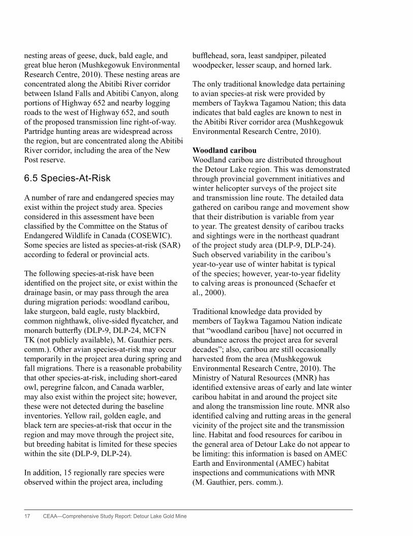
Woodland caribouWoodland caribou are distributed throughout the Detour Lake region. This was demonstrated through provincial government initiatives and winter helicopter surveys of the project site and transmission line route. The detailed data gathered on caribou range and movement show that their distribution is variable from year to year. The greatest density of caribou tracks and sightings were in the northeast quadrant of the project study area (DLP-9, DLP-24). Such observed variability in the caribou’s year-to-year use of winter habitat is typical of the species; however, year-to-year fidelity to calving areas is pronounced (Schaefer et al., 2000).
Traditional knowledge data provided by members of Taykwa Tagamou Nation indicate that “woodland caribou [have] not occurred in abundance across the project area for several decades”; also, caribou are still occasionally harvested from the area (Mushkegowuk Environmental Research Centre, 2010). The Ministry of Natural Resources (MNR) has identified extensive areas of early and late winter caribou habitat in and around the project site and along the transmission line route. MNR also identified calving and rutting areas in the general vicinity of the project site and the transmission line. Habitat and food resources for caribou in the general area of Detour Lake do not appear to be limiting: this information is based on AMEC Earth and Environmental (AMEC) habitat inspections and communications with MNR (M. Gauthier, pers. comm.).
CEAA— Comprehensive Study Report: Detour Lake Gold Mine 18
The federal Species at Risk Act (SARA) and the provincial Endangered Species Act (ESA) protect woodland caribou and their habitat. Currently, woodland caribou are designated both federally and provincially as a species-at-risk. At the federal level, they are designated as threatened in SARA, Schedule 1, and at the provincial level, they are designated as threatened. This species is also protected in Ontario by the Ontario Fish and Wildlife Protection Act (FWPA).
Recovery strategies related to the federal and provincial acts allow for the presence of industrial and human activity. However, these activities must be compatible with the recovery of the caribou and managed to protect their ranges and associated components and essential habitat functions; for example, this means identifying critical habitats, such as calving and overwintering areas.
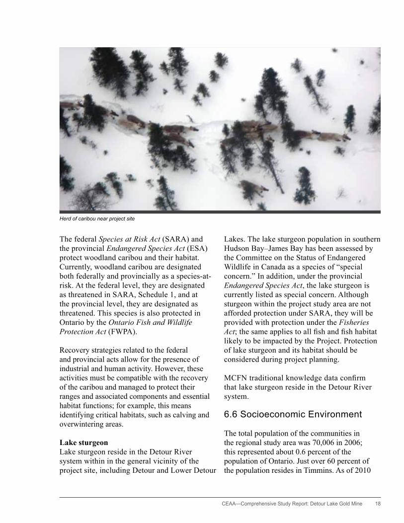
Lake sturgeonLake sturgeon reside in the Detour River system within in the general vicinity of the project site, including Detour and Lower Detour
Lakes. The lake sturgeon population in southern Hudson Bay–James Bay has been assessed by the Committee on the Status of Endangered Wildlife in Canada as a species of “special concern.” In addition, under the provincial Endangered Species Act, the lake sturgeon is currently listed as special concern. Although sturgeon within the project study area are not afforded protection under SARA, they will be provided with protection under the Fisheries Act; the same applies to all fish and fish habitat likely to be impacted by the Project. Protection of lake sturgeon and its habitat should be considered during project planning.
MCFN traditional knowledge data confirm that lake sturgeon reside in the Detour River system.
6.6 Socioeconomic Environment
The total population of the communities in the regional study area was 70,006 in 2006; this represented about 0.6 percent of the population of Ontario. Just over 60 percent of the population resides in Timmins. As of 2010
Herd of caribou near project site

19 CEAA—Comprehensive Study Report: Detour Lake Gold Mine
the total registered population for Moose Cree First Nation, Taykwa Tagamou Nation, and Wahgoshig First Nation was close to 4600.1 Of this number, less than half live on reserve (DLP-24).
As of 2006 the overall employment rates in the local communities were lower than the provincial averages. Much of the population within the project study area has traditionally relied on resource extraction activities related to forestry and mining. With the downturn in forestry industry, the local economy is experiencing some upheaval. The mining sector therefore represents an economic opportunity for skilled employment in the region (DLP-24).
Most towns and communities in the area are connected by a network of highways and roads. However, the communities of Moose Factory and Moosonee are accessible year-round by air and rail only.
All communities are serviced with power, potable water, and sewage systems. Landfill sites and solid waste disposal and pick-up are also provided in all the regional communities.
6.7 Land and Resource Use
The documented uses of the lands and resources in the project area include the following: (a) industrial commercial uses such as forestry, mining, and aggregates; and (b) outdoor recreation and tourism, including hunting, fishing, and trapping; cottaging and outfitter camps; tourism; and trails and access. Applicable land use policies allow for mineral exploration and development, aggregate extraction, and road development and, by implication, the provision of power supplies linked to mineral development (DLP-24).
Portions of the project area are under active mining claims or mining leases, including large holdings by Detour Gold in the general vicinity of the project site. Also a number of exploration companies are active in the area (DLP-24).
The project area lies entirely within a tourism area called Ontario’s Wilderness Region. Activities promoted for tourists in the area include hunting, fishing, all-terrain vehicle touring, boating, snowmobiling, and leisure and winter activities. Outfitter camps promote fly-in and remote fishing and hunting. The Approved Cochrane District Remote (Wilderness) Tourism Strategy, which is applicable to the project area, provides principles and guidelines to meet the needs of the forestry and mining industries and other natural resource users, while at the same time protecting remote tourism in the Cochrane district (DLP-24).
6.8 Aboriginal Communities, Traditional Knowledge, and Cultural heritage
The history of the Aboriginal peoples in the area goes back about 8,000 years to the time of the glacial lakes. The area was used in pre-contact times and historically by the direct ancestors of the present day Ojibwa, Northern Algonquin, and Cree peoples (Woodland Heritage Services Limited, 2010a, b).
The history of the Aboriginal peoples in the area goes back about 8,000 years
to the time of the glacial lakes.
Several First Nation and Métis communities exercise their Aboriginal and Treaty rights in the project area. The Moose Cree First Nation (MCFN), Taykwa Tagamou Nation (TTN), and
1 Based on http://www.ainc-inac.gc.ca/ai/rs/pubs/sts/ni/rip/rip10/rip10c-eng.asp

CEAA— Comprehensive Study Report: Detour Lake Gold Mine 20
Wahgoshig First Nation (WFN) have identified their traditional lands that overlap with the project area and its specific service corridors (i.e., the 230 kV transmission line and the existing Highway 652 road). The MoCreebec of the Cree Council are Aboriginal people who reside in Moosonee, Ontario, and Moose Factory, Ontario. While the MoCreebec do not have traditional territories in the project area, they may exercise their Aboriginal rights in the project area due to their proximity to the project site.
The Métis Nation of Ontario (MNO) is a provincial organization representing many Métis communities in Ontario. The MNO has identified the Timmins Métis Council and the Northern Lights Métis Council as Métis communities with Aboriginal rights that may be affected by the Project.
The proponent engaged and supported the MCFN, TTN, WFN, and the Métis groups in preparing the traditional knowledge studies. Archaeological and cultural heritage studies found variable evidence of continuing land use at varying intensities, including hunting, trapping, fishing, camps, and burial sites in the area of the transmission line route and the mine site. The study in the vicinity of Detour and Lower Detour Lakes found two archaeological sites (Detour River Camp and Lower Detour Lake Quarry site) that have been recognized by the Ontario Ministry of Culture.
Mitigation measures were identifiedtoreducetheoverall
impact of potential adverse environmental effects.
The project site overlaps a trapline that is currently held by a member of the Moose Cree First Nation. The transmission line right-of-way passes through 14 traplines, held by members of the TTN, MCFN, and by non-Aboriginal trappers. Several species are trapped, but the most important species are beaver and marten.
7. Environmental Effects Assessment
7.1 Approach
The Agency identified and assessed the project’s potential adverse environmental effects on the valued ecosystem components (VECs) and valued socioeconomic components (VSECs). The analysis of environmental effects was based on information provided by the proponent through the provincial review processes (DLP-22, DLP-23, DLP-24), submission and federal review of technical supporting documents prepared by the proponent, comments received during public Aboriginal consultation processes, and the commitments made by the proponent to implement mitigation measures. (See the list of documents in Appendix I and the proponent’s commitments table in Appendix H).
Mitigation measures2 were identified to reduce the overall impact of potential adverse environmental effects. Many of these measures have been integrated into the project design or operational plans. The environmental effects remaining after the implementation of mitigation measures—the residual effects—were evaluated consistent with the Reference Guide: Determining Whether a
2 “ Mitigation” means, in respect of a project, the elimination, reduction, or control of the adverse environmental effects of a project, and includes restitution for any damage to the environment caused by such effects through replacement, restoration, compensation or any other means—Canadian Environmental Assessment Act, Section 2.(1)

21 CEAA—Comprehensive Study Report: Detour Lake Gold Mine
Project is Likely to Cause Significant Adverse Environmental Effects (Federal Environmental Assessment Review, 1994).
A follow-up framework has been prepared to verify the accuracy of a predicted environmental effects and the effectiveness of proposed mitigation measures (see Section 8). This information may be used to support adaptive management approaches developed throughout mine operations and into decommissioning, as detailed in Appendix H.
The effects assessment methodology is described in detail in Appendix E. The residual adverse environmental effects that were considered in the overall assessment of significance of the effects of the Project are described in Appendix F, Tables F1-4.
7.2 Air Quality, Noise, and Greenhouse Gas Emissions
Approach and Potential Effects
Air QualityThe proponent used Ontario Ministry of Environment O. Reg. 419/05 standards and ambient air quality criteria (AAQC) to evaluate air quality emissions within the project site (DLP-24). The potential adverse environmental effects on air quality include various sizes of particulate emissions, as well as emissions of SO2, hydrogen cyanide, carbon and nitrogen oxides, and heavy metals associated with particulate emissions.
SO2 is used as a reagent, and small amounts are released in the process of cyanide destruction and during fuel combustion. The principal use of fuel onsite will be heavy equipment operation, including haul trucks, and diesel generators for power production during construction. Fuel
combustion also releases carbon monoxide (CO) and nitrogen oxide (NOx). The mill cyanidation process will likely release small amounts of hydrogen cyanide gas, but these emissions are routinely controlled to safe levels (DLP-24).
Particulate emissions are primarily associated with fugitive dust that comes from heavy equipment use, such as haul truck use on gravel roads, and windblown dust from mineral stockpiles and blasting activities. Point source emissions from ore crushing are also potentially important.
NoiseThe proponent evaluated noise levels according to MOE guidelines for determining the potential for noise disturbance to people beyond the site boundary and also to sensitive wildlife such as caribou. The CadnaA noise prediction software was used to model noise levels for the project operations phase, which would generate the most noise. Heavy equipment and haul truck use are the main sources of noise; the secondary sources are ore processing, construction diesel generators, and other such stationary sources. Noise effects were not considered for the construction of the transmission line as this will be a short-term activity. There are no permanent or seasonal residences close to the project site. The closest known residence, which is a seasonal camp, is about 6.7 kilometres to the west on Hopper Lake. Noise control is nevertheless important because of its potential impact on wildlife, particularly woodland caribou.
GHG EmissionsThe proponent forecast GHG emissions using methods outlined in the guidance document for Ontario Regulation 452/09 (MOE 2010) and in the 2006 guidelines of the Intergovernmental Panel on Climate Change (IPCC, 2006). Since climate change cannot be reasonably assessed
3 According to the 2003 Federal-Provincial-Territorial Committee on Climate Change and Environmental Assessment
CEAA— Comprehensive Study Report: Detour Lake Gold Mine 22
for a single project or within the context of a localized region or area,3 the proponent assessed the project’s GHG emissions in terms of onsite fuel combustion and within the context of Canadian GHG emission reduction target of 240 million tonnes per year.
Project-related greenhouse gas (GHG) emissions—principally CO2—will derive mainly from onsite fuel combustion, explosive detonation, and from offsite power generation at the energy production sources. Additional fuel consumption and CO2 emissions will result from transportation of people and materials to the project site. The proponent has designed the Project according to industry standards and best operating practices to minimize potential GHG emissions as much as practical.
The proponent has estimated that peak year diesel use (year 11) equates 0.21 million tonnes of CO2eq or 0.09 percent of Canadian GHG emission reduction target.
Mitigation
The modeling prepared by the proponent, as referenced in DLP-24, shows that the Project will be able to meet applicable provincial standards and criteria for air quality and noise at the mine property boundary with use of the following proposed mitigation measures:
• maintain roadways in good condition• possibly use surfactants, such as calcium
chloride, as a measure to control road dust, if required beyond water spraying
• progressive reclamation (revegetation) of overburden, waste rock, and tailings stockpiles
• use dust control equipment, such as bag houses, bin vents, and water sprays, to control point source emissions
• use low sulphur diesel• maintain tree screens around work areas where
practical• enclose permanent processing equipment
within buildings as per standard practice
• use transmission line power as opposed to onsite diesel generated power
• develop a compact site to reduce transportation needs and fuel consumption
• use large, more fuel efficient trucks for material transport
• maintain site equipment and vehicles in good working order
Government, Public, and Aboriginal Comments
The Ministry of Natural Resources (MNR) has identified that dust generated from mine site activities could potentially have an adverse effect on lichen growth in areas near the mine site (DLP-24). Lichens provide an important food source for caribou, and dust suppression measures should be undertaken at the site to limit such effects.
With the appropriate mitigation, the overall effect of the project’s air emissions, including fugitive dust, is consideredminorandnotsignificant.
Aboriginal groups and MNR have expressed concern that excessive noise could disturb sensitive wildlife species such as caribou (DLP-24, TK data not yet publicly available). Traditional knowledge studies conducted by members of First Nations identified noise as a potential problem for wildlife. In particular, some of the people interviewed said that noise and other disturbances associated with the former mining operations had frightened away wildlife, including caribou.
Agency Conclusions on Significance of the Residual Environmental Effects
With the appropriate mitigation, the overall effect of the project’s air emissions, including fugitive dust, is considered minor and not significant. The effect will be limited in geographic extent and magnitude, and reversible

23 CEAA—Comprehensive Study Report: Detour Lake Gold Mine
following mine closure. The magnitude and geographic extent of predicted GHG emissions are also considered to be minor, specifically, less than 0.1 percent of Canada’s target CO2 emission reduction (DLP-24).
To reduce potential effects on sensitive wildlife species such as caribou, noise control is important. Sound levels at the margin of the project area will be close to the natural background sound level of 20 to 30 dBA (DLP-24, DLP-50). The magnitude and geographic extent of the effect is therefore considered to be minor and reversible following mine closure and reclamation.
Taking into account the implementation of the mitigation proposed, the Agency concludes that the Project is not likely to cause significant adverse environmental effects on air quality and levels of noise and GHG emissions.
7.3 Local Watercourses, Lakes, and Wetlands
One or more of the following factors, will potentially affect the local watercourses, lakes, and wetlands:
• infilling during construction of site infrastructure• flow changes from to surface and groundwater
takings and watershed catchment characteristics due to mine infrastructure
• effluent, including surface drainage and seepage, from the TIA and waste rock stockpiles
• effluent, including surface drainage and seepage released from the mine operations area and treated domestic waste
• effluent and liquid waste from the explosives facilities and equipment maintenance and operation
• landfill leachate release• open pit dewatering• removal of surface water or groundwater for
ore processing and potable water uses• re-suspension and mobilization of contaminated
sediments occurring in the waterbodies downstream of the mine site
• changes to watershed catchment characteristics• redirection of some water from Karel Creek to
fill the open pit during reclamation of the site• infilling of all or portions of water bodies
associated with Cell 2 of the TIA and the south waste rock stockpile, subject to the addition of those water bodies to Schedule 2 of the MMER
• dust from road traffic and work on mineral stockpiles.
Due to the large scale of the mining operations and associated infrastructure, the Agency has identified and individually assessed environmental effects to several local watercourses, lakes, and wetlands (see Appendix G).
The management of mine waste to prevent or control acid rock drainage and metal leaching is a critical component of environmental protection within a mine. The proponent’s studies indicate approximately 20 percent of the waste rock may be potentially acid generating (DLP-17, DLP-24). To prevent impacts on water quality the effluent from waste rock and tailings will require that both active and passive mitigation measures be designed, implemented and monitored during mine operations and potentially on a long-term basis following the end of active mining operations. Mitigation measures are further addressed in the discussion of the follow-up program (see Section 8).
Other key potential adverse impacts to watercourses include (a) the potential dewatering effects on approximately 2 kilometres of Karel Creek, which is identified as cold water fish habitat that supports brook trout; (b) the dewatering of the existing flooded open pit and its 140 metre long outlet channel, which is also fish habitat; and (c) the loss of muskeg drainage features as a result of mine waste disposal.
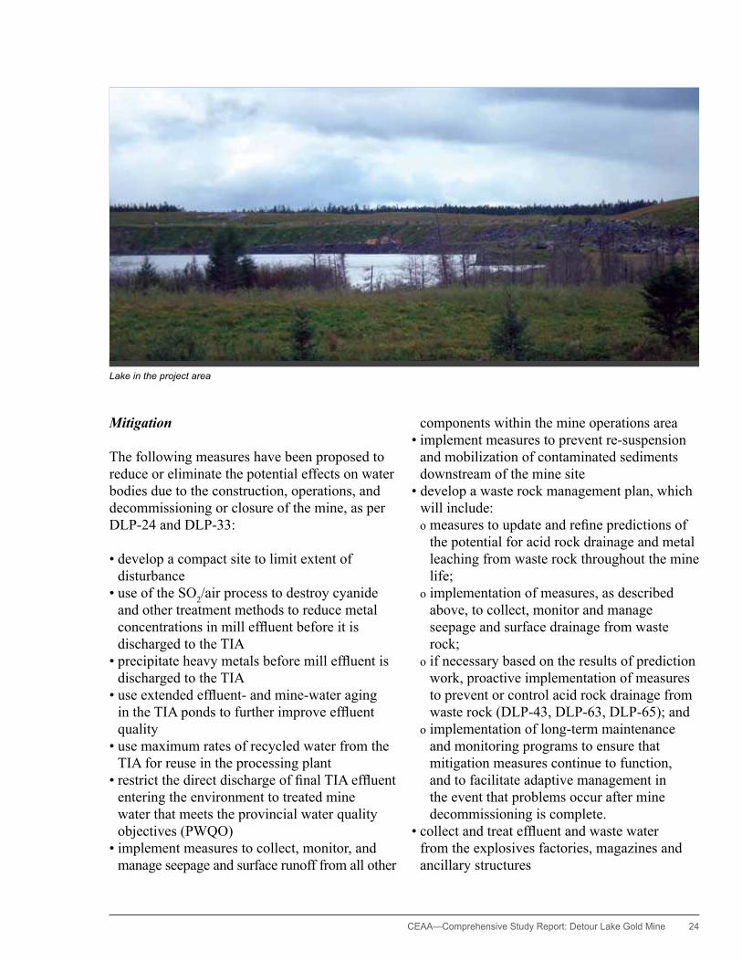
CEAA— Comprehensive Study Report: Detour Lake Gold Mine 24
Mitigation
The following measures have been proposed to reduce or eliminate the potential effects on water bodies due to the construction, operations, and decommissioning or closure of the mine, as per DLP-24 and DLP-33:
• develop a compact site to limit extent of disturbance
• use of the SO2/air process to destroy cyanide and other treatment methods to reduce metal concentrations in mill effluent before it is discharged to the TIA
• precipitate heavy metals before mill effluent is discharged to the TIA
• use extended effluent- and mine-water aging in the TIA ponds to further improve effluent quality
• use maximum rates of recycled water from the TIA for reuse in the processing plant
• restrict the direct discharge of final TIA effluent entering the environment to treated mine water that meets the provincial water quality objectives (PWQO)
• implement measures to collect, monitor, and manage seepage and surface runoff from all other
components within the mine operations area• implement measures to prevent re-suspension
and mobilization of contaminated sediments downstream of the mine site
• develop a waste rock management plan, which will include:
o measures to update and refine predictions of the potential for acid rock drainage and metal leaching from waste rock throughout the mine life;
o implementation of measures, as described above, to collect, monitor and manage seepage and surface drainage from waste rock;
o if necessary based on the results of prediction work, proactive implementation of measures to prevent or control acid rock drainage from waste rock (DLP-43, DLP-63, DLP-65); and
o implementation of long-term maintenance and monitoring programs to ensure that mitigation measures continue to function, and to facilitate adaptive management in the event that problems occur after mine decommissioning is complete.
• collect and treat effluent and waste water from the explosives factories, magazines and ancillary structures
Lake in the project area

25 CEAA—Comprehensive Study Report: Detour Lake Gold Mine
• install and construct appropriate containment features at the explosives factories, magazines, and ancillary structures
• design and implement fish habitat compensation plans to achieve no net loss of productive capacity of fish habitat (DLP-59, DLP-66).
• develop flow augmentation contingency plan(s) for implementation in case of extreme drought events, to ensure uninterrupted upstream and downstream movement of fish.
Government, Public, and Aboriginal Comments
Stakeholders and Aboriginal groups expressed concerns regarding the need to manage water quality and effluent discharge to protect the aquatic environment and its associated fisheries resources. In particular, MOE was concerned about the capacity of East Creek to assimilate effluent discharge from the TIA, and the capacity of Easter Creek to assimilate the discharge of the treated domestic sewage effluent from the construction camp.
Environment Canada, NRCan, MOE, WFN, and MCFN expressed concerns about the seepage and surface runoff from waste rock stockpiles and the TIAs.
Also stated were concerns regarding the potential impacts on water quality in Karel Creek due to metals and other contaminants in seepage and surface runoff from the waste rock stockpiles, as well as from potential acid rock drainage within the southern portion of mine rock stockpile #1.
The mine is currently subject to the Metal Mining Effluent Regulations (MMER) and will remain subject to the Regulations until such time as the mine has ceased operations and met conditions specified in the Regulations to become a recognized closed mine. As a result, all effluent from the mine operations area that is released to the environment is subject to the monitoring and reporting requirements
specified in the Regulations and must meet the specified effluent discharge limits.
MNR expressed concerns that dewatering the open pit and developing a mine rock stockpile close to Karel Creek could potentially alter the creek’s base flows and possibly affect brook trout habitat during periods of low flow (DLP-24). DFO noted that the drainage systems associated with Linden Creek, and within the footprint of mine rock stockpile #2, are natural waterbodies frequented by fish. DFO indicated the need to mitigate/compensate for any harmful alterations, disruptions, or the destruction of fish habitat. During the EA, DFO worked with the proponent to develop draft fish habitat compensation plans in compliance with the Fisheries Act and MMER and in accordance with the “no net loss” principle prescribed in the Policy for the Management of Fish Habitat (1986).
Members of Taykwa Tagamou Nation knew that a failure of the tailings pipeline had occurred during the previous mine operations, which resulted in tailings being spilled into Easter Creek (Mushkegowuk Environmental Research Centre, 2010). Wahgoshig First Nation also expressed concern about the need for protection from future potential failures of the tailings pipeline.
The Agency predicts that the residual effectstofishhabitat,suchasan
increaseordecreaseinstreamflowswill be minor and temporary.
The proponent held discussions with provincial and federal government experts about the merits of retaining East Lake as part of the provincially approved effluent treatment works. The MOE indicated that that retaining East Lake for such a purpose was not desirable given that East Lake is recovering from the past mining operations.

CEAA— Comprehensive Study Report: Detour Lake Gold Mine 26
The use of East Lake as a freshwater supply option (rather than the Detour River) was also discussed with the provincial and federal government agencies. MNR expressed a strong preference for using East Lake as the freshwater supply source for the mill, and the Ontario Ministry of the Environment (MOE) supported this point of view (DLP-24). The use of the Detour River as a source for freshwater supply was discouraged because it would unnecessarily expand the project footprint and result in associated adverse effects to woodland caribou and potential lake sturgeon. This option was not continued as result of these concerns.
Agency Conclusions on Significance of the Residual Environmental Effects
The Agency predicts that the residual effects to fish habitat, such as an increase or decrease in stream flows will be minor and temporary. The risk of impacts on water quality in adjacent water bodies is low, provided that measures proposed by the proponent to collect, monitor and manage seepage and surface runoff from tailings, waste rock and other components of the mine operations area function as predicted. All effluent released during mine operations and in the long-term following the completion of mine decommissioning, will be subject to the MMER or subsection 36(3) of the Fisheries Act. In addition, if the proponent is required to meet provincial water quality objectives as prescribed within the provincial Certificate of Approval, this requirement will further reduce the risk of impacts on water quality (DLP-43, DLP-63, DLP-65).
The permanent loss of a small muskeg pond and its connecting channel within the proposed footprint of the expanded TIA and two muskeg drainage features under the mine rock stockpile #2 would be offset through the development and implementation of a fish habitat compensation plan, as required in section 27.1 of the MMER (DLP-24, DLP-59).
Taking into account the implementation of the mitigation measures proposed, the Agency concludes that the Project is not likely to cause significant adverse environmental effects on local watercourses, lakes, and wetlands.
7.4 Groundwater
The proponent used historic mine dewatering (withdrawal) rates in combination with predictive hydrogeological modeling to assess groundwater dewatering effects. For the base case, (i.e., the expected case) a withdrawal rate of approximately 4,700 to 6,400 cubic metres/day was used. This rate is in the same range as the rate for the former mining operations at this site. For the less likely, conservative case, a groundwater withdrawal rate of 6,300 to 8,100 cubic metres/day was predicted (DLP-24, AMEC 2011).
The proponent’s groundwater modeling shows that open pit dewatering will likely reduce groundwater upwelling to the Karel Creek and Linden Creek systems and result in reduced base flow. Predicted reductions for the base case are 830 cubic metres/day (conservative case: 2,160 cubic metres/day) for Karel Creek and 300 cubic metres/day (conservative case: 550 cubic metres/day) for Linden Creek at the end of the mine life (DLP-24, AMEC 2011). The rates of reduction are expected to be comparatively low during average- and high-flow seasonal conditions. However, these rates will be important during low-flow conditions in late winter and in summer; this is when a substantial portion of the base flow of the creeks is attributed to groundwater inflow and upwelling. Winter base flow is particularly important to the Karel Creek system, because it supports a brook trout population, which depends on the winter base flow to support egg incubation and development. Another pathway of potential effect is the seepage of mine effluent into the local groundwater system and its lateral migration into water bodies.

27 CEAA—Comprehensive Study Report: Detour Lake Gold Mine
Mitigation
No mitigation measures are currently proposed to offset the lowering of the groundwater table because this action is necessary for open pit mining.
Mitigation measures for the groundwater interaction with adjacent creeks are proposed. For example, to provide compensatory spawning habitat, it is possible to develop more zones for groundwater upwelling and deep overwinter refugia within the Karel Creek system (DLP-24, DLP-58).
As stated in section 7.3, the proponent has committed to the implementation of measures to collect, monitor and manage seepage from waste rock, tailings and other components of the mine operations area, since seepage is defined as effluent under the MMER and therefore subject to the requirements of the Regulations. This will help to ensure that the risk of impacts on water quality in adjacent water bodies is low (DLP-43, DLP-63, DLP-65).
Government, Public and Aboriginal Comments
EC and DFO asked NRCan to provide advice on the adequacy of the hydrogeological assessment prepared by the proponent. NRCan indicated that the proponent has provided a reasonable representation of the hydrogeological conditions and potential effects. EC and DFO used this information to support their review of the potential effects on groundwater and the recommended seepage collection system. NRCan has further confirmed that while there is always some uncertainty with model predictions, the estimated seepage capture efficiencies of the seepage collection system seem reasonable.
The MCFN expressed concerns about the potential contamination of groundwater from seepage throughout the waste rock stockpiles and TIAs. Their concern was that
contaminated seepage would not be collected within the perimeter drainage system and would make its way into the deeper groundwater resources. MCFN identified the need for a robust monitoring system to assess changes to groundwater quality.
Agency Conclusions on Significance of the Residual Environmental Effects
Environmental effects on the groundwater system and the interaction with the surface water systems are expected to be limited. The mitigation measures are designed to preserve the ecosystem integrity and function.
Taking into account the implementation of the mitigation proposed, the Agency concludes that the Project is not likely to cause significant adverse environmental effects on groundwater.
Environmental effects on the groundwater system and the
interaction with the surface water systems are expected
to be limited.
7.5 Terrestrial Environment
7.5.1 Vegetation Communities and HabitatThe main potential effects of the Project on vegetation and terrestrial habitat will be the clearing of vegetation for mine development and transmission line corridor construction (DLP-22, DLP-24).
The proponent estimates that the mine site development will displace 19.4 square kilometres of currently undisturbed forest habitat (DLP-24). Another 3.26 square kilometres of new forest will also need to be cleared to expand and develop the existing transmission line route to connect the project site with the Ontario grid (DLP-22). These displacements represent
CEAA— Comprehensive Study Report: Detour Lake Gold Mine 28
5.6 percent and 0.9 percent of the local study areas for the mine site and the transmission line respectively (DLP-22, DLP-24). Predominantly black spruce dominated conifer woodlands and treed bog will be affected, with lesser amounts of black spruce–jack pine forest communities. All these habitat types are common in the region. Clearing of undisturbed areas will occur in areas immediately adjacent to existing disturbed areas from the former mining operation.
The proponent’s site plan focuses on developing a compact mine site and on using lands previously disturbed by past mining activities (DLP-24). Similarly, the plan for the transmission line is focused on redeveloping the former transmission line corridor between the mine site and Island Falls and developing the new one parallel to the existing Hydro One corridor between Island Falls and Pinard (DLP-22). Both of these components are intended to minimize line-clearing requirements and to avoid development of new corridors through undeveloped terrain.
Mitigation
The principal mitigation measures proposed by the proponent to limit short- and long-term adverse effects to local vegetation communities, as defined in DLP-22 AND DLP-24, include the following:
• Develop a compact mine site and transmission line corridor that will limit the extent and spread of new disturbances
• Avoid sensitive habitat areas to the extent practical
• Implement an active revegetation plan and encourage natural revegetation and recolonization of disturbed mine site areas—progressively and as practical during site operation and during reclamation at mine closure
• Meet provincial standards for chemical use on the transmission line route, and use mechanical methods for vegetation
management where the right-of-way crosses rivers and streams (DLP-18)
• Pursue reclamation of portions of the waste rock stockpiles into habitats that would support lichen growth—to serve as food for caribou—with guidance from MNR
• Use native vegetation where practical at the stage of mine closure to ensure that all disturbed areas eventually become productive forest habitat
Since the ground cover along the transmission line will remain intact, disturbed areas associated with the part of the route between the project site and Island Falls will be allowed to revegetate naturally after the transmission line is removed at mine closure (DLP-22).
The mitigation measures described above are expected to be effective for their intended purposes and, in many instances, can be further optimized in response to monitoring data (DLP-22, DLP-24). The principal uncertainty relates to the development of lichen habitat for caribou at closure. In this regard, the proponent has committed to developing test programs early in the project operations phase to determine the most practical means of developing lichen habitat (DLP-24, DLP-68).
Government, Public, and Aboriginal Comments
The proposed mitigation measures are consistent with comments from government representatives from Environment Canada, MNR, and MOE, as well as Aboriginal groups (Moose Cree First Nation, Wahgoshig First Nation, and Taykwa Tagamou Nation), and other stakeholders concerning the need for efforts to minimize the overall project footprint. The Moose Cree First Nation expressed concern about the extent of overburden cover that the proponent proposes to place on the NAG portions of the waste rock stockpiles, indicating that a more extensive cover should be applied.
29 CEAA—Comprehensive Study Report: Detour Lake Gold Mine
MNR has indicated that disturbance to the area between East Lake and Ghost Lake and Sunday Lake, including the Good Friday Lake area, should be avoided because this area supported large numbers of caribou during the 1997 late-winter period (DLP-24). MNR has also indicated that the proponent should reclaim portions of the waste rock stockpiles to habitats that would support lichen growth to serve as a food source for caribou (DLP-24). EC is supportive of MNR’s recommendation to target caribou habitat within the mine reclamation plan.
As a result of traditional knowledge studies and community consultation, all Aboriginal communities and their representatives stressed the importance of ensuring healthy vegetation communities for wildlife habitat. All Aboriginal groups expressed concern about the use of herbicides for managing vegetation regrowth within the transmission line route.
Agency Conclusions on Significance of the Residual Environmental Effects
The geographic extent of disturbance to the project area’s vegetation communities, including along the transmission line, will be comparatively small (DLP-22, DLP-24). Similar to surrounding forestry operations, the effects will last beyond the life of the Project, but they are reversible because the vegetation communities are restorable (DLP-21, DLP-22, DLP-24).
The geographic extent of disturbance to the project area’s
vegetation communities, including along the transmission line, will be
comparatively small…
Taking into account the implementation of the mitigation proposed, the Agency concludes that the Project is not likely to cause significant
adverse environmental effects on vegetation communities and associated terrestrial habitat linkages (DLP-22, DLP-24).
7.5.2 Wildlife and Migratory BirdsThe principal adverse effects to wildlife and migratory birds will be those associated with direct habitat loss, habitat disturbance, increased access, and potential vehicular collisions (DLP-22, DLP-24).
Site activity, particularly disposal of domestic waste, may attract wildlife and put them at risk of injury from vehicular collisions or consumption of non-edible items. Nuisance bears at waste disposal sites may need to be relocated or killed if they become a safety concern for people at the site (DLP-24).
Fragmentation of habitat, particularly forest habitat, is not expected to be of concern because the proposed developments will occur close to previously disturbed habitats and use the existing access; no new corridors, including the project’s transmission line will be developed (DLP-22, DLP-24).
The pattern of vegetation in the mine site area tends to have a northwest to southeast orientation, and the wildlife that uses this habitat may have a pattern of movement that corresponds to this pattern (DLP-9, DLP-24). Local disruption to wildlife movement could occur in the mine site area, but not along the transmission line route. This is because the transmission line and road linear corridors already exist. Also most local species have likely adapted to the setting because the mine site has been there for some time and exploration on the property is ongoing.
Along the transmission line route the habitat disturbance for large predators and furbearers will be more limited than in the mine site area. Black bear and some furbearers, such as marten, red fox, and short-tailed weasel, are
CEAA— Comprehensive Study Report: Detour Lake Gold Mine 30
regularly observed near the mining camps and mine sites. In general, these animals are not overly sensitive to human presence, whereas lynx and wolf tend to avoid the presence of humans, and fisher are not common in the area (DLP-24).
Direct disturbance to nesting birds will be avoided, thereby further
reducing the scale of the potential adverse effects.
Until site rehabilitation is completed following mine closure, birds of the forest will be displaced from the areas required for mine development. Direct disturbance to migratory birds during the bird nesting season, generally between May 16 and August 8, is a concern. Noise can disturb sensitive species, including owls that depend on hearing to locate prey (DLP-24, DLP-50).
Toxicity related to tailings ponds will not likely be a concern, as cyanide concentrations in the tailings ponds are expected to be less than 1 mg/L, well below any toxicity threshold; cyanide concentrations of less than 50 mg/L are considered safe for wildlife (Donato et al., 2007).
Mitigation
As well as the mitigation measures proposed for vegetation communities (see Section 7.5.1), the proponent has proposed the following additional measures to mitigate the potential for further adverse environmental effects to wildlife and migratory birds:
• Maintain, to the extent practical, a 120 metre buffer zone adjacent to rivers, creeks, and lakeshores to protect watercourses and their associated vegetated margins (DLP-24)
• Restore disturbed habitats at mine closure or encourage development of habitats capable of supporting a diversity of wildlife species,
including large predators and furbearers DLP-21, DLP-24)
• Effectively manage solid wastes, particularly food wastes, to avoid attracting wildlife (DLP-24)
• Implement a safe driving program for workers and contractors (DLP-24)
• Avoid tree clearing and land disturbance during the bird nesting season (DLP-24, DLP-50)
• Avoid raptor nesting areas as defined by stick nest surveys (DLP-24)
• Implement plans to keep conductor wires sufficiently far apart to preclude electrocution of larger avian species, particularly raptors, which frequently use hydro poles for perching or nesting (DLP-22)
• Pre-treat the total cyanide levels of mill effluent before disposal in tailing ponds to prevent wildlife toxicity (DLP-24, DLP-33)
Government, Public, and Aboriginal Comments
Wahgoshig First Nation expressed concern about the potential for waterfowl to be exposed to cyanide and other contaminants in the tailings ponds, and the possible fatalities as a result. The Moose Cree First Nation expressed concern about the extent of the overburden coverage proposed for the waste rock stockpiles at closure, and a desire to see wildlife habitat restored in a more expeditious manner. The other concern is that all reasonable effort be taken to minimize adverse effects to wildlife populations, such as developing a compact site footprint and a transmission line along the existing rights-of-way.
Agency Conclusions on Significance of the Residual Environmental Effects
From the perspective of direct disturbance, the magnitude and geographic extent of the area of potential influence will be small (DLP-22, DLP-24). Forest-dependent species would be displaced until such time as site rehabilitation is completed following mine closure, and therefore the effects are considered reversible. Direct disturbance to nesting birds will be
31 CEAA—Comprehensive Study Report: Detour Lake Gold Mine
avoided, thereby further reducing the scale of the potential adverse effects. At closure, disturbed areas at the mine site will be rehabilitated to terrain types that wildlife can use (DLP-21, DLP-68).
Taking into account the implementation of the mitigation proposed, the Agency concludes that the Project is not likely to cause significant adverse environmental effects on wildlife and migratory birds.
7.6 Species-At-Risk
Woodland caribouThe species-at-risk of greatest interest, and potentially most affected by the Project, is the woodland caribou (DLP-9, DLP-24). Direct habitat disturbance in the immediate area of the mine site and along the transmission line route is a potential concern.
The proponent asserts that food resources for caribou in the local area are not limiting, and the total area of newly disturbed forest habitat will be approximately 23 square kilometres (DLP-22, DLP-24). Of the forest habitat that will be removed at the project site, about 5.6 square kilometres will consist of black spruce–jack pine forest, which provides favourable late-wintering habitat for caribou (DLP-24). As noted earlier, this type of habitat is common in the general vicinity of the project. As well, habitat displacement would occur over a prolonged period and would primarily occur adjacent to existing disturbed areas.
In the region of Detour Lake, the average annual home range for female caribou is about 4,025 square kilometres (Brown et al., 2001). The proponent has calculated that all the project site and transmission line developments will directly displace forest habitats that are capable of supporting an estimated 0.25 caribou, which is approximately 0.5 percent of the home range of one animal (DLP-24). However, caribou
densities may be higher in the project area than for northern portions of the province as a whole (DLP-24).
Linear corridors are of interest because in these places the caribou are more exposed to predation or human disturbance. Wolves in particular are known to use linear corridors to have better access to caribou populations. However, there will be very little new corridor access because the all-season road access to the former mine site already exists and the new transmission line route follows along, or is immediately adjacent to, the existing one (DLP-22, DLP-24). Consequently, the project-related effects on woodland caribou due to linear corridor effects will not likely be very different from the existing condition.
The species-at-risk of greatest interest, and potentially most affected
by the Project, is the woodland caribou (DLP-9, DLP-24).
Effects from noise and dust generated by heavy equipment were also considered. To address this, the proponent has defined a 5 kilometre buffer zone around the principal project site, encompassing an area of approximately 200 square kilometres. The effects of disturbance from noise and dust can potentially affect lands within the buffer zone. Although caribou are not expected to completely avoid this buffer zone, they may enter this area less often (DLP-24, DLP-50). A 5 kilometre buffer zone will not be applied to the transmission lines as its construction will be short-lived, and when construction is complete, there will be no noise or dust emissions, except as a result of minor and periodic maintenance activities.
Mitigation
Mitigation measures described in Section 7 for vegetation communities and for wildlife will address concerns for species-at-risk. The
CEAA— Comprehensive Study Report: Detour Lake Gold Mine 32
following additional mitigation measures are also related to the protection of caribou (see DLP-24 and DLP-68):
• Implement wildlife management protocols to limit unnecessary disturbance to caribou
• Locate planned infrastructure to avoid known habitats for caribou calving
• Rehabilitate disturbed areas at mine closure to provide habitats suited to caribou in the long term, and focus research programs on the development of lichen stands as a food source for caribou
Lake sturgeonThe lake sturgeon in the project study area (Southern Hudson Bay—James Bay population) is listed as special concern under the Ontario ESA. A listing recommendation is also being considered under the federal Species at Risk Act. Environmental changes such as altering river habitat, changing river water quantity/quality, or otherwise interfering with the fish, have the potential to adversely affect lake sturgeon within the project study area.
Mitigation measures to protect lake sturgeon and their habitat involve effluent water quality treatment and runoff management (DLP-24). Many of these measures are outlined in Section 7.3. Using East Lake as a make-up water supply will offset the need to take water directly from Detour River, and this will reduce the potential for the Project to directly affect the sturgeon and its habitat.
Migratory birdsHabitats for SAR migratory bird species are widespread and abundant throughout the project area (DLP-9, DLP-24, DLP-50). In addition to the rusty blackbirds, olive-sided flycatchers, and common nighthawks that have been identified at the project site, three other avian SAR species have a reasonable potential for occurring within habitats that will be altered or displaced by
developments associated with the project site, including the transmission line route; these are the yellow rail, short-eared owl, and Canada warbler (DLP-9, DLP-24, DLP-50). Potential adverse effects and mitigation measures for SAR migratory bird species are the same as those described in the section on wildlife and migratory birds (see Section 7.5.2).
Government, Public, and Aboriginal Comments
The MNR, MOE, EC, local Aboriginal groups, and to some extent other stakeholders expressed concern for the protection and maintenance of local caribou populations. In particular, MNR has stated that disturbance to known caribou habitat should be avoided, or otherwise minimized, and that the construction of new major access routes, such as to the Detour River, should be avoided if at all possible (M.Gauthier, pers. comm.).
Data from MNR and AMEC surveys indicate that there are substantial numbers of caribou in the region, including in areas close to the project site (DLP-9, DLP-24). On the other hand, traditional knowledge data provided by the Moose Cree First Nation indicates that the number of caribou in the project site area, and particularly in the area around Hopper Lake, have “declined over the years,” and caribou were impacted by previous resource harvesting activities. It is acknowledged that the MNR and AMEC data only extend back to about 1997, and that broader historical perspectives are lacking in the MNR and AMEC data.
Traditional knowledge studies have indicated that past resource development, primarily consisting of large-scale forestry operations may have previously affected caribou populations.
Environment Canada has noted it is willing to work with the proponent to explore options to develop habitat for the common nighthawk in the tailings management area upon closure.

33 CEAA—Comprehensive Study Report: Detour Lake Gold Mine
Environment Canada has indicated that the Project is not likely to limit the habitat available to birds or impact populations. Given the anticipated development pressures in the boreal forest, EC has recommended that aspects of the follow-up program be designed to support ongoing study of cumulative effects (DLP-50).
Agency Conclusions on Significance of the Residual Environmental Effects
The direct loss or disturbance to habitat will occur in a small area and have minor potential effect (DLP-24). At mine closure all disturbed sites will be rehabilitated to terrain types that wildlife can use, and some areas will be specifically rehabilitated to provide food sources for woodland caribou (DLP-21, DLP-24, DLP-68).
Since no changes to water quality or habitat of the Detour River are anticipated, no significant adverse effects on the lake sturgeon population of the Detour River watershed are expected to occur (DLP-24, DLP-33).
At mine closure all disturbed sites will be rehabilitated to terrain
types that wildlife can use, and someareaswillbespecifically
rehabilitated to provide food sources for woodland caribou (DLP-21,
DLP-24, DLP-68).
Disturbance will occur to habitats that are potentially used by rusty blackbirds, olive-sided flycatchers, and common nighthawks. However habitat for these species is not limited in the general site area (DLP-24, DLP-50). The geographic extent of the area of potential influence, relative to available suitable habitat, is therefore considered to be small. Also, these species appear to tolerate disturbance; they have been observed adjacent to, or within,
the existing disturbed areas at the project site (DLP-9, DLP-24).
Therefore, taking into account the implementation of the mitigation proposed, the Agency concludes that the Project is not likely to cause significant adverse environmental effects on species-at-risk.
7.7 Land and Resource Use
7.7.1 Hunting, Fishing, and OutfittingThe proponent identified the following potential adverse effects of the Project on outdoor recreation (see DLP-22, DLP-24):
• changes in the availability of wildlife as a resource for hunting or tourism because of noise and the presence of mining infrastructure or increased traffic
• effects on sport fishing due to changes in water quality or quantity
• landscape disturbance leading to a reduced wilderness aesthetic and experience
• altered access routes and transportation methods used by recreational hunters and fishermen
• reduced abundance of wildlife and fish in local lakes and streams as a result of workers hunting and fishing in their off-time hours.
Mitigation
In addition to mitigation measures described in Section 7 for noise, water quality and quantity, vegetation communities and wildlife, the proponent has proposed the following specific strategies to limit the potential adverse effects of the Project on hunting, fishing, and outfitting:
• No construction of new, major access routes to or associated with the Project (DLP-22, DLP-24)
• No hunting allowed on the mine property, and fishing opportunities to be managed in accordance with provincial requirements and

CEAA— Comprehensive Study Report: Detour Lake Gold Mine 34
the proponent’s policies and programs that support recreational activities (DLP-24)
Typically hunted species, such as moose and bear, are not sensitive to noise disturbance, unless it is sudden and loud, such as during blasting. During these noise events, any wildlife in the immediate area of disturbance may move to adjacent areas. The effects of residual noise on people stationed at outfitter camps are not expected, except periodically at the Hopper Lake outfitter camp, depending on the activities being conducted, wind direction, and sensitivity of the people experiencing the noise (DLP-24).
Government, Public, and Aboriginal Comments
Several Aboriginal communities expressed concern about both short- and long-term impacts to their access to hunting and fish grounds in and around the mine site. The Moose Cree have expressed the importance of restoring the site at closure to provide productive habitat for fish and wildlife.
The Agency requested clarity from the proponent on how the reclamation plan and the study of rehabilitation options will meet or exceed provincial standards for mine closure. In response, the proponent provided a supplementary report (DLP-68) that explains how the reclamation plan and studies of the best strategy to reclaim the land will fulfill provincial requirements.
Agency Conclusions on Significance of the Residual Environmental Effects
The residual effects of the Project on hunting, fishing, and outfitting are likely to be limited in magnitude and geographic extent, and are reversible upon closure of the mine. Taking into account the implementation of the mitigation proposed, the Agency concludes that the Project is not likely to cause significant adverse environmental effects on hunting, fishing and outfitting.
7.7.2 Commercial Operations (Mining, Aggregates, and Forestry)The proponent has advised that the Project could limit or change the viability of commercial resource operations that overlap the project footprint or are influenced by project infrastructure, including the transmission line corridor (DLP-22, DLP-24). Conversely, the presence of project’s mining infrastructure—such as transmission line and processing facilities—may improve the viability of other commercial ventures that are able to access these facilities.
A planned, small quarry will be reopened near the western end of the project’s all-season gravel access road, about 25 kilometres southwest of the site. Access to this quarry site is presently available from Highway 652 and the all-season gravel access road (DLP-24).
The residual effects of the Project onhunting,fishing,andoutfittingarelikely to be limited in magnitude and
geographic extent, and are reversible upon closure of the mine.
The proposed mine site overlaps the Abitibi River Sustainable Forest Unit (SFU). The SFU Contingency Plan for their operating areas during 2010 to 2012 does not overlap the area of the proposed mine development and, therefore, in the near future no effect on planned forestry operations is anticipated.
If any future forest harvest areas were to potentially conflict with the mine operations, MNR will facilitate discussions between the proponent and First Resource Management Group, the company responsible for managing the forest management units that overlap the project area. If any areas need to be cleared as a result of the mine development and operations, the proponent will be required to obtain a forestry licence from MNR before clearing the trees. The proponent will give First Resource

35 CEAA—Comprehensive Study Report: Detour Lake Gold Mine
Management Group the first right of refusal to the harvested supply.
At the request of MNR, previously scheduled forest harvesting activities for 2009 and 2010 in the area south of Hopper Lake have been deferred until the anticipated provincial regulation on caribou habitat has been released and assessed in relation to regional forestry operations. Hence, the proponent has been advised that there are no planned forestry operations within 25 kilometres of the project site (DLP-24).
Government, Public, and Aboriginal Comments
Federal departments have suggested a need to consider potential mine expansion under the assessment of the project’s cumulative effects (see Section 7.10).
Agency Conclusions on Significance of the Residual Environmental Effects
The project’s effects on commercial land uses are unlikely: there are no active or future foreseeable commercial ventures that this project could negatively impact.Therefore, the Agency concludes that the Project is not likely to cause significant adverse environmental effects on commercial operations.
The project’s effects on commercial land uses are unlikely: there are no active or future foreseeable
commercial ventures that this project could negatively impact.
7.8 Traditional Land Uses
7.8.1 Resource Harvesting (Wildlife, Fishing, and Plant Use)The Project may impact traditional land use, including those relating to hunting wildlife and
waterfowl, fishing, trapping, and the harvesting of trees and medicinal, spiritual, and edible plants. The direct loss of habitat, noise and air emissions, chemical spraying to control vegetation growth, and effluent release or runoff could cause negative changes to resources in terms of their availability, health, and quality (DLP-22, DLP-24).
As a result of the Project, Aboriginal people may experience changes that could negatively impact their ability to reach traditional areas of resource harvesting near the mine site. Changes both in access and in the numbers of people in the area may increase resource competition between Aboriginal and non-Aboriginal people, which could reduce resource abundance. Increased traffic in the area could also reduce wildlife abundance due to an increase in vehicle accidents with wildlife.
Mitigation
Mitigation measures applicable to the reduction or elimination of effects on resources harvesting are outlined earlier in Section 7 in relation to air quality and noise, local water resources, vegetation communities, wildlife, and hunting, fishing, and outfitting.
Other mitigation measures the proponent has proposed or put in place to reduce the project’s effects on traditional resource harvesting include the following, as defined in DLP-22 and DLP-24, and through commitments to stakeholders, including Aboriginal peoples:
• Establish Impact Benefit Agreements (IBAs) with Aboriginal communities whose Aboriginal or Treaty rights may be infringed by the Project (IBAs have been negotiated and ratified with the MCFN, TTN, and WFN; a Memorandum of Understanding is in place with the MNO).
• Provide workers with cultural awareness training that includes showing respect for

CEAA— Comprehensive Study Report: Detour Lake Gold Mine 36
wildlife, that is, not chasing or otherwise harassing them.
• Ensure that construction crews know that trappers may be present in areas adjacent to the work sites and respect their right to be there.
• Provide information to MNR so they can communicate with local trappers about the location and schedule of construction activities.
• Communicate applicable environmental guidelines to Aboriginal people and report on compliance to these guidelines.
• Try to develop, in cooperation with the MCFN, TTN, WFN and MNO, programs to monitor potential adverse effects on fish and wildlife species, particularly woodland caribou
• Meet provincial standards for chemical use on the transmission line route, and use mechanical methods for vegetation management where the right of way crosses rivers and streams.
With the assistance of First Nations and Métis monitors, the proponent has also committed to making best efforts to avoid disturbance to important plant harvesting areas should these be identified.
Government, Public and Aboriginal Comments
Members of Taykwa Tagamou Nation (TTN) noted that people fish at some of the lakes downstream from the project site, as well as Lawagamau Lake and the Abitibi River (DLP-24). However, adverse project-related effects on these systems are not anticipated (DLP-24). According to the Mushkegowuk Environmental Research Centre (2010), who conducted the traditional land use study on behalf of the TTN, some of TTN members are concerned about the health of fish in the Abitibi River system. This is because chemical sprays are used to control vegetation regrowth along the existing transmission line route near to the Abitibi River.
The proposed approaches to reducing both the number of vehicle trips and the access of mine
workers to resources are consistent with the suggestions that the TTN made during their traditional knowledge studies (DLP-24, DLP-50). WFN also identified the need to allow mine workers to fish during off-hours so that community members can have recreational opportunities. The Moose Cree have expressed the importance of restoring the site at closure to provide productive habitat for fish and wildlife. During the traditional ecological knowledge (TEK) studies within MCFN, WFN, TTN, and Métis communities, and with the support of the proponent, Aboriginal people indicated that, historically, noise could be heard at camps at Hopper Lake (approximately 6 kilometres from the mine site, from time to time depending on the activities being conducted, wind direction, and sensitivity of the people experiencing the noise). Aboriginal people noted that, although the disturbance to harvesting areas associated with this project may be relatively small, the negative effect is greater if previous mining disturbances are also considered.
Residual noise effects at camps or cabins in the vicinity of the mine site
are expected to vary by distance from the noise emissions…
Agency Conclusions on Significance of the Residual Environmental Effects
There is a reasonable likelihood that minor effects to resource harvesting will occur. Residual noise effects at camps or cabins in the vicinity of the mine site are expected to vary by distance from the noise emissions; noise levels are expected to be at background levels within approximately 5 kilometres from the project site. Taking into account the implementation of the mitigation proposed, the Agency concludes that the Project is not likely to cause significant adverse environmental effects on resource harvesting.

37 CEAA—Comprehensive Study Report: Detour Lake Gold Mine
7.8.2 Cultural Sites and AreasAboriginal cultural heritage sites and areas include cabins, trails, burial, or ceremonial sites. Disturbance to these sites due to the project’s construction and operation activities could damage or interfere with these, or detract from their value. The project infrastructure may also affect the visual or wilderness aesthetic of these areas, and noise detracts from their use.
A number of culturally important sites have been identified in the general vicinity of the project site, and the proponent revised the project proposal to avoid interactions with these sites. During and following construction, archaeological studies and First Nations cultural monitoring will take place as appropriate (DLP-24).
Throughout the life of the Project, to avoid disturbance of culturally significant areas, the proponent will continue to support the gathering of traditional land use data from Aboriginal people who have knowledge of the project areas (DLP-24). The proponent will employ First Nations and Métis cultural monitors and develop protocols for the protection of cultural heritage features and areas, should these be encountered.
Government, Public, and Aboriginal Comments
Concerns were expressed by WFN, TTN, and MCFN that workers or non-Aboriginal people might be able to access cabins or burial areas and harm property. Cultural awareness training and other mitigation measures to protect culturally significant areas will address these concerns. Both the TTN and MCFN suggested the hiring of Aboriginal cultural monitors. In response, the proponent worked with the TTN and MCFN TK committees alongside a licensed archaeologist to identify and avoid cultural sites in the development area. The proponent will also employ environmental monitoring staff from local aboriginal communities.
Agency Conclusions on Significance of the Residual Environmental Effects
The residual effects on cultural sites and areas will be limited in magnitude and geographic extent and reversible after mine closure. Therefore, taking into account the implementation of the mitigation proposed, the Agency concludes that the Project is not likely to cause significant adverse environmental effects on cultural sites and areas.
7.9 Public health and Safety
Mining operations can potentially release contaminants that may adversely affect air and water quality. Air emissions of cadmium, lead, and mercury are a potential concern because of biomagnification within country foods (local fish, wildlife, and plants). Contaminants could be ingested by fish and wildlife, which then may be consumed by people. This is of particular concern for Aboriginal people who rely on traditional harvesting of fish and game for a large part of their diet.
The residual effects on cultural sites and areas will be
limited in magnitude and geographic extent and reversible after
mine closure.
With respect to the effects of contaminants, the following factors could affect public health and safety, as defined in DLP-24 and DLP-44:
• possible release of air contaminants associated with processing operations, fuel combustion, and fugitive dust emissions
• possible release of chemical contaminants contained in mill and mine water effluents, particularly cyanide, cyanide-breakdown products, and heavy metals

CEAA— Comprehensive Study Report: Detour Lake Gold Mine 38
• possible release of heavy metals from waste rock stockpile areas, and from waste rock used for project construction activities
• herbicide use along the transmission line for control of vegetation regrowth
Air quality modeling conducted by the proponent predicts that lead and mercury concentrations at the project site boundary will be less than 0.1 percent of Ontario’s ambient air quality criteria (AAQC), and that cadmium concentrations will be approximately 3 percent of the AAQC. At these low concentrations, adverse health effects are not anticipated (DLP-24, DLP-44).
According to the proponent’s calculations, the low concentrations in site runoff from waste rock stockpiles and TIAs of the essential elements (arsenic, chromium, copper, nickel, and zinc) and of the problematic heavy metals (cadmium, lead, and mercury) are below the levels of potential health concern for people who regularly consume local fish and wildlife (DLP-24, DLP-44). Cadmium and lead levels are extremely low in the ore and waste rock of the project site. Also, results of monitoring indicate that neither of these metals is of concern in area’s surface waters. The monitoring of mercury in fish tissue from the area has shown that current levels are below that of human health concern.
The mine site will be provided with onsite health services, and workers at the site who reside in the region will also have access to local health services (DLP-24). The issues of chemical exposure are appropriately addressed through provincial occupational health and safety guidelines (DLP-24).
Mitigation
Mitigation measures to address air emissions and water quality concerns are described above in Section 7. In addition, the proponent has committed to the developing and implementing a best management plan for fugitive dust, which
will include provisions for record keeping and inspections to examine whether fugitive dusts are being effectively managed (DLP-24).
Government, Public, and Aboriginal Comments
All Aboriginal groups expressed concern about the need to manage the release of environmental contaminants so that both human and ecological health are protected. This concern includes the periodic use of herbicides for managing vegetation growth along the transmission line.
Members of Taykwa Tagamou Nation (TTN) requested that the proponent undertake a quantitative risk assessment on ecological or human health, and the proponent agreed to do this if monitoring activities identify any increase in the levels of contaminants of concern beyond established thresholds.
The magnitude of contaminant releases through air and water is
expected to be small…
Health Canada supports the TTN’s request that the proponent undertake a human health risk assessment if the planned monitoring activities identify that the levels of contaminants of concern have increased beyond established thresholds. Furthermore, Health Canada advised that any such quantitative human health risk assessment be multi-media in nature to provide comprehensive information on all potential exposure pathways.
Agency Conclusions on Significance of the Residual Environmental Effects
The magnitude of contaminant releases through air and water is expected to be small and within applicable federal and provincial criteria for effluent discharge and guidelines for the ambient environment (DLP-24, DLP-44).
39 CEAA—Comprehensive Study Report: Detour Lake Gold Mine
Therefore, taking into account the implementation of the mitigation proposed, the Agency concludes that the Project is not likely to cause significant adverse environmental effects on public health and safety.
7.10 Cumulative Effects Assessment
Cumulative environmental effects (CEA) are defined as the effects of a project that are likely to result when a residual effect acts in combination with the effects of other projects or activities that have been or will be carried out.
Approach
This CEA was guided by the Canadian Environmental Assessment Agency’s Operational Policy Statement (2007) and the Cumulative Effects Assessment Practitioners Guide (1999). The CEA is based on the following five-step framework:
1. Scoping. The cumulative effects assessment was scoped to focus on the identified valued ecosystem components (VECs) and residual environmental effects of the Project when considered in association with environmental issues of regional concern, and the effects of past, present, and future actions or projects that have been or will be carried out in the region. This project’s CEA is focused on the analysis of effects related to current and future projects and activities that include the most likely future development scenario for the study area. Emphasis is given to cumulative environmental effects arising from projects or activities that are certain and/or reasonably foreseeable, with hypothetical projects considered at a conceptual level. Interactions with activities assessed within VSECs are not considered further.
2. Analysis of Effects. The potential environmental effects of each past and presently occurring activity or project and the likely effects of future actions or projects
that overlap spatially and/or temporally with project-specific residual effects were identified and considered.
3. Identification of Mitigation. Specific mitigation measures to prevent, avoid, reduce, or otherwise control any potential adverse cumulative environmental effects were identified by the proponent. The effectiveness of proposed mitigation was considered along with how existing effects are being or could be managed through other means (i.e., ongoing and future environmental initiatives of other levels of government, cooperative resource management agreements, work of conservation authorities, information from other project proponents, any available EA reports, and regional stakeholders).
4. Evaluation of Significance. The significance of residual cumulative effects was determined using the following criteria:
a. whether the potential cumulative environmental effects are adverse
b. whether identified adverse cumulative environmental effects would be considered significant
c. whether the significant adverse cumulative effects are likely to occur
5. Conduct of Follow-up. This step involves the implementation of any required follow-up to the cumulative effects assessment.
Scoping
For this cumulative effects assessment, the projects and human activities other than the proposed project were identified initially through a review of available information on historical (closed) projects and activities, existing (active) projects, general land use activities, and planned projects within the CEA study areas.
The proposed project site overlaps an area of past mining; therefore, the baseline environmental conditions described for the existing environment includes the environmental effects of past mining and industrial activities.

CEAA— Comprehensive Study Report: Detour Lake Gold Mine 40
Historical activities within the study area are primarily associated with forestry (logging activities and construction or use of forest service roads), hunting, trapping, and fishing. There are no other large-scale historical industrial projects or activities within the study area, and there are no existing large industrial projects within the study area.
The proponent’s scoping process identified only one project apart from the small-scale hunting, trapping, and fishing activities that are considered within the assessments of VSECs. This is a small planned quarry that, according to MNR, will be reopened by M.J. Labelle along and near the western end of the DLP all-season gravel access road, approximately 25 kilometres southwest of the project site (Figure 1-3). Details on the quarry operations have not been defined; however, the quantity of rock extraction is expected to be modest (i.e., less than 2 million cubic metres).
The project area has been and is currently managed for sustainable forest use. The MNR and the Sustainable Forest Licensee are in the process of preparing the 2012–2022 Abitibi River Forest Management Plan. To determine areas for harvesting, the plan takes into account the following elements: caribou habitat blocks, maturity of forest stands, proximity to roads, operability, mill requirements, and wildlife and natural disturbance pattern emulation. The immediate project area is not in the plan for harvesting, since this area was historically cut and is now being allowed to naturally revegetate. When operating, the mills in Cochrane have preferential access to local, more affordable wood fibre, rather than having to travel to the project area. Further, the harvesting has been scheduled over the long term, with the intention of returning large contiguous areas to preferred caribou habitat, based on full forestry regrowth, which is a 80–100 year time line. Any commercial forestry operations are unlikely in the project area during the life of the mine and well into the closure of the site.
Several other types of activities that could contribute to this project’s future cumulative effects are potentially foreseeable. It is not possible to assess the cumulative effects of hypothetical activities, but it is possible to provide a general overview of their potential interactive effects if projects related to these activities were to proceed. The proponents of any such future projects, if they were to be identified, may be required to assess the environmental effects of their projects in accordance with applicable EA requirements.
Within this context, reasonably foreseeable types of activities in the area that could contribute to possible future cumulative effects linked to development of the Project include the following:
• possible new roads or extensions to existing roads to facilitate forestry, exploration, mining and other purposes
• additional forestry operations• the setting up of new camps, cottages, or
other similar facilities on lakes in close proximity to either the DLP site or the transmission line
• possible snowmobile, all-terrain vehicle or other trails, that might be developed by others
• possible additional mineral developments, including as yet undefined future activities by the proponent (such as possible future ore body extension to the west or development at satellite exploration areas).
With regard to possible additional extraction of mineral resources, the proponent has consolidated landholdings for identified gold mineralized zones extending west from the planned open pit. Whether or not these mineralized zones support sufficient resources to warrant advanced exploration and commercial production remains to be determined. When and if such resources (and projects) are identified, separate EA studies may be required to determine the

41 CEAA—Comprehensive Study Report: Detour Lake Gold Mine
likely environmental effects, and to consider cumulative environmental effects.
Analysis of Cumulative Environmental Effects and Mitigation
As noted, there is limited industrial development in the area. Mine expansion is a hypothetical scenario based on the feasibility of resource development, which depends on factors such as the predicted value of the commodity, technical feasibility, and development costs at a point in time. Forestry and the proposed quarry operation are the only reasonably foreseeable activities that could interact with the project.
The 2012–2022 Abitibi River Forest Management Plan, currently under development and available for comment at the time of drafting this report, indicates that the mine project—during all phases through to closure and decommissioning—will not overlap with any known forestry operations. As such, there is limited potential for the effects of the project to interact with the effect of forestry operations.
In consideration of the known aggregate pit development application, there is potential for increased use of the road infrastructure leading to the mine site. During the operations phase, truck traffic to the project site for the delivery of diesel fuel and other commodities would be limited; preliminary estimates account for approximately three vehicle trips per hour using the road network.
Considering the hypothetical scenario of mine expansion or extraction of gold in nearby areas, it is anticipated that the effects of the work would be of a similar nature to the proposed project. This EA has determined through the analysis of VECs and VSECs that the potential for significant adverse environmental effects is unlikely. Therefore, if similar approaches to development and the use of mitigation measures are applied to future extraction, a similar outcome is possible.
At a conceptual level, expansion of the existing open pit and associated expansion of the waste rock and tailings disposal facilities may require additional approvals both federally and provincially. Additional and different measures to manage potential effects from expansion may be required depending on the characteristics of the development.
…the potential cumulative effectsarenotlikelytobesignificant
or will not overlap in temporal scale.
Should this scenario develop, further information gained through the mitigation and follow-up program and the materials prepared for this assessment, along with any additional environmental assessment required to consider the specifics of a proposed work, should support a thorough assessment of the potential cumulative environmental effects.
Government and Public Comments
NRCan, DFO, and EC have expressed concern with the assessment of potential mine expansion. The Agency has noted that future resource development in the area due to mine expansion or extraction from nearby areas is considered hypothetical; this is outlined in the published cumulative environmental effect policy and guidance documents. The Agency also notes that the level of effort directed to the assessment of cumulative environmental effects should be appropriate to the nature of the project under assessment, its potential effects in relation to known or reasonably foreseeable projects, and the environmental setting. In this case, there are limited potential cumulative effects considering any known or reasonably foreseeable projects. Of those that are identified, the potential cumulative effects are not likely to be significant or will not overlap in temporal scale.
CEAA— Comprehensive Study Report: Detour Lake Gold Mine 42
Agency Conclusions on Significance of the Residual Environmental Effects
Taking into account the implementation of the proposed mitigation, the Agency concludes that significant adverse cumulative environmental effects related to the Project are unlikely to occur.
7.11 Effects of Accidents and Malfunctions
Under the Act, an EA must consider the possible effects of accidents and malfunctions that could adversely affect the environment; these could occur at any stage of the Project from construction to closure, and post-closure. The potential for accidents and malfunctions is mainly associated with mine site operations.
The proponent will include consideration of malfunctions and accidents in its emergency preparedness plan (EPP), which is a component of their emergency response strategy (ERS).
The following potential malfunctions and accidents were identified:
• fuel release during truck transport • fuel releases from storage facilities and
dispensing areas • transportation accidents (non-fuel shipments,
including hazardous materials) • chemical spills within contained facilities• explosives accidents • failure of the TIA dam • failure of the TIA pipeline• failure of the effluent management system to
capture surface and seepage within the mine operations area
• pit slope failure• slope failure associated with the waste rock or
overburden stockpile • tailings impoundment area seepage and related
water quality concerns• failure of measures to prevent or control the
acid rock drainage
• fires associated with the Project• death of or excessive disturbance to
wildlife
Table F-5 summarizes data on the potential malfunctions and accidents, the likelihood of such occurrences, their possible environmental effects, preventative mitigation measures, and contingency and emergency response procedures.
The mitigation measures and commitments outlined by the proponent are described in Appendix H.
Government, Public and Aboriginal Comments
All of the local First Nations expressed the importance of preventative and response measures to preclude and respond to potential malfunctions and accidents, and that appropriate procedures need to be developed within the EPP and ERS to deal with such instances. The local First Nations also expressed a desire to review the EPP and ERS.
Agency Conclusions on Significance of the Residual Environmental Effects
Taking into account the implementation of the mitigation proposed, the Agency concludes that the Project is not likely to cause significant adverse environmental effects through accidents and malfunctions.
7.12 Capacity of Renewable Resources to Meet Present and Future Needs
Renewable resources within the project area include forest products, water power, fish and wildlife, and tourism. Potential environmental effects on these resources (with the exception of water power) are addressed within the assessments. Significant adverse effects to these resources, including water power, are not anticipated.

43 CEAA—Comprehensive Study Report: Detour Lake Gold Mine
…the Agency concludes that the Project is not likely to cause significantadverseenvironmental
effects through accidents and malfunctions.
Mineral resources are not renewable in the sense that when a particular mineral deposit is exhausted it is no longer available. The definition of a mineral resource is, however, a function of such factors as commodity pricing and mineral access. As a result, under certain circumstances the development of a given deposit could lead to future developments associated with that same deposit, or it could provide infrastructure that would improve the cost threshold for other developments in the area. The Detour Lake gold deposit exemplifies what occurs when resources within a particular deposit are considered exhausted at a much lower price. The change in gold price, the availability of infrastructure, and other factors, such as geological knowledge gained from former mine operations, has helped identify an additional resource under different circumstances.
7.13 Effects of the Environment on the Project
Under the Act, and as part of the evaluation of effects, an EA must consider the potential effects the environment may have on the Project. The Agency considers the following environmental conditions as the most likely to impact the Project:
• dry weather conditions • increased groundwater and mine water flows • flooding • forest fires• climatic variability
In the long term there could be a shortage of mill water supply if, in combination with unusually
dry weather conditions, the density of the settled tailings solids becomes substantially less than predicted. Should this condition occur, the proponent proposes to bring additional water into the TIA system from East Creek during the spring freshet, when excess water is available.
If mine water flows are greater than expected they might add more water to the overall water balance in the TIA. In response to this possibility, the proponent has designed facilities to manage any additional inflow.
Flooding can potentially affect road access, mine operations, and the TIA dam integrity. To address the potential for disruption to access resulting from flooding, the proponent has designed culverts and the ditches in the effluent management system to withstand a 24-hour event and handle a 25-to-100 year-return storm condition, depending on location. The proponent will also regularly inspect the culverts and the ditches, particularly for the effects of beavers, and conduct beaver management programs. To protect the working of the mine pit, the proponent has designed pit pumping systems to manage major storm events. The TIA dams have
East Lake Monitoring Station

CEAA— Comprehensive Study Report: Detour Lake Gold Mine 44
been designed for the probable maximum flood according to the Ontario dam safety guidelines. Adverse effects to the TIA dams as a result of extreme precipitation are therefore not expected. Severe weather increases the risk of soil erosion and the deposition of sediment in local water bodies. To comply with federal regulations regarding mine effluent, the proponent must ensure that proper controls are in place.
In terms of the effect of forest fires, the proponent predicts that the open pit, the tailings impoundment area, and the waste rock and overburden stockpiles will effectively shield the plant site from any serious forest fire threat. The permanent camp and the explosives factory are, however, more isolated and potentially more vulnerable to a forest fire threat. The proponent’s site design includes forest fire protection setbacks of about 100 metres wide around the operations camps. The proponent must also comply with setback requirements related to the explosives act. Fire-fighting procedures and measures will be in place to protect workers’ safety and property. If the transmission line is affected by fire, the damaged portions would be repaired or replaced as necessary.
Variations or long-term changes in climatic trends, such as precipitation, wind, temperature, humidity, and ice conditions could potentially affect the Project. The project water balance incorporates a range of values for each main variable, and this will allow dynamic tracking of the water status for every component of the site. This approach will provide early warnings regarding new trends of dry or wet periods, against the historic climate ranges, which will then allow responses for water management throughout the site, including the scheduling of new TIA cells or the raising of dams of the existing cells. Dynamic tracking is the primary tool for projecting if and when added effluent treatment facilities are required to maintain the water balance. Hence, the Project has been designed to address the uncertainties in long-term climate patterns.
Government, Public and Aboriginal Comments
Taykwa Tagamou Nation and federal departments identified the potential for climate change scenarios to alter the amount of rainfall, and they sought assurances that the TIA dam structures and drainage features were sufficiently designed to handle changes to precipitation levels.
Agency Conclusions on Significance of the Residual Environmental Effects
Taking into account the implementation of the proposed mitigation, the Agency concludes that the environment will not likely cause significant adverse environmental effects on the Project.
…the Project has been designed to address the uncertainties in long-term
climate patterns.
8. Follow-Up Under the Canadian Environmental Assessment Act
8.1 Background
The purpose of a follow-up program is to (a) verify the accuracy of the environmental assessment of a project, and (b) determine the effectiveness of any measures taken to mitigate the adverse environmental effects of the project. Where appropriate, the results of a follow-up program may also support the implementation of adaptive management measures to address previously unanticipated adverse environmental effects, and also environmental management systems to manage the environmental effects of projects.
This chapter provides the basis, or framework, for the follow-up program. The full program will be
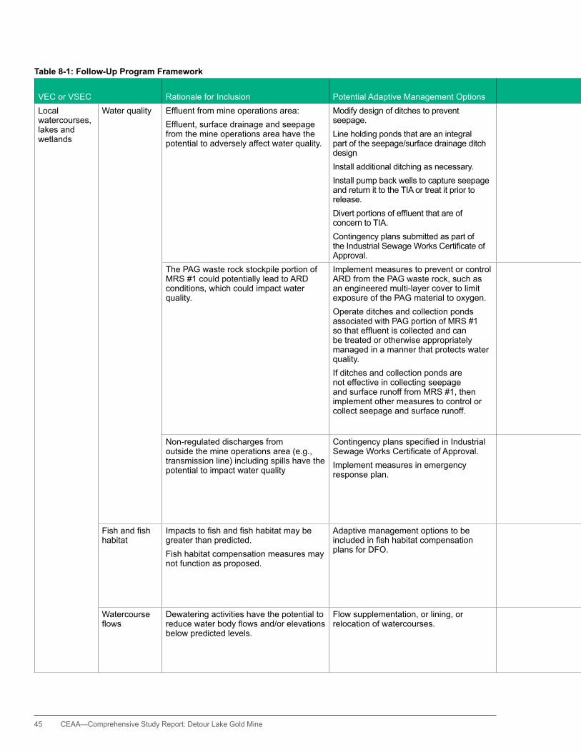
45 CEAA—Comprehensive Study Report: Detour Lake Gold Mine
Table 8-1: Follow-Up Program Framework
VEC or VSEC Rationale for Inclusion Potential Adaptive Management Options VerificationMechanismsRegulatory Instrument Responsibilities
Local watercourses, lakes and wetlands
Water quality Effluentfrommineoperationsarea:Effluent,surfacedrainageandseepagefrom the mine operations area have the potential to adversely affect water quality.
Modify design of ditches to prevent seepage.Line holding ponds that are an integral part of the seepage/surface drainage ditch design Install additional ditching as necessary.Install pump back wells to capture seepage and return it to the TIA or treat it prior to release.Divertportionsofeffluentthatareofconcern to TIA. Contingency plans submitted as part of theIndustrialSewageWorksCertificateofApproval.
MMER monitoring: quantity, quality and environmental effects. Monitoring and impact studies required through provincial approvals.
MMER: requirementsMOE:Certificatesof ApprovalMNDMF: Closure Plan and amendments (post-closure)
Proponent to provide monitoring and impact studies associated with provincial approvals.EC to review and update lead RA in situations of non-compliance where adaptive management or mitigation is deemed necessary. MOE to review all reports required through MOE permits and approvals that demonstrate the effectiveness of mitigation. MNDMF to review chemical monitoring reports during closure with reference to PWQO or established background.
The PAG waste rock stockpile portion of MRS #1 could potentially lead to ARD conditions, which could impact water quality.
Implement measures to prevent or control ARD from the PAG waste rock, such as an engineered multi-layer cover to limit exposure of the PAG material to oxygen.Operate ditches and collection ponds associated with PAG portion of MRS #1 sothateffluentiscollectedandcanbe treated or otherwise appropriately managed in a manner that protects water quality. If ditches and collection ponds are not effective in collecting seepage and surface runoff from MRS #1, then implement other measures to control or collect seepage and surface runoff.
Proponent monitoring and reporting to MNDMF and MOE.FRT input into draft Waste Rock Management Plan (WRMP) to MNDMF and MNR.
MMER: terms and conditionsMOE:Certificatesof Approval MNDMF: Closure Plan and amendments (post-closure)
Proponent to provide draft WRMP to lead RA for 30 day review and comment period. Proponent to provide lead RA with reports generated according to the requirements of the WRMP, with a summary of any adaptive management that has been recommended in response tothefindings.If needed, MNDMF to provide the WRMP provided by the proponent to lead RA. Lead RA coordinate FRT review of WRMP. MNDMF to consider, in the review of subsequent Closure Plan amendments, recommendations of NRCan, EC and DFO. MNDMF to copy EC and DFO on Notices of Material Change and Closure Plan Amendments. MOE to review all reports required through MOE permits and approvals that demonstrate the effectiveness of mitigation.
Non-regulated discharges from outside the mine operations area (e.g., transmission line) including spills have the potential to impact water quality
ContingencyplansspecifiedinIndustrialSewageWorksCertificateofApproval.Implement measures in emergency response plan.
Monitoring and impact studies required through provincial approvals.
MMER: terms and conditionsMOE:Certificatesof ApprovalMNDMF: Closure Plan and amendments (post-closure)
Proponent to provide monitoring and impact studies associated with provincial approvals. EC to review and update FRT.MOE to review all reports required through MOE permits and approvals that demonstrate the effectiveness of mitigation. MNDMF to review chemical monitoring reports during closure, with reference to PWQO or established background.
Fishandfishhabitat
Impactstofishandfishhabitatmaybegreater than predicted.Fish habitat compensation measures may not function as proposed.
Adaptive management options to be includedinfishhabitatcompensationplans for DFO.
Monitoring associated with Fisheries Act authorizations, toconfirmimpactstolocalfishpopulations,effectivenessoffishhabitatmitigationandcompensation measures.
Fisheries Act authorizations and MMER regulatory requirementsMOE:Certificatesof Approval
Proponent to provide monitoring data. ProponenttonotifyDFOandidentifyremedialmeasuresspecificto the circumstances. Remedial measures must be approved by DFO prior to implementation.DFO to review and update FRT. MOE to review all reports required through MOE permits and approvals that demonstrate the effectiveness of mitigation.
Watercourse flows
Dewatering activities have the potential to reducewaterbodyflowsand/orelevationsbelow predicted levels.
Flow supplementation, or lining, or relocation of watercourses.
Monitoring and impact studies required through provincial approvals.Monitoring associated with Fisheries Act authorizations
MOE: Permit to Take Water.Fisheries Act authorizations
Proponent to provide monitoring data and impact studies associated with provincial approvals. DFO to review and update FRT. MOE to review all reports required through MOE permits and approvals that demonstrate the effectiveness of mitigation.
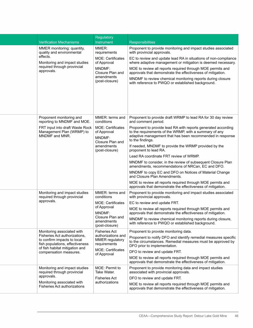
CEAA— Comprehensive Study Report: Detour Lake Gold Mine 46
Table 8-1: Follow-Up Program Framework
VEC or VSEC Rationale for Inclusion Potential Adaptive Management Options VerificationMechanismsRegulatory Instrument Responsibilities
Local watercourses, lakes and wetlands
Water quality Effluentfrommineoperationsarea:Effluent,surfacedrainageandseepagefrom the mine operations area have the potential to adversely affect water quality.
Modify design of ditches to prevent seepage.Line holding ponds that are an integral part of the seepage/surface drainage ditch design Install additional ditching as necessary.Install pump back wells to capture seepage and return it to the TIA or treat it prior to release.Divertportionsofeffluentthatareofconcern to TIA. Contingency plans submitted as part of theIndustrialSewageWorksCertificateofApproval.
MMER monitoring: quantity, quality and environmental effects. Monitoring and impact studies required through provincial approvals.
MMER: requirementsMOE:Certificatesof ApprovalMNDMF: Closure Plan and amendments (post-closure)
Proponent to provide monitoring and impact studies associated with provincial approvals.EC to review and update lead RA in situations of non-compliance where adaptive management or mitigation is deemed necessary. MOE to review all reports required through MOE permits and approvals that demonstrate the effectiveness of mitigation. MNDMF to review chemical monitoring reports during closure with reference to PWQO or established background.
The PAG waste rock stockpile portion of MRS #1 could potentially lead to ARD conditions, which could impact water quality.
Implement measures to prevent or control ARD from the PAG waste rock, such as an engineered multi-layer cover to limit exposure of the PAG material to oxygen.Operate ditches and collection ponds associated with PAG portion of MRS #1 sothateffluentiscollectedandcanbe treated or otherwise appropriately managed in a manner that protects water quality. If ditches and collection ponds are not effective in collecting seepage and surface runoff from MRS #1, then implement other measures to control or collect seepage and surface runoff.
Proponent monitoring and reporting to MNDMF and MOE.FRT input into draft Waste Rock Management Plan (WRMP) to MNDMF and MNR.
MMER: terms and conditionsMOE:Certificatesof Approval MNDMF: Closure Plan and amendments (post-closure)
Proponent to provide draft WRMP to lead RA for 30 day review and comment period. Proponent to provide lead RA with reports generated according to the requirements of the WRMP, with a summary of any adaptive management that has been recommended in response tothefindings.If needed, MNDMF to provide the WRMP provided by the proponent to lead RA. Lead RA coordinate FRT review of WRMP. MNDMF to consider, in the review of subsequent Closure Plan amendments, recommendations of NRCan, EC and DFO. MNDMF to copy EC and DFO on Notices of Material Change and Closure Plan Amendments. MOE to review all reports required through MOE permits and approvals that demonstrate the effectiveness of mitigation.
Non-regulated discharges from outside the mine operations area (e.g., transmission line) including spills have the potential to impact water quality
ContingencyplansspecifiedinIndustrialSewageWorksCertificateofApproval.Implement measures in emergency response plan.
Monitoring and impact studies required through provincial approvals.
MMER: terms and conditionsMOE:Certificatesof ApprovalMNDMF: Closure Plan and amendments (post-closure)
Proponent to provide monitoring and impact studies associated with provincial approvals. EC to review and update FRT.MOE to review all reports required through MOE permits and approvals that demonstrate the effectiveness of mitigation. MNDMF to review chemical monitoring reports during closure, with reference to PWQO or established background.
Fishandfishhabitat
Impactstofishandfishhabitatmaybegreater than predicted.Fish habitat compensation measures may not function as proposed.
Adaptive management options to be includedinfishhabitatcompensationplans for DFO.
Monitoring associated with Fisheries Act authorizations, toconfirmimpactstolocalfishpopulations,effectivenessoffishhabitatmitigationandcompensation measures.
Fisheries Act authorizations and MMER regulatory requirementsMOE:Certificatesof Approval
Proponent to provide monitoring data. ProponenttonotifyDFOandidentifyremedialmeasuresspecificto the circumstances. Remedial measures must be approved by DFO prior to implementation.DFO to review and update FRT. MOE to review all reports required through MOE permits and approvals that demonstrate the effectiveness of mitigation.
Watercourse flows
Dewatering activities have the potential to reducewaterbodyflowsand/orelevationsbelow predicted levels.
Flow supplementation, or lining, or relocation of watercourses.
Monitoring and impact studies required through provincial approvals.Monitoring associated with Fisheries Act authorizations
MOE: Permit to Take Water.Fisheries Act authorizations
Proponent to provide monitoring data and impact studies associated with provincial approvals. DFO to review and update FRT. MOE to review all reports required through MOE permits and approvals that demonstrate the effectiveness of mitigation.

47 CEAA—Comprehensive Study Report: Detour Lake Gold Mine
Table 8-1: Follow-Up Program Framework (cont'd)
VEC or VSECRationale for Inclusion: Potential Residual Adverse Effect Potential Adaptive Management Options VerificationMechanisms
Regulatory Instrument Responsibilities
Local watercourses, lakes and wetlands
Sediment Quality
Sediment quality has been impacted from the previous mine operation in some of the water bodies downstream (e.g., East Lake) of the mine site. The proposed mine could lead to a further degradation of downstream sediment quality through additional inputs or through re-suspension of the existing sediments.
ContingencyplansspecifiedinIndustrialSewageWorksCertificateofApproval.Additional sediment and erosion controls.Changes to discharge locations or methods to reduce chances of sediment re-suspension.
Monitoring and impact studies required through provincial approvals.
MOE:Certificatesof Approval
Detour to provide monitoring and impact studies associated with provincial approvals. MOE to review all reports required through MOE permits and approvals that demonstrate the effectiveness of mitigation.EC to review and update FRT.
Groundwater system
Water quality and quantity
Mine dewatering has the potential to altergroundwaterflowsand/orelevationsbeyond predicted levels. Seepage has the potential to contaminate groundwater.
Adaptive management through implementation of contingency measures specifiedinFishHabitatCompensationPlans and Industrial Sewage Works CertificateofApproval.
Monitoring and impact studies required through provincial approvals. Monitoring associated with the Fisheries Act authorizations and MMER monitoring: quantity, quality, and environmental effects.
MOE:Certificatesof ApprovalMOE: Permit to Take Water DFO: Fisheries Act authorizations and MMER regulatory requirements
Proponent to provide monitoring and impact studies associated with provincial approvals. Lead RA to delegate responsibility for reviewing submitted data and updating FRT. MOE to review all reports required through MOE permits and approvals that demonstrate the effectiveness of mitigation. MNDMF to review chemical monitoring reports during closure with reference to PWQO or established background as per Code.
Terrestrial environment
Migratory birds
Mine development and activities have the potential to create disturbance and/or displace migratory birds.
Proponent to collect, analyze, and report data; submit to EC.
Not applicable EC—to review data to be used for consideration of cumulative effects of impacts of development on migratory birds that utilize the boreal forest. Results of analysis may be used to inform future EAs.
Species-at-risk
Caribou Mine development and activities could possibly displace caribou as a result of project-related noise and disturbance.
Proponent to conduct caribou helicopter surveys, annually in early and late winter, to assess numbers and area usage.Proponent to provide data to MNR and EC.
MNR: Woodland Caribou Management PlanEC-Boreal Woodland Caribou SARA Recovery Strategy
EC to review date and contact lead RA if necessary. Proponent to provide data to MNR and EC. EC to receive data and comments from MNR, and contact lead RA if necessary.
Resource harvesting (Country Foods)
Local Fish, Wildlife, and Plants.
Possible increase of heavy metals in organisms by uptake, or via settling on organism.
Detour to establish a tissue sampling program to be carried out cooperatively with local Aboriginalhunters,fishers,and gatherers if environmental monitoring reveals any exceedances of human health related thresholds in air, water, or soil.Tissues from potentially impacted country foods would be submitted to DGC for metals, analysis
Detour to provide the assessment results to hC. hC to review and update FRT.
Land and resource use
Reclamation Large mine footprint and mining activity have the potential to displace woodland caribou during mine operations.
Successful establishment of lichen, which can potentially encourage caribou on the mine site. Options and contingencies to be described in soil and overburden management report being prepared by Detour.Use results of this study to support and inform future environmental assessments.
Mine rock stockpile revegetation program details to be provided in proponent’s table of commitments. Proponent to provide results of lichen test program to MNDMF, MNR, and FRT.
Mine rock stockpile revegetation program details may be amended in MNDMF Closure PlanMNR: Woodland Caribou Management Plan
Proponent to provide results of lichen growth success and other mine reclamation strategies.MNDMF to review physical stability and biological monitoring reports during closure, with reference to the minimum requirements of the Code.
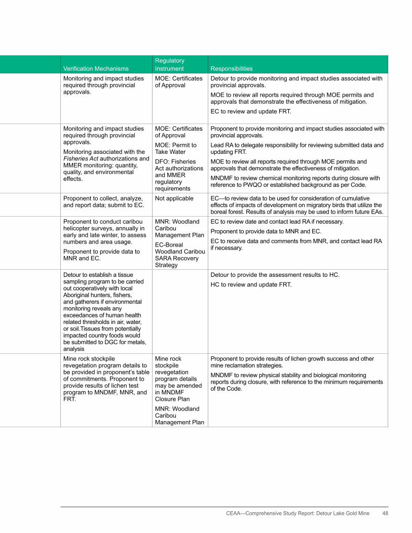
CEAA— Comprehensive Study Report: Detour Lake Gold Mine 48
Table 8-1: Follow-Up Program Framework (cont'd)
VEC or VSECRationale for Inclusion: Potential Residual Adverse Effect Potential Adaptive Management Options VerificationMechanisms
Regulatory Instrument Responsibilities
Local watercourses, lakes and wetlands
Sediment Quality
Sediment quality has been impacted from the previous mine operation in some of the water bodies downstream (e.g., East Lake) of the mine site. The proposed mine could lead to a further degradation of downstream sediment quality through additional inputs or through re-suspension of the existing sediments.
ContingencyplansspecifiedinIndustrialSewageWorksCertificateofApproval.Additional sediment and erosion controls.Changes to discharge locations or methods to reduce chances of sediment re-suspension.
Monitoring and impact studies required through provincial approvals.
MOE:Certificatesof Approval
Detour to provide monitoring and impact studies associated with provincial approvals. MOE to review all reports required through MOE permits and approvals that demonstrate the effectiveness of mitigation.EC to review and update FRT.
Groundwater system
Water quality and quantity
Mine dewatering has the potential to altergroundwaterflowsand/orelevationsbeyond predicted levels. Seepage has the potential to contaminate groundwater.
Adaptive management through implementation of contingency measures specifiedinFishHabitatCompensationPlans and Industrial Sewage Works CertificateofApproval.
Monitoring and impact studies required through provincial approvals. Monitoring associated with the Fisheries Act authorizations and MMER monitoring: quantity, quality, and environmental effects.
MOE:Certificatesof ApprovalMOE: Permit to Take Water DFO: Fisheries Act authorizations and MMER regulatory requirements
Proponent to provide monitoring and impact studies associated with provincial approvals. Lead RA to delegate responsibility for reviewing submitted data and updating FRT. MOE to review all reports required through MOE permits and approvals that demonstrate the effectiveness of mitigation. MNDMF to review chemical monitoring reports during closure with reference to PWQO or established background as per Code.
Terrestrial environment
Migratory birds
Mine development and activities have the potential to create disturbance and/or displace migratory birds.
Proponent to collect, analyze, and report data; submit to EC.
Not applicable EC—to review data to be used for consideration of cumulative effects of impacts of development on migratory birds that utilize the boreal forest. Results of analysis may be used to inform future EAs.
Species-at-risk
Caribou Mine development and activities could possibly displace caribou as a result of project-related noise and disturbance.
Proponent to conduct caribou helicopter surveys, annually in early and late winter, to assess numbers and area usage.Proponent to provide data to MNR and EC.
MNR: Woodland Caribou Management PlanEC-Boreal Woodland Caribou SARA Recovery Strategy
EC to review date and contact lead RA if necessary. Proponent to provide data to MNR and EC. EC to receive data and comments from MNR, and contact lead RA if necessary.
Resource harvesting (Country Foods)
Local Fish, Wildlife, and Plants.
Possible increase of heavy metals in organisms by uptake, or via settling on organism.
Detour to establish a tissue sampling program to be carried out cooperatively with local Aboriginalhunters,fishers,and gatherers if environmental monitoring reveals any exceedances of human health related thresholds in air, water, or soil.Tissues from potentially impacted country foods would be submitted to DGC for metals, analysis
Detour to provide the assessment results to hC. hC to review and update FRT.
Land and resource use
Reclamation Large mine footprint and mining activity have the potential to displace woodland caribou during mine operations.
Successful establishment of lichen, which can potentially encourage caribou on the mine site. Options and contingencies to be described in soil and overburden management report being prepared by Detour.Use results of this study to support and inform future environmental assessments.
Mine rock stockpile revegetation program details to be provided in proponent’s table of commitments. Proponent to provide results of lichen test program to MNDMF, MNR, and FRT.
Mine rock stockpile revegetation program details may be amended in MNDMF Closure PlanMNR: Woodland Caribou Management Plan
Proponent to provide results of lichen growth success and other mine reclamation strategies.MNDMF to review physical stability and biological monitoring reports during closure, with reference to the minimum requirements of the Code.
49 CEAA—Comprehensive Study Report: Detour Lake Gold Mine
designed, following the Minister’s Environmental Assessment Decision Statement, by the responsible authorities (RAs) in consultation with the proponent, participating federal and provincial authorities, and Aboriginal groups. The follow-up program will include, at a minimum, the components outlined in this framework.
The specific EA predictions and the mitigation measures that will be taken to eliminate, reduce, or control the adverse environmental effects of the Project are described in Section 7 of this CSR.
Table 8-1 outlines the specific elements upon which the full follow-up program will be developed.
The follow-up program and adaptive management measures may require amendment or updates during the project lifecycle to address changes in environmental conditions and as a result observed project effects on the environment and/or modified based on future federal and provincial permits, licenses, authorizations and/or approvals.
8.2 Roles and Responsibilities
8.2.1 Provincial Regulatory AgenciesProvincial Ministries have regulatory responsibilities noted in Table 8-1.
8.2.2 The Responsible Authorities: Natural Resources Canada and Fisheries and Oceans CanadaThe roles and responsibilities of the RAs in the follow-up program include the following elements:
• A Lead RA will be identified to coordinate the development and implementation of the follow-up program with assistance from the other RAs and FAs.
• RAs will ensure that the proponent has designed a follow-up program that meets the requirements of CEAA and considers (at a minimum) the components included in the follow-up program framework.
• RAs will ensure that the follow-up program accurately reflects the role of the Ontario provincial ministries, and their respective regulatory instruments, for the implementation of those aspects of mitigation and follow-up subject to provincial jurisdiction.
• The Fisheries Act: For mitigation of effects on fish and fish habitat subject to the Fisheries Act follow-up elements will be specified, where appropriate, as terms and conditions of approvals and authorizations.
• The Explosives Act: There are no components of the follow-up program related to the proposed explosives factory and magazine facilities, and, therefore, an Explosives Act licence would not contain terms and conditions related to follow-up.
• The RAs, with assistance from other federal authorities and in consultation with provincial agencies, will review any reports associated with the follow-up program to confirm the status of the Project, verify the effectiveness of mitigation and determine if adaptive management measures need to be implemented by the proponent.
• RAs will post follow-up program notices and results on the Agency’s CEAR Internet site.
8.2.3 The Federal Authorities: Environment Canada and Health Canada Both Environment Canada and Health Canada will be responsible for providing assistance in areas that are pertinent to their respective mandates and as agreed to with the RAs. This assistance would normally consist of providing input to the objectives and design of monitoring studies, receiving the results of such studies, reviewing the results, and providing recommendations to the responsible authorities on any further actions required. This could involve recommendations for adaptive management measures to address monitoring results or unanticipated adverse environmental effects.
CEAA— Comprehensive Study Report: Detour Lake Gold Mine 50
8.2.4 The Proponent: Detour Gold Corporation The proponent will work with the federal authorities to develop the follow-up program. The follow-up program will be conducted by the proponent in consultation with federal and potentially provincial agencies, Aboriginal groups, and stakeholders, as appropriate.
The proponent’s roles and responsibilities include implementing the follow-up program by conducting the required baseline studies and monitoring, analyzing the results, implementing adaptive management measures where required and reporting on the results and outcomes of the program.
The proponent’s commitment to undertake the follow-up program is set out in a letter dated October 11, 2011, which can be found in Appendix J.
8.3 Scope of the Follow-Up Program
The elements included in the follow-up program, specifically, the valued ecosystem components, were determined through consideration of the following factors:
• the potential residual adverse effects• the extent to which public and Aboriginal group
concerns were raised during the federal and provincial EAs (including comments raised by the participant funding recipients)
• areas of federal interest• whether provincial approvals, permits or plans
do include, or are reasonably predicted to include, monitoring and follow-up requirements
• whether provincial and federal regulatory instruments exist to help ensure the effectiveness of mitigation measures
• the extent to which mitigation measures are innovative in their approach as opposed to being common and well understood, or where the effectiveness of the proposed mitigation is difficult to predict with a high degree of certainty
It should be noted that for all of the components included in framework (Table 8-1), the predicted residual environmental effect is not significant. For further information please refer to Appendix F, Tables F-1 to F-4.
9.BenefitstoCanadians
On behalf of Canadians, the Agency and federal and provincial authorities collaboratively evaluated the proposed Detour Lake Project.
The provincial environmental assessments and Mine Closure Plan and the federal comprehensive study have each provided the Canadian public and Aboriginal people with opportunities to participate in the design and decision-making processes associated with this gold mining and milling project.
The federal and provincial governments reviewed and assessed the information brought forward during the EA process. This contributed to improvements in the project plan and design, particularly with respect to minimizing the environmental effects. As a result, selection of the project design, construction, and operations were not based solely on engineering or economic determinants, but rather on a balanced approach that guides the sustainable development, operation, and closure of the project.
The federal and provincial governments reviewed and assessed the information brought forward during
the EA process.The mine site layout from the start of the project was designed to develop a compact mine site, reuse previously disturbed areas and the infrastructure layout was planned in a manner that reduced impacts to the aquatic environment and wildlife.

51 CEAA—Comprehensive Study Report: Detour Lake Gold Mine
Further revisions as result of federal review, public input and aboriginal consultation resulted in changes to the project. For example, important environmental, social, and cultural factors guided the placement within the landscape of the proposed permanent camp. These include location of caribou calving sites, access to recreational activities, and respect for physical and cultural heritage sites related to Aboriginal traditional use and archaeological significance.
The EA helped reduce the overall ecological footprint of the proposed project by identifying
changes to the design and development of the mine.
One of the most significant risks associated with the development of a metal mine project is the potential to cause harm to the quantity and quality of local water resources. Through the assessment of this project, Environment Canada with the support of Natural Resources Canada guided the proponent to development mitigation plans that should reduce potential seepage into groundwater resources and uncontrolled surface runoff. Aboriginal consultation activities supported this needed change to the project and identified the importance of a thorough monitoring program. The collection system proposed will allow the proponent to effectively collect and monitor mine effluent. Reducing the potential risk of water quality contamination directly benefits local fish and wildlife populations and indirectly benefits people who may depend on these populations for recreational, commercial or cultural interests.
The federal EA also determined that more information was needed to address the potential impacts to fish and fish habitat,
and to ensure the project could operate in compliance with the Metal Mining Effluent Regulations. The proponent developed some strategies to minimize or mitigate these potential impacts, including the collection of supplemental information on fish habitat as requested by federal authorities. This information demonstrated that additional mitigation measures and approvals were needed to ensure the protection of fish and fish habitat and to compensate for the loss of fish habitat.
The EA helped reduce the overall ecological footprint of the proposed project by identifying changes to the design and development of the mine. It also helped to identify the project’s potential effects and to develop monitoring plans to assist the proponent in protecting the environment during the phases of operation and decommissioning.
10. Conclusion of the Agency
The Agency has taken into account the following information in reaching a conclusion on whether the Project is likely to cause significant adverse environmental effects:
• documentation submitted by the proponent• information, analysis, and conclusions in this
comprehensive study report• views expressed by the public, government
agencies, municipal communities, and Aboriginal groups
• information, analysis, and conclusions of the project’s provincial environmental assessments
• the proponent’s commitments as documented in the Table of Commitments, provided in Appendix H and commitment letters in Appendix J
CEAA— Comprehensive Study Report: Detour Lake Gold Mine 52
• requirements for Fisheries Act authorizations or MMER approvals, and their associated habitat compensation plans to mitigate potentially negative impacts to fish and fish habitat
• requirement for a licence issued under subsection 7(1)(a) of the Explosives Act for the manufacture and storage of explosives
• various provincial instruments such as permits, approvals and plans that regulate the mining operations and closure
• requirement for RAs to design a follow-up program based on the Follow-Up Framework agreed to by RAs and FAs as contained within the CSR and to be implemented by the proponent (Appendix J).
In the event that the RAs take the course of action described in paragraph 37(1)(a) of the Act, they will ensure mitigation measures are implemented in accordance with subsection 37(2.1) and (2.2) of the Act.
Taking into account the implementation of the mitigation proposed, including commitments made by the proponent in this report, the Agency concludes that the Project is not likely to cause significant adverse environmental effects.
Appendix A. Project Description: Additional Information
This appendix provides further detail on the major project components and activities. For a full description of the proposed project, please refer to the Detour Lake Project Description available on the Major Project Management Office (MPMO) Tracker website.4
A.1 Main Project Components and Activities
This section describes the project’s onsite and offsite facilities and activities. According to the proposed site layout, the required mine-related facilities will be located as close together as possible and use lands previously disturbed by historic mining or forestry operations, where siting locations are otherwise equivalent.
Site clearing and site preparationAlthough a portion of the project site was cleared by past mining or forestry activities, additional areas also require clearing and preparation to facilitate site development. Salvaged timber material will be offered to local forestry companies or Aboriginal groups, or be used otherwise if possible. The excavated overburden will be trucked to the overburden stockpiles if it is not needed immediately as a construction material or for progressive reclamation. An estimated 8 million tonnes (Mt) of overburden will need to be removed from the plant site area and tailings impoundment area (TIA) dam foundations.
Early site preparation also includes the establishment of a construction camp, together with associated services and infrastructure, including a potable water treatment plant, a sewage treatment plant, and diesel-fired generation (maintained at less than 5 MW).
Dewatering activitiesBefore mining can begin the water in the existing flooded pit needs to be removed. The volume and water quality of the existing pit has been studied: bathymetry data indicate that the existing pit holds a total of approximately 6.25 million cubic metres (Mm3) of water, and the upper 30 metres holds approximately 4.0 Mm3 (Lorax, 2011). The water in the upper 30 metres is of very good
4 http://www2.mpmo-bggp.gc.ca/MPTracker/project-projet-05.aspx?pid=120

53 CEAA—Comprehensive Study Report: Detour Lake Gold Mine
quality and generally meets receiving water quality standards (Lorax, 2011).
To support the initial dewatering of the pit, the proponent proposes to use directional dewatering wells drilled through the existing pit walls, or a floating barge pumping system (or equivalent) and an associated pipeline(s). Once the existing open pit has been dewatered and the mining levels approach the floor of the existing open pit, the barge pumping system will be replaced or augmented by a sump system for collecting mine water.
Prior to the start of mining activities, the water from the upper 30 metres of the existing flooded open pit will be transferred. If total suspended solids (TSS) and other contaminant levels meet final effluent discharge limits, the water will be moved directly to East Lake (the former Detour Lake Mine polishing pond), or the East Creek immediately below the existing East Lake weir. If further treatment is required to meet effluent discharge limits, the water will be moved to the TIA Cell 1 for aging and subsequent downstream of East Lake.
To complete the dewatering and to develop and maintain a dry working environment, the pumping of mine water from both the remainder of the flooded open pit and the newly expanded pit will continue throughout the construction and operations phases on a year-round basis. Dewatering requirements are projected to range from 12,000 cubic metres per day (m3/d) during the initial 1.4 years of open pit operations to 13,600 m3/d during years 2 to 5 as the surface area of the pit expands and groundwater inputs increase. Later in the life of the mine, dewatering requirements will reduce to 12,100 m3/d.
This mine water, which includes runoff to the open pit, is expected to contain suspended solids and, during mining operations, ammonia and hydrocarbon residuals from
blasting operations and heavy equipment use. For this reason, the water will be treated (aged) within the TIA prior to release to the environment. In addition to water, the bottom of existing flooded open pit is expected to contain an estimated 60,000 to 70,000 cubic metres of sulphide tailings solids from the previous mine. These solids will be extracted and taken to the TIA where they will become buried with new tailings.
Mining activitiesThe deposit of 350 Mt of mineral reserve will be mined over approximately 16 years at a nominal rate of 55,000 to 65,000 tonnes per annum (tpa), based on a 24-hour and 7-day per week operation. Pit development will expand outward and downward from the existing flooded open pit. The pit wall slopes and bench heights will be designed for safety based on industry standards.
The proponent proposes to extract ore and waste rock by blasting, using an emulsion- blend explosive and also, possibly, a limited use of an ammonium-nitrate–fuel oil (ANFO) explosive. The extracted rock will be removed using mining shovels, wheel loaders, and mostly 300 tonne haul trucks. During the first phase of the life of the mine, about four to five years, the mine-haul road will exit the north side of the open pit. During the remainder of the mine’s lifetime, the mine-haul road will exit from the south side of the pit.
Overburden and waste rock managementAn estimated 70 Mt of overburden will require removal from the open pit area (in addition to the 8 Mt from the plant site area and TIA dam foundations). Since 15 Mt of overburden will be used for TIA dam construction, the approximate amount of overburden requiring storage is 63 Mt. A portion of this stockpiled material will be used for mine reclamation.
Waste rock will also need to be removed from the open pit to gain access to the ore. About

CEAA— Comprehensive Study Report: Detour Lake Gold Mine 54
960 Mt of waste rock will be generated as a result of the proposed open pit mining. Most of the waste rock will likely be chemically non-reactive. Waste rock will be trucked to one of two waste rock stockpiles (named MRS #1 and #2) located on either side of the open pit, unless the material is designated for construction purposes. The waste rock stockpiles will be created by dumping from haul trucks and from appropriately designed access ramps. These stockpiles will be designed for long-term stability and to facilitate mine closure. The portion of the waste rock that is potentially chemically reactive will be stockpiled within the southern portion of MRS #1, where drainage and runoff can be managed and treated as required for environmental protection. This could include installation of a water treatment plant if necessary to ensure protection of water quality.
Ore processingOre will be trucked from the open pit either directly to the primary crusher or, when the primary crusher is not available, it may be stored in a temporary stockpile. Ore will be processed at a single, onsite processing plant. The ore processing circuit is designed for an initial throughput of up to 55,000 tonnes per day (tpd), increasing to about 61,200 tpd after three years of operation. The plant uses conventional gold-milling processes common to the industry. The processes consist of crushing, grinding, and cyanidation circuits that cause the gold to be loaded onto activated carbon. Gold recovery from the loaded carbon will be achieved using a conventional carbon stripping and electrowinning circuit. The cathode sludge from the electrowinning circuit containing the gold will be smelted in an induction furnace to produce gold bullion bars, which will subsequently be transported offsite.
The processing plant and the associated external tankage (cyanide leach tanks and carbon-in-pulp recovery tanks) will be constructed as a partial
two-story building and will occupy a footprint of about 5 hectares. The plant is designed to contain any spills that might occur. The cyanide leach tanks external to the building will be situated within a lined and bermed area that is capable of containing 110 percent of the volume of the largest single tank.
Mining effluent and tailings managementTailings, a mineral waste and effluent slurry produced by the conventional processing of gold ore within the mill, will be stored on the surface of the land in an engineered impoundment facility. This facility will be located east of the processing plant and will cover the existing TIA. Prior to discharge to the TIA, the tailings will be treated in the processing plant to remove the cyanide and residual heavy metals inherent in the gold extraction process, using the SO2/air treatment process. Cyanide will be treated to a nominal target level of less than 1 milligram per litre (mg/L) using this method. This is a modern technology used in many gold mining operations worldwide. The tailings are not predicted to be acid generating (AMEC 2010b). The treated tailings will be transported by a surface pipeline to the TIA for permanent storage.
The TIA will be operated such that there will be a zero or near zero discharge of treated mill water to the environment. Cyanide destruction in the mill is intended to minimize the risk from this seepage. Direct discharge from the TIA to the environment will accordingly be limited to treated (aged) mine water and to runoff from inactive TIA cells.
Mine site infrastructureThe ancillary buildings and services associated with the mine site and processing plant area will include the following: administration building, emergency response (medical and fire) office and garage, service station for light vehicles, mine service garage, wash bay, warehouses, fuel tanks, and fuelling station.

55 CEAA—Comprehensive Study Report: Detour Lake Gold Mine
There will be buildings for construction accommodations and permanent accommodations, and a security and site access gatehouse. All of the workforce, including operations personnel and support staff, will be housed at the camps. Buses will transport workers to and from defined pickup locations.
The construction camp located northeast of Sagimeo Lake will provide accommodation for a maximum of 1,000 people. It will be constructed as a portable modular camp interconnected with supporting infrastructure.
The permanent accommodations camp, to be constructed near Little Hopper Lake or Hopper Lake, is designed to accommodate up to 500 persons.
Water requirements and supplyThe proposed project requires water supply for the following purposes:
• mill process water (recycled and freshwater) • fire protection (freshwater for emergency use
only) • potable water for the construction and
operations camp (freshwater) • water for dust management, such as from
gravel roads (recycle and freshwater)• miscellaneous water demands (concrete
manufacture, truck washing, general use)
The principal water demand for this project will be for mill operations; this will be minimized as much as possible by internal recycling within the process plant. The projected mill water requirement will peak during full production at approximately 50,800 m3/d. Water in excess of 90 percent of the mill water demand, as well as water required for dust management and miscellaneous industrial water demands, will be met by recycling water that is stored temporarily in the TIA. This will be supplemented if necessary by approximately 1,600 m3/d of freshwater drawn from East Lake. Additional
water sourcing may also be required from East Lake during the spring freshet to maintain the overall TIA system water balance.
All potable water at the site will be freshwater (groundwater or surface water) that is treated to ensure safe and reliable drinking water. Wells will supply the freshwater for the construction camp. Additional wells will provide the water supply for the permanent accommodations camp, or surface water may be drawn from Hopper Lake or another nearby lake. Potable water for the mill complex and any other areas will likely be met by bottled water produced by a water treatment facility onsite.
Aggregate mining and stockpiles Rather than excavating materials from dedicated aggregate operations, mineral waste from the open pit and other site developments will be used as much as practical for mine-related construction operations. Previously approved aggregate pits on the site, including the East Burrow Pit, the Terminal Pit, and the RT Pit, have a limited capacity of quality aggregate, or they are no longer in use. Although further investigation of dedicated sources of aggregate is underway, the following sources have been identified: North Aggregate Pit (concrete grade and other sand and gravel), QT5 Quarry (quarried rock), and QT4 Quarry (quarried rock). The proposed North Aggregate Pit is positioned west of and parallel to Karel Creek. There will be no aggregate extraction within Karel Creek or its floodplain. Pending environmental approvals, rehabilitation plans for the North Aggregate Pit provide for the development of brook trout spawning habitat. The QT5 Quarry site is a large bedrock outcrop located to the immediate northeast of Lindbergh Lake. The QT4 Quarry site is entirely within the footprint of proposed TIA Cell 3. These quarries may be developed if it is not possible to have timely access to waste rock within the proposed open pit, but their development under current plans is unlikely.
CEAA— Comprehensive Study Report: Detour Lake Gold Mine 56
Explosives manufacturing facilities A bulk ammonium nitrate emulsion (ANE) plant will be installed at the Detour Gold Corporation site, to the northwest of Deem Lake for mine site consumption only. The product mix will increase annually, commencing with 17 kTe/a in the first full year of production and increasing to an average of 35 kTe/a in subsequent years. This facility will supply a load-and-shoot service for the mine.
The following infrastructure will be associated with the explosives manufacturing facility:
• ammonium nitrate emulsion (ANE) plant (including receiving, storage, and run tanks, production plant, and associated equipment)
• access roads and parking lot• garages and wash bays for truck maintenance• a bulk emulsion manufacturing module• ammonium nitrate prill storage silo, with
storage capacity 60 Te• office and amenities buildings • two explosives magazines.
The design and locations of the explosives manufacturing facilities and the volumes stored will meet the prescribed separation distances (NRCan, 1995). Individual facilities will be surrounded by rockfill or earthen safety berms according to regulatory requirements. Some design features relevant to the environmental assessment are as follows:
Site Preparation
• All roadwork, site clearing, and foundations, together with the required civil engineering, will be supplied by the proponent.
• Site preparation (such as clearing of land and excavation) will be required for the ANE manufacturing plant, the garage and wash bay building, the magazines, and the parking area.
• Secondary containment of the ANS receiving tanks will be provided by the foundation knee walls that extend high enough to
provide the necessary capacity inside the production building to manage accidents and spills.
Drainage and Storm water
• The design of the facility will consider natural site drainage and take provincial and municipal requirements into account.
• The facilities will be surrounded by a drainage ditch to collect surface and storm water runoff.
• The drainage system will collect precipitation and direct it into an adjacent ditch and pond system associated with the North waste rock stockpile for integration into the site water management system.
Effluent System
• All liquid wastes at the plant and wash bay will be collected in a sump and separated using an evaporation system. The remaining solids will be disposed of in shot bags for down-the-hole disposal, as agreed to by the proponent. Design for the effluent system from the ANE building to the evaporation tank will be confirmed during the detailed design phase.
• A septic system will be installed for handling human effluent. Solid wastes will be disposed of using existing mine site practices.
Process Water System
• The site will require 3,500 litres per day of process water, in addition to truck wash requirements of 1,000 litres per truck for normal truck wash and 1,500 litres per truck for decontamination. This process water will be supplied via a well to be drilled onsite and piped throughout the site. A mechanical water meter will be installed to control the water added to any of the ANS tanks.)
• Explosives will be delivered to the loading sites of the open pit blast hole by an explosive delivery truck that is equipped with a blast
57 CEAA—Comprehensive Study Report: Detour Lake Gold Mine
hole loading mechanism. The facility will be able to supply a maximum explosives of approximately 0.35 kilogram of explosive per tonne of blasted rock, or approximately 80 tonne of explosives per day, based on a maximum quantity of 250,000 tonne of rock (ore and waste rock) blasted per day. Blasting will typically be carried out once per day when full mine production is attained (62,100 ton per day ore production).
Domestic sewage treatment and disposalDomestic sewage from the construction and operation accommodations will be treated first using membrane bioreactor systems (MBR) and then by means of a passive wetland treatment to help remove residual nutrients (nitrates and ammonia). MBRs are a state-of-the art form of sewage treatment that provides superior effluent quality. Wetland systems are very effective for the removal of residual nutrients from sewage treatment plant effluent.
Hazardous and non-hazardous solid waste managementNon-hazardous solid wastes will consist of materials such as domestic waste (food scraps, refuse, clothing); combustible wastes (wood, paper products); and other inert wastes (scrap metals, clean glass, clean, plastics). Such wastes, excluding demolition wastes at closure, will be disposed of within the existing onsite landfill. If the ongoing monitoring of waste production indicates that the landfill capacity is insufficient, an additional landfill site will be identified and developed. Anticipated waste volumes will be 8,000 cubic metres per year during mine construction and 5,000 cubic metres per year during operations phases. The total quantity of solid wastes that would go to landfill over the life of the mine is therefore estimated at 90,000 cubic metres. An assessment will be conducted to determine the potential for the separation and recycling of some waste types to reduce these volumes.
Hazardous wastes will be stored in double-walled tanks or equivalent, sealed containers in bermed areas, or other appropriate containment, and these wastes will be periodically removed for offsite disposal at licensed facilities using licensed haulers.
Onsite power supply and power infrastructure Power supply for the Project will be established in two phases: diesel-fired generation to support initial construction activities, and a 230 kV transmission line connection to the provincial electrical grid to support the latter stages of construction and mine operations.
Diesel power generation during construction will involve the installation and operation of a nameplate operational capacity of less than 5 MW of power, excluding standby or back-up power capacity. Once the transmission line is energized, the diesel generators will be retained onsite for emergency back-up power in the event of temporary grid power outages.
To maintain the overall project construction schedule, the proponent has proposed the installation of an additional 10 MW of diesel power. This is a contingency power supply to be used only in the event that the transmission line is not constructed according to schedule.
Diesel power will be distributed around the site by overhead transmission lines of less than 115 kV (expected to be 13.8 kV). Smaller generators may be used at outlying areas.
Road accessThe site is currently accessible by means of existing Highway 652, which is paved most of its length (150 kilometres of the total 185 kilometres), a two-lane gravel access road, and an onsite gravel airstrip. Currently, there is a network of roads onsite from the previous mining operation. The existing road network will be reused and upgraded as required. This will

CEAA— Comprehensive Study Report: Detour Lake Gold Mine 58
minimize the amount of in-water work at creek crossings, which is needed to increase access and haul roads around the project site. The roads will be constructed with clean waste rock or aggregate.
Airstrip The proponent proposes using the existing all-season gravel airstrip as part of the site laydown and development area. If another airstrip needs to be built, it would be about 30 metres wide (excluding aprons), with a usable landing length of approximately 1,325 metres. This would include appropriate stopways, where an aircraft can be decelerated and stopped in case of an abandoned take-off. It would be a non-instrumented runway, such that only visual approach procedures will be required. The proponent does not have firm plans to build a new airstrip; as such this component has not been thoroughly assessed for potential impacts on the environment.
Fisheries Act compensation works The creeks, ponds and lakes in and adjacent to the project site represent cool water and cold water habitat for sport fish, coarse fish, and baitfish communities. None of the species captured in the immediate site area are considered Species-at-Risk (SAR)5, either provincially or federally; but lake sturgeon are known to inhabit the Detour River, Detour Lake, and Lower Detour Lake. Proposed works that may result in effects to fish habitat include the installation of culverts or bridges for access and haul roads, the effects on habitat due to mineral waste stockpiles and the TIA, dewatering of the existing flooded open pit and its outlet channel, flow reductions in Karel Creek and Linden Creek due to pit dewatering during construction and operations, and the discharge of effluents.
Culvert or bridge installations will be completed using the appropriate mitigation measures (DLP-58).
Transmission line and permanent powerThe power supply for the mine that previously operated on the Detour Lake site was provided by a 115 kV transmission line connecting the site to the provincial electrical grid at Island Falls on the Abitibi River. This transmission line was removed as part of decommissioning of the previous mine. The 30 metre wide right-of-way for the former transmission line has partially revegetated.
A 115 kV transmission line is insufficient to support the Project. The permanent power for the project operation will be supplied by a 230 kV overhead transmission line—constructed in two phases—connecting the site to the Ontario electrical grid at the Pinard transformer station east of Fraserdale, Ontario.
The provincial electrical grid in the region has sufficient capacity to meet the demand for up to 120 MW of power, as required for the project operations phase. The 230 kV transmission line was subject to a separate provincial EA process (Provincial Category C Individual EA for a transmission line greater than 115 kV and longer than 50 kilometres, pursuant to O.Reg. 116/01 for Electricity Projects, DLP-18).
A 230 kV substation will be constructed at the terminus of the transmission line at the Detour Lake site consisting of three 230 kV/13.8 kV transformers (rated 42/56/70MVA) and associated switchgear and protective equipment. Loads on the site requiring power at less than 13.8 kV will be served by additional transformation to 4.16 kV, 600 V and below.
5 Species-at-Risk: endangered, threatened, special concern as defined by the Committee on the Status of Endangered Wildlife in Canada; and the Committee on the Status of Species at Risk Ontario.

59 CEAA—Comprehensive Study Report: Detour Lake Gold Mine
Hydro One will provide a dedicated 230 kV circuit breaker on the north side of the Pinard transformer station.
A.2 Project Phases and Scheduling
Construction phaseThe Project will include the following primary activities:
• Completion of detailed engineering• Application for, and receipt of environment-
related permits, including meeting applicable federal and provincial EA requirements
• Procurement of material and equipment, and movement of construction materials to site
• Development of aggregate sources at the project site
• Removal of water to decrease the water level in the existing flooded open pit
• Construction of facilities, including onsite access roads, processing plant, construction and permanent accommodations, administration complex, truck shop, maintenance building, warehouse, fuel tank farm, and the offsite transmission line
• Preparation of onsite mineral waste handling facilities, including the initial TIA dams
• Establishment of site drainage works, including pipelines from freshwater or recycled water sources
• Stripping of overburden and initiation of open pit development
Other construction activities will be sequenced according to the availability of manpower and equipment and the site conditions. Certain activities, such as overburden stripping and construction in poorly drained areas, are best carried out when the ground is frozen. The sequence of construction activities will take into account environmental aspects such as fish spawning and bird nesting seasons.
Operations phaseDuring the operations phase, overburden, ore,
and waste rock will be extracted from the open pit and either stockpiled or transported directly to the primary crusher for sizing. Sized ore will be processed to recover the gold and produce doré bars for periodic shipment offsite. As the operations phase continues, the open pit and related overburden and waste rock stockpiles will become progressively larger. The TIA will expand from one to three cells, with the periodic raising of dams as needed to meet tailings storage requirements.
Additional environment-related activities are anticipated during the operations phase, including ongoing management of chemicals and wastes, environmental monitoring and reporting, follow-up environmental studies, and progressive site reclamation as practical.
Decommissioning and closure phaseClosure of the project site will be conducted according to Ontario Mining Act requirements and the filed closure plan (DLP-21), or as amended. The objective of closure activities is to rehabilitate the mine site area on completion of mining: to return the area to a natural, or near natural, and productive condition. This means ensuring that the area is capable of supporting plant, wildlife, and fish communities without infrastructure, except as necessary to support ongoing monitoring. Active reclamation is expected to take about two years, with environmental monitoring thereafter.
Appendix B. Evaluation of Alternative Means of Carrying out the Project
The proponent evaluated the alternative means of carrying out the project according to all or some of the following performance objectives, that is, as appropriate for each alternative:
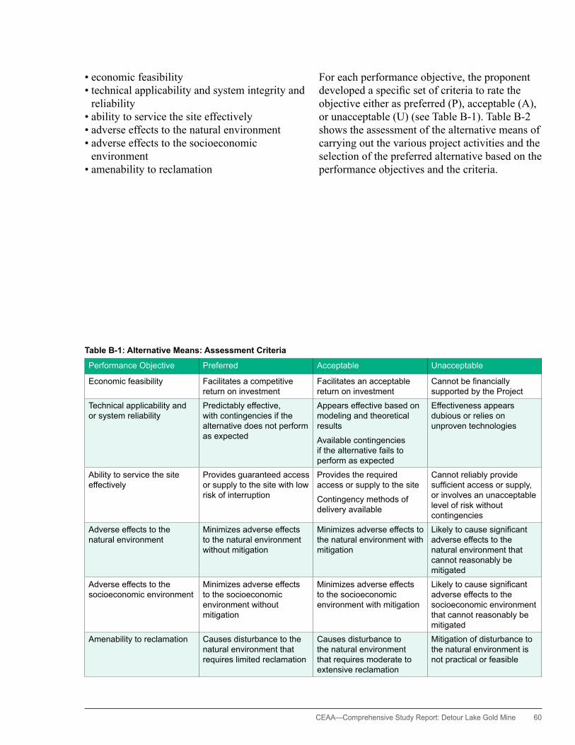
CEAA— Comprehensive Study Report: Detour Lake Gold Mine 60
• economic feasibility • technical applicability and system integrity and
reliability • ability to service the site effectively • adverse effects to the natural environment • adverse effects to the socioeconomic
environment • amenability to reclamation
For each performance objective, the proponent developed a specific set of criteria to rate the objective either as preferred (P), acceptable (A), or unacceptable (U) (see Table B-1). Table B-2 shows the assessment of the alternative means of carrying out the various project activities and the selection of the preferred alternative based on the performance objectives and the criteria.
Table B-1: Alternative Means: Assessment Criteria
Performance Objective Preferred Acceptable Unacceptable
Economic feasibility Facilitates a competitive return on investment
Facilitates an acceptable return on investment
Cannotbefinanciallysupported by the Project
Technical applicability and or system reliability
Predictably effective, with contingencies if the alternative does not perform as expected
Appears effective based on modeling and theoretical results
Available contingencies if the alternative fails to perform as expected
Effectiveness appears dubious or relies on unproven technologies
Ability to service the site effectively
Provides guaranteed access or supply to the site with low risk of interruption
Provides the required access or supply to the site
Contingency methods of delivery available
Cannot reliably provide sufficientaccessorsupply,or involves an unacceptable level of risk without contingencies
Adverse effects to the natural environment
Minimizes adverse effects to the natural environment without mitigation
Minimizes adverse effects to the natural environment with mitigation
Likelytocausesignificantadverse effects to the natural environment that cannot reasonably be mitigated
Adverse effects to the socioeconomic environment
Minimizes adverse effects to the socioeconomic environment without mitigation
Minimizes adverse effects to the socioeconomic environment with mitigation
Likelytocausesignificantadverse effects to the socioeconomic environment that cannot reasonably be mitigated
Amenability to reclamation Causes disturbance to the natural environment that requires limited reclamation
Causes disturbance to the natural environment that requires moderate to extensive reclamation
Mitigation of disturbance to the natural environment is not practical or feasible

61 CEAA—Comprehensive Study Report: Detour Lake Gold Mine
Table B-2: Summary of Evaluation of Alternative Means of Carrying Out the Project
Alternative Cost EffectivenessTechnical Applicability and System Integrity and Reliability
Ability to Service the Site Effectively
Adverse Effects to the Natural Environment
Adverse Effects to the Socio-economic Environment Amenability to Reclamation Summary Rating
Mining MethodsUnderground shaft Cost prohibitive U Unable to mine a high tonnage, low
grade, and near surface ore body, which exhibits a randomized pocket distribution; would leave a substantial crown pillar behind
U NA – Minimal effect on terrestrial and aquatic environments
P Minimal negative effect; no potential for positive local and regional economic opportunities
A Minimal requirements P Unacceptable
Underground ramp Cost prohibitive U Unable to mine a high tonnage, low grade, and near surface ore body, which exhibits a randomized pocket distribution; would leave a substantial crown pillar behind
U NA – Minimal effect on terrestrial and aquatic environments
P Minimal negative effect; no potential for positive local and regional economic opportunities
A Minimal requirements P Unacceptable
Open pit Cost effective P Mines entire ore body P NA – Local loss of terrestrial habitat and intermittent creek drainages (associated with waste rock production); losses can be offset by stockpile rehabilitation and fishhabitatcompensationmeasures
A Effects on TLU expected to be minimal; provides positive economic opportunities to local and regional communities, including Aboriginal communities, as this is the only feasible mining option
P Land disturbance requires reclamation; acid rock drainage from waste rock stockpiles may require management in perpetuity to protect downstream waters; mitigation measures are available and practicable
A Preferred
Explosives Use
ANFO Less costly compared with use of emulsion and emulsion blend explosives
P ANFO has use limitations relative to wet ground conditions, but these limitations can be partially offset through the use of impermeable stem liners.
A NA – Ammonia residuals at source are higher with ANFO explosives compared with emulsion and emulsion blend explosives; extended pond aging in the TIA wouldreducefinaleffluentammonia concentrations to acceptable levels
A ANFO use in the industry is routine and safe.
P NA – Preferred
Emulsion and emulsion blend explosives
Considerably more costly compared with ANFO use
A Emulsion and emulsion blend explosives are better suited to a range of ground moisture conditions.
P NA – Emulsion and emulsion blend explosives generate less ammonia residuals at source compared with ANFO explosives
P Emulsion and emulsion blend explosives use in the industry is routine and safe.
P NA – Preferred
Waste Rock and Overburden ManagementMRS #1 (north of proposed open pit)
As close as practicable to the open pit, resulting in lowest practicable haul distances, truck turn-around times, and overall associated costs
P Predictably effective and adaptable for PAG and NAG material
P NA – Location most suitable for PAG material
P NA – Location most suitable for PAG material and associated runoff management at closure
P Preferred (for PAG and NAG material)
MRS #2 (south of proposed open pit)
As close as practicable to the open pit, resulting in shortest haul distances, truck turn-around times, and overall lowest associated costs
P Predictably effective for NAG material, but would require added runoff collection for PAG material
P NA – Location most suitable for NAG material
P NA – Location suitable for NAG material
P Preferred (for NAG material)
West of Deem Lake and north of mine access road, stockpile area
haul distances substantially greater than for other alternatives, resulting in substantively higher costs over the MRS #2 alternative
U Predictably effective for NAG material, but would require added runoff collection for PAG material
A NA – Use of this alternative would unnecessarily expand the overall project footprint
A NA – Location suitable for NAG material
P Unacceptable
U—unacceptable; A—acceptable; P—preferred; NA—not applicable

CEAA— Comprehensive Study Report: Detour Lake Gold Mine 62
Table B-2: Summary of Evaluation of Alternative Means of Carrying Out the Project
Alternative Cost EffectivenessTechnical Applicability and System Integrity and Reliability
Ability to Service the Site Effectively
Adverse Effects to the Natural Environment
Adverse Effects to the Socio-economic Environment Amenability to Reclamation Summary Rating
Mining MethodsUnderground shaft Cost prohibitive U Unable to mine a high tonnage, low
grade, and near surface ore body, which exhibits a randomized pocket distribution; would leave a substantial crown pillar behind
U NA – Minimal effect on terrestrial and aquatic environments
P Minimal negative effect; no potential for positive local and regional economic opportunities
A Minimal requirements P Unacceptable
Underground ramp Cost prohibitive U Unable to mine a high tonnage, low grade, and near surface ore body, which exhibits a randomized pocket distribution; would leave a substantial crown pillar behind
U NA – Minimal effect on terrestrial and aquatic environments
P Minimal negative effect; no potential for positive local and regional economic opportunities
A Minimal requirements P Unacceptable
Open pit Cost effective P Mines entire ore body P NA – Local loss of terrestrial habitat and intermittent creek drainages (associated with waste rock production); losses can be offset by stockpile rehabilitation and fishhabitatcompensationmeasures
A Effects on TLU expected to be minimal; provides positive economic opportunities to local and regional communities, including Aboriginal communities, as this is the only feasible mining option
P Land disturbance requires reclamation; acid rock drainage from waste rock stockpiles may require management in perpetuity to protect downstream waters; mitigation measures are available and practicable
A Preferred
Explosives Use
ANFO Less costly compared with use of emulsion and emulsion blend explosives
P ANFO has use limitations relative to wet ground conditions, but these limitations can be partially offset through the use of impermeable stem liners.
A NA – Ammonia residuals at source are higher with ANFO explosives compared with emulsion and emulsion blend explosives; extended pond aging in the TIA wouldreducefinaleffluentammonia concentrations to acceptable levels
A ANFO use in the industry is routine and safe.
P NA – Preferred
Emulsion and emulsion blend explosives
Considerably more costly compared with ANFO use
A Emulsion and emulsion blend explosives are better suited to a range of ground moisture conditions.
P NA – Emulsion and emulsion blend explosives generate less ammonia residuals at source compared with ANFO explosives
P Emulsion and emulsion blend explosives use in the industry is routine and safe.
P NA – Preferred
Waste Rock and Overburden ManagementMRS #1 (north of proposed open pit)
As close as practicable to the open pit, resulting in lowest practicable haul distances, truck turn-around times, and overall associated costs
P Predictably effective and adaptable for PAG and NAG material
P NA – Location most suitable for PAG material
P NA – Location most suitable for PAG material and associated runoff management at closure
P Preferred (for PAG and NAG material)
MRS #2 (south of proposed open pit)
As close as practicable to the open pit, resulting in shortest haul distances, truck turn-around times, and overall lowest associated costs
P Predictably effective for NAG material, but would require added runoff collection for PAG material
P NA – Location most suitable for NAG material
P NA – Location suitable for NAG material
P Preferred (for NAG material)
West of Deem Lake and north of mine access road, stockpile area
haul distances substantially greater than for other alternatives, resulting in substantively higher costs over the MRS #2 alternative
U Predictably effective for NAG material, but would require added runoff collection for PAG material
A NA – Use of this alternative would unnecessarily expand the overall project footprint
A NA – Location suitable for NAG material
P Unacceptable
U—unacceptable; A—acceptable; P—preferred; NA—not applicable
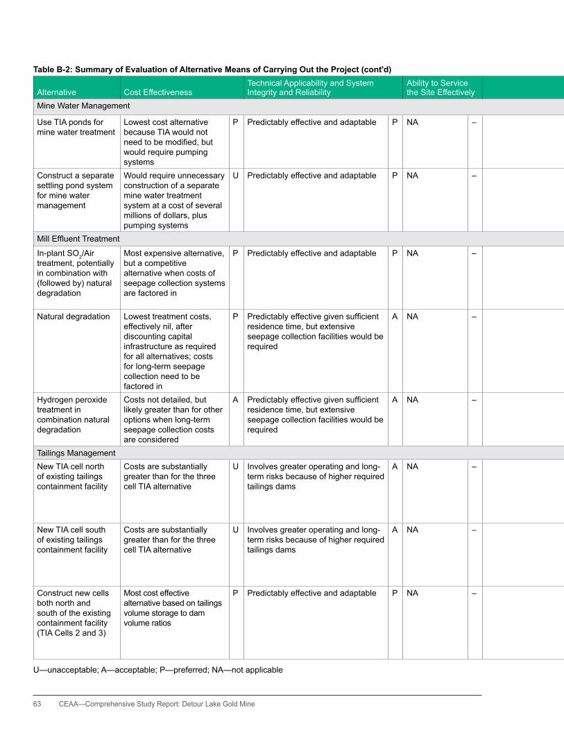
63 CEAA—Comprehensive Study Report: Detour Lake Gold Mine
Table B-2: Summary of Evaluation of Alternative Means of Carrying Out the Project (cont'd)
Alternative Cost EffectivenessTechnical Applicability and System Integrity and Reliability
Ability to Service the Site Effectively
Adverse Effects to the Natural Environment
Adverse Effects to the Socio-economic Environment Amenability to Reclamation Summary Rating
Mine Water Management
Use TIA ponds for mine water treatment
Lowest cost alternative because TIA would not needtobemodified,butwould require pumping systems
P Predictably effective and adaptable P NA – helps to maintain the smallest practical environmental footprint.
P NA – Would not alter closure plan requirements, as TIA would be constructed in any event
P Preferred
Construct a separate settling pond system for mine water management
Would require unnecessary construction of a separate mine water treatment system at a cost of several millions of dollars, plus pumping systems
U Predictably effective and adaptable P NA – Would unnecessarily expand the project footprint, and would result inasecondmajoreffluentdischarge point
A NA – Would increase reclamation costs
A Unacceptable
MillEffluentTreatment
In-plant SO2/Air treatment, potentially in combination with (followed by) natural degradation
Most expensive alternative, but a competitive alternative when costs of seepage collection systems are factored in
P Predictably effective and adaptable P NA – Use of this technology provides the greatest level of environmental protection, including protection against spills either from the tailings pipeline or from the TIA
P Provides the greatest measureoffisheriesresource protection
P Application of this technology reduces long-term closure risks and costs associated with seepage collection and management
– Preferred
Natural degradation Lowest treatment costs, effectively nil, after discounting capital infrastructure as required for all alternatives; costs for long-term seepage collection need to be factored in
P Predictablyeffectivegivensufficientresidence time, but extensive seepage collection facilities would be required
A NA – Technology when used with long-term seepage collection would provide effective environmental protection.
A Provides an acceptable level of resource protection, provided that seepage collection and tailings line spill collection facilities are in place
A Required seepage collection and management liabilities would be considerable.
– Acceptable
hydrogen peroxide treatment in combination natural degradation
Costs not detailed, but likely greater than for other options when long-term seepage collection costs are considered
A Predictablyeffectivegivensufficientresidence time, but extensive seepage collection facilities would be required
A NA – Technology when used with long-term seepage collection would provide effective environmental protection.
A Provides acceptable level of resource protection, provided that seepage collection and tailings pipeline spill collection facilities are in place
A Required seepage collection and management liabilities would be considerable.
– Acceptable
Tailings Management New TIA cell north of existing tailings containment facility
Costs are substantially greater than for the three cell TIA alternative
U Involves greater operating and long-term risks because of higher required tailings dams
A NA – Similar environmental footprint to the south TIA cell, and easily integrated into an overall TIA water management system; greater risk because of higher dams
A Increased risks to downstream aquatic resources because of higher dams
A Costly to rehabilitate due to areal extent
A Unacceptable
New TIA cell south of existing tailings containment facility
Costs are substantially greater than for the three cell TIA alternative
U Involves greater operating and long-term risks because of higher required tailings dams
A NA – Similar environmental footprint to the north TIA cell, and easily integrated into an overall TIA water management system; greater risks because of higher dams
A Increased risks to downstream aquatic resources because of higher dams
A Costly to rehabilitate due to areal extent
A Unacceptable
Construct new cells both north and south of the existing containment facility (TIA Cells 2 and 3)
Most cost effective alternative based on tailings volume storage to dam volume ratios
P Predictably effective and adaptable P NA – Increased footprint compared to either of the above options, but improved long-term stability due to lower dams and improved water management capacity with three cells
P Least risk to downstream aquatic resources because of lower dams
P Most costly to rehabilitate due to use of three cells rather than the two cells associated with other alternatives
A Preferred
U—unacceptable; A—acceptable; P—preferred; NA—not applicable

CEAA— Comprehensive Study Report: Detour Lake Gold Mine 64
Table B-2: Summary of Evaluation of Alternative Means of Carrying Out the Project (cont'd)
Alternative Cost EffectivenessTechnical Applicability and System Integrity and Reliability
Ability to Service the Site Effectively
Adverse Effects to the Natural Environment
Adverse Effects to the Socio-economic Environment Amenability to Reclamation Summary Rating
Mine Water Management
Use TIA ponds for mine water treatment
Lowest cost alternative because TIA would not needtobemodified,butwould require pumping systems
P Predictably effective and adaptable P NA – helps to maintain the smallest practical environmental footprint.
P NA – Would not alter closure plan requirements, as TIA would be constructed in any event
P Preferred
Construct a separate settling pond system for mine water management
Would require unnecessary construction of a separate mine water treatment system at a cost of several millions of dollars, plus pumping systems
U Predictably effective and adaptable P NA – Would unnecessarily expand the project footprint, and would result inasecondmajoreffluentdischarge point
A NA – Would increase reclamation costs
A Unacceptable
MillEffluentTreatment
In-plant SO2/Air treatment, potentially in combination with (followed by) natural degradation
Most expensive alternative, but a competitive alternative when costs of seepage collection systems are factored in
P Predictably effective and adaptable P NA – Use of this technology provides the greatest level of environmental protection, including protection against spills either from the tailings pipeline or from the TIA
P Provides the greatest measureoffisheriesresource protection
P Application of this technology reduces long-term closure risks and costs associated with seepage collection and management
– Preferred
Natural degradation Lowest treatment costs, effectively nil, after discounting capital infrastructure as required for all alternatives; costs for long-term seepage collection need to be factored in
P Predictablyeffectivegivensufficientresidence time, but extensive seepage collection facilities would be required
A NA – Technology when used with long-term seepage collection would provide effective environmental protection.
A Provides an acceptable level of resource protection, provided that seepage collection and tailings line spill collection facilities are in place
A Required seepage collection and management liabilities would be considerable.
– Acceptable
hydrogen peroxide treatment in combination natural degradation
Costs not detailed, but likely greater than for other options when long-term seepage collection costs are considered
A Predictablyeffectivegivensufficientresidence time, but extensive seepage collection facilities would be required
A NA – Technology when used with long-term seepage collection would provide effective environmental protection.
A Provides acceptable level of resource protection, provided that seepage collection and tailings pipeline spill collection facilities are in place
A Required seepage collection and management liabilities would be considerable.
– Acceptable
Tailings Management New TIA cell north of existing tailings containment facility
Costs are substantially greater than for the three cell TIA alternative
U Involves greater operating and long-term risks because of higher required tailings dams
A NA – Similar environmental footprint to the south TIA cell, and easily integrated into an overall TIA water management system; greater risk because of higher dams
A Increased risks to downstream aquatic resources because of higher dams
A Costly to rehabilitate due to areal extent
A Unacceptable
New TIA cell south of existing tailings containment facility
Costs are substantially greater than for the three cell TIA alternative
U Involves greater operating and long-term risks because of higher required tailings dams
A NA – Similar environmental footprint to the north TIA cell, and easily integrated into an overall TIA water management system; greater risks because of higher dams
A Increased risks to downstream aquatic resources because of higher dams
A Costly to rehabilitate due to areal extent
A Unacceptable
Construct new cells both north and south of the existing containment facility (TIA Cells 2 and 3)
Most cost effective alternative based on tailings volume storage to dam volume ratios
P Predictably effective and adaptable P NA – Increased footprint compared to either of the above options, but improved long-term stability due to lower dams and improved water management capacity with three cells
P Least risk to downstream aquatic resources because of lower dams
P Most costly to rehabilitate due to use of three cells rather than the two cells associated with other alternatives
A Preferred
U—unacceptable; A—acceptable; P—preferred; NA—not applicable
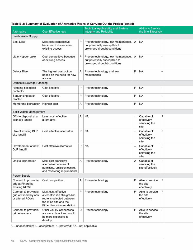
65 CEAA—Comprehensive Study Report: Detour Lake Gold Mine
Table B-2: Summary of Evaluation of Alternative Means of Carrying Out the Project (cont'd)
Alternative Cost EffectivenessTechnical Applicability and System Integrity and Reliability
Ability to Service the Site Effectively
Adverse Effects to the Natural Environment
Adverse Effects to the Socio-economic Environment Amenability to Reclamation Summary Rating
Fresh Water Supply
East Lake Most cost competitive because of distance and existing access
P Proven technology, low maintenance, but potentially susceptible to prolonged drought conditions
A NA – Development of this alternative is the least disruptive to the environment.
P Minimal effect P No major impediments to closure
P Preferred
Little hopper Lake Cost competitive because of existing access
P Proven technology, low maintenance, but potentially susceptible to prolonged drought conditions
A NA – Development of this alternative is expected to have limited adverse effects to the environment.
P Minimal effect P No major impediments to closure
P Acceptable
Detour River The highest cost option based on the need for new access
A Proven technology and low maintenance
P NA – Potential unnecessary adverse effects to caribou (SAR)
A Minimal effect P No major impediments to closure
P Acceptable
Domestic Sewage handling
Rotating biological contactor
Cost effective P Proven technology P NA – Provides acceptable level of effluenttreatment
A NA – NA – Acceptable
Sequencing batch reactor
Cost effective P Proven technology P NA – Provides acceptable level of effluenttreatment
A NA – NA – Acceptable
Membrane bioreactor highest cost A Proven technology P NA – Provides the most effective effluenttreatment
P NA – NA – Preferred
Solid Waste ManagementOffsite disposal at a licencedlandfill
Least cost effective alternative
A NA – Capable of effectively servicing the site
P Uses an existing site P Compromises other users A Reduces site liability P Acceptable
Use of existing DLP sitelandfill
Cost effective alternative P NA – Capable of effectively servicing the site
P Uses an existing site P Does not compromise other users
P Limits additional site liability
P Preferred
Development of new DLPlandfill
Cost effective alternative P NA – Capable of effectively servicing the site
P Development of a new site would be more disruptive to the environment.
A Does not compromise other users
P Adds additional liability A Acceptable
Onsite incineration Most cost prohibitive alternative because of permitting, emission control, and monitoring requirements
A Proven technology A Capable of servicing the site effectively
P Challenging to obtain approvals given the availability of other alternatives
U NA – No major impediments to closure
P Unacceptable
Power SupplyConnect to provincial grid at Pinard by existing ROWs
Cost competitive A Proven technology P Able to service the site effectively
P Limited environmental effects because follows along, or adjacent to, existing ROWs
P NA – No major impediments to closure
P Preferred
Connect to provincial grid at Pinard by new or altered ROWs
Most cost effective alternative if a straight-line route is selected between the mine site and the Pinard transformer station
P Proven technology P Able to service the site effectively
P Would involve new ROWs, including likely or possible crossing of park and conservation areas
A NA – No major impediments to closure
P Acceptable
Connect to provincial grid elsewhere
Other 230 kV connections are more distant and would be more expensive to develop.
U Proven technology P Able to service the site effectively
P Would involve new ROWs, including likely or possible crossing of park and conservation areas
A NA – No major impediments to closure
P Unacceptable
U—unacceptable; A—acceptable; P—preferred; NA—not applicable
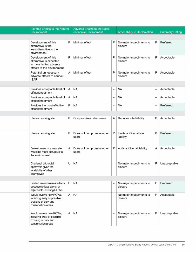
CEAA— Comprehensive Study Report: Detour Lake Gold Mine 66
Table B-2: Summary of Evaluation of Alternative Means of Carrying Out the Project (cont'd)
Alternative Cost EffectivenessTechnical Applicability and System Integrity and Reliability
Ability to Service the Site Effectively
Adverse Effects to the Natural Environment
Adverse Effects to the Socio-economic Environment Amenability to Reclamation Summary Rating
Fresh Water Supply
East Lake Most cost competitive because of distance and existing access
P Proven technology, low maintenance, but potentially susceptible to prolonged drought conditions
A NA – Development of this alternative is the least disruptive to the environment.
P Minimal effect P No major impediments to closure
P Preferred
Little hopper Lake Cost competitive because of existing access
P Proven technology, low maintenance, but potentially susceptible to prolonged drought conditions
A NA – Development of this alternative is expected to have limited adverse effects to the environment.
P Minimal effect P No major impediments to closure
P Acceptable
Detour River The highest cost option based on the need for new access
A Proven technology and low maintenance
P NA – Potential unnecessary adverse effects to caribou (SAR)
A Minimal effect P No major impediments to closure
P Acceptable
Domestic Sewage handling
Rotating biological contactor
Cost effective P Proven technology P NA – Provides acceptable level of effluenttreatment
A NA – NA – Acceptable
Sequencing batch reactor
Cost effective P Proven technology P NA – Provides acceptable level of effluenttreatment
A NA – NA – Acceptable
Membrane bioreactor highest cost A Proven technology P NA – Provides the most effective effluenttreatment
P NA – NA – Preferred
Solid Waste ManagementOffsite disposal at a licencedlandfill
Least cost effective alternative
A NA – Capable of effectively servicing the site
P Uses an existing site P Compromises other users A Reduces site liability P Acceptable
Use of existing DLP sitelandfill
Cost effective alternative P NA – Capable of effectively servicing the site
P Uses an existing site P Does not compromise other users
P Limits additional site liability
P Preferred
Development of new DLPlandfill
Cost effective alternative P NA – Capable of effectively servicing the site
P Development of a new site would be more disruptive to the environment.
A Does not compromise other users
P Adds additional liability A Acceptable
Onsite incineration Most cost prohibitive alternative because of permitting, emission control, and monitoring requirements
A Proven technology A Capable of servicing the site effectively
P Challenging to obtain approvals given the availability of other alternatives
U NA – No major impediments to closure
P Unacceptable
Power SupplyConnect to provincial grid at Pinard by existing ROWs
Cost competitive A Proven technology P Able to service the site effectively
P Limited environmental effects because follows along, or adjacent to, existing ROWs
P NA – No major impediments to closure
P Preferred
Connect to provincial grid at Pinard by new or altered ROWs
Most cost effective alternative if a straight-line route is selected between the mine site and the Pinard transformer station
P Proven technology P Able to service the site effectively
P Would involve new ROWs, including likely or possible crossing of park and conservation areas
A NA – No major impediments to closure
P Acceptable
Connect to provincial grid elsewhere
Other 230 kV connections are more distant and would be more expensive to develop.
U Proven technology P Able to service the site effectively
P Would involve new ROWs, including likely or possible crossing of park and conservation areas
A NA – No major impediments to closure
P Unacceptable
U—unacceptable; A—acceptable; P—preferred; NA—not applicable
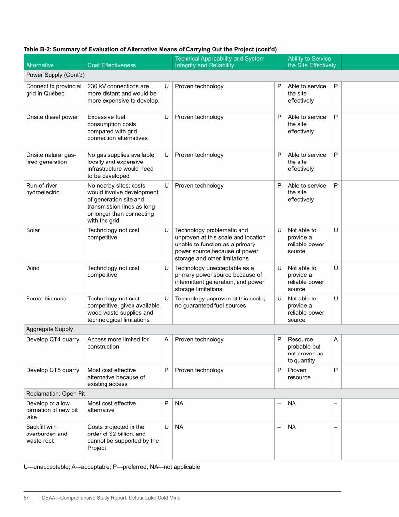
67 CEAA—Comprehensive Study Report: Detour Lake Gold Mine
Table B-2: Summary of Evaluation of Alternative Means of Carrying Out the Project (cont'd)
Alternative Cost EffectivenessTechnical Applicability and System Integrity and Reliability
Ability to Service the Site Effectively
Adverse Effects to the Natural Environment
Adverse Effects to the Socio-economic Environment Amenability to Reclamation Summary Rating
Power Supply (Cont'd)
Connect to provincial grid in Québec
230 kV connections are more distant and would be more expensive to develop.
U Proven technology P Able to service the site effectively
P Would involve new ROWs, including likely or possible crossing of park and conservation areas
A NA – No major impediments to closure
P Unacceptable
Onsite diesel power Excessive fuel consumption costs compared with grid connection alternatives
U Proven technology P Able to service the site effectively
P Substantial fuel transport and consumption, increasing risks of fuel spills; increased GhG production
A NA – No major impediments to closure
P Unacceptable
Onsite natural gas-firedgeneration
No gas supplies available locally and expensive infrastructure would need to be developed
U Proven technology P Able to service the site effectively
P Limited environmental effects; would require substantial pipeline route
P NA – No major impediments to closure
P Unacceptable
Run-of-river hydroelectric
No nearby sites; costs would involve development of generation site and transmission lines as long or longer than connecting with the grid
U Proven technology P Able to service the site effectively
P Environmental effects would be greater than for direct transmission line connections.
U NA – No major impediments to closure
P Unacceptable
Solar Technology not cost competitive
U Technology problematic and unproven at this scale and location; unable to function as a primary power source because of power storage and other limitations
U Not able to provide a reliable power source
U Limited environmental effects; requires considerable land base
P NA – No major impediments to closure
P Unacceptable
Wind Technology not cost competitive
U Technology unacceptable as a primary power source because of intermittent generation, and power storage limitations
U Not able to provide a reliable power source
U Limited environmental effects
P NA – No major impediments to closure
P Unacceptable
Forest biomass Technology not cost competitive, given available wood waste supplies and technological limitations
U Technology unproven at this scale; no guaranteed fuel sources
U Not able to provide a reliable power source
U Fuel wood supplies would be problematic.
U NA – No major impediments to closure
P Unacceptable
Aggregate Supply
Develop QT4 quarry Access more limited for construction
A Proven technology P Resource probable but not proven as to quantity
A No added environmental effects as contained with future TIA footprint
P NA – Likely no major impediments to closure
P Acceptable
Develop QT5 quarry Most cost effective alternative because of existing access
P Proven technology P Proven resource
P Limited environmental footprint
A NA – Likely no major impediments to closure
P Preferred
Reclamation: Open PitDevelop or allow formation of new pit lake
Most cost effective alternative
P NA – NA – NA – Providesnodirectbenefit P Consistent with long-term acid rock drainage water management objectives
P Preferred
Backfillwithoverburden and waste rock
Costs projected in the order of $2 billion, and cannot be supported by the Project
U NA – NA – NA – Costs would make the Project uneconomic, therefore negating positive socioeconomic effects of project development.
U Alternative would require rehabilitation as terrestrial habitat
A Unacceptable
U—unacceptable; A—acceptable; P—preferred; NA—not applicable
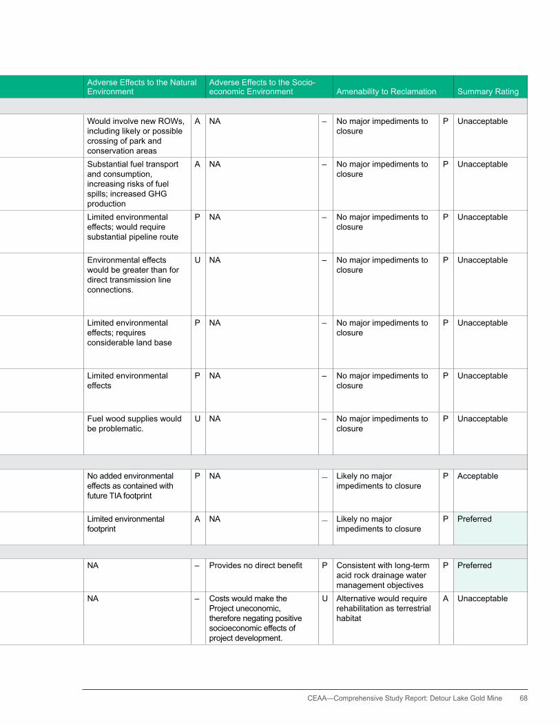
CEAA— Comprehensive Study Report: Detour Lake Gold Mine 68
Table B-2: Summary of Evaluation of Alternative Means of Carrying Out the Project (cont'd)
Alternative Cost EffectivenessTechnical Applicability and System Integrity and Reliability
Ability to Service the Site Effectively
Adverse Effects to the Natural Environment
Adverse Effects to the Socio-economic Environment Amenability to Reclamation Summary Rating
Power Supply (Cont'd)
Connect to provincial grid in Québec
230 kV connections are more distant and would be more expensive to develop.
U Proven technology P Able to service the site effectively
P Would involve new ROWs, including likely or possible crossing of park and conservation areas
A NA – No major impediments to closure
P Unacceptable
Onsite diesel power Excessive fuel consumption costs compared with grid connection alternatives
U Proven technology P Able to service the site effectively
P Substantial fuel transport and consumption, increasing risks of fuel spills; increased GhG production
A NA – No major impediments to closure
P Unacceptable
Onsite natural gas-firedgeneration
No gas supplies available locally and expensive infrastructure would need to be developed
U Proven technology P Able to service the site effectively
P Limited environmental effects; would require substantial pipeline route
P NA – No major impediments to closure
P Unacceptable
Run-of-river hydroelectric
No nearby sites; costs would involve development of generation site and transmission lines as long or longer than connecting with the grid
U Proven technology P Able to service the site effectively
P Environmental effects would be greater than for direct transmission line connections.
U NA – No major impediments to closure
P Unacceptable
Solar Technology not cost competitive
U Technology problematic and unproven at this scale and location; unable to function as a primary power source because of power storage and other limitations
U Not able to provide a reliable power source
U Limited environmental effects; requires considerable land base
P NA – No major impediments to closure
P Unacceptable
Wind Technology not cost competitive
U Technology unacceptable as a primary power source because of intermittent generation, and power storage limitations
U Not able to provide a reliable power source
U Limited environmental effects
P NA – No major impediments to closure
P Unacceptable
Forest biomass Technology not cost competitive, given available wood waste supplies and technological limitations
U Technology unproven at this scale; no guaranteed fuel sources
U Not able to provide a reliable power source
U Fuel wood supplies would be problematic.
U NA – No major impediments to closure
P Unacceptable
Aggregate Supply
Develop QT4 quarry Access more limited for construction
A Proven technology P Resource probable but not proven as to quantity
A No added environmental effects as contained with future TIA footprint
P NA – Likely no major impediments to closure
P Acceptable
Develop QT5 quarry Most cost effective alternative because of existing access
P Proven technology P Proven resource
P Limited environmental footprint
A NA – Likely no major impediments to closure
P Preferred
Reclamation: Open PitDevelop or allow formation of new pit lake
Most cost effective alternative
P NA – NA – NA – Providesnodirectbenefit P Consistent with long-term acid rock drainage water management objectives
P Preferred
Backfillwithoverburden and waste rock
Costs projected in the order of $2 billion, and cannot be supported by the Project
U NA – NA – NA – Costs would make the Project uneconomic, therefore negating positive socioeconomic effects of project development.
U Alternative would require rehabilitation as terrestrial habitat
A Unacceptable
U—unacceptable; A—acceptable; P—preferred; NA—not applicable

69 CEAA—Comprehensive Study Report: Detour Lake Gold Mine
Table B-2: Summary of Evaluation of Alternative Means of Carrying Out the Project (cont'd)
Alternative Cost EffectivenessTechnical Applicability and System Integrity and Reliability
Ability to Service the Site Effectively
Adverse Effects to the Natural Environment
Adverse Effects to the Socio-economic Environment Amenability to Reclamation Summary Rating
Reclamation: Demolition Wastes
Disposal of demolition wastes within one of the waste rock or overburden stockpiles
Most cost effective alternative
P NA – NA – NA – Providesnodirectbenefitor cost
P Acceptable solution that does not result in an expanded project footprint
P Preferred
Creation of a stand-alone demolition wastelandfill
Intermediate in costs A NA – NA – NA – Providesnodirectbenefitor cost
P Acceptable solution but would expand the project footprint
A Acceptable
Disposal of demolition wastes within the open pit
Cost prohibitive because of transport costs and covers, and the need to continue pit dewatering for an additional two or more years
U NA – NA – NA – Providesnodirectbenefitor cost
P Acceptable provided that demolition wastes are essentially free of hydrocarbon contamination
A Unacceptable
Reclamation: Waste Rock Stockpiles
Cover stockpiles with 0.3 to 0.5 m layer of overburden and revegetate
Most costly A NA – NA – NA – NA – Consistent with O.Reg. 240/00 requirements
A Acceptable
Develop overburden islands on the waste rock stockpiles, with the aim of developing a patchwork environment of forest patches and lichen habitat if practical
Intermediate in costs P NA – NA – NA – NA – Consistent with O.Reg. 240/00 requirements and provides the opportunity to develop preferred caribou habitat
P Preferred
U—unacceptable; A—acceptable; P—preferred; NA—not applicable
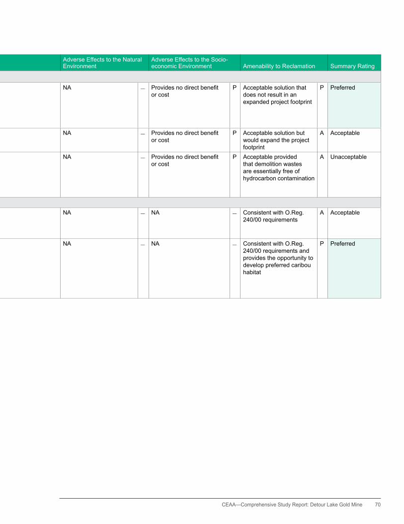
CEAA— Comprehensive Study Report: Detour Lake Gold Mine 70
Table B-2: Summary of Evaluation of Alternative Means of Carrying Out the Project (cont'd)
Alternative Cost EffectivenessTechnical Applicability and System Integrity and Reliability
Ability to Service the Site Effectively
Adverse Effects to the Natural Environment
Adverse Effects to the Socio-economic Environment Amenability to Reclamation Summary Rating
Reclamation: Demolition Wastes
Disposal of demolition wastes within one of the waste rock or overburden stockpiles
Most cost effective alternative
P NA – NA – NA – Providesnodirectbenefitor cost
P Acceptable solution that does not result in an expanded project footprint
P Preferred
Creation of a stand-alone demolition wastelandfill
Intermediate in costs A NA – NA – NA – Providesnodirectbenefitor cost
P Acceptable solution but would expand the project footprint
A Acceptable
Disposal of demolition wastes within the open pit
Cost prohibitive because of transport costs and covers, and the need to continue pit dewatering for an additional two or more years
U NA – NA – NA – Providesnodirectbenefitor cost
P Acceptable provided that demolition wastes are essentially free of hydrocarbon contamination
A Unacceptable
Reclamation: Waste Rock Stockpiles
Cover stockpiles with 0.3 to 0.5 m layer of overburden and revegetate
Most costly A NA – NA – NA – NA – Consistent with O.Reg. 240/00 requirements
A Acceptable
Develop overburden islands on the waste rock stockpiles, with the aim of developing a patchwork environment of forest patches and lichen habitat if practical
Intermediate in costs P NA – NA – NA – NA – Consistent with O.Reg. 240/00 requirements and provides the opportunity to develop preferred caribou habitat
P Preferred
U—unacceptable; A—acceptable; P—preferred; NA—not applicable

71 CEAA—Comprehensive Study Report: Detour Lake Gold Mine
Appendix C. Aboriginal Consultation and Issues Raised
Table C-1 summarizes the issues raised by Aboriginal groups and the responses provided by the proponent and the Canadian Environmental
Assessment Agency. Note: If an issue was raised by only one group that group is named; if a concern was expressed by more than one group the term “multiple groups” is used.
Table C-1: Summary of the Aboriginal Consultation Issues Raised Issue/Concern Raised Aboriginal Group Source of Concern Potential Environmental Effects Proponent's Response Canadian Environmental Assessment Agency Response Effects of mine disturbance (loss of habitat, noise or sensory disturbance) on wildlife populations, particularly caribou
Multiple Groups Traditional use— hunting, trapping, harvesting
Decline in wildlife populations Minimize footprint size, utilize previously disturbed lands as practical, avoidance of key habitat areas, study and attempt to reclaim portions of site for caribou use and discourage other competing animals.
Section 7 and Appendix F outline the potential effects, mitigation measures, and environmental effects analysis for wildlife. The Agency has concluded that, taking into accountmitigationmeasures,therewillbenosignificanteffects on wildlife, as well as associated traditional land use and resource harvesting. Appendix h of this Report contains the proponent’s summary of environmental commitments. Appendix J of this Report contains the proponent’slettersconfirmingmonitoringandfollow-upcommitments.
Loss of opportunities to meaningfully participate in cultural activities such ashunting,fishing,trapping,andgenerally spending time on the land. Increases in hunting by mine workers and contractors
Multiple Groups Traditional use—cultural heritage
Decreased wildlife availability; decreased opportunities for traditional or cultural activities
Avoidanceofareasidentifiedthroughtraditionalknowledgestudy, minimize project footprint,utilize previously disturbed lands as practical, avoidance of key habitat areas, study and attempt to reclaim portions of site for caribou use.
Proponent’s policy of no hunting by Detour Gold employees and contractors while they are on work rotation (requirement to leave site thereafter).
Reuse of existing access and avoid creation of new access creation as practical.
Section 7 and Appendix F outline the potential effects, mitigation measures, and environmental effects analysis for wildlife. The Agency has concluded that, taking into accountmitigationmeasures,therewillbenosignificanteffects on wildlife, as well as associated traditional land use and resource harvesting. Appendix h of this Report contains the proponent’s summary of environmental commitments. The summary references recreational huntingandfishingactivities.AppendixJofthisReportcontainstheproponent’slettersconfirmingmonitoringandfollow-up commitments.
Wildlife mortality due to increases in trafficvolume
Multiple Groups Traditional use—hunting, harvesting
Decline in wildlife populations Requirement to follow speed limit and rules of road; implementation of site access/bussing policy to limit number of private vehicles; maintenance of a wildlife log to track incidents and determine if additional measures are needed.
Section 7 and Appendix F outline the potential effects, mitigation measures, and environmental effects analysis for wildlife. The Agency has concluded that, taking into accountmitigationmeasures,therewillbenosignificanteffects on wildlife, as well as associated traditional land use and resource harvesting.
Changes to the health and quality of the furs, meat of animals harvested for consumption or use
Multiple Groups Traditional use—hunting, trapping, harvesting
Decline in health and quality of wildlife
Assessment of potential impacts and risks through environmental assessment processes, and commitment to test wildlife samples provided by First Nations, etc.
Section 7 and Appendix F outline the potential effects, mitigation measures, and environmental effects analysis for wildlife. The Agency has concluded that, taking into accountmitigationmeasures,therewillbenosignificanteffects on wildlife, as well as associated traditional land use and resource harvesting.
Changestotheflightpatternsofmigratory birds due to the presence of the transmission line
Multiple Groups Traditional use— hunting, harvesting
Decline in migratory bird populations in the area
Reuse of existing transmission line routing to Island Falls as practical (majority of length), and building beside the existing active hydro One transmission line for the remainder of the route to Pinard.
Section 7 and Appendix F outline the potential effects, mitigation measures, and environmental effects analysis for migratory birds. The Agency has concluded that, taking into account mitigation measures, there will be no significanteffectsonmigratorybirds,aswellasassociatedtraditional land use and resource harvesting.
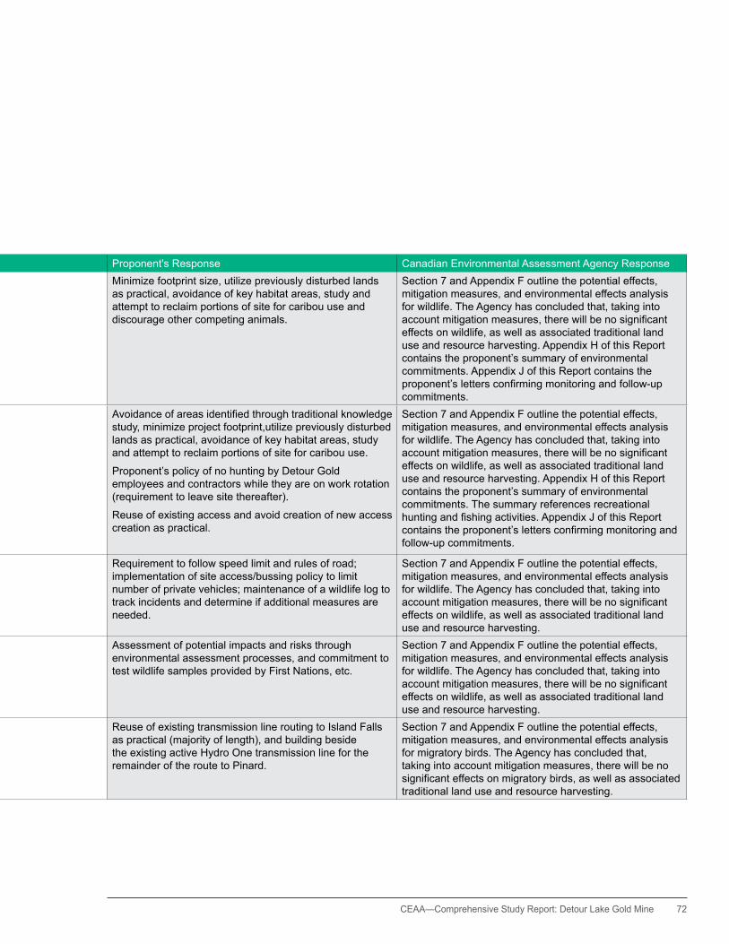
CEAA— Comprehensive Study Report: Detour Lake Gold Mine 72
Table C-1: Summary of the Aboriginal Consultation Issues Raised Issue/Concern Raised Aboriginal Group Source of Concern Potential Environmental Effects Proponent's Response Canadian Environmental Assessment Agency Response Effects of mine disturbance (loss of habitat, noise or sensory disturbance) on wildlife populations, particularly caribou
Multiple Groups Traditional use— hunting, trapping, harvesting
Decline in wildlife populations Minimize footprint size, utilize previously disturbed lands as practical, avoidance of key habitat areas, study and attempt to reclaim portions of site for caribou use and discourage other competing animals.
Section 7 and Appendix F outline the potential effects, mitigation measures, and environmental effects analysis for wildlife. The Agency has concluded that, taking into accountmitigationmeasures,therewillbenosignificanteffects on wildlife, as well as associated traditional land use and resource harvesting. Appendix h of this Report contains the proponent’s summary of environmental commitments. Appendix J of this Report contains the proponent’slettersconfirmingmonitoringandfollow-upcommitments.
Loss of opportunities to meaningfully participate in cultural activities such ashunting,fishing,trapping,andgenerally spending time on the land. Increases in hunting by mine workers and contractors
Multiple Groups Traditional use—cultural heritage
Decreased wildlife availability; decreased opportunities for traditional or cultural activities
Avoidanceofareasidentifiedthroughtraditionalknowledgestudy, minimize project footprint,utilize previously disturbed lands as practical, avoidance of key habitat areas, study and attempt to reclaim portions of site for caribou use.
Proponent’s policy of no hunting by Detour Gold employees and contractors while they are on work rotation (requirement to leave site thereafter).
Reuse of existing access and avoid creation of new access creation as practical.
Section 7 and Appendix F outline the potential effects, mitigation measures, and environmental effects analysis for wildlife. The Agency has concluded that, taking into accountmitigationmeasures,therewillbenosignificanteffects on wildlife, as well as associated traditional land use and resource harvesting. Appendix h of this Report contains the proponent’s summary of environmental commitments. The summary references recreational huntingandfishingactivities.AppendixJofthisReportcontainstheproponent’slettersconfirmingmonitoringandfollow-up commitments.
Wildlife mortality due to increases in trafficvolume
Multiple Groups Traditional use—hunting, harvesting
Decline in wildlife populations Requirement to follow speed limit and rules of road; implementation of site access/bussing policy to limit number of private vehicles; maintenance of a wildlife log to track incidents and determine if additional measures are needed.
Section 7 and Appendix F outline the potential effects, mitigation measures, and environmental effects analysis for wildlife. The Agency has concluded that, taking into accountmitigationmeasures,therewillbenosignificanteffects on wildlife, as well as associated traditional land use and resource harvesting.
Changes to the health and quality of the furs, meat of animals harvested for consumption or use
Multiple Groups Traditional use—hunting, trapping, harvesting
Decline in health and quality of wildlife
Assessment of potential impacts and risks through environmental assessment processes, and commitment to test wildlife samples provided by First Nations, etc.
Section 7 and Appendix F outline the potential effects, mitigation measures, and environmental effects analysis for wildlife. The Agency has concluded that, taking into accountmitigationmeasures,therewillbenosignificanteffects on wildlife, as well as associated traditional land use and resource harvesting.
Changestotheflightpatternsofmigratory birds due to the presence of the transmission line
Multiple Groups Traditional use— hunting, harvesting
Decline in migratory bird populations in the area
Reuse of existing transmission line routing to Island Falls as practical (majority of length), and building beside the existing active hydro One transmission line for the remainder of the route to Pinard.
Section 7 and Appendix F outline the potential effects, mitigation measures, and environmental effects analysis for migratory birds. The Agency has concluded that, taking into account mitigation measures, there will be no significanteffectsonmigratorybirds,aswellasassociatedtraditional land use and resource harvesting.
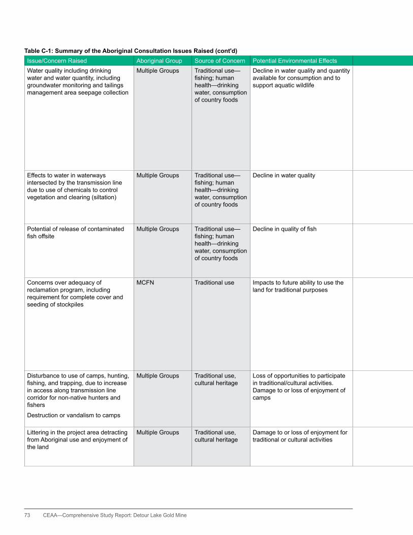
73 CEAA—Comprehensive Study Report: Detour Lake Gold Mine
Table C-1: Summary of the Aboriginal Consultation Issues Raised (cont'd)Issue/Concern Raised Aboriginal Group Source of Concern Potential Environmental Effects Proponent's Response Canadian Environmental Assessment Agency Response Water quality including drinking water and water quantity, including groundwater monitoring and tailings management area seepage collection
Multiple Groups Traditional use—fishing;humanhealth—drinking water, consumption of country foods
Decline in water quality and quantity available for consumption and to support aquatic wildlife
Commitment to provide high quality potable water at site, meeting Provincial guidelines as a minimum; plan tomeetregulatoryrequirementsforeffluentdischarge(with contingencies in place); extensive groundwater and surface water monitoring program to ensure no offsite impacts (there are no nearby permanent receptors); high level of water recycle within the process to minimize freshwater needs / potential water quantity issues downstream.
Section 7 and Appendices F and G outline the potential effects, mitigation measures and environmental effects analysisforwaterqualityandquantity,fishandhumanhealth. The Agency has concluded that, taking into account mitigationmeasures,therewillbenosignificanteffectsonwaterqualityandquantity,fishandhumanhealthaswellas associated traditional land use and resource harvesting. Appendix h of this Report contains the proponent’s summary of environmental commitments. The summary references the proponent’s development of a waste rock management plan and to include contingency plans to manage potentially acid generating rock and tailing seepage. Appendix J of this Reportcontainstheproponent’slettersconfirmingmonitoringand follow-up commitments.
Effects to water in waterways intersected by the transmission line due to use of chemicals to control vegetation and clearing (siltation)
Multiple Groups Traditional use— fishing;humanhealth—drinking water, consumption of country foods
Decline in water quality Use of only provincially-approved measures for vegetation control and only manual tending of vegetation near watercourses; during construction surface clearing only to be conducted (no sub-surface grubbing) and use of sediment control measures as appropriate during construction, with monitoring and re-vegetation if needed post-construction.
Section 7 and Appendices F and G outline the potential effects, mitigation measures and environmental effects analysisforwaterqualityandquantity,fishandhumanhealth. The Agency has concluded that, taking into account mitigationmeasures,therewillbenosignificanteffectsonwaterqualityandquantity,fishandhumanhealthaswellas associated traditional land use and resource harvesting.
Potential of release of contaminated fishoffsite
Multiple Groups Traditional use— fishing;humanhealth—drinking water, consumption of country foods
Declineinqualityoffish Maintenance of water quality in water bodies at site to ensurefishdonotbecomecontaminatedwithperiodicmonitoringtoconfirm;asrequestedbytheMCFN,althoughfishintheexistingfloodedopenpitarenotcontaminated,DetourGoldwillrequestapprovaltodestroythefish,ratherthantransferthefishtoanaturalwaterbody.
Section 7 and Appendices F and G outline the potential effects, mitigation measures and environmental effects analysisforwaterqualityandquantity,fishandhumanhealth. The Agency has concluded that, taking into account mitigationmeasures,therewillbenosignificanteffectsonwaterqualityandquantity,fishandhumanhealthaswellas associated traditional land use and resource harvesting.
Concerns over adequacy of reclamation program, including requirement for complete cover and seeding of stockpiles
MCFN Traditional use Impacts to future ability to use the land for traditional purposes
Detour Gold proposes to complete the reclamation program in accordance with the provincial government regional biologist's request to attempt to support a local species-at-risk (Woodland Caribou), rather than development of a continuous, seeded cover over stockpiles which may encourage other species (such as White-tailed Deer). Future closure plan amendments will consider alternative approaches should it be determined to be appropriate in association with the provincial government and aboriginal groups.
Please refer to DLP-68, Mine Rock Stockpile Adaptive Management Program.
Section 7 and Appendix F outline the potential effects, mitigation measures and environmental effects analysis for vegetation and wildlife habitat. Appendix h of this Report contains the proponent’s summary of environmental commitments. Appendix J of this Report contains the proponent’slettersconfirmingmonitoringandfollow-upcommitments. The Agency has concluded that, taking into accountmitigationmeasures,therewillbenosignificanteffects on vegetation and wildlife habitat as well as associated traditional land use and resource harvesting.
Disturbance to use of camps, hunting, fishing,andtrapping,duetoincreasein access along transmission line corridor for non-native hunters and fishers
Destruction or vandalism to camps
Multiple Groups Traditional use, cultural heritage
Loss of opportunities to participate in traditional/cultural activities. Damage to or loss of enjoyment of camps
Reuse of existing access and avoidance of creation of new permanent access as practical; workers/contractors will not be allowed to extract resources while on shift and must leave site on completion of shift.
AnycampsidentifiedtoDetourGoldwillbeprotectedfromnearby work; workers and contractors will be instructed to avoid these areas.
Section 7 and Appendix F outline the potential effects, mitigation measures, and effects analysis for traditional land uses. The Agency has concluded that, taking into accountmitigationmeasures,therewillbenosignificanteffects on traditional land use.
Littering in the project area detracting from Aboriginal use and enjoyment of the land
Multiple Groups Traditional use, cultural heritage
Damage to or loss of enjoyment for traditional or cultural activities
Maintenance of a tidy site; development of a comprehensive waste management plan, including to controlwind-blownlitterfromlandfill;requirementofcontractors to removal waste on a regular basis from work areas and dispose of properly.
Section 7 and Appendix F outline the potential effects, mitigation measures, and effects analysis for traditional land uses. The Agency has concluded that, taking into accountmitigationmeasures,therewillbenosignificanteffects on traditional land use.

CEAA— Comprehensive Study Report: Detour Lake Gold Mine 74
Table C-1: Summary of the Aboriginal Consultation Issues Raised (cont'd)Issue/Concern Raised Aboriginal Group Source of Concern Potential Environmental Effects Proponent's Response Canadian Environmental Assessment Agency Response Water quality including drinking water and water quantity, including groundwater monitoring and tailings management area seepage collection
Multiple Groups Traditional use—fishing;humanhealth—drinking water, consumption of country foods
Decline in water quality and quantity available for consumption and to support aquatic wildlife
Commitment to provide high quality potable water at site, meeting Provincial guidelines as a minimum; plan tomeetregulatoryrequirementsforeffluentdischarge(with contingencies in place); extensive groundwater and surface water monitoring program to ensure no offsite impacts (there are no nearby permanent receptors); high level of water recycle within the process to minimize freshwater needs / potential water quantity issues downstream.
Section 7 and Appendices F and G outline the potential effects, mitigation measures and environmental effects analysisforwaterqualityandquantity,fishandhumanhealth. The Agency has concluded that, taking into account mitigationmeasures,therewillbenosignificanteffectsonwaterqualityandquantity,fishandhumanhealthaswellas associated traditional land use and resource harvesting. Appendix h of this Report contains the proponent’s summary of environmental commitments. The summary references the proponent’s development of a waste rock management plan and to include contingency plans to manage potentially acid generating rock and tailing seepage. Appendix J of this Reportcontainstheproponent’slettersconfirmingmonitoringand follow-up commitments.
Effects to water in waterways intersected by the transmission line due to use of chemicals to control vegetation and clearing (siltation)
Multiple Groups Traditional use— fishing;humanhealth—drinking water, consumption of country foods
Decline in water quality Use of only provincially-approved measures for vegetation control and only manual tending of vegetation near watercourses; during construction surface clearing only to be conducted (no sub-surface grubbing) and use of sediment control measures as appropriate during construction, with monitoring and re-vegetation if needed post-construction.
Section 7 and Appendices F and G outline the potential effects, mitigation measures and environmental effects analysisforwaterqualityandquantity,fishandhumanhealth. The Agency has concluded that, taking into account mitigationmeasures,therewillbenosignificanteffectsonwaterqualityandquantity,fishandhumanhealthaswellas associated traditional land use and resource harvesting.
Potential of release of contaminated fishoffsite
Multiple Groups Traditional use— fishing;humanhealth—drinking water, consumption of country foods
Declineinqualityoffish Maintenance of water quality in water bodies at site to ensurefishdonotbecomecontaminatedwithperiodicmonitoringtoconfirm;asrequestedbytheMCFN,althoughfishintheexistingfloodedopenpitarenotcontaminated,DetourGoldwillrequestapprovaltodestroythefish,ratherthantransferthefishtoanaturalwaterbody.
Section 7 and Appendices F and G outline the potential effects, mitigation measures and environmental effects analysisforwaterqualityandquantity,fishandhumanhealth. The Agency has concluded that, taking into account mitigationmeasures,therewillbenosignificanteffectsonwaterqualityandquantity,fishandhumanhealthaswellas associated traditional land use and resource harvesting.
Concerns over adequacy of reclamation program, including requirement for complete cover and seeding of stockpiles
MCFN Traditional use Impacts to future ability to use the land for traditional purposes
Detour Gold proposes to complete the reclamation program in accordance with the provincial government regional biologist's request to attempt to support a local species-at-risk (Woodland Caribou), rather than development of a continuous, seeded cover over stockpiles which may encourage other species (such as White-tailed Deer). Future closure plan amendments will consider alternative approaches should it be determined to be appropriate in association with the provincial government and aboriginal groups.
Please refer to DLP-68, Mine Rock Stockpile Adaptive Management Program.
Section 7 and Appendix F outline the potential effects, mitigation measures and environmental effects analysis for vegetation and wildlife habitat. Appendix h of this Report contains the proponent’s summary of environmental commitments. Appendix J of this Report contains the proponent’slettersconfirmingmonitoringandfollow-upcommitments. The Agency has concluded that, taking into accountmitigationmeasures,therewillbenosignificanteffects on vegetation and wildlife habitat as well as associated traditional land use and resource harvesting.
Disturbance to use of camps, hunting, fishing,andtrapping,duetoincreasein access along transmission line corridor for non-native hunters and fishers
Destruction or vandalism to camps
Multiple Groups Traditional use, cultural heritage
Loss of opportunities to participate in traditional/cultural activities. Damage to or loss of enjoyment of camps
Reuse of existing access and avoidance of creation of new permanent access as practical; workers/contractors will not be allowed to extract resources while on shift and must leave site on completion of shift.
AnycampsidentifiedtoDetourGoldwillbeprotectedfromnearby work; workers and contractors will be instructed to avoid these areas.
Section 7 and Appendix F outline the potential effects, mitigation measures, and effects analysis for traditional land uses. The Agency has concluded that, taking into accountmitigationmeasures,therewillbenosignificanteffects on traditional land use.
Littering in the project area detracting from Aboriginal use and enjoyment of the land
Multiple Groups Traditional use, cultural heritage
Damage to or loss of enjoyment for traditional or cultural activities
Maintenance of a tidy site; development of a comprehensive waste management plan, including to controlwind-blownlitterfromlandfill;requirementofcontractors to removal waste on a regular basis from work areas and dispose of properly.
Section 7 and Appendix F outline the potential effects, mitigation measures, and effects analysis for traditional land uses. The Agency has concluded that, taking into accountmitigationmeasures,therewillbenosignificanteffects on traditional land use.
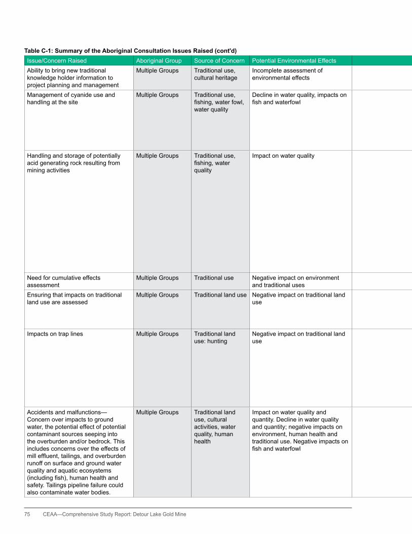
75 CEAA—Comprehensive Study Report: Detour Lake Gold Mine
Table C-1: Summary of the Aboriginal Consultation Issues Raised (cont'd)Issue/Concern Raised Aboriginal Group Source of Concern Potential Environmental Effects Proponent's Response Canadian Environmental Assessment Agency Response Ability to bring new traditional knowledge holder information to project planning and management
Multiple Groups Traditional use, cultural heritage
Incomplete assessment of environmental effects
Detour Gold encourages feedback on an ongoing basis, including during regular communications in order that new information can be incorporated.
The Agency has considered the traditional knowledge studies conducted on behalf of Aboriginal groups in the environmental assessment for this project.
Management of cyanide use and handling at the site
Multiple Groups Traditional use, fishing,waterfowl,water quality
Decline in water quality, impacts on fishandwaterfowl
In-plant destruction of cyanide to reduce cyanide withineffluentpriortofurthertreatmentinthetailingsmanagement area; adherence to international best management practices generally equivalent to the Cyanide Code requirements.
Section 7 and Appendices F and G outline the potential effects, mitigation measures and environmental effects analysisforwaterqualityandquantity,fish,waterfowlandhuman health. The Agency has concluded that, taking into accountmitigationmeasures,therewillbenosignificanteffectsonwaterqualityandquantity,fish,waterfowlandhuman health as well as associated traditional land use and resource harvesting.
handling and storage of potentially acid generating rock resulting from mining activities
Multiple Groups Traditional use, fishing,waterquality
Impact on water quality An extensive investigation was completed using both historic data and new data to document geochemistry of materials at site; proponent has committed to segregation of potentially acid generating rock and on-going investigations during operations to clarify potential impacts; contingency measures are available should modeling to date be inaccurate.
Section 7 and Appendices F and G outline the potential effects, mitigation measures and environmental effects analysisforwaterqualityandquantity,fishandhumanhealth. The Agency has concluded that, taking into account mitigationmeasures,therewillbenosignificanteffectsonwaterqualityandquantity,fishandhumanhealthaswellas associated traditional land use and resource harvesting. Appendix h of this Report contains the proponent’s summary of environmental commitments. The summary references the management of potentially acid generating rock. Appendix J of this Report contains the proponent’s lettersconfirmingmonitoringandfollow-upcommitments.
Potential acid generating rock (PAG) is proposed to be stored and managed separately to ensure that any environmental effects from this material, should such effects develop, are properly controlled.
Need for cumulative effects assessment
Multiple Groups Traditional use Negative impact on environment and traditional uses
Not applicable. Cumulative effects assessment is presented in Section 7.
Ensuring that impacts on traditional land use are assessed
Multiple Groups Traditional land use Negative impact on traditional land use
Detour Gold is committed to supporting the traditional ecological knowledge (TEK) studies and avoiding or mitigating any effects to traditional land uses. Detour Gold has commissioned TEK studies that have been used as source material for the CSR.
Traditional land use has been assessed as presented in Section 7 and Appendix F. The environmental assessment has considered TEK studies.
Impacts on trap lines Multiple Groups Traditional land use: hunting
Negative impact on traditional land use
It is intended that should local First Nation trappers be subject to interference during the construction phase for accidental damage to facilities, they will be compensated. Broader compensation will be through arrangement with their respective First Nations for interference along registered traplines with traditional pursuits involving hunting and trapping.
Detour Gold will follow up with any requests for discussion about potential effects to traplines if contacted directly by the trapline permit holder.
The presence of traplines on the project site and along the transmission line route has been noted and included in the environmental effects assessment, Section 7.7, Land and Resource Use.
Accidents and malfunctions—Concern over impacts to ground water, the potential effect of potential contaminant sources seeping into the overburden and/or bedrock. This includes concerns over the effects of milleffluent,tailings,andoverburdenrunoff on surface and ground water quality and aquatic ecosystems (includingfish),humanhealthandsafety. Tailings pipeline failure could also contaminate water bodies.
Multiple Groups Traditional land use, cultural activities, water quality, human health
Impact on water quality and quantity. Decline in water quality and quantity; negative impacts on environment, human health and traditional use. Negative impacts on fishandwaterfowl
The proponent has committed to the incorporation of consideration of malfunctions and accidents in their Emergency Preparedness Plan (EPP), which will comprise a component of the Emergency Response Strategy (ERS). The proponent will develop an internal risk matrix to identify areas of critical risk to ensure mitigation and management responses are understood by the operations team.
Section 7 and Appendix F outline potential environmental effects, mitigation measures and environmental effects analysis for potential accidents and malfunctions. The Agencyissatisfiedthat,takingintoaccountmitigationmeasures,therewillbenosignificantenvironmentaleffects due to accidents and malfunctions. Appendix h of this Report contains the proponent’s summary of environmental commitments. The summary addresses accidents and malfunctions, including an Environmental Management System. Appendix J of this Report contains theproponent’slettersconfirmingmonitoringandfollow-upcommitments.
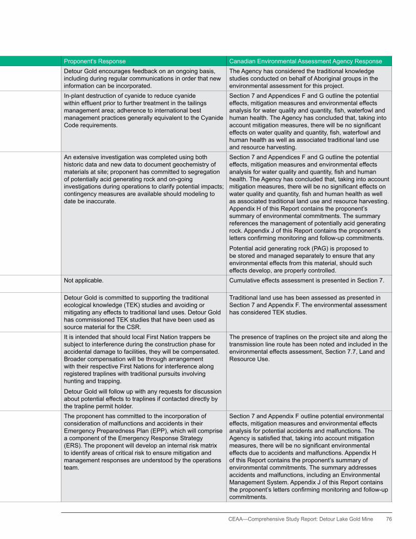
CEAA— Comprehensive Study Report: Detour Lake Gold Mine 76
Table C-1: Summary of the Aboriginal Consultation Issues Raised (cont'd)Issue/Concern Raised Aboriginal Group Source of Concern Potential Environmental Effects Proponent's Response Canadian Environmental Assessment Agency Response Ability to bring new traditional knowledge holder information to project planning and management
Multiple Groups Traditional use, cultural heritage
Incomplete assessment of environmental effects
Detour Gold encourages feedback on an ongoing basis, including during regular communications in order that new information can be incorporated.
The Agency has considered the traditional knowledge studies conducted on behalf of Aboriginal groups in the environmental assessment for this project.
Management of cyanide use and handling at the site
Multiple Groups Traditional use, fishing,waterfowl,water quality
Decline in water quality, impacts on fishandwaterfowl
In-plant destruction of cyanide to reduce cyanide withineffluentpriortofurthertreatmentinthetailingsmanagement area; adherence to international best management practices generally equivalent to the Cyanide Code requirements.
Section 7 and Appendices F and G outline the potential effects, mitigation measures and environmental effects analysisforwaterqualityandquantity,fish,waterfowlandhuman health. The Agency has concluded that, taking into accountmitigationmeasures,therewillbenosignificanteffectsonwaterqualityandquantity,fish,waterfowlandhuman health as well as associated traditional land use and resource harvesting.
handling and storage of potentially acid generating rock resulting from mining activities
Multiple Groups Traditional use, fishing,waterquality
Impact on water quality An extensive investigation was completed using both historic data and new data to document geochemistry of materials at site; proponent has committed to segregation of potentially acid generating rock and on-going investigations during operations to clarify potential impacts; contingency measures are available should modeling to date be inaccurate.
Section 7 and Appendices F and G outline the potential effects, mitigation measures and environmental effects analysisforwaterqualityandquantity,fishandhumanhealth. The Agency has concluded that, taking into account mitigationmeasures,therewillbenosignificanteffectsonwaterqualityandquantity,fishandhumanhealthaswellas associated traditional land use and resource harvesting. Appendix h of this Report contains the proponent’s summary of environmental commitments. The summary references the management of potentially acid generating rock. Appendix J of this Report contains the proponent’s lettersconfirmingmonitoringandfollow-upcommitments.
Potential acid generating rock (PAG) is proposed to be stored and managed separately to ensure that any environmental effects from this material, should such effects develop, are properly controlled.
Need for cumulative effects assessment
Multiple Groups Traditional use Negative impact on environment and traditional uses
Not applicable. Cumulative effects assessment is presented in Section 7.
Ensuring that impacts on traditional land use are assessed
Multiple Groups Traditional land use Negative impact on traditional land use
Detour Gold is committed to supporting the traditional ecological knowledge (TEK) studies and avoiding or mitigating any effects to traditional land uses. Detour Gold has commissioned TEK studies that have been used as source material for the CSR.
Traditional land use has been assessed as presented in Section 7 and Appendix F. The environmental assessment has considered TEK studies.
Impacts on trap lines Multiple Groups Traditional land use: hunting
Negative impact on traditional land use
It is intended that should local First Nation trappers be subject to interference during the construction phase for accidental damage to facilities, they will be compensated. Broader compensation will be through arrangement with their respective First Nations for interference along registered traplines with traditional pursuits involving hunting and trapping.
Detour Gold will follow up with any requests for discussion about potential effects to traplines if contacted directly by the trapline permit holder.
The presence of traplines on the project site and along the transmission line route has been noted and included in the environmental effects assessment, Section 7.7, Land and Resource Use.
Accidents and malfunctions—Concern over impacts to ground water, the potential effect of potential contaminant sources seeping into the overburden and/or bedrock. This includes concerns over the effects of milleffluent,tailings,andoverburdenrunoff on surface and ground water quality and aquatic ecosystems (includingfish),humanhealthandsafety. Tailings pipeline failure could also contaminate water bodies.
Multiple Groups Traditional land use, cultural activities, water quality, human health
Impact on water quality and quantity. Decline in water quality and quantity; negative impacts on environment, human health and traditional use. Negative impacts on fishandwaterfowl
The proponent has committed to the incorporation of consideration of malfunctions and accidents in their Emergency Preparedness Plan (EPP), which will comprise a component of the Emergency Response Strategy (ERS). The proponent will develop an internal risk matrix to identify areas of critical risk to ensure mitigation and management responses are understood by the operations team.
Section 7 and Appendix F outline potential environmental effects, mitigation measures and environmental effects analysis for potential accidents and malfunctions. The Agencyissatisfiedthat,takingintoaccountmitigationmeasures,therewillbenosignificantenvironmentaleffects due to accidents and malfunctions. Appendix h of this Report contains the proponent’s summary of environmental commitments. The summary addresses accidents and malfunctions, including an Environmental Management System. Appendix J of this Report contains theproponent’slettersconfirmingmonitoringandfollow-upcommitments.

77 CEAA—Comprehensive Study Report: Detour Lake Gold Mine
Table C-1: Summary of the Aboriginal Consultation Issues Raised (cont'd)Issue/Concern Raised Aboriginal Group Source of Concern Potential Environmental Effects Proponent's Response Canadian Environmental Assessment Agency Response Uncertainties regarding the models being used to monitor water quality, as well as concerns about how extensive and effective water quality monitoring will be.
Moose Cree First Nation
Traditional land use—hunting, fishing;waterquality
Impact on water quality The proponent has funded third party review of its plans to support MCFN’s understanding of the water quality issues and hosted a number of meetings on the topic. The number of monitoring wells was increased to provide greater certainty and Ministry of the Environmental Annual reportswillbeprovidedtothefirstnationstoillustratecompliance.
Section 7 and Appendix F outline the potential effects, mitigation measures and environmental effects analysis for wildlife. The Agency has concluded that, taking into accountmitigationmeasures,therewillbenosignificanteffects on wildlife as well as associated traditional land use and resource harvesting.
Concern that the potential for acid-generating rock becoming a serious issue and escaping the site has been underestimated
Moose Cree First Nation
Traditional land use—hunting, fishing;waterquality
Impact on water quality The mine rock segregation program as currently planned will consist of the following aspects:
•Developingadetailedminerockmanagementstrategyaround the distribution of non-acid generating (NAG) and PAG materials, including the selection of materials to be used for mine site construction.
•Developingaprogramofongoingtesting(Lecofurnacetesting of blast hole drill cuttings) to be carried out during mining operations to assess the acid-generating potential of the mine rock being removed, so that the mine rock can be directed to the appropriate mine stockpile location.
The provincial Closure Plan includes a commitment from the proponent for yearly reports to beprovided to the MNDMF of drill hole rock analysis to ensure proper segregation of waste rock.
A material change may become necessary if a marked additional quantity of PAG is created beyond that expected. Should the increase necessitate management alternatives to be developed a Closure Plan amendment mayneedtobefiledtoeffectivelymanagetheadditionalPAG generated.
Concern over the lack of a monitoring body per the Moose Cree First Nation’sImpactBenefitAgreementwith the proponent
Moose Cree First Nation
Traditional land use—hunting, fishing;waterquality
Lack of understanding about possible negative impacts on various aspects of the environment.
Detour Gold is committed to ongoing discussion with Aboriginal Groups and is in discussions with MCFN, TTN, WFN and the Metis on this issue.
CEAA was informed of this concern in a meeting with Chief hardisty on 16 September, 2011. CEAA followed up with Detour Gold on the issue of Environmental Monitoring and Regional Environmental Monitoring Body (REMB).
ConcernthattheCSRwillbefinalizedprior to adequately hearing and dealing with Moose Cree First Nation issues
Concerns over environmental impacts occurring onsite prior to the completion of the federal EA
Moose Cree First Nation
Consultation process
Negative impacts on various aspects the environment
Not applicable. As requested by the MCFN, CEAA, and FRT, staff visited Moose Factory 22-23 September 2011 and presented on a series of environmental themes and held an information booth.
Concerns raised during this visit have been noted and taken into account prior to the completion of the CSR.
Concerns over impacts to watercourse flowse.g.KarelCreek.Requestforthe development of contingency plans toprevent“no-flow”conditions.
Moose Cree First Nation
Traditional land use—fishing;waterquantity and quality
Negativeimpactsonfishandwaterfowl.
Detour commits to developing a follow-up program with federal authorities, and potentially with the Province and other relevant parties, to address monitoring commitments made through the EA process that are not covered by specificprovincialorfederalregulatoryinstruments.
Appendix h of this Report contains the proponent’s summary of environmental commitments. The summary references commitments in relation to Karel Creek. Appendix J of this Report contains the proponent’s letters confirmingmonitoringandfollow-upcommitments.
Potential impacts to aquatic biota as a result of reduced watercourseflowshavealsobeenidentifiedforinclusioninthe follow-up program. The full program will be developed pending the Section 23 decision of the Minister and the Section 37 decisions of the Responsible Authorities. For more details, please see the Table 8-1 which outlines the follow-up framework.
Air quality issues Moose Cree First Nation
Traditional land use, human health
Local air quality and human health The DLP will meet all applicable air quality standards and utilize industry best management practices. The Moose Cree First Nation has indicated that there are no unresolved issues related to air quality at this time. The further information requested will be provided to the Moose Cree First Nation throughtheProvincialapprovalsprocessforaCertificateofApproval—air, which they will have an opportunity to review.
Section 7 and Appendix F outline the potential effects, mitigation measures and environmental effects analysis. Appendix h of this Report contains the proponent’s summary of environmental commitments. The summary references air quality, including the proponent’s commitment to air quality management. Appendix J of this Report contains lettersconfirmingtheproponent’smonitoringandfollow-upcommitments.
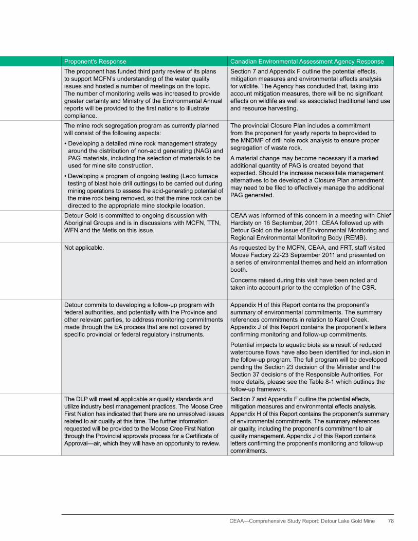
CEAA— Comprehensive Study Report: Detour Lake Gold Mine 78
Table C-1: Summary of the Aboriginal Consultation Issues Raised (cont'd)Issue/Concern Raised Aboriginal Group Source of Concern Potential Environmental Effects Proponent's Response Canadian Environmental Assessment Agency Response Uncertainties regarding the models being used to monitor water quality, as well as concerns about how extensive and effective water quality monitoring will be.
Moose Cree First Nation
Traditional land use—hunting, fishing;waterquality
Impact on water quality The proponent has funded third party review of its plans to support MCFN’s understanding of the water quality issues and hosted a number of meetings on the topic. The number of monitoring wells was increased to provide greater certainty and Ministry of the Environmental Annual reportswillbeprovidedtothefirstnationstoillustratecompliance.
Section 7 and Appendix F outline the potential effects, mitigation measures and environmental effects analysis for wildlife. The Agency has concluded that, taking into accountmitigationmeasures,therewillbenosignificanteffects on wildlife as well as associated traditional land use and resource harvesting.
Concern that the potential for acid-generating rock becoming a serious issue and escaping the site has been underestimated
Moose Cree First Nation
Traditional land use—hunting, fishing;waterquality
Impact on water quality The mine rock segregation program as currently planned will consist of the following aspects:
•Developingadetailedminerockmanagementstrategyaround the distribution of non-acid generating (NAG) and PAG materials, including the selection of materials to be used for mine site construction.
•Developingaprogramofongoingtesting(Lecofurnacetesting of blast hole drill cuttings) to be carried out during mining operations to assess the acid-generating potential of the mine rock being removed, so that the mine rock can be directed to the appropriate mine stockpile location.
The provincial Closure Plan includes a commitment from the proponent for yearly reports to beprovided to the MNDMF of drill hole rock analysis to ensure proper segregation of waste rock.
A material change may become necessary if a marked additional quantity of PAG is created beyond that expected. Should the increase necessitate management alternatives to be developed a Closure Plan amendment mayneedtobefiledtoeffectivelymanagetheadditionalPAG generated.
Concern over the lack of a monitoring body per the Moose Cree First Nation’sImpactBenefitAgreementwith the proponent
Moose Cree First Nation
Traditional land use—hunting, fishing;waterquality
Lack of understanding about possible negative impacts on various aspects of the environment.
Detour Gold is committed to ongoing discussion with Aboriginal Groups and is in discussions with MCFN, TTN, WFN and the Metis on this issue.
CEAA was informed of this concern in a meeting with Chief hardisty on 16 September, 2011. CEAA followed up with Detour Gold on the issue of Environmental Monitoring and Regional Environmental Monitoring Body (REMB).
ConcernthattheCSRwillbefinalizedprior to adequately hearing and dealing with Moose Cree First Nation issues
Concerns over environmental impacts occurring onsite prior to the completion of the federal EA
Moose Cree First Nation
Consultation process
Negative impacts on various aspects the environment
Not applicable. As requested by the MCFN, CEAA, and FRT, staff visited Moose Factory 22-23 September 2011 and presented on a series of environmental themes and held an information booth.
Concerns raised during this visit have been noted and taken into account prior to the completion of the CSR.
Concerns over impacts to watercourse flowse.g.KarelCreek.Requestforthe development of contingency plans toprevent“no-flow”conditions.
Moose Cree First Nation
Traditional land use—fishing;waterquantity and quality
Negativeimpactsonfishandwaterfowl.
Detour commits to developing a follow-up program with federal authorities, and potentially with the Province and other relevant parties, to address monitoring commitments made through the EA process that are not covered by specificprovincialorfederalregulatoryinstruments.
Appendix h of this Report contains the proponent’s summary of environmental commitments. The summary references commitments in relation to Karel Creek. Appendix J of this Report contains the proponent’s letters confirmingmonitoringandfollow-upcommitments.
Potential impacts to aquatic biota as a result of reduced watercourseflowshavealsobeenidentifiedforinclusioninthe follow-up program. The full program will be developed pending the Section 23 decision of the Minister and the Section 37 decisions of the Responsible Authorities. For more details, please see the Table 8-1 which outlines the follow-up framework.
Air quality issues Moose Cree First Nation
Traditional land use, human health
Local air quality and human health The DLP will meet all applicable air quality standards and utilize industry best management practices. The Moose Cree First Nation has indicated that there are no unresolved issues related to air quality at this time. The further information requested will be provided to the Moose Cree First Nation throughtheProvincialapprovalsprocessforaCertificateofApproval—air, which they will have an opportunity to review.
Section 7 and Appendix F outline the potential effects, mitigation measures and environmental effects analysis. Appendix h of this Report contains the proponent’s summary of environmental commitments. The summary references air quality, including the proponent’s commitment to air quality management. Appendix J of this Report contains lettersconfirmingtheproponent’smonitoringandfollow-upcommitments.
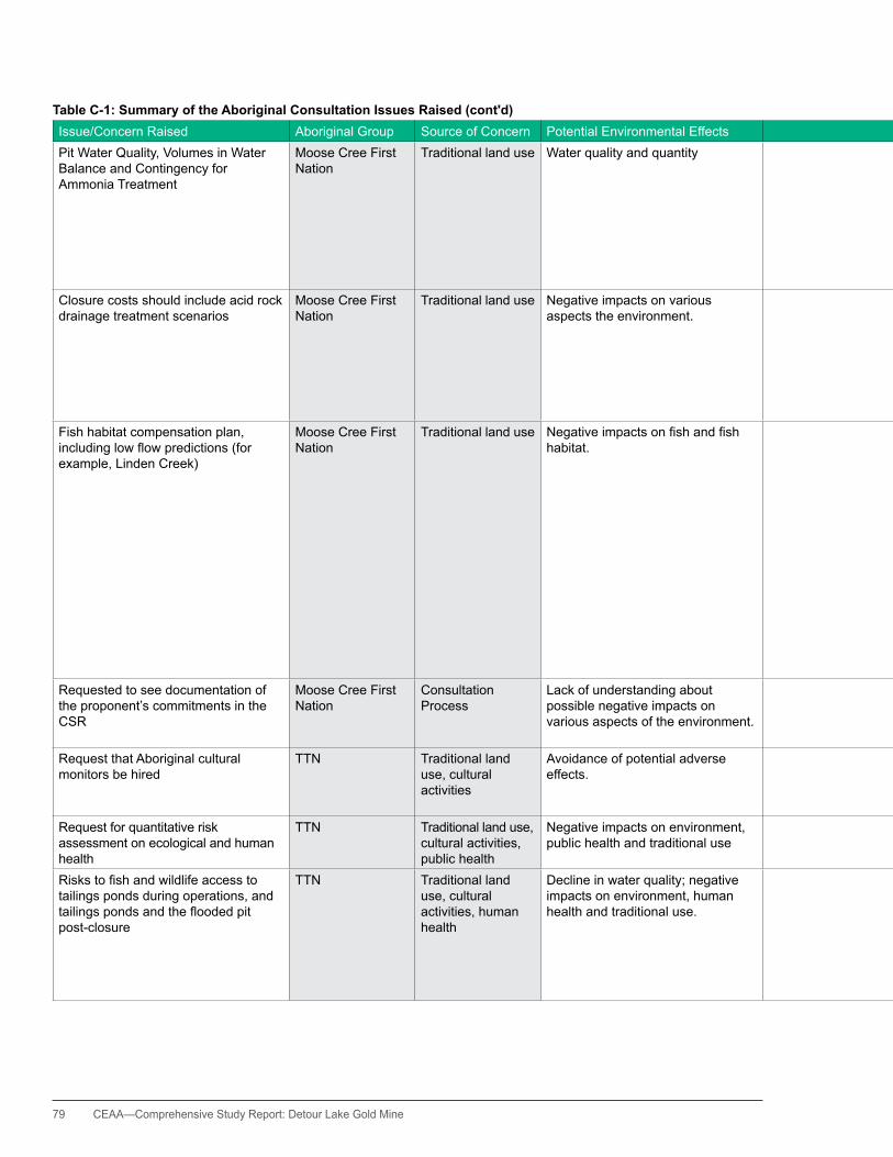
79 CEAA—Comprehensive Study Report: Detour Lake Gold Mine
Table C-1: Summary of the Aboriginal Consultation Issues Raised (cont'd)Issue/Concern Raised Aboriginal Group Source of Concern Potential Environmental Effects Proponent's Response Canadian Environmental Assessment Agency Response Pit Water Quality, Volumes in Water Balance and Contingency for Ammonia Treatment
Moose Cree First Nation
Traditional land use Water quality and quantity Minewater planned for discharge to the environment, and containing residual ammonia from the use of blasting agents, will be sent to the TMA dedicated mine water pond for extended aging and ammonia degradation. The capacity of this dedicated minewater pond can be increased as necessarytoprovidetherequiredeffluentretentiontime.Projections of ammonia degradation are conservative, and contingencies are available such as use of the ENPAR ion-exchange ammonia treatment technology if required.
Section 7 and Appendix F outline the potential effects, mitigation measures and environmental effects analysis. Appendix h of this Report contains the proponent’s summary of environmental commitments. Appendix h of this Report contains the proponent’s summary of environmental commitments. Appendix J of this Report containstheproponent’slettersconfirmingmonitoringandfollow-up commitments.
Closure costs should include acid rock drainage treatment scenarios
Moose Cree First Nation
Traditional land use Negative impacts on various aspects the environment.
Should it be determined in the future based on the on-going extensive investigation and research programs, that acid rock drainage / metal leaching is expected or likely to occur, the closure plan and cost estimate will be amended and the closure bond revised to include water treatment. Detour Gold has committed to the periodic review and update to the closure plan during the mine life, and if needed, revision to the closure bond at that time.
This issue is best addressed by Ontario’s Ministry of Northern Development and Mines who is responsible for administering Ontario’s Mining Act.
Fish habitat compensation plan, includinglowflowpredictions(forexample, Linden Creek)
Moose Cree First Nation
Traditional land use Negativeimpactsonfishandfishhabitat.
LindenCreekhasalowgradientprofilewhichisinterruptedby numerous beaver dams and is therefore not suited to directflowmeasurement.Waterhabitatisthereforebeingassessed through strategically placed water level recorders to ensure maintenance of aquatic habitat. Regarding surrogateflowmeasurements,adetailedflowdatabaseisavailable for East Creek at the East Lake outlet. East Creek, Karel Creek and Linden Creek have similar physiographic settings.SpotflowmeasurementsforKarelCreekshowcloseagreementwithdetailedEastCreekflowmeasurements,and it is highly likely that Linden Creek will follow this same pattern. Fish habitat compensation for the two Linden Creek drainages (Musk 1 and Musk 2) is included in the Karel Creek compensation package. Contingency compensation measures for Linden Creek include the provision of over-wintering pools if required.
Section 7 and Appendix F outline the potential effects, mitigation measures and environmental effects analysis. Appendix h of this Report contains the proponent’s summary of environmental commitments. Appendix J of thisReportcontainslettersconfirmingtheproponent’smonitoring and follow-up commitments.
Requested to see documentation of the proponent’s commitments in the CSR
Moose Cree First Nation
Consultation Process
Lack of understanding about possible negative impacts on various aspects of the environment.
The list of commitments from the provincial and federal assessments and approval processes to date has been provided to the Agency
Appendix h of this Report contains the proponent’s summary of environmental commitments. Appendix J of thisReportcontainslettersconfirmingtheproponent’smonitoring and follow-up commitments.
Request that Aboriginal cultural monitors be hired
TTN Traditional land use, cultural activities
Avoidance of potential adverse effects.
Detour Gold will employ First Nation and Métis cultural monitors and develop protocols for the protection of cultural heritage features and areas, should these be encountered.
TheAgencyissatisfiedwiththeproponent’scommitmentto employing cultural monitors and development of protocols to protect cultural heritage features as applicable.
Request for quantitative risk assessment on ecological and human health
TTN Traditional land use, cultural activities, public health
Negative impacts on environment, public health and traditional use
Such studies will be undertaken if monitoring activities identify any increase in the levels of contaminants of concern beyond established thresholds.
TheAgencyissatisfiedwiththeproponent’sresponseandthat the issue will be addressed as monitoring results are available.
Riskstofishandwildlifeaccesstotailings ponds during operations, and tailingspondsandthefloodedpitpost-closure
TTN Traditional land use, cultural activities, human health
Decline in water quality; negative impacts on environment, human health and traditional use.
Thereislikelytobelittleriskofmigrationoffishintothe tailings ponds. Birds may land on tailings surface waters however water quality should not pose a threat. Downstream aquatic features will be protected through strictadherencetotheprovincialCertificateofApprovals.Atclosure,thetailingswillbenaturalizedandfishmayinhabit the proposed ponds. The open pit will naturally floodandbecomeapartoftheKarellCreeksystem
Section 7 and Appendix F outline the potential effects, mitigation measures and environmental effects analysis for wildlife. The Agency has concluded that, taking into accountmitigationmeasures,therewillbenosignificanteffectstofishandonwildlifeaswellasassociatedtraditional land use and resource harvesting.

CEAA— Comprehensive Study Report: Detour Lake Gold Mine 80
Table C-1: Summary of the Aboriginal Consultation Issues Raised (cont'd)Issue/Concern Raised Aboriginal Group Source of Concern Potential Environmental Effects Proponent's Response Canadian Environmental Assessment Agency Response Pit Water Quality, Volumes in Water Balance and Contingency for Ammonia Treatment
Moose Cree First Nation
Traditional land use Water quality and quantity Minewater planned for discharge to the environment, and containing residual ammonia from the use of blasting agents, will be sent to the TMA dedicated mine water pond for extended aging and ammonia degradation. The capacity of this dedicated minewater pond can be increased as necessarytoprovidetherequiredeffluentretentiontime.Projections of ammonia degradation are conservative, and contingencies are available such as use of the ENPAR ion-exchange ammonia treatment technology if required.
Section 7 and Appendix F outline the potential effects, mitigation measures and environmental effects analysis. Appendix h of this Report contains the proponent’s summary of environmental commitments. Appendix h of this Report contains the proponent’s summary of environmental commitments. Appendix J of this Report containstheproponent’slettersconfirmingmonitoringandfollow-up commitments.
Closure costs should include acid rock drainage treatment scenarios
Moose Cree First Nation
Traditional land use Negative impacts on various aspects the environment.
Should it be determined in the future based on the on-going extensive investigation and research programs, that acid rock drainage / metal leaching is expected or likely to occur, the closure plan and cost estimate will be amended and the closure bond revised to include water treatment. Detour Gold has committed to the periodic review and update to the closure plan during the mine life, and if needed, revision to the closure bond at that time.
This issue is best addressed by Ontario’s Ministry of Northern Development and Mines who is responsible for administering Ontario’s Mining Act.
Fish habitat compensation plan, includinglowflowpredictions(forexample, Linden Creek)
Moose Cree First Nation
Traditional land use Negativeimpactsonfishandfishhabitat.
LindenCreekhasalowgradientprofilewhichisinterruptedby numerous beaver dams and is therefore not suited to directflowmeasurement.Waterhabitatisthereforebeingassessed through strategically placed water level recorders to ensure maintenance of aquatic habitat. Regarding surrogateflowmeasurements,adetailedflowdatabaseisavailable for East Creek at the East Lake outlet. East Creek, Karel Creek and Linden Creek have similar physiographic settings.SpotflowmeasurementsforKarelCreekshowcloseagreementwithdetailedEastCreekflowmeasurements,and it is highly likely that Linden Creek will follow this same pattern. Fish habitat compensation for the two Linden Creek drainages (Musk 1 and Musk 2) is included in the Karel Creek compensation package. Contingency compensation measures for Linden Creek include the provision of over-wintering pools if required.
Section 7 and Appendix F outline the potential effects, mitigation measures and environmental effects analysis. Appendix h of this Report contains the proponent’s summary of environmental commitments. Appendix J of thisReportcontainslettersconfirmingtheproponent’smonitoring and follow-up commitments.
Requested to see documentation of the proponent’s commitments in the CSR
Moose Cree First Nation
Consultation Process
Lack of understanding about possible negative impacts on various aspects of the environment.
The list of commitments from the provincial and federal assessments and approval processes to date has been provided to the Agency
Appendix h of this Report contains the proponent’s summary of environmental commitments. Appendix J of thisReportcontainslettersconfirmingtheproponent’smonitoring and follow-up commitments.
Request that Aboriginal cultural monitors be hired
TTN Traditional land use, cultural activities
Avoidance of potential adverse effects.
Detour Gold will employ First Nation and Métis cultural monitors and develop protocols for the protection of cultural heritage features and areas, should these be encountered.
TheAgencyissatisfiedwiththeproponent’scommitmentto employing cultural monitors and development of protocols to protect cultural heritage features as applicable.
Request for quantitative risk assessment on ecological and human health
TTN Traditional land use, cultural activities, public health
Negative impacts on environment, public health and traditional use
Such studies will be undertaken if monitoring activities identify any increase in the levels of contaminants of concern beyond established thresholds.
TheAgencyissatisfiedwiththeproponent’sresponseandthat the issue will be addressed as monitoring results are available.
Riskstofishandwildlifeaccesstotailings ponds during operations, and tailingspondsandthefloodedpitpost-closure
TTN Traditional land use, cultural activities, human health
Decline in water quality; negative impacts on environment, human health and traditional use.
Thereislikelytobelittleriskofmigrationoffishintothe tailings ponds. Birds may land on tailings surface waters however water quality should not pose a threat. Downstream aquatic features will be protected through strictadherencetotheprovincialCertificateofApprovals.Atclosure,thetailingswillbenaturalizedandfishmayinhabit the proposed ponds. The open pit will naturally floodandbecomeapartoftheKarellCreeksystem
Section 7 and Appendix F outline the potential effects, mitigation measures and environmental effects analysis for wildlife. The Agency has concluded that, taking into accountmitigationmeasures,therewillbenosignificanteffectstofishandonwildlifeaswellasassociatedtraditional land use and resource harvesting.

81 CEAA—Comprehensive Study Report: Detour Lake Gold Mine
Table C-1: Summary of the Aboriginal Consultation Issues Raised (cont'd)Issue/Concern Raised Aboriginal Group Source of Concern Potential Environmental Effects Proponent's Response Canadian Environmental Assessment Agency Response Local and regional accumulation of contaminantsinedibleportionsoffishand wildlife harvested by TTN, and associated long-term health effects. TTN has requested that pesticide-based vegetation control not be employed in the transmission line.
TTN, MCFN Traditional land use, cultural activities, human health
Decline in water quality; negative impacts on environment, human health and traditional use.
Future maintenance is proposed to be according to industry standards at the time, utilizing an integrated vegetation management philosophy that requires that all control strategies (whether individually or combined), meetthefollowingmajorcriteria:provenefficiency,leastenvironmental impact, operational feasibility and cost-effectiveness.
Detourtoestablishafishandwildlifetissuemonitoringprogram to be carried out cooperatively with local Aboriginalhuntersandfisherman,wherebysamplesoffishandwildlifefleshwouldbesubmittedtoDGCformetalsanalysis.
As part of the provincial Industrial Sewage Works CertificateofApprovaltheproponentshallundertakeandsubmit to the province a long term study into impacts of historicalandongoingeffluentdischargeonEastLake,East Creek, downstream of East Lake, Good Friday Lake, Sunday Lake and Sunday Creek. The study will include samplingandtestingfishforheavymetals.
Testing of caribou for heavy metals has also been identifiedforinclusioninthefollow-upprogram.Thefull program will be developed pending the Section 23 decision of the Minister and the Section 37 decisions of the Responsible Authorities. For more details, please see the Table 8-1 which outlines the follow-up framework.
Potential for electromagnetic effects of high voltage from transmission line on local wildlife populations.
TTN Traditional use—hunting, trapping, harvesting
Decline in wildlife populations There is no risk to wildlife from electromagnetic radiation. Section 7 and Appendix F outline the potential effects, mitigation measures and environmental effects analysis for wildlife. The Agency has concluded that, taking into accountmitigationmeasures,therewillbenosignificanteffects on wildlife.
ImpactofmineeffluentonLakeSturgeon in the harricana River Basin
Waskaganish First Nation
Traditional land use—fishing;waterquality
Decline in water quality; Negative impactsonfish
Please refer to DLP-70, Response to Washaganish on Biotactic report “Potential Impacts of Detour Lake Gold MineEffluentonLakeSturgeon(Acipenserfulvescens)inthe harricana River Basin.
AMEC does not anticipate adverse effects to downstream Lake Sturgeon and the Lake Sturgeon population monitoringassuggestedbyBiotacticisnotjustified.
Section 7 and Appendix F outline potential environmental effects, mitigation measures and environmental effects analysis for potential accidents and malfunctions. The Agencyissatisfiedthat,takingintoaccountmitigationmeasures,therewillbenosignificantenvironmentaleffectsonthefishandfishhabitatwithintheDetourandharricana Rivers.
Concerns about proponent’s current on-site construction activities proceeding in advance of the comprehensive study decision.
MCFN Consultation process
Lack of understanding about possible negative impacts on various aspects of the environment.
Not applicable The Agency is aware there is work under way on components of the project that do not require federal authorizations or permits. The proponent knows that the environmental assessment must be completed before federal authorizations and permits can be issued.
Request for aboriginal mine site staff tohaveaccessfishingopportunitiesand an area to participate in ceremonial practices
Multiple Groups Traditional land and cultural use
Negative impact on traditional land use and cultural ceremony
Inacknowledgementoftheinterestinfishingopportunitiesduring off work hours, Detour will consider the applicability ofhavingrecreationalfishingactivitiesatthesiteaslongas it is sustainable and approved by MNR.
The Agency notes that the proponent has committed to considering a system that would allow mine site staff duringtheoperationsphase,toparticipateinfishingactivities during off work hours. The MNR is aware of this concern and has indicated that they will work with the proponent to develop policies or programs to ensure the long-termstabilityoffishpopulations.

CEAA— Comprehensive Study Report: Detour Lake Gold Mine 82
Table C-1: Summary of the Aboriginal Consultation Issues Raised (cont'd)Issue/Concern Raised Aboriginal Group Source of Concern Potential Environmental Effects Proponent's Response Canadian Environmental Assessment Agency Response Local and regional accumulation of contaminantsinedibleportionsoffishand wildlife harvested by TTN, and associated long-term health effects. TTN has requested that pesticide-based vegetation control not be employed in the transmission line.
TTN, MCFN Traditional land use, cultural activities, human health
Decline in water quality; negative impacts on environment, human health and traditional use.
Future maintenance is proposed to be according to industry standards at the time, utilizing an integrated vegetation management philosophy that requires that all control strategies (whether individually or combined), meetthefollowingmajorcriteria:provenefficiency,leastenvironmental impact, operational feasibility and cost-effectiveness.
Detourtoestablishafishandwildlifetissuemonitoringprogram to be carried out cooperatively with local Aboriginalhuntersandfisherman,wherebysamplesoffishandwildlifefleshwouldbesubmittedtoDGCformetalsanalysis.
As part of the provincial Industrial Sewage Works CertificateofApprovaltheproponentshallundertakeandsubmit to the province a long term study into impacts of historicalandongoingeffluentdischargeonEastLake,East Creek, downstream of East Lake, Good Friday Lake, Sunday Lake and Sunday Creek. The study will include samplingandtestingfishforheavymetals.
Testing of caribou for heavy metals has also been identifiedforinclusioninthefollow-upprogram.Thefull program will be developed pending the Section 23 decision of the Minister and the Section 37 decisions of the Responsible Authorities. For more details, please see the Table 8-1 which outlines the follow-up framework.
Potential for electromagnetic effects of high voltage from transmission line on local wildlife populations.
TTN Traditional use—hunting, trapping, harvesting
Decline in wildlife populations There is no risk to wildlife from electromagnetic radiation. Section 7 and Appendix F outline the potential effects, mitigation measures and environmental effects analysis for wildlife. The Agency has concluded that, taking into accountmitigationmeasures,therewillbenosignificanteffects on wildlife.
ImpactofmineeffluentonLakeSturgeon in the harricana River Basin
Waskaganish First Nation
Traditional land use—fishing;waterquality
Decline in water quality; Negative impactsonfish
Please refer to DLP-70, Response to Washaganish on Biotactic report “Potential Impacts of Detour Lake Gold MineEffluentonLakeSturgeon(Acipenserfulvescens)inthe harricana River Basin.
AMEC does not anticipate adverse effects to downstream Lake Sturgeon and the Lake Sturgeon population monitoringassuggestedbyBiotacticisnotjustified.
Section 7 and Appendix F outline potential environmental effects, mitigation measures and environmental effects analysis for potential accidents and malfunctions. The Agencyissatisfiedthat,takingintoaccountmitigationmeasures,therewillbenosignificantenvironmentaleffectsonthefishandfishhabitatwithintheDetourandharricana Rivers.
Concerns about proponent’s current on-site construction activities proceeding in advance of the comprehensive study decision.
MCFN Consultation process
Lack of understanding about possible negative impacts on various aspects of the environment.
Not applicable The Agency is aware there is work under way on components of the project that do not require federal authorizations or permits. The proponent knows that the environmental assessment must be completed before federal authorizations and permits can be issued.
Request for aboriginal mine site staff tohaveaccessfishingopportunitiesand an area to participate in ceremonial practices
Multiple Groups Traditional land and cultural use
Negative impact on traditional land use and cultural ceremony
Inacknowledgementoftheinterestinfishingopportunitiesduring off work hours, Detour will consider the applicability ofhavingrecreationalfishingactivitiesatthesiteaslongas it is sustainable and approved by MNR.
The Agency notes that the proponent has committed to considering a system that would allow mine site staff duringtheoperationsphase,toparticipateinfishingactivities during off work hours. The MNR is aware of this concern and has indicated that they will work with the proponent to develop policies or programs to ensure the long-termstabilityoffishpopulations.

83 CEAA—Comprehensive Study Report: Detour Lake Gold Mine
Appendix D. Existing Environment: Additional Information
The subsections that follow provide additional information on the baseline environmental conditions that are summarized in Section 6. Further detail can be found in the proponent’s technical reports, which are available from the CEAA contact listed in Table 1-1.
D.1 Local Watercourses, Lakes, and Wetlands
HydrologyLong-term flow records for the project area are available from regional Water Survey of Canada (WSC) stations that represent smaller watersheds. The discharge hydrographs show a pronounced seasonal pattern of spring discharge that normally peaks in late April to early May and extreme low flows that occur in late winter. A secondary peak discharge typically occurs in the late fall, and a secondary low flow period typically occurs in the late summer or early fall.
However, based on data for the East Creek part of the project site, a statistical analysis of low flows at this weir shows that low-flow conditions at this site are likely to be substantially greater than those indicated by the regional discharge data. This occurrence is due to the stronger base-flow contribution from local esker systems and muskeg (organic) terrain.
Creek SystemsThe following sections provide a detailed description of the aquatic resources of watercourses and lakes that could be affected by the development and operation of the Project.
As referenced in Section 6.2, recent and historical sediment data showed some occurrences of parameters with concentrations greater than the Provincial Sediment Quality Guidelines (PSQG)
Lowest Effect Level (LEL) criteria. The most frequent parameters to be greater than PSQG LEL were Total Kjeldahl Nitrogen (TKN), Total Organic Carbon (TOC), cadmium and copper which were enriched at the majority of the sampling sites (DLP-7). TKN, TOC and phosphorus were generally elevated in samples taken upstream and downstream of the mine site which suggests they are likely naturally elevated (DLP-24).
In addition, some of the sediments sampled in the local waterbodies exhibited concentrations that exceeded PSQG Severe Effect Levels (SEL) for certain parameters. In particular, the sediments sampled from East Lake demonstrated concentrations for TOC, copper and nickel several orders of magnitude above the PSQG SEL (DLP-7). Copper values were elevated in several locations but there was a definitive trend of higher values, greater than the provincial SEL (110 μg/g) and the federal Probable Effects Level (PEL) (197 μg/g), within the areas downstream of the former tailings system (Good Friday and Sunday Lake systems). A similar observation was made for nickel which exceeded provincial criteria in several stations downstream of the former tailings facility and open pit (Easter, Sagimeo, Good Friday and Sunday Lake systems) (DLP-24). These elevated concentrations in sediment are likely due to previous mining activity in the area.
East Creek and Sunday Creek system
The East Creek and Sunday Creek watershed is the largest system in the project study area. The drainage area is approximately 128 square kilometres. The total flow path, which originates northeast of the site and flows into the Detour River, is 28 kilometres. The aquatic habitat in the East Creek and Sunday Creek system is variable in terms of the type of water body or watercourse. East Creek is a slow-flowing creek characterized by flats. Beaver activity within this system causes long-term inundation and flooding of the floodplain. East Lake, a shallow lake with a maximum depth of 5 metres, acted as

CEAA— Comprehensive Study Report: Detour Lake Gold Mine 84
a tertiary treatment pond within the Detour Lake Mine tailings impoundment area (TIA). Further downstream is Good Friday Lake, a small lake with a maximum depth of 4.3 metres, and Sunday Lake, the largest lake of the system (280 hectares), with a maximum depth of 4.5 metres. Sunday Creek originates from the eastern shore of Sunday Lake and is characterized by low-gradient runs with limited riffle habitat.
The East Creek and Sunday Creek system, including its associated lakes, supports cool water fish communities: brook stickleback, burbot, northern pike, mottled sculpin, walleye, white sucker, yellow perch, golden shiner, shorthead redhorse sucker, and johnny darter. Fish species present in East Creek include burbot, northern pike, mottled sculpin, and yellow perch.
The water quality of East Lake is currently degraded for select parameters associated with the former mine tailings operations—most notably copper, which historically accumulated in the lake sediments (Lorax, 2002; DLP-47). The effects of the former operations extend downstream into Good Friday Lake and Sunday Lake, where copper levels also remain elevated relative to the natural background condition. Since cessation of Detour Lake Mine operations in 1999, there has been a gradual improvement in the downstream water quality condition (DLP-47).
As a result of former mining operations, fish were essentially extirpated from East Lake. Fish, including walleye, northern pike, and yellow perch have subsequently recolonized the lake. However, the East Lake dam and weir built for the Detour Lake Mine continue to act as a barrier for fish to move upstream in the creek system.
Karel Creek system
Karel Creek, which is about 12 kilometres in length from its headwaters to its confluence with Lower Detour Lake, has a drainage area of approximately 20 square kilometres. Karel Creek originates
4 kilometres north of the Detour Lake Mine open pit and drains southward, passing immediately east of the flooded pit and through a historic realignment, to Sagimeo Lake and continues southeast into Lower Detour Lake. Karel Creek receives base flow from the adjacent esker system, and during March 2009 several ice-free areas were observed on the creek (mostly north of the open pit and former haul road). These may represent areas of substantial groundwater input to the watercourse (DLP-16). Groundwater upwelling was confirmed at a number of creek locations using piezometers during 2009.
The open pit has flooded since decommissioning and currently overflows to Karel Creek through a steep, non-engineered spillway on the east side of the pit. Periodically, beaver activity results in backwater conditions, which have allowed the pit to become colonized by several fish species, including northern pike, yellow perch, mottled sculpin, Iowa darter, burbot, and white sucker; but the abundance of fish is low.
Karel Creek and Sagimeo Lake have been classified as cold water and cool water habitats respectively, based on the observed fish communities and temperature regimes (DLP-7).
Karel Creek supports brook trout, as well as burbot, Iowa darter, longnose dace, northern pike, mottled sculpin, slimy sculpin, white sucker, and ninespine stickleback. Creek headwater areas that extend upstream from the mine site access road provide locally important brook trout habitat. The Sagimeo Lake fish community consists of burbot, northern pike, walleye, white sucker, and yellow perch.
Benthic invertebrate communities in the Karel Creek system are highly variable, depending on habitat and substrate conditions. However, the overall benthic community structure shows good health in both riffle and beaver impoundment environments. This includes a good representation of pollution-sensitive Ephemeroptera–Plecoptera–Trichoptera (EPT) species in suitable habitats (DLP-7).

85 CEAA—Comprehensive Study Report: Detour Lake Gold Mine
Easter Creek system
The Easter Creek watershed, measuring 15.46 square kilometres, is located between the proposed TIA and the plant site. Easter Creek merges with Karel Creek downstream of Sagimeo Lake, which flows into Lower Detour Lake and the Detour River system. Easter Creek, classified as a cool water system, exhibited low species diversity during 2008; a total of three species were captured there, including northern pike, lake chub, and burbot. Habitat fragmentation by beaver impoundments may limit fish species diversity. Largely as a function of habitat availability, the Easter Creek benthic communities were similar to those of other area systems.
Linden Creek system
The Linden Creek system drains southward through the western project area and borders the west side of the proposed open pit area. The length of the principal creek channel from the headwaters to its confluence with Lower Detour Lake is 14 kilometres, and the system’s drainage area is approximately 36 square kilometres. The system within the immediate vicinity of the mine site consists of a main branch of Linden Creek, several muskeg-drainage systems, and Walter Lake, which is located just south of the mine access road. Walter Lake, a shallow water body with a maximum depth of 1.9 metres, has a surface area of about 9.5 hectares. Downstream of Walter Lake, Linden Creek is characterized by slow-flow morphology (runs, flats, and pools). Linden Creek supports brook stickleback, burbot, and northern pike. Walter Lake supports northern pike and yellow perch. Two intermittent drainages to Linden Creek occur within the footprint of a proposed waste rock storage site (MRS #2). The downstream portions of these drainages provide limited fish habitat for burbot and brook stickleback. The Linden Creek benthic community appears healthy; species presence and abundance reflect the habitat conditions.
Lindbergh Creek system
The Lindbergh Creek system, located in the western part of the project area, has its headwaters immediately north of the existing access road. The length of the principal creek channel from the headwaters to its confluence with Detour Lake is 13 kilometres, and the system’s drainage area—excluding the upstream Little Hopper Lake subwatershed— is approximately 23 square kilometres. The Little Hopper Lake subwatershed originates 3 kilometres north of the site access road and drains southward through Little Hopper Lake into the Lindbergh Creek system at the northeastern shore of Lindbergh Lake. The Little Hopper Lake subwatershed is about 20 square kilometres. Little Hopper is the deepest lake in the project study area, with a maximum depth of 7 metres and a surface area of 155 hectares.
Lindbergh Lake supports a cool water fish community of northern pike, walleye, white sucker, and yellow perch. Little Hopper Lake supports a fish community of northern pike, walleye, cisco, spottail shiner, and yellow perch. Little Hopper Lake is the only known lake in the project area that supports cisco, a type of whitefish. Habitat and fish communities in Lindbergh Creek are expected to have a cool water fish community similar to that in other creeks that drain to the Detour River. Lindbergh and Little Hopper Lakes both support healthy and diverse benthic invertebrate communities, including a good representation of pollution-sensitive EPT species (DLP-7, DLP-16).
Deem Lake system
The Deem Lake and Deem Creek watershed measures 48.47 kilometres (see Figure E-1). The Deem Lake system is the only one in the project study area that drains northward away from the mine site and the Detour River. It originates immediately north of the main access road and drains to an unnamed tributary of the Lawagamau River. Deem Lake is a shallow lake, generally less than 1 metre deep, but with one small deeper area
CEAA— Comprehensive Study Report: Detour Lake Gold Mine 86
of 5 metres. Deem Lake and its associated inlet and outlet channels are considered habitats for cool water fish: northern pike, yellow perch, and spottail shiner (DLP-7). Deem Lake benthic species richness and abundance was found to be similar to those of other lakes in the area (DLP-7).
Detour River system
The Detour River, with a watershed area of 1,154 square kilometres, receives flow from all the watersheds associated with the project site, with the exception of the Deem Lake system. The Detour River system is consequently more diverse than its smaller component systems. The Detour River is the principal drainage system in the project area, and it drains to the Turgeon and Harricana Rivers, and ultimately into James Bay. The Detour River in the general vicinity of the Project averages 40 to 70 metres in width, and is generally a low-gradient system. Sport fish and coarse fish comprise the dominant fish communities of the Detour River system. Detour and Lower Detour Lakes support cool water and cold water fish communities—indicated by the presence of lake sturgeon, which is considered a cold water species (Coker et al., 2001). Other species known to inhabit these two lakes include northern pike, shorthead redhorse sucker, walleye, white sucker, and yellow perch. The Detour River in the vicinity of Detour and Lower Detour Lakes provides a cool water habitat that supports northern pike, walleye, and white sucker populations and provides migratory habitat to lake sturgeon, especially in deep pool areas.
Historic benthic invertebrate data for the Detour and Lower Detour Lakes appear to be typical of such systems: generally low densities and comparatively high diversities, which reflect the soft sand and silt substrates of these lakes. The Detour River benthic invertebrate community is more diverse, including a good representation of EPT species because of more varied habitats.
Muskeg Ponds
Ponds of various sizes and depths, scattered throughout the project area, consist of two basic types: beaver ponds and muskeg ponds. Beaver ponds are associated with periodically dammed sections of creek systems; these are addressed earlier in this section on creek systems. Muskeg ponds in the project area are typically associated with remnant landscape depressions that are presently occupied by open and wooded bog and fen systems. Most such ponds are small, shallow, and isolated, and they provide limited fish habitat. Principally, this habitat is suitable for brook stickleback, a hardy, low oxygen tolerant fish species. Traditional knowledge studies did not provide specific information on muskeg ponds in the project area.
A small muskeg pond within the proposed bounds of TIA Cell 2 is of particular interest to this project. The pond has an approximate area of 0.6 hectare and a maximum depth of 1.5 metres. Field investigations confirm that this isolated pond supports brook stickleback only and therefore constitutes “water frequented by fish” as defined in Subsection 36(3) of the Fisheries Act.
D.2 Vegetation Communities
The project area consists of 18 distinct plant communities, dominated by coniferous forest and open and treed bog terrain. Disturbed areas are extensive due to past logging and mining activities. Within coniferous forest communities, the most abundant and dominant vegetation community is the black spruce coniferous forest. In elevated, well-drained areas consisting of sandier soil, black spruce–jack pine forests are abundant. Associated with the well-drained areas are scattered trembling aspen and white birch; associated with the poorly drained areas are tamarack.
Shrub and herb layers within these coniferous forest communities are typical to northeastern
87 CEAA—Comprehensive Study Report: Detour Lake Gold Mine
Ontario. There are species such as blueberries, Labrador tea, leatherleaf, bog laurel, bunchberry, cranberry, cloudberry, and various Sphagnum moss species, together with Cladonia and Cladina lichen species, and a variety of vascular plant species such as twinflower plants.
Mixed forests that have many trembling aspen, white birch, white spruce, and balsam fir occur mainly in the vicinity of some lakes and in upland areas where soils are sandy and have better drainage. Shrub and herb layers in the mixed forest communities tend to be more diverse than those of the coniferous forest communities.
Within the project area, there are abundant open and treed bogs, both of which are characterized by scattered black spruce, and to a lesser extent tamarack. Bogs are widely distributed throughout the project area, specifically in areas with low elevation, poor drainage, and organic soils. They are typically located where former lakes existed.
The regenerating forests and cultural thickets in areas of formerly cut upland coniferous forest are common and widespread. Some of these areas have been replanted with jack pine. The herb layer within regenerating forest areas generally consists of invasive, old field meadow species.
There are limited areas of bedrock exposure, frequently within the black spruce–jack pine forests, but typically these bedrock exposure areas have more diverse flora than esker sites.
D.3 Species-At-Risk
Woodland caribouThere are several broad considerations relating to regional caribou habitat and populations. Eleven woodland caribou ranges have been defined, on a preliminary basis, for Ontario (MNR 2009). The Detour Lake area is located within Range 7,
which extends from south James Bay in the north to Lake Abitibi in the south, and from the Québec border in the east to near Kapuskasing in the west (MNR, 2009, 2010; CPAWS, 2009). A draft document by the MNR in 2010 identifies that almost 34 percent of the area of Range 7 has been disturbed; 32 percent of this disturbance is due to anthropogenic (human) activities, and the remaining 2 percent to natural causes. This document further indicates—provisionally— that a disturbance state occurring within 24 to 49 percent of the geographic area of a given caribou range is sufficient to potentially compromise the sustainability of local caribou populations.
Using the provisional criteria, the current level of disturbance for Range 7 is defined as 34 percent, which is a potential concern for the long-term persistence of woodland caribou in the area. However, this amount of disturbance is strongly influenced by the Range 7 boundary definition. The proponent has shown that a clear differentiation exists between the northern and southern portions of Range 7: the southern portion shows a disturbance level of 56 percent, and the more remote northern portion shows a disturbance level of 6 percent (DLP-24). The project site and its transmission line are located within northern portion of Range 7, and, therefore, the 6 percent disturbance level for that area is considerably less than the threshold disturbance level of 24 percent that the MNR indicates supports a self-sustaining caribou population.
Migratory BirdsBald eagles in Ontario are designated provincially as species of special concern. Although there are no specific provisions in the ESA for protection for this species, some provincial legislation protects birds and their nests. Bald eagles typically feed on fish and carrion in the vicinity of larger lakes and rivers, but they also forage occasionally in smaller aquatic systems. They tend to nest in large trees bordering large lakes
CEAA— Comprehensive Study Report: Detour Lake Gold Mine 88
and rivers. Three juvenile bald eagles were observed flying over the project site, but no nests have been seen there or along the transmission line rights-of-way (DLP-22, DLP-24).
Currently, rusty blackbirds are designated federally as species of special concern under SARA, Schedule 1, but there is no habitat protection under SARA. However, birds and their nests are protected under the Migratory Birds Convention Act (MBCA) and Fish and Wildlife Conservation Act (FWCA). Rusty blackbirds were observed in the project study area in June 2008 at two separate locations along, or adjacent to, the tailings access road. This species tends to nest in wet coniferous and deciduous forests, and in wooded swamps.
The olive-sided flycatchers and common nighthawks are designated federally as threatened in Schedule 1, and provincially as special concern. Both species and their nests are protected under SARA, MBCA, and FWCA; they also have habitat protection under SARA. During June 2008 olive-sided flycatchers were detected because of singing males at three different locations around the project study area. This species nests in coniferous, mature, black spruce forests close to wetlands and open water. It is strongly associated with open areas containing tall, live trees or snags for perching. Common nighthawks were recorded within the project study area during the AMEC 2008 baseline inventories (DLP-21). This species nests in a wide range of open, vegetation-free habitats, including dunes, beaches, recently harvested forests, burnt-over areas, logged areas, rocky outcrops, rocky barrens, grasslands, pastures, peat bogs, marshes, lakeshores, and river banks; it also inhabits mixed and coniferous forests (EC, 2010).
D.4 Industrial and Commercial Land Uses
The Project is located in an area that contains natural resources that are extracted or harvested
for commercial uses: notably mining, forestry, and aggregate extraction. Detour Gold jointly holds mining or aggregate claims adjacent to the mine site, including those held by Tradewinds Ventures Inc. Other mining claims overlapping the transmission line include those held by Lake Shore Gold Corp.
The forest management planning process of the Ministry of Natural Resources divides the area’s forests into forest management units that individual forest companies manage under a sustainable forest licence (SFL). The SFLs in the area are held by Abitibi River Forest Management Incorporated. Forest management plans for this unit are detailed in the Abitibi River Forest Management Plan (2010 to 2020). This plan shows that, for the near term, no harvesting operations are planned for areas that overlap the proposed project site or the transmission line.
Several active and surrendered aggregate pits are located along Highway 652, the project access road, and at the project site. Most of these sites are (or were) licensed to forestry companies for the purpose of building and maintaining forest resource access roads. Three licenced aggregate pits at the project site are held by Detour Gold, and another one is under application review.
D.5 hunting, Fishing, and Trapping
In the regional study area, moose is the main species that the Ministry of Natural Resources (MNR) manages for hunting. For black bear, there is a partially controlled allocation system for resident hunters. The primary small game birds hunted in the area are the ruffed grouse, spruce grouse, sharp-tailed grouse, and ptarmigan. The main tourism area for hunting is in the northern part of the North French River Conservation Reserve and fly-in areas.
The management of sport fishing includes walleye, sauger, largemouth and smallmouth

89 CEAA—Comprehensive Study Report: Detour Lake Gold Mine
bass, northern pike, yellow perch, sunfish, brook trout, rainbow trout, lake trout, splake, whitefish, and sturgeon (MNR, 2008).
MNR has indicated that the most popular fishing locations are those within or near the northern part of the North French River Conservation Area and also the larger lakes, such as the Ballantyne, Lawagamau (Kattagami), Hopper, and Little Hopper along Highway 652 and the Detour access road. Fishing is not popular in the creeks and lakes downstream of the mine site.
D.6 Outdoor Recreation and Tourism
A small number of commercial outfitter camps are located on Hopper, Whale’s Head, Ballantyne, North French, Walters (or Keiths), Twin, and Trappers Lakes (MNR, 1997). MNR has indicated that a few non-commercial recreational camps and cottages are located on Lawagamau (or Kattawagami) Lake. Two companies, Polar Bear Camps and Outfitters and Cochrane Air Service, maintain active outfitter camps near the transmission line route, close to where it intersects north of the North French River Conservation Area.
In addition to the all-season highways and roads, there are numerous forestry roads and trails through the regional study area. Within the region, the Cochrane-based Polar Bear Riders Snowmobile Club maintains over 650 kilometres of groomed riding trails that link with other trail networks. One snowmobile trail crosses the transmission line route east of the Abitibi River.
Woodland Heritage Services Limited conducted Stage 2 subsurface testing at nine sites in the project study area between Island Falls and Pinard generating station. These sites have cultural significance for the Taykwa Tagamou Nation. The fieldwork identified six archaeological sites, which have been registered with the Ontario Ministry of
Tourism and Culture, and several sites of cultural significance. None of the sites are located within the transmission line right-of-way.
D.7 Aboriginal Communities, Traditional Land Uses, and Cultural heritage
Communities and Traditional Land UsesMoose Cree First Nation (MCFN)
The MCFN are the largest First Nation in the project area. As of December 2005, there were 3,798 members of the MCFN; 1,606 lived on reserve and 2,192 lived off the reserve. In 2006 the total population in Moosonee was 2,006. The total population of Moose Factory is estimated at 2,700.6 The MCFN community is based on reserve lands on Moose Factory Island (Moose Factory Indian Reserve #1), as well as in adjacent Moosonee. The MCFN has long occupied the lands in the project area. Their traditional lands encompass the project site and access road, as well as substantial portions of the transmission line right-of-way and Highway 652.
With the support of Woodland Heritage Services Limited and AMEC Earth and Environmental, the MCFN are documenting the traditional knowledge and land use for the project study area through interviewing and mapping. The following aspects of traditional knowledge have been gathered: hunting, fishing, trapping and snaring, cabins and camps, trails and travel routes, plant harvesting and use, and ceremonial or other culturally significant sites. Members of the MCFN currently engage in land use practices at Kattawagami Lake, Wakwayowkastic Lake, and areas around Island Falls and Fraserdale.
For many years the (Eddie) Trapper family has held the trapline (CC194) that overlaps the project site and has been used for traditional activities
6 All population numbers based on http://www.moosecree.com/our_community/profile.html

CEAA— Comprehensive Study Report: Detour Lake Gold Mine 90
such as trapping, hunting, plant harvesting, and fishing. The Trapper family has a cabin on the north end of Kattawagami Lake that is used for family gatherings, and they formerly had a camp site at Hopper Lake. There are no known burial sites which will be disturbed by the Project.
Taykwa Tagamou Nation (TTN)
The TTN (formerly the New Post Band) reserve, New Post 69A, was established in 1984, 22 kilometres southeast of Cochrane. As of July 2011, the registered population of TTN was 416; of these, 131 lived on the reserve and 285 lived off the reserve.7 The TTN traditional land overlaps the traditional lands of the Moose Cree First Nation and the Wahgoshig First Nation. Their land encompasses a substantial portion of the project’s transmission line right-of-way and possibly portions of Highway 652. The TTN have developed, but not yet published, a map of their traditional lands. The area between Island Falls and the Abitibi Canyon and the Pinard generating station is a focus of the community’s land use.
The TTN have been working collaboratively to document traditional knowledge and land uses that are potentially impacted by the Project and its associated service corridors. They selected Mushkegowuk Environmental Research Centre (MERC) and Coral Rapids Power to help them implement the traditional knowledge study (MERC, 2010). Interviews were conducted to gather traditional knowledge on hunting, fishing, trapping and snaring, cabins and camps, trails and travel routes, plant harvesting and use, and ceremonial or other culturally significant sites.
The members of TTN who were interviewed said they rely on the entire region for hunting
activities. Their hunting areas are concentrated near Island Falls, Fraserdale, and to the east of the New Post Reserve 69A. They hunt moose, caribou, partridge, rabbit, geese, ducks, cranes, and beaver. Although hunting occurs throughout the year, spring and fall are their traditional hunting seasons. They stated that woodland caribou have not occurred in abundance across the project area for several decades. Elders said that the project area was part of the original caribou habitat, but caribou were among the first animals impacted by resource development activities. Caribou are still occasionally hunted in the area. The TTN people fish in the proposed project area and mainly catch walleye, pike, whitefish, trout, and sturgeon. Trout and whitefish are caught most often and are fished every season.
TTN members hold traplines that overlap with the transmission line right-ofway. Community members also use a small number of camps and cabins, none of which would be impacted by proposed project activities. TTN members do not harvest plants for food or medicine in the area surrounding the project site, but they collect plants elsewhere, including along the Highway 652 corridor. Their plant and medicine harvesting areas are concentrated around the existing transmission line and roads between Abitibi and Smoky Falls, along Highway 652, and east of Cochrane (WHS, 2010b). No burial sites or cultural heritage sites have been identified on the land that would be disturbed by developments planned for the Project.
Wahgoshig First Nation (WFN)
The WFN comprise both Cree and Algonquin peoples. WFN members live on Abitibi #70 Reserve on the south shore of Lake Abitibi. Family ties exist between the WFN (originally the Abitibi)
7 Based on http://pse5-esd5.ainc-inac.gc.ca/fnp/Main/Search/FNRegPopulation.aspx?BAND_NUMBER=145&lang=eng
8 Based on INAC: http://pse5-esd5.ainc-inac.gc.ca/fnp/Main/Search/FNRegPopulation.aspx?BAND_NUMBER=233&lang=eng

91 CEAA—Comprehensive Study Report: Detour Lake Gold Mine
and the Abitibiwinni in western Québec and their tribal council: the Algonquin Anishinabeg Nation Tribal Council. As of July 2011, there are 284 registered members of the WFN; 127 live on reserve, 145 live off the reserve, and 12 members live on other reserves.8
The WFN is currently reviewing their traditional land base. These lands are believed to extend to, or near to, the project site, and to include portions of the project access road and its transmission line corridor. Their lands overlap with the traditional lands of the MCFN and TTN.
As part of the archaeological studies conducted by White Spruce Archaeology (WSA), and to identify areas that had or have cultural significance for the WFN, members of WFN participated in a traditional knowledge and traditional ecological knowledge workshop. As a result of this workshop, areas were identified for further study during the Stage 2 archaeological assessment. No locations of cultural significance were identified in the areas that will be used for the mine development, but they were identified on Lower Detour Lake, Detour Lake, and the Detour River.
Métis Nation of Ontario (MNO)
The MNO is the Métis political and administrative organization for Ontario. The Timmins Métis Council and the Northern Lights Métis Council are the chartered community councils located closest to the project area. The James Bay and the Abitibi and Temiscamingue harvesting territories roughly correspond to the MNO Region 3, which covers northeastern Ontario and includes the project area. This territory overlaps with First Nation traditional lands, and the Métis exercise their Aboriginal rights in this region.
With the support of Detour Gold, the MNO is documenting the traditional knowledge and land use for the James Bay-Abitibi-Temiscamingue Métis region, which includes the project study area. MNO members are employed to conduct
interviews with those who hold regional traditional knowledge. They will also become responsible for holding the knowledge gathered through the interviews and preparing maps. Information is being collected on hunting, fishing, trapping and snaring, cabins and camps, trails and travel routes, plant harvesting and use, and ceremonial or other culturally significant sites.
Archaeology and Cultural HeritageArchaeology sites are defined by the Ontario Heritage Act as “property that contains an artefact or any other physical evidence of past human use or activity that is of cultural heritage value or interest.” Woodland Heritage Services Limited (WHS) has conducted archaeological and cultural heritage studies on behalf of Moose Creek First Nation and the Taykwa Tagamou Nation (WHS, 2010a, b). White Spruce Archaeology (WSA) has done the same for the WFN (WSA, 2010). Stage 2 archaeological assessments focused on areas associated with water bodies, elevated areas, and areas identified by the First Nations as having cultural significance. The areas investigated at the project site were those with a high potential for artefacts, including areas adjacent to Hopper, Little Hopper, Walter, Deem, Easter, East, Good Friday and Sagimeo Lakes. WSA found no artefacts in these areas.
Two archaeological sites, found in the vicinity of Detour and Lower Detour Lakes (Detour River Camp and Lower Detour Lake Quarry site), have received Borden Numbers from the Ontario Ministry of Culture. In addition, one area of the transmission line may have archaeological potential (although no artefacts were recovered).
Field reconnaissance conducted by WHS, found the remains of two camping areas in the vicinity of the project site, specifically near East Lake and Deem Lake; these possibly relate to the initial staking of the Detour mine site. Also located on East Lake were the remains of
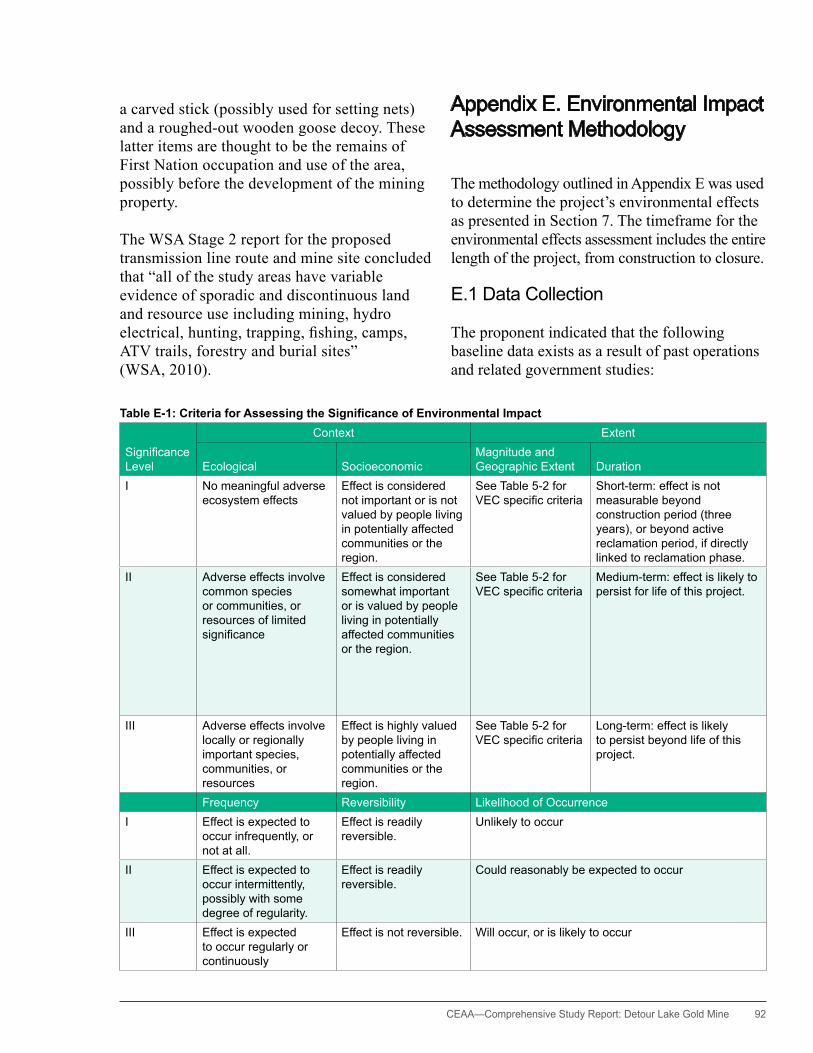
CEAA— Comprehensive Study Report: Detour Lake Gold Mine 92
a carved stick (possibly used for setting nets) and a roughed-out wooden goose decoy. These latter items are thought to be the remains of First Nation occupation and use of the area, possibly before the development of the mining property.
The WSA Stage 2 report for the proposed transmission line route and mine site concluded that “all of the study areas have variable evidence of sporadic and discontinuous land and resource use including mining, hydro electrical, hunting, trapping, fishing, camps, ATV trails, forestry and burial sites” (WSA, 2010).
Appendix E. Environmental Impact Assessment Methodology
The methodology outlined in Appendix E was used to determine the project’s environmental effects as presented in Section 7. The timeframe for the environmental effects assessment includes the entire length of the project, from construction to closure.
E.1 Data Collection
The proponent indicated that the following baseline data exists as a result of past operations and related government studies:
Table E-1: Criteria for Assessing the Significance of Environmental Impact
SignificanceLevel
Context Extent
Ecological SocioeconomicMagnitude and Geographic Extent Duration
I No meaningful adverse ecosystem effects
Effect is considered not important or is not valued by people living in potentially affected communities or the region.
See Table 5-2 for VECspecificcriteria
Short-term: effect is not measurable beyond construction period (three years), or beyond active reclamation period, if directly linked to reclamation phase.
II Adverse effects involve common species or communities, or resources of limited significance
Effect is considered somewhat important or is valued by people living in potentially affected communities or the region.
See Table 5-2 for VECspecificcriteria
Medium-term: effect is likely to persist for life of this project.
III Adverse effects involve locally or regionally important species, communities, or resources
Effect is highly valued by people living in potentially affected communities or the region.
See Table 5-2 for VECspecificcriteria
Long-term: effect is likely to persist beyond life of this project.
Frequency Reversibility Likelihood of OccurrenceI Effect is expected to
occur infrequently, or not at all.
Effect is readily reversible.
Unlikely to occur
II Effect is expected to occur intermittently, possibly with some degree of regularity.
Effect is readily reversible.
Could reasonably be expected to occur
III Effect is expected to occur regularly or continuously
Effect is not reversible. Will occur, or is likely to occur

93 CEAA—Comprehensive Study Report: Detour Lake Gold Mine
• surficial and bedrock geology • surface water hydrology for East Creek at the
East Lake outlet • water quality for past effluent discharges, and
for the East Creek and Sunday Creek systems • sediment quality for the East Creek and Sunday
Creek systems • aquatic fauna in the general area and in the East
Creek and Sunday Creek systems • vegetation for the general site area• caribou associated with MNR and university-
based studies
To advance the existing database, Detour Gold conducted further baseline studies in the following areas using both scientific research methods and traditional knowledge collection techniques:
• geotechnical studies of ground conditions• geochemistry of identified ore, waste rock, and
overburden materials
• surface water hydrology • water quality study of the flooded Detour Lake
Mine pit• hydrogeology and groundwater modeling
related to future open-pit dewatering• water and sediment quality for the project site,
in places with limited baseline data • fisheries and benthos studies of areas west of
the East Creek and Sunday Creek systems, as well as further fisheries investigations of East Creek and East Lake
• vegetation plot studies of representative site-area habitats
• wildlife studies to supplement existing data• socioeconomic conditions and land use• traditional knowledge, traditional land use, and
archaeology
E.2DeterminationofSignificance
The proponent defined the criteria to be used to determine whether or not a particular
Figure E-1: Local Study Area
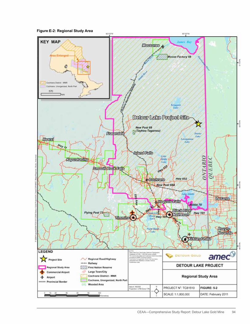
CEAA— Comprehensive Study Report: Detour Lake Gold Mine 94
Figure E-2: Regional Study Area

95 CEAA—Comprehensive Study Report: Detour Lake Gold Mine
Table E-2: Criteria for Assessing Magnitude and Geographic Extent
VEC or VSEC Level I Level II Level III
Atmospheric environment Air quality Emissions are consistent with applicable federal and provincial regulations and guidelines.
If guidelines are exceeded, little or no adverse environment effects are anticipated beyond the project claim boundaries.
Emissions have the potential to exceed federal or provincial guidelines for areas beyond project claim boundaries.
potential for meaningful adverse environmental effects to off-property residents, lands, or waters (and their biota).
Emissions are likely to exceed federal or provincial guidelines for areas beyond project claim boundaries
meaningful and unacceptable adverse environmental effects to off-property residents, lands, or waters (and their biota)
Noise hourly A-weighted sound levels at the margins of buffer zones of <40 A-weighted decibels (dBA).
hourly A-weighted sound levels at the margins of buffer zones of 40 to 45 dBA.
hourly A-weighted sound levels at the margins of buffer zones of >45 dBA
GhG emissions GhG emissions of <0.1% of Canada’s target carbon dioxide (CO2) emission rate reduction of 240 Mt/a.
GhG emissions of 0.1 to 1.0% of Canada’s target CO2 emission rate reduction of 240 million tonnes per annum (Mt/a).
GhG emissions of >1.0% of Canada’s target CO2 emission rate reduction of 240 Mt/a
Local watercourses, lakes, and wetlands
Water quantity Changetocreekandriverflowsis<15%ofseasonalnorms or such that downstream aquatic habitat would not be meaningfully affected.
Changetocreekandriverflowsis15to25%ofseasonalnorms.
Changetocreekandriverflowsis>25%ofseasonalnorms.
Water quality Effects on water quality in receiving waters are consistent with applicable federal and provincial regulations and guidelines.
If guidelines are exceeded, no adverse environment effectsareanticipatedbeyondanydefinedmixingzones.
Effects on water quality in receiving waters beyond any definedmixingzonesarepotentiallyadversefordrinkingwater uses, aquatic life, and wildlife.
Effects on water quality in receiving waters beyond any definedmixingzonesislikelytobeadverse1 for drinking water uses, aquatic life, and wildlife.
Unacceptable effects are the likely result.
Local watercourses, lakes and wetlands
Aquatichabitatandfisheriesresources
No net loss of the productive capacity of habitats. Unacceptablelossoftheproductivecapacityoflocalfishhabitat.
Unacceptable loss of the productive capacity of regional fishhabitat
Groundwater Groundwater systems System alteration is expected to result in less than 15% changefromnormsofcreekandriverseasonalflow.
System alteration is expected to result in 15 to 25% changefromnormsofcreekandriverseasonalflow.
System alteration is expected to result in less than 25% changefromnormsofcreekandriverseasonalflow.
Terrestrial environment Vegetation Effectwouldbeconsideredminor,orsolelyconfinedtoproject lands.
Activity has the potential to meaningfully affect off-property vegetation communities or species
Activity is likely to meaningfully affect off-property vegetation communities or species
Wildlife and migratory birds Effectwouldbeconsideredminororsolelyconfinedtoproject lands.
Activity has the potential to meaningfully affect off-property wildlife species.
Activity is likely to meaningfully affect off-property wildlife species
Socioeconomic No effects or low-level effects; individuals or local communities are affected. Effect occurs but may or may not be detectable, and is within the normal range of variability.
If effect can be measured quantitatively, then Level I effect represents a change of <10% from baseline conditions within project study area.
Effect is clearly distinguishable but is unlikely to pose a serious risk to the VSEC or represent a management challenge.
If effect can be measured quantitatively, then Level II effect represents a change of 10 20% from baseline conditions within project study area.
Effect extends to the regional study area or includes effects at a provincial level.
Effect is likely to pose a serious risk to the VSEC and represents a management challenge.
If effect can be measured quantitatively, then Level III effect represents a change of >20% from baseline conditions within project study area.
Effect extends beyond the regional study area and the province to the national or international level.
environmental effect is likely to be significant after mitigation; the methodology for applying the criteria was also defined. The proponent identified the following attributes as criteria used to evaluate the significance of environmental effects: magnitude and geographic extent, duration, frequency, reversibility, ecological context and socioeconomic or cultural context, and the likeliness that the effect will occur. Associated with each attribute is another set of criteria for evaluating each attribute: these are categorized in three levels as follows:
• Level I refers to a negligible or limited potential to contribute to an overall significant environmental effect.
• Level II refers to an intermediate condition between a low and high contribution to an overall significant environmental effect.
• Level III refers to a high potential to contribute to an overall significant environmental effect.
Attributes and criteria are defined in Tables E-1 and E-2.

CEAA— Comprehensive Study Report: Detour Lake Gold Mine 96
Table E-2: Criteria for Assessing Magnitude and Geographic Extent
VEC or VSEC Level I Level II Level III
Atmospheric environment Air quality Emissions are consistent with applicable federal and provincial regulations and guidelines.
If guidelines are exceeded, little or no adverse environment effects are anticipated beyond the project claim boundaries.
Emissions have the potential to exceed federal or provincial guidelines for areas beyond project claim boundaries.
potential for meaningful adverse environmental effects to off-property residents, lands, or waters (and their biota).
Emissions are likely to exceed federal or provincial guidelines for areas beyond project claim boundaries
meaningful and unacceptable adverse environmental effects to off-property residents, lands, or waters (and their biota)
Noise hourly A-weighted sound levels at the margins of buffer zones of <40 A-weighted decibels (dBA).
hourly A-weighted sound levels at the margins of buffer zones of 40 to 45 dBA.
hourly A-weighted sound levels at the margins of buffer zones of >45 dBA
GhG emissions GhG emissions of <0.1% of Canada’s target carbon dioxide (CO2) emission rate reduction of 240 Mt/a.
GhG emissions of 0.1 to 1.0% of Canada’s target CO2 emission rate reduction of 240 million tonnes per annum (Mt/a).
GhG emissions of >1.0% of Canada’s target CO2 emission rate reduction of 240 Mt/a
Local watercourses, lakes, and wetlands
Water quantity Changetocreekandriverflowsis<15%ofseasonalnorms or such that downstream aquatic habitat would not be meaningfully affected.
Changetocreekandriverflowsis15to25%ofseasonalnorms.
Changetocreekandriverflowsis>25%ofseasonalnorms.
Water quality Effects on water quality in receiving waters are consistent with applicable federal and provincial regulations and guidelines.
If guidelines are exceeded, no adverse environment effectsareanticipatedbeyondanydefinedmixingzones.
Effects on water quality in receiving waters beyond any definedmixingzonesarepotentiallyadversefordrinkingwater uses, aquatic life, and wildlife.
Effects on water quality in receiving waters beyond any definedmixingzonesislikelytobeadverse1 for drinking water uses, aquatic life, and wildlife.
Unacceptable effects are the likely result.
Local watercourses, lakes and wetlands
Aquatichabitatandfisheriesresources
No net loss of the productive capacity of habitats. Unacceptablelossoftheproductivecapacityoflocalfishhabitat.
Unacceptable loss of the productive capacity of regional fishhabitat
Groundwater Groundwater systems System alteration is expected to result in less than 15% changefromnormsofcreekandriverseasonalflow.
System alteration is expected to result in 15 to 25% changefromnormsofcreekandriverseasonalflow.
System alteration is expected to result in less than 25% changefromnormsofcreekandriverseasonalflow.
Terrestrial environment Vegetation Effectwouldbeconsideredminor,orsolelyconfinedtoproject lands.
Activity has the potential to meaningfully affect off-property vegetation communities or species
Activity is likely to meaningfully affect off-property vegetation communities or species
Wildlife and migratory birds Effectwouldbeconsideredminororsolelyconfinedtoproject lands.
Activity has the potential to meaningfully affect off-property wildlife species.
Activity is likely to meaningfully affect off-property wildlife species
Socioeconomic No effects or low-level effects; individuals or local communities are affected. Effect occurs but may or may not be detectable, and is within the normal range of variability.
If effect can be measured quantitatively, then Level I effect represents a change of <10% from baseline conditions within project study area.
Effect is clearly distinguishable but is unlikely to pose a serious risk to the VSEC or represent a management challenge.
If effect can be measured quantitatively, then Level II effect represents a change of 10 20% from baseline conditions within project study area.
Effect extends to the regional study area or includes effects at a provincial level.
Effect is likely to pose a serious risk to the VSEC and represents a management challenge.
If effect can be measured quantitatively, then Level III effect represents a change of >20% from baseline conditions within project study area.
Effect extends beyond the regional study area and the province to the national or international level.
For an effect to be defined as significant within the context of this assessment, the proponent determined that the effect must fulfill the following criteria:
• attain a rating of Level II or Level III for ecological context or socioeconomic or cultural context
• attain a rating of Level II or Level III for all attributes that involve magnitude and geographic extent, duration, and frequency.
Conversely, the effect is considered to be not significant if a rating of Level I is achieved for any of the attributes involving magnitude and geographic extent, duration, or frequency; or, if a rating of Level I is achieved for both ecological context and socioeconomic or cultural context. Effects are also assessed as to their likelihood of occurrence, recognizing that there is some overlap in the concepts of duration, frequency, and likelihood. Reversibility is also assessed but is not a significance determinant because reversibility in some, or many instances, can take several decades to occur.

97 CEAA—Comprehensive Study Report: Detour Lake Gold Mine
The rationale for this methodology is that a predicted environmental effect is not likely to be significant if the effect is (a) of low magnitude or geographic extent; (b) of short-term duration, including residual effects; or (c) is likely to occur very infrequently (or not at all), and (d) has little potential for long-lasting effects. Similarly, the effect is not likely to be significant if the effect has for any reason low or limited ecological, socioeconomic, or cultural importance.
Appendix F. Environmental Effects Analysis Summary
Tables F1 to F4 summarize the environmental effects analysis for each VEC and VSEC. Table F5 summarizes information on potential accidents and malfunctions.
Table F-1: Residual Effects on Natural Environment—Significance after Mitigation
System, Component, or Feature Potential Effect Proposed Mitigation
ResidualSignificanceAfterMitigation ResidualSignificanceAfterMitigation
OverallSignificance
Likelihood of Occurrence
Ecological, Socioeconomic, or Cultural Context
Magnitude and Geographic Extent Duration Frequency Reversibility
Atmospheric EnvironmentAir quality Air emissions from the
project site have the potential to generate dust and other contaminants that could potentially affect human health, and plant and animal health.
Lichens, an important food source for caribou are sensitive to both dust and to SO2/air emissions.
•Usetransmissionlinepower to eliminate the need for diesel generation at site, except during the construction phase
•Usewaterspraysandother dust suppressant measures
•Usebaghousesandothermeasures to reduce dust from site activities such as ore crushing
Adverse effects involve human health, and locally and regionally important communities and species, especially caribou.
With mitigation, predicted air quality will be consistent with provincial regulatory requirements.
Project lifetime
Effects are expected to occur regularly or continuously.
Emissions will cease at mine closure.
Effect is minor, and applicable standards will be met.
Effect will occur.
Level III Level I Level III Level III Level I NotSignificantNoise Noise emissions have the
potential to disturb others using the area and also sensitive wildlife such as caribou.
•Maintaintreescreensaround work areas as practical
•Usemufflersandengineskirts as appropriate to reduce sound levels at source
•Usemineralstockpilestoprovide shielding
•Enclosecrushingequipment
•Maintainheavyequipmentin good working order
Adverse effects involve locally and regionally important species, especially caribou.
With mitigation, noise levels are predicted to be consistent with provincial regulatory requirements, and will be reduced to background levels at the outer margin of the buffer zone set for caribou disturbance.
Project lifetime
Effects are expected to occur regularly or continuously.
Emissions will cease at mine closure.
Effect is minor, and applicable standards will be met.
Effect will occur.
Level III Level I Level III Level III Level I NotSignificantGhGs Greenhouse gases
associated with project construction and operation have a minor potential to contribute to global CO2 emissions and the associated phenomenon of climate change.
•Usetransmissionlinepower rather than onsite diesel power
•Reducetransportneeds(and fuel consumption) through development of a compact site
•Uselarger,morefuel-efficienttrucks
•Insulatebuildings•Maintainequipmentand
vehicles in good working order
Climate change has the potential to positively and negatively affect species and habitats on a global scale.
Project-related emissions will have negligible effect on climate.
Project lifetime
Effects are expected to occur regularly or continuously.
Emissions will cease at mine closure.
Magnitude of effect is too small to be measured.
Effect will occur.
Level III Level I Level III Level III Level I NotSignificant
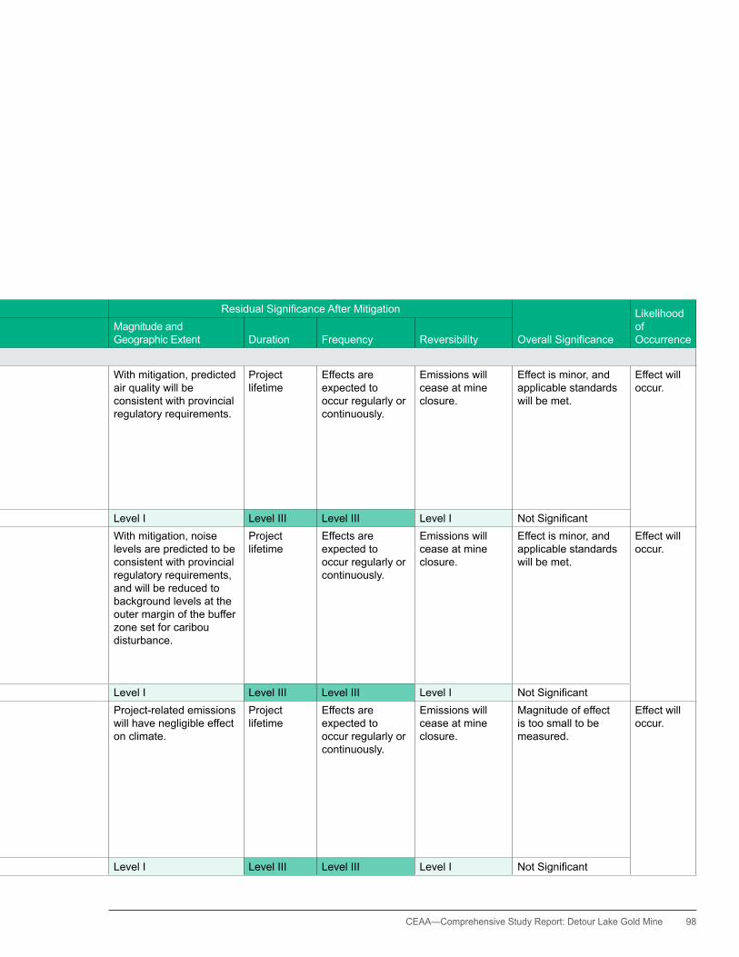
CEAA— Comprehensive Study Report: Detour Lake Gold Mine 98
Table F-1: Residual Effects on Natural Environment—Significance after Mitigation
System, Component, or Feature Potential Effect Proposed Mitigation
ResidualSignificanceAfterMitigation ResidualSignificanceAfterMitigation
OverallSignificance
Likelihood of Occurrence
Ecological, Socioeconomic, or Cultural Context
Magnitude and Geographic Extent Duration Frequency Reversibility
Atmospheric EnvironmentAir quality Air emissions from the
project site have the potential to generate dust and other contaminants that could potentially affect human health, and plant and animal health.
Lichens, an important food source for caribou are sensitive to both dust and to SO2/air emissions.
•Usetransmissionlinepower to eliminate the need for diesel generation at site, except during the construction phase
•Usewaterspraysandother dust suppressant measures
•Usebaghousesandothermeasures to reduce dust from site activities such as ore crushing
Adverse effects involve human health, and locally and regionally important communities and species, especially caribou.
With mitigation, predicted air quality will be consistent with provincial regulatory requirements.
Project lifetime
Effects are expected to occur regularly or continuously.
Emissions will cease at mine closure.
Effect is minor, and applicable standards will be met.
Effect will occur.
Level III Level I Level III Level III Level I NotSignificantNoise Noise emissions have the
potential to disturb others using the area and also sensitive wildlife such as caribou.
•Maintaintreescreensaround work areas as practical
•Usemufflersandengineskirts as appropriate to reduce sound levels at source
•Usemineralstockpilestoprovide shielding
•Enclosecrushingequipment
•Maintainheavyequipmentin good working order
Adverse effects involve locally and regionally important species, especially caribou.
With mitigation, noise levels are predicted to be consistent with provincial regulatory requirements, and will be reduced to background levels at the outer margin of the buffer zone set for caribou disturbance.
Project lifetime
Effects are expected to occur regularly or continuously.
Emissions will cease at mine closure.
Effect is minor, and applicable standards will be met.
Effect will occur.
Level III Level I Level III Level III Level I NotSignificantGhGs Greenhouse gases
associated with project construction and operation have a minor potential to contribute to global CO2 emissions and the associated phenomenon of climate change.
•Usetransmissionlinepower rather than onsite diesel power
•Reducetransportneeds(and fuel consumption) through development of a compact site
•Uselarger,morefuel-efficienttrucks
•Insulatebuildings•Maintainequipmentand
vehicles in good working order
Climate change has the potential to positively and negatively affect species and habitats on a global scale.
Project-related emissions will have negligible effect on climate.
Project lifetime
Effects are expected to occur regularly or continuously.
Emissions will cease at mine closure.
Magnitude of effect is too small to be measured.
Effect will occur.
Level III Level I Level III Level III Level I NotSignificant

99 CEAA—Comprehensive Study Report: Detour Lake Gold Mine
Table F-1: Residual Effects on Natural Environment—Significance after Mitigation (cont'd)
System, Component, or Feature Potential Effect Proposed Mitigation
ResidualSignificanceAfterMitigation ResidualSignificanceAfterMitigation
OverallSignificance
Likelihood of Occurrence
Ecological, Socioeconomic, or Cultural Context
Magnitude and Geographic Extent Duration Frequency Reversibility
Surface Waters/Aquatic BiologyEast Creek and Sunday Creek System
TIA development and effluentdischargehavethe potential to reduce downstreamflowsandto adversely affect water quality.
•Usein-plantSO2/air treatment for cyanide destruction and heavy metal precipitation
•Useextendedeffluentaging(naturaldegradation) and extensiveeffluentreclaim
•Useseepageandsurface-collection system
Adverse effects would involve commonplace and widespread ecological communities; there are no known special habitats.
Changes in system water flowsarenotexpectedto adversely affect downstreamfishhabitat.
MMER, CEQG, and PWQOeffluentandwaterquality requirements (or background levels) are expected to be met.
Effects will persist throughout the period of mine operation.
Directeffluentdischarges are expected to be intermittent, i.e., seasonal. Seepage and effects on watershed flowwouldbecontinuous.
Effects are substantially reversible following TIA closure.
Overall effects are considered to be minor, localized, and reversible.
Effect will occur to varying degrees.
Level II Level I Level II Level III Level II NotSignificantKarel Creek System Development of the
open pit and the mineral stockpiles has the potential to alter creekflows,especiallybaseflowsinrelatedtoopen pit operations.
There is potential for ARD and TSS loadings from waste rock stockpiles.
•ClosetheNorthAggregatePit to provide compensatory brook trout spawning habitat connected to Karel Creek •Developoverwinteringpoolswithin Karel Creek. •ManageARDpotentialsthrough segregation and collection. •Useperimeterditchinganddetention ponds, together with vegetated buffer zones, to collect and manage surface runoff and seepage.•Usearchedculvertsathaulroad crossings
Karel Creek is the only known cold water creek system in the immediate site area, and is known to support brook trout.
Potential adverse effects to brook trout spawning and overwintering habitats will be offset by proposedfishhabitatcompensation measures.
Effects will persist throughout the period of mine operation and well beyond closure.
Effect is expected to be continuous.
Effects will be substantially reversible following mine closure and passivefillingof the open pit, but this action will take several decades.
Overall effect is considered to be minor and can be compensated for; compensation measures are expected to be ecologically sound for the foreseeable future.
Effect will occur.
Level III Level I Level III Level III Level II NotSignificantEaster Creek System TIA development will alter
watershed boundaries.
Development of the open pit and the mineral stockpiles has the potential toaltercreekflows.
TIA seepage and drainage from the overburden stockpile can potentially affect creek water quality.
Sewage discharges could affect water quality.
Watershedfloweffectsare considered to be minor and do not require mitigation.
•ControlTIAseepagethrough use of in-plant cyanide destruction and heavy metal precipitation, in addition to the seepage collection system.
•Useperimeterditchingand detention ponds, together with vegetated buffer zones, to collect and manage surface runoff and seepage.
•Usemembranebioreactor (MBR) for sewage treatment.
Creek system and associated Easter Lake provide commonplace habitatsandsupportcoolwaterfishcommunities.
Watershedfloweffectsare expected to be minor (within15%offlownorms)
MMER, CEQG, and PWQOeffluentandwaterquality requirements (or background levels) are expected to be met.
Watershed alteration due to TIA development will be permanent.
Other effects will persist throughout the period of mine operation and beyond closure.
Effect is expected to be continuous.
Water quality effects will be reversible in the long-term following mine closure.Watershedfloweffects are not reversible.
Overall effects are considered to be minor and consistent with regulatory limits and guidelines.
Effect will occur.
Level II Level I Level III Level III Level III NotSignificant
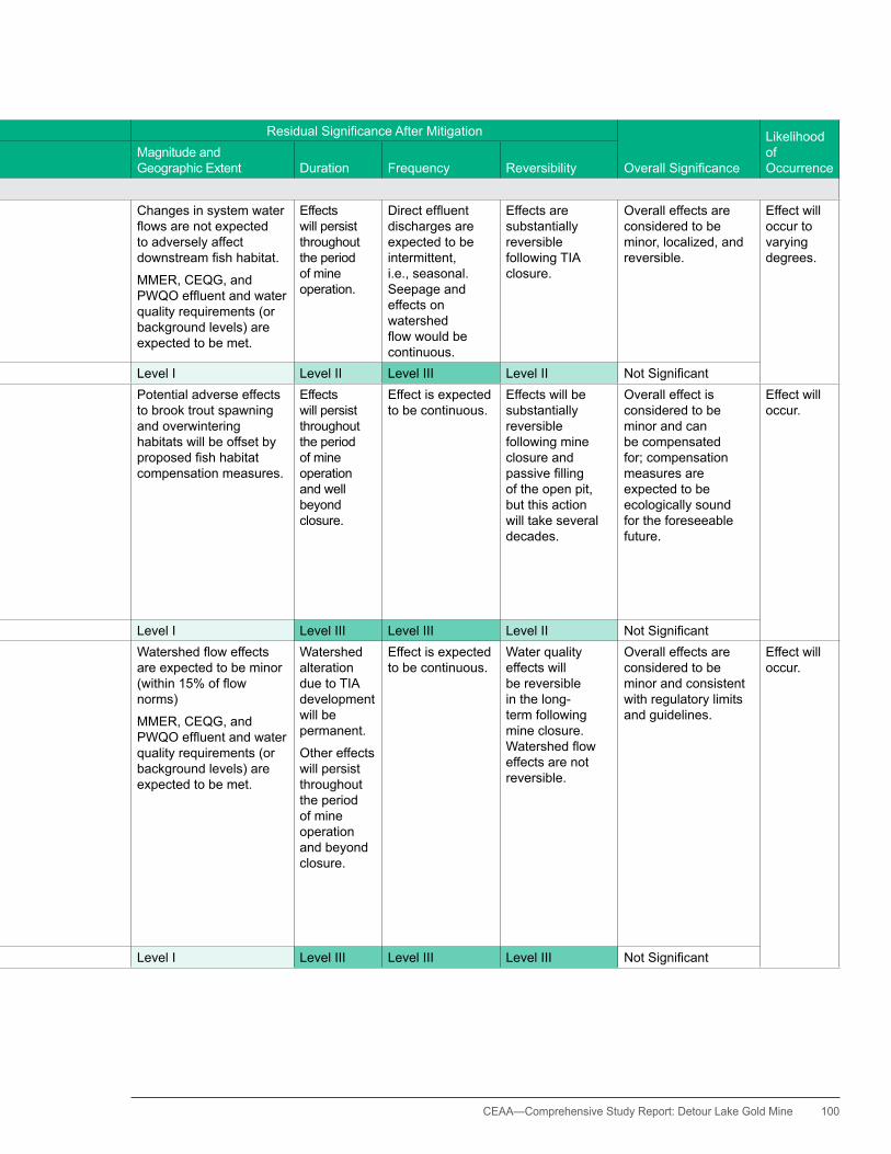
CEAA— Comprehensive Study Report: Detour Lake Gold Mine 100
Table F-1: Residual Effects on Natural Environment—Significance after Mitigation (cont'd)
System, Component, or Feature Potential Effect Proposed Mitigation
ResidualSignificanceAfterMitigation ResidualSignificanceAfterMitigation
OverallSignificance
Likelihood of Occurrence
Ecological, Socioeconomic, or Cultural Context
Magnitude and Geographic Extent Duration Frequency Reversibility
Surface Waters/Aquatic BiologyEast Creek and Sunday Creek System
TIA development and effluentdischargehavethe potential to reduce downstreamflowsandto adversely affect water quality.
•Usein-plantSO2/air treatment for cyanide destruction and heavy metal precipitation
•Useextendedeffluentaging(naturaldegradation) and extensiveeffluentreclaim
•Useseepageandsurface-collection system
Adverse effects would involve commonplace and widespread ecological communities; there are no known special habitats.
Changes in system water flowsarenotexpectedto adversely affect downstreamfishhabitat.
MMER, CEQG, and PWQOeffluentandwaterquality requirements (or background levels) are expected to be met.
Effects will persist throughout the period of mine operation.
Directeffluentdischarges are expected to be intermittent, i.e., seasonal. Seepage and effects on watershed flowwouldbecontinuous.
Effects are substantially reversible following TIA closure.
Overall effects are considered to be minor, localized, and reversible.
Effect will occur to varying degrees.
Level II Level I Level II Level III Level II NotSignificantKarel Creek System Development of the
open pit and the mineral stockpiles has the potential to alter creekflows,especiallybaseflowsinrelatedtoopen pit operations.
There is potential for ARD and TSS loadings from waste rock stockpiles.
•ClosetheNorthAggregatePit to provide compensatory brook trout spawning habitat connected to Karel Creek •Developoverwinteringpoolswithin Karel Creek. •ManageARDpotentialsthrough segregation and collection. •Useperimeterditchinganddetention ponds, together with vegetated buffer zones, to collect and manage surface runoff and seepage.•Usearchedculvertsathaulroad crossings
Karel Creek is the only known cold water creek system in the immediate site area, and is known to support brook trout.
Potential adverse effects to brook trout spawning and overwintering habitats will be offset by proposedfishhabitatcompensation measures.
Effects will persist throughout the period of mine operation and well beyond closure.
Effect is expected to be continuous.
Effects will be substantially reversible following mine closure and passivefillingof the open pit, but this action will take several decades.
Overall effect is considered to be minor and can be compensated for; compensation measures are expected to be ecologically sound for the foreseeable future.
Effect will occur.
Level III Level I Level III Level III Level II NotSignificantEaster Creek System TIA development will alter
watershed boundaries.
Development of the open pit and the mineral stockpiles has the potential toaltercreekflows.
TIA seepage and drainage from the overburden stockpile can potentially affect creek water quality.
Sewage discharges could affect water quality.
Watershedfloweffectsare considered to be minor and do not require mitigation.
•ControlTIAseepagethrough use of in-plant cyanide destruction and heavy metal precipitation, in addition to the seepage collection system.
•Useperimeterditchingand detention ponds, together with vegetated buffer zones, to collect and manage surface runoff and seepage.
•Usemembranebioreactor (MBR) for sewage treatment.
Creek system and associated Easter Lake provide commonplace habitatsandsupportcoolwaterfishcommunities.
Watershedfloweffectsare expected to be minor (within15%offlownorms)
MMER, CEQG, and PWQOeffluentandwaterquality requirements (or background levels) are expected to be met.
Watershed alteration due to TIA development will be permanent.
Other effects will persist throughout the period of mine operation and beyond closure.
Effect is expected to be continuous.
Water quality effects will be reversible in the long-term following mine closure.Watershedfloweffects are not reversible.
Overall effects are considered to be minor and consistent with regulatory limits and guidelines.
Effect will occur.
Level II Level I Level III Level III Level III NotSignificant
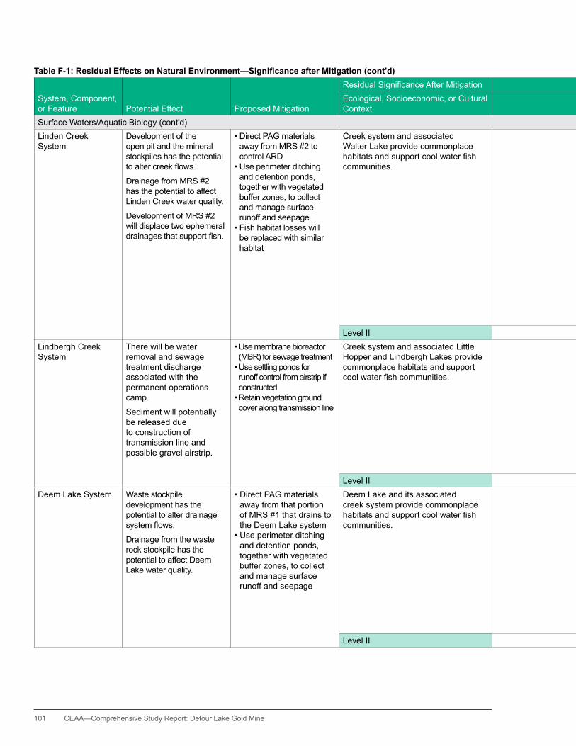
101 CEAA—Comprehensive Study Report: Detour Lake Gold Mine
Table F-1: Residual Effects on Natural Environment—Significance after Mitigation (cont'd)
System, Component, or Feature Potential Effect Proposed Mitigation
ResidualSignificanceAfterMitigation ResidualSignificanceAfterMitigation
OverallSignificance
Likelihood of Occurrence
Ecological, Socioeconomic, or Cultural Context
Magnitude and Geographic Extent Duration Frequency Reversibility
Surface Waters/Aquatic Biology (cont'd)Linden Creek System
Development of the open pit and the mineral stockpiles has the potential toaltercreekflows.
Drainage from MRS #2 has the potential to affect Linden Creek water quality.
Development of MRS #2 will displace two ephemeral drainagesthatsupportfish.
•DirectPAGmaterialsaway from MRS #2 to control ARD
•Useperimeterditchingand detention ponds, together with vegetated buffer zones, to collect and manage surface runoff and seepage
•Fishhabitatlosseswillbe replaced with similar habitat
Creek system and associated Walter Lake provide commonplace habitatsandsupportcoolwaterfishcommunities.
Changes in system water flowsexpectedtobesubstantially less 15% of annualflowrates.
MMER, CEQG, and PWQOeffluentandwaterquality requirements (or background levels) would be met.
Potential adverse effects tothefishhabitatwillbeoffsetbyproposedfishhabitat compensation measures.
Effects will persist throughout the period of mine construction and operation.
habitat losses will be permanent.
Effect is expected to be continuous.
Flow effects are expected to be reversible following mine closure and floodingofthepit.Effects on water quality associated with TSS and ammonia release would also cease at mine closure. Minor geochemical reactivity would continue for the foreseeable future, but is not expected to be a concern. habitat losses will be permanent.
Overall effects are considered to be minor, localized, and substantially reversible. Compensation measures are expected to be ecologicallysufficientinto the foreseeable future.
Effect will occur.
Level II Level I Level II Level III Level I NotSignificantLindbergh Creek System
There will be water removal and sewage treatment discharge associated with the permanent operations camp.
Sediment will potentially be released due to construction of transmission line and possible gravel airstrip.
•Usemembranebioreactor(MBR) for sewage treatment•Usesettlingpondsforrunoff control from airstrip if constructed•Retainvegetationgroundcover along transmission line
Creek system and associated Little hopper and Lindbergh Lakes provide commonplace habitats and support coolwaterfishcommunities.
Water-take expected to be <1% of average annualflowsatoutletfrom Little hopper Lake.
MBR plant is best available technology able to meet federal and provincialeffluentqualityrequirements.
Runoff from airstrip will be managed with settling ponds.
Effects will persist throughout mine construction and operation.
Effect is expected to be continuous.
Effects are reversible following mine closure.
Overall effects are considered to be minor, localized, and reversible.
Effect will occur.
Level II Level I Level II Level III Level I NotSignificantDeem Lake System Waste stockpile
development has the potential to alter drainage systemflows.
Drainage from the waste rock stockpile has the potential to affect Deem Lake water quality.
•DirectPAGmaterialsaway from that portion of MRS #1 that drains to the Deem Lake system
•Useperimeterditchingand detention ponds, together with vegetated buffer zones, to collect and manage surface runoff and seepage
Deem Lake and its associated creek system provide commonplace habitatsandsupportcoolwaterfishcommunities.
Changes in system water flowsareexpectedtobesubstantially less than 15%ofannualflowrates.
MMER, CEQG, and PWQOeffluentandwaterquality requirements (or background levels) would be met.
Effects will persist throughout mine construction and operation.
Effect is expected to be continuous.
Water quality effects associated with TSS and ammonia release would cease at mine closure. Minor geochemical reactivity would continue for the foreseeable future, but is not expected to be a concern.
Overall effects are considered to be minor, localized, and substantially reversible.
Effect will occur.
Level II Level I Level II Level III Level I NotSignificant
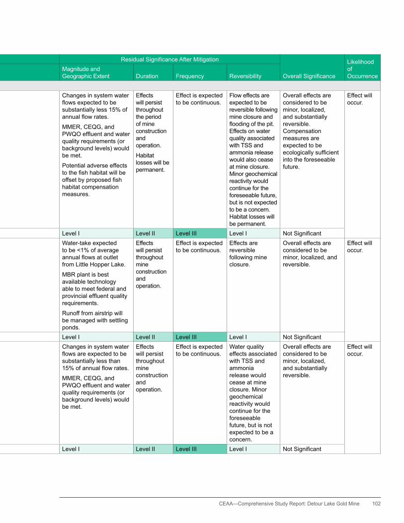
CEAA— Comprehensive Study Report: Detour Lake Gold Mine 102
Table F-1: Residual Effects on Natural Environment—Significance after Mitigation (cont'd)
System, Component, or Feature Potential Effect Proposed Mitigation
ResidualSignificanceAfterMitigation ResidualSignificanceAfterMitigation
OverallSignificance
Likelihood of Occurrence
Ecological, Socioeconomic, or Cultural Context
Magnitude and Geographic Extent Duration Frequency Reversibility
Surface Waters/Aquatic Biology (cont'd)Linden Creek System
Development of the open pit and the mineral stockpiles has the potential toaltercreekflows.
Drainage from MRS #2 has the potential to affect Linden Creek water quality.
Development of MRS #2 will displace two ephemeral drainagesthatsupportfish.
•DirectPAGmaterialsaway from MRS #2 to control ARD
•Useperimeterditchingand detention ponds, together with vegetated buffer zones, to collect and manage surface runoff and seepage
•Fishhabitatlosseswillbe replaced with similar habitat
Creek system and associated Walter Lake provide commonplace habitatsandsupportcoolwaterfishcommunities.
Changes in system water flowsexpectedtobesubstantially less 15% of annualflowrates.
MMER, CEQG, and PWQOeffluentandwaterquality requirements (or background levels) would be met.
Potential adverse effects tothefishhabitatwillbeoffsetbyproposedfishhabitat compensation measures.
Effects will persist throughout the period of mine construction and operation.
habitat losses will be permanent.
Effect is expected to be continuous.
Flow effects are expected to be reversible following mine closure and floodingofthepit.Effects on water quality associated with TSS and ammonia release would also cease at mine closure. Minor geochemical reactivity would continue for the foreseeable future, but is not expected to be a concern. habitat losses will be permanent.
Overall effects are considered to be minor, localized, and substantially reversible. Compensation measures are expected to be ecologicallysufficientinto the foreseeable future.
Effect will occur.
Level II Level I Level II Level III Level I NotSignificantLindbergh Creek System
There will be water removal and sewage treatment discharge associated with the permanent operations camp.
Sediment will potentially be released due to construction of transmission line and possible gravel airstrip.
•Usemembranebioreactor(MBR) for sewage treatment•Usesettlingpondsforrunoff control from airstrip if constructed•Retainvegetationgroundcover along transmission line
Creek system and associated Little hopper and Lindbergh Lakes provide commonplace habitats and support coolwaterfishcommunities.
Water-take expected to be <1% of average annualflowsatoutletfrom Little hopper Lake.
MBR plant is best available technology able to meet federal and provincialeffluentqualityrequirements.
Runoff from airstrip will be managed with settling ponds.
Effects will persist throughout mine construction and operation.
Effect is expected to be continuous.
Effects are reversible following mine closure.
Overall effects are considered to be minor, localized, and reversible.
Effect will occur.
Level II Level I Level II Level III Level I NotSignificantDeem Lake System Waste stockpile
development has the potential to alter drainage systemflows.
Drainage from the waste rock stockpile has the potential to affect Deem Lake water quality.
•DirectPAGmaterialsaway from that portion of MRS #1 that drains to the Deem Lake system
•Useperimeterditchingand detention ponds, together with vegetated buffer zones, to collect and manage surface runoff and seepage
Deem Lake and its associated creek system provide commonplace habitatsandsupportcoolwaterfishcommunities.
Changes in system water flowsareexpectedtobesubstantially less than 15%ofannualflowrates.
MMER, CEQG, and PWQOeffluentandwaterquality requirements (or background levels) would be met.
Effects will persist throughout mine construction and operation.
Effect is expected to be continuous.
Water quality effects associated with TSS and ammonia release would cease at mine closure. Minor geochemical reactivity would continue for the foreseeable future, but is not expected to be a concern.
Overall effects are considered to be minor, localized, and substantially reversible.
Effect will occur.
Level II Level I Level II Level III Level I NotSignificant

103 CEAA—Comprehensive Study Report: Detour Lake Gold Mine
Table F-1: Residual Effects on Natural Environment—Significance after Mitigation (cont'd)
System, Component, or Feature Potential Effect Proposed Mitigation
ResidualSignificanceAfterMitigation ResidualSignificanceAfterMitigation
OverallSignificance
Likelihood of Occurrence
Ecological, Socioeconomic, or Cultural Context
Magnitude and Geographic Extent Duration Frequency Reversibility
Surface Waters/Aquatic Biology (cont'd)Detour River TIA discharge has the
potential to affect Detour River water quality.
•Usein-planteffluenttreatment and aggressive water volume management to control TIAeffluentdischarge
The Detour River supports a number offishspeciesincludinglakesturgeon(a SARA species).
PWQO and CEQG water quality requirements (or background levels) would be met in the Detour River.
Effects will persist throughout mine operation.
Seasonal discharges from the TIA will occur in most years of operations.
Water quality effects are expected to be reversible at mine closure.
Overall effects are considered to be minor and reversible.
Effect will occur.
Level III Level I Level II Level III Level I NotSignificantMuskeg ponds Development of TIA Cell
#2 and the South Mine Waste Rock Stockpile will displace a small muskeg pond and its associated fen track drainage and two small muskeg drainages; this is an MMER Schedule 2 consideration.
•Replacemuskegpondwith similar habitat
•Connectpondtoanatural fen track
The muskeg pond and drainages haslimitedfisheriesvalue,butithaslegislativesignificancerequiringMMER Schedule 2 listing in order to allow mine waste disposal
Potential adverse effects tothemuskegpondfishhabitat will be offset by proposedfishhabitatcompensation measures.
Effects will be permanent.
Effect is expected to be continuous.
Effects will be permanent.
Overall effect is considered to be minor and can be compensated for.
Compensation measures are expected to be ecologically sufficientintotheforeseeable future.
Effect will occur.
Level III Level I Level II Level III Level I NotSignificantGroundwater System Open pit dewatering has
the potential to draw down local aquifers.
Groundwater quality would not be affected.
Mitigation measures related to potential effects of open pit dewatering on surface water systems are described above.
No other mitigation measures are proposed.
Interactions with groundwater and surface water are described above.
There are no local groundwater users.
Effects are considered to be localized, within a few hundred metres of the pit perimeter at most, andwouldnotconflictwith other users (none present).
Effects will persist throughout mine operation and well beyond closure.
Effect is expected to be continuous.
Effects are substantially reversible following mine closure and passivefillingof the open pit, but this action will take several decades.
Overall effect is considered to be minor.
Effect will occur.
Level I Level I Level III Level III Level II NotSignificantTerrestral EnvironmentVegetation communities and habitat
Mine site development will displace an estimated 20 square kilometres2 of forest habitat, including 5.6 square kilometres2 of black spruce–jack pine forest. An additional 3.26 square kilometres2 of undisturbed forest habitat will be cleared for transmission line construction.
Minor disruption to linkages between terrestrial habitats is possible since wildlife species might tend to avoid the mine site area. Much of this area is already disturbed.
The transmission line will follow along existing corridors over the majority of its length.
•Developacompactsitelocated on previously disturbed habitat to limit disturbance to new areas
•Avoidriparianandothersensitive habitats to the extent practicable•Undertakesite
revegetation at closure to restore habitats.
•Constructtransmissionline on or immediately adjacent to existing ROWs
Adverse effects will generally involve commonplace and widespread species.
Effects are considered to be minor (5.6% of LSA in the case of the project site)andconfinedtotheimmediate mine site area.
Wildlife species that usually avoid the mine site area will likely continue do so.
Effects of vegetation clearing associated with the transmission line are considered to be minor and directly associated with previously disturbed areas.
Effect will persist throughout the mine development, and it will take time for forest habitats to re-establish following active rehabilitation at mine closure.
Recovery of vegetation and wildlife habitat along the transmission line will be faster because of intact ground cover and tree seedlings.
Effect is expected to be continuous.
Effects are reversible following mine closure.
Overall effects are considered to be generally minor, localized, and reversible.
The project site is abrownfieldsitewith existing road access, and the transmission line will be constructed along and adjacent to existing ROWs.
Effect will occur.
Level II Level I Level III Level III Level I NotSignificant
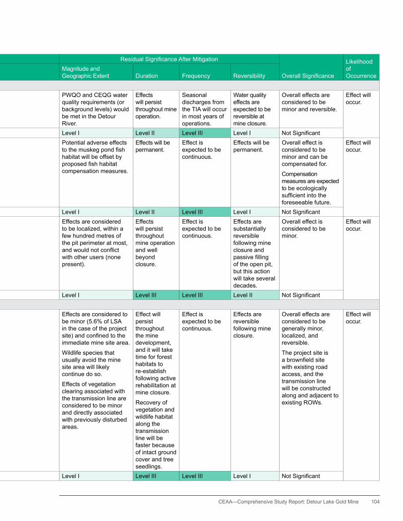
CEAA— Comprehensive Study Report: Detour Lake Gold Mine 104
Table F-1: Residual Effects on Natural Environment—Significance after Mitigation (cont'd)
System, Component, or Feature Potential Effect Proposed Mitigation
ResidualSignificanceAfterMitigation ResidualSignificanceAfterMitigation
OverallSignificance
Likelihood of Occurrence
Ecological, Socioeconomic, or Cultural Context
Magnitude and Geographic Extent Duration Frequency Reversibility
Surface Waters/Aquatic Biology (cont'd)Detour River TIA discharge has the
potential to affect Detour River water quality.
•Usein-planteffluenttreatment and aggressive water volume management to control TIAeffluentdischarge
The Detour River supports a number offishspeciesincludinglakesturgeon(a SARA species).
PWQO and CEQG water quality requirements (or background levels) would be met in the Detour River.
Effects will persist throughout mine operation.
Seasonal discharges from the TIA will occur in most years of operations.
Water quality effects are expected to be reversible at mine closure.
Overall effects are considered to be minor and reversible.
Effect will occur.
Level III Level I Level II Level III Level I NotSignificantMuskeg ponds Development of TIA Cell
#2 and the South Mine Waste Rock Stockpile will displace a small muskeg pond and its associated fen track drainage and two small muskeg drainages; this is an MMER Schedule 2 consideration.
•Replacemuskegpondwith similar habitat
•Connectpondtoanatural fen track
The muskeg pond and drainages haslimitedfisheriesvalue,butithaslegislativesignificancerequiringMMER Schedule 2 listing in order to allow mine waste disposal
Potential adverse effects tothemuskegpondfishhabitat will be offset by proposedfishhabitatcompensation measures.
Effects will be permanent.
Effect is expected to be continuous.
Effects will be permanent.
Overall effect is considered to be minor and can be compensated for.
Compensation measures are expected to be ecologically sufficientintotheforeseeable future.
Effect will occur.
Level III Level I Level II Level III Level I NotSignificantGroundwater System Open pit dewatering has
the potential to draw down local aquifers.
Groundwater quality would not be affected.
Mitigation measures related to potential effects of open pit dewatering on surface water systems are described above.
No other mitigation measures are proposed.
Interactions with groundwater and surface water are described above.
There are no local groundwater users.
Effects are considered to be localized, within a few hundred metres of the pit perimeter at most, andwouldnotconflictwith other users (none present).
Effects will persist throughout mine operation and well beyond closure.
Effect is expected to be continuous.
Effects are substantially reversible following mine closure and passivefillingof the open pit, but this action will take several decades.
Overall effect is considered to be minor.
Effect will occur.
Level I Level I Level III Level III Level II NotSignificantTerrestral EnvironmentVegetation communities and habitat
Mine site development will displace an estimated 20 square kilometres2 of forest habitat, including 5.6 square kilometres2 of black spruce–jack pine forest. An additional 3.26 square kilometres2 of undisturbed forest habitat will be cleared for transmission line construction.
Minor disruption to linkages between terrestrial habitats is possible since wildlife species might tend to avoid the mine site area. Much of this area is already disturbed.
The transmission line will follow along existing corridors over the majority of its length.
•Developacompactsitelocated on previously disturbed habitat to limit disturbance to new areas
•Avoidriparianandothersensitive habitats to the extent practicable•Undertakesite
revegetation at closure to restore habitats.
•Constructtransmissionline on or immediately adjacent to existing ROWs
Adverse effects will generally involve commonplace and widespread species.
Effects are considered to be minor (5.6% of LSA in the case of the project site)andconfinedtotheimmediate mine site area.
Wildlife species that usually avoid the mine site area will likely continue do so.
Effects of vegetation clearing associated with the transmission line are considered to be minor and directly associated with previously disturbed areas.
Effect will persist throughout the mine development, and it will take time for forest habitats to re-establish following active rehabilitation at mine closure.
Recovery of vegetation and wildlife habitat along the transmission line will be faster because of intact ground cover and tree seedlings.
Effect is expected to be continuous.
Effects are reversible following mine closure.
Overall effects are considered to be generally minor, localized, and reversible.
The project site is abrownfieldsitewith existing road access, and the transmission line will be constructed along and adjacent to existing ROWs.
Effect will occur.
Level II Level I Level III Level III Level I NotSignificant

105 CEAA—Comprehensive Study Report: Detour Lake Gold Mine
Table F-1: Residual Effects on Natural Environment—Significance after Mitigation (cont'd)
System, Component, or Feature Potential Effect Proposed Mitigation
ResidualSignificanceAfterMitigation ResidualSignificanceAfterMitigation
OverallSignificance
Likelihood of Occurrence
Ecological, Socioeconomic, or Cultural Context
Magnitude and Geographic Extent Duration Frequency Reversibility
Terrestral Environment (cont'd)Migratory birds Mine site development
will displace an estimated 20 square kilometres of forest habitat, including 5.6 square kilometres of black spruce–jack pine forest. An additional 3.26 square kilometres of undisturbed forest habitat will be cleared for transmission line construction.
Other potential effects are associated with general disturbance and vehicular collisions.
All-season road access to the project site already exists.
•Developacompactsitelocated on previously disturbed habitat to limit disturbance to new areas
•Avoidriparianandothersensitive habitats to the extent practicable•Avoidtreeclearingduringbird-nesting season•Revegetatesiteatclosure
to restore habitats. •Constructtransmission
line along or adjacent to existing ROWs
Adverse effects will generally involve commonplace and widespread species, as well as some species-at-risk and regionally rare species.
Effects are considered to be minor (5.6% of LSA and 0.9% of the transmission line LSA) andconfinedtotheimmediate mine site area or the existing transmission line ROWs.
Several SAR and regionally rare species observed at the site were associated with riparian and disturbed habitats.
Effect will persist throughout the mine development, and it will take time for forest habitats to re-establish following active rehabilitation at mine closure.
habitat recovery along the transmission line will be faster because of intact ground cover and tree seedlings.
Effect is expected to be continuous.
Effects are reversible following mine closure.
Overall effects are considered to be generally minor, localized, and reversible.
The project site is abrownfieldsitewith existing road access, and the transmission line will be constructed along and adjacent to existing ROWs.
Effect will occur.
Level III Level I Level III Level III Level I NotSignificantSpecies-At-RiskWoodland caribou
SAR migratory birds
Mine site development will displace an estimated 20 square kilometres of forest habitat, which means displacing migratory birds that typically occupy such habitat.
An additional 3.26 square kilometres of undisturbed forest habitat will be disturbed during transmission line construction, but ground and shrub habitat will remain.
•Developacompactsitelocated on previously disturbed habitat to limit disturbance to new areas
•Avoidriparianandothersensitive habitats to the extent practicable•Revegetatesiteat
closure to restore habitat, including development of lichen habitat on waste rock stockpiles as source of food for caribou
•Constructtransmissionline along or adjacent to existing ROWs
Caribou are recognized as species- at-risk by the provincial and federal governments.
Effects are considered to be minor (5.6% of the mine site LSA and confinedtotheimmediatemine site area, and 0.9% of the transmission line LSA).
Available data suggest that the area involved represents the carrying capacity for 0.23 caribou.
If the effects of general disturbance are considered, there is potential to affect a further small number of individuals at some level.
Effect will persist throughout the mine development, and it will take time for wildlife habitats to re-establish following active rehabilitation at mine closure.
Recovery of wildlife habitat along the transmission line will be faster because of intact ground cover and tree seedlings.
Effect is expected to be continuous.
Effects are reversible following mine closure.
Overall effects are considered to be generally minor, localized, and reversible.
The project site is abrownfieldsitewith existing road access, and the transmission line will be constructed along and adjacent to existing ROWs.
Effect will occur.
Level III Level I Level III Level III Level I NotSignificant
Lake Sturgeon Lake sturgeon live in the Detour River, and TIA discharge has the potential to affect the Detour River water quality.
TocontrolTIAeffluentdischarge, use the following:
•in-planteffluenttreatment•extendedeffluentaging•extensivewaterrecycling
The Detour River supports a number offishspeciesincludinglakesturgeon(a SARA species).
PWQO and CEQG (or background levels) would be met in the Detour River.
Effects will persist throughout the mine operation.
Effect is expected to be continuous.
Water quality effects are expected to be reversible at mine closure.
Overall effects are considered to be minor and reversible.
Effect will occur.
Level III Level I Level II Level III Level I NotSignificant
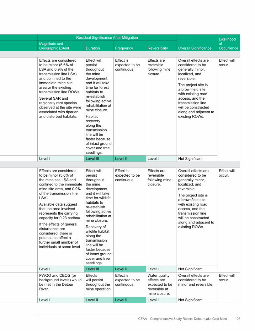
CEAA— Comprehensive Study Report: Detour Lake Gold Mine 106
Table F-1: Residual Effects on Natural Environment—Significance after Mitigation (cont'd)
System, Component, or Feature Potential Effect Proposed Mitigation
ResidualSignificanceAfterMitigation ResidualSignificanceAfterMitigation
OverallSignificance
Likelihood of Occurrence
Ecological, Socioeconomic, or Cultural Context
Magnitude and Geographic Extent Duration Frequency Reversibility
Terrestral Environment (cont'd)Migratory birds Mine site development
will displace an estimated 20 square kilometres of forest habitat, including 5.6 square kilometres of black spruce–jack pine forest. An additional 3.26 square kilometres of undisturbed forest habitat will be cleared for transmission line construction.
Other potential effects are associated with general disturbance and vehicular collisions.
All-season road access to the project site already exists.
•Developacompactsitelocated on previously disturbed habitat to limit disturbance to new areas
•Avoidriparianandothersensitive habitats to the extent practicable•Avoidtreeclearingduringbird-nesting season•Revegetatesiteatclosure
to restore habitats. •Constructtransmission
line along or adjacent to existing ROWs
Adverse effects will generally involve commonplace and widespread species, as well as some species-at-risk and regionally rare species.
Effects are considered to be minor (5.6% of LSA and 0.9% of the transmission line LSA) andconfinedtotheimmediate mine site area or the existing transmission line ROWs.
Several SAR and regionally rare species observed at the site were associated with riparian and disturbed habitats.
Effect will persist throughout the mine development, and it will take time for forest habitats to re-establish following active rehabilitation at mine closure.
habitat recovery along the transmission line will be faster because of intact ground cover and tree seedlings.
Effect is expected to be continuous.
Effects are reversible following mine closure.
Overall effects are considered to be generally minor, localized, and reversible.
The project site is abrownfieldsitewith existing road access, and the transmission line will be constructed along and adjacent to existing ROWs.
Effect will occur.
Level III Level I Level III Level III Level I NotSignificantSpecies-At-RiskWoodland caribou
SAR migratory birds
Mine site development will displace an estimated 20 square kilometres of forest habitat, which means displacing migratory birds that typically occupy such habitat.
An additional 3.26 square kilometres of undisturbed forest habitat will be disturbed during transmission line construction, but ground and shrub habitat will remain.
•Developacompactsitelocated on previously disturbed habitat to limit disturbance to new areas
•Avoidriparianandothersensitive habitats to the extent practicable•Revegetatesiteat
closure to restore habitat, including development of lichen habitat on waste rock stockpiles as source of food for caribou
•Constructtransmissionline along or adjacent to existing ROWs
Caribou are recognized as species- at-risk by the provincial and federal governments.
Effects are considered to be minor (5.6% of the mine site LSA and confinedtotheimmediatemine site area, and 0.9% of the transmission line LSA).
Available data suggest that the area involved represents the carrying capacity for 0.23 caribou.
If the effects of general disturbance are considered, there is potential to affect a further small number of individuals at some level.
Effect will persist throughout the mine development, and it will take time for wildlife habitats to re-establish following active rehabilitation at mine closure.
Recovery of wildlife habitat along the transmission line will be faster because of intact ground cover and tree seedlings.
Effect is expected to be continuous.
Effects are reversible following mine closure.
Overall effects are considered to be generally minor, localized, and reversible.
The project site is abrownfieldsitewith existing road access, and the transmission line will be constructed along and adjacent to existing ROWs.
Effect will occur.
Level III Level I Level III Level III Level I NotSignificant
Lake Sturgeon Lake sturgeon live in the Detour River, and TIA discharge has the potential to affect the Detour River water quality.
TocontrolTIAeffluentdischarge, use the following:
•in-planteffluenttreatment•extendedeffluentaging•extensivewaterrecycling
The Detour River supports a number offishspeciesincludinglakesturgeon(a SARA species).
PWQO and CEQG (or background levels) would be met in the Detour River.
Effects will persist throughout the mine operation.
Effect is expected to be continuous.
Water quality effects are expected to be reversible at mine closure.
Overall effects are considered to be minor and reversible.
Effect will occur.
Level III Level I Level II Level III Level I NotSignificant

107 CEAA—Comprehensive Study Report: Detour Lake Gold Mine
Table F-2: Residual Effects on Land and Resource Use—Significance after Mitigation
VEC Assessed Potential EffectProposed Mitigation or Enhancement
ResidualSignificanceAfterMitigation or Enhancement ResidualSignificanceAfterMitigationorEnhancement
SignificanceLikelihood of Occurrence
Ecological, Social, or Cultural Context
Magnitude and Geographic Extent Duration Frequency Reversibility
Hunting,fishingandoutfitting
Potential for negative effects due to clearing of wildlife habitat and wilderness areas
Creation of noise and air emissions could decrease wilderness aesthetic and experience
Water quality and associated fisheriesresourcescouldpotentiallybe affected.
•Containnoiseandairemissionswithin 5 kilometres of the site
•Enforcetheproject’shuntingandfishingpolicyandprovincialregulations
•Treatmineeffluentsandrunoff,and manage according to applicable federal and provincial standards
Valued by those seeking a wilderness recreation experience.
Low-level effects will impact be a few individuals.
Project lifetime Continuous Reversible after closure
Low level effects, which are reversible at closure.
Reasonably expected to occur
Level III Level I Level II Level III Level I NotSignificantCommercial operations (mining, aggregates and forestry)
Potential for negative or positive effects
Access to resources could become limited.
Improved industrial facilities in the region may improve viability of other commercial ventures.
There are no overlapping forest harvest areas or aggregates within the project area.
MNR will facilitate ongoing dialoguetoavoidconflicts.Thereare no mining claims that are limited by the Project facilities.
Valued by those operating commercial ventures in the region.
There are no active or foreseeable active commercial ventures that could be negatively impacted by the Project.
Any effects could potentially occur throughout the Project lifetime.
Effect is expected to occur infrequently, if at all.
Reversible at closure
No active or planned commercial activities will likely suffer adverse effects.
Effects are unlikely to occur.
Level III Level I Level II Level I Level I NotSignificant
Table F-3: Residual Effects on Traditional Land Uses—Significance after Mitigation
VEC Assessed Potential EffectProposed Mitigation or Enhancement
ResidualSignificanceAfterMitigation or Enhancement ResidualSignificanceAfterMitigationorEnhancement
SignificanceLikelihood of Occurrence
Ecological, Social, or Cultural Context
Magnitude and Geographic Extent Duration Frequency Reversibility
Resource harvesting
Negative effects because the project has the potential to damage plants and displace the wildlife traditionally hunted and trapped in the project area.
Fishing areas may be impacted, resulting in reduced abundance and qualityoffish.
•Tomitigateimpactsonharvested plant and animal species, monitor construction. and operations with assistance of Aboriginal people •Tomitigateeffectsonwateruseeffluenttreatment,waterrecycling, runoff management, and other means •Meetnoiseemissionlimitswithin
5 kilometres of the mine site •Implementculturalawareness
training for workers and no huntingandfishingpoliciesforworkers and contractors
Resource harvesting is an important cultural practice of aboriginal people.
Low-level effects that are not expected to pose a threat to resource harvesting because resources are widespread in the asserted traditional territories.
The potential effects will span the project phases of construction and operation.
The potential effects are expected to be continuous.
Reversible after closure
Effects are expected to occur.
Effects are expected to occur.
Level III Level I Level II Level III Level I NotSignificantCultural sites and areas
Potentially negative effects because cultural sites may be removed or altered through forest clearing.
Cultural sites have been identifiedandnoknownsitesoccur in the proposed project site or transmission line.
•Employculturalmonitorsduring construction to identify potential sites missed in the traditional land use studies
Cultural sites are important and valued by the Aboriginal peoples in the area.
The proponent intends to avoid interference with cultural sites and areas.
The effect is expected until closure.
The effect will be continuous.
Effects are expected to be reversible.
Effects are not expected to occur.
Effects are not expected to occur.
Level III Level I Level II Level III Level I NotSignificant

CEAA— Comprehensive Study Report: Detour Lake Gold Mine 108
Table F-2: Residual Effects on Land and Resource Use—Significance after Mitigation
VEC Assessed Potential EffectProposed Mitigation or Enhancement
ResidualSignificanceAfterMitigation or Enhancement ResidualSignificanceAfterMitigationorEnhancement
SignificanceLikelihood of Occurrence
Ecological, Social, or Cultural Context
Magnitude and Geographic Extent Duration Frequency Reversibility
Hunting,fishingandoutfitting
Potential for negative effects due to clearing of wildlife habitat and wilderness areas
Creation of noise and air emissions could decrease wilderness aesthetic and experience
Water quality and associated fisheriesresourcescouldpotentiallybe affected.
•Containnoiseandairemissionswithin 5 kilometres of the site
•Enforcetheproject’shuntingandfishingpolicyandprovincialregulations
•Treatmineeffluentsandrunoff,and manage according to applicable federal and provincial standards
Valued by those seeking a wilderness recreation experience.
Low-level effects will impact be a few individuals.
Project lifetime Continuous Reversible after closure
Low level effects, which are reversible at closure.
Reasonably expected to occur
Level III Level I Level II Level III Level I NotSignificantCommercial operations (mining, aggregates and forestry)
Potential for negative or positive effects
Access to resources could become limited.
Improved industrial facilities in the region may improve viability of other commercial ventures.
There are no overlapping forest harvest areas or aggregates within the project area.
MNR will facilitate ongoing dialoguetoavoidconflicts.Thereare no mining claims that are limited by the Project facilities.
Valued by those operating commercial ventures in the region.
There are no active or foreseeable active commercial ventures that could be negatively impacted by the Project.
Any effects could potentially occur throughout the Project lifetime.
Effect is expected to occur infrequently, if at all.
Reversible at closure
No active or planned commercial activities will likely suffer adverse effects.
Effects are unlikely to occur.
Level III Level I Level II Level I Level I NotSignificant
Table F-3: Residual Effects on Traditional Land Uses—Significance after Mitigation
VEC Assessed Potential EffectProposed Mitigation or Enhancement
ResidualSignificanceAfterMitigation or Enhancement ResidualSignificanceAfterMitigationorEnhancement
SignificanceLikelihood of Occurrence
Ecological, Social, or Cultural Context
Magnitude and Geographic Extent Duration Frequency Reversibility
Resource harvesting
Negative effects because the project has the potential to damage plants and displace the wildlife traditionally hunted and trapped in the project area.
Fishing areas may be impacted, resulting in reduced abundance and qualityoffish.
•Tomitigateimpactsonharvested plant and animal species, monitor construction. and operations with assistance of Aboriginal people •Tomitigateeffectsonwateruseeffluenttreatment,waterrecycling, runoff management, and other means •Meetnoiseemissionlimitswithin
5 kilometres of the mine site •Implementculturalawareness
training for workers and no huntingandfishingpoliciesforworkers and contractors
Resource harvesting is an important cultural practice of aboriginal people.
Low-level effects that are not expected to pose a threat to resource harvesting because resources are widespread in the asserted traditional territories.
The potential effects will span the project phases of construction and operation.
The potential effects are expected to be continuous.
Reversible after closure
Effects are expected to occur.
Effects are expected to occur.
Level III Level I Level II Level III Level I NotSignificantCultural sites and areas
Potentially negative effects because cultural sites may be removed or altered through forest clearing.
Cultural sites have been identifiedandnoknownsitesoccur in the proposed project site or transmission line.
•Employculturalmonitorsduring construction to identify potential sites missed in the traditional land use studies
Cultural sites are important and valued by the Aboriginal peoples in the area.
The proponent intends to avoid interference with cultural sites and areas.
The effect is expected until closure.
The effect will be continuous.
Effects are expected to be reversible.
Effects are not expected to occur.
Effects are not expected to occur.
Level III Level I Level II Level III Level I NotSignificant

109 CEAA—Comprehensive Study Report: Detour Lake Gold Mine
Table F-4: Public Health and Safety Residual Effects—Significance after Mitigation
VEC Assessed Potential EffectProposed Mitigation or Enhancement
ResidualSignificanceAfterMitigation or Enhancement ResidualSignificanceAfterMitigationorEnhancement
SignificanceLikelihood of Occurrence
Ecological, Social, or Cultural Context
Magnitude and Geographic Extent Duration Frequency Reversibility
Air emissions Potential for negative effects due to possible release of air contaminants associated with processing operations, fuel combustion, and fugitive dust
•Mineralprocessingincontrolledenvironment, with process controls for cyanide and bag houses for dust control
•Usewatertrucksandspraysforfugitive dust control
•FugitiveDustBestManagementPractices Plan
Public health is a concern to all.
With mitigation, the predicted air quality will be consistent with provincial regulatory requirements.
Project lifetime Effects are expected to occur regularly or continuously.
Emissions will cease at mine closure.
Adverse health effects are not expected to occur.
Effects are not expected to occur.
Level III Level I Level III Level III Level I NotSignificantWater quality Negative effects due to potential
for release of contaminants in mill andminewatereffluentsandfromwaste rock stockpile drainage, and herbicide use for control of vegetation on transmission line
•usein-plantcyanidetreatment•implementheavymetal
removal•extensivelyrecycleofTIA
water; •partialsegregationofmine
water, with near zero direct discharge of treated mill water
•PAGseparationandmanagement
Public health is a concern to all.
Effluentreleasesare expected to be consistent with federal and provincial regulatory standards. Non-essential metals (cadmium, lead, and mercury) will be in extremely low concentrations. Receiving water conditions are expected to attain CEQG and PWQO values.
Project lifetime Effects are expected to occur regularly or continuously.
Effects are expected to be reversible.
Adverse health effects are not expected to occur.
Effects are not expected to occur.
Level III Level I Level III Level III Level I NotSignificant
Table F-5: Measures to Address Accidents and Malfunctions
Mechanism Concern Design and Operational Safeguards (Mitigation)Contingencies and Emergency Response Procedures
Likelihood of Occurrence
Fuel release during transport Tanker truck accident releasing fuel to the environment, especially in association with watercourses
Establish operating procedures; licensed companies and operators for delivery; compartmentalized tanker trucks; tracking of vehicles; deployment of spill containment and clean-up facilities; speed limit enforcement; preparedness training
Contain and clean up spill; notificationofauthoritiesandAboriginal groups; follow-up investigation and reporting
Low
Fuel release from storage and dispensing areas
Fuel release to the environment, especially in association with watercourses
Establish operating procedures; tankage constructed to industry standards; minimum 200 m setback from watercourses; double-walled Envirotanks (or equivalent secondary containment); automaticshut-offvalves;fireprotectionequipment;regularfacility inspections; establish monitoring and inspection programs; preparedness training
Contain and clean-up spill; notificationofauthoritiesandAboriginal groups; follow-up investigation and reporting
Low (for major spill; minor spills likely to occur)
Transportation accident (non-fuel) Release of chemicals (e.g., cyanide, other mill reagents, solvents into the environment, especially in association with watercourses
Establish operating procedures; licensed companies and operators for delivery; potentially hazardous materials shipped in sealed containers and double containment as appropriate; deployment of spill containment and clean-up facilities; speed limit enforcement; establish monitoring and inspection programs; preparedness training
Contain and clean up spill materials;notificationofauthoritiesand Aboriginal groups; follow-up investigation and reporting
Low
Chemical spills onsite Release of chemicals (e.g., cyanide, other mill reagents, solvents) into the environment, especially in association with watercourses
Establish operating procedures; storage of materials within containedareas,fittedwithsumpsanddrains;millbuildingdesigned to hold failure (110% volume) of largest tank; use of dry cyanide; establish monitoring and inspection programs; preparedness training
Contain and clean up spill; notificationofauthoritiesandAboriginal groups if containment release occurs; follow-up investigationand reporting; material safety data sheets on hand
Low (for materials to escape containment)
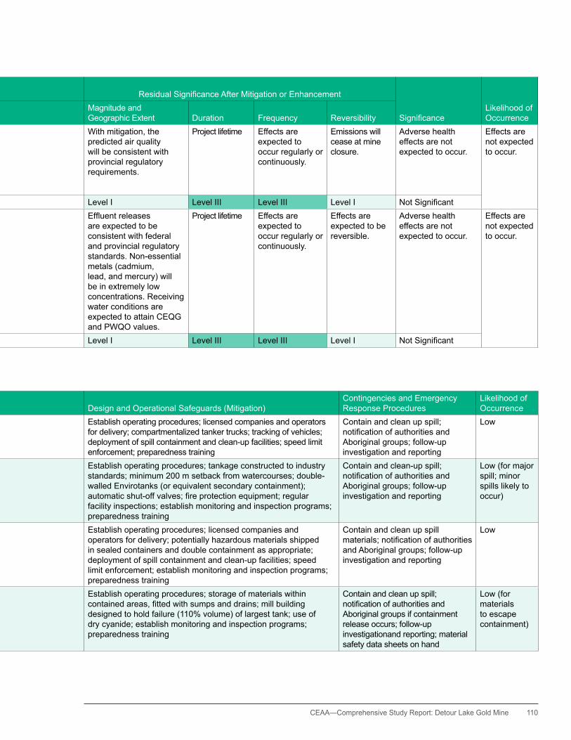
CEAA— Comprehensive Study Report: Detour Lake Gold Mine 110
Table F-4: Public Health and Safety Residual Effects—Significance after Mitigation
VEC Assessed Potential EffectProposed Mitigation or Enhancement
ResidualSignificanceAfterMitigation or Enhancement ResidualSignificanceAfterMitigationorEnhancement
SignificanceLikelihood of Occurrence
Ecological, Social, or Cultural Context
Magnitude and Geographic Extent Duration Frequency Reversibility
Air emissions Potential for negative effects due to possible release of air contaminants associated with processing operations, fuel combustion, and fugitive dust
•Mineralprocessingincontrolledenvironment, with process controls for cyanide and bag houses for dust control
•Usewatertrucksandspraysforfugitive dust control
•FugitiveDustBestManagementPractices Plan
Public health is a concern to all.
With mitigation, the predicted air quality will be consistent with provincial regulatory requirements.
Project lifetime Effects are expected to occur regularly or continuously.
Emissions will cease at mine closure.
Adverse health effects are not expected to occur.
Effects are not expected to occur.
Level III Level I Level III Level III Level I NotSignificantWater quality Negative effects due to potential
for release of contaminants in mill andminewatereffluentsandfromwaste rock stockpile drainage, and herbicide use for control of vegetation on transmission line
•usein-plantcyanidetreatment•implementheavymetal
removal•extensivelyrecycleofTIA
water; •partialsegregationofmine
water, with near zero direct discharge of treated mill water
•PAGseparationandmanagement
Public health is a concern to all.
Effluentreleasesare expected to be consistent with federal and provincial regulatory standards. Non-essential metals (cadmium, lead, and mercury) will be in extremely low concentrations. Receiving water conditions are expected to attain CEQG and PWQO values.
Project lifetime Effects are expected to occur regularly or continuously.
Effects are expected to be reversible.
Adverse health effects are not expected to occur.
Effects are not expected to occur.
Level III Level I Level III Level III Level I NotSignificant
Table F-5: Measures to Address Accidents and Malfunctions
Mechanism Concern Design and Operational Safeguards (Mitigation)Contingencies and Emergency Response Procedures
Likelihood of Occurrence
Fuel release during transport Tanker truck accident releasing fuel to the environment, especially in association with watercourses
Establish operating procedures; licensed companies and operators for delivery; compartmentalized tanker trucks; tracking of vehicles; deployment of spill containment and clean-up facilities; speed limit enforcement; preparedness training
Contain and clean up spill; notificationofauthoritiesandAboriginal groups; follow-up investigation and reporting
Low
Fuel release from storage and dispensing areas
Fuel release to the environment, especially in association with watercourses
Establish operating procedures; tankage constructed to industry standards; minimum 200 m setback from watercourses; double-walled Envirotanks (or equivalent secondary containment); automaticshut-offvalves;fireprotectionequipment;regularfacility inspections; establish monitoring and inspection programs; preparedness training
Contain and clean-up spill; notificationofauthoritiesandAboriginal groups; follow-up investigation and reporting
Low (for major spill; minor spills likely to occur)
Transportation accident (non-fuel) Release of chemicals (e.g., cyanide, other mill reagents, solvents into the environment, especially in association with watercourses
Establish operating procedures; licensed companies and operators for delivery; potentially hazardous materials shipped in sealed containers and double containment as appropriate; deployment of spill containment and clean-up facilities; speed limit enforcement; establish monitoring and inspection programs; preparedness training
Contain and clean up spill materials;notificationofauthoritiesand Aboriginal groups; follow-up investigation and reporting
Low
Chemical spills onsite Release of chemicals (e.g., cyanide, other mill reagents, solvents) into the environment, especially in association with watercourses
Establish operating procedures; storage of materials within containedareas,fittedwithsumpsanddrains;millbuildingdesigned to hold failure (110% volume) of largest tank; use of dry cyanide; establish monitoring and inspection programs; preparedness training
Contain and clean up spill; notificationofauthoritiesandAboriginal groups if containment release occurs; follow-up investigationand reporting; material safety data sheets on hand
Low (for materials to escape containment)

111 CEAA—Comprehensive Study Report: Detour Lake Gold Mine
Table F-5: Measures to Address Accidents and Malfunctions (cont'd)
Mechanism Concern Design and Operational Safeguards (Mitigation)Contingencies and Emergency Response Procedures
Likelihood of Occurrence
Explosives accident Injury to persons and damage to facilities Establish operating procedures; explosive components not individually explosive and cannot be inadvertently detonated; storage and manufacturing facilities constructed to regulatory standards; licensed and trained operators; establish monitoring and inspection programs; preparedness training
NotificationofauthoritiesandAboriginal groups; follow-up investigation and reporting
Low
Tailings dam failure ReleaseofTIAeffluentortailingssolidstotheenvironmentandparticularly to watercourses
Establish operating procedures; TIA dams designed to applicable safety standards; maintain appropriate freeboard; in-plant treatment ofmilleffluenttoreduceeffluenttoxicityatsource;trainedoperators;regular facility inspections; establish monitoring and inspection programs
Preparation of a remedial action plan to deal with tailings dam failures or spills should they occur;notificationofauthoritiesand Aboriginal groups; follow-up investigation and reporting
Low
Tailings pipeline failure Releaseofeffluentortailingssolidstotheenvironmentandparticularlyto watercourses
Establish operating procedures; tailings lines designed to applicable safety standards; secondary containment on tailings line; entire linecanbedrainedbacktoplant;in-planttreatmentofmilleffluenttoreduceeffluenttoxicityatsource;trainedoperators;secondarycontainment at water crossings; automatic alarm systems; regular facility inspections; establish monitoring and inspection programs
Preparation of a remedial action plan to deal with tailings line spills shouldtheyoccur;notificationofauthorities and Aboriginal groups; follow-up investigation and reporting.
Low
Pit slope failure hazard to workers; risk of capturing Karel Creek Establish operating procedures; geotechnical investigations and design to applicable standards; regular inspections of pit walls, slopes, and adjacent ground; establish monitoring and inspection programs
Should a major pit slope failure occur, mining operations to cease until risk of further damage can be fully assessed; take any other necessary actions
Low (except for minor sloughage)
Waste rock or overburden slope failure Major slope failure with release of materials into an adjacent watercourse
Establish operating procedures; geotechnical investigations and design to applicable standards; minimum 120 m setback of stockpile toe from adjacent watercourses; regular facility inspections; establish monitoring and inspection programs
Undertake measures to stabilize any slopes of concern; remove debris from watercourses; follow-up investigation and reporting
Low (except for minor sloughage; materials not expected to enter watercourses)
Unexpected water concerns–TIA seepage Release of contaminants into local watercourses Establish operating procedures; tailings dams designed as low permeabilitystructures;effluenttreatmentwithinthemilltostringentlevels to reduce cyanide and heavy metals to low levels in TIA pore waters; seepage collection and monitoring programs to detect seepage concerns; establish monitoring and inspection programs
Contingency to monitor groundwater conditions and pumping into the TIA required;notificationofauthoritiesand Aboriginal groups
Low
Unexpected water concerns–ARD development
Release of contaminants into local watercourses Establish operating procedures; geochemical characterization of the waste rock; ongoing real-time testing of operational drill core to segregate PAG and NAG materials; only NAG materials to be used for construction(withselectedexceptionswheredrainageisspecificallycontrolled); PAG materials to be placed in a designated area (south portion of MRS #1) for specialized management; perimeter ditching and settling pond for drainage management from PAG area will be pumped to the TIA; establish monitoring and inspection programs
Drainage from MRS #1 PAG is to be sent to tailings if required; perimeter ditching and collection of drainage from NAG areas if treatment with lime plant required; provisions for drainage collection and treatment of PAGareaatclosure;notificationofauthorities and Aboriginal groups
Low (for contaminant release to watercourses)
Projectrelatedfires Injury to persons and damage to facilities; temporary loss of adjacent terrestrial habitat
Establishoperatingprocedures;designstomeetfirecodes;firedetection and suppression systems; project layout provides buffer of mineral stockpiles surrounding the plant site area; establish monitoring and inspection programs
Preparedness training; implement measuresdefinedinEPPandERS to protect persons, property andtheenvironment;notificationof authorities and Aboriginal groups; follow-up investigation and reporting.
Low (for major fires)
Excessive disturbance to wildlife Unnecessary disruption of habitat; tree clearing during bird nesting season;harassment;excessivenoise;huntingandfishingbyemployees
Establish operating procedures; design of a compact site; no new major infrastructure corridors; no major tree clearing during bird nesting season; noise management programs; speed limit enforcement on roads; policies to restrict employee hunting and fishing;establishmonitoringandinspectionprograms
Wildlife awareness training; notificationofauthoritiesandAboriginal groups; follow-up investigation and reporting
Low

CEAA— Comprehensive Study Report: Detour Lake Gold Mine 112
Table F-5: Measures to Address Accidents and Malfunctions (cont'd)
Mechanism Concern Design and Operational Safeguards (Mitigation)Contingencies and Emergency Response Procedures
Likelihood of Occurrence
Explosives accident Injury to persons and damage to facilities Establish operating procedures; explosive components not individually explosive and cannot be inadvertently detonated; storage and manufacturing facilities constructed to regulatory standards; licensed and trained operators; establish monitoring and inspection programs; preparedness training
NotificationofauthoritiesandAboriginal groups; follow-up investigation and reporting
Low
Tailings dam failure ReleaseofTIAeffluentortailingssolidstotheenvironmentandparticularly to watercourses
Establish operating procedures; TIA dams designed to applicable safety standards; maintain appropriate freeboard; in-plant treatment ofmilleffluenttoreduceeffluenttoxicityatsource;trainedoperators;regular facility inspections; establish monitoring and inspection programs
Preparation of a remedial action plan to deal with tailings dam failures or spills should they occur;notificationofauthoritiesand Aboriginal groups; follow-up investigation and reporting
Low
Tailings pipeline failure Releaseofeffluentortailingssolidstotheenvironmentandparticularlyto watercourses
Establish operating procedures; tailings lines designed to applicable safety standards; secondary containment on tailings line; entire linecanbedrainedbacktoplant;in-planttreatmentofmilleffluenttoreduceeffluenttoxicityatsource;trainedoperators;secondarycontainment at water crossings; automatic alarm systems; regular facility inspections; establish monitoring and inspection programs
Preparation of a remedial action plan to deal with tailings line spills shouldtheyoccur;notificationofauthorities and Aboriginal groups; follow-up investigation and reporting.
Low
Pit slope failure hazard to workers; risk of capturing Karel Creek Establish operating procedures; geotechnical investigations and design to applicable standards; regular inspections of pit walls, slopes, and adjacent ground; establish monitoring and inspection programs
Should a major pit slope failure occur, mining operations to cease until risk of further damage can be fully assessed; take any other necessary actions
Low (except for minor sloughage)
Waste rock or overburden slope failure Major slope failure with release of materials into an adjacent watercourse
Establish operating procedures; geotechnical investigations and design to applicable standards; minimum 120 m setback of stockpile toe from adjacent watercourses; regular facility inspections; establish monitoring and inspection programs
Undertake measures to stabilize any slopes of concern; remove debris from watercourses; follow-up investigation and reporting
Low (except for minor sloughage; materials not expected to enter watercourses)
Unexpected water concerns–TIA seepage Release of contaminants into local watercourses Establish operating procedures; tailings dams designed as low permeabilitystructures;effluenttreatmentwithinthemilltostringentlevels to reduce cyanide and heavy metals to low levels in TIA pore waters; seepage collection and monitoring programs to detect seepage concerns; establish monitoring and inspection programs
Contingency to monitor groundwater conditions and pumping into the TIA required;notificationofauthoritiesand Aboriginal groups
Low
Unexpected water concerns–ARD development
Release of contaminants into local watercourses Establish operating procedures; geochemical characterization of the waste rock; ongoing real-time testing of operational drill core to segregate PAG and NAG materials; only NAG materials to be used for construction(withselectedexceptionswheredrainageisspecificallycontrolled); PAG materials to be placed in a designated area (south portion of MRS #1) for specialized management; perimeter ditching and settling pond for drainage management from PAG area will be pumped to the TIA; establish monitoring and inspection programs
Drainage from MRS #1 PAG is to be sent to tailings if required; perimeter ditching and collection of drainage from NAG areas if treatment with lime plant required; provisions for drainage collection and treatment of PAGareaatclosure;notificationofauthorities and Aboriginal groups
Low (for contaminant release to watercourses)
Projectrelatedfires Injury to persons and damage to facilities; temporary loss of adjacent terrestrial habitat
Establishoperatingprocedures;designstomeetfirecodes;firedetection and suppression systems; project layout provides buffer of mineral stockpiles surrounding the plant site area; establish monitoring and inspection programs
Preparedness training; implement measuresdefinedinEPPandERS to protect persons, property andtheenvironment;notificationof authorities and Aboriginal groups; follow-up investigation and reporting.
Low (for major fires)
Excessive disturbance to wildlife Unnecessary disruption of habitat; tree clearing during bird nesting season;harassment;excessivenoise;huntingandfishingbyemployees
Establish operating procedures; design of a compact site; no new major infrastructure corridors; no major tree clearing during bird nesting season; noise management programs; speed limit enforcement on roads; policies to restrict employee hunting and fishing;establishmonitoringandinspectionprograms
Wildlife awareness training; notificationofauthoritiesandAboriginal groups; follow-up investigation and reporting
Low
113 CEAA—Comprehensive Study Report: Detour Lake Gold Mine
Appendix G. Environmental Effects Assessment: Local Watercourses, Lakes, and Wetlands
Appendix G focuses on the potential adverse effects of the Project on the individual watercourses, lakes, and wetlands. Residual effects and their significance are provided in the tables in Appendix F.
East Creek and Sunday Creek System
The East Creek and Sunday Creek system includes the existing TIA Cell 1 basin. East Lake is still part of the approved TIA, provincially, but the proponent plans to stop using this lake for future TIA operations; instead, the TIA will discharge downstream of the East Lake outlet (DLP-24, DLP-33) on a seasonal basis.
Potential project effectsThe proponent proposes to take an estimated 1,606 cubic metres per day of water from East Lake to provide for the mill’s freshwater demands (DLP-24, DLP-33). Potentially, more water will be taken from East Lake during the spring freshet, if a long-term TIA water deficit should develop (DLP-24, DLP-33). The proponent has determined that there is potential for a long-term water deficit during the first phase of TIA operations if settled solids density is lower than expected and drought conditions occur. The additional water could be provided from East Lake by taking about 20 percent of the average spring flow during April, May, and June (DLP-24, DLP-33). During the second phase of TIA operations, beginning after year 5, TIA Cells 2 and 3 will be added to the system, which will contribute additional runoff and thereby offset the potential for further water deficits and the need to draw more water from East Lake during the spring freshet.
The water removed from East Lake will be partially offset by TIA seepage to groundwater discharge into the watershed, which is expected to average 880 cubic metres per day during the life of the mine (DLP-24).
The proponent anticipates that the during average annual conditions, and ignoring the positive flow effects of any seasonal TIA discharges, there will be a 5 percent flow reduction for the East Creek and Sunday Creek watershed and a 25 percent flow reduction for East Lake (DLP-24).
TIA effluent discharge volumes will increase during years of higher than normal precipitation and decrease in years of lower than normal precipitation, changing the flow reductions accordingly.
All seasonal discharges will consist of treated mine water only; the potential contaminants are total suspended solids (TSS) and residual ammonia (DLP-24, DLP-33). After a period of settlement, the TSS is readily removed. The passive discharge from inactive Cell 1 during the second phase of TIA operations and from inactive Cell 2 during the final phase of TIA operations would consist of runoff only. This runoff is expected to achieve Canadian Environmental Quality Guidelines (CEQG) and Provincial Water Quality Objectives (PWQO). Alternatively, it will achieve site-specific continuous, chronic, criterion thresholds that have been developed through assimilative capacity assessments, pursuant to the Industrial Sewage Works Certificate of Approval, for all parameters (DLP-24, DLP-33, Ministry of the Environment draft Certificate of Approval for the Industrial Sewage Works).
The tailings will not be potentially acid generating (PAG); so there are no specific concerns regarding the potential for acidic tailings or metals leaching (DLP-17).
The initial dewatering of the existing flooded open pit during the pre-production phase, is not

CEAA— Comprehensive Study Report: Detour Lake Gold Mine 114
anticipated to adversely affect the water quality of East Lake, since the upper 30 metre portion of the water in the flooded pit has good water quality, equivalent to or better than the water quality in East Lake (AMEC, 2011, DLP-46).
The only direct fish habitat displacement expected for the East Creek and Sunday Creek system is related to the TIA Cell 2 muskeg pond and its associated drainage (DLP-24, DLP-58).
Mitigation The principal means to mitigate the adverse effects on flow of the waterbodies is a high rate of effluent reclaim from the TIA. The proponent plans to recycle back to the mill more than 90 percent of the volume of mill effluent discharged to the TIA, and the rate of recycle could be increased if operating conditions allow (DLP-24). The high rate of recycle will reduce the freshwater demand from East Lake. Although watershed reductions in the East Creek system due to TIA development cannot reasonably be avoided during the mine operations phase, following mine closure the restored TIA watershed will drain to the East Creek system, essentially restoring natural flows to the system (DLP-21, DLP-24).
In-plant effluent treatment using SO2/air for the destruction of cyanide and the precipitation of heavy metals is also the principal means of controlling the quality of seepage effluent. A seepage collection system will also be installed, and, if needed, seepage will be circulated back into the TIA for additional treatment.
The mine water within the system will be separated such that the direct discharges from the TIA will be limited to the aged mine water that is discharged seasonally and the inactive TIA Cell runoff (DLP-24, DLP-33).
Residual adverse effects Outside the direct effluent discharge period of September 1 to December 31, the maximum watershed flow reductions resulting from TIA
development will likely be 20 to 25 percent for East Lake and 5 percent or less for Sunday Creek. This level of flow reduction for East Lake is not expected to have a meaningful effect on the downstream aquatic habitat of East Creek and Sunday Creek. This is because the system downstream of East Lake exhibits an extremely low gradient, averaging 0.05 percent (DLP-24). Aquatic habitat in such low-gradient systems is primarily maintained by water levels that are controlled by topography and beaver dams, not by water flows.
In terms of adverse effects on water quality, the proponent expects that the final TIA effluent discharge to East Creek will be fully compliant with O.Reg. 560/94 Certificate of Approval discharge limits that are designed to achieve applicable criteria for the protection of aquatic life, and also with MMER effluent limits (DLP-33, MOE draft Certificate of Approval for the Industrial Sewage Works).
Provincial (PWQO) and federal (CEQG) guidelines for receiving water quality are also expected to be met, or approximately met, for all parameters with the exception of copper, which is elevated in the background condition. East Lake, in its current condition of elevated background copper levels (DLP-46), supports a diverse fish community and is expected to continue to do so. Therefore, copper levels resulting from past mining activities will likely continue to remain above PWQO and CEQG. However, no further impairment of East Lake water quality is expected, consistent with MOE Policy 2 effects.
Karel Creek System
Potential project effectsThe open pit development, together with MRS #1 and plant-site surface drainage and seepage collection systems, is expected to reduce the Karel Creek watershed by approximately 3.7 square kilometres; this represents approximately 19.4 percent of the Karel Creek watershed. Further flow reduction will

115 CEAA—Comprehensive Study Report: Detour Lake Gold Mine
occur to Karel Creek as a result of groundwater pumping for open pit dewatering.
According to the proponent’s groundwater modeling, future open pit dewatering will likely reduce base flow to Karel Creek in an amount that varies from 830 to 2,160 cubic metres per day (m3/d ). The base-case flow reduction of 830 m3/d is the most likely scenario (DLP-24, AMEC 2011).
The combined effects of watershed interception and mine water pumping are expected to reduce Karel Creek average flows by an average of about 23 percent (DLP-65).
The potential for direct displacement of fish habitat is only from road crossings. The two planned major, new, haul-road crossings of Karel Creek will require culvert-crossing lengths of about 70 metres. Depending on how the culverts are installed, they can potentially affect the conditions of the creek substrate and any groundwater upwelling that might exist within the immediate areas of the crossing. As part of the safety procedures to keep small and large vehicles separated, two narrower crossings will be built for a road designated for small vehicles.
MitigationThe proposed acid rock drainage (ARD) management plan for the project site is to concentrate potentially acid-generating (PAG) materials into the southern portion of MRS #1 (DLP-24, also see Appendix A). A runoff and seepage collection system will be installed to intercept drainage from this portion of MRS #1 (DLP-43, DLP-63). During mine production the proponent expects that ARD conditions from this zone (if any) will not develop. This is because the projected rate of geochemical reactions will be slow (DLP-17, DLP-24). After the removal of the total suspended solids (TSS) in a settling pond, the collected runoff and seepage from MRS #2 and from the NAG portion of MRS#1
will continue to be discharged to Karel Creek. This assumption is based on site conditions and geochemical assessments (DLP-17, DLP-24). Collected runoff and seepage from the PAG portion of MRS #1 will be directed to the TIA, not to Karel Creek.
In the long term, following the period of active mine closure, ARD conditions could potentially develop within the southern portion of MRS #1. If required, runoff and seepage collected from this portion of the stockpile will be treated using the water treatment plant (DLP-21, DLP-24). Otherwise, any such runoff or seepage will be diverted to the open pit for treatment, as described in Section 3.6.
The proponent is proposing to develop the additional groundwater upwelling zone within the footprint of the proposed North Aggregate Pit and outside the projected zone of influence of open pit dewatering (DLP-24, DLP-58): this would occur after the construction phase when the pit becomes inactive. This aggregate pit will be developed adjacent to the west margin of the creek, and it will comprise a linear feature with a depth of 1.5 to 2 metres below the existing water table. A connection with Karel Creek at the north end of the pit will integrate the flooded inactive pit with the Karel Creek system. In consultation with regulatory authorities, the pit will then be rehabilitated to create a permanently connected pond with woody debris and other structures conducive to brook trout spawning.
The proponent also proposes to develop three pools, each about 3 metres deep, within the bed of Karel Creek, two of which would be developed beyond the zone of mine dewatering influence. The purpose of these pools is to provide areas of deeper water that will serve as winter refugia for brook trout within an otherwise comparatively shallow creek system (DLP-58).

CEAA— Comprehensive Study Report: Detour Lake Gold Mine 116
To minimize the potential for adverse effects to fish habitat at creek crossings, the proponent proposes to use arched culverts for the major haul-road crossings, and use bridges or equivalent, for the two narrower road crossings (DLP-24, DLP-58).
Potential adverse effects on water quality in Karel Creek will be managed as described above through the segregation of PAG and non-acid-generating (NAG) materials within waste rock stockpiles. Also, vegetated buffer zones and a seepage collection system will be used for managing the southern portion of MRS #1.
Residual adverse effects With the provision of habitat compensation and with the use of arched culverts and Bailey bridges to mitigate adverse fish habitat effects, the environmental effects associated with Karel Creek are considered to be of low magnitude and extent and, therefore, not significant (DLP-24). Waste rock stockpile seepage is also not expected to adversely affect the Karel Creek system as the proponent has committed to achieving one or more of PWQO, CEQG, background or site specific criteria for the protection of aquatic life (DLP-33, MOE draft Certificate of Approval for the Industrial Sewage Works). As such, potential adverse effects on the water quality of the Karel Creek system are not regarded as significant. The follow-up program may assess the effect of drawdown during operations and for any planned water withdrawl to facilitate pit filling as part of the reclamation plan.
Easter Creek System
Potential project effectsDue to TIA effluent seepage and other site developments, the potential environmental effects on the Easter Creek system include flow alterations and possible changes to water quality.
In accordance with DLP-24, flow alterations are expected to result from the following activities:
• TIA development (watershed boundary alteration and seepage)
• watershed diversions in the plant site area• development of overburden stockpile
(precipitation infiltration changes) • open pit dewatering
At full development the three-cell TIA will occupy a catchment area of 9.8 square kilometres (DLP-24). The proponent has determined that approximately 1.8 square kilometres of the additional TIA basin (i.e., portions of the proposed TIA Cells 2 and 3) lie within the Easter Creek watershed. The precipitation collected in this portion of the TIA will be part of the TIA water balance during operation, and so surplus water will be discharged to the East Creek and Sunday Creek rather than Easter Creek. At mine closure, the precipitation will continue to go into the East Creek and Sunday Creek system (DLP-24). Upon final development of stormwater catchment ponds, approximately 0.25 square kilometres of the plant site area that currently drains to Easter Creek will be diverted away from Easter Creek and be discharged to Karel Creek.
Removal of water from the Easter Creek system will be partially offset by TIA seepage to Easter Creek, with the exception of seepage derived from TIA cell 1, which would be returned to the TIA. Easter Creek flows will be reduced by approximately 8.6 percent due to TIA development (DLP-66).
Potential changes to the Easter Creek system’s water quality include (a) contaminant loadings associated with TIA seepage, (b) runoff from overburden stockpiles and other mine site development areas, and (c) effluent discharge from the construction site sewage treatment plant. These changes have the potential to alter

117 CEAA—Comprehensive Study Report: Detour Lake Gold Mine
aquatic habitat and the general functioning of the aquatic ecosystem (DLP-24).
The sewage treatment plant for the construction phase comprises a membrane bioreactor (MBR) system that delivers high-quality effluent. This treatment system will be combined with the use of natural wetland and low coniferous forest for additional treatment of the final MBR effluent (DLP-24). Data provided to the MOE indicate that Easter Creek water quality will not be impaired by this discharge.
Direct displacement of the Easter Creek fish habitat is not anticipated. However, a major creek crossing will need to be installed to provide large trucks with access to the overburden stockpile (DLP-24).
MitigationThe predicted effects on water flow are minor and do not require mitigation. The principal means of mitigating the potential effects on water quality related to TIA seepage is the use of in-plant effluent treatment by means of the SO2/air system (DLP-24, DLP-33). This process limits seepage concentrations of cyanide compounds and heavy metals. Seepage and runoff, collected in a trench surrounding the TIA, will be filtered through a settling pond and monitored for quality and quantity. If the effluent does not meet MMER and Certificate of Approval requirements, the proponent may need to further treat the water prior to its release (DLP-43, Ministry of the Environment draft Certificate of Approval for the Industrial Sewage Works).
The construction phase sewage treatment plant comprises a MBR system that delivers high- quality effluent. This treatment system is combined with natural wetland and low coniferous forest polishing of the final MBR effluent. Data provided to the MOE indicate that Easter Creek water quality will not be impaired by this discharge.
Residual adverse effects Watershed flow reductions resulting from the TIA development are expected to be minor (i.e., less than 15 percent of receiving water flows for all conditions), (DLP-24, DLP-66). Provincial and federal receiving water quality guidelines for all parameters relating to seepage are expected to be met, or approximately met, in Easter Creek. Also, the construction camp sewage treatment plant will also operate only over the short-term construction period. The environmental effects are therefore considered to be of low magnitude and extent and for the sewage treatment plant short-term, and therefore not significant (DLP-24).
Linden Creek System
Potential project effectsPotential environmental effects to the Linden Creek watershed include flow alterations, and possible changes to water quality (DLP-24).
Flow alterations are expected to result from open pit interception, mine dewatering, and changes in infiltration associated with the development of the MRS #2.
Linden Creek has a calculated average annual flow of 52,483 cubic metres per day (m3/d) based on a watershed area of 38.7 square kilometres and a regional annual runoff of 495 millimetres. The proponent has shown that open pit development is expected to result in an average annualized flow loss of 1,492 m3/d due to effects of water displacement within the watershed. This will be combined with an annualized flow loss of 425 m3/d that results from intercepting groundwater that would otherwise enter Linden Creek (DLP-24). To offset these flow losses requires an average annual flow increase of 1,424 m3/d, which will be derived from the increased runoff and seepage contributions from MRS #2. The combined calculated change in the annual average creek flow is therefore estimated to be a net decrease of 493 m3/d, or approximately 1 percent of the baseline condition (DLP-24).
CEAA— Comprehensive Study Report: Detour Lake Gold Mine 118
Based on regional low-flow statistics, the 425 m3/d maximum flow reduction due to open pit dewatering represents 30.7 percent of the regionally derived 7Q2 value and 98.4 percent of the 7Q5 value, and it exceeds the 7Q10 and 7Q20 values. Therefore, using regional statistics, mine dewatering can potentially increase the duration of the naturally occurring periods of low or zero flow (DLP-24). However, based on applicable, recent, site-specific flow data for East Creek (2007 to 2009), the proponent has determined the following: a flow reduction of 425 m3/d is equivalent to 17.0 percent of the expected lowest recorded flow, 3.6 percent of the 10th percentile lowest flow, and only 1.2 percent of the 50th percentile lowest flow (DLP-24). The magnitude of such a flow reduction is considered to be minor.
The potential for water quality effects to the Linden Creek system is from MRS #2 runoff and seepage only. This runoff and seepage will contain total suspended solids (TSS), ammonia residuals from the use of blasting agents, and possibly heavy metals derived from geochemical reactions.
The development of MRS #2 will result in the direct displacement of two ephemeral drainages to Linden Creek. These ephemeral creeks support two fish species: brook stickleback and burbot (DLP-24, DLP-59) and will require MMER Schedule 2 listing.
Mitigation To control runoff and seepage, the proponent plans to maintain a collection trench around the stockpile perimeter (DLP-43, DLP-63). This trench will drain into a settling pond to filter out most TSS before discharging into the creek. The discharge location will also be monitored for quality and quantity in compliance with the MMER and the Certificate of Approval.
The principal mitigation measure for controlling potential ARD effects associated with MRS #2 operations is the deposit of NAG and
blended PAG materials only on this stockpile and to segregate and deposit—to the extent practicable—PAG materials in MRS #1 (DLP-24, DLP-65).
Residual adverse effects Watershed flow reductions resulting from mine-related activities are expected to be minor (less than 15 percent of average annual flows) and typically less than 15 percent of low flows, except possibly under very extreme, short-lived conditions (DLP-24). As such, these reductions are regarded as not significant. Waste rock stockpile seepage is also not expected to adversely affect the Linden Creek system—PWQO, CEQG, or background water quality conditions would continue to be met in Linden Creek (DLP-24). Therefore, potential adverse effects on the water quality of the Linden Creek system are also regarded as not significant. Losses to fish habitat through ephemeral drainages will be compensated through provisions of the Fisheries Act and, therefore, are regarded as being not significant (DLP-59).
Lindbergh Creek System
Potential project effectsAn existing all-season, gravel, mine-access road currently passes through the Lindbergh Creek watershed. Planned developments that could affect this watershed are the permanent operations camp (possibly to be relocated to Hopper Lake), a transmission line, and an airstrip. The QT5 quarry, which was also located in the Lindbergh Creek watershed, is no longer planned but is being retained as a contingency (DLP-24).
The permanent operations camp will likely be located near Little Hopper Lake or Hopper Lake. The camp size will accommodate about 500 people and will include sleeping accommodations, kitchen and laundry facilities, a potable water system, a sewage treatment system, a recreational complex, and other related amenities.

119 CEAA—Comprehensive Study Report: Detour Lake Gold Mine
Pending further investigations, potable water for the permanent operations camp will be drawn from one or more wells, or directly from Little Hopper Lake, or less likely at Hopper Lake (DLP-24). The water demand projected for the permanent operations’ camp is 150 m3/d, assuming a typical rate of water use per person of 0.3 m3/d. This represents approximately 0.5 percent of the average annual watershed flow rate, and will have negligible effect on the Lindbergh Creek system.
The proponent proposes to treat domestic sewage from the permanent operations camp using a MBR packaged sewage treatment plant (DLP-24). MBR plants provide superior treatment performance compared with other packaged sewage treatment plants (MOE, 2008). Discharge from the permanent camp MBR plant will be directed to a large bog area that will help remove the residual nutrients (nitrates, ammonia, and phosphorus) that have not been fully removed by the treatment plant. As a result, the treated MBR effluent discharge is not expected to adversely affect the Lindbergh Creek system (DLP-24).
Approximately three kilometres of the 230 kV transmission line will pass through the Lindbergh Creek watershed. The transmission line will likely be constructed mostly in the winter, and ground flora along the route will remain largely intact (DLP-22). Consequently, there would be no increased potential for soil erosion and no potential for increased adverse effects to the Lindbergh Creek system.
The proposed new gravel airstrip, if constructed, is expected to be positioned partly within the Lindbergh Creek watershed. The airstrip will be flanked by perimeter ditching that will discharge to a small stormwater detention pond for the settlement of TSS (DLP-24). Any fuelling will be properly controlled on the off-runway apron, and fuel will be stored in double-walled Envirotanks (or equivalent), or in drums for helicopter use. As such, there are no anticipated
adverse effects to the Lindbergh Creek system from airstrip construction and operation.
MitigationMitigation measures related to sewage treatment plant operation are inherent in the design of the system. MBR plants are considered the best available technology for this application. Final effluent polishing by means of passive wetland treatment through the bog would provide further effluent treatment.
No additional mitigation measures are proposed in relation to the transmission line construction. Mitigation measures related to airstrip construction and operation would involve ditching and construction of a settling pond to control the TSS in any runoff, as well as security of fuel storage and fuelling activities.
Residual adverse effectsMine-related developments within the Lindbergh Creek system are expected to be fully consistent with applicable provincial and federal water quality regulations and guidelines
Deem Lake System
Potential project effectsThe development of MRS #1 will increase precipitation infiltration and runoff over the area of the stockpile—including runoff from the stockpile toe. This change will likely result in a small net increase in flows to the Deem Lake and Deem Creek watershed, specifically, a 30 percent increase for the stockpile footprint area (DLP-24).
Potentially acid-generating (PAG) materials will be segregated into the southern portion of MRS #1, and associated collection ditches will be designed and developed to direct PAG seepage away from the Deem Lake and Deem Creek watershed (DLP-24, DLP-43). With the implementation of these measures, the proponent concludes that effects on the water quality of the Deem Lake and Deem Creek system will

CEAA— Comprehensive Study Report: Detour Lake Gold Mine 120
be limited. The northern portion of MRS #1, which is within the Deem Lake and Deem Creek watershed, will contain non-acid-generating (NAG) rock (DLP-24).
The proponent anticipates that the amount of total suspended solids and residual ammonia released to the Deem Lake system from the waste rock stockpile will be comparable to the amount released into the Karel Creek watershed (DLP-24). TSS will be managed by a surface drainage and seepage collection system, and associated intact vegetation buffer zone to filter out fine particles before drainage from the stockpile reaches Deem Lake and Deem Creek.
MitigationNo mitigation measures are proposed in relation to the effects on watershed flow.
The principal mitigation measure proposed by the proponent for controlling potential effects on water quality associated with waste rock stockpile operations is to segregate PAG and NAG materials (DLP-24, DLP-65); in this way PAG materials will be directed away from that portion of MRS #1 draining to the Deem Lake system. Additional contingency measures associated with managing stockpile runoff and seepage include the use of stockpile perimeter ditching and feeding into one or more stormwater management ponds, if required, and the use of water sprays to control dust in active work areas and other areas as required.
Residual adverse effects Changes in the watershed flow resulting from increased infiltration and runoff due to precipitation on the waste rock stockpile are minor and not significant (DLP-24). Waste rock stockpile seepage is also expected to be of a quality that will not likely affect the Deem Lake and Deem Creek system as the proponent has committed to achieving one or more of the following: PWQO, CEQG, background, or site-specific continuous, chronic, criteria for
the protection of aquatic life. As such, potential adverse water quality effects to the Deem Lake and Deem Creek system are regarded as not significant.
Detour River System
Potential project effectsPotential adverse effects to the Detour River from project’s development and operations will be limited to effects on water quality related to discharge of TIA effluent and drainage from other sites (DLP-24, DLP-33, Ministry of the Environment draft Certificate of Approval for the Industrial Sewage Works).
The TIA discharge will include treated (aged) mine water that will be discharged on a seasonal basis, TIA seepage, and runoff from inactive TIA cells (DLP-33). TIA effluent discharges and seepage will not likely cause significant adverse effects on the East Creek and Sunday Creek system, and so the Detour River downstream should not be affected by TIA discharges (DLP-24, DLP-33). Easter, Karel, and Linden Creeks all flow directly or indirectly to Lower Detour Lake, and Lindbergh Creek enters Detour Lake directly. These systems will variously receive drainage from waste rock stockpiles, the main overburden stockpile, the plant site area, TIA seepage, and the sewage treatment (MBR) plants. The proponent has determined that drainage from the project site to these systems is not likely to adversely affect the water quality of these systems, and contingencies are in place if water quality contamination becomes a concern (DLP-24, DLP-33). Consequently, Lower Detour Lake, Detour Lake, and the larger Detour River system are not expected to be adversely affected by any minor contaminant loadings.
MitigationPotential water quality impacts to the Detour River would be prevented through the use of effluent treatment systems and runoff management systems described in previous

121 CEAA—Comprehensive Study Report: Detour Lake Gold Mine
sections, including high rates of TIA effluent recycle to restrict discharge volumes.
Residual adverse effects TIA effluent and other site discharges, including sewage treatment plant discharges and runoff derived from waste rock and overburden stockpiles, and from the area of the plant site are not expected to adversely affect Detour River water quality—CEQG, PWQO, or background conditions are expected to be met in the river (DLP-24, DLP-33).
Muskeg Ponds and Drainages
Potential project effectsThe proposed development and use of TIA Cell 2 will result in the permanent loss of the pond and its associated drainage channel when it is filled in with tailings during the use of the TIA Cell 2 basin (DLP-24). Therefore, the pond must be set out in Schedule 2 of the Metal Mining Effluent Regulations.
MitigationThe proponent has determined that the muskeg pond loss is unavoidable and has committed to efforts to relocate the brook stickleback, as practical, prior to the pond destruction. The proponent has further committed to constructing an equivalent muskeg pond in adjacent terrain as fish habitat compensation (DLP-24, DLP-59). This would provide like-for-like fish habitat compensation in accordance with the MMER and DFO’s Policy for the Management of Fish Habitat (DLP-59).
The compensatory pond habitat will be developed in advance of destruction of the TIA Cell 2 muskeg pond through infilling with tailings.
Residual adverse effects The effects to the Cell 2 muskeg pond are regarded as not significant because (a) muskeg ponds are widespread within the project site and local study area, (b) the specific muskeg pond in TIA Cell 2 is considered small and with little significance for fishing, and (c) the pond habitat will be fully compensated with like-for-like habitat prior to its loss (DLP-24).
Appendix h. Summary of Environmental Commitments
This summary of environmental commitments includes measures identified by the proponent throughout the comprehensive study and during the preparation of provincial environmental assessments, mine closure planning and provincial permits. Not all measures identified in the table may be deemed to be “mitigation” as defined under Section 2. (1) of the Canadian Environmental Assessment Act.
Section 2.(1) states:
“mitigation” means, in respect of a project, the elimination, reduction, or control of the adverse environmental effects of a project, and includes restitution for any damage to the environment caused by such effects through replacement, restoration, compensation or any other means.
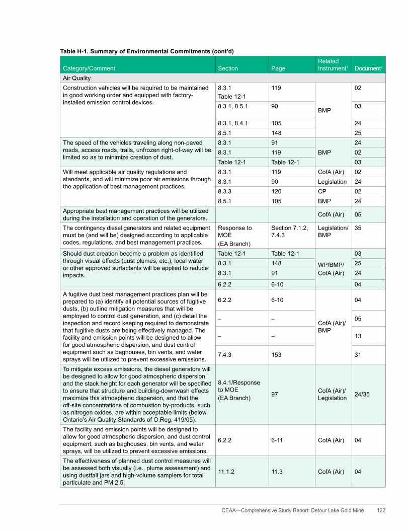
CEAA— Comprehensive Study Report: Detour Lake Gold Mine 122
Table H-1. Summary of Environmental Commitments (cont'd)
Category/Comment Section PageRelated Instrument1 Document2
Air QualityConstruction vehicles will be required to be maintained in good working order and equipped with factory-installed emission control devices.
8.3.1Table 12-1
119
BMP
02
8.3.1, 8.5.1 90 03
8.3.1, 8.4.1 105 248.5.1 148 25
The speed of the vehicles traveling along non-paved roads, access roads, trails, unfrozen right-of-way will be limited so as to minimize creation of dust.
8.3.1 91BMP
248.3.1 119 02Table 12-1 Table 12-1 03
Will meet applicable air quality regulations and standards, and will minimize poor air emissions through the application of best management practices.
8.3.1 119 CofA (Air) 028.3.1 90 Legislation 248.3.3 120 CP 028.5.1 105 BMP 24
Appropriate best management practices will be utilized during the installation and operation of the generators. CofA (Air) 05
The contingency diesel generators and related equipment must be (and will be) designed according to applicable codes, regulations, and best management practices.
Response to MOE(EA Branch)
Section 7.1.2, 7.4.3
Legislation/ BMP
35
Shoulddustcreationbecomeaproblemasidentifiedthrough visual effects (dust plumes, etc.), local water or other approved surfactants will be applied to reduce impacts.
Table 12-1 Table 12-1
WP/BMP/CofA (Air)
038.3.1 148 258.3.1 91 24
6.2.2 6-10 04A fugitive dust best management practices plan will be prepared to (a) identify all potential sources of fugitive dusts, (b) outline mitigation measures that will be employed to control dust generation, and (c) detail the inspection and record keeping required to demonstrate that fugitive dusts are being effectively managed. The facility and emission points will be designed to allow for good atmospheric dispersion, and dust control equipment such as baghouses, bin vents, and water sprays will be utilized to prevent excessive emissions.
6.2.2 6-10
CofA (Air)/ BMP
04
– – 05
– – 13
7.4.3 153 31
To mitigate excess emissions, the diesel generators will be designed to allow for good atmospheric dispersion, andthestackheightforeachgeneratorwillbespecifiedto ensure that structure and building-downwash effects maximize this atmospheric dispersion, and that the off-site concentrations of combustion by-products, such as nitrogen oxides, are within acceptable limits (below Ontario’s Air Quality Standards of O.Reg. 419/05).
8.4.1/Response to MOE(EA Branch) 97 CofA (Air)/
Legislation 24/35
The facility and emission points will be designed to allow for good atmospheric dispersion, and dust control equipment, such as baghouses, bin vents, and water sprays, will be utilized to prevent excessive emissions.
6.2.2 6-11 CofA (Air) 04
The effectiveness of planned dust control measures will be assessed both visually (i.e., plume assessment) and using dustfall jars and high-volume samplers for total particulate and PM 2.5.
11.1.2 11.3 CofA (Air) 04

123 CEAA—Comprehensive Study Report: Detour Lake Gold Mine
Table H-1. Summary of Environmental Commitments (cont'd)
Category/Comment Section PageRelated Instrument1 Document2
NoiseAll site roadways will be maintained in good condition, with regular inspections and timely repairs completed to minimize the silt loading on the roads.
6.2.2 6-10 BMP 04
An air quality management plan will be developed as part of the provincial permitting process with the Ministry of the Environment (MOE).
CofA (Air) 06
Construction vehicles will be required to be maintained in good working order and equipped with factory-installed noise emission control devices.
Table 12-1 Table 12-1 BMP
038.3.1 91 248.3.1, 8.4.1, 8.5.1 148 25
The Detour Lake Power Project (DLPP)/Detour Lake Contingency Power Project (DLCPP) will meet applicable noise regulations and standards, and will minimize noise through the application of best management practices that are proposed as part of the project design and execution.
8.4.1 120
CofA (Air)/legislation
02
8.3.1, 8.4.1, 8.5.1 91, 99, 105 24
MOE noise standards (Class 3 sound criteria) will be met within a 2 km zone around the site. CofA (Air) 06
The generator units will be insulated as required to reduce noise propagation.
8.2 65CofA (Air)
015.2, 8.4.1 148 25
A noise monitoring survey will be carried out every two years for the construction, operation, and active closure phases of the DLP, starting in 2012. This survey will include setting up a noise monitoring station adjacent to the permanent camp, as suggested.
Non-regulatory monitoring
13
Construction activities [DLPP] will be limited to daytime hours. Table 12-1 WP 03
Terrestrial habitat and VegetationTo ensure that the soil and surrounding environment is not impacted by winter road use, the travel way and winter roads will not be allowed to continue if rutting occurs.
WP 16
Crossings will include strategic placement of snow over the existing ground surface or creation of an ice crossingbyfloodinginplace.Theywillnotincludecutting into existing stream banks to expose soil. Should soil become exposed or excessive rutting damages the underlying frozen ground, the winter road usage will be discontinued immediately and the travelway relocated to another portion of the right-of-way. Repair and monitoring of damage (if any) will occur thereafter.
WP 20
Where trees must be felled, the stumps and root mat will be retained to protect the ground from surface erosion. In cases where trees are felled, the stumps and root mat will be retained to protect the banks from erosion and encourage the growth or re-growth of riparian vegetation. Trees may be trimmed (or topped) to ensure clearance requirements.
5.4.1 17
WP/FRL
02
– – 17, 21
5.4.1 18 02
Merchantable timber will be felled and stacked along the timbered edge of the right-of-way(ROW) for the forestry licence holder, or other local users.
5.4.1 17 WP/FRL 02
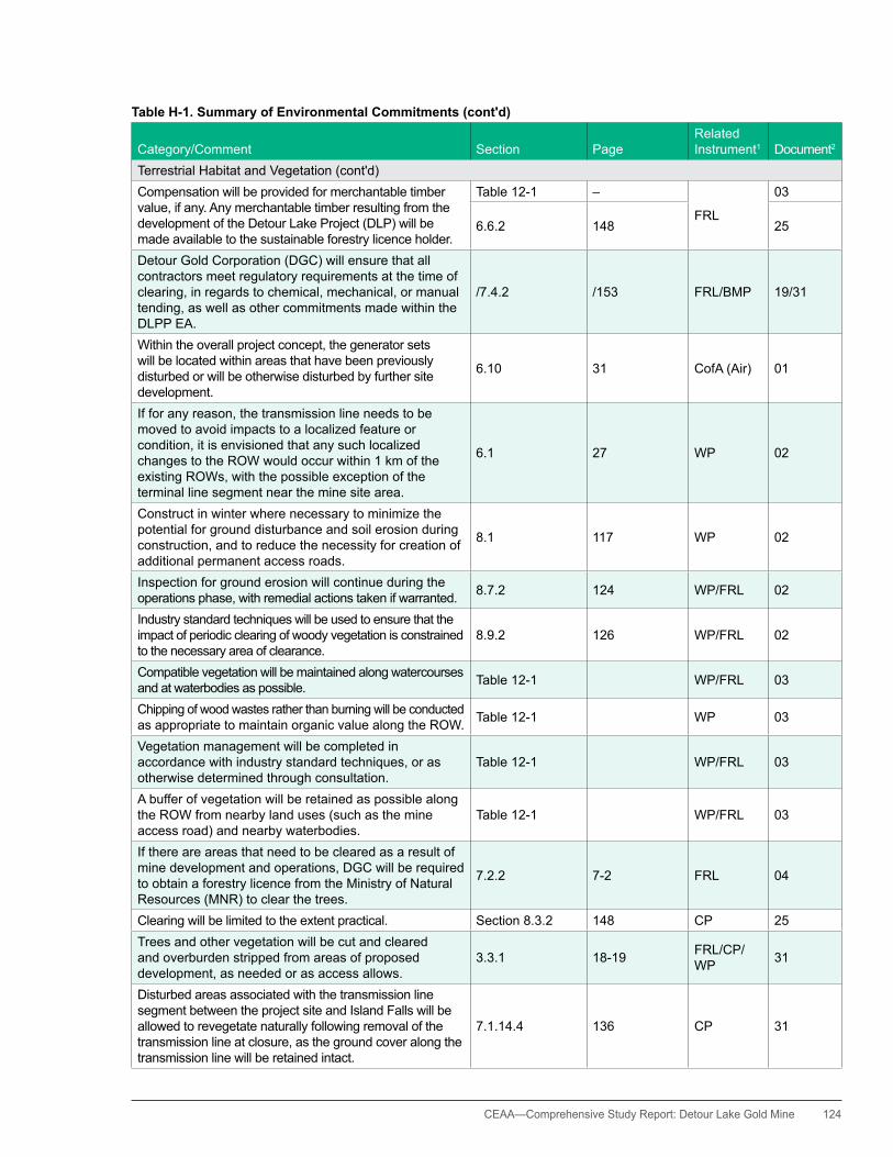
CEAA— Comprehensive Study Report: Detour Lake Gold Mine 124
Table H-1. Summary of Environmental Commitments (cont'd)
Category/Comment Section PageRelated Instrument1 Document2
Terrestrial habitat and Vegetation (cont'd)Compensation will be provided for merchantable timber value, if any. Any merchantable timber resulting from the development of the Detour Lake Project (DLP) will be made available to the sustainable forestry licence holder.
Table 12-1 –
FRL
03
6.6.2 148 25
Detour Gold Corporation (DGC) will ensure that all contractors meet regulatory requirements at the time of clearing, in regards to chemical, mechanical, or manual tending, as well as other commitments made within the DLPP EA.
/7.4.2 /153 FRL/BMP 19/31
Within the overall project concept, the generator sets will be located within areas that have been previously disturbed or will be otherwise disturbed by further site development.
6.10 31 CofA (Air) 01
If for any reason, the transmission line needs to be moved to avoid impacts to a localized feature or condition, it is envisioned that any such localized changes to the ROW would occur within 1 km of the existing ROWs, with the possible exception of the terminal line segment near the mine site area.
6.1 27 WP 02
Construct in winter where necessary to minimize the potential for ground disturbance and soil erosion during construction, and to reduce the necessity for creation of additional permanent access roads.
8.1 117 WP 02
Inspection for ground erosion will continue during the operations phase, with remedial actions taken if warranted. 8.7.2 124 WP/FRL 02
Industry standard techniques will be used to ensure that the impact of periodic clearing of woody vegetation is constrained to the necessary area of clearance.
8.9.2 126 WP/FRL 02
Compatible vegetation will be maintained along watercourses and at waterbodies as possible. Table 12-1 WP/FRL 03
Chipping of wood wastes rather than burning will be conducted as appropriate to maintain organic value along the ROW. Table 12-1 WP 03
Vegetation management will be completed in accordance with industry standard techniques, or as otherwise determined through consultation.
Table 12-1 WP/FRL 03
A buffer of vegetation will be retained as possible along the ROW from nearby land uses (such as the mine access road) and nearby waterbodies.
Table 12-1 WP/FRL 03
If there are areas that need to be cleared as a result of mine development and operations, DGC will be required to obtain a forestry licence from the Ministry of Natural Resources (MNR) to clear the trees.
7.2.2 7-2 FRL 04
Clearing will be limited to the extent practical. Section 8.3.2 148 CP 25Trees and other vegetation will be cut and cleared and overburden stripped from areas of proposed development, as needed or as access allows.
3.3.1 18-19 FRL/CP/WP 31
Disturbed areas associated with the transmission line segment between the project site and Island Falls will be allowed to revegetate naturally following removal of the transmission line at closure, as the ground cover along the transmission line will be retained intact.
7.1.14.4 136 CP 31

125 CEAA—Comprehensive Study Report: Detour Lake Gold Mine
Table H-1. Summary of Environmental Commitments (cont'd)
Category/Comment Section PageRelated Instrument1 Document2
Terrestrial habitat and Vegetation (cont'd)If there are any future potential forest harvest areas thatmaybeinconflictwiththemineoperations,theMNR will facilitate discussions between DGC and First Resource Management Group.
7.2.2.3 143 FRL 31
If there are areas that need to be cleared as a result of mine development and operations, the proponent will be required to obtain a forestry licence from MNR to clear the trees. First Resource Management Group will be given the firstright-of-refusaltoharvestedforestryresources.
7.2.2.3 143 FRL 31
Utilizebrownfieldlandstoavoiddirecthabitateffects. Response to MOE(EA Branch)
Section 8.3.2 BMP 35
Wildlife and BirdsDirect impacts to raptor nesting areas will be avoided. Table 12-1 WP/FRL 03
Trafficincreasesmayleadtomorewildlife-vehicleaccidentsand wildlife mortality. DGC will require that contractors obey speed limits and use safe driving practices, especially where wildlife is expected.
8.16.1 144 WP/Legislation/BMP
02
8.7.5 113 247.3.1.3 146 31
RecreationalhuntingandfishingoffrotationcanbemitigatedthroughtherequirementofMNRfishingandhuntinglicencesand the DGC’s support in enforcing these policies. Mine workers,likeallotherfishersandhuntersinOntario,willberequired to obtain government issued licences, which are intended to help manage wildlife resources within the province.
7.2.4 7-4
Legislation
04
7.2.1.3 141 31
Avoid tree and brush clearing, and other construction activities during the migratory bird nesting season, where applicable. Clearing and construction will be scheduled outside the bird nesting season.
8.1 117
WP/FRL/Legislation
02Table 12-1 – 038.3.2 91-92 248.3.2 148 25
All clearing and other activities will be completed in accordance with the Migratory Bird Convention Act and other applicable legislation or regulatory instruments. Most tree-clearing activities will be undertaken in the winter; thus, migratory bird species will not be disturbed. Otherwise, all reasonable attempts will be made to avoid disturbance to nesting birds.
WP/FRL/Legislation
191321
Direct disturbance to nesting birds will be avoided. 7.1.17.4 139 Legislation/CP/WP 31
Construction crews will be advised not to interfere or harass wildlife. No hunting by construction crews will be allowed. Disciplinary actions will be taken should either occur.
Table 12-1 Table 12-1WP/FRL/BMP
03
8.3.2, 8.4.2 148 25
Contractors will be required to handle food and food wastes in a responsible manner, and workers will be educated and policies enforced to ensure no feeding of wildlife. Preparation of a food waste management plan will be required by the DLPP contractors to help ensure the safety of both the workers and wildlife.
Table 12-1 Table 12-1
WP/BMP
03
7.1.13.2 13331
21
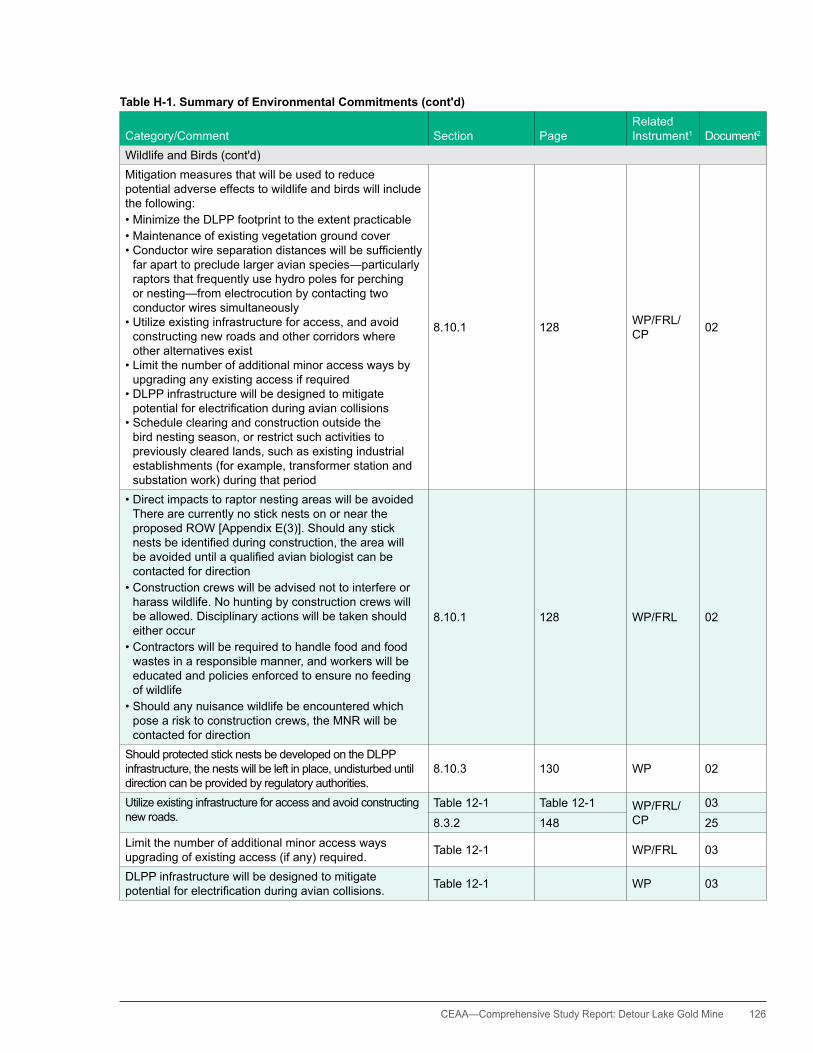
CEAA— Comprehensive Study Report: Detour Lake Gold Mine 126
Table H-1. Summary of Environmental Commitments (cont'd)
Category/Comment Section PageRelated Instrument1 Document2
Wildlife and Birds (cont'd)Mitigation measures that will be used to reduce potential adverse effects to wildlife and birds will include the following: •MinimizetheDLPPfootprinttotheextentpracticable•Maintenanceofexistingvegetationgroundcover•Conductorwireseparationdistanceswillbesufficiently
far apart to preclude larger avian species—particularly raptors that frequently use hydro poles for perching or nesting—from electrocution by contacting two conductor wires simultaneously
•Utilizeexistinginfrastructureforaccess,andavoidconstructing new roads and other corridors where other alternatives exist
•Limitthenumberofadditionalminoraccesswaysbyupgrading any existing access if required
•DLPPinfrastructurewillbedesignedtomitigatepotentialforelectrificationduringaviancollisions
•Scheduleclearingandconstructionoutsidethebird nesting season, or restrict such activities to previously cleared lands, such as existing industrial establishments (for example, transformer station and substation work) during that period
8.10.1 128 WP/FRL/CP 02
•DirectimpactstoraptornestingareaswillbeavoidedThere are currently no stick nests on or near the proposed ROW [Appendix E(3)]. Should any stick nestsbeidentifiedduringconstruction,theareawillbeavoideduntilaqualifiedavianbiologistcanbecontacted for direction
•Constructioncrewswillbeadvisednottointerfereorharass wildlife. No hunting by construction crews will be allowed. Disciplinary actions will be taken should either occur
•Contractorswillberequiredtohandlefoodandfoodwastes in a responsible manner, and workers will be educated and policies enforced to ensure no feeding of wildlife
•Shouldanynuisancewildlifebeencounteredwhichpose a risk to construction crews, the MNR will be contacted for direction
8.10.1 128 WP/FRL 02
Should protected stick nests be developed on the DLPP infrastructure, the nests will be left in place, undisturbed until direction can be provided by regulatory authorities.
8.10.3 130 WP 02
Utilize existing infrastructure for access and avoid constructing new roads.
Table 12-1 Table 12-1 WP/FRL/ CP
03
8.3.2 148 25Limit the number of additional minor access ways upgrading of existing access (if any) required. Table 12-1 WP/FRL 03
DLPP infrastructure will be designed to mitigate potentialforelectrificationduringaviancollisions. Table 12-1 WP 03

127 CEAA—Comprehensive Study Report: Detour Lake Gold Mine
Table H-1. Summary of Environmental Commitments (cont'd)
Category/Comment Section PageRelated Instrument1 Document2
Wildlife and Birds (cont'd)Local First Nation trappers will be compensated for interference with traditional pursuits involving hunting and trapping related to the DLPP.
Table 12-1 Consult- ation 03
The MNR asked that DGC share wildlife information and stated that they would like to be involved in any natural resource surveying and wildlife inventory that DGC conducts throughout the environmental assessment (EA) process.
4.5 4-10 BMP 04
The principal mitigation measures designed to limit adverse environmental effects to wildlife are as follows:•MinimizingtheDLPfootprinttothesmallestextent
practicable•Avoidingconstructingnewroadsandothercorridors
where other alternatives exist •Restoringtheminesiteareatoproductivewildlife
habitat at closure•MinimizingtheDLPfootprinttotheextentpracticable•Maintaining,totheextentpracticable,a120mbuffer
zone adjacent to rivers, creeks, and lake margins to protect watercourses and their associated vegetated margins
•Restoringdisturbedhabitatsatclosureorencouragingdevelopment of habitats capable of supporting a diversity of wildlife species, including large predators and furbearers
•Effectivemanagementofsolidwastes,particularlyfood wastes, to avoid attracting wildlife
6.13.2, 6.14.2 6-45,d 6-48 CP 04
The primary mitigation strategies for limiting adverse effects to migratory birds are as follows:•MinimizingtheDLPfootprinttotheextentpracticable•Maintaining,totheextentpracticable,aminimum
120 m buffer zone adjacent to rivers, creeks and lake margins to protect watercourses and their associated vegetated margins
•Avoidingtreeclearingandgeneralphysicallanddisturbance (such as mineral stockpile footprint expansion), as practical, during the bird nesting season•Restoringdisturbedhabitatsatclosuretohabitats
capable of supporting a diversity of wildlife species•Theriskofcyanideimpactsonmigratorywaterfowlwill
be minimal due to the pre-treatment of the tailings to levels equal to or less than 1 mg/L total cyanide (TCN) before deposition in the tailings pond, which is below the threshold criteria as outlined in the International Cyanide Management Code—which includes a criteria of 50 mg/L TCN
6.15.2 6-50CP/FRL/CofA (ind. sewage)
04
A beaver inspection and management program will be set up and, if necessary, nuisance beavers will be removed by local licenced trappers, having pre-arranged management agreements with DGC.
9.3 9-2 Consult- ation 04

CEAA— Comprehensive Study Report: Detour Lake Gold Mine 128
Table H-1. Summary of Environmental Commitments (cont'd)
Category/Comment Section PageRelated Instrument1 Document2
Wildlife and Birds (cont'd)Contractors will be required to keep a log of all wildlife observanceandinteractions.Anysignificantinteractionswill be required to be reported to DGC immediately so that appropriate mitigation measures can be implemented.
Non-regulatory monitoring
21
Mitigation measures that will be used to reduce potential adverse effects to wildlife and birds include the following: •MinimizetheDLCPPfootprinttotheextentpracticable•Utilizeexistinginfrastructureforaccess•Utilizebrownfieldlandstoavoiddirecthabitateffects•Directtransportationandconstructioncrewstonot
interfere or harass wildlife; enforce a no hunting policy for project-related personnel; and take disciplinary actions should either non-compliance occur
•ContactMNRfordirectionifthereareanyencounterswith nuisance wildlife that pose a risk to construction crews
8.3.2
92
CP/legislation
24
148 25
Mitigation measures that will be used to reduce potential adverse effects to wildlife and birds during operation include the following: •Maintenanceandoperationcrewswillbedirectednot
to interfere or harass wildlife. No hunting by Project-related personnel will be allowed. Disciplinary actions will be taken should either occur
•Nestingaroundthegeneratorswillbediscouraged•Shouldanysticknestsbeencountered,theareawillbeavoideduntilaqualifiedavianbiologistcanbecontacted for direction
•Shouldtherebeanyencounterswithnuisancewildlifethat pose a risk to site staff, the MNR will be contacted for direction
8.4.2 99-100
Legislation/BMP
24
Response to MOE(EA Branch)
Section 8.3.2, 8.4.2 35
At closure, all disturbed sites will be rehabilitated to terrain types that can be utilized by large predators and furbearers and migratory birds.
7.1.13.4 134, 136 CP 31
Aquatic EnvironmentThe diesel generator units are proposed to be located approximately 360 m from Karel Creek. Lesser generating units (if any are used sporadically through the construction phase) will be positioned no closer than 120 m to any watercourse or waterbody.
6.6 29 CofA (Air) 01
There will be no discharges to watercourses or waterbodies resulting from the installation of the proposed generators.
6.9 30 CofA (Air) 01
Along steep slopes and at water crossings, compatible vegetation will be maintained where transmission line clearances allow in order to reduce the potential for erosion and to maintain aesthetics at water crossings.
5.4.1 18 WP/FRL 02
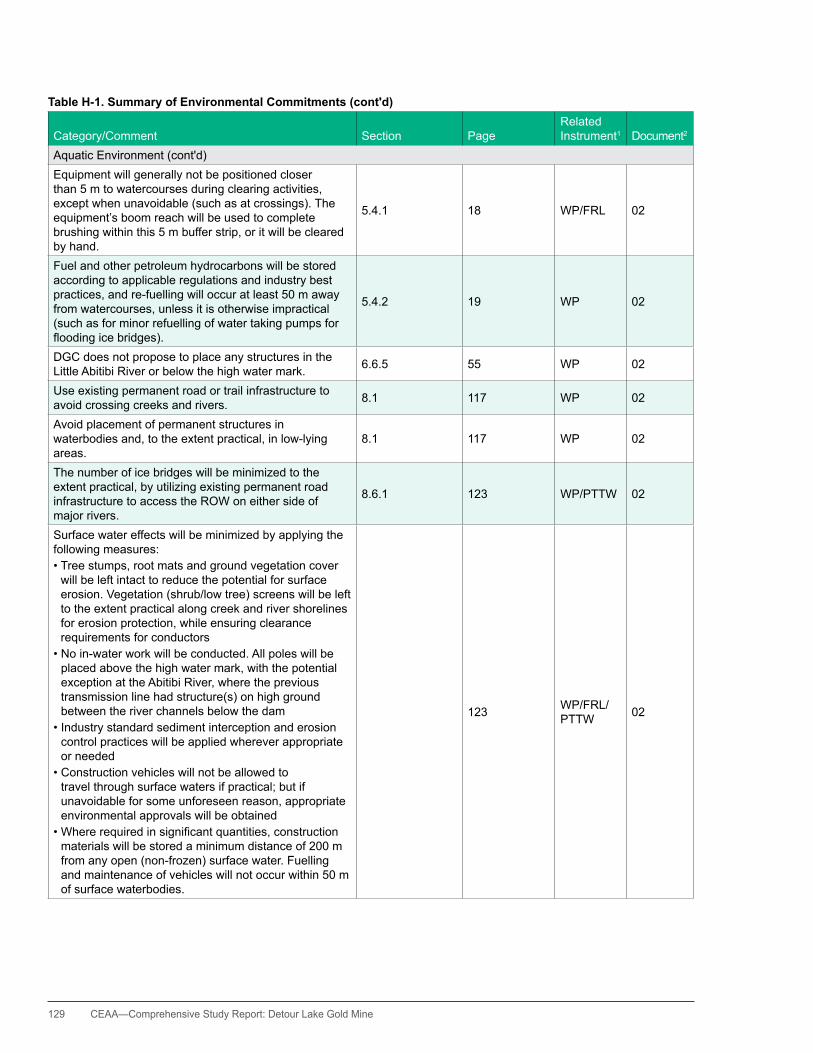
129 CEAA—Comprehensive Study Report: Detour Lake Gold Mine
Table H-1. Summary of Environmental Commitments (cont'd)
Category/Comment Section PageRelated Instrument1 Document2
Aquatic Environment (cont'd)Equipment will generally not be positioned closer than 5 m to watercourses during clearing activities, except when unavoidable (such as at crossings). The equipment’s boom reach will be used to complete brushing within this 5 m buffer strip, or it will be cleared by hand.
5.4.1 18 WP/FRL 02
Fuel and other petroleum hydrocarbons will be stored according to applicable regulations and industry best practices, and re-fuelling will occur at least 50 m away from watercourses, unless it is otherwise impractical (such as for minor refuelling of water taking pumps for floodingicebridges).
5.4.2 19 WP 02
DGC does not propose to place any structures in the Little Abitibi River or below the high water mark. 6.6.5 55 WP 02
Use existing permanent road or trail infrastructure to avoid crossing creeks and rivers. 8.1 117 WP 02
Avoid placement of permanent structures in waterbodies and, to the extent practical, in low-lying areas.
8.1 117 WP 02
The number of ice bridges will be minimized to the extent practical, by utilizing existing permanent road infrastructure to access the ROW on either side of major rivers.
8.6.1 123 WP/PTTW 02
Surface water effects will be minimized by applying the following measures:•Treestumps,rootmatsandgroundvegetationcover
will be left intact to reduce the potential for surface erosion. Vegetation (shrub/low tree) screens will be left to the extent practical along creek and river shorelines for erosion protection, while ensuring clearance requirements for conductors
•Noin-waterworkwillbeconducted.Allpoleswillbeplaced above the high water mark, with the potential exception at the Abitibi River, where the previous transmission line had structure(s) on high ground between the river channels below the dam
•Industrystandardsedimentinterceptionanderosioncontrol practices will be applied wherever appropriate or needed
•Constructionvehicleswillnotbeallowedtotravel through surface waters if practical; but if unavoidable for some unforeseen reason, appropriate environmental approvals will be obtained
•Whererequiredinsignificantquantities,constructionmaterials will be stored a minimum distance of 200 m from any open (non-frozen) surface water. Fuelling and maintenance of vehicles will not occur within 50 m of surface waterbodies.
123 WP/FRL/PTTW 02

CEAA— Comprehensive Study Report: Detour Lake Gold Mine 130
Table H-1. Summary of Environmental Commitments (cont'd)
Category/Comment Section PageRelated Instrument1 Document2
Aquatic Environment (cont'd)Any environment permit requirements related to the clean-up of debris left on the ice by equipment travel and the removal of ice bridges to reduce the potential for ice damming in the spring, will be followed.
8.6.1122 WP/PTTW
02
Table 12-1 03
Water crossings will comply with Fisheries and Oceans Canada Operational Directives. Table 12-1 WP/PTTW 03
Fuel storage areas (excluding small containers moveable by hand) will be established and mobile refuelling activities will occur a minimum of 200 m away from waterbodies wherever practical, but no closer than 50 m from waterbodies.
Table 12-1 Table 12-1
WP/CP/BMP
03– – 215.3.2 18 245.3.2 149 25
A minimum buffer of at least 120 m has been established between project components and adjacent creeks and water bodies.
Exec. Summ., 2.1, 6.12.17.1.11.3
ES-4, 2-1, 6-41127
CP0431
Potential acid generating (PAG) is proposed to be stored and managed separately to ensure that any environmental effects from this material, should such effects develop, are properly controlled.
Exec. Summ. ES-4 CP 04
The principal mitigation measures to offset potential adverseflowreductioneffectsontheKarelCreeksystem will be to•developanadditionalzoneofgroundwaterupwellings
within the creek system to provide compensatory spawning habitat, and
•developoverwinteringrefugiatoassistwithadultbrook trout survival.
6.4.2 6-23
CP/PTTW/Aggreg/LRIA/DFO Comp
04
If acid rock drainage (ARD) conditions should develop within the southern portion of Mine Rock Stockpile #1 during the period of mine operations, then the collected runoff/seepage would be directed to the tailings management area (TMA) and not to Karel Creek.
6.4.1 6-20 CP 04
Avoid disturbance to the area between East and Ghost Lakes and Sunday Lake, including the Good Friday Lake area.
6.12.1 6-41 CP 04
DGC will be required to develop adaptive management strategies for the protection of surface water systems andassociatedfisheriesandfishhabitat,intheeventthat the response of the groundwater system to open pit dewatering is substantively different from that predicted, specifically,ifgreaterthanpredictedadverseeffectstosurface water systems are considered more likely.
11.3.1 11-8Legislation (DFO Comp)
04
There will be no in water work associated with the generators. CofA (Air) 05
As indicated in the DLPP EA, there will be no disturbance to stream bed or banks (or reshaping of the stream morphology etc.).
WP/PTTW1621

131 CEAA—Comprehensive Study Report: Detour Lake Gold Mine
Table H-1. Summary of Environmental Commitments (cont'd)
Category/Comment Section PageRelated Instrument1 Document2
Aquatic Environment (cont'd)Crossings for haul roads are expected to have culvert lengths of 50 to 70 m depending on the location and verticalroadprofiles.Culvertswillbeopenfootarchculverts to reduce the potential effects of the crossings.
DFO16 4 LRIA 32
Although open foot arch culvert designs are proposed, the existingwidthofthecreekfloodplainsaresuchthatitwillbe impracticable to span the bank full width. however, the culverts will be sized such that they will accommodate the widthofthetypicalbaseflowchannel,andtherewouldbeminimal water level increases to the bank full event and to the 100-year storm event.
DFO16 4 LRIA 32
FisheriesDGC will make best efforts to remove as many of the brook stickleback as reasonably practicable, prior to pond (muskeg pond in Cell 2) destruction, and an equivalent muskeg pond would be constructed atthelocationshowninFigure6-7asfishhabitatcompensation,thereinproviding“like-for-like”fishhabitatcompensationforthe“loss”inaccordancewithFisheries and Oceans Canada (DFO) policies.
6.10.2 6-37CP/DFO Comp/MNR Fish
04
Wherethereisevidenceofnegativeimpactonfish,fishhabitatorhumanuseoffishDGCwillreportsuchurgentconditions directly and immediately to the appropriate provincial and federal regulatory authorities.
11.2.3 11-7Consult-ation
04
Further detail for achieving no-net-loss (focused on brook trout) will be developed as part of DFO authorization.
4.2.2 (5) 4 DFO Comp 22
DGCconfirmsthatthisprocess[habitatcompensation]will be addressed in detail in the DFO compensation package.
Issue #2 3 DFO Comp 28
In the North Quarry compensation plan, efforts will be made to make the habitat less attractive to pike through channel engineering, changes to vegetation, etc. They may interact, but a deep water habitat for brook trout will be provided, which will potentially allow for the physical separation of the species.
Issue #2 3DFO Comp/Aggreg
28
DGCisproposingtodevelopadditionalfishhabitatassociated with rehabilitation of the North Aggregate Pit and with two in-stream overwintering pools to be developed within the existing creek main stem, as per Section 6.4.2 of Environmental Study Report (ESR – federal reference document DLP-24).
Section 2, Issue #2 6
DFO Comp/Aggreg
30
If operational monitoring should indicate that adverse effectstoKarelCreekfishhabitataregreaterthanexpected,thenadditionalfishhabitatcompensationwillbeconsidered.Suchconsiderationswillbedefinedin the Adaptive Management Strategy (Plan), being developed for Karel Creek.
Section 2, Issue #2 6 DFO Comp 30
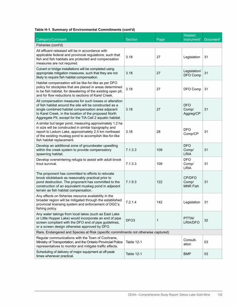
CEAA— Comprehensive Study Report: Detour Lake Gold Mine 132
Table H-1. Summary of Environmental Commitments (cont'd)
Category/Comment Section PageRelated Instrument1 Document2
Fisheries (cont'd)Alleffluentreleasedwillbeinaccordancewithapplicable federal and provincial regulations, such that fishandfishhabitatsareprotectedandcompensationmeasures are not required.
3.18 27 Legislation 31
Culvert or bridge installations will be completed using appropriate mitigation measures, such that they are not likelytorequirefishhabitatcompensation.
3.18 27 Legislation/DFO Comp 31
habitat compensation will be like-for-like as per DFO policy for stockpiles that are placed in areas determined tobefishhabitat,fordewateringoftheexistingopenpit,andforflowreductionstosectionsofKarelCreek.
3.18 27 DFO Comp 31
All compensation measures for such losses or alteration offishhabitataroundthesitewillbeconstructedasasingle combined habitat compensation area adjacent to Karel Creek, in the location of the proposed North Aggregate Pit, except for the TIA Cell 2 aquatic habitat.
3.18 27DFO Comp/Aggreg/CP
31
A similar but larger pond, measuring approximately 1.2 ha in size will be constructed in similar topography and report to Ledum Lake, approximately 2.5 km northeast of the existing muskeg pond to accomplish like-for-like fishhabitatreplacement.
3.18 28 DFO Comp/CP 31
Develop an additional zone of groundwater upwelling within the creek system to provide compensatory spawning habitat.
7.1.3.3 109DFO Comp/LRIA
31
Develop overwintering refugia to assist with adult brook trout survival. 7.1.3.3 109
DFO Comp/LRIA
31
The proponent has committed to efforts to relocate brook stickleback as reasonably practical prior to pond destruction. The proponent has committed to the construction of an equivalent muskeg pond in adjacent terrainasfishhabitatcompensation.
7.1.9.3 122CP/DFO Comp/MNR Fish
31
Anyeffectsonfisheriesresourceavailabilityinthebroader region will be mitigated through the established provincial licensing system and enforcement of DGC’s fishingpolicy.
7.2.1.4 142 Legislation 31
Any water takings from local lakes (such as East Lake or Little hopper Lake) would incorporate an end of pipe screen compliant with the DFO end of pipe guidelines, or a screen design otherwise approved by DFO.
DFO3 1 PTTW/LRIA/DFO 32
Rare,EndangeredandSpeciesatRisk(specificcommitmentsnototherwisecaptured)Regular communications with the Town of Cochrane, Ministry of Transportation, and the Ontario Provincial Police representativestomonitorandmitigatetrafficeffects.
Table 12-1 Consult- ation 03
Scheduling of delivery of major equipment at off-peak times whenever practical. Table 12-1 BMP 03
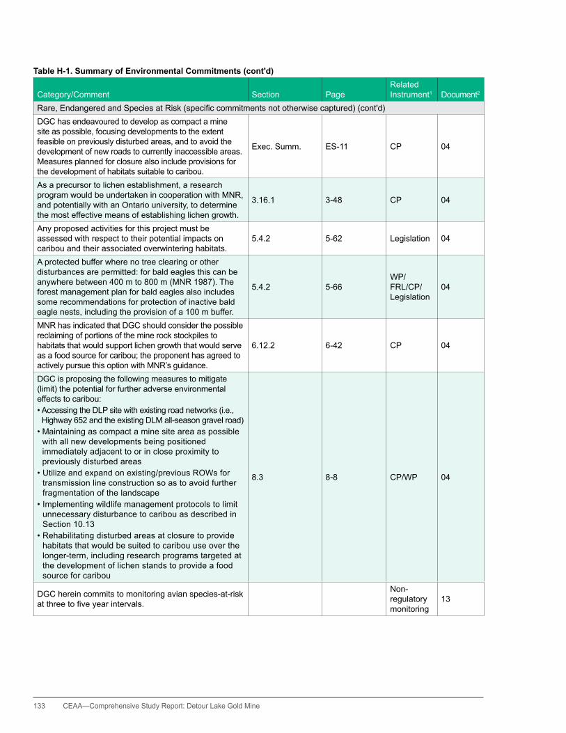
133 CEAA—Comprehensive Study Report: Detour Lake Gold Mine
Table H-1. Summary of Environmental Commitments (cont'd)
Category/Comment Section PageRelated Instrument1 Document2
Rare,EndangeredandSpeciesatRisk(specificcommitmentsnototherwisecaptured)(cont'd)DGC has endeavoured to develop as compact a mine site as possible, focusing developments to the extent feasible on previously disturbed areas, and to avoid the development of new roads to currently inaccessible areas. Measures planned for closure also include provisions for the development of habitats suitable to caribou.
Exec. Summ. ES-11 CP 04
As a precursor to lichen establishment, a research program would be undertaken in cooperation with MNR, and potentially with an Ontario university, to determine the most effective means of establishing lichen growth.
3.16.1 3-48 CP 04
Any proposed activities for this project must be assessed with respect to their potential impacts on caribou and their associated overwintering habitats.
5.4.2 5-62 Legislation 04
A protected buffer where no tree clearing or other disturbances are permitted: for bald eagles this can be anywhere between 400 m to 800 m (MNR 1987). The forest management plan for bald eagles also includes some recommendations for protection of inactive bald eagle nests, including the provision of a 100 m buffer.
5.4.2 5-66WP/FRL/CP/Legislation
04
MNR has indicated that DGC should consider the possible reclaiming of portions of the mine rock stockpiles to habitats that would support lichen growth that would serve as a food source for caribou; the proponent has agreed to actively pursue this option with MNR’s guidance.
6.12.2 6-42 CP 04
DGC is proposing the following measures to mitigate (limit) the potential for further adverse environmental effects to caribou:•AccessingtheDLPsitewithexistingroadnetworks(i.e.,highway 652 and the existing DLM all-season gravel road)•Maintainingascompactaminesiteareaaspossible
with all new developments being positioned immediately adjacent to or in close proximity to previously disturbed areas
•Utilizeandexpandonexisting/previousROWsfortransmission line construction so as to avoid further fragmentation of the landscape
•Implementingwildlifemanagementprotocolstolimitunnecessary disturbance to caribou as described in Section 10.13
•Rehabilitatingdisturbedareasatclosuretoprovidehabitats that would be suited to caribou use over the longer-term, including research programs targeted at the development of lichen stands to provide a food source for caribou
8.3 8-8 CP/WP 04
DGC herein commits to monitoring avian species-at-risk atthreetofiveyearintervals.
Non-regulatory monitoring
13
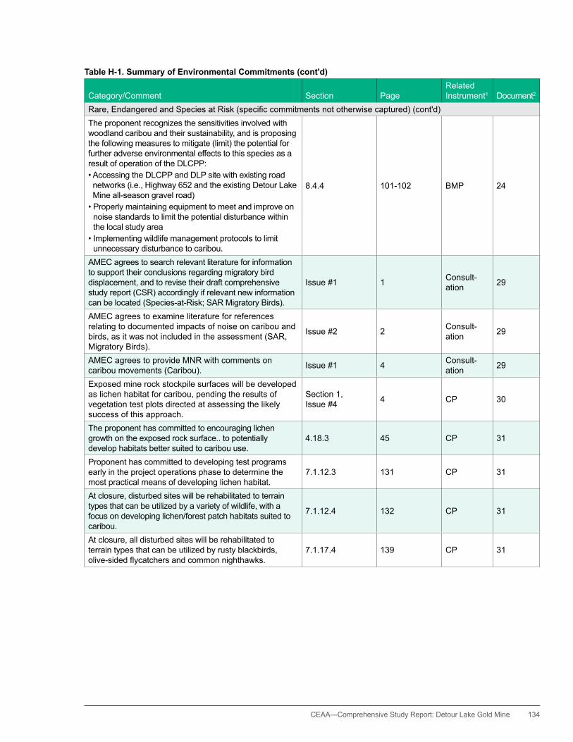
CEAA— Comprehensive Study Report: Detour Lake Gold Mine 134
Table H-1. Summary of Environmental Commitments (cont'd)
Category/Comment Section PageRelated Instrument1 Document2
Rare,EndangeredandSpeciesatRisk(specificcommitmentsnototherwisecaptured)(cont'd)The proponent recognizes the sensitivities involved with woodland caribou and their sustainability, and is proposing the following measures to mitigate (limit) the potential for further adverse environmental effects to this species as a result of operation of the DLCPP:•AccessingtheDLCPPandDLPsitewithexistingroadnetworks (i.e., highway 652 and the existing Detour Lake Mine all-season gravel road)•Properlymaintainingequipmenttomeetandimproveon
noise standards to limit the potential disturbance within the local study area
•Implementingwildlifemanagementprotocolstolimitunnecessary disturbance to caribou.
8.4.4 101-102 BMP 24
AMEC agrees to search relevant literature for information to support their conclusions regarding migratory bird displacement, and to revise their draft comprehensive study report (CSR) accordingly if relevant new information can be located (Species-at-Risk; SAR Migratory Birds).
Issue #1 1 Consult- ation 29
AMEC agrees to examine literature for references relating to documented impacts of noise on caribou and birds, as it was not included in the assessment (SAR, Migratory Birds).
Issue #2 2 Consult- ation 29
AMEC agrees to provide MNR with comments on caribou movements (Caribou). Issue #1 4 Consult-
ation 29
Exposed mine rock stockpile surfaces will be developed as lichen habitat for caribou, pending the results of vegetation test plots directed at assessing the likely success of this approach.
Section 1, Issue #4 4 CP 30
The proponent has committed to encouraging lichen growth on the exposed rock surface.. to potentially develop habitats better suited to caribou use.
4.18.3 45 CP 31
Proponent has committed to developing test programs early in the project operations phase to determine the most practical means of developing lichen habitat.
7.1.12.3 131 CP 31
At closure, disturbed sites will be rehabilitated to terrain types that can be utilized by a variety of wildlife, with a focus on developing lichen/forest patch habitats suited to caribou.
7.1.12.4 132 CP 31
At closure, all disturbed sites will be rehabilitated to terrain types that can be utilized by rusty blackbirds, olive-sidedflycatchersandcommonnighthawks.
7.1.17.4 139 CP 31

135 CEAA—Comprehensive Study Report: Detour Lake Gold Mine
Table H-1. Summary of Environmental Commitments (cont'd)
Category/Comment Section PageRelated Instrument1 Document2
human EnvironmentTrafficeffectswillmitigatedasfollows:•EnsuringthatDGCemployeesandcontractorsor
subcontractors adhere to posted speed limits and practical speed limits along the ROW
•Contractorsandtheirsubcontractorsarerequiredtohave properly and seasonally maintained equipment
•RegularcommunicationswiththeTownofCochrane,Ministry of Transportation, and the Ontario Provincial Policerepresentativestomonitorandmitigatetrafficeffects
•Schedulingofdeliveryofmajorequipmentatoff-peaktimes whenever practical
8.13.1 138 WP/BMP 02
Undertake location and/or structural adjustments to render the appearance of the proposed transmission line less obtrusive. For example, by adjusting the ROW so that it crosses the Little Abitibi River (waterway) Provincial Park on an obtuse angle rather than perpendicular to the River and its view shed, and potentially also by adjusting the tower heights and spans/pole locations if appropriate or practical.
Table 12-1 WP/FRL 03
Landscape screening to minimize the contrast in landscape character: for example, by leaving shrub and low tree cover vegetation that will not affect the conductors (i.e., the wire) in the ROW at the major river and recreational trail crossings.
Table 12-1 WP/FRL 03
Undertake transmission line construction and maintenance activities during the winter as possible, when peak recreation is at its lowest.
Table 12-1 WP/FRL 03
Ensure that there is no equipment storage at the visible edgeofmajorriversorotheridentifiedrecreationaltrailcrossings.
Table 12-1 WP/FRL 03
Avoid the need for an ice bridge and related clearing at the Little Abitibi River by using the existing road network (and creating minor connection points if needed) if practical.
Table 12-1 WP/FRL 03
DGC is committed to working with communities and individuals to increase capacity for businesses located in the Timmins/Cochrane region, and in the broader northeastern Ontario region.
2.18 2.49 Consult-ation 04
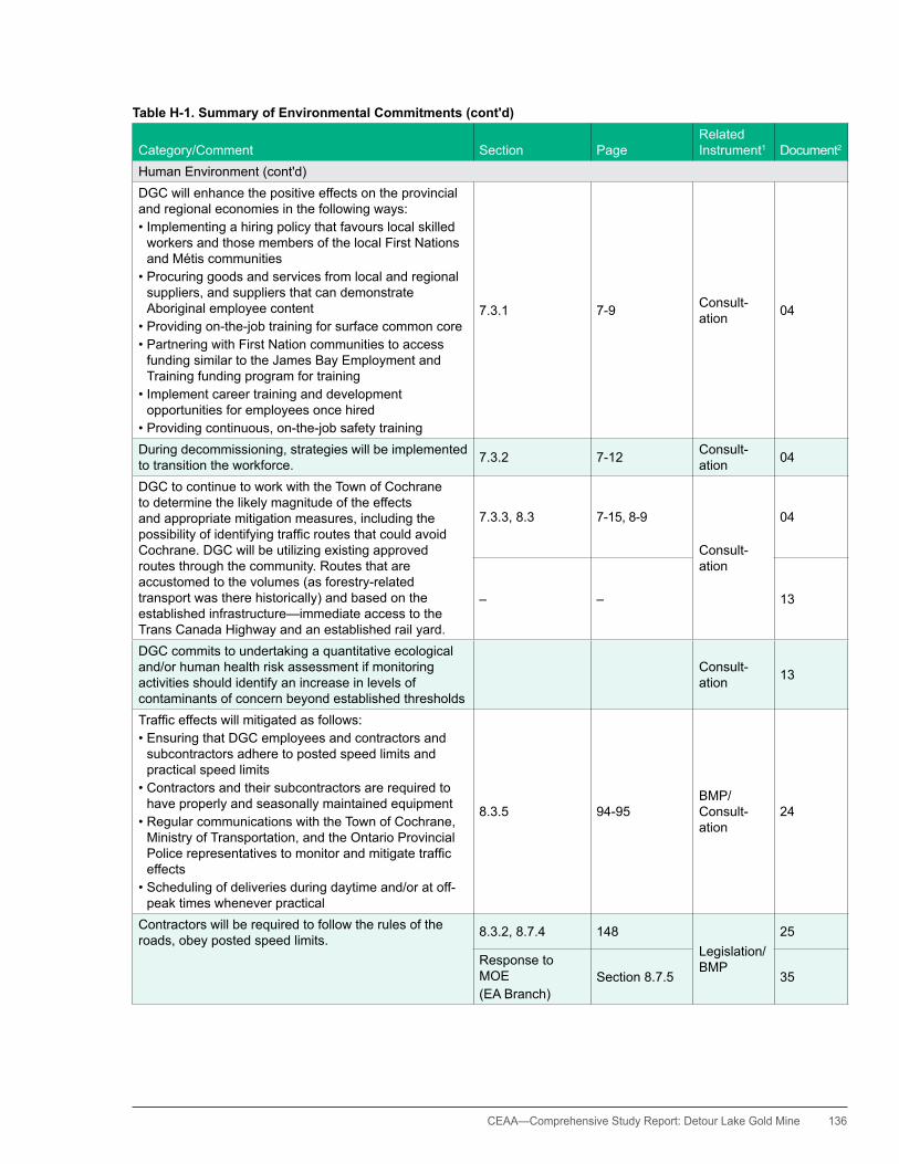
CEAA— Comprehensive Study Report: Detour Lake Gold Mine 136
Table H-1. Summary of Environmental Commitments (cont'd)
Category/Comment Section PageRelated Instrument1 Document2
human Environment (cont'd)DGC will enhance the positive effects on the provincial and regional economies in the following ways:•Implementingahiringpolicythatfavourslocalskilled
workers and those members of the local First Nations and Métis communities
•Procuringgoodsandservicesfromlocalandregionalsuppliers, and suppliers that can demonstrate Aboriginal employee content
•Providingon-the-jobtrainingforsurfacecommoncore•PartneringwithFirstNationcommunitiestoaccess
funding similar to the James Bay Employment and Training funding program for training
•Implementcareertraininganddevelopmentopportunities for employees once hired
•Providingcontinuous,on-the-jobsafetytraining
7.3.1 7-9 Consult-ation 04
During decommissioning, strategies will be implemented to transition the workforce. 7.3.2 7-12 Consult-
ation 04
DGC to continue to work with the Town of Cochrane to determine the likely magnitude of the effects and appropriate mitigation measures, including the possibilityofidentifyingtrafficroutesthatcouldavoidCochrane. DGC will be utilizing existing approved routes through the community. Routes that are accustomed to the volumes (as forestry-related transport was there historically) and based on the established infrastructure—immediate access to the Trans Canada highway and an established rail yard.
7.3.3, 8.3 7-15, 8-9
Consult-ation
04
– – 13
DGC commits to undertaking a quantitative ecological and/or human health risk assessment if monitoring activities should identify an increase in levels of contaminants of concern beyond established thresholds
Consult-ation 13
Trafficeffectswillmitigatedasfollows:•EnsuringthatDGCemployeesandcontractorsand
subcontractors adhere to posted speed limits and practical speed limits
•Contractorsandtheirsubcontractorsarerequiredtohave properly and seasonally maintained equipment
•RegularcommunicationswiththeTownofCochrane,Ministry of Transportation, and the Ontario Provincial Policerepresentativestomonitorandmitigatetrafficeffects
•Schedulingofdeliveriesduringdaytimeand/oratoff-peak times whenever practical
8.3.5 94-95BMP/ Consult-ation
24
Contractors will be required to follow the rules of the roads, obey posted speed limits. 8.3.2, 8.7.4 148
Legislation/BMP
25
Response to MOE(EA Branch)
Section 8.7.5 35
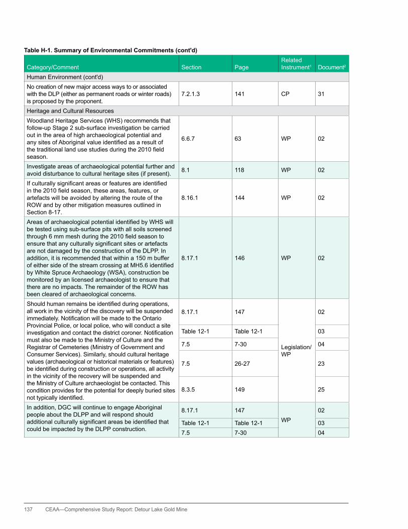
137 CEAA—Comprehensive Study Report: Detour Lake Gold Mine
Table H-1. Summary of Environmental Commitments (cont'd)
Category/Comment Section PageRelated Instrument1 Document2
human Environment (cont'd)No creation of new major access ways to or associated with the DLP (either as permanent roads or winter roads) is proposed by the proponent.
7.2.1.3 141 CP 31
heritage and Cultural ResourcesWoodland heritage Services (WhS) recommends that follow-up Stage 2 sub-surface investigation be carried out in the area of high archaeological potential and anysitesofAboriginalvalueidentifiedasaresultofthetraditionallandusestudiesduringthe2010fieldseason.
6.6.7 63 WP 02
Investigate areas of archaeological potential further and avoid disturbance to cultural heritage sites (if present). 8.1 118 WP 02
Ifculturallysignificantareasorfeaturesareidentifiedinthe2010fieldseason,theseareas,features,orartefacts will be avoided by altering the route of the ROW and by other mitigation measures outlined in Section 8-17.
8.16.1 144 WP 02
AreasofarchaeologicalpotentialidentifiedbyWHSwillbe tested using sub-surface pits with all soils screened through6mmmeshduringthe2010fieldseasontoensurethatanyculturallysignificantsitesorartefactsare not damaged by the construction of the DLPP. In addition, it is recommended that within a 150 m buffer ofeithersideofthestreamcrossingatMH5.6identifiedby White Spruce Archaeology (WSA), construction be monitored by an licensed archaeologist to ensure that there are no impacts. The remainder of the ROW has been cleared of archaeological concerns.
8.17.1 146 WP 02
Shouldhumanremainsbeidentifiedduringoperations,all work in the vicinity of the discovery will be suspended immediately.NotificationwillbemadetotheOntarioProvincial Police, or local police, who will conduct a site investigationandcontactthedistrictcoroner.Notificationmust also be made to the Ministry of Culture and the Registrar of Cemeteries (Ministry of Government and Consumer Services). Similarly, should cultural heritage values (archaeological or historical materials or features) beidentifiedduringconstructionoroperations,allactivityin the vicinity of the recovery will be suspended and the Ministry of Culture archaeologist be contacted. This condition provides for the potential for deeply buried sites nottypicallyidentified.
8.17.1 147
Legislation/WP
02
Table 12-1 Table 12-1 03
7.5 7-30 04
7.5 26-27 23
8.3.5 149 25
In addition, DGC will continue to engage Aboriginal people about the DLPP and will respond should additionalculturallysignificantareasbeidentifiedthatcould be impacted by the DLPP construction.
8.17.1 147WP
02
Table 12-1 Table 12-1 037.5 7-30 04

CEAA— Comprehensive Study Report: Detour Lake Gold Mine 138
Table H-1. Summary of Environmental Commitments (cont'd)
Category/Comment Section PageRelated Instrument1 Document2
heritage and Cultural Resources (cont'd)To ensure the protection of cultural heritage resources, DGC will carry out the following monitoring program: i) Maintain a record of all cultural heritage resources
known to occur in the vicinity of planned developments, such that intrusion or damage to such resources can be avoided during project construction, recognizing and respectingconfidentialitylimitations
ii) Maintain an active dialogue with local Aboriginal group representatives,havingknowledgeofspecificareasprior to and during major construction activities, to provide guidance to supervisory staff on the likely or possible occurrence of as yet undocumented cultural heritage sites
iii) Enlist the services of a trained archaeologist to be present, or on call, during the conduct of major construction works where there is a reasonable potential for encountering as yet undocumented cultural heritage sites
iv) Enlist the services of Elders or other cultural advisors in the event that cultural heritage resources are encountered
v) Conduct a post-construction follow-up on the state of known cultural heritage sites within the vicinity of completedprojectworkstoconfirmtheintegrityofsuchresources
11.7.2 11-13BMP/ Consult-ation
04
DGC has committed that a licensed archaeologist will be available. An archaeologist will be available for consult for the entire transmission line construction phase, but may not be present at the construction site(s). If appropriate and in discussion with the archaeologist, an archaeologist will be available at the construction site during construction at the high potential areas [from archaeological investigations to date by Woodland heritage Surveys and White Spruce Archaeology] if ground disturbance is required in the area.
WP 19, 21
DGC will continue to engage Aboriginal people about the DLCPP and will respond to avoid or mitigated effects,shouldadditionalculturallysignificantareasbeidentifiedthatcouldbeimpactedbytheDLCPPconstruction.
Section 8.3.5 149 Consult-ation 25
DGC will employ First Nation and Métis cultural monitors and develop protocols for the protection of cultural heritage features and areas, should these be encountered.
7.3.2.3 150 Consult-ation 31
Effects on cultural sites (such as burial areas, cabins, etc)identifiedthroughstudieswillbeavoided. 7.3.2.4 150 BMP 31
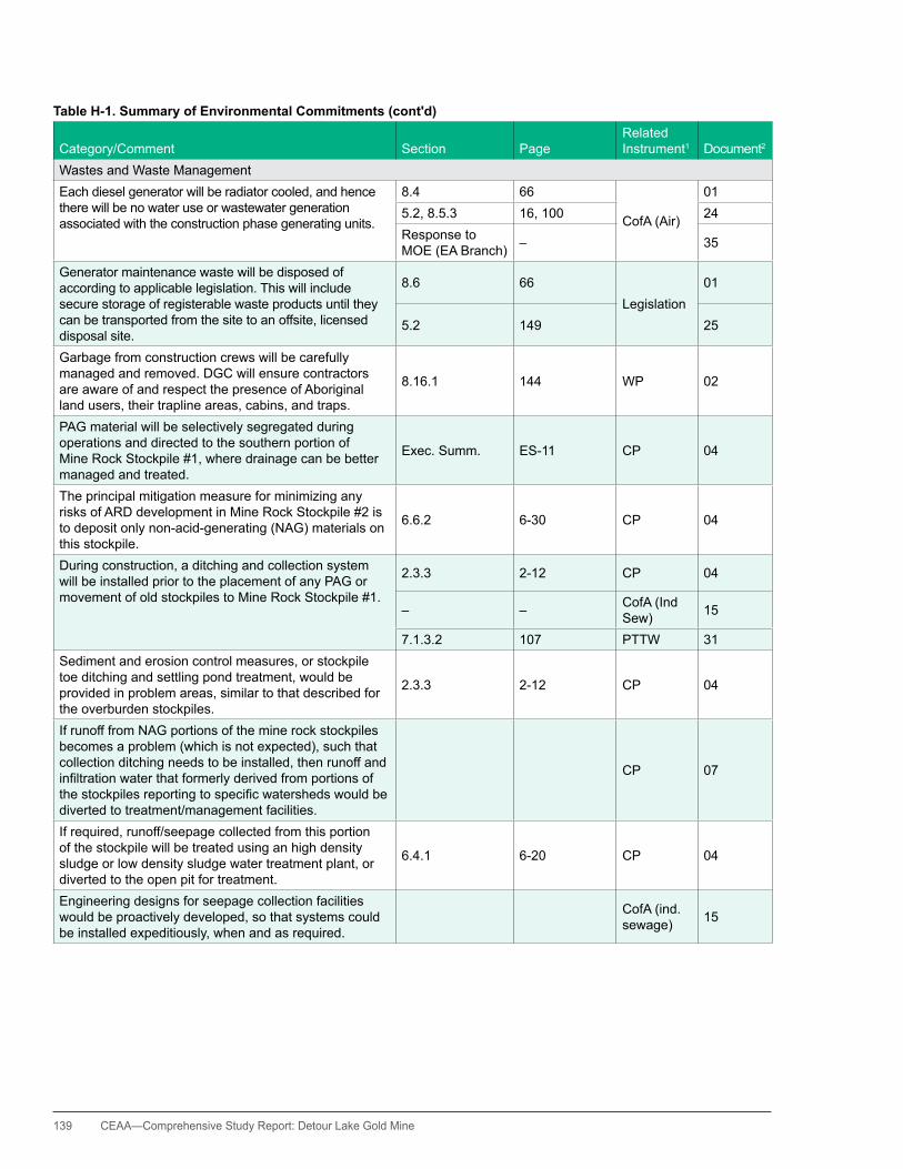
139 CEAA—Comprehensive Study Report: Detour Lake Gold Mine
Table H-1. Summary of Environmental Commitments (cont'd)
Category/Comment Section PageRelated Instrument1 Document2
Wastes and Waste ManagementEach diesel generator will be radiator cooled, and hence there will be no water use or wastewater generation associated with the construction phase generating units.
8.4 66
CofA (Air)
015.2, 8.5.3 16, 100 24Response to MOE (EA Branch) – 35
Generator maintenance waste will be disposed of according to applicable legislation. This will include secure storage of registerable waste products until they can be transported from the site to an offsite, licensed disposal site.
8.6 66Legislation
01
5.2 149 25
Garbage from construction crews will be carefully managed and removed. DGC will ensure contractors are aware of and respect the presence of Aboriginal land users, their trapline areas, cabins, and traps.
8.16.1 144 WP 02
PAG material will be selectively segregated during operations and directed to the southern portion of Mine Rock Stockpile #1, where drainage can be better managed and treated.
Exec. Summ. ES-11 CP 04
The principal mitigation measure for minimizing any risks of ARD development in Mine Rock Stockpile #2 is to deposit only non-acid-generating (NAG) materials on this stockpile.
6.6.2 6-30 CP 04
During construction, a ditching and collection system will be installed prior to the placement of any PAG or movement of old stockpiles to Mine Rock Stockpile #1.
2.3.3 2-12 CP 04
– – CofA (Ind Sew) 15
7.1.3.2 107 PTTW 31Sediment and erosion control measures, or stockpile toe ditching and settling pond treatment, would be provided in problem areas, similar to that described for the overburden stockpiles.
2.3.3 2-12 CP 04
If runoff from NAG portions of the mine rock stockpiles becomes a problem (which is not expected), such that collection ditching needs to be installed, then runoff and infiltrationwaterthatformerlyderivedfromportionsofthestockpilesreportingtospecificwatershedswouldbediverted to treatment/management facilities.
CP 07
If required, runoff/seepage collected from this portion of the stockpile will be treated using an high density sludge or low density sludge water treatment plant, or diverted to the open pit for treatment.
6.4.1 6-20 CP 04
Engineering designs for seepage collection facilities would be proactively developed, so that systems could be installed expeditiously, when and as required.
CofA (ind. sewage) 15
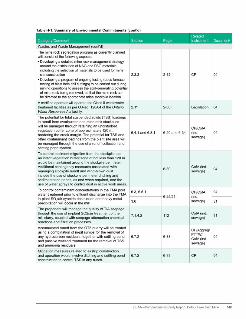
CEAA— Comprehensive Study Report: Detour Lake Gold Mine 140
Table H-1. Summary of Environmental Commitments (cont'd)
Category/Comment Section PageRelated Instrument1 Document2
Wastes and Waste Management (cont'd)The mine rock segregation program as currently planned will consist of the following aspects:•Developingadetailedminerockmanagementstrategy
around the distribution of NAG and PAG materials, including the selection of materials to be used for mine site construction
•Developingaprogramofongoingtesting(Lecofurnacetesting of blast hole drill cuttings) to be carried out during mining operations to assess the acid-generating potential of mine rock being removed, so that the mine rock can be directed to the appropriate mine stockpile location
2.3.3 2-12 CP 04
AcertifiedoperatorwilloperatetheClassIIwastewatertreatment facilities as per O.Reg. 128/04 of the Ontario Water Resources Act facility.
2.11 2-36 Legislation 04
The potential for total suspended solids (TSS) loadings in runoff from overburden and mine rock stockpiles will be managed through retaining an undisturbed vegetation buffer zone of approximately 120 m, bordering the creek margin. The potential for TSS and other contaminant loadings from the plant site area will be managed through the use of a runoff collection and settling pond system.
6.4.1 and 6.8.1 6-20 and 6-34CP/CofA (ind. sewage)
04
To control sediment migration from the stockpile toe, an intact vegetation buffer zone of not less than 120 m would be maintained around the stockpile perimeter. Additional contingency measures associated with managing stockpile runoff and wind-blown dust include the use of stockpile perimeter ditching and sedimentation ponds, as and when required, and the use of water sprays to control dust in active work areas.
6-30 CofA (ind. sewage) 04
To control contaminant concentrations in the TMA pore watertreatmentpriortoeffluentdischargeintotheTMA,in-plant SO2/air cyanide destruction and heavy metal precipitation will occur in the mill.
6.3, 6.5.16-25/21
CP/CofA (ind. sewage)
04
3.6 31
The proponent will manage the quality of TIA seepage through the use of in-plant SO2/air treatment of the mill slurry, coupled with seepage attenuation chemical reactionsandfiltrationprocesses.
7.1.4.2 112 CofA (ind. sewage) 31
Accumulated runoff from the QT5 quarry will be treated using a combination of in-pit sumps for the removal of any hydrocarbon residuals, together with settling pond and passive wetland treatment for the removal of TSS and ammonia residuals.
6.7.2 6-33
CP/Aggreg/PTTW/CofA (ind. sewage)
04
Mitigation measures related to airstrip construction and operation would involve ditching and settling pond construction to control TSS in any runoff.
6.7.2 6-33 CP 04
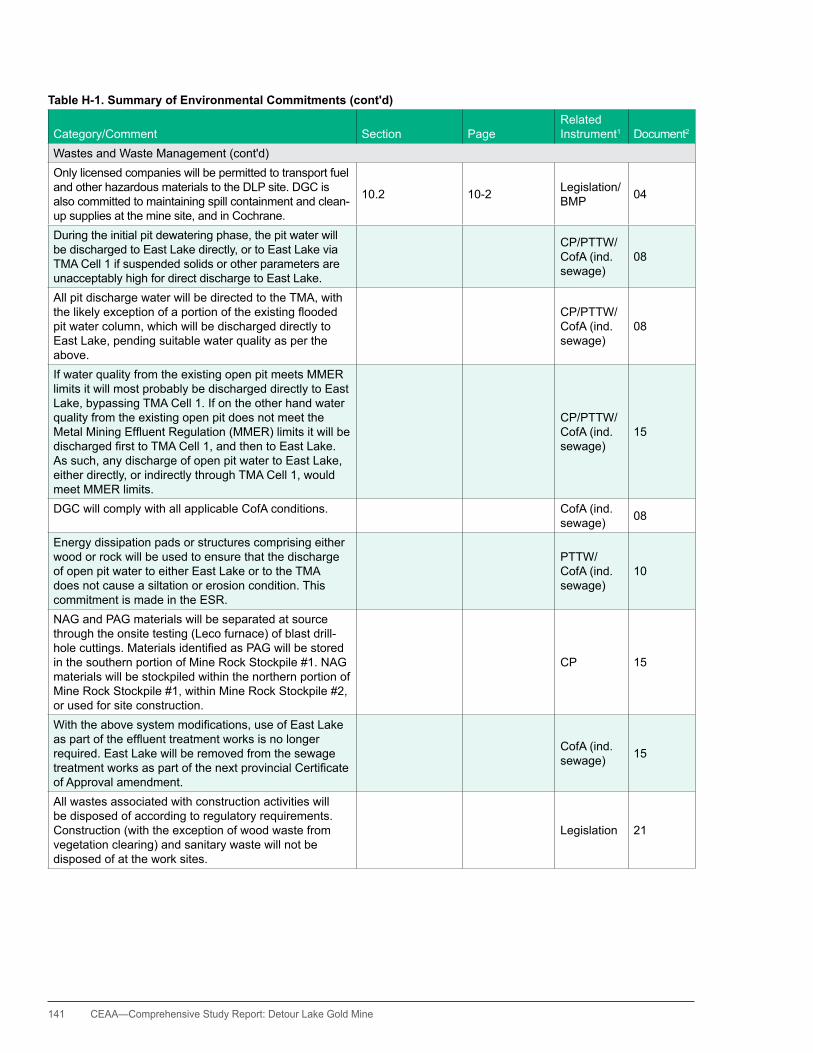
141 CEAA—Comprehensive Study Report: Detour Lake Gold Mine
Table H-1. Summary of Environmental Commitments (cont'd)
Category/Comment Section PageRelated Instrument1 Document2
Wastes and Waste Management (cont'd)Only licensed companies will be permitted to transport fuel and other hazardous materials to the DLP site. DGC is also committed to maintaining spill containment and clean-up supplies at the mine site, and in Cochrane.
10.2 10-2 Legislation/BMP 04
During the initial pit dewatering phase, the pit water will be discharged to East Lake directly, or to East Lake via TMA Cell 1 if suspended solids or other parameters are unacceptably high for direct discharge to East Lake.
CP/PTTW/CofA (ind. sewage)
08
All pit discharge water will be directed to the TMA, with thelikelyexceptionofaportionoftheexistingfloodedpit water column, which will be discharged directly to East Lake, pending suitable water quality as per the above.
CP/PTTW/CofA (ind. sewage)
08
If water quality from the existing open pit meets MMER limits it will most probably be discharged directly to East Lake, bypassing TMA Cell 1. If on the other hand water quality from the existing open pit does not meet the MetalMiningEffluentRegulation(MMER)limitsitwillbedischargedfirsttoTMACell1,andthentoEastLake.As such, any discharge of open pit water to East Lake, either directly, or indirectly through TMA Cell 1, would meet MMER limits.
CP/PTTW/CofA (ind. sewage)
15
DGC will comply with all applicable CofA conditions. CofA (ind. sewage) 08
Energy dissipation pads or structures comprising either wood or rock will be used to ensure that the discharge of open pit water to either East Lake or to the TMA does not cause a siltation or erosion condition. This commitment is made in the ESR.
PTTW/CofA (ind. sewage)
10
NAG and PAG materials will be separated at source through the onsite testing (Leco furnace) of blast drill-holecuttings.MaterialsidentifiedasPAGwillbestoredin the southern portion of Mine Rock Stockpile #1. NAG materials will be stockpiled within the northern portion of Mine Rock Stockpile #1, within Mine Rock Stockpile #2, or used for site construction.
CP 15
Withtheabovesystemmodifications,useofEastLakeaspartoftheeffluenttreatmentworksisnolongerrequired. East Lake will be removed from the sewage treatmentworksaspartofthenextprovincialCertificateof Approval amendment.
CofA (ind. sewage) 15
All wastes associated with construction activities will be disposed of according to regulatory requirements. Construction (with the exception of wood waste from vegetation clearing) and sanitary waste will not be disposed of at the work sites.
Legislation 21

CEAA— Comprehensive Study Report: Detour Lake Gold Mine 142
Table H-1. Summary of Environmental Commitments (cont'd)
Category/Comment Section PageRelated Instrument1 Document2
Wastes and Waste Management (cont'd)Generator maintenance waste will be disposed of according to applicable legislation. This will include secure storage of registerable waste products until they can be transported from the site to an offsite, licensed disposal site.
5.2 16 Legislation 24
Diesel fuel at each generation unit will be contained in an integral double-walled tank to be replenished as necessary from the DLP fuel storage area.
5.3.2 18 Legislation/BMP 24
There will be no direct discharges to surface waters resulting from the construction of the DLCPP. Drainage from the construction area will be contained to ensure that any suspended sediment in runoff is captured using appropriate sediment control measures.
8.3.3 92 CP 24
DGC agrees to this discussion in part and states that they will work toward developing a PAG management plan.
Issue #1 2 Consult- ation 28
For TSS, the recommended trigger levels, subject to MOE approval are the following:•WeeklyaverageTSSconcentration>24mg/L
(i.e., 0.8 x 30 mg/L)•MonthlyaverageTSSconcentration>12mg/L
(i.e., 0.8 x 15 mg/L) [open pit dewatering]
Section 3, Issue #6 8
CofA (ind. sewage)/PTTW
30
For ammonia, the recommended trigger levels, subject to MOE approval are the following:•Weeklyvalueun-ionizedammonia>0.03mg/L•Monthlyaverageun-ionizedammonia>0.02mg/L
[open pit dewatering]
Section 3, Issue #6 8
CofA (ind. sewage)/PTTW
30
For oxygen, it is proposed that the open pit water be dischargedintoageotextile-linedrock-filledchanneltobothdissipateflowenergyofthedischargeandtointroduceoxygenintothesystemthroughturbulentflow[open pit dewatering].
Section 3, Issue #6 8
CofA (ind. sewage)/PTTW
30
The contingency for TSS values is to direct the pit water to TMA Cell 1 for further settling [open pit dewatering]. Section 3,
Issue #6 8CofA (ind. sewage)/PTTW
30
DGC has agreed through discussions with the MOE that the amended CofA will contain a mass balance formulation whereby the proponent will be required to meet the Provincial Water Quality Objectives (PWQO) value of 0.02 mg/L for un-ionized ammonia immediatelydownstreamofthefinaleffluentdischargepoint. Discharge will be to the East Lake weir box (orimmediatelydownstream),suchthateffluentand receiver mixing are expected to be essentially instantaneous.
Section 3, Issue #6 (CofA Issue #11)
9 CofA (ind. sewage) 30

143 CEAA—Comprehensive Study Report: Detour Lake Gold Mine
Table H-1. Summary of Environmental Commitments (cont'd)
Category/Comment Section PageRelated Instrument1 Document2
Wastes and Waste Management (cont'd)Solids [concentrate tailings] will be extracted from the floodedopenpitandtakentothetailingsimpoundmentarea (TIA) where they will become buried with new tailings.
3.3.2 20 CP 31
Tailings will be treated in the processing plant to remove cyanide and residual heavy metals prior to discharge to the TIA, using SO2/air treatment process.
3.6 21 CofA (ind. sewage) 31
TIA will be operated such that there will be a zero or near zero discharge of treated mill water to the environment, other than seepage.
3.6 22 CofA (ind. sewage) 31
Direct discharge from the TIA to the environment will accordingly be limited to treated (aged) mine water and to runoff from inactive TIA cells.
3.6 22 CofA (ind. sewage) 31
Non-hazardous solid wastes, excluding demolition wastes at closure, will be disposed of within the existing onsitelandfill. 3.13 25
Prov. CofA (waste disposal site)
31
hazardous wastes such as used petroleum products, batteries, spent solvents, and biomedical wastes, will be stored in double-walled or equivalent tanks, sealed containers in bermed areas, or other appropriate containment, and periodically removed for offsite disposal at licensed facilities using licensed haulers.
3.13/4.13 25/42 Legislation 31
All seasonal discharges would consist of treated mine water only, where the principal potential contaminants are TSS and residual ammonia.
7.1.2.2 103CofA (ind. sewage)/PTTW
31
If for any reason seepage does become problematic for environmental protection, the proponent has committed to installing and operating a seepage collection system to allow recirculation of the seepage back into the TIA for additional attenuation.
7.1.2.3 105CofA (ind. sewage)/PTTW
31
The proponent has committed to collect and direct runoff/seepage from the southern portion of MRS #1 to the TIA, and not to Karel Creek.
7.1.3.2 108CofA (ind. sewage)/PTTW
31
During the construction period, the collected drainage from MRS #1 will be routed to the TIA. 7.1.3.2 108
CofA (ind. sewage)/PTTW
31
If required, runoff/seepage collected from the southern portion of MRS #1 will be treated using water treatment plant, or any such runoff/seepage will be diverted to the open pit for treatment.
7.1.3.2 108CofA (ind. sewage)/PTTW
31
Potential adverse water quality effects to Karel Creek will be managed through the segregation of PAG and NAG materials within waste rock stockpiles, and through the use of vegetated buffer zones, and a seepage collection system for the southern portion of MRS #1.
7.1.3.3 110 CofA (ind. sewage) 31
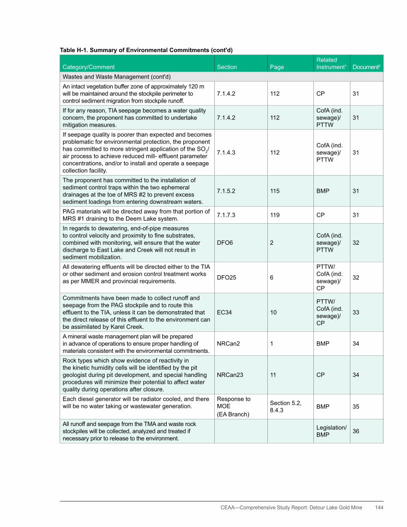
CEAA— Comprehensive Study Report: Detour Lake Gold Mine 144
Table H-1. Summary of Environmental Commitments (cont'd)
Category/Comment Section PageRelated Instrument1 Document2
Wastes and Waste Management (cont'd)An intact vegetation buffer zone of approximately 120 m will be maintained around the stockpile perimeter to control sediment migration from stockpile runoff.
7.1.4.2 112 CP 31
If for any reason, TIA seepage becomes a water quality concern, the proponent has committed to undertake mitigation measures.
7.1.4.2 112CofA (ind. sewage)/PTTW
31
If seepage quality is poorer than expected and becomes problematic for environmental protection, the proponent has committed to more stringent application of the SO2/airprocesstoachievereducedmill-effluentparameterconcentrations, and/or to install and operate a seepage collection facility.
7.1.4.3 112CofA (ind. sewage)/PTTW
31
The proponent has committed to the installation of sediment control traps within the two ephemeral drainages at the toe of MRS #2 to prevent excess sediment loadings from entering downstream waters.
7.1.5.2 115 BMP 31
PAG materials will be directed away from that portion of MRS #1 draining to the Deem Lake system. 7.1.7.3 119 CP 31
In regards to dewatering, end-of-pipe measures tocontrolvelocityandproximitytofinesubstrates,combined with monitoring, will ensure that the water discharge to East Lake and Creek will not result in sediment mobilization.
DFO6 2CofA (ind. sewage)/PTTW
32
AlldewateringeffluentswillbedirectedeithertotheTIAor other sediment and erosion control treatment works as per MMER and provincial requirements. DFO25 6
PTTW/CofA (ind. sewage)/CP
32
Commitments have been made to collect runoff and seepage from the PAG stockpile and to route this effluenttotheTIA,unlessitcanbedemonstratedthatthedirectreleaseofthiseffluenttotheenvironmentcanbe assimilated by Karel Creek.
EC34 10
PTTW/CofA (ind. sewage)/CP
33
A mineral waste management plan will be prepared in advance of operations to ensure proper handling of materials consistent with the environmental commitments.
NRCan2 1 BMP 34
Rock types which show evidence of reactivity in thekinetichumiditycellswillbeidentifiedbythepitgeologist during pit development, and special handling procedures will minimize their potential to affect water quality during operations after closure.
NRCan23 11 CP 34
Each diesel generator will be radiator cooled, and there will be no water taking or wastewater generation.
Response to MOE(EA Branch)
Section 5.2, 8.4.3 BMP 35
All runoff and seepage from the TMA and waste rock stockpiles will be collected, analyzed and treated if necessary prior to release to the environment.
Legislation/BMP 36
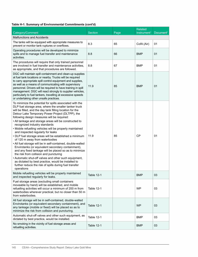
145 CEAA—Comprehensive Study Report: Detour Lake Gold Mine
Table H-1. Summary of Environmental Commitments (cont'd)
Category/Comment Section PageRelated Instrument1 Document2
Malfunctions and AccidentsThe tanks will be equipped with appropriate measures to preventormonitortankrupturesoroverflows. 8.3 65 CofA (Air) 01
Operating procedures will be developed to minimize spills and to manage fuel transfer and maintenance activities.
8.8 66 BMP 01
The procedures will require that only trained personnel are involved in fuel transfer and maintenance activities, as appropriate, and that procedures are followed.
8.8 67 BMP 01
DGC will maintain spill containment and clean-up supplies at fuel tank locations or nearby. Trucks will be required to carry appropriate spill control equipment and supplies, as well as a means of communicating with supervisory personnel. Drivers will be required to have training in spill management. DGC will react strongly to supplier vehicles, particularly to fuel tankers, travelling at excessive speeds or undertaking other unsafe practices.
11.9 85 BMP 01
To minimize the potential for spills associated with the DLP fuel storage area, where the smaller tanker truck willbefilled,andthedaytankfillinglocationfortheDetour Lake Temporary Power Project (DLTPP), the following design measures will be required: •Alltankageandstorageareaswillbeconstructedto
recognized industry standards•Mobilerefuellingvehicleswillbeproperlymaintained
and inspected regularly for leaks•DLPfuelstorageareaswillbeestablishedaminimum
of 120 m away from waterbodies•Allfuelstoragewillbeinself-contained,double-walled
Envirotanks (or equivalent secondary containment), andanyfixedtankagewillbeplacedsoastominimizethe risk from collision and puncturing•Automaticshut-offvalvesandothersuchequipment,
as dictated by best practice, would be installed to further reduce the risk of spills during fuel transfer operations
11.9 85 CP 01
Mobile refuelling vehicles will be properly maintained and inspected regularly for leaks. Table 12-1 BMP 03
Fuel storage areas (excluding small containers moveable by hand) will be established, and mobile refuelling activities will occur a minimum of 200 m from waterbodies wherever practical, but no closer than 50 m from waterbodies.
Table 12-1 WP 03
All fuel storage will be in self-contained, double-walled Envirotanks (or equivalent secondary containment), and anytankage(mobileorfixed)willbeplacedsoastominimize the risk from collision and puncturing.
Table 12-1 WP 03
Automatic shut-off valves and other such equipment, as dictated by best practice, would be installed. Table 12-1 BMP 03
No smoking in the vicinity of fuel storage areas and refuelling activities. Table 12-1 BMP 03
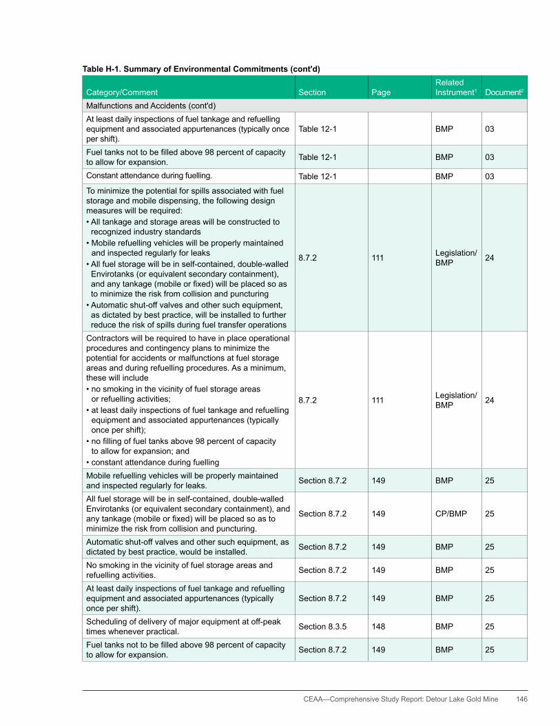
CEAA— Comprehensive Study Report: Detour Lake Gold Mine 146
Table H-1. Summary of Environmental Commitments (cont'd)
Category/Comment Section PageRelated Instrument1 Document2
Malfunctions and Accidents (cont'd)At least daily inspections of fuel tankage and refuelling equipment and associated appurtenances (typically once per shift).
Table 12-1 BMP 03
Fueltanksnottobefilledabove98percentofcapacityto allow for expansion. Table 12-1 BMP 03
Constant attendance during fuelling. Table 12-1 BMP 03
To minimize the potential for spills associated with fuel storage and mobile dispensing, the following design measures will be required: •Alltankageandstorageareaswillbeconstructedto
recognized industry standards•Mobilerefuellingvehicleswillbeproperlymaintained
and inspected regularly for leaks •Allfuelstoragewillbeinself-contained,double-walled
Envirotanks (or equivalent secondary containment), andanytankage(mobileorfixed)willbeplacedsoasto minimize the risk from collision and puncturing•Automaticshut-offvalvesandothersuchequipment,
as dictated by best practice, will be installed to further reduce the risk of spills during fuel transfer operations
8.7.2 111 Legislation/BMP 24
Contractors will be required to have in place operational procedures and contingency plans to minimize the potential for accidents or malfunctions at fuel storage areas and during refuelling procedures. As a minimum, these will include •nosmokinginthevicinityoffuelstorageareas
or refuelling activities; •atleastdailyinspectionsoffueltankageandrefuelling
equipment and associated appurtenances (typically once per shift);
•nofillingoffueltanksabove98percentofcapacity to allow for expansion; and
•constantattendanceduringfuelling
8.7.2 111 Legislation/BMP 24
Mobile refuelling vehicles will be properly maintained and inspected regularly for leaks. Section 8.7.2 149 BMP 25
All fuel storage will be in self-contained, double-walled Envirotanks (or equivalent secondary containment), and anytankage(mobileorfixed)willbeplacedsoastominimize the risk from collision and puncturing.
Section 8.7.2 149 CP/BMP 25
Automatic shut-off valves and other such equipment, as dictated by best practice, would be installed. Section 8.7.2 149 BMP 25
No smoking in the vicinity of fuel storage areas and refuelling activities. Section 8.7.2 149 BMP 25
At least daily inspections of fuel tankage and refuelling equipment and associated appurtenances (typically once per shift).
Section 8.7.2 149 BMP 25
Scheduling of delivery of major equipment at off-peak times whenever practical. Section 8.3.5 148 BMP 25
Fueltanksnottobefilledabove98percentofcapacityto allow for expansion. Section 8.7.2 149 BMP 25
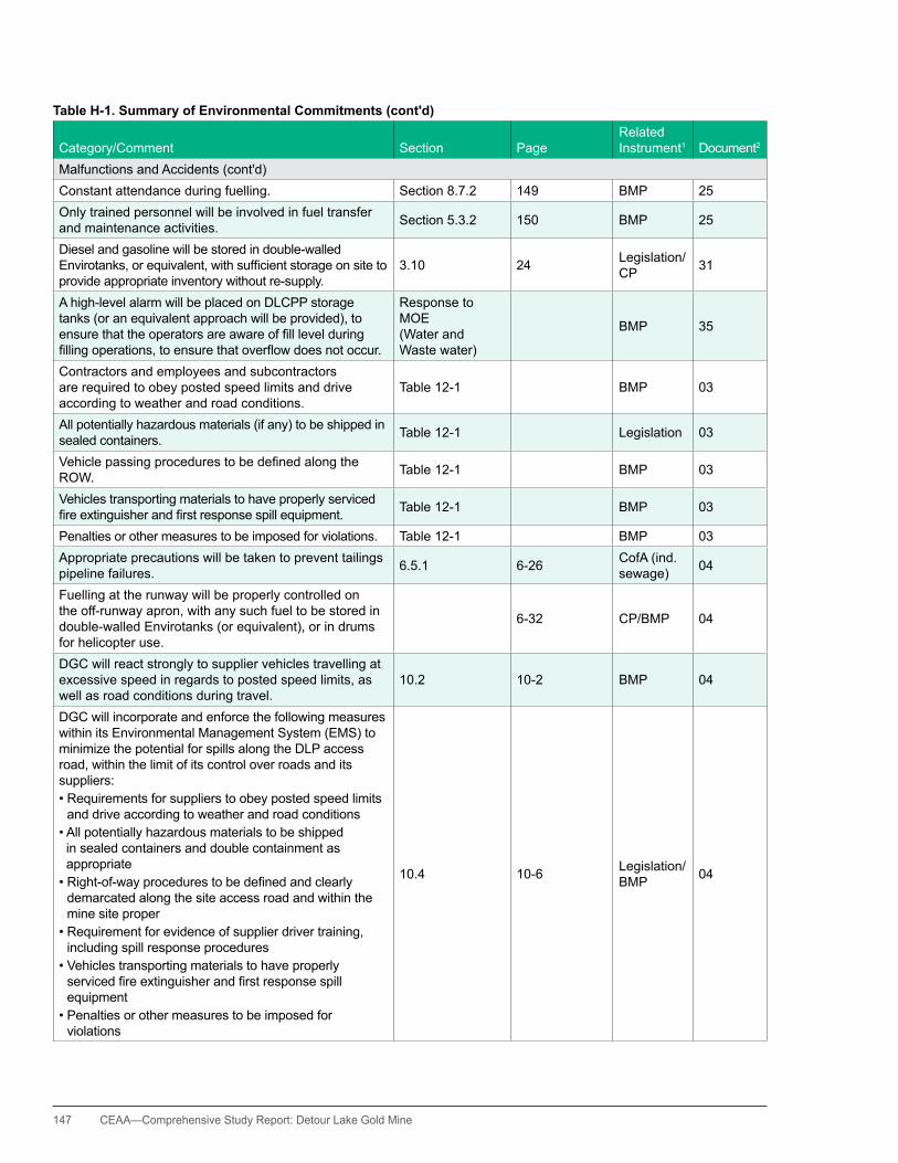
147 CEAA—Comprehensive Study Report: Detour Lake Gold Mine
Table H-1. Summary of Environmental Commitments (cont'd)
Category/Comment Section PageRelated Instrument1 Document2
Malfunctions and Accidents (cont'd)Constant attendance during fuelling. Section 8.7.2 149 BMP 25Only trained personnel will be involved in fuel transfer and maintenance activities. Section 5.3.2 150 BMP 25
Diesel and gasoline will be stored in double-walled Envirotanks,orequivalent,withsufficientstorageonsitetoprovide appropriate inventory without re-supply.
3.10 24 Legislation/CP 31
A high-level alarm will be placed on DLCPP storage tanks (or an equivalent approach will be provided), to ensurethattheoperatorsareawareoffilllevelduringfillingoperations,toensurethatoverflowdoesnotoccur.
Response to MOE (Water and Waste water)
BMP 35
Contractors and employees and subcontractors are required to obey posted speed limits and drive according to weather and road conditions.
Table 12-1 BMP 03
All potentially hazardous materials (if any) to be shipped in sealed containers. Table 12-1 Legislation 03
VehiclepassingprocedurestobedefinedalongtheROW. Table 12-1 BMP 03
Vehicles transporting materials to have properly serviced fireextinguisherandfirstresponsespillequipment. Table 12-1 BMP 03
Penalties or other measures to be imposed for violations. Table 12-1 BMP 03Appropriate precautions will be taken to prevent tailings pipeline failures. 6.5.1 6-26 CofA (ind.
sewage) 04
Fuelling at the runway will be properly controlled on the off-runway apron, with any such fuel to be stored in double-walled Envirotanks (or equivalent), or in drums for helicopter use.
6-32 CP/BMP 04
DGC will react strongly to supplier vehicles travelling at excessive speed in regards to posted speed limits, as well as road conditions during travel.
10.2 10-2 BMP 04
DGC will incorporate and enforce the following measures within its Environmental Management System (EMS) to minimize the potential for spills along the DLP access road, within the limit of its control over roads and its suppliers: •Requirementsforsupplierstoobeypostedspeedlimits
and drive according to weather and road conditions •Allpotentiallyhazardousmaterialstobeshippedin sealed containers and double containment as appropriate •Right-of-wayprocedurestobedefinedandclearly
demarcated along the site access road and within the mine site proper
•Requirementforevidenceofsupplierdrivertraining,including spill response procedures
•Vehiclestransportingmaterialstohaveproperlyservicedfireextinguisherandfirstresponsespillequipment
•Penaltiesorothermeasurestobeimposedforviolations
10.4 10-6 Legislation/BMP 04

CEAA— Comprehensive Study Report: Detour Lake Gold Mine 148
Table H-1. Summary of Environmental Commitments (cont'd)
Category/Comment Section PageRelated Instrument1 Document2
Malfunctions and Accidents (cont'd) DGC will do the following: •Developprocedurestoprevent,orotherwiseminimize,
spills during storage, transfer, and manufacturing operations; and any spills that do occur will be promptly cleaned up
•Suitablyprotectabovegroundfueltanksusedintheexplosives manufacturing process, in accordance with Subsection 4.3.7 of the National Fire Code of Canada 2005 (or other applicable requirements)
•Prepareawrittenemergencyresponseplanthatmeetsbest management practices for the industry
•Collectanddisposeofsweepingsandcontaminatedwash water in a manner that will have minimal impact on the receiving environment; and no water gel/slurry or emulsion explosive residues or wastes will be discharged directly into the receiving environment
•Drumsofpetroleumproductsorchemicalswillbetightlysealed, protected against corrosion and rust, and kept inadrybuildingorshedwithanimpermeablefloorandother appropriate containment
10.6 10-8 Legislation/BMP 04
DGC will ensure that generators and equipment brought to the site are not contaminated. BMP 05
DGC and its suppliers will be responsible for the clean-up of any contaminant releases resulting from accidents and malfunctions, and from normal operations.
Legislation/BMP 08
DGC will develop a detailed contingency plan, with appropriate monitoring programs and response triggers, for the installation of a seepage collection facility. The contingency plan will include conceptual designs for the system.
Consult-ation 12
DGC will require that all equipment used be in good working order and maintained properly, and any and all spills will be required to be cleaned up immediately no matter the size. As a result, no impact is expected.
BMP 16
A copy of the emergency response plans, including information on spill control measures and equipment will be developed prior to the start of construction and providedtotheTimminsDistrictOffice.
Consult-ation 18
DGC is in the process of developing an EMS that will include procedures related to fuelling and fuel storage, as well as spill prevention methods and contingency plans. These (and other) procedures/documents are not prepared as yet, but we have committed to having this information available in advance of any construction.
Consult-ation 20
Continue to integrate Risk Management and Contingency, and Emergency Response procedures into the EMS program.
4.10 (1, 2 and 3) 14 BMP 22
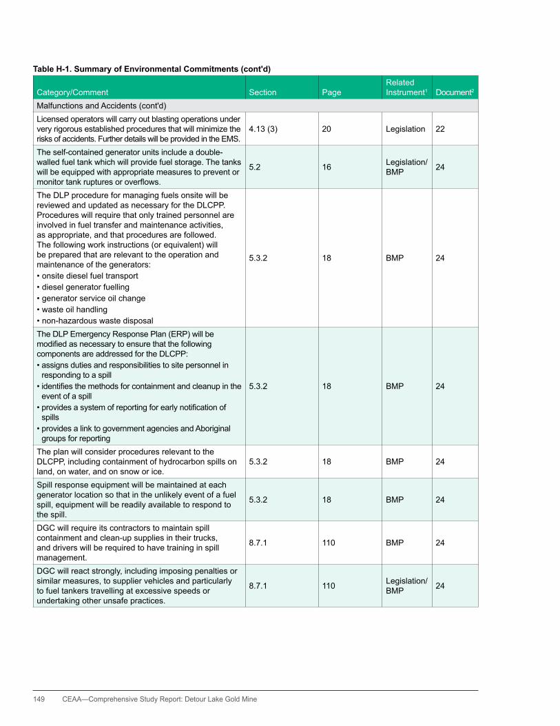
149 CEAA—Comprehensive Study Report: Detour Lake Gold Mine
Table H-1. Summary of Environmental Commitments (cont'd)
Category/Comment Section PageRelated Instrument1 Document2
Malfunctions and Accidents (cont'd)Licensed operators will carry out blasting operations under very rigorous established procedures that will minimize the risks of accidents. Further details will be provided in the EMS.
4.13 (3) 20 Legislation 22
The self-contained generator units include a double-walled fuel tank which will provide fuel storage. The tanks will be equipped with appropriate measures to prevent or monitortankrupturesoroverflows.
5.2 16 Legislation/BMP 24
The DLP procedure for managing fuels onsite will be reviewed and updated as necessary for the DLCPP. Procedures will require that only trained personnel are involved in fuel transfer and maintenance activities, as appropriate, and that procedures are followed. The following work instructions (or equivalent) will be prepared that are relevant to the operation and maintenance of the generators:•onsitedieselfueltransport•dieselgeneratorfuelling•generatorserviceoilchange•wasteoilhandling•non-hazardouswastedisposal
5.3.2 18 BMP 24
The DLP Emergency Response Plan (ERP) will be modifiedasnecessarytoensurethatthefollowingcomponents are addressed for the DLCPP:•assignsdutiesandresponsibilitiestositepersonnelin
responding to a spill•identifiesthemethodsforcontainmentandcleanupinthe
event of a spill•providesasystemofreportingforearlynotificationof
spills•providesalinktogovernmentagenciesandAboriginal
groups for reporting
5.3.2 18 BMP 24
The plan will consider procedures relevant to the DLCPP, including containment of hydrocarbon spills on land, on water, and on snow or ice.
5.3.2 18 BMP 24
Spill response equipment will be maintained at each generator location so that in the unlikely event of a fuel spill, equipment will be readily available to respond to the spill.
5.3.2 18 BMP 24
DGC will require its contractors to maintain spill containment and clean-up supplies in their trucks, and drivers will be required to have training in spill management.
8.7.1 110 BMP 24
DGC will react strongly, including imposing penalties or similar measures, to supplier vehicles and particularly to fuel tankers travelling at excessive speeds or undertaking other unsafe practices.
8.7.1 110 Legislation/BMP 24

CEAA— Comprehensive Study Report: Detour Lake Gold Mine 150
Table H-1. Summary of Environmental Commitments (cont'd)
Category/Comment Section PageRelated Instrument1 Document2
Malfunctions and Accidents (cont'd)Spilled fuel, and contaminated soil and snow, will be collected and treated according to regulations. 8.7.1 111 Legislation 24
Management practices as described for fuel use as applicable will also be implemented to reduce the potential for spills [during maintenance activities].
8.7.3 112 BMP 24
Work instructions (or equivalent) will be prepared that are relevant to the operation and maintenance of the generators.
Section 5.3.2 149 BMP 25
All tankage and storage areas will be constructed to recognized industry standards. Section 8.7.2 149 Legislation/
BMP 25
Spill response equipment will be maintained at each generator location.
Sections 5.3.2, 8.7.2 149 BMP 25
Should generators be relocated, the original site will be sampled and, if any contamination is found, the location will be remediated to provincial soil clean-up standards.
Section 5.3.3 150 Legislation/CP 25
Contractors and employees or subcontractors are required to obey posted speed limits and drive according to weather and road conditions.
Section 8.7.4 150 Legislation/BMP 25
All potentially hazardous materials (if any) to be shipped in sealed containers. 150 Legislation 25
Drivers will be required to have training in spill management.
Sections 8.4.1, 8.7.1 150 BMP 25
Vehicles transporting materials to have properly servicedfireextinguisherandfirstresponsespillequipment.
Section 8.7.1 150 BMP 25
Contractors will be requested to provide to DGC for review, an Emergency Preparedness/Response Plan. Section 8.7.1 150 BMP 25
Penalties or other measures to be imposed for violations. Section 8.7.1 150 BMP 25
The cyanide leach tanks external to the building will be sited within a lined and bermed area capable of containing 110 percent of the volume of the largest single tank.
3.5 21 BMP 31
Where there is a reasonable potential for spills, storage areas will be constructed with catchments. 3.10 24 CP/BMP 31
Automatic shut-off valves and other such equipment as dictated by best practices will be installed to further reduce the risk of spills.
3.10 24 BMP 31
The design of these [explosives] facilities, the volumes stored, as well as the locations will meet the prescribed separation distances.
3.11 24 Legislation 31
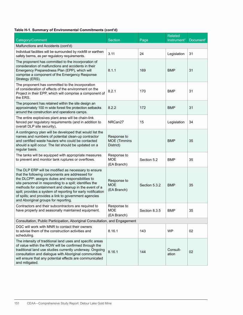
151 CEAA—Comprehensive Study Report: Detour Lake Gold Mine
Table H-1. Summary of Environmental Commitments (cont'd)
Category/Comment Section PageRelated Instrument1 Document2
Malfunctions and Accidents (cont'd)Individualfacilitieswillbesurroundedbyrockfillorearthensafety berms, as per regulatory requirements. 3.11 24 Legislation 31
The proponent has committed to the incorporation of consideration of malfunctions and accidents in their Emergency Preparedness Plan (EPP), which will comprise a component of the Emergency Response Strategy (ERS).
8.1.1 169 BMP 31
The proponent has committed to the incorporation of consideration of effects of the environment on the Project in their EPP, which will comprise a component of the ERS.
8.2.1 170 BMP 31
The proponent has retained within the site design an approximately100mwideforestfireprotectionsetbacksaround the construction and operations camps.
8.2.2 172 BMP 31
The entire explosives plant area will be chain-link fenced per regulatory requirements (and in addition to overall DLP site security),
NRCan27 15 Legislation 34
A contingency plan will be developed that would list the names and numbers of potential clean-up contractor andcertifiedwastehaulerswhocouldbecontactedshould a spill occur. The list should be updated on a regular basis.
Response to MOE (Timmins District)
BMP 35
The tanks will be equipped with appropriate measures topreventandmonitortankrupturesoroverflows.
Response to MOE(EA Branch)
Section 5.2 BMP 35
TheDLPERPwillbemodifiedasnecessarytoensurethat the following components are addressed for the DLCPP: assigns duties and responsibilities to sitepersonnelinrespondingtoaspill;identifiesthemethods for containment and cleanup in the event of a spill;providesasystemofreportingforearlynotificationof spills; and provides a link to government agencies and Aboriginal groups for reporting.
Response to MOE(EA Branch)
Section 5.3.2 BMP 35
Contractors and their subcontractors are required to have properly and seasonally maintained equipment.
Response to MOE(EA Branch)
Section 8.3.5 BMP 35
Consultation, Public Participation, Aboriginal Consultation, and EngagementDGC will work with MNR to contact their owners to advise them of the construction activities and scheduling.
8.16.1 143 WP 02
TheintensityoftraditionallandusesandspecificareasofvaluewithintheROWwillbeconfirmedthroughthetraditional land use studies currently underway. Ongoing consultation and dialogue with Aboriginal communities will ensure that any potential effects are communicated and mitigated.
8.16.1 144 Consult-ation 02

CEAA— Comprehensive Study Report: Detour Lake Gold Mine 152
Table H-1. Summary of Environmental Commitments (cont'd)
Category/Comment Section PageRelated Instrument1 Document2
Consultation, Public Participation, Aboriginal Consultation, and Engagement (cont'd)DGC will inform the Aboriginal communities of structural changes to the ROW (i.e., the nature of poles and any associated guy wires that persons travelling the ROW should be aware of). Guy wires, where used, will also be shielded and marked for improved visibility and safety.
8.16.1 144 Consult-ation 02
DGCwillpublishabusinessopportunitiesprofilethatwilloutline the goods and services required by the Project. 2.18 2-47 Consult-
ation 04
DGC will require all contractors to disclose their policies and practices regarding preferential hiring to encourage the hiring and training of Aboriginals and area residents.
2.18 2-47 Consult-ation 04
DGC will support current initiatives and resources in the local communities for addressing alcohol and substance abuse problems.
2.18 2-48 Consult-ation 04
A recruitment strategy will be developed by DGC in consultation with the First Nations and other Aboriginal groups to maximize Aboriginal involvement in the DLP, and to provide progressive employment opportunities for mine employees.
2.18 2-49 Consult-ation 04
AreaswithculturalsignificancetotheWahgoshigFirstNation (WFN) include areas on Lower Detour Lake, Detour Lake, and the Detour River. These areas and associatedinformationwillbekeptconfidentialandonfilewith the WFN. It is understood by DGC that if any future mine developments could potentially impact these areas, that further consultation with the WFN will be required.
5.7.3 5-106 Consult-ation 04
DGC is discussing with First Nations the development ofpoliciesforrestrictingfishingbytheirworkerswhileon shift.
7.4.2 7-28 Consult-ation 04
DGC will continue to support the preparation of TK studies and include the resulting information in project planning including EAs and permits if they are available at the time of submission.
Consult-ation 11
InthefinalESR,therewillbeastatementthatagreements are being negotiated with local Aboriginal groupstoensurebenefitsarerealized.
Consult-ation 11
The mine rock management strategy will be provided in a timely manner for review and comment.
Consult-ation 12
A copy of the Cyanide Management Program will be provided to the Wahgoshig Environmental Committee as requested.
Consult-ation 12
The Mine Water Management Program will be provided in a timely manner for review and comment.
Consult-ation 12
The Emergency Response and Recover Plans will be provided in a timely manner for review and comment.
Consult-ation 12
Chemical Management Procedures will be provided in a timely manner for review and comment.
Consult-ation 12
Environmental Monitoring Programs will be provided in a timely manner for review and comment.
Consult-ation 12
WEC will be actively engaged in the development of the DLP Policies, Programs, Procedures and Best Practices.
Consult-ation 12

153 CEAA—Comprehensive Study Report: Detour Lake Gold Mine
Table H-1. Summary of Environmental Commitments (cont'd)
Category/Comment Section PageRelated Instrument1 Document2
Consultation, Public Participation, Aboriginal Consultation, and Engagement (cont'd)DGC will commit to working with Ministry of Transportation staff, as appropriate, in an attempt to have large species road kills (moose, caribou. wolves and black bear) removed from the road so as not to unduly attract and put at risk other predator species or workers and contractors travelling on these roads.
Consult-ation 13
DGC will work with the Taykwa Tagamou Nation (TTN) on implementation of the Consultation Protocol in moving forward with the federal EA.
Consult-ation 13
DGC will involve TTN in these activities. Consult-ation 13
DGC will encourage the participation of TTN members in the collection of data on moose, wolf, black bear and caribou; a wildlife log will also be kept to help document road kills along highway 652 and the mine access road.
Consult-ation 13
DGC will continue to support the preparation of TK studies and include the resulting information in project planning, including EAs and permits if they are available at the time of submission.
Consult-ation 14
DGC will hold discussions with the Métis Nation of Ontario (MNO) regarding this request to act an environmental monitor.
Consult-ation 16
DGC will hold discussions with MNO in regard to development of a Protocol for participation related to environmental issues.
Consult-ation 16
DGC will hold discussions with MNO and regulatory agencies in regard to establishing a Detour Environmental Coordinating Committee.
Consult-ation 16
DGC will hold discussions with MNO in regard to hiring a Project Coordinator to provide MNO capacity.
Consult-ation 16
DGC will hold discussions with MNO in regard to establishing a list of species of interest to MNO in associated with discussions regarding traditional knowledge (TK) Study.
Consult-ation 16
Theexactmeansofaccesswillbedefinedthroughtheenvironmental approvals and construction tendering processes. TTN will be engaged in discussions on future environmental approvals and permits. Particular attention will be given to those that address access issues.
WP/FRL 19
DGC will optimize Aboriginal employment, training, and procurement opportunities as and if stated in the terms negotiatedintheImpactBenefitAgreement(IBA).
Consult-ation
1921
DGC will follow up with any requests for discussion about potential effects to traplines if contacted directly by the trapline permit holder.
Consult-ation
1921

CEAA— Comprehensive Study Report: Detour Lake Gold Mine 154
Table H-1. Summary of Environmental Commitments (cont'd)
Category/Comment Section PageRelated Instrument1 Document2
Consultation, Public Participation, Aboriginal Consultation, and Engagement (cont'd)DGC is committed to supporting the traditional ecological knowledge (TEK) studies and avoiding or mitigating any effects to traditional land uses.
Consult-ation 21
hold further discussions with DPRA/Moose Cree First Nation (MCFN) to discuss the potential for additional, specificgroundwaterwellmonitoringlocations. 4.2.4 (2) 6
Consult-ation/ Non-regulatory monitoring
22
Discuss potential for additional TMA ground water monitoring wells with DPRA/MCFN.
4.2.5 (1) 7
CofA (ind. sewage)/Non-regulatory monitoring
22
In consultation with DLP stakeholders, develop contingency trigger threshold and response strategies for additional seepage management for the TMA within 12 months of receiving the amended C. of A.
4.2.5 (2) 7 Consult-ation 22
Copies of future testing programs and PAG management protocols will be provided to the MCFN, as they become available.
4.2.6 (1) 8 Consult-ation 22
Provide additional information on surface water and groundwater water quality through the proposed monitoring committee.
4.3 (4) 9 Consult-ation 22
Continue with developing research programs, provide results to MCFN, and update Closure Plan as needed. 4.3 (8) 10
Consult-ation/ CP
22
DGC to share EMS plans with the MCFN. 4.10 (5) 14 Consult-ation 22
The progress on these programs [Permit compliance and progressive reclamation (including site drainage and sediment control)] will be shared with the stakeholders through the environment committee established as part of the First Nation agreements.
4.11 (15) 17 Consult-ation 22
DGC is committed to engaging in discussions for exploring the potential of using First Nation communities as part of any reclamation business tender programs as manyaspectsexistforthemutualbenefitofallparties.
4.12 (5) 19 Consult-ation 22
Implement commitments made in this response to comments made by DPRA on behalf of the MCFN. 4.13 (5) 20 Consult-
ation 22
DGC will continue to engage Aboriginal people about the DLCPP and will respond should additional culturally significantareasbeidentifiedthatcouldbeimpactedbythe DLCPP construction.
8.3.5 95 Consult-ation 24

155 CEAA—Comprehensive Study Report: Detour Lake Gold Mine
Table H-1. Summary of Environmental Commitments (cont'd)
Category/Comment Section PageRelated Instrument1 Document2
Consultation, Public Participation, Aboriginal Consultation, and Engagement (cont'd)DGC and its consultant will respond to all comments provided on the EA document and will compile the comments and responses into a summary table for future reference. If appropriate, the commitments listwillbeupdatedtoreflecttheresultsoftheEAapproval process.
9.3.6 137 Consult-ation 24
DGC will continue to maintain an open dialogue with area stakeholders and First Nations and Métis to ensure they continue to be good neighbours and active members of the regional community.
9.3.6 137 Consult-ation 24
DGC will ensure that proper oversight occurs with any modificationssuchasabove,inordertoensurethatthe environmental effects are minimized and remain consistent with the assessment of environmental effects determined through this individual EA.
10.0 144 Consult-ation 24
Aprimaryqualifiedcontactwillbeidentifiedforeach project phase (construction, operation and decommissioning), to provide clear direction on environmental-related matters.
12.2 146 Consult-ation 24
A formal complaints procedure will be established to provide stakeholders and Aboriginal communities a voice during the construction, operation, and decommissioning phase of the DLCPP. A response protocol will also be established to ensure that follow up occurs.
12.2 147 Consult-ation/ BMP
24
Response to MOE (EA Branch) 12.2 35
Regular communications with the Town of Cochrane, Ministry of Transportation, and the Ontario Provincial Policerepresentativestomonitorandmitigatetrafficeffects.
Section 8.3.5 148 Consult-ation 25
DGC to report back on its position regarding 2:1 slopes for the waste rock surfaces of the storage piles and the TMA perimeter dams.
Issue #1 2 Consult-ation 26
DGC to provide examples of similar reclamation plans using overburden islands on waste rock. Issue #2 5 Consult-
ation 26
DGC to provide examples of natural revegetation of waste rock surfaces. Issue #2 5 Consult-
ation 26
DGC will consider and report back on the use of soil overburden covers and the reclamation of the waste rock faced perimeter dams in the TMA.
Issue #2 5 Consult-ation 26
DGC agreed to provide to MCFN additional information regardingitscontingencyplanforsignificantlyreducedflowratesinKarelCreekduetopitdewatering.
Issue #2 5 Consult-ation 27
AMEC to send map of tailings area to MCFN for review (to assist with monitoring well placement).
Issue #5 9
Consult-ation/ non-regulatory monitoring
27

CEAA— Comprehensive Study Report: Detour Lake Gold Mine 156
Table H-1. Summary of Environmental Commitments (cont'd)
Category/Comment Section PageRelated Instrument1 Document2
Consultation, Public Participation, Aboriginal Consultation, and Engagement (cont'd)This is also a function of geology and hydrogeology, so itwillneedtobeintegratedintothefinalselectedsites.AMEC/DGC will add this component in reviewing the newproposedsitestoimprovethefinalprogram.
Issue #5 9 Consult-ation 27
DGC states that PAG segregation information will be provided in the future, once they develop the program in greater detail.
Issue #6 10 CP 27
DGC is committed to developing a waste rock management plan and to include contingency plans to manage PAG and tailing seepage.
Issue #6 10 Consult-ation 27
DGC agrees to provide additional information and screening level information on PAG management. Issue #1 2 Consult-
ation 28
DGCconfirmsthatthelevelofdetailrequiredbyDPRA/MCFN is not in EA, but can be found in a number of DFO documents, which are in the process of being developed and updated. Copies of these documents will be made available to MCFN when they have been properly prepared.
Issue #2 3 Consult-ation 28
DGC is in the process of developing the soil/overburden management plan, and will provide the draft plan to DPRA/MCFNforreviewbeforeitisfinalized.
Section 1, Issue #5 4 BMP 30
DGC is working with SRK Consulting to develop a more detailed PAG management plan. DPRA/MCFN will be provided an opportunity to review the PAG management plan once it is available.
Section 3, Issue #1 8 Consult-
ation 30
Permit applications and draft permits will be available to DPRA/MCFN for review. (CofA Issue #1).
Section 3, Issue #6 9 Consult-
ation 30
AMEC and DGC remain committed to this objective, and DGC has requested a proposal from the MCFN to conduct additional work. Of note, TK will be ongoing as necessary to meet objectives at the mine (with respect to working with MCFN as partners to ensure that appropriate additional community members are consulted regarding traditional knowledge).
Section 4, Issue #2 13 Consult-
ation 30
Salvaged timber material will be offered to local forestry companies and/or Aboriginal groups. 3.3.1 19 FRL 31
The proponent has committed to best efforts to reasonably avoid disturbance to important plant harvestingareasshouldthesebeidentified.
7.3.1.3 145 Consult-ation 31
DGC has been consulting with stakeholder organizations, government agencies, and Aboriginal communities since early 2008 and is committed to continuing this dialogue throughout the life of the Project.
10.2.4 183 Consult-ation 31

157 CEAA—Comprehensive Study Report: Detour Lake Gold Mine
Table H-1. Summary of Environmental Commitments (cont'd)
Category/Comment Section PageRelated Instrument1 Document2
Consultation, Public Participation, Aboriginal Consultation, and Engagement (cont'd)The alternatives assessment for the TIA is being revised and will be issued separately. EC2, EC12 1, 3 Legislation 33
The alternatives assessment for mine waste will be revised in consideration of these comments and issued under separate cover. A separate table will be issued with the revised document indicating how these comments have been addressed.
EC14, EC16-EC29 4, 5-7 Consult-
ation 33
DGC will work with the Federal Review Team to develop an appropriate Follow-Up Program in regards to these and other aspects.
EC50 19 33
Stakeholders, Aboriginal groups, and other interested persons have been and will continue to be engaged in dialogue about the potential natural and human environmental effects, cumulative effects, mitigation and accommodation measures, and follow-up and monitoring.
Response to MOE(EA Branch) Section 9.2 BMP 35
DGC will continue to maintain an open dialogue with area stakeholders and First Nations and Métis to ensure they continue to be good neighbours and active members of the regional community.
Response to MOE(EA Branch)
Section 9.3.2 BMP 35
It is intended that should local First Nation trappers be subject to interference during the construction phase for accidental damage to facilities, they will be compensated. Broader compensation will be through arrangement with their respective First Nations for interference, related to the DLPP, along registered traplines with traditional pursuits involving hunting and trapping.
8.10.1 128 WP/FRL 02
Inadditiontothemitigationmeasuresidentifiedaboveand in other sections, additional measures will be taken to avoid or limit any DLPP effects on traditional land uses: •PuttinginplaceagreementswithAboriginal
communities whose Aboriginal or Treaty rights may be impacted by the DLPP
•TheAgreement(s)areintendedtocoverallmembersof the potentially impacted Aboriginal communities from loss. Should there be direct harm during the construction of the transmission line, such as accidental loss of marten boxes, direct compensation maybe required to cover this loss if not covered in the agreement
8.16.1 145 Consult-ation 02
PuttinginplaceImpactBenefitsAgreementswithAboriginal communities whose Aboriginal or Treaty rights may be infringed by the DLPP.
Table 12-1 Consult-ation 03
Local First Nation trappers will be compensated for interference, related to the DLPP, with traditional pursuits involving hunting and trapping.
Table 12-1 Consult-ation 03
ComplyingwithImpactBenefitsAgreementswithAboriginal communities whose Aboriginal or Treaty rights may be infringed by the DLCPP.
Sections 8.3.5, 8.4.5 149 Consult-
ation 25

CEAA— Comprehensive Study Report: Detour Lake Gold Mine 158
Table H-1. Summary of Environmental Commitments (cont'd)
Category/Comment Section PageRelated Instrument1 Document2
Consultation, Public Participation, Aboriginal Consultation, and Engagement (cont'd)Local First Nation trappers will be compensated for interference, related to the DLCPP, with traditional pursuits involving hunting and trapping.
Sections 8.3.5, 8.4.5 149 Consult-
ation 25
DGC intends to continue to support the traditional knowledge studies, to continue to engage communities in discussion about traditional land uses that overlap with the DLCPP and to determine appropriate mitigation measures to avoid or reduce any impacts.
Sections 8.3.5, 9.3.4 149 Consult-
ation 25
The proponent has committed to work with local Aboriginal peoples to continue to collect TEK and knowledge of traditional land use (TLU) as the Project goes forward to advance DGC’s understanding of the Project area and to further assist in the implementation of appropriate mitigation measures to minimize negative effects on TLU.
7.3.1.1 144 Consult-ation 31
Mitigation measures are proposed by the proponent to reduce effects on traditional resource harvesting.•Providingworkerswithculturalawarenesstrainingthat
will include the need to show respect to wildlife•Ensuringthatallconstructioncrewsareawareofthe
possible presence of trappers in the areas adjacent to the work sites and respect their right to be in the area
•Conductingceremoniesbeforemajorgroundbreakingconstruction activities to show respect for the land
•ContinuetogatherTLUinformationfromknowledgeholders(astheyareidentified)throughoutthelifeofthe Project to determine potential areas of cultural significancethatmaybeimpactedbytheDLP
7.3.1.3 146 BMP 31
OperationsThe total combined available (excluding backup) generating capacity at any given time will be under 5 megawatts (MW).
2.4 6 CofA (Air) 01
The total combined generating capacity will be under 5 MW, although the number, size, and timing of the generators may change according to the construction needs.
8.2 65 CofA (Air) 01
Minimum safe clearance will be provided according to industry standards from the transmission line and the ground, trees, watercourses, buildings, and other installations.
5.3.1 15Legislation/Safety Standards
02
The line would be temporarily connected into an existing 115 kV circuit (temporary Island Falls tie point and metering substation (SS) between the hunt SS and Abitibi Canyon Generating Stations (GS)). This temporary supply to the DLP site would provide 20 MW of power for mine construction and pumping activities. The second phase would include construction of the 230 kilovolt (kV) transmission line between Island Falls and the Pinard transformer station (TS) and a new 230 kV line circuit facility at the Pinard TS.
5.3.2 15 WP 02
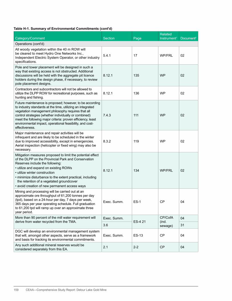
159 CEAA—Comprehensive Study Report: Detour Lake Gold Mine
Table H-1. Summary of Environmental Commitments (cont'd)
Category/Comment Section PageRelated Instrument1 Document2
Operations (cont'd)All woody vegetation within the 40 m ROW will be cleared to meet hydro One Networks Inc., Independent Electric System Operator, or other industry specifications.
5.4.1 17 WP/FRL 02
Pole and tower placement will be designed in such a way that existing access is not obstructed. Additional discussions will be held with the aggregate pit licence holders during the design phase, if necessary, to review pole placement designs.
8.12.1 135 WP 02
Contractors and subcontractors will not be allowed to utilize the DLPP ROW for recreational purposes, such as huntingandfishing.
8.12.1 136 WP 02
Future maintenance is proposed; however, to be according to industry standards at the time, utilizing an integrated vegetation management philosophy requires that all control strategies (whether individually or combined) meetthefollowingmajorcriteria:provenefficiency,leastenvironmental impact, operational feasibility, and cost-effectiveness.
7.4.3 111 WP 02
Major maintenance and repair activities will be infrequent and are likely to be scheduled in the winter due to improved accessibility, except in emergencies. Aerialinspection(helicopterorfixedwing)mayalsobenecessary.
8.3.2 119 WP 02
Mitigation measures proposed to limit the potential effect of the DLPP on the Provincial Park and Conservation Reserves include the following:•utilizeandexpandonexistingROWs•utilizewinterconstruction•minimizedisturbancetotheextentpractical,including
the retention of a vegetated groundcover•avoidcreationofnewpermanentaccessways
8.12.1 134 WP/FRL 02
Mining and processing will be carried out at an approximate ore throughput of 61,200 tonnes per day (tpd), based on a 24-hour per day, 7 days per week, 365 days per year operating schedule. Full graduation to 61,200 tpd will ramp up over an approximate three year period.
Exec. Summ. ES-1 CP 04
More than 90 percent of the mill water requirement will derive from water recycled from the TMA.
Exec. Summ.ES-4 21
CP/CofA (ind. sewage)
04
3.6 31
DGC will develop an environmental management system that will, amongst other aspects, serve as a framework and basis for tracking its environmental commitments.
Exec. Summ. ES-13 CP 04
Any such additional mineral reserves would be considered separately from this EA. 2.1 2-2 CP 04
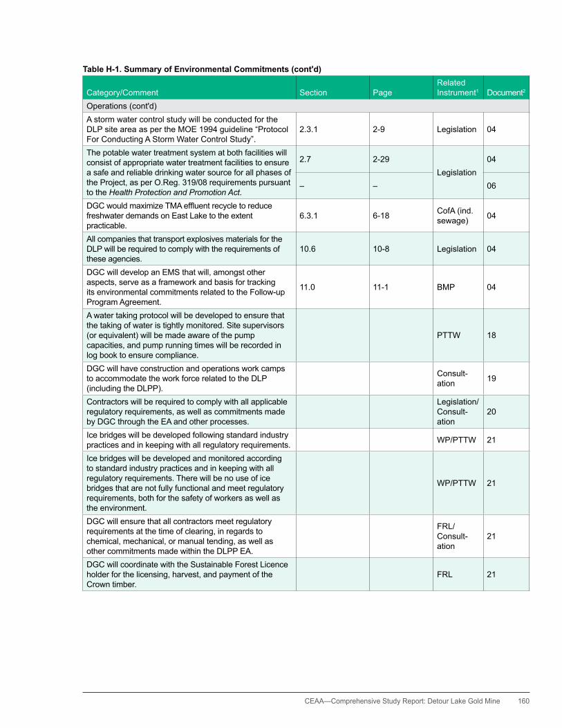
CEAA— Comprehensive Study Report: Detour Lake Gold Mine 160
Table H-1. Summary of Environmental Commitments (cont'd)
Category/Comment Section PageRelated Instrument1 Document2
Operations (cont'd)A storm water control study will be conducted for the DLP site area as per the MOE 1994 guideline “Protocol ForConductingAStormWaterControlStudy”.
2.3.1 2-9 Legislation 04
The potable water treatment system at both facilities will consist of appropriate water treatment facilities to ensure a safe and reliable drinking water source for all phases of the Project, as per O.Reg. 319/08 requirements pursuant to the Health Protection and Promotion Act.
2.7 2-29Legislation
04
– – 06
DGCwouldmaximizeTMAeffluentrecycletoreducefreshwater demands on East Lake to the extent practicable.
6.3.1 6-18 CofA (ind. sewage) 04
All companies that transport explosives materials for the DLP will be required to comply with the requirements of these agencies.
10.6 10-8 Legislation 04
DGC will develop an EMS that will, amongst other aspects, serve as a framework and basis for tracking its environmental commitments related to the Follow-up Program Agreement.
11.0 11-1 BMP 04
A water taking protocol will be developed to ensure that the taking of water is tightly monitored. Site supervisors (or equivalent) will be made aware of the pump capacities, and pump running times will be recorded in log book to ensure compliance.
PTTW 18
DGC will have construction and operations work camps to accommodate the work force related to the DLP (including the DLPP).
Consult-ation 19
Contractors will be required to comply with all applicable regulatory requirements, as well as commitments made by DGC through the EA and other processes.
Legislation/Consult-ation
20
Ice bridges will be developed following standard industry practices and in keeping with all regulatory requirements. WP/PTTW 21
Ice bridges will be developed and monitored according to standard industry practices and in keeping with all regulatory requirements. There will be no use of ice bridges that are not fully functional and meet regulatory requirements, both for the safety of workers as well as the environment.
WP/PTTW 21
DGC will ensure that all contractors meet regulatory requirements at the time of clearing, in regards to chemical, mechanical, or manual tending, as well as other commitments made within the DLPP EA.
FRL/Consult-ation
21
DGC will coordinate with the Sustainable Forest Licence holder for the licensing, harvest, and payment of the Crown timber.
FRL 21
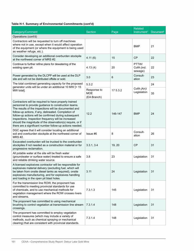
161 CEAA—Comprehensive Study Report: Detour Lake Gold Mine
Table H-1. Summary of Environmental Commitments (cont'd)
Category/Comment Section PageRelated Instrument1 Document2
Operations (cont'd)Contractors will be requested to turn off machines where not in use, except when it would affect operation of the equipment (or where the equipment is being used as weather refuge, etc.).
BMP 21
Consider developing an additional overburden stockpile at the northwest corner of MRS #2. 4.11 (6) 15 CP 22
Continuetofurtherrefineplansfordewateringoftheexisting open pit. 4.13 (4) 20
PTTW/CofA (ind. sewage)
22
Power generated by the DLCPP will be used at the DLP site and will not be distributed offsite or sold. 3.0 6 Consult-
ation 23
The total combined generating capacity for the proposed generator units will be under an additional 10 MW [< 15 MW total].
5.3.2
17 5.3.2 CofA (Air)/Legislation
24
Response to MOE(EA Branch)
35
Contractors will be required to have properly trained personnel to provide guidance to construction teams. The results of the inspections will be documented and follow-up actions, if any, delineated. Completion of follow-upactionswillbeconfirmedduringsubsequentinspections. Inspection frequency will be increased should the magnitude of the observation(s) require, or if thereareasignificantnumberfollow-upactionsneeded.
12.2 146-147 BMP 24
DGC agrees that it will consider locating an additional soil and overburden stockpile at the northwest corner of MRS #2.
Issue #6 8 Consult-ation 26
Excavated overburden will be trucked to the overburden stockpiles if not needed as a construction material or for progressive reclamation.
3.3.1, 3.4 19, 20 CP 31
All potable water at the site will be fresh water (groundwater or surface water) treated to ensure a safe and reliable drinking water source.
3.8 23 Legislation 31
A licensed explosives contractor will be responsible for explosives material delivery (excluding fuel, which will be taken from onsite diesel tanks as required), onsite explosives manufacturing, and for explosives handling and loading in the open pit blast holes.
3.11 24 Legislation 31
For the transmission line ROW, the proponent has committed to meeting provincial standards for use of chemicals, and to use mechanical methods for vegetation management where the ROW crosses rivers and streams.
7.3.1.3 145 Legislation 31
The proponent has committed to using mechanical brushing to control vegetation at transmission line stream crossings.
7.3.1.4 148 Legislation 31
The proponent has committed to employ vegetation control measures (which may include a variety of methods, such as chemical spraying or mechanical clearing) that are consistent with provincial standards.
7.3.1.4 148 Legislation 31
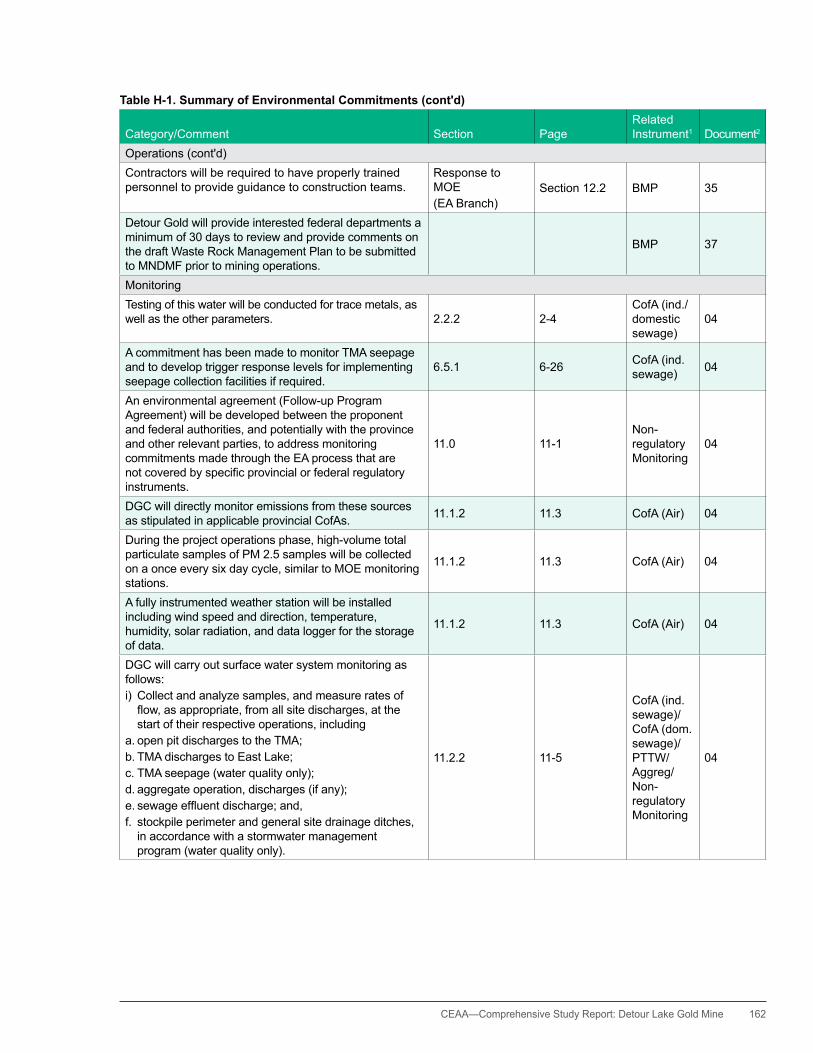
CEAA— Comprehensive Study Report: Detour Lake Gold Mine 162
Table H-1. Summary of Environmental Commitments (cont'd)
Category/Comment Section PageRelated Instrument1 Document2
Operations (cont'd)Contractors will be required to have properly trained personnel to provide guidance to construction teams.
Response to MOE(EA Branch)
Section 12.2 BMP 35
Detour Gold will provide interested federal departments a minimum of 30 days to review and provide comments on the draft Waste Rock Management Plan to be submitted to MNDMF prior to mining operations.
BMP 37
MonitoringTesting of this water will be conducted for trace metals, as well as the other parameters. 2.2.2 2-4
CofA (ind./domestic sewage)
04
A commitment has been made to monitor TMA seepage and to develop trigger response levels for implementing seepage collection facilities if required.
6.5.1 6-26 CofA (ind. sewage) 04
An environmental agreement (Follow-up Program Agreement) will be developed between the proponent and federal authorities, and potentially with the province and other relevant parties, to address monitoring commitments made through the EA process that are notcoveredbyspecificprovincialorfederalregulatoryinstruments.
11.0 11-1Non-regulatory Monitoring
04
DGC will directly monitor emissions from these sources as stipulated in applicable provincial CofAs. 11.1.2 11.3 CofA (Air) 04
During the project operations phase, high-volume total particulate samples of PM 2.5 samples will be collected on a once every six day cycle, similar to MOE monitoring stations.
11.1.2 11.3 CofA (Air) 04
A fully instrumented weather station will be installed including wind speed and direction, temperature, humidity, solar radiation, and data logger for the storage of data.
11.1.2 11.3 CofA (Air) 04
DGC will carry out surface water system monitoring as follows: i) Collect and analyze samples, and measure rates of flow,asappropriate,fromallsitedischarges,atthestart of their respective operations, including
a. open pit discharges to the TMA;b. TMA discharges to East Lake;c. TMA seepage (water quality only);d. aggregate operation, discharges (if any); e.sewageeffluentdischarge;and,f. stockpile perimeter and general site drainage ditches,
in accordance with a stormwater management program (water quality only).
11.2.2 11-5
CofA (ind. sewage)/CofA (dom. sewage)/PTTW/ Aggreg/Non-regulatory Monitoring
04
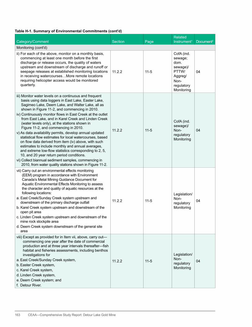
163 CEAA—Comprehensive Study Report: Detour Lake Gold Mine
Table H-1. Summary of Environmental Commitments (cont'd)
Category/Comment Section PageRelated Instrument1 Document2
Monitoring (cont'd)ii) For each of the above, monitor on a monthly basis, commencingatleastonemonthbeforethefirstdischarge or release occurs, the quality of waters upstream and downstream of discharge and runoff or seepage releases at established monitoring locations in receiving watercourses…More remote locations requiring helicopter access would be monitored quarterly.
11.2.2 11-5
CofA (ind. sewage; dom. sewage)/PTTW/ Aggreg/Non-regulatory Monitoring
04
iii) Monitor water levels on a continuous and frequent basis using data loggers in East Lake, Easter Lake, Sagimeo Lake, Deem Lake, and Walter Lake, all as shown in Figure 11-2, and commencing in 2010.
iv)ContinuouslymonitorflowsinEastCreekattheoutletfrom East Lake, and in Karel Creek and Linden Creek (water levels only), at the stations shown in Figure 11-2, and commencing in 2010.
v) As data availability permits, develop annual updated statisticalflowestimatesforlocalwatercourses,basedonflowdataderivedfromitem(iv)above,withsuchestimates to include monthly and annual averages, andextremelow-flowstatisticscorrespondingto2,5,10, and 20 year return period conditions.
vi) Collect biannual sediment samples, commencing in 2010, from water quality stations shown in Figure 11-2.
11.2.2 11-5
CofA (ind. sewage)/Non-regulatory Monitoring
04
vii) Carry out an environmental effects monitoring (EEM) program in accordance with Environment Canada’s Metal Mining Guidance Document for Aquatic Environmental Effects Monitoring to assess the character and quality of aquatic resources at the following locations:
a. East Creek/Sunday Creek system upstream and downstream of the primary discharge outfall
b. Karel Creek system upstream and downstream of the open pit area
c. Linden Creek system upstream and downstream of the mine rock stockpile area
d. Deem Creek system downstream of the general site area
11.2.2 11-5
Legislation/Non-regulatory Monitoring
04
viii) Except as provided for in Item vii, above, carry out—commencing one year after the date of commercial productionandatthreeyearintervalsthereafter—fishhabitatandfisheriesassessments,includingbenthosinvestigations for
a. East Creek/Sunday Creek system, b. Easter Creek system,c. Karel Creek system,d. Linden Creek system, e. Deem Creek system; andf. Detour River.
11.2.2 11-5
Legislation/Non-regulatory Monitoring
04
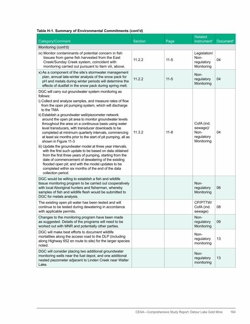
CEAA— Comprehensive Study Report: Detour Lake Gold Mine 164
Table H-1. Summary of Environmental Commitments (cont'd)
Category/Comment Section PageRelated Instrument1 Document2
Monitoring (cont'd)ix)Monitorcontaminantsofpotentialconcerninfish
tissuesfromgamefishharvestedfromtheEastCreek/Sunday Creek system, coincident with monitoring carried out pursuant to Item viii, above.
11.2.2 11-5
Legislation/Non-regulatory Monitoring
04
x) As a component of the site’s stormwater management plan, annual late-winter analysis of the snow pack for ph and metals during winter periods will determine the effects of dustfall in the snow pack during spring melt.
11.2.2 11-5Non-regulatory Monitoring
04
DGC will carry out groundwater system monitoring as follows: i)Collectandanalyzesamples,andmeasureratesofflow
from the open pit pumping system, which will discharge to the TMA
ii) Establish a groundwater well/piezometer network around the open pit area to monitor groundwater levels throughout the area on a continuous basis using water level transducers, with transducer downloads to be completed at minimum quarterly intervals, commencing at least six months prior to the start of pit pumping, all as shown in Figure 11-3
iii) Update the groundwater model at three year intervals, withthefirstsuchupdatetobebasedondataobtainedfromthefirstthreeyearsofpumping,startingfromthedate of commencement of dewatering of the existing floodedopenpit;andwiththemodelupdatestobecompleted within six months of the end of the data collection period.
11.3.2 11-8
CofA (ind. sewage)/Non-regulatory Monitoring
04
DGCwouldbewillingtoestablishafishandwildlifetissue monitoring program to be carried out cooperatively withlocalAboriginalhuntersandfisherman,wherebysamplesoffishandwildlifefleshwouldbesubmittedtoDGC for metals analysis.
Non-regulatory Monitoring
06
The existing open pit water has been tested and will continue to be tested during dewatering in accordance with applicable permits.
CP/PTTW/CofA (ind. sewage)
08
Changes to the monitoring program have been made as suggested. Details of the programs will need to be worked out with MNR and potentially other parties.
Non-regulatory Monitoring
09
DGC will make best efforts to document wildlife mortalities along the access road to the DLP (including along highway 652 en route to site) for the larger species noted.
Non-regulatory monitoring
13
DGC will consider placing two additional groundwater monitoring wells near the fuel depot, and one additional nested piezometer adjacent to Linden Creek near Walter Lake.
Non-regulatory monitoring
13
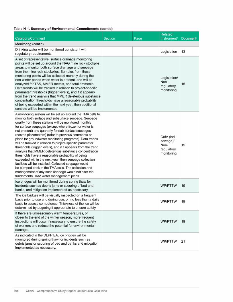
165 CEAA—Comprehensive Study Report: Detour Lake Gold Mine
Table H-1. Summary of Environmental Commitments (cont'd)
Category/Comment Section PageRelated Instrument1 Document2
Monitoring (cont'd)Drinking water will be monitored consistent with regulatory requirements. Legislation 13
A set of representative, surface drainage monitoring points will be set up around the NAG mine rock stockpile areas to monitor both surface drainage and seepage from the mine rock stockpiles. Samples from these monitoring points will be collected monthly during the non-winter period when water is present, and will be analyzed for TSS, MMER metals, and total ammonia. Datatrendswillbetrackedinrelationtoproject-specificparameter thresholds (trigger levels), and if it appears from the trend analysis that MMER deleterious substance concentration thresholds have a reasonable probability of being exceeded within the next year, then additional controls will be implemented.
Legislation/Non-regulatory monitoring
15
A monitoring system will be set up around the TMA cells to monitor both surface and subsurface seepage. Seepage quality from these stations will be monitored monthly for surface seepages (except where frozen or water is not present) and quarterly for sub-surface seepages (nested piezometers) (refer to previous comments on plans for groundwater monitoring programs). Data trends willbetrackedinrelationtoproject-specificparameterthresholds (trigger levels), and if it appears from the trend analysis that MMER deleterious substance concentration thresholds have a reasonable probability of being exceeded within the next year, then seepage collection facilities will be installed. Collected seepage would be pumped back to the TMA cells. The collection and management of any such seepage would not alter the fundamental TMA water management plans.
CofA (ind. sewage)/Non-regulatory monitoring
15
Ice bridges will be monitored during spring thaw for incidents such as debris jams or scouring of bed and banks, and mitigation implemented as necessary.
WP/PTTW 19
The ice bridges will be visually inspected on a frequent basis prior to use and during use, on no less than a daily basis to assess competence. Thickness of the ice will be determined by augering if appropriate to ensure safety.
WP/PTTW 19
If there are unseasonably warm temperatures, or closer to the end of the winter season, more frequent inspections will occur if necessary to ensure the safety of workers and reduce the potential for environmental damage.
WP/PTTW 19
As indicated in the DLPP EA, ice bridges will be monitored during spring thaw for incidents such as debris jams or scouring of bed and banks and mitigation implemented as necessary.
WP/PTTW 21

CEAA— Comprehensive Study Report: Detour Lake Gold Mine 166
Table H-1. Summary of Environmental Commitments (cont'd)
Category/Comment Section PageRelated Instrument1 Document2
Monitoring (cont'd)Develop a groundwater monitoring program beyond post-closure in the area surrounding MRS #1, based on a transparent operational database.
4.2.4 (5) 6CP/Non-regulatory monitoring
22
Metal levels in representative vegetation areas would be monitored at appropriate intervals, during operations (including advanced closure of tailings ponds or waste rock areas) and periodically during the 10 years (post-closure) and compared with reference background levels.
4.11 (14) 16Non-regulatory monitoring
22
Monitoringwellsareplannedinthegenerallandfillareato track the adjacent waste stockpiles as well as this area. Monitoring during the post-closure period will be conductedafterthelandfillhasbeenclosed.
4.13 (6) 21
Non-regulatory monitoring/CP
22
Compliance monitoring will be completed in a manner consistent with the DLP Environmental Management System until such time as the DLCPP is decommissioned. In addition, air quality and noise monitoring will comply with requirements within the approvedComprehensiveCertificateofApproval(Air)oras amended, to verify the accuracy of model predictions presented herein.
12.2 146
Various instruments/non-regulatory monitoring
24
Other environmental monitoring will include (but will not be limited to) inspection of the following:•Appropriatenessofequipmentchoiceandmaintenanceof equipment to minimize environmental impacts•Constructionactivitiesandequipmentoperation,
including refueling exercises•Maintenanceandrepairprocedures•Monitoringofremedialactionsassociatedwith
malfunctions and accidents (if any)
12.2 146 BMP 24
At a minimum, weekly inspections of the DLCPP byaqualifiedpersonwilloccurduringeachphase(construction, operation, and decommissioning).
12.2 146Non-regulatory monitoring
24
DGC agrees that a number of metrics will need to be put in place to measure biological productivity. DGC agreed to include cross-referencing to wildlife use and metal uptake, but not the other parameters.
Issue #14 12Non-regulatory monitoring
26
DGC agreed to resample the well in Area-1, Sample Location KUW-1 for general chemistry, (including TSS), nutrients, and dissolved metals.
Issue #1 2Non-regulatory monitoring
27
AMEC agrees to MCFN’s request for surface water samples to be taken upstream and downstream from the KUW-1 location.
Issue #1 2Non-regulatory monitoring
27
DGCconfirmsthatwaters[existingfloodedopenpit]willbe monitored consistently prior to discharge. Full details regarding the discharge process and plan are to be developed in the future.
Issue #3 5PTTW/CofA (ind. sewage)
27
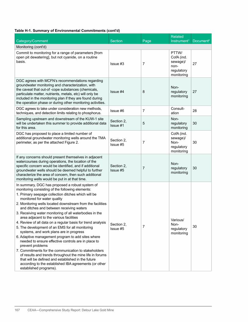
167 CEAA—Comprehensive Study Report: Detour Lake Gold Mine
Table H-1. Summary of Environmental Commitments (cont'd)
Category/Comment Section PageRelated Instrument1 Document2
Monitoring (cont'd)Commit to monitoring for a range of parameters [from open pit dewatering], but not cyanide, on a routine basis. Issue #3 7
PTTW/CofA (ind. sewage)/non-regulatory monitoring
27
DGC agrees with MCFN’s recommendations regarding groundwater monitoring and characterization, with the caveat that out-of -cope substances (chemicals, particulate matter, nutrients, metals, etc) will only be included in the monitoring plan if they are found during the operation phase or during other monitoring activities.
Issue #4 8Non-regulatory monitoring
27
DGC agrees to take under consideration new methods, techniques, and detection limits relating to phosphorus. Issue #6 7 Consult-
ation 28
Sampling upstream and downstream of the KUW-1 site will be undertaken this summer to provide additional data for this area.
Section 2, Issue #1 5
Non-regulatory monitoring
30
DGC has proposed to place a limited number of additional groundwater monitoring wells around the TMA perimeter, as per the attached Figure 2. Section 2,
Issue #5 7
CofA (ind. sewage)/Non-regulatory monitoring
30
If any concerns should present themselves in adjacent watercourses during operations, the location of the specificconcernwouldbeidentified,andifadditionalgroundwater wells should be deemed helpful to further characterize the area of concern, then such additional monitoring wells would be put in at that time.
Section 2, Issue #5 7
Non-regulatory monitoring
30
In summary, DGC has proposed a robust system of monitoring consisting of the following elements:1. Primary seepage collection ditches which will be
monitored for water quality2. Monitoring wells located downstream from the facilities
and ditches and between receiving waters3. Receiving water monitoring of all waterbodies in the
area adjacent to the various facilities4. Review of all data on a regular basis for trend analysis5. The development of an EMS for all monitoring
systems, and work plans are in progress6. Adaptive management program to add sites where
needed to ensure effective controls are in place to prevent problems
7. Commitments for the communication to stakeholders of results and trends throughout the mine life in forums thatwillbedefinedandestablishedinthefutureaccording to the established IBA agreements (or other established programs).
Section 2, Issue #5 7
Various/Non-regulatory monitoring
30
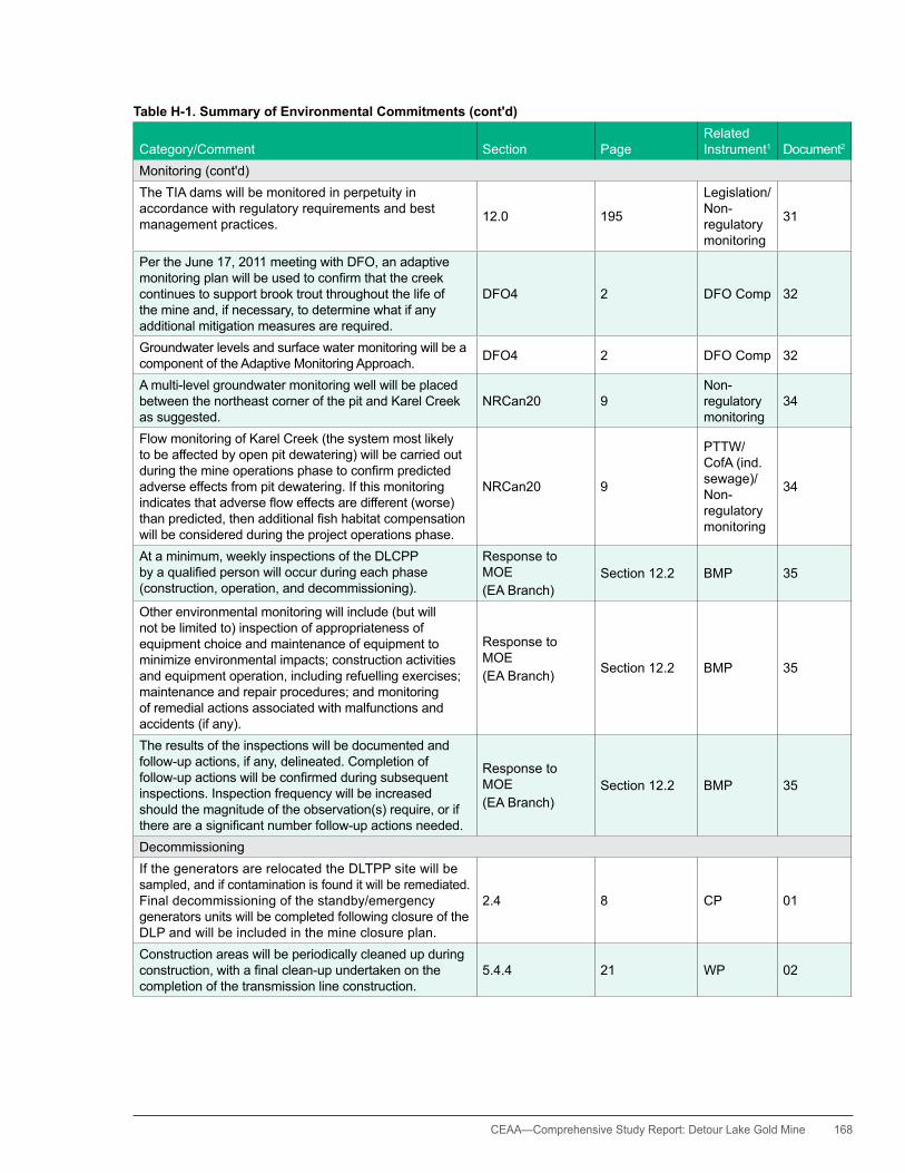
CEAA— Comprehensive Study Report: Detour Lake Gold Mine 168
Table H-1. Summary of Environmental Commitments (cont'd)
Category/Comment Section PageRelated Instrument1 Document2
Monitoring (cont'd)The TIA dams will be monitored in perpetuity in accordance with regulatory requirements and best management practices. 12.0 195
Legislation/Non-regulatory monitoring
31
Per the June 17, 2011 meeting with DFO, an adaptive monitoringplanwillbeusedtoconfirmthatthecreekcontinues to support brook trout throughout the life of the mine and, if necessary, to determine what if any additional mitigation measures are required.
DFO4 2 DFO Comp 32
Groundwater levels and surface water monitoring will be a component of the Adaptive Monitoring Approach. DFO4 2 DFO Comp 32
A multi-level groundwater monitoring well will be placed between the northeast corner of the pit and Karel Creek as suggested.
NRCan20 9Non-regulatory monitoring
34
Flow monitoring of Karel Creek (the system most likely to be affected by open pit dewatering) will be carried out duringthemineoperationsphasetoconfirmpredictedadverse effects from pit dewatering. If this monitoring indicatesthatadversefloweffectsaredifferent(worse)thanpredicted,thenadditionalfishhabitatcompensationwill be considered during the project operations phase.
NRCan20 9
PTTW/CofA (ind. sewage)/Non-regulatory monitoring
34
At a minimum, weekly inspections of the DLCPP byaqualifiedpersonwilloccurduringeachphase(construction, operation, and decommissioning).
Response to MOE(EA Branch)
Section 12.2 BMP 35
Other environmental monitoring will include (but will not be limited to) inspection of appropriateness of equipment choice and maintenance of equipment to minimize environmental impacts; construction activities and equipment operation, including refuelling exercises; maintenance and repair procedures; and monitoring of remedial actions associated with malfunctions and accidents (if any).
Response to MOE(EA Branch) Section 12.2 BMP 35
The results of the inspections will be documented and follow-up actions, if any, delineated. Completion of follow-upactionswillbeconfirmedduringsubsequentinspections. Inspection frequency will be increased should the magnitude of the observation(s) require, or if thereareasignificantnumberfollow-upactionsneeded.
Response to MOE(EA Branch)
Section 12.2 BMP 35
DecommissioningIf the generators are relocated the DLTPP site will be sampled, and if contamination is found it will be remediated. Final decommissioning of the standby/emergency generators units will be completed following closure of the DLP and will be included in the mine closure plan.
2.4 8 CP 01
Construction areas will be periodically cleaned up during construction,withafinalclean-upundertakenonthecompletion of the transmission line construction.
5.4.4 21 WP 02

169 CEAA—Comprehensive Study Report: Detour Lake Gold Mine
Table H-1. Summary of Environmental Commitments (cont'd)
Category/Comment Section PageRelated Instrument1 Document2
Decommissioning (cont'd)Refuse and litter will be regularly removed to a licensed landfill,withafinalinspectionandremovalatthecompletion of construction. If needed, impacted lands will be stabilized by the planting of non-invasive native plants along watercourse banks, slopes, and any other erosion prone areas.
5.4.4 21 WP 02
In the unlikely event that the ownership of the transmission line from Island Falls to the Pinard TS is not transferred to another operator, it will be decommissioned in a similar manner.
5.6 23 CP 02
During the decommissioning phase only, that portion of the DLPP between the DLP site and Island Falls would be removed, as it is anticipated that the transmission line section between Island Falls and Pinard would be left in place to reinforce the existing hydroelectric grid.
8.2 118 CP 02
During the decommissioning phase, a winter road is expected to be created to facilitate removal of the DLPP. The winter road width of up to approximately 10 m extending from the DLP site to Island Falls
8.9.3 127 CP 02
On completion of decommissioning, the lands will be allowedtonaturallyinfillwithnativespecies. 8.16.3 146 CP 02
DGC will work with MNR to conduct vegetation trials on experimental mine rock stockpiles during mine operations to better determine the potential for such rehabilitation measures at closure.
2.17.5 2-45 CP 04
For that part of Mine Rock Stockpile #1 containing PAG materials, a complete overburden and soil cover would be provided with a thickness of not less than 1.0 m, to limitprecipitationinfiltrationintothePAGmaterial.
3.16.1 3-48 CP 04
Buildings, equipment, machinery, and all related infrastructure such as access roads and pipelines would be reclaimed in accordance with the Mining Act, Ontario Reg. 240/00 requirements.
3.17 3-49 CP 04
DGC is committed to encouraging and, as practical, restoring the DLP site to productive, naturalized vegetation communities on cessation of mining.
6.12.1 6-41 CP 04
Alllocalsiteroadsneedtobeplantedafterscarificationtoreturn the sites to caribou habitat; otherwise, undesirable tree species would become entrenched and create habitat more suitable to moose. In addition, DGC agrees with this recommendation, and appropriate changes have beenmadetotheESRtoreflectthiscommitment.
CP 09
Mitigation for this should be to recreate caribou habitat by recovering all areas where aggregate material was used.Allareasmayneedtobescarified;thenuseoverburden (perhaps in sections) to give trees something to work with, plant trees, even if it is 40 to 60 percent stocking, and promote lichen growth. This should apply to all roads, camp and building areas, and anything else where aggregate was used. Commitments to restore site habitats where aggregates are used have been made in theappropriatesectionsofthefinalESR.
CP 09
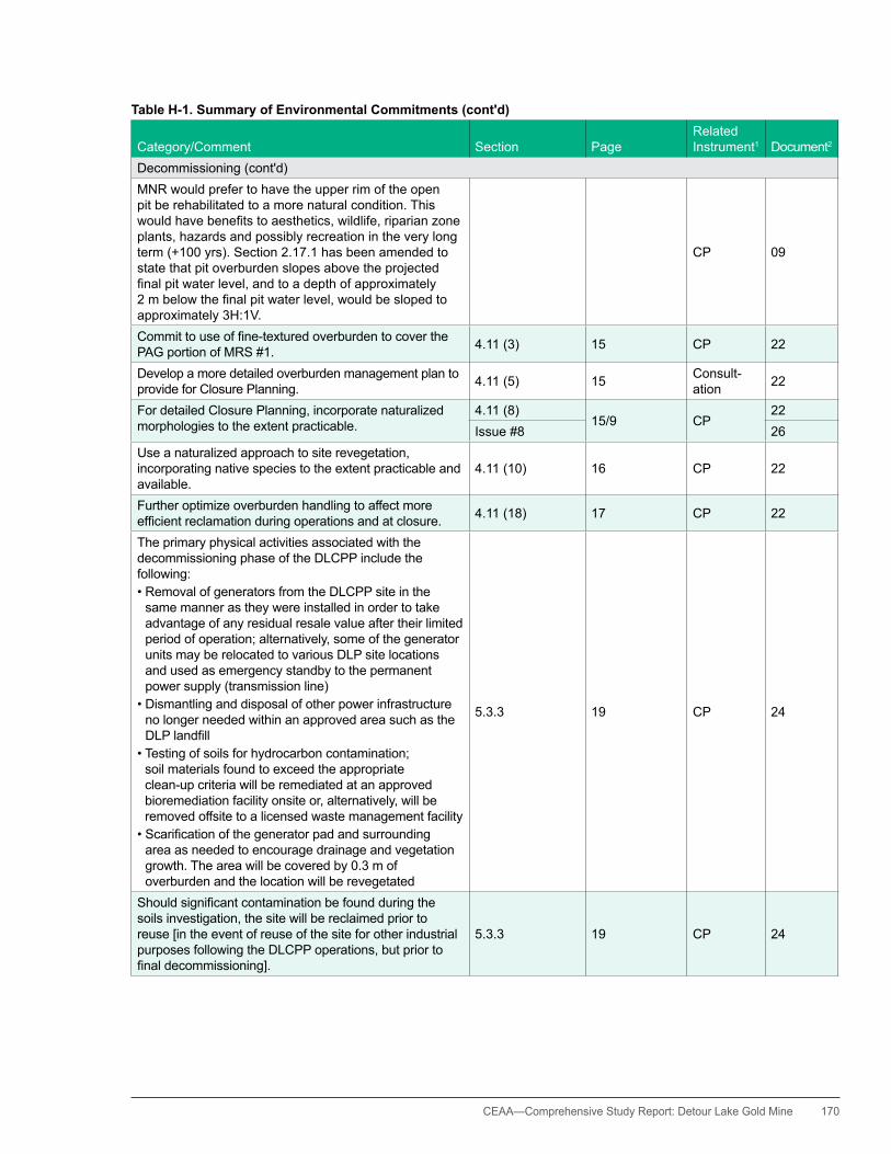
CEAA— Comprehensive Study Report: Detour Lake Gold Mine 170
Table H-1. Summary of Environmental Commitments (cont'd)
Category/Comment Section PageRelated Instrument1 Document2
Decommissioning (cont'd)MNR would prefer to have the upper rim of the open pit be rehabilitated to a more natural condition. This wouldhavebenefitstoaesthetics,wildlife,riparianzoneplants, hazards and possibly recreation in the very long term (+100 yrs). Section 2.17.1 has been amended to state that pit overburden slopes above the projected finalpitwaterlevel,andtoadepthofapproximately2mbelowthefinalpitwaterlevel,wouldbeslopedtoapproximately 3h:1V.
CP 09
Committouseoffine-texturedoverburdentocoverthePAG portion of MRS #1. 4.11 (3) 15 CP 22
Develop a more detailed overburden management plan to provide for Closure Planning. 4.11 (5) 15 Consult-
ation 22
For detailed Closure Planning, incorporate naturalized morphologies to the extent practicable.
4.11 (8)15/9 CP
22Issue #8 26
Use a naturalized approach to site revegetation, incorporating native species to the extent practicable and available.
4.11 (10) 16 CP 22
Further optimize overburden handling to affect more efficientreclamationduringoperationsandatclosure. 4.11 (18) 17 CP 22
The primary physical activities associated with the decommissioning phase of the DLCPP include the following:•RemovalofgeneratorsfromtheDLCPPsiteinthe
same manner as they were installed in order to take advantage of any residual resale value after their limited period of operation; alternatively, some of the generator units may be relocated to various DLP site locations and used as emergency standby to the permanent power supply (transmission line)
•Dismantlinganddisposalofotherpowerinfrastructureno longer needed within an approved area such as the DLPlandfill
•Testingofsoilsforhydrocarboncontamination;soil materials found to exceed the appropriate clean-up criteria will be remediated at an approved bioremediation facility onsite or, alternatively, will be removed offsite to a licensed waste management facility
•Scarificationofthegeneratorpadandsurroundingarea as needed to encourage drainage and vegetation growth. The area will be covered by 0.3 m of overburden and the location will be revegetated
5.3.3 19 CP 24
Shouldsignificantcontaminationbefoundduringthesoils investigation, the site will be reclaimed prior to reuse [in the event of reuse of the site for other industrial purposes following the DLCPP operations, but prior to finaldecommissioning].
5.3.3 19 CP 24
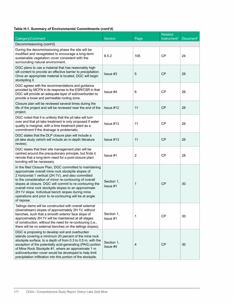
171 CEAA—Comprehensive Study Report: Detour Lake Gold Mine
Table H-1. Summary of Environmental Commitments (cont'd)
Category/Comment Section PageRelated Instrument1 Document2
Decommissioning (cont'd)During the decommissioning phase the site will be modifiedandrevegetatedtoencouragealong-termsustainable vegetation cover consistent with the surrounding natural environment.
8.5.2 105 CP 24
DGC plans to use a material that has reasonably high silt content to provide an effective barrier to precipitation. Once an appropriate material is located, DGC will begin stockpiling it.
Issue #3 5 CP 26
DGC agrees with the recommendations and guidance provided by MCFN in its response to the ESR/CSR in that DGC will provide an adequate layer of soil/overburden to provide a loose and permeable rooting zone.
Issue #4 6 CP 26
Closure plan will be reviewed several times during the life of the project and will be reviewed near the end of the project.
Issue #12 11 CP 26
DGC noted that it is unlikely that the pit lake will turn over and that pit lake treatment is only proposed if water quality is marginal, with a lime treatment plant as a commitment if the drainage is problematic.
Issue #13 11 CP 26
DGC states that the DLP closure plan will include a pit lake study (which will include an in-depth literature review).
Issue #13 11 CP 26
DGC states that their site management plan will be centredaroundtheprecautionaryprinciple,butfindsitremote that a long-term need for a post-closure plan/bonding will be necessary.
Issue #1 2 CP 28
InthefiledClosurePlan,DGCcommittedtomaintainingapproximate overall mine rock stockpile slopes of 2 horizontal:1 vertical (2h:1V), and also committed to the consideration of minor re-contouring of overall slopes at closure. DGC will commit to re-contouring the overall mine rock stockpile slopes to an approximate 2h:1V slope. Individual bench slopes during mine operations and prior to re-contouring will be at angle of repose.
Section 1,Issue #1
1 CP 30
Tailings dams will be constructed with overall external (downstream) slopes of approximately 2h:1V, without benches, such that a smooth exterior face slope of approximately 2h:1V will be maintained at all stages of construction, without the need for re-contouring (i.e., there will be no external benches on the tailings slopes).
Section 1,Issue #1
1 CP 30
DGC is proposing to develop soil and overburden islands covering a minimum 20 percent of the mine rock stockpile surface, to a depth of from 0.3 to 0.5 m, with the exception of the potentially acid-generating (PAG) portion of Mine Rock Stockpile #1, where an approximate 1 m soil/overburden cover would be developed to help limit precipitationinfiltrationintothisportionofthestockpile.
Section 1, Issue #4 4 CP 30

CEAA— Comprehensive Study Report: Detour Lake Gold Mine 172
Table H-1. Summary of Environmental Commitments (cont'd)
Category/Comment Section PageRelated Instrument1 Document2
Decommissioning (cont'd)Onceaggregateextractionceases,thefloodedpitwillbe reclaimed and connected to Karel Creek. 3.18 27
DFO Comp/Aggreg/CP
31
Atclosure,theoutletfromEastLakewillbereconfiguredtoprovideanextended,graduated,artificialcreekbedwith a slope angle of not greater than approximately 3percenttoallowfishpassageover(oraround)the dam structure.
3.18 28 DFO Comp/CP 31
OnlypredominantlyNAGrockfillmaterialswouldbeusedforconstruction,exceptwheredrainagecanbespecificallycontrolled to prevent the potential release of contaminants to the environment.
4.11 41 CP 31
Closure of the DLP site will be conducted per Ontario MiningActrequirementsandinaccordancewiththefiledclosure plan or as amended.
3.19.3 29 CP 31
The proponent is committed to encouraging and, as practical, restoring the DLP site to productive, naturalized vegetation communities on cessation of mining. This will involve the active revegetation of the mine site area using a combination of hydroseeding and hand planting of tree seedlings. Native seed mixes, where available commercially, will be used if practical.
7.1.11.3 127 CP 31
The proponent has committed to revegetate the mine site at closure to enhance the natural redevelopment of wildlife and plant habitats.
7.3.1.3 145 CP 31
At closure, disturbed areas at both the mine site and along the transmission line, except for that portion between Island Falls and Pinard, will be reclaimed to allow productive forest habitat to be developed.
7.3.1.4 148 CP 31
Overburden above and to a depth of about 2 m below theprojectedfinalpitwaterlevel,willbestabilizedandrevegetated to provide for aesthetics, wildlife use, and safety considerations.
12.0 195 CP 31
Drainage from the southern portion of MRS #1 will be directed to the open pit through a series of collection ditches during the post-closure period to manage acid rock drainage from the stockpile (if any).
12.0 195 CP 31
Aseparate,approved,landfillwillbeestablishedatclosure. 12.0 195
Prov CofA (waste disposal site)
31
Buildings, salvageable machinery and equipment, and surface pipelines will be dismantled, cleaned as appropriate,anddepositedwithintheonsitelandfill,unless sale is possible.
12.0 195 CP 31
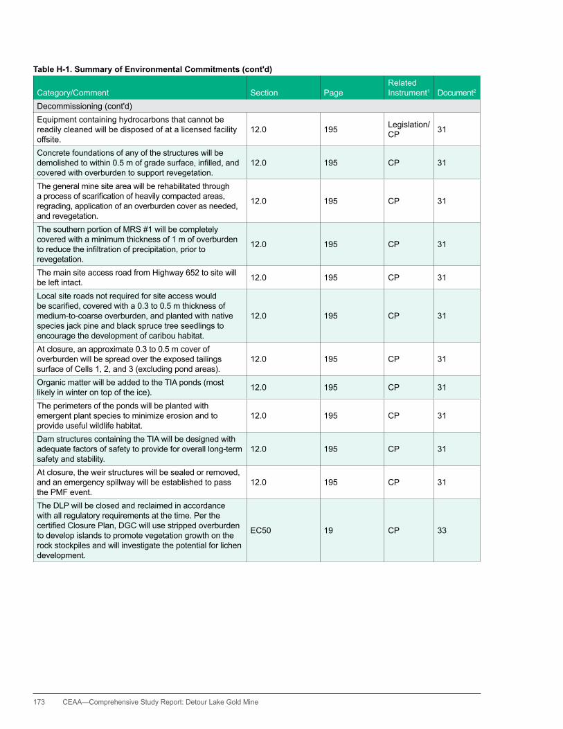
173 CEAA—Comprehensive Study Report: Detour Lake Gold Mine
Table H-1. Summary of Environmental Commitments (cont'd)
Category/Comment Section PageRelated Instrument1 Document2
Decommissioning (cont'd)Equipment containing hydrocarbons that cannot be readily cleaned will be disposed of at a licensed facility offsite.
12.0 195 Legislation/CP 31
Concrete foundations of any of the structures will be demolishedtowithin0.5mofgradesurface,infilled,andcovered with overburden to support revegetation.
12.0 195 CP 31
The general mine site area will be rehabilitated through aprocessofscarificationofheavilycompactedareas,regrading, application of an overburden cover as needed, and revegetation.
12.0 195 CP 31
The southern portion of MRS #1 will be completely covered with a minimum thickness of 1 m of overburden toreducetheinfiltrationofprecipitation,priortorevegetation.
12.0 195 CP 31
The main site access road from highway 652 to site will be left intact. 12.0 195 CP 31
Local site roads not required for site access would bescarified,coveredwitha0.3to0.5mthicknessofmedium-to-coarse overburden, and planted with native species jack pine and black spruce tree seedlings to encourage the development of caribou habitat.
12.0 195 CP 31
At closure, an approximate 0.3 to 0.5 m cover of overburden will be spread over the exposed tailings surface of Cells 1, 2, and 3 (excluding pond areas).
12.0 195 CP 31
Organic matter will be added to the TIA ponds (most likely in winter on top of the ice). 12.0 195 CP 31
The perimeters of the ponds will be planted with emergent plant species to minimize erosion and to provide useful wildlife habitat.
12.0 195 CP 31
Dam structures containing the TIA will be designed with adequate factors of safety to provide for overall long-term safety and stability.
12.0 195 CP 31
At closure, the weir structures will be sealed or removed, and an emergency spillway will be established to pass the PMF event.
12.0 195 CP 31
The DLP will be closed and reclaimed in accordance with all regulatory requirements at the time. Per the certifiedClosurePlan,DGCwillusestrippedoverburdento develop islands to promote vegetation growth on the rock stockpiles and will investigate the potential for lichen development.
EC50 19 CP 33

CEAA— Comprehensive Study Report: Detour Lake Gold Mine 174
Table H-1. Summary of Environmental Commitments (cont'd)
Category/Comment Section PageRelated Instrument1 Document2
Decommissioning (cont'd)The DLP will be closed and reclaimed in accordance with all regulatory requirements at the time. DGC will used stripped overburden and peat to facilitate reclamation and the regrowth of vegetation at the DLP as appropriate, with the use maximized in areas where the improved substrate quality is most required to ensure immediate growth and long-term sustainable vegetation cover.
EC51 19 CP 33
The stockpiles will be reclaimed in accordance with the MiningActandthecertifiedClosurePlan,includinguseof stockpiled overburden.
EC53 20 CP 33
Decommissioning of the DLCPP will be in accordance with thecertifiedmineClosurePlanfortheDLP.
Response to MOE(EA Branch)
Section 11.1 CP 35
Scarificationofthegeneratorpadandsurroundingareaas needed to encourage drainage and vegetation growth. The area will be covered by 0.3 m of overburden and the location will be revegetated.
Response to MOE(EA Branch)
Section 5.3.3 CP 35
ThesubsequentamendmenttothecertifiedClosurePlanthe include the following: CP 36
Surface Water/Aquatic Environment•Thefollowingadditionalonsitestationswillbeaddedtothe Years 1 to 3 surface water monitoring plan: a station within the open pit lake, when possible to begin sampling; a monitoring station in the MRS #1 Settling Pond; a monitoringstationforrunofffrombothonsitelandfills;amonitoring station in the North Aggregate Pit Pond; and a monitoring station in the QT5 Pond, if existing
CP 36
•Thefollowingadditionalbackground/receivingwaterquality stations will be added to the Years 1 through 10 surface water monitoring plan: an upstream site from TMA Cell 2 (the Easter Creek headwaters); and a monitoring station within the Won Lake watershed, since this is where TMA Cell 3 runoff travels, and the Won Lake watershed has had historical PWQO exceedences for cadmium, cobalt, lead, and iron, likely due to previous mining activities
•Temperatureandtotalphosphorusshouldbeaddedto the list of parameters to be measured at the monitoring stations, and that ph and temperature measurementsarecollectedinthefield
•Hydrocarbonparametersshouldbeaddedtotheanalytical parameter list for stations located within the DLP operations area (i.e., TMA discharge to East Lake, quarry and pit ponds)
•MonitoringofTMAseepageandstockpilerunoffin the long-term should continue beyond 10 years, (without the potential for ceasing monitoring), given that acid rock drainage may not manifest for several decades
CP 36
175 CEAA—Comprehensive Study Report: Detour Lake Gold Mine
Table H-1. Summary of Environmental Commitments (cont'd)
Category/Comment Section PageRelated Instrument1 Document2
Decommissioning (cont'd)•BeyondYear10,thesurfacewaterstationsinEast
Lake continue to be monitored, given that this lake is directly affected by the TMAs
•Themonitoringplanshouldincludemandatorymonitoringafterasignificantevent,(ifoneoccurs),suchasa100yearstorm,flood,orearthquake,ora catastrophic event, such as a tailings dam break, regardless of the given monitoring schedule at the timeofthesignificantevent
•Allmonitoringresultsshouldberetainedindefinitely,giventhattheopenpitiscurrentlynotexpectedtofillfor 120 years, and that concerns related to ARD may notpresentfor“severaldecades”
•Shouldwaterqualityconcernsbenoted(astriggeredby either upward trending toward non-compliance or exceedance of objectives or applicable guidelines used for comparison), the potential source will beinvestigated,andmethodsidentifiedandimplemented to remediate the potential cause and to improve water quality going forward, if appropriate
CP 36
Fisheries and Benthos•DGCwillensurethat,shouldtotheirknowledgetherebeanyhealthissuesrelatedtofishtissues(i.e.,exceedance of applicable Provincial guidelines), the TTNChiefwillbenotified
•Monitoringforaquatichealthshouldtakeplacefora period longer than 10 years and be triggered to also occur if there are concerns that arise from the reclamation monitoring (e.g., excess of chemicals in the groundwater). Therefore, should any concern arise during operation or closure that would suggest additional monitoring is appropriate, the closure plan will be amended accordingly
CP 36
Terrestrial•ReviseSection11.5VegetationCommunities—toinclude
a description of the types of vegetation communities, including general species composition, that DGC anticipates will develop across the rehabilitated site
•ReviseFigure11-2toshowhowrehabilitatedlandswillintegrate with adjacent naturally occurring vegetation communities
•ReviseSection11.5—AnimalCommunities—toincludea discussion of the rehabilitated areas with respect to the regionallandscapeandfunctionsidentifiedinSection4.7of the Terrestrial Baseline Report
•Establishpermanentvegetationmonitoringplotsinareasto be progressively rehabilitated throughout the project area. Examples of suitable locations for permanent monitoring plots include the reclaimed aggregate operations described in Section 6(i). Conduct annual monitoring throughout operation of the DLP, and into post-closure as described in Section 10(iii)
CP 36
CEAA— Comprehensive Study Report: Detour Lake Gold Mine 176
Table H-1. Summary of Environmental Commitments (cont'd)
Category/Comment Section PageRelated Instrument1 Document2
Decommissioning (cont'd)Terrestrial (cont'd)•Includeplantingsaplingsandshrubsaspartofthe
Proposed Revegetation Investigation Programs, with an emphasis on species that are characteristic of existing, naturally occurring vegetation communities in the project site. The revegetation program will be developed in detaillaterinminelife,afterin-fieldprogramshavebeenconducted
CP 36
Closure costs will be revisited in subsequent amendments to the Closure Plan, with an appropriate change to the closure bond if needed.
CP 36
1) Related Instrument Abbreviations
Aggreg Aggregate Permit (Ministry of Natural Resources)
CP Closure Plan (Ministry of Northern Development, Mines and Forestry)
CofA CertificateofApproval:air,domesticsewage, industrial sewage, waste disposal site (Ministry of the Environment)
DFO Comp Compensation Plan (Fisheries and Oceans Canada)
FRL Forestry Resource Licence (Ministry of Natural Resources)
LRIA Lakes and River Improvement Act (Ministry of Natural Resources)
MNR Fish License to Transport/Stock Fish (Ministry of Natural Resources)
PTTW Permit to Take Water (Ministry of the Environment)
WP Work Permit (Ministry of Natural Resources)
BMP Best Management PracticeConsultation General consultation commitmentLegislation Legal requirementNon-regulatory Monitoring not strictly associated monitoring with an instrument
2) See Appendix I for references for related documents.
Appendix I. References and Master List of Documents Issued by Detour Gold to Support the Comprehensive Study Report
1. Detour Lake Temporary Power Project (DLTPP). Class EA Document.
2. Detour Lake Power Project (DLPP). (Approved) Terms of Reference.
3. Detour Lake Power Project. Summary of EA Commitments from Table 12-1.
4. DLP–MNR Environmental Study Report. 5. Detour Lake Temporary Power Project
Environmental Review Report. Response to TTN/AECOM Comments.
6. Draft Ministry of Natural Resources Class EA Environmental Study Report— Response to Health Canada Comments.
7. Draft Ministry of Natural Resources Class EA Environmental Study Report— Response to MNDMF Comments.
8. Draft Ministry of Natural Resources Class EA Environmental Study Report— Response to MNO Comments.
9. Draft Ministry of Natural Resources Class EA Environmental Study Report— Responses to MNR Comments.

177 CEAA—Comprehensive Study Report: Detour Lake Gold Mine
10. Draft Ministry Of Natural Resources Class EA Environmental Study Report— Response to MOE Comments.
11. Draft Ministry Of Natural Resources Class EA Environmental Study Report— Response to TTN-AECOM Comments.
12. Draft Ministry of Natural Resources Class EA Environmental Study Report— Response to WFN Comments.
13. (Final) Ministry of Natural Resources Class EA Environmental Study Report— Response to AECOM Comments.
14. (Final) Ministry of Natural Resources Class EA Environmental Study Report—Response to MNR Cochrane District Comments.
15. (Final) Ministry of Natural Resources Class EA Environmental Study Report—Response to Environment Canada Comments.
16. Detour Lake Power Project, Individual EA—Response to MNO Comments.
17. Detour Lake Power Project, Individual EA—Response to MNR Comments.
18. Detour Lake Power Project, Individual EA—Response to MOE Comments.
19. Detour Lake Power Project, Individual EA—Response to TTN Comments (Initial and Follow Up Responses).
20. Detour Lake Power Project, Individual EA—Response to Wahgoshig First Nations Comments.
21. Detour Lake Power Project, Individual EA—Response to TTN Comments.
22. DLP Response to DPRA Comments on Final ESR.
23. DLCPP Terms of Reference (excluding commitments related to the proposed EA content).
24. DLCPP Individual EA. 25. Table 12-1, Summary of Commitments—
DLCPP EA. 26. DGC Meeting #1 – April 29, 2011.
Reclamation and Remediation Meeting (Attendees: MCFN/DPRA/AMEC/DGC).
27. DGC Project Meeting #2—May 3, 2011. Air Quality/ Water Quality/Water Quantity Issues (Attendees: DPRA/WESA/AMEC/DGC).
28. DGC Meeting #3—May 4, 2011. Fisheries and Aquatic Resources (Attendees: DPRA/MCFN/AMEC/DGC).
29. MCFN/AMEC Meeting—May 26, 2011. Outstanding Issues, Species at Risk and Caribou (Attendees: DPRA/MCFN/AMEC).
30. DLP Technical Memo, Prepared in Response to Outstanding Action Items in Follow-Up to Minutes Issued by DPRA on Behalf of the MCFN, July 20, 2011.
31. DLP Draft Comprehensive Study Report. 32. Response to FRT Comments. Table received
June 16, 2011—DFO (excludes comments related to working with the CEA Agency in regards to finalization of the CSR report).
33. Response to FRT Comments. Table received June 16, 2011—EC.
34. Response to FRT Comments. Table received June 16, 2011—NRCan
35. DLCPP Response to Government, Aboriginal. and Public Comments on Individual EA.
36. Response to AECOM/Taykwa Tagamou Nation Comments on draft CSR.
37. Intergovernmental meeting held on September 1, 2011.
38. Brown, G.S., F.F. Mallory, and J.W. Rettie. 2003. Range Size and Seasonal Movement for Female Woodland Caribou in the Boreal Forest of Northeastern Ontario. Rangifer Special Issue 14 (Proceedings of the Ninth North American Caribou Workshop, Kuujuak, Québec, 2001): 227–223.
39. Coker, G.A., C.B. Portt, and C.K. Minns. 2001. Morphological and Ecological Characteristics of Canadian Freshwater Fishes. Canadian Manuscript Report of Fisheries and Aquatic Sciences, 2554: iv + 89.
40. CPAWS Wildlands League. 2009. A Snapshot of Caribou Range Condition in Ontario. Special Report.
41. Donato, D.B., O. Nichols, H. Possingham, M. Moore, P.F. Ricci, and B.N. Noller. 2007. A Critical Review of the Effects of

CEAA— Comprehensive Study Report: Detour Lake Gold Mine 178
Gold Cyanide-bearing Tailings Solutions on Wildlife. Environment International, 33(7): 974–84.
42. Environmental Applications Group. 1983. Environmental Assessment Baseline Inventory (Vol. 1). Report Prepared for Detour Lake Joint Venture. Estimate Review Final Report. Detour Gold. Report Reference Number M09396A01
43. Environment Canada. 2010. Environment Canada Species at Risk Public Registry. Retrieved from http://www.sararegistry.gc.ca/default_e.cfm.
44. Federal Environmental Assessment Review (FEARO). 1994. A Reference Guide for Environmental Assessment: Determining Whether a Project is Likely to Cause Significant Adverse Environmental Effects.
45. Federal-Provincial-Territorial Committee on Climate Change and Environmental Assessment. 2003. Incorporating Climate Change Considerations in Environmental Assessment: General Guidance for Practitioners. Ottawa.
46. Gauthier, M. 2008, 2009, 2010. Personal communication. Cochrane District, Ministry of Natural Resources.
47. Intergovernmental Panel on Climate Change. 2006. Guidelines for National Greenhouse Gas Inventories, Volume 2: Energy. Prepared by the National Greenhouse Gas Inventories Programme. Eggleston, H.S., Buendia L., Miwa K., Ngara T. and Tanabe K. (Eds). Published: IGES, Japan.
48. Lorax Environmental. 2002. East Lake Water Quality Management Plan: Development of Site-Specific Water Quality Objectives for Copper. Status Report.
49. Ministry of the Environment (Ontario). 2008. Design Guidelines for Sewage Works. PIBS 6879.
50. Ministry of the Environment (Ontario). 2010. Guideline for Greenhouse Gas Emissions Reporting. PIBS 8024e.
51. Ministry of Natural Resources (Ontario).
2008. Let’s Fish. Retrieved July 2008 from www.mnr.gov.on.ca/en/Business/LetsFish/Publication/STEL02_163615.html in AMEC 2010. Detour Gold Project Socio-Economic Baseline.
52. Ministry of Natural Resources (Ontario). 2009. Draft Ontario Woodland Caribou Conservation Plan (for Consultation). April 27, 2009.
53. Ministry of Natural Resources (Ontario). 2010. Caribou Range Analysis: Disturbance Analysis Cochrane and Nipigon (Draft).
54. Mushkegowuk Environmental Research Centre. 2010. Detour Traditional Ecological Knowledge Study. Draft 1.3.
55. Schaefer, J.A., C.M. Bergman, and S.N. Luttich. 2000. Site Fidelity of Female Caribou at Multiple Spatial Scales. Landscape Ecology,15:731–39.
56. White Spruce Archaeology. 2010. Stage 2 Archaeological Assessment: Detour Lake Mine Site and Associated Transmission Line.
57. Woodland Heritage Services Limited. 2010a. Stage 1 and 2 Archaeological and Cultural Heritage Resource Assessment of the Detour Gold Mine Site Development Areas, Cochrane District. Prepared for Moose Cree First Nation, c/o Detour Gold. Draft.
58. Woodland Heritage Services Limited. 2010b. Traditional Knowledge-based Stage 2 Archaeological and Cultural Heritage Resource Assessment of the Western Section of the Proposed Hydro Line Corridor Connecting Pinard Transformer Station to the Detour Mine via Island Falls Generating Station, Cochrane District. Prepared for Tagamou Nation c/o Detour Gold.
59. Ministry of the Environment (Ontario). Draft Certificate of Approval for the Industrial Sewage Works, 2010.
60. AMEC 2011. Application for the Permit to Take Water. Pit Dewatering, August 2011.
61. DLP-0. Draft Comprehensive Study Report (for Government Review), February 11, 2011.
179 CEAA—Comprehensive Study Report: Detour Lake Gold Mine
62. DLP-1. Fish Community Summary and Potential Mine Facilities for the Proposed Detour Lake Project, September 12, 2008.
63. DLP-2. Detour Lake Project, Project Description, Draft for Discussion, May 2009.
64. DLP-3. Detour Lake Project, Project Description, July 8, 2009.
65. DLP-4. Letter—July 8, 2009, East Lake Polishing Pond and East Creek: Spring Walleye Spawning Survey Results. Detour Lake Project, September 11, 2009.
66. DLP-5. Response to DFO Request for Additional Information. Detour Lake Project, September 11, 2009.
67. DLP-6, AMEC (2009a). Detour Lake Project, Climate and Air Quality Baseline Study. September 16, 2010.
68. DLP-7, AMEC (2009b). Detour Lake Project, 2008 Aquatic Resources Baseline Study. September 16, 2010.
69. DLP-8, AMEC (2009c). Detour Lake Project, Hydrogeology Baseline Study. September 16, 2010.
70. DLP-9, AMEC (2009d). Detour Lake Project, Terrestrial Resources Baseline Study. September 16, 2010.
71. DLP-10. Letter—September 28, 2009. Existing Open Pit Habitat and Fish Community Results. Detour Lake Project, September 28, 2009.
72. DLP-11. Letter—October 21, 2009. Response to DFO Request for Additional Information on Open Pit Dewatering. Detour Lake Project, October 21, 2009.
73. DLP-12. Memo—December 9, 2009. Project Update on mill tonnage and tailings management alternatives. Detour Lake Mine, December 9, 2009.
74. DLP-13, AMEC (2009e). Detour Lake Project, Individual Environmental Assessment, Main Power Supply for the Proposed Detour Lake Project, Proposed Terms of Reference, November 19, 2009.
75. DLP-14, AMEC (2009f). Detour Lake Project, Individual Environmental Assessment, Main Power Supply for the
Proposed Detour Lake Project, Proposed Terms of Reference Record of Consultation, November 19, 2009.
76. DLP-15, AMEC (2009g). Memo to Steve Woolfenden—CEAA and Melissa Preston; MPMO from Dave Simms, Re: Potential Downstream Environmental Effects to Québec First Nations. Detour Lake Project, August 4, 2009.
77. DLP-16, AMEC (2010a). 2009 Aquatic Resources Baseline Report. Detour Lake Project, August 4, 2009.
78. DLP-17, AMEC (2010b). Metal Leaching and Acid Rock Drainage Characterization Report, August 2010. Detour Lake Project, September 16, 2010.
79. DLP-18, AMEC (2010d). Detour Lake Project, Project Description (Rev.1), January 18, 2010
80. DLP-19. Detour Lake Project, Draft Environmental Study Report, April 29, 2010.
81. DLP-20, AMEC (2010f). Detour Lake Project, Tailings, Mine Rock. and Overburden Management. Feasibility Study Design Update Report, October 22, 2010.
82. DLP-21, AMEC (2010g). Detour Lake Project, Mine Closure Plan (for Production), September 16, 2010.
83. DLP-22, AMEC (2010h). Detour Lake Power Project, Individual Environmental Assessment, 230 kV Transmission Line Power Supply, April 26, 2010.
84. DLP-23, AMEC (2010i). Detour Lake Temporary Power Project (Construction Power), Environmental Review Report, June 10, 2010.
85. DLP-24, AMEC (2010j). Detour Lake Project. Environmental Study Report, MNR Class EA, August 13, 2010.
86. DLP-25, AMEC (2010k). Detour Lake Contingency Power Project, Individual Environmental Assessment, Contingency Power Supply for the Proposed DLP, Proposed Terms of Reference, August 30, 2010
87. DLP-26, AMEC (201l). Detour Lake Contingency Power Project, Individual

CEAA— Comprehensive Study Report: Detour Lake Gold Mine 180
Environmental Assessment, Contingency Power Supply for the Proposed DLP, Proposed Terms of Reference, Record of Consultation, August 30, 2010.
88. DLP-27. Report—January 2010. Detour Lake Project Draft Consultation Framework for Federal and Ontario Environmental Assessments, January 2010.
89. DLP-28, Memo—January 25, 2010. Current Surface Water Drainage Direction and Ground Elevations in Relation to the Existing Tailings Pond. Detour Lake Project, January 25, 2010.
90. DLP-29, Letter—July 8, 2010. Request for Clarification that the Detour Lake Project Existing Tailings Facility is not a Natural Water Body Frequented by Fish and Would not Require an Amendment to Schedule 2 of the Metals Mining Effluent Regulations, July 8, 2010.
91. DLP-30. Cross-sections for site area; Figures 1, 2, 3, and 4, per request of Environment Canada, January 26, 2011.
92. DLP-31. Letter—December 21, 2010. Proposed Tailings Impoundment Area Cell 3 Fish Habitat and Fish Community Results. Detour Lake Project, December 21, 2010.
93. DLP-32. Easter Creek and Karel Creek Waterway Summaries, March 4, 2011.
94. DLP-33. Certificate of Approval Amendment Detour Lake Project Tailings Management Area, March 4, 2011.
95. DLP-34. Site Plan with Watershed Boundaries, March 4, 2011.
96. DLP-35. Assessment of Alternatives for Tailings Storage, March, 7, 2011.
97. DLP-36. Memo to DFO regarding Proposed Stockpiles and Fish, April 1, 2011.
98. DLP-37. 2008 Geotechnical Investigation, April 21, 2011.
99. DLP-38, Gibson (1983). Hydrogeological Investigation of Mine Seepage Control, April 21, 2011.
100. DLP-39, Pakalnis (1999). Geotechnical Assessment of the Detour Lake Mine Open Pit: Mine Closure, April 21, 2011.
101. DLP-40, Klohn-Crippen (1993). Preliminary Hydrogeological Study, April 21, 2011.
102. DLP-41, Golder (2008). Preliminary Pit Slope Design, April 21, 2011.
103. DLP-42, Watts, Griffis and McOuat (2008). Technical Report and Mineral Resource Estimate Update for the Detour Lake Mine Option Property, April 21, 2011.
104. DLP-43. Detour Lake Project Technical Memorandum prepared in response to comments received on the draft Comprehensive Study Report—Runoff and Seepage Collection, June 23, 2011.
105. DLP-44. Detour Lake Project Technical Memorandum prepared in response to comments received on the draft Comprehensive Study Report—Ecological and Health Risk Considerations, June 22, 2011.
106. DLP-45. Response to Comment EC32 from Federal Review Team Comments (June 1, 2011), Detour Lake Gold Mine, June 23, 2011.
107. DLP-46, Lorax (2011). Detour Pit Lake Water Quality Considerations and Options for Dewatering, June 23, 2011.
108. DLP-47, Minnow (2008). Detour Lake Mine, 2007 Aquatic Environmental Effects Monitoring Program, June 23, 2011.
109. DLP-48, Golder (2011). Technical Memorandum (June 27, 2011), Influence of Seismic Loading on Pit Slope Stability, June 30, 2011.
110. DLP-49. Detour Lake Project Technical Memorandum prepared in response to comments received on the draft Comprehensive Study Report—Hydrology, June 30, 2011.
111. DLP-50. Detour Lake Project Technical Memorandum prepared in response to comments received on the draft Comprehensive Study Report—Migratory Birds, June 30, 2011.
112. DLP-51, Detour Lake Project Technical Memorandum prepared in response

181 CEAA—Comprehensive Study Report: Detour Lake Gold Mine
to comments received on the draft Comprehensive Study Report—Hydrogeology Aspects, July 5, 2011.
113. DLP-52. Response to Federal Review Team Comments. Table received June 16, 2011, Detour Lake Gold Mine (four tables: Environment Canada, Health Canada, Fisheries and Oceans Canada and Natural Resources Canada), June 30, 2011.
114. DLP-53. Assessment of Alternatives for Tailings Storage at the Detour Lake Project, Rev. 1, July 19, 2011.
115. DLP-54. Additional Response to Federal Review Team Comments. Table received June 16, 2011, Detour Lake Gold Mine (Environment Canada(2), July 19, 2011.
116. DLP-55. Operational Area (revised) per Comment EC10, July 19, 2011.
117. DLP-56. Approximate Discharge Locations Figures, per DFO request, July 21, 2011.
118. DLP-57. Assessment of Alternatives for Waste Rock Storage at the Detour Lake Project, July 21, 2011.
119. DLP-58. Draft Fish Habitat Compensation Plan, Section 35, Authorizations. Detour Lake Project, July 22, 2011.
120. DLP-59. Draft Fish Habitat Compensation Plan, Schedule 2, Amendment, Waterbodies, July 22, 2011.
121. DLP-60. Master List of DLP Commitments Draft to Federal Review Team, July 27, 2011.
122. DLP-61. Response to NRCan Additional Information Request, July 27, 2011.
123. DLP-62. Master List of DLP Commitments. Revised Draft to Federal Review Team, August 5, 2011.
124. DLP-63. Assessment of Water Quality Impacts on Receiving Waters Associated with New Trenching Plan. Response to Environment Canada, August 12, 2011.
125. DLP-64. Draft Response to the Environment Comments of August 12, 2011, Regarding the Detour Lake Project, August 30, 2011.
126. DLP-65. Response to Environment Canada’s Letter of August 12, 2011, September 15, 2011.
127. DLP-66. Response to DFO Comments of August 12, 2011 on documents DLP-58 and DLP-59. Draft Fish Habitat Compensation Plans, September 15, 2011.
128. DLP-67. Response to NRCan August 25, 2011 Comments Table, September 16, 2011.
129. DLP-68. Mine Rock Stockpile Adaptive Management Program, September 29, 2011.
130. DLP-69. Consolidated Commitments by Category. Detour Lake Project, September 29, 2011.
131. DLP-70. Response to Washaganish on Biotactic report, Potential Impacts of Detour Lake Gold Mine Effluent on Lake Sturgeon (Acipenser fulvescens) in the Harricana River Basin, October 7, 2011.
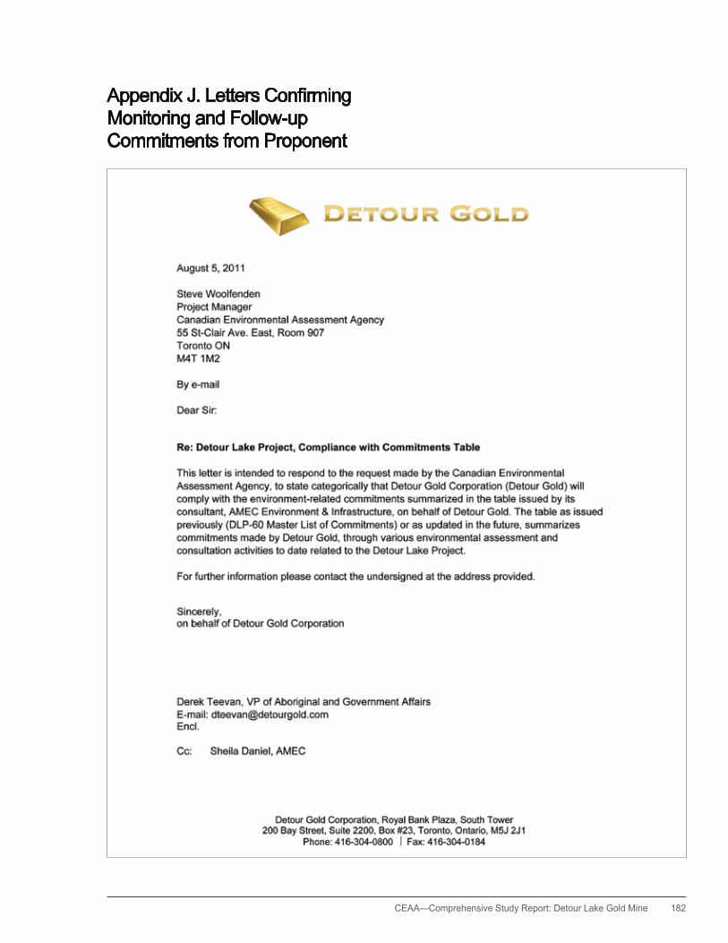
CEAA— Comprehensive Study Report: Detour Lake Gold Mine 182
AppendixJ.LettersConfirmingMonitoring and Follow-up Commitments from Proponent
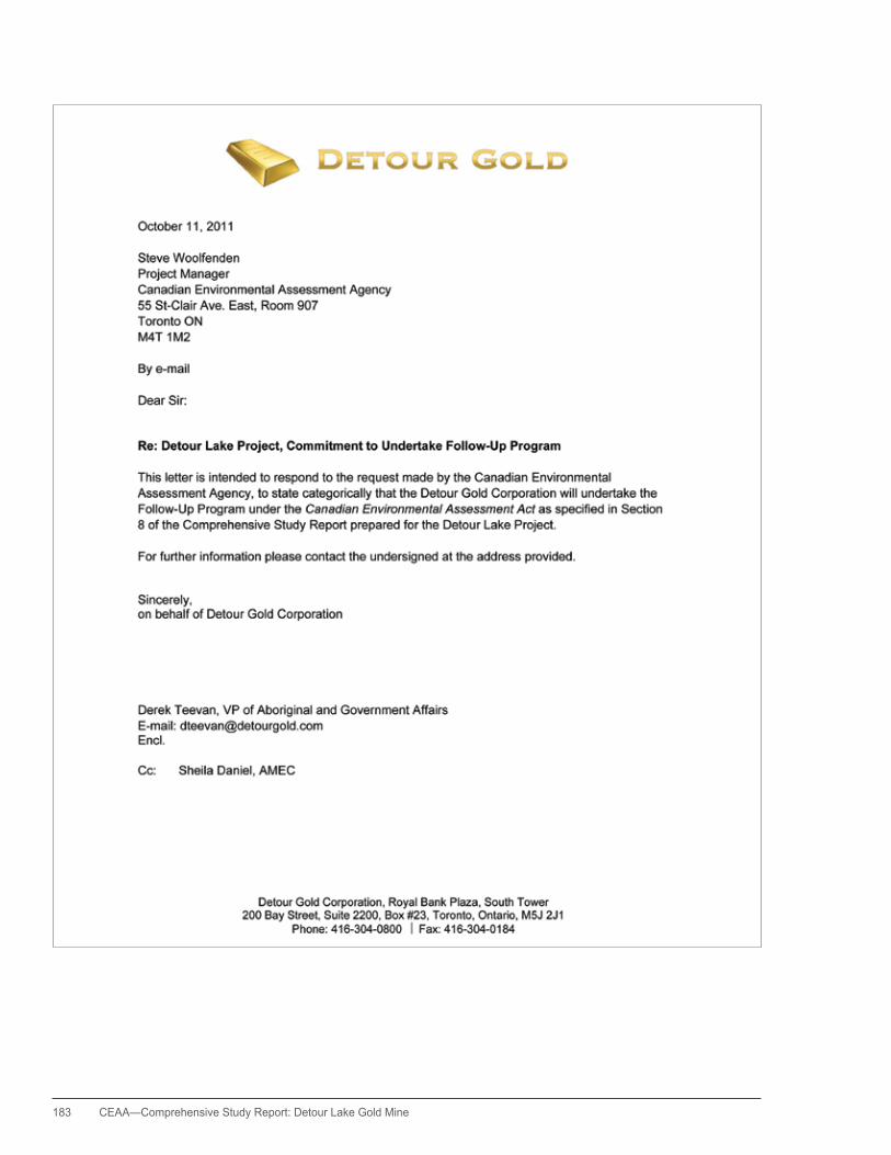
183 CEAA—Comprehensive Study Report: Detour Lake Gold Mine

CEAA— Comprehensive Study Report: Detour Lake Gold Mine 184
Related Documents


