Welcome message from author
This document is posted to help you gain knowledge. Please leave a comment to let me know what you think about it! Share it to your friends and learn new things together.
Transcript
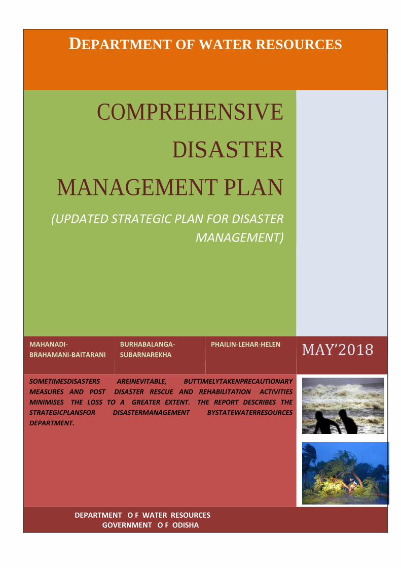
DEPARTMENT OF WATER RESOURCES
COMPREHENSIVE
DISASTER
MANAGEMENT PLAN (UPDATED STRATEGIC PLAN FOR DISASTER
MANAGEMENT)
MAHANADI-
BRAHAMANI-BAITARANI
BURHABALANGA-
SUBARNAREKHA
PHAILIN-LEHAR-HELEN
MAY’2018
SOMETIMESDISASTERS AREINEVITABLE, BUTTIMELYTAKENPRECAUTIONARY
MEASURES AND POST DISASTER RESCUE AND REHABILITATION ACTIVITIES
MINIMISES THE LOSS TO A GREATER EXTENT. THE REPORT DESCRIBES THE
STRATEGICPLANSFOR DISASTERMANAGEMENT BYSTATEWATERRESOURCES
DEPARTMENT.
DEPARTMENT O F WATER RESOURCES
GOVERNMENT O F ODISHA
DEPARTMENT OFWATER RESOURCES, GOVERNMENT OFODISHA
COMPREHENSIVE DISASTER MANAGEMENT PLAN
MAY’2018
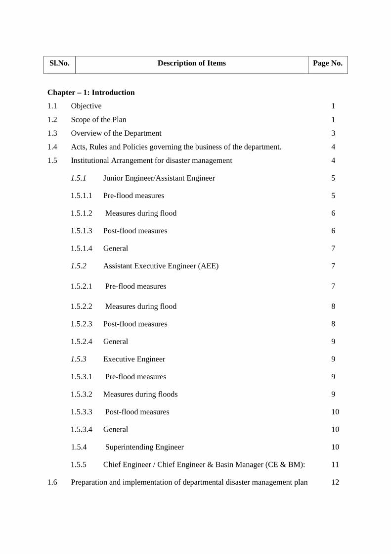
Sl.No. Description of Items Page No.
Chapter – 1: Introduction
1.1 Objective 1
1.2 Scope of the Plan 1
1.3 Overview of the Department 3
1.4 Acts, Rules and Policies governing the business of the department. 4
1.5 Institutional Arrangement for disaster management 4
1.5.1 Junior Engineer/Assistant Engineer 5
1.5.1.1 Pre-flood measures 5
1.5.1.2 Measures during flood 6
1.5.1.3 Post-flood measures 6
1.5.1.4 General 7
1.5.2 Assistant Executive Engineer (AEE) 7
1.5.2.1 Pre-flood measures 7
1.5.2.2 Measures during flood 8
1.5.2.3 Post-flood measures 8
1.5.2.4 General 9
1.5.3 Executive Engineer 9
1.5.3.1 Pre-flood measures 9
1.5.3.2 Measures during floods 9
1.5.3.3 Post-flood measures 10
1.5.3.4 General 10
1.5.4 Superintending Engineer 10
1.5.5 Chief Engineer / Chief Engineer & Basin Manager (CE & BM): 11
1.6 Preparation and implementation of departmental disaster management plan 12
Chapter – 2: Hazard, Risk and Vulnerability Analysis
2.1 Historical/past disaster/losses in the department 14
2.2 Emerging Concerns 22
Chapter-3: Capacity – Building Measures
3.1 Trainings and Capacity Building 23
3.2 Community Awareness and Community Preparedness Planning 23
3.3 Capacity Building of Community Task forces 24
3.4 Sustainable Management 25
3.5 Mitigation 25
3.6 DRR Master Planning for the Future 25
3.6.1 Community Engagement 26 3.6.2 Organizing Teams 26
3.7 Mitigation Capacity Building Needs & Workshop Planning 26
3.8 Workshop Planning. 26
3.9 Capacity Building 26
Chapter – 4: Prevention & Mitigation Measures
4.1 General 30
4.2 Flood control in Mahanadi Basin 30
4.3 Flood Control in Baitarani Basin 32
4.4 Flood Control in Brahmani Basin 34
4.5 MEASURES 36
4.5.1 Structural Measure 36
4.5.2 Non-structural Measures 36
4.5.3 Institution and Community 37
4.5.4 Launching of Flood Forecasting Model for Department 38
of Water Resources, Odisha
4.5.5 Structural Measures for Flood Control 39
4.6 Risk Analysis 42
4.6.1 Assessing Flood Probabilities 42
4.6.2 Flood Modelling of Rivers 42
4.6.3 Storm-surge Modelling for Hurricanes and Cyclones 42
Chapter – 5: Historical Events and Basin Wise Flood Management
5.1 Flood Damage Statistics 43
5.2 Flood Fighting 43
5.2.1 Measures taken during Phailin (2013) 44
5.2.2 Vulnerable Locations for 2013 50
5.2.3 Vulnerable Locations for 2014 50
5.2.4 Vulnerable Locations for 2015 51
5.2.5 Vulnerable Locations for 2016 52
5.2.6 Vulnerable Locations for 2017 53
5.3 Rainfall Distribution 54
Chapter – 6: Preparedness (For the current year)
6.1 General 60
6.2 Activities 60
6.3 Flood Preparedness-2018 64
6.4 Budget provision-2018 64
6.5 Physical Action to be taken by Officials 66
6.6 Long Term Actions and Responsibility 70
6.7 Dams and their Emergency Action Plan 71
6.7.1 Why Dam Fails? 71
6.7.2 How to keep a watch on Dam Condition? 72
6.7.2.1 Brief history of the dam and salient features 72
6.7.2.2 Assessment of Health Status 72
6.7.2.3 Reservoir operation 72
6.7.2.4 Instrumentation 73
6.7.2.5 Emergency Situations, Signs of Failure and Classification 73
6.7.3 How to get prepared before a Dam Failure 75
6.7.3.1 Preparedness 75
6.7.3.2 Warning System 76
6.7.3.3 Communication System 77
6.7.3.4 Availability of machines, materials & labour 78
6.7.3.5 Dam Security Arrangement 78
6.7.3.6 Review, Update and Validation 78
6.7.4 What to do during a flood? 78
6.7.4.1 Local Evacuation Plan 78
6.7.5 Implementation 79
6.8 Scientific Assessment of Flood Prone Areas Pilot Project 79
at Burhabalanga Basin
6.9 Knowledge Management 80
6.10 Points for Open Discussions 81
6.10.1 Embankment Free Flood Plain 81
6.10.2 De-commissioning of Older Dams 81
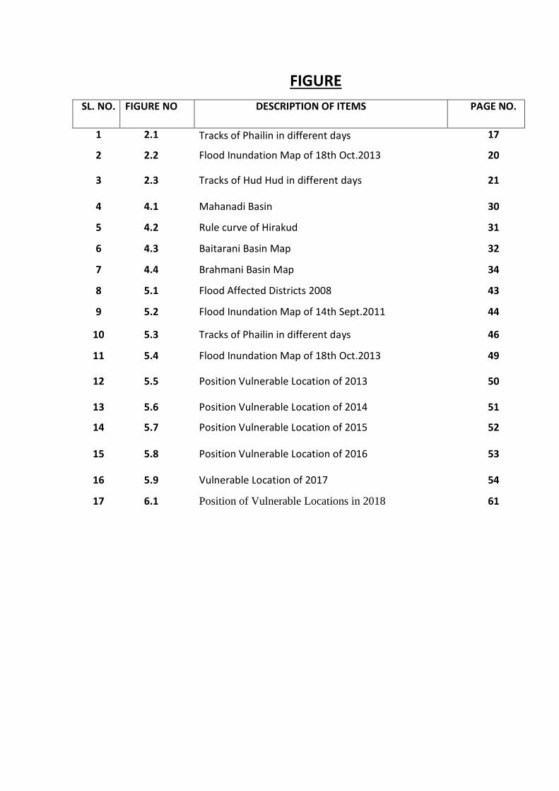
FIGURE
SL. NO. FIGURE NO DESCRIPTION OF ITEMS PAGE NO.
1 2.1 Tracks of Phailin in different days 17
2
2.2 Flood Inundation Map of 18th Oct.2013
20
3 2.3 Tracks of Hud Hud in different days 21
4 4.1 Mahanadi Basin 30
5 4.2 Rule curve of Hirakud 31
6 4.3 Baitarani Basin Map 32
7 4.4 Brahmani Basin Map 34
8 5.1 Flood Affected Districts 2008 43
9 5.2 Flood Inundation Map of 14th Sept.2011 44
10 5.3 Tracks of Phailin in different days 46
11 5.4 Flood Inundation Map of 18th Oct.2013
49
12 5.5 Position Vulnerable Location of 2013 50
13 5.6 Position Vulnerable Location of 2014 51
14 5.7 Position Vulnerable Location of 2015 52
15 5.8 Position Vulnerable Location of 2016 53
16 5.9 Vulnerable Location of 2017 54
17 6.1 Position of Vulnerable Locations in 2018 61
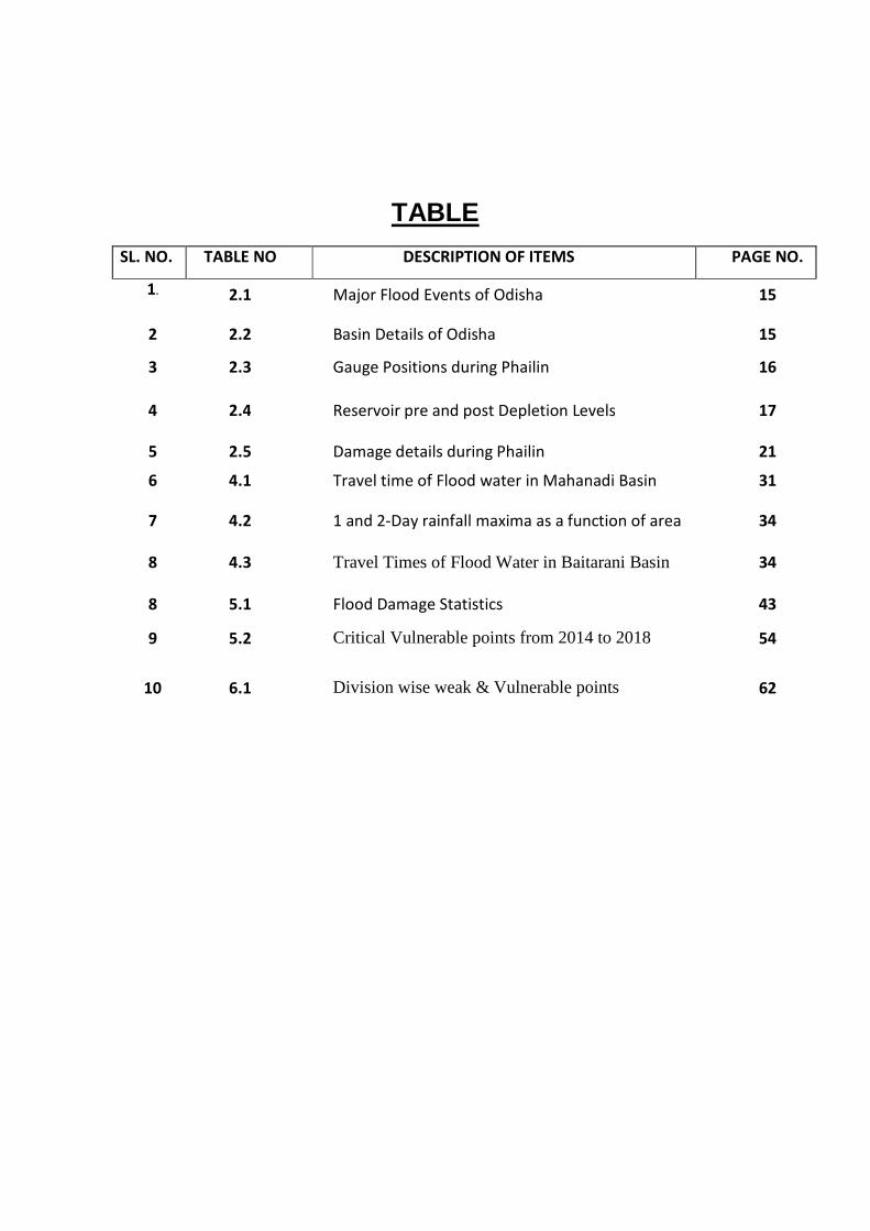
TABLE
SL. NO. TABLE NO DESCRIPTION OF ITEMS PAGE NO.
1.
2.1 Major Flood Events of Odisha 15
2 2.2 Basin Details of Odisha 15
3 2.3 Gauge Positions during Phailin 16
4 2.4 Reservoir pre and post Depletion Levels 17
5 2.5 Damage details during Phailin 21
6 4.1 Travel time of Flood water in Mahanadi Basin 31
7 4.2 1 and 2-Day rainfall maxima as a function of area
34
8 4.3 Travel Times of Flood Water in Baitarani Basin 34
8 5.1 Flood Damage Statistics 43
9 5.2 Critical Vulnerable points from 2014 to 2018 54
10 6.1 Division wise weak & Vulnerable points 62
1
1. INTRODUCTION
1.1 OBJECTIVE
Objective of this plan is to define the actions and roles necessary to prepare for and respond to
any disaster situation in a coordinated manner. The Departmental Disaster Management Plan
helps the Department to assess its own capacity in terms of available resources and get ready to
mitigate any unexpected disaster effectively and to prevent the loss of human lives and property
through preparedness, prevention & mitigation of disasters. It helps to know the standard
operating procedures of the department at the time of disaster. The role and responsibility of each
and every officer can be detected at the time of disaster. It also helpful to develop immediate and
long-term support plans for vulnerable people in/during disasters.
1.2 SCOPE OF THE PLAN
Odisha had faced number of natural disasters like flood, cyclone, drought, lightening, coastal
erosion etc. Any disaster will cause innumerable miseries, loss of life and appreciable economic
loss to the state. The Disaster Management Plan is intended to guide the concerned officers in
identifying, monitoring, responding to and mitigating the emergency situations. It is also useful to
assist the officials to take immediate action in a critical situation, before getting a formal approval
from higher authorities.
Scope of the plan is to protect and preserve human life, health and well-being. Minimize damage
to the natural environment. Minimize loss, damage or disruption to the facilities, resources and
operations. Manage immediate communications and information regarding emergency response
operations and campus safety. Provide essential services and operations. Provide and analyze
information to support decision-making and action plans
Plan Objectives:
The objectives of this plan are to:
Organisation
a. Provide clear and easy-to-follow checklist based guidelines for the most critical functions
and liaisons during an emergency response.
b. Provide an easy to follow plan design in which users can quickly determine their role,
responsibilities and primary tasks.
c. Link and coordinate processes, actions and the exchange of critical information into an
efficient and real-time overall response so that stakeholders are informed of the emergency
response process and have access to information about what is occurring.
2
d. Provide clear and easy-to-follow checklist based guidelines.
Communications and Information Management
a. Serve as the central point of communications both for receipt and transmission of urgent
information and messages.
b. Serve as the official point of contact during emergencies when normal communication
channels are interrupted.
c. Provide 24-hour communication services for voice, data and operational systems.
d. Collect and collate all disaster related information for notification, public information,
documentation and post-incident analysis.
e. Provide a basis for training staff and organizations in emergency response management.
f. Decision Making - Determine, through a clear decision-making process, the level of
response and the extent of emergency control and coordination that should be activated
when incidents occur.
Response Operations
a. Utilize the resources to implement a comprehensive and efficient emergency management
response team.
b. Be prepared with a pro-active emergency response management action plan that provides
the possibilities and eventualities of emerging incidents.
Recovery Operations
a. Transition response operations to normal management and operational processes, as able.
b. Support business resumption plans and processes, as needed, during restoration phases.
c. Types and Levels of Crisis - Limited Crisis. A limited crisis, within the scope of
this plan, is any incident,
• Identify vital records and create a backup for storage in a safe place.
• Train employees on what to do in the event of a disaster.
• Compile and make employees aware of a list of emergency telephone Res. numbers.
• Inventory and repair all disaster response equipment.
3
• Identify emergency power requirements, and purchase a generator, if necessary.
• Determine computer requirements for employees who must maintain operations during a
disaster.
• Verify that communications equipment is operational.
• Collect, label, and store emergency supplies.
• Ensure that your facility is in compliance with any legal or regulatory requirement
1.3 OVERVIEW OF THE DEPARTMENT
The state Odisha is vulnerable to multiple disasters. Due to its topography, river networks, sub-
tropical littoral location, the State is prone to heavy floods, tropical cyclone forced rainfall and
storm surges. The state has 11 river basins and the basin details are given in Table below. Its
densely populated coastal plains are the alluvial deposits of its river systems. Each basin is
managed by a CE and Basin Manager under whom numbers of SEs ,EEs,DEEs and AEEs are
posted. The structure of engineers under a basin is pyramidal.
Water has always played a major role in human societies. It is literally a source of life and
prosperity and a cause of death and devastation. Because of this close relationship between water
and man, water resources management has been viewed as a crucial vehicle for socio-economic
development. Water resources development in the state was taken up in the late 19th century to
curb the destructive effects of water, particularly the devastating floods of river Mahanadi.
Though some noticeable works were done during the nineteenth and early twentieth century,
concerted efforts were not attempted to remove regional disparity. Large parts of the state
continued to remain in the grip of flood and famine in the pre-independence period. After
independence, water resources development was given top priority in national agenda. Water
being a State subject, State Governments were encouraged to invest heavily in hydraulic
infrastructure in order to promote growth, mitigate risk and alleviate poverty. At the initial stages,
in Odisha, major & medium irrigation project works were under Public Works Department &
minor (flow) irrigation works under the control of Revenue Department. In the year 1962, a
separate Department called Irrigation and Power was set up to expedite the construction work of
major and medium irrigation projects. Minor irrigation works were transferred to Rural
Engineering Organization (REO) formed under Planning & Co-ordination Department. In 1980,
the R.E.O was abolished and Minor Irrigation activities were transferred to the Irrigation and
Power Department. The year 1990 witnessed major changes in Secretariat Administration,
resulting in the reorganization of departments and creation of several new departments. A new
4
department called Rural Development Department was created and Irrigation & Power
Department was split into Department of Irrigation and Department of Energy. Major and
Medium Irrigation remained with the Department of Irrigation, power generation went to the
Department of Energy; Minor irrigation works were transferred to R.D. Department. In the
meantime, other sectoral demands of water such as domestic and urban agglomeration, industrial
have been increased considerably, which warranted an integrated water resources development
and management approach. To face the challenge, first National Water Policy was framed in
1987. Following the principles of National Water Policy, the State Water Policy was framed in
1994, which underscores the need of a coordinated approach to the state’s water resources
development. Administrative initiatives were taken to bring all water-related subjects under one
umbrella, and in the year 1994,Irrigation Department was restructured as Water Resources
Department, which became the nodal department with regard to all matters concerning the State’s
water resources.
1.4 ACTS, RULES AND POLICIES GOVERNING THE BUSINESS OF THE DEPARTMENT. Generally OPWD code is followed for construction and maintenance works. For world bank
aided project world bank guide line is followed for works consultancy and goods procurement. E
procurement method of bidding is followed in state for maintaining transparency. State disastrous
Mitigation Guide line is followed for management of Flood disasters and other critical events.
Disaster Score Cards will be used to assess the resilience of states to disasters.
1.5 INSTITUTIONAL ARRANGEMENT FOR DISASTER MANAGEME NT
DUTIES AND RESPONSIBILITIES OF OFFICERS IN FLOOD M ANAGEMENT
Pre-flood maintenance of flood infrastructure and flood preparedness before the onset of
monsoon plays a vital role in the smooth management of high flood situations. When the river is
in spate, the embankment requires close and constant watch and unremitting day and night
supervision by adequate trained staff and officers. Efficient and constant patrolling with timely
warning and timely action alone can avert a situation leading to disaster. During this period
inspection by the senior officials will have to be carried out systematically and all the officers
concerned and staff will have to remain alert to meet any emergent situation. The establishment
required for this purpose will vary depending upon importance of the embankment and behavior
of the river. The temporary headquarters of the Junior Engineer, Assistant Engineer, Assistant
Executive Engineer and Executive Engineer are to be located near the vulnerable and important
reaches of the embankment under his/her charge.
The duties and responsibilities of the officers for smooth management of the flood are as under.
5
1.5.1 Junior Engineer/Assistant Engineer.
A Junior Engineer/Assistant Engineer is responsible for efficient flood management within
his/her jurisdiction. A high level of alertness and resourcefulness are expected from the Junior
Engineer/Assistant Engineer for the above purpose. He should essentially be faithful to the
Government and get thoroughly involved in all activities and discharge his duties sincerely.
He is entrusted with the following responsibilities.
1.5.1.1 Pre-flood measures
• Identification of vulnerable points, weak embankments and other problematic areas.
• Survey, investigation and preparation of estimates for raising and strengthening of
embankments to design section, treatment of all piping points noticed during previous floods
as per records maintained in the register, all flood protection works, procurement of flood
fighting materials required for the embankments in his charge by 20th April.
• He/She will see that all departmental vehicles, boats, lunches are in working condition. He
will also arrange all tools and equipment like torch, hurricane lamps, spades, etc. by 15th
May.
• His/Her duty comprises timely and efficient execution and completion of temporary /
permanent flood protection works, repair of embankments to design section, breach closing
works, treatment of gauge posts by painting, greasing etc. and collection of flood fighting
materials at site by 1st week of June.
• The gates of all major, medium and minor dams, drainage sluice and canals are to be
checked, repaired if necessary by 1st week of June.
• The Junior Engineer has to certify in the log book of gates maintained by his section office
that the maintenance and repair have already been done and all the gates are operational.
• Measurement of all the permanent / temporary flood protection works must be recorded
before the monsoon flow starts in the river or by 15th June whichever is earlier with due
acceptance of the executing agency.
• A Junior Engineer/Assistant Engineer has to carefully record the level and slope of all the
front and loop embankments after the year’s maintenance raising is completed and keep the
record in his custody.
• He/She is responsible for the proper custody of the monsoon period materials stacked at
strategic locations. Accordingly he is to arrange necessary watch and ward for the purpose till
their utilization during flood watching.
6
• He/She has to display the notice boards containing the nature of vulnerability at all the
strategic locations like previous breach points, piping points, scouring points etc. for public
awareness.
1.5.1.2 Measures during flood
• Junior Engineer/Assistant Engineer concerned with his/her field staff will keep a round the
clock vigil on the embankments during flood.
• He/She will prepare a duty chart for each embankment under his jurisdiction.
• He/She is required to see that all leaks, wave-wash action and wetting of embankments are
properly attended to and that the entire establishment is doing the work allotted to them.
• He/She will observe the gauge readings, velocity of river flow by current meter or floats at
critical and important points along the embankment and will also note the direction of flow
during flood.
• He/She will always remain in touch with the Assistant Executive Engineer during flood
watching and apprise him of the situation.
• In case of any emergent situation like piping, overtopping, scour of embankment or any other
threat, he has to take appropriate steps to attend to the need in the absence of higher
authorities with intimation to the Assistant Executive Engineer.
• The JE/AE is to keep contact with the local bodies and NGOs for flood management in their
respective jurisdictions.
• He/She has to keep his mobile phone in operative mode during high flood for instant
communication.
• He/She has to record all the piping points in the register for permanent repair before the
monsoon of the next year.
• He/She has to mark the high flood level of the year and keep record of it’s for reference.
1.5.1.3 Post-flood measures
• As soon as the flood approaches, the Junior/Assistant Engineer concerned has to open the
sluice gates for release of drain water.
• He/She has to assess the damages due to flood immediately through personnel verification,
prepare the flood damage report and submit the same to the Assistant Executive Engineer as
promptly as possible, not later than one week in any case.
7
1.5.1.4 General
The Junior/Assistant Engineer concerned has to take the levels of river bed at every three years
interval or if any change is noticed in order to find out any change in river bed or in its course,
measure the scour lines of the river bank and incorporate the same in the scour line map
maintained at his section and report to his next higher authority.
1.5.2 Assistant Executive Engineer (AEE)
An Assistant Executive Engineer will remain in charge of the embankments and will be
responsible for everything that occurs in his jurisdiction. The duties and responsibilities of the
Assistant Executive Engineer in flood management are as follows:
1.5.2.1 Pre-flood measures
• The Assistant Executive Engineer concerned will inspect the embankments in his jurisdiction
to suggest to the Junior/Assistant Engineer, the nature and type of flood protection or flood
fighting works to be taken up before monsoon and check at least 50% levels or measurements
taken by the Junior/Assistant Engineer for preparation of all the flood preparatory estimates.
He/She shall ensure that the above estimates are prepared and submitted to the Executive
Engineer by 30th April.
• His/Her responsibility is to see that all the river embankments are repaired to designed
section, breaches are closed, gauge posts are painted before 1st week of June.
• He/She will see that all the ongoing temporary / permanent flood protection works are
completed by 1st week of June.
• He/She will check measure all the ongoing or completed flood protection works positively
before arrival of monsoon flow in the river or latest by 15th June.
• He/She will ensure that the required flood fighting materials are collected and stacked at
strategic locations by 15th June and check at least 50% of materials. He will make
arrangement for procurement of more materials in case of exigency.
• He will ensure that all the gates are made functional and the drains are cleared of silt and
vegetation by 1st week of June.
• The Assistant Executive Engineer will certify in the log book of gates maintained by the
JE/AE that the maintenance and repair have already been done all the gates are operational
and submit the copy to the Executive Engineer.

8
• He will check at least 50% of the free board statement prepared by the Junior/Assistant
Engineer and give a certificate that he has satisfied himself with regard to the correctness of
the level of the top and of all flood embankments and submit the copy to the Executive
Engineer.
1.5.2.2 Measures during flood
• The Assistant Executive Engineer concerned will remain in touch with the local bodies,
N.G.Os for community participation during flood fighting.
• His/Her establishment during flood watching consists of Junior/Assistant Engineers, Work
Mistries, Work Sarkars, Mates and Khalais.
• He/She will arrange proper distribution of patrol establishment for due discharge of duties
keeping in view to various needs at different points.
• He/She will remain in contact with his Junior/Assistant Engineers and keep himself in touch
with up-to-date conditions of the embankments and river in his charge.
• During high floods the Assistant Executive Engineer will visit the embankments continuously
so that he can keep watch on the patrolling staff and find out the problems for taking
immediate measures.
• Apart from engaging of patrols, he/she will keep one or two teams reserved at convenient
place for deployment when emergency arises.
• It is the duty of the Assistant Executive Engineer to inform about the situation to the
Executive Engineer everyday and to make suggestions for the efficient management of flood.
• The Assistant Executive Engineer will encourage the participation of N.G.Os and local bodies
for watch and ward and flood fighting during flood.
• In case of occurrence of any breach or overtopping, the Assistant Engineer will at once
inform the Executive Engineer, Superintending Engineer, Chief Engineer and local/district
administration for taking immediate precautionary measure for the safety of the lives and
property of the local people.
• During the entire flood period, the Assistant Engineer will have to keep his mobile phone in
operative mode for direct communication.
1.5.2.3 Post-flood measures
The Asst. Executive Engineer has to verify and consolidate the flood damage reports submitted
by the JEs/AEs and submit the same to the Executive Engineer immediately.
9
1.5.2.4 General
The Assistant Executive Engineer will check the levels and measurement of river bed and the
scour lines of the river bank after the flood situation is over and incorporate the same in the scour
line map and report to the Executive Engineer.
1.5.3 Executive Engineer
An Executive Engineer is the officer, fully responsible for smooth flood management of his
jurisdiction. The duties and responsibilities of the Executive Engineer during flood are as follows.
1.5.3.1 Pre-flood measures
• The Executive Engineer concerned will inspect all embankments, sluices, gauge stations,
flood protection works and cross check the flood fighting materials kept in readiness by the
end of 15th June. He will satisfy himself about the arrangement and report to the
Superintending Engineer.
• He will check some of the gates at random and countersign on the certificate of the log book
and submit copies of the same to the Superintending Engineer before 1st week of June.
• He will countersign the certificate of free board statement of all embankments with a
minimum check of 10% and submit the copy of the Superintending Engineer for record.
• He should be vigilant and keep track of flood situation at all the vulnerable points under his
jurisdiction.
• During high floods the Executive Engineer has to make contact with S.E./C.E. and District
Administration and inform them about the flood situation at different locations at regular
intervals. The interval is to be reduced depending on the seriousness of the situation.
• The Executive Engineer concerned will have to take immediate steps for flood fighting
measures, when he suspects that an abnormal condition may occur and intimate the District
Administration and Superintending Engineer.
• For anticipated inundation of the low-lying area, the Executive Engineer has to inform the
local/district administration for immediate evacuation of the people to safe places in advance.
1.5.3.2 Measures during floods
• In case of occurrence of any breach or overtopping, the Executive Engineer will immediately
inform the District Collector to provide immediate relief and undertake rescue operation for
the affected population with intimation to the Superintending Engineer and Chief Engineer. If
possible, the Executive Engineer will take steps for temporary closing of the breach.

10
• He will always be available for ready communication through his mobile phone.
1.5.3.3 Post-flood measures
• Damage reports will be consolidated and communicated to S.E. and Collector concerned for
necessary action.
1.5.3.4 General
After the flood season, the Executive Engineer will submit a detailed report to the Superintending
Engineer about the change of river course, if any, and the village map marked with scour line
with his counter signature for record.
1.5.4 Superintending Engineer
The Superintending Engineer concerned is the controlling officer for repair and maintenance of
the flood embankments. He will monitor the watch and ward of the entire length of embankments
of his circle and will remain responsible for all occurrences.
• He will inspect some of the flood protection works, all vulnerable points, all breach closing
and repair works of embankments at random positively by end of 15th June and will issue
instructions to the field staff for any remedial measures required and furnish a report to the
Chief Engineer mentioning the overall flood preparedness relating to his circle.
• He will keep record of free board statement of all embankments under his control. A graph
would be drawn to compare the actual top level and the ground level with the highest flood
level of the previous year and the other flood years at an interval of one kilometer.
• He will make additional arrangement for flood watching wherever needed by deputing
technical staff from other places within his circle.
• He may place requisition for additional technical staff to the Chief Engineer for smooth flood
management if he feels serious shortage of staff.
• He will not leave the head quarters during high flood. In such a situation if he wants to leave
the head quarters due to any unavoidable reason, he will take prior permission of the Chief
Engineer before leaving the head quarters.
• The Superintending Engineer concerned will be in touch with the Chief Engineer at hourly
intervals and apprise him of the latest developments after receiving message from the
Executive Engineers.

11
• After receiving message of any abnormal incident, which has occurred or about to occur from
the Executive Engineer, he has to rush to the site and suggest appropriate measures to manage
it efficiently with intimation to the Chief Engineer.
• He will always make himself available during the high flood through his mobile phone.
• Immediately after recession of each flood, the Superintending Engineer will submit a detailed
report to the Chief Engineer about the extent of damage and the approximate cost of their
restoration after consultation with the Executive Engineers concerned.
1.5.5 Chief Engineer / Chief Engineer & Basin Manager (CE & BM):
The Chief Engineer Flood Controller & Basin Manager, Lower Mahanadi Basin is the reporting
officer in the flood situation for the entire state and is directly responsible to the Government. The
field Chief Engineers / CE & BMs are the reporting officers for the area under their jurisdiction.
• The Chief Engineer will make random visit to vulnerable points in order of importance basing
on the report of the Superintending Engineers and furnish a brief report on flood preparedness
to the D.O.W.R /EIC,WR/ S.R.C/ CE, FC&BM, LMB.
• He may depute some Executive Engineers, Assistant Engineers or Junior Engineers working
in the unaffected areas with no flood duty to the divisions having important and dangerous
vulnerable points to serve as additional hand during high flood after getting requisition from
the Superintending Engineers.
• The Chief Engineer will always be in touch with Government during flood watching and
intimate the developments to the Government.
• During flood in any river, the Chief Engineer will be in constant touch with the CWC, IMD
and directly monitor the situation.
• He will keep in constant touch with the field officers on flood duty and control the system
from the control room.
• He will collect information on the status of reservoirs within the State and those of other
States for interstate rivers.
• In case of any abnormal incident, which has either occurred or is about to occur, the Chief
Engineer will jointly inspect the site with the concerned S.E. and suggest immediate measures
to manage it efficiently.
12
• Immediately after receipt of message about occurrence of any breach or submergence of the
embankment, the Chief Engineer will intimate to the D.O.W.R. / EIC,WR/ S.R.C with details
of the location, the time of occurrence, nature of damage for relief and rescue operation.
After each flood, the Chief Engineer will submit a detailed report to the Govt. mentioning the
cause of the flood, the extent of damage and the approximate cost of their restoration as early as
possible.
1.6 PREPARATION AND IMPLEMENTATION OF DEPARTMENTAL DISA STER MANAGEMENT PLAN
The flood problem in the state generally aggravated due to some or all of the reasons as below:
� Erratic monsoon, heavy monsoon rainfall accompanied by low pressures, depressions,
deep depressions and cyclones.
� Dam releases due to heavy inflows, thus causing massive outflows in the river.
� Inadequate channel carrying capacity due to low height embankment & sand deposition at
bed.
� Low rate of discharge of floodwater into the sea due to congestion of river mouths.
� Tidal surge during the flood thereby heading up of floodwater. This may occur during
monsoon or non-monsoon.
� Changing land use conditions leading to the erosion of soils, thus reducing the channel
carrying and reservoir capacity.
� Thick clay layer mostly over deltaic area (paddy grown area) which form an
impervious bed.
� Free flow flood plains are gradually being closed due to public utility/demand causing
excess floodwater in the rivers, which ultimately threats to the capital embankments.
Hence preparation and implementation of departmental disaster management plan becomes
imperative where
� A close monitoring of the reservoirs in the worst affected basins.
� Announcements are made over loud speakers by the CE, FC & BM, in the river basins
for warning the people on the both sides of the river up to a distance of 20km to move to
the higher and safer places as a precautionary measure against storm surge inundation.
� Flood fighting materials like sand, sand bags, bamboo, bullahare pre-positioned before
the flood. All field engineers are asked to do round the clock patrolling of the
embankments in collaboration in collaboration with PaniPanchayats and local
communities.
� Throughout the cyclone and flood, the river gauge and reservoir water level data on
13
hourly basis are collected through SMS. The vital reading were monitored and
exchanged between the field functionaries of the department up to Principal Secretary
level.
� The Principal Secretary to Govt. in DoWR issues order for cancellation of holidays
during Durga Puja for round the clock operation of the control rooms at different levels
as a measure for fighting the calamity.
� The time to time updated IMD bulletins are sent to field officials for taking latest
precautionary measures.
� Round the clock operation of emergency centers and control room at circle and division
levels of the Water Resource Department.
� Requisition of the machineries and equipment like JCB, Excavator etc. to be in
readiness for rescue and mitigation operation.
� Ensure uninterrupted power supply to the control rooms by providing DG sets
� To safe guard the saline embankments against the anticipated surge caused due to
cyclonic storm.
� To be in close contact with flood cell/ control room of EIC, WR and SRC to get
transmit the updated information on the anticipated cyclone.
14
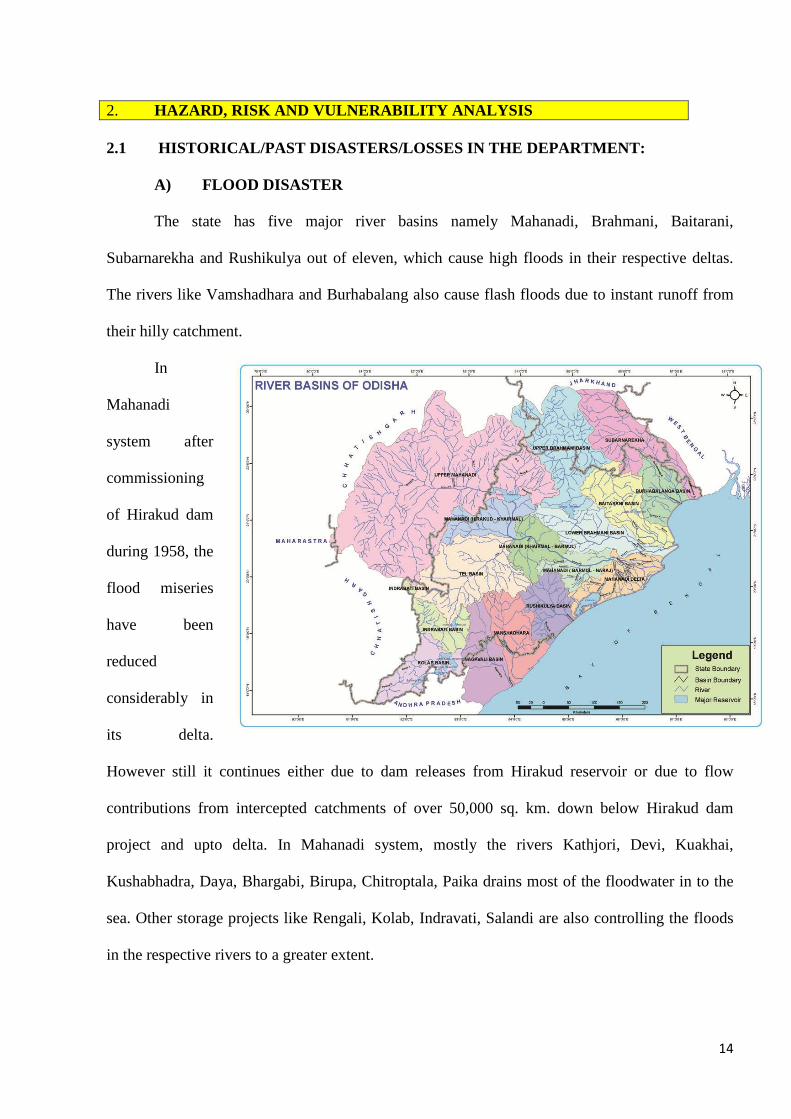
2. HAZARD, RISK AND VULNERABILITY ANALYSIS 2.1 HISTORICAL/PAST DISASTERS/LOSSES IN THE DEPARTMENT:
A) FLOOD DISASTER
The state has five major river basins namely Mahanadi, Brahmani, Baitarani,
Subarnarekha and Rushikulya out of eleven, which cause high floods in their respective deltas.
The rivers like Vamshadhara and Burhabalang also cause flash floods due to instant runoff from
their hilly catchment.
In
Mahanadi
system after
commissioning
of Hirakud dam
during 1958, the
flood miseries
have been
reduced
considerably in
its delta.
However still it continues either due to dam releases from Hirakud reservoir or due to flow
contributions from intercepted catchments of over 50,000 sq. km. down below Hirakud dam
project and upto delta. In Mahanadi system, mostly the rivers Kathjori, Devi, Kuakhai,
Kushabhadra, Daya, Bhargabi, Birupa, Chitroptala, Paika drains most of the floodwater in to the
sea. Other storage projects like Rengali, Kolab, Indravati, Salandi are also controlling the floods
in the respective rivers to a greater extent.
15
However the flood hazard is still not under control and generally every two to three year a
heavy flood is experienced in the deltaic area. Due to excess of water than carrying capacity,
major breaches occurred on these rivers and almost inundate the deltaic area.
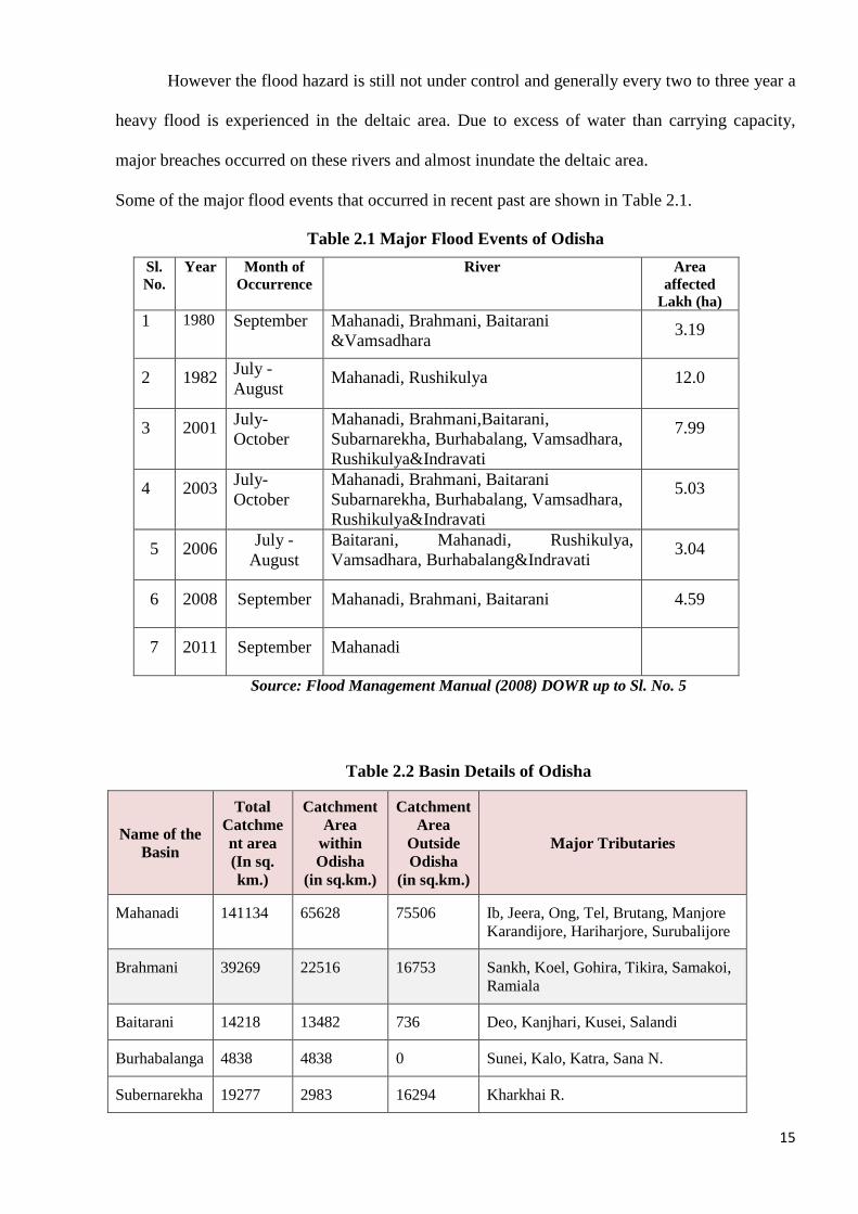
Some of the major flood events that occurred in recent past are shown in Table 2.1.
Table 2.1 Major Flood Events of Odisha
Sl. No.
Year Month of Occurrence
River Area affected
Lakh (ha) 1 1980 September Mahanadi, Brahmani, Baitarani
&Vamsadhara 3.19
2 1982 July - August
Mahanadi, Rushikulya 12.0
3 2001 July- October
Mahanadi, Brahmani,Baitarani, Subarnarekha, Burhabalang, Vamsadhara, Rushikulya&Indravati
7.99
4 2003 July- October
Mahanadi, Brahmani, Baitarani Subarnarekha, Burhabalang, Vamsadhara, Rushikulya&Indravati
5.03
5 2006 July - August
Baitarani, Mahanadi, Rushikulya, Vamsadhara, Burhabalang&Indravati
3.04
6 2008 September Mahanadi, Brahmani, Baitarani 4.59
7 2011 September Mahanadi
Source: Flood Management Manual (2008) DOWR up to Sl. No. 5
Table 2.2 Basin Details of Odisha
Name of the Basin
Total Catchment area (In sq. km.)
Catchment Area
within Odisha
(in sq.km.)
Catchment Area
Outside Odisha
(in sq.km.)
Major Tributaries
Mahanadi 141134 65628 75506 Ib, Jeera, Ong, Tel, Brutang, Manjore Karandijore, Hariharjore, Surubalijore
Brahmani 39269 22516 16753 Sankh, Koel, Gohira, Tikira, Samakoi, Ramiala
Baitarani 14218 13482 736 Deo, Kanjhari, Kusei, Salandi
Burhabalanga 4838 4838 0 Sunei, Kalo, Katra, Sana N.
Subernarekha 19277 2983 16294 Kharkhai R.
16
Rushikulya 8963 8963 0 Badanadi, Dhanei, Ghodahado, Padma, Baghua
Vansadhara 11377 8960 2417 Badanalla, Harbhangi Mahendratanaya, Sananadi.
Nagavali 9275 4500 4775 Jhanjabati, Sananadi, Barha Nadi Situguda N.
Indravati 41700 7400 34300 Kapur, Muran, Telengiri, Joura, Turi,
Bhaskel
Kolab 20427 10300 10127 Karandi N., Potteru R., Sileru R.,Machhkund R.
Bahuda 1118 890 228 Poichandia, Boginadi, BatrudaNalla
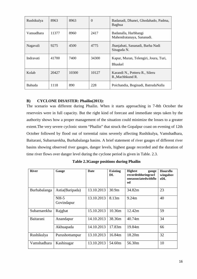
B) CYCLONE DISASTER: Phailin(2013): The scenario was different during Phailin. When it starts approaching in 7-8th October the
reservoirs were in full capacity. But the right kind of forecast and immediate steps taken by the
authority shows how a proper management of the situation could minimize the losses to a greater
extent.The very severe cyclonic storm “Phailin” that struck the Gopalpur coast on evening of 12th
October followed by flood out of torrential rains severely affecting Rushikulya, Vamshadhara,
Baitarani, Subarnarekha, Burhabalanga basins. A brief statement of river gauges of different river
basins showing observed river gauges, danger levels, highest gauge recorded and the duration of
time river flows over danger level during the cyclone period is given in Table. 2.3.
Table 2.3Gauge positions during Phailin
River Gauge Date ExistingDL
Highest gauge recordedduringcucloneassociatedwithflood
HoursflowingaboveDL
Burhabalanga Astia(Baripada) 13.10.2013 30.9m 34.82m 23
NH-5 Govindapur
13.10.2013 8.13m 9.24m 40
Subarnarekha Rajghat 15.10.2013 10.36m 12.42m 59
Baitarani Anandapur 14.10.2013 38.36m 40.74m 34
Akhuapada 14.10.2013 17.83m 19.84m 66
Rushikulya Purushottampur 13.10.2013 16.84m 18.20m 32
Vamshadhara Kashinagar 13.10.2013 54.60m 56.30m 10
17
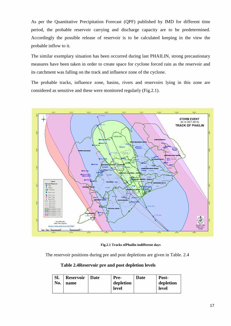
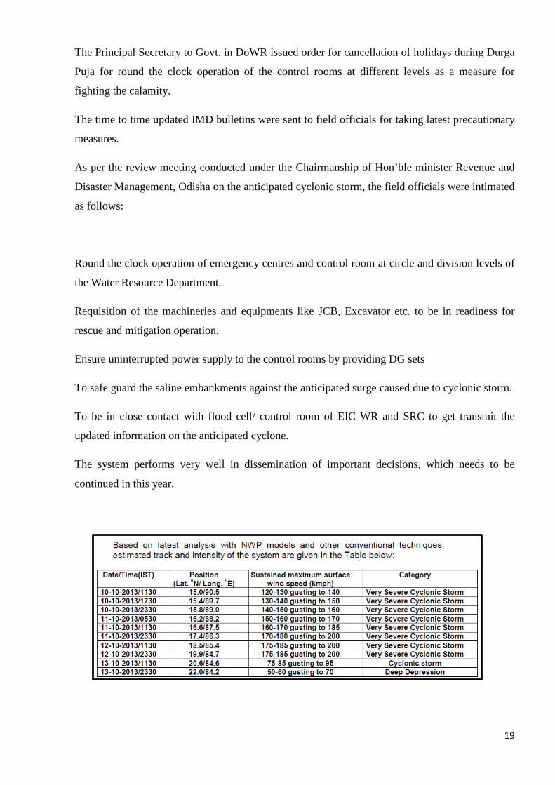
As per the Quantitative Precipitation Forecast (QPF) published by IMD for different time
period, the probable reservoir carrying and discharge capacity are to be predetermined.
Accordingly the possible release of reservoir is to be calculated keeping in the view the
probable inflow to it.
The similar exemplary situation has been occurred during last PHAILIN, strong precautionary
measures have been taken in order to create space for cyclone forced rain as the reservoir and
its catchment was falling on the track and influence zone of the cyclone.
The probable tracks, influence zone, basins, rivers and reservoirs lying in this zone are
considered as sensitive and these were monitored regularly (Fig.2.1).
Fig.2.1 Tracks ofPhailin indifferent days
The reservoir positions during pre and post depletions are given in Table. 2.4
Table 2.4Reservoir pre and post depletion levels
Sl. No.
Reservoirname
Date Pre-depletionlevel
Date Post-depletionlevel
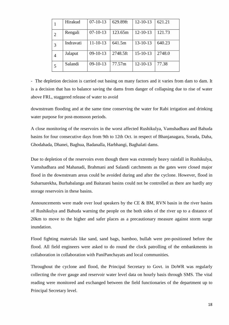
18
1 Hirakud 07-10-13 629.89ft 12-10-13 621.21
2 Rengali 07-10-13 123.65m 12-10-13 121.73
3 Indravati 11-10-13 641.5m 13-10-13 640.23
4 Jalaput 09-10-13 2748.5ft 15-10-13 2748.0
5 Salandi 09-10-13 77.57m 12-10-13 77.38
- The depletion decision is carried out basing on many factors and it varies from dam to dam. It
is a decision that has to balance saving the dams from danger of collapsing due to rise of water
above FRL, staggered release of water to avoid
downstream flooding and at the same time conserving the water for Rabi irrigation and drinking
water purpose for post-monsoon periods.
A close monitoring of the reservoirs in the worst affected Rushikulya, Vamshadhara and Bahuda
basins for four consecutive days from 9th to 12th Oct. in respect of Bhanjanagara, Sorada, Daha,
Ghodahada, Dhanei, Baghua, Badanalla, Harbhangi, Baghalati dams.
Due to depletion of the reservoirs even though there was extremely heavy rainfall in Rushikulya,
Vamshadhara and Mahanadi, Brahmani and Salandi catchments as the gates were closed major
flood in the downstream areas could be avoided during and after the cyclone. However, flood in
Subarnarekha, Burhabalanga and Baitarani basins could not be controlled as there are hardly any
storage reservoirs in these basins.
Announcements were made over loud speakers by the CE & BM, RVN basin in the river basins
of Rushikulya and Bahuda warning the people on the both sides of the river up to a distance of
20km to move to the higher and safer places as a precautionary measure against storm surge
inundation.
Flood fighting materials like sand, sand bags, bamboo, bullah were pre-positioned before the
flood. All field engineers were asked to do round the clock patrolling of the embankments in
collaboration in collaboration with PaniPanchayats and local communities.
Throughout the cyclone and flood, the Principal Secretary to Govt. in DoWR was regularly
collecting the river gauge and reservoir water level data on hourly basis through SMS. The vital
reading were monitored and exchanged between the field functionaries of the department up to
Principal Secretary level.
19
The Principal Secretary to Govt. in DoWR issued order for cancellation of holidays during Durga
Puja for round the clock operation of the control rooms at different levels as a measure for
fighting the calamity.
The time to time updated IMD bulletins were sent to field officials for taking latest precautionary
measures.
As per the review meeting conducted under the Chairmanship of Hon’ble minister Revenue and
Disaster Management, Odisha on the anticipated cyclonic storm, the field officials were intimated
as follows:
Round the clock operation of emergency centres and control room at circle and division levels of
the Water Resource Department.
Requisition of the machineries and equipments like JCB, Excavator etc. to be in readiness for
rescue and mitigation operation.
Ensure uninterrupted power supply to the control rooms by providing DG sets
To safe guard the saline embankments against the anticipated surge caused due to cyclonic storm.
To be in close contact with flood cell/ control room of EIC WR and SRC to get transmit the
updated information on the anticipated cyclone.
The system performs very well in dissemination of important decisions, which needs to be
continued in this year.
20
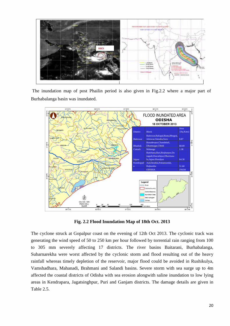
The inundation map of post Phailin period is also given in Fig.2.2 where a major part of
Burhabalanga basin was inundated.
Fig. 2.2 Flood Inundation Map of 18th Oct. 2013
The cyclone struck at Gopalpur coast on the evening of 12th Oct 2013. The cyclonic track was
generating the wind speed of 50 to 250 km per hour followed by torrential rain ranging from 100
to 305 mm severely affecting 17 districts. The river basins Baitarani, Burhabalanga,
Subarnarekha were worst affected by the cyclonic storm and flood resulting out of the heavy
rainfall whereas timely depletion of the reservoir, major flood could be avoided in Rushikulya,
Vamshadhara, Mahanadi, Brahmani and Salandi basins. Severe storm with sea surge up to 4m
affected the coastal districts of Odisha with sea erosion alongwith saline inundation to low lying
areas in Kendrapara, Jagatsinghpur, Puri and Ganjam districts. The damage details are given in
Table 2.5.
District
Block
Area
(Sq.Kms)
Baleswar
Baleswar,Baliapal,Basta,Bhograi,
Jaleswar,Simulia,Soro
8.87
Bhadrak
Basudevpur,Chandabali,
Dhamnagar,Tihidi 68.69
Cuttack Mahanga 1.38
Jajpur
Badchana,Bari,Binjharpur,Da
nagadi,Dasrathpur,Dharmasa
la,Jajpur,Rasulpur
64.30
Kendrapad
a
Aul,Derabisi,Pattamundai,
Rajkanika 51.60
ODISHA 194.84
21
Table 2.5 DamageDetails during Phailin
Sector Damage Details Amount (in
CE &BM, LMB
Breachesandpartialdamagestotheriverembankments,saline embankments andbuildings.
Rs.27583.41
CE, Minor Irrigation
Damages to minor irrigation projects. Rs.8158.20
OLIC Damagestoliftirrigationprojects,deepbore welldamagedand buildings.
Rs.6294.78
CE, Drainage
Damages to drains Rs.1050.0
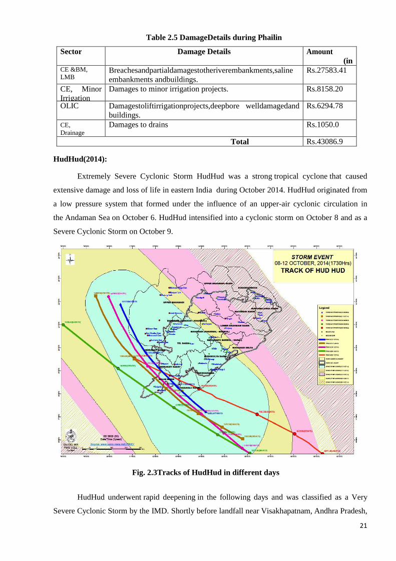
Total Rs.43086.9 HudHud(2014):
Extremely Severe Cyclonic Storm HudHud was a strong tropical cyclone that caused
extensive damage and loss of life in eastern India during October 2014. HudHud originated from
a low pressure system that formed under the influence of an upper-air cyclonic circulation in
the Andaman Sea on October 6. HudHud intensified into a cyclonic storm on October 8 and as a
Severe Cyclonic Storm on October 9.
Fig. 2.3Tracks of HudHud in different days
HudHud underwent rapid deepening in the following days and was classified as a Very
Severe Cyclonic Storm by the IMD. Shortly before landfall near Visakhapatnam, Andhra Pradesh,
22
on October 12, Hudhud reached its peak strength with three-minute wind speeds of 175 km/h
(109 mph) and a minimum central pressure of 960 mbar (28.35 inHg). The system then drifted
northwards towards Uttar Pradesh and Nepal, causing widespread rains in both areas and heavy
snowfall in the latter.The Odisha government had placed 16 districts under high
alert: Balasore, Kendrapara, Bhadrak, Jagatsinghpur, Puri,Ganjam, Mayurbhanj, Jajpur, Cuttack, K
hurdha, Nayagarh, Gajapati, Dhenkanal, Keonjhar, Malkangiri and Koraput.
At the time of the storm's landfall, strong winds and heavy rainfall commenced in southern Odisha
districts, leading to disruption in power supply. Wind speeds reaching 90 km/h (56 mph) were
predicted in the region.
2.2 EMERGING CONCERNS
It is imperative that the total flood control is not practicable from economic considerations and
therefore flood management is essential. Flood management rationally refers to the provision of
reasonable degree of protection against floods by structural / non-structural measures to mitigate
the recurring havoc caused by floods. During the last five decades, a number of structural and
non-structural measures have been taken to minimize flood.
� As a part of structural measures, reservoirs namely Hirakud on the Mahanadi river,
Rengali on the Brahmani river, Upper Kolab in Kolab river and Upper Indravati in
Indravati river have been constructed. Similarly, Kanupur Dam is under construction in
Keonjhar will also moderate flood to some extent in Baitarani delta. Chanduli and Icha
dam (under construction) in Jharkhand will control flood to some extent in Subernarekha
system.
� Rivers namely Rushikulya, Vamshadhara, Nagavali, Bahuda and Budhabalanga do not
have flood control reservoirs.
� Besides, in the deltaic area, floods are being controlled by flood protection embankments
constructed on both sides of the rivers. A total 7138 kms of protective embankments, 1952
spurs and 253 kms of stone packing have been constructed in different basins particularly
in the deltaic areas to control the flood and saline ingress.
23
3. CAPACITY – BUILDING MEASURES
3.1 Trainings and Capacity Building
To enhance organizational and capability skills to deal with emergency situations requires
trainings and capacity building exercises of the various linked government and non-government
officers. Since disaster management is a multi-organizations effort, it emphasizes on trainings in
execution and coordination as well. Therefore, wide ranges of trainings related to management
skills are highly required for potential officers in order to equip them for specialized disaster-
related tasks. They require orientation of various aspects of crises management such as;
Skill Training, Planning,
Trainings on Emergency Response Functions such as first-aid, search and rescue, emergency
operation centre, emergency feeding and welfare, communication and damage assessment etc.
Trainings for coordinated disaster management activities and response operations are highly
required especially for the persons engaged in emergency services, government–line departments,
non-government organizations and important private sector groups
Training requirements are likely to comprise of core activities of emergency management such as
Incident Response System, Emergency Response Functions and basic management skills. Persons
to be trained shall be:
· Government Officers at par with the rank requirement under Incident Response System
· Team leaders and members under Emergency Support functions
· Quick Response Teams at headquarter and field level
· Community level taskforces including Volunteers, NGOs and Home Guard volunteers, school and college students, NCC and NSS scouts and NYKS etc
District Administration can organize seminars and workshops with the help of State Disaster
Management Authority, Civil Defence and Home Guard, Fire Fighting Department, Health
departments etc. A record of trained manpower shall be maintained by each department and their
representation shall be noticed during mock-drill.
3.2 Community Awareness and Community Preparedness Planning
The hazard analysis of the district indicates that there is a high need of community awareness
through public awareness programmes on the following themes of disaster:
24
� Types of disasters and basic Do’s and Don’ts related to those disasters
� Post disaster epidemic problems
� Construction and retrofitting techniques for disaster resistant buildings
� Communication of possible risk based on vulnerable areas in the District
� Evacuation related schemes and community preparedness problems
Volunteers and social organizations also play a vital role in spreading mass scale community
awareness. Media can also play an important role in raising awareness and educating people.
Community Disaster Management Planning is one of the vital components of community
preparedness. It involves all important parameters related to hazard awareness, evacuation
planning, resource inventory, community level taskforces and committees etc. which helps
community members in organizing themselves to combat disaster in a pre-planned manner.
Preparation of community plans encourages promoting preparedness planning at community
level. District administration is also imparting trainings on regular basis to the volunteers of
Civil Defence and Home Guards, Nehru Yuva Kendra Sangthan, Residential Welfare
Associations, Market Trade Associations, Self Help Group, GRCs and NGOs etc to involve
them to into community planning.
3.3 Capacity Building of Community Task forces
Community taskforces and community committees has been constituted and trained in all types
of communities by government and non-government agencies. District administration, Medical
officers, Trained volunteers, Delhi fire Services, Civil Defence and Home Guard volunteers,
NYKS etc. are playing important role in building capacities of community task forces in
building their capacities in search and rescue work, fire-fighting, warning dissemination, first-
aid and damage assessment etc.
Conducting a participatory capacity and vulnerability on DRR will develop the lesson plans
where everyone in the community can better understand how disasters can impact their village
Leading a participatory capacity and vulnerability analysis workshop. a hazard mapping
exercise, a timeline exercise, and a summary of hazard impacts on lives and assets. After
completing the assessment you will work with the community to prioritize the most important
hazards, to pinpoint specific solutions—and to determine community capacity for implementing
the solutions.
25
3.4 Sustainable Management
DRR Overview: set up a community based project management committeeand a Community
Based DRR subcommittee. This subcommittee will be able to work with NGO to create long-
term associations with government agencies that can support long-term DRR activities. The
subcommittee will be in charge of developing a DRR plan, and for coordinating disaster teams.
Setting up a subcommittee is a much more rapid process than setting up a full committee. We
will also explore an overview of common DRR activities.
Survey of Activities for use Before Disasters Strike
Preparedness for Disaster: Early warning systems. Traditionally, community members have not
had warning of when they need to evacuate—and frequently they have left it too late.
Meteorological office may have the capability of, for example, in a potential flood situation,
evaluating when water has reached a critical height and can announce that a flood is imminent.
Communities should form partnerships with these offices and ensure that they have clear access
to early warning information in case of disaster.
3.5 Mitigation
Survey of Activities for use During Disasters
Evacuation training. If people need to evacuate, they need to know when to evacuate, they
need to know what to do with their valuable possessions and assets, they need to know where to
go where it's safe, they need to know what to take with them, and they need to know what to do
when they get to shelter. Capacity building workshops led by the evacuation team can train
community members in each of these—and most importantly—can lead them in practice drills
Search and rescue training. Search and rescue team members learn specific techniques that are
safe, and are given simple tools such as lifejackets, safe boats, inner tubes, and flashlights which
give them the confidence and the capability to look for a missing person or of rescue a trapped
elderly or disabled person.
3.6 DRR Master Planning for the Future
Developing a DRR plan. Developing a DRR plan may include each of the activities in the
surveys above—and maintaining them in perpetuity. This will involve a plan for consciousness-
raising among community members about DRR challenges, connecting with an early warning
system, organizing teams, training teams in evacuation and search and rescue, and prioritizing
26
mitigation strategies. The plan can include an advocacy campaign for obtaining government
support.
3.6.1 Community Engagement. Frequently community members don't have a clear
picture of how and why disasters happen. They also may not know how to react when a disaster is
building or is already in progress. Workshops and simple posters or how-to cards need to be
developed to help them understand these concepts and to learn that there are things that they can
do to reduce the risk caused by disasters, and to mitigate the severity of the disasters.
3.6.2 Organizing Teams. Based upon the results of community’s participatory capacity
and vulnerability assessment, one should now have a prioritized list of hazards and disasters. As
part of the DRR plan the committee will prioritize preparedness activities, risk reduction activities
and mitigation activities. Teams should be organized for each of the major priorities. If, for
example, the type of disaster your community faces necessitates evacuation, an evacuation team
should be established that develops a plan to lead an evacuation at the appropriate time—and then
lead an actual evacuation if necessary.
3.7 Mitigation Capacity Building Needs & Workshop Planning
Evaluate the results of participatory mapping of disaster risks and hazards—and then select an appropriate disaster risk mitigation technique specifically for community members to learn to implement. Develop an overview for committee members of disaster risk mitigation techniques that could include reforestation of watersheds, gully plugging, secure food storage and a savings plan. Make an appointment to propose appropriate techniques to the DRR Management Committee for feedback.
3.8 Workshop Planning.
Prioritize which DRR technique should be introduced in the first workshop. Contact a DRR
expert of feedback and input. Develop a workshop lesson plan. Draw a how-to card. Arrange the
date and location for the workshop with your community contact person. Arrange for supplies
and tools for the workshop with your community contact person.
3.9 Capacity Building
Capacity building for disaster risk reduction and mitigation activities for community
members. There are many activities that can be done to mitigate potential disasters. Some, like
mangrove plantings along river banks can reduce erosion during a flood season. The reforestation
of a watershed can reduce danger from flash floods. Both are activities that communities can do
27
over the span of time. Capacity building workshops give community members the skill sets that
they need to do these activities. Other activities like relocating houses to higher ground may be
outside of their purchasing power, but committee members can be trained to develop advocacy
campaigns for approaching governments for support in more major investments.
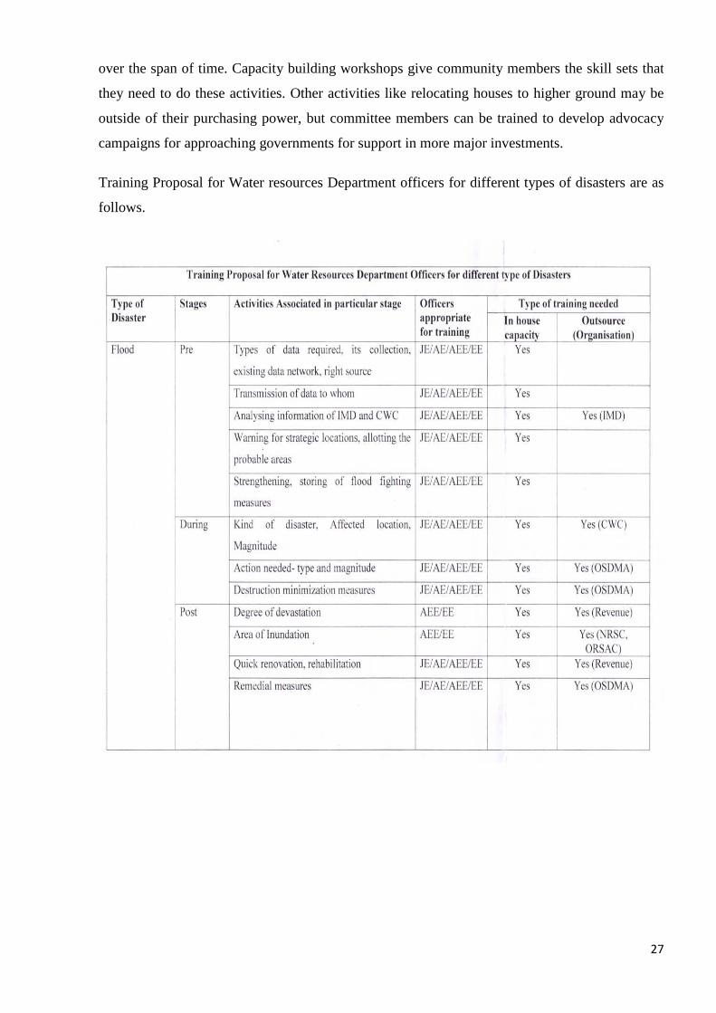
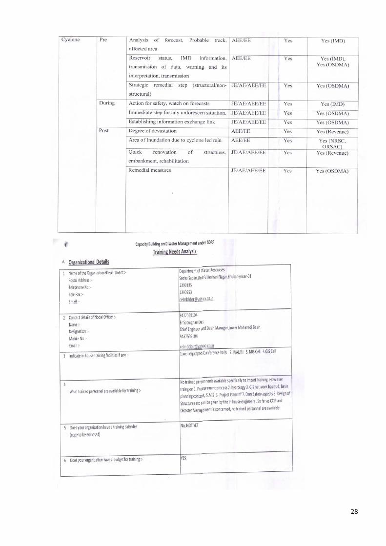
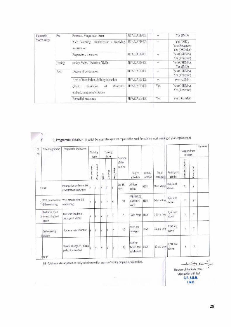
Training Proposal for Water resources Department officers for different types of disasters are as
follows.
28
29
30
4. PREVENTION & MITIGATION MEASURES
4.1 GENERAL:
In flood management structural measures are given the most priority. These are in the form of
reservoirs, weirs, embankments and other structures. There are seven multipurpose major
reservoir projects have been constructed in our state with basic objectives of irrigation, flood
control and power. The operation of the reservoirs is regulated by a standard Rule Curve meant
for satisfying all the demand.
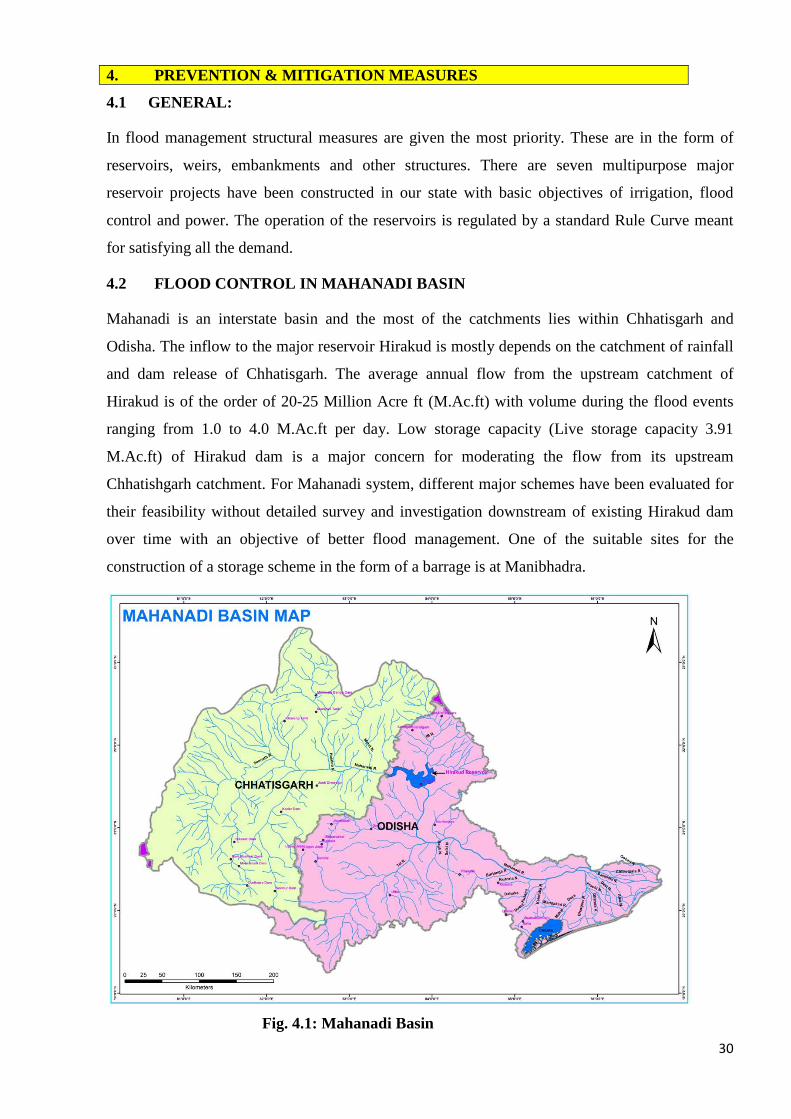
4.2 FLOOD CONTROL IN MAHANADI BASIN
Mahanadi is an interstate basin and the most of the catchments lies within Chhatisgarh and
Odisha. The inflow to the major reservoir Hirakud is mostly depends on the catchment of rainfall
and dam release of Chhatisgarh. The average annual flow from the upstream catchment of
Hirakud is of the order of 20-25 Million Acre ft (M.Ac.ft) with volume during the flood events
ranging from 1.0 to 4.0 M.Ac.ft per day. Low storage capacity (Live storage capacity 3.91
M.Ac.ft) of Hirakud dam is a major concern for moderating the flow from its upstream
Chhatishgarh catchment. For Mahanadi system, different major schemes have been evaluated for
their feasibility without detailed survey and investigation downstream of existing Hirakud dam
over time with an objective of better flood management. One of the suitable sites for the
construction of a storage scheme in the form of a barrage is at Manibhadra.
Fig. 4.1: Mahanadi Basin
31
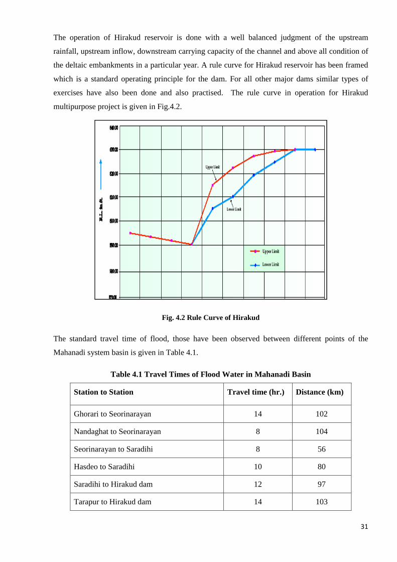
The operation of Hirakud reservoir is done with a well balanced judgment of the upstream
rainfall, upstream inflow, downstream carrying capacity of the channel and above all condition of
the deltaic embankments in a particular year. A rule curve for Hirakud reservoir has been framed
which is a standard operating principle for the dam. For all other major dams similar types of
exercises have also been done and also practised. The rule curve in operation for Hirakud
multipurpose project is given in Fig.4.2.
Fig. 4.2 Rule Curve of Hirakud
The standard travel time of flood, those have been observed between different points of the
Mahanadi system basin is given in Table 4.1.
Table 4.1 Travel Times of Flood Water in Mahanadi Basin
Station to Station Travel time (hr.) Distance (km)
Ghorari to Seorinarayan 14 102
Nandaghat to Seorinarayan 8 104
Seorinarayan to Saradihi 8 56
Hasdeo to Saradihi 10 80
Saradihi to Hirakud dam 12 97
Tarapur to Hirakud dam 14 103
32
Station to Station Travel time (hr.) Distance (km)
Deogaon to Hirakud dam 9 90
Hirakud dam to Khairmal 12-18 115
Khairmal to Barmul 12-16 109
Barmul to Mundali 12-16 125
Mundali to Naraj 0.45(Avg.) 3
Source: Flood Management Plan 2008, DOWR
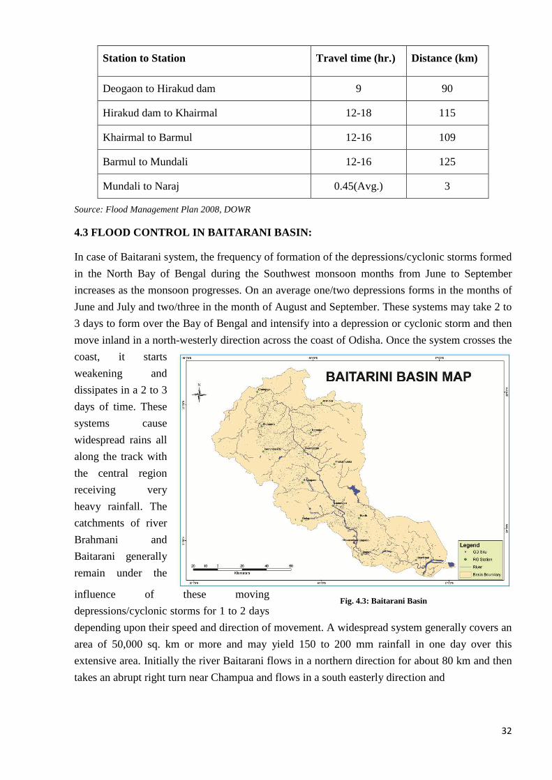
4.3 FLOOD CONTROL IN BAITARANI BASIN:
In case of Baitarani system, the frequency of formation of the depressions/cyclonic storms formed
in the North Bay of Bengal during the Southwest monsoon months from June to September
increases as the monsoon progresses. On an average one/two depressions forms in the months of
June and July and two/three in the month of August and September. These systems may take 2 to
3 days to form over the Bay of Bengal and intensify into a depression or cyclonic storm and then
move inland in a north-westerly direction across the coast of Odisha. Once the system crosses the
coast, it starts
weakening and
dissipates in a 2 to 3
days of time. These
systems cause
widespread rains all
along the track with
the central region
receiving very
heavy rainfall. The
catchments of river
Brahmani and
Baitarani generally
remain under the
influence of these moving
depressions/cyclonic storms for 1 to 2 days
depending upon their speed and direction of movement. A widespread system generally covers an
area of 50,000 sq. km or more and may yield 150 to 200 mm rainfall in one day over this
extensive area. Initially the river Baitarani flows in a northern direction for about 80 km and then
takes an abrupt right turn near Champua and flows in a south easterly direction and
Fig. 4.3: Baitarani Basin
33
finally discharges into Bay of Bengal through the deltaic area of river Brahmani. The river travels
a total distance of 360 km and drains an area of over 14,000 sq. km. The annual normal rainfall
varies from 1250 mm to 1500 mm over the Baitarani basin.
In the context of Baitarani river system, some of the major causes can be summarized as
follows. The drainage pattern of Baitarani river basin (central plateau) is dendrite type and flash
flood is a natural character of such type of drainage pattern. Again since the upper catchment of
Baitarani is full of hillocks and occurrence of a large number of drainage lines allow the run off
generating over there to gush into the main river with greater force in very short span of time. The
lower part of Baitarani is a part of greater Mahanadi & Brahmani delta.
1. Baitarani is a highly meandering river. In meandering channels the flow is highly
turbulent and forms eddy currents, which very often leads to sudden overflow of the
embankments causing inundation of surrounding areas.
2. Due to heavy mining activities and practices of shifting cultivation in the upper catchment
a large quantity of sediments are added to the river during monsoon seasons. This lowers
the carrying capacity of the river and thus even a medium size rainfall can cause high
flood in Baitarani.
3. The shallow aquifer conditions, water table nearer to the ground level, spread of water
logging areas, swamps, and estuarine etc. do not allow precipitation & thus compound the
impact of flood.
4. There is no major diversion channel to control flood in Baitarani river Basin
5. The upper catchment i.e. the central plateau comprises of meta-sediment & controlled by
severe fault and shear zones, which contributes more sediment into the basin.
6. Encroachment of flood plains due to growth of population is also causing heavy damage
though the flood is not so high. Sufficient area should be left in order to allow the
floodwater flow into the sea safely. This particular cause is an important human factor.
Such that there is no flood zone planning for the coastal area of eastern ghat region.
7. The flow of Brahmani River is also adding to the flood in Baitarani River in the
downstream and both the rivers forms a combined delta.
8. The most flood affected blocks in Baitarani system are Anandapur, Dasarathpur, Korei,
Bari, Jajpur, Binjharpur and Rajkanika.
All the severe storms that have occurred since 1901 over the catchment areas of Brahmani and
Baitarani and other neighboring basins have been studied by IMD. Enveloping curves for 1-day
and 2-day rainfall amounts have been drawn. The rainfall depths corresponding to different
standard areas were picked up as given in Table 4.2.
34
Table 4.2: 1 and 2-day rainfall maxima as a function of area
Area (km2) Rainfall Depths (mm) 1 – day 2 – day
1000 521 737 5000 434 653 10000 366 574 20000 292 465 50000 198 366 100000 142 279
(Period 1901-1950) (Source: Hydrology Project Report)
Table 4.3 Travel Times of Flood Water in Baitarani Basin
Station to Station Travel time (hr.) Distance (km)
Champua to Swampatana 10 65
Swampatana to Anandpur 7 52
Anandpur to Akhuapada 7-9 hrs 40
Source: Flood Management Plan 2008, DOWR
4.4 FLOOD CONTROL IN BRAHMANI BASIN
Another flood causing basin in the state is the Brahmani system. The annual normal rainfall in
this system varies from 1250 mm to 1750 mm. From different hydrological studies, it has been
revealed that the floods in the Brahmani delta are governed by:
1. Inflow from
Brahmani river
system as well as flow
from Rengali dam.
The total intercepted
catchment at
Brahmani delta at
Jenapur is 35,700
sq.km, of which
25,100 sq.km.is
controlled by Rengali
dam,
Fig. 4.4: Brahmani Basin
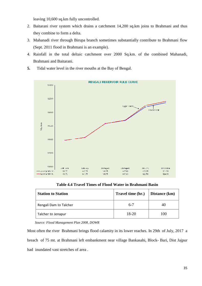
leaving 10,600 sq.km fully uncontrolled.
2. Baitarani river system which drains a catchment 14,200 sq.km joins to Bra
they combine to form a delta.
3. Mahanadi river through Birupa branch sometimes substantially contribute to Brahmani flow
(Sept. 2011 flood in Brahmani is an example).
4. Rainfall in the total deltaic catchment over 2000 Sq.km. of the
Brahmani and Baitarani.
5. Tidal water level in the river mouths at the Bay of Bengal.
Table 4.4 Travel Times of Flood Water in Brahmani Basin
Station to Station
Rengali Dam to Talcher
Talcher to Jenapur
Source: Flood Management Plan 2008, DOWR
Most often the river Brahmani brings flood calamity
breach of 75 mt. at Brahmani left embankment near village Bankasahi, Block
had inundated vast stretches of area .
leaving 10,600 sq.km fully uncontrolled.
Baitarani river system which drains a catchment 14,200 sq.km joins to Bra
they combine to form a delta.
Mahanadi river through Birupa branch sometimes substantially contribute to Brahmani flow
(Sept. 2011 flood in Brahmani is an example).
Rainfall in the total deltaic catchment over 2000 Sq.km. of the
Brahmani and Baitarani.
Tidal water level in the river mouths at the Bay of Bengal.
Table 4.4 Travel Times of Flood Water in Brahmani Basin
Travel time (hr.)
6-7
18-20
Source: Flood Management Plan 2008, DOWR
Most often the river Brahmani brings flood calamity in its lower reaches
breach of 75 mt. at Brahmani left embankment near village Bankasahi, Block
had inundated vast stretches of area .
35
Baitarani river system which drains a catchment 14,200 sq.km joins to Brahmani and thus
Mahanadi river through Birupa branch sometimes substantially contribute to Brahmani flow
Rainfall in the total deltaic catchment over 2000 Sq.km. of the combined Mahanadi,
Table 4.4 Travel Times of Flood Water in Brahmani Basin
Distance (km)
40
100
in its lower reaches. In 29th of July, 2017 a
breach of 75 mt. at Brahmani left embankment near village Bankasahi, Block- Bari, Dist Jajpur
36
4.5 MEASURES:
At the current scenario, with the existing flood management directives following measures may
be proposed.
4.5.1 Structural Measure
Managing flood through structural measure is one of the effective ways, but it requires large
investment, huge manpower and long time. Structural measure like construction of storage
reservoir, detention tank, raising leaves, digging of silted channels and dredging of sea mouth,
slope protection etc. are generally executed for flood protection. So far seven numbers of major
dams, forty medium projects and 2196 minor dams have been constructed and rest 22 major and
medium projects are in the ongoing stage. These structures, especially major projects are
minimizing the flood havocs to a greater extent as well as serving the multipurpose activities.
River systems namely Baitarani, Rushikulya, Vamsadhara, Nagabali, Bahuda and Burhabalanga
do not have major flood control reservoirs.
The raising of the embankments, slope protection, channels excavation, mouth clearance
to sea etc. works are also being carried out every year and before starting of the monsoon season.
These factors are well checked and appropriate safety measures also been carried out at
indentified vulnerable locations. Further the river falling to lake Chilika are also being treated
periodically for release of flood water during high tides while protecting the existing saline flora
and fauna of the lake. The organisations like World Bank, Asian Development Bank, JICA and
other infrastructural funding agency are supporting these developmental activities.
4.5.2 Non-structural Measures
It has been realized that, there are difficulties to go in for structural measures in the form of major
dams, barrages, raising and strengthening of embankments due to various constraints like time,
money, as well as resettlement, rehabilitation and environmental factors. Non-structural measures
like flood forecasting, early warning, flood plain zoning and flood risk mapping and others needs
to be adopted as tools for a better flood management.
For flood forecasting, a well-distributed hydrological information system network is
highly essential. So far the department has established 56 standard rain gauge stations under
Hydrology Project (HP) and 34 non-HP stations. There are 12 Automated Rain Gauges, 44 Gauge
Discharge sites, 12 water level recorder and 9 full climate stations also have been established in
ten river basins of the state. Beside that 20 sedimentations laboratories, 11 water quality and
sedimentation laboratories are also established on the basins. On effective operation of full
climate station, these will be established at Subarnarekha, Brahmani, Nagavali and Kolab basin
37
very soon. It is also planned to develop the ARG & SRRG network over all the basins. Presently
rainfall and gauging information are being received from IMD, CWC and Revenue Department
and satellite imageries being received from NRSC for interpretation analyses.
Flood formulation also taken up with prime support of CWC. For modeling now physical
based model like HEC-HMS, MIKE Model and IFAS model are also being exercised for better
flood forecasting.
Round the clock (24x7) running flood cell is disseminating the flood information to all the
recipient bodies. The Revenue Department, Agriculture Department, Water Resource
Department, Health Department and Police Department co-operate each other and run side by
side in order to avert the unprecedented flood havoc if arise. The flood information is updated in
the site http://www.dowrorissa.gov.in every day during a period from 1st June to 31st October.
The Department of Water Resources is now planning to prepare the following works in
order to properly model and manage total flood related scenarios.
• Digital terrain models for catchment delineation.
• Digital terrain models of floodplains.
• Catchment land use and soil data (derived from satellite imagery).
• Hydrological rainfall-runoff modeling to produce flood hydrograph at a range of return
periods.
• River crosses sections for the length of river that creates significant flood, and survey of
bridge/culvert opening and other feature that may resist flow.
• Computational hydrologic modeling to produce flood inundation or flood hazard maps at a
range of return periods.
• Detailed flood plain land use mapping using satellite imagery (road, embankments,
commercial and industrial properties, public utility, (eg. water treatment, electricity sub-
station etc) residential properties and properties classifications)
• Survey of levels of roads and typical floor level of properties in the flood plain.
• Flood risk mapping (combination of flood hazard map with land-use).
4.5.3 Institution and Community
• Development of coordination with IMD, CWC, NRSC, OSDMA, SEOC, SRC.
• Development of coordination for data sharing and dam release information among states in
case of interstate basin.
38
• Developing awareness among community on flood preparedness.
• Awareness with school and college students regarding hydro-meteorological information and
flood related activities.
4.5.4 LAUNCHING OF FLOOD FORECASTING MODEL FOR DEPA RTMENT OF
WATER RESOSURCES, ODISHA.
• The Water Resource Department, Government of Odisha embarked upon developing an early
flood warning system as one of the most effective flood management strategies to reduce risk
to life and property. The existing flood forecasting systems rely only on past precipitation
inputs, which come from observation networks of rain gauges and radar. Thus presently,
maximum forewarning given is of 8 hours, which in many situations is too less for any
meaningful action. The desirable lead time of such forecasts is between 48 to 72 hours.
However, for such medium term forecasts (48 to 72 hours ahead), it is required to use
quantitative precipitation forecasts from numerical weather prediction (NWP) products.
• The Water Resource Department, Government of Odisha, aided by technical assistance from
DFID funded “Climate Change Innovation Programme”( through engagement of INRM
Consultants, an IIT, Delhi incubate company )have developed a basin wide hydrological
model which will increase the flood warning and reaction time to 36-72 hours. The
department has been working on this hydrological model based decision support system since
April 2015. The model is based on the SWAT (Soil and Water Assessment Tool) hydrological
model, developed by the United States Department of Agriculture. The model has gained a
wide global acceptability. There are more than 90 countries using the model for practical
applications. SWAT is a public domain model actively supported by the Blackland, Soil and
Water Research Laboratory (Temple, TX, USA) of the USDA Agricultural Research Service.
• The model was launched by Shri Naveen Patnaik, Honourable Chief inister of Odisha, Shri
Aditya Prasad Padhi, Chief Secretary, Govt. of Odisha Shri R Balakrishnan, Development
Commissioner cum Additional Chief Secretary, Planning and Convergence Shri P. K. Jena,
Principal Secretary, Water Resources Dr Cristina Rumbaitis Del Rio, Regional Programme
Manager – CPGD – DFID on 28th June 2017.
• The models were installed and running at FF & FRM Cell, Secha Sadan and another at
office of Chief Engineer, Burla.
• The model uses multiple weather forecasts available from different sources including IMD to
provide flood warnings up to 72 hours in advance.

39
• The flood forecasting model is an innovative approach of the Department of Water Resources
(DoWR) towards better forecast and management of floods in the undivided Mahanadi basin.
Development of a Flood Forecasting Model was one of the identified activities under State
Climate Change Innovative program. The model has been developed basing on internationally
acknowledged hydrology models and considers the physical characteristics of the basin.
• In addition to formulating flood forecasts, the model could also help in Integrated Water
Resource Management (IWRM) as a planning and management framework that considers a
range of supply-side and demand-side water resources processes and actions, and incorporates
stakeholder participation in decision-making. The same hydrological model can be further
used in assessing the impacts of climate change on water resources and implement suitable
adaptation strategy. The model is based on water balance equation and other hydrological
processes; hence water utilization and its impact over a period of time in upper catchment can
also be worked out in the long run.
• The Hirakud Dam, with a major objective of flood moderation, intercepts a catchment area of
only 83,000 sq km, leaving almost 62,000 sq. km uncontrolled. Holistic reservoir operation is
of prime importance so far as release of water to and from the reservoir both during monsoon
and non-monsoon period is concerned. The Climate change is exacerbating the situation due
to changes in seasonality and variability of runoff. In the changed scenario of rainfall and
water utilization pattern in upstream, special attention for flood management of reservoir and
downstream catchment area of Hirakud with special reference to the increasing interventions
at upper catchment by neighboring state has been considered as prime importance by the
Department of Water Resources, Government of Odisha. Development of the hydrological
model “SWAT” will give a new dimension in analyzing the above interventions.
• Primary testing of the model has yielded better results than those forecasted by the CWC.
Thus, the model will increase the flood warning and reaction time to 36-72 hours and will
enable the department towards more proactive flood management planning.
4.5.5 STRUCTURAL MEASURES FOR FLOOD CONTROL :
- Geographical Area of the State - 15.57 Mha.
- Flood affected Area - 3.34 Mha (21.45 % geographical area)
- 7 out of 11 river basins of Odisha are flood prone.
- Different categories of Flood protective embankments have been constructed
to mitigate flood as one of the structural measures.
- Status of embankments.
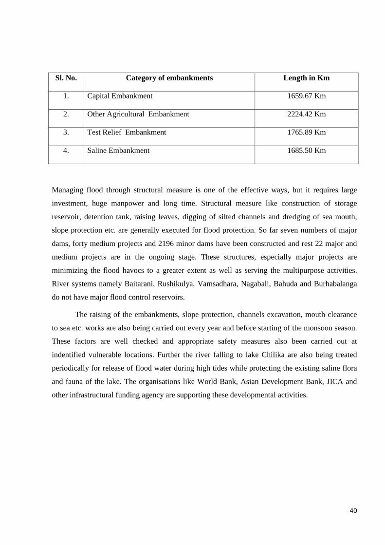
40
Sl. No. Category of embankments Length in Km
1. Capital Embankment 1659.67 Km
2. Other Agricultural Embankment 2224.42 Km
3. Test Relief Embankment 1765.89 Km
4. Saline Embankment 1685.50 Km
Managing flood through structural measure is one of the effective ways, but it requires large
investment, huge manpower and long time. Structural measure like construction of storage
reservoir, detention tank, raising leaves, digging of silted channels and dredging of sea mouth,
slope protection etc. are generally executed for flood protection. So far seven numbers of major
dams, forty medium projects and 2196 minor dams have been constructed and rest 22 major and
medium projects are in the ongoing stage. These structures, especially major projects are
minimizing the flood havocs to a greater extent as well as serving the multipurpose activities.
River systems namely Baitarani, Rushikulya, Vamsadhara, Nagabali, Bahuda and Burhabalanga
do not have major flood control reservoirs.
The raising of the embankments, slope protection, channels excavation, mouth clearance
to sea etc. works are also being carried out every year and before starting of the monsoon season.
These factors are well checked and appropriate safety measures also been carried out at
indentified vulnerable locations. Further the river falling to lake Chilika are also being treated
periodically for release of flood water during high tides while protecting the existing saline flora
and fauna of the lake. The organisations like World Bank, Asian Development Bank, JICA and
other infrastructural funding agency are supporting these developmental activities.
41
FORMAT FOR FLOOD DAMAGE REPORT
Remarks
11
Amount
required (Rs. In
lakh)
10
Brief Description of
work required for
immediate restoration
9
Length of
Breach/ Damage
in mtr.
8
Name of the
Asset and
Location
7
Name of
the
Constituenc
y
6
Name of
the Block
5
Name of
the
District
4
Name of the River
3
Period of
Occurrence
2
Sl.
No.
1
42
4.6 RISK ANALYSIS:
An integrated risk analysis looks into both the probabilities and impacts of flooding. Modeling of
river floods and storm surges forms an important part of the risk analysis. Flood Management
Information System cell is functioning in the Water Resources Department, the cell is engaging in
the data management, information sharing, research, flood modeling. The risk assessments are:
4.6.1 Assessing Flood Probabilities The challenge is to extrapolate from a limited set of observations to determine the probability of
an extreme rainfall or discharge event. Various statistical techniques are available to perform such
extrapolations. MIKE and HEC software along with GIS provides easy use of all the main
distribution functions, expertise to provide advice on sound extrapolations to assess flood
probabilities.
4.6.2 Flood Modeling of Rivers
To translate an extreme event into a hydraulic load (a high water level) at the flood defense
requires modeling of the runoff and of the river flow. For major rivers need simulates the
hydrodynamics of both the one-dimensional river/channel network and the two-dimensional
overland flow. The model is suited to simulate the dynamic behavior of overland flow over an
initially dry land. It deals with every kind of geometry, including flat land or hilly terrain. The 1-
Dimensional channel network and the 2-Dimensional rectangular grid hydrodynamics are solved
simultaneously using the HEC which is able to tackle steep fronts as well as sub critical and
supercritical flow.
4.6.3 Storm-surge Modeling for Hurricanes and Cyclones
The IMD is computing surface winds and pressure around the specified location of the moving
eye of a cyclone taking into account the path or track of the storm. The information provided by
Meteorological Department used for the Strom surge modeling which required trained manpower
and investment.
There is always a risk of flooding from rivers or the sea, no matter how high and strong
we make our embankments. What happens if a dike does fail? Simulations MIKE/HEC model
assist in determining the extent and impacts of possible flood scenarios. The impacts include
casualties as well as economic and environmental damage. MIKE/HEC with GIS performs
casualty risk assessments using methods that combine the flood characteristics, such as water
depth and flow velocity, with evacuation efficiency and vulnerability of inhabitants. A similar
approach is adopted for economic damage, making use of damage functions for different types of
land use.
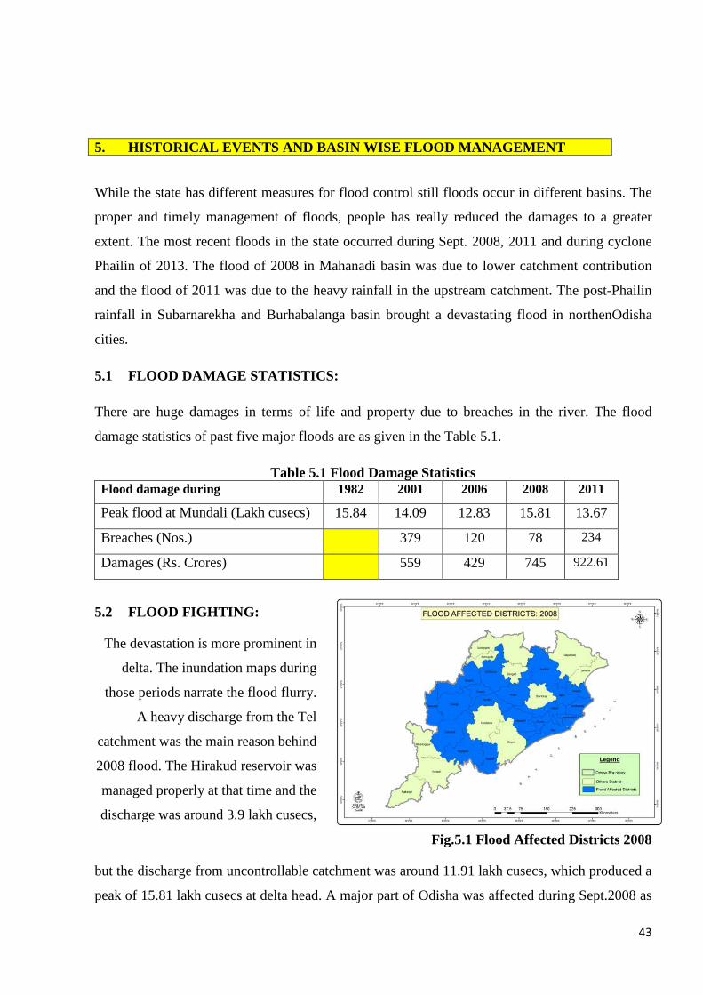
43
5. HISTORICAL EVENTS AND BASIN WISE FLOOD MANAGEMENT
While the state has different measures for flood control still floods occur in different basins. The
proper and timely management of floods, people has really reduced the damages to a greater
extent. The most recent floods in the state occurred during Sept. 2008, 2011 and during cyclone
Phailin of 2013. The flood of 2008 in Mahanadi basin was due to lower catchment contribution
and the flood of 2011 was due to the heavy rainfall in the upstream catchment. The post-Phailin
rainfall in Subarnarekha and Burhabalanga basin brought a devastating flood in northenOdisha
cities.
5.1 FLOOD DAMAGE STATISTICS:
There are huge damages in terms of life and property due to breaches in the river. The flood
damage statistics of past five major floods are as given in the Table 5.1.
Table 5.1 Flood Damage Statistics Flood damage during 1982 2001 2006 2008 2011
Peak flood at Mundali (Lakh cusecs) 15.84 14.09 12.83 15.81 13.67
Breaches (Nos.) 379 120 78 234
Damages (Rs. Crores) 559 429 745 922.61
5.2 FLOOD FIGHTING:
The devastation is more prominent in
delta. The inundation maps during
those periods narrate the flood flurry.
A heavy discharge from the Tel
catchment was the main reason behind
2008 flood. The Hirakud reservoir was
managed properly at that time and the
discharge was around 3.9 lakh cusecs,
Fig.5.1 Flood Affected Districts 2008
but the discharge from uncontrollable catchment was around 11.91 lakh cusecs, which produced a
peak of 15.81 lakh cusecs at delta head. A major part of Odisha was affected during Sept.2008 as
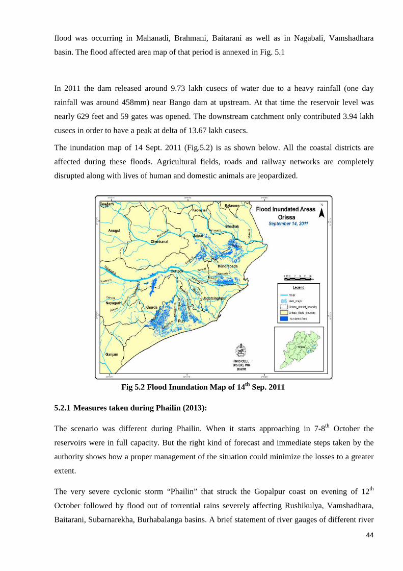
44
flood was occurring in Mahanadi, Brahmani, Baitarani as well as in Nagabali, Vamshadhara
basin. The flood affected area map of that period is annexed in Fig. 5.1
In 2011 the dam released around 9.73 lakh cusecs of water due to a heavy rainfall (one day
rainfall was around 458mm) near Bango dam at upstream. At that time the reservoir level was
nearly 629 feet and 59 gates was opened. The downstream catchment only contributed 3.94 lakh
cusecs in order to have a peak at delta of 13.67 lakh cusecs.
The inundation map of 14 Sept. 2011 (Fig.5.2) is as shown below. All the coastal districts are
affected during these floods. Agricultural fields, roads and railway networks are completely
disrupted along with lives of human and domestic animals are jeopardized.
Fig 5.2 Flood Inundation Map of 14th Sep. 2011
5.2.1 Measures taken during Phailin (2013):
The scenario was different during Phailin. When it starts approaching in 7-8th October the
reservoirs were in full capacity. But the right kind of forecast and immediate steps taken by the
authority shows how a proper management of the situation could minimize the losses to a greater
extent.
The very severe cyclonic storm “Phailin” that struck the Gopalpur coast on evening of 12th
October followed by flood out of torrential rains severely affecting Rushikulya, Vamshadhara,
Baitarani, Subarnarekha, Burhabalanga basins. A brief statement of river gauges of different river
45
basins showing observed river gauges, danger levels, highest gauge recorded and the duration of
time river flows over danger level during the cyclone.
As per the Quantitative Precipitation Forecast (QPF) published by IMD for different time period,
the probable reservoir carrying and discharge capacity are to be predetermined. Accordingly the
possible release of reservoir is to be calculated keeping in the view the probable inflow to it.
The similar exemplary situation has been occurred during last PHAILIN, strong precautionary
measures have been taken in order to create space for cyclone forced rain as the reservoir and its
catchment was falling on the track and influence zone of the cyclone.
As a measure of preparedness for the anticipated VSCS on the coast of Odisha, a meeting as well
as video conferencing were held under the chairmanship of Hon’ble Chief Minister of Odisha on
the 9th Oct 2013.
- The Principal Secretary to Govt. in DoWR issued alert to the EIC, WR for the emergency
situation due to cyclonic storm. The same was transmitted to field functionaries.
- The telephone numbers/fax/e-mailaddresses of flood control rooms in respect of different
districts, circles, divisions, were kept ready for regular contact during emergency. Control
rooms were opened in the Major and Medium Irrigation, Minor Irrigation, OLIC head
quarters and field officials.
- The IMD forecast regarding the anticipated cyclonic wind speed / category of storms were
intimated to the field officers.
- The probable tracks, influence zone, basins, rivers and reservoirs lying in this zone are
considered as sensitive and these were monitored regularly (Fig.5.3).
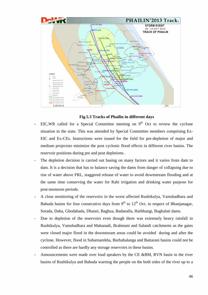
46
Fig.5.3 Tracks of Phailin in different days
- EIC,WR called for a Special Committee meeting on 9th Oct to review the cyclone
situation in the state. This was attended by Special Committee members comprising Ex-
EIC and Ex-CEs. Instructions were issued for the field for pre-depletion of major and
medium projectsto minimize the post cyclonic flood effects in different river basins. The
reservoir positions during pre and post depletions .
- The depletion decision is carried out basing on many factors and it varies from dam to
dam. It is a decision that has to balance saving the dams from danger of collapsing due to
rise of water above FRL, staggered release of water to avoid downstream flooding and at
the same time conserving the water for Rabi irrigation and drinking water purpose for
post-monsoon periods.
- A close monitoring of the reservoirs in the worst affected Rushikulya, Vamshadhara and
Bahuda basins for four consecutive days from 9th to 12th Oct. in respect of Bhanjanagar,
Sorada, Daha, Ghodahada, Dhanei, Baghua, Badanalla, Harbhangi, Baghalati dams.
- Due to depletion of the reservoirs even though there was extremely heavy rainfall in
Rushikulya, Vamshadhara and Mahanadi, Brahmani and Salandi catchments as the gates
were closed major flood in the downstream areas could be avoided during and after the
cyclone. However, flood in Subarnarekha, Burhabalanga and Baitarani basins could not be
controlled as there are hardly any storage reservoirs in these basins.
- Announcements were made over loud speakers by the CE &BM, RVN basin in the river
basins of Rushikulya and Bahuda warning the people on the both sides of the river up to a
5/28/2014 GP Roy,DoWR. 101
#
#
!
!
!
!
"
"
"
"
"
"
Ï
Ï
Ï
KJ
KJ
KJ
KJ
KJ
KJ
KJ
¥
¥
¥
¥
¥
¥
¥
¥
¥
¥
¥
¥
¥
¥
¥
¥
¥
¥
¥
¥¥
¥ ¥
¥
¥
¥
¥
¥
¥ ¥
¥
¥
¥
¥
¥
¥
¥
¥
¥
¥
KJ
KJKJ
KJ
KJ
KJ
KJKJ
KJKJ
UPPER MAHANADI
TEL BASIN
SUBARNAREKHA
UPPER BRAHMANI BASIN
VANSHADHARA
BAITARANI BASIN
KOLAB BASIN NAGAVALI BASIN
MAHANADI DELTA
LOWER BRAHMANI BASIN
RUSHIKULYA BASIN
INDRABATI BASIN
BURHABALANGA BASIN
MAHANADI (HIRAKUD - KHAIRMAL)
MAHANADI (KHAIRMAL - BARMUL)
MAHANADI ( BARMUL-NARAJ)
INDRABATI BASIN
12/18Z
13/18Z
14/1130 (56)
12/1130 (260)
13/1130 (140)
14/0530 (56)
13/1730 (93)
13/0530 (160)
12/1730 (225)
13/2330 (56)
13/1130 (120)
12/1330 (185)
Ong
Nesa
Kalo
Daha
Uttei
Sunei
Remal
Sundar
Ramial
Gohira
Dhanei
Saipala
KhadkeiJambiraHaladia
Derjang
Bhaskel
Salandi
Jalaput
Rengali
Hirakud
Talasara
Satiguda
Kanjhari
Balimela
Kodar Dam
SarafgarhPitamahal
Pilasalki
Jharbandh
Ghodahado
BadanallaIndravati
Sondur Dam
Upper Jonk
Kansabahal
Dumarbahal
Bankabahal
Dudhawa Dam
Sikaser DamDadaraghati
Bhanjanagar
Upper Kolab
Kharung Tank Maniyari Tank
Budhabudhiani
Moorumsili Dam
Jonk Diversion
Baghua Stage-II
Ravi Shankar Dam
Baghalati Stage-I
Minimata Bango Dam
Sorada (Balancing Re
STORM EVENT08 - 14 OCT 2013
TRACK OF PHAILIN
Legend
KJ Major
¥ Medium
Ï Approach Date (13 Oct)
" Approach Date (12 Oct)
! Approach Date (11 Oct)
# Approach Date (10 Oct)
Track (13 Oct)
Track (12 Oct)
Track (11 Oct)
Track (10 Oct)
River Basin
Area of Influence (13 Oct)
Area of Influence (12 Oct)
Area of Influence (11 Oct)
Area of Influence (10 Oct)
12/2330 (205)
PHAILIN’2013 Track.
47
distance of 20km to move to the higher and safer places as a precautionary measure
against storm surge inundation.
- Flood fighting materials like sand, sand bags, bamboo bullah were pre-positioned before
the flood. All field engineers were asked to do round the clock patrolling of the
embankments in collaboration in collaboration with PaniPanchayats and local
communities.
- Throughout the cyclone and flood, the Principal Secretary to Govt. in DoWR was
regularly collecting the river gauge and reservoir water level data on hourly basis through
SMS. The vital reading were monitored and exchanged between the field functionaries of
the department up to Principal Secretary level.
- The Principal Secretary to Govt. in DoWR issued order for cancellation of holidays during
Durga Puja for round the clock operation of the control rooms at different levels as a
measure for fighting the calamity.
- The time to time updated IMD bulletins were sent to field officials for taking latest
precautionary measures.
- As per the review meeting conducted under the Chairmanship of Hon’ble minister
Revenue and Disaster Management, Odisha on the anticipated cyclonic storm, the field
officials were intimated as follows:
� Round the clock operation of emergency centres and control room at circle
and division levels of the Water Resource Department.
� Requisition of the machineries and equipments like JCB, Excavator etc. to
be in readiness for rescue and mitigation operation.
� Ensure uninterrupted power supply to the control rooms by providing DG
sets
� To safe guard the saline embankments against the anticipated surge caused
due to cyclonic storm.
� To be in close contact with flood cell/ control room of EIC WR and SRC to
get transmit the updated information on the anticipated cyclone.
During Oct’2013 the disaster related information has been delivered through SMS to all
concerned the authorities as shown below. The system performs very well in dissemination of
important decisions, which needs to be continued in this year.
A sample of IMD data transmission during Oct.’2013 is as follows:
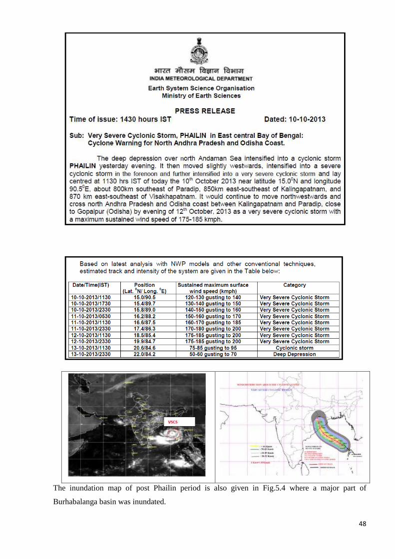
48
The inundation map of post Phailin period is also given in Fig.5.4 where a major part of
Burhabalanga basin was inundated.
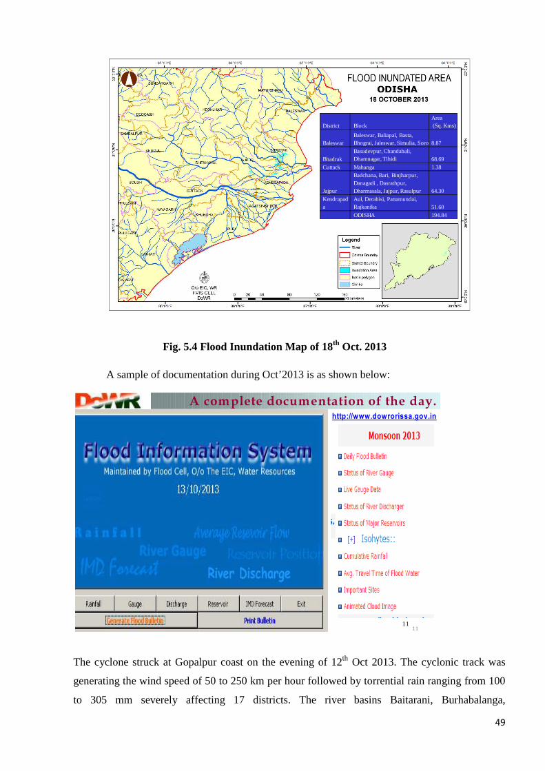
49
Fig. 5.4 Flood Inundation Map of 18th Oct. 2013
A sample of documentation during Oct’2013 is as shown below:
The cyclone struck at Gopalpur coast on the evening of 12th Oct 2013. The cyclonic track was
generating the wind speed of 50 to 250 km per hour followed by torrential rain ranging from 100
to 305 mm severely affecting 17 districts. The river basins Baitarani, Burhabalanga,
District BlockArea(Sq. Kms)
BaleswarBaleswar, Baliapal, Basta, Bhograi, Jaleswar, Simulia, Soro 8.87
BhadrakBasudevpur, Chandabali, Dhamnagar, Tihidi 68.69
Cuttack Mahanga 1.38
Jajpur
Badchana, Bari, Binjharpur, Danagadi , Dasrathpur, Dharmasala, Jajpur, Rasulpur 64.30
Kendrapada
Aul, Derabisi, Pattamundai, Rajkanika 51.60
ODISHA 194.84
5/28/2014 1111
A complete documentation of the day.http://www.dowrorissa.gov.in
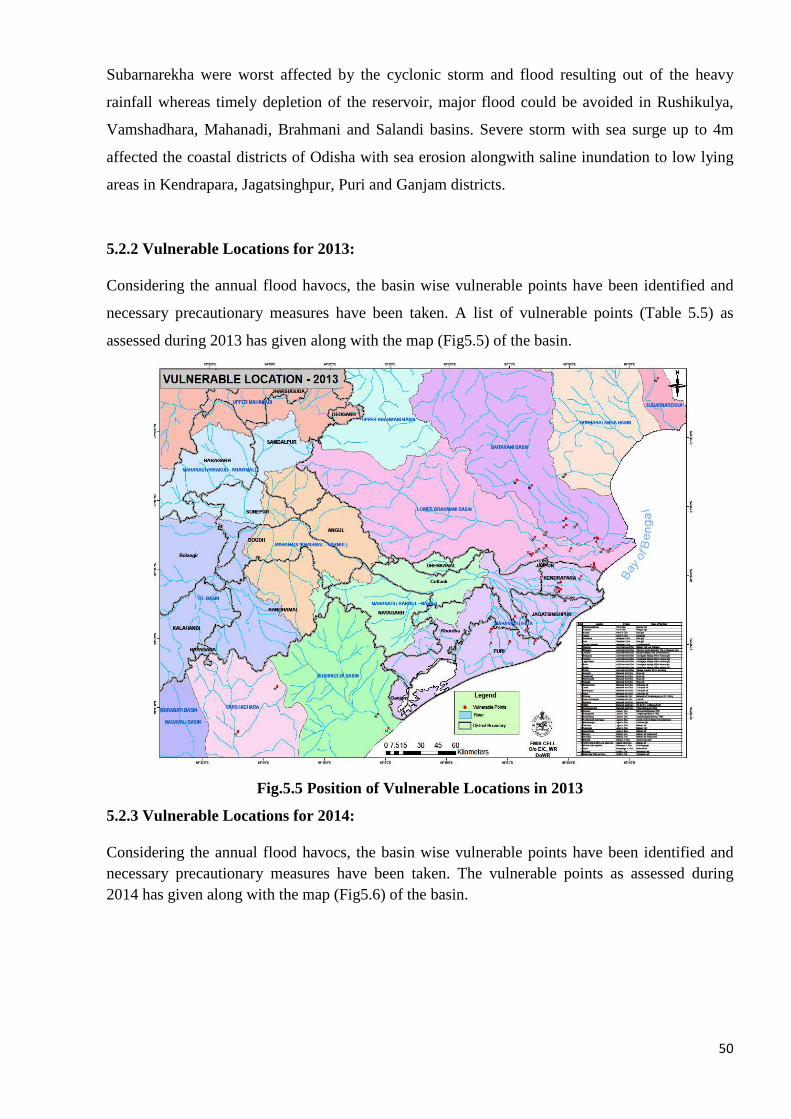
50
Subarnarekha were worst affected by the cyclonic storm and flood resulting out of the heavy
rainfall whereas timely depletion of the reservoir, major flood could be avoided in Rushikulya,
Vamshadhara, Mahanadi, Brahmani and Salandi basins. Severe storm with sea surge up to 4m
affected the coastal districts of Odisha with sea erosion alongwith saline inundation to low lying
areas in Kendrapara, Jagatsinghpur, Puri and Ganjam districts.
5.2.2 Vulnerable Locations for 2013:
Considering the annual flood havocs, the basin wise vulnerable points have been identified and
necessary precautionary measures have been taken. A list of vulnerable points (Table 5.5) as
assessed during 2013 has given along with the map (Fig5.5) of the basin.
Fig.5.5 Position of Vulnerable Locations in 2013
5.2.3 Vulnerable Locations for 2014:
Considering the annual flood havocs, the basin wise vulnerable points have been identified and necessary precautionary measures have been taken. The vulnerable points as assessed during 2014 has given along with the map (Fig5.6) of the basin.
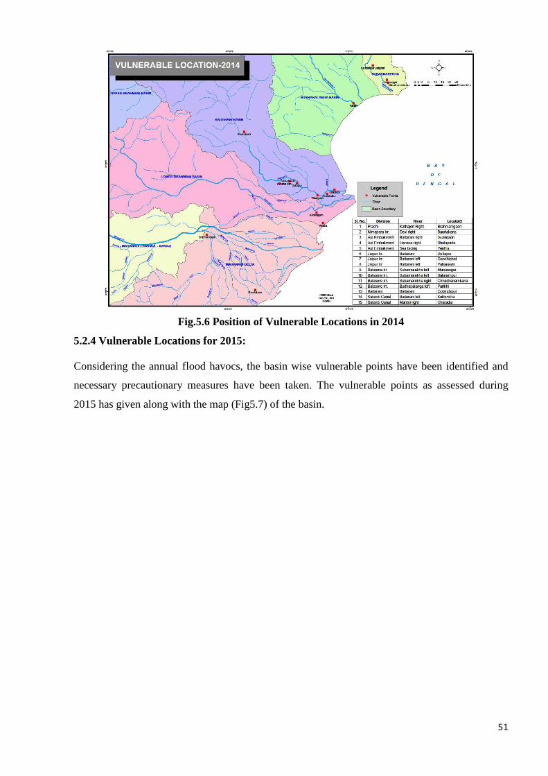
51
Fig.5.6 Position of Vulnerable Locations in 2014
5.2.4 Vulnerable Locations for 2015:
Considering the annual flood havocs, the basin wise vulnerable points have been identified and
necessary precautionary measures have been taken. The vulnerable points as assessed during
2015 has given along with the map (Fig5.7) of the basin.

52
Fig.5.7 Position of Vulnerable Locations in 2015
5.2.5 Vulnerable Locations for 2016:
Considering the annual flood havocs, the basin wise vulnerable points have been identified and
necessary precautionary measures have been taken. The vulnerable points as assessed during
2016 has given along with the map (Fig5.8) of the basin.
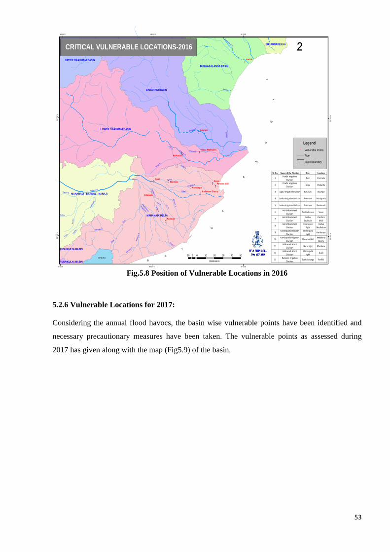
53
Fig.5.8 Position of Vulnerable Locations in 2016
5.2.6 Vulnerable Locations for 2017:
Considering the annual flood havocs, the basin wise vulnerable points have been identified and
necessary precautionary measures have been taken. The vulnerable points as assessed during
2017 has given along with the map (Fig5.9) of the basin.
B
A
Y
O
F
B
E
N
GA
L
")
")
")
")
")
")")
")
")
")
")
")")
MAHANADI DELTA
BAITARANI BASIN
LOWER BRAHMANI BASIN
BURHABALANGA BASIN
MAHANADI ( BARMUL - NARAJ)
UPPER BRAHMANI BASIN
SUBARNAREKHA
RUSHIKULYA BASIN
RUSHIKULYA BASIN
CHILIKA
Brahmani R
Kharsua R
Daya
Devi R.
Birupa R
Kus
ami
Mahanadi R.
Prachi N.
Gobari N
Duant
Alka N.
Baitarani R.
Mat
ei R
Bara na la N
.
Chitrotpala R
Paika R
Dahuka
Dhanua R.
Bha
rga v
i R.
Kushabhadra
Kansbahs N.
Nagjho
r
Nuna N
Burhabalanga R.
Kelu R .
Kain
ful ia
R
Kath ajor i R
.
Makar
Kuanria N.
Ratnachir R.
Mandakini R.
Kandal N
.
GualiSasanMandana
Parikhi
Arjunpur
Parimala
Khalarda
Bankasahi
Haridaspur
Pandara Maili
Hadua Madhuban
Kodakana Gherry
87°0'0"E
87°0'0"E
86°0'0"E
86°0'0"E
85°0'0"E
85°0'0"E
21°0
'0"N
21°0
'0"N
20°0
'0"N
20°0
'0"N
10 0 10 20 30 40 505
Kilometers
²
Sl. No. Name of the Division River Location
1Prachi irrigation
DivisionDevi Parimala
2Prachi irrigation
DivisionSirua Khalarda
3 Jajpur Irrigation Division Baitarani Arjunpur
4 Jaraka Irrigation Division Brahmani Matiapada
5 Jaraka Irrigation Division Brahmani Bankasahi
6Aul Embankment
DivisionRadhia Kansar Sasan
7Aul Embankment
Division
Jambu-
Baulakani
Pandara
Maili
8Aul Embankment
Division
Kharasuan
Right
Hadua
Madhuban
9Kendrapada Irrigation
Division
Chitrotpala
rightHaridaspur
10Kendrapada Irrigation
DivisionMahanadi left
Kodakana
Gherry
11Mahanadi North
DivisionNuna right Mandana
12Mahanadi North
Division
Chitrotpala
rightGuali
13Balasore irrigation
DivisionBudhabalanga Parikhi
CRITICAL VULNERABLE LOCATIONS-2016
Legend
" Vulnerable Points
River
Basin Boundary
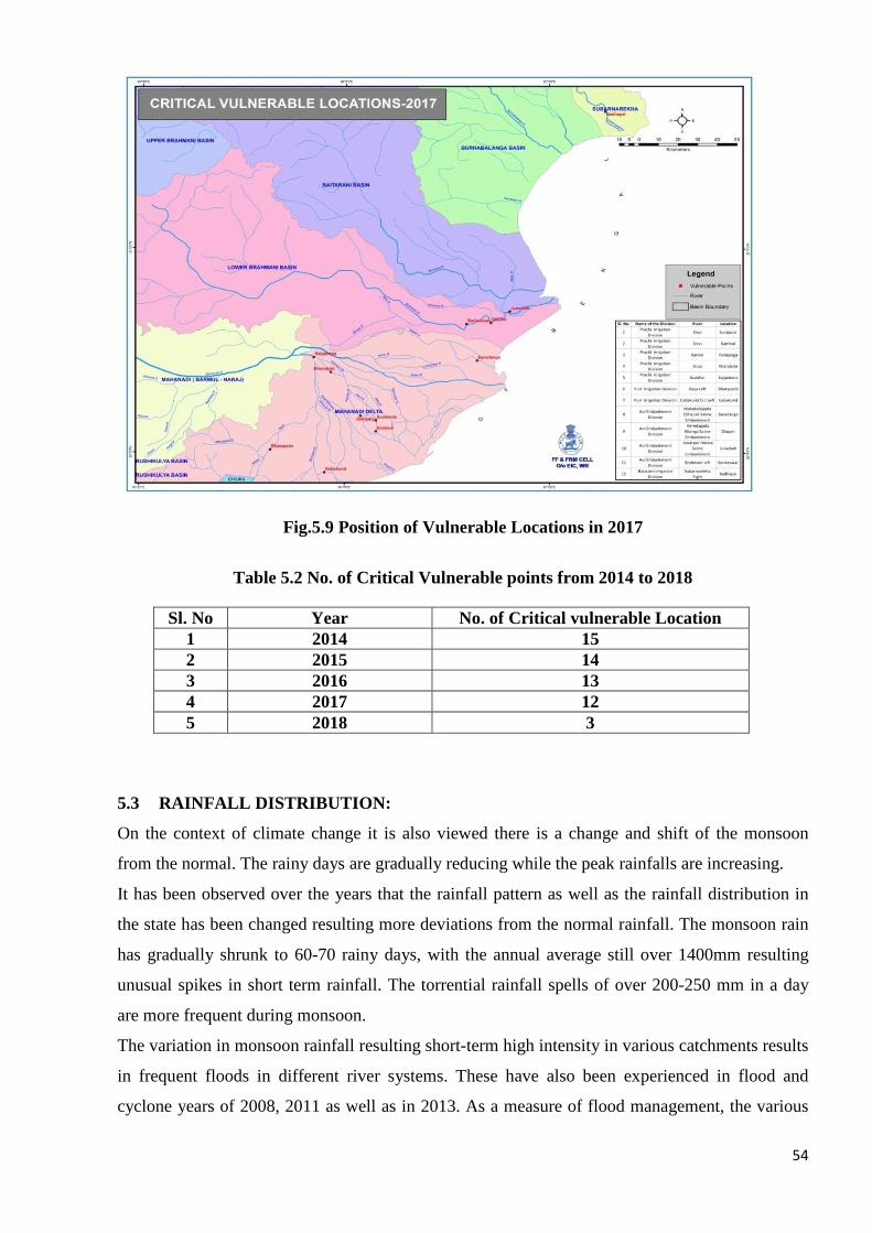
54
Fig.5.9 Position of Vulnerable Locations in 2017
Table 5.2 No. of Critical Vulnerable points from 2014 to 2018
5.3 RAINFALL DISTRIBUTION:
On the context of climate change it is also viewed there is a change and shift of the monsoon
from the normal. The rainy days are gradually reducing while the peak rainfalls are increasing.
It has been observed over the years that the rainfall pattern as well as the rainfall distribution in
the state has been changed resulting more deviations from the normal rainfall. The monsoon rain
has gradually shrunk to 60-70 rainy days, with the annual average still over 1400mm resulting
unusual spikes in short term rainfall. The torrential rainfall spells of over 200-250 mm in a day
are more frequent during monsoon.
The variation in monsoon rainfall resulting short-term high intensity in various catchments results
in frequent floods in different river systems. These have also been experienced in flood and
cyclone years of 2008, 2011 as well as in 2013. As a measure of flood management, the various
Sl. No Year No. of Critical vulnerable Location 1 2014 15 2 2015 14 3 2016 13 4 2017 12 5 2018 3

55
Major and Medium storage schemes in the states already exists have been evaluated for their live
storage capacities to conserve water. But still it is felt; the storage quantum is inadequate against
the flow volumes of the floods.

Deviation of Rainfall from normal 2016
Deviation of Rainfall from normal 2016
56
Deviation of Rainfall from normal 2016

57

Deviat
Deviation of Rainfall from normal 2017
58
2017

`
`
59
60
6.1 GENERAL: Field officers of Water Resources Department will remain alert for
watch and ward of the embankments constantly at vulnerable locations and patrolling will
be done at other places once the danger level is touched. Special attention is required to be
given to new embankments and also to old embankments where breaches occurred in the
past. The flood contingent materials like sand, empty cement bags, bamboos, bullahs etc.
should be kept ready at all strategic locations for meeting eventuality like breach/
overtopping of embankments.
6.2 ACTIVITIES:
The details of activities to be under taken for flood watching, before and during floods are
listed below.
• Repair of rain cuts are to be made.
• Scoured points are to be covered with sand bags with bullah piling, if necessary,
before flood situation arises to avoid further damage. Geo-textile or simple
polythene sheets may be spread below sand bags if the soil is of less rigidity in
order to arrest further scour.
• Round the clock watch and ward arrangement at vulnerable points will be made
once floodwater touches the embankment and the water level shows a rising trend.
Patrolling for this purpose will continue till water finally recedes from the
embankment.
• The rivers are to be carefully watched for scouring and erosion of banks for taking
necessary precautionary measures.
• Special vigilance is necessary in the countryside to detect any formation of boils
due to seepage. This is to be immediately attended to by providing loading berm to
counter balance exit gradient. A suitable filter material may be placed around
boiling point below the loading berm to arrest fines in seepage water.
• Seepage under embankment through the sand stratum may be seen emerging on the
countryside in the form of bubbling springs. As a protective measure embankment
of sand filled sacks may be built around them for ponding the water and thus a
head on the countryside is created sufficient to stop the flow of silt by minimizing
the effective head of water.
• Overtopping and washing out of a portion of embankment will have to be
6. PREPAREDNESS (For the current year)
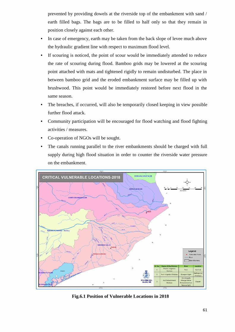
61
prevented by providing dowels at the riverside top of the embankment with sand /
earth filled bags. The bags are to be filled to half only so that they remain in
position closely against each other.
• In case of emergency, earth may be taken from the back slope of levee much above
the hydraulic gradient line with respect to maximum flood level.
• If scouring is noticed, the point of scour would be immediately attended to reduce
the rate of scouring during flood. Bamboo grids may be lowered at the scouring
point attached with mats and tightened rigidly to remain undisturbed. The place in
between bamboo grid and the eroded embankment surface may be filled up with
brushwood. This point would be immediately restored before next flood in the
same season.
• The breaches, if occurred, will also be temporarily closed keeping in view possible
further flood attack.
• Community participation will be encouraged for flood watching and flood fighting
activities / measures.
• Co-operation of NGOs will be sought.
• The canals running parallel to the river embankments should be charged with full
supply during high flood situation in order to counter the riverside water pressure
on the embankment.
Fig.6.1 Position of Vulnerable Locations in 2018
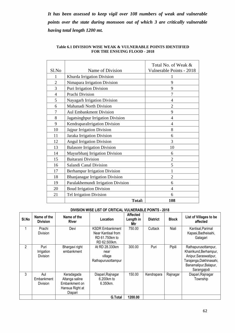
62
It has been assessed to keep vigil over 108 numbers of weak and vulnerable
points over the state during monsoon out of which 3 are critically vulnerable
having total length 1200 mt.
Table 6.1 DIVISION WISE WEAK & VULNERABLE POINTS ID ENTIFIED FOR THE ENSUING FLOOD - 2018
Sl.No Name of Division Total No. of Weak &
Vulnerable Points - 2018 1 Khurda Irrigation Division 1 2 Nimapara Irrigation Division 9 3 Puri Irrigation Division 9 4 Prachi Division 7 5 Nayagarh Irrigation Division 4 6 Mahanadi North Division 2 7 Aul Embankment Division 9 8 Jagatsinghpur Irrigation Division 4 9 KendraparaIrrigation Division 4 10 Jajpur Irrigation Division 8 11 Jaraka Irrigation Division 6 12 Angul Irrigation Division 3 13 Balasore Irrigation Division 10 14 Mayurbhanj Irrigation Division 6 15 Baitarani Division 2 16 Salandi Canal Division 5 17 Berhampur Irrigation Division 1 18 Bhanjanagar Irrigation Division 2 19 Paralakhemundi Irrigation Division 6 20 Boud Irrigation Division 4 21 Tel Irrigation Division 6
Total: 108
DIVISION WISE LIST OF CRITICAL VULNERABLE POINTS - 2018
Sl.No Name of the
Division Name of the
River Location
Affected Length in
Mtr District Block
List of Villages to be affected
1 Prachi Division
Devi KSDR Embankment Near Kantisal from RD 61.750km to RD 62.500km.
750.00 Cuttack Niali Kantisal,Parimal Kapasi,Badheisahi,
Galagari
2 Puri Irrigation Division
Bhargavi right embankment
At RD 28.330km near
village Rathapurusottampur
300.00 Puri Pipili Rathapurusottampur, Khairikund,Berhampur, Anipur,Saraswatipur,
Tarajanga,Dakhinasahi, Banamalipur,Balapur,
Sarangajodi
3 Aul Embankment
Division
Keradagada Altanga saline
Embankment on Hansua Right at
Diapari
Diapari,Rajnagar 6.200km to 6.350km.
150.00 Kendrapara Rajnagar Diapari,Rajnagar Township
G.Total 1200.00

63
Following points will be checked / discussed in this meeting.
- The identification of weak and vulnerable points on the embankment.
- Strategic locations of riverbanks for guarding and watch and ward.
- Ensuring clearance of river mouths to either Bay of Bengal or Chilkalake.
- Strengthening of data collection network and transmission system.
- The operational policy of major reservoirs.
- The possible preparatory steps for the anticipated disasters.
- The availability and engagement of human resources at right places.
- Sufficient storage of relief items like sand bags, bullah, generator, candles,
tarpaulins etc.
- Instruction for completion of pending structural works related to disasters well
before onset of monsoon.
- Other Government departments, Public are also made aware regarding the
outcomes of this meeting.
- Govt. in DoWR has communicated to Member, Central Water Commission for
transmission of flow forecast, level forecast during the monsoon.
- Under the chairmanship of Chief Secretary, Odisha a pre-cyclone exercise meeting
IS conducted on first week of May. As a follow up of the same, Engineer-in-Chief,
Water Resources instructs the concerned Chief Engineers of the interstate basins to
deploy officers not below the rank of Asst. Executive Engineers to remain present in
strategic locations inside Jharkhand and Chhatishgarh for real time transmission of
flow data and upstream dam releases.
Besides this, specific meetings during June’2017 will be conducted with
Chhatishgarh, Jharkhand counterparts by Dam safety organization of the state for
smooth flow of flood and upper catchment rainfall information.
- Special committee meeting on operation of Hirakud reservoir will be conducted
during mid June’2017. This year is so far being predicted as a less rainfall year.
Appropriate decisions will be taken regarding conservation and release from the
reservoir.
- As a normal practice, observed rainfall data, Quantitative Precipitation Forecast
(QPF) will be obtained from Indian Meteorological Department on daily basis from
1st June to 31st Oct2017. These data after analyses will be hoisted on the
department web site of daily basis.
64
In the event of depression or deep depression the impact point (land fall), eye of the
cyclone and its zone of influence are also to be marked on the catchment map so as
to identify the dams and embankments expected to be vulnerable. The strategic
locations like weak embankments, reservoirs under the influence area of the cyclone
are to be identified.
- The status of availability of flood fighting materials at different locations division
wise have been hoisted in the DoWR website www.dowrorissa.gov.in for awareness
of the public.
6.3 FLOOD PREPAREDNESS 2018 :
- Pre-flood preparedness meeting with the EEs, SEs/CCEs have been
conducted.
- State Flood Control Cell in the O/o the EIC, WR started functioning from
01.06.2018 and will continue up to 31.10.2018.
� Flood related messages like rainfall, river gauge & discharge, Major/medium
reservoir position are being collected daily.
� Flood messages from CWC & Weather report from IMD are being collected
and transmitted the same to the field level.
� Keep close contact with Revenue Dept., IMD, Hirakud and Rengali Control
Room.
� Daily Flood bulletin is being prepared incorporating Rainfall, river gauge &
discharge, reservoir position and weather forecast and communicated to 74
officials. The same is hoisted daily in the website of DOWR.
- Flood Control Cell started functioning from 01.06.2018 in Division as well
as Circle offices.
- Field Functionaries have been instructed to collect the required flood
fighting materials like sand bags, bamboos, bullah etc to be stored at
strategic location.
� Empty cement bags - 33,35,080 nos.
� Sand - 67,627 Cum.
� Bullah - 19,430 nos.
� Bamboo - 10320 nos.
� Bamboo Mat - 15,125 Sqm
6.4 Budget provision-2018
Budget provision for Flood fighting arrangement for 2018 is Rs 10 crs .The tentative
list of flood fight fighting materils required for 2018 is attached here with.
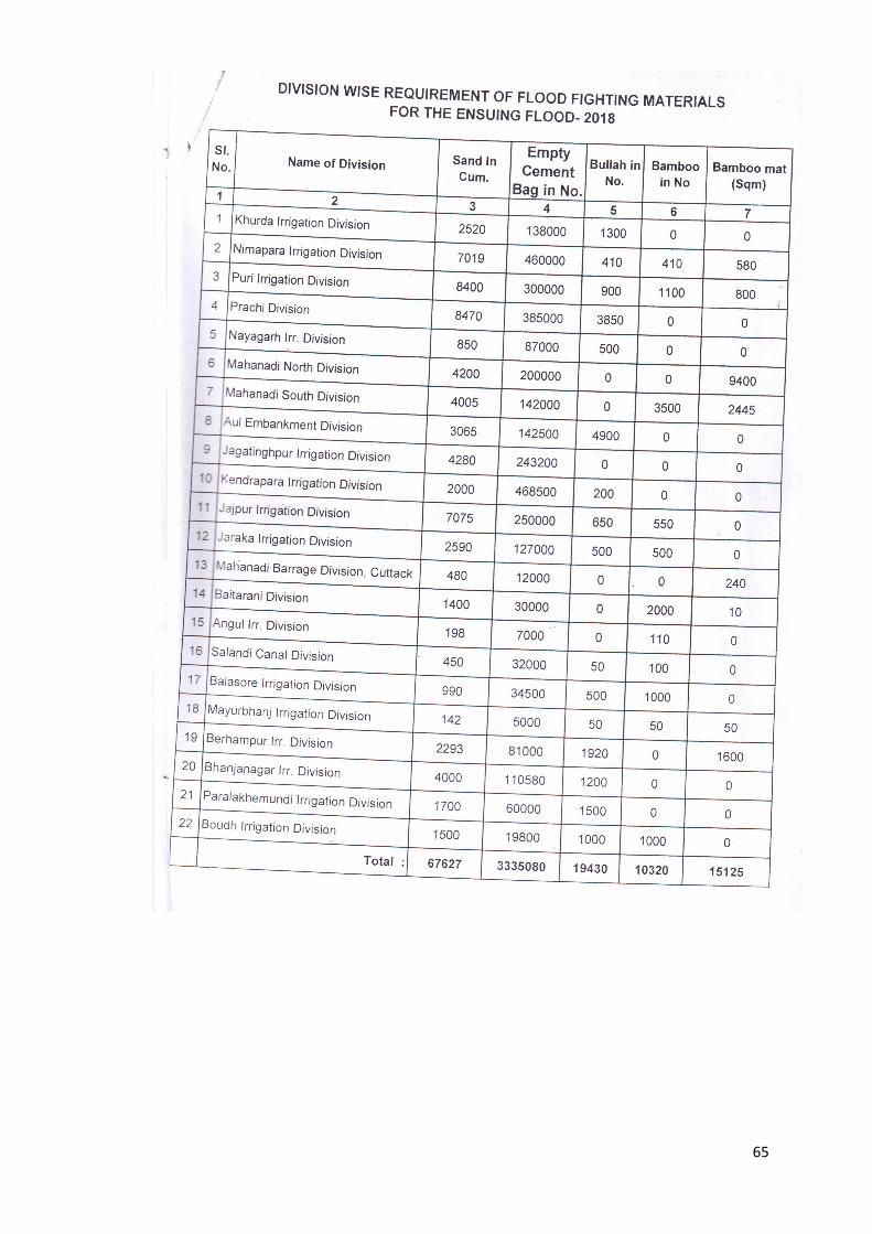
65
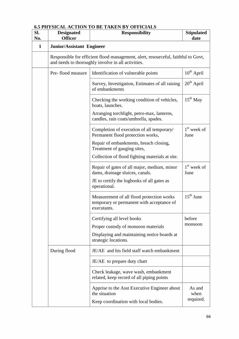
66
6.5 PHYSICAL ACTION TO BE TAKEN BY OFFICIALS Sl. No.
Designated Officer
Responsibility Stipulated date
1 Junior/Assistant Engineer
Responsible for efficient flood management, alert, resourceful, faithful to Govt, and needs to thoroughly involve in all activities.
Pre- flood measure Identification of vulnerable points 10th April
Survey, Investigation, Estimates of all raising of embankments
20th April
Checking the working condition of vehicles, boats, launches.
Arranging torchlight, petro-max, lanterns, candles, rain coats/umbrella, spades.
15th May
Completion of execution of all temporary/ Permanent flood protection works,
Repair of embankments, breach closing, Treatment of gauging sites,
Collection of flood fighting materials at site.
1st week of June
Repair of gates of all major, medium, minor dams, drainage sluices, canals.
JE to certify the logbooks of all gates as operational.
1st week of June
Measurement of all flood protection works temporary or permanent with acceptance of executants.
15th June
Certifying all level books
Proper custody of monsoon materials
Displaying and maintaining notice boards at strategic locations.
before monsoon
During flood JE/AE and his field staff watch embankment
JE/AE to prepare duty chart
Check leakage, wave wash, embankment related, keep record of all piping points
Apprise to the Asst Executive Engineer about the situation
Keep coordination with local bodies.
As and when
required.
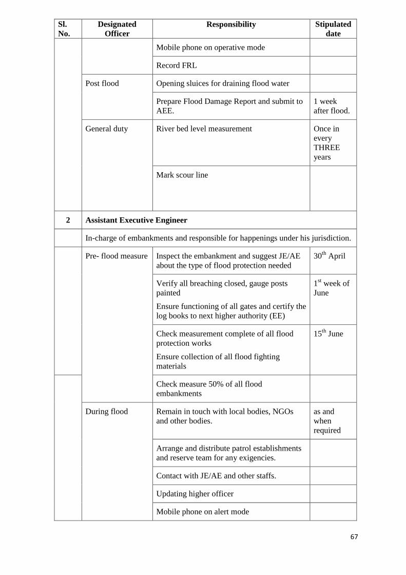
67
Sl. No.
Designated Officer
Responsibility Stipulated date
Mobile phone on operative mode
Record FRL
Post flood Opening sluices for draining flood water
Prepare Flood Damage Report and submit to AEE.
1 week after flood.
General duty River bed level measurement Once in every THREE years
Mark scour line
2 Assistant Executive Engineer
In-charge of embankments and responsible for happenings under his jurisdiction.
Pre- flood measure
Inspect the embankment and suggest JE/AE about the type of flood protection needed
30th April
Verify all breaching closed, gauge posts painted
Ensure functioning of all gates and certify the log books to next higher authority (EE)
1st week of June
Check measurement complete of all flood protection works
Ensure collection of all flood fighting materials
15th June
Check measure 50% of all flood embankments
During flood Remain in touch with local bodies, NGOs and other bodies.
as and when required
Arrange and distribute patrol establishments and reserve team for any exigencies.
Contact with JE/AE and other staffs.
Updating higher officer
Mobile phone on alert mode
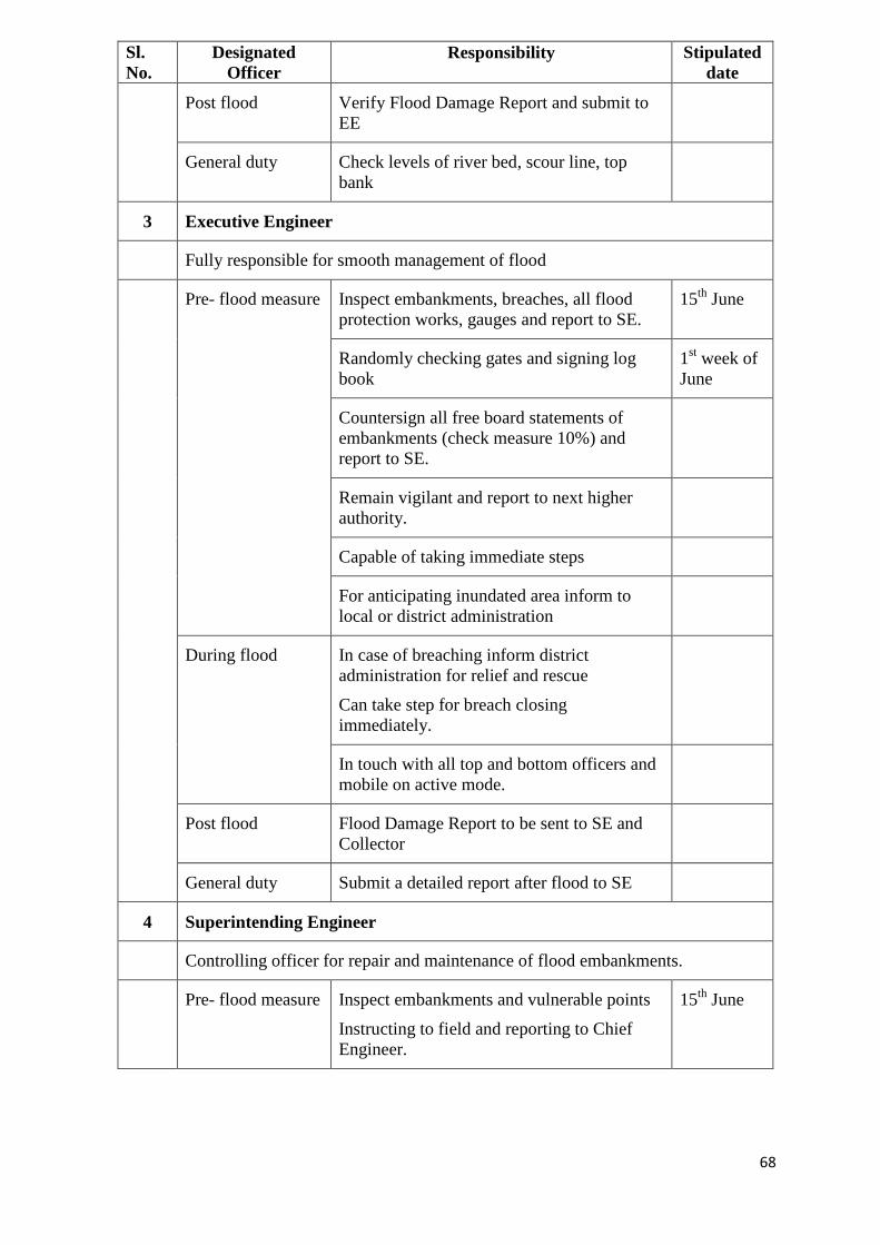
68
Sl. No.
Designated Officer
Responsibility Stipulated date
Post flood Verify Flood Damage Report and submit to EE
General duty Check levels of river bed, scour line, top bank
3 Executive Engineer
Fully responsible for smooth management of flood
Pre- flood measure
Inspect embankments, breaches, all flood protection works, gauges and report to SE.
15th June
Randomly checking gates and signing log book
1st week of June
Countersign all free board statements of embankments (check measure 10%) and report to SE.
Remain vigilant and report to next higher authority.
Capable of taking immediate steps
For anticipating inundated area inform to local or district administration
During flood In case of breaching inform district administration for relief and rescue
Can take step for breach closing immediately.
In touch with all top and bottom officers and mobile on active mode.
Post flood Flood Damage Report to be sent to SE and Collector
General duty Submit a detailed report after flood to SE
4 Superintending Engineer
Controlling officer for repair and maintenance of flood embankments.
Pre- flood measure
Inspect embankments and vulnerable points
Instructing to field and reporting to Chief Engineer.
15th June
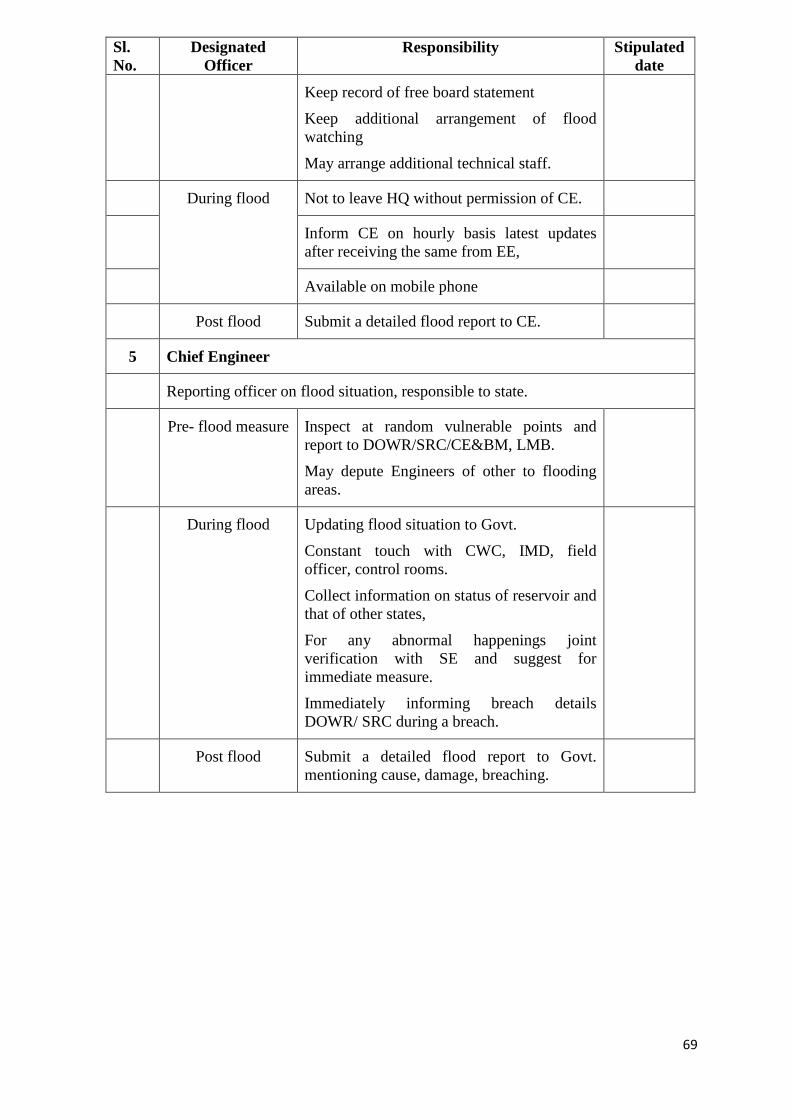
69
Sl. No.
Designated Officer
Responsibility Stipulated date
Keep record of free board statement
Keep additional arrangement of flood watching
May arrange additional technical staff.
During flood Not to leave HQ without permission of CE.
Inform CE on hourly basis latest updates after receiving the same from EE,
Available on mobile phone
Post flood Submit a detailed flood report to CE.
5 Chief Engineer
Reporting officer on flood situation, responsible to state.
Pre- flood measure
Inspect at random vulnerable points and report to DOWR/SRC/CE&BM, LMB.
May depute Engineers of other to flooding areas.
During flood Updating flood situation to Govt.
Constant touch with CWC, IMD, field officer, control rooms.
Collect information on status of reservoir and that of other states,
For any abnormal happenings joint verification with SE and suggest for immediate measure.
Immediately informing breach details DOWR/ SRC during a breach.
Post flood Submit a detailed flood report to Govt. mentioning cause, damage, breaching.
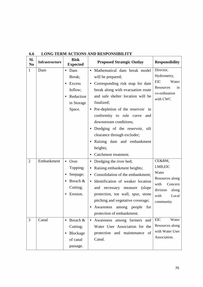
70
6.6 LONG TERM ACTIONS AND RESPONSIBILITY Sl. No
Infrastructure Risk Expected Proposed Strategic Outlay Responsibility
1 Dam • Dam
Break;
• Excess
Inflow;
• Reduction
in Storage
Space.
• Mathematical dam break model
will be prepared;
• Corresponding risk map for dam
break along with evacuation route
and safe shelter location will be
finalized;
• Pre-depletion of the reservoir in
conformity to rule curve and
downstream conditions;
• Dredging of the reservoir, silt
clearance through excluder;
• Raising dam and embankment
heights;
• Catchment treatment.
Director,
Hydrometry,
EIC Water
Resources in
co-ordination
with CWC
2 Embankment • Over
Topping;
• Seepage;
• Breach &
Cutting;
• Erosion.
• Dredging the river bed;
• Raising embankment heights;
• Consolidation of the embankment;
• Identification of weaker location
and necessary measure (slope
protection, toe wall, spur, stone
pitching and vegetative coverage;
• Awareness among people for
protection of embankment.
CE&BM,
LMB,EIC
Water
Resources along
with Concern
division along
with Local
community
3 Canal • Breach &
Cutting;
• Blockage
of canal
passage.
• Awareness among farmers and
Water User Association for the
protection and maintenance of
Canal.
EIC Water
Resources along
with Water User
Association.
71
6.7 DAMS &THEIR EMERGENCY ACTION PLAN
A Dam is an artificial barrier that has capacity to store or impound water to provide
irrigation, power supply, human consumption, industrial use, aquaculture and navigability.
On the other hand; Dams are considered ‘’Installations containing dangerous forces’’
under International Humanitarian Law as it induces massive destruction of live, property
and environment on failure. There are 204 nos. of large dams in Odisha which have been
categorized in to Major, Medium & Minor based on its culturable command area. As
natural or induced floods are of increasing concern due to adverse hydro-meteorological
conditions. Standard Operating Procedure (SOP) and Emergency Action Plan (EAP) are
ought to be present for existing dams to prevent or minimize the damages to life and
property.EAP is a formal plan that depicts the identification of emergency conditions at the
dam site and prescribes the pre-planned actions to be followed by the different agencies so
as to mitigate the loss to a manageable extent. The sudden release of huge quantity of
water or dam break creates such emergency conditions at dam as well as the downstream
areas, which requires warning, evacuation, rescue and relief operations within minimum
response time. The purpose of an EAP is to protect lives and reduce property damage.
EAP therefore prescribes the duties and responsibilities of the Emergency Planning
Manager and operating personnel and provides procedures designed to identify unusual
and unlikely condition which endangers Dam. Apart from that, this Plan is designed to
notify the appropriate public officials and downstream residents, impending or actual dam
failure, so that the area can be evacuated in a timely manner. EAP also contains inundation
maps to show the emergency management authorities the critical areas along the river for
action in case of an emergency.
6.7.1 Why Dam Fails?
Dams can fail for one or a combination f the following reasons:
• Overtopping caused by floods that exceed the capacity of the dam.
• Deliberate acts of sabotage
• Structural failure of materials used in the dam construction
72
• Piping and internal erosion of soil in the embankment
• Inadequate maintenance and upkeep
6.7.2 How to keep a watch on Dam Condition?
Followings are the steps to keep a watch on Dam condition
6.7.2.1 Brief history of the dam and salient features:
This will be dam specific.
6.7.2.2 Assessment of Health Status: -
It is pertinent on every dam authority to complete pre- and post-monsoon
inspection reports in prescribed time and take appropriate preventive measures as
per the assessment of State Dam Safety Organization (SDSO). The expert and
professional opinion may be sought in case of critical distress conditions
6.7.2.3 Reservoir operation:
The reservoir operation comprises of gate operation, mock drill, reservoir
regulation and flood forecasting.
i)Gate Operation:
• The working of spillway gates, under sluices and outlets / Head Regulators
from Reservoir shall be checked before the onset of monsoon every year.
• The gate operation schedule preferably based on site condition should clearly
indicate the complete sequence and stages of operation of various gates
corresponding to various reservoir levels and flood situations.
• All mechanical and electrical equipments shall be maintained properly and
inspected at regular intervals to be specified by Dam authorities.
• Operating instructions shall be displayed near equipments for important
structures.
ii) Mock Drill:
The dam authorities shall regularly organize mock drill specifically with
respect to the operation of gates and hydro-mechanical equipments of all dams
prior to onset of monsoon and deficiency of gates should be kept in mind. In
73
case of any serious deficiency in any gate, a prominent tag depicting 'NOT TO
BE OPERATED' should be hanged.
iii) Reservoir Regulation:
• Reservoir operation schedule shall be regularly reviewed and. if necessary,
modified.
• Reservoir silt survey should be done at regular intervals and area capacity
curve of the reservoir should be accordingly revised.
• Flood carrying capacity of the river channels downstream of the dam shall be
reviewed at regular intervals.
• The adequacy of spillway and free board need to be reviewed periodically with
the help of continuous short term data, built up during the course of operation.
• There should be exchange of operation schedule, inflow, outflow and SOP on
regular basis during monsoon /emergent situation among the inter-state dams
so as to moderate flood inflow.
iv) Flood forecasting:
• An efficient flood forecasting system should be established to formulate
forecasts of inflow and volume of floods and regulation of gates for efficient
flood disposal. .
• Actions may be initiated to install Automatic as well as manual Water Level
Recorder in the reservoir that will facilitate the user to calibrate on the spot and
transmit data anywhere as per the need and requirement.
6.7.2.4 Instrumentation:
• The dam authorities will ensure the installation of basic instruments like V-
notch, piezometers at strategic locations and also need through analysis prior to
the onset monsoon
• The dam authority needs to check whether the piezometric observations are
within the limits of phreatic line as per the design.
• The water quality test of seepage must be conducted at regular interval to assess
the presence of turbidly and other minerals.
6.7.2.5 Emergency Situations, Signs of Failure and Classification
i. Situations
Many dam conditions can lead to emergency situations, not all of which
will necessitate the implementation of the EAP. However, if any of them
occur, the appropriate actions must be taken.
• Severe Storms/ Inclement Weather: Although generally not in themselves a
74
threat to the dam, severe storms and other inclement weather conditions can
contribute to an existing problem and hinder any remediation efforts. Severe
storms also cause the uncontrolled release of floodwater, and increase flow
in already rain -swollen areas.
• Tropical cyclones: Tropical cyclones do occur in the area, with the potential
for structural damage to the dam, possibly resulting in its failure. If a
tropical cyclone has struck in the area, an inspection of the dam for any
signs of damage will be appropriate.
• Earthquakes: Appropriate post-earthquake inspections should be performed
based on dam is located on which earthquake zone.
• Sabotage: A threat to damage the dam has been made. Appropriate actions
must be taken to protect the dam.
ii. Signs of Failure
The early identification of potentially dangerous conditions can allow time
for the implementation of EAPs. It is important to understand how distress
can develop into failure. With appropriate action, distress need not lead to a
catastrophic failure of the dam. The following sections describe some o f
the different types of failure which could lead to a dam failure.
• Seepage Failure: Although all earthen embankments allow some minor
seepage through the dam or the foundation, excessive, uncontrolled seepage
can result in piping(the movement of embankment material in the seepage
flow)and lead to failure. Piping can occur for years at a slow rate. If the
piping has progressed to a dangerous level, it will be evident by increased
flow or the discharge of muddy water (or both).At that stage, immediate
action to stop the piping is needed. Fully developed piping is difficult to
control and is very likely to result in failure. A whirl pool in the reservoir is
a sign of uncontrollable piping and necessitates immediate emergency
action.
• Embankment or Foundation Sliding: Sliding is usually first apparent when
cracks or bulges in the embankment appear. Slides with progressive
movement can cause failure of the embankment.
• Structural Failure: The structural failure or collapse of any non-overflow
portion of the dam, spillway or spillway gates could result in loss of the
reservoir. A structural failure of a portion of the spillway could cause
piping and possibly embankment failure.
75
• Overtopping Failure: Overtopping of the embankment results in erosion of
the dam crest. Once erosion begins, it is very difficult to stop.
iii.Emergency classification:
A) Internal Alert Condition BLUE
A BLUE emergency level is created by an unusual, slowly developing event
that poses no threat to the structural stability of the dam or to its operational
elements, and which does not make unviable the dam observation system.
The condition will not have an off-site impact. However, the situation is one
that needs to be monitored closely to make sure the condition does not
worsen. If the condition does become more severe or unfavourable, the
emergency status will be elevated to the next level.
B) External Alert Condition ORANGE
An ORANGE emergency level occurs when a rapidly developing situation
is taking place that will probably cause the dam to fail and produce a
devastating flood. However, enough time is available for analysis before
deciding whether or not to evacuate residents. Emergency responders in
affected areas will be alerted that an unsafe situation is developing and dam
failure is possible. Authorities responsible for rescue and relief shall gear up
for evacuation of residents in potential inundation areas. When it is
determined that there is no longer time available to implement corrective
measures to prevent dam failure, the emergency status will be elevated to
the highest (Red) level
C) External Alert Conditions RED– These are “failure” conditions. Either
the dam is in immediate danger of failing or has already failed. No time
remains to implement measures to prevent failure. Evacuate immediately.
Evacuation efforts will continue until the situation is stabilized. A RED
emergency level is triggered when dam failure is about to occur or is
already in progress. Once a decision is made that there is no possibility of
preventing failure, an order for evacuation of residents in potential
inundation areas will be issued immediately by the incident commander or
emergency responder.
6.7.3 How to get prepared before a Dam Failure
6.7.3.1 Preparedness
76
• The inundation maps may be prepared for three conditions of flooding- i)
Overtopping, ii) Piping and iii) Large controlled-release which will depict
the flooded areas from a dam failure. The dam Authority should mark the
list of towns, villages and important public buildings, road connectivity
which comes under the flood line to reduce the effects of a dam failure.
Surveillance, Response on forecast of excessive inflow, Response during
weekends and holidays, Response during periods of darkness and adverse
weather, Access to the site could prevent or delay failure after an
emergency is first discovered.
• Records that may be required for proper inspection and maintenance
shall be available at dam site office & regularly updated.
• Where no record is available, efforts shall be made to generate them.
• Data in respect of upstream gauge stations, flood warning system,
communication channels and additional data such as rainfall, wave
height, wind velocity, temperature, humidity etc. shall be collected
6.7.3.2 Warning System:
• The dam authorities shall identify the vulnerable areas, tourist spots by using
inundation maps& mark the danger levels at appropriate places. The time of
arrival of wave front, maximum depth of inundation, and maximum
velocity of flow may also be estimated for areas of high impact.
• There should be permanent warning posts, which should be visible with
naked eyes from reasonable distance within a distance of 15 km
downstream from Dam in case of Major Projects, 5 km from Medium
Projects & 2 km for Minor Projects.
• The district administration i.e. Collector, SP, BDO, Tahasildar & other
important officers along with Press & Media. T.V & News channels
.Radio may be generally intimated regarding first release of the water
during monsoon prior to 48hrs for all major dams and 24hrs for all gated
medium dams However this time line for intimation may be fixed for each
gated Dam separately by the Project authorities depending on Project
specific issues. District administration will be intimated at least 3 hrs
before each subsequent releases during monsoon periods & all releases
during non-monsoon period. The district administration & important
officers shall be intimated through Fax & e-mail by the project authority
within timeline,
77
• It is essential to install sirens to alert the nearby locality in the downstream
areas before release of water from gated reservoirs. Powerful sirens to be
installed at audible locations so that they can be heard up to 5 km
downstream for all Major Dams & 2 km downstream for all gated medium
dams
• Steps shall be taken within a time frame for providing successive Sirens
which will be audible up to 15 km downstream for all major dams and 5
km downstream for all gated medium dams.
• The sirens shall be blown 2hrs prior to the opening of gates in 15 minutes
interval for 3 times and shall be continuous 15 minutes prior to and during
the entire gate operation of all Major & gated Medium Dams. This process
shall be repeated after all the gates are closed & again gates are required to
be opened afresh this is applicable for monsoon & non-monsoon fresh
releases.
• In addition to that a mobile van equipped with public address system to
give prior warning along 10 km downstream in habitations in case of
Major projects & 3kms downstream in case of gated medium irrigation
projects.
6.7.3.3 Communication System:
• The dam authorities for all Major & Medium Dams shall establish a
Control Room to maintain inflow & outflow of reservoir & other
hydrological information during monsoon period Steps shall be taken by
Project authorities of Hirakud Dam for operation of control room round
the clock throughout the year.
• The dam authorities should ensure effective transmission of hydro-
metrological and stream flow data through different means which include
Short Message Service (SMS), telephone and wireless to the Flood Cell
of the State.
• The dam authorities, may take steps to install a remote surveillance"
system through telemetry facilities at the dam site so as to facilitate the
continuous flow of data to FLOOD CELL of the state from the remote
and inaccessible locations.
• The concerned project authorities shall develop appropriate mechanism
to keep local administration informed about extreme inflows, sudden
release of water and other exigency conditions.
78
• Directory of contact numbers of key persons of Govt. & Senior
Engineers, civil administration, police, ambulance, fire station etc. shall
be available in control room. Regular revision / updating of the Directory
shall be carried out.
• Further, dam authorities may identify the auxiliary communication
system available, if the primary system fails at any stage.
• It is essential to have constant liaison with State Data Centre & State
Flood Cell during emergency period
6.7.3.4 Availability of machines, materials & labour:
• The dam authorities should make necessary arrangements during
monsoon to stockpile the ample construction materials, keep necessary
spares for gates & machineries near the dam site for emergency repair.
• Sufficient numbers life jackets should be kept in readiness for
departmental use to face any eventuality
6.7.3.5 Dam Security Arrangement:
The dam authorities shall assess the need for proper security arrangements
of the dam & the equipments installed within Dam premises .They will take
all steps for early implementations of such security arrangements.
6.7.3.6 Review, Update and Validation
• This guide line shall be followed for preparation of Dam specific EAP
for all Major, Medium and Minor Dams of the State.
• Periodic review and updating is an essential feature of a strong and
vibrant EAP.
• During the review, an evaluation of any amendments to guidelines or
changes in downstream human habitation or in the reservoir should be
taken into account to determine whether any revisions to the current
plan are necessary in order to improve the workability of the plan.
6.7.4 What to do during a flood?
6.7.4.1 Local Evacuation Plan
The immediate impact will be to areas along [Stream] downstream of the
dam. For sunny-day and design flood breaches, the following actions should be
taken:
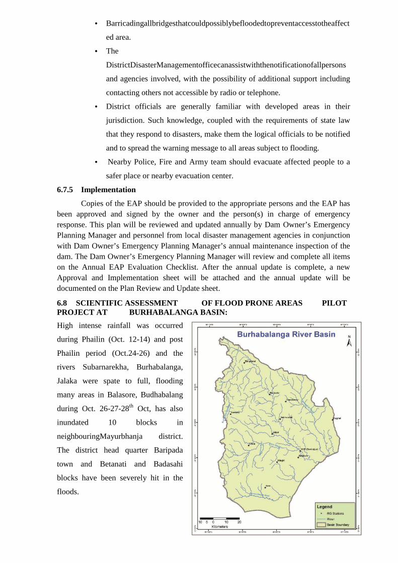
79
• Barricadingallbridgesthatcouldpossiblybefloodedtopreventaccesstotheaffect
ed area.
• The
DistrictDisasterManagementofficecanassistwiththenotificationofallpersons
and agencies involved, with the possibility of additional support including
contacting others not accessible by radio or telephone.
• District officials are generally familiar with developed areas in their
jurisdiction. Such knowledge, coupled with the requirements of state law
that they respond to disasters, make them the logical officials to be notified
and to spread the warning message to all areas subject to flooding.
• Nearby Police, Fire and Army team should evacuate affected people to a
safer place or nearby evacuation center.
6.7.5 Implementation
Copies of the EAP should be provided to the appropriate persons and the EAP has been approved and signed by the owner and the person(s) in charge of emergency response. This plan will be reviewed and updated annually by Dam Owner’s Emergency Planning Manager and personnel from local disaster management agencies in conjunction with Dam Owner’s Emergency Planning Manager’s annual maintenance inspection of the dam. The Dam Owner’s Emergency Planning Manager will review and complete all items on the Annual EAP Evaluation Checklist. After the annual update is complete, a new Approval and Implementation sheet will be attached and the annual update will be documented on the Plan Review and Update sheet.
6.8 SCIENTIFIC ASSESSMENT OF FLOOD PRONE AREAS PILOT PROJECT AT BURHABALANGA BASIN:
High intense rainfall was occurred
during Phailin (Oct. 12-14) and post
Phailin period (Oct.24-26) and the
rivers Subarnarekha, Burhabalanga,
Jalaka were spate to full, flooding
many areas in Balasore, Budhabalang
during Oct. 26-27-28th Oct, has also
inundated 10 blocks in
neighbouringMayurbhanja district.
The district head quarter Baripada
town and Betanati and Badasahi
blocks have been severely hit in the
floods.
80
� Flood water gushed into Baripada town and about 50 villages in the tribal dominated
district are suffered.
� Also nearly 57,000 people in 164
villages under 38 Panchayats in the
district had been affected besides ward numbers 3, 7, 8, 9, 10 and 20 in Baripada town.
Before this event the Burhabalanga basin has suffered flood devastation many a time. The
reasons for this recurrence flood are being associated with following reasons as:
� Reduction in carrying capacity and operational failure of 3 internal streams namely
Jirali, Sarali and Sorhajoda before its outfall to Burhabalanga.
� Reduction in carrying capacity of flood water of Burhabalangariver.
� Back water effect in release of water to sea and at confluence points of small streams.
Now with technical assistance of CWC and NRSC scientific assessment work of flood
prone area are being taken up in collaboration with state water resources department. As a
pilot project Burhabalanga basin is taken up and initial works are already been started.
As per the action plan a Regional Committee is constituted for our state with
Principal Secretary of the Water Resources Department as its Chairman and Regional
Chief Engineer of CWC as Member Secretary of the Committee. The programme is going
on with close association of NRSC, Hyderabad. This committee is now engaged in
identifying, demarcating and classifying the flood prone area based on scientific
methodology, classification, criteria as suggested by higher technical authorities like NIH,
Roorkee within stipulated period. The final report is under preparation at NRSE Level.
6.9 KNOWLEDGE MANAGEMENT:
This department as the premier institute in the water resources has its own training institute
named WALMI (Water & Land Management Institute) at Pratapnagari, Cuttack. It
provides the orientation course to new Junior and Assistant Engineers. Specialized courses
are being organized in this institute on the topics like Design of the Structures, Flood
Control and Management, Quality Control and Assurance in Construction, Water
Distribution in Canal System along with the role of PaniPanchayat and on many more
subjects.
The department is closely associated with Central Water Commission (CWC) for
reservoir, discharge and flood related activities, Indian Meteorological Department (IMD)
for getting the information on rainfall, cyclones and its forecasting and other details, and
Fig. 6.2: Burhabalanga Basin
81
Integrated Coastal Zone Management Project (ICZMP) for availing the information on sea
and coast.
The Department also organizes training programs at various national institutes of
repute like Central Water Power Research Station (CWPRS)-Pune, National Water
Academy (NWA)-Pune, National Institute of Hydrology (NIH)-Roorkee, CWC-NewDelhi,
Engineering Staff College of India (ESCI)-Hyderabad, National Remote Sensing Centre
(NRSC)-Hyderabad, Indian Institute of Remote Sensing (IIRS)-Dehradun.
For the sake of research and higher education department is also sending its
employees to Indian Institute Technology (IIT) Roorkee for doing M.Tech courses on
Water Resources Development & Management and in Hydrology. After completing the
courses they are also positioned at some of the decisive post thus strengthening the
technicality of the department. Few employees also completed the doctoral degrees on
reservoir operation and in flood control and reinforcing graciously the technical processes.
6.10 POINTS FOR OPEN DISCUSSIONS
6.10.1 Embankment Free Flood Plain:
From the period prior to construction of dams/reservoirs when uncontrolled flow was
available at delta, there was no embankment to confine the flood within a channel. Again it
is seen due to continuous siltation river beds are getting up day by day (aggradations of bed
levels) and the country sides remains at comparatively down level. At this condition any
occurrence of breaches may cause a huge loss in the country side. So in order to maintain
the regime condition (balanced channel bed and flood plain) the embankments should be
made open at strategic locations allowing unobstructed free flow thereby reducing the
flood furry.
Encroachment in the flood plain has become a regular phenomenon over the year. It
needs to implement the law to make the flood plain free for safe disposal of flood water.
6.10.2 De-commissioning of Older Dams:
The management of flood in the major flood causing basins like Mahanadi and Brahmani
still relies on the dams of over 61years (Hirakud) and 34 years (Rengali). After a decade
or so, debate may come towards the decommissioning of such dams. The next alternative
may to go in for such storage projects or to live with flood.
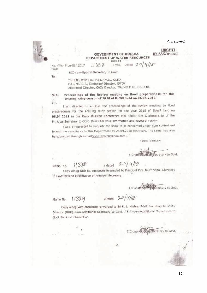
82
Annexure-1

83

84
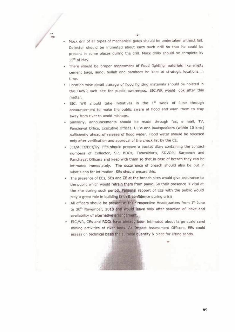
85

86

87

88

89
Related Documents