West River Watershed Coalition 333 Sherman Avenue New Haven CT 06511 Douglas Hausladen Department of Transportation, Traffic & Parking 200 Orange Street New Haven CT 06510 February 19, 2014 Dear Mr. Hausladen, Please find attached a Complete Streets Project Request Form submission for the intersection of Ella Grasso Boulevard and Derby Avenue. Sincerely Yours, West River Watershed Coalition steering committee _____________________________ Aaron Goode Stephanie Fitzgerald Martha Smith Christ Heitmann Stacy Spell Kim Stoner Frank Cochran Frank Panzarella Joel Tolman Lynne Bonnett Maria Tupper Billy Bromage Kathy Fay Mary Mushinsky Toshi Karato

Welcome message from author
This document is posted to help you gain knowledge. Please leave a comment to let me know what you think about it! Share it to your friends and learn new things together.
Transcript

West River Watershed Coalition333 Sherman AvenueNew Haven CT 06511
Douglas HausladenDepartment of Transportation, Traffic & Parking200 Orange StreetNew Haven CT 06510
February 19, 2014
Dear Mr. Hausladen,
Please find attached a Complete Streets Project Request Form submission for the intersection of EllaGrasso Boulevard and Derby Avenue.
Sincerely Yours,
West River Watershed Coalition steering committee_____________________________
Aaron Goode Stephanie Fitzgerald Martha Smith
Christ Heitmann Stacy Spell Kim Stoner
Frank Cochran Frank Panzarella Joel Tolman
Lynne Bonnett Maria Tupper Billy Bromage
Kathy Fay Mary Mushinsky Toshi Karato
Project Name: Derby Avenue / Ella Grasso Boulevard CompleteStreets InterventionContact: Aaron Goode [email protected] Heitmann [email protected] Spell [email protected] Bromage [email protected] Cochran [email protected]
Project Location: 11001128 Ella Grasso Boulevard, a.k.a. Derby Avenue / Ella Grasso Boulevardintersection, 41.310454, 72.953692
Brief Description of Project: Shortterm: Lengthen pedestrian signal timing [see SeeClickFix ticket#849132]; tighten turning radius of eastbound Derby Avenue onto Ella Grasso; use paint and/or bollards tocreate pedestrian refuge on Ella Grasso.Medium term: Create gradeseparated traffic island; add bicycle lane on Ella Grasso; improve sidewalkconditions.Long term: Create pedestrian bridge with full public access; fully protected bicycle infrastructure as part ofWest River Greenway.
Project Impetus: The importance of the West River as an open space and community asset is increasinglybeing recognized. A variety of communitydriven projects reflect that growing recognition: Friends of WestRiver Memorial Park was formed to promote foster public safety and stewardship in the park. West RiverWest River Memorial Park recently became a National Wildlife Service "Urban Oasis." An annual WaterFestival has been held the last three years at West River Memorial Park in July. Recently the West RiverWatershed Coalition has been working on addressing combined sewer overflow (CSO) pollution and cleaningup the West River in order to enhance recreational opportunities. Unfortunately these grassroots efforts havenot been met with support from the City of New Haven or State of Connecticut to improve the builtenvironment around West River Memorial Park in ways that enhance access. It remains difficult andhazardous to access the area from the adjoining neighborhoods except by automobile. Furthermore, theconnection between Edgewood Park and West River Memorial Park is critical in establishing the “WestRiver Greenway” proposed in the City's most recent Comprehensive Plan [see appendix]. Unfortunately thepedestrian bridge connecting Barnard School to the nature center in West River Memorial Park is only opento school affiliates and not to the neighborhood, making these open space connections difficult to achieve.
The 2004 Comprehensive Plan identified the following goals for this area [see Appendix]:
Acknowledge and enhance existing extensive trail network in City’s parks along the West River Make the West River accessible at locations where public access is difficult or impossible because
of noncompatible uses. Extend regional Regicides Trail to New Haven Harbor with connection to proposed Harborside Trail.
We believe this project makes measurable progress towards achieving all these goals.
In 2008 the South Central Connecticut Regional Council of Governments Route 10 Corridor Study. Thisstudy found inadequate pedestrian infrastructure along much of the corridor [see Section 2.1.6]. The studyidentified a number of problems with the section of Route 10 between Columbus and Derby Avenue,including “few visual cues within the rightofway or beyond the edge of the rightofway that impart themultiuse function of the street.” The study recommended a new 12 foot landscaped median that would serveas a traffic calming measure to mitigate traffic speeds through this area; and providing street trees along the
corridor to “provide enclosure and visual cues that the street is not an extension of the interstate highwaysystem but a street that serves neighborhoods and parks.” Furthermore the study recommended providing a10 foot shareduse path adjacent to West River Memorial Park to accommodate pedestrians and bicyclists[Section 4.15].
In 2014, construction will begin on reconfiguring Exit 45 of I95. This project will include improvements to thesection of the East Coast Greenway that connects the City Point neighborhood with the Kimberly AvenueBridge. This raises the exciting possibility of using bicycle infrastructure along Route 10 to connect the EastCoast Greenway at Exit 45 with the existing bicycle lane on Ella Grasso Boulevard north of WhalleyAvenue.
Project Goals: The goal of the project is to improve the safety of this intersection for pedestrians, cyclists,and motorists. Accomplishing that primary goal will help to achieve the secondary goal of enhancing publicaccess to two of the city's prime recreational assets. In turn, this will improve the quality of life and propertyvalues in the adjoining neighborhoods.
Cost: Least expensive option: $10002000; most expensive option $200,000
Funding Sources: We are confident this project could be funded through participatory budgeting, shouldthe City adopt such a process. For a more expensive treatment we would recommend including thiscomplete streets intervention within a larger project in the area that is already funded, e.g. improvements toRoute 10 or Route 34.
Describe Project Context: Nearby are a school (Barnard), nursing home (University Skilled Nursing), andlow income residential neighborhood (Hill North and West River). Route 34 West is in the process of beingredeveloped into a mixeduse zone, potentially bringing more pedestrian traffic into the area. The residentialareas are separated from two parks of high recreational and scenic value (West River Memorial Park,Edgewood Park) by Ella Grasso Boulevard.
Classification of affected streets: Both Derby and Ella Grasso are twoway arterial state highways.
Safety and Slow vehicle Speeds: Project would enhance both pedestrian and traffic safety by slowingvehicle speeds.
Connectivity: Connectivity would be enhanced between the residential West River and Hill Northneighborhoods and major open space assets. Connectivity would be enhanced between existing andproposed Greenway systems. Connectivity would be enhanced for bicycles along Route 10 corridor.
Human Health: Enhancing access to parks is a public health goal. Research has shown West Riverneighborhood has high rates of obesity and obesityrelated illness and insufficient access to open space[see appendix].
Livability: Enhancing access to parks improves livability in adjoining residential areas and improvesproperty values.
Context: Major transportation corridor but also a residential area with schools, churches and senior citizenhousing within ¼ mile. This complete streets intervention will make the transportation corridor less hostile tothe residential setting.
Equity: West River and Hill North are lowincome residential neighborhoods, while most of the automotivetraffic in the area is throughtraffic originating from outside the city. Improving the pedestrian climate in thearea will enhance equity and benefit New Haven residents.
Aesthetics: Positive impact. Plantings in West River Memorial Park could enhance park aesthetics while

also serving as a trafficcalming device.
Economic Development: Positive impact. A complete streets intervention in this area will improveconditions for mixeduse economic development along Route 34 corridor.
Environment: Reducing traffic speeds will have a positive environmental impact. Reducing impermeableroadway surface with a median / pedestrian refuge will reduce stormwater runoff. West River has the highestconcentration of CSO runoff of any waterway in New Haven.
APPENDIX:
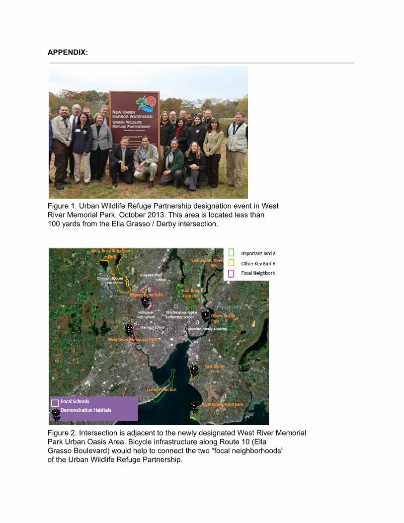
Figure 1. Urban Wildlife Refuge Partnership designation event in WestRiver Memorial Park, October 2013. This area is located less than100 yards from the Ella Grasso / Derby intersection.
Figure 2. Intersection is adjacent to the newly designated West River MemorialPark Urban Oasis Area. Bicycle infrastructure along Route 10 (EllaGrasso Boulevard) would help to connect the two “focal neighborhoods”of the Urban Wildlife Refuge Partnership.
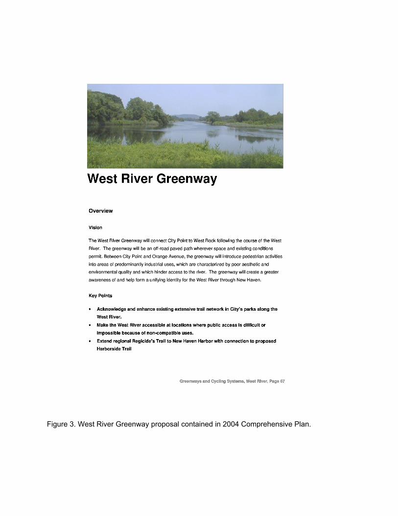
Figure 3. West River Greenway proposal contained in 2004 Comprehensive Plan.
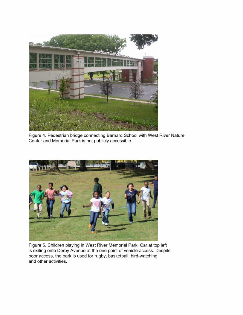
Figure 4. Pedestrian bridge connecting Barnard School with West River NatureCenter and Memorial Park is not publicly accessible.
Figure 5. Children playing in West River Memorial Park. Car at top leftis exiting onto Derby Avenue at the one point of vehicle access. Despitepoor access, the park is used for rugby, basketball, birdwatchingand other activities.
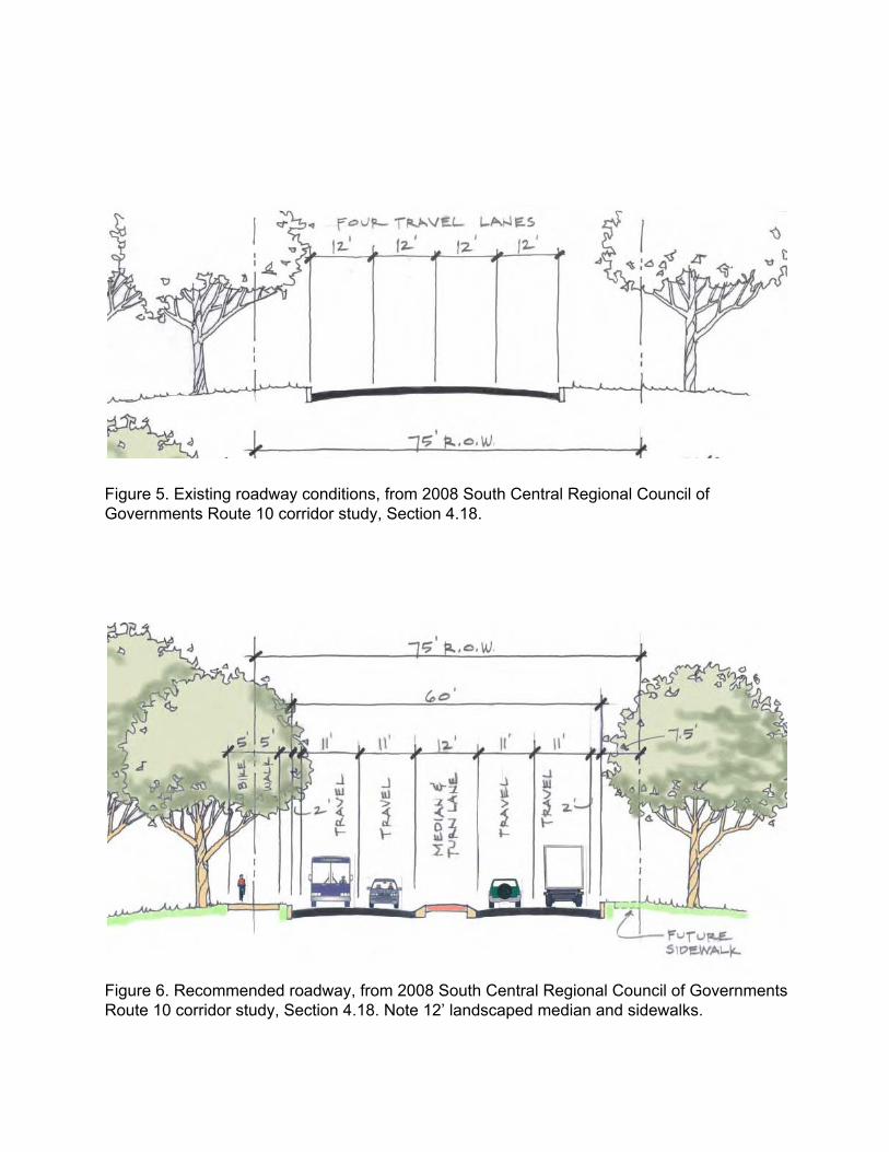
Figure 5. Existing roadway conditions, from 2008 South Central Regional Council ofGovernments Route 10 corridor study, Section 4.18.
Figure 6. Recommended roadway, from 2008 South Central Regional Council of GovernmentsRoute 10 corridor study, Section 4.18. Note 12’ landscaped median and sidewalks.
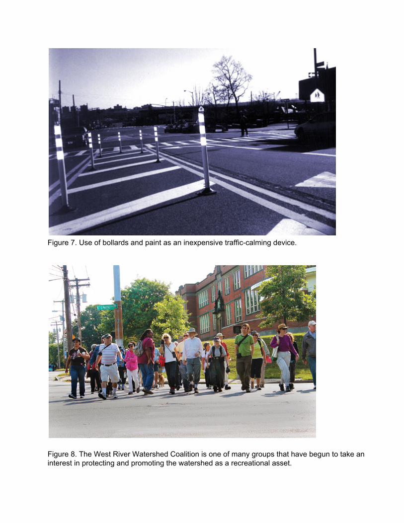
Figure 7. Use of bollards and paint as an inexpensive trafficcalming device.
Figure 8. The West River Watershed Coalition is one of many groups that have begun to take aninterest in protecting and promoting the watershed as a recreational asset.

Figure 9. West River neighborhood suffers from high levels of obesity and lack of exercise.
Related Documents