
Welcome message from author
This document is posted to help you gain knowledge. Please leave a comment to let me know what you think about it! Share it to your friends and learn new things together.
Transcript
Iraqi Bulletin of Geology and Mining Vol.6, No.2, 2010
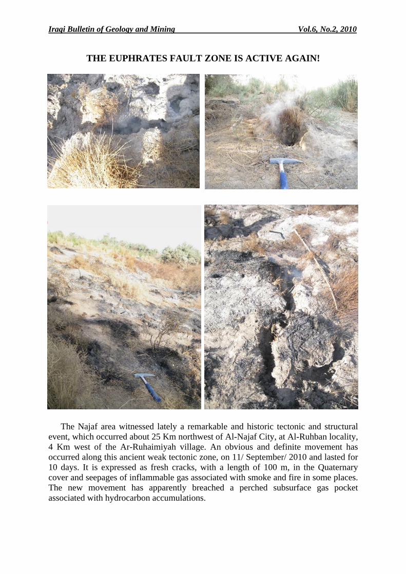
THE EUPHRATES FAULT ZONE IS ACTIVE AGAIN!
The Najaf area witnessed lately a remarkable and historic tectonic and structural
event, which occurred about 25 Km northwest of Al-Najaf City, at Al-Ruhban locality, 4 Km west of the Ar-Ruhaimiyah village. An obvious and definite movement has occurred along this ancient weak tectonic zone, on 11/ September/ 2010 and lasted for 10 days. It is expressed as fresh cracks, with a length of 100 m, in the Quaternary cover and seepages of inflammable gas associated with smoke and fire in some places. The new movement has apparently breached a perched subsurface gas pocket associated with hydrocarbon accumulations.
Iraqi Bulletin of Geology and Mining Vol.6, No.2, 2010 p 1− 16
1
MICROFOSSIL ASSEMBLAGES AND DIAGENESIS OF BALAMBO FORMATION FROM AZMER MOUNTAIN
IN NORTHEAST SULAIMANIYAH, KURDISTAN REGION, IRAQ
Hyam S. Daoud*, Ramona Balc** and Ghafor H. Sur***
Received: 15/ 6/ 2009, Accepted: 1/ 4/ 2010
Key words: Calcareous nannofossils, Diagenesis, Balambo Formation, Upper Barremian, Azmer Mountain, Kurdistan Region, Iraq.
ABSTRACT
A detailed Lower Cretaceous section of Balambo Formation, which is exposed in the Azmer Mountain, northeast of Sulaimaniyah city (Kurdistan, Iraq) has been investigated. Eighty four limestone samples have been studied for microfacies analyses and 52 clay and marl samples were investigated for calcareous nannofossils determinations.
Most of the rocks consist of two main types of facies: Wackestone and packstone with radiolaria. The main diagenetic processes are represented by dissolution, calcitization, dolomitization, stylolitization, silicification and cementation.
The calcareous nannofossils from Balambo Formation were studied for the first time from the study area. Based on the identified calcareous nannofossil assemblages, the studied rocks were assigned to the Upper Barremian. The calcareous nannofossil assemblages are dominated by Micrantolithus, Nannoconus and Rhagodiscus spp.
العمليات التحويرية لتكوين باالمبو ويقةالمتحجرات الدق العراق،ردستانوكشرق السليمانية، شمال ،في جبل أزمر
سورةرامونا بالك و غفور حم ، داود صالحهيـام
مستخلصال
أزمر، شمال شرق مدينة السليمانية جبلت دراسة مقطع من الكريتاسي األسفل لتكوين باالمبو في منطقةتم نموذج 52 لدراسة السحنات المجهرية و نموذج من الحجر الكلسي84اسة على اجريت هذه الدر). قردستان، العراوك(
باكستون وواكستون : المقطع يتكون في أغلبه من نوعين رئيسيين من السحنات. الكلسي nannofossilsلدراسة الـ ذوبان تحت الضغط والدلمتة تحت شروط الدفن العمليات التحويرية التي تم تحديدها تتمثل بالان . بالراديوالرياالغنيتين لتي تم تحديدها في تكوين باالمبو في جبل من نوعها ااألولى الكلسي هي nannofossils ان دراسة الـ. التدريجي
وضعات تعود إلى عصر الباريميان مي تم تحديده فان هذه التذالكلسي ال nannofossils باالستناد على تجمع الـ. أزمر Micrantolithus، Nannoconusالكلسي غالبيته من األنواع nannofossilsان تجمع الـ . العلوي
..Rhagodiscus sppو
____________________________________ * Lecturer, Sulaimaniyah University, College of Engineering, e-mail: [email protected] ** Lecturer, College of Environmental Science, Babeş-Bolyai University, Cluj-Napoca,
400294, Romania, e-mail: [email protected] ***
Lecturer, Sulaimaniyah University, College of Sciences, Department of Geology
Microfossil Assemblages and Diagenesis of Balambo Formation Hyam Daoud et al.
2
INTRODUCTION The Balambo Formation was first described by Wetzel (1947) in Bellen et al. (1959) from
the Sirwan Valley near Halabja, NE Iraq. The age of this formation is Valanginian – Turonian (Buday, 1980). It was divided into two units: Lower Balambo Formation (Valanginian – Albian) and Upper Balambo Formation (Cenomanian – Turonian) (Buday, 1980).
Throughout the type locality, which is in the proximity of Halabja town (southern part of Balambo Mountains, in Sirwan Valley), the lower part of Balambo Formation comprises 280 m (Buday, 1980). It consists of thin layered bluish ammonites-rich limestone, with interlayers of marls and clays, with beds of olive green marl and dark blue shale, followed by radiolarian-rich limestone (Bellen et al., 1959).
Bellen et al. (1959) and Buday (1980) divided the Hauterivian – Valanginian part of the Balambo Formation into three faunal zones, from the bottom upwards, these comprise: ─ Crioceras Zone with: Crioceras plicatilis, C. raricostatum, Neocomites houdardi, Olcosteohanus sp., Bochianites neocomiensis, Kilianella bochianenensis, K. ischnotera, Neocosmoceras cf. sayni. ─ Hoplites Zone with: Crioceras plicatilis, Crioceras sp., Neocomites houdardi, Olcostephanus sp., Distoceras sp., Acanthodiscus sp., Thurmannites sp., Holcodiscus sp. and Hoplites karakash. ─ Duvalia Zone with: Hibolites sp., Phylloceras tethys and Radiolaria.
The Barremian – Aptian part of the formation, in the High Folded Zone contains Radiolaria and Pseudohoploceras sp. (Buday, 1980).
The lower part of the Balambo Formation is deposited in deep bathyal environment the lower contact of the formation in the type section seems to be non sequential, without visible unconformity. The basal Valanginian and the Berriasian are missing here (Buday, 1980). The continuous sedimentation is evident in all areas where the Balambo Formation forms tongues within the Lower Sarmord and/ or Lower Qamchuqa formations, and the upper boundary of the Lower Balambo Formation is always gradational and conformable.
The upper part of Balambo Formation is homogeneous and consists of thin bedded globigerinal limestone, passing down into radiolarian limestone (Bellen et al., 1959). Throughout the type area, it comprises mostly of thinly bedded (rarely thickly bedded), light colored limestone with a pelagic globigerinal – radiolarian – oligosteginal assemblages. The Cenomanian part of the formation in the type area is (170 – 200) m thick and the Turonian part is (315 – 350) m thick (Bellen et al. 1959 and Buday, 1980). The upper part of Balambo Formation was deposited in an outer shelf to bathyal environment, relatively deep basin situated along the NE boundary of the Arabian Plate (Buday, 1980). Bellen et al. (1959) listed abundant fauna in the upper part of Balambo Formation of Cenomanian – Turonian age.
The lowermost beds of the upper part of Balambo Formation comprise grey globigerinal limestone of Albian age, which conformably overly blue ammonite-bearing limestone of the upper part of the Lower Balambo Formation. The upper part of Balambo Formation crops out extensively in the Imbricated Zone of NE Iraq (Jassim and Buday in Jassim and Goff, 2006). Based on the identified planktonic foraminifera in the Balambo Formation from Azmer Mountain, Ghafor (1993) defined three zones: Hedbergella washitensis Zone (lowermost), Rotalipora appenninica Zone, and Marginotruncana helvetica Zone (uppermost). He claimed an Albian – Turonian age for the formation. The depocentre extends into SW Iran, where it is referred to as the "Massive Limestone Group" (Kent et al., 1951). In North Iraq, the Balambo – Tanjero Zone is either overthrusted by the Northern Thrust Zone or completely missing. In this region, neretic limestones of the Herki, Rikan and Zibar areas (Hall, 1957) replace the Balambo Formation.
Iraqi Bulletin of Geology and Mining Vol.6, No.2, 2010 p 1− 16
3
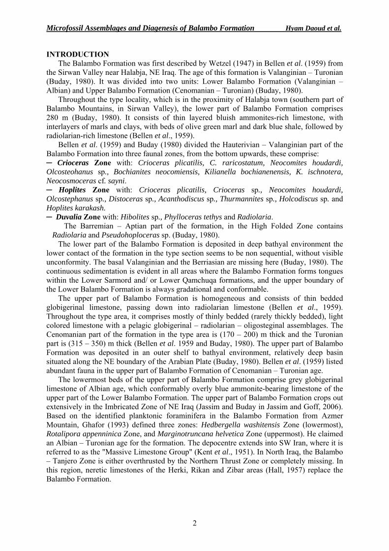
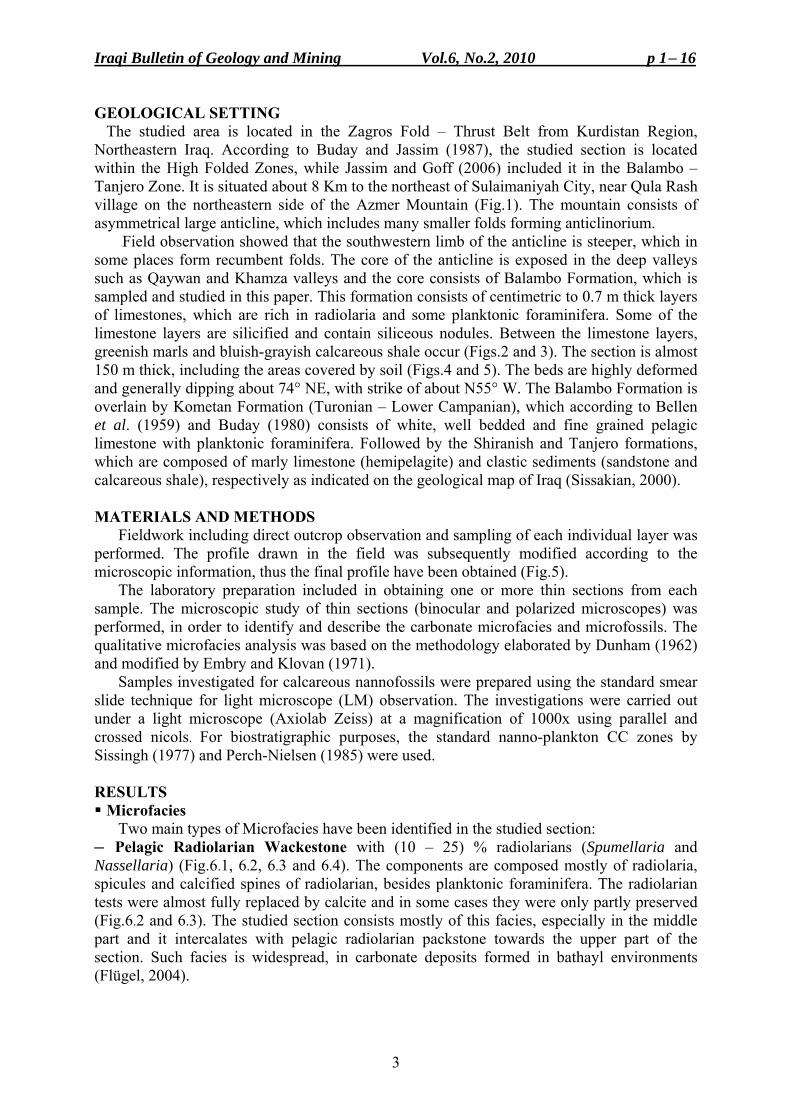
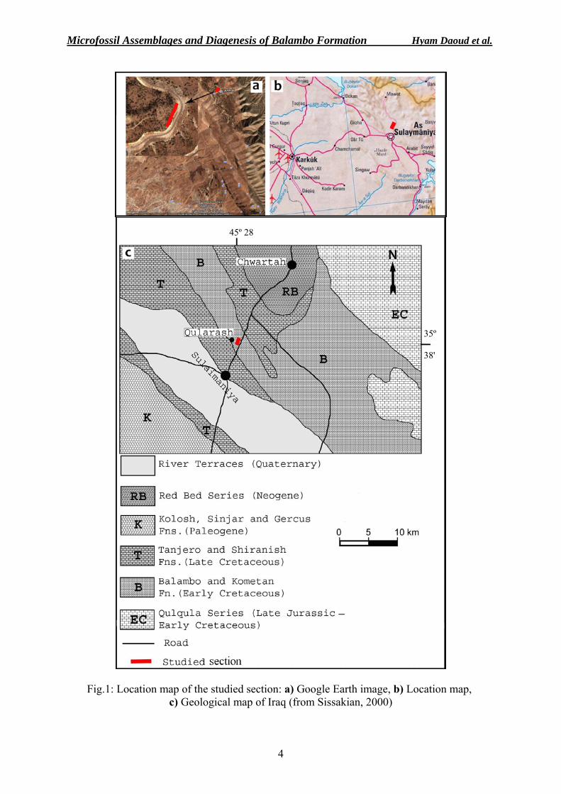
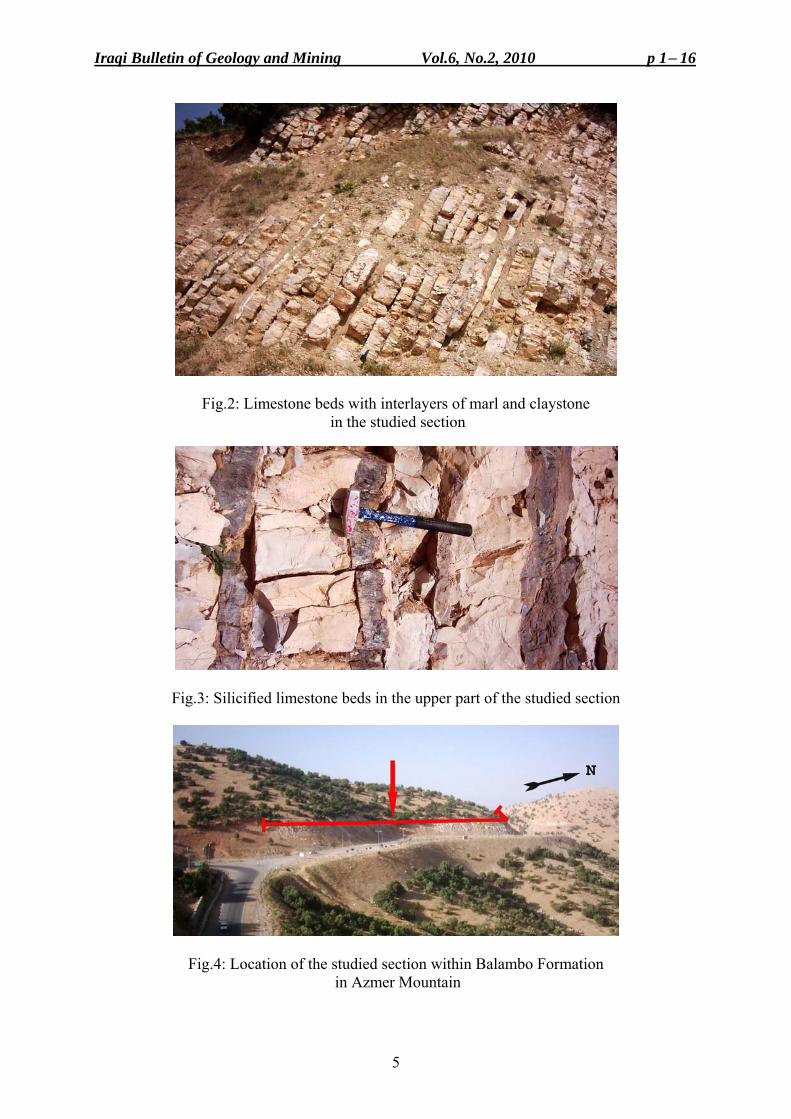
GEOLOGICAL SETTING The studied area is located in the Zagros Fold – Thrust Belt from Kurdistan Region, Northeastern Iraq. According to Buday and Jassim (1987), the studied section is located within the High Folded Zones, while Jassim and Goff (2006) included it in the Balambo – Tanjero Zone. It is situated about 8 Km to the northeast of Sulaimaniyah City, near Qula Rash village on the northeastern side of the Azmer Mountain (Fig.1). The mountain consists of asymmetrical large anticline, which includes many smaller folds forming anticlinorium. Field observation showed that the southwestern limb of the anticline is steeper, which in some places form recumbent folds. The core of the anticline is exposed in the deep valleys such as Qaywan and Khamza valleys and the core consists of Balambo Formation, which is sampled and studied in this paper. This formation consists of centimetric to 0.7 m thick layers of limestones, which are rich in radiolaria and some planktonic foraminifera. Some of the limestone layers are silicified and contain siliceous nodules. Between the limestone layers, greenish marls and bluish-grayish calcareous shale occur (Figs.2 and 3). The section is almost 150 m thick, including the areas covered by soil (Figs.4 and 5). The beds are highly deformed and generally dipping about 74° NE, with strike of about N55° W. The Balambo Formation is overlain by Kometan Formation (Turonian – Lower Campanian), which according to Bellen et al. (1959) and Buday (1980) consists of white, well bedded and fine grained pelagic limestone with planktonic foraminifera. Followed by the Shiranish and Tanjero formations, which are composed of marly limestone (hemipelagite) and clastic sediments (sandstone and calcareous shale), respectively as indicated on the geological map of Iraq (Sissakian, 2000). MATERIALS AND METHODS
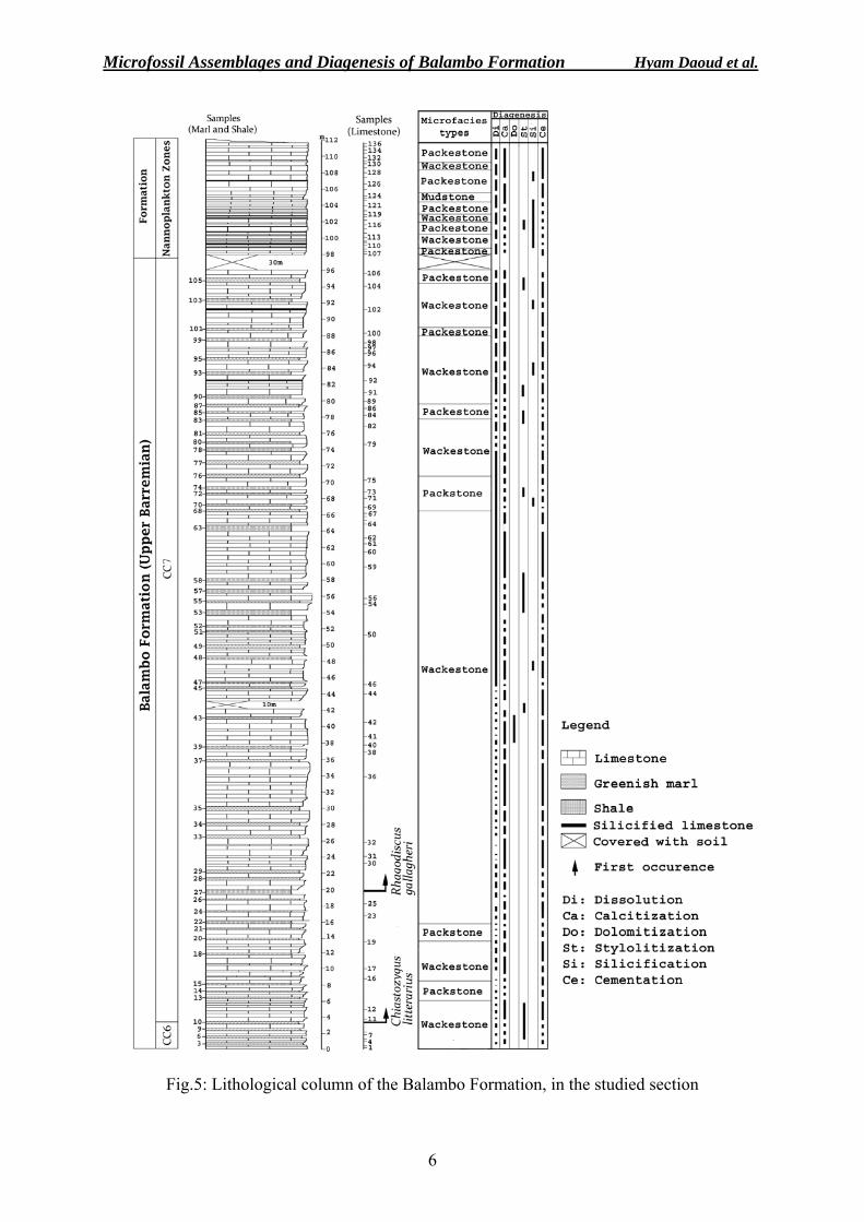
Fieldwork including direct outcrop observation and sampling of each individual layer was performed. The profile drawn in the field was subsequently modified according to the microscopic information, thus the final profile have been obtained (Fig.5).
The laboratory preparation included in obtaining one or more thin sections from each sample. The microscopic study of thin sections (binocular and polarized microscopes) was performed, in order to identify and describe the carbonate microfacies and microfossils. The qualitative microfacies analysis was based on the methodology elaborated by Dunham (1962) and modified by Embry and Klovan (1971).
Samples investigated for calcareous nannofossils were prepared using the standard smear slide technique for light microscope (LM) observation. The investigations were carried out under a light microscope (Axiolab Zeiss) at a magnification of 1000x using parallel and crossed nicols. For biostratigraphic purposes, the standard nanno-plankton CC zones by Sissingh (1977) and Perch-Nielsen (1985) were used. RESULTS Microfacies
Two main types of Microfacies have been identified in the studied section: ─ Pelagic Radiolarian Wackestone with (10 – 25) % radiolarians (Spumellaria and Nassellaria) (Fig.6.1, 6.2, 6.3 and 6.4). The components are composed mostly of radiolaria, spicules and calcified spines of radiolarian, besides planktonic foraminifera. The radiolarian tests were almost fully replaced by calcite and in some cases they were only partly preserved (Fig.6.2 and 6.3). The studied section consists mostly of this facies, especially in the middle part and it intercalates with pelagic radiolarian packstone towards the upper part of the section. Such facies is widespread, in carbonate deposits formed in bathayl environments (Flügel, 2004).
Microfossil Assemblages and Diagenesis of Balambo Formation Hyam Daoud et al.
4
Fig.1: Location map of the studied section: a) Google Earth image, b) Location map, c) Geological map of Iraq (from Sissakian, 2000)
45º 28
35º 38'
Iraqi Bulletin of Geology and Mining Vol.6, No.2, 2010 p 1− 16
5
Fig.2: Limestone beds with interlayers of marl and claystone in the studied section
Fig.3: Silicified limestone beds in the upper part of the studied section
Fig.4: Location of the studied section within Balambo Formation in Azmer Mountain
Microfossil Assemblages and Diagenesis of Balambo Formation Hyam Daoud et al.
6
Fig.5: Lithological column of the Balambo Formation, in the studied section
Iraqi Bulletin of Geology and Mining Vol.6, No.2, 2010 p 1− 16
7
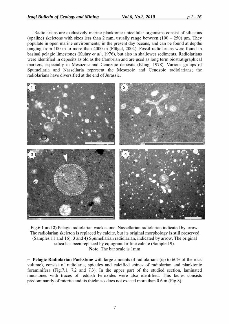
Radiolarians are exclusively marine planktonic unicellular organisms consist of siliceous (opaline) skeletons with sizes less than 2 mm, usually range between (100 – 250) µm. They populate in open marine environments; in the present day oceans, and can be found at depths ranging from 100 m to more than 4000 m (Flügel, 2004). Fossil radiolarians were found in basinal pelagic limestones (Kuhry et al., 1976), but also in shallower sediments. Radiolarians were identified in deposits as old as the Cambrian and are used as long term biostratigraphical markers, especially in Mesozoic and Cenozoic deposits (Kling, 1978). Various groups of Spumellaria and Nassellaria represent the Mesozoic and Cenozoic radiolarians; the radiolarians have diversified at the end of Jurassic.
Fig.6:1 and 2) Pelagic radiolarian wackestone. Nassellarian radiolarian indicated by arrow. The radiolarian skeleton is replaced by calcite, but its original morphology is still preserved
(Samples 11 and 16). 3 and 4) Spumellarian radiolarian, indicated by arrow. The original silica has been replaced by equigranular fine calcite (Sample 19).
Note: The bar scale is 1mm
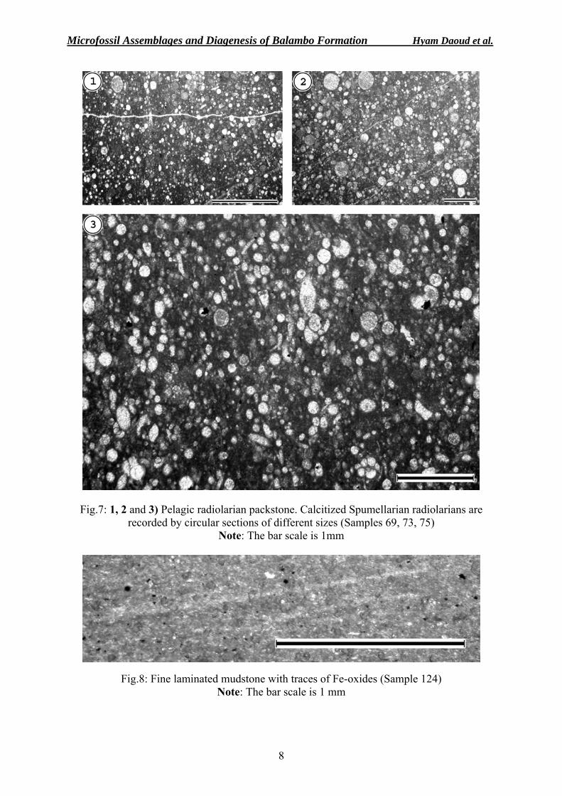
─ Pelagic Radiolarian Packstone with large amounts of radiolarians (up to 60% of the rock volume), consist of radiolaria, spicules and calcified spines of radiolarian and planktonic foraminifera (Fig.7.1, 7.2 and 7.3). In the upper part of the studied section, laminated mudstones with traces of reddish Fe-oxides were also identified. This facies consists predominantly of micrite and its thickness does not exceed more than 0.6 m (Fig.8).
Microfossil Assemblages and Diagenesis of Balambo Formation Hyam Daoud et al.
8
Fig.7: 1, 2 and 3) Pelagic radiolarian packstone. Calcitized Spumellarian radiolarians are recorded by circular sections of different sizes (Samples 69, 73, 75)
Note: The bar scale is 1mm
Fig.8: Fine laminated mudstone with traces of Fe-oxides (Sample 124) Note: The bar scale is 1 mm
Iraqi Bulletin of Geology and Mining Vol.6, No.2, 2010 p 1− 16
9
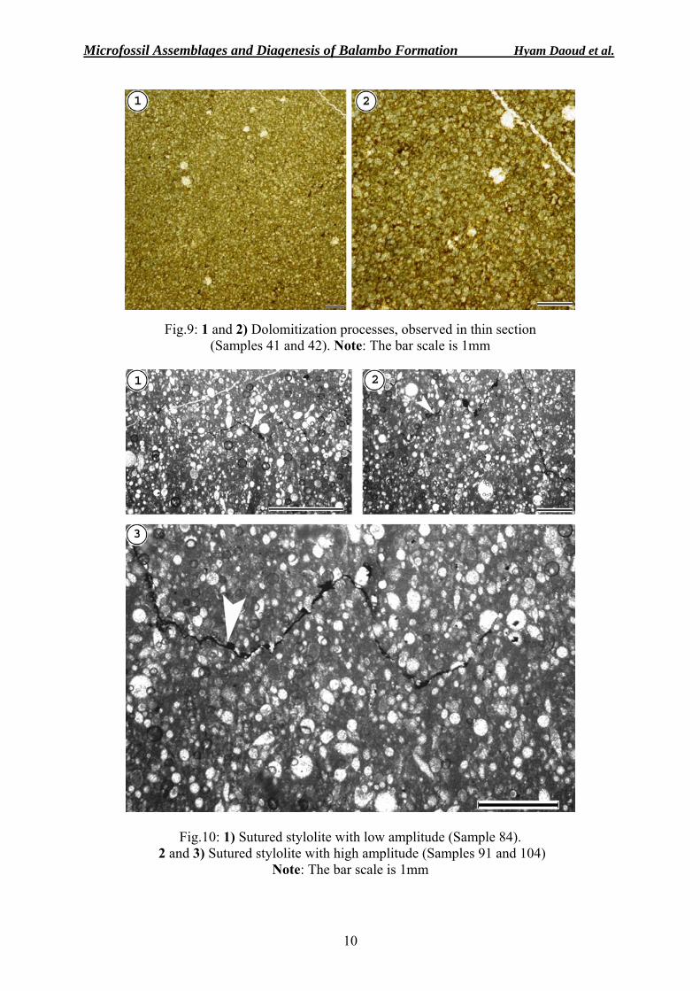
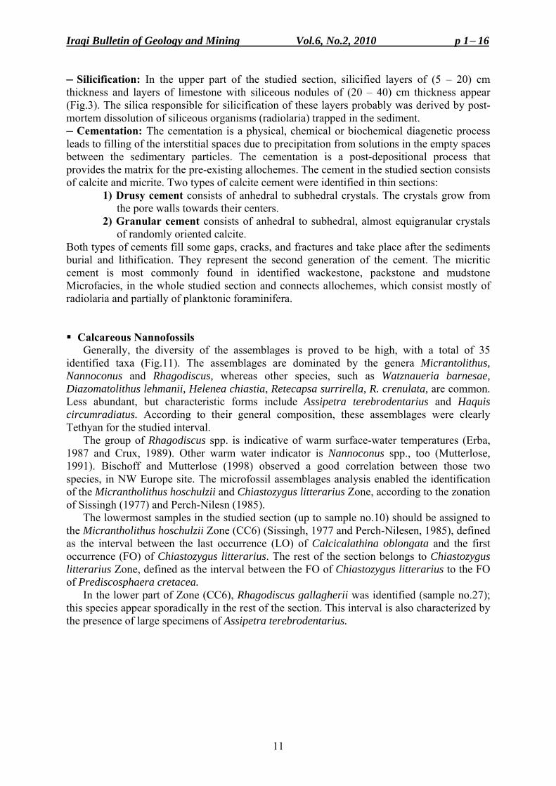
Diagenetic Processes ─ Dissolution: The dissolution of the radiolarian tests took place in immersed conditions, at or below the sediment – water interface. The process was controlled by the silica saturation of the pore fluids, by the intensity of the bioturbation and by the sedimentation rate (Flűgel, 2004). A high sedimentation rate leads to a good preservation of the radiolarian tests (Flűgel, 2004). The transformation of the radiolarian tests under burial conditions is much faster within limestones, as compared to claystones, but the test's preservation status is poorer in limestones, as compared to siliceous rocks (Kiessling, 1996). In the lower and middle parts of the studied section, the tests of radiolarian are well preserved because they were slightly affected by the dissolution processes (Fig.6). Towards the upper part of the section, the dissolution become more influent and leads to poorly preservation of radiolarian tests (Fig.10). ─ Calcitization: The calcitization of radiolarians is a common process in limestones. It starts during the early diagenetic stage, and continues during the shallow to deep burial stages. The radiolarian tests are replaced by calcite, and sometimes might be misinterpreted as calcispheres. However, the peripheral zone of the radiolarian tests shows an irregular, interlocked pattern, while the calcispheres show smooth contours. In some samples of the studied section, the radiolarian tests are replaced by calcite, but they have still preserved their original morphology (Fig.6.3). In other samples, especially in the upper part of the studied section, the skeletons of the radiolaria are completely replaced by calcite and only their ghosts can be seen (Fig.10). ─ Dolomitization: The dolomitization is represented by equigranular, anhedral crystals of dolomite (Fig.9.1 and 9.2). This process was observed only in one level of a thickness of 3 m; between (38 – 41) m of the studied section. The observed crystals of the dolomite in thin sections are represented by equigranular, anhedral crystals, tightly packed anhedral and subhedral crystals, intercrystalline boundaries lobate and straight, some crystal face junctions are preserved, and grain size between (0.1 – 0.3) mm. These fine crystalline mosaic dolomites were formed by replacement of crystalline calcite matrix. Such crystals suggest that dolomitization took place at a relatively low temperature and occurred at a relatively early stage of diagenesis (Sibley and Gregg, 1987). The need for the diagenetic fluids to move freely to dolomitize such limestones, may necessitate relatively early dolomitization, when the rock was more porous and sufficiently permeable (Mresah, 1998). However, the dolomitization is a secondary diagenetic process that may take place during any of the diagenetic stages that affected the sediment (Purdy, 1968 and Septfontaine, 1976). ─ Stylolitization: It is resulted by dissolution under pressure, pointing to progressive burial diagenesis (Simpson, 1990 and Flügel, 2004) that resulted in the lithification and consolidation of the sediments. Most often, the stylolites formed after the first cementation stage and contributed to additional lithification of the sediment due to the CaCO3 released by dissolution under pressure (Bathurst, 1975). The stylolites are composed of same material as the rock of which they are part, and are better developed in limestones and dolomites than in any other kinds of rocks (Mitsui, 1967). According to their morphology (Choquette and James, 1987), two types of stylolites were identified in the studied section; a sutured with small amplitude (Fig.10.1), and sutured with high amplitude (Fig.10.2 and 10.3). These types of stylolites usually form in limestones with low amount of insoluble residual material and are the result of overburden pressure (Bathurst, 1975). Stylolites serve as permeability barriers and they have a considerable effect on later diagenetic processes, such as dolomitization.
Microfossil Assemblages and Diagenesis of Balambo Formation Hyam Daoud et al.
10
Fig.9: 1 and 2) Dolomitization processes, observed in thin section (Samples 41 and 42). Note: The bar scale is 1mm
Fig.10: 1) Sutured stylolite with low amplitude (Sample 84). 2 and 3) Sutured stylolite with high amplitude (Samples 91 and 104)
Note: The bar scale is 1mm
Iraqi Bulletin of Geology and Mining Vol.6, No.2, 2010 p 1− 16
11
─ Silicification: In the upper part of the studied section, silicified layers of (5 – 20) cm thickness and layers of limestone with siliceous nodules of (20 – 40) cm thickness appear (Fig.3). The silica responsible for silicification of these layers probably was derived by post-mortem dissolution of siliceous organisms (radiolaria) trapped in the sediment. ─ Cementation: The cementation is a physical, chemical or biochemical diagenetic process leads to filling of the interstitial spaces due to precipitation from solutions in the empty spaces between the sedimentary particles. The cementation is a post-depositional process that provides the matrix for the pre-existing allochemes. The cement in the studied section consists of calcite and micrite. Two types of calcite cement were identified in thin sections: 1) Drusy cement consists of anhedral to subhedral crystals. The crystals grow from
the pore walls towards their centers. 2) Granular cement consists of anhedral to subhedral, almost equigranular crystals
of randomly oriented calcite. Both types of cements fill some gaps, cracks, and fractures and take place after the sediments burial and lithification. They represent the second generation of the cement. The micritic cement is most commonly found in identified wackestone, packstone and mudstone Microfacies, in the whole studied section and connects allochemes, which consist mostly of radiolaria and partially of planktonic foraminifera.
Calcareous Nannofossils
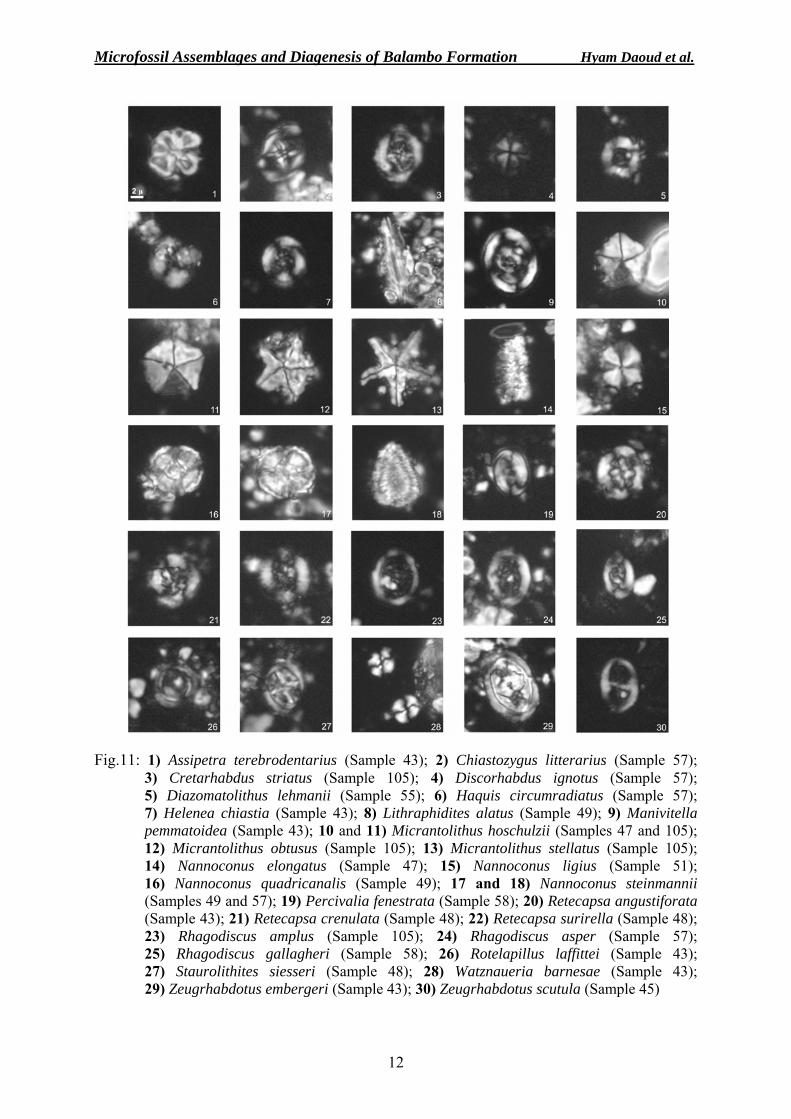
Generally, the diversity of the assemblages is proved to be high, with a total of 35 identified taxa (Fig.11). The assemblages are dominated by the genera Micrantolithus, Nannoconus and Rhagodiscus, whereas other species, such as Watznaueria barnesae, Diazomatolithus lehmanii, Helenea chiastia, Retecapsa surrirella, R. crenulata, are common. Less abundant, but characteristic forms include Assipetra terebrodentarius and Haquis circumradiatus. According to their general composition, these assemblages were clearly Tethyan for the studied interval.
The group of Rhagodiscus spp. is indicative of warm surface-water temperatures (Erba, 1987 and Crux, 1989). Other warm water indicator is Nannoconus spp., too (Mutterlose, 1991). Bischoff and Mutterlose (1998) observed a good correlation between those two species, in NW Europe site. The microfossil assemblages analysis enabled the identification of the Micrantholithus hoschulzii and Chiastozygus litterarius Zone, according to the zonation of Sissingh (1977) and Perch-Nilesn (1985).
The lowermost samples in the studied section (up to sample no.10) should be assigned to the Micrantholithus hoschulzii Zone (CC6) (Sissingh, 1977 and Perch-Nilesen, 1985), defined as the interval between the last occurrence (LO) of Calcicalathina oblongata and the first occurrence (FO) of Chiastozygus litterarius. The rest of the section belongs to Chiastozygus litterarius Zone, defined as the interval between the FO of Chiastozygus litterarius to the FO of Prediscosphaera cretacea.
In the lower part of Zone (CC6), Rhagodiscus gallagherii was identified (sample no.27); this species appear sporadically in the rest of the section. This interval is also characterized by the presence of large specimens of Assipetra terebrodentarius.
Microfossil Assemblages and Diagenesis of Balambo Formation Hyam Daoud et al.
12
Fig.11: 1) Assipetra terebrodentarius (Sample 43); 2) Chiastozygus litterarius (Sample 57); 3) Cretarhabdus striatus (Sample 105); 4) Discorhabdus ignotus (Sample 57); 5) Diazomatolithus lehmanii (Sample 55); 6) Haquis circumradiatus (Sample 57); 7) Helenea chiastia (Sample 43); 8) Lithraphidites alatus (Sample 49); 9) Manivitella pemmatoidea (Sample 43); 10 and 11) Micrantolithus hoschulzii (Samples 47 and 105); 12) Micrantolithus obtusus (Sample 105); 13) Micrantolithus stellatus (Sample 105); 14) Nannoconus elongatus (Sample 47); 15) Nannoconus ligius (Sample 51); 16) Nannoconus quadricanalis (Sample 49); 17 and 18) Nannoconus steinmannii (Samples 49 and 57); 19) Percivalia fenestrata (Sample 58); 20) Retecapsa angustiforata (Sample 43); 21) Retecapsa crenulata (Sample 48); 22) Retecapsa surirella (Sample 48); 23) Rhagodiscus amplus (Sample 105); 24) Rhagodiscus asper (Sample 57); 25) Rhagodiscus gallagheri (Sample 58); 26) Rotelapillus laffittei (Sample 43); 27) Staurolithites siesseri (Sample 48); 28) Watznaueria barnesae (Sample 43); 29) Zeugrhabdotus embergeri (Sample 43); 30) Zeugrhabdotus scutula (Sample 45)
Iraqi Bulletin of Geology and Mining Vol.6, No.2, 2010 p 1− 16
13
DISCUSSION The assemblages are largely composed of cosmopolitan and Tethyan species, but we can
also point out some striking absences: First, there is a total absence of Hayesites irregularis, which first occurs shortly before the FO of Chiastozygus litterarius. Second, the total absence of the Boreal species. The FO of Hayesites irregularis was proposed by Thierstein (1973) as a nannofossil event coinciding with Barremian – Aptian boundary. Other authors (Applegate and Bergen, 1988; Channel and Erba, 1992, Coccioni et al., 1992) documented the FO of H. irregularis in the Uppermost Barremian, below the base of CM0, in the upper part of CM1n magnetostratigraphic zone. The absence of this species and the presence of Chiastozygus litterarius, in the studied section ascertain that, the studied sequence is below the Barremian – Aptian boundary. The first occurrence of Chiastozygus litterarius has been used by Thierstein (1973 and 1976) and Roth (1983) to define the Barremian – Aptian boundary, but other authors pointed out that Chiastozygus litterarius was present even during Upper Barremian (Bralower et al., 1994). CONCLUSIONS • Two main facies types were recognized in the studied section, pelagic radiolarian
wackestone and pelagic radiolarian packstone. They were overprinted by: 1) dissolution under pressure, 2) cementation and 3) chemical compaction processes in a burial diagenetic environment that resulted during the sediments lithification and consolidation.
• Six diagenetic processes have been recognized and represented by dissolution, calcitization, dolomitization, stylolitization, silicification, and cementation.
• The nannofossil assemblages recorded from the studied section have a marked Tethyan character. The Micrantolithus hoschulzii and Chiastozygus litterarius Zones have been identified.
• In addition to the biohorizons containing the zonal markers, the FO of Rhagodiscus gallagherii has also been identified.
• Due to the outcrop conditions, the upper part of the Chiaztozygus litterarius Zone is not represented. This fact is indicated by the absence of Hayesites irregularis within the uppermost part of the studied section. It is known from other sections that the FO's of these species is recorded near the Barremian – Aptian boundary, immediately above the FO of Chiastozygus litterarius Zone.
Appendix: List of calcareous nannofossil species in Balambo Formation HETEROCOCCOLITS
I. Muroliths a. Imbricating muroliths (laxoliths)
Family Chiastozygaceae 1. Central area with axial cross
Staurolithites (Caratini, 1963) Staurolithites crux (Deflandre and Fert, 1954 and Caratini, 1963) Staurolithites siesseri (Bown, 2000)
2. Central area with tranvserse bar Zeugrhabdotus clarus (Bown, 2005) Zeugrhabdotus embergeri (Noël, 1958 and Perch-Nielsen, 1984) Zeugrhabdotus scutula (Bergen, 1994 and Rutledge and Bown, 1996)
Microfossil Assemblages and Diagenesis of Balambo Formation Hyam Daoud et al.
14
3. Central area with diagonal cross Chiastozygus litterarius (Górka, 1957 and Manivit,1971)
Family Rhagodiscaceae Percivalia fenestrata (Worsley, 1971 and Wise, 1983) Rhagodiscus (Reinhardt, 1967) Rhagodiscus amplus (Bown, 2005) Rhagodiscus asper (Stradner, 1963 and Reinhardt, 1967) Rhagodiscus gallagherii (Rutledge and Bown,1996) Rhagodiscus robustus (Bown, 2005)
b. Non-imbricating muroliths (protoliths) Family Stephanolithaceae
Rotelapillus laffittei (Noël, 1956 and 1973)
II. Placoliths a. Non-imbricating placoliths
Family Biscutaceae Discorhabdus ignotus (Gorka, 1957 and Perch-Nielsen, 1968)
Family Cretarhabdulaceae Cretarhabdus striatus (Stradner, 1963 and Black, 1973)
Helenea chiastia (Worsley, 1971) Helenea quadrata (Worsley, 1971 and Bown and Rutledge, 1998) Retecapsa angustiforata (Black, 1971) Retecapsa crenulata (Bramlette and Martini, 1964 and Grün, 1975) Retecapsa surirella (Deflandre and Fert, 1954 and Grün in Grün and Allemann, 1975)
Family Tubodiscaceae Manivitella pemmatoidea (Deflandre, 1965 and Thierstein, 1971) emend. Black, 1973)
b. Imbricating placoliths Family Watznaueriaceae
1. Genera with type rim Cyclogelosphaera margerelii (Noël, 1965)
Watznaueria barnesae (Black, 1959 and Perch-Nielsen, 1968) Watznaueria ovata (Bukry, 1969)
2. Genera with modified rim Diazomatolithus lehmanii (Noël, 1965) c. Heterococcoliths with uncertain affinities – placoliths Haqius circumradiatus (Stover, 1966 and Roth, 1978) NANNOLITHS
Family Braarudospheraceae Micrantolithus hoschulzii (Reinhardt, 1966 and Thierstein, 1971)
Micrantolithus obtusus (Stradner, 1963) Micrantolithus stellatus (Aguado, 1997)
Family Microrhabdulaceae Litrhaphidites alatus (Thierstein, 1972)
Family Nannoconaceae Nannoconus (Kamptner, 1931) Nannoconus elongatus (Brönnimann, 1955)
Iraqi Bulletin of Geology and Mining Vol.6, No.2, 2010 p 1− 16
15
Nannoconus circularis (Deres and Achéritéguy, 1980) Nannoconus ligius (Applegate and Bergen, 1988) Nannoconus quadricanalis (Bown and Concheyro, 2004) Nannoconus steinmannii (Brönnimann, 1955)
Family Policiclolithaceae Assipetra terebrodentarius (Applegate et al. in Covington and Wise, 1987,and Rutledge and Bergen in Bergen, 1994)
REFERENCES Applegate, J.L. and Bergen, J.A., 1988. Cretaceous calcareous nannofossil biostratigraphy of sediments
recovered from the Galicia Margin, O.D.P Leg. 103. In: G., Boillot and E.L, Winterer (Eds.), Proceedings of the Ocean Drilling Program, Scientific Results103, p. 293 – 348.
Bathurst, R.G.C., 1975. Carbonate Sediments and Their Diagenesis. Elsevier Scientific Publishing Company, Amsterdam, 658pp.
Bellen, R.C. van Dunnington, H.V., Wetzel, R. and Morton, D., 1959. Lexique Stratigraphic International. Asie, Fasc., 10a, Iraq, Paris, 333pp.
Bischoff, G. and Mutterlose, J., 1998. Calcacreous nannofossils of the Barremian – Aptian boundary interval in NW Europe: Biostratigraphic and paleoecologic implications of a high resolution study. Cretaceous Research, Vol.19, p. 635 – 661.
Bralower, T.J., Arthur, M.A., Leckie, R.M., Sliter, W.V., Allard, D.J. and Schlanger, S.O., 1994. Timing and paleoceanography of oceanic dysoxia – anoxia in the Late Barremian to Early Aptian (Early Cretaceous). Palaios, Vol. 9, p. 335 – 369.
Buday, T., 1980. The Regional Geology of Iraq, Vol.1, Stratigraphy and Paleogeography. In: I.I., Kassab and S.Z., Jassim (Eds.). GEOSURV, Baghdad, 445pp.
Buday, T. and Jassim, S.Z. 1987. The Regional Geology of Iraq, Vol.2, Tectonism, Magmatism and Metamorphism. In: I.I. Kassab and M.J. Abbas (Eds.), Baghdad. 445pp.
Choquette, P.W. and James, N.P., 1987. Diagenesis, 12, Diagenesis in limestones, 3, The deep burial environment. Geoscience, Canada, Vol.14, p. 3 − 35.
Chanell, J.E.T. and Erba, E., 1992. Early Cretaceous polarity chrons CM0 to CM11 recorded in northern Italian land sections near Brescia, northern Italy. Earth and Planetary Science Letters, 108, p. 161 – 179.
Coccioni, R., Erba, E. and Premoli-Silva, I., 1992. Barremian – Aptian calcareous plankton biostratigraphy of the Gorgo Cerbara section (Marche, Central Italy) and implications for plankton evolution. Cretaceous Research, Vol.13, p. 517 – 537.
Crux, J.A., 1989. Biostratigraphy and palaeogeographical applications of Lower Cretaceous nannofossils from northwestern Europe. In: J.A., Crux and S.E.V., Heck (Eds.), Nannofossils and their applications. Ellis Horwood, Chichester, p. 143 – 211.
Dunham, R.J., 1962. Classification of carbonate rocks according to depositional texture. In: W.E., Ham, (Ed.), Classification of carbonate rocks. American Association of Petroleum Geologists Memoir, p. 108 – 121.
Embry, A.F. and Klovan, J.E., 1971. A Late Devonian reef tract on Northeastern Banks Island, NWT. Canadian Petroleum Geology Bull., Vol.19, p. 730 – 781.
Erba, E., 1987. Mid – Cretaceous cyclic pelagic facies from the Umbrian – Marchean Basin: What calcareous nannofossils suggest?. International Nannoplankton Association Newsletter, Vol.9, p. 52 – 53.
Flügel, E., 2004. Microfacies of Carbonate Rocks. Springer Verlag, Berlin, 976pp. Ghafor, I.M., 1993. Planktonic foraminifera ranges in the Balambo Formation (Albian – Turonian) in
Sulaimaniya, Azmer region northeastern Iraq. Second Scientific Congress, 24 – 25 Aprile 1993, Special Issue, Arbil, Iraq, p. 30 – 40.
Hall, P.K., 1957. The geology of Rikan and Zibar. Manuscript report, GEOSURV, Baghdad. Jassim, S.Z. and Buday, T., 2006. Late Tithonian – Early Turonian Megasequence AP8. Geology of Iraq. In:
S.Z., Jassim and J.C., Goff (Eds.). Dolin, Prague and Moravian Museum, Brno, 341pp. Jassim, S.Z. and Goff, J.C., 2006. Geology of Iraq, Dolin Prague and Moravian Museum Brno. 341pp. Kent, P.E., Slinger, F.C. and Thomas, A.N., 1951. Stratigraphical exploration surveys in SW Persia. 3rd World
Petroleum Congress. Sect. 1.1, The Hague. Kiessling, W., 1996. Facies characterization of Mid – Mesozoic deep water sediments by quantitative analysis of
siliceous microfaunas. Facies, Vol.35, p. 237 – 274. Kling, S.A., 1978. Radiolaria. In: B.U., Haq and A., Boersma, (Eds.). Introduction to Marine Micropaleontology.
Elsevier, New York, p. 203 – 244.
Microfossil Assemblages and Diagenesis of Balambo Formation Hyam Daoud et al.
16
Kuhry, B., Clercq, S.W.G. and Decker, L., 1976. Indications of current actions in Late Jurassic limestones, Radiolarian Limestones, Saccocoma Limestones and associated rocks from the Subbetic, SE Spain. Sed. Geol., Amsterdam, Vol.15, p. 235 – 258.
Mitsui, S., 1967. Stylolites from the Izu peninsula, Shizuoka Prefecture, Japan. Sci. Rep. Tohoku Univ., 2nd Ser. (Geol.), Vol.39, No.2, p. 149 – 157.
Mresah, M.H., 1998. The massive dolomitization of platformal and basinal sequences: Proposed models from the Paleocene, Northeast Sirte Basin, Libya. Sedimentary Geology, Elsevier, Vol. 116, p. 199 – 226.
Mutterlose, J., 1991. Das Verteilungs – und Migrations-Muster des kalkigen Nannoplanktons in der Unterkreide (Valanginian – Aptian) NW – Deutschlands. Palaeontographicai, Abt. B, 221, p. 27 – 152.
Perch-Nielsen, K., 1985. Mesozoic calcareous nannofossils. In: Plankton (H.M., Bolli, et al., Eds.), Stratigraphy. Cambridge University Press, Cambridge, p. 329 – 426.
Purdy, E.D., 1968. Diagenesis an environmental survey. Geol. Romana, Vol.7, Roma, p. 183 – 228. Roth, P.H., 1983. Jurassic and Lower Cretaceous calcareous nannofossils in the western North Atlantic
(Site 534): Biostratigraphy, preservation, and some observations on biogeography and paleoceanography. Initial Reports of the Deep Sea Drilling Project 76. R.E., Sheridan and F.M., Gradstein (Eds.) p. 587 – 621.
Septfontaine, P.M., 1976. Microfaciès et diagenèse de quelques niveaux jurassiques de Préalpes médianes du Chablais occidental (Haute–Savoie, France). Eclogae geol. Helv., 69/1, Bâle, p. 39 – 61,
Sibley, D.E. and Gregg, J.M., 1987. Classification of dolomite rock textures. Jour. Sediment. Petrol., Vol.57, p. 967 – 975.
Simpson, J., 1990. Stylolite controlled layering in an homogeneous limestone: Pseudo bedding produced by burial diagenesis. In: M.E., Tucker, and R.G.C., Bathurst (Eds.), Carbonate Diagenesis. Blackwell Scientific Publications, Oxford, p. 293 – 303.
Sissakian, V.K., 2000. Geological Map of Iraq, Scale 1: 1000 000, 3rd edit. GEOSURV, Baghdad, Iraq. Sissingh, W., 1977. Biostratigraphy of Cretaceous calcareous nannoplankton. Geologie en Mijnbouw, Vol.56,
p. 37 – 65. Thierstein, H.R., 1973. Lower Cretaceous calcareous nannoplankton biostratigraphy. Abhandlungen der
Geologischen Bundesanstalt, 29, p. 1 – 52. Thierstein, H.R., 1976. Mesozoic calcareous nannoplankton biostratigraphy of marine sediments. Marine
Micropaleontology, Vol.1, p. 325 – 362.
About the authors
Dr. Hayam S. Daoud graduated from Babes-Bolyai University (Romania) in 1985 with B.Sc. and M.Sc. in Geology and Geophysical Engineering. In 2006, he got Ph.D. from the same university in facies and diagenesis. In 2006, he joined University of Sulaimaniyah, as Lecturer in College of Engineering, Irrigation Department, and still is lecturing there. He has eight publications in different scientific journals. His major field of interest is carbonate microfacies and microbialtic structures. Dr. Ramona Balc graduated in 2001 from Babes-Bolyai University, Cluj-Napoca, Romania, with B.Sc. degree in Geology. In 2002 she got M.Sc. degree, and in 2007 the Ph.D. degree from the same university. Since 2002, she joined the Technical High School in Cluj-Napoca, as Geography Teacher. In 2008, she joined Babes-Bolyai University, Faculty of Environmental Sciences, as Lecturer. She has 32 scientific published papers. Her major field of interest is Mesozoic and Cenozoic calcareous nannofossils biostratigraphy, as well Paleoecology and Paleobiogeography, based on calcareous nannofossils.
Iraqi Bulletin of Geology and Mining Vol.6, No.2, 2010 p 17− 39
17
CHANGE DETECTIONS IN MARSH AREAS, SOUTH IRAQ, USING REMOTE SENSING AND GIS APPLICATIONS
Mawahib F. Abdul Jabbar,*Ahmed F. Al-Ma'amar** and Ahmed T. Shehab**
Received: 27/ 9/ 2009, Accepted: 1/ 4/ 2010 Key words: Marshes, Change detections, Land cover classification, Soil salinity
ABSTRACT
The marshes of the southern part of Iraq are considered the most outstanding feature in the area. They are developed within the Mesopotamian Plain forming natural balance between the Tigris and Euphrates Rivers and Shat Al-Arab that leads to the Arabian Gulf.
The marshes that are locally called "Ahwar" have suffered from drying processes, since early eighties of the last century. During the late nineties, large parts were dried leaving barren salty (Sabkha) lands devoid of all types of life, especially those related to the large water bodies, beside human activities. Moreover, hydrological and climatic changes that clearly could be observed in the areas involved.
To detect the considerable changes, in land use and land cover, remote sensing techniques and GIS applications were used; among these are Landsat images in three different intervals: MSS in 1973, TM in 1990 and ETM in 2000. These were used in the changes detection method. Moreover, different digital image processing techniques that are available in ERDAS program were applied. Normalized Difference Vegetation Index (NDVI) was also used to recognize the vegetation cover. The classified images were converted to vector shape in GIS media in each class; the area of each class is determined as percentage from the total coverage area of the marshes.
The current study revealed that large changes took place between 1973 and 2000 in land cover and land use. The barren land is increased; while the water bodies are decreased drastically, consequently desertification is increased causing large environmental and hydrological changes that affected on the physical and chemical properties of the soil. The soil became unfertile and not suitable for agricultural purposes. The marsh areas were also abandoned by the local people due to the mentioned changes.
Since 2004, great efforts are carried on in the marsh areas to rehabilitate and reactivate the marshes. Therefore, considerable parts of the marshes have grown again; local people started to reconstruct their communities. Some types of birds, fishes and vegetation reappeared again. The coverage area of the marshes is about 50% of the original marsh areas, hitherto.
العراقجنوب في منطقة األهوار،تحديد التغيرات باستخدام تقنيات التحسس النائي ونظم المعلومات الجغرافية
حمد طارق شهابوأ حمد فائق، أمواهب فاضل عبد الجبار
المستخلص سهل تي تكونت ضمن ال الظواهر البارزة في المنطقة الأكثرتعتبر األهوار في الجزء الجنوبي من العراق من
ويطلق عليها محليا ، الخليج العربيإلى موازنة طبيعية بين نهري دجلة والفرات وشط العرب المؤدي الرسوبي مكونةًراضي السبخة ا مخلفةًات من القرن األخيرنيداية الثمانيمن التجفيف منذ بجزء كبير منها وقد عانى ،)أهوار( اسم
مناخية التغيرات الإلى باإلضافة ،شري جانب النشاط البإلىاصة المياه وخ، الحياة في المنطقةأنواعة من كل والخالي .ة التي يمكن مالحظتها في المنطقةيدرولوجيواله
____________________________________ * Senior Geologist, State Co. of Geological Survey and Mining, P.O. Box 986, Baghdad, Iraq e-mail: [email protected] ** Senior Geologist, State Co. of Geological Survey and Mining
Change Detections in Marsh Areas, South Iraq Mawahib F. Abdul Jabbar et al.
18
لتحديد التغيرات في (GIS)ي وتطبيقات نظم المعلومات الجغرافية ئاستخدمت في هذه الدراسة تقنيات التحسس النا ، لمتحسسات مختلفة ولفترات زمنية متباينةLandsat بيانات للقمر الصناعي استخدمتلذلك ،غطاءات األرض
ETM 2000, TM 1990, MSS1973 برنامج باستخدام عملية التصنيف الموجه وإجراء ERDAS 9.1 وتم نسبةً، صيغة المتجهات ضمن بيئة نظام المعلومات الجغرافية وحساب المساحة والنسبة المئوية لكل صنفإلىتحويلها
. المساحة الكلية لألهوارإلى بزيادة األراضي تمثل2000 و 1973ين عامي بتم في الدراسة الحالية مالحظة التغير الكبير في المساحة
أثرتيدرولوجية كبيرة في التصحر سببت تغيرات بيئية وه ولذلك هناك زيادة،الجرداء على حساب المسطحات المائية . شاملة هجرة سكانيةإلىللزراعة وأدت بالتالي غير صالحة وأصبحتيائية والكيميائية للتربة على الصفات الفيزسلباً
بنسبة أكثر من عملية إحيائهاهوار الرئيسية بعد أل في مساحة ا يمكن مالحظة الزيادة الملحوظة2004 عاممنذولكن . من جديدالسماك والحيوانات وا النباتات بعض عودة بعض السكان وظهورإلىأدى ، مما50%
INTRODUCTION
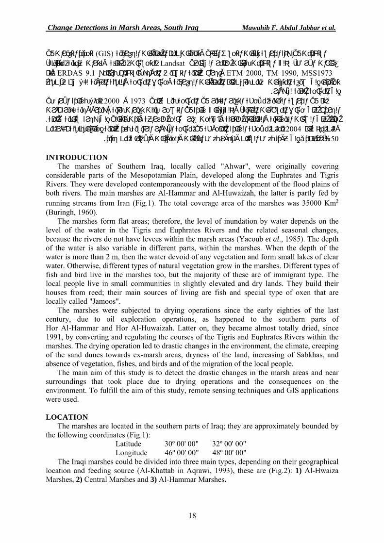
The marshes of Southern Iraq, locally called "Ahwar", were originally covering considerable parts of the Mesopotamian Plain, developed along the Euphrates and Tigris Rivers. They were developed contemporaneously with the development of the flood plains of both rivers. The main marshes are Al-Hammar and Al-Huwaizah, the latter is partly fed by running streams from Iran (Fig.1). The total coverage area of the marshes was 35000 Km² (Buringh, 1960).
The marshes form flat areas; therefore, the level of inundation by water depends on the level of the water in the Tigris and Euphrates Rivers and the related seasonal changes, because the rivers do not have levees within the marsh areas (Yacoub et al., 1985). The depth of the water is also variable in different parts, within the marshes. When the depth of the water is more than 2 m, then the water devoid of any vegetation and form small lakes of clear water. Otherwise, different types of natural vegetation grow in the marshes. Different types of fish and bird live in the marshes too, but the majority of these are of immigrant type. The local people live in small communities in slightly elevated and dry lands. They build their houses from reed; their main sources of living are fish and special type of oxen that are locally called "Jamoos".
The marshes were subjected to drying operations since the early eighties of the last century, due to oil exploration operations, as happened to the southern parts of Hor Al-Hammar and Hor Al-Huwaizah. Latter on, they became almost totally dried, since 1991, by converting and regulating the courses of the Tigris and Euphrates Rivers within the marshes. The drying operation led to drastic changes in the environment, the climate, creeping of the sand dunes towards ex-marsh areas, dryness of the land, increasing of Sabkhas, and absence of vegetation, fishes, and birds and of the migration of the local people.
The main aim of this study is to detect the drastic changes in the marsh areas and near surroundings that took place due to drying operations and the consequences on the environment. To fulfill the aim of this study, remote sensing techniques and GIS applications were used. LOCATION
The marshes are located in the southern parts of Iraq; they are approximately bounded by the following coordinates (Fig.1):
Latitude 30º 00' 00" 32º 00' 00" Longitude 46º 00' 00" 48º 00' 00"
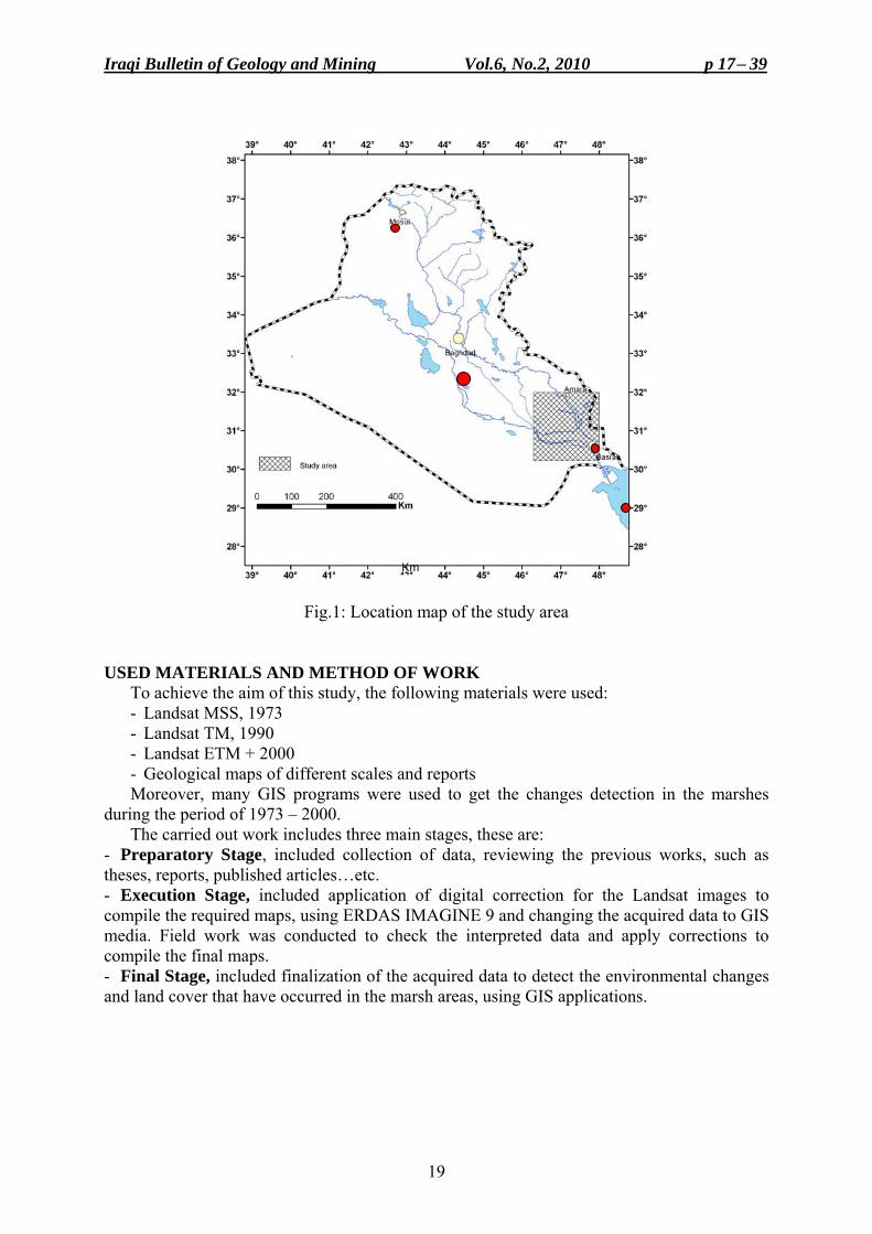
The Iraqi marshes could be divided into three main types, depending on their geographical location and feeding source (Al-Khattab in Aqrawi, 1993), these are (Fig.2): 1) Al-Hwaiza Marshes, 2) Central Marshes and 3) Al-Hammar Marshes.
Iraqi Bulletin of Geology and Mining Vol.6, No.2, 2010 p 17− 39
19
Fig.1: Location map of the study area
USED MATERIALS AND METHOD OF WORK To achieve the aim of this study, the following materials were used: - Landsat MSS, 1973 - Landsat TM, 1990 - Landsat ETM + 2000 - Geological maps of different scales and reports Moreover, many GIS programs were used to get the changes detection in the marshes
during the period of 1973 – 2000. The carried out work includes three main stages, these are:
- Preparatory Stage, included collection of data, reviewing the previous works, such as theses, reports, published articles…etc. - Execution Stage, included application of digital correction for the Landsat images to compile the required maps, using ERDAS IMAGINE 9 and changing the acquired data to GIS media. Field work was conducted to check the interpreted data and apply corrections to compile the final maps. - Final Stage, included finalization of the acquired data to detect the environmental changes and land cover that have occurred in the marsh areas, using GIS applications.
Km
Change Detections in Marsh Areas, South Iraq Mawahib F. Abdul Jabbar et al.
20
Fig.2: Landsat image of the Iraqi Marshes, 1973
PREVIOUS WORKS
The carried out works in the marsh areas concerning changes detection are very rare. However, the followings are the most relevant studies in the area: - Buring (1960) studied the Iraqi soils and classified them; he also studied the flood plain levels and attributed their formation to the carried loads by Tigris and Euphrates Rivers. - Yacoub et al. (1985) carried out systematic geological mapping for the southern part of the Mesopotamian Plain. They described the different geological and geomorphological units, including the marshes. - Yacoub et al. (1981) carried out preliminary study of the Quaternary sediments of south Iraq
Iraqi Bulletin of Geology and Mining Vol.6, No.2, 2010 p 17− 39
21
- Aqrawi (1993) studied the recent sediments in the marsh areas, the delta of the Tigris and Euphrates Rivers, as related to the oscillations in the sea level and tectonic activities, and their consequences on the sediments of the flood plain. - UNEP (2001) conducted a study concerning the main marshes, included the consequences of the drying operations on the environment and the demographic distribution. The report concluded that the existing dams along the Tigris and the Euphrates Rivers have negative effect on the marshes and recommended that the down stream yield of the dams must ensure the continuity of the marshes. - Rehabilitation Center of the Marshes (2006) conducted a study in Al-Huwaizah Marshes concerning the reactivation of the marsh's environment. The study included topographic survey, evaluation of the hydraulic system of the marshes, evaluation of the input and output water types in the marshes. - Iraqi Ministries (2006) conducted a Total Management for the Water Resources in marsh areas. The study concluded that the maximum required quantity of water to sustain the marshes (in March) should be 2300 x 10 6 m 3, whilst the minimum required quantity of water to sustain the marshes (in August) should be 650 x 10 6 m 3. GEOLOGICAL SETTING
The hereinafter mentioned geological data (Fig.3) are mainly acquired from Yacoub et al. (1985) and Yacoub (1995).
Geomorphology
The marsh areas are located in the southern part of the Mesopotamian Plain. They comprise almost flat areas with very gentle slope that is about 4 cm/ Km, along Euphrates River and 8 cm/ Km, along Tigris River. Due to this very gentle slope, rivers have a meandering system with many distributaries that form lacustrine deltas. This natural system contributes in feeding of the marshes and it is one of the main factors that contributed in the development of the marshes. The main characteristic features are natural levees (in the northern parts) that are very poorly developed, depressions; some of which are filled with clean water; seasonally or annually, and others that have shallow water and change to marshes; when filled with vegetation.
Stratigraphy
The marsh areas are totally covered by Quaternary sediments of fluvial origin, represented by the flood plain sediments of Tigris and Euphrates Rivers. The thickness of the sediments is about 120 m, near Amara city. They consist of silt and mud, rich in organic materials and very rarely calcareous.
Structure and Tectonics The marsh areas are located within the Unstable Shelf of the Arabian Platform
(Al-Kadhimi et al., 1996 and Fouad, 2010), while according to Jassim and Buday in Jassim and Goff (2006) they are located within the Stable Shelf. Many subsurface structures are developed within the area, they have N – S direction in the southern part, whereas in the central and northern parts they have NW – SE direction. Some lithological facial changes and acute meandering of the rivers may indicate the activity of these structures and development of Shat Al-Arab (Scott, 2005). The whole area is a large subsiding basin, which is continuously subsiding with a rate of subsidence amount that ranges from (– 0.4 to 1.4) cm/ 100 years, while the total subsidence ranges from (– 250 to ≥ 2000) m (Sissakian and Deikran, 1998).
Change Detections in Marsh Areas, South Iraq Mawahib F. Abdul Jabbar et al.
22
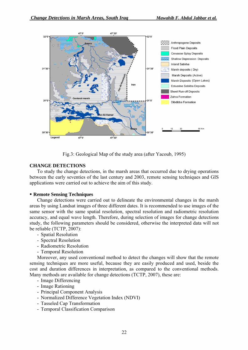
Fig.3: Geological Map of the study area (after Yacoub, 1995)
CHANGE DETECTIONS To study the change detections, in the marsh areas that occurred due to drying operations
between the early seventies of the last century and 2003, remote sensing techniques and GIS applications were carried out to achieve the aim of this study. Remote Sensing Techniques
Change detections were carried out to delineate the environmental changes in the marsh areas by using Landsat images of three different dates. It is recommended to use images of the same sensor with the same spatial resolution, spectral resolution and radiometric resolution accuracy, and equal wave length. Therefore, during selection of images for change detections study, the following parameters should be considered, otherwise the interpreted data will not be reliable (TCTP, 2007):
- Spatial Resolution - Spectral Resolution - Radiometric Resolution - Temporal Resolution Moreover, any used conventional method to detect the changes will show that the remote
sensing techniques are more useful, because they are easily produced and used, beside the cost and duration differences in interpretation, as compared to the conventional methods. Many methods are available for change detections (TCTP, 2007), these are:
- Image Differencing - Image Rationing - Principal Component Analysis - Normalized Difference Vegetation Index (NDVI) - Tasseled Cap Transformation - Temporal Classification Comparison
(Active)
(Open Lakes)
60 Km
Iraqi Bulletin of Geology and Mining Vol.6, No.2, 2010 p 17− 39
23
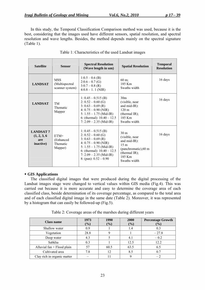
In this study, the Temporal Classification Comparison method was used, because it is the best, considering that the images used have different sensors, spatial resolution, and spectral resolution and wave lengths. Besides, the method depends mainly on the spectral signature (Table 1).
Table 1: Characteristics of the used Landsat images
Satellite Sensor Spectral Resolution (Wave length in um) Spatial Resolution Temporal
Resolution
LANDSAT
MSS (Multispectral scanner system)
1:0.5 – 0.6 (B) 2:0.6 – 0.7 (G) 3:0.7 – 0.8 (R) 4:0.8 – 1. 1 (NIR)
60 m; 185 Km Swaths width
16 days
LANDSAT
TM Thematic Mapper
1: 0.45 – 0.515 (B) 2: 0.52 – 0.60 (G) 3: 0.63 – 0.69 (R) 4: 0.75 – 0.90 (NIR) 5: 1.55 – 1.75 (Mid-IR) 6: (thermal): 10.40 – 12.57: 2.09 – 2.35 (Mid-IR)
30m (visible, near and mid-IR): 120 m (thermal IR); 185 Km Swaths width
16 days
LANDSAT 7
(1, 2, 3, 6 are
inactive)
ETM+ (Enhanced Thematic Mapper)
1: 0.45 – 0.515 (B) 2: 0.52 – 0.60 (G) 3: 0.63 – 0.69 (R) 4: 0.75 – 0.90 (NIR) 5: 1.55 – 1.75 (Mid-IR) 6: (thermal): 10.40 – 12.57: 2.09 – 2.35 (Mid-IR) 8: (pan): 0.52 – 0.90
30 m (visible, near and mid-IR): 15 m (panchromatic),60 m (thermal IR); 185 Km Swaths width
16 days
GIS Applications
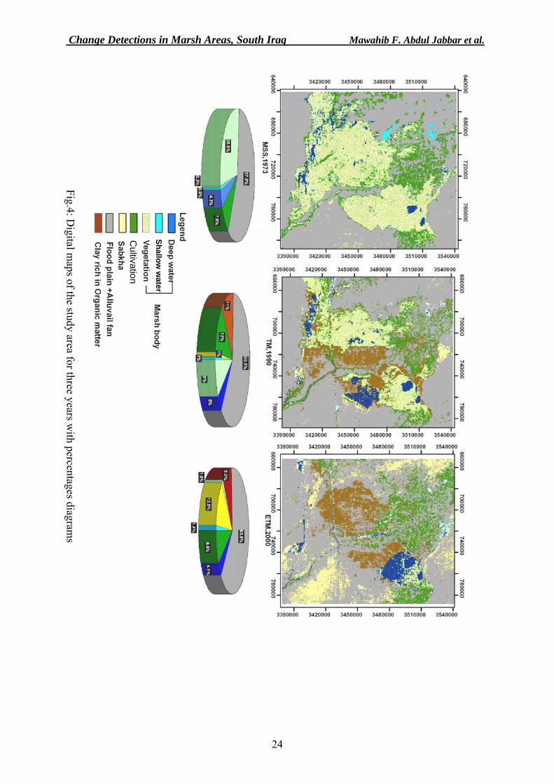
The classified digital images that were produced during the digital processing of the Landsat images stage were changed to vertical values within GIS media (Fig.4). This was carried out because it is more accurate and easy to determine the coverage area of each classified class, beside determination of its coverage percentage, as compared to the total area and of each classified digital image in the same date (Table 2). Moreover, it was represented by a histogram that can easily be followed-up (Fig.5).
Table 2: Coverage areas of the marshes during different years
Class name 1973 (%)
1990 (%)
2000 (%)
Percentage Growth (%)
Shallow water 0.9 1 1.4 0.3 Vegetation 28.8 9 1 – 27.8 Deep water 4.3 5 4.1 – 0.2
Sabkha 0.3 1 12.5 12.2 Alluvial fan + Flood plain 57 60.5 63.5 6.5
Cultivated area 7.8 12 8.5 0.7 Clay rich in organic matter – 11 9 – 2
Change Detections in Marsh Areas, South Iraq Mawahib F. Abdul Jabbar et al.
24
Fig.4: Digital m
aps of the study area for three years with percentages diagram
s
Cultivation
Shallow w
ater
Iraqi Bulletin of Geology and Mining Vol.6, No.2, 2010 p 17− 39
25
From reviewing the determined percentages (Table 2), the changes in the coverage areas can be seen for the period 1973 – 2000. It is very clear that there is an increase in barren areas and dry soils, which include the old flood plain and sabkhas. It is worth to mention that the increase in the areas covered with natural vegetation, in 1973, is accompanied with increase of areas of shallow marshes, which means the deep water areas were decreased. This means that the marshes, in the year 1973 were very densely covered by natural vegetation (reed and rushes), which had led to diminution of the water body due to the coverage by vegetation, therefore, the vegetation cover was increased.
To determine the changes in each class of the marshes environment and to detect the changes in the covered areas, before and after drying, relation curves were drawn (Fig.6) to represent the coverage area of each class with different durations. Reviewing these linear relations, the followings can be seen:
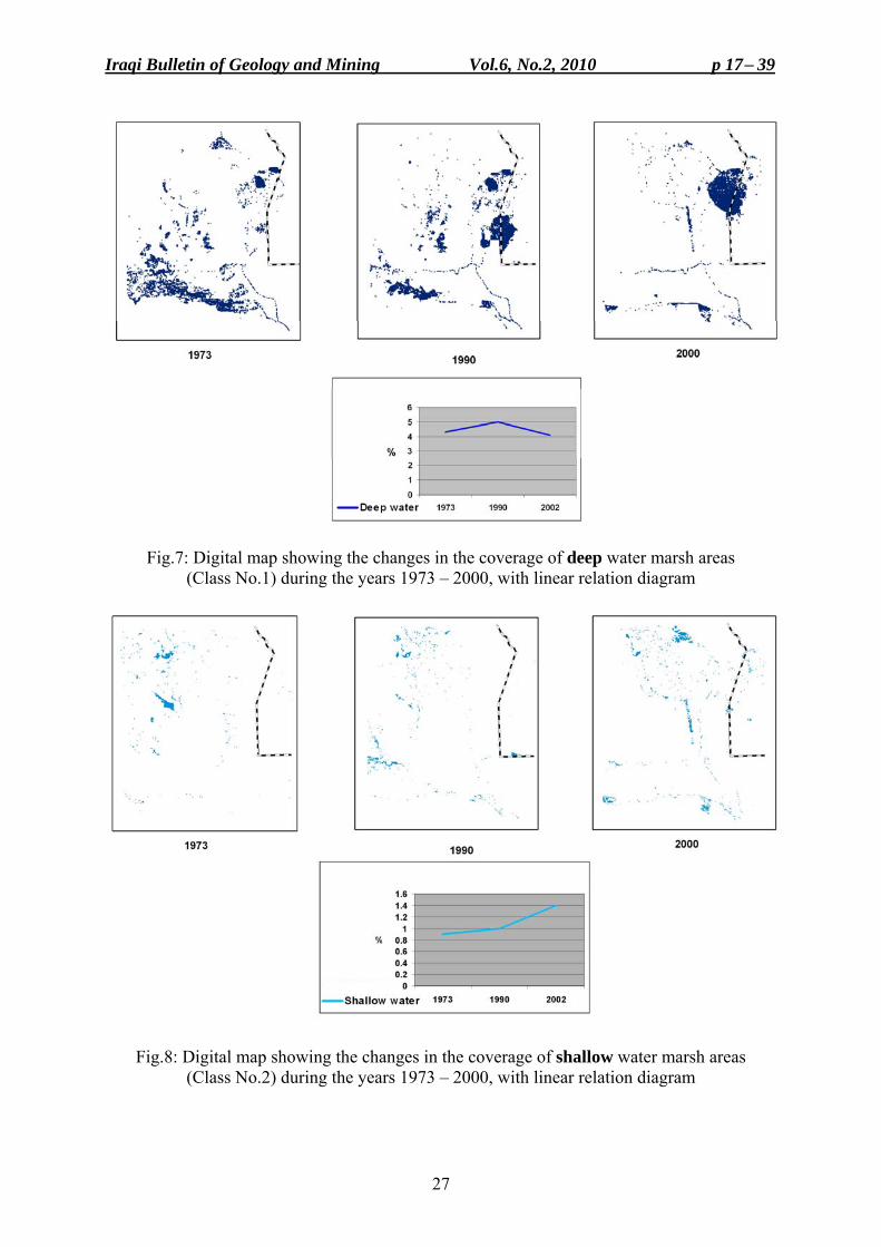
- Decrease in the areas of deep water marshes (Class No.1) about 0.3% during 1973 – 2000, but there is an increase in the year 1990, which is attributed to human activities in harvesting the natural vegetation from the south part of Al-Huwaizah Marsh. However, in the year 2000, these areas have, decreased again (Fig.7).
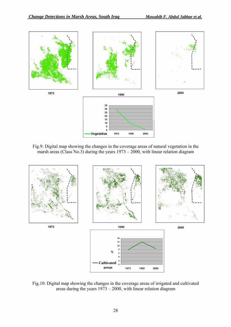
- Increase in the areas of shallow water marshes (Class No.2), due to decrease of the deep water marshes (Fig.8).
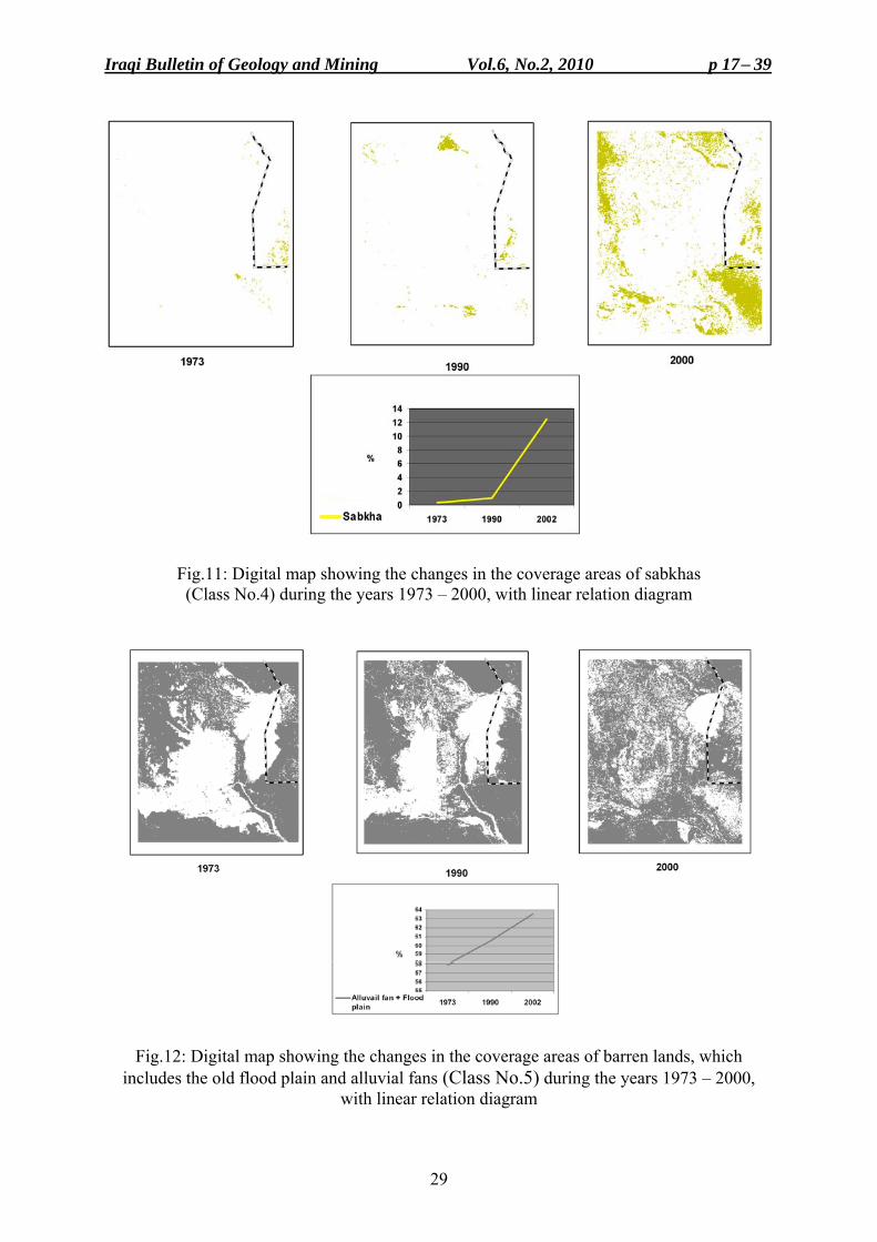
- Decrease in the areas of natural vegetation and water (Class No.3) (Fig.9), the latter is included within the marshes. This is due to the drying operations of the marshes and its consequences on the natural vegetation.
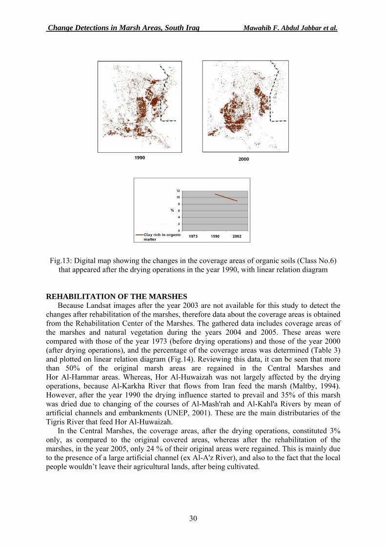
- Increase in the cultivated areas (Class No.4) (Fig.10) in the year 1990, because the local people involved by cultivation after the marshes were dried. But, these areas started to decrease due to the continuation of the drying operations, till the year 2000, and due to shallow water saline groundwater level that increased the salinity of the soil, the areas became unsuitable for cultivation. According to UNEP (2000), the local people started to emigrate from the marsh areas due to aforementioned reasons.
- Drastic increase in the sabkha areas (Class No.5) (Fig.11). According to UNEP (2000), 1000 Kg of salt were added to each hectare of land, due to the capillary action. Consequently, 3 million tons of salt is added yearly to the marsh areas.
- Increase in the areas of Barren lands (Class No.6), due to the drying operations and their consequences on the natural vegetation (reed and rushes) These barren lands include the old flood plain and alluvial fans in the northern and southern parts (Fig.12,). It is worth to mention, that many geomorphic units are grouped together, like the old flood plain and alluvial fans, because it is very difficult to differentiate them spectrally. This is due to high reflection of the flood plain, because it is highly eroded (barren) and has very smooth surface. Therefore, they are grouped with sabkhas and saliferous soil.
- Increase in the areas of organic soil (Class No.7) that started to develop in the year 1990, which marked the beginning of vast drying operations and caused by humification of the natural vegetation (reed), after drying of the marshes during 1973 – 2000. But, then, they started to decrease (Fig.13), because the organic soils became gradually barren and saliferous. Field check, showed that these areas were densely covered by natural vegetation, called locally "Talha".

Change Detections in Marsh Areas, South Iraq Mawahib F. Abdul Jabbar et al.
26
0
10
20
30
40
50
60
70
1 2 3 4 5 6 7
Fig.5: Histograms of coverage areas for each class during three years
0
10
20
30
40
50
60
70
1973 1990 2000
Shallow water
Vegetation
Deep water
Sabkha
Alluvail fan + FloodplainAgricultural area
Clay rich in organicmatter
Fig.6: Linear relation between percentages of coverage areas and duration
Cultivated + Flood
Cov
erag
e ar
ea (%
)
1. Shallow water 2. Vegetation 3. Deep water 4. Sabkha 5. Alluvial fan + Flood plain 6. Cultivated area 7. Clay rich in organic matter
1973
1990
2000
Cultivated
Iraqi Bulletin of Geology and Mining Vol.6, No.2, 2010 p 17− 39
27
Fig.7: Digital map showing the changes in the coverage of deep water marsh areas (Class No.1) during the years 1973 – 2000, with linear relation diagram
Fig.8: Digital map showing the changes in the coverage of shallow water marsh areas (Class No.2) during the years 1973 – 2000, with linear relation diagram
Change Detections in Marsh Areas, South Iraq Mawahib F. Abdul Jabbar et al.
28
Fig.9: Digital map showing the changes in the coverage areas of natural vegetation in the marsh areas (Class No.3) during the years 1973 – 2000, with linear relation diagram
Fig.10: Digital map showing the changes in the coverage areas of irrigated and cultivated areas during the years 1973 – 2000, with linear relation diagram
Cultivated areas
Iraqi Bulletin of Geology and Mining Vol.6, No.2, 2010 p 17− 39
29
Fig.11: Digital map showing the changes in the coverage areas of sabkhas (Class No.4) during the years 1973 – 2000, with linear relation diagram
Fig.12: Digital map showing the changes in the coverage areas of barren lands, which includes the old flood plain and alluvial fans (Class No.5) during the years 1973 – 2000,
with linear relation diagram
Change Detections in Marsh Areas, South Iraq Mawahib F. Abdul Jabbar et al.
30
Fig.13: Digital map showing the changes in the coverage areas of organic soils (Class No.6) that appeared after the drying operations in the year 1990, with linear relation diagram
REHABILITATION OF THE MARSHES Because Landsat images after the year 2003 are not available for this study to detect the
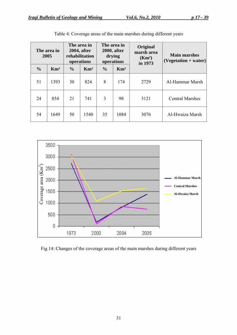
changes after rehabilitation of the marshes, therefore data about the coverage areas is obtained from the Rehabilitation Center of the Marshes. The gathered data includes coverage areas of the marshes and natural vegetation during the years 2004 and 2005. These areas were compared with those of the year 1973 (before drying operations) and those of the year 2000 (after drying operations), and the percentage of the coverage areas was determined (Table 3) and plotted on linear relation diagram (Fig.14). Reviewing this data, it can be seen that more than 50% of the original marsh areas are regained in the Central Marshes and Hor Al-Hammar areas. Whereas, Hor Al-Huwaizah was not largely affected by the drying operations, because Al-Karkha River that flows from Iran feed the marsh (Maltby, 1994). However, after the year 1990 the drying influence started to prevail and 35% of this marsh was dried due to changing of the courses of Al-Mash'rah and Al-Kahl'a Rivers by mean of artificial channels and embankments (UNEP, 2001). These are the main distributaries of the Tigris River that feed Hor Al-Huwaizah.
In the Central Marshes, the coverage areas, after the drying operations, constituted 3% only, as compared to the original covered areas, whereas after the rehabilitation of the marshes, in the year 2005, only 24 % of their original areas were regained. This is mainly due to the presence of a large artificial channel (ex Al-A'z River), and also to the fact that the local people wouldn’t leave their agricultural lands, after being cultivated.
Iraqi Bulletin of Geology and Mining Vol.6, No.2, 2010 p 17− 39
31
Table 4: Coverage areas of the main marshes during different years
The area in 2000, after
drying operations
The area in 2004, after
rehabilitation operations
The area in 2005 Main marshes
(Vegetation + water)
Original marsh area
(Km²) in 1973
Km² % Km² % Km² %
Al-Hammar Marsh 2729 174 8 824 30 1393 51
Central Marshes 3121 98 3 741 21 854 24
Al-Hwaiza Marsh 3076 1084 35 1540 50 1649 54
Fig.14: Changes of the coverage areas of the main marshes during different years
Al-Hammar Marsh Central Marshes Al-Hwaiza Marsh
Cov
erag
e ar
ea (K
m2 )
Change Detections in Marsh Areas, South Iraq Mawahib F. Abdul Jabbar et al.
32
HYDROLOGICAL CHANGES AND ENVIRONMENTAL IMPACT The drying operations of the marshes caused severe changes in the soil and water
properties that affected the water quality of the Tigris and Euphrates Rivers due to increase in the salt content. This pollution, which includes some chemical compounds of different sources, will be transferred to the Tigris and the Euphrates Rivers after rehabilitation of the marshes.
Due to drying of the marshes, increase of the evaporation and fluctuations of the daily temperatures caused increase of salt contents, especially that of sodium chloride in the upper parts of the soil. Moreover, the contamination of the irrigation water with that of the drainage has increased the total dissolved salts in the irrigation water, and the soil becomes polluted and unfavorable for agricultural purposes.
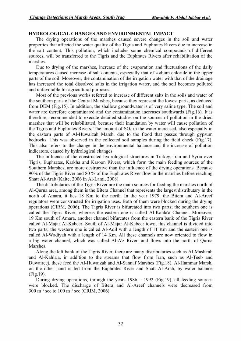
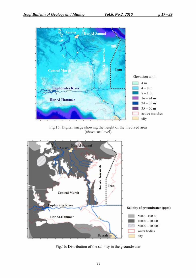
Most of the previous works referred to increase of different salts in the soils and water of the southern parts of the Central Marshes, because they represent the lowest parts, as deduced from DEM (Fig.15). In addition, the shallow groundwater is of very saline type. The soil and water are therefore contaminated and the contamination increases southwards (Fig.16). It is therefore, recommended to execute detailed studies on the sources of pollution in the dried marshes that will be rehabilitated, because their inundation by water will cause pollution of the Tigris and Euphrates Rivers. The amount of SO4 in the water increased, also especially in the eastern parts of Al-Huwaizah Marsh, due to the flood that passes through gypsum bedrocks. This was observed in the collected soil samples during the field check (Fig.17). This also refers to the change in the environmental balance and the increase of pollution indicators, caused by hydrological changes.
The influence of the constructed hydrological structures in Turkey, Iran and Syria over Tigris, Euphrates, Karkha and Karoon Rivers, which form the main feeding sources of the Southern Marshes, are more destructive than the influence of the drying operations. Because 90% of the Tigris River and 80 % of the Euphrates River flow in the marshes before reaching Shatt Al-Arab (Kaite, 2006 in Al-Lami, 2008).
The distributaries of the Tigris River are the main sources for feeding the marshes north of Al-Qurna area, among them is the Bitera Channel that represents the largest distributary in the north of Amara, it lies 18 Km to the north. In the year 1979, the Bitera and Al-Areef regulators were constructed for irrigation uses. Both of them were blocked during the drying operations (CIRM, 2006). The Tigris River is bifurcated into two parts; the southern one is called the Tigris River, whereas the eastern one is called Al-Kahla'a Channel. Moreover, 19 Km south of Amara, another channel bifurcates from the eastern bank of the Tigris River called Al-Majar Al-Kabeer. South of Al-Majar Al-Kabeer town, this channel is divided into two parts; the western one is called Al-Adil with a length of 11 Km and the eastern one is called Al-Wadiyah with a length of 14 Km. All these channels are now oriented to flow in a big water channel, which was called Al-A'z River, and flows into the north of Qurna Marshes.
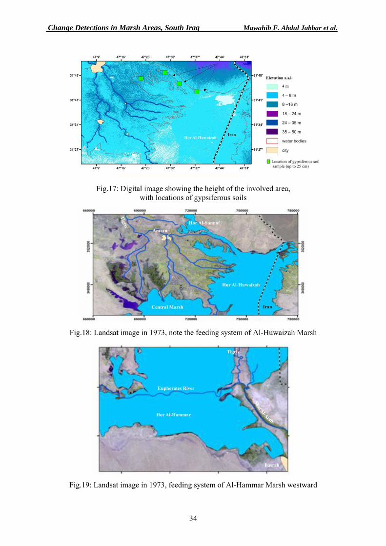
Along the left bank of the Tigris River, there are many distributaries such as Al-Mash'rah and Al-Kahla'a, in addition to the streams that flow from Iran, such as Al-Teeb and Duwaireej, these feed the Al-Huwaizah and Al-Sannaf Marshes (Fig.18). Al-Hammar Marsh, on the other hand is fed from the Euphrates River and Shatt Al-Arab, by water balance (Fig.19).
During drying operations, through the years 1986 – 1992 (Fig.19), all feeding sources were blocked. The discharge of Bitera and Al-Areef channels were decreased from 300 m3/ sec to 100 m3/ sec (CRIM, 2006).
Iraqi Bulletin of Geology and Mining Vol.6, No.2, 2010 p 17− 39
33
Fig.15: Digital image showing the height of the involved area (above sea level)
Fig.16: Distribution of the salinity in the groundwater
Change Detections in Marsh Areas, South Iraq Mawahib F. Abdul Jabbar et al.
34
Fig.17: Digital image showing the height of the involved area, with locations of gypsiferous soils
Fig.18: Landsat image in 1973, note the feeding system of Al-Huwaizah Marsh
Fig.19: Landsat image in 1973, feeding system of Al-Hammar Marsh westward
Iraqi Bulletin of Geology and Mining Vol.6, No.2, 2010 p 17− 39
35
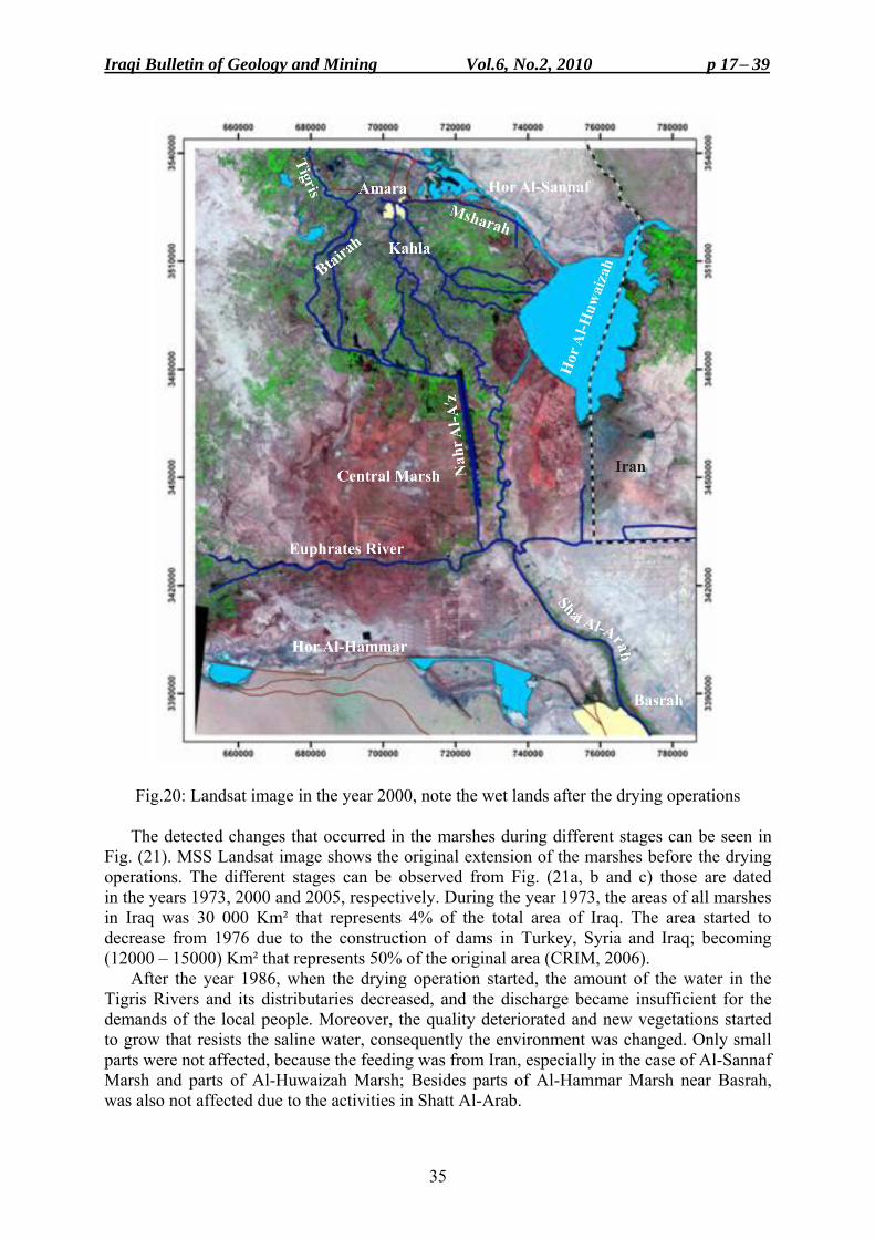
Fig.20: Landsat image in the year 2000, note the wet lands after the drying operations
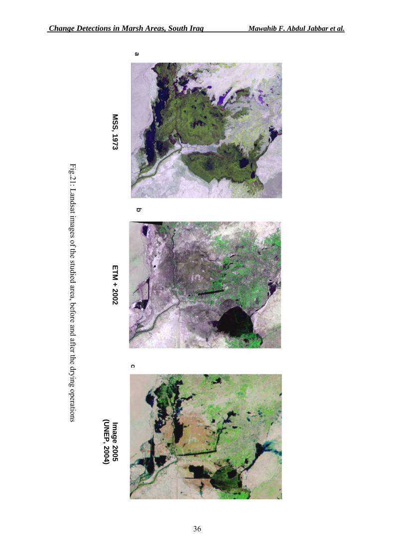
The detected changes that occurred in the marshes during different stages can be seen in Fig. (21). MSS Landsat image shows the original extension of the marshes before the drying operations. The different stages can be observed from Fig. (21a, b and c) those are dated in the years 1973, 2000 and 2005, respectively. During the year 1973, the areas of all marshes in Iraq was 30 000 Km² that represents 4% of the total area of Iraq. The area started to decrease from 1976 due to the construction of dams in Turkey, Syria and Iraq; becoming (12000 – 15000) Km² that represents 50% of the original area (CRIM, 2006).
After the year 1986, when the drying operation started, the amount of the water in the Tigris Rivers and its distributaries decreased, and the discharge became insufficient for the demands of the local people. Moreover, the quality deteriorated and new vegetations started to grow that resists the saline water, consequently the environment was changed. Only small parts were not affected, because the feeding was from Iran, especially in the case of Al-Sannaf Marsh and parts of Al-Huwaizah Marsh; Besides parts of Al-Hammar Marsh near Basrah, was also not affected due to the activities in Shatt Al-Arab.
Change Detections in Marsh Areas, South Iraq Mawahib F. Abdul Jabbar et al.
36
Fig.21: Landsat images of the studied area, before and after the drying operations
MSS, 1973
ETM+
2002 Im
age 2005 (U
NEP, 2004)
Iraqi Bulletin of Geology and Mining Vol.6, No.2, 2010 p 17− 39
37
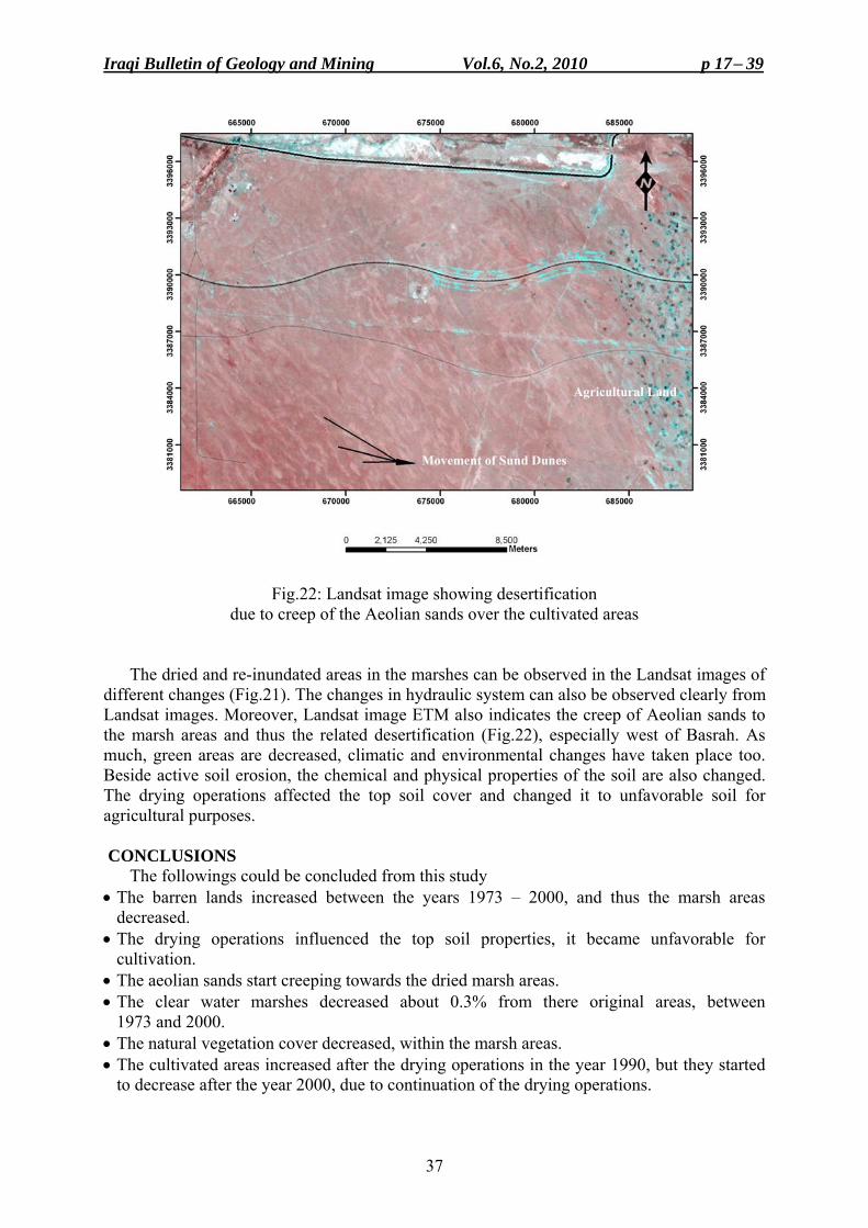
Fig.22: Landsat image showing desertification due to creep of the Aeolian sands over the cultivated areas
The dried and re-inundated areas in the marshes can be observed in the Landsat images of different changes (Fig.21). The changes in hydraulic system can also be observed clearly from Landsat images. Moreover, Landsat image ETM also indicates the creep of Aeolian sands to the marsh areas and thus the related desertification (Fig.22), especially west of Basrah. As much, green areas are decreased, climatic and environmental changes have taken place too. Beside active soil erosion, the chemical and physical properties of the soil are also changed. The drying operations affected the top soil cover and changed it to unfavorable soil for agricultural purposes.
CONCLUSIONS The followings could be concluded from this study • The barren lands increased between the years 1973 – 2000, and thus the marsh areas
decreased. • The drying operations influenced the top soil properties, it became unfavorable for
cultivation. • The aeolian sands start creeping towards the dried marsh areas. • The clear water marshes decreased about 0.3% from there original areas, between
1973 and 2000. • The natural vegetation cover decreased, within the marsh areas. • The cultivated areas increased after the drying operations in the year 1990, but they started
to decrease after the year 2000, due to continuation of the drying operations.
Change Detections in Marsh Areas, South Iraq Mawahib F. Abdul Jabbar et al.
38
• The drying operations led to immigration of the local people from the marsh areas. • After rehabilitation, in the year 2005, the areas of Al-Huwaizah and Al-Hammar Marshes
increased about 50% from the dried areas, whereas in the Central Marsh areas the increased area represents 24% only.
• The Central Marshes have the lowest elevations, as compared with other marshes; therefore they have the shallowest groundwater level and highest salt content.
• The drying operations caused increasing of SO4 content and other salts in the soil. • All detected changes in the marshes and related environment were due to human activities. ACKNOWLEDGEMNT
The authors would like to express their sincere thanks to Mr. Varoujan K. Sissakian (Expert, Geology) for reviewing this article and presenting his valuable notes that amended the presented article. REFERENCES Al-Kadhimi, J.A.M., Sissakian, V.K., Fattah, A.S. and Deikran, D.B., 1996. Tectonic Map of Iraq, scale
1: 1000 000, 2nd edit. GEOSURV, Baghdad, Iraq. Al-Lami, H.A.J., 2008. Hyrdochemical and Sedimentological study of the Northwestern Part of Hor
Al-Huwizah, Misan Governorate, South of Iraq. Unpub. M.Sc. Thesis, University of Baghdad (in Arabic). Al-Sa'idi, Y. I., 2008. Environmental and Mineral Geochemistry of Hor Al-Jakka, South of Al-Mashrah River.
Unpub. M. Sc. Thesis, University of Baghdad (in Arabic). Aqrawi, A.A.M. and Evans, G., 1993. Sedimentation in lakes and marshes (Ahwar) of the Tigris – Euphrates
delta, southern Iraq. Buringh, P., 1960. Soil and Soil Conditions of Iraq. Ministry of Agriculture, D.G., Agric. Res. and Projects.
Baghdad, Iraq. CIRM, 2006. A study of rehabilitation of environmental system of Al-Hwaiza Marsh. Final Report (in Arabic). Fouad, S.F., 2010. Tectonic Map of Iraq, scale 1: 1000 000, 3rd edit. GEOSURV, Baghdad, Iraq. Jassim, S. Z. and Goff, J. C., (Eds.) 2006. Geology of Iraq. Dolin, Prague and Moravian Museum, Brno. Sissakian, V.K. and Deikran, D.B., 1998. Neotectonic Map of Iraq, scale 1:1000 000, GEOSURV, Baghdad,
Iraq. Maltby, E., (Ed.), 1994. An Environmental and Ecological Study of the Marshlands of Mesopotamia. Draft
Consultative Bulletin. Wetland Ecosystems Research Group, University of Exeter. Published by the AMAR Appeal Trust, London, 224pp.
Iraqi Ministries, 2006. New Eden master plan. Executive summary for integrate water resources management in the marshland area. Prepared by Iraqi Ministries of Environment, Water Resources, Municipalities and Public Works in cooperation with The Italian Ministry for the Environment and Territory, and Free Iraq Foundation. ITALY – IRAQ 2006, 26pp.
Yacoub S.Y., Purser, B.H., Al-Hassani, N.H., Al-Azzawi, M., Orzag-Sperber, F., Hassan, K.M., Plaziat, J.C., Younis, W.R., 1981. Preliminary study of the Quaternary sediments of SE Iraq. Joint research project by the Geological Survey of Iraq and University of Paris XI, Orsay, GEOSURV, int. rep. no. 1078.
Yacoub, S.Y., Roffa, S.H. and Tawfiq, J.M., 1985. The geology of Al-Amara – Al-Nasiriyah – Al-Basrah Area. GEOSURV, int. rep. no. 1386. Baghdad, Iraq.
Yacoub, S.Y., 1995. The Geology of Al-Ammara Quadrangle, scale 1: 250 000, sheet no. 4-38-NE. GEOSURV, Baghdad, Iraq.
Scott, D., 2005. A Directory of Wetlands in the Middle East. IUCN, Gland, Switzerland and IWRB, Slimbrige, U.K.
TCTP, 2007. Third Country Training Program (TCTP), remote sensing and geographical information system methodologies for mineral mapping , 2006, Ankara , Turkey.
UNEP, 2000. Iraqi Marshlands Observation System: UNEP Technical Report. UNEP, 2001. The Mesopotamian Marshlands: Demise of an Ecosystem. Early Warning and Technical
Assessment Report. UNEP/DEWA/TR.01-3 Rev.1, Division of Early Warning and Assessment, United Nations Environmental Programme, Nairobi, Kenya.
Iraqi Bulletin of Geology and Mining Vol.6, No.2, 2010 p 17− 39
39
About the authors
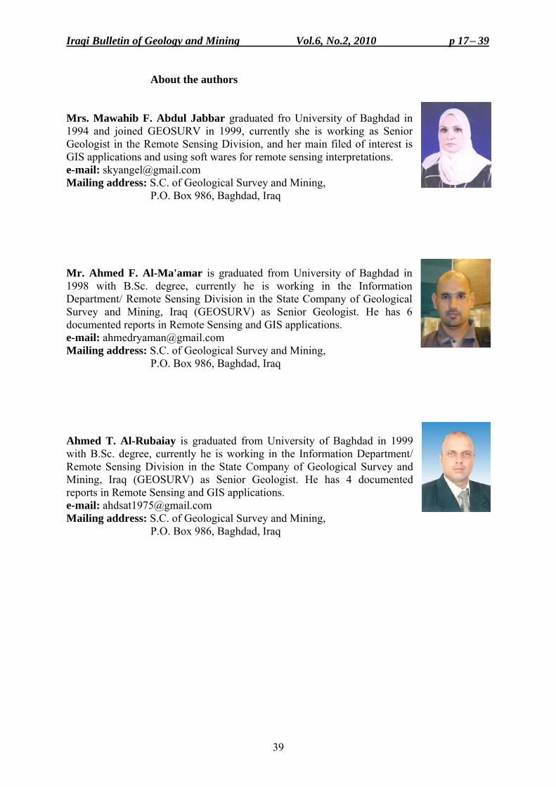
Mrs. Mawahib F. Abdul Jabbar graduated fro University of Baghdad in 1994 and joined GEOSURV in 1999, currently she is working as Senior Geologist in the Remote Sensing Division, and her main filed of interest is GIS applications and using soft wares for remote sensing interpretations. e-mail: [email protected] Mailing address: S.C. of Geological Survey and Mining, P.O. Box 986, Baghdad, Iraq
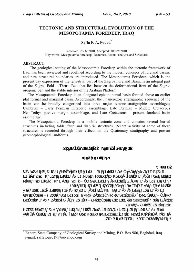
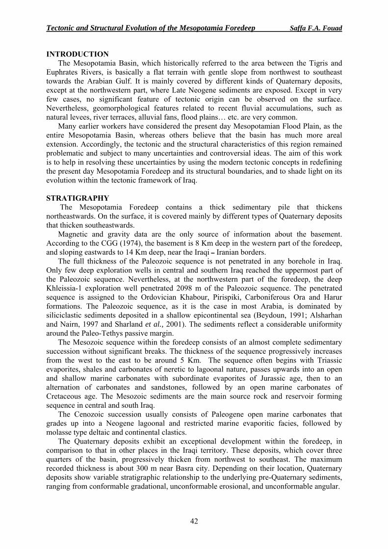
Mr. Ahmed F. Al-Ma'amar is graduated from University of Baghdad in 1998 with B.Sc. degree, currently he is working in the Information Department/ Remote Sensing Division in the State Company of Geological Survey and Mining, Iraq (GEOSURV) as Senior Geologist. He has 6 documented reports in Remote Sensing and GIS applications. e-mail: [email protected] Mailing address: S.C. of Geological Survey and Mining, P.O. Box 986, Baghdad, Iraq Ahmed T. Al-Rubaiay is graduated from University of Baghdad in 1999 with B.Sc. degree, currently he is working in the Information Department/ Remote Sensing Division in the State Company of Geological Survey and Mining, Iraq (GEOSURV) as Senior Geologist. He has 4 documented reports in Remote Sensing and GIS applications. e-mail: [email protected] Mailing address: S.C. of Geological Survey and Mining, P.O. Box 986, Baghdad, Iraq
Iraqi Bulletin of Geology and Mining Vol.6, No.2, 2010 p 41− 53
41
TECTONIC AND STRUCTURAL EVOLUTION OF THE MESOPOTAMIA FOREDEEP, IRAQ
Saffa F. A. Fouad*
Received: 28/ 6/ 2010, Accepted: 30/ 09/ 2010
Key words: Mesopotamia Foredeep, Tectonics, Basinal analysis and Structures
ABSTRACT The geological setting of the Mesopotamia Foredeep within the tectonic framework of Iraq, has been reviewed and redefined according to the modern concepts of foreland basins, and new structural boundaries are introduced. The Mesopotamia Foredeep, which is the present day expression of the terrestrial part of the Zagros Foreland Basin, is an integral part of the Zagros Fold – Thrust Belt that lies between the deformational front of the Zagros orogenic belt and the stable interior of the Arabian Platform. The Mesopotamia Foredeep is an elongated epicontinental basin formed above an earlier plat formal and marginal basin. Accordingly, the Phanerozoic stratigraphic sequence of the basin can be broadly categorized into three major tectono-stratigraphic assemblages; Cambrian – Early Permian intraplate assemblage, Late Permian – Middle Cretaceous Neo-Tethys passive margin assemblage, and Late Cretaceous – present foreland basin assemblage. The Mesopotamia Foredeep is a mobile tectonic zone and contains several buried structures including folds, fault and diapiric structures. Recent activity of some of these structures is recorded through their effects on the Quaternary stratigraphy and present geomorphological landforms.
، العراق التركيبية لحوض مابين النهرينالنشأة
فؤاد صفاء الدين فخري مستخلصال
عادة تعريفه وفق إ، وتمت هيئة التكتونية للعراقين ضمن التمت مناقشة الوضع الجيولوجي لحوض مابين النهر عن حالياًنهرين الذي يعبران حوض مابين ال . لهجديدة، واقترحت حدود تركيبية ةماميألحواض األ لالحديثةالمفاهيم
تصدع زاكروس الذي يقع بين جبهة التشويه –طي ، هو جزء من نطاقاألماميالجزء البري من حوض زاكروس . العربيةالمسطبة المستقر من الداخلي لحزام زاكروس الجبلي وبين الجزءماميةألا
ويمكن تقسيم التتابع . السابقتينفةوالحا المسطبةأحواض ان حوض مابين النهرين هو حوض قاري تشكل على المبكر، البيرمي– من عمر الكامبيري مجموعة داخل الصفيحة: ى ثالثة مجاميع رئيسية هيالطباقي فيه إل – التكتوني
مامي من أل الحوض ا األوسط ومجموعة الطباشيري– المتأخر البيرمييثس من عمر لمحيط التمجموعة الحافة الخاملة . الحاضر–خر أالمتعمر الطباشيري
كالطيات ،السطحيةيعتبر حوض مابين النهرين نطاق تكتوني مرن ويحتوي على العديد من التراكيب تحت شكال أل على رواسب العصر الرباعي واتأثيراتكما ان للعديد من هذه التراكيب . الملحيةوالصدوع واالندساسات
. لياً مما يشير الى نشاطها المستمر حاالحالية السطحية
____________________________________ * Expert, State Company of Geological Survey and Mining, P.O. Box 986, Baghdad, Iraq. e-mail: [email protected]
Tectonic and Structural Evolution of the Mesopotamia Foredeep Saffa F.A. Fouad
42
INTRODUCTION The Mesopotamia Basin, which historically referred to the area between the Tigris and
Euphrates Rivers, is basically a flat terrain with gentle slope from northwest to southeast towards the Arabian Gulf. It is mainly covered by different kinds of Quaternary deposits, except at the northwestern part, where Late Neogene sediments are exposed. Except in very few cases, no significant feature of tectonic origin can be observed on the surface. Nevertheless, geomorphological features related to recent fluvial accumulations, such as natural levees, river terraces, alluvial fans, flood plains… etc. are very common.
Many earlier workers have considered the present day Mesopotamian Flood Plain, as the entire Mesopotamia Basin, whereas others believe that the basin has much more areal extension. Accordingly, the tectonic and the structural characteristics of this region remained problematic and subject to many uncertainties and controversial ideas. The aim of this work is to help in resolving these uncertainties by using the modern tectonic concepts in redefining the present day Mesopotamia Foredeep and its structural boundaries, and to shade light on its evolution within the tectonic framework of Iraq. STRATIGRAPHY
The Mesopotamia Foredeep contains a thick sedimentary pile that thickens northeastwards. On the surface, it is covered mainly by different types of Quaternary deposits that thicken southeastwards.
Magnetic and gravity data are the only source of information about the basement. According to the CGG (1974), the basement is 8 Km deep in the western part of the foredeep, and sloping eastwards to 14 Km deep, near the Iraqi ــ Iranian borders.
The full thickness of the Paleozoic sequence is not penetrated in any borehole in Iraq. Only few deep exploration wells in central and southern Iraq reached the uppermost part of the Paleozoic sequence. Nevertheless, at the northwestern part of the foredeep, the deep Khleissia-1 exploration well penetrated 2098 m of the Paleozoic sequence. The penetrated sequence is assigned to the Ordovician Khabour, Pirispiki, Carboniferous Ora and Harur formations. The Paleozoic sequence, as it is the case in most Arabia, is dominated by siliciclastic sediments deposited in a shallow epicontinental sea (Beydoun, 1991; Alsharhan and Nairn, 1997 and Sharland et al., 2001). The sediments reflect a considerable uniformity around the Paleo-Tethys passive margin.
The Mesozoic sequence within the foredeep consists of an almost complete sedimentary succession without significant breaks. The thickness of the sequence progressively increases from the west to the east to be around 5 Km. The sequence often begins with Triassic evaporites, shales and carbonates of neretic to lagoonal nature, passes upwards into an open and shallow marine carbonates with subordinate evaporites of Jurassic age, then to an alternation of carbonates and sandstones, followed by an open marine carbonates of Cretaceous age. The Mesozoic sediments are the main source rock and reservoir forming sequence in central and south Iraq.
The Cenozoic succession usually consists of Paleogene open marine carbonates that grades up into a Neogene lagoonal and restricted marine evaporitic facies, followed by molasse type deltaic and continental clastics.
The Quaternary deposits exhibit an exceptional development within the foredeep, in comparison to that in other places in the Iraqi territory. These deposits, which cover three quarters of the basin, progressively thicken from northwest to southeast. The maximum recorded thickness is about 300 m near Basra city. Depending on their location, Quaternary deposits show variable stratigraphic relationship to the underlying pre-Quaternary sediments, ranging from conformable gradational, unconformable erosional, and unconformable angular.
Iraqi Bulletin of Geology and Mining Vol.6, No.2, 2010 p 41− 53
43
GEOLOGICAL SETTING The Iraqi territory is the northeastern extension of the Arabian Platform that surrounds the
Arabian Shield. Early workers have subdivided the Arabian Platform within the Iraqi territory into two major parts: a stable part to the southwest and an unstable part to the northeast (Henson, 1951; Dunnington, 1958). These broad lines of definition were adapted latter by many workers, either under the same names or others, then further subdivided it into smaller and smaller zones and subzones to describe the structural framework of Iraq (e.g. Ditmar, 1971; Buday, 1980; Iraq – Soviet Team, 1979… etc).
Perhaps the first comprehensive tectonic division of Iraq was introduced by Buday (1980), then by Buday and Jassim (1987). In their work, the Iraqi territory was divided into a Stable Shelf (to the southwest) and Unstable Shelf (to the northeast). Then, further subdivided the Unstable Shelf into Mesopotamian, Foothill, High Folded and Geosynclinal Zones. According to this division, the Mesopotamian Zone as a part of the Unstable Shelf, is bordered from the northeast by "the first superficially and morphologically prominent anticlines starting with Makhul, continuing southeastward with Himreen, Badra and Buzurgan". The southwestern boundary of the zone coincides with the Euphrates Fault, extending in a NW direction to Al-Ramadi, then swings sharply in a NS direction to follow the Tharthar valley, and then terminates against Makhul Range near AlـHatra (Fig.1). Furthermore, they have subdivided the Mesopotamian Zone into a minor eastern (Tigris), western (Euphrates), and southern (Zubair) Subzones. The same major divisions were adapted by Al-Kadhimi et al. (1996), but with minor modifications. Jassim and Goff (2006) made a crucial modification to the tectonic divisions by considering the Mesopotamian Zone as a part of the Stable Shelf. Moreover, they significantly changed the boundaries between the subzones that constitute the major zone.
It is critically important to mention that almost all of the mentioned tectonic divisions of Iraq, have had considered the present day "Mesopotamian Flood Plain" as the entire Mesopotamian basin (or zone). This consideration has caused a lot of confusion and uncertainties to the true structural nature of the basin. Actually, the Mesopotamia Basin is much larger and areally extensive, than that of the Mesopotamian Zone (or Flood Plain), which consists only a part of it. The present day Mesopotamia Basin extends from northeast Syria to the Straits of Hormuz. It consists of two domains, the first is a terrestrial one that covers parts of northeast Syria, Iraq, and parts of Kuwait and the coastal plains of Iran, and the second is a marine, represented by the Arabian Gulf Basin (Berberian, 1995; Alshrhan and Nairn, 1997; Brew, 2001; Sharland et al., 2001; Alavi, 2004 and Fouad and Nasir, 2009).
In the present work, however, the term "Mesopotamia Foredeep" will be used instead of the Mesopotamia Zone, because of its comprehensive dynamic and tectonic implications. Moreover, the Mesopotamia Foredeep will be redefined as well as its geological setting and boundaries, to fit the modern tectonic and structural concepts.
STRUCTURES OF THE MESOPOTAMIA FOREDEEP
The Mesopotamia Foredeep within the Iraqi territory consists of two distinct physiographic provinces; Al-Jazira Area in the northwest and the Mesopotamian Flood Plain in the center and southeast (Fig.2). The structural evolution of AlـJazira Area has been discussed earlier in details by Fouad (2007) and Fouad and Nasir (2009), and will be briefly reviewed here, whereas the central and the southeastern parts of the basin are the prime concern of this article.
The Mesopotamia Foredeep is a flat terrain in general. Significant surface structures of tectonic origin are rare. Nevertheless, the foredeep contains several structures including faults, folds, and diapiric structures that are almost entirely concealed beneath the Quaternary deposits (Fig.2).
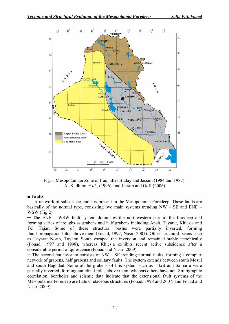
Tectonic and Structural Evolution of the Mesopotamia Foredeep Saffa F.A. Fouad
44
Fig.1: Mesopotamian Zone of Iraq, after Buday and Jassim (1984 and 1987); Al-Kadhimi et al., (1996), and Jassim and Goff (2006)
■ Faults
A network of subsurface faults is present in the Mesopotamia Foredeep. These faults are basically of the normal type, consisting two main systems trending NW – SE and ENE – WSW (Fig.2). ─ The ENE – WSW fault system dominates the northwestern part of the foredeep and forming series of troughs as grabens and half grabens including Anah, Tayarat, Khlesia and Tel Hajar. Some of these structural basins were partially inverted, forming fault-propagation folds above them (Fouad, 1997; Nasir, 2001). Other structural basins such as Tayarat North, Tayarat South escaped the inversion and remained stable tectonically (Fouad, 1997 and 1998), whereas Khlesia exhibits recent active subsidence after a considerable period of quiescence (Fouad and Nasir, 2009). ─ The second fault system consists of NW – SE trending normal faults, forming a complex network of grabens, half grabens and solitary faults. The system extends between south Mosul and south Baghdad. Some of the grabens of this system such as Tikrit and Samarra were partially inverted, forming anticlinal folds above them, whereas others have not. Stratigraphic correlation, boreholes and seismic data indicate that the extensional fault systems of the Mesopotamia Foredeep are Late Cretaceous structures (Fouad, 1998 and 2007; and Fouad and Nasir, 2009).
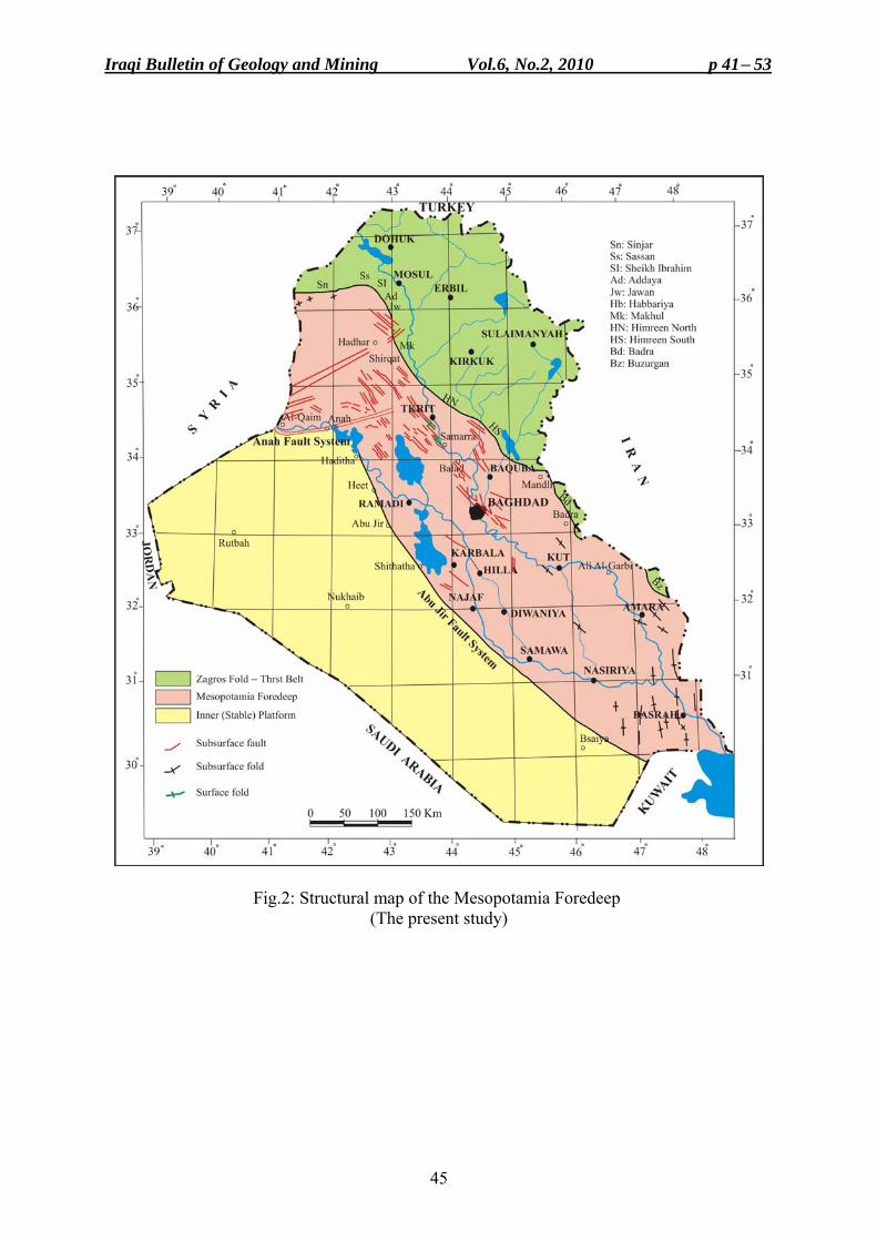
Iraqi Bulletin of Geology and Mining Vol.6, No.2, 2010 p 41− 53
45
Fig.2: Structural map of the Mesopotamia Foredeep (The present study)
Tectonic and Structural Evolution of the Mesopotamia Foredeep Saffa F.A. Fouad
46
■ Folds As already mentioned, folds visible at the surface are almost absent in the Mesopotamia Foredeep. Anah, Tikrit and Samara anticlines are the only exception. In contrast to the persistent Anah, Tikrit and Samarra anticlines are hardly expressed on the surface because of the Quaternary cover. Nevertheless, because of their continuous growth, Quaternary deposits are uplifted along these structures with about (10 – 15) m relief, with respect to the surrounding, forming local drainage divide lines coincide with the crests of these structures.
On the contrary, to the surface folds, subsurface folds are rather common structures within the Mesopotamia Foredeep. These folds are usually hidden beneath Quaternary cover. The folds are roughly E – W trending in the northwestern part of the foredeep and NW – SE in the central and eastern parts, following the general trend of the surface folds of the Zagros Fold – Thrust Belt, but deviated largely in the extreme southern part, where the folds are N – S trending (Fig.2).
Genetically, folds of the Mesopotamia Foredeep are of three types: The first is the compressional fold propagation folds. They usually have developed above an initial fault bounded structural basins (grabens or half grabens) as a result of structural inversion phenomenon. The trend and geometry of such folds reflect and match the trend and geometry of the underlying initial structural basin. Tikrit and Samarra folds are examples of this category. The second type is the simple buckle folds, which formed as a result of the regional compression exerted by Arabian – Eurasian Plates collision. Such folds usually follow the trend of the Zagros Fold – Thrust Belt. The third type is the least common and limited to the extreme southern part of Iraq. These folds do not follow the common Zagros fold trend, but they follow the old inherited N – S Arabian trend, which is best developed in the north Gulf region. These folds are related to the movement of the salt substratum, therefore can be described as bending folds (i.e. folds generated as a result of forces acting at high angle to the initial bedding). However, this type of folds is usually long, broad and with low amplitudes such as Zubair and Rumaila structures. It is believed that the presence of the Late Precambrian – Early Cambrian Hormuz Salt (Colman-Saad, 1978; Alavi, 2004) in this particular part of the Mesopotamia Foredeep and its subsequent active halokinesis movement is the reason behind the development of these folds. The diapiric structures beneath the folds have pierced the overlying sedimentary sequence to different stratigraphic levels, but have had reached the surface at only one locality known as Jabel Sanam. Dolerite rock blocks and fragments of Precambrian (?) age are exposed in the core of the domal structure and thought to be stripped off the basement and brought to the surface by the upward movement of the buoyant salt. The surrounding sedimentary rocks, which are of Miocene – Pliocene age, exhibit radial dip toward the peripheries, forming a circular dome of about 4 Km diameter and more than 100 m of relief (Fig.3). The Mesopotamia Foredeep is an extremely mobile zone, and contains many active structures. Evidences, such as tilted Pleistocene – Holocene river terraces, deviated stream channels, recent subsidences and uplift movements add another indication to the Neotectonic activity of the foredeep structures. This will be discussed in details in a following article.
BIRTH OF THE ZAGROS FORELAND BASIN Late Cretaceous emplacement of ophiolite – radiolaritic thrust sheets over the Arabian passive margin was the sign of the continental convergence between the Arabian and the Eurasian (Iranian) Plates. The ophiolite obduction on the Mesozoic Arabian Plate margin resulted in the distraction of the margin and the formation of an epicontinental basin on the destroyed passive margin ahead of the thrusted ophiolite sheets. This epicontinental basin known as the Zagros Foreland Basin (Kazmin et al.,1987; Daly, 1990; Peel and Wright, 1990;
Iraqi Bulletin of Geology and Mining Vol.6, No.2, 2010 p 41− 53
47
Alsharhan and Nairn, 1997; Alavi, 2004; Bahroudi and Koyi, 2004, and Leturmy and Robin, 2010). Foreland basins are formed primarily as a result of the down flexing of the continental lithosphere in response to the excess load imposed by the adjacent growing fault – fold belt (Dickinson, 1974; Alan and Alan, 1990; Macqueen and Leckie, 1992; DeCells and Giles, 1996; Chahil, 2006; Egan and William, 2006).
Fig.3: Sanam salt diapiric structure
By the end of the Cretaceous, the following three tectonic element can be distinguished along the Arabian Plate margin (Fig.4): 1) An elevated zone corresponding to the obducted ophiolites and the associated radiolaritic
mélange that was periodically emerging, and submerging. 2) An asymmetric foreland basin with deep part adjacent to the mountain front, swallowing
towards the undiformed continental interior; and 3) A shallow Arabian Shelf that terminates against the exposed Nubia – Arabian Shield
(Fig.4).
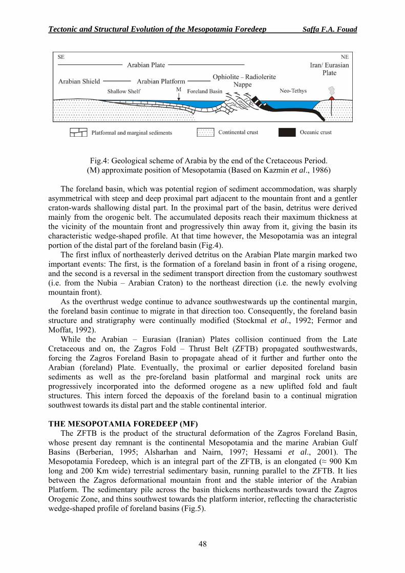
Tectonic and Structural Evolution of the Mesopotamia Foredeep Saffa F.A. Fouad
48
Fig.4: Geological scheme of Arabia by the end of the Cretaceous Period. (M) approximate position of Mesopotamia (Based on Kazmin et al., 1986)
The foreland basin, which was potential region of sediment accommodation, was sharply
asymmetrical with steep and deep proximal part adjacent to the mountain front and a gentler craton-wards shallowing distal part. In the proximal part of the basin, detritus were derived mainly from the orogenic belt. The accumulated deposits reach their maximum thickness at the vicinity of the mountain front and progressively thin away from it, giving the basin its characteristic wedge-shaped profile. At that time however, the Mesopotamia was an integral portion of the distal part of the foreland basin (Fig.4).
The first influx of northeasterly derived detritus on the Arabian Plate margin marked two important events: The first, is the formation of a foreland basin in front of a rising orogene, and the second is a reversal in the sediment transport direction from the customary southwest (i.e. from the Nubia – Arabian Craton) to the northeast direction (i.e. the newly evolving mountain front).
As the overthrust wedge continue to advance southwestwards up the continental margin, the foreland basin continue to migrate in that direction too. Consequently, the foreland basin structure and stratigraphy were continually modified (Stockmal et al., 1992; Fermor and Moffat, 1992).
While the Arabian – Eurasian (Iranian) Plates collision continued from the Late Cretaceous and on, the Zagros Fold – Thrust Belt (ZFTB) propagated southwestwards, forcing the Zagros Foreland Basin to propagate ahead of it further and further onto the Arabian (foreland) Plate. Eventually, the proximal or earlier deposited foreland basin sediments as well as the pre-foreland basin platformal and marginal rock units are progressively incorporated into the deformed orogene as a new uplifted fold and fault structures. This intern forced the depoaxis of the foreland basin to a continual migration southwest towards its distal part and the stable continental interior. THE MESOPOTAMIA FOREDEEP (MF)
The ZFTB is the product of the structural deformation of the Zagros Foreland Basin, whose present day remnant is the continental Mesopotamia and the marine Arabian Gulf Basins (Berberian, 1995; Alsharhan and Nairn, 1997; Hessami et al., 2001). The Mesopotamia Foredeep, which is an integral part of the ZFTB, is an elongated (≈ 900 Km long and 200 Km wide) terrestrial sedimentary basin, running parallel to the ZFTB. It lies between the Zagros deformational mountain front and the stable interior of the Arabian Platform. The sedimentary pile across the basin thickens northeastwards toward the Zagros Orogenic Zone, and thins southwest towards the platform interior, reflecting the characteristic wedge-shaped profile of foreland basins (Fig.5).
Iraqi Bulletin of Geology and Mining Vol.6, No.2, 2010 p 41− 53
49
The Phanerozoic sedimentary sequences of the MF can be broadly categorized into three major tectono-stratigraphic assemblages: A Cambrian – Early Permian Gondwana intraplate assemblage dominated by siliciclastic deposits, Late Permian – Cretaceous Neo-Tethys passive margin assemblage dominated by carbonates, and Late Cretaceous – Present foreland basin assemblage dominated by marine grading upwards into continental deposits. Moreover, the foreland basin assemblage can be further subdivided into two secondary sedimentary packages: 1) An early Late Cretaceous – Middle Miocene package denoting the under filled stage of the basin, where deposition occurred in marine conditions and 2) A late Upper Miocene – Recent package denoting the overfilled stage of the basin in which deposition occurred in terrestrial conditions.
It should be pointed out however, that present day NW – SE tectonic strike parallel regional profile along the basin exhibit sediment progradation from the terrestrial overfilled part to the marine (Arabian Gulf) under filled part, with large delta occupying the transition zone.
When the modern concepts and characteristics of the foreland basins are considered (e.g. Dickinson, 1974; Macqueen and Leckie, 1992; De Cells and Giles, 1996; Chahil, 2006), the structural boundaries of the Mesopotamia Basin as delineated by earlier workers (e.g. Budy and Jassim, 1987; Al-Khadhimi et al., 1996; Jassim and Goff, 2006) should be modified and changed to fit the new concepts. In this study, the present day Mesopotamia Foredeep structural boundaries as proposed by Fouad (1997 and 2007), and Fouad and Nasir (2009) were adapted. In their work, they have extended the northern structural boundary of the basin further northwest, and significantly changed the western one.
It is proposed here that the northeastern structural boundary of the MF with the Low Folded Zone of the ZFTB coincides with the first topographic mountain front of the Zagros Orogene made by Buzurgan, Badra, Himreen South, Himreen North and Makhul Mountain chains, and continues northwest to follow Habbariya, Jawan, Ad'daya, and Sheikh Ibrahim, then swings westwards following Sasan and Sinjar Mountain front (Fig.2).
On the other side, the MF southwestern boundary forms the tectonic boundary between the Stable (the Inner) and the Unstable (the Outer) Shelves of the Arabian Platform. The boundary coincides with Abu Jir Fault System from Al-Batin lineament, southwest of Basrah, extending more than 600 Km northwestwards along the Euphrates River valley, through Samawa, Shithatha, Abu Jir, Awasil, Heet, Al-Baghdadi, and Haditha, then swings westwards for about 100 Km following Anah Fault System to Al-Qaim near the Iraqi Syrian borders, where it meets the NW – SE trending Euphrates Fault System of eastern Syria ( Fig.2).
These new proposed boundaries imply the following significant geological aspects that
were long being subject to confusion and uncertainties: - The Mesopotamian Plain consists only the central and southern parts of the major
Mesopotamia Foredeep, and not the entire basin as confused by many (e.g. Buday and Jassim, 1987, Al-Kadhimi et al., 1996; Jassim and Goff, 2006).
- Al-Jazira Area, which is located between the Zagros Orogenic Zone and the stable interior of the Arabian Platform, eventually represents the northwestern extension of the Mesopotamia Foredeep. Its Cenozoic tectonic and stratigraphic history strongly supports this consideration (Fouad, 2007; Fouad and Nasir, 2009).
- The new boundaries of the Mesopotamia Foredeep are in accordance with the tectonic zonation of both Iran and the Arabian Gulf region to the southeast (Berberian, 1995), and that of Syria to the west and northwest (Brew, 2001), and eventually with the Arabian Plate tectonic framework.
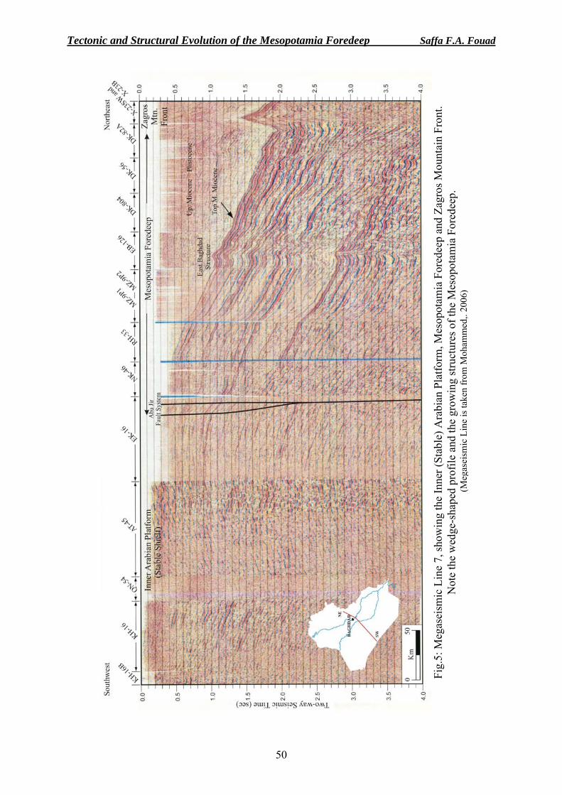
Tectonic and Structural Evolution of the Mesopotamia Foredeep Saffa F.A. Fouad
50
Fig.
5: M
egas
eism
ic L
ine
7, sh
owin
g th
e In
ner (
Stab
le) A
rabi
an P
latfo
rm, M
esop
otam
ia F
ored
eep
and
Zagr
os M
ount
ain
Fron
t. N
ote
the
wed
ge-s
hape
d pr
ofile
and
the
grow
ing
stru
ctur
es o
f the
Mes
opot
amia
For
edee
p.
(Meg
asei
smic
Lin
e is
take
n fr
om M
oham
med
,. 20
06)
Iraqi Bulletin of Geology and Mining Vol.6, No.2, 2010 p 41− 53
51
CONCLUSIONS The following could be concluded from this study.
• The Mesopotamia Foredeep is an integral part of the Zagros Fold – Thrust Belt. It is the present day expression of the continental part of the major Zagros Foreland Basin, whereas the Arabian Gulf Basin represents its marine counterpart.
• Based on the modern tectonic concepts of foreland basins, new structural boundaries to the foredeep are introduced. The boundaries are in accordance with the regional tectonic zonation of the Arabian Plate.
• The Mesopotamia Foredeep is an elongated basin lies between the first topographic and physiographic mountain front of the Zagros Orogenic Belt that extends from Buzurgan to Sinjar, and the stable interior of the Arabian Platform, which is bounded by Anah – Abu Jir Fault Systems.
• The foredeep is an asymmetric basin with a wedge-shaped profile. Maximum sediment thicknesses within the basin occur adjacent to the orogenic front and gradually decrease southwest towards the un-deformed continental interior.
• The Mesopotamia Foredeep is an epicontinental basin that has formed above an earlier platformal and marginal sedimentary basin. Eventually, the Phanerozoic sedimentary sequence of the basin could be broadly divided into three major tectono – stratigraphic complexes: Cambrian – Early Permian Gondwana intraplate assemblage; Late Permian-Mid Cretaceous Neo-Tethys opening and passive margin assemblage; and Late Cretaceous – Present foreland basin assemblage. Moreover, the foreland basin assemblage can be further subdivided into two sedimentary groups denoting an early under filled and late overfilled stages of the basin.
• The Mesopotamia Foredeep is an extremely mobile zone, and contains a number of buried tectonic structures including folds, faults and diapiric structures. Many of the buried structures are neotectonically active. Their recent activity can be observed through their effects on the Pleistocene – Holocene stratigraphy and the present geomorphological landforms.
REFERENCES Al-Kadhimi, J., Sissakian, V.K., Fattah, A.S. and Deikran, D.B., 1996. Tectonic Map of Iraq, scale 1: 1000 000,
2nd. ed., GEOSURV, Baghdad, Iraq. Alavi, M., 2004. Regional stratigraphy of the Zagros Fold – Thrust Belt of Iran and its pro-foreland evolution.
Amer. Jour. Sci., 304: 1 – 20. Allen, P.A. and Allen, J.R., 1990. Basin Analysis: Principles and Applications. Blackwell Scientific
Publications, 451pp. Alsharhan, A.S. and Nairn, A.E.M., 1997. Sedimentary Basins and Petroleum Geology of the Middle East.
Elsevier, Amsterdam, 811pp. Bahroudi, A., and Koyi, H.A., 2004. Tectono- sedimentary framework of the Gachsaran Formation in the Zagros
foreland basin. Jour. Petrol. Geol., 21: 1295 – 1310. Berberian, M., 1995. Master "blind" thrust faults hidden under the Zagros folds: active basement tectonics and
surface morphotectonic. Tectonophysics, 241: 193 – 224. Beydoun, Z.R., 1991. Arabian Plate Hydrocarbon Geology and Potential. A plate Tectonic Approach. Studies in
geology, 33, AAPG, Tulsa, Oklahoma, USA, 77pp. Brew, G., 2001. Tectonic evolution of Syria interpreted from integrated geological and geological analysis.
Ph.D. Dissertation. Cornell University. Buday, T., 1980. The Regional Geology of Iraq. Vol.1: Stratigraphy and Paleogeography. GEOSURV
Publication, Baghdad 445pp. Buday, T. and Jassim, S.Z., 1984. Tectonic Map of Iraq, scale 1: 1000 000. GEOSURV, Baghdad Iraq. Buday, T., and Jassim, S.Z., 1987. The Regional Geology of Iraq. Vol.2. Tectonism, Magmatism and
Metamorphism. In: M.J., Abbas and I.I., Kassab (Eds.) GEOSURV, Baghdad, 352pp.
Tectonic and Structural Evolution of the Mesopotamia Foredeep Saffa F.A. Fouad
52
CGG., 1974. Aeromagnetometric and aerospectrometric survey of Iraq. Massy, France, GEOSURV int. rep. no. 2642.
Colman – Sadd, S.P., 1978. Fold development in Zagros simply folded belt, southwest Iran. AAPG Bull., 62: 984 – 1003.
Chahil, P., 2006. Foreland basin, tectonic activity and evolution. Available at web site http://www.science.mcmaster.ca/geo/faculty/boyc/3203/ foreland-basins/.
Daly, M.C., 1990. Basin analysis and prospectivity of NW Iraq, Vol.2. A plate tectonic model of the Northern Arabian margin. BP/Idemitsu Study of NW Iraq. OEC Lib., Baghdad.
De Celles, P.G. and Giles, K.A., 1996. Foreland basin system. Basin Research, 8: 105 – 123. Dickinson, W.R., 1974. Plate tectonics and sedimentation. SEPM Spec. Pub. 22: 1 – 27. Ditmar, V., 1971. Geological conditions and hydrocarbon prospect of the Republic of Iraq (Northern and Central
part). Technoexport report, OEC Lib, Baghdad. Dunnington, H.V., 1958. Generation, migration, accumulation and dissipation of oil in Northern Iraq, In G.L.
Weeks (Ed.), Habitat of Oil, a Symposium. AAPG, Tulsa. Egan,S. and Williams G., 2006. Foreland basin Available at http://www.geolsoc.org.uk/template.cfm?name =
fbasins. Fermor, P.R and Moffat, I.W., 1992. Tectonics and structure of the western Canada foreland basin. In: R.W.,
Macqueen and D.A., Leckie (Eds.). Foreland Basin and Fold Belt, AAPG Memoir, 55: 81 – 105. Fouad, S.F.A., 1997. Tectonic and structural evolution of Anah Region, west Iraq. Unpub. Ph.D. Thesis.
University of Baghdad. Fouad, S.F., 1998. Tectonic and structural study of Tayarat Grabens, West Iraq. GEOSURV, int. rep. no. 2459. Fouad, S.F., 2007. Tectonic and structural evolution, Geology of Iraqi Western Desert. Iraqi Bull. Geol. and
Min., Special Issue. 1: p. 29 – 50. Fouad, S.F.A., and Nasir, W.A.A., 2009. Tectonic and structural evolution of Al-Jazira area. Geology of
Al-Jazira Area, Iraqi bulletin of geology and Mining, special Issue No. 3: 33 – 48. Henson, F.R.S., 1951. Observations on the geology and petroleum occurrences of the Middle East. 3rd World
petroleum Congress, Proc. Hessami, K., Koyi, H.A., Talbot, G.J., Tabasi, H., and Shalanian, E., 2001. Progressive unconformities within an
evoluting foreland fold-thrust belt, Zagros Mountains. Jour. Geol. Soc., 158: 969 – 981. Iraqi- Soviet Team, 1979. Geological conditions and hydrocarbon prospects of the Republic of Iraq. INOC Lib,
Baghdad. Jassim, S.Z., and Goff, J.C., 2006. Geology of Iraq. Dolin, Prague and Moravian Museum, Brno. 341pp. Kazmin, V., Ricou, L.E. and Sbortshikov, I.M., 1986. Structure and evolution of the passive margin of the
eastern Tethys. In: J., Aubbouin, X., LePichon and A.S., Monin (Eds.). Evolution of the Tethys. Tectonophysics, Vol.123: 153 – 179.
Leturmy, P. and Robinc, (Eds.), 2010. Tectonic and Stratigraphic Evolution of Zagros and Makran During the Mesozoic – Cenozoic. Geol. Soc. Sp. Pub., 330, 360pp.
Macqueen, R.W. and Leckie D.A., (Eds.), 1992. Foreland Basin and Fold Belts. AAPG Memoir 55: 460pp. Mohammed, S.A.G. 2004. Megaseismic section across the northeastern slope of the Arabian Plate, Iraq.
GeoArabia, 11: 77 – 90. Nasir, W.A.A., 2001. Structural and tectonic evolution of graben system in north Arabian Plate. Unpub. M.Sc.
Thesis, University of Baghdad, 85pp. Peel, F. and Wright, A., 1990. Basin analysis and prospectivity of NW Iraq. Vol.3, Structural geology of
Northern Iraq. BP/ Idemitsu Study of NW Iraq. OEC Lib, Baghdad. Sharland, P.R., Archer., Casey, D.M., Davies, R.B., Hall, S.H., Heward, A.P., Horbury, A.D., and Simmons,
M.O., 2001. Arabian Plate Sequence Stratigraphy. Geo Arabia Special Publication 2. Gulf Petrolink, Bahrain, 371pp.
Stockmal, G.S., Cant, D.J., and Bell, J.S., 1992. Relationship of the stratigraphy of the western Canada foreland basin to Cordilleran tectonics: insight from geodynamic models. In: R.W., Macqueen and D.A., Leckie (Eds.). Foreland Basin and Fold Belt, AAPG Memoir 55: p. 107 – 124.

Iraqi Bulletin of Geology and Mining Vol.6, No.2, 2010 p 41− 53
53
About the author
Dr. Saffa F. A. Fouad, graduated from University of Baghdad in 1979, with B.Sc. degree in geology, he got his M.Sc. and Ph.D. degrees from the same university in 1983 and 1997, respectively in Tectonics and Structural Geology and joined GEOSURV in 1984. He was nominated as Expert in 2006. Currently, he is the Deputy Director General. His main field of interest is tectonics of Zagros and Iraqi territory. He has more than 60 documented reports and published papers.
Iraqi Bulletin of Geology and Mining Vol.6, No.2, 2010 p 57− 69
57
NEOTECTONIC MOVEMENTS IN DARBANDI BAZIAN AREA, SOUTHWEST OF SULAIMANIYAH CITY, NE IRAQ
Varoujan K. Sissakian*
Received: 07/ 09/ 2009, Accepted: 28/ 12/ 2009
Key words: Neotectonics, Alluvia fans, Pila Spi Formation, NE Iraq ABSTRACT
The northeastern part of Iraq is known to be tectonically an active area due to its position in the northeastern marginal part of the Arabian Plate, which is in collision with the Eurasian (Iranian) Plate. Therefore, the whole area referred to the High Folded Zone is consequently active. The activity, however, is not uniform; locally more active areas do exist causing Neotectonic movements.
Darbandi Bazian Gorge that is located southwest of Sulaimaniyah city, NE Iraq suffers from Neotectonic movement, being more active from near surroundings. The gorge is located within the Pila Spi Formation that consists of well bedded, hard limestone and dolostone with very rare marl intercalations; its thickness is about 120 m. The Pila Spi Formation forms a continuous ridge, few hundred kilometers in length that represents the boundary between the High Folded and Low Folded Zones, the former being in the north.
The area had suffered from Neotectonic movement, which is indicated by the existence of large alluvial fans, southwards of Darbandi Bazian Gorge, the fans are formed by a single perennial stream that was previously flowing out of the gorge towards south. The older alluvial fan is now inactive, because the stream is divided into two parts; the divide point being on the top of the Pila Spi Formation that forms a high ridge, about 200 m and dips southwestwards. Part of the stream; called Chamai Bawa Fany flows southwards across the alluvial fan, whereas the other part; Tainal Stream flows northeastwards then turns southeastwards; parallel to the ridge of the Pila Spi Formation and continues its direction for about 20 Km, then turns southwestwards and crosses the same ridge in another gorge; called Basara, which is parallel to Darbandi Bazian Gorge.
The abandoned alluvial fan, the presence of old fan near Cham Chamal town, the division of the stream into two opposite parts, the abnormal trend and course of Tainal Stream, and the abnormal shape of the Darbandi Bazian Gorge are good indications for uplifting Neotectonic movement in Darbandi Bazian area, which is estimated to be during the late Holocene.
حركات بنيوية حديثة في منطقة مضيق دربند بازيان، جنوب غرب مدينة السليمانية، شمال شرق العراق
فاروجان خاجيك سيساكيان
المستخلص
تتميز المنطقة الشمالية الشرقية من العراق بكونها من المناطق النشطة بنيوياً لوقوعها في الطرف الشمالي الشرقي ، وعليه تعتبر مناطق نطاق الطيات )اإليرانية (وروسيةحالة اصطدام مع الصفيحة األتي هي بمن الصفيحة العربية وال
. مسبباً حركات بنيوية حديثةأخرى إلى النشاط يتباين من منطقة أن إال. العالية من المناطق النشطة
____________________________________ * Expert, S.C. of Geological Survey and Mining, P.O. Box 986, Baghdad, Iraq
e-mail:[email protected]
Neotectonic Movements in Darbandi Bazian Area Varoujan K. Sissakian
58
يقع مضيق دربند بازيان جنوب غرب مدينة السليمانية، شمال شرق العراق ويتميز بنشاطه البنيوي الحديث لكونه ية والدولومايت تكوين بيالسبي والذي يتكون من الصخور الكلسيقطع المضيق . لمناطق المحيطة به نشاطاً من اأكثر
ويشكل تكوين البيالسبي سلسلة جبلية . متر120 وبسمك حوالي نذات التطبق الجيد والصالبة العالية مع القليل من الطفل .والطيات الواطئةتمتد لمئات الكيلومترات ويعتبر الحد الفاصل بين نطاقي الطيات العالية
ب مضيق دربنـد بازيـان والتـي غرينية كبيرة جنو وجود مراوح : الحركات البنيوية الحديثة هي إن األدلة على إن المروحـة الغرينيـة القديمـة . بواسطة جدول موسمي، والذي كان سابقاً ينحدر من المضيق باتجاه الجنوب تشكلت
ـ ونق ، غير نشطة حالياً بسبب انقسام الجدول الى قسمين الموجودة قرب مدينة جمجمال وين طة االنقسام تبدأ من قمة تكن المناطق المجاورة لها ويميل باتجاه الجنـوب متر ع 200بيالسبي والذي يشكل جرفاً عالياً في المنطقة، يرتفع حوالي
يتجه اآلن إلى الجنوب، أما الجزء الثـاني ويـسمى جـدول " جمي باوة فامي "دول والذي يسمى وجزء من الج . الغربي كيلومتر، ثم يغير اتجاهـه الـى 20لشرقي ويستمر بهذا االتجاه لحوالي ، فيتجه نحو الشمال الشرقي ثم الجنوب ا "تينال"
.، ويكون هذا المضيق موازياً لمضيق دربند بازيان"باسارة" في مضيق يسمى الجنوب الغربي ويقطع نفس السلسلة الجـدول إلـى ووجود مروحة غرينية قديمة قرب مدينة جمجمال وانقسام )المهجورة( القديمة إن المروحة الغرينية
، كلها أدلة جيـدة لوجـود حركـة دربند بازيان لمضيقل والشكل الغريب واالتجاه والمسار الغريب لجدول تينا ينجزئ .نهوض بنيوية حديثة في منطقة الدراسة، ومن المحتمل حدثت في نهاية الهولوسين
INTRODUCTION
Darbandi Bazian Gorge is located southwest of Sulaimaniyah city, NE Iraq (Fig.1). The gorge is within Pila Spi Formation that forms a continuous ridge in NW – SE direction that extends off the study area for few hundred kilometers, starting from Iraqi – Iranian borders, in the southeast; crossing Darbandi Bazian Gorge and extends northwestwards until Iraqi – Turkish borders (Sissakian, 2000). Towards south, southeast and southwest, the area is a highly dissected plain (Cham Chamal Plain) with dense drainage patterns forming typical bad land. Whilst towards north and northeast, a gently rolling morphology exists, but changes to a mountainous landform with high peaks that attain 2773 m (a.s.l.) called Pera Magroon Mountain and other mountains and hills.
Darbandi Bazian Gorge is like other hundreds of gorges, in northeastern and northern parts of Iraq, which cross topographic barriers, either a limb or the whole anticline (Sissakian and Abdul Jabbar, 2010); they are usually formed due to:
- Structural effect, like fault, plunge area, lineament that facilitate the evolution of the gorge
- Headward erosion - Active mass movements
In all aforementioned cases, a stream must contribute in carving of the hard rocks. The size of the gorge depends on many factors; among them is the size of the stream, its gradient and amount of running water.
Darbandi Bazian Gorge separates the ridge into two parts; the northwestern one is called Qashlagh Mountain, with a peak of 1440 m (a.s.l.), whereas the southeastern one is called Hanjira Mountain, with a peak of 1120 m (a.s.l.). The width of the gorge in the outlet (within Pila Spi Formation) is about 100 m and widens northeast wards to about 1 Km. The width of the gorge, in the inlet is 3 Km, with steeper southwestern slope that attains about (35 – 55)°, whereas the northeastern slope attains about (15 – 25)°. This difference, in both slopes is due to exposure of hard rocks of the Pila Spi Formation in the southwestern slope, while soft rocks of the Gercus and Kolosh formations are exposed in the northeastern slope (Sissakian, 1995 and Ma'ala, 2007). The elevation of the surface in the crossing point, where Baghdad – Kirkuk – Sulaimaniyah main road passes through the gorge (Fig. 2) is about 960 m (a.s.l.), and the height of the cliff is about 200 m. The following coordinates define the crossing point, in the outlet: Latitude 35° 38' 20.49" N and Longitude 44° 58' 21.38" E.
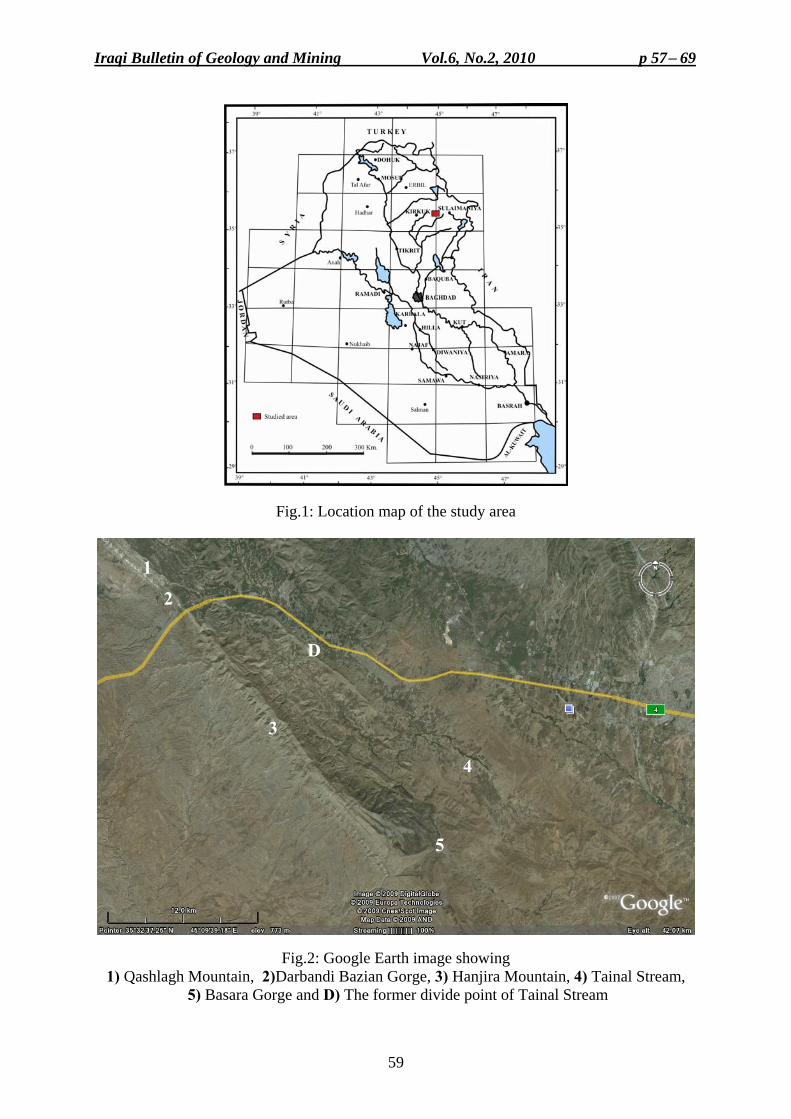
Iraqi Bulletin of Geology and Mining Vol.6, No.2, 2010 p 57− 69
59
Fig.1: Location map of the study area
Fig.2: Google Earth image showing 1) Qashlagh Mountain, 2)Darbandi Bazian Gorge, 3) Hanjira Mountain, 4) Tainal Stream,
5) Basara Gorge and D) The former divide point of Tainal Stream
1
2
3
4
5
D
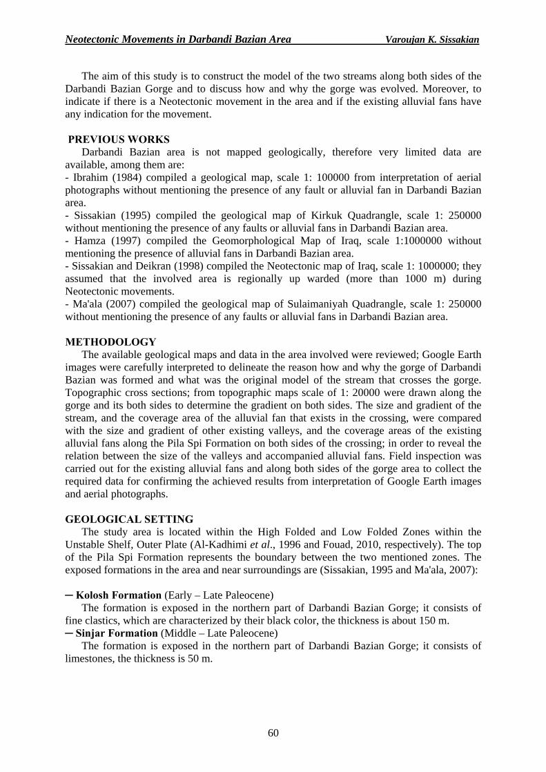
Neotectonic Movements in Darbandi Bazian Area Varoujan K. Sissakian
60
The aim of this study is to construct the model of the two streams along both sides of the Darbandi Bazian Gorge and to discuss how and why the gorge was evolved. Moreover, to indicate if there is a Neotectonic movement in the area and if the existing alluvial fans have any indication for the movement. PREVIOUS WORKS
Darbandi Bazian area is not mapped geologically, therefore very limited data are available, among them are: - Ibrahim (1984) compiled a geological map, scale 1: 100000 from interpretation of aerial photographs without mentioning the presence of any fault or alluvial fan in Darbandi Bazian area. - Sissakian (1995) compiled the geological map of Kirkuk Quadrangle, scale 1: 250000 without mentioning the presence of any faults or alluvial fans in Darbandi Bazian area. - Hamza (1997) compiled the Geomorphological Map of Iraq, scale 1:1000000 without mentioning the presence of alluvial fans in Darbandi Bazian area. - Sissakian and Deikran (1998) compiled the Neotectonic map of Iraq, scale 1: 1000000; they assumed that the involved area is regionally up warded (more than 1000 m) during Neotectonic movements. - Ma'ala (2007) compiled the geological map of Sulaimaniyah Quadrangle, scale 1: 250000 without mentioning the presence of any faults or alluvial fans in Darbandi Bazian area. METHODOLOGY
The available geological maps and data in the area involved were reviewed; Google Earth images were carefully interpreted to delineate the reason how and why the gorge of Darbandi Bazian was formed and what was the original model of the stream that crosses the gorge. Topographic cross sections; from topographic maps scale of 1: 20000 were drawn along the gorge and its both sides to determine the gradient on both sides. The size and gradient of the stream, and the coverage area of the alluvial fan that exists in the crossing, were compared with the size and gradient of other existing valleys, and the coverage areas of the existing alluvial fans along the Pila Spi Formation on both sides of the crossing; in order to reveal the relation between the size of the valleys and accompanied alluvial fans. Field inspection was carried out for the existing alluvial fans and along both sides of the gorge area to collect the required data for confirming the achieved results from interpretation of Google Earth images and aerial photographs. GEOLOGICAL SETTING
The study area is located within the High Folded and Low Folded Zones within the Unstable Shelf, Outer Plate (Al-Kadhimi et al., 1996 and Fouad, 2010, respectively). The top of the Pila Spi Formation represents the boundary between the two mentioned zones. The exposed formations in the area and near surroundings are (Sissakian, 1995 and Ma'ala, 2007):
─ Kolosh Formation (Early – Late Paleocene)
The formation is exposed in the northern part of Darbandi Bazian Gorge; it consists of fine clastics, which are characterized by their black color, the thickness is about 150 m. ─ Sinjar Formation (Middle – Late Paleocene)
The formation is exposed in the northern part of Darbandi Bazian Gorge; it consists of limestones, the thickness is 50 m.
Iraqi Bulletin of Geology and Mining Vol.6, No.2, 2010 p 57− 69
61
─ Gercus Formation (Early – Middle Eocene) The formation is exposed in the northern part of Darbandi Bazian Gorge; it consists of
claystone alternated with siltstone and sandstone. The red color is distinguishable character, the thickness ranges from (100 – 150) m. ─ Pila Spi Formation (Middle – Late Eocene)
The formation is exposed along the southern part of the Darbandi Bazian Gorge and its northwestern and southeastern sides; it consists of limestones and dolostone, the thickness is about 120 m. ─ Fatha Formation (Middle Miocene)
The formation is exposed south of Darbandi Bazian Gorge; it consists of claystone, marl and limestone, siltstone and sandstone occur in the upper parts, with very rare gypsum in the lower parts, the thickness is about 100 m. ─ Injana Formation (Late Miocene)
The formation is exposed in the south of the Darbandi Bazian Gorge; it consists of reddish brown sandstone, siltstone and claystone, in cyclic nature, the thickness is 150 m. ─ Mukdadiya Formation (Late Miocene – Pliocene)
The formation is exposed south of the Darbandi Bazian Gorge; it consists of grey sandstone, siltstone and claystone in cyclic nature. Some of the sandstone beds are pebbly, the thickness is 400 m. ─ Bai Hassan Formation (Pliocene – Pleistocene)
The formation is exposed south of the Darbandi Bazian Gorge; it consists of conglomerate, reddish brown sandstone, siltstone and claystone, in cyclic nature, the thickness is about 500 m. ALLUVIAL FANS
Alluvial fans are apron-like deposits of granular debris that extend from the base of a mountain front to a low land below. Each fan radiates from a single source channel, and has fan-like shape in plan view. Its transverse profile is arched, and the longitudinal profile is slightly concave. Slopes are usually less than 10o. They are best developed in semiarid deserts, where elongate mountain ranges that are tectonically active (basin-and-range topography) and lack protective vegetation cover, are subjected to erosion by episodic heavy rain precipitation (Bull, 1991). In the study area, Qashlagh and Hanjira Mountains are the source area for formation of the alluvial fans; they form elongated mountain chain with maximum height of 1440 m, almost with rare vegetation cover, forming the range topography. Whereas, Cham Chamal Plain is the depositional basin in which the alluvial fans are formed. Therefore, the "basin-and-range topography" is typically formed in the study area.
Alluvial fans are formed due to decrease of gradient of a stream; hence, the coarse grained solid materials carried by the water are dropped down. As this reduces the capacity of the channel, the channel will change direction over time; gradually building up a slightly mounded or shallow fan shape. Therefore, the deposits are usually poorly sorted. The fan shape can also be explained with a thermodynamic justification: the system of the sediment introduced at the apex of the fan will trend to a state, which minimizes the sum of the transport energy involved in moving the sediment and the gravitational potential of material in the cone (American Geological Institute, 1962). Therefore, there will be iso-trnsport energy lines forming concentric arcs about the discharge point at the apex of the fan. Thus, the materials will tend to be deposited equally about these lines, forming the characteristic cone shape (National Aeronautics and Space Administration, 2009).
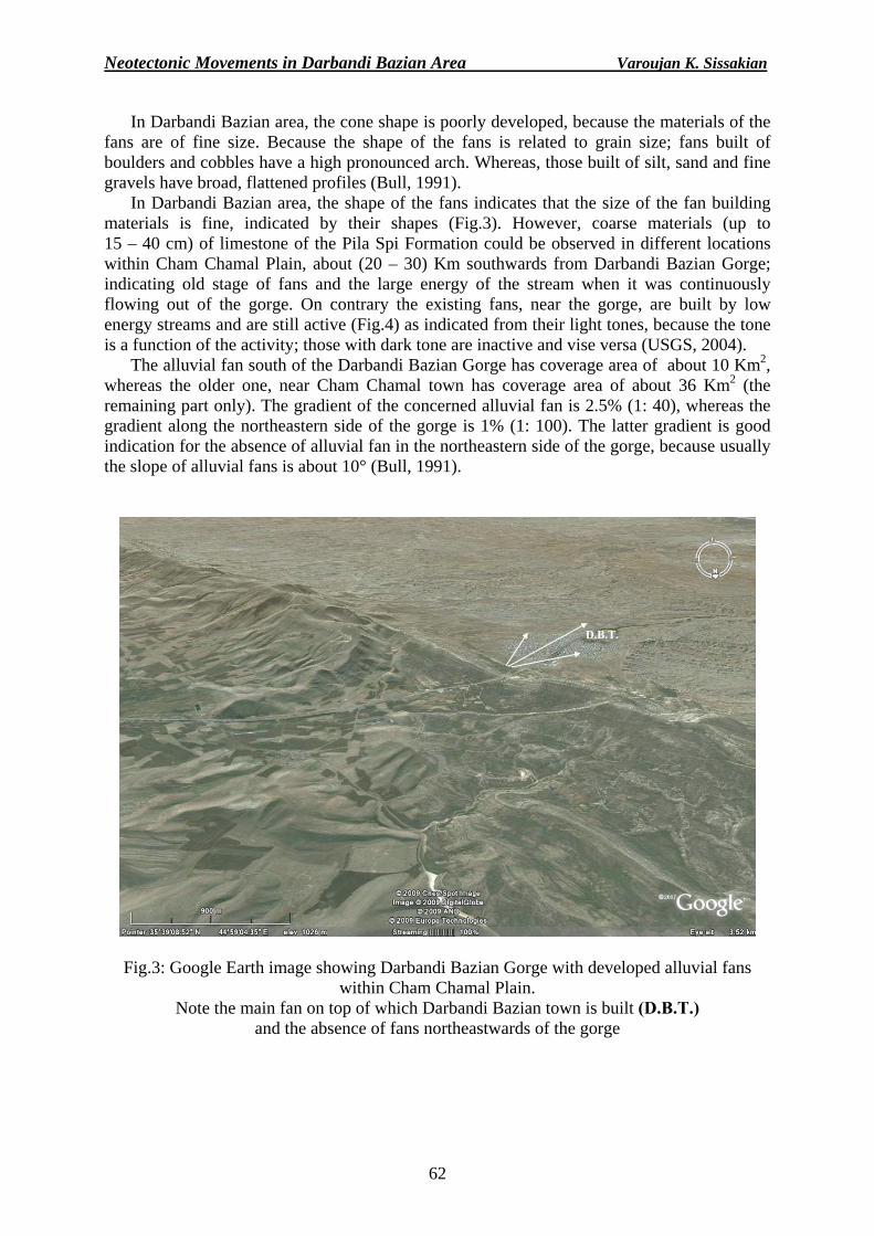
Neotectonic Movements in Darbandi Bazian Area Varoujan K. Sissakian
62
In Darbandi Bazian area, the cone shape is poorly developed, because the materials of the fans are of fine size. Because the shape of the fans is related to grain size; fans built of boulders and cobbles have a high pronounced arch. Whereas, those built of silt, sand and fine gravels have broad, flattened profiles (Bull, 1991).
In Darbandi Bazian area, the shape of the fans indicates that the size of the fan building materials is fine, indicated by their shapes (Fig.3). However, coarse materials (up to 15 – 40 cm) of limestone of the Pila Spi Formation could be observed in different locations within Cham Chamal Plain, about (20 – 30) Km southwards from Darbandi Bazian Gorge; indicating old stage of fans and the large energy of the stream when it was continuously flowing out of the gorge. On contrary the existing fans, near the gorge, are built by low energy streams and are still active (Fig.4) as indicated from their light tones, because the tone is a function of the activity; those with dark tone are inactive and vise versa (USGS, 2004).
The alluvial fan south of the Darbandi Bazian Gorge has coverage area of about 10 Km2, whereas the older one, near Cham Chamal town has coverage area of about 36 Km2 (the remaining part only). The gradient of the concerned alluvial fan is 2.5% (1: 40), whereas the gradient along the northeastern side of the gorge is 1% (1: 100). The latter gradient is good indication for the absence of alluvial fan in the northeastern side of the gorge, because usually the slope of alluvial fans is about 10° (Bull, 1991).
D.T.B
Fig.3: Google Earth image showing Darbandi Bazian Gorge with developed alluvial fans within Cham Chamal Plain.
Note the main fan on top of which Darbandi Bazian town is built (D.B.T.) and the absence of fans northeastwards of the gorge
D.B.T.
Iraqi Bulletin of Geology and Mining Vol.6, No.2, 2010 p 57− 69
63
Fig.4: Google Earth image, note the light tone alluvial fans, indicating their activity and dark tone of the main fan, indicating it is inactive
RESULTS
Darbandi Bazian Gorge that crosses a ridge within the Pila Spi Formation shows, nowadays a single stream (Chamai Bawa Fany), which flows just from the outlet of the gorge towards south, and then changes towards southwest. On the other side of the gorge, Tainal Stream flows northeastwards, and then changes its trend towards southeast, and then towards south and crosses the same ridge in Basara Gorge. A large alluvial fan is built southwards from the gorge, another old one, much bigger with coarser materials is present far from the gorge for about (20 – 30) Km. No alluvial fan is built north wards of the gorge and no blocks of the Pila Spi Formation were found there. To carve the present "V" shape gorge within the Pila Spi Formation, about 18 000000 m3 of limestone has to be eroded and transported, either southwards or northeastwards. Certainly, this needs a stream with large transporting ability, which means a large stream with very high energy and has to be much bigger than the present stream (Chamai Bawa Fany). No faults were observed along the gorge, neither transversal nor parallel. Many faults, however, are present along the slopes of both sides of Darbandi Bazian Gorge.
The response of alluvial fans, either to be activated or abandoned, to Neotectonic movements is very common phenomenon world wide (Backer, 1993; Markovic et al., 1996; Mello et al., 1999; Kumanan, 2001; Bhattacharya et al., 2005; Jones and Arzani, 2005; Philip and Vidri, 2007; Woldai and Dorjsuren, 2008, among others). The author believes that Darbandi Bazian Gorge was formed due to a main stream that was divided latter on into two streams. The main stream was flowing towards south and had built up two stages of fans from the eroded and transported materials from the nowadays gorge area. Latter on, the stream was divided into two parts due to Neotectonic movement. The area due to the north of the ridge was up lifted, as compared to the southern side, consequently dividing of the main stream into
Dark tone
Light tone
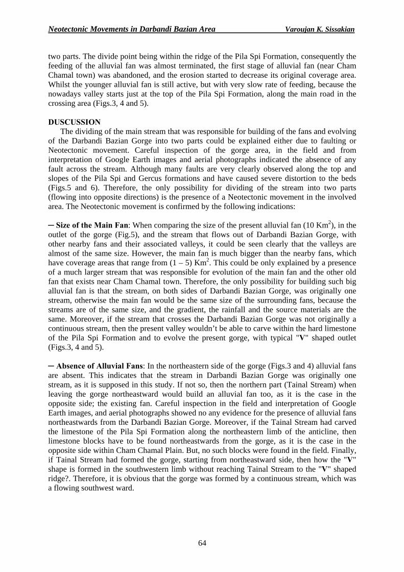
Neotectonic Movements in Darbandi Bazian Area Varoujan K. Sissakian
64
two parts. The divide point being within the ridge of the Pila Spi Formation, consequently the feeding of the alluvial fan was almost terminated, the first stage of alluvial fan (near Cham Chamal town) was abandoned, and the erosion started to decrease its original coverage area. Whilst the younger alluvial fan is still active, but with very slow rate of feeding, because the nowadays valley starts just at the top of the Pila Spi Formation, along the main road in the crossing area (Figs.3, 4 and 5). DUSCUSSION
The dividing of the main stream that was responsible for building of the fans and evolving of the Darbandi Bazian Gorge into two parts could be explained either due to faulting or Neotectonic movement. Careful inspection of the gorge area, in the field and from interpretation of Google Earth images and aerial photographs indicated the absence of any fault across the stream. Although many faults are very clearly observed along the top and slopes of the Pila Spi and Gercus formations and have caused severe distortion to the beds (Figs.5 and 6). Therefore, the only possibility for dividing of the stream into two parts (flowing into opposite directions) is the presence of a Neotectonic movement in the involved area. The Neotectonic movement is confirmed by the following indications: ─ Size of the Main Fan: When comparing the size of the present alluvial fan (10 Km2), in the outlet of the gorge (Fig.5), and the stream that flows out of Darbandi Bazian Gorge, with other nearby fans and their associated valleys, it could be seen clearly that the valleys are almost of the same size. However, the main fan is much bigger than the nearby fans, which have coverage areas that range from (1 – 5) Km2. This could be only explained by a presence of a much larger stream that was responsible for evolution of the main fan and the other old fan that exists near Cham Chamal town. Therefore, the only possibility for building such big alluvial fan is that the stream, on both sides of Darbandi Bazian Gorge, was originally one stream, otherwise the main fan would be the same size of the surrounding fans, because the streams are of the same size, and the gradient, the rainfall and the source materials are the same. Moreover, if the stream that crosses the Darbandi Bazian Gorge was not originally a continuous stream, then the present valley wouldn’t be able to carve within the hard limestone of the Pila Spi Formation and to evolve the present gorge, with typical "V" shaped outlet (Figs.3, 4 and 5). ─ Absence of Alluvial Fans: In the northeastern side of the gorge (Figs.3 and 4) alluvial fans are absent. This indicates that the stream in Darbandi Bazian Gorge was originally one stream, as it is supposed in this study. If not so, then the northern part (Tainal Stream) when leaving the gorge northeastward would build an alluvial fan too, as it is the case in the opposite side; the existing fan. Careful inspection in the field and interpretation of Google Earth images, and aerial photographs showed no any evidence for the presence of alluvial fans northeastwards from the Darbandi Bazian Gorge. Moreover, if the Tainal Stream had carved the limestone of the Pila Spi Formation along the northeastern limb of the anticline, then limestone blocks have to be found northeastwards from the gorge, as it is the case in the opposite side within Cham Chamal Plain. But, no such blocks were found in the field. Finally, if Tainal Stream had formed the gorge, starting from northeastward side, then how the "V" shape is formed in the southwestern limb without reaching Tainal Stream to the "V" shaped ridge?. Therefore, it is obvious that the gorge was formed by a continuous stream, which was a flowing southwest ward.
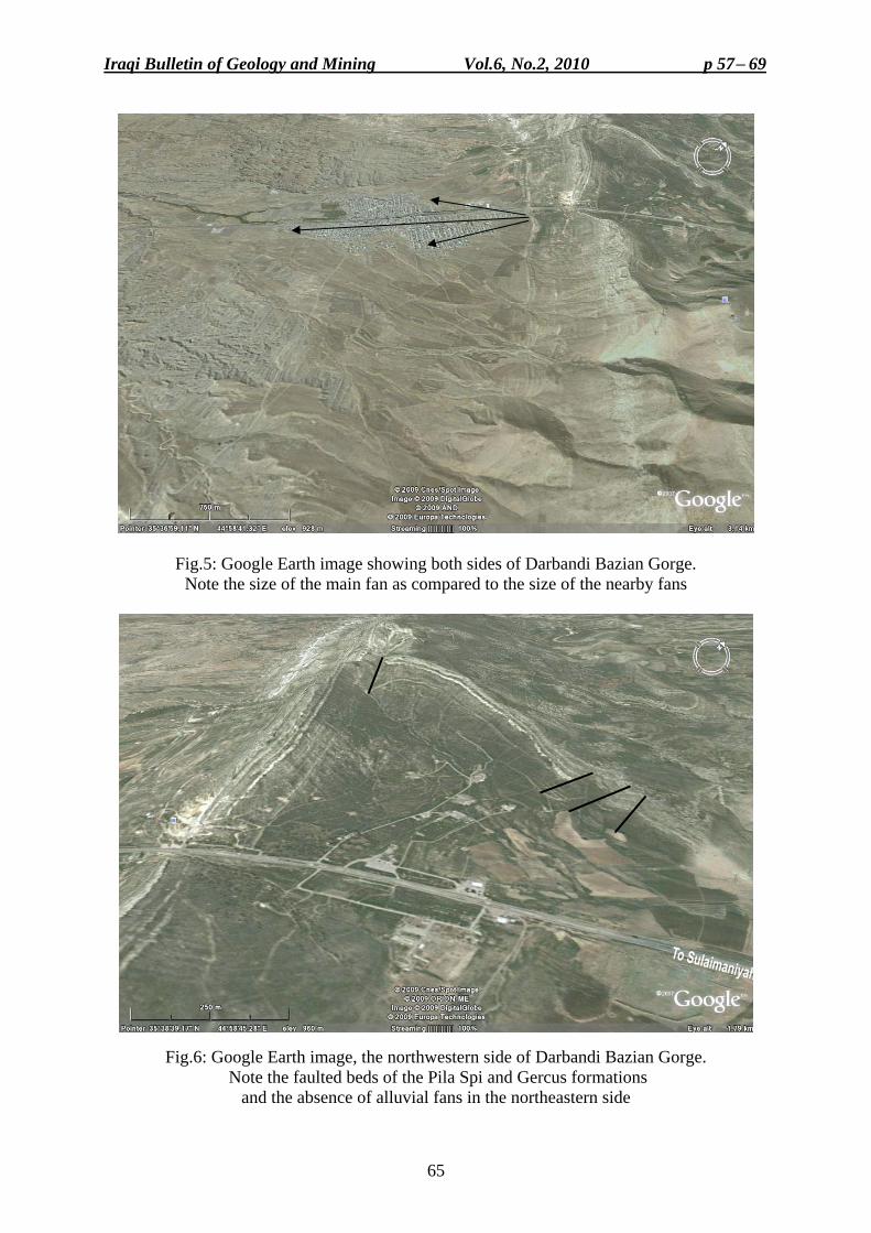
Iraqi Bulletin of Geology and Mining Vol.6, No.2, 2010 p 57− 69
65
Fig.5: Google Earth image showing both sides of Darbandi Bazian Gorge. Note the size of the main fan as compared to the size of the nearby fans
Fig.6: Google Earth image, the northwestern side of Darbandi Bazian Gorge. Note the faulted beds of the Pila Spi and Gercus formations
and the absence of alluvial fans in the northeastern side
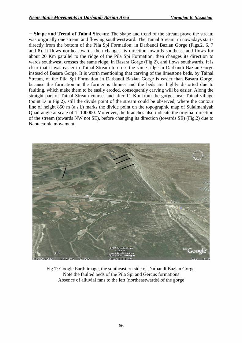
Neotectonic Movements in Darbandi Bazian Area Varoujan K. Sissakian
66
─ Shape and Trend of Tainal Stream: The shape and trend of the stream prove the stream was originally one stream and flowing southwestward. The Tainal Stream, in nowadays starts directly from the bottom of the Pila Spi Formation; in Darbandi Bazian Gorge (Figs.2, 6, 7 and 8). It flows northeastwards then changes its direction towards southeast and flows for about 20 Km parallel to the ridge of the Pila Spi Formation, then changes its direction to wards southwest, crosses the same ridge, in Basara Gorge (Fig.2), and flows southwards. It is clear that it was easier to Tainal Stream to cross the same ridge in Darbandi Bazian Gorge instead of Basara Gorge. It is worth mentioning that carving of the limestone beds, by Tainal Stream, of the Pila Spi Formation in Darbandi Bazian Gorge is easier than Basara Gorge, because the formation in the former is thinner and the beds are highly distorted due to faulting, which make them to be easily eroded, consequently carving will be easier. Along the straight part of Tainal Stream course, and after 11 Km from the gorge, near Tainal village (point D in Fig.2), still the divide point of the stream could be observed, where the contour line of height 850 m (a.s.l.) marks the divide point on the topographic map of Sulaimaniyah Quadrangle at scale of 1: 100000. Moreover, the branches also indicate the original direction of the stream (towards NW not SE), before changing its direction (towards SE) (Fig.2) due to Neotectonic movement.
Fig.7: Google Earth image, the southeastern side of Darbandi Bazian Gorge. Note the faulted beds of the Pila Spi and Gercus formations
Absence of alluvial fans to the left (northeastwards) of the gorge
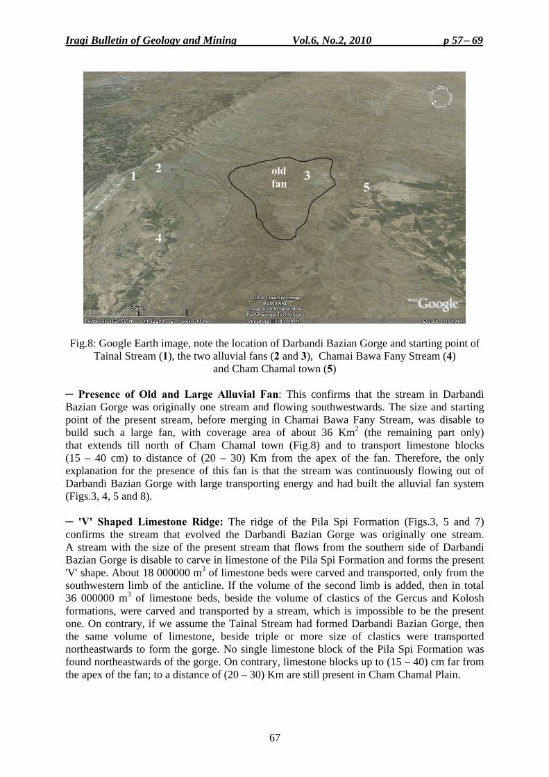
Iraqi Bulletin of Geology and Mining Vol.6, No.2, 2010 p 57− 69
67
Fig.8: Google Earth image, note the location of Darbandi Bazian Gorge and starting point of Tainal Stream (1), the two alluvial fans (2 and 3), Chamai Bawa Fany Stream (4)
and Cham Chamal town (5)
─ Presence of Old and Large Alluvial Fan: This confirms that the stream in Darbandi Bazian Gorge was originally one stream and flowing southwestwards. The size and starting point of the present stream, before merging in Chamai Bawa Fany Stream, was disable to build such a large fan, with coverage area of about 36 Km2 (the remaining part only) that extends till north of Cham Chamal town (Fig.8) and to transport limestone blocks (15 – 40 cm) to distance of (20 – 30) Km from the apex of the fan. Therefore, the only explanation for the presence of this fan is that the stream was continuously flowing out of Darbandi Bazian Gorge with large transporting energy and had built the alluvial fan system (Figs.3, 4, 5 and 8). ─ 'V' Shaped Limestone Ridge: The ridge of the Pila Spi Formation (Figs.3, 5 and 7) confirms the stream that evolved the Darbandi Bazian Gorge was originally one stream. A stream with the size of the present stream that flows from the southern side of Darbandi Bazian Gorge is disable to carve in limestone of the Pila Spi Formation and forms the present 'V' shape. About 18 000000 m3 of limestone beds were carved and transported, only from the southwestern limb of the anticline. If the volume of the second limb is added, then in total 36 000000 m3 of limestone beds, beside the volume of clastics of the Gercus and Kolosh formations, were carved and transported by a stream, which is impossible to be the present one. On contrary, if we assume the Tainal Stream had formed Darbandi Bazian Gorge, then the same volume of limestone, beside triple or more size of clastics were transported northeastwards to form the gorge. No single limestone block of the Pila Spi Formation was found northeastwards of the gorge. On contrary, limestone blocks up to (15 – 40) cm far from the apex of the fan; to a distance of (20 – 30) Km are still present in Cham Chamal Plain.
1 2 3
4
5old fan
Neotectonic Movements in Darbandi Bazian Area Varoujan K. Sissakian
68
─ Shape of the Darbandi Bazian Gorge: The shape of the gorge confirms the up ward movement of the Darbandi Bazian Gorge and division of the main stream into two parts. The present southern outlet has typical "V" shape within the ridge of the Pila Spi Formation, with width of about 100 m (Figs.3, 5 and 7), which is carved by an out flowing stream. Whereas, the northeastern outlet has no uniform shape (Figs.6 and 7), with width of about 3 Km, this is attributed to gentle northeastern limb of the anticline, highly deformed Pila Spi Formation in the northeastern limb, and up ward movement. These factors have accelerated the erosion of the limestone of the Pila Spi Formation, consequently clastics of the Gercus and Kolosh formations were exposed and due to their weak resistance to erosion; they were eroded easily and the present day landscape (Figs.6 and 7) is developed by the originally southwestward flowing stream. DATING OF THE NEOTECTONIC MOVEMENT
Because no precise dating facilities are available, to the author, therefore, conventional dating is used in estimating the age of the Neotectonic movement. The dividing of the main stream was after the deposition of the old alluvial fan, which is most probably of Late Pleistocene age, because it covers the rocks of the Bai Hassan Formation (Pliocene – Pleistocene). Therefore, the movement must be during or after Late Pleistocene. But, the author believes it is much younger, because the present fan was also built before the stream was divided and because the indications of the divide point along Tainal Stream are still present, therefore the age of the Neotectonic movement was most probably during late Holocene. CONCLUSIONS
The following could be concluded from this study: • Darbandi Bazian Gorge is built up by a main stream that was flowing south wards,
including the present day two streams; Tainal and Chamai Bawa Fany. • The main stream was divided into two parts (flowing into opposite directions) due to
Neotectonic movement that had occurred along the ridge of the Pila Spi Formation and near surroundings.
• The area of Darbandi Bazian Gorge was up uplifted due to Neotectonic movement. • Indications for the Neotectonic movement are: the presence of the alluvial fan just near the
gorge, the old alluvial fan near Cham Chamal town, the strange trend of Tainal Stream and the 'V' shaped limestone ridge, in the Darbandi Bazian Gorge.
• The age of the Neotectonic movement is most probably during late Holocene. REFERENCES Al-Kadhimi, J.A.M., Sissakian, V.K., Fattah, A.S. and Deikran, D.B., 1996. Tectonic Map of Iraq, scale
1: 1000000, 2nd edit., GEOSURV, Baghdad, Iraq. American Geological Institute, 1962. Alluvial Fan: Dictionary of Geological Terms. New York, Dolphin Books.
Wikipedia, the free Encyclopedia. Bull, W.B., 1991. Geomorphic Responses to Climate Change. Oxford University Press. Becker, A., 1993. An attempt to define "neotectonic period" for central and northern Europe. International Jour.
Earth Science, Vol.82, No.1. Bhattacharya, S., Virdi, N.S. and Philip, G., 2005. Neotectonic activity in the outer Himalaya of Himacgal
Pradesh in and around Paonta Sahib: A morphotectonic approach. Wadia Institute of Himalayan Geology, Dehra Dun – 248 001, India.
Fouad, S. F., 2010. Tectonic Map of Iraq, scale 1: 1000000, 3rd edit., GEOSURV, Baghdad, Iraq. Hamza, N.M., 1997. Geomorphological Map of Iraq, scale 1: 1000000, GEOSURV, Baghdad, Iraq.
Iraqi Bulletin of Geology and Mining Vol.6, No.2, 2010 p 57− 69
69
Kumanan, C.J., 2001. Remote sensing revealed morphotectonic anomalies as a tool to neotectonic mapping, experience from South India. 22nd Asian Conference on Remote Sensing, 5 – 9 November 2001, Singapore, National University of Singapore.
Ibrahim, Sh.B., 1984. Report on the photogeology of a part of the Folded Zone, Northern Iraq. GEOSURV, int. rep. no. 1376.
Jones, S.J. and Arzani, A., 2005. Alluvial fan response times to tectonic and climatic driven processes: Example from the Khrud mountain belt, Central Iran. Geophysical Research Abstracts, Vol.7, 07380. European Geosciences Union.
Ma'ala, Kh.A., 2007. Geological Map of Sulaimaniyah Quadrangle, scale 1: 250000, GEOSURV, Baghdad, Iraq. Markovic, M., Pavlovic, R., Cupkovic, T. and Zivkovic, P., 1996. Structural Pattern and Neotectonic activity in
the wider Majdanpek area, NE Serbia, Yugoslavia. Acta Montanistica Slovaca, Rocnik 1 (1996), No.2, p. 151 – 158.
Mello, C.L., Metelo, C.M.S., Suguio, K. and Kohler, C.H., 1999. Quaternary sedimentation, neotectonic and evolution of the Doce river middle valley lake system (SE Brazil). Revista do Instituto Geologico, IG Sao Paulo, Vol.20, No.1/2, p. 29 – 36.
National Aeronautics and Space Administration, 2009. Geomorphology from Space; Fluvial Landforms, Chapter 4. Internet data.
Philip, G. and Virdi, N.S., 2007. Active faults and neotectonic activity in the Pinjaur Dun, NW Frontal Himalaya. Wadia Institute of Himalayan Geology, 33. Mahadeo Sing Road, Dehra Dun – 248 001, India.
Sissakian, V.K., 1995. Geological Map of Kirkuk Quadrangle, scale 1: 250000, GEOSURV, Baghdad, Iraq. Sissakian, V.K., 2000. Geological Map of Iraq, scale 1: 1000000, 3rd edit., GEOSURV, Baghdad, Iraq. Sissakian, V.K. and Deikran, D.B., 1998. Neotectonic Map of Iraq, scale 1: 1000000, GEOSURV, Baghdad,
Iraq. Sissakian, V.K. and Abdul Jabbar, M.F., 2010. Morphometry and genesis of the transversal gorges in north and
northeast Iraq. Iraqi Bull. Geol. Min., Vol.6, No.1, p. 95 – 120. USGS, 2004. Desert Working Group, Knowledge, Science Incorporation. Alluvial Fans. Internet data. Woldai, T. and Dorjsuren, J., 2008. Application of remotely sensed data for neotectonic study in Western
Mongolia. Commission VI, Working Group V, Internet Data.
About the author Varoujan K. Sissakian graduated from University of Baghdad in 1969 with B.Sc. degree in Geology, and M.Sc. in Engineering Geological Mapping from I.T.C., the Netherlands in 1982. Currently, he is working as the Head of Geology Department in GEOSURV and was nominated as Expert in 2005. He has 136 documented reports in GEOSURV's library and 38 published articles in different geological aspects. His major fields of interest are geological hazards, geological maps and the stratigraphy of Iraqi territory. He is the Deputy Vice President of the Middle East Subcommission of CGMW, Paris, since February 2010. e-mail: [email protected] Mailing address: S.C. of Geological Survey and Mining, P.O. Box 986, Baghdad, Iraq
Iraqi Bulletin of Geology and Mining Vol.6, No.2, 2010 p 71− 94
71
PETROLOGY, GEOCHEMISTRY AND DEPOSITIONAL ENVIRONMENT OF THE KHABOUR FORMATION IN
ORA AND KHABOUR LOCALITIES, NORTHERN IRAQ
Khaldoun S. Al-Bassam*
Received: 24/ 11/ 2009, Accepted: 2/ 6/ 2010 Key words: Khabour Formation, Depositional environment, Iraq
ABSTRACT The Khabour Formation, the oldest exposed rock unit in Iraq (Ordovician), was sampled in two
exposed sections at Ora and Khabour localities. It is comprised of about 800 m thick sandstone-shale cyclic alternations. Petrographic study showed that quartz arenite and phyllarenite are the main textural varieties of the sandstone with mica and silt-size quartz dominating the shale. The sandstones are texturally mature and mineralogically mature to submature. The mineralogy includes: quartz (dominant), muscovite, illite, glauconite, chlorite/serpentine (mixed layer), francolite (conodont) and heavy minerals (opaques and ZTR). Silica cementation is the main diagenetic process, resulted from pressure solution of silica and lead to an interlocking quartz mosaic texture. Alteration is of minor intensity.
The chemical composition is characterized by high SiO2/Al2O3 and K2O/Na2O ratios. The geochemical associations are controlled by the mineralogy and three groups were recognized by factor analysis, namely the sheet alumino-silicates, phosphate and heavy minerals (ZTR). All of which are diluents to the major mineral constituent: quartz.
Mineralogical analysis of the studied samples suggests recycled granitic plutonic rocks and more proximal low-grade metamorphic rocks as source of the clastics. The whole sequence of the Khabour Formation seems to have deposited in marine environment extending from shallow intertidal to deep outer shelf, under variable conditions of sea-level fluctuation, subsidence rate, and detritus supply. The whole sequence may have resulted from deposition from turbidity currents; the proximal part is rich in coarse clastics and the distal part is rich in micaceous shale. Complete Bouma sequence was not recognized, but the sedimentary facies of the Khabour Formation may be considered as an example of a passive plate margin turbidities.
،ورا والخابورلتكوين الخابور في مناطق أالبيئة الترسيبية رية وجيوآيميائية واصخ شمال العراق
خلدون صبحي البصام
المستخلص
وتقع مكاشفه في كشفة في العراق ويقدر عمره باالوردوفيزي التكوينات الجيولوجية المتأقدمور يعتبر تكوين الخاب شمال العراق في منطقتي أورا والخابور وقد تم التعرف على التكوين أو مكافآته الصخرية والعمرية مع بعض أقصى
،عكاس في الصحراء الغربيةة الجزيرة وآبار الخليصية في منطقاالختالفات السحنية الطفيفة تحت السطح في مقاطع . وسوريا والسعودية وتركيااألردنفضالً عن عدد من الدول المجاورة مثل
كشفة في العراق وما أنجز في هذا المجال يعود إلى حوالي وين بدراسات حديثة في مقاطعه المتلم يحظ هذا التك . نصف قرن من الزمن
كشفين في منطقتي أورا والخابور، حيث كوين الخابور في مقطعين متمذجة لتألغراض البحث الحالي، جرت نيتدرج الحجر الرملي نحو حجم . متر من تتابع دوري من الحجر الرملي والسجيل800يتألف التكوين من حوالي
بوجود تميزاًالغرين باتجاه األعلى لينتهي بطبقات السجيل تدريجياً غير أن حد االتصال مع الدورة األعلى يكون حاداً وم . المايكا والكثير من التراكيب الرسوبية مثل الحفريات وآثار الكروزيانا
____________________________________ * Chief Researcher, State Co. of Geological Survey and Mining, P. O. Box 986 Alwiya,
Baghdad. e-mail: [email protected]
Petrology, Geochemistry and Depositional Environment of the Khabour Formation . Khaldoun S. Al-Bassam
72
عينة جرى فحصها مجهرياً من خالل الشرائح الرقيقة فضالً عن فصل 26بلغ عدد العينات في هذه الدراسة :كاسيدليل العينات كيميائياً لألكما تم تح. وتشخيص المعادن الثقيلة
SiO2, TiO2, Fe2O3, Al2O3, CaO, MgO, K2O, Na2O, P2O5, ZrO2الفلور وتحليل عينات مختارة لعنصر. المكونة للسجيل األخرىوالمعادن ) واألطيانالمايكا ( السينية لدراسة المعادن الصفائحية األشعةاعتمدت تقنية حيود
. وبعض عينات الحجر الرمليرينايت في حين والفيالرينايتأ وارتزالك: أظهرت الدراسة الصخرية المجهرية ان الحجر الرملي من نوعين
يتكون السجيل من المايكا والكوارتز الغريني وبينت ان الحجر الرملي دقيق التحبب وجيد الفرز، يوجد احياناً بدون كما بينت الدراسة نضوج الصخور الرملية من ناحية النسيج . مع حشوة من المايكا بكافة معادنهاأخرى وأحياناًحشوة
. ن الناحية المعدنية غير ناضجة مإلىالمجهري وناضجة متداخل (ت ، الكلوراياليت، الغلوكونايتإل، المسكوفايت، ا)المعدن السائد(دني من الكوارتز يتكون التركيب المع
العملية ). المعتمة والزركون والتورمالين والروتايل(والمعادن الثقيلة ) كونودونت(، الفرنكواليت )الطبقات مع السربنتين ترسيبها لتعطي مظهراً وإعادة السيليكا تحت الضغط إذابةلتحام بالسيليكا الناتجة عن اإلهي التحويرية الرئيسية
التغيرات التحويرية ظهرت قليلة نسبياً وتميزت بتغير محدود للفلدسبار . موزائيكياً متداخالً لحبيبات الكوارتزفي ) موقعي النشأة(وجود معدن الفرنكواليت إن. سربنتين/ ت الى كلورايت المايكا وتحول الكلورايإلى) بالجيوكليز(
يرتبط ترسيبه أن ظهور للفوسفات الرسوبي البحري في التكوينات الجيولوجية العراقية ويمكن أقدمهذا التكوين يأشر . ترسيب تكوين الخابورأثناءببداية انطالق دورة من دورات الطغيان البحري المتعاقبة التي سادت الحوض الرسوبي
لومينا ومن البوتاسيوم الى الصوديوم ويتحكم التركيب أل اإلى التركيب الكيميائي بنسب عالية من السيليكا يتميز يتحكم بالمعادن األول: المعدني باالرتباطات الجيوكيميائية حيث تم تمييز ثالثة مجاميع على ضوء التحليل العاملي
نات الفوسفاتية والثالث بالمعادن الثقيلة وجميع هذه الفصائل المعدنية ة والثاني يتحكم بالمكويلومينية السيليكألالصفائحية ا . تعتبر مخففات للمعدن الرئيسي السائد وهو الكوارتز ولها عالقة سالبة معه
صخور غرانيتية بلوتونية معادة األول صخور المصدر من نوعين إنيشير التحليل المعدني لعينات الدراسة التتابع بكامله قد ترسب في بيئة أنرب من الصخور المتحولة ذات الرتبة الواطئة ويبدو قأمصدر الثاني الترسيب و
المناطق العميقة من الرف الخارجي وتحت ظروف متباينة إلىبحرية تمتد من المناطق الضحلة المتأثرة بالمد البحري يمكن تفسير . فتاتيات من المصدرمن تذبذب في مستوى سطح البحر ونسبة الهبوط في الحوض الرسوبي والتغذية بال
تداخل عدة عوامل جيولوجية مؤثرة مثل تذبذب في مستوى سطح إلى) أطيانرمال، غرين، (الترسيب الدوري للفتاتيات الحوض الرسوبي من مناطق المصدر والترسيب الدوري إلى مناخية وكمية الفتاتيات الواردة أو بنيوية ألسبابالبحر
من التتابع بسيادة سحنة السجيل التي األعلىيتميز الجزء ). تتابع بوما(متدرجة لرواسب الكدرة النموذجي للطبقات ال كامل التتابع قد يكون قد ترسب من تيارات كدرة، الجزء القريب منها غني إن. إلى طغيان بحري واضحتشير
من عدم مالحظة وجود تتابع بوما متكامل بالفتاتيات الخشنة والجزء البعيد غني بالسجيل المحمل بالمايكا وعلى الرغم . التي تتكون في حافات الصفائح الخاملة) التربيدايت(غير ان تكوين الخابور يمكن اعتباره نموذجاًً لرواسب الكدرة
االلومينا والبوتاسيوم الى الصوديوم إلى النسب العالية من السيليكا إلىويسند ذلك المعطيات الجيوكيميائية التي تشير والنسيج الصخري العام لصخور الدراسة والترسيب الدوري للتابع فضالَ عن اتفاق الوضع الجغرافي القديم للمنطقة مع
.ستنتاجإلهذا ا INTRODUCTION
The Khabour Formation, about 800 m exposed thickness of sandstone-shale association in the type section, is the oldest rock unit exposed in Iraq dated as Ordovician. It was first described by Wetzel (1950) in the area North of Zakho, in the valley of the Khabour River, where the formation got its name and where the type section is located. Later it was encountered in subsurface sections in Khleisia-1 well in the Al-Jazira area (Gaddo and Parker, 1959 and Ditmar et al., 1971) and in Akkass-1 well in the Western Desert (Habba et al., 1994 and Aqrawi, 1998).
The Khabour Formation was encountered and compared, on the basis of age and lithology, to several rock units in SE Turkey, E Jordan, Syria and Saudi Arabia (Buday, 1980; Aqrawi, 1998; Sharland et al., 2001 and Jassim and Goff, 2006). Due to the remoteness and difficult accessibility of the area, the exposed sections of the Khabour Formation in Iraq were not studied in detail. All the previous work dealt with field examination of outcrops, except where paleontological studies, for age determination, were carried out in the early works.
The purpose of this work is to study the petrology, mineralogy and chemical composition of the Khabour Formation in two sections exposed in Ora and Khabour localities, N Iraq and to synthesis the results to have an updated view on the depositional environment.
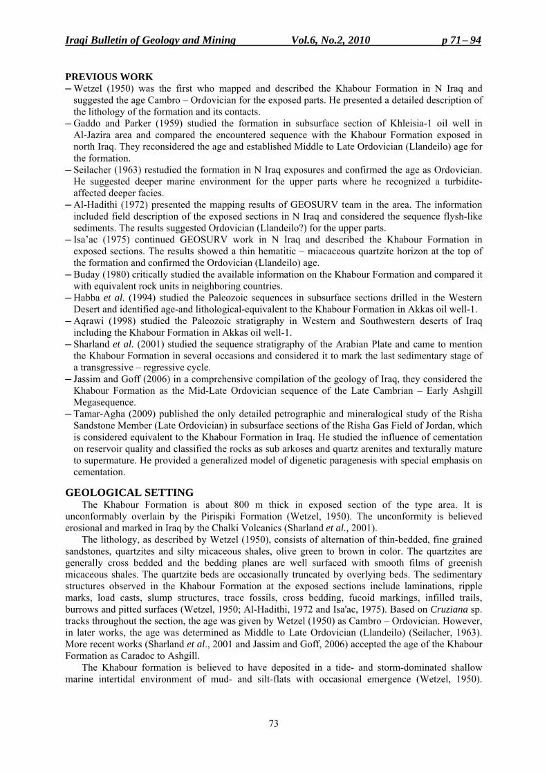
Iraqi Bulletin of Geology and Mining Vol.6, No.2, 2010 p 71− 94
73
PREVIOUS WORK ─ Wetzel (1950) was the first who mapped and described the Khabour Formation in N Iraq and
suggested the age Cambro – Ordovician for the exposed parts. He presented a detailed description of the lithology of the formation and its contacts.
─ Gaddo and Parker (1959) studied the formation in subsurface section of Khleisia-1 oil well in Al-Jazira area and compared the encountered sequence with the Khabour Formation exposed in north Iraq. They reconsidered the age and established Middle to Late Ordovician (Llandeilo) age for the formation.
─ Seilacher (1963) restudied the formation in N Iraq exposures and confirmed the age as Ordovician. He suggested deeper marine environment for the upper parts where he recognized a turbidite-affected deeper facies.
─ Al-Hadithi (1972) presented the mapping results of GEOSURV team in the area. The information included field description of the exposed sections in N Iraq and considered the sequence flysh-like sediments. The results suggested Ordovician (Llandeilo?) for the upper parts.
─ Isa’ac (1975) continued GEOSURV work in N Iraq and described the Khabour Formation in exposed sections. The results showed a thin hematitic – miacaceous quartzite horizon at the top of the formation and confirmed the Ordovician (Llandeilo) age.
─ Buday (1980) critically studied the available information on the Khabour Formation and compared it with equivalent rock units in neighboring countries.
─ Habba et al. (1994) studied the Paleozoic sequences in subsurface sections drilled in the Western Desert and identified age-and lithological-equivalent to the Khabour Formation in Akkas oil well-1.
─ Aqrawi (1998) studied the Paleozoic stratigraphy in Western and Southwestern deserts of Iraq including the Khabour Formation in Akkas oil well-1.
─ Sharland et al. (2001) studied the sequence stratigraphy of the Arabian Plate and came to mention the Khabour Formation in several occasions and considered it to mark the last sedimentary stage of a transgressive – regressive cycle.
─ Jassim and Goff (2006) in a comprehensive compilation of the geology of Iraq, they considered the Khabour Formation as the Mid-Late Ordovician sequence of the Late Cambrian – Early Ashgill Megasequence.
─ Tamar-Agha (2009) published the only detailed petrographic and mineralogical study of the Risha Sandstone Member (Late Ordovician) in subsurface sections of the Risha Gas Field of Jordan, which is considered equivalent to the Khabour Formation in Iraq. He studied the influence of cementation on reservoir quality and classified the rocks as sub arkoses and quartz arenites and texturally mature to supermature. He provided a generalized model of digenetic paragenesis with special emphasis on cementation.
GEOLOGICAL SETTING
The Khabour Formation is about 800 m thick in exposed section of the type area. It is unconformably overlain by the Pirispiki Formation (Wetzel, 1950). The unconformity is believed erosional and marked in Iraq by the Chalki Volcanics (Sharland et al., 2001).
The lithology, as described by Wetzel (1950), consists of alternation of thin-bedded, fine grained sandstones, quartzites and silty micaceous shales, olive green to brown in color. The quartzites are generally cross bedded and the bedding planes are well surfaced with smooth films of greenish micaceous shales. The quartzite beds are occasionally truncated by overlying beds. The sedimentary structures observed in the Khabour Formation at the exposed sections include laminations, ripple marks, load casts, slump structures, trace fossils, cross bedding, fucoid markings, infilled trails, burrows and pitted surfaces (Wetzel, 1950; Al-Hadithi, 1972 and Isa'ac, 1975). Based on Cruziana sp. tracks throughout the section, the age was given by Wetzel (1950) as Cambro – Ordovician. However, in later works, the age was determined as Middle to Late Ordovician (Llandeilo) (Seilacher, 1963). More recent works (Sharland et al., 2001 and Jassim and Goff, 2006) accepted the age of the Khabour Formation as Caradoc to Ashgill.
The Khabour formation is believed to have deposited in a tide- and storm-dominated shallow marine intertidal environment of mud- and silt-flats with occasional emergence (Wetzel, 1950).
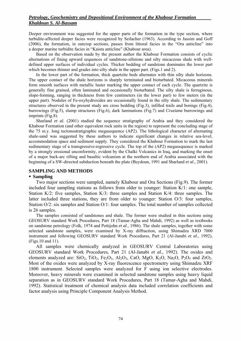
Petrology, Geochemistry and Depositional Environment of the Khabour Formation . Khaldoun S. Al-Bassam
74
Deeper environment was suggested for the upper parts of the formation in the type section, where turbidite-affected deeper facies were recognized by Seilacher (1963). According to Jassim and Goff (2006), the formation, in outcrop sections, passes from littoral facies in the “Ora anticline” into a deeper marine turbidite facies in “Kaista anticline” (Khabour area).
Based on the observation made by the present author the Khabour Formation consists of cyclic alternations of fining upward sequences of sandstone-siltstone and silty micaceous shale with well-defined upper surfaces of individual cycles. Thicker bedding of sandstone dominates the lower part which becomes thinner and grades into silty shale in the upper part. (Figs.1 and 2).
In the lower part of the formation, thick quartzite beds alternates with thin silty shale horizons. The upper contact of the shale horizons is sharply terminated and bioturbated. Micaceous minerals form smooth surfaces with metallic luster marking the upper contact of each cycle. The quartzite is generally fine grained, often laminated and occasionally bioturbated. The silty shale is ferruginous, slope-forming, ranging in thickness from few centimeters (in the lower part) to few meters (in the upper part). Nodules of Fe-oxyhydroxides are occasionally found in the silty shale. The sedimentary structures observed in the present study are cross bedding (Fig.3), infilled trails and borings (Fig.4), burrowings (Fig.5), slump structures (Fig.6), dark laminations (Fig.7) and Cruziana burrowings and imprints (Fig.8).
Sharland et al. (2001) studied the sequence stratigraphy of Arabia and they considered the Khabour Formation (and other equivalent rock units in the region) to represent the concluding stage of the 75 m.y. long tectonostratigraphic megasequence (AP2). The lithological character of alternating shale-sand was suggested by these authors to indicate significant changes in relative sea-level, accommodation space and sediment supply. They considered the Khabour Formation to mark the last sedimentary stage of a transgressive-regressive cycle. The top of the (AP2) megasequence is marked by a strongly erosional unconformity, evident by the Chalki Volcanics in Iraq, and marking the onset of a major back-arc rifting and basaltic volcanism at the northern end of Arabia associated with the beginning of a SW-directed subduction beneath the plate (Beydoun, 1991 and Sharland et al., 2001).
SAMPLING AND METHODS Sampling
Two major sections were sampled, namely Khabour and Ora Sections (Fig.9). The former included four sampling stations as follows from older to younger: Station K/1: one sample, Station K/2: five samples, Station K/3: three samples and Station K/4: three samples. The latter included three stations, they are from older to younger: Station O/3: four samples, Station O/2: six samples and Station O/1: four samples. The total number of samples collected is 26 samples.
The samples consisted of sandstones and shale. The former were studied in thin sections using GEOSURV standard Work Procedures, Part 18 (Tamar-Agha and Mahdi, 1992) as well as textbooks on sandstone petrology (Folk, 1974 and Pettijohn et al., 1986). The shale samples, together with some selected sandstone samples, were examined by X-ray diffraction, using Shimadzu XRD 7000 instrument and following GEOSURV standard Work Procedures, Part 21 (Al-Janabi et al., 1992), (Figs.10 and 11).
All samples were chemically analyzed in GEOSURV Central Laboratories using GEOSURV standard Work Procedures, Part 21 (Al-Janabi et al., 1992). The oxides and elements analyzed are: SiO2, TiO2, Fe2O3, Al2O3, CaO, MgO, K2O, Na2O, P2O5 and ZrO2. Most of the oxides were analyzed by X-ray fluorescence spectrometry using Shimadzu XRF 1800 instrument. Selected samples were analyzed for F using ion selective electrodes. Moreover, heavy minerals were examined in selected sandstone samples using heavy liquid separation as in GEOSURV standard Work Procedures, Part 18 (Tamar-Agha and Mahdi, 1992). Statistical treatment of chemical analysis data included correlation coefficients and factor analysis using Principle Component Analysis Method.
Iraqi Bulletin of Geology and Mining Vol.6, No.2, 2010 p 71− 94
75
Fig.1: Sampling station No.4 in the Khabour locality. Medium bedded, graded sandstone interbedded with very thin silty shale horizons
Fig.2: Sampling station No.5 in the Khabour locality. Thin and medium bedded fine grained sandstone interbedded with silty shale with Cruziana trails
Petrology, Geochemistry and Depositional Environment of the Khabour Formation . Khaldoun S. Al-Bassam
76
PETROGRAPHY AND MINERALOGY Framework Grains ─ Quartz: Is the dominant mineral among the detrital constituents of the sandstone. It forms more than 95% of the detrital grains in the lower parts of the sampled sections and mostly at the base of the cycles where the sandstone may be classified as quartz arenite (Folk, 1974 and Pettijohn et al., 1986). The quartz is fine grained, moderately well sorted, subangular to subrounded and monocrystalline (Figs.12, 13 and 14). Interlocking compound quartz grains with sinuous outlines are common, (Fig.13) especially at the base of the cycles, where it is matrix-free and quartz may form more than 90% of the sandstone constituents. The quartz grains approach silt-size in the upper parts of the cycle and its content is reduced to less than 50% of the constituents with an open framework texture, filled with sheet silicate matrix (Fig.14). ─ Feldspars: Are present in very minor proportion. They are composed mostly of plagioclase, showing polysynthetic twining (Fig.15), and to a lesser extent microcline (Fig.16). They are fine to very fine grained, generally fresh, but occasional diagenetic alteration of plagioclase to smectite (?) can be noticed (Fig.17). It usually shows a presence in XRD patterns (as albite) (Figs.10 and 11). ─ Muscovite: Is a dominant detrital framework constituent in the Khabour Formation, present as elongated flakes deformed and bended, occasionally buckled (Fig.14), and forms the major detrital constituent at the top of the cycles commonly as bed-surface lining. In XRD patterns, the 001 reflection of muscovite is usually accompanied by major reflections of other mica minerals (such as illite and glauconite) (Fig.11b), but occasionally it is sharp and indicates high crystallinity (Fig.11a). ─ Francolite: Is a rare framework constituent in the studied samples. It was recognized by XRD in one sample only (Fig.10c) as conodont (?) remains (Fig.19), bioclasts (Fig.20) and cortoids (Fig.21). The francolite grains are of larger size than the quartz, and appear to have formed authigenically. The skeletal phosphatic elements may be related to conodonts remains, which thrived in the Ordovician (Muller, 1978 and Cooper, 1981). However, this assumption requires detailed paleontological work to be verified. ─ Heavy minerals: They are present in the studied samples in considerable amounts; ranging from (7 – 19) % of the (63 – 250) µm size fractions. The opaques make most of the heavies (27 – 74 %). Zircon, tourmaline and rutile (ZTR) form the major transparent heavies (18 – 70 %). Occasionally, chlorite is present in significant amounts reaching up to 30% of the transparent heavies. (Sample 0/3/4) (Table 1 and Fig.22). Anatase and ulvospinel (Fe2TiO4) are among the opaque heavy minerals and were identified in the XRD scans of the heavy fraction in considerable concentrations (Fig.29). Matrix
Crushed muscovite and illite are the main matrix minerals in the Khabour sandstone. Matrix constituents increase upward in each cycle and appear as crushed fragments filling space between quartz grains. Basal parts of the cycles contain less matrix constituents. Interstratified chlorite/serpentine rarely forms some of the matrix and/or cement's constituents, present as elongate fibers, isolated or buckled (Fig.23) and confirmed by X-ray diffraction (Fig.11) (Reynolds et al., 1999). It was recognized in a few samples only with an outstanding presence in sample (0/3/1), forming shiny surface lining of sandstone beds.
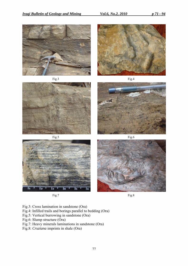
Iraqi Bulletin of Geology and Mining Vol.6, No.2, 2010 p 71− 94
77
Fig.3 Fig.4 Fig.5 Fig.6 Fig.7 Fig.8 Fig.3: Cross lamination in sandstone (Ora) Fig.4: Infilled trails and borings parallel to bedding (Ora) Fig.5: Vertical burrowing in sandstone (Ora) Fig.6: Slump structure (Ora) Fig.7: Heavy minerals laminations in sandstone (Ora) Fig.8: Cruziana imprints in shale (Ora)
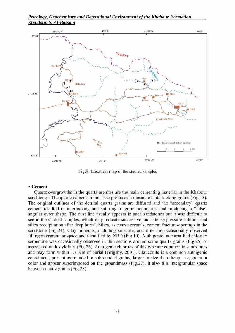
Petrology, Geochemistry and Depositional Environment of the Khabour Formation . Khaldoun S. Al-Bassam
78
Fig.9: Location map of the studied samples Cement
Quartz overgrowths in the quartz arenites are the main cementing material in the Khabour sandstones. The quartz cement in this case produces a mosaic of interlocking grains (Fig.13). The original outlines of the detrital quartz grains are diffused and the “secondary” quartz cement resulted in interlocking and suturing of grain boundaries and producing a “false” angular outer shape. The dust line usually appears in such sandstones but it was difficult to see in the studied samples, which may indicate successive and intense pressure solution and silica precipitation after deep burial. Silica, as coarse crystals, cement fracture-openings in the sandstone (Fig.24). Clay minerals, including smectite, and illite are occasionally observed filling intergranular space and identified by XRD (Fig.10). Authigenic interstratified chlorite/ serpentine was occasionally observed in thin sections around some quartz grains (Fig.25) or associated with stylolites (Fig.26). Authigenic chlorites of this type are common in sandstones and may form within 1.8 Km of burial (Grigsby, 2001). Glauconite is a common authigenic constituent, present as rounded to subrounded grains, larger in size than the quartz, green in color and appear superimposed on the groundmass (Fig.27). It also fills intergranular space between quartz grains (Fig.28).
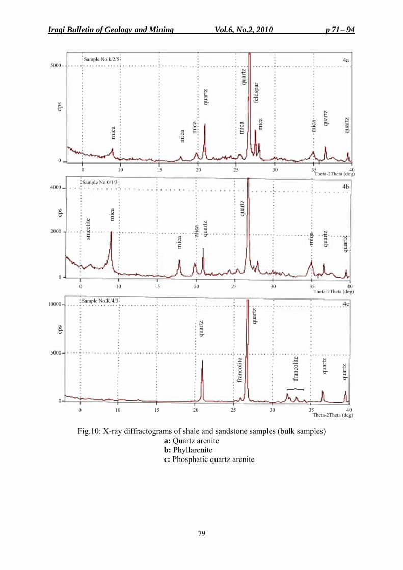
Iraqi Bulletin of Geology and Mining Vol.6, No.2, 2010 p 71− 94
79
Fig.10: X-ray diffractograms of shale and sandstone samples (bulk samples) a: Quartz arenite b: Phyllarenite c: Phosphatic quartz arenite
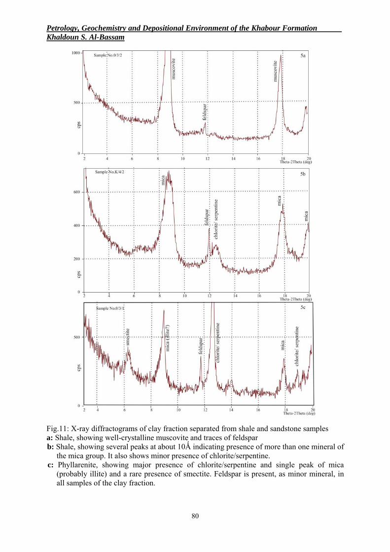
Petrology, Geochemistry and Depositional Environment of the Khabour Formation . Khaldoun S. Al-Bassam
80
Fig.11: X-ray diffractograms of clay fraction separated from shale and sandstone samples a: Shale, showing well-crystalline muscovite and traces of feldspar b: Shale, showing several peaks at about 10Ǻ indicating presence of more than one mineral of
the mica group. It also shows minor presence of chlorite/serpentine. c: Phyllarenite, showing major presence of chlorite/serpentine and single peak of mica
(probably illite) and a rare presence of smectite. Feldspar is present, as minor mineral, in all samples of the clay fraction.
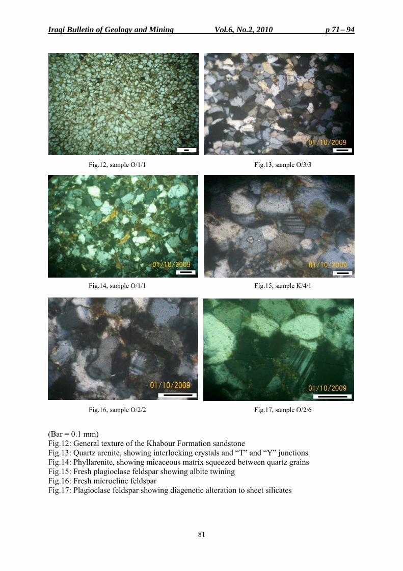
Iraqi Bulletin of Geology and Mining Vol.6, No.2, 2010 p 71− 94
81
Fig.12, sample O/1/1 Fig.13, sample O/3/3
Fig.14, sample O/1/1 Fig.15, sample K/4/1
Fig.16, sample O/2/2 Fig.17, sample O/2/6 (Bar = 0.1 mm) Fig.12: General texture of the Khabour Formation sandstone Fig.13: Quartz arenite, showing interlocking crystals and “T” and “Y” junctions Fig.14: Phyllarenite, showing micaceous matrix squeezed between quartz grains Fig.15: Fresh plagioclase feldspar showing albite twining Fig.16: Fresh microcline feldspar Fig.17: Plagioclase feldspar showing diagenetic alteration to sheet silicates
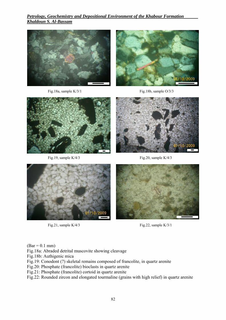
Petrology, Geochemistry and Depositional Environment of the Khabour Formation . Khaldoun S. Al-Bassam
82
Fig.18a, sample K/3/1 Fig.18b, sample O/3/3
Fig.19, sample K/4/3 Fig.20, sample K/4/3
Fig.21, sample K/4/3 Fig.22, sample K/3/1 (Bar = 0.1 mm) Fig.18a: Abraded detrital muscovite showing cleavage Fig.18b: Authigenic mica Fig.19: Conodont (?) skeletal remains composed of francolite, in quartz arenite Fig.20: Phosphate (francolite) bioclasts in quartz arenite Fig.21: Phosphate (francolite) cortoid in quartz arenite Fig.22: Rounded zircon and elongated tourmaline (grains with high relief) in quartz arenite
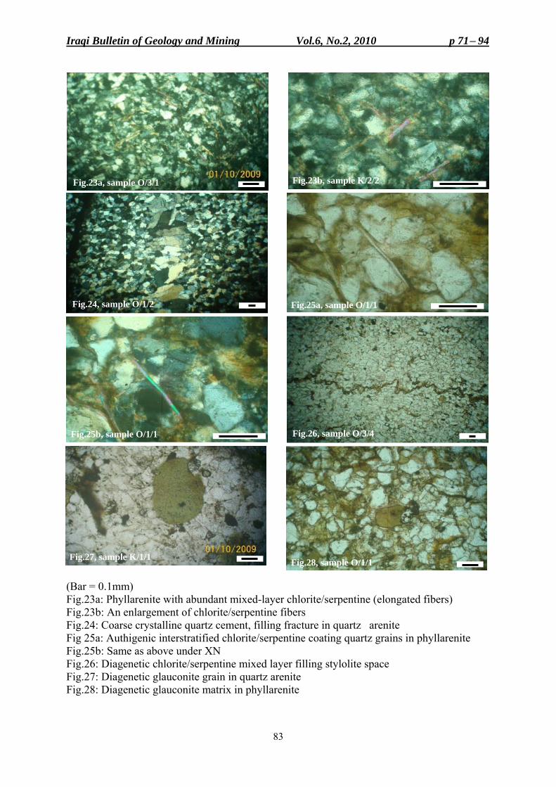
Iraqi Bulletin of Geology and Mining Vol.6, No.2, 2010 p 71− 94
83
(Bar = 0.1mm) Fig.23a: Phyllarenite with abundant mixed-layer chlorite/serpentine (elongated fibers) Fig.23b: An enlargement of chlorite/serpentine fibers Fig.24: Coarse crystalline quartz cement, filling fracture in quartz arenite Fig 25a: Authigenic interstratified chlorite/serpentine coating quartz grains in phyllarenite Fig.25b: Same as above under XN Fig.26: Diagenetic chlorite/serpentine mixed layer filling stylolite space Fig.27: Diagenetic glauconite grain in quartz arenite Fig.28: Diagenetic glauconite matrix in phyllarenite
Fig.23a, sample O/3/1 Fig.23b, sample K/2/2
Fig.25a, sample O/1/1
Fig.25b, sample O/1/1 Fig.26, sample O/3/4
Fig.27, sample K/1/1 Fig.28, sample O/1/1
Fig.24, sample O/1/2

Petrology, Geochemistry and Depositional Environment of the Khabour Formation . Khaldoun S. Al-Bassam
84
Oth
ers
Stau
rolit
e T.
, kya
nite
T.,
garn
et 1
.11,
bar
ite a
nd
celle
stite
0.5
5, b
iotit
e T.
–
Gar
net
1.76
, ba
rite
and
celle
stite
1.
32,
anat
ase
0.88
G
arne
t 1.
33,
barit
e an
d ce
llest
ite
0.44
, an
atas
e 1.
33, t
itani
te 1
.33
Gar
net
0.44
, ba
rite
and
cele
stite
0.
88,
anat
ase
T., k
yani
te 0
.44
Gar
net
T.,
titan
ite
T.,
anat
ase
0.53
Stau
rolit
e T.
, ana
tase
T.,
barit
e an
d ce
llest
ite
4.02
, bio
tite
T.
Bar
ite
and
celle
stite
0.
61,
anat
ase
1.23
, ky
anite
0.6
1
Alte
rite
s
1.66
1.87
2.20
1.77
0.88
– 0.89
2.45
Pyro
xene
–
0.93
3.08
2.22
– – 5.8
3.07
Hor
nble
nde
0.55
– 1.76
1.33
0.88
– 2.68
1.23
Zoi
site
–
Epi
dote
1.11
0.47
3.08
1.33
1.77
0.26
1.34
0.61
Chl
orite
4.44
T 6.17
8.44
30.9
2
0.53
15.6
3
3.68
Rut
ile
3.33
2.80
2.64
3.55
2.21
8.07
1.79
5.52
Tou
rmal
ine
11.6
6
7.94
7.93
19.5
5
11.5
0
30.2
1
12.0
5
20.8
6
Zir
con
10.0
11.2
1
7.05
15.1
1
9.73
32.8
1
10.7
1
9.20
Num
ber
%
Opa
ques
67.2
2
74.7
6
62.1
1
42.2
2
40.2
6
27.6
0
45.0
9
51.9
2
L.F
91.2
7
92.7
5
92.7
3
89.1
8
91.3
7
89.1
4
87.5
2
80.9
4
Wei
ght %
*
H.F
8.73
7.25
7.27
10.8
2
8.63
10.8
6
12.4
8
19.0
6
Wt.
(gm
) of
(6
3 –
250)
µm
frac
tion
19.4
6
22.6
3
15.1
2
16.1
7
17.3
7
23.1
9
13.1
4
12.2
9
Sam
ple
N
o.
O/1
/1
O/1
/2
O/2
/2
O/2
/3
O/3
/4
K/2
/2
K/2
/3
K/3
/3
Tabl
e 1:
Hea
vy m
iner
al a
naly
sis
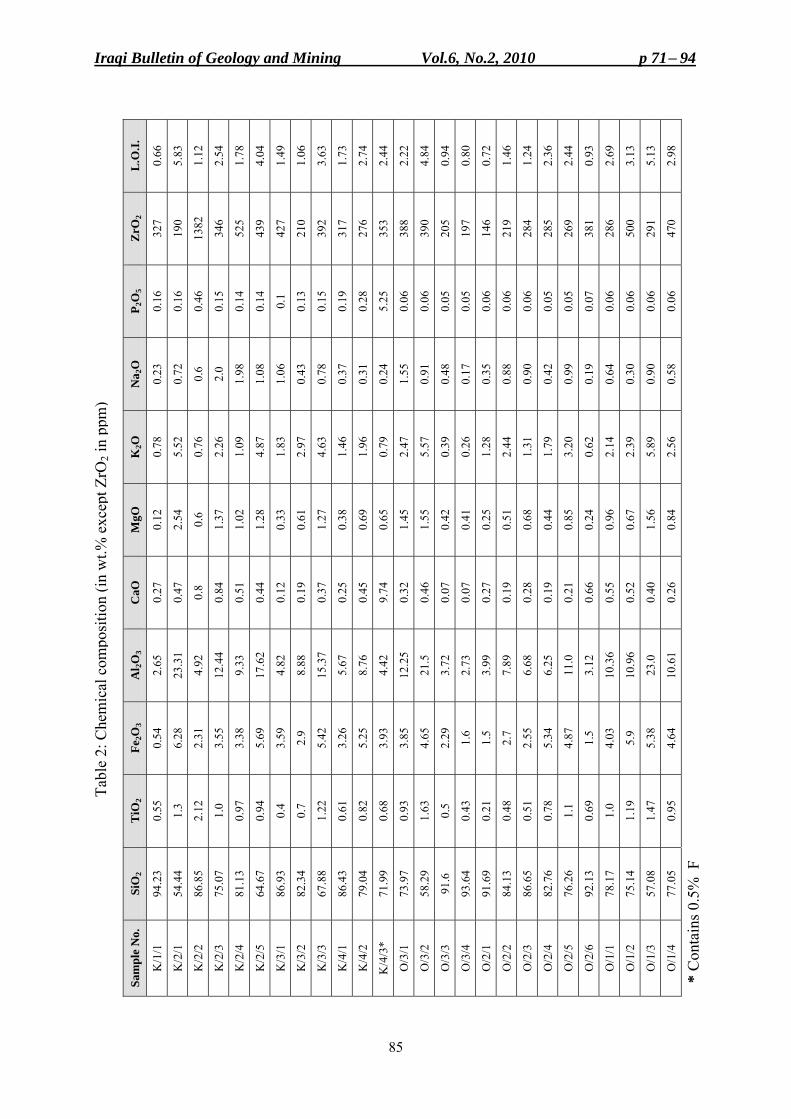
Iraqi Bulletin of Geology and Mining Vol.6, No.2, 2010 p 71− 94
85
L
.O.I.
0.66
5.83
1.12
2.54
1.78
4.04
1.49
1.06
3.63
1.73
2.74
2.44
2.22
4.84
0.94
0.80
0.72
1.46
1.24
2.36
2.44
0.93
2.69
3.13
5.13
2.98
ZrO
2
327
190
1382
346
525
439
427
210
392
317
276
353
388
390
205
197
146
219
284
285
269
381
286
500
291
470
P 2O
5 0.
16 0.
16 0.
46 0.
15 0.
14 0.
14
0.1
0.13
0.15
0.19
0.28
5.25
0.06
0.06
0.05
0.05
0.06
0.06
0.06
0.05
0.05
0.07
0.06
0.06
0.06
0.06
Na 2
O
0.23
0.72
0.6
2.0
1.98
1.08
1.06
0.43
0.78
0.37
0.31
0.24
1.55
0.91
0.48
0.17
0.35
0.88
0.90
0.42
0.99
0.19
0.64
0.30
0.90
0.58
K2O
0.78
5.52
0.76
2.26
1.09
4.87
1.83
2.97
4.63
1.46
1.96
0.79
2.47
5.57
0.39
0.26
1.28
2.44
1.31
1.79
3.20
0.62
2.14
2.39
5.89
2.56
MgO
0.12
2.54
0.6
1.37
1.02
1.28
0.33
0.61
1.27
0.38
0.69
0.65
1.45
1.55
0.42
0.41
0.25
0.51
0.68
0.44
0.85
0.24
0.96
0.67
1.56
0.84
CaO
0.27
0.47
0.8
0.84
0.51
0.44
0.12
0.19
0.37
0.25
0.45
9.74
0.32
0.46
0.07
0.07
0.27
0.19
0.28
0.19
0.21
0.66
0.55
0.52
0.40
0.26
Al 2O
3
2.65
23.3
1
4.92
12.4
4
9.33
17.6
2
4.82
8.88
15.3
7
5.67
8.76
4.42
12.2
5
21.5
3.72
2.73
3.99
7.89
6.68
6.25
11.0
3.12
10.3
6 10
.96
23.0
10.6
1
Fe2O
3
0.54
6.28
2.31
3.55
3.38
5.69
3.59
2.9
5.42
3.26
5.25
3.93
3.85
4.65
2.29
1.6
1.5
2.7
2.55
5.34
4.87
1.5
4.03
5.9
5.38
4.64
TiO
2 0.
55
1.3
2.12
1.0
0.97
0.94
0.4
0.7
1.22
0.61
0.82
0.68
0.93
1.63
0.5
0.43
0.21
0.48
0.51
0.78
1.1
0.69
1.0
1.19
1.47
0.95
SiO
2 94
.23
54.4
4 86
.85
75.0
7 81
.13
64.6
7 86
.93
82.3
4 67
.88
86.4
3 79
.04
71.9
9 73
.97
58.2
9
91.6
93.6
4 91
.69
84.1
3 86
.65
82.7
6 76
.26
92.1
3 78
.17
75.1
4 57
.08
77.0
5
Sam
ple
No.
K/1
/1 K
/2/1
K/2
/2 K
/2/3
K/2
/4 K
/2/5
K/3
/1 K
/3/2
K/3
/3 K
/4/1
K/4
/2 K
/4/3
*
O/3
/1 O
/3/2
O/3
/3 O
/3/4
O/2
/1 O
/2/2
O/2
/3 O
/2/4
O/2
/5 O
/2/6
O/1
/1 O
/1/2
O/1
/3 O
/1/4
* C
onta
ins 0
.5%
F
Tabl
e 2:
Che
mic
al c
ompo
sitio
n (in
wt.%
exc
ept Z
rO2 i
n pp
m)
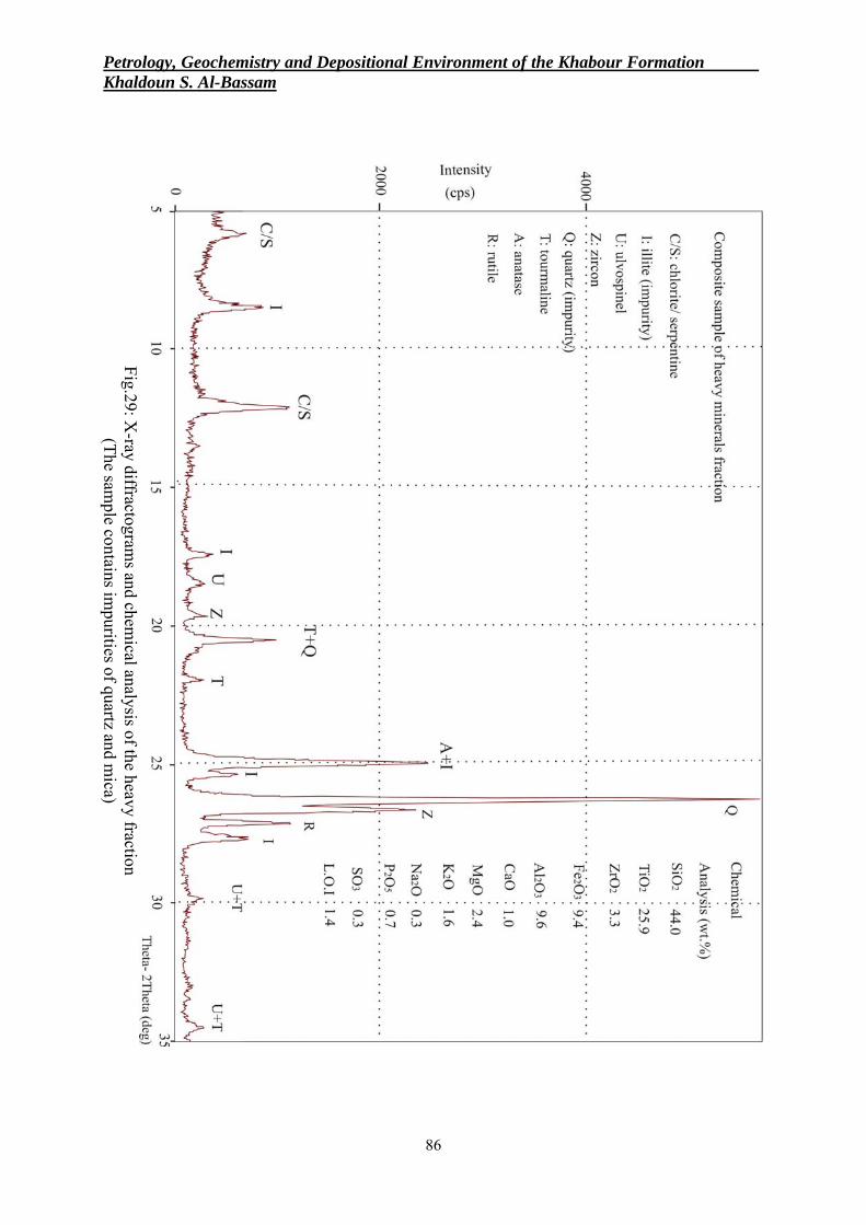
Petrology, Geochemistry and Depositional Environment of the Khabour Formation . Khaldoun S. Al-Bassam
86
Fig.29: X-ray diffractogram
s and chemical analysis of the heavy fraction
(The sample contains im
purities of quartz and mica)
Iraqi Bulletin of Geology and Mining Vol.6, No.2, 2010 p 71− 94
87
CHEMICAL COMPOSITION AND GEOCHEMISTRY The results of chemical analysis are presented in Table (2). The samples were separated
into three groups according to their chemical, mineralogical and textural criteria, and the mean chemical composition was derived for each group (Table 3). Group 1 represents quartz arenite (more than 90% SiO2), Group 2 represents phyllarenite (sandstones with less than 90% SiO2) and Group 3 represents the shale.
The chemical composition is directly related to mineral composition and controlled by the relative proportions of quartz, muscovite-illite, glauconite and occasionally chlorite/serpentine. Francolite (in one sample) show some influence on chemical composition as well as the minor amounts of the heavy minerals (zircon, tourmaline, ulvospinel, anatase and rutile).
Silica is shared with almost all minerals; alumina is mainly related to sheet silicates (mainly muscovite-illite), feldspar and some heavy minerals like tourmaline. Potassium is mainly hosted by muscovite-illite and glauconite, iron oxide is mainly hosted by ulvospinel, tourmaline, illite, glauconite and chlorite (with some possible free Fe oxyhydroxide cement) whereas magnesia is related to chlorite/serpentine. Calcium, phosphorus and fluoride are strictly restricted to francolite. Titanium is related to rutile, ulvospinel and anatase, whereas zirconium is related to zircon. Some titanium, however, may be incorporated in the sheet silicates. Sodium may be related to tourmaline and feldspar.
The Khabour Formation consists of various proportions of these minerals; dominated by quartz in the quartz arenite with minor amounts of sheet silicate minerals and feldspar. SiO2 content in this rock type is more than 90% and is characterized by a low Al2O3, K2O, MgO and generally less than 1% H2O+ (L.O.I). The SiO2/Al2O3 ratio is 28.6 and the K2O/Na2O ratio is 2.4. The quartz content decreases to a mean of about 50% in the phyllarenite with increasing proportions of the sheet silicates especially muscovite-illite (about 35%) and to a lesser extent (<10%) glauconite and minor chlorite, leading to higher concentrations of Al2O3, Fe2O3, K2O and MgO related to these minerals, accompanied by a consequent increase of H2O+ (L.O.I) content to about 2%. The SiO2/Al2O3 ratio decreases here to 9.3, whereas the K2O/ Na2O ratio is 2.2, which is close to that of the quartz arenite.
Shale samples consist of similar mineral assemblage, but with quartz (silt-size) content decreasing to about 25% and mica – illite content increasing to about 60%. Glauconite represents about 10% of the mineral composition of these shales.
This change in mineral proportions is reflected in lower SiO2 and higher Al2O3, K2O, MgO and Fe2O3. The L.O.I. (H2O)+ content increases to about 4% (mean value), released from hydrous sheet silicates. The SiO2/Al2O3 ratio in these samples is 4.0 and the K2O/Na2O ratio is 5.9. Potter (1978) related high SiO2/Al2O3 and high K2O/Na2O ratios to Atlantic-type passive margin big-river sands and distinguished them from collision-type coasts that have lowered such ratios.
Statistical analysis of the analytical data is in agreement with geochemical association of elements to the minerals identified in these samples (Table 4). Quartz, being almost free of ionic substitution and a major constituent of these rocks dominating the silica content, shows (as SiO2) strong negative correlation with diluent's sheet silicate mineral constituents (such as Fe, Al, Mg, K and L. O. I). It shows insignificant correlation with Zr, P and Ca.
On the other hand, alumina, the representative oxide of the sheet silicate minerals and feldspars, is positively correlated with Fe, Mg, K and L.O.I. Titanium correlation is shared positively between the sheet-silicate constituents, as a substituent ion in the octahedral layer, evidenced by the positive correlation with Al, Mg, K and L.O.I. and with Zr as a member of the stable heavy mineral assemblage.
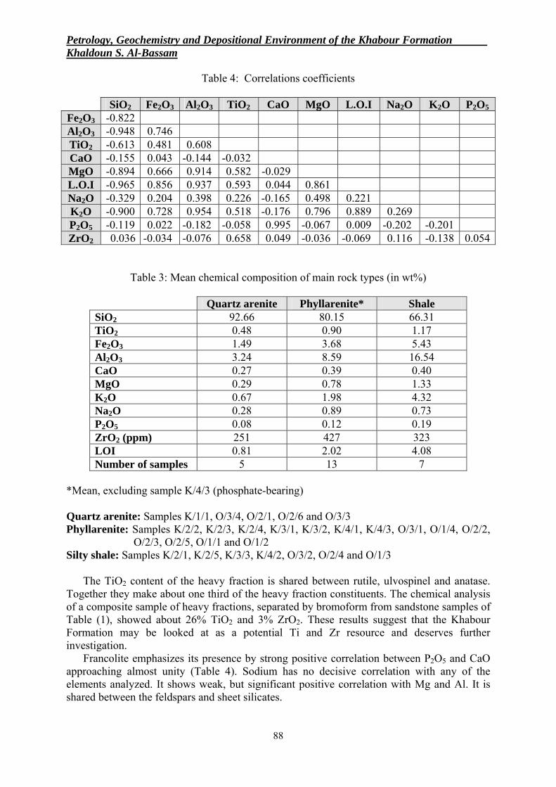
Petrology, Geochemistry and Depositional Environment of the Khabour Formation . Khaldoun S. Al-Bassam
88
Table 4: Correlations coefficients
SiO2 Fe2O3 Al2O3 TiO2 CaO MgO L.O.I Na2O K2O P2O5 Fe2O3 -0.822 Al2O3 -0.948 0.746 TiO2 -0.613 0.481 0.608 CaO -0.155 0.043 -0.144 -0.032 MgO -0.894 0.666 0.914 0.582 -0.029 L.O.I -0.965 0.856 0.937 0.593 0.044 0.861 Na2O -0.329 0.204 0.398 0.226 -0.165 0.498 0.221 K2O -0.900 0.728 0.954 0.518 -0.176 0.796 0.889 0.269 P2O5 -0.119 0.022 -0.182 -0.058 0.995 -0.067 0.009 -0.202 -0.201 ZrO2 0.036 -0.034 -0.076 0.658 0.049 -0.036 -0.069 0.116 -0.138 0.054
Table 3: Mean chemical composition of main rock types (in wt%)
Quartz arenite Phyllarenite* Shale SiO2 92.66 80.15 66.31 TiO2 0.48 0.90 1.17 Fe2O3 1.49 3.68 5.43 Al2O3 3.24 8.59 16.54 CaO 0.27 0.39 0.40 MgO 0.29 0.78 1.33 K2O 0.67 1.98 4.32 Na2O 0.28 0.89 0.73 P2O5 0.08 0.12 0.19 ZrO2 (ppm) 251 427 323 LOI 0.81 2.02 4.08 Number of samples 5 13 7
*Mean, excluding sample K/4/3 (phosphate-bearing) Quartz arenite: Samples K/1/1, O/3/4, O/2/1, O/2/6 and O/3/3 Phyllarenite: Samples K/2/2, K/2/3, K/2/4, K/3/1, K/3/2, K/4/1, K/4/3, O/3/1, O/1/4, O/2/2,
O/2/3, O/2/5, O/1/1 and O/1/2 Silty shale: Samples K/2/1, K/2/5, K/3/3, K/4/2, O/3/2, O/2/4 and O/1/3
The TiO2 content of the heavy fraction is shared between rutile, ulvospinel and anatase.
Together they make about one third of the heavy fraction constituents. The chemical analysis of a composite sample of heavy fractions, separated by bromoform from sandstone samples of Table (1), showed about 26% TiO2 and 3% ZrO2. These results suggest that the Khabour Formation may be looked at as a potential Ti and Zr resource and deserves further investigation.
Francolite emphasizes its presence by strong positive correlation between P2O5 and CaO approaching almost unity (Table 4). Sodium has no decisive correlation with any of the elements analyzed. It shows weak, but significant positive correlation with Mg and Al. It is shared between the feldspars and sheet silicates.
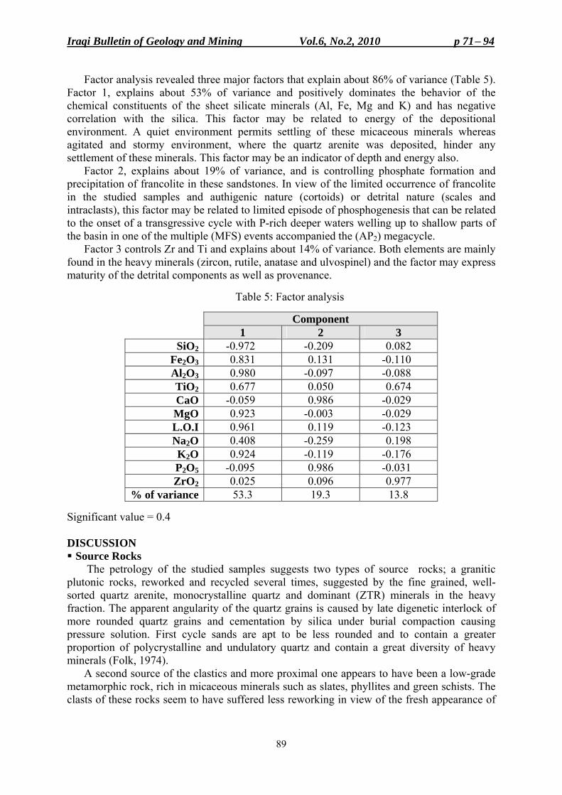
Iraqi Bulletin of Geology and Mining Vol.6, No.2, 2010 p 71− 94
89
Factor analysis revealed three major factors that explain about 86% of variance (Table 5). Factor 1, explains about 53% of variance and positively dominates the behavior of the chemical constituents of the sheet silicate minerals (Al, Fe, Mg and K) and has negative correlation with the silica. This factor may be related to energy of the depositional environment. A quiet environment permits settling of these micaceous minerals whereas agitated and stormy environment, where the quartz arenite was deposited, hinder any settlement of these minerals. This factor may be an indicator of depth and energy also.
Factor 2, explains about 19% of variance, and is controlling phosphate formation and precipitation of francolite in these sandstones. In view of the limited occurrence of francolite in the studied samples and authigenic nature (cortoids) or detrital nature (scales and intraclasts), this factor may be related to limited episode of phosphogenesis that can be related to the onset of a transgressive cycle with P-rich deeper waters welling up to shallow parts of the basin in one of the multiple (MFS) events accompanied the (AP2) megacycle.
Factor 3 controls Zr and Ti and explains about 14% of variance. Both elements are mainly found in the heavy minerals (zircon, rutile, anatase and ulvospinel) and the factor may express maturity of the detrital components as well as provenance.
Table 5: Factor analysis
Component 1 2 3 SiO2 -0.972 -0.209 0.082
Fe2O3 0.831 0.131 -0.110 Al2O3 0.980 -0.097 -0.088 TiO2 0.677 0.050 0.674 CaO -0.059 0.986 -0.029 MgO 0.923 -0.003 -0.029 L.O.I 0.961 0.119 -0.123 Na2O 0.408 -0.259 0.198 K2O 0.924 -0.119 -0.176 P2O5 -0.095 0.986 -0.031 ZrO2 0.025 0.096 0.977
% of variance 53.3 19.3 13.8 Significant value = 0.4
DISCUSSION Source Rocks
The petrology of the studied samples suggests two types of source rocks; a granitic plutonic rocks, reworked and recycled several times, suggested by the fine grained, well-sorted quartz arenite, monocrystalline quartz and dominant (ZTR) minerals in the heavy fraction. The apparent angularity of the quartz grains is caused by late digenetic interlock of more rounded quartz grains and cementation by silica under burial compaction causing pressure solution. First cycle sands are apt to be less rounded and to contain a greater proportion of polycrystalline and undulatory quartz and contain a great diversity of heavy minerals (Folk, 1974).
A second source of the clastics and more proximal one appears to have been a low-grade metamorphic rock, rich in micaceous minerals such as slates, phyllites and green schists. The clasts of these rocks seem to have suffered less reworking in view of the fresh appearance of
Petrology, Geochemistry and Depositional Environment of the Khabour Formation . Khaldoun S. Al-Bassam
90
the micaceous minerals and their larger size compared to quartz. Because of the softness of the slate and phyllite fragments, they are abraded away producing great volumes of clay-mica mush which are winnowed out of the sands to produce thick shale horizons (Folk, 1974). This is supported by the presence of mixed-layer chlorite/serpentine and some diagnostic heavy minerals (Table 1).
Maturity
Textural maturity is represented by the relative abundance of matrix and degree of rounding and sorting of framework grains (Boggs, 2006). In this sense, the basal parts of the sedimentary cycles of the Khabour Formation may be considered mature to supermature, grading upward to submature with the introduction of the micaceous matrix. On the other hand, compositional (mineralogical) maturity is estimated by the relative abundance of stable and unstable grains (Boggs, 2006) and may be represented by the ratio of quartz (stable) to feldspar or rock fragments (unstable or less stable). Mica (as muscovite) is considered as a mechanically stable mineral and, under cold climate and/ or arid conditions, a chemically stable mineral (Krumbein and Sloss, 1963). In this sense the studied sandstones can be considered fairly mature. Paleogeography and Paleoclimate
The low rate of alteration found in the feldspar and mica suggests cool and/ or arid climate. Iraq and the rest of Arabia were located at about 40° latitude south of the equator during the Ordovician time (Beydon, 1993). The Saharan glaciation's affected the western parts of the Arabia, which was at that time at its lowest southerly latitude (Sharland et al., 2001, Jassim and Goff, 2006). This palaeogeographic position induced cool climate and lower sea-level. The cool climate is supported by the fresh feldspar grains (Figs.15 and 16) and their persistent presence in the fine fraction (Fig.11). Depositional Environment
The Khabour Formation in the studied sections comprises a sequence of graded beddings of quartz sand, silt and micaceous shale. All of which appear to have been deposited in marine environment ranging from intertidal to outer shelf realms. The marine fauna and Cruziana trails as well as the common presence of glauconite and occasional francolite (with conodont remains) are evidence of the marine environment.
Wetzel (1950) suggested deposition in a tide-and storm-dominated shallow marine intertidal environment of mud-and silt-flats. The results of the present study can not verify storm-dominated mud or silt-flat environment for these clastics. The storm-dominated shelf deposits are usually quite complex and show thin layers consisting of concentrations of coarser grains interlayered or embedded in finer-grained mud (Krumbein and Sloss, 1963 and Boggs, 2006). Moreover, tidal flat deposits are usually rich in marine life and highly oxygenated, because of intermittent exposure. Seilacher (1963), on the other hand, suggested turbidite facies for the upper part of the sequence, which seems an acceptable model.
Graded bedding may form by sedimentation from suspension clouds or last phases of heavy floods, but most of these graded beds of marine origin in the geologic record have been attributed to turbidity currents (Boggs, 2006). Most turbidities are composed of sands, silty sands (or gravelly sands) interbedded with pelagic clays. They are commonly characterized by normal-size grading and may or may not display complete Bouma sequence (Boggs, 2006). In the present study a complete Bouma sequence was not observed. A stack of complete Bouma sequences overlying each other in a cyclic manner assumes no change in sea-level and the only variable is the successive episodes of density currents supplying clastics to the marine
Iraqi Bulletin of Geology and Mining Vol.6, No.2, 2010 p 71− 94
91
environment, and the sediment supply should be almost equal to subsidence rate, allowing for a constant accommodation space. Such ideal conditions were never the case, as these variables acted indifferently. This may partly explains the absence of a complete and ideal Bouma sequences stacked in a cyclic manner in the studied sections.
In the opinion of the author, most of the cyclic succession of the Khabour Formation may be assigned to deposition from turbidity currents of submarine fan environment under variable sea-level, subsidence rate and sediment supply. The quartz arenites (basal deposits of the cycles) represent the proximal parts of the fan, deposited in intertidal, very shallow agitated environment, gradually passing into deeper subtidal outer shelf facies with a high appearance of micaceous minerals and Cruziana trails, which represent the distal part of the fan. The occasional presence of wave ripples (observed by previous workers) in the lower part of the sequence where medium-and fine grained sandstones dominates the sequence, indicates high density turbidity currents and suggests that the seabed was often within storm waver-base (50 – 100) m. (Rieu and Allen, 2008). Their presence indicates shallow turbidite system fed by rivers rather than a deep-sea turbidite (Plink-BjOrklund and Steel, 2004). On the other hand, the laminated greenish shale and siltstone in the upper part of the sequence with slump structures associated with thin graded sandstones indicates a quiet, distal-marine depositional environment dominated by deep outer shelf hemi pelagic sedimentation. It represents outer fan facies association and low density turbidity currents (Rieu and Allen, 2008). The whole sequence may be considered as an example of a passive plate margin turbidities influenced by variable sea-level and sediment supply. The relatively high SiO2/Al2O3 and K2O/Na2O ratios are related to Atlantic-type passive margin sand deposits (Potter, 1978). Pettijohn et al. (1986) stated that submarine fans on the continental shelf bellow submarine canyons show greater abundance of micas farther out on the fan, whereas the more proximal parts of the fan are coarser grained and contain less mica.
The cyclicity of the sequence might have been partly induced by episodes of floods supplying clastics from source rocks exposed at higher altitudes of the Afro-Arabian craton and transported to the marine realm via turbidity currents, or by pulses of sea-level fluctuations. Sea-level fluctuations may be related to tectonic pulses leading to higher subsidence rate, or eustatic periodical changes related to glaciation's intensity at the poles.
During the Middle and Late Ordovician, a gradual rise in sea level resulted in the development of an intracratonic marine shelf basin (Jassim and Goff, 2006). The sudden increase in subsidence was attributed by Oterdoom et al. (1999) to rifting across Arabia, and thought to have brought the outer-shelf shales to be rapidly deposited above inner-shelf and continental coarse clastics. The relatively deeper shelf conditions were suddenly terminated by a drop of sea level triggered by the Saharan glaciations, which resulted in highly incised land forms and submarine canyons in NW Arabia (Husseini, 1991 and 1992).
Sharland et al. (2001) mentioned that the lithological changes during (AP2), from relatively undifferentiated coarse clastics to alternating shale-sand associations suggests significant changes in relative sea-level, accommodation space and sediment supply. AP2 (520 – 445 M.a.) was deposited during passive subsidence (Jassim and Goff, 2006). Within AP2, several MFS’s were recognized, represented by the shale beds in the sequence, and indicate transgressive phases. The 040 MFS is Late Ordovician (Late Caradoc) dated as 453 M.a. and is correlatable with the shale in the middle of the Khabour Formation (Aqrawi, 1998).
These successive transgressive – regressive episodes seem to have been more frequent and short-lived in the early stages, followed by longer transgressive stands in the later stages, allowing for thicker distal outer shelf shale sediments to dominate the middle and upper parts of the sequence. The partings (surfaces) between one cycle and the next represents a second
Petrology, Geochemistry and Depositional Environment of the Khabour Formation . Khaldoun S. Al-Bassam
92
order (MFS) where deposition may stand still or becomes very slow evidenced by burrowed and pitted surfaces and common presence of glauconite and occasional francolite; both are indicators of condensed sections of non-or slow-deposition (Pettijohn et al., 1986). The non-or slow-deposition may have been caused by decreasing influence of the turbidity currents which retreated shore-ward due to high sea-level stand and consequent retreat of the feeding source further insides the continent.
Successive density currents, passing over previous deposits may lay down additional graded bed without seriously disturbing the relatively fine upper surface of previous cycle, although surface markings may occur (Krumbein and Sloss, 1963). Many of these surface markings were noticed by previous authors in the studied sequence (Wetzel, 1950, Al-Hadithi, 1972 and Isaac, 1975).
The erosional unconformity, marking the uppermost part of the Khabour Formation, may have removed significant sedimentary record of the retreating glaciation of the Ashgill (Jassim and Goff, 2006). The missing upper part of the formation was encountered in many subsurface sections.
Digenesis
Early diagenetic processes include partial and minor alteration of feldspars, illite transformation to chlorite, and formation of digenetic muscovite and deposition of glauconite. Deep burial of the Khabour Formation clastics caused some later diagenetic alterations, mainly pressure-solution and reprecipitation of silica, probably some smectite transformation to illite, partial removal of Fe from chlorite, development of chlorite/ serpentine mixed layer and the break down and squeeze of the detrital mica flakes between the much harder quartz grains, by compaction pressure, forming the matrix material in the matrix-bearing arenites. No sign of metamorphic alterations were noticed, except those related to deep burial. CONCLUSIONS
• The clastics of the Khabour Formation were derived from two probable sources: a recycled granitic plutonic rock and more proximal low-grade (phyllitic) metamorphic rocks.
• The sandstones are texturally mature to supermature and mineralogically fairly mature. The sandstones are of two types: quartz arenite (more than 90% interlocking quartz grains) and phyllarenite (mostly quartz and mica). The shale consists of silt-size quartz and micaceous minerals. Feldspar is a minor to trace constituent.
• Glauconite and francolite are the main authigenic minerals. The latter may be related to conodonts, and marks the earliest marine phosphate showing in Iraq. A mixed-layer chlorite/ serpentine is an alteration product and marks deep burial. Silica cementation is the main diagenetic process induced by pressure solution due to burial.
• The whole sequence is marine in origin, deposited in environments ranging from agitated intertidal to calm deep outer shelf environments.
• The cyclicity of the sequence may be explained as due to several factors including sea-level fluctuations (tectonic and eustatic) and supply rate of detritus to the depositional environment. However, the cyclicity may be interpreted by successive density currents and the whole sequence may be considered as an example of a passive extensional plate margin turbidities. ACKNOWLEDGMENTS
The author is indebted to Dr. Saffa A. Fouad, Mr. Varoujan K. Sissakian and Mr. Sabah Y. Yacoub (GEOSURV Experts) for their valuable help in locating the studied sections and help during fieldwork. The stimulating discussions with Professor Mazin Tamar-Agha and
Iraqi Bulletin of Geology and Mining Vol.6, No.2, 2010 p 71− 94
93
Dr. Saffa Fouad enlightened the author on many aspects related to the concept of this paper. Their comments on the manuscript were valuable and highly appreciated. The heavy minerals were identified and counted by Mrs. Luma E. Al-Mukhtar (GEOSURV Central Laboratories). The hard work by Miss. Mariamme A. Kaka and Miss. Zainab S. Haddu in typing, editing and computer cartography is highly appreciated. REFERENCES Al-Hadithi, T.M., 1972 (revised by Pesel, V., 1974). Geological stage report on Sereru area, Northern Iraq.
GEOSURV, int. rep. no. 655. Al-Janabi, Y., Al-Sa'adi, N., Zainal, Y., Al-Bassam, K., and Al-Delaimy, M., 1992. GEOSURV Work
Procedures, Part 21: Chemical Laboratories. GEOSURV, int. rep. no. 1991. Aqrawi, A.A.M., 1998. Paleozoic stratigraphy and petroleum systems of the Western and Southwestern Deserts
of Iraq. GeoArabia, Vol.3, p. 229 – 248. Beydoun, Z.R., 1991. Arabian Plate hydrocarbon geology and potential: A plate tectonic approach. Studies in
Geology, AAPG, Vol.33, 77pp. Boggs, S. Jr., 2006. Principles of Sedimentology and Stratigraphy, 4th edit. Pearson/ Prentice Hall, New Jersey,
662pp. Buday, T., 1980. The Regional Geology of Iraq. Vol.1, Stratigraphy and Paleogeography. In: I.I. Kassab and
S.Z. Jassim (Eds.). GEOSURV, Iraq, 445pp. Cooper, B.J., 1981. Early Ordovician conodont from the Horn Valley siltstone, Central Australia. Paleontology,
Vol.24, p. 147 – 183. Ditmar, V. and Iraqi – Soviet Team, 1971. Geological conditions and hydrocarbon prospects of the Republic of
Iraq (Northern and Central parts). Ministry of Oil (INOC), internal report. Folk, R.L., 1974. Petrology of Sedimentary Rocks. Hemphill Publishing Co., Austin Texas, 182pp. Gaddo, J. and Parker, D., 1959. Final report on well Khleisia No.1. MPC int. rep. (Ministry of Oil, INOC
Library, no. FWR 28). Grigsby, J.D., 2001. Origin and growth mechanism of authigenic chlorite in sandstones of the Lower Vicksburg
Formation, South Texas. Jour. Sedimentary Research, Vol.71, p. 27 – 36. Habba, Y., Sammarai, A., Al-Jubouri, F., Georgis, N. and Ahmed, I., 1994. Exploration for the Paleozoic
prospects in Western Iraq. Part 1: Exploration of the Paleozoic systems in Western Iraq. Proceedings of the 2nd Seminar on Hydrocarbon Potential of Deep Formations in the Arab Countries (OAPEC), Cairo (in Arabic).
Husseini, M.I., 1991. Tectonic and depositional model of the Arabian and adjoining plates during the Silurian – Devonian. AAPG, Vol.75, p. 108 – 120.
Husseini, M.I., 1992. Upper Paleozoic tectono-sedimentary evolution of the Arabian and adjoining plates. Jour. Geol. Soc., London, Vol.149, p. 419 – 429.
Isa’ac, E.A., 1975. Geology of the Dafaf – Keshan area, Northern Thrust Zone. GEOSURV, int. rep. no. 659. Jassim, S.Z. and Goff, J.C. (Eds.), 2006. Geology of Iraq. Dolin, Prague and Moravian Museum, Brno, 340pp. Krumbein, W.C. and Sloss, L.L., 1963. Stratigraphy and Sedimentation. W.H. Freeman and Co., London, 2nd
edit., 660pp. Muller, K.J., 1978. Conodont and other phosphatic microfossils. In: B.U., Hakand and A., Boersma (Eds.),
Introduction to Marine Micropaleontology. Elsevier, New York, p. 277 – 291. Oterdoom, W.H., Worthing, M.A. and Partington, M., 1999. Petrological and tectonostratigraphic evidence for
a mid Ordovician rift pulse on the Arabian Peninsula. GeoArabia, Vol.4, p. 467 – 500. Pettijohn, F.J., Potter, P.E. and Siever, R., 1986. Sand and Sandstone. Springer-Verlag, 2nd edit., 553pp. Plink-BjOrklund, P. and Steel, R., 2004. Initiation of turbidity currents: Evidence for hyperpycnal flow
turbidities in Eocene Central Basin of Spitsbergen. Sed. Geol., Vol.165, p. 29 – 52. Potter, P.E., 1978. Petrology and chemistry of modern big river sands. Jour. Geology, Vol.86, p. 423 – 449. Reynolds, R.C., Di Stefano, M.P. and Lahann, R.W., 1992. Randomly interstratified serpentine/chlorite; its
detection and quantification by powder X-ray diffraction methods. Clays and Clay Minerals, Vol.40, p. 262 – 267.
Rieu, R. and Allen, P.A., 2008. Siliciclastic sedimentation in the interlude between two Neoproterozoic glaciation, Mirbat area, Southern Oman: A missing link in the Huqf Supergroup? GeoArabia, Vol.13, p. 45 – 72.
Seilacher, A., 1963. Kaledonischer Unterbau der Irakiden. Neuses Jahrb. Geol. Planet. Abt. Monatshefte, No.10, p. 527 – 542.

Petrology, Geochemistry and Depositional Environment of the Khabour Formation . Khaldoun S. Al-Bassam
94
Sharland, P.R., Archer, R., Casey, D.M., Davies, R.B., Hall, S.H., Heward, A.P. Harbury, A.D. and Simmons, M.D., 2001. Arabian Plate Sequence Stratigraphy. GeoArabia, Special Publ., No.2, Gulf Petrolink, 371pp.
Tamar-Agha, M. and Mahdi, A., 1992. GEOSURV Work Procedures, Part 18: Petrology and Paleontology Laboratories. GEOSURV, int. rep. no. 1999.
Tamar-Agha, M., 2009. The influence of cementation on the reservoir quality of the Risha Sandstones Member (Upper Ordovician), Risha Gas Field, NE Jordan. Jour. Petroleum Geology, Vol.32, p. 193 – 208.
Wetzel, R., 1950. Khabour Quartzite Formation. In: Bellen, R.C., van, Dunnington, H.V., Wetzel, R. and Morton, D., 1959; Lexique Stratigraphique International. Asie, Fasc. 10a, Iraq. Paris, Vol.3, 333pp.
Iraqi Bulletin of Geology and Mining Vol.6, No.2, 2010 p 95− 114
95
LITHOFACIES ASSOCIATION, DOLOMITIZATION, AND POTENTIALITY OF THE PILA SPI FORMATION,
TAQ TAQ OIL FIELD, KURDISTAN REGION, NE IRAQ
Divan H. Othman* and Basim A. Al-Qayim**
Received: 18/ 11/ 2009, Accepted: 29/ 07/ 2010 Key wards: Pila ٍٍٍٍٍٍٍSpi Formation, Taq Taq, Eocene, Reservoir, Petrophysics
ABSTRACT
Subsurface data of four oil wells from the Taq Taq oil field of Northeast Iraq, in addition to one surface section from the near by Haibat Sultan Mountain were selected to study the lithofacies associations of the Pila Spi Formation. Detailed investigation of rock samples, cuttings, cores and wire-line logs is attempted to identify lithologic units and association, and to evaluate dolomitization effect on these rocks and its contribution to the reservoir quality.
The formation, in this area is subdivided into four distinctive lithologic units, from bottom to top are: Lower Brecciated and Silicified Unit (P1), Dolomitized Tidal Flat Limestone (P2), Lagoonal Limestone and Dolostone (P3), and Upper Brecciated Dolomitic Limestone (P4). These rocks were variably affected by diagenesis and intensively modified by dolomitization, which is drastically overprinted the original fabrics and components. Several types of dolomite were recognized including: Fenestral Fine Crystalline Dolomite (D1), Fine Crystalline Planar-e to Planar-s Dolomite (D2), Fine Crystalline Non-planar Dolomite (D3), Medium Crystalline Non-planar Dolomite (D4), and Coarse Crystalline Dolomite (D5).
Dolomitization had positively influenced the reservoir characteristics by enhancing inter-crystalline porosity, and developing intra-skeletal and moldic porosity, which evolve into the common micro-vug porosity, especially, in the middle lithologic units (P2 and P3). Reservoir flow potentiality, however, is greatly enhanced by the secondary fracture porosity.
السبييية لتكوين البوالقدرة المكمن، ةالدلمت، الصخريةةالوحدات السحني شمال شرق العراق، كوردستانإقليم ، في حقل طق طق
م القي عبد الخالقم باس و حسينديفان عثمان
مستخلصال
طق في شمال شرق العراق نفطية لحقل نفط طق من أربعة آبارستحصلة المسطحية التحتتشكل المعلومات عن الحالية للدراسة ساسيةألا المادة سبيالي من جبل هيبة سلطان عن تكوين البخوذةأالم الحقلية المعلومات إلى ضافةإ
.السبيي لتكوين البة والسحنيالصخريةالعالقات وذلك والمجسات البئرية، اب الصخرياللبالفتات و، الصخريةبري للنماذج فحص مختالتفصيلية الدراسةشملت
.ة على الصخور والخصائص المكمنية عمليات الدلمتتأثير ولتقييم ة الصخريةلتحديد الوحدات والعالقات السحني
____________________________________ * Assistant Lecturer, Department of Geology, Sulaimaniyah University, Kurdistan, Iraq ** Professor, Department of Geology, Sulaimaniyah University, Kurdistan, Iraq, e-mail: [email protected]
Lithofacies Association, Dolomitization, and Potentiality of the Pila Spi Formation Divan H. Othman and Basim A. Al-Qayim
96
البريشيا وحدة :األعلى إلى األسفلمن ة، وحدات صخريأربعة إلى المنطقةفي هذه البيالسبي تكوينقسم مكن تيوحدة الحجر الجيري والدولوميتي ، )P2(يتي للمسطح المدي اوحدة الحجر الجيري الدولوم، )P1( السفلىالسليكية
.)P4(ووحدة حجر البريشيا العليا ، ) P3(المستنقعي على المكونات أثرت التي ةلمت نتيجة عمليات الد وتحويرات شديدةمهمة تغييرات إلى تعرضت هذه الصخور
: من الدولومايت تشملأنواعلقد تم تمييز عدة . للصخوراألصليوالنسيج الصخري ، )D2( األوجهمستوي شبه إلىدقيق البلورات المستوي الدولومايت ، )D1(دقيق البلورات " الفنستري"مايت الدولو )D4( األوجهغير مستوي لومايت متوسط البلورات الدو، )D3( األوجهمستوي غير البلورات دقيقالدولومايت .)D5( خشن البلوراتوالدولومايت
للتكوين عن طريق تحسين مسامية مابين ايجابي على تطور الخصائص المكمنية بشكل أثرت عملية الدلمتة خاصة في الجزء صغيرةال التجاويف مساميةإلى والتي تحولت بالنهايةة والقالبي الهيكليةالمساميةوتطوير ، البلورات . الثانوية مسامية الكسور تأثير الجريان المكمني فقد تحسنت نتيجة ة قدرأما). P2 و P1 دتيوح( من التكوين األوسط
INTRODUCTION
Taq Taq oil field is located 13 Km southwest of Koi Sanjaq town, about 61 Km northeast of Kirkuk, and 85 Km southeast of Erbil (Fig.1). The first well (Tq-1) was drilled in 1958 by the Iraqi Petroleum Company on the crest of the structure to about 3986 m depth. Then followed by Well Tq-2 and Tq-3, in which Tq-2 drilled to a target depth of 663 m, which is about the depth of the Eocene Pila Spi Formation, and well. Tq-3, which is drilled to the depth of 1631m and targeting the deeper Cretaceous units.
In 2005, a contract with a Turkish Company called "Genel Enerji" and "Addax Petroleum Corporation" formed a merger of new company called Taq Tqa Operation Company (TTOPCO), is signed to run the field by commencement of drilling activities. During the following years, new wells have been drilled (TT-04, TT-05, TT-06, TT-07, TT-08, and TT-09) and by targeting Cretaceous units. However, the renewed interest on the Tertiary reservoirs namely the Pila Spi Formation stimulate this and other research to investigate their different geologic aspects and their impact on the potentiality of these units.
Four wells were selected for this study (Tq-2, Tq-3, TT-04 and TT-05) with whatever available data of cuttings, core samples and different types of well logs. To support the lithologic study, a surface section was measured from Haibat Sultan Mountain, which is about 17 Km to the northeast of the field. The Pila Spi Formation is completely exposed at this ridge with accessible and road cut outcrops. Core and cutting samples of all rock types were examined by binocular microscope to record all petrological and sedimentological aspects. Selected samples were thin-sectioned and occasionally stained to investigate their petrographic components and texture using polarized microscope. Dolomite as a dominant mineral is studied in details due to its anticipated role in affecting the quality of the Pila Spi reservoir. Few samples were scanned by SEM microscope to differentiate between different fabrics of dolomites. Different types of well logs, especially: Gamma Ray, Sonic, Density, and Neutron logs were used to assist identification of lithologic boundaries as well as determination of general lithologies in an un-cored intervals of the studied wells, they also were used to evaluate porosity and permeability of the studied reservoir.
Taq Taq structure can easily be distinguished by the positive features of the topography, well exposed units with average elevation of about 600 m (a.s.l.). The general pattern and shape of the outcrops clearly reflect the underlying geological structure and lithological differences of the strata. The structure is double plunging anticline, the surface expression of the structure is 27 Km long and 11 Km width, with NW – SE oriented axis (Fig.2).
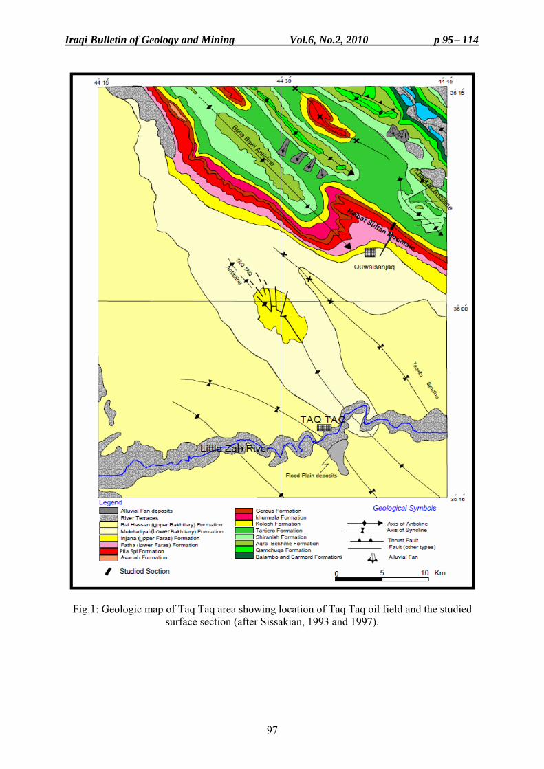
Iraqi Bulletin of Geology and Mining Vol.6, No.2, 2010 p 95− 114
97
Fig.1: Geologic map of Taq Taq area showing location of Taq Taq oil field and the studied surface section (after Sissakian, 1993 and 1997).
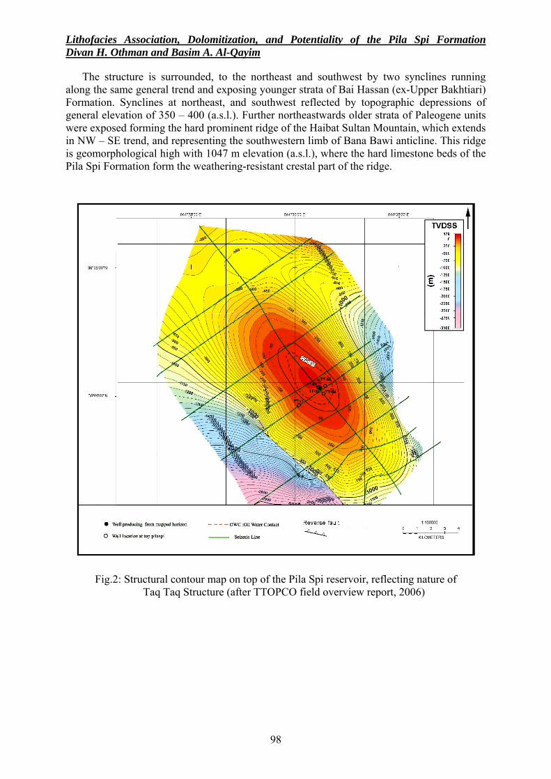
Lithofacies Association, Dolomitization, and Potentiality of the Pila Spi Formation Divan H. Othman and Basim A. Al-Qayim
98
The structure is surrounded, to the northeast and southwest by two synclines running along the same general trend and exposing younger strata of Bai Hassan (ex-Upper Bakhtiari) Formation. Synclines at northeast, and southwest reflected by topographic depressions of general elevation of 350 – 400 (a.s.l.). Further northeastwards older strata of Paleogene units were exposed forming the hard prominent ridge of the Haibat Sultan Mountain, which extends in NW – SE trend, and representing the southwestern limb of Bana Bawi anticline. This ridge is geomorphological high with 1047 m elevation (a.s.l.), where the hard limestone beds of the Pila Spi Formation form the weathering-resistant crestal part of the ridge.
Fig.2: Structural contour map on top of the Pila Spi reservoir, reflecting nature of Taq Taq Structure (after TTOPCO field overview report, 2006)
Iraqi Bulletin of Geology and Mining Vol.6, No.2, 2010 p 95− 114
99
STRATIGRAPHY The Pila Spi Formation was first described by Lees (1930) in Bellen et al. (1959) from the
surrounding of Pila Spi village of the High Folded Zone of northeast Iraq. It was redefined by Wetzel (1947) and amended by Bellen et al. (1959). The original type section was submerged under the water of the Darbandi Khan reservoir; a supplementary type section was thus described at Kashti on the Baranan Dagh Mountain, of Darbandi Khan area.
The formation, in the type section consists of two parts: The lower part shows well bedded hard, whitish, porous with vitreous, bituminous, or white, poorly fossiliferous dolostone with algal or shell sections (Bellen et al., 1959). The upper part is composed of well bedded, bituminous, chalky, and crystalline dolostone, with bands of white chalky marl with chert nodules, especially towards the top. In the supplementary type section, dolomitic and chalky dolostone, with few dolomitized bands, chert intercalations, with traces of sub-ooliths and rare concentrations of gastropod debris, form the bulk of the formation (Buday, 1980). Tongues of the Nummulitic Avanah Formation occur within the basal part of the formation near and in several wells of Duhok area (Jassim and Buday, 2006 in Jassim and Goff, 2006). The thickness of the formation varies between (100 – 200) m. The variable thickness of the formation could be related to variable erosional rate or the original geometry of the sedimentary basin, especially in the High Folded Zone of northeast Iraq.
Fossils are abundant with sporadic distribution, which includes: Milolids (Pyrgo sp.), chilostomellids, Peneroplis dusenbury Henson, Praerhapidionina huberi Henson, Rhapidionina urensis Henson, Rhapidionina williamsoni Henson, Rhapidionina macfadyeni Henson, Valvulinids (Bellen, et al. 1959). Based on that, Bellen et al. (1959) claimed Middle – Late Eocene. However, Buday (1980), and Jassim and Goff (2006) believe that the formation was deposited during Late Eocene time.
In Degala, 25 Km to the north of Taq Taq area the formation consists of dolostone, which alternates with green marls with bioturbation. In Darbandi Bazian, the formation consists of three parts. The lower part consists of stromatolitic dolostone, marl, and dolomitic limestone. The middle and upper parts consist of recrystallized dolostone alternating with marls with the presence of chert nodules (Qadir, 1989). Similar lithologies were recognized in Dokan and Shaqlawa areas (Al-Sakry,1999), Dohuk area (Al-Jawadi, 1978), Darbandi Khan area (Lawa, 2004).
The lower boundary of the Pila Spi Formation appears to be conformable and gradational in the type section in NE Iraq, where it overlies the Gercus Formation. The boundary is either interfingering; as in Bekhme area (Al-Qayim and Al-Shaibani, 1997), or marked by locally distributed (0.5 – 1 m thick) conglomerate horizon; as in Shaqlawa area (Al-Qayim et al., 1994), and Haibat Sultan ridge (Al-Qayim et al., 1988). The upper boundary is frequently reported to be unconformable with the overlying Fatha (ex-Lower Fars) Formation of the Middle Miocene age. It is recognized by thick and extensive basal conglomerate horizon (Bellen et al., 1959; Buday, 1980; Jassim and Buday, 2006 in Jassim and Goff, 2006). In other areas, however, such as Basara gorge, south of Sulaimaniyah, a thin Oligocene unit is believed to have intervened between the Fatha and Pila Spi Formation (Khanqa et al., 2009). According to Bellen et al. (1959) and Buday (1980), the Pila Spi Formation, generally, represents lagoonal sediments, of an inshore type. The formation was deposited in a shallow extensive lagoonal setting (Jassim and Buday, 2006 in Jassim and Goff, 2006). Al-Sakry (1999) believed that the Pila Spi Formation was deposited in a shelf and shallow lagoonal environment, and some of the deposits may be developed in an intertidal environment, or over a continental shelf, probably of tropical and warmer topographic region (Al-Saeed, 1977). Numan, et al. (1995) suggests a general miogeosynclinal setting for the Pila Spi Formation, and Karim, et al. (2008), believe that it is part of the main foreland basin.
Lithofacies Association, Dolomitization, and Potentiality of the Pila Spi Formation Divan H. Othman and Basim A. Al-Qayim
100
LITHOFACIES ASSOCIATIONS The lithologic characters of the Pila Spi Formation in Taq Taq oil field show no
considerable differences from the surrounding areas and are quite similar to its counter surface section of Haibat Sultan Mountain (Fig.3). The thickness of the formation at this area is about 70m.
The lower part of the Pila Spi Formation is characterized by fractured red and brecciated dolostone, with dissolution cavities. It shows alternation of thin to medium bioclastic dolostone with marly dolostone and marls. The middle part is the thickest and generally consists of cyclic alternation of dolostone and marly dolostone. Cycles are thinning upward and alternate with hard dolostone, and fissile marly dolostone. The upper part is characterized by hard gray dense dolostone with shaley interlayers, which become sandy, and reddish upwards and intermixed with rusty thin sandy crust including chert nodules. The Formation is underlain by the reddish claystones of the Gercus Formation, and overlain by the brecciated unit of the unconformity zone, which separates the Pila Spi Formation from the clastic – carbonate strata of the Fatha (ex-Lower Fars) Formation.
The subsurface lithologic characters of the Pila Spi Formation in Taq Taq oil field is well represented by the section of well Tq-2 (Fig.4). Four distinctive lithofacies units were identified using core and cutting description, petrographic examination, assisted by well log analysis, and supported by well correlation across the field and over to the surface section of Haibat Sultan Mountain. The thicknesses of these units in the studied sections are shown in Table (1), and their description is given hereinafter, from bottom to top.
Table 1: Thicknesses of the lithologic units in the studied sections
Thicknesses of the lithologic units (m) Sections and well No. P1 P2 P3 P4
Surface section 2.5 12.5 45 10
Tq-2 10 30 75 16
Tq-3 7.5 20 80 20.8
TT-04 10 20 65 15
TT-05 6 22 68 15 ■ Lower Brecciated - Silicified Dolostone Unit (P1)
The lower contact of this unit with Gercus Formation is gradational (Fig.5a and b). The unit is characterized by light grey to reddish, hard, fine crystalline dolostone, with dissolution cavities, large vugs, intermixed with silicified brecciated dolostone, especially in the lower part. Inter-granular matrix is characterized by buff silty to sandy sediments, which some times occur as silty intercalations. The thickness of this unit is variable and ranges between (2.5 – 10) m. It is believed to represent a transitional zone from the underlying the red clastics of the Gercus Formation to the overlying marine carbonates of the Pila Spi Formation.
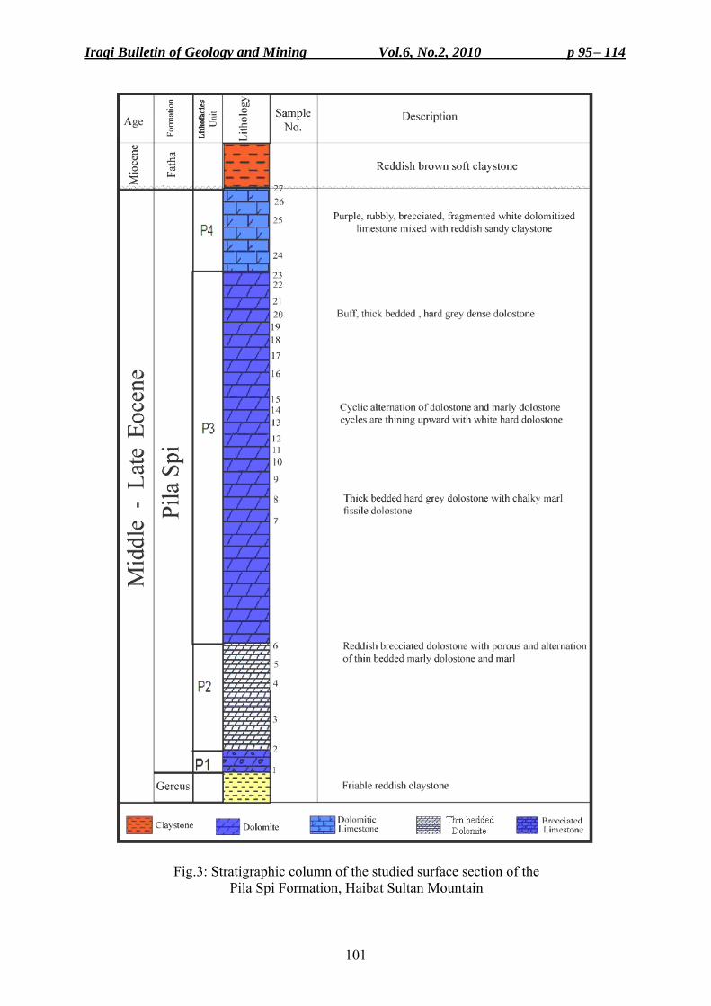
Iraqi Bulletin of Geology and Mining Vol.6, No.2, 2010 p 95− 114
101
Fig.3: Stratigraphic column of the studied surface section of the Pila Spi Formation, Haibat Sultan Mountain
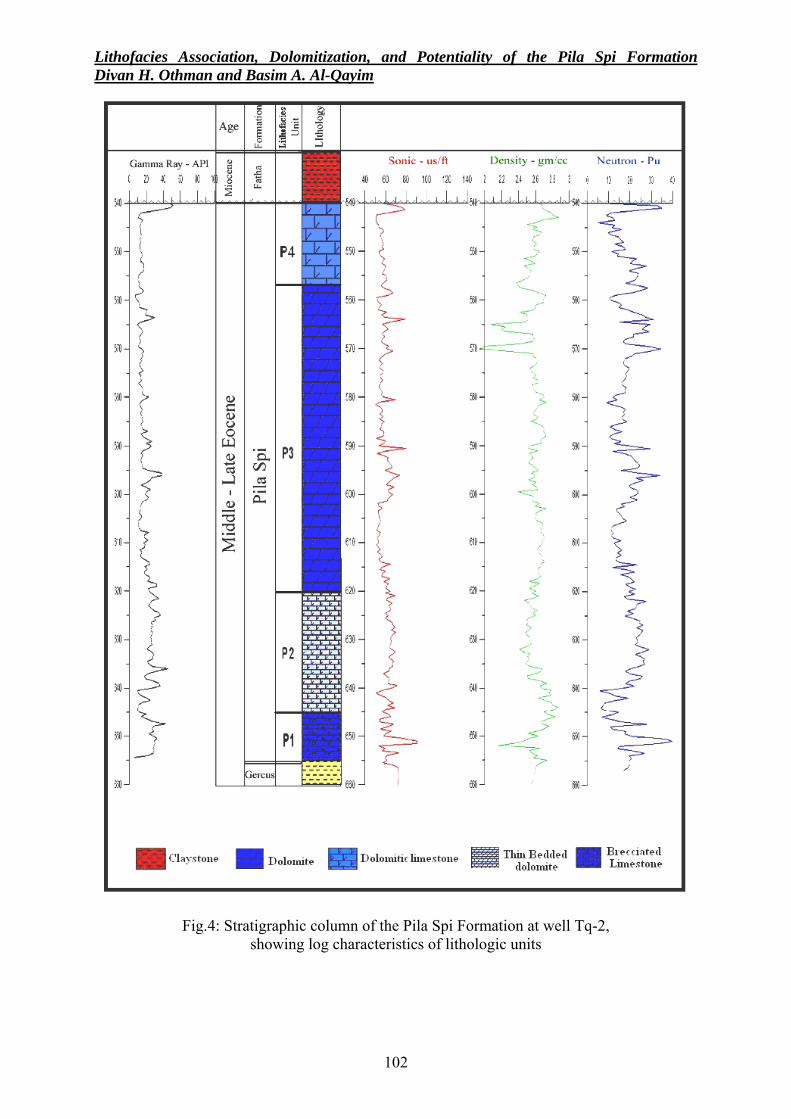
Lithofacies Association, Dolomitization, and Potentiality of the Pila Spi Formation Divan H. Othman and Basim A. Al-Qayim
102
Fig.4: Stratigraphic column of the Pila Spi Formation at well Tq-2, showing log characteristics of lithologic units
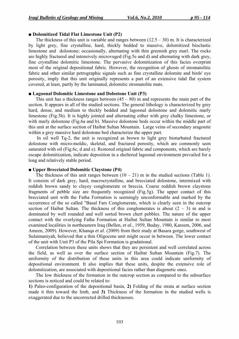
Iraqi Bulletin of Geology and Mining Vol.6, No.2, 2010 p 95− 114
103
■ Dolomitized Tidal Flat Limestone Unit (P2) The thickness of this unit is variable and ranges between (12.5 – 30) m. It is characterized
by light grey, fine crystalline, hard, thickly bedded to massive, dolomitized bioclastic limestone and dolostone; occasionally, alternating with thin greenish grey marl. The rocks are highly fractured and intensively microvuged (Fig.5e and d) and alternating with dark grey, fine crystalline dolomitic limestone. The pervasive dolomitization of this facies overprint most of the original depositional fabric. However, the recognition of ghosts of stromatolitic fabric and other similar petrographic signals such as fine crystalline dolomite and birds' eye porosity, imply that this unit originally represents a part of an extensive tidal flat system covered, at least, partly by the laminated, dolomitic stromatolite mats.
■ Lagoonal Dolomitic Limestone and Dolostone Unit (P3)
This unit has a thickness ranges between (45 – 80) m and represents the main part of the section. It appears in all of the studied sections. The general lithology is characterized by grey hard, dense, and medium to thickly bedded and lagoonal dolostone and dolomitic marly limestone (Fig.5h). It is highly jointed and alternating either with grey chalky limestone, or with marly dolostone (Fig.6a and b). Massive dolostone beds occur within the middle part of this unit at the surface section of Haibat Sultan Mountain. Large veins of secondary aragonite within a grey massive hard dolostone bed characterize the upper part.
In oil well Tq-2, the unit is recognized as brown to light grey bioturbated fractured dolostone with micro-moldic, skeletal, and fractured porosity, which are commonly seen saturated with oil (Fig.6c, d and e). Restored original fabric and components, which are barely escape dolomitization, indicate deposition in a sheltered lagoonal environment prevailed for a long and relatively stable period.
■ Upper Brecciated Dolomitic Claystone (P4)
The thickness of this unit ranges between (10 – 21) m in the studied sections (Table 1). It consists of dark grey, hard, macrocrystalline, and brecciated dolostone, intermixed with reddish brown sandy to clayey conglomerate or breccia. Coarse reddish brown claystone fragments of pebble size are frequently recognized (Fig.5g). The upper contact of this brecciated unit with the Fatha Formation is seemingly unconformable and marked by the occurrence of the so called "Basal Fars Conglomerate, which is clearly seen in the outcrop section of Haibat Sultan. The thickness of this conglomerates is about (2 – 3) m and is dominated by well rounded and well sorted brown chert pebbles. The nature of the upper contact with the overlying Fatha Formation at Haibat Sultan Mountain is similar to most examined localities in northeastern Iraq (Bellen, et al., 1959, Buday, 1980, Kareem, 2006, and Ameen, 2009). However, Khanqa et al. (2009) from their study at Basara gorge, southwest of Sulaimaniyah, believed that a thin Oligocene unit might occur in between. The lower contact of the unit with Unit P3 of the Pila Spi Formation is gradational.
Correlation between these units shows that they are persistent and well correlated across the field, as well as over the surface section of Haibat Sultan Mountain (Fig.7). The uniformity of the distribution of these units in this area could indicate uniformity of depositional environment. It also implies that these units, despite the extensive role of dolomitization, are associated with depositional facies rather than diagenetic ones.
The low thickness of the formation in the outcrop section as compared to the subsurface sections is noticed and could be related to: 1) Paleo-configuration of the depositional basin, 2) Folding of the strata at surface section made it thin toward the limb, and 3) Thickness of the formation in the studied wells is exaggerated due to the uncorrected drilled thicknesses.
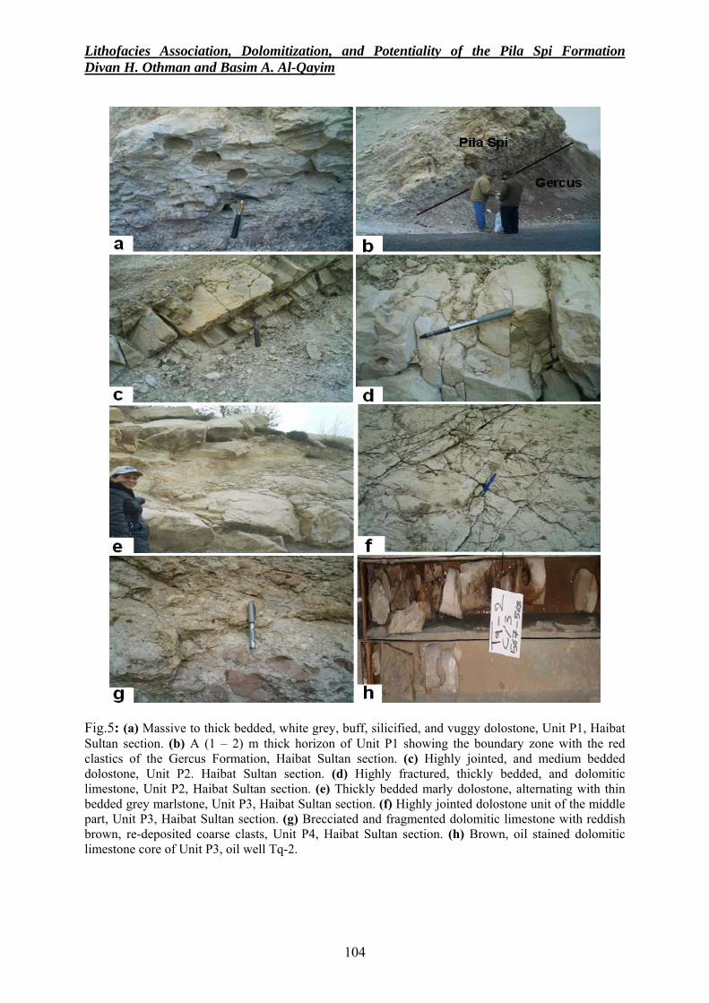
Lithofacies Association, Dolomitization, and Potentiality of the Pila Spi Formation Divan H. Othman and Basim A. Al-Qayim
104
Fig.5: (a) Massive to thick bedded, white grey, buff, silicified, and vuggy dolostone, Unit P1, Haibat Sultan section. (b) A (1 – 2) m thick horizon of Unit P1 showing the boundary zone with the red clastics of the Gercus Formation, Haibat Sultan section. (c) Highly jointed, and medium bedded dolostone, Unit P2. Haibat Sultan section. (d) Highly fractured, thickly bedded, and dolomitic limestone, Unit P2, Haibat Sultan section. (e) Thickly bedded marly dolostone, alternating with thin bedded grey marlstone, Unit P3, Haibat Sultan section. (f) Highly jointed dolostone unit of the middle part, Unit P3, Haibat Sultan section. (g) Brecciated and fragmented dolomitic limestone with reddish brown, re-deposited coarse clasts, Unit P4, Haibat Sultan section. (h) Brown, oil stained dolomitic limestone core of Unit P3, oil well Tq-2.
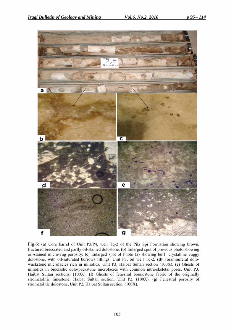
Iraqi Bulletin of Geology and Mining Vol.6, No.2, 2010 p 95− 114
105
Fig.6: (a) Core barrel of Unit P3/P4, well Tq-2 of the Pila Spi Formation showing brown, fractured brecciated and partly oil-stained dolostone. (b) Enlarged spot of previous photo showing oil-stained micro-vug porosity. (c) Enlarged spot of Photo (a) showing buff crystalline vuggy dolostone, with oil-saturated burrows fillings, Unit P3, oil well Tq-2. (d) Foraminiferal dolo-wackstone microfacies rich in miliolids, Unit P3, Haibat Sultan section (100X). (e) Ghosts of miliolids in bioclastic dolo-packstone microfacies with common intra-skeletal pores, Unit P3, Haibat Sultan sections, (100X). (f) Ghosts of fenestral boundstone fabric of the originally stromatolitic limestone. Haibat Sultan section, Unit P2, (100X). (g) Fenestral porosity of stromatolitic dolostone, Unit P2, Haibat Sultan section, (100X).
Lithofacies Association, Dolomitization, and Potentiality of the Pila Spi Formation Divan H. Othman and Basim A. Al-Qayim
106
Fig.7: Correlation of lithologic units of the Pila Spi Formation across the studied wells and the surface section
Horizontal scale is ignored (For legend see Fig.4)
MICROFACIES ANALYSIS The ultimate goal of this analysis is to determine sedimentological control on the
distribution of reservoir petrophysical parameters, and to investigate the diagenetic processes that had affected these rocks in order to evaluate its influence on reservoir potentiality. For this purpose, 106 thin-sections were studied under a polarized microscope. The studied sequence has different petrographical properties, and variable different degree of diagenetic effects, especially, dolomitization, which altered most of the original fabrics and replaced it by dolomite mosaic of different sizes and shapes.
Names of the inferred microfacies followed the classification of carbonate rocks by Dunhum (1962). However, for dolomite or dolomitic facies the work of Gregg and Sibley (1987) is followed, which combined microscopic and Scanning Electron Microscope (SEM) features to describe different dolomite fabrics.
Most of the examined samples were found to belong to either dolomitic limestone or dolostone; due to the intensive dolomitization, which affect the Pila Spi limestone and destroyed partly to completely the original fabric of the rock. Attempts were made to restore the original fabric and the primary sedimentary facies using petrographic relics and remains of the studied thin sections.
The microfacies types of the studied samples are grouped into two major groups, as discussed hereinafter.
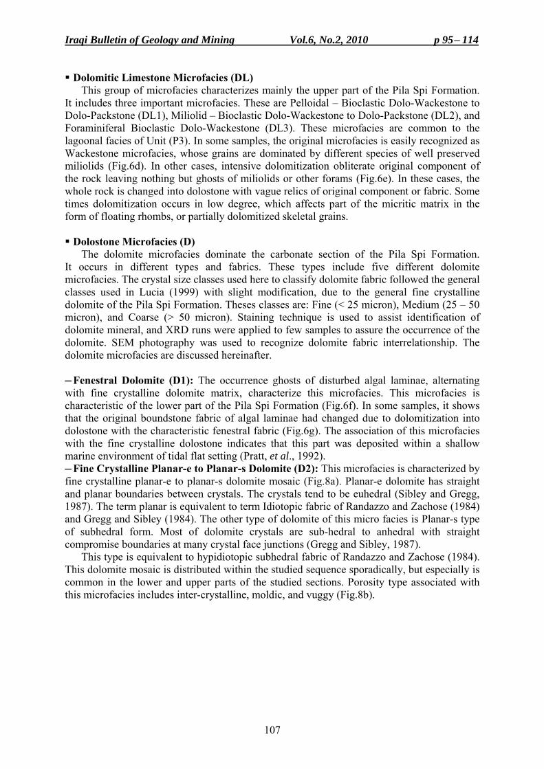
Iraqi Bulletin of Geology and Mining Vol.6, No.2, 2010 p 95− 114
107
Dolomitic Limestone Microfacies (DL) This group of microfacies characterizes mainly the upper part of the Pila Spi Formation.
It includes three important microfacies. These are Pelloidal – Bioclastic Dolo-Wackestone to Dolo-Packstone (DL1), Miliolid – Bioclastic Dolo-Wackestone to Dolo-Packstone (DL2), and Foraminiferal Bioclastic Dolo-Wackestone (DL3). These microfacies are common to the lagoonal facies of Unit (P3). In some samples, the original microfacies is easily recognized as Wackestone microfacies, whose grains are dominated by different species of well preserved miliolids (Fig.6d). In other cases, intensive dolomitization obliterate original component of the rock leaving nothing but ghosts of miliolids or other forams (Fig.6e). In these cases, the whole rock is changed into dolostone with vague relics of original component or fabric. Some times dolomitization occurs in low degree, which affects part of the micritic matrix in the form of floating rhombs, or partially dolomitized skeletal grains.
Dolostone Microfacies (D)
The dolomite microfacies dominate the carbonate section of the Pila Spi Formation. It occurs in different types and fabrics. These types include five different dolomite microfacies. The crystal size classes used here to classify dolomite fabric followed the general classes used in Lucia (1999) with slight modification, due to the general fine crystalline dolomite of the Pila Spi Formation. Theses classes are: Fine (< 25 micron), Medium (25 – 50 micron), and Coarse (> 50 micron). Staining technique is used to assist identification of dolomite mineral, and XRD runs were applied to few samples to assure the occurrence of the dolomite. SEM photography was used to recognize dolomite fabric interrelationship. The dolomite microfacies are discussed hereinafter.
─ Fenestral Dolomite (D1): The occurrence ghosts of disturbed algal laminae, alternating with fine crystalline dolomite matrix, characterize this microfacies. This microfacies is characteristic of the lower part of the Pila Spi Formation (Fig.6f). In some samples, it shows that the original boundstone fabric of algal laminae had changed due to dolomitization into dolostone with the characteristic fenestral fabric (Fig.6g). The association of this microfacies with the fine crystalline dolostone indicates that this part was deposited within a shallow marine environment of tidal flat setting (Pratt, et al., 1992). ─ Fine Crystalline Planar-e to Planar-s Dolomite (D2): This microfacies is characterized by fine crystalline planar-e to planar-s dolomite mosaic (Fig.8a). Planar-e dolomite has straight and planar boundaries between crystals. The crystals tend to be euhedral (Sibley and Gregg, 1987). The term planar is equivalent to term Idiotopic fabric of Randazzo and Zachose (1984) and Gregg and Sibley (1984). The other type of dolomite of this micro facies is Planar-s type of subhedral form. Most of dolomite crystals are sub-hedral to anhedral with straight compromise boundaries at many crystal face junctions (Gregg and Sibley, 1987).
This type is equivalent to hypidiotopic subhedral fabric of Randazzo and Zachose (1984). This dolomite mosaic is distributed within the studied sequence sporadically, but especially is common in the lower and upper parts of the studied sections. Porosity type associated with this microfacies includes inter-crystalline, moldic, and vuggy (Fig.8b).
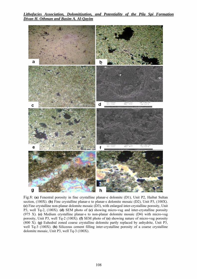
Lithofacies Association, Dolomitization, and Potentiality of the Pila Spi Formation Divan H. Othman and Basim A. Al-Qayim
108
Fig.8: (a) Fenestral porosity in fine crystalline planar-e dolomite (D1), Unit P2, Haibat Sultan section, (100X). (b) Fine crystalline planar-e to planar-s dolomite mosaic (D2), Unit P3, (100X). (c) Fine crystalline non-planar dolomite mosaic (D3), with enlarged inter-crystalline porosity, Unit P3, well Tq-2, (100X). (d) SEM photo of (c) showing micro-vug and inter-crystalline porosity (975 X). (e) Medium crystalline planar-s to non-planar dolomite mosaic (D4) with micro-vug porosity, Unit P3, well Tq-2 (100X). (f) SEM photo of (e) showing nature of micro-vug porosity (800 X). (g) Euhedral zoned coarse crystalline dolomite partly replaced by anhydrite, Unit P3, well Tq-3 (100X). (h) Siliceous cement filling inter-crystalline porosity of a coarse crystalline dolomite mosaic, Unit P3, well Tq-3 (100X).
Iraqi Bulletin of Geology and Mining Vol.6, No.2, 2010 p 95− 114
109
─ Fine Crystalline Non-Planar-a Dolomite (D3): This type of microfacies is characterized by fine crystalline non-planar-a dolomite mosaic (Fig.8c and d). Non-planar texture is represented by closely packed anhedral crystals, with mostly curved, lobate, serrate, or otherwise irregular inter-crystalline boundaries (Gregg and Sibley, 1984). The term non-planar is equivalent to the term Xenotopic of Randazzo and Zachose (1984); Gregg and Sibley (1984). It is distributed within the most of the studied intervals of the Pila Spi Formation. Ghosts of original skeletal fragments indicate that the original depositional microfacies type of this dolostone is seemingly associated with Foraminiferal – Bioclastic Wackestone. Good amount of porosity seems to be related to this microfacies especially micro-vugs (Fig.8c). ─ Medium Crystalline Non-Planar-a Dolomite (D4): This microfacies is composed of medium crystalline non-planar dolomite mosaic with common in moldic and micro-vug porosity (Fig.8e and f). This microfacies is the most common dolomite type in all of the studied sections, and is distributed in the middle part of the studied intervals, especially in the Unit P3. Owing to the large amount of moldic and micro-vug porosities, this microfacies might be developed by intensive dolomitization of a limestone with originally bioclastic packstone type (Randazzo and Zachose, 1984). ─ Coarse Crystalline Dolomite (D5): This type of microfacies is not common and it is characterized by coarse crystalline dolomite mosaic. Crystals are of planar-e to planar-s forms (Fig.8g and h). This microfacies is not common and has restricted distribution especially within the upper part of the Pila Spi Formation. It is also seen in outcrop section within the Upper Brecciated Unit (P4) and below. It is also associated with secondary anhydrite inclusions or secondary siliceous cement filling pores and spaces between the coarse crystalline dolomite mosaic (Fig.8h).
RESERVOIR POTENTIALITY
The results of the microfacies analysis were used to support lithofacies determination, and to recognize a possible relationship between of basic types of porosity and the identified microfacies, in order to evaluate the ultimate link between lithofacies and reservoir petrophysical properties. The qualitative estimation of porosity, from thin-section, in the studied samples is also attempted. To do that, the vertical distribution of the recognized lithofacies and microfacies, are plotted against type and value of estimated and measured porosity in each sample for each section (Figs.9 and 10). Well Tq-2 is displayed here as a representative to the subsurface sections of the Taq Taq oil field.
As we see in Fig. (10), the qualitative porosity variation as compared to the calculated porosity curve (calculated from plugs in the laboratories by the operating company) can indicate that the porous part of the studied section of the Pila Spi reservoir is associated with Unit P3. It is obvious that these potential parts are associated with the dolostone units, which acquired its high secondary porosity due to dolomitization. The most porous parts are characterized by fine crystalline dolomite mosaic, which generated the extensive inter-crystalline porosity network. Moreover, leached skeletal grains of the original limestone became associated with either intra-skeletal porosity or moldic porosity after intensive dolomitization. In addition, successive dolomitization completely obliterate the original fabric and contribute to the development of extensive network of micro-vugs pores, which add to the secondary porosity (Lonoy, 2006).
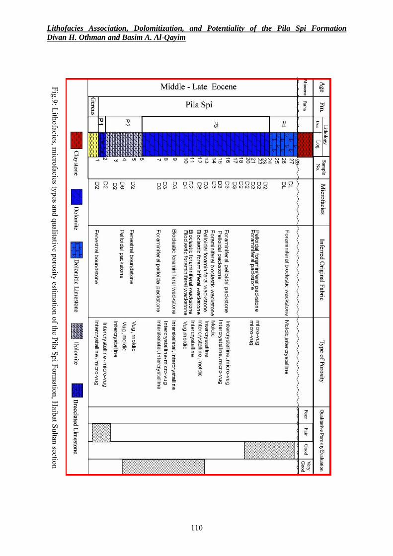
Lithofacies Association, Dolomitization, and Potentiality of the Pila Spi Formation Divan H. Othman and Basim A. Al-Qayim
110
Fig.9: Lithofacies, microfacies types and qualitative porosity estim
ation of the Pila Spi Formation, H
aibat Sultan section
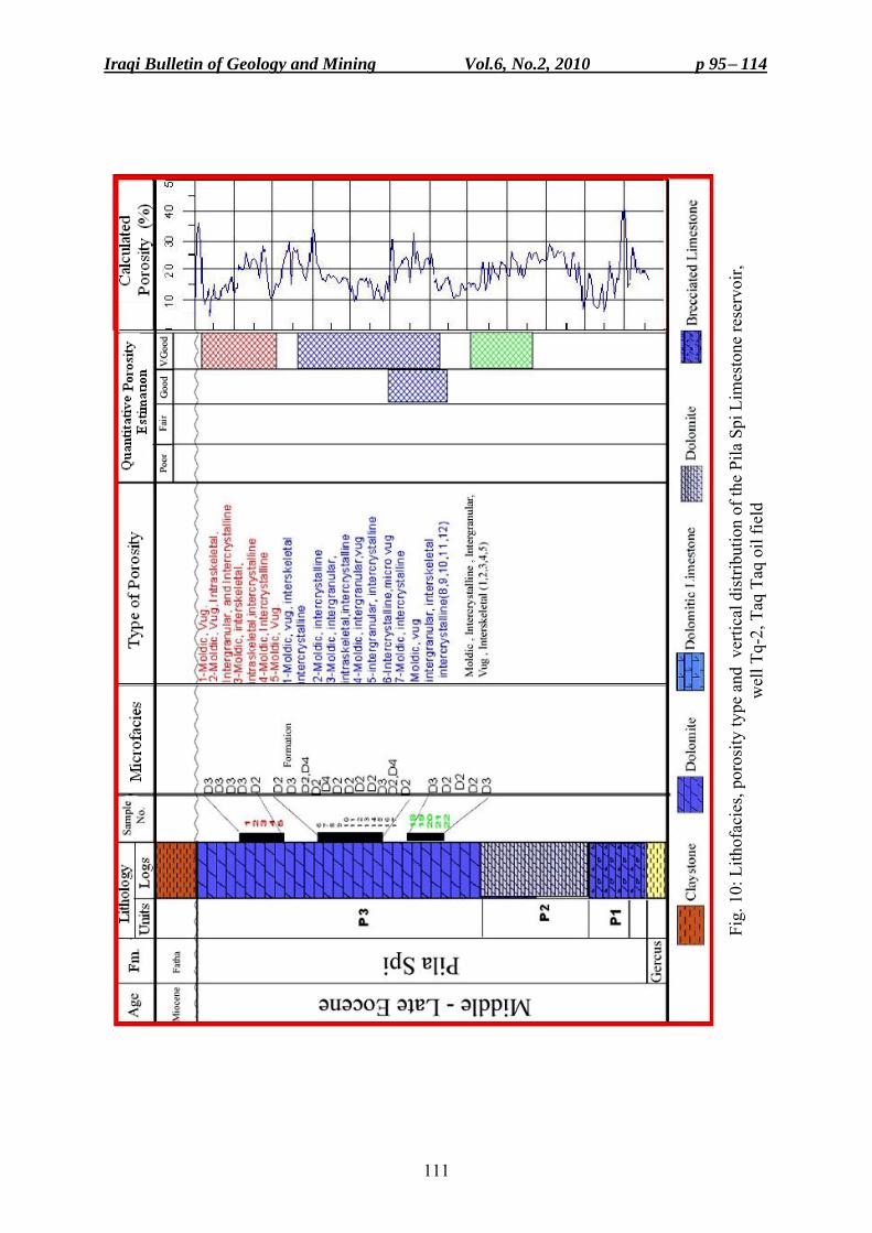
Iraqi Bulletin of Geology and Mining Vol.6, No.2, 2010 p 95− 114
111
Fig.
10:
Lith
ofac
ies,
poro
sity
type
and
ver
tical
dis
tribu
tion
of th
e Pi
la S
pi L
imes
tone
rese
rvoi
r,
wel
l Tq-
2, T
aq T
aq o
il fie
ld
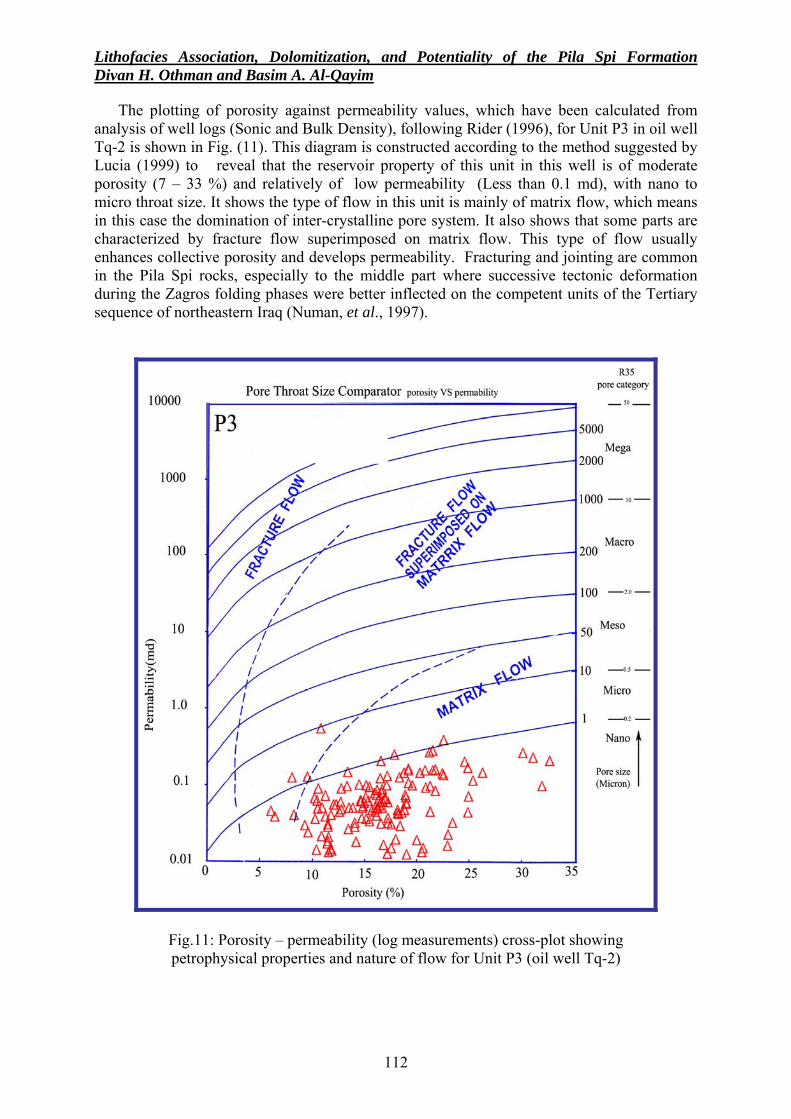
Lithofacies Association, Dolomitization, and Potentiality of the Pila Spi Formation Divan H. Othman and Basim A. Al-Qayim
112
The plotting of porosity against permeability values, which have been calculated from analysis of well logs (Sonic and Bulk Density), following Rider (1996), for Unit P3 in oil well Tq-2 is shown in Fig. (11). This diagram is constructed according to the method suggested by Lucia (1999) to reveal that the reservoir property of this unit in this well is of moderate porosity (7 – 33 %) and relatively of low permeability (Less than 0.1 md), with nano to micro throat size. It shows the type of flow in this unit is mainly of matrix flow, which means in this case the domination of inter-crystalline pore system. It also shows that some parts are characterized by fracture flow superimposed on matrix flow. This type of flow usually enhances collective porosity and develops permeability. Fracturing and jointing are common in the Pila Spi rocks, especially to the middle part where successive tectonic deformation during the Zagros folding phases were better inflected on the competent units of the Tertiary sequence of northeastern Iraq (Numan, et al., 1997).
Fig.11: Porosity – permeability (log measurements) cross-plot showing petrophysical properties and nature of flow for Unit P3 (oil well Tq-2)
Iraqi Bulletin of Geology and Mining Vol.6, No.2, 2010 p 95− 114
113
CONCLUSIONS • The Pila Spi Formation of the Taq Taq oil field and its correlatable surface section of Haibat
Sultan Mountain is divided into four distinctive lithologic units. The differences between these units are controlled by occurrences of marl and shale interlayers, type of original depositional fabric and variability in the degree of dolomitization.
• Dolomite occurs through out different intervals of the formation and in different types ranging from fine to coarse crystalline mosaic. The dominated type of dolomite, however, is characterized by fine crystalline ( 25 < µm) planar-e to planar-s mosaic, which acquired the Pila Spi reservoir it's best inter-crystalline. Moldic and micro-vug porosity were inherited from dolomitization and contributed to the reservoir porosity.
• Fracturing of certain parts of the rocks of the Pila Spi Formation, due to successive tectonic events; contributed in initiating of the secondary porosity, enhancement of the permeability, and development of the reservoir perspective potentiality.
ACKNOWLEDGMENTS
The authors are indebted to the Northern Oil Company, Kirkuk, and the Taq Taq Operating Company (TTOPCO) for their generosity in providing what ever available of subsurface data for this study. REFERENCES Al-Jawadi, A.F., 1978. Mineralogical, petrographical, and geochemical studies on Pila Spi Formation from
Northern Iraq, Unpub. M.Sc. Thesis, Mosul University, 112pp. Al-Qayim, B., Al-Shaibani, S. and Nisan, B., 1988. Stratigraphic evolution of Paleogene sequence Haibat Sultan,
Northeastern Iraq. Jour. Geol. Soci. of Iraq, Vol.21, No.2, p. 51 – 61. Al-Qayim, B., Al-Shaibani, S. and Nissan, B., 1994. A Bimodal Tidal Depositional System of the Gercus
Formation , Shaqlawa Area, Northern Iraq. Iraqi Geol. Jour. Vol.27, No.2, p. 75 – 95. Al-Qayim, B. and Al-Shaibani, S., 1997. Lithostratigraphy of Cretaceous – Tertiary transect Bekhme Gorge, NE
Iraq. Iraqi Geol. Jour., Vol.28, No.2, p. 127 – 136. Al-Saeed, M.M., 1977. Petrographical and geochemical studies on Pila Spi Formation, Unpubl. M.Sc. Thesis,
University of Baghdad, 146pp. Al-Sakry, S.I., 1999. Stratigraphy and facies of Paleogene carbonate formations of selected sections,
Northeastern Iraq, Unpub. M.Sc. Thesis, University of Baghdad, 113pp. Ameen, B., 2009. Lithological indicators for the Oligocene unconformity, NE Iraq. Iraqi Bull. Geol. Min., Vol.5,
No.1, p. 25 – 34. Bellen, R.C., van, Dunnington, H.V., Wetzel, R. and Morton, D.M., 1959. Lexique Stratigraphique International,
Asie, Fasc. 10a, Iraq, Paris, 333pp. Buday, T., 1980. The Regional Geology of Iraq, Vol.1, Stratigraphy and Paleogeography. In: I.I., Kassab and
S.J.,Jassim (Eds.). GEOSURV, Baghdad, Iraq, 445pp. Dunham, R.J., 1962. Classification of Carbonate Rocks According to Depositional Texture. In: W.E. Ham, (Ed.),
Classification of Carbonate Rocks: AAPG Memoir 1, Tulsa, Oklahoma, p. 108 – 121. Gregg, J.M. and Sibley, D.F., 1984. Epigenetic dolomitization, and the origin of xenotopic dolomite texture.
Jour. Sed. Pet., Vol.54, No.3, p. 908 – 931. Jassim, S.Z. and Buday, T., 2006. Middle Paleocene – Eocene Megasequence Ap10, Chapter 13, in S.Z. Jassim,
and J.C. Goff, (Eds.), Geology of Iraq, Dolin Prague and Moravian Museum, Brno, 341pp. Khanqa, P., Karim, S.M., Sissakian, V.K. and Kareem, K.H., 2009. Lithostratigraphic study of a Late Oligocene
– Early Miocene succession, south of Sulaimaniyah, NE Iraq. Iraqi Bull. Geol. Min., Vol.5, No.2, p. 41 – 58.
Karim, K., Al-Barzinjy, S. and Ameen, B., 2008. History and geological setting of intermontane basins in the Zagros fold – thrust belt, Kurdistan region, north Iraq. Iraqi Bull. Geol. Min., Vol.4, No.1, p. 21 – 34.
Kareem, P., 2006. sedimentology of the Upper Eocene – Middle Miocene boundary from Darbandikhan area, Kurdistan Region, NE Iraq. Unpub. M.Sc. Thesis. Sulaimaniyah University, 95pp.
Lawa, F.A., 2004. Sequence stratigraphy analysis of the Middle Paleocene – Middle Eocene in the Sulaimany district (Kurdistan Region), Unpub. Ph.D. Thesis, University of Sulaimaniyah, 258pp.
Lonoy, A., 2006. Making sense of carbonate system. AAPG, Vol.90, No.9, p. 1381 – 1405.
Lithofacies Association, Dolomitization, and Potentiality of the Pila Spi Formation Divan H. Othman and Basim A. Al-Qayim
114
Lucia, F.J., 1999. Characterization of Petrophysical Flow Units in Carbonate Reservoirs: Discussion: AAPG Bulletin, Vol.83, No.7, p. 1161 – 1163.
Numan, N., Hammoud, P. and Chorowicz, J., 1997. Synsedimentary tectonics in the Eocene Pila Spi Limestone Formation in Iraq and its geodynamic implications. Jour. of African Earth Science, Vol.27, No.1, p. 141 – 148.
Pratt, B.R., Noel, P.J. and Cowan, C.A., 1992. Peritidal carbonates. In: J., Walker and J., Noel (Eds.) Facies Models, Geol. Ass. Canada., GEO text (1), p. 333 – 322.
Qadir, F.A., 1989. Microfacies of the Pila Spi Formation in selected sections from Northeast Iraq. Unpub. M.Sc. Thesis, University of Salahaddin, Arbil, 96pp.
Randazzo, A.F. and Zachos, L.G., 1984. Classification and description of dolomite fabric of rocks from the Florida Aquifer. U.S.A: Jour. Sed. Geol., Vol.57, p.151 – 162.
Rider, M., 1996. The Geological Interpretation of Well Logs, 2nd edit. Petroleum Exploration Rider French Consulting Ltd. Aberdeen and Sutherland, 280pp.
Sibley, D.F. and Gregg, J.M., 1987. Classification of dolomite rock textures. Jour. Sed. Petr., Vol.57, No.6, p. 967 – 975.
Sissakian, V.K., 1993. Geological Map of Kirkuk Quadrangle, Sheet NI-38-2, scale 1: 250000, GEOSURV, Baghdad, Iraq.
Sissakian, V.K., 1997. Geological Map of Arbeel and Mahabad Quadrangles, Sheets NJ-38-14 and NJ-38-15, scale 1: 250000, GEOSURV, Baghdad, Iraq
Taq Taq Operating Company (TTOPCO), 2006a, Final well report of well TT-04, 26pp. Taq Taq Operating Company (TTOPCO), 2006b, General Field overview report. 17pp.
About the authors
Mrs. Devan O. Hussein graduated from University of Sulaimaniyah in 2003, she joined the Geology Department in the university and got her M.Sc. degree in Petroleum Geology in 2008. Currently, she is working as assistant lecturer at the same department in University of Sulaimaniyah. Dr. Basim A. Al-Qayim had earned his B.Sc. and M.Sc degrees in geology from the University of Baghdad back in the seventies. He got his Ph.D. degree in stratigraphy from the University of Pittsburgh, U.S.A. Since then, he was engaged in his academic career by teaching undergraduate and graduate courses in several universities amongst: Salahuddine, Baghdad, Sana'a and Sulaimaniyah. Research interests circled around stratigraphy, sedimentology and petroleum geology of Zagros Fold – Thrust Belt. Publications exceed 60 research papers.
Iraqi Bulletin of Geology and Mining Vol.6, No.2, 2010 p 115− 126
115
COMPARISON OF GYPSIFEROUS SOILS IN SAMARRA AND KARBALA AREAS, IRAQ
Mou'taz A. Al-Dabbas*, Tom Schanz** and Mohammed J. Yassen***
Received: 26/ 11/ 2008, Accepted: 1/ 4/ 2010
Key words: Gypsiferous soil, Clay minerals, Shear strength, Swelling index, Collapse potential
ABSTRACT A proposed engineering gypsiferous soil classification is given using: soil texture,
mineralogy, geochemistry, engineering properties, and chemical analyses of soils water-extract. The results reflect that these soils consist of different percentages of sand, silt, clay, and some gravel. Analyses also detected secondary gypsum, quartz, calcite, feldspar and different types of rock fragments and different types of heavy minerals in trace amounts. Clay minerals are dominated by palygorskite. Hydrochemical analyses results of soils water-extract show that the calcium and sulphate ions are most common, followed by sodium, bicarbonate, chloride, magnesium and potassium. Bicarbonate and chloride show high values in Karbala area. Gypsum content ranges from (0.9 – 67.5) % in Samarra area, while in Karbala it ranges from (0.4 – 28.9) %. The physical and engineering properties of the studied soils were determined, such as specific gravity, density, shear strength parameters, unconfined compressive strength, and compression and shear wave velocities, compression index, swelling index, initial void ratio, and collapse potential. Samples, which were allowed to soak water show a sudden drop in unconfined compressive strength and compression and shear values immediately after soaking, then were decreased gradually.
The proposed engineering classification of gypsiferous soils includes two classes: “Gypsiferous Soil” and “Highly Gypsiferous Soil”; according to the gypsum content (< 25% and > 25%, respectively), initial void ratio, coefficient of curvature, coefficient of uniformity, collapse potential, compressive strength, cohesion, plasticity index, content of fines, and the T.D.S of the soils water-extract. It is believed that this proposed classification for Iraqi soils can be applied to other locations, therefore, will be useful for other soil scientists and engineers as well, worldwide.
مقارنة بين الترب الجبسية في منطقتي سامراء وكربالء، العراق
ستار الدباس، توم شخانز و محمد جاسم ياسينمعتز عبد ال
مستخلصال إلى إضافةً ، نسيج ومعدنية وجيوكيميائية الترب الجبسيةلترب الجبسية باستخدامهندسي ل تصنيف اقتراح تم
الترب الجبسية نسيجأن عكست النتائج ب. مستخلصات تلك التربلمياهية نتائج التحاليل الكيميائخواصها الهندسية و ، حيث منطقة سامراءباستثناء. الطين والحصىوتكون بصورة رئيسية من الرمال ونسب مختلفة من الغرين لمدروسة يا
أظهرت الدراسة المعدنية أن هذه الترب تتكون بصورة .الحصى ونسب مختلفة من الرمال ونالطي وتتكون من الغرين من ونسب نزرةبار، أنواع مختلفة من القطع الصخريةرئيسية من الجبسم الثانوي، الكوارتز، الكالسايت، الفيلدس
تتراوح نسبة و ،سكايت يكون من المعادن الطينية الشائعة فيها، وان معدن الباليكورالمعادن الثقيلة بكميات قليلة جداًأظهرت الدراسة .) %9.28 – 4.0( في كربالء بين نسبتهتكونو في سامراء % )– 67.5 0.9( الجبسم من
تليها أيونات الصوديوم، البيكربونات، ،وكيميائية لمستخلصات التربة أن أيوني الكالسيوم والكبريتات أكثر شيوعاًالهيدر . كربالء منطقة تزايداً فيانظهرين أيوني البيكربونات والكلورايد والورايد، المغنيسيوم والبوتاسيومالك
____________________________________ * College of Science, University of Baghdad. e-mail: [email protected] ** Ruhr University of Bochum, Germany. e-mail: [email protected] *** College of Engineering, University of Mustansyriya, Baghdad, Iraq
Comparison of Gypsiferous Soils in Samarra and Karbala Mou'taz A. Al-Dabbas et al.
116
الكثافة النسبية ومعامالت قوة القص والتماسك الكثافة و ومثلية والهندسية وتحديدها الصفات الفيزيائتمت دراسة والقصية وجهد االنهيار ومعامل االنضغاط واالنتفاخ اإلنضغاطيةومقاومة االنضغاط غير المحصور وسرعة الموجات
.األوليةونسبة الفجوات محتواها من معدن إلى يتكون من مجموعتين استناداً في هذه الدراسةلترب الجبسيةلالهندسي المقترح تصنيف ال إنالثانية مجموعة ال وممن الجبس% 25الترب الجبسية وبنسب اقل من األولى تسمى حيث المجموعة ،م الثانويالجبس
الصفات الهندسية ةإضاف ممن الجبس% 25 من أعلىبنسب م وذات المحتوى العالي من الجبستسمى الترب الجبسية .المذكورة سابقا
INTRODUCTION
Gypsiferous soils represent serious problems in many fields of human activity. They have dramatic impacts on buildings and infrastructure. The gypsiferous soils consist of a secondary gypsum-rich crust within the soil, developed after sedimentation of the soil material by increasing evaporation of saline and sulphate-rich groundwater in arid and warm regions. Infact, gypsiferous soils retain most of the original soil components (clay, silt and sand) but, impregnated by variable amounts of gypsum; as nests or disseminations. Fine-grained soils contain more gypsum than coarse grained soils. Almost, all gypsum accumulates above capillary water zone; in dry areas at which water table is located at about 3 m below ground surface. The soil distribution map in Iraq represents that secondary gypsum is concentrated in the middle third and southern parts of Iraq (Buringh, 1960). Structures built on gypsiferous soils in Iraq suffer from many engineering problems as cracks, tilting, or differential settlements in buildings or as structure collapse and breakage of water and sewage network due to solubility of gypsum within the soil. The main cause of these problems is the collapse of the gypsiferous soils and/ or their decrease in compressibility in case of saturation of the site by rain water or irrigation.
The study areas of this research are situated within Mesopotamian Plain, and included two sites, namely: Samarra and Karbala, which are located between latitudes 32º 30' and 34º 00', and longitudes 43º 45' and 44º 30' (Fig.1). They are covered by Quaternary sediments and Tertiary rocks. The exposed Tertiary rocks are represented by Fatha Formation, consists of marl, claystone, limestone and gypsum, with rare siltstone and sandstone. Injana Formation (consists mainly of sandstone, siltstone and claystone). Mukdadiya Formation, consists mainly of pebbly sandstone, sandstone, siltstone, and claystone, and Dibdibba Formation, consists mainly of sand, gravel and gravelly sandstone with lenses of clay, which is composed of compacted clay balls interfered with some sand and gypsum as cementing material (Fig.1).
Quaternary sediments cover the underlying Tertiary formations; involve Pleistocene and Holocene sediments that include river terraces, gypcrete, flood plain sediments and Aeolian sediments; as constituents of almost all the soil of the studied area.
Little work has been carried out; so far in studying the engineering characteristics of gypsiferous soils in Iraq; among them are Al-Mohammadi and Nashat (1987); Al-Layla (1993) and Abdulla (2005). Work has been limited mostly to Soviet field tests (Petrukhin and Boldyrev, 1978 and Petrukhin and Arakelyan, 1985). Also there are some Iraqi studies dealing with different properties of the gypsiferous soil, such as dry gypsiferous soils behavior in compression and rebound, collapsibility of a gypsiferous soil under different stress levels, the mineralogy and geochemistry of gypsiferous soils (Sirwan et al., 1989; Al-Mohammadi et al., 1987; Seleam, 1988; Al-Qaissy, 1987; Al-Ani and Seleam,1993; Al-Layla, 1993; Al-Badran, 2001; Al-Bassam and Dawood, 2002, and Yassin, 1988 and 2006).
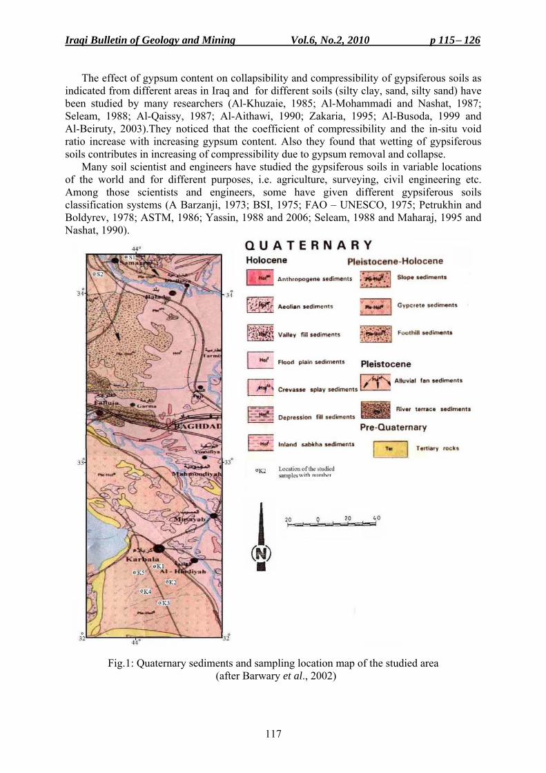
Iraqi Bulletin of Geology and Mining Vol.6, No.2, 2010 p 115− 126
117
The effect of gypsum content on collapsibility and compressibility of gypsiferous soils as indicated from different areas in Iraq and for different soils (silty clay, sand, silty sand) have been studied by many researchers (Al-Khuzaie, 1985; Al-Mohammadi and Nashat, 1987; Seleam, 1988; Al-Qaissy, 1987; Al-Aithawi, 1990; Zakaria, 1995; Al-Busoda, 1999 and Al-Beiruty, 2003).They noticed that the coefficient of compressibility and the in-situ void ratio increase with increasing gypsum content. Also they found that wetting of gypsiferous soils contributes in increasing of compressibility due to gypsum removal and collapse.
Many soil scientist and engineers have studied the gypsiferous soils in variable locations of the world and for different purposes, i.e. agriculture, surveying, civil engineering etc. Among those scientists and engineers, some have given different gypsiferous soils classification systems (A Barzanji, 1973; BSI, 1975; FAO – UNESCO, 1975; Petrukhin and Boldyrev, 1978; ASTM, 1986; Yassin, 1988 and 2006; Seleam, 1988 and Maharaj, 1995 and Nashat, 1990).
Fig.1: Quaternary sediments and sampling location map of the studied area (after Barwary et al., 2002)
with number
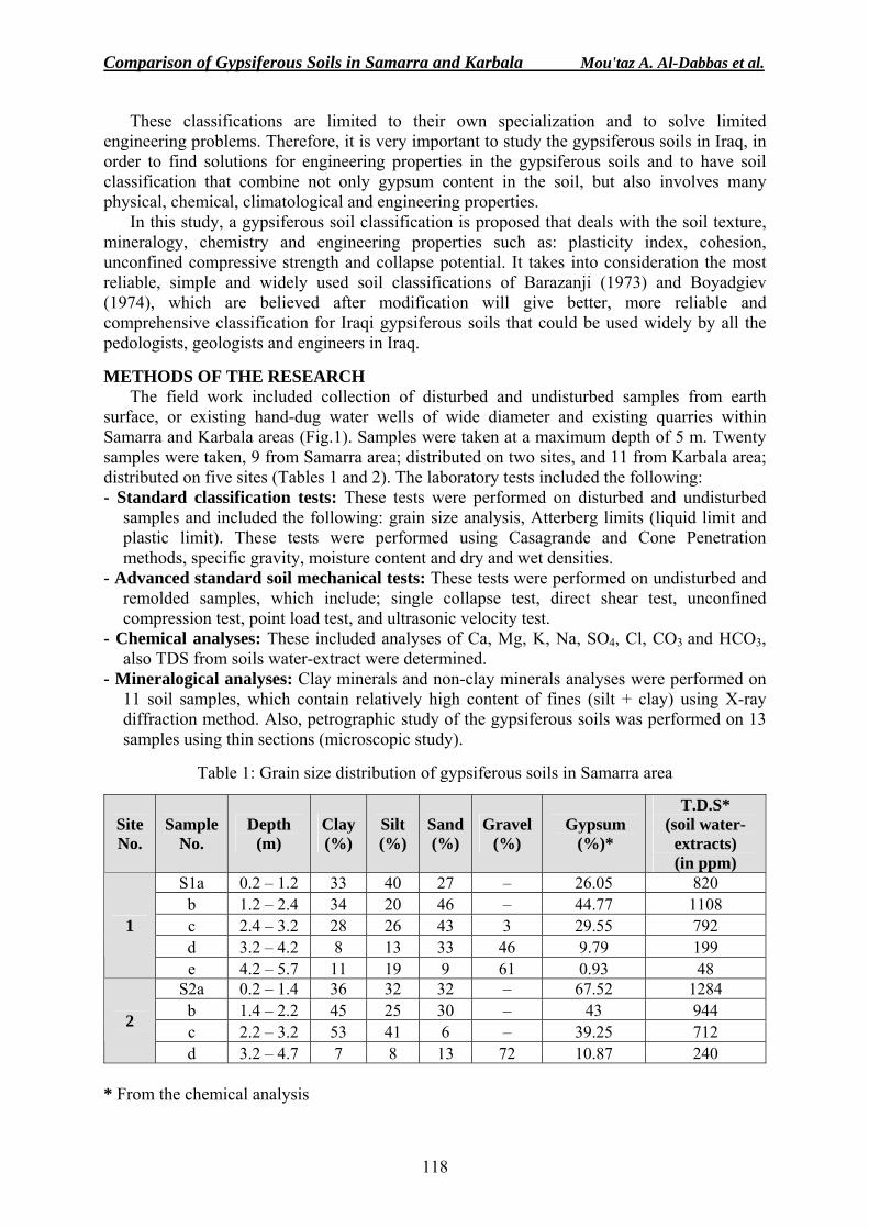
Comparison of Gypsiferous Soils in Samarra and Karbala Mou'taz A. Al-Dabbas et al.
118
These classifications are limited to their own specialization and to solve limited engineering problems. Therefore, it is very important to study the gypsiferous soils in Iraq, in order to find solutions for engineering properties in the gypsiferous soils and to have soil classification that combine not only gypsum content in the soil, but also involves many physical, chemical, climatological and engineering properties.
In this study, a gypsiferous soil classification is proposed that deals with the soil texture, mineralogy, chemistry and engineering properties such as: plasticity index, cohesion, unconfined compressive strength and collapse potential. It takes into consideration the most reliable, simple and widely used soil classifications of Barazanji (1973) and Boyadgiev (1974), which are believed after modification will give better, more reliable and comprehensive classification for Iraqi gypsiferous soils that could be used widely by all the pedologists, geologists and engineers in Iraq.
METHODS OF THE RESEARCH
The field work included collection of disturbed and undisturbed samples from earth surface, or existing hand-dug water wells of wide diameter and existing quarries within Samarra and Karbala areas (Fig.1). Samples were taken at a maximum depth of 5 m. Twenty samples were taken, 9 from Samarra area; distributed on two sites, and 11 from Karbala area; distributed on five sites (Tables 1 and 2). The laboratory tests included the following: - Standard classification tests: These tests were performed on disturbed and undisturbed
samples and included the following: grain size analysis, Atterberg limits (liquid limit and plastic limit). These tests were performed using Casagrande and Cone Penetration methods, specific gravity, moisture content and dry and wet densities.
- Advanced standard soil mechanical tests: These tests were performed on undisturbed and remolded samples, which include; single collapse test, direct shear test, unconfined compression test, point load test, and ultrasonic velocity test.
- Chemical analyses: These included analyses of Ca, Mg, K, Na, SO4, Cl, CO3 and HCO3, also TDS from soils water-extract were determined.
- Mineralogical analyses: Clay minerals and non-clay minerals analyses were performed on 11 soil samples, which contain relatively high content of fines (silt + clay) using X-ray diffraction method. Also, petrographic study of the gypsiferous soils was performed on 13 samples using thin sections (microscopic study).
Table 1: Grain size distribution of gypsiferous soils in Samarra area
Site No.
Sample No.
Depth (m)
Clay (%)
Silt (%)
Sand (%)
Gravel (%)
Gypsum (%)*
T.D.S* (soil water-
extracts) (in ppm)
S1a 0.2 – 1.2 33 40 27 – 26.05 820 b 1.2 – 2.4 34 20 46 – 44.77 1108 c 2.4 – 3.2 28 26 43 3 29.55 792 d 3.2 – 4.2 8 13 33 46 9.79 199
1
e 4.2 – 5.7 11 19 9 61 0.93 48 S2a 0.2 – 1.4 36 32 32 – 67.52 1284
b 1.4 – 2.2 45 25 30 – 43 944 c 2.2 – 3.2 53 41 6 – 39.25 712 2
d 3.2 – 4.7 7 8 13 72 10.87 240 * From the chemical analysis
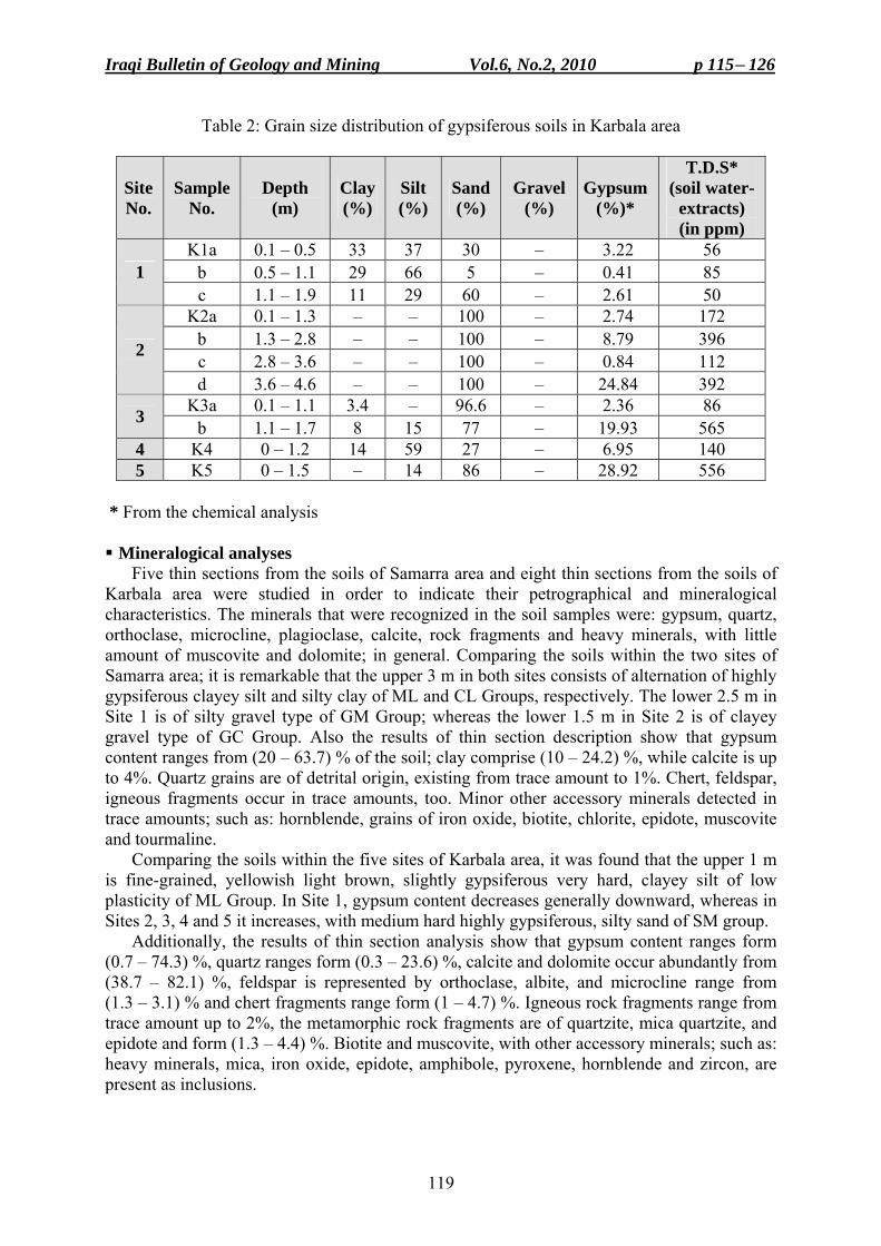
Iraqi Bulletin of Geology and Mining Vol.6, No.2, 2010 p 115− 126
119
Table 2: Grain size distribution of gypsiferous soils in Karbala area
Site No.
Sample No.
Depth (m)
Clay (%)
Silt (%)
Sand(%)
Gravel (%)
Gypsum (%)*
T.D.S* (soil water-
extracts) (in ppm)
K1a 0.1 – 0.5 33 37 30 – 3.22 56 b 0.5 – 1.1 29 66 5 – 0.41 85 1 c 1.1 – 1.9 11 29 60 – 2.61 50
K2a 0.1 – 1.3 – – 100 – 2.74 172 b 1.3 – 2.8 – – 100 – 8.79 396 c 2.8 – 3.6 – – 100 – 0.84 112 2
d 3.6 – 4.6 – – 100 – 24.84 392 K3a 0.1 – 1.1 3.4 – 96.6 – 2.36 86 3 b 1.1 – 1.7 8 15 77 – 19.93 565
4 K4 0 – 1.2 14 59 27 – 6.95 140 5 K5 0 – 1.5 – 14 86 – 28.92 556
* From the chemical analysis Mineralogical analyses
Five thin sections from the soils of Samarra area and eight thin sections from the soils of Karbala area were studied in order to indicate their petrographical and mineralogical characteristics. The minerals that were recognized in the soil samples were: gypsum, quartz, orthoclase, microcline, plagioclase, calcite, rock fragments and heavy minerals, with little amount of muscovite and dolomite; in general. Comparing the soils within the two sites of Samarra area; it is remarkable that the upper 3 m in both sites consists of alternation of highly gypsiferous clayey silt and silty clay of ML and CL Groups, respectively. The lower 2.5 m in Site 1 is of silty gravel type of GM Group; whereas the lower 1.5 m in Site 2 is of clayey gravel type of GC Group. Also the results of thin section description show that gypsum content ranges from (20 – 63.7) % of the soil; clay comprise (10 – 24.2) %, while calcite is up to 4%. Quartz grains are of detrital origin, existing from trace amount to 1%. Chert, feldspar, igneous fragments occur in trace amounts, too. Minor other accessory minerals detected in trace amounts; such as: hornblende, grains of iron oxide, biotite, chlorite, epidote, muscovite and tourmaline.
Comparing the soils within the five sites of Karbala area, it was found that the upper 1 m is fine-grained, yellowish light brown, slightly gypsiferous very hard, clayey silt of low plasticity of ML Group. In Site 1, gypsum content decreases generally downward, whereas in Sites 2, 3, 4 and 5 it increases, with medium hard highly gypsiferous, silty sand of SM group.
Additionally, the results of thin section analysis show that gypsum content ranges form (0.7 – 74.3) %, quartz ranges form (0.3 – 23.6) %, calcite and dolomite occur abundantly from (38.7 – 82.1) %, feldspar is represented by orthoclase, albite, and microcline range from (1.3 – 3.1) % and chert fragments range form (1 – 4.7) %. Igneous rock fragments range from trace amount up to 2%, the metamorphic rock fragments are of quartzite, mica quartzite, and epidote and form (1.3 – 4.4) %. Biotite and muscovite, with other accessory minerals; such as: heavy minerals, mica, iron oxide, epidote, amphibole, pyroxene, hornblende and zircon, are present as inclusions.
Comparison of Gypsiferous Soils in Samarra and Karbala Mou'taz A. Al-Dabbas et al.
120
X-Ray Diffraction The soil of the study area is examined by X-Ray diffraction method (XRD). Samples were
prepared as bulk samples in order to study clay type and non-clay minerals. The results reflect that non-clay type minerals, in the studied soils are: quartz, calcite, dolomite, gypsum and feldspar; while the clay minerals are: chlorite, montmorillonite, kaolinite, illite and palygorskite. The dominant presence of palygorskite among the clay minerals reflects the arid and semi-arid climatic conditions. These clay minerals require alkaline environment and high to moderate Mg-salinity. The aridity and hot climate are obvious in the whole study area indicated by the gypsiferous soils in Samarra area and by the gypsiferous aeolian sand in Karbala area. Geochemistry of Water-Extracts of Gypsiferous Soils
The soil pore water-extracts were analyzed for major cations and anions in order to throw some light on the hydrochemistry of the salt-bearing soil that caused post depositional enrichment; of these sediments with gypsum and other salts. Gypsum occurs within the study areas as secondary gypsum of different sizes; or as crystals formed as a result of leaching rocks of Fatha Formation by rain water or capillary action of the groundwater.
Twenty disturbed samples were collected from two areas; of which 9 samples are distributed on two sites from Samarra area and 11 samples are distributed on five sites from Karbala area. Gypsum content of the samples was estimated from the chemical analysis of the water-extracts and the major cations and anions concentration for soil-water extract from the study areas were determined. Total Dissolved Solids (TDS)
In Samarra area, TDS range from (48 – 1284) mg/l, averaged 683 mg/l, whereas in Karbala area, TDS range from (50 – 565) mg/l, averaged 237.3 mg/l. It is noticeable that soil salinity in Karbala area is considerably lower than that of Samarra area. Major Ions
– Cations: The Calcium (Ca2+) has the widest occurrence among other elements in the soil. In the study area at Samarra, the Calcium (Ca2+) ranges from (52.4 – 99.7) epm %, averaging 65.4 epm %, whereas in Karbala, the Calcium (Ca2+) ranges from (42.3 – 89.3) epm %. Magnesium (Mg2+) in Samarra ranges from (0.2 – 5.9) epm %, averaging 1.9 epm %, while in Karbala, the Magnesium (Mg2+) ranges from (0.5 – 21.7) epm % averaging 5.6 epm %. The Sodium (Na+) ranges in Samarra from (0 – 46.5) epm %, averaging 32.5 epm %, whereas in Karbala ranges from (0 – 46.9) epm % averaging 30.6 epm %. The Potassium (K+) ranges in Samarra from (0 – 1.5) epm %, averaging 0.3 epm %, whereas in Karbala ranges from (0.1 – 4.8) epm %, averaging 1.3 epm %. – Anions: The Sulphate (SO4
2-) in Samarra ranges from (0 – 97.1) epm %, averaging 82.0 epm %, whereas in Karbala ranges from (0 – 92.8) epm %, averaging 62.1 epm %. The Chloride (Cl-) in Samarra ranges from (0.8 – 29.4) epm %, averaging 6.0 epm %, whereas in Karbala ranges from (3.7 – 36.2) epm %, averaging 14.7 epm %. The Carbonate (CO3
2-) ions in the study areas are totally absent, while bicarbonate (HCO3
-) ions in Samarra ranges from (1.6 – 70.6) epm %, averaging 12.0 epm % and in Karbala ranges from (3.4 – 76.2) epm %, averaging 23.2 epm %.
It is remarkable that calcium is the dominant cation in the whole studied areas, followed by sodium ion, whereas potassium and magnesium ions are of low content. On the other hand, sulphate is the prevailing anion followed by bicarbonate ion, while Chloride ion is of low concentration. Ca2+ and SO4
2- dominate the ionic composition of the water-extracts in sections of Samarra and Karbala areas. Na+ is the second cation in all samples, whereas Cl- or HCO3
-
Iraqi Bulletin of Geology and Mining Vol.6, No.2, 2010 p 115− 126
121
is the second anion. The latter is more dominant than the former, especially at the lower parts of both sections. However, Na+, HCO3
- and Cl- show higher concentrations in the lower parts, where Ca2+ and SO4
2+ are decreased. Moreover, gypsum is present almost in all fractions of the soil, which increases with increase of the fine fractions. Obviously, Ca2+ and SO4
2- amounts in the soil water-extract also (generally) increases with increase of gypsum content. GEOTECHNICAL PROPERTIES
Geotechnical properties of the soil represent the physical and the engineering properties of the soil as well, these properties were studied and determined in Samarra and Karbala areas, the results are discussed hereinafter: Physical Properties of the Soil
The following two parameters were studied: – Grain size distribution: Twenty samples were examined according to ASTM (1986), to find weight percentages of different sizes of dry soil samples. The results indicate that in Samarra area, clay fraction ranges from (7 – 53) %, averaging 28.3%. Silt fraction ranges from (8 – 41) %, averaging 24.9%. Sand ranges from (6 – 46) %, averaging 26.6%. Gravel ranges from (0 – 72) %, averaging 20.2%. While, in Karbala area, clay ranges from (0 – 33) %, averaging 8.7%. Silt ranges from (0 – 66) %, averaging 20.2%. Sand ranges from (5 – 100) %, averaging 71.1%. It was found that the fine sand fraction is the prevailing size within the studied samples. Grading was determined by estimating two parameters from the grain size distribution curves, which are the uniformity coefficient, Cu = D 60/ D 10, and the coefficient of curvature Cc = D10 x D60/ (D30). It was found that the samples are entirely poorly graded. – Atterberg Limits: Atterberg limits were determined for soils of the studied area, according to Casagrande method and the Cone Penetrometer Test (ASTM, 1986 and BSI, 1975). In Samarra area, liquid limit values of the soil range from (28.7 – 56.6) %, averaging 38.6%, indicating low to high plasticity. In Karbala area, liquid limit values of the soil ranges from (27.8 – 33.6) %, averaging 30.7%, indicating low plasticity, few samples are non-plastic.
The soils of the studied area were classified according to the liquid limit depending on Clayton and Jukes (1978) classification. In Samarra area, 66.67% of the samples are of low plasticity, 11.11% of intermediate plasticity and 22.22% of high plasticity. In Karbala area, 100% of the samples are of low plasticity. The Plastic Limit, in Samarra area, ranges from (20.5 – 44.2) %, averaging 28.1%, while in Karbala area ranges from (19.5 – 26.4) %, averaging 22.7%, few samples are non plastic. The Plasticity Index in Samarra area ranges from 5.3 – 27.1, averaging 10.5, therefore, indicating low to high plasticity. In Karbala area, the Plasticity Index, ranges from 1.4 – 14.1, averaging 8.0, indicating almost plastic to medium plasticity, few samples are non plastic. According to Al-Asho (1991) classification it was found that in Samarra area, 66.67% of the samples are of low plasticity, 22.22% of medium plasticity, and 11.11% of high plasticity. In Karbala area, 45.45% of the samples are of low plasticity, 36.36% are non-plastic, and 9.09% are plastic and 9.09% of medium plasticity. The plasticity index of the majority of the samples is less than 15.
The specific gravity values of the soil samples revealed that in Samarra and Karbala areas, they range from 2.18 – 2.56, averaging 2.3, and from 2.38 – 2.73, averaging 2.5, respectively. The unit weights or dry densities were calculated from partly undisturbed samples in the studied areas; the results show that in Samarra area, ranges from (1.26 – 1.87) g/cm3, averaging 1.5 g/cm3, while in Karbala area, ranges from (1.66 – 2.07) g/cm3, averaging 1.8 g/cm3.
Comparison of Gypsiferous Soils in Samarra and Karbala Mou'taz A. Al-Dabbas et al.
122
The Engineering Properties of the Studied Soils Engineering properties of the soils were studied within two areas (Samarra and Karbala),
which included single collapse test, direct shear test, unconfined compressive strength test, ultra sonic velocity test and point load test. The results are mentioned hereinafter. – Shear Strength: In this study, unconsolidated – undrained (UU) direct shear test was performed (Das, 1985). The ø and c values were estimated by plotting normal stress values (100, 200 and 400 KN/m2) against shear strength (KN/m2) measured from the test represented by two components, the cohesion (c) and the angle of internal friction (ø). However, direct shear test results revealed that in the study areas, at Samarra, cohesion varies between (8 – 42) KN/m2, averaging 23 KN/m2, whereas internal friction angle ranges from (31– 45)°, averaging 39°. At Karbala area, cohesion ranges from (3 – 31) KN/m2, averaging 14.8 KN/m2, whereas internal friction angle varies between (27 – 45)°, averaging 36°.
The relatively high cohesion values in Samarra area are attributed to the relatively higher gypsum and fines (silt and clay) contents, as compared to Karbala area, as cohesion and grain size are inversely proportional (Maharaj, 1995). On the other hand, the relatively higher sand content and lower gypsum content of the latter seems to have minor effect on the internal friction angles, as their average values are almost identical or very close.
Also internal friction angle (øu) is affected by soil density as it increases with interlocking of particles, which means a higher density. Moreover, the presence of clay minerals like illite, chlorite and montmorillonite decreases the internal friction angle (øu), as they cause sliding and decreases resistance at contact points from microstructure during shearing (Mitchell, 1993). – Unconfined Compressive Test: The unconfined compressive strength for undisturbed samples collected from block samples, was measured. Samples were tested in both dry and soaked states. Different soaking periods were used, varied from few minutes, hours and days. As wetting fluid, distilled water was used. Eleven samples were tested in unconfined compressive strength, of which 8 were in dry condition, as they have low compressive strength values, while 3 samples were tested and have disintegrated at soaking. Unconfined compressive strength values, in dry condition ranges from (0 – 21.3) MN/m2, averaging 1.4 MN/m2; for Karbala soils, while it was found to be 0.0 for Samara soils. – Ultrasonic Wave Velocity Test: This non-destructive dynamic test was performed to determine the dynamic properties of gypsiferous soils involving compressional wave velocity (Vp) and shear wave velocity (Vs). Samples were tested in both dry and soaked states; the same soaking periods as in unconfined compressive test were used. Eight samples were tested, of which 5 were in dry condition, as they have low compressive strength and have disintegrated at soaking, 3 were tested in both dry and soaked conditions. Compression wave velocities in dry condition range from (1.56 – 2.53) Km/sec, averaging 2.1 Km/sec for Karbala soils, while it is zero for Samara soils. Shear wave velocities in dry condition range from (0.93 – 1.43) Km/sec, averaging 1.2 Km/sec for Karbala soils and is zero for Samara soils. – Collapsibility and Compressibility: The method of Kezdi (1980) is followed in the present study, except that the samples were dried due to their remolded nature and water was added at 200 and 400 KPa soaking pressure. The soils of the studied areas were tested using remolded cylindrical samples of 19 mm height and 75 mm or 50 mm diameter (B.S.I., 1975). Initial void ratio (eo) is determined and the change in void ratio with applied pressure was computed from which collapse curves were plotted and collapse potential (CP %) was estimated, with compression index (Cc) and swelling index (Cr). Pressures of 50, 100, 200, 400 and 800 KPa were used. In the study area, at Samarra, CP values range from (1.07 – 6.83) %, averaging
Iraqi Bulletin of Geology and Mining Vol.6, No.2, 2010 p 115− 126
123
3.8%. Compression index ranges from (0.0299 – 0.28), averaging 0.1158, swelling index ranges from (0.0036 – 0.0202), averaging 0.0117. CP values range suggests a severity of problem (Moderate Trouble – Trouble) averaging Moderate Trouble. In Karbala, CP values range from (0.09 – 2.8) %, averaging 0.8%. CP values range suggests a severity of problems (No problem – Moderate Trouble) averaging to No problem. – Void Ratio (e): The Void ratio (e) in the study areas, was studied, it ranges at Samarra from (0.35 – 0.73), averaging 0.53, whereas at Karbala ranges from (0.206 – 0.598) averaging 0.4. The variation in void ratio may be attributed to overburden pressure and differences in fine and coarse fractions of the soil. – Compression Index (Cc): In the study area, at Samarra, Cc values range from (0.03 – 0.28), averaging 0.116 and at Karbala range from (0.03 – 0.31), averaging 0.11. The change in compression index values is related to the changes in void ratio of the soil, which in turn depends on the soil type. It is noticeable that as sand content increases, compression index decreases, therefore, clayey soils are more compressible than sandy soil. – Swelling Index (Cr): In the study area, at Samarra, Cr values range from (0.004 – 0.02), averaging 0.012 and at Karbala range from (0.002 – 0.03), averaging 0.012. Swelling index depends on the soil type, as clayey soils have higher swelling ability than sandy soils. DISCUSSION
Many soil scientist and engineers, worldwide have studied the gypsiferous soils in variable locations of the world and for different purposes, i.e. agriculture, surveying, civil engineering, etc., among those scientists and engineers, some had suggested different gypsiferous soils classifications. Those classifications often are limited to their own specialization and to solve limited engineering problems. Therefore, it is essential to have a soil classification that combines not only gypsum content in the soil, but also involves relevant physical, chemical, climatological and engineering properties. In this research, a new gypsiferous soil classification is proposed that invokes soil texture, mineralogy, chemistry and engineering properties, such as plasticity index, cohesion, unconfined compressive strength and collapse potential. These parameters were indicated by the results of this research for the studied areas, taking into consideration the most reliable, simple and widely used soil classification of Barzanji (1973). Therefore, it is believed that modifying the classification of Barzanji (1973) will give better, more reliable and comprehensive classification for Iraqi gypsiferous soils that could be used widely by all pedologists, geologists and other scientists and engineers (Table 3).
Concerning the relationship between silt and clay percentage, and plasticity index, it is noticed that there are positive relationships between them. The relation of collapsibility, void ratio, collapsibility index, compression index and swelling index with TDS, soil constituents, compression index and swelling index show significant relations. Also, it was noticed that as density increases, void ratio decreases.
Collapsibility index is affected by void ratio showing a positive relation. This depends on fine and coarse materials content, water content, and also on gypsum content. Also liquid limit and plasticity index values affect the collapsibility index, as their values increase the collapsibility index decreases. Variation in compression index relates to variation in void ratio, which in turn depends on soil type. There is a significant relation between shear strength, cohesion (c), friction angle (ø), sand content, dry density and gypsum content of the soils, in the study area. Silt and clay show also positive weak relations as cohesion increases with increase of the fine materials.
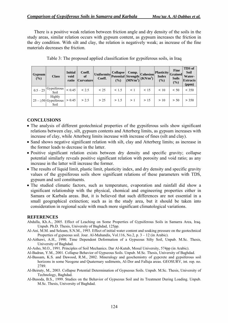
Comparison of Gypsiferous Soils in Samarra and Karbala Mou'taz A. Al-Dabbas et al.
124
There is a positive weak relation between friction angle and dry density of the soils in the study areas, similar relation occurs with gypsum content, as gypsum increases the friction in the dry condition. With silt and clay, the relation is negatively weak; as increase of the fine materials decreases the friction.
Table 3: The proposed applied classification for gypsiferous soils, in Iraq
Gypsum (%) Class
Initial void ratio
Coeff. of
Curvature
UniformityCoeff.
CollapsePotential
(%)
Comp. Strength(MN/m2)
Cohesion(KN/m2)
Plasticity Index (%)
Fine Grained
Soils (%)
TDS of Soil
Water- Extracts (ppm)
0.5 – 25 Gypsiferous Soil
< 0.45 < 2.5 < 25 < 1.5 < 1 < 15 < 10 < 50 < 350
25 – ≥50 Highly
Gypsiferous Soil
> 0.45 > 2.5 > 25 > 1.5 > 1 > 15 > 10 > 50 > 350
CONCLUSIONS • The analysis of different geotechnical properties of the gypsiferous soils show significant
relations between clay, silt, gypsum contents and Atterberg limits, as gypsum increases with increase of clay, while Atterberg limits increase with increase of fines (silt and clay).
• Sand shows negative significant relation with silt, clay and Atterberg limits; as increase in the former leads to decrease in the latter.
• Positive significant relation exists between dry density and specific gravity; collapse potential similarly reveals positive significant relation with porosity and void ratio; as any increase in the latter will increase the former.
• The results of liquid limit, plastic limit, plasticity index, and dry density and specific gravity values of the gypsiferous soils show significant relations of these parameters with TDS, gypsum and soil constituents.
• The studied climatic factors, such as temperature, evaporation and rainfall did show a significant relationship with the physical, chemical and engineering properties either in Samara or Karbala areas. But, it is believed that such differences are not essential in a small geographical extinction; such as in the study area, but it should be taken into consideration in regional scale with much more significant climatological variations.
REFERENCES Abdulla, Kh.A., 2005. Effect of Leaching on Some Properties of Gypsiferous Soils in Samarra Area, Iraq.
Unpub. Ph.D. Thesis, University of Baghdad, 125pp. Al-Ani, M.M. and Seleam, S.N.M., 1993. Effect of initial water content and soaking pressure on the geotechnical
Properties of gypseous soil. Jour. Al-Muhandis, Vol.116, No.2, p. 3 – 12 (in Arabic). Al-Aithawi, A.H., 1990. Time Dependent Deformation of a Gypseous Silty Soil, Unpub. M.Sc. Thesis,
University of Baghdad. Al-Asho, M.O., 1991. Principles of Soil Mechanics. Dar Al-Kutub, Mosul University, 574pp (in Arabic). Al-Badran, Y.M., 2001. Collapse Behavior of Gypseous Soils. Unpub. M.Sc. Thesis, University of Baghdad. Al-Bassam, K.S. and Dawood, R.M., 2002. Mineralogy and geochemistry of gypcrete and gypsiferous soil
horizons in some Neogene and Quaternary sediments, Al-Dor and Falluja areas. GEOSURV, int. rep. no. 2789.
Al-Beiruty, M., 2003. Collapse Potential Determination of Gypseous Soils. Unpub. M.Sc. Thesis, University of Technology, Baghdad.
Al-Busoda, B.S., 1999. Studies on the Behavior of Gypseous Soil and its Treatment During Loading. Unpub. M.Sc. Thesis, University of Baghdad.
Iraqi Bulletin of Geology and Mining Vol.6, No.2, 2010 p 115− 126
125
Al-Khuzaie, H.M.A., 1985. The Effect of Leaching on the Engineering Properties of Al-Jazirah Soil. Unpub. M.Sc. Thesis, Mosul University.
Al-Layla, M.T., 1993. Problems of gypseous soils and their solution proposal. A lecture given in Civ. Eng. Dept., College of Eng. Mosul University.
Al-Mohammadi, N.M. and Nasha'at, I.H., 1987. Compressibility and collapse of gypseous soils. Proc. of 8th Asian Reg. Conf. on SMFE., Vol. l, Kyoto, Japan, p. 20 – 24.
Al-Qaissy, F.F., 1987. Effect of Gypsum Content and its Migration on Compressibility and Shear Strength of the Soil. Unpub. M.Sc. Thesis, University of Technology, Baghdad.
American Society for Testing Materials (ASTM), 1986. Soil and Rock Building Stones. Sec.4, Vol.04 – 08. Barazanji, A.F., 1973. Gypsiferous Soils of Iraq. D.Sc. Thesis, State University of Ghent, Belgium, p. 1 – 2. Boyadgiev, T.G., 1974. Contribution to the knowledge of gypsiferous soils. AGON/ SF/ SYR/ 67/ 522. FAO,
Rome. British Standards Institution (B.S.I.), 1975. Methods of Testing Soils for Civ. Eng. Purposes, B.S. 1377. Buday, T. and Jassim, S.Z., 1987. The Regional Geology Iraq. Vol.2 Tectonism, Magmatism and
Metamorphism, In: I.I., Kassab and M.J., Abbas (Eds.) GEOSURV, Baghdad, Iraq, 325pp. Buringh, P., 1960. Soils and Soils Condition of Iraq. Minis. of Agric., D.G. of Agric., Research and Project,
Baghdad, 332pp. Das, B.M., 1985. Principles of Geotechnical Engineering. Brooks, Coll. Eng. Div., Calf. FAO – UNESCO., 1975. Soil Map of the World. Vol.1, Legend – UNESCO, Paris. Kezdi, A., 1980. Hand Book of Soil Mechanics. Vol.1.2, Soil Testing Academic Kiado, Budapest. Maharaj, R., 1995. Engineering geological mapping of tropical soils for Land use planning and geotechnical
purpose. Jour. Eng. Geo., Vol.40, No.314, 243pp. Nashat, I.H., 1990. Engineering Characteristics of some Gypseous Soil in Iraq. Unpub. Ph.D. Thesis, University
of Baghdad. Petrukhin, V.P. and Boldyrev, G.B., 1978. Investigation of the deformability of gypsified soil by a static load,
translated from Osnovaniya. MSFE (English), Vol.15, No.3, p. 178 – 182. Petrukhin, V.P. and Arakelyan, E.A., 1985. Strength of Gypsum Clay Soils and its variation during the leaching
of salts. SMFE, Vol.21, No.6. Seleam, S.N., 1988. Geotechnical Characteristics of Gypseous Sandy Soil Including the Effect of Contamination
with Some Oil Products .Unpub. M.Sc. Thesis, University of Technology, Baghdad. Sirwan, K., Al-Omari, R.R. and Nazhat, Y.N.Y., 1989. Shear behavior of gypsiferous soil. Soil Survey Staff,
Soil Taxonomy, A comprehensive system, U.S.D.A. Yassin, M.J., 1988. Some geotechnical properties of soils in the Anah area, Western Desert, Iraq. GEOSURV,
int. rep. no. 1556 Int. Geol. Correl. Prog. (UNESCO), Proc. of the Int. Symp. on the Geol. of Deserts and Desert Env. Vol.1,
p. 197 – 217, Baghdad, Iraq. Yassin, M.J., 2006. Study of geotechnical, mineralogical, and geochemical properties of gypsiferous soils for
selected samples from Samarra, Falluja, Najaf and Karbala areas, Central Iraq. Unpub. Ph.D. Thesis, University of Baghdad.
Zakaria, W.A., 1995. Permeability of Gypseous soil. Unpub. M.Sc. Thesis, University of Technology, Baghdad.
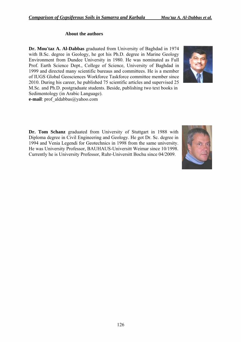
Comparison of Gypsiferous Soils in Samarra and Karbala Mou'taz A. Al-Dabbas et al.
126
About the authors
Dr. Mou'taz A. Al-Dabbas graduated from University of Baghdad in 1974 with B.Sc. degree in Geology, he got his Ph.D. degree in Marine Geology Environment from Dundee University in 1980. He was nominated as Full Prof. Earth Science Dept., College of Science, University of Baghdad in 1999 and directed many scientific bureaus and committees. He is a member of IUGS Global Geosciences Workforce Taskforce committee member since 2010. During his career, he published 75 scientific articles and supervised 25 M.Sc. and Ph.D. postgraduate students. Beside, publishing two text books in Sedimentology (in Arabic Language). e-mail: [email protected]
Dr. Tom Schanz graduated from University of Stuttgart in 1988 with Diploma degree in Civil Engineering and Geology. He got Dr. Sc. degree in 1994 and Venia Legendi for Geotechnics in 1998 from the same university. He was University Professor, BAUHAUS-Universitt Weimar since 10/1998. Currently he is University Professor, Ruhr-Universitt Bochu since 04/2009.
Iraqi Bulletin of Geology and Mining Vol.6, No.2, 2010 p 127− 137
127
INFILTRATION RATES OF SOILS IN SOME LOCATIONS WITHIN ERBIL PLAIN, KURDISTAN REGION, NORTH IRAQ
Galawezh B. Bapeer*, Ali M. Surdashy**and Kareem M. Hassan***
Received: 06/ 12/ 2009, Accepted: 01/ 07/ 2010
Key words: Erbil Plain, Infiltration capacity, Permeability, Porosity
ABSTRACT The present study includes infiltration capacity of Quaternary sediments in some locations
at the middle part of Erbil Plain, which covers a total area of about 1670 Km2. Quaternary sediments cover about 85 % of the study area, which consists mainly of alluvial fans, slope, flood plain, and valley fill sediments. Aeolian sediments and some outcrops of Bai Hassan (ex- Upper Bakhtiari) Formation are also present in northeast, northwest and southeastern parts of the study area. Mukdadiya (ex-Lower Bakhtiari) Formation is also exposed in the northwestern part.
For infiltration tests, seventeen localities are selected in different parts of the study area. These localities were selected according to the texture of the soil and kind of sediments. Depth of infiltration with time is determined for all selected locations.
According to f(t) value, the infiltration capacity of the middle part of Erbil Plain is between Slow – Rapid. The study area is classified in to three zones (A, B and C) based on infiltration results: Zone A: Is located at the northeastern and southeastern parts of the study area, it is
characterized by medium rate of infiltration. Zone B: Is located at the southern part of the study area, it is characterized by slow to
medium rate of infiltration. Zone C: Is located at the northern, northwestern and southwestern parts of the study area, it is
characterized by medium to rapid rate of infiltration. The infiltration capacity results indicated that all parts, except the southern part, of the
study area are considered as a good recharge area for Erbil city, so it is recommended not to use these areas for heavy construction projects to remain as a source of recharge for Erbil city. Whereas, the southern part of the study area is characterized by slow to medium rate of infiltration capacity.
The lithology of the deep wells indicated that the southern part mainly consists of clay with few silt intercalations, where the clay is characterized by high porosity, but low permeability, so the rate of infiltration is low. The other parts of the study area consist of alternation of gravel, sand, silt and clay. Where the gravel, sand and silt are characterized by high porosity and permeability, so the rate of infiltration is high. ___________________________________ * Department of Geotechnic, College of Engineering, University of Koya, Iraq
e-mail: [email protected] ** Assistant Professor, Dean of College of Engineering, University of Koya, Iraq *** Assistant Professor, College of Science, University of Baghdad, Iraq
Infiltration Rates of Soils in Some Locations Within Erbil Plain Galawezh B. Babeer et al.
128
العراقشمال ، كردستانإقليم ،بعض المواقع فى سهل اربيلل سعة الترشيح في الترب
ود حسن كريم محم وود سورداشىكالويز بكر بابير، على محم
مستخلصالتبلغ مساحة و،بيلوسط من سهل أر لبعض المواقع في الجزء األفي الترب تشمل الدراسة الحالية سعة الترشيح
الرباعي المتكونة من المراوح ترسبات العصر ب مغطاة من المنطقة%85 وحوالي .2كم 1670 منطقة الدراسة تقريباً ترسبات الرياح وبعض إلى باإلضافة. الترسبات المالئة للوديان ترسبات السهل الفيضى و، ترسبات المنحدرات،الغرينية
، من منطقة الدراسةلجنوب الشرقيا ول الغربي والشماي الجزء الشمال الشرقيموجودة ف حسن المكاشف تكوين باي .أيضاً الغربي الجزء الشمال فيتكوين المقدادية تكشفاتإضافة إلى
على نسيج تم تحديد هذه المواقع اعتماداً و،لدراسة لغرض تحديد سعة الترشيح منطقة ا فياً موقع17تم اختيار نوع الاستخدم جهاز لقياس سعة الترشيح من .عمق الترشيح مع الوقت لكل المواقعوتم تحديد نوع الرسوبيات التربة و
ترشيح للترب في المناطق المختارة، وتم اختيار هذه ال لقياس سعة (Double ring infiltrometer)الدائري المزدوج معدنيتينويتكون الجهاز من دائرتين. الطريقة لكونها سهلة التطبيق وسريعة التنفيذ ويطبق في المناطق المستوية
سم، ويغرس الجهاز في التربة بعمق 60 سم والخارجي 30 وبقطرين مختلفين، الداخلي بقطر ملم2 بسمك مزدوجتين، 5، 4، 3، 2، 1( سم ويصب الماء في الدائرة الداخلية ويقاس مستوى الماء بشكل مستمر وبفترات زمنية مختافة 15
. ساعات5، وقد استغرق كل فحص حوالي ) دقيقة300و ...... ، 18، 8 ).C وA ، B( ثالث انطقة إلى يمكن تقسيم المنطقة ،الترشيح تجارب على نتائجاعتماداً
. منطقة الدراسةمن الجنوب الشرقي و الجزء الشمال الشرقيفييقع بمعدل ترشيح متوسط وAالنطاق يمتاز .منطقة الدراسة من الجنوبي الجزء فييقع وتوسط مإلى واطئ بمعدل ترشيح B النطاقيمتازمنطقة من الغربيالجنوب والغربي الشمالي والشمال الجزء فييقع سريع وإلى بمعدل ترشيح متوسطC النطاقيمتاز
.الدراسةة تعتبر من مناطق التغذية الجيد، عدا الجزء الجنوبي، منطقة الدراسةءأجزا كافة إن سعة الترشيح نتائجبينت
مدينة اً لتغذية المناطق لمشاريع البناء الضخمة لتبقى مصدرهذهلذلك نوصى بعدم استخدام و،وأطرافها أربيللمدينة .متوسطإلى واطئ من منطقة الدراسة يمتاز بمعدل ترشيح الجنوبي الجزء أربيل، كما آن من الدراسة معظمه متكوني من منطقة بان الجزء الجنوب، المنطقةفيالعميقة المحفورة اآلبار صخارية تبين من
ة ق منطأجزاء بقية أما. ولذلك معدل الترشيح يكون واطئاً واطئة، تكونلكن النفاذية مسامية عالية ووأن الطين له .الطينالرمل والغرين مسامية ونفاذية عالية ووان للحصى .، الغرين والطين الرمل،راسة فتتكون من التعاقب بين الحصىالد . اً معدل الترشيح يكون عالي فانكولذل
.
INTRODUCTION The study area covers about 1670 Km2 within and around Erbil city, which is located
northeast of Iraq. It is bounded by UTM grid 3960000, 4014300 in the north and 364000, 43200 in the east (Fig.1). The area is surrounded by some hills, mountains and valleys. Sharabout and Kasnazan hills are in the north and northeastern parts of the study area. In the southeast; Bestana hills exist, while Awana Mountain forms the southwestern boundary. The Dameer Dagh hills bound the study area from the northwest (Fig.2). It is worth to mention that the middle and southern parts of Erbil Plain are mostly covered by Quaternary sediments.
Infiltration capacity is expressed in terms of the depth of water in millimeters that can infiltrate in the soil in a unit of time (one hour) (Small, 1989). Surface infiltration depends on rain fall density, column water pressure, initial soil water content, pore size and continuity, soil matrices potential and vegetation (Halfman, 2005). Among the other factors that affect on the infiltration rate are: Slope surface, size of rain drops, presence of organic matter, frozen surface, porosity and permeability, compaction and temperature.
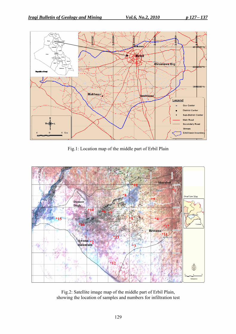
Iraqi Bulletin of Geology and Mining Vol.6, No.2, 2010 p 127− 137
129
Fig.1: Location map of the middle part of Erbil Plain
Fig.2: Satellite image map of the middle part of Erbil Plain, showing the location of samples and numbers for infiltration test
*10
*8 *9
*7 *6 *14
Dameer Dagh
*17
*5 *4 *16
*15
*11 Bestana
*13 *2 Awana
mountain *3
*12
*1
Sharabot
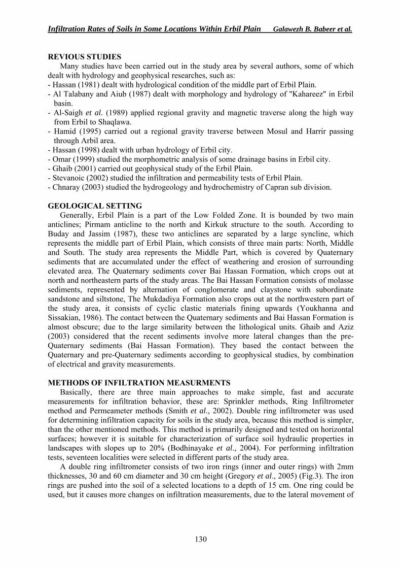
Infiltration Rates of Soils in Some Locations Within Erbil Plain Galawezh B. Babeer et al.
130
REVIOUS STUDIES Many studies have been carried out in the study area by several authors, some of which
dealt with hydrology and geophysical researches, such as: - Hassan (1981) dealt with hydrological condition of the middle part of Erbil Plain. - Al Talabany and Aiub (1987) dealt with morphology and hydrology of "Kahareez" in Erbil
basin. - Al-Saigh et al. (1989) applied regional gravity and magnetic traverse along the high way
from Erbil to Shaqlawa. - Hamid (1995) carried out a regional gravity traverse between Mosul and Harrir passing
through Arbil area. - Hassan (1998) dealt with urban hydrology of Erbil city. - Omar (1999) studied the morphometric analysis of some drainage basins in Erbil city. - Ghaib (2001) carried out geophysical study of the Erbil Plain. - Stevanoic (2002) studied the infiltration and permeability tests of Erbil Plain. - Chnaray (2003) studied the hydrogeology and hydrochemistry of Capran sub division. GEOLOGICAL SETTING
Generally, Erbil Plain is a part of the Low Folded Zone. It is bounded by two main anticlines; Pirmam anticline to the north and Kirkuk structure to the south. According to Buday and Jassim (1987), these two anticlines are separated by a large syncline, which represents the middle part of Erbil Plain, which consists of three main parts: North, Middle and South. The study area represents the Middle Part, which is covered by Quaternary sediments that are accumulated under the effect of weathering and erosion of surrounding elevated area. The Quaternary sediments cover Bai Hassan Formation, which crops out at north and northeastern parts of the study areas. The Bai Hassan Formation consists of molasse sediments, represented by alternation of conglomerate and claystone with subordinate sandstone and siltstone, The Mukdadiya Formation also crops out at the northwestern part of the study area, it consists of cyclic clastic materials fining upwards (Youkhanna and Sissakian, 1986). The contact between the Quaternary sediments and Bai Hassan Formation is almost obscure; due to the large similarity between the lithological units. Ghaib and Aziz (2003) considered that the recent sediments involve more lateral changes than the pre-Quaternary sediments (Bai Hassan Formation). They based the contact between the Quaternary and pre-Quaternary sediments according to geophysical studies, by combination of electrical and gravity measurements. METHODS OF INFILTRATION MEASURMENTS
Basically, there are three main approaches to make simple, fast and accurate measurements for infiltration behavior, these are: Sprinkler methods, Ring Infiltrometer method and Permeameter methods (Smith et al., 2002). Double ring infiltrometer was used for determining infiltration capacity for soils in the study area, because this method is simpler, than the other mentioned methods. This method is primarily designed and tested on horizontal surfaces; however it is suitable for characterization of surface soil hydraulic properties in landscapes with slopes up to 20% (Bodhinayake et al., 2004). For performing infiltration tests, seventeen localities were selected in different parts of the study area.
A double ring infiltrometer consists of two iron rings (inner and outer rings) with 2mm thicknesses, 30 and 60 cm diameter and 30 cm height (Gregory et al., 2005) (Fig.3). The iron rings are pushed into the soil of a selected locations to a depth of 15 cm. One ring could be used, but it causes more changes on infiltration measurements, due to the lateral movement of
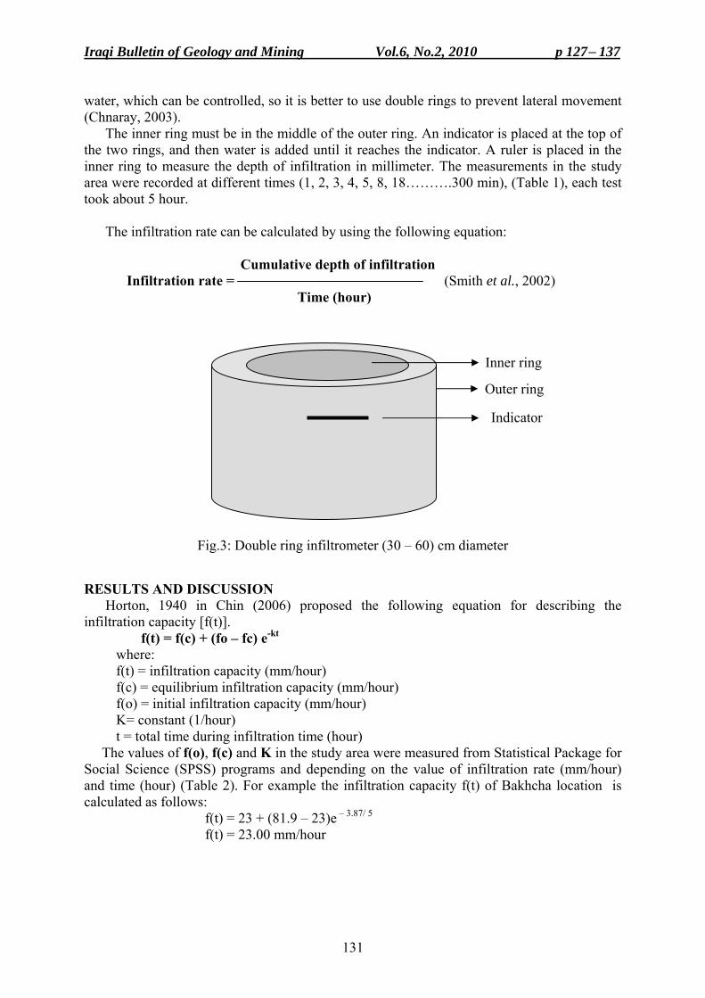
Iraqi Bulletin of Geology and Mining Vol.6, No.2, 2010 p 127− 137
131
water, which can be controlled, so it is better to use double rings to prevent lateral movement (Chnaray, 2003).
The inner ring must be in the middle of the outer ring. An indicator is placed at the top of the two rings, and then water is added until it reaches the indicator. A ruler is placed in the inner ring to measure the depth of infiltration in millimeter. The measurements in the study area were recorded at different times (1, 2, 3, 4, 5, 8, 18……….300 min), (Table 1), each test took about 5 hour.
The infiltration rate can be calculated by using the following equation: Cumulative depth of infiltration Infiltration rate = (Smith et al., 2002) Time (hour)
Fig.3: Double ring infiltrometer (30 – 60) cm diameter
RESULTS AND DISCUSSION Horton, 1940 in Chin (2006) proposed the following equation for describing the
infiltration capacity [f(t)]. f(t) = f(c) + (fo – fc) e-kt
where: f(t) = infiltration capacity (mm/hour) f(c) = equilibrium infiltration capacity (mm/hour) f(o) = initial infiltration capacity (mm/hour) K= constant (1/hour) t = total time during infiltration time (hour)
The values of f(o), f(c) and K in the study area were measured from Statistical Package for Social Science (SPSS) programs and depending on the value of infiltration rate (mm/hour) and time (hour) (Table 2). For example the infiltration capacity f(t) of Bakhcha location is calculated as follows:
f(t) = 23 + (81.9 – 23)e – 3.87/ 5
f(t) = 23.00 mm/hour
Inner ring
Indicator
Outer ring
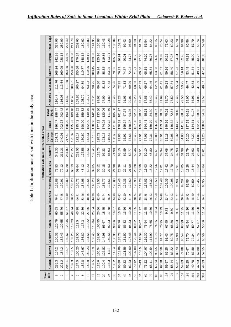
Infiltration Rates of Soils in Some Locations Within Erbil Plain Galawezh B. Babeer et al.
132
Qus
h T
apa
337.
06
259.
09
227.
40
211.
79
202.
65
169.
62
156.
83
141.
95
130.
88
119.
43
112.
28
106.
04
102.
71
99.4
3
96.6
9
94.1
8
91.7
0
89.5
4
84.2
2
80.1
5
76.7
4
72.6
3
69.2
3
66.7
8
64.3
9
60.5
6
57.7
9
55.7
4
52.5
9
Bir
ajna
242.
35
228.
18
204.
60
183.
88
170.
84
148.
12
139.
16
133.
30
125.
16
119.
85
113.
31
105.
58
96.9
1
90.0
1
84.7
7
80.5
8
77.0
6
74.2
0
69.7
6
66.4
8
63.8
3
60.2
8
57.2
7
54.6
1
52.4
5
48.8
3
45.9
9
43.7
6
40.3
3
Shaw
es
168.
24
169.
09
163.
20
158.
36
155.
66
119.
77
110.
06
103.
45
96.2
4
88.3
2
83.0
5
79.5
6
76.9
3
74.7
7
72.9
2
71.2
1
69.6
0
68.1
5
65.6
4
63.5
8
61.6
7
59.8
6
58.4
0
57.2
3
56.1
4
53.4
5
51.3
4
49.7
1
47.7
6
Kas
naza
n
111.
76
113.
64
111.
20
108.
51
106.
27
94.8
9
93.2
3
90.7
5
86.8
0
81.3
2
77.5
3
74.9
6
72.9
5
71.3
3
69.9
9
68.6
3
67.3
3
66.2
7
64.4
6
62.8
9
61.4
1
59.5
3
57.8
4
55.9
4
53.7
5
46.4
7
42.8
3
41.9
9
40.6
7
Ain
Kaw
a
116.
47
116.
06
113.
60
110.
45
109.
88
105.
79
103.
77
102.
25
99.9
2
97.0
9
94.8
0
93.4
6
92.2
8
91.0
3
90.0
1
89.2
0
88.4
3
87.8
8
85.4
2
83.4
6
81.6
9
79.7
0
77.5
0
75.4
6
73.5
6
69.9
0
66.9
6
64.0
6
62.5
7
Erb
il Pa
rk
196.
47
202.
42
193.
80
189.
10
184.
82
159.
32
149.
76
142.
20
133.
80
120.
06
111.
49
105.
58
101.
27
97.7
4
94.9
5
92.6
7
90.5
0
88.5
3
84.3
0
80.9
7
78.0
9
75.0
2
72.6
4
70.4
6
68.6
1
64.5
1
61.2
7
58.6
6
54.0
2
Jmka
196.
47
202.
73
198.
20
195.
97
195.
42
190.
00
182.
99
178.
60
177.
12
174.
92
172.
78
171.
40
170.
31
169.
24
168.
37
167.
30
165.
99
164.
43
159.
79
156.
20
153.
04
149.
36
146.
32
143.
72
141.
45
137.
53
134.
61
132.
25
128.
40
Scie
nce
Col
lege
25
4.71
240.
91
217.
40
195.
37
172.
17
150.
60
142.
51
137.
15
128.
72
123.
15
116.
47
108.
60
99.8
3
92.9
1
87.6
5
83.4
5
79.9
1
77.0
5
72.3
1
68.8
0
65.9
1
62.1
8
59.0
6
56.3
2
54.0
0
50.2
0
47.2
2
44.8
6
41.2
6
Bna
slaw
a
342.
35
311.
21
281.
00
256.
27
232.
53
172.
56
152.
51
138.
45
118.
76
97.3
3
84.0
3
74.9
0
68.1
0
62.8
9
58.7
7
55.4
6
52.5
1
50.1
0
45.8
0
42.6
1
39.9
4
37.0
8
34.7
5
32.9
3
31.3
9
28.7
9
26.9
3
25.3
8
23.0
1
Qus
hTap
a
73.5
3
72.1
2
67.2
0
63.1
3
59.6
4
48.1
2
43.2
3
39.6
5
35.1
2
30.1
8
27.0
3
24.9
8
23.3
6
22.1
1
21.0
9
20.2
8
19.5
9
19.0
3
18.2
2
17.5
6
17.0
1
17.4
2
17.7
0
17.9
1
18.0
5
18.2
8
18.4
4
18.5
2
18.6
4
Mas
taw
a
165.
88
170.
91
165.
80
163.
28
160.
72
154.
06
149.
64
146.
20
141.
56
135.
77
131.
61
128.
88
126.
48
124.
33
122.
60
120.
98
119.
28
117.
83
115.
32
112.
58
109.
48
105.
35
100.
98
96.9
8
93.2
8
86.5
5
80.5
0
75.4
5
66.9
5
Bak
hcha
79.4
1
77.8
8
74.4
0
70.1
5
66.5
1
53.4
6
48.3
8
44.7
0
42.0
0
38.7
4
36.3
5
34.8
0
33.4
5
32.2
0
31.1
5
30.2
4
29.2
9
28.3
8
26.8
2
25.6
0
24.4
9
23.1
7
22.1
2
21.2
7
20.5
4
19.3
3
18.4
0
17.6
4
16.5
1
Pird
awd
60.6
3
55.7
6
51.8
7
46.7
4
40.9
8
32.8
6
27.5
6
25.5
4
20.6
6
18.4
5
17.7
8
16.8
7
15.2
5
13.5
6
13.0
0
11.6
5
11.7
7
11.4
5
10.5
6
10.3
4
10.3
3
9.73
9.50
9.50
11.2
5
11.3
0
11.5
0
12.0
0
11.5
4
Satu
re
120.
76
120.
55
120.
45
119.
23
119.
5
117.
3
110.
22
115.
34
100.
55
95.6
7
92.3
3
90.5
6
88.7
6
86.8
2
84.3
3
80.5
2
80.6
7
78.5
4
76.6
5
74.2
5
70.9
5
67.4
5
66.8
6
66.5
3
63.9
9
61.5
4
59.7
7
57.8
7
55.5
6
Kur
daw
a
160.
32
162.
43
160.
67
159.
25
159.
50
156.
80
154.
55
153.
45
151.
66
144.
98
140.
56
138.
95
135.
78
131.
50
127.
45
122.
44
118.
54
116.
30
114.
90
100.
76
94.7
7
91.4
3
89.7
5
87.9
8
80.5
4
75.7
0
72.3
4
68.7
6
65.5
6
Sada
wa
154.
2
154.
2
153.
7
152.
5
150.
25
146.
67
140.
23
136.
3
130.
54
122.
82
1118
115.
4
113.
89
111.
56
109.
60
107.
80
105.
5
104.
97
100.
54
95.6
5
90.5
0
85.2
5
83.2
2
80.7
3
74.8
8
70.6
7
67.8
0
62.8
0
57.5
5
Infil
trat
ion
rate
(mm
) in
the
test
ed a
reas
Grd
ish
235.
3
221.
2
208.
11
187.
3
174.
5
152.
8
143.
9
137.
5
125.
6
120.
4
115.
3
103.
2
95.8
8
89.2
2
83.2
3
79.1
2
76.4
3
73.2
2
68.1
1
65.2
4
62.7
8
59.5
7
58.4
4
56.8
7
54.8
3
52.2
5
49.7
8
47.9
3
44.2
3
Tim
e m
in
1 2 3 4 5 8 10
12
15
20
25
30
35
40
45
50
55
60
70
80
90
105
120
135
150
180
210
240
300
Tabl
e 1:
Infil
tratio
n ra
te o
f soi
l with
tim
e in
the
stud
y ar
ea
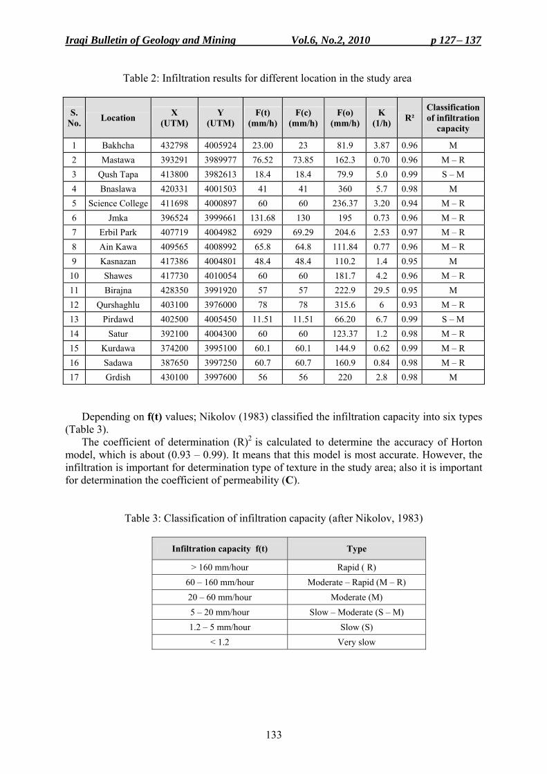
Iraqi Bulletin of Geology and Mining Vol.6, No.2, 2010 p 127− 137
133
Table 2: Infiltration results for different location in the study area
S. No. Location X
(UTM) Y
(UTM) F(t)
(mm/h) F(c)
(mm/h) F(o)
(mm/h) K
(1/h) R² Classification of infiltration
capacity
1 Bakhcha 432798 4005924 23.00 23 81.9 3.87 0.96 M 2 Mastawa 393291 3989977 76.52 73.85 162.3 0.70 0.96 M – R 3 Qush Tapa 413800 3982613 18.4 18.4 79.9 5.0 0.99 S – M 4 Bnaslawa 420331 4001503 41 41 360 5.7 0.98 M 5 Science College 411698 4000897 60 60 236.37 3.20 0.94 M – R 6 Jmka 396524 3999661 131.68 130 195 0.73 0.96 M – R 7 Erbil Park 407719 4004982 6929 69.29 204.6 2.53 0.97 M – R 8 Ain Kawa 409565 4008992 65.8 64.8 111.84 0.77 0.96 M – R 9 Kasnazan 417386 4004801 48.4 48.4 110.2 1.4 0.95 M
10 Shawes 417730 4010054 60 60 181.7 4.2 0.96 M – R 11 Birajna 428350 3991920 57 57 222.9 29.5 0.95 M 12 Qurshaghlu 403100 3976000 78 78 315.6 6 0.93 M – R 13 Pirdawd 402500 4005450 11.51 11.51 66.20 6.7 0.99 S – M 14 Satur 392100 4004300 60 60 123.37 1.2 0.98 M – R 15 Kurdawa 374200 3995100 60.1 60.1 144.9 0.62 0.99 M – R 16 Sadawa 387650 3997250 60.7 60.7 160.9 0.84 0.98 M – R 17 Grdish 430100 3997600 56 56 220 2.8 0.98 M
Depending on f(t) values; Nikolov (1983) classified the infiltration capacity into six types (Table 3).
The coefficient of determination (R)2 is calculated to determine the accuracy of Horton model, which is about (0.93 – 0.99). It means that this model is most accurate. However, the infiltration is important for determination type of texture in the study area; also it is important for determination the coefficient of permeability (C).
Table 3: Classification of infiltration capacity (after Nikolov, 1983)
Type Infiltration capacity f(t)
Rapid ( R) > 160 mm/hour Moderate – Rapid (M – R) 60 – 160 mm/hour
Moderate (M) 20 – 60 mm/hour Slow – Moderate (S – M) 5 – 20 mm/hour
Slow (S) 1.2 – 5 mm/hour Very slow < 1.2
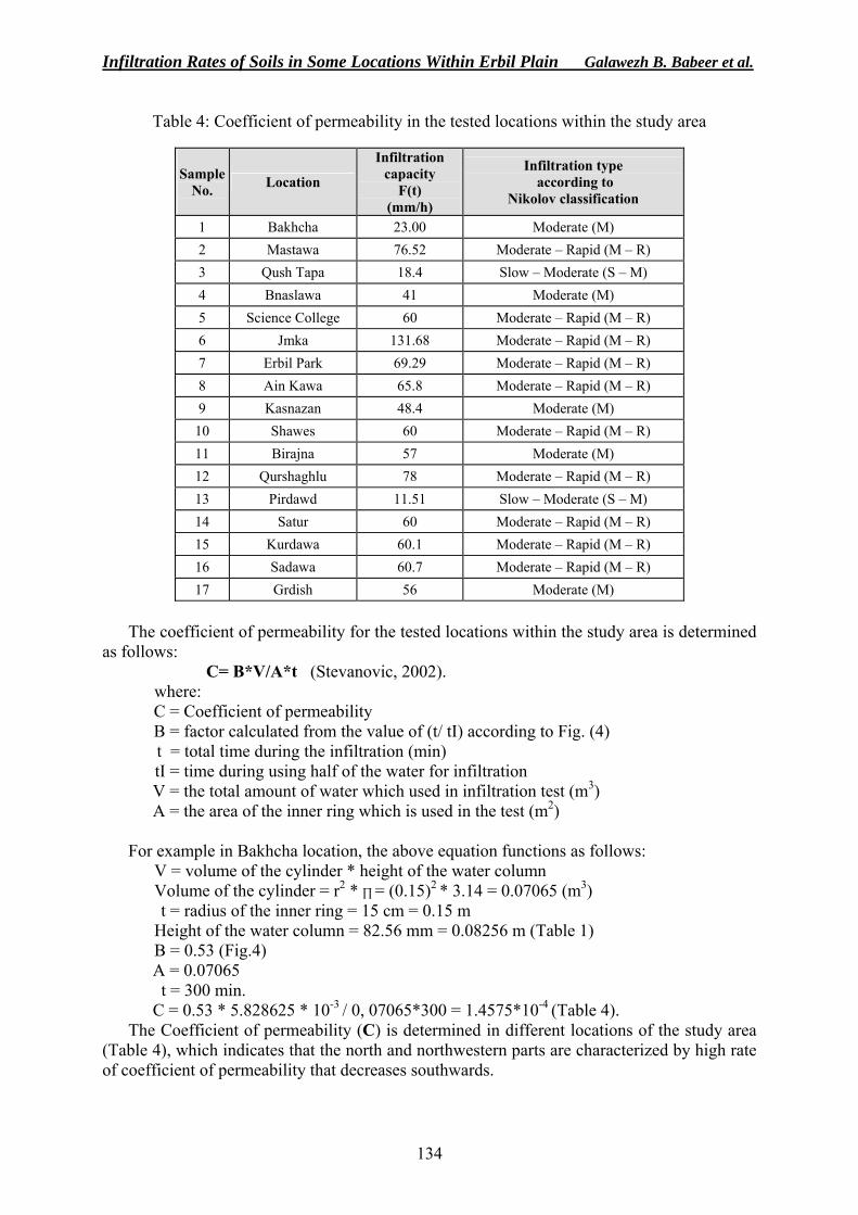
Infiltration Rates of Soils in Some Locations Within Erbil Plain Galawezh B. Babeer et al.
134
Table 4: Coefficient of permeability in the tested locations within the study area
Sample
No.
Location
Infiltration capacity
F(t) (mm/h)
Infiltration type according to
Nikolov classification
1 Bakhcha 23.00 Moderate (M) 2 Mastawa 76.52 Moderate – Rapid (M – R) 3 Qush Tapa 18.4 Slow – Moderate (S – M) 4 Bnaslawa 41 Moderate (M) 5 Science College 60 Moderate – Rapid (M – R) 6 Jmka 131.68 Moderate – Rapid (M – R) 7 Erbil Park 69.29 Moderate – Rapid (M – R) 8 Ain Kawa 65.8 Moderate – Rapid (M – R) 9 Kasnazan 48.4 Moderate (M)
10 Shawes 60 Moderate – Rapid (M – R) 11 Birajna 57 Moderate (M) 12 Qurshaghlu 78 Moderate – Rapid (M – R) 13 Pirdawd 11.51 Slow – Moderate (S – M) 14 Satur 60 Moderate – Rapid (M – R) 15 Kurdawa 60.1 Moderate – Rapid (M – R) 16 Sadawa 60.7 Moderate – Rapid (M – R) 17 Grdish 56 Moderate (M)
The coefficient of permeability for the tested locations within the study area is determined
as follows: C= B*V/A*t (Stevanovic, 2002). where:
C = Coefficient of permeability B = factor calculated from the value of (t/ tI) according to Fig. (4) t = total time during the infiltration (min) tI = time during using half of the water for infiltration V = the total amount of water which used in infiltration test (m3) A = the area of the inner ring which is used in the test (m2)
For example in Bakhcha location, the above equation functions as follows:
V = volume of the cylinder * height of the water column Volume of the cylinder = r2 * ∏ = (0.15)2 * 3.14 = 0.07065 (m3) t = radius of the inner ring = 15 cm = 0.15 m
Height of the water column = 82.56 mm = 0.08256 m (Table 1) B = 0.53 (Fig.4) A = 0.07065 t = 300 min. C = 0.53 * 5.828625 * 10-3 / 0, 07065*300 = 1.4575*10-4 (Table 4).
The Coefficient of permeability (C) is determined in different locations of the study area (Table 4), which indicates that the north and northwestern parts are characterized by high rate of coefficient of permeability that decreases southwards.
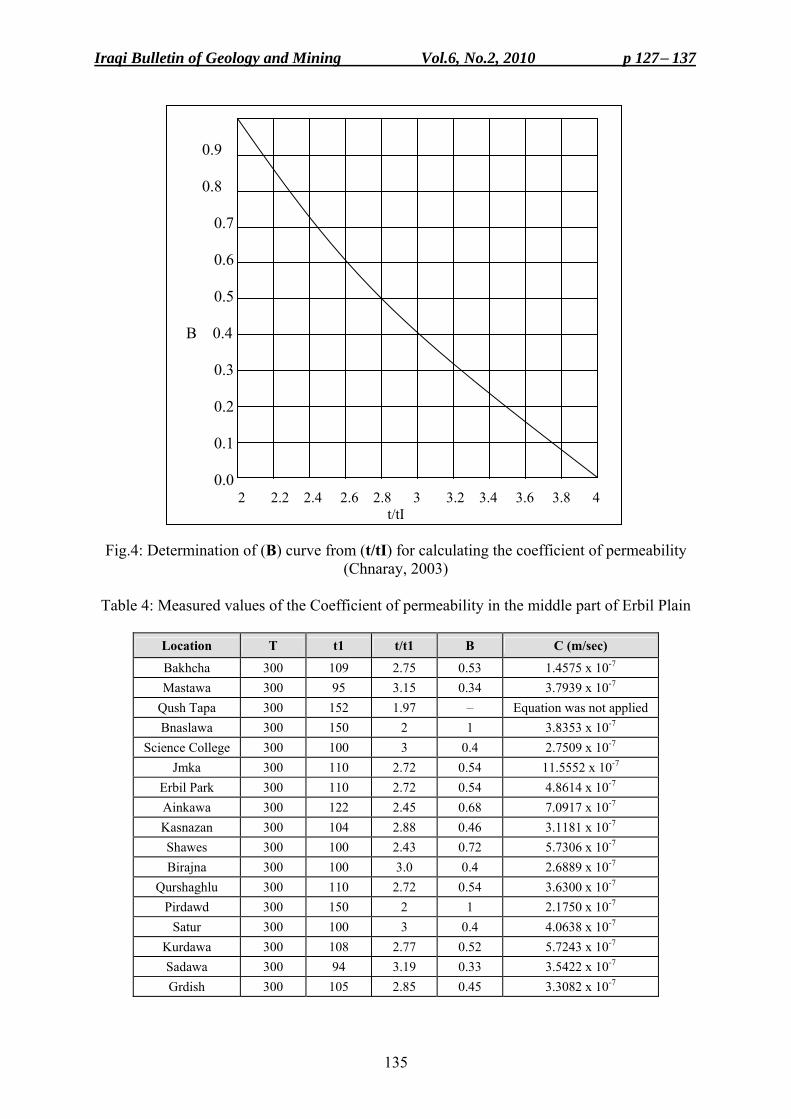
Iraqi Bulletin of Geology and Mining Vol.6, No.2, 2010 p 127− 137
135
0.9 0.8 0.7 0.6
0.5 B 0.4
0.3
0.2
0.1
0.0 2 2.2 2.4 2.6 2.8 3 3.2 3.4 3.6 3.8 4
t/tI
Fig.4: Determination of (B) curve from (t/tI) for calculating the coefficient of permeability (Chnaray, 2003)
Table 4: Measured values of the Coefficient of permeability in the middle part of Erbil Plain
Location T t1 t/t1 B C (m/sec)
Bakhcha 300 109 2.75 0.53 1.4575 x 10⁻⁷ Mastawa 300 95 3.15 0.34 3.7939 x 10⁻⁷
Qush Tapa 300 152 1.97 – Equation was not applied Bnaslawa 300 150 2 1 3.8353 x 10⁻⁷
Science College 300 100 3 0.4 2.7509 x 10⁻⁷ Jmka 300 110 2.72 0.54 11.5552 x 10⁻⁷
Erbil Park 300 110 2.72 0.54 4.8614 x 10⁻⁷ Ainkawa 300 122 2.45 0.68 7.0917 x 10⁻⁷ Kasnazan 300 104 2.88 0.46 3.1181 x 10⁻⁷ Shawes 300 100 2.43 0.72 5.7306 x 10⁻⁷ Birajna 300 100 3.0 0.4 2.6889 x 10⁻⁷
Qurshaghlu 300 110 2.72 0.54 3.6300 x 10⁻⁷ Pirdawd 300 150 2 1 2.1750 x 10⁻⁷
Satur 300 100 3 0.4 4.0638 x 10⁻⁷ Kurdawa 300 108 2.77 0.52 5.7243 x 10⁻⁷ Sadawa 300 94 3.19 0.33 3.5422 x 10⁻⁷ Grdish 300 105 2.85 0.45 3.3082 x 10⁻⁷
Infiltration Rates of Soils in Some Locations Within Erbil Plain Galawezh B. Babeer et al.
136
CONCLUSIONS • The application of the infiltration method in the study area indicated that the southern part
consists mainly of clayey sediments (flood plain sediments), which have low permeability, so the rate of infiltration is low. The northeastern and southeastern parts of the area are characterized by Medium rate of infiltration, whereas the northwestern and southwestern parts are characterized by Medium to Rapid rate of infiltration.
• The lithology of the study area, as indicated from the deep wells is as follows: The southern part mostly consists of clay with few silt intercalations, where the clay is characterized by high porosity but low permeability, so the rate of infiltration is low. The other parts consist of alternation of gravel, sand, silt and clay. The gravel, sand and silt are characterized by high porosity and permeability, so the rate of infiltration is high.
• The coefficient of permeability is high in the northern, northwestern and western parts of the study area and decreases southwards.
REFERENCES Bodhinaryake, W., Chengsi, B. and Noborio, K., 2004. Determination of Hydraulic Properties in Sloping
Landscape from Tension and Double – Ring Infiltrometers. Vadose Zone Jour., Vol.3: 964 – 970, p. 1 – 12.
Buday, T. and Jassim, S.Z., 1987. The Regional Geology of Iraq, Vol.2, Tectonism, Magmatism and Metamorphism. In: I.I., Kassab and M.J., Abbas (Eds.). GEOSURV, Baghdad, Iraq, 352pp.
Chaib, A.F. and Aziz, B.K., 2003. A combination of electrical and gravity measurements for groundwater prospection in parts of Erbil city. Dohuk University Jour., Vol.6, No.1, p.105 – 111.
Chin, D.A., 2006. Water Resources Engineering, 2nd edit., Upper Saddle River, New Jersey 07458. Chnaray, M.A., 2003. Hydrogeology and Hydrochemistry study of Kapran sub division. Unpub. Ph.D. Thesis,
Science College, University of Baghdad, 290pp. Halfmann, D.M., 2005. Management system effects of water infiltration and soil physical properties. Unpub.
M.Sc. Thesis, Graduate Faculty of Tex Tech. University, p. 9 – 72. Gregory, J.H., Dukes, M.D., Miller, G.L. and Jones, P.H., 2005. Analysis of Double-Ring Infiltration Technique
and development of a simple automatic water delivery system. Online, Applied Turfgrass Science doi: 10.1094/ ATS-2005-0531-01-MG. p.1 – 7.
Nikolov, S.P., 1983. Rainfall erosion in the Northern Iraq, Baghdad, 177pp. Small, R.J., 1989. Geomorphology and Hydrology. Longman, London and New York, 175pp. Smith, R.E., Smettem, K.R.J., Broadbridge, P. and Woolhiser, D.A., 2002. Infiltration Theory for Hydrological
Applications. American Geophysical Union, Washington. D.C., p. 135 – 140. Stevanovic, Z., 2002. Report of infiltration and permeability tests of Erbil Plain. Phase-11, Groundwater Unit,
FAO, p. 9 – 72. Youkhanna, R, and Sissakian, V.K., 1986. Stratigraphy of Shaqlawa – Quwai Sanjaq Area, Jour. Geol. Soc. Iraq,
Vol.19, No.3. p. 137 – 154.
Iraqi Bulletin of Geology and Mining Vol.6, No.2, 2010 p 127− 137
137
About the authors
Mrs. Galawezh B. Bapeer graduated from Salahaddin University in 1988 with B.Sc. degree in Geology and got her M.Sc. degree in Hydrology from Koya University in 2008. She joined the Groundwater Directorate, Erbil in 1992 and worked as a Team Leader with FAO from 2000 – 2004. In 2004, she joined Koya University as Demonstrator. Currently, she is Assistant Lecturer in Geotechnical Department, College of Engineering, Koya University since 2008. e-mail: [email protected] Mailing address: Koya, Zanko Q., Sec. 326, Street 78, House No.17, Kurdistan, NE Iraq. Dr. Ali M. Surdashy graduated from Salahaddin University in 1982 With B.Sc. degree in Geology, in got his M.Sc. and Ph.D. degrees in Stratigraphy from University of Baghdad in 1989 and 1999, respectively. Currently, he is the Dean of College of Engineering, Koya University since 2004. His major filed of interest is Sequence stratigraphy and geology of Kurdistan e-mail: [email protected] Mailing address: Koya University, Engineering College, Koy Sanjaq, Arbil, Kurdistan Region, NE Iraq. Dr. Kareem M. Hassan graduated from University of Baghdad in 1974 with B.Sc. degree and joined GEOSURV in 1976, as field geologist. In 1985, he got his M.Sc. degree from Hull University in Stratigraphy and Paleontology. In 1998, he got Ph.D. degree from University of Baghdad in Stratigraphy and Paleontology. During his career, he participated in geological mapping in different parts of Iraq; and was nominated as Expert in 2004. In 2004, he joined Koya University in Kurdistan Region, as Assistant Professor, and in 2008 he joined University of Baghdad. His major field of interest is stratigraphy of Iraq, especially Cretaceous rocks.
Iraqi Bulletin of Geology and Mining Vol.6, No.2, 2010 p 139− 147
139
MODES OF GOLD OCCURRENCES IN GA'ARA DEPRESSION, WESTERN DESERT, IRAQ
Mazin M. Mustafa* and Faraj H. Tobia**
Received: 02/ 07/ 2009, Accepted: 29/ 07/2010
Key words: Gold, Ga'ara Depression, Ga'ara Formation, Ironstone,
ABSTRACT This research deals with gold occurrences in the ferruginous sandstones and ironstones
(massive and pisolitic) of the Ga'ara Formation (Permo – Carboniferous). The morphological features of the gold particles suggest that the gold occurrences are multisourced. The gold occurs in two modes namely: mechanical transportation of the gold grains associated with ferruginous sandstones, and chemical mobilization associated with the (massive and pisolitic) ironstones. The most significant primary gold source is the Precambrian Shield of Saudi Arabia after deep weathering and erosion under humid tropical conditions. The other possible source is the supergene ore deposits that are not far from the area. The majority of the gold is transported in a suspended form as scales and gold dust (first mode), or is transported in a colloidal form with the ferric hydroxides (second mode).
، الصحراء الغربية العراقيةعرةگال تواجد الذهب في منخفض أنماط
مازن محمد مصطفى و حبيب فرج طوبيا مستخلصال
موزعة على عرةگ ال المتكشف في منخفض)عمر البيرموكاربونيمن (عرةگالذجا من تكوين نمو25تم دراسة ) نموذج2(، دويخلة )ذج نما5(بي من المنخفض، تل العفايف في الجزء الشمالي الغر) ذج نما8 (مناطق جبد العبدجمعت النماذج . رقي من المنخفض في الجزء الجنوبي والجنوبي الشاألخيرة وتقع الثالثة ،)ذج نما10(ووادي أم أيدية
لصخور الحديدية اإلىقليلة الصالبة حت من الصخور الرملية الحديدية تراوإذ الصخور الحاملة للذهب، أنواعلتمثل كل درست النماذج من خالل الشرائح الرقيقة الصقيلة وكذلك تم دراسة قسم من النماذج بعد . الحبيباتناعمة الكتلية الصلبة
.ديد الحإذابةالصخور الرملية الحديدية، الصخور الحديدية الكتلية والصخور : منها من الصخورأنواعيتركز الذهب في عدة
، معدنياً. وتتواجد الصخور الحديدية على شكل عدسات محصورة في الجزء العلوي من التكوين،الحديدية الحمصية . والهيماتايت كمادة سمنتيةايتوثگالتتكون النماذج من معدن الكوارتز وكميات مختلفة من
غير أشكالعلى شكل حبيبات متناثرة ذات ) قليلة الصالبة(يتواجد الذهب في الصخور الرملية الحديدية شبه الهشة . الرمل الناعمإلى بحجم الغرين أي مايكرون، 120 إلى مايكرون 30منتظمة ناعمة يتراوح حجمها بين
الصخور الحديدية الكتلية خصوصا في عدسات منطقتي يتركز فيه الذهب، فهيذي النوع الثاني من الصخور الأما آخرهناك تمعدن . م) 4 – 2(وبسمك ) م 100 - 50حوالي (يدية وكال العدستين لها امتدادات محدودة أوأمجبد العبد
ت متكسرة وتكون هذه الحمصيا) ضمن عدسات الصخور الحديدية الحمصية(ضمن الطبقات المتعاقبة للحمصيات .وكبيرة الحجم، تتواجد هذه بالقرب من سطح التماس مع تكوين ملصي في الحافة الجنوبية للمنخفض
قد يكون نفس مصدر رسـوبيات ) المرافق للصخور الرملية الحديدية (ان المصدر المحتمل للذهب في النمط االول عد تعرضها الى تجوية كيميائية شديدة في ظروف تكوين الكعرة، اي من صخور الدرع العربي ذات العمر القبلكامبري ب
استوائية رطبة، اذ نقلت نواتج التجوية بوساطة االنهار والجداول بعد تعرضها الى عدة مراحل من التعرية والترسـيب .واخيرا ترسبت في البيئات النهرية
____________________________________ * Expert, State Company of Geological Survey and Mining, P.O. Box 986, Baghdad, Iraq e-mail: [email protected] ** Lecturer, University of Salahaddin, College of Science, Erbil, Iraq e-mail: [email protected]
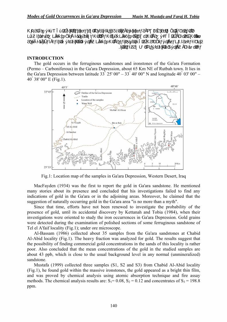
Modes of Gold Occurrences in Ga'ara Depression Mazin M. Mustafa and Faraj H. Tobia
140
الحديد المائية علـى شـكل غبـار ذات أكاسيدفقد انتقل مع ) فق للصخور الحديدية بنوعيهاالمرا( النمط الثاني أما على شكل غرويات مصدرها قد يكون ترسبات الخامات السوبرجينية والتي قد تكون غير بعيدة عـن أوحبيبات ناعمة وتغير األيونيةئية مثل زيادة القوة على تجمع هذه الغرويات قد تكون عوامل كيميا أثرتان العوامل التي . منطقة الكعرة
. عوامل فيزيائية مثل انخفاض سرعة المياهأوالحامضية INTRODUCTION
The gold occurs in the ferruginous sandstones and ironstones of the Ga'ara Formation (Permo – Carboniferous) in the Ga'ara Depression, about 65 Km NE of Rutbah town. It lies in the Ga'ara Depression between latitude 33° 25' 00" – 33° 40' 00" N and longitude 40° 03' 00" – 40° 38' 00" E (Fig.1).
Fig.1: Location map of the samples in Ga'ara Depression, Western Desert, Iraq
MacFayden (1934) was the first to report the gold in Ga'ara sandstone. He mentioned many stories about its presence and concluded that his investigations failed to find any indications of gold in the Ga'ara or in the adjoining areas. Moreover, he claimed that the suggestion of naturally occurring gold in the Ga'ara area "is no more than a myth".
Since that time, efforts have not been renewed to investigate the probability of the presence of gold, until its accidental discovery by Kettanah and Tobia (1984), when their investigations were oriented to study the iron occurrences in Ga'ara Depression. Gold grains were detected during the examination of polished sections of some ferruginous sandstone of Tel el A'faif locality (Fig.1); under ore microscope.
Al-Bassam (1986) collected about 35 samples from the Ga'ara sandstones at Chabid Al-Abid locality (Fig.1). The heavy fraction was analyzed for gold. The results suggest that the possibility of finding commercial gold concentrations in the sands of this locality is rather poor. Also concluded that the mean concentrations of the gold in the studied samples are about 43 ppb, which is close to the usual background level in any normal (unmineralized) sandstone.
Mustafa (1999) collected three samples (S1, S2 and S3) from Chabid Al-Abid locality (Fig.1), he found gold within the massive ironstones, the gold appeared as a bright thin film, and was proved by chemical analysis using atomic absorption technique and fire assay methods. The chemical analysis results are: S1= 0.08, S2 = 0.12 and concentrates of S3 = 198.8 ppm.
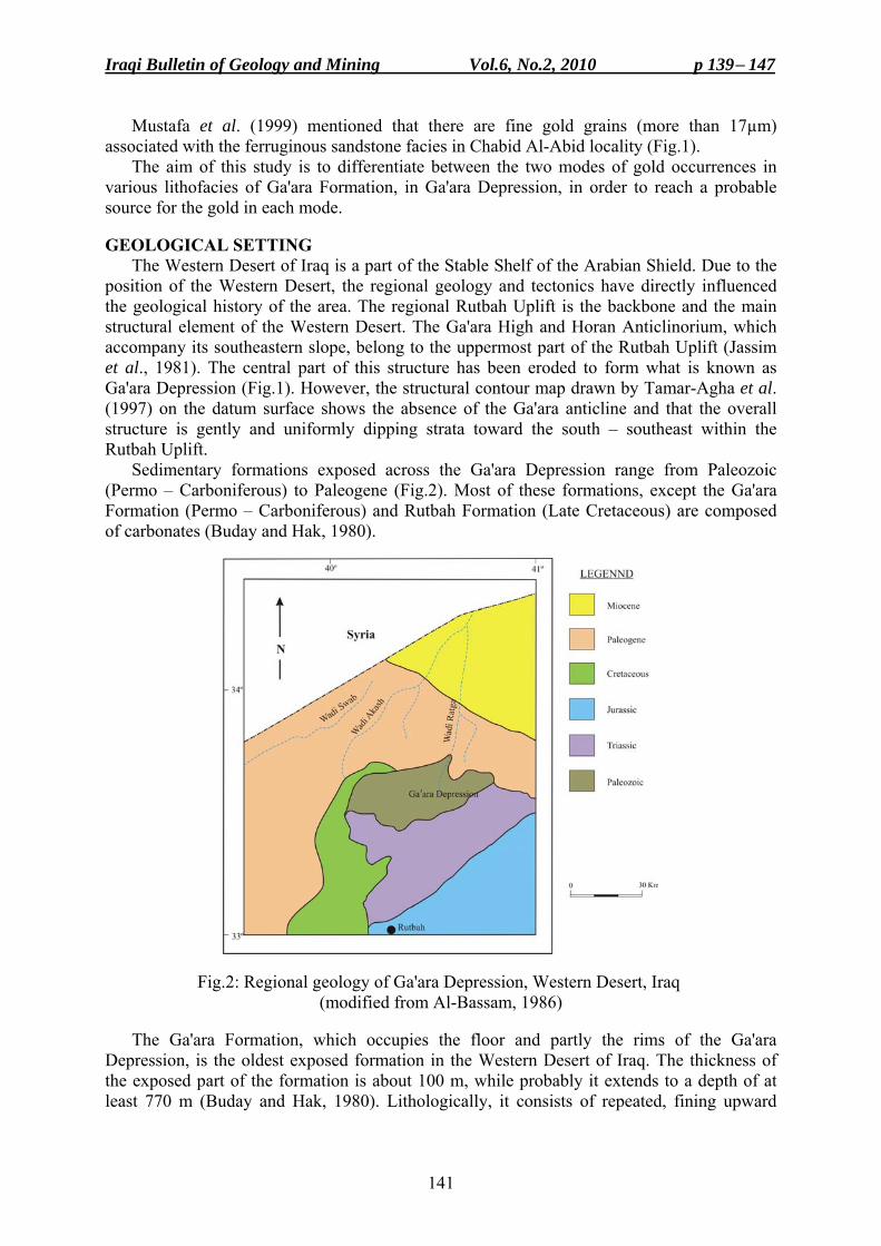
Iraqi Bulletin of Geology and Mining Vol.6, No.2, 2010 p 139− 147
141
Mustafa et al. (1999) mentioned that there are fine gold grains (more than 17µm) associated with the ferruginous sandstone facies in Chabid Al-Abid locality (Fig.1).
The aim of this study is to differentiate between the two modes of gold occurrences in various lithofacies of Ga'ara Formation, in Ga'ara Depression, in order to reach a probable source for the gold in each mode.
GEOLOGICAL SETTING
The Western Desert of Iraq is a part of the Stable Shelf of the Arabian Shield. Due to the position of the Western Desert, the regional geology and tectonics have directly influenced the geological history of the area. The regional Rutbah Uplift is the backbone and the main structural element of the Western Desert. The Ga'ara High and Horan Anticlinorium, which accompany its southeastern slope, belong to the uppermost part of the Rutbah Uplift (Jassim et al., 1981). The central part of this structure has been eroded to form what is known as Ga'ara Depression (Fig.1). However, the structural contour map drawn by Tamar-Agha et al. (1997) on the datum surface shows the absence of the Ga'ara anticline and that the overall structure is gently and uniformly dipping strata toward the south – southeast within the Rutbah Uplift.
Sedimentary formations exposed across the Ga'ara Depression range from Paleozoic (Permo – Carboniferous) to Paleogene (Fig.2). Most of these formations, except the Ga'ara Formation (Permo – Carboniferous) and Rutbah Formation (Late Cretaceous) are composed of carbonates (Buday and Hak, 1980).
Fig.2: Regional geology of Ga'ara Depression, Western Desert, Iraq (modified from Al-Bassam, 1986)
The Ga'ara Formation, which occupies the floor and partly the rims of the Ga'ara
Depression, is the oldest exposed formation in the Western Desert of Iraq. The thickness of the exposed part of the formation is about 100 m, while probably it extends to a depth of at least 770 m (Buday and Hak, 1980). Lithologically, it consists of repeated, fining upward
Modes of Gold Occurrences in Ga'ara Depression Mazin M. Mustafa and Faraj H. Tobia
142
cycles of sedimentary rocks; each cycle usually starts with sandstone grading upward into siltstone, claystone (mostly kaolinitic) as well as occasional ironstone in the uppermost part of the formation. The goethitic – hematitic ironstones are of four types: sandy, clayey, pisolitic – oolitic and nodular-discontinuous laminated ironstones (Tobia, 1983). In addition, plant remains and thin coal streaks occur in the rocks of the formation.
The Ga'ara Formation is unconformably overlain by the Mulussa Formation of Upper Triassic age, in the southern rim. The Mulussa Formation consists of dolostone, calcareous dolostones and dolomitic limestones. In the northern rim, however, the Ga'ara Formation is overlain by sandstones of Rutbah Formation (Late Cretaceous), as in Chabid Al-Abid locality and by breccia and carbonates of Hartha, Tayarat and Digma formations (Paleogene), as in Al-Na'ajah locality. The sediments of the Ga'ara Formation are believed to have been derived from plutonic – metamorphic complexes of the Arabian Shield, transported by rivers and then deposited in continental, fluviatile and lacustrine environments with possible near shore and wind action contribution (Philip et al., 1968; Salman, 1977; Buday, 1980; Radosevic and Lesevic, 1981; Tobia, 1983 and Tamar-Agha, 1993).
The Ga'ara Formation is of special economic importance for its containing ironstones, kaolinites, mudstone deposits and glass sand, which are quarried hitherto.
SAMPLING AND METHODS
Twenty five samples were collected from the Ga'ara Depression, 5 samples from Tel el A'faif locality, 2 samples from Dwaikhla locality, 8 samples from Chabid Al-Abid locality, and 10 samples from Umm Idayya locality (Fig.2). These samples were chosen to represent all types of the gold-bearing rocks, and they range from moderately friable ferruginous sandstone to hard, massive, fine-grained ironstone. All samples were studied by thin polished sections, and five of them were studied after applying the technology of gold lixiviation from ores and concentrates, using hydrochloric acid and extraction from solution by absorption (Olteanu et al., 2008).
RESULTS AND DISCUSSION
The Ga'ara Formation consists of repeated fining upward cycles of sedimentary rocks, each cycle starts with sandstone grading upward into siltstone, claystone as well as occasional lenses of ironstone, in the uppermost part of the formation. Gold occurs as scattered fine grains within the ferruginous sandstones and siltstones of Ga'ara Formation. Most ferruginous sandstone beds exposed at Tel el A'faif locality are gold bearing, and exposures in Dwaikhla locality were proved to contain gold too.
The ore microscope examinations show that gold grains are usually located within the limonitic – goethitic cementing materials along side the detrital grains as engulfed within embayment of quartz grains; or trapped in the interstices of quartz grains (Fig.3a).
The gold-bearing sandstones are mostly friable, due to poor cementing by iron oxides; the beds are crossly-bedded and vary in thickness from (1 – 8) m. These beds are channelized reflecting some ancient river channels with sandstones at the bottom grading upward into siltstones and claystones, and sometimes capped by ironstones.
The gold grains are of irregular shapes, i.e. amoeboidal (Fig.3b), porous gold particles, flakey or equate with sharp boundaries. They are golden yellow and yellowish white in color. They range in size from 30 µm up to about 120 µm; i.e. they are of silt to very fine sand size. According to the optical properties (color, reflectance, Vickers micro-hardness), Kettanah and Tobia (1984) concluded that the Ga'ara gold contains certain amount of silver, which increases the reflectivity of the gold, and with probable copper content, due to the higher micro hardness than other natural gold (Table 1).
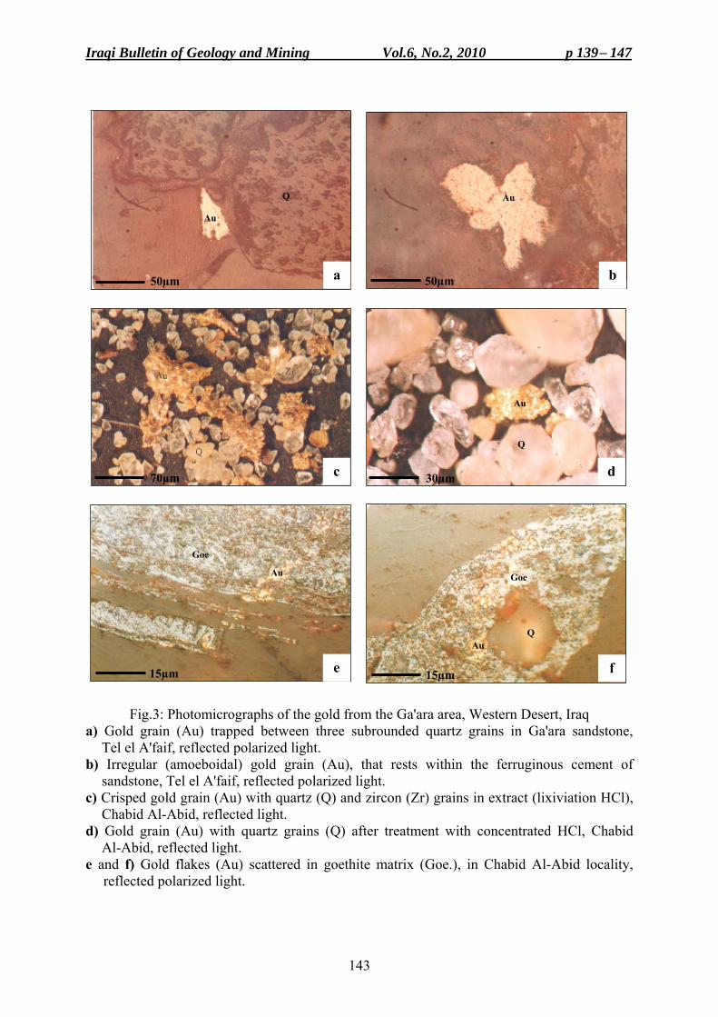
Iraqi Bulletin of Geology and Mining Vol.6, No.2, 2010 p 139− 147
143
Fig.3: Photomicrographs of the gold from the Ga'ara area, Western Desert, Iraq a) Gold grain (Au) trapped between three subrounded quartz grains in Ga'ara sandstone,
Tel el A'faif, reflected polarized light. b) Irregular (amoeboidal) gold grain (Au), that rests within the ferruginous cement of
sandstone, Tel el A'faif, reflected polarized light. c) Crisped gold grain (Au) with quartz (Q) and zircon (Zr) grains in extract (lixiviation HCl),
Chabid Al-Abid, reflected light. d) Gold grain (Au) with quartz grains (Q) after treatment with concentrated HCl, Chabid
Al-Abid, reflected light. e and f) Gold flakes (Au) scattered in goethite matrix (Goe.), in Chabid Al-Abid locality,
reflected polarized light.
Au
Q Au
Au
Q
Goe
Au Goe
Q Au
a
15µm 15µm
b
c d
e f
50µm 50µm
70µm 30µm
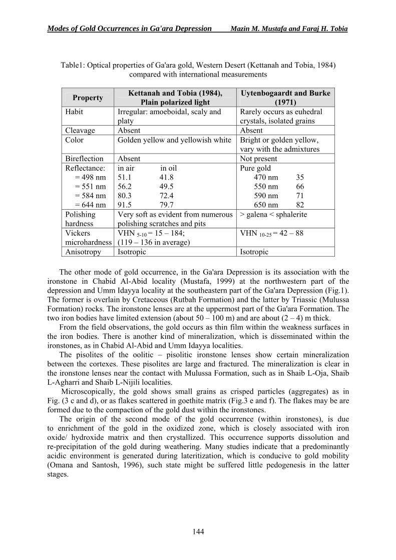
Modes of Gold Occurrences in Ga'ara Depression Mazin M. Mustafa and Faraj H. Tobia
144
Table1: Optical properties of Ga'ara gold, Western Desert (Kettanah and Tobia, 1984)
compared with international measurements
Uytenbogaardt and Burke (1971)
Kettanah and Tobia (1984), Plain polarized light Property
Rarely occurs as euhedral crystals, isolated grains
Irregular: amoeboidal, scaly and platy
Habit
Absent Absent Cleavage Bright or golden yellow, vary with the admixtures
Golden yellow and yellowish white Color
Not present Absent Bireflection Pure gold 470 nm 35 550 nm 66 590 nm 71 650 nm 82
in air in oil 51.1 41.8 56.2 49.5 80.3 72.4 91.5 79.7
Reflectance: = 498 nm = 551 nm = 584 nm = 644 nm
> galena < sphalerite Very soft as evident from numerous polishing scratches and pits
Polishing hardness
VHN 10-25 = 42 – 88 VHN 5-10 = 15 – 184; (119 – 136 in average)
Vickers microhardness
Isotropic Isotropic Anisotropy
The other mode of gold occurrence, in the Ga'ara Depression is its association with the ironstone in Chabid Al-Abid locality (Mustafa, 1999) at the northwestern part of the depression and Umm Idayya locality at the southeastern part of the Ga'ara Depression (Fig.1). The former is overlain by Cretaceous (Rutbah Formation) and the latter by Triassic (Mulussa Formation) rocks. The ironstone lenses are at the uppermost part of the Ga'ara Formation. The two iron bodies have limited extension (about 50 – 100 m) and are about (2 – 4) m thick.
From the field observations, the gold occurs as thin film within the weakness surfaces in the iron bodies. There is another kind of mineralization, which is disseminated within the ironstones, as in Chabid Al-Abid and Umm Idayya localities.
The pisolites of the oolitic – pisolitic ironstone lenses show certain mineralization between the cortexes. These pisolites are large and fractured. The mineralization is clear in the ironstone lenses near the contact with Mulussa Formation, such as in Shaib L-Oja, Shaib L-Agharri and Shaib L-Nijili localities.
Microscopically, the gold shows small grains as crisped particles (aggregates) as in Fig. (3 c and d), or as flakes scattered in goethite matrix (Fig.3 e and f). The flakes may be are formed due to the compaction of the gold dust within the ironstones.
The origin of the second mode of the gold occurrence (within ironstones), is due to enrichment of the gold in the oxidized zone, which is closely associated with iron oxide/ hydroxide matrix and then crystallized. This occurrence supports dissolution and re-precipitation of the gold during weathering. Many studies indicate that a predominantly acidic environment is generated during lateritization, which is conducive to gold mobility (Omana and Santosh, 1996), such state might be suffered little pedogenesis in the latter stages.
Iraqi Bulletin of Geology and Mining Vol.6, No.2, 2010 p 139− 147
145
Gold might be transported from the source area as suspended form (as a fine grains and gold dust) or as a colloidal phase that can be originated chemically, by the breakdown of complex gold compounds (Wierchowiec, 2002). The colloidal gold could be associated with the iron oxides by strong electrostatic interactions. The poorly ordered iron oxides are highly efficient in trapping gold from solution due to its high surface area (Greffie et al., 1996). Mechanically, gold may be abrading because of its softness and high density during transportation through sediment movement resulting in the formation of new colloidal particles (Wierchowiec, 2002).
Adsorption and/ or co precipitation of negatively charged gold complexes and colloids by positively charged gels, such as hydrous ferric oxides, appears to be particularly effective since most iron oxides in or near gold-bearing deposit are generally enriched in gold. In addition, Greffie et al. (1996) investigated the interaction of gold complexes with iron oxides (ferrihydrates, goethites) during co-precipitation experiments and they found most of the gold was removed from solution in the presence of iron oxides, whereas gold remained in the reference samples.
The source rocks of the Ga'ara Formation are believed to be from plutonic – metamorphic rock complexes of the Arabian Shield that have been subjected to intense chemical weathering under humid tropical conditions. The weathered products are transported and reworked many times by rivers and streams, to be deposited in continental fluviatile and lacustrine environments (Philip et al., 1968; Salman, 1977; Buday, 1980; Buday and Hak, 1980; Tobia, 1983; Tamar-Agha, 1993). This assumption can further be substantiated by the nature of facial distribution of Ga'ara Formation, as it wedges out towards the eastern rim of Ga'ara Depression, and might also wedges out to the north of the Khleisia Uplift, and is most likely open to the south with extensive aerial extent (Buday, 1980).
One of the ultimate origins of the gold is thus, the same as that of the associated sediments (Ga'ara Formation), i.e. the Arabian Shield rocks. The gold is known to exist in Saudi Arabia since old times. It occurs all over the Arabian – Nubian Shield, however, the important gold deposits in the Precambrian Shield of Saudi Arabia are those of Mahd adh Dhahab, Al-Amar and Jabal Ishmas – Wadi Tathlith Fault Zone (Worl, 1980).
Ga'ara gold (especially the mode in ferruginous sandstones) could have been derived from any of the aforementioned major gold deposits or partly all of them, as well as from any other unknown occurrences. However, the optical properties of the Ga'ara gold is comparable to the gold of "Mahd adh Dhahab" and is the nearest to the Ga'ara area (Kettanah and Tobia, 1984). The other mode (in ironstones) may have been transported with hydrous iron oxides as a dust or as colloids from the supergene ore deposits that is not far from the Ga'ara Depression. This can be deposited with the iron oxide, especially with the goethite. The factors that affect the accumulation of these colloids may be due to the chemical factors (increasing of ionic strength, change in pH), or due to the physical factors (reducing water velocity) (Andrade et al., 1991).
CONCLUSIONS • The morphology, surface texture of gold particles and the associated clastics suggest that
the gold of the studied occurrences are multisourced. • The authors believe that the principal sources for the gold most probably are the plutonic –
metamorphic rock complexes of Arabian Shield, which are subjected to intensive chemical weathering.
• The majority of the gold is transported presumably in a suspend forms, as flakes, scales, small grains, and gold dust, by rivers and streams; as the results of weathering and erosion of auriferous sediments.
Modes of Gold Occurrences in Ga'ara Depression Mazin M. Mustafa and Faraj H. Tobia
146
• Gold also could have been dissolved, transported under favorable chemical condition, and reprecipitated (second mode). Some amoeboidal, porous gold particles, without any signs of mechanical abrasion could be formed chemically during diagenesis.
• Gold enrichment has taken place by mechanical followed by diagenesis processes (in ferruginous sandstones) and chemical (in ironstones and pisolites) processes.
REFERENCES Al-Bassam, K.S., 1986. The legendary Bassam gold concession at Ga'ara. A fresh look, Jour. Geol. Soc. Iraq,
Vol.19, No.2, p. 201 – 209. Al-Bassam, K.S., Yakta, S.A., Hassan, K.M., Sa'ad, L.K. and Salman, M., 1990. Geological survey of the Upper
Cretaceous to Lower Tertiary phosphorite bearing-sequence, Western Desert, Iraq, GEOSURV, int. rep. no. 2008.
Andrade, D., Machesky, M.L. and Rose, A.W., 1991. Gold distribution and mobility in the surficial environment, Carajas region, Brazil, Jour. Geoch. Explor., Vol.40, p. 95 – 115.
Buday, T. and Hak, J., 1980, Report on the geological survey of the Western Desert, Iraq, GEOSURV, int. rep. no. 1000.
Buday, T., 1980. The Regional Geology of Iraq, Part I, Stratigraphy and Paleogeography. In: I.I.M., Kassab and S.Z., Jassim (Eds.), GEOSURV, Iraq, 445pp.
Greffie, C., Benedetti, M.F., Parron, C. and Amouric, M., 1996. Gold and iron oxide associations under supergene conditions. An experimental approach. Geochim. et Cosmochim. Acta, Vol.60. No.9, p. 1531 – 1542.
Jassim, S.Z., Prouza, V. and Rejchrt, M., 1981. Geology and petrology of sediments of the Western Desert Area, Iraq (Abstract): Abstract book of the 6th Iraqi Congress, Al-Zahra'a Press, Baghdad, p. 54 – 55.
Kettanah, Y.A. and Tobia, F.H., 1984. Discovery of gold in the sandstones of Ga'ara Formation, Ga'ara area, Western Desert, Iraq. GEOSURV, manuscript report, 53pp.
MacFayden, W.A., 1934. The Bassam gold concession at Ga'ara, Mineral Report No.1, GEOSURV, int. rep. no.95a, 9pp.
Mustafa, M.M., 1999. Discovery of gold in Chabid Al-Abid locality within the massive iron ore in the Ga'ara Formation, Western Desert of Iraq, Manuscript report, GEOSURV, Baghdad (in Arabic).
Mustafa, M.M., Yakta, S.A. and Al-Mukhtar, L.A., 1999. Preliminary report on the relationship between gold, ironstone and quartzite in Chabid Al-Abid area, Western Desert, Iraq. GEOSURV, int. rep. no. 3047 (in Arabic).
Olteanu, A.F., Dobre, T., Radulescu, R., Panturu, E. and Grigoras, L., 2008. Mathematical model of gold lixiviation, Chem. Bull. "POLITEHNICA" Univ., Vol.53, No.67, p. 140 – 143.
Omana, P.K. and Santosh, M., 1996. Laterite profile geochemistry in outlining supergene gold deposits. A case from Nilambur, Kerala, Jour. Geol. Soci. India, Vol.48. No.2, p. 139 – 150.
Philip, G., Saadallah, A. and Ajina, T., 1968. Mechanical analysis and mineral composition of the Middle Triassic Ga'ara sandstone, Iraq. Jour. Sediment. Geol., Vol.2, p. 51 – 76.
Radosevic, B. and Lesevic, Z., 1981. The results of palaeogeographic investigations in wider Rutbah area, Western Desert, Iraq (Abstract), Abstract book of the 6th Iraqi Geological Congress, Al-Zahra'a Press, Baghdad.
Salman, H.H., 1977. Sedimentology of the Upper Part of Ga'ara Formation, Western Iraq, Unpub. M.Sc. Thesis, University of Baghdad, 118pp.
Tamar-Agha, M.Y., 1993. Exploration and prospecting in the Ga'ara Depression (1986 – 1990), Part one, GEOSURV, int. rep. no. 1778.
Tamar-Agha, M.Y., Numan, N.M.S. and Al-Bassam, K.S., 1997. The Ga'ara anticline in Western Iraq. A structure fiasco, Rafidain Jour. Sci., Vol.8, No.2, p. 56 – 70.
Tobia, F.H., 1983. Geochemistry and mineralogy of the iron ore deposits of Ga'ara Formation in Iraqi Western Desert. Unpub. M.Sc. Thesis, University of Baghdad, 156pp.
Uytenbogaardt, W. and Burke, E.A.J., 1971. Tables for Microscopic Identification of Ore Minerals. Elsevier Scientific Publishing Company, New York, 430pp.
Wierchowiec, J., 2002. Morphology and chemistry of placer gold grains-indicators of the origin of the placers: An example from the east Sudetic foreland, Poland. Acta Geologica Polonica, Vol.4, p. 563 – 576.
Worl, R.G., 1980. Gold deposits associated with the Jabal Ishmas – Wadi Tathlith Fault Zone. In: Al-Shanti, A.M.S. et al. (Eds.), Proceeding of a symposium held at King Abdul Aziz Univ., Institute of Applied Geology, IAG Bull., Vol.4, No.3, Pergamon Press, Oxford, p. 61 – 70.
Iraqi Bulletin of Geology and Mining Vol.6, No.2, 2010 p 139− 147
147
About the authors
Mr. Mazin M. Mustafa graduated from University of Baghdad in 1968, and then got his M.Sc. degree from Hull University in 1981; he joined the Iraqi Geological Survey in 1970, after long field experience he was assigned as Expert in mineral investigation, and industrial minerals and rocks. For more than thirty-five years, he was the Head of Mineral Investigation Department and project manager in different aspects and different parts of Iraq, his major field of interest is mineral investigation. e-mail: [email protected] Mailing address: S.C. of Geological Survey and Mining, P.O. Box 986, Baghdad, Iraq
Dr. Faraj H. Tobia graduated from University of Baghdad with B.Sc. degree in 1980 and M.Sc. degree in 1983. In 1986, he joined the Scientific Research Council, in 1991 he joined GEOSURV as field geologist in many mineral exploration projects. In 2005, he got his Ph.D. degree in geochemistry from Mosul University. In 2006, he joined University of Salahaddin, College of Sciences, Department of Geology as Lecturer. His main field of interest is geochemistry and ore geology. He has 13 published and documented reports and articles. e-mail: [email protected] Mailing address: Department of Geology, University of Salalhaddin, Erbil, Iraq.
Iraqi Bulletin of Geology and Mining Vol.6, No.2, 2010 p 149− 157
149
UPGRADING OF MONTMORILLONITE CLAYSTONE (DIGMA FORMATION) FROM WADI BASHIRA,
WESTERN DESERT, IRAQ
Abdul Wahab A. Al-Ajeel* and Sahar N. Abdullah**
Received: 8/ 6/ 2009, Accepted: 2/ 6/ 2010 Key words: Montmorillonite, Dispersion, Upgrading, Beneficiation, Phosphate dispersers
ABSTRACT
Wet beneficiation processing of Wadi Bashira Ca-montmorillonite claystone, which belongs to the Digma Formation, has been studied using tetrasodium pyrophosphate as dispersant agent. The claystone is located in the Western Desert of Iraq. It is of a low grade, associated with different amount of clay and non-clay mineral impurities. Calcite (CaCO3) constitutes the major proportion of these impurities.
In this study, the effect of different parameters (slurry solid concentration, dispersant amount and dispersant/ slurry mixing times) on the efficiency of the beneficiation process were investigated and followed through the measurement of CaO% values of the upgraded claystone (concentrate). Gravity and centrifugal sedimentation were tested to separate the impurities from the clay suspension. The process variables were optimized and the yielded claystone was evaluated. It was shown that the beneficiation process was very effective in upgrading the montmorillonite claystone and capable of producing a high grade montmorillonite (89% montmorillonite) with CEC of 85 meq/100 gm.
من منطقة وادي بشيرة، ) مةگدتكوين ( أطيان المونتمورلونايت رفع رتبة الصحراء الغربية، العراق
عبد الوهاب عبد الرزاق العجيل و سحر نجم عبداهللا
مستخلصال
ام ثالثي صوديوم تمت دراسة عملية التركيز الرطب ألطيان المونتمورلونايت الكالسيومي لوادي بشيرة باستخد في الصحراء الغربية من گمةدضمن تكوين يقع راسب الطين المستخدم في هذه الدراسة. بيروفوسفات كمادة مشتتة
مثل ت والطينية غير، الطينية والعراق وهو من األنواع واطئة النوعية ويرتبط مع كميات مختلفة من الشوائب المعدنية .ن هذه الشوائبكاربونات الكالسيوم الجزء األكبر م
،)خليط الطين والماء (في اللبابالمتمثلة بتركيز المواد الصلبة ( تأثير العوامل المختلفة ،في هذه الدراسةتم البحث على كفاءة عملية التركيز ومتابعتها من خالل قياس نسبة ) مع اللبابكمية المادة المشتتة وزمن مزج المادة المشتتة
CaOوقد درست عمليتي الترسيب الطبيعي والطرد المركزي في مرحلة فصل الشوائب عن . في ركاز الطين الناتج .األطيان التي هي في حالة عالق، نتيجة لتأثير المادة المشتتة
بعد تحديد القيم المثلى للمؤشرات الفنية لعملية التركيز وتقييم ركاز الطين الناتج من خالل التحاليل الكيميائية ونسبة ة جداً في رفع رتبة الطين، وأدت الى إنتاج ان عملية التركيز كانت كفوءنايت وسعة التبادل األيوني، لوحظ المونتمورلو
وسعة التبادل األيوني بحدود%89لى اا تصل نسبة المونتمورلونايت فيه،نوعية عالية من أطيان المونتمورلونايت . غم خام100ملغم مكافئ لكل 85
____________________________________ * Expert, S.C. of Geological Survey and Mining, P.O. Box 986, Baghdad, Iraq.
e-mail: [email protected] ** Senior Engineer, S.C. of Geological Survey and Mining, e-mail: [email protected]
Upgrading of Montmorillonite Claystone (Digma Formation) Abdul Wahab A. Al-Ajeel and Sahar N. Abdullah
150
INTRODUCTION Montmorillonite occupies a prominent position among industrial minerals. It is the main
constituent of bentonite and the detrimental factor of its properties. Regardless of origin or occurrence, montmorillonite and bentonite are two names of exactly the same mineral (Grim, 1968).
Montmorillonite belongs to smectite class of clay minerals, which has 2:1 type of layer structure. Meaning that each layer consists of three sheets, an octahedral alumina sheet sandwiched between two tetrahedral silica sheets (Grim, 1968; Ainsworth et al., 1994 and Schenning, 2004). Because of the isomorphous substitution of Mg2+ and/ or Fe2+ for Al3+ in the octahedral sheet and Al3+ for Si4+ in the tetrahedral sheet, the particle of montmorillonite is negatively charged at the surface and positively charged at the edges. The electrical neutrality is attained by other cations (external to the lattice) that reside in the inter-laminar region, between the lattice layers. These cations (usually Na+ or Ca2+) are relatively easily exchangeable, giving montmorillonite high cation exchange capacity phenomenon (Grim, 1968; Ainsworth et al., 1994; Bala et al., 2000 and Schenning, 2004). The type of cation that fulfils the charge-balancing role has marked impact on the performance of the montmorillonite in terms of its capacity for swelling, thixotropy, and adsorption (Grim, 1962 and Ainsworth et al., 1994). In industry, montmorillonite is generally either sodium (Na+) or calcium (Ca2+) type. Sodium montmorillonite, where the inter-laminar region is occupied mainly by sodium ions (dominant exchangeable ion), has very high swelling capacities and thixotropic properties when added to water, therefore, it is highly valuable as drilling muds and other uses requiring thixotropic suspension. The Ca-montmorillonite has no value for such application. It has a very little swelling ability; flocculation and settling are much more rapid than for sodium montmorillonite (Keren, 1988; Bowyer and Moine, 2008 and Alther, 2004). Therefore, this type is directed largely for bleaching of oils (Grim, 1962).
In Iraq, particularly in the Western Desert, montmorillonite was first reported in 1985 by Al-Bassam and Al-Saadi (1985). Years later, the exploratory works of Khdair and Al-Saady (1987) and Al-Bassam and Saeed (1989) resulted in localizing two calcium montmorillonite claystone deposits. The deposit, located in Wadi Bashira (Fig.1), was considered the major deposit explored in the Western Desert. It represents the lower part of the Digma Formation of Late Cretaceous age and of marine sedimentary origin. It is of low grade with montmorillonite content; averaging about 68 wt%, associated with clay and non-clay impurities including attapulgite, calcite, quartz, apatite, gypsum, and halite. These impurities account about for 32 wt% of the deposit. Calcite, however, represents the major impurity, it averages about 15 wt% of the deposit (Al-Bassam and Saeed, 1989). This montmorillonite claystone deposit, showed a poor response to sodium activation and failed when tested (API specification) for drilling mud (Al-Ajeel et al., 1990).
Generally, the major problems facing the utilization of Wadi Bashira claystone deposit are its low concentration of montmorillonite (about 68%), high level of impurities, and inconsistent composition. Therefore, it has to be processed and upgraded before utilization. The potential method for this purpose is the wet beneficiation method (Ainsworth, 1994).
It has been demonstrated (Hassan and Abdel-Khalek, 1998) that by subjecting Egyptian Ca-bentonite slurry to a hydrocyclone classifier and treating the over flow with dilute HCl, led to effective removal of calcite impurities. The same results were achieved when slurry of Iraqi Ca-montmorillonite claystone was treated with dilute HCl to remove calcite impurities (Al-Ajeel et al., 2003), the same authors also claimed that an effective removal of the calcite gangue could be achieved by carrier flotation (the carrier material used was light polymer beads). Furthermore, it was shown (Shaoxian et al., 2005) that dispersion and sedimentation
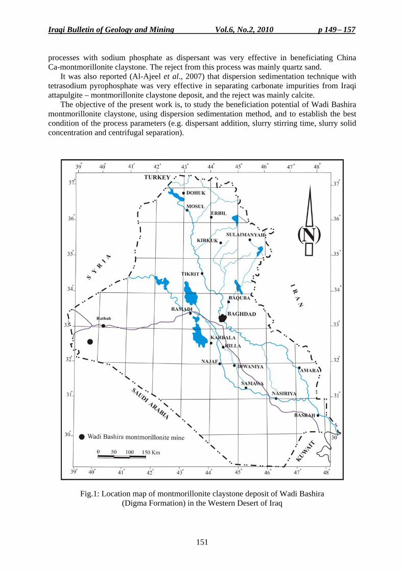
Iraqi Bulletin of Geology and Mining Vol.6, No.2, 2010 p 149− 157
151
processes with sodium phosphate as dispersant was very effective in beneficiating China Ca-montmorillonite claystone. The reject from this process was mainly quartz sand.
It was also reported (Al-Ajeel et al., 2007) that dispersion sedimentation technique with tetrasodium pyrophosphate was very effective in separating carbonate impurities from Iraqi attapulgite – montmorillonite claystone deposit, and the reject was mainly calcite.
The objective of the present work is, to study the beneficiation potential of Wadi Bashira montmorillonite claystone, using dispersion sedimentation method, and to establish the best condition of the process parameters (e.g. dispersant addition, slurry stirring time, slurry solid concentration and centrifugal separation).
Fig.1: Location map of montmorillonite claystone deposit of Wadi Bashira
(Digma Formation) in the Western Desert of Iraq
Upgrading of Montmorillonite Claystone (Digma Formation) Abdul Wahab A. Al-Ajeel and Sahar N. Abdullah
152
MATERIALS AND METHODS Montmorillonite claystone sample of Wadi Bashira collected randomly from many
trenches in the deposit was used for the beneficiation tests. The dispersing reagent used was analytical grade tetrasodium pyrophosphate (Na4P2O10H2O) (TSPP).
Sample Preparation
The claystone sample, as received, was successively crushed to pass 4 mm sieve in a laboratory jaw crusher, then identical samples of 0.5 Kg each were separated for the tests using Jons Riffle sampler. Furthermore, a representative specimen was withdrawn for chemical, XRD and cation exchange capacity (CEC) analysis. The CEC, was determined by the methylene blue adsorption method, and was used to evaluate the montmorillonite purity of both, feed sample and the upgraded clay (concentrates). The procedure used was European Standard (Schenning, 2004).
Mineralogical and Chemical Composition
Table (1) presents the mineralogical and chemical composition of the investigated montmorillonite claystone sample. According to the XRD analysis results, the predominant identified minerals were; Ca-montmorillonite, calcite, quartz, kaolinite, and palygorskite (attapulgite), with minor amounts of feldspar. The chemical analysis results display the presence of Cl (1.16%), SO3 (1.4%) and P2O5 (0.4%), which accordingly indicates the association of halite (1.9%), gypsum (3%) and apatite (1.4%), respectively with the claystone raw sample. The data of Table (1) showed a high value of CaO (9.5%) that suggests the presence of high amount of calcite (CaCO3).
Table (1) Mineralogical and chemical composition of the
investigated montmorillonite claystone raw sample
Mineralogical Composition Montmorillonite, Calcite, Quartz, Kaolinite, Palygorskite (Attapulgite) and Minor Feldspar
Chemical Composition (wt %) SiO2 Fe2O3 Al2O3 CaO MgO SO3 P2O5 Na2O K2O Cl L.O.I 48.56 4.48 13.16 9.5 4.6 1.4 0.4 1.13 0.32 1.16 14.22
The results of CEC and montmorillonite measurements of the claystone raw sample were
about 68.7 meq/ 100 gm and 72%, respectively. It has been reported (Hora, 1998) that economic grade bentonite; usually contains more than 80% montmorillonite. Other properties depend on the specification for particular application. Therefore, in order to improve the grade (purity) of Wadi Bashira montmorillonite claystone, it has to be processed; so that the associated impurities can be removed or reduced. This should enhance the quality of the deposit in terms of CEC value and montmorillonite content.
Upgrading of Montmorillonite Claystone
The employed beneficiation method comprised the following steps: - Preparing a slurry of the crushed montmorillonite claystone containing 8 wt% solid and then
degritting the slurry on 75 µm to remove the over size (+75 µm) fraction. - Adding dispersant to the degritted slurry to disperse the clay in water. - Separating the dispersed clay from undispersed (settled) material by decantation after;
a) gravity sedimentation and, b) centrifugal sedimentation.
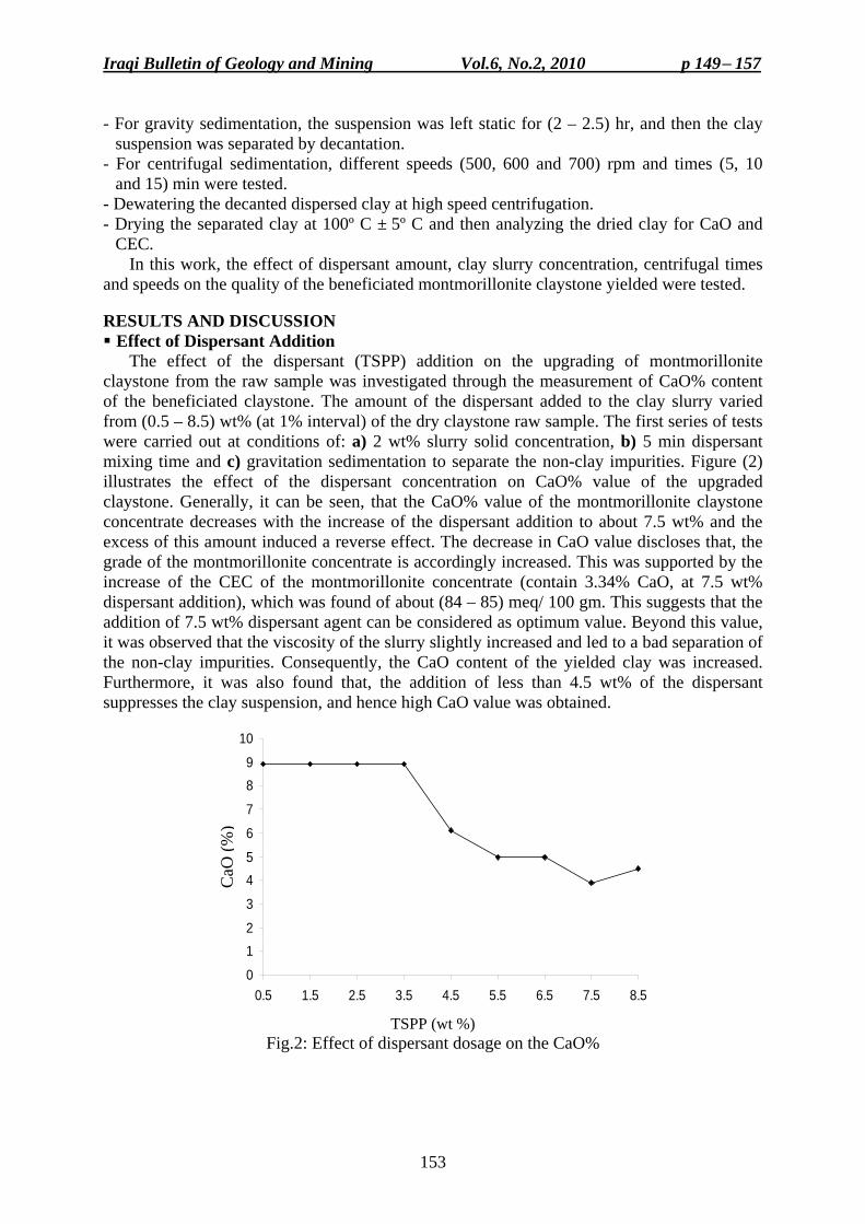
Iraqi Bulletin of Geology and Mining Vol.6, No.2, 2010 p 149− 157
153
- For gravity sedimentation, the suspension was left static for (2 – 2.5) hr, and then the clay suspension was separated by decantation.
- For centrifugal sedimentation, different speeds (500, 600 and 700) rpm and times (5, 10 and 15) min were tested.
- Dewatering the decanted dispersed clay at high speed centrifugation. - Drying the separated clay at 100º C ± 5º C and then analyzing the dried clay for CaO and
CEC. In this work, the effect of dispersant amount, clay slurry concentration, centrifugal times
and speeds on the quality of the beneficiated montmorillonite claystone yielded were tested. RESULTS AND DISCUSSION Effect of Dispersant Addition
The effect of the dispersant (TSPP) addition on the upgrading of montmorillonite claystone from the raw sample was investigated through the measurement of CaO% content of the beneficiated claystone. The amount of the dispersant added to the clay slurry varied from (0.5 – 8.5) wt% (at 1% interval) of the dry claystone raw sample. The first series of tests were carried out at conditions of: a) 2 wt% slurry solid concentration, b) 5 min dispersant mixing time and c) gravitation sedimentation to separate the non-clay impurities. Figure (2) illustrates the effect of the dispersant concentration on CaO% value of the upgraded claystone. Generally, it can be seen, that the CaO% value of the montmorillonite claystone concentrate decreases with the increase of the dispersant addition to about 7.5 wt% and the excess of this amount induced a reverse effect. The decrease in CaO value discloses that, the grade of the montmorillonite concentrate is accordingly increased. This was supported by the increase of the CEC of the montmorillonite concentrate (contain 3.34% CaO, at 7.5 wt% dispersant addition), which was found of about (84 – 85) meq/ 100 gm. This suggests that the addition of 7.5 wt% dispersant agent can be considered as optimum value. Beyond this value, it was observed that the viscosity of the slurry slightly increased and led to a bad separation of the non-clay impurities. Consequently, the CaO content of the yielded clay was increased. Furthermore, it was also found that, the addition of less than 4.5 wt% of the dispersant suppresses the clay suspension, and hence high CaO value was obtained.
0
12
3
45
6
7
89
10
0.5 1.5 2.5 3.5 4.5 5.5 6.5 7.5 8.5
CaO
(%)
TSPP (wt %)
Fig.2: Effect of dispersant dosage on the CaO%
CaO
(%)
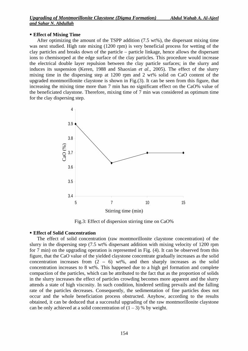
Upgrading of Montmorillonite Claystone (Digma Formation) Abdul Wahab A. Al-Ajeel and Sahar N. Abdullah
154
Effect of Mixing Time After optimizing the amount of the TSPP addition (7.5 wt%), the dispersant mixing time
was next studied. High rate mixing (1200 rpm) is very beneficial process for wetting of the clay particles and breaks down of the particle – particle linkage, hence allows the dispersant ions to chemisorped at the edge surface of the clay particles. This procedure would increase the electrical double layer repulsion between the clay particle surfaces; in the slurry and induces its suspension (Keren, 1988 and Shaoxian et al., 2005). The effect of the slurry mixing time in the dispersing step at 1200 rpm and 2 wt% solid on CaO content of the upgraded montmorillonite claystone is shown in Fig.(3). It can be seen from this figure, that increasing the mixing time more than 7 min has no significant effect on the CaO% value of the beneficiated claystone. Therefore, mixing time of 7 min was considered as optimum time for the clay dispersing step.
3.4
3.5
3.6
3.7
3.8
3.9
4
5 7 10 15
CaO
(%)
Stirring time (min)
Fig.3: Effect of dispersion stirring time on CaO%
Effect of Solid Concentration
The effect of solid concentration (raw montmorillonite claystone concentration) of the slurry in the dispersing step (7.5 wt% dispersant addition with mixing velocity of 1200 rpm for 7 min) on the upgrading operation is represented in Fig. (4). It can be observed from this figure, that the CaO value of the yielded claystone concentrate gradually increases as the solid concentration increases from (2 – 6) wt%, and then sharply increases as the solid concentration increases to 8 wt%. This happened due to a high gel formation and complete compaction of the particles, which can be attributed to the fact that as the proportion of solids in the slurry increases the effect of particles crowding becomes more apparent and the slurry attends a state of high viscosity. In such condition, hindered settling prevails and the falling rate of the particles decreases. Consequently, the sedimentation of fine particles does not occur and the whole beneficiation process obstructed. Anyhow, according to the results obtained, it can be deduced that a successful upgrading of the raw montmorillonite claystone can be only achieved at a solid concentration of (1 – 3) % by weight.
CaO
(%)
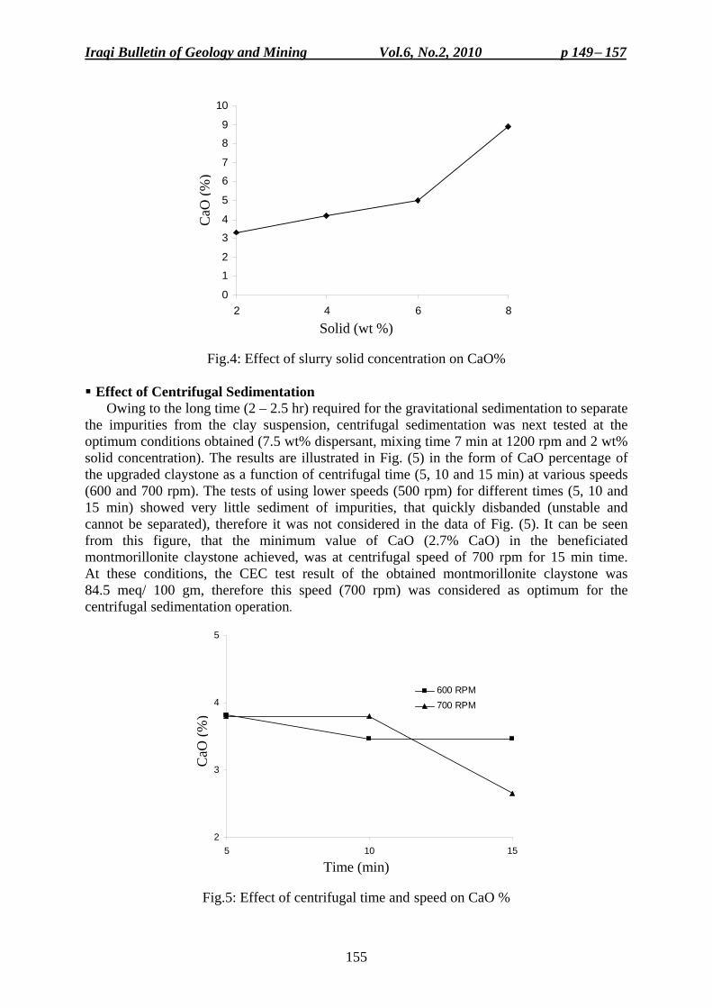
Iraqi Bulletin of Geology and Mining Vol.6, No.2, 2010 p 149− 157
155
0
1
2
3
4
5
6
7
8
9
10
2 4 6 8
CaO
(%)
Solid (wt %)
Fig.4: Effect of slurry solid concentration on CaO%
Effect of Centrifugal Sedimentation
Owing to the long time (2 – 2.5 hr) required for the gravitational sedimentation to separate the impurities from the clay suspension, centrifugal sedimentation was next tested at the optimum conditions obtained (7.5 wt% dispersant, mixing time 7 min at 1200 rpm and 2 wt% solid concentration). The results are illustrated in Fig. (5) in the form of CaO percentage of the upgraded claystone as a function of centrifugal time (5, 10 and 15 min) at various speeds (600 and 700 rpm). The tests of using lower speeds (500 rpm) for different times (5, 10 and 15 min) showed very little sediment of impurities, that quickly disbanded (unstable and cannot be separated), therefore it was not considered in the data of Fig. (5). It can be seen from this figure, that the minimum value of CaO (2.7% CaO) in the beneficiated montmorillonite claystone achieved, was at centrifugal speed of 700 rpm for 15 min time. At these conditions, the CEC test result of the obtained montmorillonite claystone was 84.5 meq/ 100 gm, therefore this speed (700 rpm) was considered as optimum for the centrifugal sedimentation operation.
2
3
4
5
5 10 15
CaO
(%)
600 RPM700 RPM
Time (min)
Fig.5: Effect of centrifugal time and speed on CaO %
CaO
(%)
C
aO (%
)
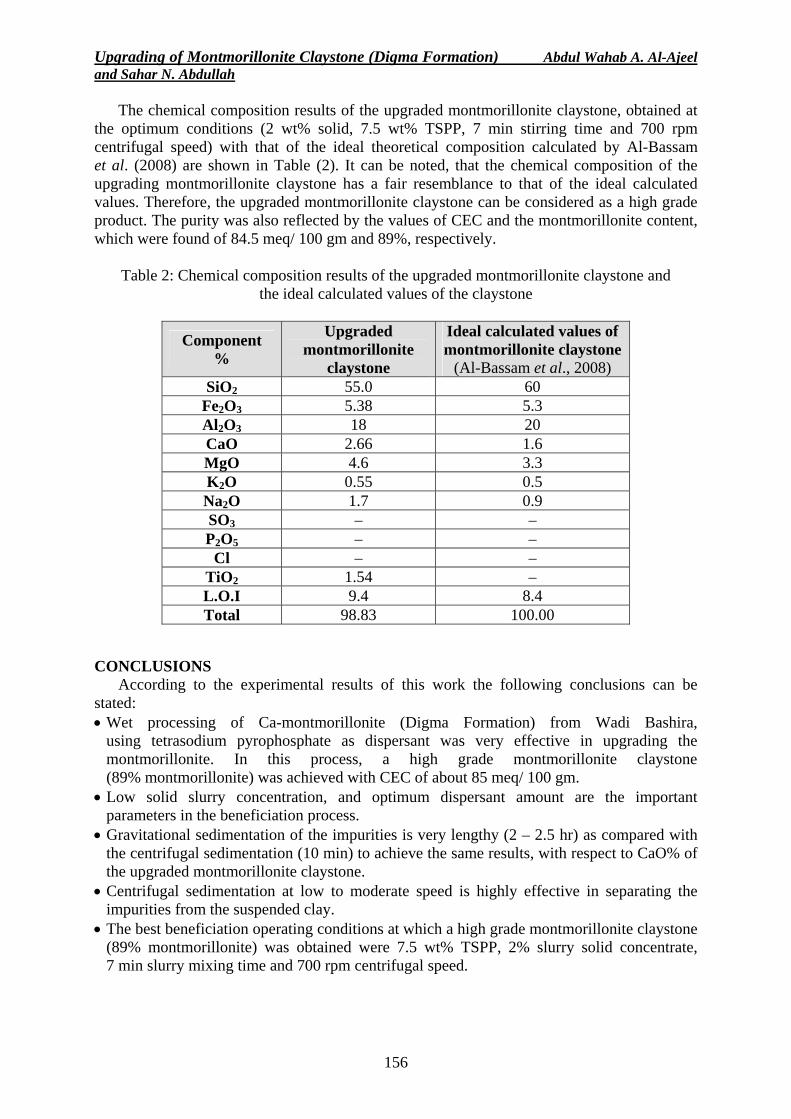
Upgrading of Montmorillonite Claystone (Digma Formation) Abdul Wahab A. Al-Ajeel and Sahar N. Abdullah
156
The chemical composition results of the upgraded montmorillonite claystone, obtained at the optimum conditions (2 wt% solid, 7.5 wt% TSPP, 7 min stirring time and 700 rpm centrifugal speed) with that of the ideal theoretical composition calculated by Al-Bassam et al. (2008) are shown in Table (2). It can be noted, that the chemical composition of the upgrading montmorillonite claystone has a fair resemblance to that of the ideal calculated values. Therefore, the upgraded montmorillonite claystone can be considered as a high grade product. The purity was also reflected by the values of CEC and the montmorillonite content, which were found of 84.5 meq/ 100 gm and 89%, respectively.
Table 2: Chemical composition results of the upgraded montmorillonite claystone and
the ideal calculated values of the claystone
Component %
Upgraded montmorillonite
claystone
Ideal calculated values of montmorillonite claystone
(Al-Bassam et al., 2008) SiO2 55.0 60
Fe2O3 5.38 5.3 Al2O3 18 20 CaO 2.66 1.6 MgO 4.6 3.3 K2O 0.55 0.5 Na2O 1.7 0.9 SO3 – – P2O5 – –
Cl – – TiO2 1.54 – L.O.I 9.4 8.4 Total 98.83 100.00
CONCLUSIONS
According to the experimental results of this work the following conclusions can be stated: • Wet processing of Ca-montmorillonite (Digma Formation) from Wadi Bashira,
using tetrasodium pyrophosphate as dispersant was very effective in upgrading the montmorillonite. In this process, a high grade montmorillonite claystone (89% montmorillonite) was achieved with CEC of about 85 meq/ 100 gm.
• Low solid slurry concentration, and optimum dispersant amount are the important parameters in the beneficiation process.
• Gravitational sedimentation of the impurities is very lengthy (2 – 2.5 hr) as compared with the centrifugal sedimentation (10 min) to achieve the same results, with respect to CaO% of the upgraded montmorillonite claystone.
• Centrifugal sedimentation at low to moderate speed is highly effective in separating the impurities from the suspended clay.
• The best beneficiation operating conditions at which a high grade montmorillonite claystone (89% montmorillonite) was obtained were 7.5 wt% TSPP, 2% slurry solid concentrate, 7 min slurry mixing time and 700 rpm centrifugal speed.
Iraqi Bulletin of Geology and Mining Vol.6, No.2, 2010 p 149− 157
157
REFERENCES Ainsworth, J., Vanconuver, B.C. and Calgary, A., 1994. Market Study of Bentonite Products. British Columbia,
Ministry of Energy, Mine and Petroleum Resources, Geological Survey Branch, 64pp. Al-Ajeel, A., Daykh, B. and Abdullah, S.N., 2003. Bench scale experiment for reducing CaO content from
Al-Safra low grade bentonite. GEOSURV, int. rep. no. 2835 (in Arabic). Al-Ajeel, A., Zainal, Y., Nouri, E. and Abdul Ahad, S., 1990. Sodium activation of Iraqi montmorillonite
claystone from the Western Desert, Iraq. GEOSURV, int. rep. no. 1867. Al-Ajeel, A., Abdulla, S.N. and Mustafa, A.M., 2007. Beneficiation of attapulgite – montmorillonite claystone
by dispersion – sedimentation method. GEOSURV, int. rep. no. 3057. Al-Bassam, K.S. and Al-Saadi, N., 1985. A new discovery of montmorillonite clay deposit in Iraq. GEOSURV,
int. rep. no. 1438. Al-Bassam, K.S. and Saeed, L.K., 1989. Mineral investigation of the Upper Cretaceous Safra montmorillonite
claystone deposit, Wadi Bashira, Western Desert. GEOSURV, int. rep. no. 1922. Al-Bassam, K.S. and Abdulrahman, S.M., 2008. Cation exchange capacity in Iraqi industrial montmorillonite
claystone and its use in the estimation of montmorillonite content in the produced clay. GEOSURV, int. rep. no. 3092.
Alther, R.G., 2004. Some practical observation of the use of bentonite. Jour. Environmental and Engineering Geosciences, Vol.10, No.4, p. 347 – 359.
Bala, P., Samantaray, B.K. and Srivostave, S.K., 2000. Dehydration transformation in Ca-montmorillonite. Bull. Meter. Sci., Vol.23, No.1, p. 61 – 67.
Bowyer, D.K and Moine, V.L., 2008. Bentonite, more than just dirt. Wynboor. Technical Guide for wine producers. www.wynborer.co.za/recentarticles/200806bentonite.php3
Grim, R.E., 1962. Applied Clay Mineralogy. McGraw Hill Book Company, 422pp. Grim, R.E., 1968. Clay Mineralogy. McGraw Hill Book Company, 2nd edit., 569pp. Hassan, M.S. and Abdel-Khalek, N.A., 1998. Beneficiation and applications of an Egyptian bentonite. Jour.
Applied Clay Science, Vol.13, p. 99 – 115. Hora, Z.D., 1998. Bentonite. E06, British Columbia Geological Survey.
www.em.gov.bc.ca/Mining/Geo/surv/default.htm. Keren, R., 1988. Rheology of aqueous suspension of sodium/calcium montmorillonite. Soil Sci. Soc. Am. Jour.,
Vol.52, p. 924 – 928. Khdair, M., Abass, A. and Al-Saady, N., 1987. Geological investigation of montmorillonite claystone, Trefawi,
Al-Anbar. GEOSURV, int. rep. no. 1573 (in Arabic). Schenning, J.A., 2004. Hydraulic Performance of Polymer Modified Bentonite. M.Sc. Thesis, College of
Engineering, University of South Florida. Shaoxian, S., Yimin, Z., Tao, L. and Min, Z., 2005. Beneficiation of montmorillonite ores by dispersion
processing. Jour. Dispersion Science and Technology, Vol.26, Issue 3, p. 375 – 379.
Iraqi Bulletin of Geology and Mining Vol.6, No.2, 2010 p 159− 165
159
SCIENTIFIC NOTE
AN UPDATE ON THE MINERALOGY AND CHEMISTRY OF THE ALTA'AMEEM METEORITE
Alta'ameem meteorite fell in 1977 near the village of Humaira, Kirkuk (Alta'ameem) Governorate. The mineralogy and chemical composition was studied by Al-Bassam (1978) and the meteorite was classified as a metamorphosed chondrite of the LL group. It is a light gray, brecciated meteorite with black fusion crust (Fig.1a). It is composed of olivine (Fig.1b and 1c), orthopyroxene (Fig.1d) and plagioclase (Fig.1e). Other minerals include troilite, kamacite, taenite and chromite (Fig.1f, 1g and 1h). Ilmenite, apatite, clinopyroxene and chalcopyrite were also reported (Al-Bassam, 1978).
Several small samples were delivered to major natural history museums and scientific institutes in the world. The meteorite is kept at the US National Museum of Natural History under no. 5964, and it is classified as LL 4 chondrite in the Catalogue of Meteorites (Grady, 2001) and as LL5 chondrite by Kallemeyn et al. (1989).
Since the publication of Al-Bassam article in 1978, little additional work was published on this rare meteorite. It was mentioned in the work of Kallemeyn et al. (1989) as one of 66 other ordinary chondrites in an attempt to find petrologic and chemical criteria for chondrite classification.
Hiroi et al. (2006) compared the near infrared reflectance spectrum of Alta'ameem meteorite with that of the asteroid 2543 Itokawa. Among all the meteorite samples studied by Hiroi and his co-workers, Alta'ameem meteorite said to be the only one that have a near- identical reflectance spectra to that of some areas on the Itokawa asteroid (Hiroi et al., 2006). The asteroid was discovered in 1998 by LINER Project as part of the Hayabusa space mission (Japan). It is a near-Earth, rubble pile asteroid, 535 x 294 x 209 m in dimensions. It could have been the parent body of the Alta'ameem meteorite.
To meet the international curiosity and interest, and being a rare meteorite, the present scientific note is published to introduce new information on the mineralogy and mineral chemistry of the Alta'ameem meteorite. The analytical results presented here are based mostly on electron probe microanalysis and neutron activation analysis carried out in the Geological Survey of Hungary.
The new results include chemical analysis of bulk meteorite (major and trace elements) and electron probe microanalysis of kamacite, taenite, chromite, plagioclase, apatite, native copper, olivine and pyroxene. The results are presented in Tables (1 and 2). Indicator parameters for classification of the meteorite were calculated and presented in Table (3).
The results confirm that Alta'ameem meteorite is an olivine – hypersthene chondrite (Group C) based on mineralogical composition (Mason, 1962 and 1967) and it is a low-Fe chondrite (LL-Group) according to chemical composition based on Fe, V, Cu, Sc, Ir, Au and Ni contents and Co/ Ni ratio (Mason and Wiik, 1964, and Van Schmus and Wood, 1967). According to Kallemeyn et al. (1989) classification, it is an LL5 chondrite. The LL chondrites are the least abundant among ordinary chondrites. They are low in total Fe (19 – 22%), metallic Fe (0.3 – 3%), Fe in olivine (26 – 32 mole % Fa) and they contain the largest chondrules among ordinary chondrites (Tschermak 1964).
The Alta'ameem meteorite composition is consistent, as indicated by the multiple analysis carried out on separate samples and in different laboratories (Table 1). This chemical homogeneity indicates a metamorphic history, which is supported by the near disintegration of most chondrules (especially those composed of olivine, Fig.1c). The metamorphism of the
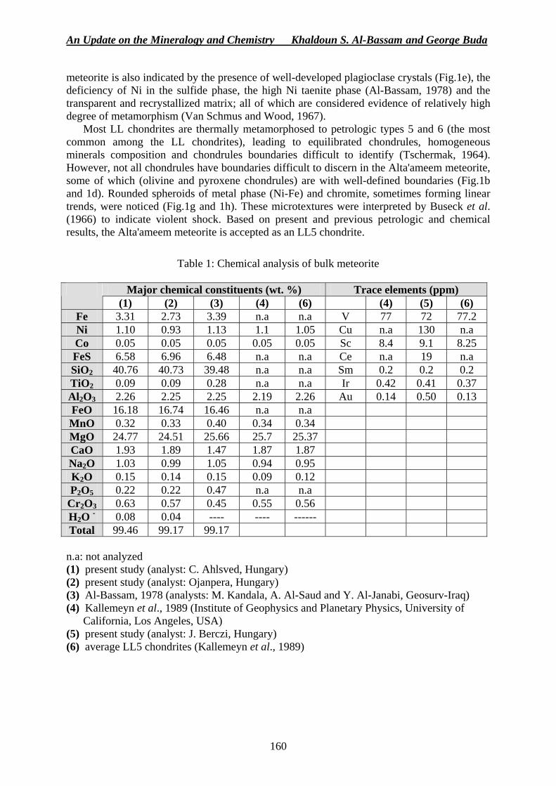
An Update on the Mineralogy and Chemistry Khaldoun S. Al-Bassam and George Buda
160
meteorite is also indicated by the presence of well-developed plagioclase crystals (Fig.1e), the deficiency of Ni in the sulfide phase, the high Ni taenite phase (Al-Bassam, 1978) and the transparent and recrystallized matrix; all of which are considered evidence of relatively high degree of metamorphism (Van Schmus and Wood, 1967).
Most LL chondrites are thermally metamorphosed to petrologic types 5 and 6 (the most common among the LL chondrites), leading to equilibrated chondrules, homogeneous minerals composition and chondrules boundaries difficult to identify (Tschermak, 1964). However, not all chondrules have boundaries difficult to discern in the Alta'ameem meteorite, some of which (olivine and pyroxene chondrules) are with well-defined boundaries (Fig.1b and 1d). Rounded spheroids of metal phase (Ni-Fe) and chromite, sometimes forming linear trends, were noticed (Fig.1g and 1h). These microtextures were interpreted by Buseck et al. (1966) to indicate violent shock. Based on present and previous petrologic and chemical results, the Alta'ameem meteorite is accepted as an LL5 chondrite.
Table 1: Chemical analysis of bulk meteorite
Major chemical constituents (wt. %) Trace elements (ppm)
(1) (2) (3) (4) (6) (4) (5) (6) Fe 3.31 2.73 3.39 n.a n.a V 77 72 77.2 Ni 1.10 0.93 1.13 1.1 1.05 Cu n.a 130 n.a Co 0.05 0.05 0.05 0.05 0.05 Sc 8.4 9.1 8.25 FeS 6.58 6.96 6.48 n.a n.a Ce n.a 19 n.a SiO2 40.76 40.73 39.48 n.a n.a Sm 0.2 0.2 0.2 TiO2 0.09 0.09 0.28 n.a n.a Ir 0.42 0.41 0.37 Al2O3 2.26 2.25 2.25 2.19 2.26 Au 0.14 0.50 0.13 FeO 16.18 16.74 16.46 n.a n.a MnO 0.32 0.33 0.40 0.34 0.34 MgO 24.77 24.51 25.66 25.7 25.37 CaO 1.93 1.89 1.47 1.87 1.87 Na2O 1.03 0.99 1.05 0.94 0.95 K2O 0.15 0.14 0.15 0.09 0.12 P2O5 0.22 0.22 0.47 n.a n.a
Cr2O3 0.63 0.57 0.45 0.55 0.56 H2O - 0.08 0.04 ---- ---- ------ Total 99.46 99.17 99.17 n.a: not analyzed (1) present study (analyst: C. Ahlsved, Hungary) (2) present study (analyst: Ojanpera, Hungary) (3) Al-Bassam, 1978 (analysts: M. Kandala, A. Al-Saud and Y. Al-Janabi, Geosurv-Iraq) (4) Kallemeyn et al., 1989 (Institute of Geophysics and Planetary Physics, University of
California, Los Angeles, USA) (5) present study (analyst: J. Berczi, Hungary) (6) average LL5 chondrites (Kallemeyn et al., 1989)
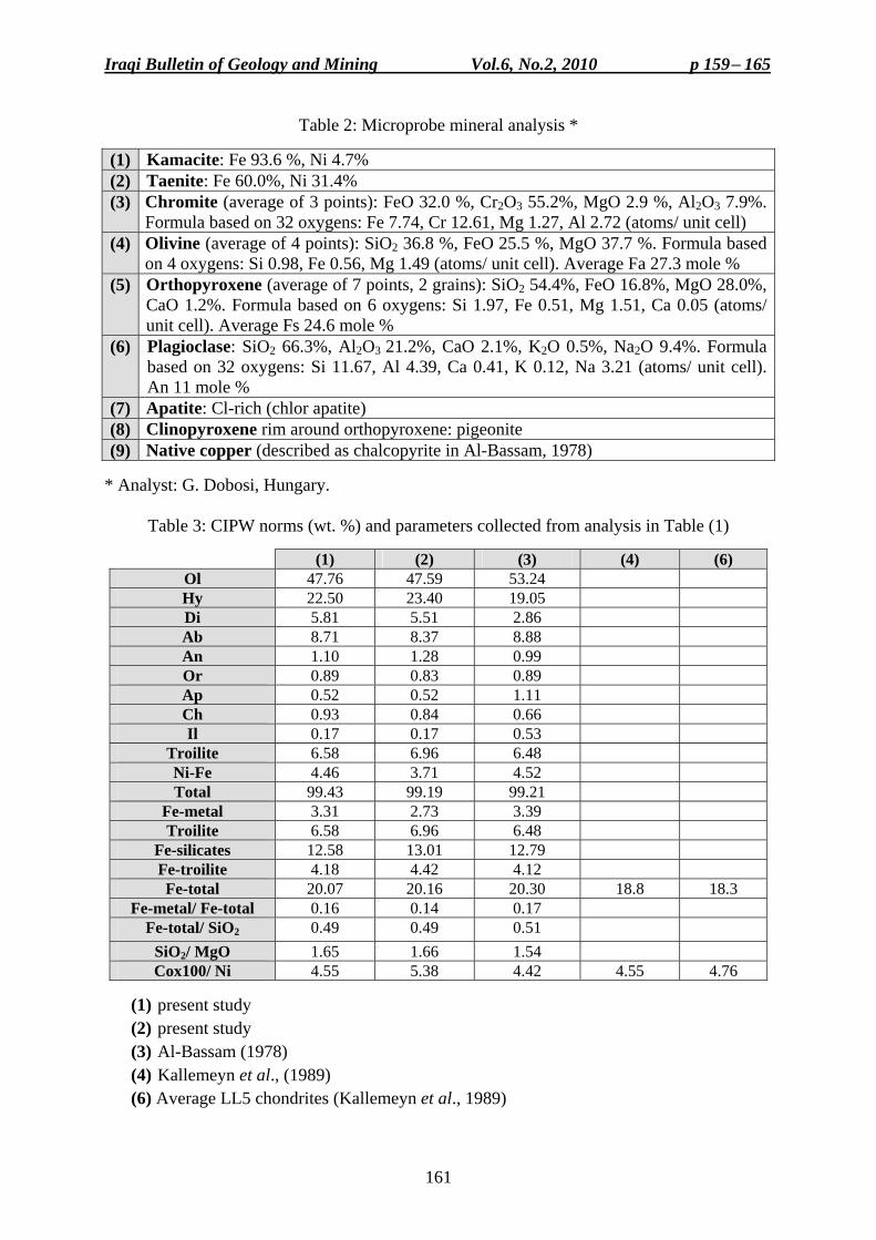
Iraqi Bulletin of Geology and Mining Vol.6, No.2, 2010 p 159− 165
161
Table 2: Microprobe mineral analysis *
(1) Kamacite: Fe 93.6 %, Ni 4.7% (2) Taenite: Fe 60.0%, Ni 31.4% (3) Chromite (average of 3 points): FeO 32.0 %, Cr2O3 55.2%, MgO 2.9 %, Al2O3 7.9%.
Formula based on 32 oxygens: Fe 7.74, Cr 12.61, Mg 1.27, Al 2.72 (atoms/ unit cell) (4) Olivine (average of 4 points): SiO2 36.8 %, FeO 25.5 %, MgO 37.7 %. Formula based
on 4 oxygens: Si 0.98, Fe 0.56, Mg 1.49 (atoms/ unit cell). Average Fa 27.3 mole % (5) Orthopyroxene (average of 7 points, 2 grains): SiO2 54.4%, FeO 16.8%, MgO 28.0%,
CaO 1.2%. Formula based on 6 oxygens: Si 1.97, Fe 0.51, Mg 1.51, Ca 0.05 (atoms/ unit cell). Average Fs 24.6 mole %
(6) Plagioclase: SiO2 66.3%, Al2O3 21.2%, CaO 2.1%, K2O 0.5%, Na2O 9.4%. Formula based on 32 oxygens: Si 11.67, Al 4.39, Ca 0.41, K 0.12, Na 3.21 (atoms/ unit cell). An 11 mole %
(7) Apatite: Cl-rich (chlor apatite) (8) Clinopyroxene rim around orthopyroxene: pigeonite (9) Native copper (described as chalcopyrite in Al-Bassam, 1978)
* Analyst: G. Dobosi, Hungary.
Table 3: CIPW norms (wt. %) and parameters collected from analysis in Table (1)
(1) (2) (3) (4) (6) Ol 47.76 47.59 53.24 Hy 22.50 23.40 19.05 Di 5.81 5.51 2.86 Ab 8.71 8.37 8.88 An 1.10 1.28 0.99 Or 0.89 0.83 0.89 Ap 0.52 0.52 1.11 Ch 0.93 0.84 0.66 Il 0.17 0.17 0.53
Troilite 6.58 6.96 6.48 Ni-Fe 4.46 3.71 4.52 Total 99.43 99.19 99.21
Fe-metal 3.31 2.73 3.39 Troilite 6.58 6.96 6.48
Fe-silicates 12.58 13.01 12.79 Fe-troilite 4.18 4.42 4.12 Fe-total 20.07 20.16 20.30 18.8 18.3
Fe-metal/ Fe-total 0.16 0.14 0.17 Fe-total/ SiO2 0.49 0.49 0.51
SiO2/ MgO 1.65 1.66 1.54 Cox100/ Ni 4.55 5.38 4.42 4.55 4.76
(1) present study (2) present study (3) Al-Bassam (1978) (4) Kallemeyn et al., (1989)
(6) Average LL5 chondrites (Kallemeyn et al., 1989)
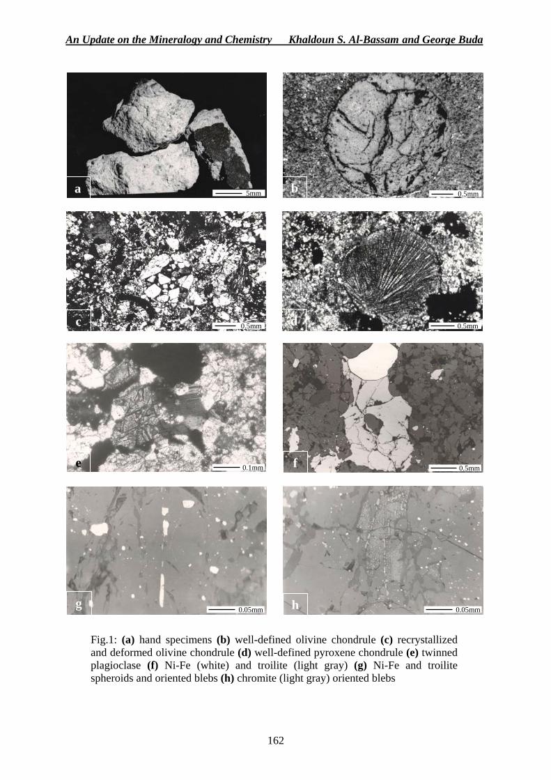
An Update on the Mineralogy and Chemistry Khaldoun S. Al-Bassam and George Buda
162
Fig.1: (a) hand specimens (b) well-defined olivine chondrule (c) recrystallized and deformed olivine chondrule (d) well-defined pyroxene chondrule (e) twinned plagioclase (f) Ni-Fe (white) and troilite (light gray) (g) Ni-Fe and troilite spheroids and oriented blebs (h) chromite (light gray) oriented blebs
a b
c d
e f
g h
5mm 0.5mm
0.5mm 0.5mm
0.1mm 0.5mm
0.05mm 0.05mm
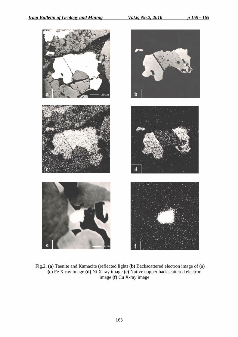
Iraqi Bulletin of Geology and Mining Vol.6, No.2, 2010 p 159− 165
163
Fig.2: (a) Taenite and Kamacite (reflected light) (b) Backscattered electron image of (a) (c) Fe X-ray image (d) Ni X-ray image (e) Native copper backscattered electron
image (f) Cu X-ray image
a b
c d
e f
30µm
4µm
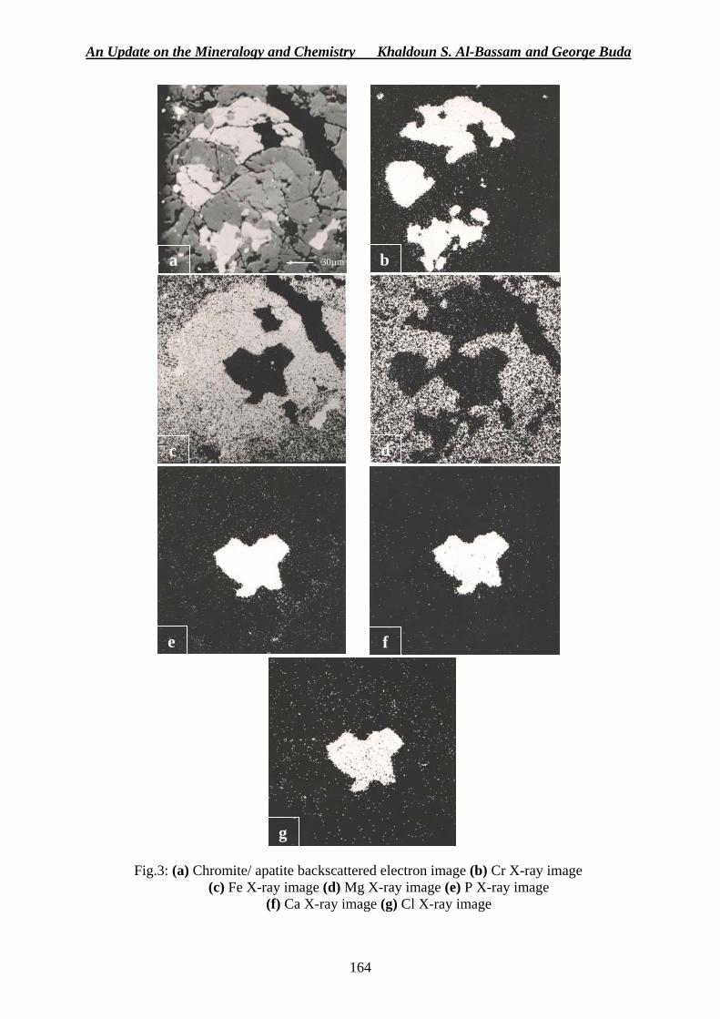
An Update on the Mineralogy and Chemistry Khaldoun S. Al-Bassam and George Buda
164
Fig.3: (a) Chromite/ apatite backscattered electron image (b) Cr X-ray image
(c) Fe X-ray image (d) Mg X-ray image (e) P X-ray image (f) Ca X-ray image (g) Cl X-ray image
a b
c d
e f
g
30µm
Iraqi Bulletin of Geology and Mining Vol.6, No.2, 2010 p 159− 165
165
Khaldoun S. Al-Bassam, Chief Researcher, GEOSURV, Iraq George Buda, Expert (retired), Geological Survey of Hungary REFERENCES Al-Bassam, K.S., 1978. The mineralogy and chemistry of the Alta'ameem meteorite. Meteoritics, Vol.13,
p. 257 – 265. Buseck, P.R., Mason, B. and Wiik, H.B., 1966. The Farmington meteorite. Mineralogy and chemistry. Geochim.
Cosmochim. Acta, Vol.30, p. 1 – 8. Grady, M.M., 2001. Catalogue of Meteorites, 5th edition. Cambridge University Press, Cambridge. Hiroi, T., Abe, M., Kitazato, K., Abe, S., Clark, B.E., Ishigura, M. and Barnouin-Jaha, O.S., 2006. Developing
space weathering on the asteroid 25143, Itokawa. Nature, Vol.443, p. 56 – 58. Kallemeyn, G.W., Rubin, A.E., Wang, D. and Wasson, J.T., 1989. Ordinary chondrites: Bulk compositions,
classification, lithophile-element fractionation and composition-petrographic type relationships. Geochim. Cosmochim. Acta, Vol.53, p. 2747 – 2767.
Mason, B., 1962. Meteorites. J.Wiley & sons, N.Y., 274pp. Mason, B., 1967. Extraterrestrial mineralogy. Amer. Mineralogist, Vol.52, p. 307 – 327. Mason, B. and Wiik, H.B., 1964. The amphoterites and meteorites of similar composition. Geochim.
Cosmochim. Acta, Vol.28, p. 533 – 538. Tschermak, G.,1964. The microscopic properties of meteorites. Smithsonian Contributions to Astrophysics,
Vol.4, p. 137 – 239. Van Schmus, W.R. and Wood, J.A., 1967. Chemical-petrologic classification of the chondritic meteorites.
Geochim. Cosmochim. Acta, Vol.31, p. 747 – 766.
167
INSTRUCTIONS FOR CONTRIBUTORS ▬ Three printed copies (A4 size) of the manuscript should be presented to the Secretary of
the Editorial Board. The text should be typed in Font 12, using Times New Roman, for English language and Arabic Transparent for Arabic language, considering the following: The title should be typed in Font 14, bold type, both in English (capital letters) and Arabic languages.
The name of the author(s) should be in bold type, Font 12, both in English and Arabic languages.
Fife key words should be included ABSTRACT, not exceeding 500 words, of the original language of the paper. However, extended abstract is needed by the other used language.
Affiliation and mailing address of the author(s), as foot note, with e-mail address of the first author. Personal colored photos are optional for printing after the references.
▬ The paper is expected to include: Introduction, Previous Works, Method of work (if applicable), Results, Discussion, Conclusions and References.
The references list should be prepared alphabetically and printed (font 10) on the last page. References should be referred to in the text by family name and date of publication. The following examples are for clarification: Al-Kadimi, J.A.M., Sissakian, V.K., Fattah, A.S. and Deikran, D.B., 1996. Tectonic Map of
Iraq, scale 1:1000 000, 2nd edit. GEOSURV, Baghdad, Iraq. Vail, P.R., Mitchum, R.M., Todd, R.G., Widmier, J.M. and Hatleid, W.G., 1977. Seismic
stratigraphy and global changes in sea level. In: Seismic Stratigraphy, Application to Hydrocarbon Exploration: C.E., Payton (Ed.). Memoir of the American Association of Petroleum Geologists, Tulsa, 26, p. 49 – 62.
Hagopian, D.H., 1979. Regional geological mapping of Nahidain – Tinif area. GEOSURV, int. rep. no. 983.
▬ Tables should appear directly after are referred in the text, except those which are full page size A4, then should appear overleaf. The number and title of the table should be placed on the top; they should be referred to in the text. Scanned tables are not accepted.
▬ Figures, drawings and photographs (all should be referred as Fig.) should be clear and neat not exceeding (15 × 25) cm in dimensions. They should appear directly after are referred in the text, except those which are full page size, then should appear overleaf. Titles should be placed below and all figures should be referred to in the text. Figures should be digitized, otherwise should be scanned, not less than 500 Dpi.
▬ All manuscripts presented to the bulletin for publication are reviewed by scientific referees inside and outside GEOSURV. The manuscript is returned to the senior author with the referees comments and suggestions to be revised accordingly. The revised copy will be checked by one of the referees to assure that the revised copy is amended according to the remarks of the referees, otherwise it will be returned to the senior author.
▬ When a paper is accepted, the senior author will be informed by a letter of acceptance, then a hard copy and CD are requested from the Senior author.
▬ Colored figures could be published; after paying 40000 I.D. per A4 page, by the author. ▬ The author will be provided by a copy of the issue that includes his/ her paper, besides a
paper copy of the article. When the paper includes more than one author, then the co-author(s) will be provided by a paper copy only.
▬ When two of the referees recommended not publishing a paper, then an official letter will inform the author, including the reason of not accepting the paper.
▬ The Editorial Board is not obliged to publish all manuscripts presented for publication. ▬ The scientific notes should have the same formatting of an ordinary paper, but without
abstract and the number of the pages should not exceed 5 pages. The scientific notes will be published in the first coming issue, after being reviewed by the Editorial Board.
▬ When referring to the bulletin, use Iraqi Bull. Geol. Min. as abbreviation.
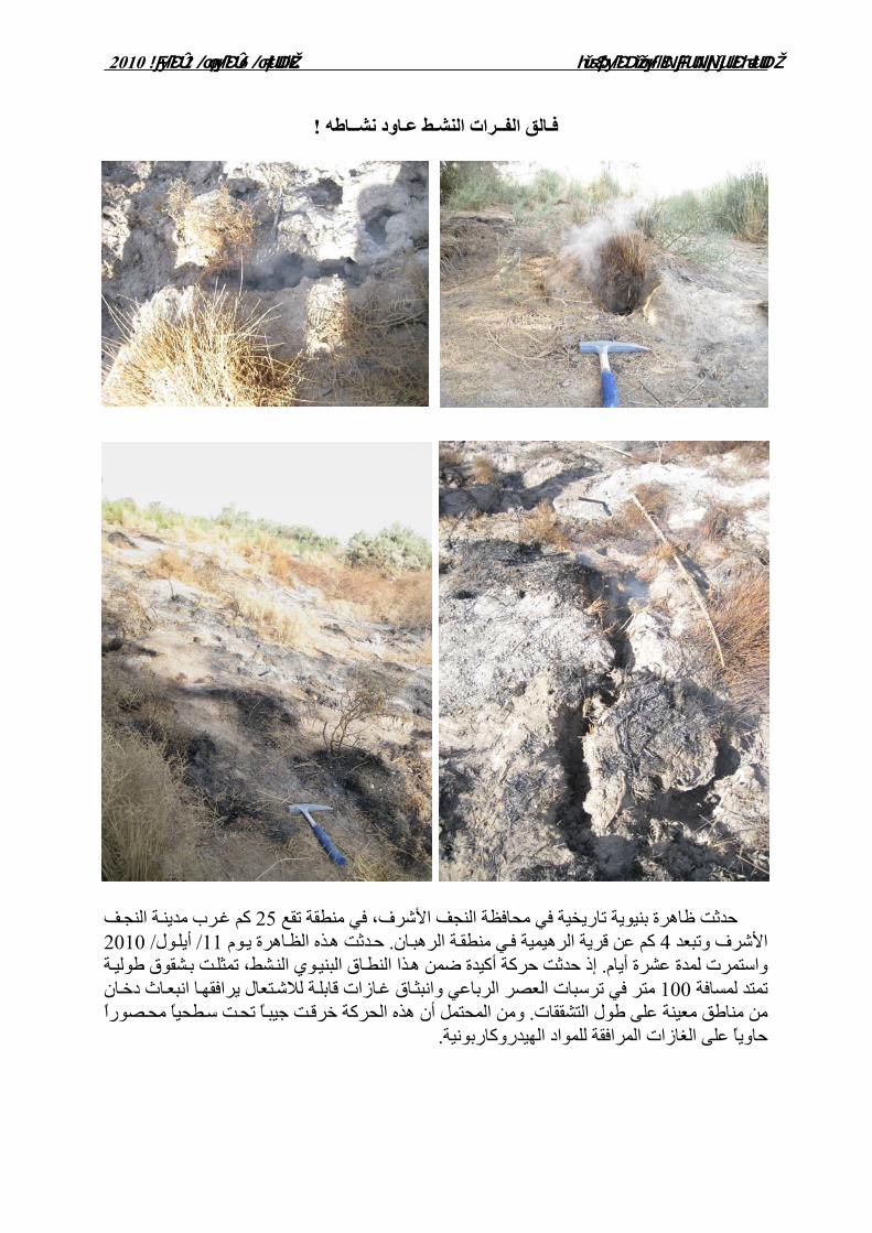
مجلة الجيولوجيا والتعدين العراقية المجلد/ 6، العدد/ 2، العام 2010
!اطه ــاود نشـط عـرات النشــ الفالقـف
ة النجف 25ت ظاهرة بنيوية تاريخية في محافظة النجف األشرف، في منطقة تقع حدث آم غرب مدين
ان 4األشرف وتبعد ة الرهب وم . آم عن قرية الرهيمية في منطق ذه الظاهرة ي ول / 11حدثت ه 2010/ أيلشط، تمثل . واستمرت لمدة عشرة أيام وي الن ذا النطاق البني ة تإذ حدثت حرآة أآيدة ضمن ه شقوق طولي ب
ا انبعاث دخان ترسبات العصر الرباعي في متر 100تمتد لمسافة ة لالشتعال يرافقه اق غازات قابل وانبثًا تح . من مناطق معينة على طول التشققات ت سطحيًا محصورًا ومن المحتمل أن هذه الحرآة خرقت جيب
.حاويًا على الغازات المرافقة للمواد الهيدروآاربونية
1020 العام ،2 /العدد ،6 /المجلد نعـــــي العراقية التعدين و الجيولوجيا جلةم
1
وحـصل علـى شـهادة الصويرة في مدينة 1953 عام الدكتور كريم محمود حسن ولد المرحوم بالشركة العامـة التحق 1976 في عام . 1974 من جامعة بغداد عام علم الجيولوجيا لوريوس في االبك
حـصل علـى شـهادة الماجـستير مـن جامعـة 1985للمسح الجيولوجي والتعـدين، فـي عـام Hull University شهادة الدكتوراه من جامعة بغـداد فـي موضـوع حصل على1998 وفي عام وعمل المرحوم في مشاريع حقلية متنوعة في مناطق متعـددة مـن العـراق، . الطباقية والمتحجرات
ي عام وف ،شعبة المسح الجيولوجي ل مسؤوالً أصبح 2003في عام . وترأس العديد من المشاريع الحقلية . حصل على لقب خبير جيولوجي2004
وعمل ، إقليم كوردستان أنتقل المرحوم الدكتور كريم محمود حسن إلى جامعة كويا 2004في عام . جامعة بغداد، كلية العلوم، قسم الجيولوجياإلى، حيث انتقل 2009بدرجة أستاذ مساعد حتى عام
ونـشاطه وتميـز بهدوئـه على العمل وبكل تفاني وإخالص بين والمواظ كان المرحوم من األكفاء
. عمله بالدقة والسرعة والجودة وتميز . بالعمل وزميالتهوحسن تصرفه وعالقته الممتازة مع زمالئه
.نوبة قلبية حادةثر أ 2010/ 9/ 16وافاه األجل بتاريخ
سيح جناته من اهللا سبحانه وتعالى أن يتغمده برحمته الواسعة ويسكنه فندعو الصبر والسلوان وزميالتهويلهم أهله وزمالئه
راجعون وإنا هللا وإنا إليه
هيئــة التحريــر
تنعى هيئة التحرير
نيابة عن كافة منتسبي الشـركة العامـة للمسـح الجيولوجـي والتعديـن
الزميل المرحوم
سنـمود حـم محـكريالدكتور
3
للنشرعداد البحث إ تعليمات عتمـد ي، و لسكرتارية هيئة التحرير 12 خط وبحجم A4 على ورق تقدم ثالث نسخ مطبوعة من البحث ▬
، للغـة االنكليزيـة Times New Roman للغـة العربيـة و Arabic Transparent الخطنوع :وبالشكل التالي
.)Bold 14خط الحجم ( باللغتين العربية واالنكليزية عنوان البحث .)Bold 12 خطالحجم ( باللغتين العربية واالنكليزية )أو المؤلفين(اسم المؤلف خمسة كلمات دالة ، وتقدم خالصة مطولة باللغة ) كلمة 500زيد على يعلى أن ال ( باللغتين العربية واالنكليزية مستخلص
.االنكليزية والعنـوان المهنـي والعنـوان البريـدي واالنتمـاء ) أو المؤلفين (العنوان الوظيفي للمؤلف يذكر
. في الحاشية السفلى من الصفحة األولىااللكتروني للمؤلف األول : من المؤمل أن يضم البحث ما يلي▬
.االستنتاجات والمناقشة، النتائج ،)حسب طبيعة البحث( أسلوب العمل، األعمال السابقة، مقدمةال باسـم ابتداء ،وفق التسلسل األبجدي ) 10خط الحجم (ث تطبع قائمة المصادر في نهاية البح :المصادر
ويشار إلى المصادر فـي . وسنة النشر ثم جهة النشر ، عنوان البحث )اسم العائلة (المؤلف أو المؤلفين : ، وكما في األمثلة التاليةالمتن باألسماء والسنة
.2005يل، عزيز اسعد، عاالحسن، علي خضير واسم وعبداألمير، خلدون عباس وكاظم، ماجد عبد همعل تقرير،جيوسرف. كوردستان – ، اربيل)الجزء الشرقي(المحدبة غالمسح الجيولوجي التفصيلي لطية دمير دا
. 2960 رقمداخلي Bellen, R.C. van, Dunnington, H.V., Wetzel, R. and Morton, D., 1959. Lexique Stratigraphique,
International. Asie, Fasc. 10a, Vol.3, Iraq. Paris, 333pp. Hagopian, D.H., 1979. Regional geological mapping of Nahidain – Tinif area. GEOSURV,
int. rep. no. 983. وإذا كـان متن البحث ويوضع رقم الجدول وعنوانه في األعلـى في بعد أول إشارة لها الجداول تظهر ▬
.)scanned(وال تقبل الجداول الممشطة فعندها يظهر بعد الصفحة التالية،A4الجدول بحجم عـن ال تزيـد بعاد وبأشكل واضح وب بالحاسبة )شكلجميعها تسمى (والصوراألشكال والمرتسمات تعد ▬
)15 x 25( وال تقبـل األشـكال الممـشطة ، من الجوانب األربعة لكل صفحة سم3 ويترك فراغسم )(scanned 500 قل منبأDpi . ترسل البحوث المقدمة للنشر في المجلة إلى التقييم بما ال يقل عن ثالثـة مقيمـين مـن ذوي الخبـرة ▬
تقييمه مع مالحظات المقيمين إلى الباحث األقـدم انتهاء يعاد البحث بعد . واالختصاص في مجال البحث ) سخة المعدلة وفق مالحظات المقيمين الن( يرسل البحث . وإعداد نسخة معدلة إلجراء التعديالت المطلوبة
الباحث قد أن من لتأكداو) قبل النشر ( الهيئة االستشارية للتدقيق النهائي أو هيئة التحرير أعضاءالى احد .أخرى التعديالت المطلوبة من قبل المقيمين، وبخالف ذلك يعاد البحث الى الباحث مرة أجرى
نسخة نهائية للبحث مسجلة ويطلب من الباحث رسالة قبول، في حالة قبول البحث، يعلم الباحث بواسطة ▬ .على قرص مدمج مع نسخة ورقية
.)A4 ( للصفحة الواحدة دينار40000 البالغة بعد تسديد كلفتها من قبل المؤلف والصور الملونةتنشر ▬مشاركة ، أما في حالة مع نسخة ورقية من البحث خة من عدد المجلة الذي يحوي بحثه بنس الباحث يزود ▬
.باحثين أو أكثر في اإلعداد يزود المشاركين بنسخة من البحث فقط في هبحث، يعاد البحث الى المؤلف مع رسالة اعتذار لنشر ية اثنين من المقيمين بعدم نشر في حالة توص ▬
.، موضحاً سبب الرفضالمجلةن الباحث تقديم موافقـة ، يطلب م للنشر في المجلة في حالة تقديم بحث مستل من أطروحة دراسات عليا ▬
. إلى سكرتارية هيئة تحريرالمشرف على مضمون البحث ونشره، وتقدم رسمياً . من بحوثليهاإالمجلة ليست ملزمة بنشر كل ما يقدم ▬الصـة وال تزيـد عـن ، وتكون بنفس شاكلة البحوث ولكـن بـدون خ المالحظات العلمية تنشر المجلة ▬
.يصدر بعد تقييمها من قبل أعضاء هيئة التحرير صفحات، وتنشر في أول عدد 5
Related Documents


![Sham'e Karbala [Urdu]](https://static.cupdf.com/doc/110x72/577cd6981a28ab9e789cbd41/shame-karbala-urdu.jpg)