Comparing Global and Interest Point Descriptors for Similarity Retrieval in Remote Sensed Imagery Shawn Newsam Computer Science and Engineering University of California Merced, CA 95343 [email protected] Yang Yang Computer Science and Engineering University of California Merced, CA 95343 [email protected] ABSTRACT We investigate the application of a new category of low-level image descriptors termed interest points to remote sensed image analysis. In particular, we compare how scale and rotation invariant descriptors extracted from salient image locations perform compared to proven global texture fea- tures for similarity retrieval. Qualitative results using a geo- graphic image retrieval application and quantitative results using an extensive ground truth dataset show that inter- est point descriptors support effective similarity retrieval in large collections of remote sensed imagery. Categories and Subject Descriptors H.3 [Information Storage and Retrieval]: Information Search and Retrieval General Terms Image retrieval Keywords Interest points, similarity search, remote sensed imagery 1. INTRODUCTION Remote sensed imagery continues to accumulate at an in- creasing rate. Exciting new geographic information systems such as Google Earth and Microsoft Virtual Earth are allow- ing more and more people to access this imagery. However, these systems only allow users to view the raw image data. A much richer interaction would be enabled by the integration of automated techniques for annotating the image content. Services such as land-use classification, similarity retrieval, and spatial data mining would not only satisfy known de- mands but would also spawn new unthought-of applications. Automated remote sensed image analysis remains by-and- large an unsolved problem. There has been significant effort over the last several decades in using low-level image de- scriptors, such as spectral, shape and texture features, to Permission to make digital or hard copies of all or part of this work for personal or classroom use is granted without fee provided that copies are not made or distributed for profit or commercial advantage and that copies bear this notice and the full citation on the first page. To copy otherwise, to republish, to post on servers or to redistribute to lists, requires prior specific permission and/or a fee. ACMGIS’07 , November 7-9, 2007, Seattle, WA Copyright 2007 ACM 978-1-59593-914-2/07/11 ...$5.00. make sense of the raw image data. While there has been noted successes for specific problems, ample opportunities remain. In this paper, we investigate the application of a new cat- egory of low-level image descriptors, termed interest points, to remote sensed image analysis. Interest point descriptors have enjoyed surprising success for a range of traditional computer vision problems. There has been little research, however, on applying them to remote sensed imagery. Our investigation is done in the context of similarity re- trieval. In particular, we compare interest point descriptors to global texture features which have been shown to be par- ticularly effective for remote sensed image retrieval. Simi- larity retrieval is not only an interesting application but also serves as an excellent platform for evaluating the overall de- scriptiveness of a descriptor. Our comparison confirms that interest point descriptors show great promise for remote sensed image analysis. Even a straight forward application to similarity retrieval performs comparably to the proven global texture features. This find- ing opens the door to further investigation. 2. RELATED WORK Content-based image retrieval (CBIR) has been an ac- tive research area in computer vision for over a decade with IBM’s Query by Image Content (QBIC) system from 1995 [2] being one of the earliest successes. A variety of image descriptors have been investigated including color, shape, texture, spatial configurations, and others. A recent survey is available in [5]. Similarity based image retrieval has been proposed as an automated method for managing and interacting with the the growing collections of remote sensed imagery. As in other domains, a variety of descriptors have been investi- gated including spectral [3, 4], shape [14], texture [11, 7, 10, 15, 20], and combinations such as multi-spectral tex- ture [19]. While the most effective descriptor is problem de- pendent, texture features have enjoyed success since, unlike spectral features, they incorporate spatial information which is clearly important for remote sensed imagery but avoid the difficult pre-processing step of segmentation needed to ex- tract shape features. The recent emergence of interest point descriptors has re- vitalized several research areas in computer vision. A num- ber of different techniques have been proposed which have two fundamental components in common. First, a method for finding the so-called interesting or salient locations in an image. Second, a descriptor for describing the image patches Proceedings of the 15th International Symposium on Advances in Geographic Information Systems ACM GIS 2007

Welcome message from author
This document is posted to help you gain knowledge. Please leave a comment to let me know what you think about it! Share it to your friends and learn new things together.
Transcript
Comparing Global and Interest Point Descriptors forSimilarity Retrieval in Remote Sensed Imagery
Shawn NewsamComputer Science and Engineering
University of CaliforniaMerced, CA 95343
Yang YangComputer Science and Engineering
University of CaliforniaMerced, CA 95343
ABSTRACTWe investigate the application of a new category of low-levelimage descriptors termed interest points to remote sensedimage analysis. In particular, we compare how scale androtation invariant descriptors extracted from salient imagelocations perform compared to proven global texture fea-tures for similarity retrieval. Qualitative results using a geo-graphic image retrieval application and quantitative resultsusing an extensive ground truth dataset show that inter-est point descriptors support effective similarity retrieval inlarge collections of remote sensed imagery.
Categories and Subject DescriptorsH.3 [Information Storage and Retrieval]: InformationSearch and Retrieval
General TermsImage retrieval
KeywordsInterest points, similarity search, remote sensed imagery
1. INTRODUCTIONRemote sensed imagery continues to accumulate at an in-
creasing rate. Exciting new geographic information systemssuch as Google Earth and Microsoft Virtual Earth are allow-ing more and more people to access this imagery. However,these systems only allow users to view the raw image data. Amuch richer interaction would be enabled by the integrationof automated techniques for annotating the image content.Services such as land-use classification, similarity retrieval,and spatial data mining would not only satisfy known de-mands but would also spawn new unthought-of applications.
Automated remote sensed image analysis remains by-and-large an unsolved problem. There has been significant effortover the last several decades in using low-level image de-scriptors, such as spectral, shape and texture features, to
Permission to make digital or hard copies of all or part of this work forpersonal or classroom use is granted without fee provided that copies arenot made or distributed for profit or commercial advantage and that copiesbear this notice and the full citation on the first page. To copy otherwise, torepublish, to post on servers or to redistribute to lists, requires prior specificpermission and/or a fee.ACMGIS’07 , November 7-9, 2007, Seattle, WACopyright 2007 ACM 978-1-59593-914-2/07/11 ...$5.00.
make sense of the raw image data. While there has beennoted successes for specific problems, ample opportunitiesremain.
In this paper, we investigate the application of a new cat-egory of low-level image descriptors, termed interest points,to remote sensed image analysis. Interest point descriptorshave enjoyed surprising success for a range of traditionalcomputer vision problems. There has been little research,however, on applying them to remote sensed imagery.
Our investigation is done in the context of similarity re-trieval. In particular, we compare interest point descriptorsto global texture features which have been shown to be par-ticularly effective for remote sensed image retrieval. Simi-larity retrieval is not only an interesting application but alsoserves as an excellent platform for evaluating the overall de-scriptiveness of a descriptor.
Our comparison confirms that interest point descriptorsshow great promise for remote sensed image analysis. Even astraight forward application to similarity retrieval performscomparably to the proven global texture features. This find-ing opens the door to further investigation.
2. RELATED WORKContent-based image retrieval (CBIR) has been an ac-
tive research area in computer vision for over a decade withIBM’s Query by Image Content (QBIC) system from 1995[2] being one of the earliest successes. A variety of imagedescriptors have been investigated including color, shape,texture, spatial configurations, and others. A recent surveyis available in [5].
Similarity based image retrieval has been proposed as anautomated method for managing and interacting with thethe growing collections of remote sensed imagery. As inother domains, a variety of descriptors have been investi-gated including spectral [3, 4], shape [14], texture [11, 7,10, 15, 20], and combinations such as multi-spectral tex-ture [19]. While the most effective descriptor is problem de-pendent, texture features have enjoyed success since, unlikespectral features, they incorporate spatial information whichis clearly important for remote sensed imagery but avoid thedifficult pre-processing step of segmentation needed to ex-tract shape features.
The recent emergence of interest point descriptors has re-vitalized several research areas in computer vision. A num-ber of different techniques have been proposed which havetwo fundamental components in common. First, a methodfor finding the so-called interesting or salient locations in animage. Second, a descriptor for describing the image patches
Proceedings of the 15th International Symposium on Advances in Geographic Information Systems ACM GIS 2007

at these locations. Interest point detectors and descriptorshave shown to be robust to changes in image orientation,scale, perspective and illumination conditions as well as toocclusion, and, like global features, do not require segmenta-tion. They are very efficient to compute which allows themto be used in real-time applications. They have been suc-cessfully applied to a number of problems including imagestereo pair matching, object recognition and categorization,robot localization, panorama construction, and, relevant tothis work, image retrieval. Excellent comparisons of differ-ent interest point detectors and descriptors can be found in[18] and [17] respectively.
The application of interest point detectors and descriptorsto image retrieval has focused primarily on retrieving im-ages of the same object or scene under different conditions.Examples include finding additional appearances of a givenobject in scenes or shots in a video [22], finding images of3D objects acquired from different viewpoints [21, 23, 24] oragainst different backgrounds [27], finding images belongingto distinct, homogeneous semantic categories [8, 23], findingframes of the same scene in a video [25], and finding im-ages of the same indoor scene for localization [9]. There hasbeen little application to finding similar images or imageregions. In particular, to the best of our knowledge, interestpoint detectors and descriptors have not been applied to theproblem of similarity retrieval in large collections of remotesensed imagery.
3. METHODOLOGY
3.1 Global FeaturesWe consider Gabor texture features as the global features.
Texture features, and in particular Gabor texture features,have proven to be effective for performing content-based sim-ilarity retrieval in remote sensed imagery [11, 19, 20, 10,15, 7]. The MPEG-7 Multimedia Content Description In-terface [16] standardized Gabor texture features after theywere shown to outperform other texture features for similar-ity retrieval. One of the evaluation datasets used in the com-petitive standardization process consisted of remote sensedimagery.
Gabor texture analysis is accomplished by applying a bankof scale and orientation selective Gabor filters to an image.Gabor functions are Gaussians functions modulated by asinusoid. Two dimensional spatial filters based on Gaborfunctions can be made orientation and scale selective by con-trolling this modulation. While the choice of the number oforientations and scales is application dependent, experimen-tation has shown that a bank of filters tuned to combina-tions of five scales, at octave intervals, and six orientations,at 30-degree intervals, is sufficient for the analysis of remotesensed imagery.
A Gabor texture feature vector is formed from the filteroutputs as follows [26]. Applying a bank of Gabor filterswith R orientations and S scales to an image results in atotal of RxS filtered images:
f ′11 (x, y) , . . . , f ′
RS (x, y) . (1)
A single global feature vector for the original image is formedby computing the first and second moments of the filteredimages. That is, a 2RS dimension feature vector, hGABOR,
is formed as
hGABOR = [µ11, σ11, µ12, σ12, . . . , µ1S , σ1S , . . . , µRS , σRS ] ,(2)
where µrs and σrs are the mean and standard deviation off ′
rs (x, y). Finally, to normalize for differences in range, eachof the 2RS components is scaled to have a mean of zero anda standard deviation of one across the entire dataset.
The (dis)similarity between two images is measured bycomputing the Euclidean distance between their texture fea-tures
d(h1, h2) = ‖h1 − h2‖2 =
vuut2RSXi=1
(h1i − h2i)2 . (3)
This results in an orientation (and scale) sensitive similar-ity measure. Orientation invariant similarity is possible byusing the modified distance function
dRI(h1, h2) = minr∈R
‖h1<r> − h2‖2 (4)
where h<r> represents h circularly shifted by r orientations:
h<r> = (5)
[(hr1, hr2, · · · , hrS), (h(r+1)1, h(r+1)2, · · · , h(r+1)S),
· · · , (hR1, hR2, · · · , hRS), (h11, h12, · · · , h1S),
· · · , (h(r−1)1, h(r−1)2, · · · , h(r−1)S)] .
Parentheses have been added for clarity. Conceptually, thisdistance function computes the best match between rotatedversions of the images without repeating the feature extrac-tion. The granularity of the rotations is of course limited bythe filter bank construction.
3.2 Interest PointsWe choose David Lowe’s Scale Invariant Feature Trans-
form (SIFT) [12, 13] as the interest point detector and de-scriptor. SIFT-based descriptors have been shown to berobust to image rotation and scale, and to be capable ofmatching images with geometric distortion and varied il-lumination. An extensive comparison with other local de-scriptors found that SIFT-based descriptors performed thebest in an image matching task [17]. Like most interestpoint based analysis, there are two components to SIFT-based analysis. First, a detection step locates points thatare identifiable from different views. This process ideallylocates the same regions in an object or scene regardless ofviewpoint, illumination, etc. Second, these locations are de-scribed by a descriptor that is distinctive yet also invariantto viewpoint, illumination, etc. In short, SIFT-based analy-sis focuses on image patches that can be found and matchedunder different image acquisition conditions.
The detection step is designed to find image regions thatare salient not only spatially but also across different scales.Candidate locations are initially selected from local extremain Difference of Gaussian (DoG) filtered images in scalespace. The DoG images are derived by subtracting twoGaussian blurred images with different σ
D(x, y, σ) = L(x, y, kσ) − L(x, y, σ) . (6)
where L(x, y, σ) is the image convolved with a Gaussian ker-nel with standard deviation σ, and k represents the differentsampling intervals in scale space. Each point in the three
2

dimensional DoG scale space is compared with its eight spa-tial neighbors at the same scale, and with its nine neighborsat adjacent higher and lower scales. The local maximumor minimum are further screened for minimum contrast andpoor localization along elongated edges. The last step ofthe detection process uses a histogram of gradient directionssampled around the interest point to estimate its orientation.This orientation is used to align the descriptor to make it itrotation invariant.
A feature descriptor is then extracted from the imagepatch centered at each interest point. The size of this patchis determined by the scale of the corresponding extremumin the DoG scale space. This makes the descriptor scaleinvariant. The feature descriptor consists of histograms ofgradient directions computed from a 4x4 spatial grid. Theinterest point orientation estimate described above is used toalign the gradient directions to make the descriptor rotationinvariant. The gradient directions are quantized into eightbins so the final feature vector has dimension 128 (4x4x8).This histogram-of-gradients descriptor can be roughly thoughtof a summary of the edge information in the image patchcentered at the interest point.
Rather than work with the full 128 dimension SIFT fea-ture vectors, we clustered a large sampling of the featuresand labeled the full SIFT feature set with the id of the closestcluster center. Representing the features using the clusterlabels has been shown to be effective in other image retrievaltasks [22]. The clustering was performed using the standardk-means algorithm.
The final interest point descriptor used to compute thesimilarity between two images is composed of the frequencycounts of the labeled SIFT feature vectors. That is, hINT
for an image, is
hINT = [t0, t1, . . . , tk−1] , (7)
where ti is number of occurrences of SIFT features with labeli in the image. hINT is similar to a term vector in documentretrieval. The cosine distance has shown to be effective forcomparing documents represented by term vectors [6] so weuse it here to compute the similarity between images:
d(h1, h2) =
k−1Pi=0
h1ih2isk−1Pi=0
h12i
k−1Pi=0
h22i
. (8)
The cosine distance measure ranges from zero (no match)to one (perfect match). To make it compatible with the dis-tance function used for comparing the global Gabor texturefeatures, for which zero is a perfect match, we use one mi-nus the cosine distance to perform similarity retrieval usinginterest point descriptors.
3.3 Similarity RetrievalThe above features and associated distance measures are
used to perform similarity retrieval as follows. Let T bea collection of M images; let hm be the feature vector ex-tracted from image m, where m ∈ 1, . . . , M ; let d(·, ·) be adistance function defined on the feature space; and let hquery
be the feature vector corresponding to a given query image.Then, the image in T most similar to the query image isthe one whose feature vector minimizes the distance to the
query’s feature vector:
m∗ = arg min1≤m≤M
d(hquery, hm) . (9)
Likewise, the k most similar images are those that result inthe k smallest distances when compared to the query image.Retrieving the k most similar items is commonly referred toas a k-nearest neighbor (kNN) query.
Given a ground-truth dataset, there are a number of waysto evaluate retrieval performance. One common method isto plot the precision of the retrieved set for different valuesof k. Precision is defined as the percent of the retrievedset that is correct and can be computed as the ratio of thenumber of true positives to the size of the retrieved set. Itis straight forward and meaningful to compute and comparethe average precision for a set of queries when the groundtruth sizes are the same. (It is not straight forward to dothis for precision-recall curves.)
Plotting precision versus the size of the retrieved set pro-vides a graphical evaluation of performance. A single mea-sure of performance that not only considers that the ground-truth items are in the top retrievals but also their order-ing can be computed as follows [16]. Consider a query qwith a ground-truth size of NG(q). The Rank(k) of the kthground-truth item is defined as the position at which it isretrieved. A number K(q) ≥ NG(q) is chosen so that itemswith a higher rank are given a constant penalty
Rank(k) =
(Rank(k), if Rank(k) ≤ K(q)
1.25K(q), if Rank(k) > K(q). (10)
K(q) is commonly chosen to be 2NG(q). The Average Rank(AVR) for a single query q is then computed as
AV R(q) =1
NG(q)
NG(k)Xk=1
Rank(k) . (11)
To eliminate influences of different NG(q), the NormalizedModified Retrieval Rank (NMRR)
NMRR(q) =AV R(q) − 0.5[1 + NG(q)]
1.25K(q) − 0.5[1 + NG(q)](12)
is computed. NMRR(q) takes values between zero (indicat-ing whole ground truth found) and one (indicating nothingfound) irrespective of the size of the ground-truth for queryq, NG(q). Finally, the Average Normalized Retrieval Rate(ANMRR) can be computed for a set NQ of queries
ANMRR =1
NQ
NQXq=1
NMRR(q) . (13)
4. EVALUATIONThis section describes the datasets and techniques used to
perform the comparisons.
4.1 DatasetsA collection of IKONOS 1-m panchromatic satellite im-
ages of the United States was used to compare the descrip-tors. Separate datasets were created for the qualitative andquantitative analyses. For the qualitative analysis, two largeIKONOS images of the Phoenix and Los Angeles areas werepartitioned into non-overlapping 64-by-64 pixel tiles. ThePhoenix image measures 21,248-by-11,328 pixels for a total
3
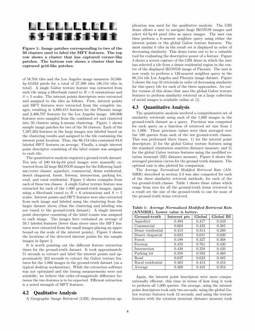
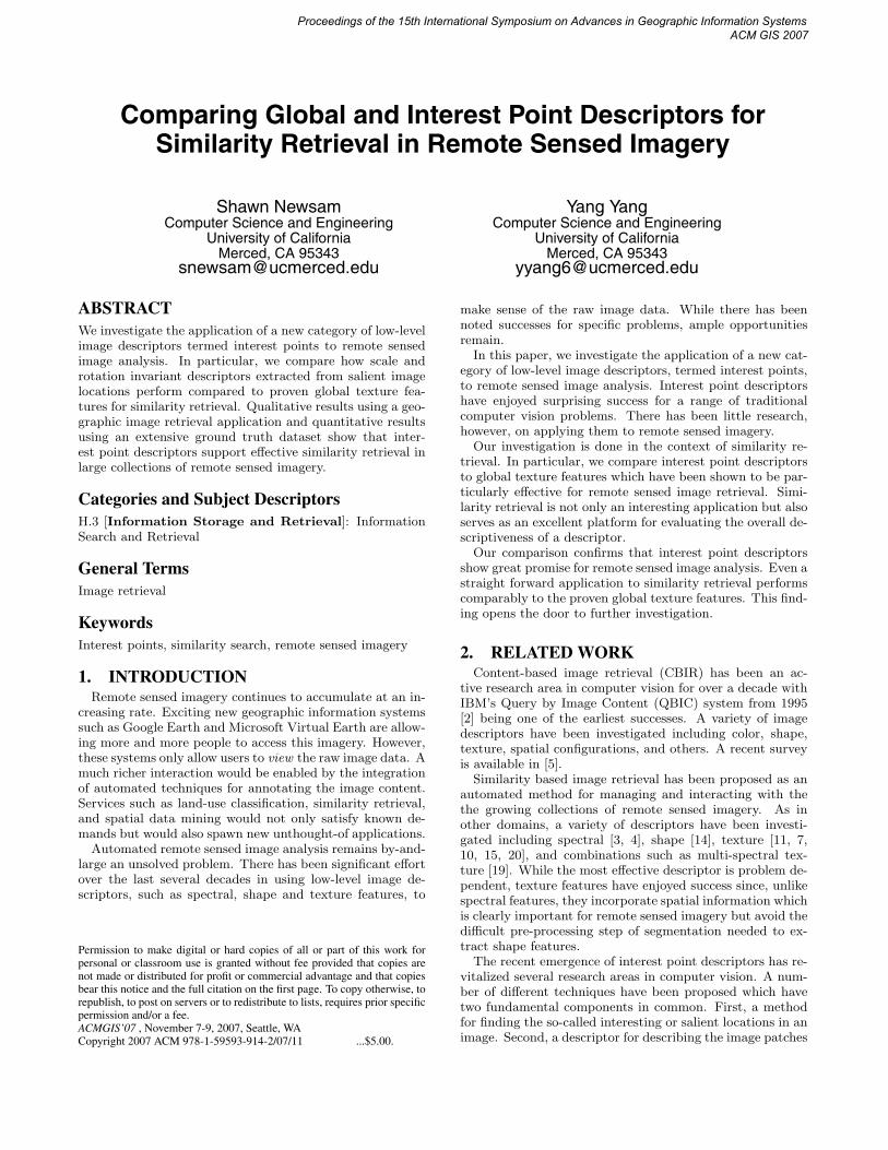
Figure 1: Image patches corresponding to two of the50 clusters used to label the SIFT features. The toprow shows a cluster that has captured corner-likepatches. The bottom row shows a cluster that hascaptured grid-like patches.
of 58,764 tiles and the Los Angeles image measures 10,560-by-10,624 pixels for a total of 27,390 tiles (86,154 tiles intotal). A single Gabor texture feature was extracted fromeach tile using a filterbank tuned to R = 6 orientations andS = 5 scales. The interest points descriptors were extractedand assigned to the tiles as follows. First, interest pointsand SIFT features were extracted from the complete im-ages, resulting in 4,880,415 features for the Phoenix imageand 2,406,787 features for the Los Angeles image. 100,000features were sampled from the combined set and clusteredinto 50 clusters using k-means clustering. Figure 1 showssample image patches for two of the 50 clusters. Each of the7,287,202 features in the large images was labeled based onthe clustering results and assigned to the tile containing theinterest point location. Thus, the 86,154 tiles contained 84.6labeled SIFT features on average. Finally, a single interestpoint descriptor consisting of the label counts was assignedto each tile.
The quantitative analysis required a ground-truth dataset.Ten sets of 100 64-by-64 pixel images were manually ex-tracted from 22 large IKONOS images for the following land-use/cover classes: aqueduct, commercial, dense residential,desert chaparral, forest, freeway, intersection, parking lot,road, and rural residential. Figure 2 shows examples fromeach of these ten classes. A single Gabor texture feature wasextracted for each of the 1,000 ground-truth images, againusing a filterbank tuned to R = 6 orientations and S = 5scales. Interest points and SIFT features were also extractedfrom each image and labeled using the clustering from thelarger dataset above (thus the clustering and labeling wasnot tuned to the ground-truth dataset). A single interestpoint descriptor consisting of the label counts was assignedto each image. The images here contained an average of59.1 labeled features (fewer than above since the SIFT fea-tures were extracted from the small images placing an upperbound on the scale of the interest points). Figure 3 showsthe locations of the detected interest points for the sampleimages in figure 2.
It is worth pointing out the different feature extractiontimes for the ground-truth dataset. It took approximately51 seconds to extract and label the interest points and ap-proximately 353 seconds to extract the Gabor texture fea-tures for the 1,000 images in the ground-truth dataset (on atypical desktop workstation). While the extraction softwarewas not optimized and the timing measurements were notscientific, we believe this order-of-magnitude difference be-tween the two features is to be expected. Efficient extractionis a noted strength of SIFT features.
4.2 Qualitative AnalysisA Geographic Image Retrieval (GIR) demonstration ap-
plication was used for the qualitative analysis. The GIRdemo allows a user to navigate large IKONOS images andselect 64-by-64 pixel tiles as query images. The user canthen perform a k-nearest neighbor query using either theinterest points or the global Gabor texture features. Themost similar k tiles in the result set is displayed in order ofdecreasing similarity. This demo turns out to be a valuabletool for evaluating the descriptive power of a feature. Figure4 shows a screen capture of the GIR demo in which the userhas selected a tile from a dense residential region in the cen-ter of the displayed IKONOS image of Phoenix. The user isnow ready to perform a 128-nearest neighbor query in the86,154 tile Los Angeles and Phoenix image dataset. Figure5 shows the top 32 retrievals in order of decreasing similarityfor this query tile for each of the three approaches. An ear-lier version of this demo that uses the global Gabor texturefeatures to perform similarity retrieval on a large collectionof aerial images is available online at [1].
4.3 Quantitative AnalysisThe quantitative analysis involved a comprehensive set of
similarity retrievals using each of the 1,000 images in theground-truth dataset as a query. Precision was computedfor each query as a function of retrieved set size from 1to 1,000. These precision values were then averaged overthe 100 queries from each of the ten ground-truth classes.This was performed three times: 1) for the interest pointdescriptors; 2) for the global Gabor texture features usingthe standard orientation sensitive distance measure; and 3)for the global Gabor texture features using the modified ro-tation invariant (RI) distance measure. Figure 6 shows theaveraged precision curves for the ground truth datasets. Theoptimal case is also plotted for comparison.
The Average Normalized Modified Retrieval Rate (AN-MRR) described in section 3.3 was also computed for eachof the three similarity retrieval methods, for each of theten ground-truth classes. Table 1 shows these values whichrange from zero for all the ground-truth items retrieved ina result set the size of the ground-truth to one for none ofthe ground-truth items retrieved.
Table 1: Average Normalized Modified Retrieval Rate(ANMRR). Lower value is better.Ground-truth Interest pts Global Global RIAqueduct 0.494 0.417 0.243Commercial 0.604 0.432 0.385Dense residential 0.413 0.314 0.280Desert chaparral 0.023 0.015 0.020Forest 0.188 0.327 0.368Freeway 0.458 0.761 0.430Intersection 0.438 0.358 0.420Parking lot 0.358 0.502 0.460Road 0.637 0.623 0.485Rural residential 0.463 0.413 0.454Average 0.408 0.416 0.354
Again, the interest point descriptors were more compu-tationally efficient, this time in terms of how long it tookto perform all 1,000 queries. On average, using the interestpoint descriptors took only two seconds, using the global Ga-bor texture features took 12 seconds, and using the texturefeatures with the rotation invariant distance measure took
4

(a) (b) (c) (d) (e) (f) (g) (h) (i) (j)
Figure 2: Two examples from each of the ground-truth classes. (a) Aqueduct. (b) Commercial. (c) Denseresidential. (d) Desert chaparral. (e) Forest. (f) Freeway. (g) Intersection. (h) Parking lot. (i) Road. (j)Rural residential.
(a) (b) (c) (d) (e) (f) (g) (h) (i) (j)
Figure 3: The interest point locations for the images in figure 2.
Figure 4: The Geographic Image Retrieval demo which allows users to perform similarity retrieval in remotesensed imagery.
5

(a)
(b)
(c)
Figure 5: Examples of similarity retrieval using the GIR demo. The query tile (top left) and the top 32retrieved images in order of decreasing similarity for (a) interest point descriptors, (b) global Gabor texturefeatures, and (c) global Gabor texture features using the rotation invariant similarity measure.
6

0 200 400 600 800 10000
0.1
0.2
0.3
0.4
0.5
0.6
0.7
0.8
0.9
1
Size of return set
Ave
rage
pre
cisi
on (
%)
Aqueduct queries
Interest pointsGlobal featuresGlobal features RIOptimal
(a)
0 200 400 600 800 10000
0.1
0.2
0.3
0.4
0.5
0.6
0.7
0.8
0.9
1
Size of return set
Ave
rage
pre
cisi
on (
%)
Commercial queries
Interest pointsGlobal featuresGlobal features RIOptimal
(b)
0 200 400 600 800 10000
0.1
0.2
0.3
0.4
0.5
0.6
0.7
0.8
0.9
1
Size of return set
Ave
rage
pre
cisi
on (
%)
Dense Residential queries
Interest pointsGlobal featuresGlobal features RIOptimal
(c)
0 200 400 600 800 10000
0.1
0.2
0.3
0.4
0.5
0.6
0.7
0.8
0.9
1
Size of return set
Ave
rage
pre
cisi
on (
%)
Forest queries
Interest pointsGlobal featuresGlobal features RIOptimal
(d)
0 200 400 600 800 10000
0.1
0.2
0.3
0.4
0.5
0.6
0.7
0.8
0.9
1
Size of return set
Ave
rage
pre
cisi
on (
%)
Freeway queries
Interest pointsGlobal featuresGlobal features RIOptimal
(e)
0 200 400 600 800 10000
0.1
0.2
0.3
0.4
0.5
0.6
0.7
0.8
0.9
1
Size of return set
Ave
rage
pre
cisi
on (
%)
Intersection queries
Interest pointsGlobal featuresGlobal features RIOptimal
(f)
Figure 6: Precision as a function return set size for the three similarity retrieval methods for the ground-truth classes. (RI=rotation invariant) (a) Aqueduct. (b) Commercial. (c) Dense residential. (d) Forest.(e) Freeway. (g) Intersection. Not shown are desert chaparral (methods perform comparably), parking lot(curves are similar to forest), road (curves are similar to aqueduct), and rural residential (curves are similarto commercial).
60 seconds. This variation could be critical for supportinginteractive similarity retrieval.
5. DISCUSSIONThe qualitative analysis provided by the GIR demo showed
the interest point descriptors support effective similarity re-trieval. Retrieval results for the interest points, such as theexample in figure 5, are rotation invariant, and when com-pared to the global features, are less sensitive to differencesin scale. This makes sense because the interest points arenormalized for scale during the detection step. We also ob-served that they are more robust to variation in the spatialconfigurations of the ground truth classes. Notice that theretrieved set for the interest point descriptors in figure 5 ex-hibits greater variability in the arrangement of the housesand streets than the retrieved sets for the global texturefeatures.
None of the approaches was shown to clearly outperformthe others in the quantitative analysis. Both the precisioncurves and the ANMRR values indicate that different de-scriptors are better for different ground truth classes. Thefollowing general observations can be made from the preci-sion curves in figure 6. The interest points descriptors havedifficulty with the aqueduct, commercial, and road classes(the precision curves for the road class are not shown but arevery similar in shape to those for the aqueduct class). Theseclasses tend to be very structured which presents a challengefor the interest point descriptors. The interest point descrip-tors perform the best for the forest and parking lot classes
(the curves for parking lot are similar to those for forest).Again, these classes exhibit less structure–forest is a stochas-tic rather than a regular pattern, and the parking lots varyin how full they are. The rotation invariance of the interestpoint descriptors makes them perform comparable to therotation invariant global texture approach for the freewayclass. Finally, the rotation sensitive global texture approachperforms the best for the intersection and rural residentialclasses (the curves for rural residential are similar to thosefor forest). Due to the nature of the IKONOS images, theseclasses tend to be similarly oriented thus providing an ad-vantage to an approach that exploits this.
The ANMRR values in table 1 are in agreement with theseobservations. The ANMRR averaged over all ground-truthclasses indicates the rotation invariant global texture ap-proach performs the best overall, followed by the interestpoints, and last is the rotation sensitive global texture fea-tures.
This work represents an initial investigation into using in-terest point descriptors for content-based analysis of remotesensed imagery. This new category of low-level features wasshown to perform comparably to proven approaches to sim-ilarity retrieval. There is plenty of future work to be done.We plan to incorporate the spatial arrangement of the in-terest points into the descriptor. This should improve theperformance for ground-truth classes such as aqueduct androad. The challenge will be to do this in a computationallyefficient manner. We also plan on performing a comparisonusing a ground-truth dataset containing class exemplars atvarying scales. This should further validate the scale invari-
7

ance of the interest point descriptors.
6. REFERENCES[1] MPEG-7 homogeneous texture descriptor demo.
http://faculty.ucmerced.edu/snewsam/MPEG7Demo.html.
[2] J. Ashley, M. Flickner, J. Hafner, D. Lee, W. Niblack,and D. Petkovic. The query by image content (QBIC)system. In ACM SIGMOD International Conferenceon Management of Data, 1995.
[3] T. Bretschneider, R. Cavet, and O. Kao. Retrieval ofremotely sensed imagery using spectral informationcontent. In Proceedings of the IEEE InternationalGeoscience and Remote Sensing Symposium, pages2253–2255, 2002.
[4] T. Bretschneider and O. Kao. A retrieval system forremotely sensed imagery. In International Conferenceon Imaging Science, Systems, and Technology,volume 2, pages 439–445, 2002.
[5] R. Datta, D. Joshi, J. Li, and J. Z. Wang. Imageretrieval: Ideas, influences, and trends of the new age.In Penn State University Technical Report CSE06-009, 2006.
[6] D. Hand, H. Mannila, and P. Smyth. Principles ofData Mining. The MIT Press, 2001.
[7] Y. Hongyu, L. Bicheng, and C. Wen. Remote sensingimagery retrieval based-on Gabor texture featureclassification. In International Conference on SignalProcessing, pages 733–736, 2004.
[8] C.-T. Hsu and M.-C. Shih. Content-based imageretrieval by interest points matching and geometrichashing. In SPIE Photonics Asia Conference, volume4925, pages 80–90, 2002.
[9] L. Ledwich and S. Williams. Reduced SIFT featuresfor image retrieval and indoor localisation. InAustralasian Conference on Robotics and Automation,2004.
[10] C.-S. Li and V. Castelli. Deriving texture feature setfor content-based retrieval of satellite image database.In IEEE International Conference on ImageProcessing, 1997.
[11] Y. Li and T. Bretschneider. Semantics-based satelliteimage retrieval using low-level features. In Proceedingsof the IEEE International Geoscience and RemoteSensing Symposium, volume 7, pages 4406–4409, 2004.
[12] D. G. Lowe. Object recognition from localscale-invariant features. In IEEE InternationalConference on Computer Vision, volume 2, pages1150–1157, 1999.
[13] D. G. Lowe. Distinctive image features fromscale-invariant keypoints. International Journal ofComputer Vision, 60(2):91–110, 2004.
[14] A. Ma and I. K. Sethi. Local shape association basedretrieval of infrared satellite images. In IEEEInternational Symposium on Multimedia, 2005.
[15] B. S. Manjunath and W. Y. Ma. Texture features forbrowsing and retrieval of image data. IEEE Trans. onPattern Analysis and Machine Intelligence,18(8):837–842, 1996.
[16] B. S. Manjunath, P. Salembier, and T. Sikora, editors.Introduction to MPEG7: Multimedia ContentDescription Interface. John Wiley & Sons, 2002.
[17] K. Mikolajczyk and C. Schmid. A performanceevaluation of local descriptors. IEEE Trans. onPattern Analysis and Machine Intelligence,27(10):1615–1630, 2005.
[18] K. Mikolajczyk, T. Tuytelaars, C. Schmid,A. Zisserman, J. Matas, F. Schaffalitzky, T. Kadir,and L. V. Gool. A comparison of affine regiondetectors. International Journal of Computer Vision,65(1/2):43–72, 2005.
[19] S. Newsam and C. Kamath. Retrieval using texturefeatures in high resolution multi-spectral satelliteimagery. In SPIE Defense and Security Symposium,Data Mining and Knowledge Discovery: Theory,Tools, and Technology VI, 2004.
[20] S. Newsam, L. Wang, S. Bhagavathy, and B. S.Manjunath. Using texture to analyze and managelarge collections of remote sensed image and videodata. Journal of Applied Optics: InformationProcessing, 43(2):210–217, 2004.
[21] C. Schmid and R. Mohr. Local grayvalue invariantsfor image retrieval. IEEE Trans. on Pattern Analysisand Machine Intelligence, 19(5):530–535, 1997.
[22] J. Sivic and A. Zisserman. Video Google: A textretrieval approach to object matching in videos. InIEEE International Conference on Computer Vision,volume 2, pages 1470–1477, 2003.
[23] Q. Tian, N. Sebe, M. Lew, E. Loupias, and T. Huang.Content-based image retrieval using wavelet-basedsalient points. In SPIE International Symposium onElectronic Imaging, Storage and Retrieval for MediaDatabases, 2001.
[24] J. Wang, H. Zha, and R. Cipolla. Combining interestpoints and edges for content-based image retrieval. InIEEE International Conference on Image Processing,pages 1256–1259, 2005.
[25] C. Wolf, W. Kropatsch, H. Bischof, and J.-M. Jolion.Content based image retrieval using interest pointsand texture features. International Conference onPattern Recognition, 04:4234, 2000.
[26] P. Wu, B. S. Manjunath, S. Newsam, and H. D. Shin.A texture descriptor for browsing and image retrieval.Journal of Signal Processing: Image Communication,16(1):33–43, 2000.
[27] H. Zhang, R. Rahmani, S. R. Cholleti, and S. A.Goldman. Local image representations using prunedsalient points with applications to CBIR. InProceedings of the 14th Annual ACM InternationalConference on Multimedia, 2006.
8
Related Documents