Data Sheet ® RIEGL RIEGL VQ-840-G VQ-840-G Compact Topo- Bathymetric Airborne Laser Scanner with Online Waveform Processing and Full Waveform Recording Airborne Laser Scanning visit our website www.riegl.com The RIEGL ® VQ-840-G is a fully integrated compact airborne laser scanner for combined topographic and bathymetric surveying. The system can be offered optionally with an integrated and factory-calibrated IMU/GNSS system and with an optional camera or IR rangefinder. The VQ-840-G is a compact and lightweight LiDAR system to be installed on various platforms including UAVs. The scanner carries out laser range measurements for high resolution surveying of underwater topography with a narrow, visible green laser beam, emitted from a pulsed laser source. Subject to clarity, at this particular wavelength the laser beam penetrates water enabling measurement of submerged targets. The distance measurement is based on the time-of-flight measurement with very short laser pulses and subsequent echo digitization and online waveform processing. To handle target situations with most complex multiple echo signals, beside the online waveform processing the digitized echo waveforms can be stored on the removable data storage card for subsequent off-line full waveform analysis. The laser beam is deflected in an elliptic scan pattern and hits the water surface at an incidence angle with low variation. The VQ-840-G can be complemented with an inertial navigation sensor for subsequent estimation of the instrument’s location and orientation. As an option either a high-resolution digital camera or an infrared laser rangefinder can be integrated to supplement the data gained by the green laser scanner. The rugged internal mechanical structure together with the dust- and splash water proof housing enables long-term operation on airborne platforms. Typical applications include • coastline and shallow water mapping • surveying for hydraulic engineering • hydro-archeological-surveying • river surveying • repeated survey of water reservoirs • designed for combined topographic and bathymetric airborne and UAV-based survey • high accuracy ranging based on echo digitization and online wave- form processing with multiple-target capability • concurrent comprehensive full waveform storage for all measurements for subsequent full waveform analysis • high spatial resolution due to measurement rate of up to 200 kHz and high scanning speed of up to 100 scans/sec • integrated inertial navigation system (optional) • additional, fully integrated infrared laser rangefinder (optional) • integrated digital camera (optional) • compact, lightweight and robust housing compliant with typical hatches in aircrafts and with stabilized platforms

Welcome message from author
This document is posted to help you gain knowledge. Please leave a comment to let me know what you think about it! Share it to your friends and learn new things together.
Transcript

Data Sheet
®RIEGLRIEGL VQ-840-G VQ-840-G
Compact Topo-Bathymetric Airborne Laser Scannerwith Online Waveform Processing and Full Waveform Recording
Airborne Laser Scanning
visit our websitewww.riegl.com
The RIEGL® VQ-840-G is a fully integrated compact airborne laser scanner for combined topographic and bathymetric surveying. The system can be offered optionally with an integrated and factory-calibrated IMU/GNSS system and with an optional camera or IR rangefinder. The VQ-840-G is a compact and lightweight LiDAR system to be installed on various platforms including UAVs.
The scanner carries out laser range measurements for high resolutionsurveying of underwater topography with a narrow, visible green laser beam, emitted from a pulsed laser source. Subject to clarity, at this particular wavelength the laser beam penetrates water enablingmeasurement of submerged targets.The distance measurement is based on the time-of-flight measurement with very short laser pulses and subsequent echo digitization and online waveform processing. To handle target situations with most complex multiple echo signals, beside the online waveform processing thedigitized echo waveforms can be stored on the removable datastorage card for subsequent off-line full waveform analysis.The laser beam is deflected in an elliptic scan pattern and hits the water surface at an incidence angle with low variation.The VQ-840-G can be complemented with an inertial navigationsensor for subsequent estimation of the instrument’s location and orientation. As an option either a high-resolution digital camera or an infrared laser rangefinder can be integrated to supplement the data gained by the green laser scanner.The rugged internal mechanical structure together with the dust- and splash water proof housing enables long-term operation on airborne platforms.
Typical applications include• coastline and shallow water mapping• surveying for hydraulic engineering• hydro-archeological-surveying• river surveying• repeated survey of water reservoirs
• designed for combined topographic and bathymetric airborne and UAV-based survey
• high accuracy ranging based on echo digitization and online wave-form processing with multiple-target capability
• concurrent comprehensivefull waveform storage for all measurements for subsequent full waveform analysis
• high spatial resolution due to measurement rate of up to 200 kHz and high scanning speed ofup to 100 scans/sec
• integrated inertial navigation system (optional)
• additional, fully integratedinfrared laser rangefinder (optional)
• integrated digital camera (optional)
• compact, lightweight and robust housing compliant with typical hatches in aircrafts and withstabilized platforms
visit our website
splash water proof housing enables long-term operation on airborne platforms.

RIEGL VQ-840-G Scan Pattern
2 Data SheetCopyright RIEGL Laser Measurement Systems GmbH © 2020– All rights reserved.
shoreline
water surface
seabed
typ. topographic targets
transmitted laser pulse
elliptic scan of green laser scanner
bottom echo
surface echo
bottom echo
received echo signal
surface echo
Point pattern and density for UAV applications flying altitude 75 m, flying speed 20 kts, average point density: 92 points/sqmblack lines: scan trace on ground, red crosses: points on the ground
Point pattern and density for helicopter applicationsflying altitude 150 m, flying speed 50 kts, average point density: 18 points/sqmblack lines: scan trace on ground, red crosses: points on the ground

RIEGL VQ-880-G Housing
3
RIEGL VQ-840-G Main Dimensions
Data Sheet Copyright RIEGL Laser Measurement Systems GmbH © 2020– All rights reserved.
dimensions in mm
Data SheetCopyright RIEGL Laser Measurement Systems GmbH © 2020– All rights reserved.
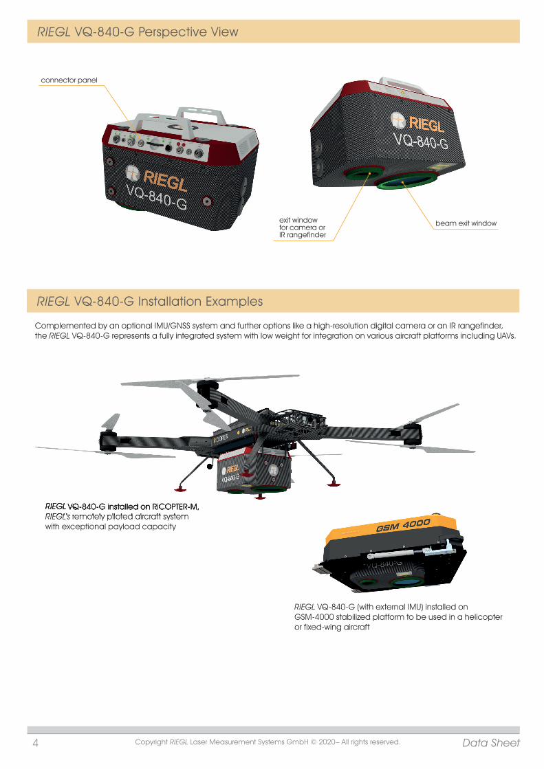
exit window for camera or IR rangefinder
beam exit window
connector panel
4
RIEGL VQ-840-G Perspective View
RIEGL VQ-840-G Installation Examples
RIEGL VQ-840-G installed on RiCOPTER-M,RIEGL‘s remotely piloted aircraft systemwith exceptional payload capacity
Complemented by an optional IMU/GNSS system and further options like a high-resolution digital camera or an IR rangefinder, the RIEGL VQ-840-G represents a fully integrated system with low weight for integration on various aircraft platforms including UAVs.
RIEGL VQ-840-G (with external IMU) installed on GSM-4000 stabilized platform to be used in a helicopter or fixed-wing aircraft
RIEGL VQ-840-G installed on RiCOPTER-M,RIEGL‘s remotely piloted aircraft system

5
RIEGL VQ-840-G Technical Data
Export Classification The VQ-840-G is subject to export restrictions as set up by the Wassenaar Arrangement. The Topo-Bathymetric Airborne Laser Scanner VQ-840-G It is classified as dual-use good according to position number 6A8j3 of the official Dual-Use-List has been designed and developed for commercial to be found on site http://www.wassenaar.org.topographic, hydrographic and bathymetric surveying Within the European Union, Council Regulation (EC) No 428/2009 implements the exportapplications. restrictions of the Wassenaar Arrangement. The corresponding position number is 6A008j3.
Laser Product Classification for System with Green Laser Scanner and optional Laser Rangefinder Laser Class
NOHD 1) 3) 4) 15 m ENOHD 2) 3) 4) 75 m
Range Measurement PerformanceMeasuring Principle echo signal digitization, online waveform processing, full waveform recording, time-of-flight measurement, multiple target capability
Minimum Range 20 mAccuracy 8) 10) 20 mmPrecision 9) 10) 15 mmLaser Pulse Repetition Rate 50 kHz to 200 kHzMax. Effective Measurement Rate 5) up to 200 000 meas./sec Echo Signal Intensity for each echo signal, high-resolution 16 bit intensity information is providedNumber of Targets per Pulse online waveform processing: up to 15 11)
Laser Wavelength 532 nm, greenLaser Beam Divergence selectable, 1 up to 6 mrad 12)
Receiver Field of View selectable, 3 up to 18 mrad Laser Beam Footprint (Gaussian Beam Definition) 50 mm @ 50 m, 100 mm @ 100 m, 150 mm @ 150 m 13)
Scanner PerformanceScanning Mechanism / Scan Pattern rotating scan mirror Scan Pattern elliptic Off Nadir Scan Angle Range ± 20° = 40°Scan Speed (selectable) 10 - 100 lines/sec (lps) 14)
Angular Step Width (selectable) 0.018° ≤ ≤ 0.72° (for PRR 50 kHz) 15) 16)
between consecutive laser shots Angle Measurement Resolution 0.001° (3.6 arcsec)
5) rounded values6) The depth performance is specified for bright targets with size
in excess of the laser beam diameter and for clear atmospheric conditions. Flight altitude 75 m above water level.
7) Waveform averaging applied8) Accuracy is the degree of conformity of a measured quantity
to its actual (true) value.9) Precision, also called reproducibility or repeatability, is the
degree to which further measurements show the same result.10) One sigma @ 150m rarounded values
11) If the laser beam hits, in part, more than one target, the laser‘s pulse power is split accordingly. Thus, the achievable range ist reduced.12) Measured at the 1/e² points. 1.0 mrad corresponds to an increase of 100 mm of beam diameter per 100 m distance.13) The laser beam footprint values correspond to a beam divergence of 1mrad.14) One line corresponds to a full revolution (360°) of the scan mechanism which can be split into two user defined segments.15) The angular step width depends on the selected laser PRR.16) The maximum angular step width is limited by the maximum scan rate.
Class 3B Laser Product according to IEC60825-1:2014 The following clause applies for instruments delivered into the United States: Complies with 21 CFR 1040.10 and 1040.11 except for conformance with IEC 60825-1 Ed.3., as described in Laser Notice No. 56, dated May 8, 2019.
Laser Pulse Repetition Rate PRR 5) 200 kHz 100 kHz 50 kHz 5 kHz 7) 0.5 kHz 7)
Max. Water Depth Penetration in Secchi Depths 6) 1.7 1.8 2.0 2.2 2.5
3) beam divergence 6 mrad, laser PRR 50kHz4) provided that the instrument is mounted on a moving platform
Data Sheet Copyright RIEGL Laser Measurement Systems GmbH © 2020– All rights reserved.
1) NOHD ... Nominal Ocular Hazard Distance2) ENOHD ... Extended Nominal Ocular Hazard Distance
17) @ 20°C ambient temperature, 100 kHz PRR, 100 scans/sec 18) for standard atmospheric conditions: 1013 mbar, +15°C at sea level
General Technical Data Power Supply Input Voltage 18 - 34 V DCPower Consumptionwithout IMU/GNSS/camera typ. 110 Wwith internal IMU/GNSS/camera 17) or IR rangefinder 160 W max. 400 WMain Dimensions (LxWxH) 360 mm x 285 mm x 200 mmWeight approx. 12 kg <15 kg (with IMU/GNSS and camera or IR rangefinder)Humidity non condensingProtection Class IP64, dust and splash-proofMax. Flight Altitude 18)
operating / not operating 18 500 ft (5 600 m) above Mean Sea Level (MSL)Temperature Range operation / storage -10°C up to +40°C / -20°C up to +50°C

www.riegl.comData Sheet, RIEGL VQ-840-G, 2020-04-07
RIEGL VQ-840-G Technical Data (Optional Components)
IMU/GNSS (optional)IMU Accuracy 1) Roll, Pitch 0.015° Heading 0.035°IMU Sampling Rate 200 HzPosition Accuracy (typ.) horizontal / vertical <0.05 m / <0.1 m
Integrated Digital Camera (optional)2)
RGB Camera Sensor Resolution 12 MPixelSensor Dimensions (diagonal) 17.5 mm (4112 x 3008 px)Focal Length of Camera Lens 16 mmField of View (FOV) approx. 47° x 36°Interface GigE
Data InterfacesConfiguration LAN 10/100/1 000 Mbit/sec, WLAN IEEE 802.11 a/b/g/nScan Data Output LAN 10/100/1 000 Mbit/sec, high speed data link to RIEGL DR1560i (optional)GNSS Interface 3) Serial RS-232 interface for data string with GNSS-time information, TTL input for 1 PPS synchronization pulseGeneral IO & Control 1x TTL input/output, 1x Serial RS-232 Interface, 1x Remote on/offCamera Interface 1x GNSS RS-232 Tx & PPS, Power, Trigger, ExposureRemovable Storage Card CFast®, up to 512 GByte (optional)
1) accuracy specifications for post-processed data 2) Please note that the camera is an optional component which cannot be integrated together with the optional infrared laser rangfinder.
3) to be used for external GNSS receiver
Copyright RIEGL Laser Measurement Systems GmbH © 2020– All rights reserved.Use of this data sheet other than for personal purposes requires RIEGL’s written consent.This data sheet is compiled with care. However, errors cannot be fully excluded and alternations might be necessary.
RIEGL Laser Measurement Systems GmbHRiedenburgstraße 483580 Horn, AustriaPhone: +43 2982 [email protected] | www.riegl.com
RIEGL USA Inc. | [email protected] | www.rieglusa.com
RIEGL Japan Ltd. | [email protected] | www.riegl-japan.co.jp
RIEGL China Ltd. | [email protected] | www.riegl.cn
RIEGL Australia Pty Ltd. | [email protected] | www.riegl.com
Measuring Principle time of flight measurement, echo signal digitization, online waveform processing
Minimum Range 3 mAccuracy 7) 9) 15 mmPrecision 8) 9) 10 mmLaser Pulse Repetition Rate 4) 100 kHzMax. Effective Measurement Rate 4) up to 100 000 meas./sec.Echo Signal Intensity for each echo signal, high-resolution 16 bit intensity information is providedLaser Wavelength near infraredLaser Beam Divergence 10) 1.6 x 0.5 mradLaser Beam Footprint 160 mm x 50 mm @ 100 m
Laser Pulse Repetition Rate PRR 4) 100 kHz Max. Measuring Range 5)
natural targets ≥ 20 % 150 m natural targets ≥ 60 % 250 m
Max. Number of Targets per Pulse 6) 5 4) Rounded values.5) Typical values for average conditions. Maximum range is specified for flat targets with size in excess of the laser beam diameter, perpendicular angle of incidence, and for
atmospheric visibility of 23 km. In bright sunlight, the max. range is shorter than under overcast sky.6) If more than one target is hit, the total laser transmitter power is split and, accordingly, the achieveable range is reduced.
9) One sigma @ 50 m range under RIEGL test conditions.10) Measured at 50% peak intensity, 1.6 mrad corresponds to an increase of 160 mm of beam diameter per 100 m distance.
7) Accuracy is the degree of conformity of a measured quantity to its actual (true) value.
8) Precision, also called reproducibility or repeatability, is the degree to which further measurements show the same result.
Infrared Laser Rangefinder (optional)
Important Note: Please note that the rangefinder is an optional component which cannot be integrated together with the optional camera.
Related Documents