Communal Spaces: Aggregation and Integration in the Mogollon Region of the United States Southwest LA-14312-T Thesis Approved for public release; distribution is unlimited.

Welcome message from author
This document is posted to help you gain knowledge. Please leave a comment to let me know what you think about it! Share it to your friends and learn new things together.
Transcript

Communal Spaces:
Aggregation and Integration in the
Mogollon Region of the United States Southwest
LA-14312-TThesisApproved for public release;
distribution is unlimited.

This report was prepared as an account of work sponsored by an agency of the U.S. Government. Neither Los Alamos National Security, LLC, the U.S. Government nor any agency thereof, nor any of their employees make any warranty, express or implied, or assume any legal liability or responsibility for the accuracy, completeness, or usefulness of any information, apparatus, product, or process disclosed, or represent that its use would not infringe privately owned rights. Reference herein to any specific commercial product, process, or service by trade name, trademark, manufacturer, or otherwise does not necessarily constitute or imply its endorsement, recommendation, or favoring by Los Alamos National Security, LLC, the U.S. Government, or any agency thereof. The views and opinions of authors expressed herein do not necessarily state or reflect those of Los Alamos National Security, LLC, the U.S. Government, or any agency thereof. Los Alamos National Laboratory strongly supports academic freedom and a researcher’s right to publish; as an institution, however, the Laboratory does not endorse the viewpoint of a publication or guarantee its technical correctness.
Los Alamos National Laboratory, an Affirmative Action/Equal Opportunity Employer, is operated by Los Alamos National Security, LLC, for the National Nuclear Security Administration of the U.S. Department of Energy under contract DE-AC52-06NA25396.
This thesis was accepted by the Department of Anthropology, University of Oklahoma, Norman, Oklahoma, in partial fulfillment of the requirements for the degree of Doctor of Philosophy in Anthropology. The text and illustrations are the independent work of the author, and only the front matter has been edited by the IRM-CAS Staff to conform with Department of Energy and Los Alamos National Laboratory publication policies.
Funding provided by the University of Oklahoma Graduate College, University of Oklahoma Graduate Student Senate, Los Alamos National Laboratory, & Dr. Russell J. Nisengard.

Communal Spaces:
Aggregation and Integration in the
Mogollon Region of the United States Southwest
Jennifer E. Nisengard*
Copyright © 2006 by Jennifer E. Nisengard
* Non-Laboratory Author Affiliations (Staff Research Assistant) (University of Oklahoma, Norman, Oklahoma 73019.)
LA-14312-TThesisIssued: December 2006


Acknowledgments
Data collection and analysis was funded by multiple sources; these include grants
from the University of Oklahoma’s Graduate Student Senate, the University of
Oklahoma’s Graduate College, the Oklahoma Archeological Survey, and generous
contributions from Dr. Russell Nisengard. Drs. John S. Isaacson, Denny Hjeresen, Tori
George, Bradley J. Vierra, Joyce Ortega-Tapia, Charles Richardson, Christine Serrano,
Mark Swoboda, and Steve McKee with NMT at Los Alamos National Laboratory
(LANL) provided me with the financial support and encouragement needed to complete
this project. Hector Hinojosa from the Ecology group at LANL provided editorial advice
and support. I would never have completed this thesis without the efforts of John
Isaacson, Joyce Ortega-Tapia, and Christine Serrano, all of whom stressed the importance
of finishing and made sure I had time to work on it. John was particularly helpful
throughout this process, providing editing suggestions, asking difficult but provocative
questions, and letting me talk through my ideas.
The staff of Laboratory of Anthropology in Santa Fe, particularly Robyn
Richards, Tim Seaman, Scott Geister, Dee Dee Snow, and Louanne Haecker, were very
helpful in answering my questions and providing me with space to work with their files.
Ricky Karl at the University of Arizona gave me access to AZSite and provided some
additional information about several of the Arizona sites in my study.
Drs. Joy Kolb, Alan LaFlamme, and Alvin Morrison at SUNY Fredonia provided
me with my initial well-rounded anthropological education and encouraged my interests
in teaching and archaeology. Dr. Margaret Nelson gave me my first opportunity to do
v

fieldwork. Dr. J. Jefferson Reid at the University of Arizona taught me a great deal about
how to conduct research. He helped me to develop my writing skills and forced me to
become a better scholar. Dr. Bruce Masse of Los Alamos National Laboratory
continually reminded me that this project would be done. At UC Denver, Dr. Tammy
Stone was, and continues to be, both an advisor and a friend. Tammy’s knowledge of
statistics and the Mogollon region in general has been a great help to me and an asset to
this dissertation.
Several other professors and scholars have helped to bring me to the place I am
today. I thank them for their contributions. Roger Anyon always made it a point to ask
me how my research was going. Dr. Darrell Creel is one of the most supportive and
helpful people I have ever met. Dr. Robert Hard is a mentor and a person who has given
me many opportunities to challenge myself as an archaeologist. Dr. John Isaacson has
shown great interest in my success and never stopped urging me to continue my research
and to complete my dissertation. Ellen McGehee, M.A. always helped me to laugh at
situations I found myself in. Dr. Brad Vierra provided me with a great job and field
opportunities in a part of the Southwest in which I had never worked. Dr. Elaine Davis
provided statistical consultation for sections of Chapter 5 and worked through the
questions regarding significance of my results. John Roney, M.A., one of the most
knowledgeable archaeologists I know, provided information that was difficult to find.
I look forward to working with Drs. Robert L. Brooks, Patricia A. Gilman, and
Paul E. Minnis in the future. All three of them provided advice, guidance, and sometimes
food. Their doors were open to me, and they were willing to listen to my ideas and to
vi

help me develop them. These professors provided opportunities for fieldwork, funding,
and teaching that I would not have had at many universities and for this, I am grateful.
Drs. Morris Foster and Robert Rundstrom participated in the final stages of this research
and contributed some alternative perspectives on ways to consider my ideas. I also thank
my ANTH 1113 students, as they challenged me to become a better instructor and
reminded me why I was in graduate school.
Dr. Marjy Duncan has provided unwavering support and has kept me on target in
many of aspects of my life. I thank Dr. John Duncan who is always willing to engage me
in philosophical talks about my research. I learned so much from John, and my
dissertation would not be what it is, were it not for his thought provoking questions.
Throughout the years, conversations with fellow graduate students and others
have greatly improved this research. I cannot possibly thank all of them individually, but
I hope they know how important they are to me. Special thanks to Aaron Gonzales,
Debby Green, Dr. Valli Marti, Tim Martinez, Karin Rebnegger, Beau Schriever, Dr.
Robert J. Stokes, and Steven J. Swanson for their questions, comments, and advice about
this research. Steven was instrumental in providing access to environmental and location
data for sites in my analysis. He helped coordinate some last minute data acquisition and
created figures for me when I was at a loss! Steven also provided me with one last
opportunity to excavate a communal structure as part of the Blue River Archaeological
Project. It was a great experience and great fun to work with him again.
vii

My experience as a field crew member on the El Proyecto Archaico Tardío del
Chihuahua with Bob Hard and John Roney contributed a great deal to my ideas about
aggregation and integration in the desert borderlands. Bob and John gave me roles and
responsibilities that encouraged my success. The people I had the privilege to work with
on this project included Elizabeth Bagwell, Jorge Bencomo, Kevin Hanselka, Dr. Art
MacWilliams, Todd Pitezel, Gerry Raymond, Rudi Roney, Kari Schmidt, José Zapata,
and Bridget Zavala. They are wonderful friends and taught me a great deal about
archaeology, scholarship, and friendship.
Dr. Peter J. McCormick is a wonderful friend and an inspiration. I sat with him
many evenings discussing my data and my ideas about human behavior. He is always
able to provide an alternative view – some other way to think about an issue.
Kari M. Schmidt is so many things to me it is difficult to know how to thank her.
She is a friend, sister, roommate, co-worker, and traveling companion. She has always
been there to listen, and to provide insight into both personal and professional concerns.
viii

ix
Table of Contents
Page Number Acknowledgments iv Table of Contents x List of Figures xii List of Tables xv Abstract xviii CHAPTER 1. BUILDING TIES: COMMUNITY FORMATION, AGGREGATION, AND INTEGRATION 1
The Mogollon Case Study 4 Defining Aggregation and Integration 5 Communal Architecture, Aggregation, and Integration 12 Chapter Summaries 20
CHAPTER 2. AGGREGATION AND INTEGRATION:
BACKGROUND RESEARCH ON THE ARCHITECTURE OF SOCIAL ORGANIZATION IN THE MOGOLLON REGION 21 Previous Research: Aggregation and Integration 22 Aggregation and Integration: Exploratory Models 23 Architecture, Aggregation, and Integration 34 Archaeological Examples of Communal Architecture, Population Aggregation, and Social Integration 39 Chapter Summary 45
CHAPTER 3. AN ENVIRONMENTAL, CULTURAL, AND ARCHAEOLOGICAL BACKGROUND FOR THE MOGOLLON REGION 48
Defining the Mogollon 49 Defining the Mogollon: The Environment of the Region 51 Defining the Mogollon: Culture and Geography 59 Mogollon Chronology 62 Mogollon Communal Structures: A Current Debate 93 Chapter Summary 95

x
CHAPTER 4. RESEARCH METHODS AND MEASURES OF AGGREGATION AND INTEGRATION 96
Criteria for Identification of Communal Structures 98 Architectural Analyses 104 Communal Structure Frequency 105 Communal Structure Location 107 Communal Structure Size 109 Communal Structure Shape 110 Communal Structure Hearth Shape 111 Communal Structure Orientation 112 Communal Structure Wall Construction 113 Dismantling, Destruction, Burning, and Burials 116 Methods for Communal Structure Data Collection 117
CHAPTER 5. AN ANALYSIS OF MOGOLLON COMMUNAL STRUCTURES 119
Frequency of Communal Structures 130 Communal Structure Frequency: A Summary 189 Communal Structure Location 197 Communal Structure Location: A Summary 234 Communal Structure Size 237 Communal Structure Size: A Summary 278 Communal Structure Shape 282 Communal Structure Shape: A Summary 308 Communal Structure Hearths 311 Communal Structure Orientation 316 Wall Construction Technique 328 The “Closing” of a Communal Structure 333 The Analysis of Mogollon Communal Structures: A Summary 343 Integration, Aggregation, and Analyses of Mogollon Communal 353 Structures
CHAPTER 6. COMMUNAL STRUCTURES, AGGREGATION, AND INTEGRATION: INTERPRETATIONS, CONCLUSIONS, AND FUTURE DIRECTIONS 356
Theoretical Perspectives on the Analysis of Mogollon Communal Structures 362 Analyzing Communal Structures, Aggregation, and Integration: Conclusions and Interpretations 363 Future Directions: Defining Mogollon Communal Structures 369
REFERENCES CITED 372 APPENDIX I. Codes for Communal Structures Database 409 APPENDIX II. Communal Structures Database 412

xi
List of Figures Figure 1.1. Hypothetical Example of a Mogollon Communal Structure. 3
Figure 1.2. The Mogollon Region of the Desert Borderlands (after Vierra 2005). 5
Figure 1.3. Late Archaic Sites in Northern Chihuahua, Mexico. 8
Figure 2.1. Pot Creek Pueblo, A.D. 1268 to 1320 (Crown and Kohler 1994). 40
Figure 2.2. Arroyo Hondo Component I Site Plan (Creamer 1993). 42
Figure 2.3. Arroyo Hondo Component II Site Plan (from Creamer 1993). 44
Figure 3.1. Map of the North American Desert Borderlands (From Vierra 2005). 50
Figure 3.2. Mogollon Divisions and Major Rivers (after Wheat 1955). 52
Figure 4.1. Communal Structure Data Collection Form. 97
Figure 5.1. General Communal Structure Frequency for Mogollon Sites. 121
Figure 5.2. Topographic Locations of Mogollon Sites with Communal Structures by Period. 123
Figure 5.3. Prominent Vegetation Types for Mogollon Sites with Communal Structures by Period. 124
Figure 5.4. Elevations for EPS Period Sites with Communal Structures. 126
Figure 5.5. Elevations for MPS Period Sites with Communal Structures. 126
Figure 5.6. Elevations for LPS Period Sites with Communal Structures. 127
Figure 5.7. Elevations for EP Sites with Communal Structures. 127
Figure 5.8. Elevations for ELP Period Sites with Communal Structures. 128
Figure 5.9. Elevations for LLP Period Sites with Communal Structures. 128
Figure 5.10. Average Communal Structure Frequency per Site by Period. 132
Figure 5.11. Average Communal Structure Frequency per Site by Period, with the LP Period Subdivided into ELP (A.D. 1150 to 1300) and LLP (A.D. 1300 to 1450). 132
Figure 5.12. Communal Structure Frequency during the EPS Period. 135
Figure 5.13. Communal Structure Frequency during the MPS Period. 141
Figure 5.14. Communal Structure Frequency during the LPS Period. 146
Figure 5.15. Communal Structure Frequency during the EP Period. 159
Figure 5.16. Communal Structure Frequency during the LP Period. 175

xii
Figure 5.17. Communal Structure Frequency during the ELP Period. 177
Figure 5.18. Communal Structure Frequency per Site during the Late Late Pueblo Period. 186
Figure 5.19. Mogollon Communal Structure Locations. 199
Figure 5.20. Communal Structure Location Data by Period with the LP Period Separated into ELP and LLP Periods. 201
Figure 5.21. Communal Structure Location during the EPS Period. 203
Figure 5.22. Communal Structure Location during the MPS Period. 207
Figure 5.23. Communal Structure Location during the LPS Period. 210
Figure 5.24. Communal Structure Locations during the EP Period. 217
Figure 5.25. Communal Structure Location during the ELP Period. 228
Figure 5.26. Communal Structure Location during the LLP Period. 232
Figure 5.27. Average Size (m2) of Communal Structures by Period. 239
Figure 5.28. Average Communal Structure Size (m2) with the LP Period Separated into ELP and LLP Periods. 240
Figure 5.29. Regression Chart Depicting Average Communal Structure Size (in m2) across Time, with 1 Representing the EPS Period and 6 Representing the LLP Period. 240
Figure 5.30. Percentage of Communal Structure Shapes at Sites in the Mogollon Region. 284
Figure 5.31. Communal Structure Shapes during the EPS Period. 286
Figure 5.32. Communal Structure Shapes during the MPS Period. 289
Figure 5.32. Communal Structure Shapes during the LPS Period. 292
Figure 5.34. Communal Structure Shapes during the EP Period. 295
Figure 5.35. Communal Structure Shapes during the ELP Period. 302
Figure 5.36. Communal Structure Shape during the LLP Period. 306
Figure 5.37. A General Overview of Communal Structure Hearth Shape. 311
Figures 5.38, 5.39, and 5.40. Hearth Shape during the EPS, MPS, and LPS Periods. 312
Figures 5.41, 5.42, and 5.43. Hearth Shape during the EP, ELP, and LLP Periods. 313
Figure 5.44. Communal Structure Shape and Hearth Shape. 315
Figure 5.45. General Communal Structure Orientation. 317

xiii
Figure 5.46. Communal Structure Orientation during the EPS Period. 319
Figure 5.47. Communal Structure Orientation during the MPS Period. 320
Figure 5.48. Communal Structure Orientation during the LPS Period. 321
Figure 5.49. Communal Structure Orientation during the EP Period. 323
Figure 5.50. Communal Structure Orientation during the ELP Period. 325
Figure 5.51. Communal Structure Orientation during the LLP Period. 327
Figure 5.52. Communal Structure Wall Construction Materials by Period. 329
Figure 5.53. Pit Structure Wall Construction Materials. 332
Figure 5.54. Pueblo Wall Construction Materials. 332
Figure 5.55. Evidence for Communal Structure Burning. 336
Figure 5.56. Intentionally Burned Communal Structures by Period. 336
Figure 5.57. Evidence for Communal Structure Dismantling by Period. 337
Figure 5.58. Evidence for Burials within Communal Structures. 338
Figure 6.1. Average Communal Structure Frequency by Period. 365

xiv
List of Tables Table 1.1. Proposed Characteristics of Communal Structures in Aggregated and
Integrated Communities. 16
Table 3.1. A Sample of Cultural Chronologies Used in the Mogollon Region. 65
Table 3.2. Mogollon Chronology Used in the Analysis of the Appendix II Communal Structures. 66
Table 4.1. Mogollon Communal Structures by Period (xxx designates missing or unavailable data). 99
Table 5.1. Number of Sites and Communal Structures in the Assemblage by Period. 119
Table 5.2. Results from unpaired t-Tests. 133
Table 5.3. EPS Period Sites with Communal Structures. 134
Table 5.4. MPS Period Sites with Communal Structures. 140
Table 5.5. LPS Period Sites with Communal Structures. 144
Table 5.6. EP Period Sites with Communal Structures. 156
Table 5.7. Late Pueblo Period Sites with Communal Structures. 172
Table 5.8. Percent of Mogollon Sites with Evidence for Integration by Period, Based on Analyses Presented in this Chapter. 190
Table 5.9. Number of Sites with Evidence for Aggregation and/or Integration Based on Frequency Data. 190
Table 5.10. Sites with Evidence for Aggregation and/or Integration Based on Frequency Data. 191
Table 5.11. Communal Structures from Appendix II Smaller than 20 m2 by Period. 192
Table 5.12. Sites Affected by Removal of Communal Structures Smaller than 20 m2 by Period. 195
Table 5.13. Sites with Evidence for Aggregation and/or Integration Based on Frequency Data with Communal Structures Smaller than 20 m2 removed. 196
Table 5.14. Percent Comparisons of Mogollon Sites with One Communal Structure by Period, with Structures Smaller than 20 m2 and Excluding those Structures. 197
Table 5.15. Description of Location Categories for Mogollon Communal Structures. 199
Table 5.16. Communal Structure Locations by Period. 201

xv
Table 5.17. Communal Structure Location during the EPS Period. 202
Table 5.18. Communal Structure Location during the MPS Period. 207
Table 5.19. Communal Structure Location during the LPS Period. 209
Table 5.20. Communal Structure Location during the EP Period. 216
Table 5.21. Communal Structure Location during the ELP Period. 227
Table 5.22. Communal Structure Location during the LLP Period. 227
Table 5.23. Number of Sites with Evidence for Aggregation and/or Integration Based on Location Data. 234
Table 5.24. Sites with Evidence for Aggregation and/or Integration Based on Location Data. 235
Table 5.25. Results from Unpaired t-Test. 239
Table 5.26. Communal Structure Size during the EPS Period. 241
Table 5.27. Communal Structure Size during the MPS Period. 245
Table 5.28. Communal Structure Size during the LPS Period. 248
Table 5.29. Communal Structure Size during the EP Period. 257
Table 5.30. Communal Structure Size during the ELP Period. 270
Table 5.31. Communal Structure Size during the LLP Period. 276
Table 5.32. Sites with Evidence for Aggregation and/or Integration Based on Communal Structure Size Data. 279
Table 5.33. Communal Structure Shapes during the EPS Period. 286
Table 5.34. Communal Structure Shapes during the MPS Period. 289
Table 5.35. Communal Structure Shapes during the LPS Period. 291
Table 5.36. Communal Structure Shapes during the EP Period. 295
Table 5.37. Communal Structure Shapes during the ELP Period. 303
Table 5.38. Communal Structure Shapes during the LLP Period. 307
Table 5.39. Sites with Evidence for Aggregation and/or Integration Based on Communal Structure Shape Data. 310
Table 5.40. Evidence for Burning and Dismantling of Mogollon Communal Structures. 333
Table 5.41. Summary of Measures of Aggregation and Integration. 343
Table 6.1. Percent of Sites with One Communal Structure Based on Raw Counts. 364

xvi
Table 6.2. Comparison of Percent of Sites with Evidence for Aggregation and/or Integration Based on Analyses of Frequency, Location, and Size Data. 366
Table 6.3. Percent Comparisons of Mogollon Sites with One Communal Structure by Period, with Structures Smaller than 20 m2 and Excluding Those Structures. 370

xvii
COMMUNAL SPACES: AGGREGATION AND INTEGRATION IN THE MOGOLLON REGION OF THE UNITED STATES SOUTHWEST
by
Jennifer E. Nisengard
Abstract
Aggregation and integration are processes that occur in human societies
throughout the globe. An informative example of population aggregation and social
integration can be observed in the North American desert borderlands from A.D. 250 to
1450 in the area known as the Mogollon region. In fact, Mogollon communities
oscillated from smaller social groups into larger ones and dispersed into smaller groups
only to form larger ones again. For this reason, examining the groups of people living in
the Mogollon region provides a magnified view of social change over a substantial
period. Understanding patterns of aggregation and integration provides researchers with
the promise for research into the nature of these phenomena.
In general, the Mogollon region is characterized by limited water supplies and
low average annual precipitation. However, pockets of the Mogollon area, including the
Mimbres valley and the Gila River valley, represent oases, where permanent rivers and
their associated tributaries allowed for the pursuit of agricultural endeavors and access to
a wide variety of wild plant and animal resources. The areas with these kinds of potential
became population centers for previously dispersed groups of people living in the region.
These people exploited natural resources and practiced agriculture in areas surrounding
their communities. Over time, more organized aggregated and socially integrated
communities were established throughout the region. Using ancient Mogollon communal
architecture, commonly called kivas, this study examines issues of, and evidence for,
population aggregation and social integration.

xviii

1
CHAPTER 1
BUILDING TIES: COMMUNITY FORMATION, AGGREGATION, AND INTEGRATION
One of the most significant and compelling aspects of anthropological research is
the formation of communities by groups of people. While these communities are
organized in a wide variety of ways, there appear to be recurring recognizable patterns.
The concept of social organization, including population aggregation and social
integration, has been theoretically explained; it is useful to explore their causes. This
allows an understanding of how and why communities form and grow as a result of
population aggregation, and sometimes reorganize via social integration.
For the research reported here, the Mogollon region was selected, allowing a
combination of theoretical views that may shed light on aspects of human existence.
Population aggregation and social integration can be observed in the Mogollon region of
the North American desert borderlands from A.D. 250 to 1450. These communities have
repeatedly oscillated between smaller and larger social groups. For this reason,
examining the groups of people living in the Mogollon region provides a magnified view
of social change over a substantial period allowing research into the nature of aggregation
and integration.
This study examines aggregation and integration, from both a descriptive
perspective and using a combination of theoretical models. Specifically, I describe and
examine data from 110 Mogollon sites. Throughout the course of this examination, the

2
analysis was guided by three areas of thought. I defined the dynamics of aggregation and
integration within these groups by identifying the various factors involved in bringing
about the formation of larger communities. I explored the external and internal factors,
including ecological, social, and behavioral aspects, influencing strategies of adaptation
in the formation of population aggregation and social integration. The role of communal
architecture was also discerned for these communities as a measure for these social
processes.
Three interlocking hypotheses form an integral part of the theoretical framework
for this investigation. The first hypothesis is that changing ecological conditions such as
rainfall patterns, resource availability, and periods of drought affect aggregation and/or
integration. The second hypothesis is that population aggregation, combined with
declining resources or external threats to a community led to social integration. A third
hypothesis is that population aggregation and social integration are relatively short-lived
endeavors at sites in areas affected by frequent fluctuations in rainfall and resource
abundance.
The phenomena of population aggregation and social integration (although they
are not always linked) are best disclosed through an examination of a common
architectural form, namely subterranean or semi-subterranean communal structures,
traditionally called “kivas” (Figure 1.1), found throughout the Mogollon area. While the
presence of kivas certainly indicates similarities in social organization, an analysis of
communal structure variation may demonstrate the amount and nature of aggregative and
integrative activity. As such, communal structures are the primary focus of this study.

3
This analysis contains both synchronic and diachronic architectural elements as well as
archaeological and ethnographic data from contemporary communities. The results of
the study will evaluate the nature and analyze the significance of population aggregation
and social integration, related to social changes within communities.
Figure 1.1. Hypothetical Example of a Mogollon Communal Structure. Arrows point to posthole locations.
Hearth
Sipapu
Ramp entryway
N
0

4
The Mogollon Case Study
The Mogollon area encompasses much of southern New Mexico, southeastern
Arizona, portions of southwestern Texas, and portions of northern Chihuahua, Mexico
(Figure 1.2). This region has been recognized for the study of social networks and the
impacts of environmental influences on community formation (Anyon and LeBlanc 1980;
Anyon et al. 1981; Haury 1936, 1985; LeBlanc and Whalen 1980; Nelson and LeBlanc
1986).
The Mogollon area was chosen for this analysis for three specific reasons. First, it
has a semi-arid desert environment with water and arable land necessary for agriculture,
both of which are concentrated in relatively small areas. As Stone and Downum (1999)
suggest, these factors affect the need for specific organizational strategies. Second, a
wide variety of wild plant and animal resources exists in the Mogollon area facilitating
the ability of people to live in larger aggregated and/or integrated communities even
when faced with limited access to water and arable land suitable for agriculture (Hill
1970; Leonard and Reed 1993; Stone and Downum 1999). Third, Mogollon villages of
various sizes and many with communal structures have been excavated (Anyon and
LeBlanc 1980, 1984; Nelson and LeBlanc 1986). These excavation data provide
significant material for a regional study of aggregation and integration spanning multiple
generations, from Winn Canyon, one of the earliest known sites with a communal
structure (A.D. 310), to the latest date for the large Grasshopper community (A.D. 1425).

5
Figure 1.2. The Mogollon Region of the Desert Borderlands (after Vierra 2005).
Defining Aggregation and Integration
The organizational strategies of a community are dynamic as reflected by the
archaeological record. Defining the processes of aggregation and integration as they
apply to this research is important because many scholars use the terms aggregation and
integration interchangeably (Adler 1989a, 1989b, 1994; Cordell 1997). Cordell
(1994:79) describes aggregation as the process by which groups of people come together
spatially, but without proposing any instigating or motivating factors. Lipe (1994:142)
suggested that there can be varying degrees of aggregation, and integration may represent

6
a higher degree of aggregation. Hill (1970:89) was one of the earliest to discuss
aggregation and integration as distinct, related social processes (see also Longacre 1966).
Hill states that at sites located in the Hay Hollow Valley of east-central Arizona in the
“process of aggregation, there appears to have been an increase in the scope of
integration” (Hill 1970:89). Hill (1970) also suggests that integrated sites may be
identified by their relative architectural homogeneity, and aggregated sites tend to be
characterized by greater numbers of communal structures and diversity in architectural
styles (Hill 1970:108-109). Although Hill does not explicitly define these two processes,
he makes a clear distinction between the two. This distinction is very important to the
research presented in this analysis.
Aggregation
A group is considered aggregated when people come together to form a densely
populated community (Cordell 1994; Cordell et al. 1994; Crown and Kohler 1994;
Leonard and Reed 1993). The length of the aggregation and the size of the community
are not central components of the definition. Aggregation is simply the process by which
several allied but autonomous families or groups coalesce. Evidence for aggregation is
seen in all types of societies, including foragers, horticulturalists, agriculturalists, and
industrialists (Adler 1989a; Hard and Roney 1999; Johnson and Earle 1987). It has been
suggested that all societies participate to some degree in aggregation (Adler 1989a,
1989b; Adler and Wilshusen 1990; Chagnon 1992; Hard and Roney 1999; Johnson and
Earle 1987; Riggs 1999, 2000).

7
Although aggregated communities vary in size and length of stay, there are
common characteristics that all such communities exhibit. People living in aggregated
communities generally have similar lifestyles, but they do not necessarily share unified
political, social, or religious views of the world (Cordell 1994; Leonard and Reed 1993;
Stone and Downum 1999). Stone and Downum (1999) suggest aggregation occurs in
communities that need to intensify their agricultural production because lands well suited
for food production are relatively concentrated. Population aggregation in the desert
borderlands occurred as early as 3,000 years ago (Adams and Hanselka 2001; Hard and
Roney 1999, 2000, 2001, 2002a; Schmidt and Nisengard 1998, 2001).
Early population aggregation has been observed in hilltop settlements in
northwestern Chihuahua, Mexico, at sites such as Cerro Juanaqueña (Figure 1.3), Cerro
Vidal, and Cerro de los Torres (Hard and Roney 1999, 2000, 2001, 2002a, 2002b; Hard et
al. 1999; Roney and Hard 1999, 2002a, 2002b). Early aggregation also occurred in
communities situated in the Tucson Basin (i.e., the Costello-King site; Riggs et al. 2000).
Dates from these sites provide important data concerning Late Archaic and subsequent
aggregation in the Mogollon region. For many years, archaeologists working in the
region believed that pit structure villages, which appeared after the Archaic period, were
the first evidence of community formation and aggregation in the region. An
archaeological investigation of aggregation at Archaic sites provides evidence for
population aggregation and social integration at sites that predate pit structure villages by
more than 2,000 years. Evidence from these sites helps to address the question, what
motivates people to begin to aggregate and live in larger communities than they

8
previously did? Chihuahua and Tucson Basin sites help identify factors that contribute to
the formulation of an aggregated community and the development of social integration.
Figure 1.3. Late Archaic Sites in Northern Chihuahua, Mexico. Dark circles are sites that have been subject to archaeological testing (Hard 2000).

9
Several factors may encourage maintenance of smaller communities while others
that promote or prompt a move into more aggregated ones. Aggregation most often
occurs in response to one or more of the following conditions:
1. Relatively short periods of environmental uncertainty. As an example, regular
fluctuations in annual rainfall patterns in the desert borderlands can influence
aggregation (Leonard and Reed 1993:655; Minnis 1985). During such
fluctuations, the ability of a group to access a larger number of people willing
to contribute to the accumulation of resources may provide increased social
and economic stability (Stone and Downum 1999).
2. Increased agricultural productivity and/or resource abundance. For example,
when a vital/desirable resource or the potential for productivity is
concentrated within a relatively small area, people may participate in
aggregated efforts to establish or maintain access to that resource (Stone and
Downum 1999). In areas like the desert borderlands, resources are relatively
limited, and the potential for productivity is concentrated in areas with
permanent or semi-permanent water sources (Minnis 1985).
3. External threats from outside groups. Larger numbers of people involved in a
community provide not only the appearance of strength in numbers but also
tend to reduce the threat of competition in an area because outsiders are faced
with an organized and united front (Cordell 1994; Ember and Ember 1992;
Feinman and Neitzel 1984; LeBlanc 1999; Stone and Downum 1999).

10
4. Social reasons (Fish and Fish 1994; Fish et al. 1994:138). Groups of related
people living in small, dispersed communities may aggregate during certain
times of the year to forge marriage and trade alliances (Carneiro 1967, 1970).
Dispersed communities involved in cooperative marriage, hunting, or warring
alliances may join to form an aggregated community (Chagnon 1968, 1992).
In all of the situations outlined above, the congregation of dispersed groups even
for a relatively short period is a response to the conditions present. The congregating
groups do not necessarily share a common ideology or political structure, although
aggregated populations often consist of extended families (Fish et al. 1994). At the same
time, aggregated populations tend to have a common economic strategy but not
necessarily the same subsistence base because trade alliances often involve the exchange
of non-local foodstuffs. A contemporary example of aggregation is today’s urban,
aggregated communities, which are sometimes gated. People surrender certain individual
freedoms to share decision-making responsibilities (i.e., local elections, home
associations, and seats on school boards) and are of a similar economic background but
may belong to different religious and/or social groups.
Integration
In contrast to aggregation, integration is the process by which an aggregated
population becomes politically, socially, symbolically, ritually, and economically unified
(Adams 1989; Adler 1994; Carneiro 1967; Hegmon 1989:5, 1995; Hill 1970). Certainly,
not all aggregated communities become integrated. Integrated communities can be
identified by their own unique mark in the archaeological record. Sometimes physical

11
remains of communal activities at an integrated site reflect a greater emphasis on group
solidarity (i.e., community planning) than for people who were only aggregated.
Integration is more likely in the following situations:
1. Extended periods of ecological distress. Long-term drought within an
aggregated community may act as a catalyst for integration (Longacre 1966).
In these cases, the reliable cooperation for the good of all members may help
to defer the consequences of ecological damage.
2. Decreases in agricultural production over extended periods (Stone and
Downum 1999). An integrated community will help provide for its members
in an invested manner, which does not occur in a relatively segregated,
aggregated community.
3. Increases in access to resource-rich lands largely used for the pursuit of
agricultural endeavors (Hard and Roney 2002a, 2002b; Stone and Downum
1999). Where resources are concentrated within coveted, limited space,
integration allows a stronger, more permanent claim to the area.
4. Sustained threats and/or aggression from outside groups (Hegmon 1989;
LeBlanc 1999). Long-term threats may lead to integration, because people
who are part of an integrated community work together to deter or eliminate
the threat.
5. Periods requiring frequent organization of large numbers of people for the
accomplishment of ritual, political, economic, or social goals (Adler 1989a,
1989b; Adler and Wilshusen 1990). In this case, the goals of the community

12
become long-term, overarching, or all encompassing for members of a
community who want to strengthen ties to one another and/or to an economic,
political, or religious system.
In the above five examples, there is an intensification of the conditions that
initially motivated population aggregation. The people coming together as an integrated
community are organized in a specific manner (i.e., hierarchically or heterarchically). A
portion of the population may allocate access to resources to the rest of the community or
may organize activities including community construction (Adler 1994; Adler and
Wilshusen 1990; Hard and Roney 2000). Frequently, during periods of increased
integration, artifact standardization becomes more common and communities place an
emphasis on group participation in the erection and use of communal structures (Adler
1989a, b; Cordell 1997:310; Powell 2001).
Communal Architecture, Aggregation, and Integration
Architecture and Archaeology
Architectural evidence potentially provides a great deal of information about
ancient peoples and their communities. At the same time, as Binford (1965) points out,
"...it must be recalled that these buildings (prehistoric ruins) are cultural products - not
the culture.” Binford (1965) suggests that culture cannot be found within the material
remains of the people that use them. However, material culture, such as clothing, is a
manifestation of a person’s culture. For example, the clothing that people wear may keep
them warm. That same clothing also conveys information about resource availability and
exploitation and reflects aspects of a person’s political, social, economic, religious

13
beliefs, and status. In much the same way, architecture is not culture per se; but a
reflection of certain aspects of both the practical needs of the people who build and use it
and the social dynamics that brought it into existence as a particular form containing
information and revealing behavioral patterns.
The multi-faceted relationship between architecture and culture can be observed
in contemporary American societies. For instance, adobe, which consists of sun-baked
bricks made from a mixture of mud and straw, is a readily available construction material
that has long been associated with many ancient cultures in the desert borderlands.
Currently, in many areas of Santa Fe, New Mexico, building restrictions require that
people of all ethnic backgrounds use adobe and build in this traditional “southwestern”
style. These regulations are largely socio-cultural and economic, as the people of Santa
Fe and the tourism industry have decided that they want to actively pursue and propagate
this uniquely recognized architectural tradition. This example emphasizes the importance
of recognizing and understanding all of the factors that influence the architecture of a
community, including both the functional and stylistic aspects of architectural elements.
Archaeologists recognize the value of architectural evidence to define, describe,
and analyze ancient peoples and cultures. As is the case in many areas of the globe,
architectural characteristics have been used to delineate and differentiate desert
borderland cultures (Cordell 1997; Haury 1936; Kidder 1924; LeBlanc and Whalen 1980;
Wheat 1954). For example, adobe construction, ball courts, and mounds characterize
Hohokam communities in southern Arizona after A.D. 1150 (Cordell 1997:331-340).
Hohokam characteristics can be compared to the slab masonry blocks that were the most

14
common construction material found at Ancestral Pueblo sites in the northern portions of
the desert borderlands (Cordell 1997:306-313). As a further example, coursed,
cobblestone masonry is identified throughout the majority of the Pueblo period
(A.D. 1000 to 1450) in the Mogollon area of the southern desert borderlands. The use of
architecture for reconstructing and evaluating functions within ancient communities as
well as a more thorough discussion of the differences in architectural form throughout the
desert borderlands are explored in depth in Chapter 2.
Communal structures have been centerpieces of numerous Mogollon societies for
centuries and continue to be a fixture of many American Indian pueblos in the
southwestern United States today. Specific uses of communal structures at various
southwestern pueblos are discussed in Chapter 3 (Adams 1989, 1991; Cordell 1994;
Dozier 1970a, 1970b; Ladd 1979:482; Smith 1972, 1990). Today, Pueblo people build
and use communal structures employing many of the same methods as their ancestors.
For this reason, an intensive study of such ethnographic structures provides a more
holistic understanding of the social dynamics, specifically aggregation and integration,
within these ancient societies.
Communal structures can be the material reflection of population aggregation and
social integration in that the construction of such a structure helps a community to
establish and maintain social order by providing a central, tangible place for activities
that involve all or part of its members (Adler 1989b; Adler and Wilshusen 1990; Lipe
1994:43). Therefore, the fewer the number of communal structures, the more likely it is
that the people at a site are integrated. The availability of only one structure for

15
communal activities encourages a larger proportion of the community to interact and
reinforces solidarity. Conversely, the higher the number of contemporary communal
structures at a site, the more likely that only aggregation is present. In this latter case, ties
to a larger community are not necessarily reinforced, and the population is, in relative
terms, more segregated. These organizational strategies include the relationships
between the social, political, economic, and/or ritual needs of a community in that it is
within these buildings that decisions regarding the community are made (Adler 1989b;
Adler and Wilshusen 1990; Anyon et al. 1981; Creel and Anyon 2003; Hegmon and Lipe
1989; Leonard and Reed 1993).
Although aggregation and integration can occur simultaneously, one or the other
may be more appropriate in response to specific conditions. The following are a series of
measures for population aggregation and social integration that I constructed based on my
expectations of the architectural manifestations of aggregation and integration in the
archaeological record; these form the basis of this research, and the order in which they
are presented is consistent from chapter to chapter. Table 1.1 presents a summary of the
expected conditions and characteristics associated with communal structures at
aggregated and integrated communities.

16
Table 1.1. Proposed Characteristics of Communal Structures in Aggregated and Integrated Communities.
Measure Aggregated Integrated
Frequency Multiple contemporary communal structures expected at a site.
Fewer communal structures expected at a site, most likely, there would be only one to serve the entire site, regardless of site size.
Location Multiple structures associated with particular roomblocks or smaller subsets of the community.
One centrally or prominently located communal structure within a community. One spatially or isolated structure associated with one or more communities. Redundant use of the same location at a site to erect a communal structure.
Size Variability in communal structure size is expected for multiple contemporary structures. Structure size may be dependent on the location of the structure within the site and the size of the groups using the structures.
Usually a relatively large structure, although size can be relative to a site’s population size. Isolated structures may also be large and serve to integrate several communities.
Shape Variation within the contemporary communal structures at a single site.
When there is only one structure at a site, this characteristic is not as revealing of a characteristic, but may be used to reflect regional integration. If there are multiple communal structures, the shape will be consistent throughout the site and the period at an integrated site.
Wall construction technique
Varies from structure to structure at the same site.
This may only be useful at a regional level; however, if there are multiple communal structures at an integrated site there will be consistency in construction. This may be particularly evident in communal structures erected in a specific location over a broad period.
Hearth shape
Hearth shape should vary from structure to structure.
If there are multiple hearths in a structure at an integrated site, there will be more standardization within structures. There will be little or no variation in hearth shape.
Orientation Variable from structure to structure.
Standardized orientation.

17
The first characteristic of importance is that of contemporary communal structure
frequency at Mogollon sites. Adler (1989b) stated that communal structures are built
when there are a minimum of six decision-making entities involved in a group effort. It
is true that some sites have more communal structures and communal structure frequency
does change through time. I suggest that aggregated sites generally have multiple
contemporary communal structures, reflecting a relatively segregated or at least
segmented group of inhabitants. I further suggest that an integrated site has fewer
contemporary communal structures because this encourages social solidarity in a
community. However, in keeping with Adler (1989b), sites with large populations may
require multiple structures, although these will have architectural redundancies, which
will be discussed below.
The second measure is the location of a communal structure at a site. Location is
an important characteristic because the placement of a communal structure can provide
information about who has access to a facility. Multiple social groups or communities
may share access and use-rights to a communal structure. Communal structures may be
located in enclosed roomblocks whereby the inhabitants of the roomblock would limit or
at least monitor access to the structure. I suggest that aggregated sites will have multiple
communal structures, each located close to a roomblock or section of the community with
which it is associated. An integrated community will have one or two structures that are
centrally located and/or located in areas where access to them can be controlled.
The third characteristic is that of communal structure size. The size of a
communal structure is important because smaller sizes will provide for fewer numbers of

18
participants. On the other hand, a larger facility will allow for greater numbers of people
to participate in communal activities. Therefore, aggregated communities will have
multiple smaller, contemporary communal structures, and integrated communities will
have fewer and larger facilities. It should be noted that, in both of these cases, communal
structure size would be influenced by the size of the group using it.
Another important measure of aggregation and integration in a community is
communal structure shape. Although there may be certain shapes common during a
particular period, aggregated communities should have more diversity in communal
structure shape. Shape variation would reflect social diversity within a community,
people aggregating on the landscape with different ideas about how a communal structure
is shaped. Increasing social integration at a site can also be identified when communal
structure shape becomes more consistent at and among sites. As previously discussed, an
integrated community may have multiple communal structures because of a community’s
size, but the structures should be similar in shape. Shape is also important because
shapes change with time and can reflect increasing regional integration.
Wall construction technique is another characteristic used to measure aggregation
and integration in this analysis. Although people living in the Mogollon region were
somewhat limited in the materials for their architecture, construction patterns are
associated with population aggregation and social integration. Similar to shape, the
construction techniques used to erect contemporary communal structures at an aggregated
site should be relatively diverse. Construction techniques at an integrated community

19
will be more standardized, such that if there are multiple communal structures, they will
be more similar.
Hearth shape is an interesting characteristic, because the presence of a hearth
within a room is often central to the characterization of a room’s function. Generally,
storage rooms do not have hearths, habitation rooms have at least one hearth (the shape of
which varies), and communal structures tend to have a single hearth (Anyon and LeBlanc
1980; Creel and Anyon 2003). Hearth shape is associated with aggregation and
integration, in that an aggregated community will have greater diversity in contemporary
hearth shape, while contemporary communal structures at an integrated community will
have a more standard hearth shape. This characteristic is also important at a regional
level, because if integration is occurring within a large area, hearth shape will be
consistent from site to site.
Finally, structure orientation is an important characteristic, because diversity in
this characteristic may reveal information about aggregation and integration. An
aggregated site will have more diversity, including subtle variation, in structure
orientation, while a socially integrated site will have a more standardized orientation.
The analysis of the measures discussed in the previous section, which is presented
in Chapter 5, uses 206 communal structures from 110 Mogollon sites ranging in age from
A.D. 310 to 1425. These sites are from many locations, representing a cross section of
the Mogollon region (Appendix II). Not all of the structures included in Appendix II
were excavated and as a result, the available data for them are limited. Appendix I
provides a coding sheet that can be used to interpret Appendix II. Appendix II includes

20
all of the available detailed information (i.e., dates, sizes, construction technique, and site
location) about each structure along with reference information.
Chapter Summaries
Chapter 2 includes a general review of previous research on architecture, aggregation, and integration
including a detailed discussion of how aggregation and integration can be identified using architectural
evidence. In an effort to accomplish this goal, included in this chapter are examples from the ethnographic
and archaeological record. Chapter 3 provides detailed information on the Mogollon region. Specifically,
the physical environments of the area are discussed as well as are several archaeological examples of
research concerning aggregation and integration. The criteria used to define an architectural feature as a
communal structure as well as the methods used to collect, organize, and analyze these data are included in
Chapter 4. Chapter 4 also includes an explanation of the theoretical model used to explain community
formation, aggregation, and integration in the Mogollon region. Chapter 5 presents the results and
discussion of the architectural analyses conducted. The database and coding information used to generate
the results presented in Chapter 5 can be found in Appendices I and II. The chapter also addresses
questions associated with architectural data and how they can be used to identify, measure, or gauge
population aggregation and social integration. Analysis of communal structure data and discussions about
Mogollon communities and their communal structures are included in Chapter 5 with regard to the
expectations outlined in Table 1.1. Chapter 6 presents conclusions from the analysis as well as some
lessons learned about data collection. Issues involved with the study of aggregation and integration, and
excavation strategies are included in this chapter. Broader issues related to research concerning
aggregation and integration are addressed in the final chapter as well.

21
CHAPTER 2 AGGREGATION AND INTEGRATION: BACKGROUND RESEARCH ON THE
ARCHITECTURE OF SOCIAL ORGANIZATION IN THE MOGOLLON REGION
Aggregation and integration are the two processes central to the research
presented in this thesis. This chapter explores the ways in which archaeologists use these
two concepts to understand human relationships and communities. Archaeologists
working in the southwestern United States and northern Mexico frequently refer to
aggregation and integration when evaluating community organization (Adler 1989a,
1989b; Crown and Kohler 1994; Hill 1970; Leonard and Reed 1993). The terms are
sometimes used interchangeably although they sometimes appear to be mutually
exclusive. In Chapter 1, I define aggregation and integration in very specific ways. In
this chapter, I review previous research concerning aggregation and integration, the ways
in which archaeologists have defined these terms, and how researchers apply their
definitions to analyses of archaeological data.
Archaeologists have long been interested in the conditions under which humans
initially come together to form groups and why they remain together as groups for
varying intervals of time. Understanding the impetuses for group formation allows
researchers to gain information about the decisions people have made in the past and
continue to make today. Previous research concerning the concepts of aggregation and
integration are considered in this chapter. Background research conducted in the
Mogollon region and elsewhere that focuses on these concepts is reviewed in the

22
following sections. Additionally, previous research on communal structures as the
architecture of aggregation and integration is also discussed.
Previous Research: Aggregation and Integration
Aggregation and integration are two distinct processes of community formation.
Although these two processes differ, they can occur simultaneously or sequentially in
ancient, historic, and contemporary communities (Adler 1989a, 1989b; Hill 1970; Ortiz
1970). Aggregation does not necessarily lead to integration. Documented cases exist
where population aggregation, social integration, and dispersal oscillate back and forth
for extended periods of time or indefinitely (Chagnon 1968, 1992; Creamer 1993; Hill
1970; Schmidt and Nisengard 1998, 2001). For example, some groups come together for
a variety of reasons, which include harvests and marriage alliances. Once the goals of
their unity have been accomplished, the people who form these groups then return to their
smaller communities (Chagnon 1968, 1992; Hard and Roney 1999, 2002a, 2002b;
Johnson and Earle 1987; Schmidt and Nisengard 1998). The circumstances under which
such movements occur are explored more fully below.
Since the 1930s, archaeologists working in the southwestern United States and
elsewhere have considered the concepts of integration and aggregation (Adler 1989a,
1994; Cordell 1994; Hegmon and Lipe 1989; Hill 1970; Leonard and Reed 1993;
Steward 1937; Stone and Downum 1999). While the definitions of aggregation and
integration used in this research were presented in Chapter 1, in this chapter, I explore
previous archaeological explanations for these two phenomenon. Aggregation and
integration are measured in this research using communal structures identified at

23
archaeological sites in the Mogollon region. The concepts of aggregation and integration
are not new, and many researchers have contributed to the definitions included in this
research.
Despite differences in defining these terms, most archaeologists are more explicit
in explaining how and why these processes occur (Hegmon and Lipe 1989; Leonard and
Reed 1993). Almost all of the models used to explain aggregation and integration
incorporate at least one of the following causative factors: population size/density,
subsistence strategies, environmental conditions, conflict (either internal or external
strife), and social coherence (Adler 1989a, 1989b, 1994; Cordell et al. 1994; Hegmon and
Lipe 1989; Leonard and Reed 1993; Stone and Downum 1999). One reason that some of
these variables are considered primary is that they can be quantified. Additionally,
changes in one or more of these elements can correspond to a visible social response.
The background research presented in the following section focuses sequentially on each
of the factors listed above as they have been used to explain integration and aggregation.
Aggregation and Integration: Explanatory Models
Population Models
Although they do not specifically define the terms, Fish et al. (1994) propose that,
as population growth occurs, it is necessary for people to employ organizational
mechanisms such as aggregation and integration in order to incorporate the growing
numbers of people living within their communities. To explain site abandonments in the
southwestern United States and using an area in southern Arizona specifically, Fish et al.
(1994:137) suggest that population aggregation and social integration are two possible
24
responses to increasing population size. Aggregation into concentrated areas on the
landscape can lead to increasing social integration, allowing larger numbers of people to
occupy densely populated villages in an organized manner. Population concentration into
large communities is not necessarily associated with resource depletion or depression but
rather with the integration of substantial numbers of people (Fish et al. 1994:138). At the
same time, concentrating populations should have some common unifying ideals and
goals in order to promote a functioning integrated society (Fish et al. 1994:159). Adler
(1989b), however, suggests that the process of integration might also facilitate the need
for public architecture such as communal structures. In Adler’s (1989b) models, a
communal structure can serve as a focal point for the community and in its construction
may serve as a mechanism of unification.
Although Adler (1989a, 1989b) and others (Crown and Kohler 1994; Johnson
1982) do not draw a distinction between aggregation and integration, they present
density-dependent models to explain the emergence of these phenomena. In such
models, population density, as opposed to population growth, is the motivating factor in
socio-organizational change including integrative characteristics. Adler (1989b),
following Johnson (1982), offers a “scalar stress” model. He uses data from a sample of
“non-ranked” societies selected from the Human Relation Area Files (HRAF) to discuss
scalar stress. Adler (1989b:39-40) begins with a discussion of how people living in non-
ranked societies make decisions, and in general, he finds that decision-making is done via
consensus. As the number of decision-making entities increases, reaching a consensus
becomes increasingly difficult, resulting in socio-political stress or what Johnson

25
(1982:38-39) refers to as scalar stress. In an effort to decrease this stress, organizational
changes occur. One change Adler (1989b) finds consistently is an increase in social
integration, which is manifested in the archaeological record as “integrative facilities” or
communal structures. Specifically, Adler notes that when there are at least six decision-
making entities involved (e.g., six families, corporate groups), a communal structure is
built to facilitate a consensus.
Subsistence Strategy Models
Leonard and Reed (1993:652), in reviewing models that focus on population
growth as the motivating factor for aggregation and integration, conclude that population
growth is not the most important factor. Instead, these authors suggest, population
growth is the result of a successful adaptation already in place. Leonard and Reed
(1993:653) focus on increasing levels of agricultural specialization as the major influence
on population aggregation. In their model, climatic changes, including decreasing levels
of rainfall, lead to increased specialization in agriculture as opposed to foraging, hunting,
and non-specialized agricultural endeavors. Subsistence specialization and
intensification require a greater labor investment. This encourages population
aggregation, allowing for a larger, more organized, and reliable labor pool. Therefore, it
is an appropriate response to subsistence changes and climatological variation regardless
of trends in population growth (Leonard and Reed 1993:655). This model further
suggests that aggregation may occur in the absence of substantial population growth.
Adler (1994:87-89) considers agricultural resource availability in his “curvilinear
hypothesis.” According to Adler (1994:87), aggregation of household units occurs when

26
there is “moderate resource scarcity” within an area. This aggregation allows previously
autonomous household units to pool their resources (i.e., land, water, and labor) and to
intensify their agricultural pursuits. However, Adler (1994:87) contends that a
cooperative effort does not endure if or when subsistence conditions become more
stressful (as determined by ethnobotanical, zooarchaeological, dedrochronological, and
other methodologies); the elevated resource stress motivates the aggregated households to
return to subsistence autonomy.
Minnis (1985) suggests that “food stress” does not necessarily cause social
change, but that it is certainly related to organizational changes like aggregation and
integration. Using subsistence and environmental data from the Mimbres Valley in the
Mogollon region, Minnis (1985:5-8, 195-197) states that social integration is a strategy
used by groups to help decrease the impacts of both chronic and acute episodes of food
stress. If shortages and over harvesting of local resources continue over long periods,
however, populations disperse (Minnis 1985).
The examples provided in this section focus primarily on subsistence systems and
the role that this element plays in aggregation and integration. Subsistence is related to
environmental conditions, and the next section explores models that have used the
paleoenvironment as the primary force motivating population aggregation and social
integration.
Paleoenvironmental Models
The environmental fluctuations characteristic of the desert borderlands are
constant, and there is evidence to suggest that ancient borderland peoples used social and

27
economic strategies to plan for expected and unexpected variations in rainfall patterns.
Societies must maintain a certain level of flexibility to allow for unpredictable
environmental events; this kind of flexibility may be manifested in periods of aggregation
and/or integration that are visible on the landscape and in the archaeological record.
Halstead and O’Shea (1989) introduce one model using environmental conditions
as the primary factor involved with aggregation and integration. These authors discuss
“coping mechanisms” employed by people faced with variation in environmental
conditions. According to Halstead and O’Shea (1989), these mechanisms explain the
presence of aggregation and integration during times of resource depression.
Specifically, humans have a wide range of strategies, including aggregation and
integration, which may be related to fluctuations in environmental conditions. These
“coping mechanisms” can be quickly employed to help a group of people or a community
to endure unpredictable or changing conditions.
As such, the archaeological record of the North America desert borderlands
provides a context for understanding the relationship between environmental fluctuations
and the strategies of aggregation and integration (Halstead and O’Shea 1989:2; Minnis
1985). Furthermore, the “coping mechanism” model assumes that decisions previously
made by groups of people may be predictable within the social context of that group.
Obviously, certain strategies for dealing with a set of circumstances help a group or a
community to deal with variability while others do not. Therefore, the approaches that
have been employed in the past will most likely be the first implemented both in the

28
present and future as similar situations and problems present themselves (Halstead and
O’Shea 1989:5; Minnis 1985).
Understanding the environmental factors that play a role in the aggregation and/or
integration of a community provides information about the conditions that result in these
kinds of social organization. This is the case with Hill (1970:88), who uses
environmental factors to explain population aggregation and social integration at sites in
east-central Arizona, suggesting that these two mechanisms occur when the need to
control concentrated areas of land and water suited for agricultural production increases.
These needs are made immediate due to changes in the physical environment, more
specifically in fluctuating periods of drought (Hill 1970:95; Longacre 1970). Population
levels at small sites in areas of east-central Arizona decreased, and people from these
sites moved into more densely populated, aggregated, and integrated larger villages
located near required and desired resources. According to Hill (1970), cultural materials
recovered from archaeological sites should reflect organizational choices. Specifically,
Hill (1970:95) suggests that an increase in communal structures at sites is evidence for
population aggregation, and that decreases in these types of structures indicate an
emphasis on social integration.
According to Hill’s model (1970:95), social integration is necessary during times
of resource depression. Integration provides a larger labor pool to contribute to a
bountiful harvest. Social integration results from the need to organize these larger
numbers of people and to promote social cohesion within the community. Hill
(1970:105-109) also suggests that any one particular integrated community can be short

29
lived, but integration and aggregation will continue to be important over time. In other
words, concentrated, highly socially integrated communities may not endure for long
periods at a single site, but people will form new integrated communities in others areas
of the landscape. Ultimately, Hill (1970:106) suggests that the scope of integration may
include multiple sites, and sometimes it continues to increase even as smaller sites are
abandoned and the people are incorporated into a larger community.
Conflict Models
Models that emphasize internal or external strife as the primary factors that
motivate aggregation and integration suggest that competition for resources or ritual or
political power create a need for the implementation of aggregative and/or integrative
mechanisms (Carneiro 1970; Feinman and Neitzel 1984; LeBlanc 1999; McGuire and
Villalpando 2001). In these cases, conflict includes a broad spectrum of everything from
competition to threats of violence to actual warfare. For example, Stone and Downum
(1999) propose that aggregation occurs as a response to perceived or actual political and
economic threats to vital and limited resources. They advocate an alternative to
“Boserupian” models (i.e., when increasing population growth results in increasing
agricultural productivity [see Boserup 1965 and McGuire 1984 for a discussion of the
original model]). Using Wupatki pueblo as a case study, Stone and Downum (1999) state
that agricultural intensification was difficult in this area of northern Arizona because of
the lack of water (210 to 280 mm annual precipitation) and the relatively concentrated
arable land. In contrast, they contend that population aggregation occurred at Wupatki
pueblo due to the migration of people into the area.

30
Aggregation at Wupatki was a response to social strategizing as well as to the
concentration of resources favorable for agricultural production in an area that benefited
from newly deposited volcanic ash. The area with potential for agricultural production
was relatively small, with arable land and water being fairly concentrated, which can lead
to extreme resource competition. During the time between A.D. 1065 and 1180, greater
numbers of people, an estimated 200, than had ever before inhabited the area were able to
establish and maintain control over the arable lands and resources in the Wupatki region.
Aggregation at the site served to increase the numbers of people cooperating and
participating in a very visible working whole. Population aggregation thereby promoted
cooperation and helped decrease external threats to the limited resources by presenting a
united front to strangers. The authors refer to the behavior at Wupatki as “extensive
farming” because they made the most of their limited resources and farmed areas that
were not necessarily the most productive (Stone and Downum 1999:114).
The success of Wupatki agricultural production contributed to population growth
and community expansion in the area. In turn, the need to protect valuable and limited
resources such as land became increasingly important. In this case, the land control
strategies included population aggregation (Stone and Downum 1999:119). Rather than
having many relatively autonomous groups of people scattered across the landscape who
might pose a threat to one another as possible land competitors, aggregation allowed
these groups to come together. Stone and Downum (1999) do suggest that aggregation
may occur for a short period, and that an aggregated community would be characterized
by social and political communication and cooperation. Concurrently, the land and

31
resource consolidation provided the necessary resources, tangible (e.g., arable land, fuel,
labor), social, and political, to carry out farming that is more extensive. Aggregation in
this case, as Stone and Downum (1999:119) state, provides “a sociopolitical entity able to
back land claims by threat or force.” In short, Stone and Downum propose that the
people of Wupatki decreased the amount of competition for the consolidated and
relatively limited resources in their area by creating a unified aggregated front. This
strategy was effective for a group of people faced with the potential for conflict and
competition for these resources.
LeBlanc (1999:281-283) suggests that the motivation for large-scale aggregation
and social integration was the emergence of “intense warfare” in parts of the Southwest.
LeBlanc (1999:288-294) finds that warfare increased dramatically throughout much of
the northern North American Southwest during the late thirteenth and early fourteenth
centuries. This increase led to population aggregation and social integration by A.D.
1275 and 1325, when almost all residents of the Rio Grande valley and the Colorado
Plateau moved from smaller sites into very large aggregated and/or integrated
communities (LeBlanc 1999:283).
LeBlanc (1999) provides evidence for aggregation within sites, stating that some
communities were actually “hybrids” of several previously autonomous sites
(LeBlanc 1999:280-282). LeBlanc (1999:280 and 329) uses the site of Kin Tiel, located
on the Colorado Plateau, as an example of a merged site. At the site, two roomblocks
were combined architecturally into one by constructing additional rooms that were used
to attach two formerly separate units. Even though the two sites became one, they did

32
maintain some degree of autonomy because a spatial separation was maintained in the
center of the site (LeBlanc 1999:280). At the same time, LeBlanc (1999) suggests that
integrative activities and features, including group construction projects and shared
public architecture (LeBlanc 1999:282), were put into place to help newly formed
communities deal with their new larger sizes, to limit the amount of internal strife, and to
combat the stress of warfare.
Social Coherence Models
Unlike conflict models, some scholars focus on the more peaceful alliance and
coherence models to explain population aggregation and social integration (Fish and Fish
1994; Kintigh 1994; Spielmann 1994). These models emphasize the importance of social
and symbolic factors. Using Hohokam communities situated on the Salt and Gila Rivers,
Fish and Fish (1994) found that, although environmental variables and subsistence
strategies are important factors to consider, aggregation and integration are stimulated by
social dynamics. The authors (1994:127) suggest that the strength of cooperative social
efforts and stable decision-making skills allow communities to weather changing
environmental conditions and fluctuating subsistence stress where people at multiple sites
cooperated in an aggregated manner. In this area of southern Arizona, community
cooperation and aggregation, based on social coherence, allowed for “risk sharing and
subsistence exchange,” which in turn provided protection, stability, and success for
people involved in the group effort (Fish and Fish 1994:127).
Spielmann’s (1994) confederacy model is similar to that presented by Fish and
Fish (1994). She follows Wilcox (1984) and suggests that population aggregation and

33
social integration result from changes in shared social and political relationships among
cooperating groups. Using northern Rio Grande communities as a case study, Spielmann
(1994) suggests that there was a balance of power shared by at least eight cooperating
communities, or confederacies as she refers to them. Spielmann (1994:48-50) uses
ethnographic data from the Huron to create an explanatory model for the sociopolitical
aggregation and integration that occurred in the northern Rio Grande pueblos of central
New Mexico during the fifteenth century. In this model, aggregated communities
become part of a decision-making alliance, which, through a balance of power, promote
peaceful interactions and subsequently share control over important resources and trade
routes (Spielmann 1994:50).
Kintigh (1994), using communal architecture as his primary data type, suggests
that population aggregation and social integration are the result of ties to a broader
political and symbolic ideology. His research focuses on sites in the Cibola area, referred
to as Chacoan outliers, during the period immediately following the collapse of Chaco
(Kintigh 1994:132). Kintigh (1994) cites the merging of these previously unorganized
small sites into “…compact clusters of contemporaneous roomblocks…” and the
introduction of unroofed kivas into the Ancestral Pueblo areas of the northern desert
borderlands as evidence for rapid population aggregation during the late twelfth and early
thirteenth centuries (Kintigh 1994:132). Kintigh (1994:138) suggests that aggregation
into communities with unroofed kivas was a result of “competitive emulation” between
groups to display their affiliation to the Chaco ideology, which displays their connection
to this important and dominant community in a symbolic way. At the same time, Kintigh

34
(1994) points out that altering an easily identified symbol to make it your own reflects
your own autonomy as a community or political entity.
Architecture, Aggregation, and Integration
Subsistence, environmental, and social factors associated with aggregation and
integration were discussed in the previous section. In the following section, I explore
previous research on the architecture of aggregation and integration, specifically the
communal architecture of archaeological communities. Architectural evidence has been
used to support a variety of models and hypotheses concerning population aggregation and
social integration in the ancient North American desert borderlands (Adler 1989a, 1989b;
Cameron 1996; Hegmon 1989; Hill 1970; Kent 1990a, 1990b; Kohler and Van West 1996).
Many archaeologists look for periods of cultural change defined by variation in architectural
forms and community organization to assess the evolution of a community over time.
Architectural evidence from the North American desert borderlands is presented in the
following section to illustrate how these data have been used to measure degrees of
aggregation and integration.
One question that is central to this discussion is how is an analysis of architectural
changes used to discuss the occurrence of population aggregation and/or social
integration in the archaeological record? Basing changes in population aggregation and
social integration on changes in one artifact type can be difficult, because there are
numerous political, economic, religious, and social factors involved with change.
However, communal structures are useful, not only because they are found throughout
the Mogollon region, but also because they have served a variety of roles, including that

35
of community center. For this reason, communal structures can be used to measure
degrees of population aggregation and social integration. Researchers have evidence for
periods of intensive reorganization that coincide with architectural changes, specifically
with changes in communal structures (Adler 1989a, 1989b; Anyon and LeBlanc 1980;
Hegmon 1989; Hill 1970; Lipe and Hegmon 1989). Archaeologists working in the desert
borderlands have presented a variety of explanations for the presence of communal
structures and their measurement of aggregation and integration. This section considers
three of the primary models used to relate changes in communal architecture to
aggregation and integration.
Population Models
Several archaeologists have suggested that the presence of a communal structure
is tied to population density (Adler 1989a, 1989b; Johnson 1982). In these types of
explanations, the presence or absence of communal structures is indicative of the size of a
community’s population and the level of social integration present at a particular site.
Adler (1989a, 1989b) suggests that communal structures are added to a site once the
population reaches a certain level. Using data collected from the HRAF representing 28
ethnographic groups from around the globe, Adler (1989b:39-41) found that once the
population of a community reaches approximately 200 individuals (which may be a result
of population aggregation, although he does not discuss this phenomenon), a communal
structure is constructed. In Adler’s model, population levels are directly correlated with
the presence of an integrative structure. In this model, communal structures serve a
specific function, which is to integrate a population of individuals. Unfortunately, Adler

36
does not address the variation in different types of communal structures since he is
interested in the general principle provided by his equation. While the model attempts to
explain the presence of communal structures at some sites, it does not address those
structures found at sites with populations of less than 200, sites with multiple
contemporary communal structures, or sites consisting of only isolated communal
structures.
Steward (1937:96-99), in a widely cited article, uses the ratio of communal
structures to the number of rooms to support a model of increasing integration in the
Ancestral Pueblo area. Estimating site population levels using the number of rooms,
Steward recognizes a trend towards fewer communal structures to serve larger numbers
of people. By bringing more people into fewer structures, the people become
increasingly integrated rather than segregated. Steward’s model is relatively incomplete
since it does not offer an explanation as to why integration occurs.
Creamer (1993) proposes a population model for Arroyo Hondo, finding that the
increasing number of communal structures corresponded with increasing levels of
aggregation. At the same time, the construction of one structure within an enclosed plaza
corresponded with a push towards social integration. When northern New Mexico
witnessed a period of significant aggregation during the early A.D. 1300s, as people
living in other areas of the southwestern United States migrated into northern New
Mexico and elsewhere due to severe environmental conditions, integration in these
northern areas occurred (Creamer 1993:10). As greater numbers of people congregated

37
at sites along the Rio Grande in northern New Mexico, there was an increase in the
number of communal structures at the sites.
Reid’s (1989:88) discussion of communal structures looks to internal community
dynamics to provide explanations for their presence. Reid’s model focuses on the
response of people to increasing sedentariness. Groups that become increasingly
sedentary deal with the consequences of both sedentariness and with other issues related
to population aggregation. These changes require people to make appropriate alterations
to their communities and social networks, but they do so within the existing cultural
context. Using the site of Grasshopper pueblo, located in eastern Arizona along a
tributary of the Salt River, Reid provides evidence for long-term changes in aggregation
and integration at the site. Reid proposes that communal structures are added to sites as
communities become increasingly stable after periods of rapid population aggregation.
According to this model, increases in either the number of communal structures or the
elaboration of such structures reflect increases in population aggregation.
Social Models
Hill (1970) provides an alternative model to explain the presence of communal
structures. In his analysis of Broken K pueblo, a site located in east-central Arizona on
the Little Colorado River and dating between A.D. 1100 and 1300, Hill (1970:7, 107)
proposes that the need for aggregation and integration is the result of population growth
and a social system based on inheritance. At Broken K pueblo, Hill (1970) uses stylistic
attributes in internal features to identify architectural variation. He uses this variation to
provide evidence for the existence of two large corporate groups aggregating at the site.

38
Each of these groups controlled resources and was associated with a communal structure.
In this study, Hill (1970:19) proposes that communal structures are intricately linked to
the integration of village economics, in that the two autonomous aggregated groups share
and distribute the resources during ceremonies conducted at their communal structures.
The residents of sites like Broken K were organized into “corporate groups,” and
architecture and pottery styles associated with each group displayed stylistic similarities
(Hill 1970:107). Hill’s explanation uses stylistic evidence and variation or the lack
thereof to explain the ways in which people living at Broken K organized themselves. He
compares the Carter Ranch site, also located in eastern Arizona, to Broken K in order to
establish the degree to which integration was present at these two sites. He concludes
that aggregation occurred at both of these sites, although at different times. The
conditions that precipitated the kind of population division evidenced at Broken K are not
discussed. Citing Longacre (1970), Hill (1970:89-90) makes the argument that with
population aggregation into an area or a site there is an increase in the degree of
integration. Hill finds evidence for what both he and Longacre refer to as ritual
integration in the presence of Great Kivas at Broken K pueblo and elsewhere in the Hay
Hollow Valley of eastern Arizona. The Broken K pueblo communal structures reflect the
importance of “intra-village integration” and can be associated with social components of
the site stylistically and spatially, allowing visibility of corporate groups. Hill’s case
study provides a more detailed analysis of communal structures than Adler’s does, in that
he examines individual structures.

39
Previous research has provided a wide range of definitions of and explanations for
population aggregation and social integration. Causal factors include population growth,
environmental factors, and changes in economic conditions for a variety of reasons. A
general summary of all of the explanatory models for aggregation and integration is
provided at the end of this Chapter, as is a discussion of the most useful perspectives as
they relate to the data presented in this thesis. First, however, two examples of previous
research identifying aggregation and integration in the archaeological record using
architecture, specifically communal structures are provided below.
Archaeological Examples of Communal Architecture, Population Aggregation, and Social Integration
As previously mentioned, architectural evidence is one of the most durable
artifacts to which we have to assess ancient social organization including population
aggregation and social integration. The structures within which people live reflect
sociopolitical organization, ideology, and needs of the people who resided within their
walls (Gilman 1983, 1987; Hegmon 1989; Rapoport 1969, 1982). Specifically,
communal structures allow researchers to understand the aggregative and integrative
forces from which they resulted. Archaeological excavations at two northern Rio Grande
pueblos provide examples of the use of communal structures to measure aggregation and
integration in ancient communities.
It was a rapidly aggregating population that established Pot Creek pueblo
(Figure 2.1) in A.D. 1230. The site is located in the northern Rio Grande valley of New
Mexico below the Sangre de Cristo Mountains (Creamer 1993:xi). Evidence for
aggregation is found in the construction history of the site, which grew by accretion;

40
clusters of rooms were built around the original roomblock, and there does not appear to
have been a premeditated, single episode construction strategy (Crown 1991). During the
first 70 to 80 years of occupation, inhabitants constructed at least two small kivas at the
site. These structures are associated with specific roomblocks and are partially enclosed
within the walls of these clusters (Crown and Kohler 1994). The fact that these kivas are
small and have limited accessibility provides further support for Pot Creek pueblo as an
aggregated settlement, because these structures seem to be serving small segments of the
population, rather than people from the entire site.
Figure 2.1. Pot Creek Pueblo, A.D. 1268 to 1320 (Crown and Kohler 1994).

41
The social organization at Pot Creek changed during the final phase of occupation
from A.D. 1310 to 1320. In 1318, the people of Pot Creek constructed a large Great Kiva
(Kiva 1 on Figure 2.1) in the central plaza at the site (Crown and Kohler 1994). The
construction of this facility appears to have been largely symbolic, as it was built shortly
before a period of rapid depopulation at the site. Hegmon (1995) provides a possible
explanation for this phenomenon when she points out that increased ceremonialism and
ritual behavior are characteristic of integrated societies because they reinforce social
identity and cohesion (see also Adler 1989a, 1989b; Powell 2001). Kiva 1 is indicative
of at least a symbolic effort to show a socially integrated community. I refer to this effort
as symbolic, because it is unclear if the facility was ever used or even completed by the
people of Pot Creek (Crown 1991:310; Wetherington 1969).
Arroyo Hondo, a large, multi-component northern Rio Grande pueblo, provides
an additional example of how communal structures can be used to measure population
aggregation and social integration at an archaeological site. As is the case at Pot Creek
pueblo, there is architectural and construction evidence for a rapidly aggregating
population establishing Arroyo Hondo from A.D. 1300 to 1340 during a period of
occupation that researchers have labeled Component I (Figure 2.2) (Creamer 1993:xiii).
There are 13 plazas and five kivas that date to Component I. While the construction of
each part of the site occurred in a discernable order, all of the communal structures have
overlapping dates. Creamer (1993:57, 88-91) suggests that they were contemporary for
some period although they were not built at the same time. An evaluation of the
construction history and the kinds of structures built at Arroyo Hondo reveals that, like

42
Pot Creek, the site growth via population aggregation occurred at the site. While the
initial inhabitants founded the first roomblock and built a plaza and a kiva at the center of
the site, others soon joined them (Creamer 1993:89). Over time, the rapid addition of
roomblocks, plazas, and communal structures, each added to the initial roomblock and to
other areas of the site, provides evidence for population aggregation at the site.
Additional evidence for aggregation, as opposed to integration, is that each of the
additional roomblocks, plazas, and communal structures, while similar to the founding
ones, had its own unique architectural style.
Figure 2.2. Arroyo Hondo Component I Site Plan (Creamer 1993).

43
An example of the architectural diversity identified at Arroyo Hondo includes the
fact that each roomblock at Arroyo Hondo enclosed, or partially enclosed, a plaza
(Creamer 1993:57-107). The diversity evidenced at the site also includes the fact that
some plazas had communal structures within them, while others did not (Creamer
1993:57-107). Arroyo Hondo’s architectural features therefore mirror the population
aggregation, or relative social segmentation, of the population. The aggregated
community that resided at Arroyo Hondo did not last long, and the site appears to have
been largely abandoned within half a century of its establishment.
Reoccupation did occur at the site referred to by Creamer as Component II
(Figure 2.3), but only in one area of the site. The roomblocks surrounding plazas C, D,
and F were those reoccupied during Component II (Figures 2.2 and 2.3) (Creamer
1993:6-9). The 10 roomblocks, consisting of both new and remodeled rooms along with
a single communal structure, represent the architecture of Component II (Creamer
1993:6-9). Architectural data from the site suggest that the population that returned to
inhabit Arroyo Hondo was much more integrated than the one that inhabited the site
during Component I. For instance, there are three plazas associated with Component II,
but only one is enclosed and it contains the only communal structure (Creamer 1993:40).
The location of the communal structure is functional and symbolic in that it facilitates
integration by requiring participants to enter the plaza and the kiva through an enclosed
space (Crown and Kohler 1994:113). Having only one structure to serve the entire
community helps to symbolize and reiterate group unity (Crown and Kohler 1994:113;
Dozier 1970:209-210).

44
Figure 2.3. Arroyo Hondo Component II Site Plan (from Creamer 1993).
Architectural data from Pot Creek pueblo and Arroyo Hondo provide examples of
how communal structures can be used to measure aggregation and integration. Site
construction histories and other architectural data contribute to a more complete picture
of population aggregation and social integration. However, in both of these examples,
the communal structures offer the most revealing information about organizational
changes that occurred at the sites. In these cases, the sites formed via population

45
aggregation and the presence of multiple communal structures can be used as an indicator
of this aggregation. Social integration was also part of the occupation histories of these
sites. The construction, contemporaneousness, and use of the Pot Creek and Arroyo
Hondo communal structures provide evidence for social integration in these communities
as well. At Pot Creek, integration, as revealed by the construction of the large Great Kiva
at the center of the site, became important during the later portion of the site’s
occupation. Integration at Arroyo Hondo occurred when an abandoned, initially
aggregated site was repopulated with people who only used one of the five communal
structures initially built at the site.
Chapter Summary
The previous research summarized in this chapter provides a variety of
information that is useful to discussions of population aggregation and social integration
in the desert borderlands. Many scholars emphasize the impact of fluctuating population
size on population aggregation and social integration (Adler 1989a, 1989b; Fish and Fish
1994; Fish et al. 1994). Others scholars (Adler 1994; Leonard and Reed 1993; Minnis
1985) emphasize the role that subsistence strategies employed by ancient groups play in
whether a community is aggregated or integrated. Still others (Halstead and O’Shea
1989) consider the physical environment to be the defining factor in the organization of
communities. Most recently, LeBlanc (1999) and others (Hard and Roney 2002; Stone
and Downum 1999) have suggested that external conflict and/or threats (real or potential)
can lead to organizational changes, which emphasize cooperation, specifically
aggregation and social integration. Regardless of what causes the changes and patterns

46
these scholars document, many have chosen to use the architecture of a site to provide
evidence for such changes (Adler 1994; Crown and Kohler 1994; Hard and Roney 2001;
Rautman 1995). For this reason, Chapter 2 has also provided a brief review of literature
that focuses on communal structures and their relationship to aggregation and integration.
For the research presented in this thesis, one of the most important contributions
to the discussion of population aggregation and social integration is provided by Hill
(1970). Unlike many other researchers, who tend to either use the two terms
interchangeably or suggest that the two do not describe community organization, Hill
differentiates between aggregation and integration, illustrating that the two can occur
independently and simultaneously. As discussed in Chapter 1, for my research into
communal structures, I also view these two phenomena as individual forms of
community organization motivated by different factors. At the same time, Adler (1989)
and others (Adler and Wilshusen 1990) suggest that population aggregation may in fact
bring about the need for social integration. I am interested in the link between population
increase, via internal growth or density increases, and aggregation and integration.
Ultimately, I want to know if and when these changes are manifested architecturally in
the archaeological record, specifically in the construction of communal structures at
Mogollon sites.
I suggest that communal structures can provide evidence for both aggregation and
integration and that multiple factors, but specifically population increase leading to social
change, external threats, and surplus goods are the causal factors related to population
aggregation and social integration in the Mogollon region. I also suggest that following

47
Adler (1989), initial population aggregation is frequently replaced by integrative
mechanisms in an effort to maintain a sense of community, just as we see in
contemporary society. I also propose that until surpluses are available, and specific
members of a community gain control of those surpluses, integration will be the optimal
form of community organization. Chapter 3 provides a detailed discussion of the
environmental, cultural, and archaeological characteristics of the Mogollon region, which
are also contributing factors to organizational decisions made by communities.

48
CHAPTER 3
AN ENVIRONMENTAL, CULTURAL, AND ARCHAEOLOGICAL BACKGROUND FOR THE MOGOLLON REGION
The data used in my analysis of aggregation and integration are derived from the
communal structures associated with the ancient Mogollon culture of the desert
borderlands. As stated in Chapter 1, this area was selected as the case study for the
analysis for three primary reasons. First, there is evidence for a long occupational
history, which includes communal structures, associated with the Mogollon region.
Second, sites from a wide variety of periods have been excavated in the Mogollon region.
Third, there is information available for many parts of the area.
This chapter provides detailed information about the environmental, geographic,
cultural, chronological, and archaeological characteristics of communal structures in the
Mogollon region. These data are important to this research for several reasons. First, the
ecological and geographic information allow the reader to develop an understanding of
the location of the Mogollon region and the environmental diversity that exists within it.
Environmental and geographic factors play a role in the economic, social, political,
economic, and religious characteristics of a culture. Second, the Mogollon region is
divided into several sub-areas (discussed in a subsequent section of this chapter), each of
which is unique in its own way. I conducted an analysis of communal structures from all
of the Mogollon areas to determine if the unique nature of these areas is simply material
or if it extends to forms of social organization associated with the areas. Third, the
analysis presented in Chapter 5 follows a chronological order based on a combination of

49
chronologies proposed by archaeologists who have worked in the Mogollon region.
Finally, although there are certain archaeological characteristics that can be used to
include or exclude sites from the category “Mogollon,” there is a great deal of diversity in
the region, and this variability is an important part of the architectural analysis presented
in Chapter 5.
Defining the Mogollon
In 1931, at the third annual Pecos Conference, the term Mogollon was used to
differentiate the cultural remains associated with this portion of the North American
Southwest (Woodbury 1993). Participants decided to use the term Mogollon, from the
dominant mountain range in the area (previously named after an eighteenth century New
Mexican governor), as a label for this region (Cordell 1997:170). Since 1931, the
archaeological remains in the Mogollon region have been described, defined, and
discussed by a variety of scholars.
The area traditionally ascribed to the Mogollon culture is quite large (Figure 3.1).
Cordell (1997:202) describes the Mogollon area as “more than twice the size of even the
most generous estimates of the Colorado Plateau country occupied by the Ancestral
Pueblo [Anasazi].” While several sub-areas within the Mogollon region have been
subject to rigorous surveys and excavations, other areas have had relatively little
research. Cordell (1997:204) has also emphasized that as more research is conducted in
the area, the Mogollon culture becomes increasingly well defined. According to many of
today’s definitions, the Mogollon region is now thought to include southwestern Texas,
most of southern New Mexico, parts of southeastern Arizona, and portions of

50
northwestern Chihuahua, and northeastern Sonora, Mexico (Figure 3.1). Many parts of
this region are extremely rugged and are geographically, topographically, and
vegetatively diverse. Mountains and basin and range dominate the Mogollon region
(Brown 1994; Cordell 1997; Martin 1943:6-7; Wheat 1955:1).
Figure 3.1. Map of the North American Desert Borderlands (From Vierra 2005).
Along with the ecological variation characteristic of the region is a great deal of
ancient cultural diversity. As a result, the Mogollon region is divided into multiple sub-
areas (Figure 3.2; Cordell 1997:202-203; Haury 1985; Wheat 1955:8), which include but
are not limited to the Chihuahuan (Gladwin and Sayles 1936), Forestdale

51
(Breternitz 1956, 1959; Haury 1940, 1985; Wheat 1954, 1955), Jornada (Lehmer 1948),
Mimbres (Haury 1936; LeBlanc 1983), Pine Lawn (Martin and Rinaldo 1947, 1950b;
Martin et al. 1940, 1949, 1957) and Reserve (Nesbitt 1931), Cliff/Gila (Cosgrove 1947),
Grasshopper (Graves et al. 1982; Haury 1941; Reid 1974, 1989), and San Simon (Sayles
1945). The primary factor motivating these divisions is that the human groups who
occupied the regions produced distinct artifacts and were somewhat geographically
isolated from one another by the natural topographic and geographic characteristics.
Cordell (1997:203) provides an excellent overview discussion of these divisions.
Defining the Mogollon: The Environment of the Region
The Mogollon region straddles two zones, which include the basin and range
(an area with isolated mountain ranges and flat basin areas) and the southern Rocky
Mountains (Brown 1994; Cordell 1997; Martin 1963: 6-7; Wheat 1955:1). A discussion
of the physical environment associated with the Mogollon region is important, because
the environment affects the organizational strategies of the people who lived in these
areas. Variations across the physical environment may affect the organizational
strategies of people, which include aggregation and integration, the focus of the research
presented in this thesis.

52
Figure 3.2. Mogollon Divisions and Major Rivers (after Wheat 1955).
MEXICO
ChihuahuaSonora
Arizona New Mexico
Texas
PINE LAWN/RESERVE
MIMBRES
JORNADA
SAN SIMON
FORESTDALE
CHIHUAHUAN
UNITED STATES
CLIFF/GILA
BLACK RIVER

53
The Chihuahuan desert of southern New Mexico, southeastern Arizona, and
northern Chihuahua, Mexico, ranges from relatively low (1000 ft above sea level) to
quite high in elevation (11,000 ft) (Brown 1994; Cordell 1997:201). The area of the
Chihuahuan desert within which much of the Mogollon region is located is characterized
as the driest area of the Mexican Plateau located east of the Sierra Madre Occidental
(Brown 1994; Gabin 1977; Martin 1963:6-7, 71). It is within the northern part of this
vast desert that ancient inhabitants constructed the communal structures used in this
analysis of population aggregation and social integration.
Much of the Mogollon region consists of mountains associated with the Colorado
Plateau (Wheat 1955:3-4). The Mogollon and White Mountains are the central and most
rugged mountain areas of the Mogollon region and climb to an elevation of 3,427
m/11,000 ft (Brown 1994; Cordell 1997:202; Martin 1979:61; Wheat 1955:3-4). The
Black, San Francisco, Tularosa, and other smaller ranges are additional mountainous
areas and help to account for some of the elevation, topographic, and vegetative variation
associated with the area (Wheat 1955:3-6). Elevation differences translate to variation in
local vegetation and annual precipitation. The flora and fauna of the area will be
discussed below, but variation in precipitation, vital to the lives of all human beings is
included here.
Heavily forested mountain areas of the Mogollon region (9500 to 11,000 ft)
receive an annual precipitation of 30 to 90 inches (Brown 1994). Runoff from moderate
to heavy winter snows can last into the spring and early summer months (Brown 1994;
Cordell 1997:39; Gabin 1977). At 8000 to 9500 feet, annual precipitation drops

54
significantly to 25 or 30 inches, and it drops again to 20 to 25 inches at 6500 and 8000
feet (Brown 1994; Cordell 1997:39; Gabin 1977). Between 4500 and 6500 feet in the
piñon pine and juniper woodland areas, annual precipitation ranges from 10 to 20 inches
(Brown 1994). The desert basins (1000 to 4500 feet) associated with the Mogollon
region are dissected by streams and rivers (Brown 1994; Gabin 1977). Basin areas
consist of desert grasslands, sand dunes, playas, and river basins. Average precipitation
in these areas drops to less than eight inches and up to 12 inches a year (Brown 1994;
Cordell 1997:39; Gabin 1977). The majority of the precipitation in the low-elevation
areas comes in the form of snowmelt from the mountainous areas and during the July to
September monsoon season (Brown 1994; Cordell 1997).
Permanent to semi-permanent water in the area includes the Rio Grande and
Mimbres River in southern New Mexico, the Rio Casas Grandes in northern Mexico, the
San Francisco and Gila Rivers in southern New Mexico and Arizona and the Blue and
Salt Rivers in eastern Arizona (Figure 3.2). The average flows of the rivers vary greatly
from year to year and from season to season (Gabin 1977). During the spring season,
many of the rivers in the Mogollon region overflow, and water spills out onto portions of
associated floodplains. During the hot summer months, rivers can be reduced to dry or
nearly dry watercourses. Today, large-scale irrigation, which includes the use of dams in
both the United States and Mexico, has had an enormous impact on the integrity,
appearance, water flow, and ability of the rivers to flood (e.g., McNamee 1994). These
fluctuations likely affected the ability of the Mogollon people to establish and maintain
aggregated and integrated communities for extended periods, although these are not part

55
of my analysis. The ecology and environment of this part of the Chihuahuan desert are
discussed in this section because they reflect plant and animal diversity. This
biodiversity is important to consider; it is an additional factor affecting aggregation and
integration. People living in the Mogollon region appear to have established their
communities in a variety of areas with access to resources, including but not limited to,
arable land, water, plants, and game animals (Cordell 1997).
Flora
Plant life within the Mogollon region is diverse, largely due to changes in
elevation and availability of water. Short grasses and desert shrubs occur in basins at the
lowest elevations (below 900 m/2890 ft), while alpine areas dominated by spruce and fir
trees are found at the highest elevations (to 3427 m/11,000 ft) (Brown 1994; Cordell
1997:202; Martin 1963:66-70). Piñon, oak, and juniper woodlands, ponderosa pine,
aspen, and Douglas fir dominate the elevations between the two extremes. These middle
elevation arboreal areas are also the locations for many ancient habitation sites, although
many others are situated in the desert areas, especially near water sources (e.g., washes,
springs) (Cordell 1997:202; LeBlanc and Whalen 1980; Lekson 1982; Wheat 1955).
Cottonwoods and willows can be found along the banks of rivers (e.g., Mimbres and Gila
rivers) and some drainages in the Mogollon region (Brown 1994). The desert basins are
found in the lowest areas (1000 and 4500 ft) where grasses, yucca, ocotillo, cholla, and
various other cacti reside (Brown 1994).
The diverse plant life found in the lower elevations of the Mogollon region
includes cat-claw, creosote, saltbush, gramma grasses, and mesquite. Cacti and

56
succulents, common in both lower and upper elevations, include ocotillo, prickly pear
cactus, cholla, yucca, and agave. Domesticates, associated with archaeological
communities, are primarily found in the lower and middle elevations in the
archaeological record, but some domesticates have been identified in upper elevations
(Haury 1985; Martin 1963:34-56). Domesticates include, but are not limited to, corn,
beans, and squash.
Fauna
The faunal diversity found in the Mogollon area is also influenced by the diversity
of ecological zones. For example, most large game animals, including mule deer, white-
tailed deer, bighorn sheep, and pronghorn antelope, are often found at higher elevations
(Cannon 2001). However, deer and antelope are found in the desert areas as well.
Coyote, fox, bear, bobcat, and mountain lion represent the majority of the carnivorous
animals, and as with large game, the latter three are usually found in the more
mountainous areas of the region. Bison and the domesticated dog have also been
recovered from archaeological sites in this area (Cannon 2001; Haury 1985:147; Sanchez
1996).
Although larger game animals are an important part of the Mogollon
archaeofaunal assemblages associated with aggregated and integrated communities, some
medium and small animals were central to the subsistence systems. Medium animals,
which dominate most archaeofaunal assemblages, include jackrabbit and cottontail rabbit
(Schmidt 1999; Shaffer 1992; Shaffer and Schick 1995; Stein 1962; Szuter and Gillespie
1994). Small animals identified in archaeofaunal assemblages, but for which there is no

57
evidence for their inclusion in the diet (e.g., no cut marks or burning), are pocket gophers,
pocket mice, kangaroo rats, and cotton rats (Cannon 2001; Schmidt 1999; Schmidt and
Nisengard 1998, 2001; Shaffer 1992; Shaffer and Schick 1995; Stein 1962).
Birds may have played a role in subsistence systems, but the majority of evidence
from sites in the region suggests that these animals were instead an important part of the
socio-religious lives of ancient Mogollon peoples (Burden 2001; Creel 2000; Haury
1985). At some sites (e.g., Old Town and NAN Ranch ruins both located in southwestern
New Mexico), the bones of raptors and other birds have been used as termination objects,
which are objects used as burial items in structures that are purposefully destroyed
(Anyon and Creel 2002). These items appear to have been placed into communal
structures upon their abandonment (Anyon and Creel 2002; Creel 2000). In addition,
bird depictions are commonly found on ceramic vessels recovered from Mogollon sites.
Birds found today, and in the archaeofaunal assemblages of the Mogollon region, include
roadrunner, Gambel’s quail, Harlequin quail, owls, hawks, and turkey (Anyon and
LeBlanc 1984; Cannon 2001; Haury 1985; Sanchez 1996; Schmidt 1999; Schmidt and
Nisengard 1998). Near waterways, ducks and geese are relatively common as well
(Sanchez 1996; Schmidt 1999; Schmidt and Nisengard 1998).
Reptiles and amphibians are common throughout the Mogollon region today and
in the archaeofaunal record. It is unclear if the reptile remains recovered from sites are
part of the ancient diet or if they are a more recent intrusion, due to an absence of
evidence for the human manipulation (e.g., burning and cut marks). The arid
environment of the Chihuahuan desert, within which are archaeological remains

58
associated with the ancient Mogollon culture, provides an excellent habitat for a wide
variety of lizards, venomous and non-venomous snakes, and turtles, although turtles are
more commonly found near well-watered areas.
Summary
The plants and animals discussed in this section are found in varying ubiquities in
faunal and floral assemblages from Mogollon sites, largely dependent on site elevation.
The faunal and floral data provide evidence to suggest that people living in the Mogollon
region relied primarily on locally available resources (Cannon 2001; Haury 1985; Minnis
1985, 1992; Schmidt 1999; Schmidt and Nisengard 1998, 2001). These data are
important to the study of human aggregation and integration because floral and faunal
availability has important consequences for the people who established their communities
in the Mogollon region. As previously discussed, aggregation may initially occur in
resource rich areas, but if and when local resources become scarce or become
increasingly concentrated, the organization within the community may change as well
(e.g., population dispersal or integration). For this reason, it is important to understand
the environmental factors that played a role in population aggregation and social
integration in the Mogollon region.
Subsistence strategies, including harvesting wild plants and animals, and food
production, are affected by population aggregation in various areas of the region and by
changing degrees of social integration within Mogollon communities (Cannon 2001;
Cordell 1997; Minnis 1985; Schmidt and Nisengard 1998). Variations in the physical
environment should affect the organizational strategies (e.g., aggregation and integration)
59
of the Mogollon people; most researchers make a distinction between “the Mountain
Mogollon and the Desert Mogollon” based on ecological variables (Bussey 1972:19).
Previous research has demonstrated that, in general, changes in annual precipitation and
resource availability have an impact on aggregated and integrated communities (Anyon
and LeBlanc 1980, 1984; Cordell 1997:97; Minnis 1985; Schmidt and Nisengard 1998,
2001).
Defining the Mogollon: Culture and Geography
One question posed by archeologists is whether the Mogollon region is a
geographic entity, an overarching cultural category, or both (Cordell 1997:202-210;
Martin 1979). The region includes architectural diversity and other artifacts that can be
difficult to categorize as something from another culture area (e.g., Hohokam or
Ancestral Pueblo) (Haury 1936). Defining a Mogollon “culture area” is a complex issue
because there are a number of geographic divisions within the area, as there are in most
cultural areas. In many ways, the Mogollon region is defined by what it is not (Cordell
1997:169-172).
At pit structure village sites like Mogollon village, Harris site, and Bear ruin,
Haury (1936, 1950, 1985:xviii) found materials, specifically red and brown coiled
ceramics that he could not characterize as Hohokam or as Ancestral Pueblo [Anasazi]
(Haury 1936). Haury (1985:xviii) was cautious about differentiating a cultural group on
ceramics alone. However, when he looked at the ceramic and architectural diversity in
Mogollon pueblo communities that were contemporary with the Hohokam and Ancestral
Pueblo sites, he found that people in the region produced unique pottery, differed from

60
the other areas in their architectural styles, and had unique burial practices unlike those
identified at Ancestral Pueblo and Hohokam sites. The pottery types Haury (1936)
identified at these sites were very different, in material and design, from those he had
seen in contemporary northern or western culture areas. As a result, Haury and other
researchers decided that the pre-A.D. 1000 period in the Mogollon culture area was
different from the Ancestral Pueblo [Anasazi] to the north and the Hohokam to the west
(Bradfield 1931; Cosgrove and Cosgrove 1932; Gladwin and Gladwin 1934; Haury 1936,
1950).
Haury (1936, 1985:xvii) and others considered that the differences they saw
among Mogollon, Hohokam, and Ancestral Pueblo [Anasazi] sites could be the result of
environmental diversity, specifically in resource variation and the relative geographic
isolation of people living in the Mogollon region (Bussey 1972; Martin 1979:62;
Wheat1955:7). Ultimately, however Mogollon ceramic types, in addition to architectural
evidence, human cranial morphology, specifically occipital deformation resulting from
cradleboard use, and inhumations, particularly a preference for flexed burials, provided
evidence for the establishment of the Mogollon as a distinct southwestern cultural entity
(Bussey 1972; Haury 1936).
Not all archaeologists working in the Mogollon region agreed that a single
cultural designation was appropriate for all sites within the area (Cordell 1997; Haury
1936; Martin 1979; Martin and Rinaldo 1947; Wheat 1955). Martin was one of the first
processual archaeologists to work in the Mogollon region (Cordell 1997:54). Martin’s
work at the SU site, located in southwestern New Mexico, revealed notable architectural

61
differences among pit structure sites in the Mogollon region, specifically in construction
material, site structure organization, and the presence and absence of large communal
structures (Martin and Rinaldo 1947). Haury (1936), Martin (1979), and other
researchers (Cordell and Plog 1979; Di Peso 1979; Wheat 1955) have stated that there is
enough variability within the Mogollon region to sub-divide it even further.
For many years, some researchers suggested that the Mogollon culture was
considered the “country cousin” of the Ancestral Pueblo people or at least was greatly
influenced by their architectural and ceramic styles (Bussey 1972; Cordell 1997: 206;
Gladwin and Gladwin 1934; Haury 1936; Martin 1979; Wheat 1955:206). This idea was
supported by the fact that while the Mogollon had pueblo architecture and black and
white pottery similar to that associated with Ancestral Pueblo communities, they were not
as elaborate as those found in northern Ancestral Pueblo villages (Haury 1936,
1985:xvii). While evidence certainly supported the idea that the architecture and artifacts
associated with sites in the Mogollon region are distinct from those in the Ancestral
Pueblo, they by no means display a lesser form of architectural design, and some forms,
including large communal structures, pre-date Ancestral Pueblo remains (Haury 1936;
Martin 1979; Wheat 1955:206). Once researchers decided to identify the Mogollon as a
unique entity, they began to develop a chronology that captured changes within the area.
Beginning in 1940, archaeologists have suggested a variety of chronologies for the region
in general (Wheat 1955) and for specific areas (Anyon et al. 1981; Haury 1940; Reid
1989; Stafford and Rice 1980).

62
Mogollon Chronology
A review of Mogollon chronology must include at least a brief discussion of the
Archaic period of occupation, because they contribute the formation of the Pueblo
cultures including that of the Mogollon (Cordell 1997:102). Martin (1979:64-65) and
others have stated that the foundation of the subsistence system, which included a
mixture of foraged and domesticated foodstuffs, used by the Mogollon people was
established as early as 3,000 years ago (Adams and Hanselka 2001; Hard and Roney
1999; Irwin-Williams 1979; Martin et al. 1957; Schmidt and Nisengard 1998). The
chronology presented here also includes a detailed summary of the differences in both the
architecture and the artifacts between the Pithouse (A.D. 200 to 950/1000) and Pueblo
(A.D. 950/1000 to 1400) periods (Anyon et al. 1981; Haury 1985). This summary is
important because changes in the material remains associated with a particular group of
people are indicative of social transitions, as well as, potentially shown in Mogollon
communal structures over time (Anyon and LeBlanc 1980). While there are obvious
differences between the Pithouse and Pueblo periods, many scholars have made more
finely tuned chronological distinctions within these two broader categories (Table 3.1).
Late Archaic
There are four recognized cultural traditions associated with the Archaic period in
the Greater Southwest; these include the San-Dieguito-Pinto, the Oshara, the Cochise,
and the Chihuahua (Cordell 1997107-111). Irwin-Williams (1979) suggests that the
Cochise were likely the ancestors of the Mogollon. However, it is likely that interactions
among Archaic peoples in general could make it difficult to isolate any one “tradition,”

63
based largely on tool kits, as the quintessential Mogollon ancestor. What is clear is that
economic changes that occurred during the Late Archaic period had important
consequences during the later Pit Structure periods.
The Late Archaic period marks a change in the ways in which people living the
United States Southwest made a living (Vierra 2005). It is during this period that
researchers have been able to point to an increase in the number of and use of
domesticated plants in the diet of people living in this area (Irwin-Williams 1979; Minnis
1992; Wills 1988). Recent research throughout the Greater Southwest has provided
evidence that by the Late Archaic, 1500 B.C. to A.D. 200, domesticates, primarily maize
but also cheno-ams, beans, and some squash, had become part of the subsistence base
throughout much of what later became the Mogollon region (Adams and Hanselka 2001;
Cordell 1997:119-126; Hanselka 2000; Hard and Roney 1999). Late Archaic sites
contain evidence for domestication, population growth, increased sedentism, including
ephemeral pit structures, and some degree of population aggregation (Cordell 1997;
Gilman 1997; Vierra 2005). Examples of this have been identified at sites in northern
Chihuahua and southern Arizona (Hard and Roney 1999, 2000, 2001, and 2002a, b;
Huckell 1999).
In some cases, Late Archaic sites, such as Cerro Juanaqueña in northern
Chihuahua, Mexico (Hard and Roney 1999) and the Costello-King site (Ezzo and Deaver
1996) and McEuen Cave sites in southern Arizona (Huckell 1999), are located on hilltops
and on other defensible landforms (i.e., sites with limited accessibility and/or natural
barriers). Information from sites dating to this time provides data important for

64
understanding the social and subsistence systems of Late Archaic peoples (Hard and
Roney 1999, 2000, 2001, 2002a, b; Huckell 1995, 1999; Schmidt and Nisengard 1998;
Vierra 2005). These data provide a foundation for understanding the early development
of population aggregation and social integration. Although to date there are no known
communal structures that date to the Late Archaic period, there is evidence for population
aggregation (e.g., large semi-permanent to permanent communities) at sites, dating to this
period (Gilman 1997; Hard and Roney 1998, 1999, 2000, 2001, 2002a, b; Huckell 1999;
Schmidt and Nisengard 1998).
There are data that support the idea that at least seasonal population aggregation
and/or social integration (e.g., the construction of terraces at Cerro Juanaqueña) was part
of the lives of Late Archaic peoples living in northern Chihuahua and southern Arizona
(Huckell 1999). Evidence for integration includes architectural and agricultural
endeavors that required a community, or part of a community, effort to accomplish (Hard
and Roney 1999, 2000, 2002b). While data from Late Archaic sites are currently
somewhat limited, there are data to suggest that aggregation and integration began to
become important at sites like Cerro Juanaqueña during this period.

65
Table 3.1. A Sample of Cultural Chronologies Used in the Mogollon Region.
Dates Mogollon (Wheat 1955)
Pine Lawn (Stafford and Rice 1980:15)
Forestdale (Haury 1940; Haury
and Sayles 1947)
Mimbres (Anyon et al. 1981; Nelson and
LeBlanc 1986:2)
A.D. 1500 A.D. 1400 Canyon Creek Cliff Phase (A.D. 1300 to 1450) A.D. 1300 Pinedale A.D. 1200
Tularosa Black Mountain Phase (A.D.
1130/50 to 1300) A.D. 1100
Mogollon 4
Carrizo
A.D. 1000
Reserve
Dry Village
Classic Mimbres (A.D. 1000 to 1130/50)
A.D. 900 Three Circle Corduroy A.D. 800
Mogollon 3 San Francisco
Three Circle (A.D. 750 to 1000)
A.D. 700
Forestdale
San Francisco (A.D. 650 to 750) A.D. 600 Pine Lawn Georgetown (A.D. 550 to 650) A.D. 500 Mogollon 2
Cottonwood
A.D. 400 A.D. 300
Mogollon 1 Hilltop
A.D. 200
Early Pithouse
(Cumbre A.D. 200 to 550)
1500 B.C. to A.D. 200
Archaic (Cochise)
Late Archaic Late Archaic

66
The following sections provide summaries for the Pithouse and Pueblo periods as
I have organized them for this analysis (Table 3.2). I have chosen to use parts of several
previous chronologies, but I have constructed more specific periods (e.g., Early, Middle,
and Late Pit Structure) to convey architectural, social, and, sometimes environmental
changes that occurred in the Mogollon region. Table 3.2 provides important dates and
period designations for the communal structures included in my analysis. In some cases,
communal structures were dated in a very general way (e.g., Mogollon, Pueblo), and as a
result, I have included date ranges that capture these generalities. The Pueblo period is
divided into three categories in Table 3.2; as I discuss in a subsequent section, I separated
the Late Pueblo period into Early and Late sub-periods because there are substantial
architectural and ceramic differences. Unfortunately, only relative dates were available
for many of the structures, and for this reason, I included dates for both the Early Late
and Late Late Pueblo periods and a general date range for the Late Pueblo period.
Table 3.2. Mogollon Chronology Used in the Analysis of the Appendix II Communal Structures.
Period Designation Dates (A.D.)
Early Pit Structure (EPS) 250 to 700 Middle Pit Structure (MPS) 700 to 850 Late Pit Structure (LPS) 850 to 1000 General Pit Structure 250 to 1000 Late Pit Structure to Early Pueblo 900 to 1150 Early Pueblo (EP) 1000 to 1150 Early Late Pueblo (ELP) 1150 to 1300 Late Late Pueblo (LLP) 1300 to 1450 Late Pueblo (LP) 1150 to 1450 General Pueblo 1000 to 1450 General Mogollon 250 to 1450

67
The Pit Structure Period
The Pit Structure period begins with the introduction of ceramics in the Mogollon
region (Cordell 1997:203). Remains associated with this early period of village life are
the first to be specifically referred to as the Mogollon culture. At these early habitation
sites, researchers (Haury 1936; Wheat 1955) identified “typical” Mogollon pit structures
and both decorated and undecorated brown, red, and black-on-white wares (Anyon and
LeBlanc 1980; Cordell 1997; Haury 1936; Wheat 1955:35-37). At many sites, the pit
structures vary in size and number and do not appear to be arranged in an obvious pattern
(Haury and Sayles 1947; Martin 1979:66-67). However, at other sites, settlement clusters
within villages display some formal patterning (Creel 1996, 1997a, 1998, 1999a; Haury
1936). Such patterning is not visible at sites dating to the EPS period, but was present by
the LPS period at sites in the Jornada region (Whalen 1994), in the Mimbres valley
(Anyon and LeBlanc 1984; Bradfield 1931; Creel 1998, 1999; Shafer 2003), in the Gila
valley (Lightfoot and Feinman 1982), and at Mogollon village located in the San
Francisco valley (Haury 1936).
As previously stated there are several variations of the Mogollon chronology
(Table 3.1). In an effort to construct a chronology that I could apply to the Mogollon
region in general, I divided the 750-year Pit Structure period into three sub-periods, the
Early, Middle, and Late Pit Structure periods. There are distinct architectural features
and ceramics associated with each. Although there are a number of similarities between
the early and late portions of the period, there are also differences. This chronology also
allowed me to consider long-term change, for example, some changes often attributed to

68
the Late Pit Structure period began to emerge during the Middle Pit Structure period.
Each of the Pit Structure period divisions is discussed in detail in the following sections.
The Early Pit Structure Period (A.D. 250 to 700). For my analysis of Mogollon
communal structures, I have combined the Early Pithouse (or Cumbre) and Georgetown
periods/phases into one Early Pit Structure period. I combined the two for three reasons.
First, because of the presence of plain and red pottery with no painted pottery at sites
dating to this period. Second, one of the earliest Mogollon communal structure, at Winn
Canyon, dates to A.D. 310 and this structure marks the beginning of the tradition in the
Mogollon region, in that the structure is very similar to others identified at sites dating
between A.D. 250 and 700 (Anyon and LeBlanc 1980). The third reason for grouping
these periods is that the Georgetown phase (Anyon and LeBlanc 1980) relates
specifically to the Mimbres valley and not to the Mogollon region as a whole. In an
effort to present a broader picture of aggregation and integration, I consider this early
period across the entire Mogollon region.
Early Pit Structure period ceramics. Early Pit Structure period ceramics are
relatively crude, consisting primarily of plainware vessels, including bowls and jars
(Cordell 1997). Some red pottery was identified at sites in the Mogollon region
(Cordell 1997; Haury 1936). No decorated pottery was associated with EPS period sites
although some red-on-brown ceramics (i.e., San Francisco red-on-brown) do appear
towards the end of the EPS period (Cordell 1997).
Early Pit Structure period community location. Traditionally, archaeologists
working primarily in the Mimbres valley suggested that the majority of sites dating to the

69
Early Pit Structure period were located atop isolated knolls, cliffs, and bluffs (Anyon et
al. 1981; Anyon and LeBlanc 1980, 1984; Cordell 1997:202-205; Diehl and LeBlanc
2001; Haury 1940; LeBlanc 1980, 1983, 1999; Linse 1999a, 1999b; Martin and Rinaldo
1950a, 1950b). Defense was the most common explanation for this choice of site
location (Cordell 1997:204-205; LeBlanc 1999). Recent research concerning Early Pit
Structure period sites has shown a great deal more variability in site location
(Gilman 1997; Linse 1999a; Oakes 1999). It can also be suggested that sites situated in
defensible locations may be a continuation of a Late Archaic settlement preference
evidenced in some areas of the Mogollon region (e.g., Cerro Juanaqueña in northern
Chihuahua; Hard and Roney 1999; Oakes 1999; Rice 1980).
In her 1999 study of EPS period sites, Oakes (1999:163) found that during the
Pine Lawn phase in the Reserve area (A.D. 200 to 550) site locations included valley
bottoms, knolls, ridges, terraces, and isolated locales (see also Rice 1980). Oakes
(1999:165) provides elevation data that show Early Pit Structure period communities, on
average, were often located 1000 ft lower in elevation than their Late Archaic
counterparts, although they continued to be situated at relatively high elevations (Anyon
and LeBlanc 1980; Cordell 1997:205-206; Haury 1985; Martin and Rinaldo 1947). The
decision to occupy sites at higher elevations may have been influenced by the
continuation of the Late Archaic lifestyle.
Early Pit Structure period domestic architecture. In general, Early Pit Structure
period architecture consists of pit structures with entries oriented to the east.
Communities dating to this period range in size from small (i.e., 6 to 10 structures) to

70
large (i.e., 30 to 60 structures) (Anyon and LeBlanc 1984; Diehl and LeBlanc 2001;
Martin 1979:66). Pit structures are commonly shallow (i.e., 0.5 to 1.5 m), circular and
oval, and relatively small (i.e., smaller than 5 m in diameter) and, in general, do not
appear to have been organized in an identifiable intra-site pattern (Cordell 1997).
However, there is architectural variation among sites (Martin 1979:66; Martin and
Rinaldo 1947).
As previously stated, Martin’s (1979:66) work at the SU site in western
New Mexico revealed a wide range of variability in pit structure size and shape
(Wheat 1955:13-25; Wills 1991a). Martin (1979) and others (Wills 1991a) have
suggested that variation in village patterns reflects differences in mobility patterns and
subsistence strategies and represents differences in site use strategies.
It is also possible that the inhabitants of Early Pit Structure period sites resided in
their homes on a seasonal, rather than a full-time, basis (Anyon and LeBlanc 1984;
Diehl 1990, 1997; Gilman 1983, 1997; Nisengard and Schmidt 2000; Schmidt and
Nisengard 1998; Wills 1991a). The lack of hearths and fire pits in many of the early
structures suggest that they may have only been occupied during the summer months
(Martin 1979:67). Gilman (1995, 1997) has suggested that people living in Early Pit
Structure period communities in the San Simon valley practiced residential mobility.
Gilman (1997) also suggests that all people who reside in pit structures practice such
mobility to some degree.
Early Pit Structure period communal structures. Beginning in the Early Pit
Structure period, communal structures are part of some Mogollon communities.

71
Square, circular, and D-shaped communal structures, many of which are quite large, at
least 70 m2, compared to habitation features, have been identified in the Mogollon region
as early as A.D. 310 (Anyon and LeBlanc 1980; Creel and Anyon 2003; Fitting 1973;
Haury 1985; Haury and Sayles 1947; Hogg 1977). Traditionally, archaeologists
suggested that these structures were Ancestral Pueblo traits that had diffused into the
Mogollon area (Haury 1936; Wheat 1955). Subsequent research has provided numerous
examples of Mogollon communal structures from sites like the Bluff (Haury and Sayles
1947), Winn Canyon (Anyon and LeBlanc 1980), and LA 19075 (Anyon and LeBlanc
1980) that predate those identified in the Ancestral Pueblo sites of northern New Mexico
and Arizona and southern Colorado. Largely based on their size, these have been
interpreted as communal structures and are often referenced as “Great Kivas” (e.g.,
Bluhm 1957; Martin 1979:66-68). Large circular and oval communal structures with
“ritual” features (e.g., sipapus; Creel and Anyon 2003) are found at many Early Pit
Structure sites throughout the Mogollon region (Anyon and LeBlanc 1980;
Cordell 1997:205-206; Fitting 1972; Wheat 1955:57).
EPS period communal structures are commonly large, circular to oval structures,
many of which have earthen lobes surrounding them. Very few Early Pit Structure
period communal structures are alone on the landscape; instead, they are often at an equal
distance between two pit structure villages (Anyon and LeBlanc 1980; Cordell 1997:205;
Fitting 1982). The function of isolated communal structures may have been to serve as a
meeting place for several small communities. Wheat (1955:13-33) suggests that Early Pit

72
Structure period communal structures occur at a ratio of one per site; I will present the
results of my own analysis of communal structure frequency in Chapter 5.
Early Pit Structure period subsistence. During the EPS period, people living in
the Mogollon region practiced a mixed foraging and agricultural subsistence base, with
an emphasis on hunting and gathering, particularly during the winter months (Cordell
1997). The lack of hearths within EPS period structures provides evidence for seasonal
occupation of Mogollon villages at this time. Subsistence remains recovered from sites
dating to this period also provide evidence for a subsistence economy with a dependence
on foraged foodstuffs (Cordell 1997:204; Huckell 1995).
The Middle Pit Structure period (A.D. 700 to 850). The Middle Pit Structure
period is a time when, although some aspects of the Mogollon culture remain the same
(e.g., subsistence strategies; Cannon 2001), others are marked by change (e.g.,
community size, pit structure shape and size, and the introduction of painted pottery;
Anyon and LeBlanc 1980; LeBlanc and Whalen 1979). In some areas, Middle Pit
Structure period sites are remarkably similar, in both architectural and ceramic styles, to
Early Pit Structure sites (e.g., Mogollon Village). In other areas (e.g., the Mimbres
valley), there are visible increases in the number of people living in Middle Pit Structure
period communities (e.g., Galaz and Harris).
Middle Pit Structure period ceramics. The relatively crude ceramics associated
with the EPS period were replaced with more “finished” pottery types during the MPS
period (Cordell 1997:206-207). In general, by the Middle Pit Structure period, ceramics,
which include bowls and jars, identified across the Mogollon region consist of polished,

73
slipped, red and red-on-brown ceramics (Cordell 1997:204-206; Haury 1936). The red-
on-brown ceramics were sometimes decorated, particularly towards the end of the MPS
period.
Middle Pit Structure period community location. Middle Pit Structure period
consists of small pit structures (i.e., smaller than 5 m in diameter) that are primarily
rectangular, a change from the circular Early Pit Structure period pit structures (Cordell
1997:205). MPS period communities were no longer situated on knolls or bluffs, but
rather were situated closer to land appropriate for agriculture (Cordell 1997:206).
Middle Pit Structure period domestic architecture. These communities appear to
have been occupied on a more consistent basis than were those dating to the EPS period.
More MPS period domestic pit structures have hearths than did EPS period structures,
suggesting that they were occupied on a more full time and less seasonal basis, which
may have something to do with the increase in the number of people living in the region
at this time (Cordell 1997:205). Population increase appears to have occurred in many
areas of the Mogollon region during the Middle Pit Structure period.
Population increase, either internal or via migration, occurred in the Mimbres,
Pine Lawn, and Forestdale areas, where average site size increases three-fold (Anyon et
al. 1981; Haury 1936; Wheat 1955). Communities that date to the Middle Pit Structure
period include Black’s Bluff, Galaz, Gallita Springs, Harris, and Old Town (Anyon and
LeBlanc 1980; Bradfield 1931; Creel 1991, 1996, 1997a, 1998, 1999a). In the Reserve
area, Turkey Foot Ridge was an important MPS period center (Haury 1936;

74
Wheat 1955:13-14) and in the Jornada region, Turquoise Ridge dated to the Middle Pit
Structure period (Whalen 1994).
Middle Pit Structure period communal structures. Communal structures
associated with the Middle Pit Structure period are as large as those that date to the EPS
period, and are primarily circular to oval. At the same time, communal structure shape
diversity increases during the MPS period, and D-shaped, rectangular, and square
communal structures are found in the Mogollon region. However, the earthen lobes
associated with EPS period communal structures disappear during the MPS period.
Several of Middle Pit Structure period sites continued to be occupied through the
Late Pit Structure period and into the Pueblo period. The establishment of sites that
continue to be population centers in the Mogollon region for hundreds of years is what
makes the MPS period an important one to consider. The MPS period ends when
architectural and ceramic changes occur at Mogollon sites.
Middle Pit Structure period subsistence. During the Middle Pit Structure period,
maize continues to be an important part of the subsistence base throughout much of the
Mogollon region. However, in places like the Jornada area, a mixed foraging diet
supplemented with cultigens is the norm (Lehmer 1948). As was the case during the EPS
period, hunting likely remained a consistent part of the Mogollon diet (Anyon et al.
1981). However, recent research by Cannon (2001) has suggested that during the MPS
period, deer and pronghorn became quite limited at least in the Mimbres region. This
decline was somewhat permanent and numbers did not rebound in this area, even during

75
subsequent periods (Cannon 2001). These data may help to explain the increasing
reliance on agriculture in this area of the Mogollon region.
The Late Pit Structure period (A.D. 850 to 1000). According to many researchers
(Anyon et al. 1981; Haury 1936; LeBlanc and Whalen 1979), important changes at many
pit structure sites occur from A.D. 850 until A.D. 950/1000 (Cordell 1997:206; Stokes
and Roth 1999). Sites dating to this period are generally larger than Early and Middle Pit
Structure period communities, which were quite small (i.e., five to thirty structures)
(Anyon et al. 1981). One example of a Late Pit Structure period site is Luna village
(Hough 1907; Wheat 1955:23-24), in far western New Mexico. Situated on a tributary of
the San Francisco River, it consists of 100 pit structures and a large (96 m2) communal
structure. Occupation of Crooked Ridge village, situated in eastern Arizona along the
Black River, continued from a small 20 pit structure Middle Pit Structure period
community into the Late Pit Structure period, when 100 pit structures and two communal
structures were built at the site (Wheat 1954).
Late Pit Structure period ceramics. During the LPS period, decorated red-on-
brown ceramics, including bowls and jars, are quite common, although polished and red
slipped ceramics are also identified at LPS period sites (Cordell 1997:206). By the end of
the LPS period, people living in some areas of the Mogollon region (e.g., the Mimbres
valley) produced white slipped bowls and jars with black paint decorations (Cordell
1997:207-208). Mimbres Boldface Black-on-white would later become Classic Mimbres
Black-on-white, which became one of the most recognizable characteristics of the Early
Pueblo period (Cordell 1997:206-207; LeBlanc 1983; Powell 2001).
76
Late Pit Structure period community location. Many LPS period sites are
continuously occupied from the MPS period (Cordell 1997:206-207). These sites are
larger than EPS and MPS period sites and more sites are associated with the LPS period
than ever before (Anyon et al. 1981; Cordell 1997:206-207). Because there are more
sites that are larger during the LPS period, diversity in site location increases. Overall,
the majority of LPS period sites are situated next to arable land (Cordell 1997:205).
Late Pit Structure period domestic architecture. Rectangular pit structures
become the norm at LPS period sites (Anyon et al. 1981; Cordell 1997:205). LPS period
pit structures are larger than those associated with EPS and MPS period sites, and are
commonly greater than 5 m in diameter (Anyon et al. 1981). In the Mimbres region,
people began to construct their LPS period pit structures using cobble stone masonry
(Anyon et al. 1981). Although there is regional variation (e.g., Jornada), almost all LPS
period domestic pit structures have hearths, suggesting that they were occupied year-
round as opposed to seasonally.
Late Pit Structure period communal structures. Large communal structures
continued to be common at Late Pit Structure period sites (Anyon and LeBlanc 1980;
Cordell 1997:206), but large structures situated at some distance from sites are not
present. Smaller communal structures, referred to as “kin kivas” by some researchers
(Adler 1989a, 1989b) appear in the archaeological record during the LPS period as well.
Diversity in communal structure shape decreases during this period and rectangular
structures are the most prevalent.

77
Late Pit Structure period subsistence. Subsistence remains (e.g., increasing
numbers of leporid remains and decreasing amounts of large game animals; Cannon
2001) from LPS period sites, architectural remains (Anyon et al. 1981), and settlement
patterns (Anyon et al. 1981) are similar to those associated with the subsequent Pueblo
period (Anyon and LeBlanc 1980; Gilman 1980; Hegmon and Brady 2001; Nisengard
1995; Shafer and Taylor 1986; Whalen 1980, 1981).
Although in the past some researchers have suggested that the pit structure period
in the Mogollon region was relatively stable and largely unchanging (Cordell 1997:206),
it appears that architectural style and organization, and changes in ceramic artifacts,
traditionally associated with the Early Pueblo period, had their foundations in the Late Pit
Structure period (Anyon et al. 1981). Architectural and ceramic changes did not occur in
all areas of the vast Mogollon region. In the Jornada area, pit structures continued to be
the architectural norm at habitation sites until A.D. 1100 (Cordell 1997:360-361; Lehmer
1948; Rocek 1994; Whalen 1981, 1994). In some Mogollon areas, there is evidence that
during the Late Pit Structure period community size increased from the Early Pit
Structure and Middle Pit Structure period sites (Anyon et al. 1981; Cordell 1997).
The Pueblo Period
Several changes occurred between the Pit Structure and Pueblo periods (Anyon
and LeBlanc 1980; Anyon et al. 1981; Cordell 1997:205). One of the most marked
changes associated with the Pueblo period is the move from pit structures into surface
room blocks composed of cobblestone masonry (Anyon et al. 1981; Anyon and LeBlanc
1980; Cordell 1997:206-207; Gilman 1980; LeBlanc 1989; Martin 1979:68-70).

78
The move from pit structures to above ground roomblocks did not occur in all of the
Mogollon areas (Lehmer 1948; Reid 1989).
In areas like the Jornada and San Simon regions, people resided in pit structures
until A.D. 1050 to 1100 (Cordell 1997:360-361; Gilman 1997; Lehmer 1948; Whalen
1994). In the Jornada region, adobe structures are common (Cordell 1997:360-361;
Kelley 1984). Additional changes in pottery styles, including the development of
Mimbres Black-on-white, a ceramic type that was initially developed as early as A.D.
800/850 (Anyon and LeBlanc 1980; Cordell 1997) is associated with the Early Pueblo
Period, referred to as the Classic Mimbres period, in the Mimbres Valley of southern
New Mexico. Settlement patterns changed as well. Specifically, by A.D. 950/1000 in
many areas of the Mogollon region, people began to construct larger, architecturally
planned sites situated closer to permanent water sources and arable land (Anyon et al.
1981; Anyon and LeBlanc 1984; Cordell 1997; Wills 1991a, 1991b; Woodbury 1961).
Subsistence strategies, specifically a greater reliance on agricultural foodstuffs, had
changed by this time throughout many areas of the Mogollon region as well (Anyon et al.
1981; Anyon and LeBlanc 1984; Cannon 2000; Cordell 1997; Wills 1991a, 1991b;
Woodbury 1961).
The Early Pueblo Period (A.D. 1000 to 1150). During the Early Pueblo period,
many Mogollon communities witnessed settlement and social changes (e.g., the
construction of larger, more concentrated communities) (Anyon and LeBlanc 1980;
Cordell 1997). One area that experienced a cultural florescence (e.g., trade of locally
produced goods, trading into the communities of non-local goods, trademark cultural

79
styles, and patterns) was that of the Mimbres valley, situated in southern New Mexico
(Anyon and LeBlanc 1980, 1984; Creel 1989; Shaffer 2003). Important evidence (e.g.,
architecture, ceramics, the presence of non-local goods at sites in the area) for social,
political, and economic changes was recovered from Mimbres valley sites such as the
Galaz ruin (Anyon and LeBlanc 1984), NAN Ranch ruin (Shafer 1981, 1983, 1990,
2003), and Old Town (Creel 1989, 1990, 1991, 1996, 1997a, 1998, 1999a, 1999b,
1999c). Because the largest sites of this period are concentrated along the Mimbres
River, this area is commonly referred to as the “heartland’ of the Classic Mimbres people
(LeBlanc 1983) and has sometimes been the sole focus of summaries of Early Pueblo
period Mogollon sites (e.g., see Cordell 1997:348-355).
The general trend during the Early Pueblo period is toward higher population
levels, which began during the Late Pit Structure period (Anyon and LeBlanc 1980,
1984; Cordell 1997; Creel and Anyon 2003). Another trend is large, spatially organized,
surface room communities, which replaced earlier pit structures villages (Anyon et al.
1981; Anyon and LeBlanc 1984; Blake et al. 1986; Fish and Fish 1984; Gilman 1980,
1990; Hard 1986, 1990; Holliday 1996; Lekson 1988a 1988b; Lightfoot and Plog 1984;
Shafer and Taylor 1986; Whalen 1980). Despite this trend, some Mogollon areas,
including the east side of the Black Range in southern New Mexico (Brady and Clark
1999; Nelson 1999), the Jornada region (Lehmer 1948), and other mountain areas
(Peterson 1988) did not experience similar changes (Cordell 1997:360-361).
In the Jornada region, people continued to practice a subsistence strategy,
which included less agriculturally produced goods and more hunting and gathering.

80
Pit structures continued to be used in the Jornada region during the Early Pueblo period,
and large communities were not created in the area (Cordell 1997:206-207; Lehmer 1948;
see Kelley 1984 for an alternative). They appeared to live a more mobile lifestyle,
occupying their villages on a seasonal basis (Lehmer 1948). The fact that people living
in the Jornada region did not have continuous access to more permanent water resources
may have contributed to this lack of population concentration (Lehmer 1948).
In the Mimbres, Pine Lawn, and Reserve areas, Early Pueblo period sites were
often constructed directly atop Late Pit Structure period sites, which were situated in
areas with access to arable land and permanent to semi-permanent water resources
(Anyon and LeBlanc 1984; Creel 1998, 1999a, 1999b, 2000; Shafer 2003). This is
certainly the case in the Mimbres valley, where many pit structure villages were replaced
with variously sized masonry pueblos (Cordell 1997:206-207, 350-351; LeBlanc 1983;
Lekson 1992).
Early Pueblo period ceramics. Red and white wares were present in assemblages
recovered from sites in the Grasshopper, Jornada, San Simon, and Point of Pines regions
during the Early Pueblo period. Decorated red wares also continued to be present in EP
period ceramic assemblages (Cordell 1997:205-208). However, the addition of the truly
spectacular Classic Mimbres Black-on-white ceramics also occurs at this time (Anyon
and LeBlanc 1984; Cordell 1997:206-207; Crown 1994; LeBlanc 1983; Powell 2000;
Shafer and Brewington 1995; Shafer and Taylor 1986). Cordell (1997:207-208) points
out that Mimbres Black-on-white is a continuation of the LPS period Mimbres Boldface

81
Black-on white, however, the designs associated with the EP period are far more
elaborate and detailed than their earlier counterparts.
Early Pueblo period community location. There is a great deal of diversity in EP
period site choice. In some areas (e.g., the Mimbres valley), EP period communities
were constructed atop LPS period villages (Anyon et al. 1981; Creel 1998, 1999a, 1999b,
1999c, 2000; Creel and Anyon 2003). There are more sites on the landscape during the
EP period than previously documented in the Mogollon region. In general, EP period
communities are larger than Pit Structure period villages and they are situated very close
to arable lands, specifically adjacent to permanent rivers and other water sources (Minnis
1985). However, there are some indications that population increase during the EP
period resulted in an expansion of settlements into areas that were less favorable for
agricultural pursuits (Minnis 1985).
Early Pueblo period domestic architecture. During the EPS period, one of the
most recognizable changes that defined the period, and those that followed, is the move
from subterranean pit structures to above ground masonry roomblocks (Anyon et al.
1981; Cordell 1997:206-207). This change occurred relatively quickly and the result was
a great deal more organization within those Mogollon communities that built pueblo
roomblocks. Masonry rooms associated with the EP period vary quite a bit in size
(e.g., 3 by 3 m, 3 by 5 m), are rectangular or square, and are most commonly attached to
other rooms in a linear pattern (Cordell 1997:208). A majority of EP period habitation
rooms have hearths suggesting year-round occupation of these sites. Mealing bins,
storage pits, and other forms of domestic “furniture” are also common in EP period

82
rooms. These features, in addition to site location, provide evidence for the importance
of agriculture during this period.
Early Pueblo period communal structures. Very large “Great Kivas” were
constructed during the EP period, although these structures were not as large as many of
the Pit Structure period counterparts. Small “kin kivas” also become more frequent
during the EP period. As was the case during the LPS period, rectangular communal
structures are the most common. In addition to subterranean to semi-subterranean
communal structures at sites, open plazas were added to EP period communities, often in
the center of a roomblock or a site (Cordell 1997:205-207).
Early Pueblo period subsistence. The Mogollon subsistence base also changed
during the Early Pueblo period. Specifically, an increasing reliance on and production of
domesticated foodstuffs occurred in many areas of the Mogollon region (Cordell
1997:203; Hard et al. 1996; Martin 1979:65; Shafer 2003). However, people living in
areas that experienced a growing reliance on domesticates never completely abandoned
their foraging practices in favor of complete reliance on maize production (Cannon 2001;
Schmidt 1999; Szuter and Bayham 1989, 1996; Szuter and Gillespie 1994). Food
production and foraging continued to be used in combination in many Mogollon areas
into the Late Pueblo period (Cannon 2001; Creel 1994), although settlement patterns
seem to reflect increased variability in site location choices and site architecture
(Creel 1994; Nelson 1999; Nelson and LeBlanc 1986).
The Early Pueblo period ends at approximately A.D. 1150 (Cordell 1997:207).
Many of the large pueblos that date to the Early Pueblo period are abandoned or
83
experience a period of rapid depopulation (LeBlanc 1989; Minnis 1985). While some
areas of the Mogollon region do not experience population decrease, the areas that were
the most densely occupied during the EP period (e.g., the Mimbres and Gila rivers
valleys) did. The reasons for these changes are explored in the next section.
The Late Pueblo Period. As was the case during the Early Pueblo period, there is
a great deal of diversity in architectural and ceramic elements throughout the Mogollon
region during the Late Pueblo period (Cordell 1997:208-209). In general, however, the
Late Pueblo period (A.D. 1150 to 1450) is characterized by declining population levels in
areas of southern New Mexico, including the Mimbres valley (Anyon and LeBlanc
1980). The amount and frequency of external influences on communities in the
Mogollon region increases during the Late Pueblo period (LeBlanc 1999; Nelson and
LeBlanc 1986). Population increase also occurs at this time, particularly in the western
portion of the Mogollon region (Anyon and LeBlanc 1980; Blake et al. 1986; Nelson and
LeBlanc 1986; Rautman 1996; Ravesloot 1979; Riggs 2000, 2003; Shafer 1999). Adobe
architecture and polychrome pottery (e.g., Salado and Chihuahua) are produced in several
areas of the Mogollon region during the Late Pueblo period (Cordell 1997:416-417;
Crown 1991; Lekson 1992; Nelson and LeBlanc 1986). Population movements out of the
Mogollon region and into other areas (e.g., into areas of eastern Arizona and the northern
Rio Grande) are common during this period (Cordell 1997: 207-208, 378-380; Creamer
1993; Martin 1979:65; Nelson 1999; Reid 1989; Reid and Shimada 1982; Riggs 1999,
2000, 2003).

84
In some areas, people in the large communities that were prevalent during the
early part of the Pueblo period dispersed, and many people relocated to other parts of the
southwestern United States (Cordell 1997; Nelson 1999; Nelson and LeBlanc 1986). In
other areas, particularly to the eastern Black Range in southwestern New Mexico (e.g.,
the Animas valley), sites were rather small, although located in proximity to one another
(Anyon and LeBlanc 1984; Nelson 1999; Nelson and LeBlanc 1986). In areas of eastern
Arizona, new sites were constructed, many of which were rather large (e.g., Grasshopper)
(Cordell 1997; Reid 1989, 1974; Riggs 1999, 2000, 2003; Reid and Shimada 1982).
Some researchers (Cordell 1996; Nelson and LeBlanc 1996; LeBlanc 1999;
Woodson 1999) suggest that some Late Pueblo period settlements are a result of external
architectural, political, economic, and social influences. Some of these influences are
from Ancestral Pueblo peoples to the north (LeBlanc 1999; Woodson 1999). Other Late
Pueblo period influences are believed to come from the south, from sites like Paquimé
(DiPeso 1974), a large ancient trade center located in what is today Chihuahua, Mexico
(Cordell 1997:208-209, 389; LeBlanc 1999:250-253; Nelson and LeBlanc 1986; Shafer
1999; Whalen and Minnis 1996; Woodson 1999). LeBlanc (1999:250-251) suggests that
warfare was rampant, during the Late Pueblo period, and that this had an impact on site
organization and settlement plans. Others researchers (Creel 1997b; 1999b; Nelson
1999:47-71) suggest that the Late Pueblo period reflects the socio-political and material
diversity seen throughout the Mogollon region for centuries, and that external influences
are not responsible for the changes in architectural and ceramic styles.

85
In some parts of the Mogollon region (e.g., the Mimbres valley), Late Pueblo
period villages are much smaller than their earlier counterparts. In other areas (e.g.,
eastern Arizona), however, the Late Pueblo period communities were larger than those
that date to the Early Pueblo period (Cordell 1997:378; Reid 1989; Riggs 2000). Because
there is a great deal of site diversity across space, I divided the Late Pueblo period into
the Early Late Pueblo period (A.D. 1150 to 1300) and the Late Late Pueblo period (A.D.
1300 to 1450).
Early Late Pueblo Period (A.D. 1150 to 1300). In many areas of the Mogollon
region, the Early Late Pueblo period is a time of population dispersal and reorganization;
for example, large Mimbres communities shrink or are abandoned, with people
constructing smaller roomblocks and ceasing to make Mimbres black-on-white pottery
(Anyon and LeBlanc 1980; Creel 1999a, 1999b; Nelson and LeBlanc 1986). During this
time, there is a great deal of architectural and ceramic variation present in the Mogollon
region. Researchers disagree on why variation exists; some (Nelson and LeBlanc 1986;
Shafer 1999) have suggested that people from other parts of the Southwest come into the
Mogollon region and, in effect, colonize the area. Others (Creel 1999a, 1999b, 1999c)
suggest that architectural and ceramic variation is a result of internal change within
existing populations. It is clear that change does occur between the Early and Early Late
Pueblo periods (Anyon et al. 1981) and I review these changes below.
Early Late Pueblo period ceramics. The spectacular Mimbres Black-on-white
ceramics associated with the Early Pueblo period do not continue during the Early Late
Pueblo period. However, black-on-white ceramics do not completely disappear from

86
Mogollon ceramic assemblages (Cordell 1997:207; Reid 1989). Brown wares, white
wares, and red slipped wares continue to be produced by people living in many areas of
the Mogollon region (Cordell 1997:207). In some cases, specifically at sites in eastern
Arizona, non-local ceramic types were recovered from Early Late Pueblo period sites
(Crown 1991).
Early Late Pueblo community location. ELP period sites are found in a variety of
locations. ELP period communities in general are smaller than EP period villages. Sites
are situated close to arable land and semi-permanent to permanent water resources, as
agricultural production remains a high priority during this period. At the same time,
large, multi-room pueblos that characterized many areas of the Mogollon region during
the EP period are not present during the ELP period in many of the same areas (Cordell
1997; Haury 1985). In the Jornada region, a majority of the settlements are abandoned
by the ELP period and do not appear to be reoccupied again (Cordell 1997; Lehmer
1948).
Early Late Pueblo domestic architecture. Domestic architecture associated with
the EP period is similar to previous periods in that it is relatively diverse depending on
which area of the region it is found. Cobble masonry continues to be a common form of
masonry in the Black Range in southern New Mexico and in the Point of Pines region of
eastern Arizona (Reid 1989). At the same time, architectural styles of masonry
construction resemble those associated with Ancestral Pueblo sites in eastern Arizona
(e.g., “dressed” stone masonry) and sites in northern Chihuahua (e.g., course adobe) at

87
the beginning of the thirteenth century (e.g., Mimbres, Nelson and LeBlanc 1986; Point
of Pines region, Reid 1989).
Early Late Pueblo period communal structures. Communal structure frequency
appears to decrease during the ELP period (Haury 1985). There is a great deal of
diversity in the communal structures dating to the EP period. Rectangular communal
structures continue to be common; however, circular structures are equally as common.
Square communal structures dating to the ELP period have also been identified. Haury
(1985:391) suggested that Great Kivas are absent from Mogollon sites dating to the ELP
period. He suggested that the plaza, within which communal structures were situated
during the ELP period in eastern Arizona, had taken the place of the Great Kiva in
Mogollon communities (Haury 1985:391). However, at sites like Grasshopper (Reid
1989; Riggs 2000, 2001) and Turkey Creek (Lowell 1991) there are large communal
structures as well as smaller structures that date to the ELP period.
Early Late Pueblo period subsistence. In general, subsistence patterns appear to
remain relatively consistent with those associated with the EP period during the ELP
period (Cordell 1997). However, the scale of agricultural production does appear to
decline during the ELP period in some areas (e.g., Mimbres and Gila River valleys). This
decrease is likely associated with diminishing numbers of people living in these areas. In
eastern Arizona, however, large sites with people dependent on a mixture of agriculture,
hunting, and foraging continue to be occupied (Reid 1989; Riggs 2001).
Researchers (Cordell 1997:375-383; LeBlanc 1999; Wilcox and Haas 1994) have
provided a variety of explanations for the presence of large late thirteenth and early

88
fourteenth century pueblos; many of these explanations focus on defense and warfare.
Others (Adams 1991; Crown 1994) have chosen to focus on social explanations,
suggesting that the well-organized, large, Late Pueblo period communities are a result of
more complex socio-political relationships throughout the southwestern United States.
Some researchers (Blake et al. 1986; Cordell 1997) have suggested that resource
depletion combined with a drought, which began in A.D. 1270, may have brought about
the need for people to reorganize. This reorganization would have had social
consequences for people living in the Mogollon region. One remedy for this was the
implementation of social controls within large communities. The origins of the Katchina
cult, which promoted social cohesion by ridiculing improper or anti-social behavior, are
believed to date to the Late Late Pueblo period (Adams 1991; LeBlanc 1999). Some
researchers (Adams 1991; Cordell 1997:423-428; Crown 1994) have suggested that the
cult arose to provide a common socio-religious bond as people from diverse backgrounds
came together to inhabit larger pueblos.
Small sites (e.g., Phelps and Buckaroo), lacking communal structures, were built
during the Early Late Pueblo period in areas like the eastern Mimbres area of
southwestern New Mexico (Nelson 1999). However, by A.D. 1300, some areas of the
Mogollon region, including the Jornada area, were largely abandoned (Cordell 1997:413-
415). Between A.D. 1300 and 1450, the intense reorganization, discussed above and
below, occurred and large communities once again emerged in the Mogollon region,
albeit in different areas than their earlier counterparts were located (Cordell 1997:413-
421; Reid 1989; Reid and Shimada 1982; Riggs 2003).

89
Late Late Pueblo period (A.D. 1300 to 1450). In some areas of the Mogollon
region (e.g., the Animas valley and the eastern part of the Mimbres area), the Late Late
Pueblo period was a time of population dispersal and movement into smaller
communities. For instance, Nelson (1999) has provided evidence for a continuation of
occupation in the eastern part of the Mimbres region, albeit in smaller communities.
Survey and excavation data from the eastern part of the Mimbres area provide evidence
that, although people left the large Early Pueblo period Mimbres communities of Galaz,
NAN Ranch, and Mattocks, people did not abandon the area altogether, but moved into
smaller villages in the eastern part of the region (Nelson 1999:187-193). The large
communities that characterized the Early Pueblo period in the Mimbres area were
replaced with what Nelson (1999:189-191) refers to as hamlets, where populations were
small and communal structures were not part of the area’s settlement pattern. Other areas
of the Mogollon region (e.g., Jornada) appear to have been completely abandoned by the
people who made it home for hundreds of years (Lehmer 1948).
Late Late Pueblo period ceramics. Late Late Pueblo period ceramic assemblages
reflect even more diversity than those associated with the Early Late Pueblo period.
Locally produced red, white, and brown wares are found at sites in the Black Range and
at sites like Grasshopper in eastern Arizona (Reid 1989). At the same time, Ancestral
Pueblo, Hohokam, and Chihuahuan ceramics appear in Mogollon assemblages.
Polychrome designs from the site of Paquimé in northern Chihuahua have been identified
at sites in the Mimbres valley and elsewhere (Nelson and LeBlanc 1986). While these
ceramics were likely traded into the area, Ancestral Pueblo ceramics were probably made

90
locally at sites like Grasshopper Pueblo, by migrants forced to move south during what is
the Late Late Pueblo period in the Mogollon region (Woodson 1999). Ceramics from the
Late Late Pueblo period provide evidence for a period marked by a great deal of cultural
change within the region as a whole.
Late Late Pueblo period community location. The locations of Late Late Pueblo
period communities are relatively diverse, as they were during the Early Late Pueblo
period. At the same time, many LLP period sites are situated close to arable lands and
permanent water supplies, as were their EP period counterparts. Some LLP period sites
appear to have been constructed in defensible locations, on ridges overlooking valleys
(LeBlanc 1999). Sites are also found in the more rugged, mountainous areas of the
Mogollon region (e.g., the Black Range); these site location choices may suggest a return
to a more mixed foraging diet for people living in these areas.
Late Late Pueblo period domestic architecture. During the Late Late Pueblo
period in the Mogollon region, people in some areas of the Mogollon region constructed
large communities, often with central plazas (e.g., the Late Late Pueblo period at
Grasshopper and in the Point of Pines and Forestdale areas of eastern Arizona).
Cobblestone masonry, which was common during the Early Pueblo and Early Late
Pueblo periods, was replaced in some areas (e.g., eastern Arizona) with masonry
characteristic of Ancestral Pueblo architectural styles (Cordell 1997:207; Woodson
1999). In other areas (e.g., the Mimbres valley), adobe walls, like those identified at sites
situated in northern Chihuahua, became increasingly common (Cordell 1997:207-208).

91
The organization of Late Late Pueblo period communities did not reflect
diversity, in fact the appearance of these sites provided evidence that, in some of these
communities, there was an increased emphasis on social cohesion during this period
(Cordell 1997:210; Creel 1997b; Herr 2001:42-59; LeBlanc 1989; Nelson and LeBlanc
1986; Wasley 1952). Many Late Late Pueblo period sites were quite large and spatially
concentrated (e.g., Grasshopper pueblo). These changes may reflect the stresses that Late
Late Pueblo communities had to cope with when faced with a period of rapid
depopulation, followed almost immediately by an influx of immigrants from other areas
of the desert borderlands.
Some LLP period sites were quite large, for example, Turkey Creek pueblo,
located along the creek of the same name in the Point of Pines region of central Arizona,
consists of more than 300 rooms and several communal structures and plazas (Haury
1989; Johnson 1961; Lowell 1988, 1991). Unlike Turkey Creek, some Late Late Pueblo
period sites, like those located in the eastern Mimbres region of southwestern New
Mexico, were smaller than those that date to the Early Pueblo period and had no
communal structures associated with them (Hegmon et al. 1999; M. Nelson 1999; B.
Nelson and LeBlanc 1986).
Late Late Pueblo period communal structures. At LLP period sites, large plazas
were enclosed within roomblocks, which sometimes housed communal structures. Large,
spatially concentrated sites with only one communal structure, to which access is
controlled, provide evidence for an effort by Late Pueblo period people to promote group
solidarity (see Hill 1970). Communal structure shape diversity diminishes and almost

92
disappears during the LLP period and almost all communal structures are rectangular.
Both small and large communal structures are present at LLP period sites, as are the
plazas first constructed during the Early Pueblo period in many areas of the Mogollon
region.
Late Late Pueblo period subsistence. As previously stated, some LLP period
Mogollon sites are situated in areas where intensive agriculture would have been difficult
(Nelson 1999). It is likely that people living in these areas did not rely as heavily on
agricultural food production as those who lived in large Early Pueblo period
communities. In other areas, however, agriculturally produced foods remained the
primary subsistence base for Mogollon peoples. At places like Grasshopper pueblo (Reid
1989) and Turkey Creek pueblo (Lowell 1991), large numbers of people relied on the
successful production of corn, beans, squash, and other domesticates. Complex irrigation
systems, grid gardens, check dams, and other agricultural features were constructed to aid
agricultural pursuits at some LLP period sites (Cordell 1997; Riggs 2001). At the same
time, hunting and foraging activities continued to support agricultural diets (Lowell
1991).
Explanations for Late Late Pueblo period population reorganization and dispersals
are varied (Cordell 1997:378; LeBlanc 1989; M. Nelson 1999:186-193; B. Nelson and
LeBlanc 1986). LeBlanc (1989) and B. Nelson and LeBlanc (1986) have used the
Mimbres example to suggest that external forces, specifically warfare, led to the
population dispersals and reorganizations associated with the Late Pueblo period (Cordell
1997:378). LeBlanc (1989) and others (Reid 1989; Wilcox and Haas 1994) have used

93
site locations, architectural characteristics (e.g., features that limit access to a
community), increased projectile point frequency, and skeletal evidence of violence to
support the idea that warfare was part of life in the region (Cordell 1997:375-383).
Cordell (1997:375-376) in her discussions of Ancestral Pueblo peoples, living to the
north of the Mogollon region, has stated that Puebloans may have been subject to raids by
non-pueblo peoples or may have gone to battle with other Pueblo groups.
Researchers (LeBlanc 1999; Wilcox and Haas 1994) have speculated that
resource depression and population increase, associated with the Early Pueblo period, and
subsequent expansion may have led to an increase in warfare in the Mogollon region and
elsewhere during the Late Late Pueblo period. While this issue is certainly a contentious
one, warfare models may help to explain settlement reorganizations during the Late
Pueblo period.
Mogollon Communal Structures: A Current Debate
Smaller communal structures become more prevalent in the Mogollon region
during the Late Pit Structure period, and they continue to dominate the assemblage until
the Early Late Pueblo period (Anyon and Creel 2002; Anyon and LeBlanc 1980; Herr
2001; Lekson 1989). As a result, one current debate among Mogollon archaeologists is
whether smaller pit structures serve communal roles (Anyon and LeBlanc 1989; Gilman
1998; Gilman and LeBlanc n.d.; Lekson 1989). Roberts (1929) and others (Adler 1989a,
1989b; Anyon and LeBlanc 1980; LeBlanc 1989) suggest that these smaller pit structures
serve to integrate the room blocks with which they are associated. The function of these
smaller structures is primarily based on ethnographic records and fieldwork. Small

94
communal structures are found at many contemporary pueblos (e.g., Zuni) and are used
by moieties and clans for ceremonial, religious, and communal functions (Dozier 1970a,
1970b; Ferguson 1996; Ladd 1979; Woodbury 1979).
Lekson (1989) is one of the researchers to question the characterization of these
smaller “out of sequence” pit structures as kivas. Lekson (1989:161), in his study of
Ancestral Pueblo kivas, suggests that smaller structures may be pit structures that
continued to be used for habitation even after people began living in above ground
roomblocks. One reason that Lekson (1988a, 1988b, 1989) has questioned the integrative
function of these smaller structures is that they are so plentiful even after above ground
structures became the primary architectural form. Gilman (1998) has also offered an
alternate explanation for the presence of these smaller pit structures, suggesting that they
were temporary homes for people as they constructed above ground roomblocks.
Researchers also continue to discuss and debate the roles served by the structures
called “great kivas” as well as the importance of smaller communal structures in the lives
of ancient peoples living in the Mogollon region (Adams 1991; Anyon and LeBlanc
1980; Cordell 1997; Hegmon 1989). Some researchers (Adler 1989b; Hegmon 1989)
suggest that the primary role of communal structures is for community integration. It is
also possible that only men had access to and were able to use Mogollon communal
structures, as is the case in many contemporary Pueblo communities (Dozier 1970a,
1970b; T. Martinez, Lieutenant Governor San Ildefonso Pueblo, personal
communication, 2004; Ortiz 1970). Even in some areas of the Southwest today, women
are prohibited from entering these structures, whether they are archaeological or modern

95
(T. Martinez, Lieutenant Governor San Ildefonso Pueblo, personal communication,
2003). On the other hand, communal structures may be the primary locations for
activities such as social networking (Adler 1989a, 1989b) and the redistribution of food
resources (Lightfoot and Feinman 1982; Lightfoot and Upham 1989). Martin (1979)
proposed that the large structures were used to facilitate multi-community cooperation; in
this context, such a role would be interpreted as inter-site integration. Still others (Lipe
1978; Plog F. 1984) have presented the idea that the redistribution of resources within a
community is organized and conducted within the walls of great kivas.
Chapter Summary
This chapter is an overview of environmental and cultural information for the
Mogollon region, which is important for understanding the data presented in Chapter 5.
This chapter also provides a backdrop for Chapter 4, which includes a detailed discussion
of the research methods used to conduct this analysis. One goal of the background
information included in this chapter is to relay the amount of cultural and environmental
diversity that characterizes the Mogollon region. Recent research, conducted throughout
many areas of the region, has added to and expanded our understanding of both the
diversity and similarities that exist in the Mogollon culture (Creel 1997a, 1997b, 1999a,
1999b; Gilman 1997; Hard and Roney 1999, 2000; Herr 2001). Recognizing this
diversity allows for the development of a broader understanding of aggregation and
integration in the Mogollon region between A.D. 250 and 1425.

96
CHAPTER 4
RESEARCH METHODS AND MEASURES OF AGGREGATION AND
INTEGRATION
The focus of this chapter is on the methodological approach and the measures of
aggregation and integration used for this analysis. In order of appearance, these measures
include the frequency of communal structures, their location, size, and shape; communal
structure hearth shape; structure orientation; wall construction techniques; and
dismantling and/or destruction and/or burning of communal structures. While I do not
deal specifically with the analysis of site size, topography, or vegetation, I collected these
data to look for patterns in site selection; each is discussed in Chapter 5 as they related to
issues of aggregation and integration. I also considered evidence of the structure having
burned. In their 2003 article, Anyon and Creel discussed the significance of intentional
destruction of communal structures. The authors suggest that the construction and
dismantling of Mogollon communal structures are symbolic acts that reflect the socio-
religious and political conditions of their communities. In an effort to determine how
many of the structures in the Appendix II database had been purposefully burned, I
collected these data. I present results from the analysis of all the data listed above in
Chapter 5.
My analysis of Mogollon communal structures across a wide expanse of land and
over an 1100-year period required a systematic approach. I constructed a data collection
form (Figure 4.1) in an effort to be consistent while amassing data from a wide variety of
published and unpublished resources, including site reports, articles and books, archival

97
materials, and data from excavations in which I have participated. Ultimately, I was
interested in assessing the architectural patterns in Mogollon communal structures
through time. Subsequently, I was able to develop an interpretation based on the
information collected for this analysis to discuss issues of aggregation and integration.
Communal Structure Collection Form Revised 8 June 1999
Today’s date: _______________________ Reference(s): _____________________________________________________________ Site Number: ____________________ Site Name: ________________________________ Structure Number/Name: ____________________________________________________ Phase Designation: ____________________Estimated Dates: ____________________ Absolute Date (A.D.): _________ Type of Date (i.e., radiocarbon): ____________________ Shape: __ circular; __circular with lobes; __ D-shaped; __oval; __ rectangular; __square; __irregular; __other. Shape notes: _____________________________________________ Structure orientation: _____________________________Size (m2): ____________ Entryway: __ramp; __stepped__; __roof; __ other Depth (meters from the floor to the top of the remaining wall): ____________________ Wall construction: __subterranean; __ masonry; __ adobe; __ earthen; __ other Notes on wall construction: ____________________________________________________ Structure floor: __ plastered __ not plastered __ other Floor notes: ______________________________________________________________ Structure roof: ___________________________________________________________ Internal features: Sipapu_____; Vent_____; Deflector_____; Niche_____; Pit_____; Storage Pit _____; Foot drum_____; Floor Vault_____; Human Burials_____; Faunal Burials_____; Other_______________________________________________________ Notes on internal features: __________________________________________________ ________________________________________________________________________ Number of hearths_____; Shape(s): ____________________________________ Evidence for reuse/remodeling of communal structure: ____________________________ ________________________________________________________________________ Structure burning __Burned; __ Not burned; __ Unknown Site size: ________________________________________________________________ Topographic location: _____________________________________________________ Vegetation: ______________________________________________________________ Closest permanent or semi-permanent water: ___________________________________ UTMs: Northing: _________________ Easting: ________________ Elevation (meters): ____________________ Quad name: _____________________________________________________________ Additional information: ___________________________________________________ _____________________________________________________________________________
Figure 4.1. Communal Structure Data Collection Form.

98
Criteria for Identification of Communal Structures
A central question of this analysis is, which buildings qualify as communal
structures? The definition I employ is that a communal structure is a facility specifically
designed and designated for use by people to conduct ceremonies, rituals, meetings,
and/or activities that involve members of their community, or the community as a whole.
The structure will be differentiated from non-communal structures in its frequency,
location, size, shape, and/or internal features. While I have developed my own definition
of what a communal structure is, I ultimately decided to include all structures described
by Mogollon researchers as kivas or communal structures in my analysis because these
data have been collected by so many archaeologists over the course of almost a century.
I did not feel that I could remove a communal structure from its status without revisiting
and or re-excavating these features. I did opt not to include any structure that researchers
called “kivas” without providing construction, size, or any other details.
Table 4.1 includes an abbreviated list of the structures included in the analysis;
the table is abbreviated in that not all of the information collected for each structure is
included (for these data, see Appendix II). Specific data concerning the kinds of dates
available for each structure is available in Chapter 5 and in Appendix II. The designation
xxx is used to indicate missing or unavailable data. It is possible to debate the idea
whether some of these structures are communal structures, but archaeological site reports
and published data indicate that at some point researchers had evidence to suggest that
they did serve communal functions. As a result, it would bias the analysis to disregard
these structures arbitrarily because they are controversial.

99
Table 4.1. Mogollon Communal Structures by Period (xxx designates missing or unavailable data). Dating information is from site reports,
published articles and books, personal communications.
Site Number Site Name Structure Number Period Size (m2) AZ P:16:1 Bear Kiva No. 1 EPS 86 LA 103907 Bluff House 5 EPS 83 W:10:15 Crooked Ridge Pithouse 9 EPS 82 W:10:15 Crooked Ridge Structure 19 EPS 111.6 LA 32536 Cuchillo 1 EPS 41 LA 6538 Diablo Feature 5 EPS 31.9 LA 6538 Diablo Feature 14 EPS 36.3 LA 635 Galaz Unit 8 EPS 37 LA 1867 Harris House 14 EPS 44 Lagoon Lagoon EPS 35.3 LA 12110 McAnally Unit 11 EPS 23.8 LA 11568 Mogollon House 5A EPS 82.5 LA 1113 Old Town A67 EPS 39 LA 9713 Promotory House B EPS 86 LA 127260 Ridout Locus House F EPS 35.84
LA 5421 Saige-McFarland Pithouse 1/Great
Kiva EPS 57.7 LA 64931 SU House V EPS 78.5 LA 64931 SU Pithouse A EPS 84.9 LA 53 Three Circle Room 19 EPS 53.2 LA 53 Three Circle 2A EPS 57.2 LA 34813 Winn Canyon Room 2/Kiva EPS 63.5 LA 19075 EPS 40.3 W:9:10 Stove Canyon Kiva 1 EPS/MPS 62.64 LA 34787 Black's Bluff Pit House 1 MPS 37.1 LA 6083 Gallita Springs Feature 40 MPS 20 LA 1867 Harris House 23 MPS 45.5 LA 1867 Harris 8 MPS 70.9 LA 11568 Mogollon House 3 MPS 55.4 LA 1113 Old Town A71 MPS 52 LA 10411 San Francisco 19 MPS 53.2 LA 10411 San Francisco 2A MPS 57.2 LA 9709 Turkey Foot Ridge Pithouse K MPS 59.2 Turquoise Ridge Structure 35 MPS 30 LA 127260 Wind Mountain House O MPS 28.24 LA 127260 Wind Mountain House AK MPS 29.85 LA 127260 Wind Mountain House AB MPS 40.5 LA 18888 Beauregard Structure 1 LPS 64 LA 78337 Bradsby 1 LPS 16.2 LA 190 Cameron Creek 105 LPS 13.3 LA 190 Cameron Creek 127 LPS 13.7 LA 190 Cameron Creek 112 LPS 18.1 LA 190 Cameron Creek 119 LPS 35.3 LA 190 Cameron Creek Kiva LPS 85.3

100
Table 4.1 continued, xxx designates missing or unavailable date. Site Number Site Name Structure Number Period Size (m2)
LA 5841 Cooney Ranch #1 Communal Structure 1 LPS 64
LA 635 Galaz 42A LPS 175.3 LA 6083 Gallita Springs Feature 38 LPS 16 LA 1867 Harris House 10 LPS 143 LA 71877 Lake Roberts Vista Great Kiva LPS 60 LA 6000 Lee 21 LPS 12 LA 6000 Lee 23 LPS 12 LA 6000 Lee 20 LPS 16 LA 6000 Lee 18 LPS 18 LA 6000 Lee 19 LPS 19 LA 6000 Lee 22 LPS 22 LA 2465 NAN Ranch 91 LPS 20 LA 2465 NAN Ranch 52 LPS 43.2 LA 2465 NAN Ranch 43 LPS 58 AZ W:10:111 Nantack Pithouse 10 LPS 60 AZ W:10:111 Nantack Great Kiva 1 LPS 152.8 LA 1113 Old Town A16 LPS 78 LA 104065 Ponderosa Ranch LPS xxx LA 9657 Sawmill/Fox Farm Kiva LPS 75.6 LA 84657 Squaw Canyon LPS xxx LA 38624 Starkweather Pithouse B LPS 99 LA 64931 SU Pithouse Y LPS 12.5 LA 1691/LA 15002 Swarts Room 2 LPS 27.5 LA 1691/LA 15002 Swarts Room W LPS 76 LA 1691/LA 15002 Swarts Room AE LPS 109.4 LA 4424 Wheatley Ridge House 7 LPS 100.44 LA 127260 Wind Mountain House XX LPS 27.95 LA 127260 Wind Mountain House Y LPS 29.84 LA 127260 Wind Mountain House U LPS 36.9 LA 127260 Wind Mountain House X LPS 70.5 LA 3099 WS Ranch/McKeen Kiva C LPS 39.7 LA 3274 Great Kiva LPS 232.2 LA 3921 LPS xxx LA 39261 LPS/EP 25 LA 34787 Black's Bluff Kiva 7 EP 14 LA 34787 Black's Bluff Great Kiva 13 EP 28 Carter Ranch Carter Ranch Kiva 1 EP 8.1 Carter Ranch Carter Ranch Room 16 EP 8.4 Carter Ranch Carter Ranch Great Kiva EP 235 LA 5066 Cottonwood Creek Pueblo EP xxx LA 6538 Diablo Feature 7 EP 16.8 LA 6783 Dinwiddie Feature 14 EP 12.8 LA 6783 Dinwiddie Feature 11 EP 13.3 W:6:5 Dry Prong Kiva 1 EP 192
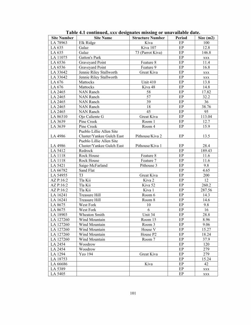
101
Table 4.1 continued, xxx designates missing or unavailable date. Site Number Site Name Structure Number Period Size (m2) LA 78963 Elk Ridge Kiva EP 100 LA 635 Galaz Kiva 107 EP 12.8 LA 635 Galaz 73 (Parrot Kiva) EP 146.8 LA 11075 Gatton's Park EP xxx LA 6536 Graveyard Point Feature 8 EP 11.4 LA 6536 Graveyard Point Feature 9 EP 16.8 LA 33642 Jennie Riley Stallworth Great Kiva EP xxx LA 33642 Jennie Riley Stallworth EP xxx LA 676 Mattocks Unit 410 EP 13.8 LA 676 Mattocks Kiva 48 EP 14.8 LA 2465 NAN Ranch 58 EP 17.82 LA 2465 NAN Ranch 57 EP 32.2 LA 2465 NAN Ranch 39 EP 36 LA 2465 NAN Ranch 18 EP 38.76 LA 2465 NAN Ranch 45 EP 95 LA 86310 Ojo Caliente G Great Kiva EP 113.04 LA 3639 Pine Creek Room 1 EP 12.7 LA 3639 Pine Creek Room 4 EP 15.9
LA 4986 Pueblo Lillie Allen Site Cluster/Yankee Gulch East Pithouse/Kiva 2 EP 13.5
LA 4986 Pueblo Lillie Allen Site Cluster/Yankee Gulch East Pithouse/Kiva 1 EP 28.4
LA 5412 Redrock EP 189.43 LA 1118 Rock House Feature 8 EP 11.6 LA 1118 Rock House Feature 7 EP 11.6 LA 5421 Saige-McFarland Pithouse 3 EP 9.8 LA 66782 Sand Flat EP 4.65 LA 54955 TJ Great Kiva EP 200 AZ P:16:2 Tla Kii Kiva 2 EP 12 AZ P:16:2 Tla Kii Kiva 52 EP 260.2 AZ P:16:2 Tla Kii Kiva 1 EP 287.56 LA 16241 Treasure Hill Room 6 EP 14.3 LA 16241 Treasure Hill Room 8 EP 14.6 LA 8675 West Fork 10 EP 9.8 LA 8675 West Fork 6 EP 16 LA 18903 Wheaton Smith Unit 34 EP 28.8 LA 127260 Wind Mountain Room 15 EP 8.96 LA 127260 Wind Mountain Room 3 EP 9.06 LA 127260 Wind Mountain House V EP 15.27 LA 127260 Wind Mountain House P2 EP 18.24 LA 127260 Wind Mountain Room 7 EP 37.9 LA 2454 Woodrow EP 120 LA 2454 Woodrow EP 279 LA 1294 Yeo 194 Great Kiva EP 279 LA 18753 EP 15.24 LA 66686 Kiva EP 42 LA 5389 EP xxx LA 5405 EP xxx

102
Table 4.1 continued, xxx designates missing or unavailable date. Site Number Site Name Structure Number Period Size (m2) LA 68709 EP xxx LA 14883 EP xxx LA 3272 EP xxx LA 6079 EP xxx LA 2949 Apache Creek Great Kiva ELP 50 AZ P:14:24 Chodistaas Room 2a ELP 33.75 AZ P:14:24 Chodistaas Room 18a ELP 50 LA 68188 Fox Place ELP 18.5 LA 4913 Gila Cliff Dwellings Room 27 ELP 25 LA 4913 Gila Cliff Dwellings Room 17 ELP 31.5 LA 4026 Goesling Ranch ELP 46.12 AZ P:14:8 Grasshopper Spring Room 7/Protokiva ELP 39 LA 8682 Higgins Flat Kiva 1 ELP 99.75 LA 8682 Higgins Flat Great Kiva ELP 128.4 LA 467 Hulbert ELP 30.48 LA 15075 Montoya Room 4 ELP 37.75 W:10:51 Point of Pines Pithouse 13 ELP 10.6 W:10:50 Point of Pines Kiva 5 ELP xxx LA 5391 Pueblo Cordoval ELP xxx LA 8891 Schoolhouse Canyon Kiva ELP 22.09
LA 1119 Small House North of Arroyo Seco ELP xxx
LA 2112 Smokey Bear/Block Lookout Feature 4 ELP 32.8 LA 6565 Taylor Draw Feature 15 ELP 12 LA 6565 Taylor Draw Feature 22 ELP 16 LA 6565 Taylor Draw Feature 7 ELP 16 AZ W:9:123 Turkey Creek Room 152-K1 ELP 11.6 AZ W:9:123 Turkey Creek Room251-K3 ELP 13 AZ W:9:123 Turkey Creek Room 237-K2 ELP 14 AZ W:9:123 Turkey Creek Great Kiva ELP 180 LA 3271 Valley View Room 2 ELP 29.3 LA 88889 Victorio ELP xxx LA 88889 Victorio ELP xxx LA 88889 Victorio ELP xxx W:10:37 Kiva 5 ELP 7.5 W:10:37 Kiva 3 ELP 9.6 W:10:37 Kiva 2 ELP 10.5 W:10:37 Kiva 1 ELP 10.6 W:10:65 Kiva 2 ELP 10.9 W:10:65 Kiva 1 ELP 11 W:10:37 Kiva 4 ELP 17.3 W:10:57 Kiva 1 ELP 21.1 LA 3274 ELP xxx LA 8780 Grasshopper Room 341 LLP 12.48 LA 8780 Grasshopper Room 246 LLP 29.19 LA 8780 Grasshopper Great Kiva LLP 181.83 LA 5793 Ormand Room 79 LLP 17.1 W:10:50 Point of Pines Kiva 1 LLP 220

103
Table 4.1 continued, xxx designates missing or unavailable date. Site Number Site Name Structure Number Period Size (m2) W:10:50 Point of Pines Kiva 2 LLP 263 W:10:47 Kiva 1 LLP 19 W:10:52 Kiva 1 LLP 20.1 W:10:52 Kiva 2 LLP 20.1 W:10:48 Kiva 1 LLP 21.2 LA 3275 Aragon Highway Salvage LP xxx AZ Q:15:3 Casa Malpais LP xxx LA 8682 Higgins Flat Kiva 2 LP 48 LA 3279 Hough site Room 1 LP 12.23 LA 3279 Hough site Great Kiva LP 97.38 LA 5390 Largo Creek LP xxx LA 5793 Ormand Room 97 LP 71.07 LA 3099 WS Ranch/McKeen Kiva G LP 13 LA 4031 LP xxx LA 68709 LP xxx LA 11075 Gatton's Park Pit Structure 81 LA 11076 Gatton's Park Pit Structure 121 LA 71877 Lake Roberts Vista Pit Structure 16.72 W:9:83 Lunt Pit Structure xxx LA 19071 Warm Springs Kiva Pit Structure 62 LA 43840 Pit Structure 21 LA 47626 Pueblo 112 LA 5404 Pueblo xxx LA 3259 WNMT 41 Mogollon 14
LA 3278 WNMT 92/Glenwood Highway Salvage #1 Kiva Mogollon 15.9
LA 39261 Structure H Mogollon 31.2 LA 39261 Structure K Mogollon 33 LA 39261 Small Kiva 1 Mogollon xxx
In Chapters 5 and 6, I discuss how my definition of a communal structure came to
change during this analysis. I also discuss whether my initial ideas about what defined
communal structures were accurate or not. What became clear during the course of this
analysis is that, in general, there is a great deal of location, size, and architectural
diversity in the assemblage of Mogollon communal structures (Appendix II).
Some researchers referred to unexcavated depressions at sites as “possible kivas,”
but in the absence of additional evidence to support the claim, such structures were not
included in the database. The structures at the end of Table 4.1 were included because

104
they were referenced in the literature as communal structures or kivas and because there
was some additional information available for them (see Appendix II). In general,
consistent and comprehensive information about internal architectural features,
construction technique, and structure size was not always available for each of the 206
structures. Structures for which there were missing data are included in the database (and
as previously stated, xxx was used as the designation for missing data). A more detailed
list of the available data for all of the structures included in the analysis is provided in
Appendix II.
Architectural Analyses
Each of the variables presented in this section was used in the analysis because
each helps to measure the level or degree of aggregation or integration present at a site.
Some of these variables were easier to analyze than others were; for example, site reports
that provided the size of an excavated communal structure were relatively
straightforward. However, a variety of factors, including the kind of original
investigation (survey, testing, or large-scale excavation), influenced the amount and
nature of the data obtained from any given site. For example, an excavation strategy that
involved testing a structure rather than complete excavation influenced the ability of
researchers to calculate the size and shape of a communal structure accurately.
Although it is extremely important to my analysis, another variable that was often
difficult to evaluate was that of communal structure contemporaneity. Radiocarbon,
archaeomagnetic, and/or tree-ring dates were available for fewer than half of the
communal structures in the database (n = 93) (Table 4.1, Chapter 5, and Appendix II).

105
All of the other structures were dated via ceramics and construction histories at specific
sites. In some instances, researchers have provided a detailed construction history for the
communal structures at their sites (Creel 1998, 1999a), and it is clear that although
structures may date to the same period, they were not necessarily used at the same time.
Unfortunately, in many cases, the use dates for structures are provided simply in terms of
a phase or period range. In such instances, it is difficult to ascertain whether the multiple
communal structures found at sites were contemporary. Variations, discrepancies, and
inconsistencies in these communal structure data are detailed in the “notes” column in
Appendix II. Appendix II also provides all additional information, including the sources
for these data.
Communal Structure Frequency
The issue of communal structure frequency is perhaps one of the most important
in this analysis (Anyon and LeBlanc 1984; Hill 1970; Longacre 1970; Steward 1937).
Adler (1989b), following Johnson (1982), has suggested that increasing population size
that results in an increase in the number of decision-making entities accounts for the
appearance of a communal structure within a community. The number of communal
structures found at a site is used as an indicator of the presence of population aggregation
and/or social integration (Hill 1970).
In my analysis, I predict that aggregated sites should have multiple contemporary
communal structures. The communal structures at an aggregated site should also display
a great deal of architectural variation (i.e., size, shape, and number and kinds of features)
because they are built by autonomous groups of people who reside within the same

106
community (see below for a more detailed discussion of this variation). The inverse of
this is that integrated sites will have fewer contemporary communal structures, and that
when there are multiple contemporary structures at an integrated site, they will be similar,
if not identical, architecturally. Sites that have multiple contemporary communal
structures may reflect the presence of aggregation and integration at a single site. In
these cases, I would expect one large, centrally located communal structure and one or
more, smaller communal structures.
In order to calculate communal structure frequency, I included all of the
communal structures for which phase or period dates were available (Appendix II); I did
not include structures with dates that spanned multiple periods (i.e., A.D. 600 to 1200). I
subsequently calculated communal structure frequency averages for each period and
displayed them in a single figure, in an effort to depict long-term frequency trends
(Figure 5.1). Averages for each of the Early, Middle, and Late Pit Structure periods, as
well as for the Early and Late Pueblo periods, all of which were defined in Chapter 3, are
also provided (Table 5.1). I subdivided the Late Pueblo period into Early Late Pueblo
(A.D. 1150 to 1300) and Late Late Pueblo (A.D. 1300 to 1400) to obtain a better
perspective on the changes that occurred during the Late Pueblo period. The Early Late
Pueblo period is essentially before the beginning of a significant drought that affected
some of the Mogollon region. The Late Late Pueblo period is the period that follows a
significant drought throughout the region (circa A.D. 1270). I created bar graphs for each
of the periods in order to depict communal structure frequency.

107
Communal Structure Location
The location of a communal structure within a site is also an important component
of this research. If the structure is located in an area that is physically separated from the
habitation structures at a site or away from a site, it may serve more than one group of
people. In these cases, the people using an isolated communal structure may have a
regular cycle of gathering for communal activities, perhaps during particular times of the
year. An isolated structure can serve an integrative function, as it provides a centrally
located structure within which regional integration may take place. For communal
structures found within sites (e.g., attached to a roomblock, situated near a particular
roomblock, or centrally located at a site), the location of these structures is important
because it can provide evidence for aggregation and integration.
Ethnographers have provided evidence to suggest that the distribution of kivas in
contemporary pueblos has a great deal of socio-ceremonial significance (Dozier
1970b:126; Eggan 1950). For instance, ethnographic data collected from Pueblo of
Acoma in western New Mexico during the mid-twentieth century, shows that there are
two kivas in the pueblo, and each structure is located in the center of the roomblock with
which it is associated (Ladd 1979:725). In this instance, I interpret the location of the
structures as representative of population aggregation at the site, as was the case at the
beginning of the occupation of Pot Creek Pueblo (Crown and Kohler 1994). In fact,
ethnographic work with the people of Acoma Pueblo provides evidence for aggregation
(in the form of two moieties) within this community (Ladd 1979). A site with multiple
contemporary communal structures associated with specific areas of the site, or one with

108
a single communal structure associated with a particular roomblock is evidence for
population aggregation at a site. In the latter case, the communal structure is likely used
by the roomblock’s inhabitants, who have chosen to segregate themselves in this manner.
It is possible that some of the people aggregating at a site build a communal structure,
while others do not (Cordell 1997).
As stated in Chapters 1 and 2, the people who form an aggregated community do
not necessarily share common socio-political or religious views. These differences are
visible in the archaeological record. For example, I have excavated sites in the northern
Rio Grande area, dating to the Classic Ancestral Pueblo period (A.D. 1235 to 1600) that
are situated less than 500 meters from one another and display differing architectural
patterns (Nisengard n.d., Schmidt 2006; Vierra et al. n.d.). Architectural diversity also
exists within a site if there are people from different social or ethnic groups.
Location data were available for 133 of the communal structures (Appendix II).
Location data were analyzed using a coding system (Appendix I). Isolated communal
structures, those that are at least 50 meters from habitation structures at a site, were coded
with an ‘I.’ Communal structures associated with particular roomblocks were coded with
an ‘A.’ Structures located in a prominent area of the site and not associated with a
particular roomblock or set of habitation rooms were coded with a ‘P.’ Communal
structures that were spatially separated from the habitation structures at a site were coded
with an ‘S.’ Using the location codes, average frequency for each location was calculated
by period, which are illustrated with graphs and tables. These illustrations depict trends
in communal structure location through time and provide evidence that I use to show
109
changes in aggregation and integration, in that isolated, spatially separated, and
prominent communal structures provide evidence for social integration, and communal
structures adjacent to or within particular roomblocks are indicative of population
aggregation.
Communal Structure Size
The variable “size” is also important and is in many ways impacted by the same
factors (e.g., problems with reporting) that influence frequency and location. Most basic
to a discussion of aggregation and integration in an area not characterized by social
hierarchy is that smaller structures provide meeting places for fewer people, while larger
buildings are more likely to serve larger groups. It is important to recognize the fact that
smaller structures may be used by multiple groups of people at different times, as is the
case in many contemporary Pueblo communities including San Ildefonso Pueblo, located
in northern New Mexico, and Zuni Pueblo, located in western New Mexico (Dozier
1979a, 1979b). In this analysis, however, the use of smaller structures by a number of
groups cannot be determined, as I have found no discussion in my review of the existing
literature that would provide evidence for such behavior. Therefore, the presence of
numerous contemporary small or large communal structures is indicative of population
aggregation.
As was discussed in the previous section (i.e., communal structure location), if
there is only one small communal structure at a site it may be indicative of one of two
phenomena. If the small structure is centrally located at the site, the structure may
indicate social integration at a site with a relatively small population. If, however, the

110
structure is associated with a particular area of a site, or with a specific roomblock, the
small structure provides evidence for population aggregation, with other groups at the site
not building communal structures. Evidence specifically for social integration comes in
the form of a single large communal structure, which indicates a high degree of
integration, because all members of a community are able to interact in the same space at
the same time.
Communal structure size was available in many of the published and unpublished
reports. However, in an effort to include data from as many structures as possible, I
sometimes had to calculate measurements based on plan views of these structures. Size
averages for each period were calculated and are depicted in graphs and in tables, which
also include standard deviation data.
Communal Structure Shape
Another variable considered is that of structure shape. Shape is an important
aspect when considering within-site architectural standardization. I began with the idea
that it is possible that the shape of communal structures is associated with temporal
changes in the architectural techniques used to build habitation rooms (e.g., the change
from circular to square and rectangular pit structures) and is not related to aggregation
and integration. However, it was important to analyze this characteristic to help address
the possibility that contemporary variations in structure shape are related to aggregation
and integration. One of the factors used to evaluate the three hypotheses presented in
Chapter 1 is that if a community is aggregated then there should be greater variation in
contemporary communal structure shape because the people at the site do not necessarily

111
share the same backgrounds. On the other hand, if a community is socially, politically,
ritually, and economically integrated, there will be less architectural variation present,
because underscoring similarities would be important to an integrated community. Shape
data were available for those communal structures that had been subject to testing and for
some that had not been, shape was based on the way in which the unexcavated structure
looked (e.g., Woodrow ruin [Lekson 1990]), located in the Gila valley of southwestern
New Mexico). Appendix II provides information about the structures for which shape
was projected by researchers who visited the site but did not excavate, and for excavated
structures.
Communal structure shapes were grouped into six categories; rectangular,
circular, D-shaped, oval, square, and irregular (Appendix II). I then created a chart
depicting the number of communal structures of each shape by period. This Chapter 5
chart depicts the six shapes and illustrates shape change through time. I also charted
structure shape for each period to provide a more detailed picture of the variability that
existed during the Pit Structure and Pueblo periods.
Communal Structure Hearth Shape
Changes in hearth shape have been an important aspect of communal structure
research in the Mogollon region (Anyon and LeBlanc 1980, 1984). Shafer (1995:40-41)
has provided evidence that changes in hearth shape are largely temporal and linked to
changes in subsistence strategies. Given the research conducted by Shafer (1995) and
others (e.g., Anyon and LeBlanc 1980), I decided to look for patterns, or a lack thereof, in
communal structure hearth shape. Specifically, I was interested in the ways in which

112
hearth shape could be related to issues of aggregation and integration. As it follows,
aggregated sites are expected to have multiple contemporary communal structures with
variation in the shapes of the hearths, because they are a result of autonomous groups
coming to live together in a single community while maintaining their traditional
distinctive construction techniques. Integrated sites will have fewer contemporary
communal structures, with a standard hearth shape found in each. Standardization in
construction is one way to shed uniqueness and to identify with the integrated group. If
hearth shape is indeed time dependent, I expected to find changes in hearth shape across
time.
Hearths were grouped into six categories, including rectangular, circular, oval,
square, irregular, and no formal hearth. The final category is interesting because some of
the communal structures in this assemblage are cited as having no formal hearths. A
figure depicting communal structure hearth shape through time is provided in Chapter 5,
as is a detailed discussion of the kinds of hearths that have been found in Mogollon
communal structures to assess the degrees of population aggregation and social
integration at sites in the region. This discussion includes period information on
structures that have no hearths and a discussion of the significance, or lack thereof, of the
absence of a formal hearth.
Communal Structure Orientation
The orientation of a communal structure is a useful measure of aggregation and
integration when considered in terms of consistency and variation. For this analysis,
redundancy in architectural orientation is suggested to be indicative of the presence of

113
integration, although some researchers have argued that redundancy in structure
orientation relates to function (i.e., to facilitate solar energy harnessing and/or to promote
thermal efficiency; Kang 1989). While structure orientation may be related to thermal
efficiency, it is important to consider patterns. I expect that greater variation in
contemporary structure orientation will indicate population aggregation, and increased
standardization should be associated with social integration. Structure orientation for the
sites included in Appendix II was available for the majority of the structures. Orientation
was largely based on the direction of ramp or stepped entryway. In some cases, there was
no evidence of an entryway; hearths and sipapus within communal structures are
sometimes aligned, in cases when these data were known, I used them to determine
structure orientation (Creel and Anyon 2003).
The analysis of communal structure orientation is presented in a table in Chapter
5, as is a discussion of variation. I included eight categories for orientation (north,
northeast, east, southeast, south, southwest, west, and northwest). There is certainly a
temporal trend in overall orientation data; however, I am interested in a more
synchronous analysis of these data. As a means to this end, I include a chart of structure
orientation by period and a discussion of how redundancy in this characteristic relates to
aggregation and integration.
Communal Structure Wall Construction
Initially, I thought that detailed information concerning wall construction
characteristic of communal structures, including wall height and wall, floor, and roof
materials, would be useful components of this analysis. This type of information can be

114
used to aid in the initial definition of what a communal structure is, which can be related
to issues of aggregation and integration. For example, communal structures may be
differentiated from other structures at a site because they are deeper, and the walls are
more elaborately constructed than habitation rooms. Very elaborate rooms would be
indicative of specialization in construction.
Architectural research has provided evidence that can be used to suggest that
specific kinds of materials may be used to build communal facilities (e.g., non-local
woods, clays, sands, stones; Anyon and Creel 2002; Creel 1998). These materials may at
times be difficult to procure or may require people to travel long distances to obtain such
items (see Anyon and Creel 2002). If the techniques employed to construct particular
kinds of buildings are significantly different from those used to build habitation
structures, they lend credence to the idea that these structures are communal in nature
(Anyon and Creel 2002; Diehl 1990).
In my analysis, variation in wall construction techniques at a site is indicative of
population aggregation. In these cases, the people coming together to live at a site
remain relatively autonomous and build their communal structure in a manner that is in
some way unique to them. Roof, wall, and floor construction are important, because they
are evidence for identifiable patterns in techniques associated with specific groups of
people. Socially integrated sites should display more standardization in construction
technique. If there are multiple contemporary communal structures at an integrated site,
they should be constructed using similar techniques. My discussion of construction
technique includes an investigation of individual communal structures and the ways in

115
which they were built, as well as a chart depicting the most common construction
techniques used to build Mogollon communal structures. Again, I expect to see variation
in communal structure construction technique at aggregated sites and very little or no
variation at integrated sites. Sites with one communal structure will be difficult to
analyze, and in such cases, construction technique will be assessed in conjunction with
size, location, and frequency.
An initial review of the available archaeological literature concerning
construction techniques and materials revealed that there is a great deal of inconsistency
in data recording. In some cases, researchers state that communal structure walls are
subterranean but fail to discuss specifics about these walls (i.e., plaster or masonry). In
other reports, there is an absence of any data relating to construction. Many scholars
identify these structures only as subterranean and do not provide any additional
information about specific construction techniques. Many of the reports that provided
other information for this analysis simply did not include these kinds of data. Ultimately,
as is the case with several other categories, this one is not complete. However, I did
collect construction material data when available; these data are presented in
Appendix II. Although collection inconsistencies prevent a detailed analysis, a general
discussion of construction variation is included in Chapter 5, as it is an important
measure of aggregation and integration.

116
Dismantling, Destruction, Burning, and Burials
Anyon and Creel (2003) discuss the purposeful destruction of Mimbres Mogollon
communal structures. The authors provide evidence some communal structures were
built with destruction in mind, and when they had served their purpose within their
communities, they were either collapsed or burned. I wondered if purposeful destruction
was a practice only associated with the ancient Mimbrenos, or if this occurred in other
areas of the region. I looked at evidence for dismantling, burning, and/or destruction in
all Mogollon communal structures. I also felt that communal structure destruction relates
to aggregation and integration.
If multiple communal structures are used at a site simultaneously and have no
evidence of dismantling or burning, they are likely indicative of aggregation at the site.
If however one communal structure is destroyed at a site before a new one is built and
used it can be indicative of social integration in that the community feels that one
communal space must be ruined before a new one can take its place (see Creel and
Anyon 2003).
I also looked at burials as indicative of the ritual closing of a communal structure.
As is the case with dismantling, destruction, and burning, burials within the walls of a
communal structure provide information about aggregation and integration. If the
residents of a community destroy one communal structure, and/or use it for burials, such
that it would not be reused, before building a new structure, there is an indication of
social integration at the site. If multiple structures are in use at the same time, there are
indications of population aggregation.

117
Methods for Communal Structure Data Collection
Each of the variables presented in this section was used in this analysis because
each helps to measure the level or degree of aggregation or integration present at a site.
These data are presented in Appendix II. In some cases, I found it useful to code data,
and coding information can be found in Appendix I.
As previously stated, information about the 206 communal structures from 110
Mogollon sites included in this analysis was gathered from published and unpublished
reports, journal articles, and books. A great deal of the information about these
architectural features was available from the Archeological Records Management Section
(ARMS) of the Historic Preservation Division at the Laboratory of Anthropology in
Santa Fe, New Mexico. The Mogollon region is subdivided in a variety of ways; these
divisions are discussed in Chapter 3.
In my analysis, I use the Mimbres Valley, Forestdale, and Western Pueblo areas
that include Grasshopper pueblo, and the Jornada areas to discuss differences in
communal structures found in the Mogollon region. There are certain areas of the region
(i.e., the San Simon) for which there are no recorded communal structures, and they are
not discussed in my analysis.
Chapter 5 presents the analysis of 206 communal structures, located at sites that
represent many of the diverse areas of the Mogollon region. By studying sites from
across a broad area, I am better able to present a discussion of patterns of population
aggregation and social integration in the Mogollon region as a whole over a 1200-year
period. In a perfect world, the database would include only those communal structures

118
that are architecturally distinct from all other buildings at a site. However, this was not
always the case and I have included all structures identified as communal in the analysis
presented in Chapter 5. Even those small communal structures that have been the subject
of debate and discussion are included in the analysis for three reasons. First, because
field researchers characterized these structures as communal while in the field, it seems
presumptuous to remove structures arbitrarily because their identifications are
contentious. Second, small communal structures are associated with all of the Pit
Structure and Pueblo periods, including some Late Pueblo period communities that did
not have pit structure components. Finally, small communal structures are found in
contemporary Pueblo communities and appear to reflect aggregation at these sites (Ladd
1979). In the final section of Chapter 5, I discuss the alternative results I achieved when I
removed all structures smaller than 20 m2 (n = 63) from my analysis in an attempt to
determine if their presence has affected my interpretations of aggregation and integration
in the Mogollon region.

119
CHAPTER 5
AN ANALYSIS OF MOGOLLON COMMUNAL STRUCTURES
As discussed in previous chapters, I am using the frequency of communal
structures at sites, the spatial location of communal structures within or between sites, the
size of Mogollon communal structures, communal structure shape, wall construction
techniques, internal communal structure features, communal structure hearth shapes, and
communal structure orientation to measure aggregation and integration. I discussed the
importance of each of these factors and their relationships to aggregation and integration
in depth in Chapter 4. In this chapter, each variable is presented with a brief review of its
relationship to these phenomena. The results from the detailed analysis of the communal
structure data are discussed by topic in order by period (Table 5.1).
Table 5.1. Number of Sites and Communal Structures in the Assemblage by Period. († Communal structures not dated to a specific period are not included in the analyses presented in this chapter. Please note that some sites are listed in multiple periods and therefore the total number of sites is 136 and not 110 as indicated in the text and in Appendix II.) Period Designation Dates (A.D.) Number of
sites Number of
communal structures Early Pit Structure (EPS) 250 to 700 18 22 Middle Pit Structure (MPS) 700 to 850 7 10 Late Pit Structure (LPS) 850 to 1000 23 36 General Pit Structure † 250 to 1000 7 6 LPS to Early Pueblo † 900 to 1150 4 7 Early Pueblo (EP) 1000 to 1150 36 60 Early Late Pueblo (ELP) 1150 to 1300 21 39 Late Late Pueblo (LLP) 1300 to 1450 10 14 Late Pueblo (LP) † 1150 to 1450 5 5 General Pueblo † 1000 to 1450 2 2 General Mogollon † 250 to 1450 3 5 Totals 136 206
120
Table 5.1 provides the number of communal structures dating to each period and
reiterates the Mogollon chronology used to analyze these data. A structure was analyzed
when specific or period dates were available (e.g., EP period). However, structures that
could not be associated with a particular period (e.g., those dating to the general Pit
Structure period) were excluded from the analyses.
Specific dates were not available for 25 of the communal structures from 21 sites
(e.g., structures with date ranges that span the General Pit Structure, LPS to EP, LP,
General Pueblo, and General Mogollon periods); while they are included in the database
(Appendix II), they are not analyzed here (Table 5.1). The majority of these structures,
(n = 20) are not analyzed because the analysis is conducted chronologically and without
this control, they lack a cultural and/or temporal context. I included them in Table 5.1
and in Appendix II, because they are Mogollon communal structures, and someone else
conducting research on these structures may find them useful. The five structures that
date to the Late Pueblo period are included in some of the analyses and are noted in such
cases.
As stated in previous chapters, there are 110 sites in the Appendix II database.
However, some sites have multiple structures that date to multiple periods and are
therefore counted in more than one period (Figure 5.1). As a result, as indicated in the
notes, the total number of sites listed in Table 5.1 is 136 and not 110. Again, general
information including site numbers, names, dates, structure sizes, and room numbers was
presented in Table 4.1 in Chapter 4. Detailed information about each individual structure
is provided in Appendix II.

121
Number of Communal Structures Identified at Mogollon Sites
6 1
2 6
12
5
21
01
0 0 01
0
5
10
15
20
25
30
35
40
45
50
55
60
65
One Two Three Four Five Six Seven Eight Nine Ten Eleven Twelve
Number of communal structures
Num
ber
of si
tes
Figure 5.1. General Communal Structure Frequency for Mogollon Sites (109 of the 110 sites and 205 of the 206 communal structures from the Appendix II database are included here because it is not clear from site reports, provided by researchers, how many communal structures are present at the Lunt site).
In an effort to consider the architectural diversity present in the Mogollon region,
the communal structures included in these analyses are from sites situated in all areas of
the region as discussed and defined in Chapter 3. These sites represent the diversity in
topographic location, vegetation, and elevation characteristic of sites located within the
Mogollon region.

122
Figure 5.2 differentiates between a hill top, a mesa top, a terrace, and a ridge
because all of these terms have distinct, commonly known geographic and geological
definitions. A hill is a geological feature that is higher than all surrounding features, but
it is smaller than a mountain. A mesa is an elevated feature with a flat top and is
surrounded by steep cliffs on all sides. A terrace is an elevated geological feature that
forms over time by deposits from a water source (e.g., a stream or a river). Finally, a
ridge is a long, narrow crest, which is elevated above surrounding features. These
definitions are standard United States Geological Survey definitions and are commonly
used by archaeologists to describe a site’s topographic location. While there may be
some overlap in the use of ridge, terrace, mesa, and hill, each is a distinct formation, so I
opted to use each in Figure 5.2, as noted by the reporting archaeologist (Appendix II).
As has been previously pointed out by researchers (Anyon and LeBlanc 1980;
Cordell 1997), terraces and ridges are the most common topographic locations for
Mogollon sites across time (Figure 5.2). Such locations, particularly first terraces above
rivers and drainages, provide relative ease of access to water and arable land, while
simultaneously providing views of surrounding areas. Sites situated on flood plains,
mesa tops, hill tops, and hill slopes are relatively rare (Figure 5.2). Flood plain locations
may have left residents vulnerable to both natural hazards and outsiders (LeBlanc 1999).
Mesas and hills may not have provided access to local resources, although the majority of
mesa top locations date to the EPS period and may reflect a continuation of one Late
Archaic settlement pattern discussed by Hard and Roney (1999, 2001) and others
(LeBlanc 1999).

123
Topographic Locations for Mogollon Sites with Communal Structures by Period
0
2
4
6
8
10
12
14
16
18
20
Terrace Ridge Hill top Hill slope Mesa top Flood plain
Num
ber o
f site
s
EPSMPSLPSEPELPLLP
Figure 5.2. Topographic Locations of Mogollon Sites with Communal Structures by Period.
In Figure 5.3, I use four vegetation types, woodland, forest, scrubland, and
grassland. I differentiate between woodland and forest vegetation because woodland
areas are dominated by piñon/juniper and oak (the distribution of which is dependant on
site location), while a forest has a preponderance of conifers, spruce, aspens, and other
trees. Mogollon sites tend to be situated in areas dominated by woodland and grassland
vegetation. However, a few sites, are located in higher elevations (e.g., in the Jornada
region), others are situated in forested areas, and still others are in desert scrublands.

124
Overstory Vegetation at Mogollon Sites with Communal Structures by Period
0
5
10
15
20
25
30
Woodland Forest Scrubland Grassland
Num
ber o
f site
s
EPSMPSLPSEPELPLLP
Figure 5.3. Prominent Vegetation Types for Mogollon Sites with Communal Structures by Period.

125
The greatest variation in site location, in terms of vegetation, occurs during the
EPS, LPS, and EP periods (Figure 5.3). While woodland and grassland locations
continue to be popular during these three periods, other site preferences are visible in the
data as well. It is during the LPS and EP periods that some researchers (Anyon and
LeBlanc 1980) have suggested that population increase occurred in many areas of the
region.
Figures 5.4 to 5.9 display elevation variation for 100 Mogollon sites dating from
the EPS period to the LLP period (elevation data were collected from the Laboratory of
Anthropology, http://potsuii.arms.state.nm.us/index). Mogollon sites are situated in areas
with a great deal of elevation variation, although no EPS or LLP period sites were built at
very high mountainous areas (7000 to 8000 ft) or very low (3500 to 4500 ft) elevations
frequently associated with floodplains (Figures 5.4 and 5.9). During the EPS period, all
sites are clustered between 4500 and 7000 ft in elevation (Figure 5.4). This kind of
grouping does not occur during any other period, this provides evidence for regional
integration, as consistency in site location is one piece of evidence for integration listed
in Table 1.1. Sites situated at an elevation of 5500 to 6500 ft, most frequently on terraces
and ridges, are the most common across time (Figures 5.4 to 5.9). The greatest elevation
variation (i.e., 4000 to 8000 ft) occurs during the EP period when Mogollon sites are
established on terraces, ridges, hill tops, hill slopes, mesa tops, and flood plains. This
diversity is not surprising as site density in the Mogollon region is the highest during this
period (Anyon and LeBlanc 1980, 1984; Cordell 1997).

126
Elevations for Early Pit Structure Period Sites with Communal Structures
0
1
2
3
4
5
6
3500-4000
4000-4500
4500-5000
5000-5500
5500-6000
6000-6500
6500-7000
7000-7500
7500-8000
Elevation (ft)
Num
ber
of o
ccur
renc
es
Figure 5.4. Elevations for EPS Period Sites with Communal Structures.
Elevations for Middle Pit Structure Period Sites with Communal Structures
0
1
2
3
3500-4000
4000-4500
4500-5000
5000-5500
5500-6000
6000-6500
6500-7000
7000-7500
7500-8000
Elevation (ft)
Num
ber
of o
ccur
renc
es
Figure 5.5. Elevations for MPS Period Sites with Communal Structures.

127
Elevations for Late Pit Structure Period Sites with Communal Structures
0
2
4
6
8
10
3500-4000
4000-4500
4500-5000
5000-5500
5500-6000
6000-6500
6500-7000
7000-7500
7500-8000
Elevation (ft)
Num
ber
of o
ccur
renc
es
Figure 5.6. Elevations for LPS Period Sites with Communal Structures.
Elevations for Early Pueblo Period Sites with Communal Structures
0
2
4
6
8
10
12
3500-4000
4000-4500
4500-5000
5000-5500
5500-6000
6000-6500
6500-7000
7000-7500
7500-8000
Elevation (ft)
Num
ber
of o
ccur
renc
es
Figure 5.7. Elevations for EP Sites with Communal Structures.

128
Elevations for Early Late Pueblo Period Sites with Communal Structures
0
2
4
6
8
10
3500-4000
4000-4500
4500-5000
5000-5500
5500-6000
6000-6500
6500-7000
7000-7500
7500-8000
Elevation (ft)
Num
ber
of o
ccur
renc
es
Figure 5.8. Elevations for ELP Period Sites with Communal Structures.
Elevations for Late Late Pueblo Period Sites with Communal Structures
0
1
2
3
4
5
6
3500-4000
4000-4500
4500-5000
5000-5500
5500-6000
6000-6500
6500-7000
7000-7500
7500-8000
Elevation (ft)
Num
ber
of o
ccur
renc
es
Figure 5.9. Elevations for LLP Period Sites with Communal Structures.

129
The importance of the topographic, vegetation, and elevation data presented in
these sections is not only in reflecting site selection diversity, but also because these data
are useful for evaluating traditional views regarding location preferences as they relate to
issues of aggregation and integration in the Mogollon region across time (e.g., Anyon and
LeBlanc 1980). If population aggregation occurred at sites in the Mogollon region across
time, I would expect to see greater variation in site topography, vegetation, and elevation
as people aggregating in the region will bring preferences from elsewhere into the area.
If social integration occurs most commonly at sites, I expect greater concentrations of
sites in areas with the greatest access to resources.
Topography, Vegetation, and Elevation in the Mogollon Region: A Summary
An analysis of topography and vegetation from Mogollon sites revealed a great
deal of consistency in site preference and little data that could be used to address issues of
aggregation and integration. Topographically, the majority of Mogollon sites are situated
on terraces and ridges; this site preference remains relatively constant across time
(Figure 5.2). Vegetative variation also remains relatively constant across time from the
EPS period into the ELP period (Figure 5.3), with people selecting woodland and
grassland locations for their sites across time. While topography and vegetation do not
reveal a great deal about aggregation and integration, elevation data do appear to reflect
differences that may be associated with these phenomena (Figures 5.4 to 5.9). Elevation
data for the EPS period provide evidence for a preference for site location between 4500
and 7000 ft. LeBlanc (1999:68) has pointed out that almost all EPS period sites are
situated on hilltops, mesa tops, or in some defensible location. This site location
preference provides evidence for social integration during the EPS period because people

130
living in these communities are building a structure (e.g., a wall) to support a communal
effort.
In contrast to the EPS period clustering of sites at middle range terraces, mesas,
and hilltops, during the EP period, site elevation varies the most. It is during this time
that researchers (Anyon and LeBlanc 1980; Cordell 1997) suggest that population
aggregation occurred in many areas of the Mogollon region. While the majority of sites
dating to the EP period are situated at an elevation of 5500 to 6000 ft, site elevation
varies from 4000 to 8000 ft (Figure 5.7). This variation appears to reflect at least some
degree of aggregation during the EP in that variation in site location choice may be
indicative of increasing population levels via aggregation. These data are somewhat
ambiguously related to aggregation and integration. However, the following sections
include analyses of characteristics more useful for measuring population aggregation and
social integration.
Frequency of Communal Structures
The frequency of communal structures is directly related to population
aggregation (Adler 1989a; Hill 1970; Johnson 1982; Longacre 1966) and social
integration (Adler 1989b; Hegmon 1989; Hill 1970). The hypotheses posed in this
research are that sites with multiple contemporary communal structures are associated
with high degrees of population aggregation, while sites with fewer contemporary
communal structures or more likely only one structure represent socially integrated
communities. At issue is whether there are changes in communal structure frequency
over time (Figure 5.10). A second issue deals with differences in aggregation and
integration at contemporary sites in various areas of the Mogollon region, which relates

131
to organizational diversity in the region. In some cases, sites have multiple small
communal structures and one large one, in these cases it is likely that integration occurred
within an aggregated community, but this is discussed in detail throughout this section.
There are 206 communal structures from 110 sites in the Appendix II database, but
specific dates were not available for 25 of the communal structures (the 25 structures are
indicated with an † or a * on Table 5.1). Five of the LP period structures cannot be dated
to the early or later part of the period, but they are included in portions of the frequency
analysis (Figures 5.10 and 5.11). The remaining 20 structures, for which specific dates
are not available, are not included in any of the analyses of average communal structure
frequency.
An analysis of the 188 structures for which dating information was available
(including the five structures that date only to the LP period) revealed that the average
frequency of communal structures per site increases from the EPS period to the EP period
(Figures 5.10 and 5.11). The average frequency of communal structures per site during
the LP period appears to increase (Figure 5.10); however, when the period is separated
into early (A.D. 1150 to 1300) and late sections (A.D. 1300 to 1450; Figure 5.11), there
is an increase followed by a decrease. There is an increase in average communal
structure frequency during the ELP period (A.D. 1150 to 1300). However, the average
frequency decreases during the LLP period (A.D. 1300 to 1450) to an average similar to
those seen during the EPS and MPS periods.

132
Average Frequency of Communal Structures per Site by Period
1.22
1.5 1.571.67 1.71
0
0.5
1
1.5
2
EPS MPS LPS EP LP
Period
Ave
rage
Fre
quen
cy
Figure 5.10. Average Communal Structure Frequency per Site by Period.
Average Frequency of Communal Structures by Period
1.22
1.5 1.571.67
1.86
1.4
0
0.5
1
1.5
2
EPS MPS LPS EP ELP LLP
Period
Ave
rage
Fre
quen
cy
Figure 5.11. Average Communal Structure Frequency per Site by Period, with the LP Period Subdivided into ELP (A.D. 1150 to 1300) and LLP (A.D. 1300 to 1450). The five structures dated only to the LP period have been removed.

133
The decrease in average communal structure frequency between the ELP and LLP
periods is not statistically significant (p = .259), however, there is an identifiable trend
towards an average frequency of one communal structure per site (Figure 5.11). In fact,
while there is a visible trend across time (Figure 5.11), results from the student’s t-Tests
for all periods indicate that these differences are not statistically significant (Table 5.2).
The only t-Test result that indicated a possible relationship or trend although it is not
significant (p = .138), was the comparison of Pit Structure and Pueblo periods. ANOVA
results comparing all periods (p = .458; F = .9405) were not significant. Statistical
analyses of this are since neither the periods nor the sample sizes from each of the periods
were equal. At the same time, however, given the detailed analysis of which follows in
chronological order from early to late in the following sections, it is possible that
communal structure data indicate that there is not a great deal of change in aggregation
and integration across time.
Table 5.2. Results from unpaired t-Tests. Periods Compared Standard Deviation p value
EPS to MPS .544 .241 MPS to LPS 1.17 .893 LPS to EP 1.18 .619 EP to LP 1.01 .207 EP to ELP 1.13 .664 ELP to LLP 1.03 .259 EP to LLP 1.04 .391 Pit Structure to Pueblo 1.02 .138

134
Table 5.3. EPS Period Sites with Communal Structures. Site number Site name Structure number Dates (A.D.) Dating notes and/or alternative dates Number of communal structures LA 19075 NM Y:4:6 None 305+/-85 Radiocarbon date 1 LA 34813 Winn Canyon Room 2/Kiva 310+/-75 Radiocarbon date
1
LA 103907 Bluff House 5 320v Tree-ring cutting date 1 LA 12110 McAnally Unit 11 580 +/- 60 Radiocarbon date 1 LA 1867 Harris House 14 582r Tree-ring cutting date 1 LA 127260 Ridout Locus;
Wind Mountain House F 620 to 710 Archaeomagnetic date range 1
LA 1113 Old Town A67 650+/- Archaeomagnetic date 1 AZ P:16:1 Bear Kiva 1 667 +/- 60 Radiocarbon date
657vv Tree-ring non-cutting date 1
LA 5421 Saige-McFarland Great Kiva Unit 1
672+/- Archaeomagnetic date range 645 to 770
1
LA 635 Galaz Great Kiva 8 Pithouse 8
650+/-60 Radiocarbon date 1
LA 64931 SU Pithouse A 200 to 550 Ceramic dates 2 LA 9713 Promotory House B 250 to 600 Ceramic dates 1 W:10:15 Crooked Ridge Pithouse 9 400 to 600 Ceramic dates 2 W:10:15 Crooked Ridge Structure 19 400 to 600 Ceramic dates 2 LA 6538 Diablo Feature 5 400 to 650 Ceramic dates 2 LA 32536 Cuchillo 1 550 to 650 Ceramic dates 1 LA 6538 Diablo Feature 14 550 to 650 Ceramic dates 2 Lagoon None 550 to 650 Ceramic dates 1 LA 11568 Mogollon House 5A 550 to 750 Ceramic dates 1 LA 64931 SU House V 550 to 750 Ceramic dates 2 LA 53 Three Circle Room 19 550 to 750 Ceramic dates 2 LA 53 Three Circle Room 2A 550 to 750 Ceramic dates 2
*Dating information is from site reports, published articles and books, and personal communication; see Appendix II for references.

135
Pit Structure Period
Early Pit Structure Period (A.D. 250 to 700). Twenty-two communal structures
from 18 sites (Table 5.3 and Figure 5.12) are associated with the EPS period (A.D. 250 to
700), with an average of 1.22, just slightly more than one communal structure per site
(Figures 5.10). Four of the EPS period sites have two communal structures each, but no
site has more than two. As discussed in Chapter 4, in general, the number of communal
structures dating to this period may be slightly underrepresented because some of these
early sites have been subject to reuse and/or remodeling for decades. When EPS sites
were abandoned and reoccupied, new structures were sometimes erected atop the earlier
structures. The majority of EPS sites, n = 14 or 78 percent, have only one communal
structure, providing evidence for integration at most sites during this period.
Communal Structure Frequency during the Early Pit Structure Period
0
2
4
6
8
10
12
14
16
One Two Three Four Five
Number of structures
Num
ber o
f site
s
Figure 5.12. Communal Structure Frequency during the EPS Period.

136
In some cases, dating issues make it difficult to know if the communal structures
at EPS sites with multiple structures were contemporaneous, or if structures were used
sequentially. While there are radiocarbon and/or tree-ring cutting dates available for
some of the EPS sites with only one communal structure, there are only relative dates for
those that have two (Table 5.3). However, the available data can be used to suggest that
at four EPS sites (Crooked Ridge, Diablo village, Three Circle, and SU) two communal
structures may have been used contemporaneously, these sites are discussed below.
At Crooked Ridge village, located in eastern Arizona along the Black River, there
are two communal structures with ceramic dates spanning 200 years (A.D. 400 to 600)
(Wheat 1955:58-64). There are 100 pit structures at the site, making it one of the largest
EPS period communities in the Mogollon region. As a result, there may have been two
communal structures to provide space for all of the site’s residents in communal activities
and/or rituals. If the structures were contemporary, data from Crooked Ridge provide
evidence for population aggregation at the site during the EPS period.
Interestingly, both of the Crooked Ridge communal structures, Pithouse 9 and
structure 19, are quite large (82 and 112 m2). It is possible, although Wheat (1955) does
not suggest this, that the smaller structure may have been replaced by the larger one as
the communal structure for the village if the community grew over time. In the absence
of absolute dates for the site, it is difficult to assess the contemporaneity of the two
structures.
The second site with two EPS period communal structures is Diablo village
(Creel and Anyon 2003; Dycus 1997; Hammack 1966). Situated along the upper Gila

137
River drainage in New Mexico, the site has two communal structures, Features 5 and 14,
which date to the EPS period. Ceramic dates for Feature 5 range from A.D. 400 to 650,
and Feature 14 dates from A.D. 550 to 650. Hammack (1966) does not state why he
assigned different ceramic dates for the features, and no other reports for the site specify
the reasons for the difference. However, the overlap in the dates for Features 5 and 14
provides evidence to suggest that the two Diablo village structures may have been used
contemporarily for 100 years.
Recently, Dycus (1997) used architectural evidence to provide a construction
history for the site, which shows that Feature 14 was constructed before Feature 5. He
has suggested that the earlier feature was abandoned when the second structure was built
and that the two were not contemporary. Interestingly, Feature 5 is smaller than Feature
14; I discuss the importance of these data in the subsequent size section. If the
construction history provided by Dycus (1997) is reliable, Diablo is another example of
EPS period integration.
The Three Circle site, situated in the northern Mimbres River valley in
southwestern New Mexico, has two EPS period communal structures, Rooms 2A and 19
(Creel and Anyon 2003). Both structures have ceramic dates of A.D. 550 to 750 and are
approximately the same size, although 2A is the largest of the 24 pit structures at the site.
Researchers (Creel and Anyon 2003:73) have suggested that Room 19 was used from the
EPS period into the MPS period, while 2A was abandoned and burned at the end of the
EPS period. This may help to explain the presence of the two structures at the site in that
19 likely replaced the destroyed 2A. However, the two were perhaps both used during

138
the end of the EPS period, suggesting that some degree of population aggregation
occurred at the site.
The fourth EPS period site with two communal structures is the SU site, which is
situated in the Reserve area of southwestern New Mexico (Cordell 1997:222; Martin and
Rinaldo 1947; Wills 1991a, 1991b). House V and Pithouse A have been identified as
EPS period communal structures. The date ranges for the two structures do not overlap,
as is the case for the other three EPS period sites with two communal structures.
Pithouse A has a ceramic date of A.D. 200 to 550, and researchers (Martin and Rinaldo
1947; Wheat 1955) estimate that House V was constructed and used between A.D. 550
and 750. Pithouse A predates House V, and, as was the case at Diablo village, the earlier
structure was larger than that later one. The two EPS period communal structures at SU
appear to have been used sequentially, rather than simultaneously, providing additional
evidence for EPS period integration.
Prior to the detailed analysis presented here, 78 percent of EPS period sites had
evidence for only one communal structure. There are four EPS period sites with two
communal structures each although evidence from one of the four sites suggests that they
were not contemporary. The communal structures at the SU site have evidence for
sequential use; Three Circle is the only EPS period site with evidence indicating that the
communal structures were contemporary. Frequency data for Crooked Ridge and Diablo
were inconclusive. Therefore, in general, evidence from EPS period sites provides data
that can be used to support the idea that during this period social integration was
emphasized at the majority of these communities, which makes sense as EPS period

139
communities were in general smaller than those associated with the LPS and Pueblo
periods. These structures were some of the earliest to be built and used to integrate
people living in the Mogollon region. Subsequent sections, specifically those that focus
on communal structure location and size, provide additional evidence to support the idea
that social integration was an important part of the lives of Mogollon people during the
EPS period. Ultimately, it appears that perhaps 15 of the 18 sites, or 83 percent, have
evidence for integration at this time.
Middle Pit Structure Period (A.D. 700 to 850). The number of communal
structures that date to the MPS period is considerably fewer than those from the EPS
period (Table 5.4 and Figure 5.13), and the average number of communal structures per
site increases during this period from 1.22 to 1.50 structures per site (Figures 5.10 and
5.11). Twelve communal structures from eight sites are associated with the MPS period
(Table 5.4 and Figure 5.13). Harris has two communal structures, and another, Wind
Mountain, has three (Figure 5.13 and Table 5.4). As was the case during the EPS period,
the majority of MPS sites, 63 percent, have only one communal structure (Figure 5.10
and 5.13), which provides evidence for integration at most sites during this period,
although to a lesser degree than was the case during the EPS period. Three of the MPS
period sites do have more than one communal structure, but none of the sites have more
than three.

140
Table 5.4. MPS Period Sites with Communal Structures.
Site number Site name Structure number Dates (A.D.) Dating notes and/or alternative dates
Number of communal structures
LA 127260 Wind Mountain House AB 620 to 730 Archaeomagnetic date range 3 LA 127260 Wind Mountain House AK 640 to 780 Archaeomagnetic date range 3 LA 1867 Harris 8 650 to 750 Ceramic dates 2 LA 11568 Mogollon House 3 650 to 750 Ceramic dates 1 LA 127260 Wind Mountain House O 650 to 750 Ceramic dates 3 LA 9709 Turkey Foot Ridge Pithouse K 767r Tree-ring cutting date 1 TX:4:132 Turquoise Ridge Structure 35 770 to 820 Archaeomagnetic date range 1 LA 6083 Gallita Springs Feature 40 800r Tree-ring cutting date 1 LA 1867 Harris House 23 836vv; 838vv Tree-ring non-cutting date 2 LA 1113 Old Town A71 800 to 874 Archaeomagnetic date range 1
*Dating information is from site reports, published articles and books, and personal communication; see Appendix II for references.

141
Communal Structure Frequency per Site during the Middle Pit Structure Period
0
1
2
3
4
5
6
One Two Three Four Five Six
Number of structures
Num
ber o
f site
s
Figure 5.13. Communal Structure Frequency during the MPS Period.
It is possible that population aggregation was beginning to increase during the
MPS period. The key evidence here again is whether multiple communal structures
found at MPS period sites were contemporary. If they are, they reflect an increase in
aggregation. However, if they are not, they provide evidence that can be used to suggest
that social integration continues to be maintained at most sites in the Mogollon region
during the MPS period (Figure 5.13). The following section provides the evidence from
communal structures dating to the MPS period.
Tree-ring and archaeomagnetic dates were available for seven of MPS period
communal structures (Table 5.4). In most cases, the tree-ring cutting and
archaeomagnetic dates provide a relatively concise period for the use of each of the

142
structures. The five structures for which absolute dates were not available have been
dated to a 100-year time span based on ceramics found within and sometimes on the
floors of these MPS period communal structures (Table 5.4).
As previously stated, five of the 12 MPS period communal structures are the only
such structure on the sites at which they are found (Figure 5.13). As was the case during
the EPS period, it appears that at these MPS period sites social integration was an
important emphasis. Three of the MPS sites have more than one communal structure.
At Harris, situated on the eastern side of the Mimbres River in southwestern New
Mexico, there are two MPS period communal structures, structure 8 and House 23 (Creel
and Anyon 2003; Haury 1936; Haury and Sayles 1947). A ceramic date of A.D. 650 to
750 is available for structure 8, and House 23 has a tree-ring non-cutting date of A.D.
838. Given these dates, it is likely that, although the two structures date to the MPS
period, they were not used contemporaneously by the inhabitants of Harris village. The
later communal structure, House 23, was smaller than its predecessor was.
There are three communal structures at the southwestern New Mexico site of
Wind Mountain (Woosley and McIntyre 1996). According to archaeomagnetic dates, the
first structure, House AB, is the largest of the three structures and was built and used
sometime between A.D. 620 and 730; the second, House AK, between A.D. 640 and 780;
and the third, House O, between A.D. 650 and 750 (Woosley and McIntyre 1996). The
three structures are located on the western side of the site and are randomly spaced
among the 50 pit structures at the site. The construction sequence developed for Wind
Mountain based on architectural style, dates for the structures, and artifacts identified in

143
the structures indicates that the three communal structures were used at the same time
(Woosley and McIntyre 1996); although they were not necessarily built at the same time,
they were likely to have been contemporary. If the construction sequence presented by
Woosley and McIntyre (1996) is accurate, and these three MPS period communal
structures were used simultaneously, Wind Mountain provides possible evidence for
some degree of population aggregation during this period.
Although there is a decrease from the EPS period (n = 83 percent) in the
percentage of MPS period sites, 63 percent, with only one communal structure, the most
important result presented here is that during the MPS period there is evidence for social
integration at most of the sites dating to this period. There is an increase, but not a large
one, between the EPS and MPS periods in the average number of communal structures
per site. However, in a detailed analysis of communal structure frequency data provide
evidence that at six of the eight sites, or 75 percent, there was a continued emphasis on
social integration during the MPS period.
Late Pit Structure Period (A.D. 850 to 1000). Thirty-six communal structures
from 23 sites comprise the LPS period assemblage. The number of LPS period
communal structures is three times that for the MPS period (Tables 5.1 and 5.5 and
Figure 5.14). The reason for the difference in numbers may be related to the fact that
there are more LPS period sites and that more LPS period structures have been excavated
than earlier ones. During this period, there is also a slight increase in the average number
of communal structures at Mogollon sites to 1.57. There is a great deal more variation in
the number of communal structures per site found at LPS period sites than at earlier sites.

144
Table 5.5. LPS Period Sites with Communal Structures. Site number Site name Structure
number Dates (A.D.) Dating notes and/or alternative dates Number of communal
structures LA 34787 Black's Bluff Pithouse 1 778 to 800 Tree-ring date range (Anyon and LeBlanc 1980) 1
LA 127260 Wind Mountain House XX 778 to 1030 Archaeomagnetic date range 4
LA 127260 Wind Mountain House X 800 to 940 Archaeomagnetic date range 4
LA 2465 NAN 52
737 to 859; 513 to 778; 660 to 990
Tree-ring date range; AMS dates; Archaeomagnetic date range 3
LA 4424 Wheatley Ridge House 7 870 to 936 Archaeomagnetic date range 1
LA 1113 Old Town A16 874 to 925 Archaeomagnetic date range 1
LA 6083 Gallita Springs Feature 38 875 to 950 Tree-ring dates range 1
LA 1867 Harris House 10 877v; 877r Tree-ring non-cutting dates
(also 736vv, 843vv, 846vv, 854vv, 858vv) 1
LA 84657 Squaw Canyon None 800 to 950 Ceramic dates 1
LA 5841 Cooney Ranch #1 Communal Structure 1 900 to 980 Tree-ring date range 1
LA 71877 Lake Roberts
Vista Great Kiva 900v Tree-ring non-cutting date 1
LA 2465 NAN 43 900vv Tree-ring non-cutting date 3
LA 104065 Ponderosa Ranch None 900v Tree-ring non-cutting date 1
LA 38624 Starkweather Pithouse B 900 Ceramic date 1 LA 1691/LA
15002 Swarts Room W 900v Tree-ring non-cutting date 3
LA 9657 Sawmill/Fox Farm Kiva 950vv Tree-ring non-cutting date 1
LA 3099 WS Ranch Kiva C 950+/-80 Radiocarbon date 1
LA 78337 Bradsby 1 996v Tree-ring non-cutting date 1
LA 18888 Beauregard Structure 1 750 to 1000 Ceramic dates 1
LA 635 Galaz Communal
Structure 42A 750 to 1000 Ceramic dates 1
LA 64931 SU Pithouse Y 750 to 1000 Ceramic dates 1 LA 1691/LA
15002 Swarts Room 2 750 to 1000 Ceramic dates 3 LA 1691/LA
15002 Swarts Room AE 750 to 1000 Ceramic dates 3

145
Table 5.5 continued.
Site Number Site Name Structure Number Dates (A.D.) Dating Notes and/or alternative dates Number of communal structures
LA 127260 Wind Mountain House U 750 to 1000 Ceramic dates 4
LA 127260 Wind Mountain House Y 750 to 1000 Ceramic dates 4
LA 6000 Lee 18 900 to 1000 Ceramic dates 6
LA 6000 Lee 19 900 to 1000 Ceramic dates 6
LA 6000 Lee 20 900 to 1000 Ceramic dates 6
LA 6000 Lee 21 900 to 1000 Ceramic dates 6
LA 6000 Lee 22 900 to 1000 Ceramic dates 6
LA 6000 Lee 23 900 to 1000 Ceramic dates 6
LA 3274 None 900 to 1000 Ceramic dates 1
LA 3921 None 900 to 1000 Ceramic dates 1
LA 2465 NAN 91 900 to 1000 Ceramic dates 3
AZ W:10:111 Nantack Great Kiva 1 900 to 1000 Ceramic dates 2
AZ W:10:111 Nantack Pithouse 10 900 to 1000 Ceramic dates 2
*Dating information is from site reports, published articles and books, and personal communication; see Appendix II for references.

146
Average Communal Structure Frequency per Site during the Late Pit Structure Period
02468
101214161820
One Two Three Four Five Six
Number of Structures
Num
ber
of S
ites
Figure 5.14. Communal Structure Frequency during the LPS Period.
One LPS period site, Nantack village, has two communal structures; two sites,
NAN and Swarts have three structures; there are four structures at the Wind Mountain
site; and Lee village has six (Figure 5.14 and Table 5.5). Even with this variation, the
majority of LPS sites, 18 of the 23 sites or 78 percent of the assemblage, have only one
communal structure (Figure 5.14), which provides evidence for integration at most sites
during this period, as was the case during the previous two pit structure periods.
LPS period communal structures from the Appendix II database range in age from
A.D. 750 to 1000/1050 (Table 5.4). Although I have designated a date of A.D. 850 for
the beginning of the LPS period, I have included those structures associated with the LPS
period by archaeologists who have used alternate dates for the period. There are tree-
ring, archaeomagnetic, and relative dates available for all of the structures (Table 5.5).

147
While the average number of communal structures at LPS period sites is 1.57,
five sites have multiple communal structures that date to the period (Figure 5.14). For
example, Lee village (also referred to as Fort West Hill in the literature), located in
southwestern New Mexico along the Gila River, has 63 to 70 pit houses and six
communal structures that date to the LPS period (Bussey 1972, 1975). This site is
problematic, however, in that the ceramic dates for these communal structures span a
period of 100 years (A.D. 900 to 1000) (Bussey 1972:50-56).
The lack of dates for the Lee village structures is partially a result of a lack of
decorated sherds associated with the floors of the structures, an absence of tree-ring
samples, and no results from archaeomagnetic samples (Bussey 1972:52, 55). However,
using a Robinson’s Index, which Bussey (1972:51-53) describes as “an index of
likeness,” for ceramics found within the six structures, he calculates construction
sequences for several of them. Results from the Index revealed that structure 21 was the
first structure built at the site, structure 22 was built later, and structure 23 was
constructed after that (Bussey 1972:53). Unfortunately, when Bussey (1972:53) uses
other ceramic methods for dating, he finds conflicting results. Specifically, he calculates
the percentage of Cliff Black-on-white to Mangus Black-on-white and finds a different
construction sequence. In the latter case, his results suggest that structure 23 was one of
the first at the site, followed by structures 22 and 21.
Based on his findings, Bussey (1972:53) is only able to say that structures 21, 22,
and 23 predate the other three communal structures at the site, but the order in which they
were built remains unclear. Specific dates for structures 18, 19, and 20 were not

148
calculated, but all three are later than 21, 22, and 23. Bussey (1975) later proposes a date
range of A.D. 920 to 980 for structures 21, 22, and 23 and A.D. 980 to 1050 for 18, 19,
and 20. Following Bussey (1975), at least three of the six structures at Lee village may
have been contemporary, and it is likely that the earlier three could have been replaced by
the later three, structures 18, 19, and 20. It is unclear why these structures were replaced,
and only one of the earlier structures, 21, showed evidence of having burned (Bussey
1972). Construction evidence from the six Lee village communal structures supports the
idea that population aggregation occurred at the site. During the LPS period, at least
three communal structures may have been used simultaneously, although they were not
necessarily constructed at the same time. Simultaneous use of such structures provides
evidence for LPS period aggregation.
While the contemporaneity information for the Lee village structures is not
detailed, specific dates are available for some of the LPS period communal structures at
the Wind Mountain site, located to the south in the Mimbres valley Burro Mountains
(Woosley and McIntyre 1996). Of the 12 communal structures excavated at the Wind
Mountain site, four of these, Houses U, Y, X, and XX date to the LPS period (Woosley
and McIntyre 1996). There are archaeomagnetic and ceramic dates for these four
structures, within the range of A.D. 750 to 1030. The four Wind Mountain communal
structures could have been built and abandoned at various times throughout this almost
300-year period, but it is also possible that the inhabitants of this LPS period site used
these structures contemporaneously. For example, the dates for House X are within the
range of A.D. 800 to 940, while dates for House XX are within the range of A.D. 778 to

149
1030, and so the possibility of use overlap exists. These dates also overlap with the other
two LPS period structures, but because ceramic dates are the only ones available for
Houses U and Y, it is difficult to assess the contemporaneity of these structures. If the
structures were contemporary, there is evidence for a continuation of the possible MPS
period population aggregation at Wind Mountain during the LPS period. The size, shape,
and orientation of these structures (discussed below) do provide additional evidence for
population aggregation at the site. Frequency data alone do not provide clear evidence
for aggregation or integration at Wind Mountain during the LPS period.
Two LPS period sites, Swarts and NAN, both situated in the southern portion of
the Mimbres valley, have three LPS communal structures each. Swarts ruin consists of
40 to 60 pit structures, a number that includes three communal structures, dating
somewhere between A.D. 750 to 1000 (Cosgrove and Cosgrove 1974). Only one of the
structures provided a non tree-ring cutting date of A.D. 900v (Room W), and the other
two dates (A.D. 750 to 1000) are based on ceramics recovered from the structures,
although not from floor contexts (Cosgrove and Cosgrove 1974). Room AE is very large,
while Room 2 is much smaller (Cosgrove and Cosgrove 1974). Construction data for the
site suggest that AE and 2 were abandoned prior to the construction of Room W
(Cosgrove and Cosgrove 1974). It is possible that the two structures were replaced by the
later communal structure. All three of the Swarts structures were burned upon their
abandonment, but unfortunately neither radiocarbon nor tree-ring dates are available
(Anyon and LeBlanc 1980; Cosgrove and Cosgrove 1974).

150
Given the lack of specific dates for two of the three Swarts communal structures,
it is only possible to remark that perhaps the structures were contemporary, although
construction data suggest otherwise. Interestingly, the three structures range greatly in
size (from 29 to 109 m2), in orientation, and in their locations, which are associated with
different areas of the site. The variation in size and location, discussed in subsequent
sections, provides some possible evidence for population aggregation in the area during
the LPS period.
At NAN, a 20 to 30 pit structure village, there is also evidence for three
contemporary structures, although the dates are more specific at this Mimbres valley site
(Burden 2001; Shafer 1983, 1989, 1990, 2003). The dates for three LPS period
communal structures, Rooms 43, 52, and 91, overlap. Shafer (2003:33) does not discuss
Room 43 in detail, because it was tested, but not fully excavated, and because it did not
burn. However, he does state that although Room 43 was likely used during the LPS
period, it appears that the structure was constructed during the MPS period and was
abandoned during the LPS period (Shafer 2003:35, 48).
Archaeomagnetic dates, Accelerator Mass Spectrometer (AMS) dates, tree-ring
dates, and construction sequences from NAN suggest that Room 52 was the functioning
communal structure at the site during the LPS period and dates somewhere between A.D.
660 and 859 (Shafer 2003). As Shafer (2003: 33-35) points out, dating Room 52 was
difficult because AMS, archaeomagnetic, and tree-ring dates conflicted with each other at
times. He does state however, that Room 52 was used as a communal structure during
the LPS period, and hence the overlapping dates of Rooms 43 and 52 (Shafer 2003).

151
This overlap does not necessarily mean that the two structures were contemporary, but it
does mean that it is possible that the structures were used during the same period.
A ceramic date range of A.D. 900 to 1000 is available for structure 91, as is a
construction history for the structure that provides additional support for this date range
(Burden 2001; Shafer 1990, 2003). The structure appears to have been used for an
extended period, as the floor was replastered three times (Shafer 2003:49). Based on
architectural features and decorated ceramics, primarily Mimbres Style II sherds,
recovered from the floor of the structure, Shafer (2003:48) suggests that structure 91
dates to the end of the LPS period.
Interestingly, structure 43, which construction sequences for the site suggest may
have been constructed earlier than structure 52, is the largest of the three NAN communal
structures (Burden 2001; Shafer 2003:48). It is possible that the initial structure, 43, was
not large enough for the community, and so they built an additional one, 52, in a similar
location to accommodate a greater number of the community’s members. Communal
structure size, and its implications for issues of aggregation and integration, is explored in
depth in a subsequent section. The focus of this section is the importance of three
structures with overlapping dates at NAN.
If the three NAN communal structures are contemporary, they provide evidence
for initial integration at the site (i.e., only one communal structure at the site first) in that
structure 43 was constructed during the MPS period. However, the fact that structure 43
was used into the LPS period along with two additional structures suggests that
aggregation occurred later during the period. The two smaller structures, 52 and 91,

152
appear to have been purposefully destroyed (both have evidence that they were burned,
and dedicatory/termination objects were placed into the structures prior to their
destruction) suggesting that they may have served their purpose when they were
destroyed (Burden 2001; Creel and Anyon 2003; Shafer 1989, 1990). At NAN, it does
appear that by the end of the LPS period residents of the site abandoned and/or destroyed
all three communal structures. These structures were replaced by EP period communal
structures.
Data from Nantack village also provide evidence for population increase and
social integration during the LPS period. The site has two LPS period communal
structures with ceramic dates (A.D. 900 to 1000). Nantack village is a 21 pit structure
site situated in the Point of Pines area of eastern Arizona. The two communal structures,
Great Kiva 1 and Pithouse 10, were excavated during the early 1950s (Breternitz 1956,
1959). While ceramic dates for the two structures suggest that the structures were
contemporary, Breternitz (1956) examined the site’s construction history to provide an
explanation for the presence of the two. Pithouse 10 is much smaller (60 m2) than the
Great Kiva (152 m2). Pithouse 10 was also built before the Great Kiva, and it appears
that the community initially constructed the smaller Pithouse 10 and then came to require
a larger communal structure (Breternitz 1956). It is possible that the Great Kiva was also
used for visitors, as the size of the structure would have been more than adequate to
accommodate members of the Nantack community. Archaeological data from Nantack
village support the idea that in this area of the Mogollon region, social integration, which
may at times have included visitors to the site, was the focus.

153
During the LPS period, there is evidence for relative stability in the degree of
social integration at a majority of Mogollon communities, including Nantack, Old Town,
Galaz, Harris, and many others. At the same time, population aggregation occurs at other
sites (e.g., Lee, NAN). The importance of integration during the LPS period comes from
the majority of sites, 18 of 23, that have only one communal structure and Nantack,
where the community used only one communal structure at a time. Nineteen sites have
only one communal structure. The average communal structure frequency data for the
LPS period, 1.57, supports the idea that social integration was important at the majority
of Mogollon sites, however the percentage of sites with only one communal structure is
actually 83 percent (when Nantack is added to the equation), which is an increase from
the MPS period percent of 75.
The MPS period percentage may be influenced by the relatively small sample size
of communal structures dating to that period. When considering data from the communal
structures, this percentage might be a bit misleading in that, although the percent of sites
with only one communal structure decreases from the EPS period to the MPS period,
most sites have only one “active” communal structure at a time. LPS period communal
structures provide evidence that the degree of social integration at Mogollon sites
increases during this period. The percentage of sites with only one communal structure is
83 during the LPS period, a percentage that is quite similar to that calculated for the EPS
period.

154
Communal Structure Frequency during the Pit Structure Period: A Summary
Communal structure data are used to suggest that social integration is an
important focus at most Pit Structure period sites. An emphasis on integration is
evidenced by the fact that the majority of EPS, MPS, and LPS sites have a single
communal structure, and some sites with more than one structure have evidence that they
were not contemporary. Although they are not statistically significant, changes in the
average number of contemporary communal structures per site during the Pit Structure
period are indicators of both population aggregation and social integration in the
Mogollon region. The average frequency of communal structures per site begins during
the EPS period at 1.22 structures per site and increases into the MPS period (n = 1.5), and
increases slightly once again during the LPS period when the average is 1.57 (Figure
5.10). However, these numbers, without closer review, are misleading. The averages
provide support for the idea that population aggregation increased across time during the
Pit Structure period. However, the percentage of sites with only one communal structure
provides different information about what occurred during this period. Communal
structure counts or averages per site do not provide a complete picture of aggregation and
integration. A more careful analysis of Pit Structure period communal structures results
in percentages of sites with one structure, providing data that can be used to suggest that
population aggregation may only have been an issue during the MPS period.
The percentage of MPS period sites with one communal structure before the
analysis presented here was 63 percent. The MPS period percent increases to 75 percent
when a detailed analysis is conducted, which is still a decrease from the EPS period

155
average of 83 percent. Researchers have reported that during the Pit Structure period
Mogollon communities were increasing in size, particularly in the Mimbres, Forestdale,
and Pine Lawn areas (Anyon and LeBlanc 1980; Cordell 1997; Wheat 1955). These
increases may be a result of population aggregation in the area at least at some Mogollon
sites during the MPS period. It may be the case that there are more MPS period
communal structures at individual sites because people in the Mogollon region were
faced with population aggregation. However, by the LPS period, communities appear to
have mitigated this issue, and social integration is once again reinforced at a majority of
sites.
The Pueblo Period
The Early Pueblo Period (A.D. 1000 to 1150). Thirty-six sites in the assemblage
date to the EP period (Table 5.6 and Figure 5.15). There are 60 communal structures at
these sites. The average number of structures per site during the EP period is 1.67, a
slight increase from the LPS period average of 1.57 (Figure 5.10). As was the case
during the Pit Structure period, the majority of EP period sites, 56 percent, have one
communal structure (n = 20) (Table 5.6). A higher proportion of EP period communities
have more than one communal structure (n = 16) than did sites dating to the Pit Structure
periods. Twelve EP period sites (e.g., Woodrow, Mattocks, Pueblo Lillie Allen, Jennie
Riley Stallworth, Dinwiddie, Graveyard Point, Pine Creek, Rock House, Treasure Hill,
West Fork, Galaz, and Black’s Bluff) ranging in size from 10 to 300 rooms have two
communal structures. Carter Ranch and Tla Kii, have three communal structures, and
Wind Mountain and NAN, have five structures (Figure 5.15 and Table 5.6).

156
Table 5.6. EP Period Sites with Communal Structures. Site
number Site name Structure number Dates (A.D.) Dating notes
(and/or alternative dates) Number of communal
structures LA 635 Galaz 73 (Parrot Kiva) 900 to 1150 Ceramic and construction dates 2
LA 5421 Saige-McFarland Pithouse 3 950 to 1100 Ceramic date 1
LA 127260 Wind Mountain House V 970 to 1080 Archaeomagnetic date range 5
LA 2454 Woodrow xxx 1000 Ceramic date 2
LA 2454 Woodrow xxx 1000 Ceramic date 2
LA 2465 NAN 58 1000 to 1130; 1105vv Archaeomagnetic date range; tree-ring date 5
AZ P:16:2 Tla Kii Kiva 1 1008 to 1121 Tree-ring non-cutting date range 3
LA 676 Mattocks Unit 410 1020vv; 1015 to 1250 Tree-ring non-cutting date; archaeomagnetic
date range 2
LA 2465 NAN 57 1025 to 1070 Archaeomagnetic date range 5
LA 127260 Wind Mountain Room 15 1030 to 1150 Archaeomagnetic date range 5
AZ P:16:2 Tla Kii Kiva 2 1035 Tree-ring non-cutting date (Haury 1985:54) 3
LA 127260 Wind Mountain Room 7 1040 to 1130 Archaeomagnetic date range 5
LA 4986 Pueblo Lillie Allen Site
Cluster/Yankee Gulch East Kiva 1 1057 to 1150 Report does not specify origin of date 2
LA 4986 Pueblo Lillie Allen Site
Cluster/Yankee Gulch East Kiva 2 1057 to 1150 Report does not specify origin of date 2
LA 2465 NAN 18 1066vv, 1068vv;
1071 to 1100 Tree–ring non-cutting dates, archaeomagnetic
date range 5
LA 2465 NAN 39 1090vv (Coeval with
45) Tree-ring date 5
LA 127260 Wind Mountain House P2 1100 Tree-ring non-cutting date 5
LA 2465 NAN 45 1107r (Coeval with
39) Tree-ring non-cutting date 5
Carter Ranch Great Kiva 1116 to 1156 Archaeomagnetic date range 3
Carter Ranch Room 16 1000 to 1150 Ceramic date 3
Carter Ranch Kiva 1 1000 to 1150 Ceramic date 3
LA 33642 Jennie Riley Stallworth Great Kiva 1000 to 1100 Ceramic date 2
LA 33642 Jennie Riley Stallworth Xxx 1000 to 1100 Ceramic date 2

157
Table 5.6 continued. Site number Site name Structure number Dates (A.D.) Dating notes
(and/or alternative dates) Number of communal
structures LA 5389 xxx 1000 to 1100 Ceramic date 1
LA 5405 xxx 1000 to 1100 Ceramic date 1
LA 5066 Cottonwood Creek xxx 1000 to 1150 Ceramic date 1
LA 6538 Diablo Feature 7 1000 to 1150 Ceramic date 1
LA 6783 Dinwiddie Feature 14 1000 to 1150 Ceramic date 2
LA 6783 Dinwiddie Feature 11 1000 to 1150 Ceramic date 2
W:6:5 Dry Prong Kiva 1 1000 to 1150 Ceramic date 1
LA 78963 Elk Ridge Kiva 1000 to 1150 Ceramic date 1
LA 635 Galaz Kiva 107 1000 to 1150 Ceramic date 2
LA 11075 Gatton's Park xxx 1000 to 1150 Ceramic date 1
LA 6536 Graveyard Point Feature 9 1000 to 1150 Ceramic date 2
LA 6536 Graveyard Point Feature 8 1000 to 1150 Ceramic date 2
LA 676 Mattocks Kiva 48 1000 to 1150 Ceramic date 2
LA 3639 Pine Creek Highway
Salvage 1 1000 to 1150 Ceramic date 2
LA 3639 Pine Creek Highway
Salvage 4 1000 to 1150 Ceramic date 2
LA 1118 Rock House Feature 8 1000 to 1150 Ceramic date 2
LA 1118 Rock House Feature 7 1000 to 1150 Ceramic date 2
LA 66782 Sand Flat xxx 1000 to 1150 Ceramic date 1
AZ P:16:2 Tla Kii Kiva 52 1000 to 1150 Ceramic date 3
LA 16241 Treasure Hill Room 6 1000 to 1150 Ceramic date 2
LA 16241 Treasure Hill Room 8 1000 to 1150 Ceramic date 2
LA 8675 West Fork 6 1000 to 1150 Ceramic date 2
LA 8675 West Fork 10 1000 to 1150 Ceramic date 2
LA 18903 Wheaton to Smith Unit 34 1000 to 1150 Ceramic date 1

158
Table 5.6 continued. Site number Site name Structure number Dates (A.D.) Dating notes
(and/or alternative dates) Contemporary communal structures
LA 127260 Wind Mountain Room 3 1000 to 1150 Ceramic date 5
LA 68709 xxx 1000 to 1150 Ceramic date 1
LA 66686 Kiva 1000 to 1150 Ceramic date 1
LA 5412 Redrock 1100 Ceramic date (report provides date of 1100 for this
structure, but does not specify origin of date) 1
LA 34787 Black's Bluff Great Kiva 13 1000 to 1175 Ceramic date 2
LA 34787 Black's Bluff Kiva 7 1000 to 1175 Ceramic date 2
LA 86310 Ojo Caliente G Great Kiva 1000 to 1175 Ceramic date 1
LA 1294 Yeo 194 Great Kiva 1000 to 1175 Ceramic date 1
LA 3272 xxx 1000 to 1175 Ceramic date 1
LA 14883 xxx 1000 to 1175 Ceramic date 1
LA 18753 xxx 1000 to 1175 Ceramic date 1
LA 6079 xxx 1000 to 1175 Ceramic date 1
LA 54955 TJ Great Kiva 1000 to 1200 Ceramic date 1
*Dating information is from site reports, published articles and books, and personal communication; see Appendix II for references.
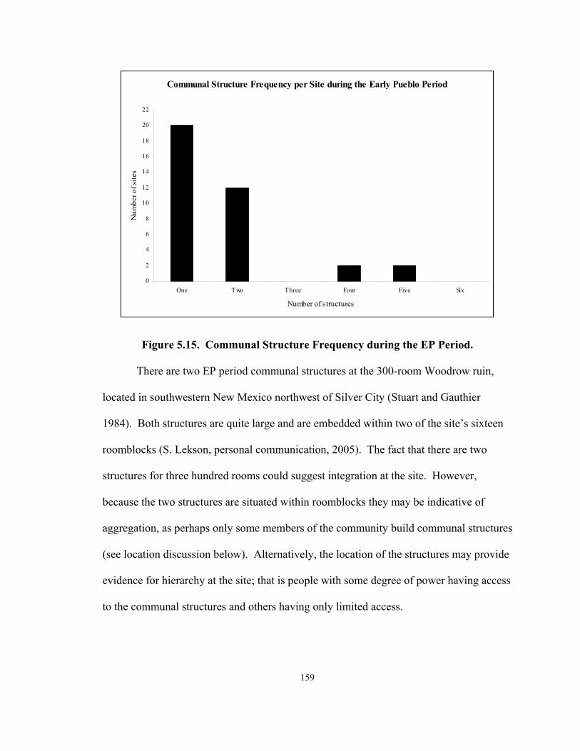
159
Communal Structure Frequency per Site during the Early Pueblo Period
0
2
4
6
8
10
12
14
16
18
20
22
One Two Three Four Five Six
Number of structures
Num
ber o
f site
s
Figure 5.15. Communal Structure Frequency during the EP Period.
There are two EP period communal structures at the 300-room Woodrow ruin,
located in southwestern New Mexico northwest of Silver City (Stuart and Gauthier
1984). Both structures are quite large and are embedded within two of the site’s sixteen
roomblocks (S. Lekson, personal communication, 2005). The fact that there are two
structures for three hundred rooms could suggest integration at the site. However,
because the two structures are situated within roomblocks they may be indicative of
aggregation, as perhaps only some members of the community build communal structures
(see location discussion below). Alternatively, the location of the structures may provide
evidence for hierarchy at the site; that is people with some degree of power having access
to the communal structures and others having only limited access.

160
The lack of dates for the structures, because they were subject to limited testing, is
problematic when attempting to determine if they are coeval. The communal structures
have very little post-depositional fill within them, and the site appears to have been
abandoned at the end of the EP period (S. Lekson, personal communication, 2005; Stuart
and Gauthier 1984). The absence of specific dates or ceramics from floor contexts for
either communal structure makes it difficult to argue that one of the structures was
abandoned and another built and used. Neither structure shows evidence for purposeful
destruction or burning. The lack of destruction of either of the structures when combined
with the locations of the structures does add support that the structures could be
contemporary. Ultimately, however, data from Woodrow are inconclusive in terms of
revealing evidence for population aggregation or social integration during the EP period.
In the Mimbres valley at the Mattocks ruin, Robinson and Cameron (1991:23)
have provided an early cutting date of 1079 and a late non-cutting date of 1117 for the
site. There is relatively little information about the site’s communal structures. Unit 410
was a habitation pit structure that was later remodeled into a communal structure
(LeBlanc 1983). Kiva 48 is the earliest communal structure that has been identified to
date at the site; the remodeled Unit 410 later came to be used. Gilman (1998) and others
(Lekson 1989) have discussed these small out of sequence pit structures suggesting that
they are not communal structures at all, but rather represent temporary residences for
people constructing surface roomblocks. This issue will be addressed at the end of the
frequency section. Communal structure data from Mattocks do not provide clear
evidence for aggregation or integration.

161
Although Kayser (1971) provides the same dates for the two communal structures
at Pueblo Lillie Allen, a site situated on Apache Creek in western New Mexico, he
concludes that of the construction of Kiva 1 predated Kiva 2. He reaches his conclusion
based on construction sequences from the site and based on the sizes of these two
structures. He also suggests that ultimately the two communal structures were used at the
site simultaneously. Kiva 1 is larger than Kiva 2, which was remodeled from a habitation
structure to become a communal structure (Kayser 1971). The presence of Kiva 1
suggests that integration was initially present at the site, but that later, the simultaneous
use of Kivas 1 and 2 provide evidence for increased population aggregation at the site.
The Jennie Riley Stallworth site, situated in the middle San Francisco drainage on
Devil’s Creek in southwestern New Mexico, is a relatively small site consisting of only
one roomblock. Accola and Neely (1980) identified two communal structures, one large
Great Kiva (approximately 100 m2) situated to the northeast of the roomblock and a much
smaller structure to the southeast. While fill within the Great Kiva suggests that it was
used during the EP period, the smaller structure is problematic. Given the fact that there
were at least five additional pit structures identified at the site, some of which were
underneath the roomblock (Accola and Neely 1980), it is possible that the smaller Jennie
Riley Stallworth “communal structure” is actually a pit structure that dates to an earlier
period. If the smaller pit structure does date to the Pit Structure period, then the Great
Kiva was the only EP period communal structure, which provides evidence for social
integration at the site.

162
Dinwiddie, an EP period site situated on the upper Gila River in southwestern
New Mexico, has two contemporary communal structures (Bussey 1972). Based on
ceramic data collected during site excavations, the site has been dated between A.D. 1000
and 1100 (Bussey 1972:78). Features 11 and 14 are approximately the same size (less
than 20 m2), and the ceramic dates available for the structures are the same (Anyon and
LeBlanc 1980; Bussey 1972; Linse 1999b). There are two roomblocks at the Dinwiddie
site, one eastern and one western (Anyon and LeBlanc 1980; Linse 1999a). Feature 14 is
attached to the northern end of the western roomblock (Anyon and LeBlanc 1980; Bussey
1972:62). Feature 11 is associated with the eastern roomblock (Anyon and LeBlanc
1980:268-269; Bussey 1972:62). The relatively short occupation at the site, the size of
the communal structures, and their association with different roomblocks is a strong
indication that aggregation occurred during the EP period at this Mogollon site.
At the Graveyard Point ruin, Accola and Neely (1980) state that there is one
“Great Kiva” and one smaller communal structure present at the site. The smaller
structure is situated within the roomblock and the larger structure is an independent
structure (Accola and Neely 1980). Only ceramic dates are available for the two EP
period communal structures, so it is not possible to determine whether the two were
contemporaneous. It is possible that the Great Kiva was used as the integrating structure
at the site, but it is quite small relative to many other structures identified in the Mogollon
region (Anyon and LeBlanc 1980). If the structures were used at the same time,
Graveyard Point reflects aggregation during the EP period. However, the lack of
additional data makes it impossible to determine if they are coeval.

163
Pine Creek pueblo is located on the western side of Duck Creek, a tributary of the
Gila River in southwestern New Mexico (Anyon and LeBlanc 1980). The two EP period
communal structures at this site, Rooms 1 and 4, are approximately the same size, and
both are relatively small (Anyon and LeBlanc 1980). Neither of the structures is attached
to roomblocks, and Anyon and LeBlanc (1980:268) state that the structures are
“isolated.” I suggest in a subsequent section that these structures are not “isolated” but
rather are spatially separated from the rest of the site’s architecture. Pine Creek pueblo
may provide evidence for population aggregation, but again given the lack of more
specific temporal data it is difficult to determine.
Rock House ruin, situated on the Mimbres River, has two EP period communal
structures (Anyon and LeBlanc 1980). The structures, Features 7 and 8, are exactly the
same size (11.6 m2), and their ceramic dates overlap. Both of these structures are
attached to the only roomblock at the site (Anyon and LeBlanc 1980). Construction data
for the site show that Feature 8 was abandoned prior to the construction of Feature 7
(Anyon and LeBlanc 1980; Laboratory of Anthropology site files, Santa Fe, New
Mexico). In this case, the people living at Rock House ruin appear to have replaced their
original communal structure with another one of the exact same size. The fact that these
two structures are not contemporary, that they occupy the same space within the
community, and the fact that they are the same size provide an example of social
integration at an EP period site.
Treasure Hill, situated on Cameron Creek near Silver City in southwestern New
Mexico, has two communal structures that are approximately the same size (14 m2)

164
(Anyon and LeBlanc 1980; Cosgrove 1923; Cosgrove and Cosgrove 1932). Excavations
at the site provided limited amounts of information about the site’s architecture
(Cosgrove 1923). Ceramic dates suggest that the two structures, Rooms 6 and 8, are
coeval (Cosgrove 1923). However, Room 6 is associated with the northern roomblock
and Room 8 with the east roomblock (Anyon and LeBlanc 1980; Cosgrove 1923). Given
the sizes and associations of the two structures, they make a strong case for EP period
aggregation. Treasure Hill is similar to the Dinwiddie site in terms of communal
structure frequency and location and both provide strong evidence to suggest that
population aggregation did occur during the EP period.
There are no absolute dates for the two West Fork communal structures (Anyon
and LeBlanc 1980; Ice 1968). The site is aptly named, as it is situated on the west fork of
the Gila River in southern New Mexico. The dates for the two communal structures, 10
and 6, range from A.D. 1000 to 1150 based on the regional ceramic seriation (Table 5.5).
The site has subsequently been purposefully destroyed (Shafer 2003:112). Both of the
structures were relatively small and were associated with specific roomblocks at this site
(Ice 1968). If the two structures were contemporary, West Fork is quite similar to
Dinwiddie and Treasure Hill and the site provides evidence for population aggregation in
this part of the Mogollon region during the EP period.
At the 150-room Mimbres site of Galaz, there are also two EP period communal
structures, Kiva 107 and structure 73, or Parrot Kiva (Anyon and LeBlanc 1984:134-
135). Parrot Kiva (structure 73) is quite large, while Kiva 107 is relatively small and is
associated with one of the site’s roomblocks. Based on the ceramic dates and

165
construction evidence available for these two structures, it appears that Parrot Kiva was
constructed prior to Kiva 107, perhaps during the latter part of the LPS period (Anyon
and LeBlanc 1984:134). As Anyon and LeBlanc (1984:134) state “Although we cannot
be sure of its construction date, it appears that it was at least in use during the Classic
period, as was Galaz structure 73.” Therefore, the two structures were contemporary and
both were used during the EP period. The longevity of Kiva 107’s use is supported by
the fact that it was remodeled twice during the EP period (Anyon and LeBlanc 1984:135-
137). Frequency data from the two structures suggests that while integration may have
been emphasized initially during the EP period, at some point some degree of aggregation
appears to have become an issue at the site.
The EP period site of Black’s Bluff, in southwestern New Mexico, consists of 12
roomblocks and two communal structures (Anyon and LeBlanc 1980, Brunet 1972;
Fitting et al. 1972). The two communal structures, Kiva 7 and Great Kiva 13, date to the
EP period. Unfortunately, only ceramic dates ranging from A.D. 1000 to 1175 are
available for the two structures (Fitting et al. 1972). Neither of the structures is
exceptionally large, but the larger of the two structures, Great Kiva 13, is located in a
prominent location while the smaller Kiva 7 is associated with one of the site’s
roomblocks (Fitting et al. 1972).
The lack of absolute dates for the Black’s Bluff communal structures makes it
difficult to determine their contemporaneity. If the two are contemporary, the Great Kiva
could represent the importance of social integration at the site, while Kiva 7 reflects
possible population aggregation at the site. It is not clear if the Black’s Bluff communal

166
structures reflect aggregation and integration at this EP period site. It is possible that
within this large aggregated site, there was some degree of small group integration. The
Great Kiva could have been used for larger scale social integration, while Kiva 7 could
have been used by those who resided in the roomblock with which it is associated.
Without dates that are more specific or construction information, it is not possible to
determine whether aggregation or integration occurred at the site during the EP period.
Sites with two contemporary communal structures are proportionally more
common, during the EP period than they were during the Pit Structure period. Many of
these sites (e.g., Woodrow, Mattocks, and Graveyard Point) have two relatively small
communal structures. At some of the EP period sites (e.g., West Fork and Treasure Hill),
the two communal structures appear to have been contemporary and therefore, provide
evidence for a greater degree of population aggregation during the EP period than during
the LPS period in the Mogollon region.
The EP period sites of Tla Kii and Carter Ranch each have three possibly
contemporary communal structures. Tla Kii is a 21-room pueblo located on Forestdale
Creek in east-central Arizona. Kivas 1, 2, and 52 make up the Tla Kii’s EP communal
structure assemblage (Haury 1985; Herr 2001). Kiva 1 dates some time between A.D.
1008 to 1121 based on a series of non-cutting outer ring dates (Haury 1985:47-48), a date
of A.D. 1035 was provided for Kiva 2 (Herr 2001), and a ceramic date range between
A.D. 1000 and 1150 was provided for the third structure at the site. Interestingly, reports
regarding Tla Kii (Haury 1985; Herr 2001) indicate that the construction of Kiva 2, a
very small structure at 12 m2 and situated within one of the roomblocks, was not

167
completed; the structure was abandoned in favor of the much larger Kiva 1, which is 288
m2 and is situated 25 meters south of the site.
Construction of the small Tla Kii structure may have represented a desire of the
people living at Tla Kii to privatize their communal activities or to create a space where
fewer people could attend functions. The abandonment of this smaller structure and the
construction of a much larger one suggest that integration of large numbers of people
became the ultimate priority. The third structure is also large, 260 m2, and, given its size,
it is probably not a contemporary of Kiva 1, as the residents of a 21-room pueblo would
not likely need two very large communal structures (and Haury 1985 does not mention
this structure). When considered as a whole, it is likely that data from Tla Kii provide
evidence to support the idea that social integration, rather than aggregation, was
emphasized at this site during the EP period.
Communal structure data from the Carter Ranch (Laboratory of Anthropology site
files, Santa Fe, New Mexico; Longacre 1970), situated in eastern Arizona, is problematic
because only date ranges are available for the EP period assemblage. There are tree-ring
cutting dates for the Great Kiva ranging from A.D. 1116 to 1156 and ceramic dates for
the two other structures, Room 16 and Kiva 1, which range from A.D. 1000 to 1150.
Kiva 1, a small, 8 m2, D-shaped communal structure is situated within an enclosed plaza.
Room 16 is the same size as Kiva 1, 8 m2, and is associated with one of the roomblocks
at the site. The Great Kiva is 10 meters from the site’s center and is very large at 235 m2.
Site reports housed at the Laboratory of Anthropology in Santa Fe, New Mexico, state
that the Great Kiva was constructed earlier than the other two structures.

168
The physical separation of the large communal structure from the site’s center
provides support for some degree of social integration at Carter Ranch. The separation of
the large structure from the plaza and the roomblocks suggests that it has some level of
autonomy. The importance of the location will be addressed in depth in a subsequent
section. Interestingly, the Great Kiva was burned upon its abandonment, and the two
later structures are incorporated into the site’s architecture. This is interesting because it
suggests that the separated Great Kiva was destroyed and replaced with two structures
that were part of the pueblo.
The Carter Ranch community appears to have experienced changes in aggregation
and integration during its occupation. It is possible that these changes led to the
abandonment of the Great Kiva and subsequent use of two smaller structures housed
within the walls of the community later in time. It does appear that population
aggregation did occur at the site, as evidenced by the presence of two smaller communal
structures. Communal structure frequency data from Carter Ranch provide support for
initial integration, which was subsequently replaced by population aggregation. It is
important to point out here that Gilman (1998) and Lekson (1989) have argued that
smaller structures found at sites are not communal structures, but rather out of sequence
pit structures. This issue is explored below and in subsequent sections.
The EP period site of Wind Mountain consists of three roomblocks (Woosley and
McIntyre 1996). The site has five communal structures that date to the EP period. The
five Wind Mountain communal structures include Room 3 (somewhere between A.D.
1000 to 1150), Room 7 (somewhere between A.D. 1040 to 1130), Room 15 (somewhere

169
between A.D. 1030 to 1150), House V (somewhere between A.D. 970 to 1050), and P2
(A.D. 1100+/-) (Woosley and McIntyre 1996). The structures vary in size, but are all
relatively small (15 to 38 m2) and are scattered throughout the site (Woosley and
McIntyre 1996).
Construction data and dates from the Wind Mountain communal structures
provide some evidence that the structures are contemporary (Woosley and McIntyre
1996), although the date ranges overlap, and thus do not provide definitive evidence for
contemporaneity. However, as previously discussed, following Gilman (1998) and
Lekson (1989), the size of the five structures also makes their delineation as communal
structures difficult. It is clear that these structures are associated with various parts of the
site, which also provides support for aggregation at the EP period site. That the site has a
history of more than one communal structure makes it interesting as an example of both
early and long-term population aggregation in this area of the Mogollon region.
NAN Ranch ruin also has five EP communal structures. The site is located in the
Mimbres valley and experienced growth during the LPS period (Burden 2001; Shafer
2003). During the EP period, communal structures 18, which dates somewhere between
A.D. 1071 and 1100, 57 (somewhere between A.D. 1025 and 1070), 58 (somewhere
between A.D. 1000 and 1130), 45 (A.D. 1107r), and 39 (1090vv; ca. A.D. 1099) were
used at the site (Burden 2001; Shafer 2003:93). Using construction sequences for the
site, Shafer (2003) and Burden (2001) have provided evidence that structure 57 was a
contemporary of structure 58 (A.D. 1000 to 1130). Structure 57 was abandoned before
the construction of structures 18, 45, and 39 (Burden 2001). However, Shafer (2003:78,

170
98) suggests that structure 58 continues to be used along with structures 18, 39, and 45.
These data provide evidence for a continuation of population aggregation at NAN from
the LPS period into the EP period.
Data from both NAN and Wind Mountain provide examples of multi-period
aggregation. At both sites, aggregation begins during the LPS period and continues into
the EP period. While not all of the communal structures at NAN and Wind Mountain are
contemporary, at both sites multiple contemporary communal structures appear to have
been used at the same time.
Multiple contemporary communal structures are much more common during the
EP period than during the Pit Structure period. Sixty-four percent of the EP period sites
have multiple structures that are not contemporary or have only one communal structure.
This percentage is down from 83 percent calculated for the LPS period. EP period
communal structure frequency data provide support for the idea that while population
aggregation did increase during the EP period, at a majority of communities dating to this
period, social integration continued to be important.
There are benefits and consequences associated with increased aggregation; the
most fundamental result of this phenomenon is that there are larger numbers of people
living in communities. These groups of congregating people have their own ways of
organizing themselves and strategies for encouraging cooperation that are vital to the
success of the group. In some cases, evidence suggests that aggregation (e.g., Dinwiddie,
Wind Mountain, and NAN) functions quite well, and multiple groups live in a somewhat
segmented, although coherent, community. I refer to the sites as segmented in that they

171
consist of groupings of surface roomblocks and communal structures that are spatially
distinct. In other communities (e.g., Tla Kii), it appears that the strategy used to organize
a larger number of people living within a community is to promote social integration.
The average number of communal structures per site during the EP period
provides evidence to suggest that at some sites people continued to place a strong
emphasis on socially integrating larger numbers of people by building and using only one
communal structure. Population aggregation appears to have become more of an issue
during the EP period when the percent of sites with only one communal structure drops
and the number of sites with multiple structures increases.
Late Pueblo Period (A.D. 1150-1450). Fifty-eight communal structures from 36
sites date to the ELP (A.D. 1150 to 1300) (n = 39), LLP (A.D. 1300 to 1450) (n = 14), or
general LP period (A.D. 1150 to 1450) (n = 5) (Table 5.7 and Figure 5.16). The average
number of communal structures per site increases during the LP period (A.D. 1150 to
1450) to 1.71 (Figures 5.10 and 5.11). However, when the LP period is separated in the
ELP and LLP periods, a difference become apparent. The average number of communal
structures at ELP period sites is 1.86, but during the LLP period it drops to 1.40
(Figures 5.10 and 5.11).

172
Table 5.7. Late Pueblo Period Sites with Communal Structures. Site number Site name Structure
number Dates (A.D.) Dating notes
(and/or alternative dates) Number of
communal structures Early Late Pueblo or
Late Late Pueblo period LA 3279 Hough Great Kiva 1080 to 1150 Ceramic date 2 Early Late Pueblo
LA 8682 Higgins Flat Kiva 1 1175 to 1250 Ceramic date 3 Early Late Pueblo LA 3274 xxx 1200 Tree-ring non-cutting date 1 Early Late Pueblo LA 68188 Fox Place xxx 1215 to 1290 Archaeomagnetic date range 1 Early Late Pueblo AZ W:9:123 Turkey Creek Room 152-K1 1225 to 1286 Archaeomagnetic date range 4 Early Late Pueblo AZ W:9:123 Turkey Creek Room 237-K3 1225 to 1286 Archaeomagnetic date range 4 Early Late Pueblo AZ W:9:123 Turkey Creek Room 251-K2 1225 to 1286 Archaeomagnetic date range 4 Early Late Pueblo AZ P:14:24 Chodistaas Room 18a 1232 to 1288 Tree-ring cutting date range 2 Early Late Pueblo AZ P:14:24 Chodistaas Room 2a 1232 to 1288 Tree-ring cutting date range 2 Early Late Pueblo AZ W:9:123 Turkey Creek Great Kiva 1240 Tree-ring cutting date 4 Early Late Pueblo LA 8682 Higgins Flat Great Kiva 1249 to 1281 Tree-ring cutting date range 3 Early Late Pueblo W:10:51 Point of Pines Pithouse 13 1265 to 1300 Archaeomagnetic date range 1 Early Late Pueblo AZ Q:15:3 Casa Malpais xxx 1268 to 1274 Tree-ring cutting date range 1 Early Late Pueblo LA 4913 Gila Cliff Dwellings Room 27 1270 to 1290 Tree-ring non-cutting date range 2 Early Late Pueblo
AZ P:14:8 Grasshopper
Springs Room 7 1278 Tree-ring cutting date 1 Early Late Pueblo
LA 4913 Gila Cliff Dwellings Room 17 1287 Tree-ring cutting date 2 Early Late Pueblo LA 6565 Taylor Draw Feature 15 1100 to 1200 Ceramic date 3 Early Late Pueblo LA 6565 Taylor Draw Feature 22 1100 to 1200 Ceramic date 3 Early Late Pueblo LA 6565 Taylor Draw Feature 7 1100 to 1200 Ceramic date 3 Early Late Pueblo LA 15075 Montoya Unit 4 1100 to 1200 Ceramic date 1 Early Late Pueblo LA 88889 Victorio xxx 1100 to 1200 Ceramic date 3 Early Late Pueblo LA 88889 Victorio xxx 1100 to 1200 Ceramic date 3 Early Late Pueblo LA 88889 Victorio xxx 1100 to 1200 Ceramic date 3 Early Late Pueblo LA 2949 Apache Creek Great Kiva 1100 to 1250 Ceramic date 1 Early Late Pueblo LA 3271 Valley View Room 2 1100 to 1250 Ceramic date 1 Early Late Pueblo

173
Table 5.7 continued.
Site Number
Site Name Structure Number
Dates (A.D.) Dating notes (and/or alternative dates)
Number of communal structures
Early Late Pueblo or Late Late Pueblo period
LA 4026 Goesling Ranch xxx 1100 to 1250 Ceramic date 1 Early Late Pueblo LA 5793 Ormand Room 97 1100 to late 1300s Ceramic date 1 Early Late Pueblo
LA 1119 Small House North of
Arroyo Seco xxx 1150 to 1250 Ceramic date 1 Early Late Pueblo
W:10:57 Kiva 1 1150 to 1265 Ceramic date 1 Early Late Pueblo W:10:65 Kiva 1 1150 to 1265 Ceramic date 2 Early Late Pueblo W:10:37 Kiva 1 1150 to 1265 Ceramic date 5 Early Late Pueblo W:10:65 Kiva 2 1150 to 1265 Ceramic date 2 Early Late Pueblo W:10:37 Kiva 2 1150 to 1265 Ceramic date 5 Early Late Pueblo W:10:37 Kiva 3 1150 to 1265 Ceramic date 5 Early Late Pueblo W:10:37 Kiva 4 1150 to 1265 Ceramic date 5 Early Late Pueblo W:10:50 Point of Pines Kiva 5 1150 to 1265 Ceramic date 3 Early Late Pueblo W:10:37 Kiva 5 1150 to 1265 Ceramic date 5 Early Late Pueblo
LA 3279 Hough Structure 1 1123/24; 1119-1123 Tree-ring cutting date; six non-
cutting dates cluster 2 Early Late Pueblo
LA 8682 Higgins Flat Kiva 2 1175 to 1250 Ceramic date 3 Early Late Pueblo W:10:50 Point of Pines Kiva 1 1265 to 1325/1350 Ceramic date 3 Late Late Pueblo
LA 467 Hulbert xxx 1300 Not available 1 Late Late Pueblo LA 8780 Grasshopper Great Kiva 1330 Tree-ring cutting date 3 Late Late Pueblo LA 2112 Smokey Bear Feature 4 1250 to 1350 Ceramic date 1 Late Late Pueblo LA 8891 Schoolhouse Canyon Kiva 1250 to 1350 Ceramic date 1 Late Late Pueblo LA 5391 Pueblo Cordova xxx 1250 to 1350 Ceramic date 1 Late Late Pueblo LA 8780 Grasshopper Room 246 1300 to 1400 Ceramic and construction date 3 Late Late Pueblo LA 8780 Grasshopper Room 341 1300 to 1400 Ceramic and construction date 3 Late Late Pueblo LA 5793 Ormand Room 79 1300 to 1450 Ceramic date 1 Late Late Pueblo W:10:50 Point of Pines Kiva 2 1325/1350 to 1400 Ceramic date 3 Late Late Pueblo

174
Table 5.7 continued.
Site Number Site Name Structure Number
Dates (A.D.) Dating Notes (and/or alternative dates)
Contemporary communal structures
Early Late Pueblo or Late Late Pueblo period
W:10:48 Kiva 1 1400 to 1450 Archaeomagnetic date range 1 Late Late Pueblo W:10:47 Kiva 1 1400 to 1450 Archaeomagnetic date range 1 Late Late Pueblo W:10:52 Kiva 1 1400 to 1450 Archaeomagnetic date range 2 Late Late Pueblo W:10:52 Kiva 2 1400 to 1450 Archaeomagnetic date range 2 Late Late Pueblo LA 3099 WS Ranch Kiva G 1175 to 1400 Ceramic date 1 Late Pueblo LA 68709 xxx 1175 to 1400 Ceramic date 1 Late Pueblo
LA 4031 xxx 1175 to 1400 Ceramic date 1 Late Pueblo
LA 3275 Aragon Highway
Salvage xxx 1175 to 1400 Ceramic date 1 Late Pueblo
LA 5390 Largo Creek xxx 1175 to 1400 Ceramic date 1 Late Pueblo
*Dating information is from site reports, published articles and books, and personal communication; see Appendix II for references.

175
Average Communal Structure Frequency per Site during the Late Pueblo Period
0
5
10
15
20
25
One Two Three Four Five Six
Number of structures
Num
ber o
f site
s
Figure 5.16. Communal Structure Frequency during the LP Period. The chart includes five structures that cannot be dated specifically to the ELP or LLP periods.
Differences between the ELP and LLP periods are discussed in detail below. In
general, patterns of communal structure frequency during the LP period are similar to
those seen during the previous four periods. The majority of LP period sites, or 69
percent, have one structure (n = 24). As was the case during the EP period, there is a
great deal of variation in the number of communal structures found at LP period sites.
Six LP period sites, Chodistaas, Ormand, Hough, W:10:65, W:10:52, and the Gila Cliff
Dwellings, have two communal structures, although one Ormand site dates to the ELP
period and the other dates to the LLP period, which is why the number of sites with two
communal structures in Figure 16 is five. Higgins Flat, Taylor Draw, Victorio,

176
Grasshopper, and Point of Pines have three LP period communal structures. Turkey
Creek has four LP period structures, and W:10:37 has five (Figure 5.16 and Table 5.7).
As discussed previously in this chapter and in Chapter 3, I divided the LP into the
ELP (A.D. 1150 to 1300) and LLP (A.D. 1300 to 1450) periods in an effort to gain finer
control over this extended cultural period. The division was made to provide additional
information about the differences that occurred between the EP period, which was a time
of cultural florescence in many areas of the Mogollon region, and the LP period, when
there were fewer sites, and populations diminished in many areas. The LP period has
often been thought to be a time of widespread site abandonment (Martin 1979:65). When
the LP period is divided into early and late sub-periods, differences, including a change in
the average frequency of structures at sites, become visible in the communal structure
data (Figure 5.11).
During the ELP period, the average frequency of communal structures per site is
1.86, an increase from the EP period average of 1.67 (Figure 5.11). These numbers,
although not statistically significant as previously discussed, suggest that there was an
increase in the numbers of communal structures found at sites early in the LP period.
The average frequency of structures at sites declined during the LLP period to 1.40, an
average similar to that found during the EPS and MPS periods (Figures 5.10 and 5.11).
However, as was the case during earlier periods, a more detailed analysis of LP period
communal structures provides data that can be used to suggest that these averages are
somewhat misleading.
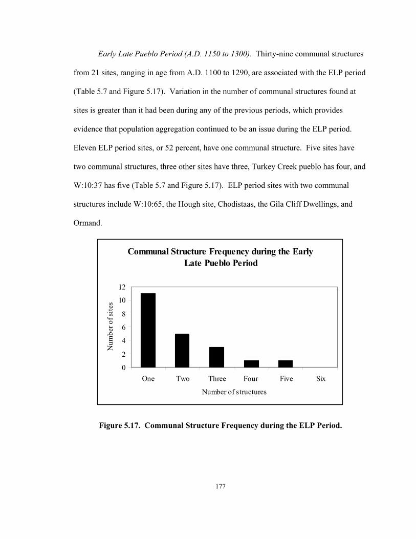
177
Early Late Pueblo Period (A.D. 1150 to 1300). Thirty-nine communal structures
from 21 sites, ranging in age from A.D. 1100 to 1290, are associated with the ELP period
(Table 5.7 and Figure 5.17). Variation in the number of communal structures found at
sites is greater than it had been during any of the previous periods, which provides
evidence that population aggregation continued to be an issue during the ELP period.
Eleven ELP period sites, or 52 percent, have one communal structure. Five sites have
two communal structures, three other sites have three, Turkey Creek pueblo has four, and
W:10:37 has five (Table 5.7 and Figure 5.17). ELP period sites with two communal
structures include W:10:65, the Hough site, Chodistaas, the Gila Cliff Dwellings, and
Ormand.
Communal Structure Frequency during the Early Late Pueblo Period
0
2
4
6
8
10
12
One Two Three Four Five Six
Number of structures
Num
ber o
f site
s
Figure 5.17. Communal Structure Frequency during the ELP Period.

178
At W:10:65, a 40-room pueblo site located in the Point of Pines region of eastern
Arizona, there are two communal structures that have been dated, based on ceramics,
between A.D. 1150 and 1265 (Olson 1959; Stone 2001). The site’s communal structures
are both quite small, 11 m2 each, and it is difficult to evaluate whether they were used at
the same time or not because of the lack of absolute dates. It is interesting to note that
neither of the structures had any internal features, which includes the absence of a hearth.
The lack of features and the fact that the structure was dated based on ceramics found
within the fill of the room, and not on floor assemblages, make it difficult to place them
temporally. The date range for the structure is based on general period dates. Because
ceramic typologies and architectural styles are all that are available for the structures at
this site, there are insufficient data on which to base an opinion about whether
aggregation and/or integration occurred at the site.
The Hough site (Oakes and Zamora 1993; United States Forest Service 1996) is a
35-room ELP period pueblo situated on the San Francisco River in southwestern New
Mexico. The site is interesting in that the two communal structures identified at the site
are next to one another. The Great Kiva is a very large (97 m2) rectangular structure, and
structure 1 is a very small (12 m2) circular structure. The Great Kiva also has two rooms
attached on either side of the ramp entryway. Oakes and Zamora (1993) suggest that
these three structures (i.e., the Great Kiva and its two attached rooms) were contemporary
and data from Hough site suggest that they formed a communal complex. The
significance of the architectural elaboration of these centrally located communal
structures will be discussed in subsequent sections. Without absolute dates, it is difficult

179
to assess the contemporaneity of the Great Kiva and structure 1. However, given Oakes
and Zamora’s (1993) discussions, it appears that there is more evidence for social
integration than aggregation at this site.
At Chodistaas pueblo (Lowell 1999; J. Jefferson Reid personal communication;
Riggs 2001), there are data for population aggregation during the ELP period. The two
communal structures identified at the site, Rooms 18a and 2a, are approximately the same
size, 50 and 34 m2, respectively, but each is associated with one side of the 18-room
pueblo. Room 18a is a walled communal structure with an attached room, located on the
south side of the roomblock. Room 2a is located on the community’s north side.
Chodistaas may be an example of population aggregation where the community was
divided into a northern and southern group during the ELP period. The location and
architectural variation of the two structures support the idea that aggregation occurred at
the site during the ELP period.
At the Gila Cliff Dwellings in southern New Mexico, Rooms 17 and 27 date to
the ELP period. A tree-ring cutting date of A.D. 1287 is available for Room 17, and a
tree ring cutting date range of A.D. 1270 to 1290 was provided for Room 27 (Anderson et
al. 1986; Gadd 1993). Both structures are rectangular and approximately the same size,
and researchers have suggested that the dwellings were used for a relatively short period,
one generation (Anderson et al. 1986; Gadd 1993). The presence of these two structures
suggests some degree of aggregation at the site.
It is interesting to note that Room 17, the larger of the two Gila Cliff Dwelling
communal structures, is much more elaborate than Room 27 with wall murals, storage
180
chambers, niches, and a platform (Anderson et al. 1986; Gadd 1993). The elaboration of
one structure over another may suggest one of two things. Elaboration may emphasize
differences in the people constructing and using the structure (i.e., aggregating groups).
At the same time, architectural elaboration may suggest that Room 17 was the more
important of the two and therefore served as the primary meeting place for the
community’s members (i.e., integration). The dates for the two structures, combined
with the relatively brief period of occupation at the site, suggest that the two structures
were in fact contemporary (Anderson et al. 1986; Gadd 1993).
At the Ormand site, the ceramic dates available suggest that one structure dates to
the ELP period and the other to the LLP period. As a result, only the ELP period
communal structure, Room 97, is discussed in this section. Room 97 is rather large, 71
m2, and is enclosed in the central plaza of the site’s four roomblock community (Wallace
1998). Ceramic data from the structure were used to date the site from A.D. 1100 to the
late 1300s. It is likely, that during the ELP period integration was an important factor at
the site, and members of the community’s four roomblocks were integrated using the
centrally located communal structure. Ultimately, Room 97 was dismantled and
abandoned; it may have been replaced by Room 79 during the LLP period (Wallace
1998). Because this structure is the only one that dates to the ELP period itself, Ormand
provides evidence for social integration at the site.
Three ELP period sites have three communal structures each, including Higgins
Flat, Taylor Draw, and Victorio. Unfortunately, the dates for communal structures from

181
two of the three sites are ceramic, making it difficult to discuss the contemporaneity of
the structures.
Construction data from Higgins Flat (Martin 1979; Martin and Rinaldo 1950a,
1950b; Martin et al. 1957; Rinaldo et al. 1956) provide evidence for the contemporaneity
of the site’s three communal structures. The community of Higgins Flat, a 15-25-room
ELP period pueblo, appears to have had early population aggregation, which was
subsequently replaced by social integration. The Great Kiva and Kivas 1 and 2 at
Higgins Flat, situated along the upper San Francisco River in western New Mexico,
overlap in date ranges, but the Great Kiva was built over Kiva 1.
Both of Higgins Flat communal structures are quite large (128 and 100 m2), and
the Great Kiva replaced the earlier structure, both of which are situated between the site’s
two roomblocks. Kiva 2 is physically separated from both of the roomblocks, outside of
the eastern roomblock. It is possible that the community consisted of two aggregating
groups, one associated with Kiva 1 and one with Kiva 2, which suggests that aggregation
occurred at the site. However, over time, the centrally located Great Kiva appears to
have become the focus of communal activities for the entire community. Kiva 2 appears
to have fallen into disuse after the Great Kiva was built. The three communal structures
at Higgins Flat appear to provide an example of an aggregated community that became
integrated over time.
Although the site files (Laboratory of Anthropology site files, Santa Fe, New
Mexico) indicate that there are four communal structures at the Taylor Draw site, I have
found no data for the fourth structure. Therefore, only three structures, for which there is

182
evidence, are discussed here. The Taylor Draw site, a 60-room pueblo, provides an
example of population aggregation in the Jornada area of the Mogollon region. Features
7, 15, and 22 date from A.D. 1100 to 1200, based on ceramics, and construction data
(e.g., building sequences) for the structures suggest they were contemporary. Site
recorders note that the ratio of 20 rooms per communal structure can be used to suggest
that the site’s community consisted of three aggregated clusters (Laboratory of
Anthropology site files, Santa Fe, New Mexico). If the Taylor Draw communal
structures are contemporary, the site represents aggregation in the Jornada region. Given
the lack of absolute dates for the structures, however, it is not possible to determine
whether they were contemporary.
The Victorio site, situated on Alamosa Creek in southwestern New Mexico, has a
similar ratio of rooms to communal structures, with three communal structures for 36
rooms dating from A.D. 1100 to 1200 (Laboratory of Anthropology site files, Santa Fe,
New Mexico; Laumbaugh 1992). Unfortunately, detailed construction data are not
provided for these structures, and no decorated ceramics were encountered during
excavation, which makes it difficult to discuss details of aggregation or integration that
might have occurred at the site.
One ELP period site, Turkey Creek pueblo (Lowell 1991; R. Karl, personal
communication, 2003), situated along Turkey Creek in the Point of Pines region of
eastern Arizona, has 335 rooms and four communal structures. The Great Kiva and
Rooms 152-K1, 251-K2, and 237-K3 all date to a 61-year period. The Great Kiva has a
tree-ring cutting date of A.D. 1240, and Rooms 1, 2, and 3 date somewhere in the range

183
from A.D. 1225 to 1286 (Lowell 1991). The largest structure, the Great Kiva, is centrally
located, and the smaller structures are scattered throughout the site.
Data from the site suggest that both population aggregation and social integration
occurred at Turkey Creek. The three smaller structures are found throughout the site, and
two of the structures were found underneath rooms (Lowell 1991). Construction
sequences available for the site suggest that the three smaller structures represent a part of
the earlier portion of the site’s occupation (Lowell 1991). The presence of the three
smaller, earlier communal structures suggests that it is possible that the Turkey Creek
community was formed in part by aggregation. The later Great Kiva suggests that during
the ELP period the community began to promote social integration. The fact that
structures were built atop the three smaller communal structures also suggests that initial
aggregation was replaced by integration.
Site W:10:37 (Olsen 1959; Stone 2001), also situated in the Point of Pines region
of east-central Arizona, has five ELP communal structures. Kivas 1, 2, 3, 4, and 5 date
somewhere between A.D. 1150 and 1265, based on ceramic data. All of the structures
are approximately the same size and have similar, although not identical, internal
features. Size and feature data are discussed in a subsequent section. The ELP period
community at W:10:37 consisted of 40 rooms. If all of the communal structures were
contemporary, population aggregation occurred at the site, and the population appears to
have been relatively segregated. The site is segregated in that if there are five clusters of
eight rooms and one communal structure per cluster, then this suggests an aggregated

184
site. The lack of absolute dates or construction histories for the communal structures
makes it difficult to state that aggregation was definitely present at the site.
One additional site has ELP period communal structures. Point of Pines Ruin,
also known as W:10:50, is a very large 800-room ELP and LLP period site situated in
eastern Arizona (Gerald 1957; Stone 2001). Three communal structures were identified
at the site, although ceramic dates and construction histories for the site suggest that only
two of the structures were contemporary (Gerald 1957). Kiva 1, a very large structure,
200 m2, was constructed at the beginning of the ELP period, but was later remodeled and
expanded to an even larger size of 264 m2 (Gerald 1957; Stone 2001). The larger
communal structure, Kiva 2, which will be discussed in depth in the LLP period section,
included three internal rooms. Unfortunately, size data for the third communal structure
at the site, Kiva 5, is unavailable from any published or unpublished Point of Pines
reports.
The available data from Point of Pines can be used to suggest that Kiva 1, a large
communal structure, was built and used during the ELP period and was later replaced by
an even larger structure during the LLP period. However, if Kiva 5 was used during the
ELP period, it is possible that there were two contemporary communal structures at the
site, which, considering the size of the site, is likely. It does appear that at Point of Pines,
one large integrating structure was built and used to help organize the community’s large
population.
Evidence from the ELP period sites with multiple communal structures provide
evidence for some degree of aggregation during this time, although problems with dating

185
make it difficult to determine the contemporaneity of the structures at several sites.
Population aggregation was certainly an important factor during the beginning of the LP
period. However, after a more detailed analysis, the percentage of sites with one
communal structure during the ELP period is 62 percent, which provides support for the
idea that residents of the Mogollon region did continued to place some emphasis on
social integration. As communities continued to deal with issues related to aggregation,
they appear to have experienced changes once again, changes that are visible in the
average number of communal structures at LLP period sites. During this time, average
frequency indicates that social integration appears to have become more common.
Late Late Pueblo Period (A.D. 1300 to 1450). The assemblage of communal
structures dating to the LLP period is much smaller than that for the ELP period,
consisting of only 14 structures from 10 sites (Table 5.7 and Figure 5.18). However,
average frequency data can be used to suggest that social integration was the primary
focus (Table 5.7 and Figure 5.11). During the LLP period, no sites have more than three
contemporary communal structures, while the majority, have only one. W:10:52 and
Point of Pines have two communal structures and Grasshopper has three communal
structures. I included Point of Pines pueblo, which has two communal structures dating
specifically to the Late Pueblo period. The site was discussed in the section addressing
ELP period structures, because the dates overlap between the ELP and LLP periods. Two
of the Point of Pines communal structures Kivas 1 and 2 date to the LLP period, but Kiva
and 5 may also have been used into the LLP period.

186
Average Communal Structure Frequency during the Late Late Pueblo Period
0
2
4
6
8
One Two Three Four Five Six
Number of structures
Num
ber o
f site
s
Figure 5.18. Communal Structure Frequency per Site during the Late Late Pueblo Period.
As previously discussed, there are two LP period communal structures at the
Ormand site. Room 79 is the LLP period communal structure at Ormand. A much
smaller structure than the ELP period, Room 97, Room 79, the LLP period communal
structure, was 17 m2 and was built into one of the roomblocks between A.D. 1300 and
1450 at the site. This structure is attached to several rooms in the roomblock, and there
are at least five doorways, which provide access to the structure (Wallace 1998). The
Ormand community may have become smaller during the LLP period and the site’s
residents may have built and used a much smaller structure, Room 79, as their communal
structure during this period. This site provides evidence for LLP period integration.

187
At W:10:52, the two communal structures, Kivas 1 and 2, are both approximately
20 m2 and may have been contemporary (Smiley 1952). The site consists of 100 rooms,
and the two structures are associated with different parts of the site. Smiley (1952)
suggests that the two W:10:52 communal structures were used during the same 50-year
period (A.D. 1400 to 1450) using construction data. If this is the case, it is evidence for
population aggregation at the site during the LLP period.
At Point of Pines, two LLP period communal structures, Kivas 1 and 2, are
present (Gerald 1957; Stone 2001). A third structure, discussed in the previous section,
Kiva 5 dates between the end of the ELP period and the beginning of the LLP period
(Stone 2001). Dates for Kiva 1 range from A.D. 1265 to 1325/1350, while Kiva 2 has
been dated from 1325/1350 to 1400 (Gerald 1957; Stone 2001). However, construction
data for the site suggest that Kiva 2 replaced the late ELP period Kiva 1 at the site and
that Kiva 2 and 5 were used at the same time during the LLP period even though they
were not necessarily built at the same time (Stone 2001). The Point of Pines communal
structures provide evidence for some degree of population aggregation during the LLP
period.
Grasshopper pueblo, a 447-room pueblo situated on a plateau overlooking the Salt
Water Draw in east-central Arizona, provides support for a dual emphasis on population
aggregation and social integration during the LLP period (Riggs 2001). As Riggs
(2001:124-127) points out poor preservation of wood recovered from the site limits the
number of absolute dates available for various rooms; the majority of tree ring dates from

188
Grasshopper are tree-ring (vv) dates. At the same time, other dating techniques do
provide information about the construction history (Riggs 2001:120-124).
At Grasshopper pueblo, the large Great Kiva, with a tree-ring date of A.D. 1330,
is situated within the walls of the initial roomblock constructed at the site (Reid 1989;
Reid and Montgomery 1999; Riggs 2001). However, tree-ring and construction data
suggest that the Great Kiva was not built until the site had been occupied for more than
50 years (Riggs 2001:120). The residents of Grasshopper pueblo constructed several
roomblocks and enclosed plazas before building the Great Kiva (Riggs 2001:120). It is
possible that as the site grew, the site’s residents constructed a Great Kiva in the founding
roomblock in an effort to promote integration within their aggregated community.
There are two smaller communal structures at Grasshopper, Rooms 246 and 341,
both of which have ceramic and construction dates of A.D. 1300 to 1400. These two
smaller structures are embedded within roomblocks at the site. Reid (1989) and others
(Reid and Whittlesey 1999; Riggs 1999, 2001:118-119) have suggested that Grasshopper
was established by several related groups of people living within the area of the site.
Evidence for LLP period aggregation at Grasshopper comes in the form of ceramic dates,
construction sequences and architectural variation in roomblock construction (Riggs
2001). The two smaller communal structures associated with some of the site’s
roomblocks and built simultaneously with these roomblocks provide evidence for
aggregation at the site (Riggs 2001:151). However, later in the occupational history of
the site, it also appears that the residents built a Great Kiva to promote social integration
within this initially aggregated community.

189
After a detailed analysis of LLP period communal structures, the percent of sites
with only one structure is 80 percent. This percentage includes Ormand and the seven
sites with only one communal structure. Eighty percent reflects a return to the level of
integration evidenced during the EPS and LPS periods.
Communal Structure Frequency: A Summary
Overall, the trend in the percent of Mogollon sites with one communal structure
varies through time. The percentages listed in the first column in Table 5.8 provide a
general summary of communal structure data that suggests that integration was common
at the majority of sites across all periods. At the beginning of each period section, I
presented the initial percentages based on raw counts of communal structures. However,
not all of the communal structures identified at sites are contemporary. Therefore, the
percentages that resulted from the frequency analyses differ from the raw data counts
(Table 5.8). The percentage of sites with only one communal structure, based on the
detailed analysis of communal structure frequency in the previous sections, varies from
83 percent during the EPS period to 75 percent during the MPS period, and up to 83
percent during the LPS period (Table 5.8). The percentage drops dramatically during the
EP period to 64 percent. The percentage drops slightly during the ELP period to 62
percent, but then returns to 80 percent during the LLP period.

190
Table 5.8. Percent of Mogollon Sites with Evidence for Integration by Period, Based on Analyses Presented in this Chapter.
Period % of sites with
one communal structure
% of sites with one communal structure, PLUS sites with
multiple non-contemporary communal structures
% of sites with multiple
contemporary communal structures
% of sites with conflicting or
insufficient data
EPS 78 83* 6 11 MPS 63 75* 12.5 12.5 LPS 78 83* 8.5 8.5 EP 56 64* 8 28
ELP 52 59* 14 27 LLP 70 80* 0 20
*Note the percentages presented here are based on the analyses discussed in the previous sections and differ from the raw data percentages provided at the beginning of each period section.
Tables 5.9 and 5.10 provide data to support the idea that integration was the most
common organizational form throughout the Mogollon region across time. Frequency
data from Mogollon communal structures also provide some evidence for aggregation at
10 sites. At four sites, there is evidence for initial aggregation, followed by integration,
while three sites have evidence for integration and subsequent aggregation.
Table 5.9. Number of Sites with Evidence for Aggregation and/or Integration Based on Frequency Data.
Period Evidence for
aggregation Evidence for integration
Evidence for aggregation
then integration
Evidence for integration
then aggregation
Insufficient data
EPS 1 15 0 0 2 MPS 1 6 0 0 1 LPS 2 19 2 0 0 EP 3 23 0 3 7
ELP 3 12 2 0 4 LLP 0 8 1 0 1
Totals 10 83 4 3 16

191
Table 5.10. Sites with Evidence for Aggregation and/or Integration Based on Frequency Data.
Period Evidence for aggregation Evidence for integration
Evidence for aggregation then
integration
Evidence for integration then
aggregation Insufficient data
EPS (1) Three Circle
(15) Bear, Bluff, Cuchillo, Galaz, Harris, Lagoon, McAnally, Mogollon, NM Y:4:6, Old Town, Promotory, Ridout Locus, Saige-McFarland, SU, Winn Canyon
(2) Crooked Ridge, Diablo
MPS (1) Wind Mountain
(6) Gallita Springs, Harris, Mogollon, Old Town, Turkey Foot Ridge, Turquoise Ridge
LPS (2) Lee, Wind Mountain
(19) Beauregard, Black’s Bluff, Bradsby, Cooney Ranch #1, Galaz, Gallita Springs, Harris, LA 3274, LA 2465, Lake Roberts Vista, Nantack, Old Town, Ponderosa Ranch, Sawmill/Fox Farm, Squaw Canyon, Starkweather, SU, WS Ranch, Wheatley Ridge
(2) NAN, Swarts
EP
(3) Dinwiddie, Treasure Hill, Wind Mountain
(23) Cottonwood Creek, Diablo, Dry Prong, Elk Ridge, Galaz, Gatton’s Park, LA 3272, LA 5389, LA 5405, LA 6079, LA 14883, LA 18753, LA 66686, LA 68709, Ojo Caliente, Redrock, Rock House, Saige-McFarland, , Sand Flat, TJ, Tla Kii, Wheaton Smith, Yeo 194
(3) Carter Ranch, Pueblo Lillie Allen, NAN
(7) Black’s Bluff Jennie Riley Stalworth, Graveyard Point, Mattocks, Pine Creek, West Fork, Woodrow
ELP
(3) Chodistaas, Gila Cliff Dwellings, W:10:37
(12) Apache Creek, Casa Malpais, Fox Place, Goesling Ranch, Grasshopper Springs, Hough, LA 3274, Montoya, Point of Pines, Small House North of Arroyo Seco, Valley View, W:10:57
(2) Higgins Flat, Turkey Creek
(4) Ormand, Taylor Draw, Victorio, W:10:65
LLP (8) Cordova, Hulbert, Ormand, Point of Pines, Pueblo Schoolhouse, Smokey Bear, W:10:47, W:10:48
(1) Grasshopper (1) W:10:52

192
Site totals listed in Tables 5.9 and 5.10 do not always sum to the total number of
sites, as many sites have evidence for changing aggregation and/or integration through
time. The importance of frequency data is that having multiple contemporary communal
structures at a site rather than only one suggests a more aggregated community. Having
one structure to serve the entire community promotes social integration. The data
presented in this section provide evidence for changes in aggregation and integration.
Small Mogollon Communal Structures: An Analysis
As mentioned in Chapter 4, there is some debate in the Mogollon region about
whether all of the structures identified by researchers as kivas are actually communal
structures (Gilman 1998; Lekson 1989). Those that have received the most scrutiny are
smaller subterranean structures identified as kivas. In an effort to determine the impact
of the smaller structures on the results presented in the frequency section, I removed all
of the structures that were less than 20 m2 from the following discussion (Table 5.11).
Table 5.11. Communal Structures from Appendix II Smaller than 20 m2 by Period.
Site Number Site Name Period Size (m2) LA 6000 Lee LPS 12 LA 6000 Lee LPS 12 LA 64931 SU LPS 12.5 LA 6000 Lee LPS 16 LA 6083 Gallita Springs LPS 16 LA 78337 Bradsby LPS 16.2 LA 6000 Lee LPS 18 LA 6000 Lee LPS 19 LA 66782 Sand Flat EP 4.65 Carter Ranch EP 8.1 Carter Ranch EP 8.4 LA 127260 Wind Mountain EP 8.96

193
Table 5.11 continued. Site Number Site Name Period Size (m2)
LA 127260 Wind Mountain EP 9.06 LA 5421 Saige-McFarland EP 9.8 LA 8675 West Fork EP 9.8 LA 6536 Graveyard Point EP 11.4 LA 1118 Rock House EP 11.6 LA 1118 Rock House EP 11.6 AZ P:16:2 Tla Kii EP 12 LA 3639 Pine Creek EP 12.7 LA 635 Galaz EP 12.8 LA 6783 Dinwiddie EP 12.8 LA 6783 Dinwiddie EP 13.3 LA 4986 Pueblo Lillie Allen EP 13.5 LA 676 Mattocks EP 13.8 LA 34787 Black's Bluff EP 14 LA 16241 Treasure Hill EP 14.3 LA 16241 Treasure Hill EP 14.6 LA 676 Mattocks EP 14.8 LA 18753 EP 15.24 LA 127260 Wind Mountain EP 15.27 LA 3639 Pine Creek EP 15.9 LA 8675 West Fork EP 16 LA 6536 Graveyard Point EP 16.8 LA 6538 Diablo EP 16.8 LA 2465 NAN EP 17.82 LA 127260 Wind Mountain EP 18.24 LA 3279 Hough LP 12.23 LA 3099 WS Ranch LP 13 W:10:37 ELP 7.5 W:10:37 ELP 9.6 W:10:37 ELP 10.5 W:10:37 ELP 10.6 W:10:51 Point of Pines ELP 10.6 W:10:65 ELP 10.9 W:10:65 ELP 11 AZ W:9:123 Turkey Creek ELP 11.6 LA 6565 Taylor Draw ELP 12 AZ W:9:123 Turkey Creek ELP 13 AZ W:9:123 Turkey Creek ELP 14

194
Table 5.11 continued.
Site Number Site Name Period Size (m2) LA 6565 Taylor Draw ELP 16 LA 6565 Taylor Draw ELP 16 W:10:37 ELP 17.3 LA 68188 Fox Place ELP 18.5 LA 8780 Grasshopper LLP 12.48 LA 5793 Ormand LLP 17.1 W:10:47 LLP 19
Part of the size issue is that archaeologists differ in their opinions of what
qualifies as a Mogollon communal structure. There are many structures listed in
Table 5.10 that were described as ‘kivas’ by competent archaeologists on Laboratory of
Anthropology forms, in site reports, and in published articles and books. It is difficult to
evaluate, based on size, whether these descriptions are valid or not.
I chose 20 m2 because most Mogollon pit structures used for habitation are this
size or smaller (Cordell 1997). As a result, 57 structures were removed and I recalculated
the number of communal structures per site and the percentages of sites with one
communal structure. The resulting data provided evidence that in some ways agree with
the conclusions presented in the previous section concerning communal structure
frequency, aggregation, and integration.
If the structures included in Table 5.11 are not communal structures, then
frequency data suggest that social integration was the norm in the Mogollon region from
the EPS period through the LLP period. The only change in evidence for an emphasis on
integration occurs during the MPS period, as no small structures date to that period and
the percent of sites with only one communal structure is 75. However, after reviewing
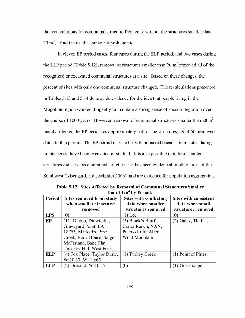
195
the recalculations for communal structure frequency without the structures smaller than
20 m2, I find the results somewhat problematic.
In eleven EP period cases, four cases during the ELP period, and two cases during
the LLP period (Table 5.12), removal of structures smaller than 20 m2 removed all of the
recognized or excavated communal structures at a site. Based on these changes, the
percent of sites with only one communal structure changed. The recalculations presented
in Tables 5.13 and 5.14 do provide evidence for the idea that people living in the
Mogollon region worked diligently to maintain a strong sense of social integration over
the course of 1000 years. However, removal of communal structures smaller than 20 m2
mainly affected the EP period, as approximately half of the structures, 29 of 60, removed
dated to this period. The EP period may be heavily impacted because more sites dating
to this period have been excavated or studied. It is also possible that these smaller
structures did serve as communal structures, as has been evidenced in other areas of the
Southwest (Nisengard, n.d.; Schmidt 2006), and are evidence for population aggregation.
Table 5.12. Sites Affected by Removal of Communal Structures Smaller than 20 m2 by Period.
Period Sites removed from study when smaller structures
removed
Sites with conflicting data when smaller structures removed
Sites with consistent data when small
structures removed LPS (0) (1) Lee (0) EP (11) Diablo, Dinwiddie,
Graveyard Point, LA 18753, Mattocks, Pine Creek, Rock House, Saige-McFarland, Sand Flat, Treasure Hill, West Fork
(5) Black’s Bluff, Carter Ranch, NAN, Pueblo Lillie Allen, Wind Mountain
(2) Galaz, Tla Kii,
ELP (4) Fox Place, Taylor Draw, W:10:37, W: 10:65
(1) Turkey Creek (1) Point of Pines,
LLP (2) Ormand, W:10:47 (0) (1) Grasshopper

196
Table 5.13. Sites with Evidence for Aggregation and/or Integration Based on Frequency Data with Communal Structures Smaller than 20 m2 removed.
Period Evidence for aggregation Evidence for integration
Evidence for aggregation then
integration
Evidence for integration then
aggregation
Insufficient or conflicting
data
EPS (1) Three Circle
(15) Bear, Bluff, Cuchillo, Galaz, Harris, Lagoon, McAnally, Mogollon, NM Y:4:6, Old Town, Promotory, Ridout Locus, Saige-McFarland, SU, Winn Canyon
(2) Crooked Ridge, Diablo
MPS (1) Wind Mountain
(6) Gallita Springs, Harris, Mogollon, Old Town, Turkey Foot Ridge, Turquoise Ridge
LPS (1) Wind Mountain
(20) Beauregard, Black’s Bluff, Bradsby, Cooney Ranch #1, Galaz, Gallita Springs, Harris, LA 3274, LA 2465, Lake Roberts Vista, Lee, Nantack, Old Town, Ponderosa Ranch, Sawmill/Fox Farm, Squaw Canyon, Starkweather, SU, WS Ranch, Wheatley Ridge
(2) NAN, Swarts
EP
(23) Black’s Bluff, Carter Ranch, Cottonwood Creek, Dry Prong, Elk Ridge, Galaz, Gatton’s Park, LA 3272, LA 5389, LA 5405, LA 6079, LA 14883, LA 66686, LA 68709, NAN, Ojo Caliente, Pueblo Lillie Allen, Redrock, TJ, Tla Kii, Wheaton Smith, Wind Mountain, Yeo 194
(2) Jennie Riley Stalworth, Woodrow
ELP
(2) Chodistaas, Gila Cliff Dwellings
(11) Apache Creek, Casa Malpais, Goesling Ranch, Grasshopper Springs, Hough, LA 3274, Montoya, Point of Pines, Small House North of Arroyo Seco, Valley View, W:10:57
(1) Higgins Flat (3) Ormand, Turkey Creek, Victorio
LLP (6) Cordova, Hulbert, Point of Pines, Pueblo Schoolhouse, Smokey Bear, W:10:48 (1) Grasshopper (1) W:10:52

197
Table 5.14. Percent Comparisons of Mogollon Sites with One Communal Structure by Period, with Structures Smaller than 20 m2 and Excluding those Structures.
Period Percent of sites with one communal structure based on original frequency data
Percent of sites with one communal structure excluding structures smaller than 20 m2
EPS 83 83 MPS 75 75 LPS 83 87 (20/23) EP 64 92 (23/25)
ELP 62 65 (11/17) LLP 80 75 (6/8)
Communal Structure Location
As related to issues of aggregation and integration, the location of a communal
structure within the site reveals information about the social structure of an ancient
community. Some scholars have provided data that support the idea that during the EPS
period, communal structures were spatially separated from their pit structure villages
(Anyon and LeBlanc 1980). Isolated communal structures may have been shared, and
such structures would have been accessible to multiple communities (Adler 1989b; Adler
and Wilshusen 1990; Johnson 1982). Isolated communal structures may have been used
to integrate several communities located within proximity of one another. In such cases,
people from several autonomous but related villages would come together at a large
isolated communal structure to participate in a variety of activities, including resource
distribution, trade, marriages, and religious and/or communal rituals. These meetings
would be similar to the Yanomami shabono gatherings reported by Chagnon (1968,
1992) as discussed in Chapter 2.
For my research, I divided communal structure location into four categories:
isolated, spatially separate, prominent, and associated (Table 5.15 and Figure 5.19).

198
Isolated structures are at least 50 meters away from the villages closest. Spatially
separate structures are those that are separated from the rest of the architecture at the site
(i.e., not attached to a particular roomblock or other structure). The spatially separate
category does not include communal structures that are less than 10 meters away from
other structures at a site. Spatially separate communal structures are different from
prominently located structures, in that they are at least 10 meters away from the other
architecture at the site (Table 5.15). Spatially separate communal structures are not
categorized, as prominent and prominent structures are not classed as spatially separate.
Communal structures that are prominently located may be situated in the center of a site
(e.g., amidst roomblocks), in the plaza of a site, or in an otherwise important location at
the site (see discussion below for examples).
The associated category includes structures are connected with a particular area of
a roomblock or site. For example, at a site with 30 pit structures that has two communal
structures, one on the northern side of the site and one on the south side, the “associated”
location category would be used. These communal structures, because they are found at
both Pit Structure and Pueblo sites, may or may not be physically attached to another
structure, but will be located very close to a group of pit structures or adjacent to a
roomblock. Associated communal structures are different from prominently located
structures in that they are usually smaller than prominent structures and are aligned with
roomblocks and or pit structures. In cases where there is some overlap in definition, I
provide a detailed discussion of the structure’s location in the subsequent sections.

199
Table 5.15. Description of Location Categories for Mogollon Communal Structures. Location Description Isolated More than 50 meters from other structures at the site
Spatially Separate More than 10 meters from other structures at the site Prominent Within 10 meters of other structures and situated in a central or
focal location at a site Associated Attached to a roomblock or in case of a pit structure community,
within 10 meters of a particular group of pit structures
Mogollon Communal Structure Locations within Sites
62
3
52
10
0
10
20
30
40
50
60
70
Associated Isolated Prominent Spatially Separated
Location
Num
ber o
f stru
ctur
es
Figure 5.19. Mogollon Communal Structure Locations.
The four categories of location are meaningful in terms of aggregation and
integration in several different ways. For instance, when a communal structure is isolated
from a community, it may be serving to integrate more than one group of people. A
spatially separate structure is indicative of social integration at a site, in that it brings all

200
members of the community to a place that is distinct from the buildings within which
they reside. If a structure is built in a prominent location, it may indicate of a high degree
of integration, as illustrated by the Arroyo Hondo and Pot Creek examples discussed in
Chapter 2 (Crown and Kohler 1994). A communal structure that is associated with a
specific roomblock will be important to the inhabitants of that roomblock, and it reflects
an integrated segment of the group within a potentially aggregated community (Hill
1970; Steward 1937). The associated category also includes communal structures that
appear to be connected to particular areas of the site, and it is an appropriate designation
when discussing communal structures in pit structure communities. In a situation where
there are many roomblocks and only one communal structure associated with a particular
roomblock, it may be that these are the more politically, spiritually, or economically
powerful people in the community. These may also be the most socially isolated sections
of a community (see Woodson 1999 for an example of this). It is also possible that in an
aggregated community only some of the aggregating groups built and used communal
structures. As stated in Chapters 1 and 2, aggregating groups do not necessarily share the
same political, religious, or ceremonial beliefs and therefore some people may have built
and used communal structures, while others did not.
Location data were available for 127 of 206 structures in the Appendix II
database, including several communal structures dating to the general Pit Structure and
Pueblo periods. Prominently located communal structures (n = 52) and those associated
with a roomblock, or particular area of the site (n = 62), are the most common and
account for 90 percent of the assemblage (Figure 5.20 and Appendix II). Those

201
structures that could not be dated to a specific period are not included in the subsequent
analyses. One hundred and sixteen communal structures, for which specific dates were
provided, are included in the following analysis (Table 5.16). Figure 5.20 and Table 5.16
display the results of the location analysis for structures that could be dated to a specific
period.
Communal Structure Locations by Period
0
5
10
15
20
25
30
EPS MPS LPS EP ELP LLP
Period
Num
ber
of st
ruct
ures
Prominently Located
Spatially Separated
Associated with aparticular area of the site
Isolated
Figure 5.20. Communal Structure Location Data by Period with the LP Period Separated into ELP and LLP Periods.
Table 5.16. Communal Structure Locations by Period.
Period Associated Isolated Prominent Spatially Separated
EPS 2 1 7 1 MPS 3 0 5 0 LPS 13 0 8 0 EP 24 1 16 7
ELP 13 1 8 1 LLP 3 2 0 0
Totals 58 5 44 9

202
Pit Structure Period
Early Pit Structure Period (A.D. 250 to 700). Location data are available for 11
EPS period communal structures from nine sites (Table 5.17 and Figure 5.21). Although
this is a relatively small sample, these data do provide information about the location of
communal structures at this early time. During the EPS period, the majority of
communal structures are prominently located (n = 7) within their communities. There
are, however, two structures, one at McAnally and one at Galaz that are associated with
specific areas of the site (Anyon and LeBlanc 1984). Spatially separate structures are
those that are not centrally or prominently located, and that are physically separated from
all of the other structures at the site. Although previous accounts of EPS period
communal structures state that all are isolated (Anyon and LeBlanc 1980), only one EPS
period structure, Kiva 1 at Bear ruin, is located further than 50 meters from the nearest
community (Anyon and LeBlanc 1980; Haury 1985).
Table 5.17. Communal Structure Location during the EPS Period. P = prominent location; S = spatially separated;
A = associated with a particular area of the site; I = isolated.
Site Number Site Name Room Designation Location LA 103907 Bluff House 5 P W:10:15 Crooked Ridge Pithouse 9 P W:10:15 Crooked Ridge Structure 19 P LA 1867 Harris House 14 P LA 1867 Harris 8 P LA 11568 Mogollon House 5A P LA 1113 Old Town A67 P LA 34813 Winn Canyon Room 2/Kiva S LA 635 Galaz Unit 8 A LA 12110 McAnally Unit 11 A AZ P:16:1 Bear Kiva 1 I

203
Communal Structure Location during the Early Pit Structure Period
0
2
4
6
8
ProminentlyLocated
SpatiallySeparated
Associated with aparticular area of
the site
Isolated
Location
Num
ber
of st
ruct
ures
Figure 5.21. Communal Structure Location during the EPS Period.
Kiva 1 at Bear ruin provides an example of a site with an isolated communal
structure in the Forestdale area of the Mogollon region. The communal structure at Bear
ruin is a large, turtle shaped building with a non-cutting tree-ring date of A.D. 667, and it
is situated on the outskirts of the pit structure community with which it was associated
(Haury 1936, 1941; Haury and Sayles 1947; Wheat 1955). This large structure likely
served an integrating function for members of the Bear ruin community, which consisted
of approximately 40 pit structures. Given the large size of the structure, it may also have
facilitated visits from members of neighboring communities as discussed above and in
Chapter 2.

204
Seven of the 11 EPS period communal structures are in prominent locations at
sites, and most are near the center of the village with which they are associated
(Figure 5.21). These data provide support for the idea that at this time there was a strong
emphasis placed on social integration at these sites. The location of these structures,
particularly at sites where they are the only communal structures dating to the period
(e.g., Old Town, Mogollon village, and Bluff), provides a central meeting place for all
members of a community. For example, House 5 at the Bluff site (Haury 1985; Haury
and Sayles 1947) is one of the earliest structures in the database and dates to the early
part of the EPS period (A.D. 320). The site, situated on Forestdale Creek in east-central
Arizona, consists of 30 to 35 pit structures. House 5 is a communal structure that is three
times the size of all of the other pit structures at the site and is centrally located (Haury
1936; Wheat 1955:17). Location data from the Bluff site provide evidence for integration
during the EPS period.
At the Old Town site, structure A67 is not in the center of the site but is in a
prominent location at the entryway to the community (Creel 1999a, 2000, 2001). The
only documented ancient Mogollon road was found at Old Town, and the road terminates
at the entrance to this communal structure. Creel (1999a, 1999b, 1999c) has stated that in
terms of location, the structure appears to have been the focal point for this EPS period
village. A67 is at least three times the size of all of the other pit structures at the site.
The communal structure would have been the first building visitors to the site would have
seen as they traveled on the road into the village. This site also provides evidence for

205
EPS period integration in that there is only one communal structure at the site and it is
located in a prominent place in the community.
There are two EPS sites, Crooked Ridge and Harris, with two centrally located
communal structures, for which location data were available. Studies conducted at
Crooked Ridge failed to provide absolute dates for the site’s two EPS period communal
structures (Wheat 1955). A 200-year age range (A.D. 400 to 600) is available for the two
structures, and based on these dates it is difficult to determine if Pithouse 9 and structure
19 were contemporary. However, construction data from the site suggest that Pithouse 9,
the smaller of the two structures, was replaced by a larger structure, structure 19 (Wheat
1955). Since the site consisted of 100 pit structures (Wheat 1955), it is clear that the
residents of the community needed a larger structure to facilitate their communal
activities. These location data, suggest that integration was a focus at this site, but due to
the lack of dates it is difficult to be certain.
At the Harris site, in the Mimbres valley (Anyon and LeBlanc 1980; Diehl and
LeBlanc 2001; Haury 1936), there are also two EPS period communal structures. The
initial structure, House 14 (A.D. 582v), occupied a central location at the site (Anyon and
LeBlanc 1980; Haury 1936). House 14 was eventually destroyed by fire (Creel and
Anyon 2003) and was subsequently replaced by a larger communal structure, House 8
(A.D. 650to750), which was also centrally located within the site’s eight EPS period
habitation units (Wheat 1955). The two Harris communal structures provide additional
evidence for EPS period social integration.

206
A majority of EPS communal structures are isolated (I), spatially separate (S), or
situated in prominent (P) locales. These structures are also most frequently the only
communal structure at their sites. Isolated, spatially separate, and prominent locations
support the findings presented in the frequency section and suggest that social integration
was emphasized during the EPS period. Both Galaz and McAnally have communal
structures that are associated with specific areas of their pit structure communities. AS
previously stated, the fact that these structures are the only ones at their sites may suggest
that they are situated near the homes of people with some degree of power at the site.
The location may also indicate possible aggregation, in that perhaps only some members
of the community build communal structures. However, Unit 11 at McAnally is likely
evidence for integration as there are only 12 pit structures at this site. Although both
Crooked Ridge and Harris have more than one communal structure, the Harris communal
structures actually provide evidence for integration. Data from Crooked Ridge are
insufficient and location data for the two communal structures at the site do not provide
evidence for aggregation or integration. Ultimately, analysis of location data reveal, that
of the nine EPS period sites, seven have evidence for integration.
Middle Pit Structure Period (A.D. 700 to 850). Location data are available for
eight of the communal structures from six sites that date to the MPS period (Table 5.18
and Figure 5.22). Five of the MPS period sites have one large, prominently located
communal structure, while one site has three smaller structures, which appear to be
associated with specific areas of the site (Table 5.18). Black’s Bluff (Anyon and LeBlanc
1980), Gallita Springs (Lekson 1996), and Harris (Anyon and LeBlanc 1980; Diehl and

207
LeBlanc 2001; Haury 1936) have a single, centrally located MPS period communal
structure. Old Town and Mogollon village have one prominently located communal
structure. Wind Mountain (Woosley and McIntyre 1996) has three MPS period
communal structures associated with specific areas of the site.
Communal Structure Location during the Middle Pit Structure Period
0
1
2
3
4
5
6
ProminentlyLocated
SpatiallySeparated
Associated witha particular area
of the site
Isolated
Location
Num
ber
of S
truc
ture
s
Figure 5.22. Communal Structure Location during the MPS Period.
Table 5.18. Communal Structure Location during the MPS Period. P = prominent location; S = spatially separated;
A = associated with a particular area of the site; I = isolated.
Site Number Site Name Room No. Location LA 34787 Black's Bluff Pit House 1 P LA 6083 Gallita Springs Feature 40 P LA 1867 Harris House 23 P LA 11568 Mogollon House 3 P LA 1113 Old Town A71 P
LA 127260 Wind Mountain House AB A LA 127260 Wind Mountain House AK A LA 127260 Wind Mountain House O A

208
A71 at Old Town is interesting in that it was built atop the EPS period communal
structure. At Old Town (Creel 1999a, 2000, 2001), structure A71 was superimposed
upon structure A67. The MPS period Old Town communal structure is a different shape
and almost twice as large as the earlier structure. In this case, location data suggest that
social integration occurred at the site and that this particular location at the site was
important, as it was used multiple times for the construction of the site’s communal
structure. As previously noted, an ancient road begins in the floodplain below the Old
Town site and terminates at the entrance of the communal structure (Creel 1998, 1999a).
This provides additional evidence for the importance of the location of this structure
within the site’s settlement pattern. The fact that the MPS period communal structure
was built atop the EPS period structure at Old Town supports the idea that social
integration continued to be important to the community.
Archaeomagnetic dates for the three Wind Mountain communal structures
indicated that House AB, the largest of the three structures, was built between A.D. 620
and 730. The smaller structures, House AK and House O, were constructed between
A.D. 640 and 780 and A.D. 650 and 750, respectively (Woosley and McIntyre 1996).
The construction sequence at Wind Mountain indicates that the three communal
structures were used at the same time (Woosley and McIntyre 1996:26-27, 28, 88).
While the structures were not necessarily built at the same time, they were likely to have
been contemporary. All three of the Wind Mountain communal structures are associated
with particular areas of the site. The communal structures are associated with different

209
parts of the site. Wind Mountain provides evidence for population aggregation during the
MPS period.
A majority of the MPS period sites, five of the six or 83 percent, for which
location data are available have prominent, and commonly central, located communal
structures. With the exception of Wind Mountain, MPS period sites support the idea that
social integration continued to be an important focus at Mogollon sites during this period.
Late Pit Structure Period (A.D. 850 to 1000). Twenty-one communal structures
from ten sites in the assemblage date to the LPS period (Table 5.19 and Figure 5.23).
During this period, there are more sites with multiple communal structures (e.g., Nantack,
Wind Mountain, Lee, and NAN) than there were during previous periods. In addition,
unlike the previous two pit structure periods, the majority of the LPS period communal
structures are not centrally located within their communities.
Table 5.19. Communal Structure Location during the LPS Period. P = prominent; S = spatially separated;
A = associated with a particular area of the site; I = isolated.
Site Number Site Name Room Designation Location LA 5841 Cooney Ranch #1 Communal Structure 1 P LA 635 Galaz 42A P LA 1867 Harris House 10 P AZ W:10:111 Nantack Pithouse 10 P AZ W:10:111 Nantack Great Kiva 1 P LA 1113 Old Town A16 P LA 127260 Wind Mountain House XX P LA 127260 Wind Mountain House X P LA 78337 Bradsby 1 A LA 6000 Lee 21 A LA 6000 Lee 23 A LA 6000 Lee 20 A LA 6000 Lee 18 A LA 6000 Lee 19 A

210
Table 5.19 continued.
Site Number Site Name Room Designation Location LA 6000 Lee 22 A LA 2465 NAN 52 A LA 2465 NAN 91 A LA 2465 NAN 43 A LA 127260 Wind Mountain House Y A LA 127260 Wind Mountain House U A LA 3099 WS Ranch/McKeen Kiva C A
Communal Structure Location during the Late Pit Structure Period
0
2
4
6
8
10
12
14
Prominently Located Spatially Separated Associated with aparticular area of the
site
Isolated
Location
Num
ber
of st
ruct
ures
Figure 5.23. Communal Structure Location during the LPS Period.
Thirteen of LPS period structures are associated with specific areas of a site, most
of these sites have more than one communal structure and are discussed below.
However, Bradsby and WS Ranch each have only one associated communal structure.
Structure 1 at Bradsby is relatively small and is associated with the site’s only roomblock
(Anyon and LeBlanc 1980). As a result, Bradsby reflects integration even though the

211
communal structure is associated with other structures at the site. At WS Ranch, Kiva C
is located closest to one area of the site and may reflect aggregation at this LPS period
site in that there is no large prominently located communal structure that could serve the
entire community. It is possible that the WS Ranch community was comprised of
aggregating groups of people, some of whom built communal structures, some of which
did not.
Eight structures are located in prominent locations within their communities. The
LPS period communal structure, 42A, at Galaz, although separate, but not more than 10
meters away from other architecture at the site, is situated in a prominent location (Anyon
and LeBlanc 1980). At Harris, House 10 is the only LPS period communal structure and
is situated in a prominent location at the site, providing evidence for integration.
Cooney Ranch #1 (Stokes 2000b), Old Town (Creel 1998, 1999a), Nantack
village (Breternitz 1956, 1959), and Wind Mountain (Woosley and McIntyre 1996) all
have prominently located LPS period communal structures. The centrally located
communal structure 1 excavated at Cooney Ranch 1, in the Mimbres valley, was used
during the LPS period (A.D. 900 to 980) (Stokes 2000b). Interestingly, the residents of
Cooney Ranch 1 subsequently abandoned and dismantled the LPS period communal
structure at the beginning of the EP period (Stokes 2000b). Location evidence for this
structure suggests that social integration was emphasized during the LPS period at this
site in the Mogollon region.
At Old Town (Creel 1998, 1999a), during the LPS period, the site’s inhabitants
built a new structure, A16 (A.D. 874 to 925), atop the two earlier EPS and MPS period

212
structures in the same location. While this structure is not in the center of the site, it was
constructed in a prominent location at the site, which is fronted by the ancient road that
led to the site. This third Pit Structure period communal structure at Old Town is the
largest of the three and may provide evidence for increasing population size over time at
the site. As the population grew, the site’s inhabitants constructed larger and larger
communal structures to integrate their growing numbers. Again, the location of the Old
Town structure is important as evidence for social integration during the LPS period and
as evidence for the importance of the structure’s location within the community.
Nantack village has two prominently located LPS period communal structures one
of which is smaller than the other one (Breternitz 1956, 1959). Ceramic dates of A.D.
900 to 1000 were provided for the two communal structures, Great Kiva 1 and Pithouse
10 (Breternitz 1956, 1959). Breternitz (1956) used a construction history to address the
issue of whether or not the structures were coeval. According to Breternitz (1956),
Pithouse 10 is much smaller (60 m2) than the Great Kiva (152 m2) and was built first at
the site (Breternitz 1956). Although there are two prominently located communal
structures at Nantack village, they are not contemporary and the site provides evidence to
support the idea that in this area of the Mogollon region social integration was the focus.
At Wind Mountain, two of the LPS period communal structures, Houses XX and
X, are centrally located, while two others, Houses U and Y, are associated with areas of
the site (Woosley and McIntyre 1996). House Y was abandoned toward the end of the
LPS period and another structure was erected atop it (Woosley and McIntyre 1996).
House XX was built atop the earlier House AB communal structure and House U later

213
became a smaller communal structure, House V (Woosley and McIntyre 1996). Despite
the remodeling and rebuilding occurring at Wind Mountain, based on ceramic data and
construction sequence information, at least two of the LPS period communal structures,
Houses X and XX, appear to have been contemporary. Again, both of these structures
are located close to the center of the community. Location data from the Wind Mountain
communal structures provide evidence for a continuation of population aggregation at the
site. The prominent location of these two structures may indicate a trend toward social
integration within the aggregated community during the LPS period.
Two sites, NAN and Lee village, have multiple LPS period communal structures
associated with particular areas of the site. NAN Ranch ruin, a 25-30-pit structure LPS
period site located along the Mimbres River in southern New Mexico, has three ornate
communal structures, each associated with a particular area of the site (Burden 2001;
Shafer 2003). Structure 52 has a mural of a painted serpent, several pits, a sipapu, and a
deflector. Researchers identified two hearths, multiple floor pits, a sipapu, and an alter in
structure 91. In addition, there was evidence for long-term use of the structure (e.g.,
multiple replastering events). In structure 43, only a hearth was identified. The diversity
in decoration, features, and construction of these three communal structures is indicative
of population aggregation, because each structure appears to be associated with one of
three areas of the site. However, as stated in the frequency section above, it appears that
two of the structures, the smaller ones, were built before the third structure, 43. The two
smaller structures were subsequently destroyed and burned and a larger communal
structure was erected at the site (Burden 2001; Creel and Anyon 2003; Shafer 2003); the

214
latter was not burned. If a single structure replaces the earlier structures during the LPS
period, then there is evidence for a trend towards social integration during the LPS period
at NAN.
The six communal structures associated with specific areas of Lee village (also
known as Fort West Hill) provide evidence for population aggregation during the LPS
period (Bussey 1972). As stated in the frequency section, Bussey (1972, 1975) did not
encounter decorated ceramics on the floors of the communal structures at the site.
However, Bussey was able to relatively date the six structures. According to Bussey’s
(1972) calculations, structures 21, 22, and 23 were built earlier than structures 18, 19, and
20. While there are inconsistencies in Bussey’s dating, his alternate dating technique
provides evidence that there were three contemporary communal structures associated
with specific areas of Lee village. Therefore, there is evidence for population
aggregation at the site during the LPS period.
During the LPS period, sites with multiple communal structures become more
prevalent. Sites with contemporary communal structures associated with specific parts of
the community provide evidence for increasing population aggregation during the LPS
period. As these communities grew, additional communal structures were built, and as a
result, many sites that date to this period have a relatively segregated appearance (i.e.,
groups of pit structures and communal structures). More so than the frequency data
presented earlier, location data for the LPS period can be used to suggest that population
aggregation becomes an important issue during the LPS period. At Nantack, while there

215
are multiple structures, they are not contemporary. As a result, it is clear that integration
did continue to be important within most LPS period Mogollon communities.
Communal Structure Location during the Pit Structure Period: A Summary
Location data from Pit Structure period sites provide data to support the idea that
throughout the period social integration was important at the majority of Mogollon
communities. However, location data suggest that as early as the MPS period, population
aggregation appears to become an issue. Aggregation appears to have continued into the
LPS period according to some of the location data. Old Town, a Mimbres valley site,
provides a rare and important example of the importance of social integration within a
community over a period of several hundred years. As previously stated the Old Town
ruin has three fully excavated Pit Structure period communal structures (A-16, A-67, A-
71) and each structure dates to a different part of the Pit Structure period. At the site,
members of the community destroyed old communal structures and built new ones,
sometimes directly atop but always at least adjacent to the abandoned one (Creel 1997a,
1998, 1999a, 1999b, 1999c; Creel and Anyon 2003). Social integration and the location
for the Old Town communal structures appear to have been important to people living at
this site.
Pueblo Period
The Early Pueblo Period (A.D. 1000 to 1150). Location data were available for
48 EP period communal structures from 28 sites (Table 5.20 and Figure 5.24). There is a
great deal more variation in location during the EP period (Figure 5.24). While the
majority of EP period communal structures (n = 24) are associated with specific

216
roomblocks, 16 structures are located in prominent areas of their sites, seven are spatially
separated from the other structures at the site, and one, Kiva 1 at Tla Kii, is truly isolated.
Location variation may be indicative of some degree of cultural diversity at Mogollon
sites during the EP period, a result of possible population aggregation.
Table 5.20. Communal Structure Location during the EP Period. P = prominent location; S = spatially separated;
A = associated with a particular area of the site; I = isolated.
Site Number Site Name Room Designation Location LA 34787 Black's Bluff Great Kiva 13 P Carter Ranch Kiva 1 P W:6:5 Dry Prong Kiva 1 P LA 78963 Elk Ridge Kiva P LA 635 Galaz 73 (Parrot Kiva) P LA 33642 Jennie Riley Stallworth Great Kiva P LA 2465 NAN 45 P LA 86310 Ojo Caliente G Great Kiva P LA 5412 Redrock P LA 54955 TJ P LA 2454 Woodrow P LA 2454 Woodrow P LA 66686 Kiva P LA 14883 P LA 3272 P LA 6079 P Carter Ranch Great Kiva S LA 6538 Diablo Feature 7 S LA 6536 Graveyard Point Feature 8 S LA 6536 Graveyard Point Feature 9 S LA 3639 Pine Creek 1 S LA 3639 Pine Creek Room 4 S LA 18753 S LA 34787 Black's Bluff Kiva 7 A Carter Ranch Room 16 A LA 6783 Dinwiddie Feature 14 A LA 6783 Dinwiddie Feature 11 A LA 635 Galaz Kiva 107 A LA 11075 Gatton's Park A LA 676 Mattocks Unit 410 A

217
Table 5.20 continued
Site Number Site Name Room Designation Location LA 676 Mattocks Kiva 48 A LA 2465 NAN 58 A LA 2465 NAN 57 A LA 2465 NAN 18 A LA 2465 NAN 39 A LA 1118 Rock House Feature 7 A LA 1118 Rock House Feature 8 A LA 16241 Treasure Hill Room 6 A LA 16241 Treasure Hill Room 8 A LA 8675 West Fork 10 A LA 8675 West Fork 6 A LA 18903 Wheaton Smith Unit 34 A LA 127260 Wind Mountain House P2 A LA 127260 Wind Mountain Room 3 A LA 127260 Wind Mountain Room 15 A LA 127260 Wind Mountain Room 7 A LA 127260 Wind Mountain House V A AZ P:16:2 Tla Kii Kiva 1 I
Communal Structure Location during the Early Pueblo Period
0
5
10
15
20
25
30
Prominently Located Spatially Separated Associated with aparticular area of the
site
Isolated
Location
Num
ber
of st
ruct
ures
Figure 5.24. Communal Structure Locations during the EP Period.

218
Variation is not limited to location data during the EP period, and in fact,
architectural diversity in general is manifested in a much more dramatic way with the
construction of above ground, linear roomblocks. One wide-reaching change at many
sites dating to the EP period in terms of general architectural styles is that many pit
structures are replaced by above ground masonry roomblocks (Anyon et al. 1981; Cordell
1997; LeBlanc 1983). In many cases, during the EP period, communal structures were
built along with roomblocks, and many were attached to the associated roomblock. It is
also interesting to note that data from Appendix II show that for the first time during the
EP period, plazas became an important location for communal structures.
One area where aggregation appears to have occurred was in the Mimbres valley
of southern New Mexico (Anyon and LeBlanc 1980; Cordell 1997). For example, the
Mimbres valley site of NAN has four EP communal structures for which location data are
available (Shafer 2003). Communal structures 18 (A.D. 1071 to 1100), 57 (A.D. 1025 to
1070), 58 (A.D. 1000 to 1130), 45 (A.D. 1107), and 39 (A.D. 1090) were used at the site
during the EP period (Burden 2001). Using construction sequences for the site, Shafer
(2003) and Burden (2001) have provided evidence that structure 57 was a contemporary
of structure 58. Burden (2001) posits that structure 57 was abandoned before the
construction of structures 18, 45, and 39 and Shafer (2003) suggests that structure 58
continued to be used along with structures 18, 39, and 45.
Interestingly, each of the four NAN EP communal structures is associated with
one of the four roomblocks excavated at the site (Burden 2001; Shafer 1990, 1995, 2003).
Because one of the NAN communal structures was abandoned prior to the construction of

219
several others, it appears that as the NAN population grew, new roomblocks were added
to the community. Associated with these new roomblocks were communal structures.
Location data from the NAN communal structures provide evidence for population
aggregation in the Mimbres valley during the EP period. However, the presence of
structure 45, located in a prominent place at the site suggests some degree of integration
was present as well.
At Rock House ruin (Anyon and LeBlanc 1980), located in New Mexico, there
are two EP period communal structures attached to the site’s only roomblock. However,
the two structures were not used at the same time, but were built sequentially in the same
location by remodeling a LPS period pit structure (Anyon and LeBlanc 1980). At Rock
House Ruin, while the communal structure is in the associated category, because it is
attached to the roomblock, it provides evidence for social integration at the site. Location
data is also important because the community used the same space for both of their
communal structures.
Black’s Bluff provides additional evidence for EP period integration in other parts
of the Mogollon region. Location data were available for both of the EP period
communal structures identified at this site (Fitting et al. 1972). The Great Kiva at
Black’s Bluff is located in a prominent position at the site; it is large and centrally
located. Kiva 7 was associated with a particular roomblock at the site (Fitting et al.
1972). It is unclear whether these structures are contemporary or not. If they are, it is
possible that population aggregation occurred at Black’s Bluff. If they are not and the
smaller structure was the first at the site, the community may have been trying to mitigate

220
aggregation with the construction of a Great Kiva, which would have reinforced social
integration. It is not possible to determine this without knowing if the two structures are
coeval.
At Carter Ranch, location data were available for three communal structures. One
is prominently located within the site, one is a spatially separate Great Kiva, and one is
associated with a particular roomblock (Laboratory of Anthropology site files, Santa Fe,
New Mexico; Longacre 1966). It is unclear if these structures were contemporary, but
Longacre (1966) reports that the Great Kiva was constructed first at the site. However, it
does appear that at this site, social integration appears to have been reinforced by the
community in two ways. First, the Carter Ranch community constructed a centrally
located (i.e., prominent) communal structure, which was enclosed within a plaza. The
location of the communal structure, in an area with relatively limited access, would have
underscored social integration within the community itself. Second, the community built
a spatially separate large Great Kiva 10 meters from their community’s center, which
would have promoted the involvement of members of the community, but also could
have included visitors to the community.
There is an alternative way to consider the location data from Carter Ranch. It is
possible that the founders of the community constructed a roomblock, a plaza, and the
spatially separate Great Kiva. As the site grew, additional roomblocks were added, as
were communal structures Kiva 1 and Room 16. These two smaller communal structures
may represent evidence for population aggregation at the site.

221
The EP period sites of Graveyard Point, Pine Creek, Dinwiddie, Treasure Hill,
West Fork, and Mattocks all have two relatively small communal structures that are
either associated with specific roomblocks or spatially separated from the site’s
architecture. Galaz has one large and one very small communal structure and two large
communal structures were reported at Woodrow ruin. Wind Mountain has four small
communal structures each situated close to a particular roomblock.
Accola and Neely (1980) reported two EP period communal structures, Features 8
and 9, at Graveyard Point ruin. Both of the structures are relatively small (<20 m2) and
both are spatially separated from the site’s roomblocks. The presence of two communal
structures at the site is indicative of aggregation. However, the spatially separate location
of the structures may be indicative of some level of integration during the EP period.
Ceramic dates, which range from A.D. 1000 to 1150, are the only dates available for the
two EP period communal structures, so it is not possible to determine whether the two
were contemporaneous. If the structures were used at the same time, Graveyard Point
reflects some degree of population aggregation during the EP period. If they were not
contemporary they were instead sequential, the site may provide evidence for integration.
It is not possible to determine which of these two scenarios is correct without additional
chronometric data.
Pine Creek pueblo is located on a tributary of the Gila River in southwestern New
Mexico (Anyon and LeBlanc 1980). The two EP period communal structures at this site,
Rooms 1 and 4, are relatively small and both are spatially separated from the rest of the
site’s architecture. Dates for the two structures span the entire EP period from A.D. 1000

222
to 1150, and there is not enough chronometric data for the structures to determine if they
were coeval. If these structures were contemporary, they appear to provide evidence for
population aggregation in this area of the Mogollon region during the EP period.
However, given the lack of absolute dates there is insufficient data to state whether
aggregation or integration was present at the site during the EP period.
As previously stated, Dinwiddie is an EP period site situated on the upper Gila
River in southwestern New Mexico. There are two communal structures, Features 11 and
14 that date to this period (Bussey 1972). Based on ceramic data, the site has been dated
between A.D. 1032 and 1100 (Bussey 1972:78). Features 11 and 14 are approximately
the same size (less than 20 m2) and the relative dates available for the structures do
overlap (Anyon and LeBlanc 1980; Bussey 1972; Linse 1999a). There are two
roomblocks at Dinwiddie, one located on the eastern side of the site, the other on the
western (Anyon and LeBlanc 1980; Linse 1999a). Feature 14 is attached at the northern
end of the western roomblock and Feature 11 is associated with the eastern roomblock at
the site (Anyon and LeBlanc 1980:268-269; Bussey 1972:62). Given the relatively short
occupation at the site, the location of these structures, when combined with frequency
data that suggests that the structures were contemporary, supports the contention that
aggregation occurred during the EP period at this Mogollon site.
The Treasure Hill site is situated on Cameron Creek in southwestern New Mexico
(Cosgrove 1923). There are two communal structures at the site and they are
approximately the same sizes (less than 20 m2) and are associated with particular areas of
the site (Anyon and LeBlanc 1980; Cosgrove 1923; Cosgrove and Cosgrove 1932).

223
Ceramic dates for the two structures, Rooms 6 and 8, do overlap (Cosgrove 1923). Room
6 is associated with the northern roomblock and Room 8 with the east roomblock (Anyon
and LeBlanc 1980; Cosgrove 1923). Location data for the two structures provide
evidence for EP period aggregation.
Excavations at the West Fork site, situated on the west fork of the Gila River in
southwestern New Mexico provided no absolute dates for the site’s two communal
structures (Anyon and LeBlanc 1980; Ice 1968). Ceramic date ranges for communal
structures 10 and 6 are A.D. 1000 to 1150 (Anyon and LeBlanc 1980; Ice 1968).
Unfortunately, ceramics found within the site, which has subsequently been destroyed
(Shafer 2003:112), date only broadly to the EP period. Both of the structures are
associated with particular areas of the site and both are relatively small (Anyon and
LeBlanc 1980; Ice 1968). While absolute dates are not available, the location data for the
two West Fork communal structures suggest population aggregation during the EP
period.
In the Mimbres valley, at the Mattocks ruin, two small (less than 20 m2)
communal structures have been identified (LeBlanc 1983). Both structures are associated
with specific roomblocks at the site. Unit 410 (a tree ring date for the structure is A.D.
1020v and archaeomagnetic date range is from A.D. 1015 to 1250) was a LPS period pit
structure used for habitation that was remodeled into a communal structure during the EP
period (LeBlanc 1983). The second structure, Kiva 48 (A.D. 1000 to 1150) was the first
communal structure. The dates for Unit 410 and Kiva 48 do overlap in that they both
date to the EP period, and so they reflect the possibility of population aggregation at the

224
site. The fact that there are only two small communal structures for approximately 180
habitation rooms also provides evidence for aggregation, because some groups appear to
be building and using communal structures, while others do not.
There are two communal structures at the 150 -room Mimbres pueblo of Galaz.
The Parrot Kiva (73) is large and located in a prominent location within the site. A
smaller communal structure, Kiva 107, also dates to the EP period, and is associated with
one of the site’s roomblocks. Based on the ceramic dates available for these two
structures, the Parrot Kiva was constructed before Kiva 107, but the two structures were
used at the same time during the EP period. Location data from the site suggests that at
this site integration was maintained over time and that at some point aggregation appears
to have become an issue at the site.
There are two large EP period communal structures at the 300-room Woodrow
ruin, located in southwestern New Mexico northwest of Silver City (Stuart and Gauthier
1984). Both structures are quite large, situated next to one another, and located in a
prominent location within the site’s 16 roomblocks (S. Lekson, personal communication
2005). The lack of dates for the structures, because they were subject to limited testing,
is problematic when attempting to determine if they are coeval. The communal structures
have very little post-depositional fill within them, and the site appears to have been
abandoned at the end of the EP period (S. Lekson, personal communication 2005; Stuart
and Gauthier 1984). The location of the structures, side by side as opposed to one
superimposed upon the other, could support the idea that they were contemporary.

225
Ultimately, however, location data from Woodrow are inconclusive in terms of revealing
evidence for population aggregation or social integration during the EP period.
The EP period site of Wind Mountain consists of three roomblocks (Woosley and
McIntyre 1996). Five communal structures at Wind Mountain date to the EP period
(Woosley and McIntyre 1996). As was the case during the MPS and LPS periods, the
residents of Wind Mountain may have experienced population aggregation and used
multiple communal structures during the EP period. The five Wind Mountain communal
structures include Room 3 (A.D. 1000 to 1150), Room 7 (A.D. 1040 to 1130), Room 15
(A.D. 1030 to 1150), House V (A.D. 970 to 1050), and P2 (A.D. 1100+/-) (Woosley and
McIntyre 1996). The structures range in size, but are all relatively small (15 to 38 m2)
and are scattered throughout the site (Woosley and McIntyre 1996).
Although I refer to the Wind Mountain communal structures as “scattered
throughout the site,” in the frequency section, all of the EP structures are associated with
particular roomblocks at the site. However, there are five communal structures
associated with three roomblocks, which means that some roomblocks have more than
one communal structure. Ceramic and construction dates as well as location data from
the Wind Mountain communal structures provide evidence that for population
aggregation at the site (Woosley and McIntyre 1996). However, although the date ranges
overlap, they do not provide definitive evidence to suggest that all five structures were
coeval.

226
Communal structure location indicates that social integration continued to be
important in many areas of the Mogollon region. However, at some sites (e.g., NAN)
population aggregation appears to have been an issue as well. Earlier integration may
have been replaced by population aggregation at some sites during the EP period (e.g.,
NAN). The number of sites with location data, which provide evidence for integration,
decreases slightly during the EP period (exact counts and percentages will be provided at
the end of this section). This reflects an increase in the number of sites with location data
providing evidence for population aggregation during this period as well. There is
certainly more variation in communal structure location at this time, a characteristic that
appears to continue into the Late Pueblo periods.
Late Pueblo Period (A.D. 1150 to 1450). Location data were available for 29
ELP and LLP period communal structures from 18 sites (Tables 5.21 and 5.22, Figures
5.25 and 5.26). Ten of these structures occupy prominent locations at Mogollon sites.
Sixteen of the LP period communal structures are associated with a particular roomblock,
one is spatially separated from other structures at the site, and LA 3274’s communal
structure is truly isolated. The decrease in the number of isolated and/or spatially
separate communal structures marks a change from earlier periods, when these locations
were relatively common. However, prominently located structures, particularly those
found within plazas at LP period sites, provide support for social integration in these
communities. However, location data for LP period communal structures also provide
support for population aggregation, although perhaps more so during the early part of the
period than later.

227
Table 5.21. Communal Structure Location during the ELP Period. P = prominent location; S = spatially separated;
A = associated with a particular area of the site; I = isolated.
Site Number Site Name Room Designation LocationLA 2949 Apache Creek Great Kiva P LA 4026 Goesling Ranch P LA 8682 Higgins Flat Kiva 1 P LA 8682 Higgins Flat Great Kiva P LA 467 Hulbert P LA 2112 Smokey Bear/Block Lookout Feature 4 P AZ W:9:123 Turkey Creek Great Kiva P LA 1119 Small House North of Arroyo Seco S AZ P:14:24 Chodistaas Room 2a A AZ P:14:24 Chodistaas Room 18a A LA 68188 Fox Place A LA 4913 Gila Cliff Dwellings Room 17 A LA 4913 Gila Cliff Dwellings Room 27 A AZ P:14:8 Grasshopper Spring Room 7/Protokiva A LA 8682 Higgins Flat Kiva 2 A W:10:51 Pithouse 13 A LA 8891 Schoolhouse Canyon Kiva A AZ W:9:123 Turkey Creek Room 152-K1 A AZ W:9:123 Turkey Creek Room 251-K3 A AZ W:9:123 Turkey Creek Room 237-K2 A W:10:65 Kiva 2 A W:10:65 Kiva 1 A LA 3274 I
Table 5.22. Communal Structure Location during the LLP Period.
P = prominent location; S = spatially separated; A = associated with a particular area of the site; I = isolated.
Site Number Site Name Room Designation Location
LA 8780 Grasshopper Great Kiva P W:10:50 Point of Pines Kiva 1 P W:10:50 Point of Pines Kiva 2 P LA 8780 Grasshopper Room 341 A LA 8780 Grasshopper Room 246 A LA 5793 Ormand Room 79 A

228
Early Late Pueblo Period (A.D. 1150 to 1300). Eight ELP period communal
structures were constructed in prominent locations at the sites they occupy (Table 5.21
and Figure 5.25). Thirteen of the ELP period structures, a majority, are attached to
roomblocks or associated with particular areas of the site. At LA 3274, there is a truly
isolated communal structure (Martin et al. 1957; Wendorf 1954) and at the Small House
North of Arroyo Seco, the communal structure is spatially separated from the rest of the
site’s architecture (Nelson 1993a, b). Several ELP period sites have one prominently
located ELP period communal structure (e.g., Apache Creek, Goesling Ranch, Hulbert,
W:10:51, and Smokey Bear). These structures provide evidence for social integration.
Schoolhouse Canyon, Grasshopper Spring, and Fox Place are interesting because they all
have only one communal structure and it is associated with a particular area of the site.
Communal Structure Location during the Early Late Pueblo Period
0
2
4
6
8
10
12
14
16
Associated Isolated Prominent Spatially Separated
Location
Num
ber
of st
ruct
ures
Figure 5.25. Communal Structure Location during the ELP Period.

229
The Schoolhouse Canyon site in eastern Arizona consisted of 15 to 20 rooms and
one relatively small, but decorated, associated communal structure (Laboratory of
Anthropology site files, Santa Fe, New Mexico). The communal structure was not built
when the roomblock was, but was constructed during the last part of the site’s
occupation. It is possible that the site’s inhabitants constructed their communal structure
in an effort to facilitate community integration, as was the case at Pot Creek pueblo as
discussed in Chapter 2. While the Kiva is associated, it reflects integration because it is
associated with the only roomblock at the site. A similar situation occurred at
Grasshopper Spring. Grasshopper Spring, situated in southern Arizona, also has a
communal structure associated with its only roomblock, again providing evidence for
integration at the site. Fox Place, a site situated in the Jornada area of the Mogollon
region is interesting in that it consists of 10 pit structures and a single communal structure
(Wiseman 1992:178). The communal structure is not in a prominent location among the
pit structures, but appears to be associated with one area of the site. It is unclear why the
structure is situated where it is, but given the size of the community, it is likely that this
structure reflects integration rather than aggregation. Chodistaas, the Gila Cliff
Dwellings, W:10:65, Turkey Creek, Higgins Flat, and Point of Pines have multiple
communal structures that date to this period.
Chodistaas, the Gila Cliff Dwellings, and W:10:65 each have two communal
structures associated with a particular area of the site, and provide evidence for
population aggregation during the ELP period. Chodistaas, an 18-room pueblo located in
eastern Arizona, has two ELP period communal structures associated with specific areas

230
of the site (Lowell 1999). Room 2a is located in the northern portion of the site and
Room 18a is situated within a walled plaza in the southern part of the site. Lowell (1999)
provides tree ring cutting dates for the two structures and states that at this 18-room
pueblo the two communal structures were used simultaneously. At Chodistaas, it appears
that aggregation was the primary organizational strategy, as no centrally located or
separate communal structure has been identified at the site. The same is true of the two
communal structures found at the Gila Cliff Dwellings in southern New Mexico.
At the Gila Cliff Dwellings, a 30-40-room pueblo located along the Gila River in
southern New Mexico, there are two contemporary communal structures (Anderson et al.
1986; Gadd 1993). Anderson et al. (1986) have suggested that the site was occupied for a
relatively short time, from A.D. 1270 to 1290. Room 17 (A.D. 1287v) is situated on the
eastern side of cave 3 and Room 27 (A.D. 1270 to 1290) is on the eastern side of Cave 5.
Construction and cutting and non-cutting dates suggest that this site was occupied for a
single generation (Anderson et al. 1986). For this reason, researchers state that the two
communal structures were contemporary. Rooms 17 and 27 provide evidence for some
degree of population aggregation at this ELP period site.
W:10:65 is a 40-room ELP period pueblo site located in the Point of Pines region
of eastern Arizona. At the site, there are two small communal structures dating between
A.D. 1150 and 1265, each of which is associated with a particular roomblock (Olsen
1959; Stone 2001). It is difficult to evaluate whether they were used at the same time or
not because of the lack of absolute dates. As a result, while location data do suggest that
aggregation occurred at the site, chronometric data for the structures are inconclusive.

231
Turkey Creek pueblo provides another example of possible ELP period
population aggregation. Location data were available for four Turkey Creek communal
structures, the Great Kiva and Rooms 152-K1, 237-K2, and 251-K3 (Lowell 1991). The
Great Kiva is prominently located in the center of the community, while the other three
are relatively small and are associated with roomblocks at the site. Given the size of the
site, 335 rooms, it is not surprising that there are several communal structures and plazas
distributed throughout the site (Lowell 1991). Dates for the site suggest that is was
occupied for approximately 60 years (Lowell 1991). The Great Kiva was the first
communal structure erected at the site and likely promoted social integration within this
large expanding community. Rooms 152-K1 and 237-K2 were also built relatively early
and were eventually covered by subsequent dwellings. Room 251-K3 appears to have
built after the other three communal structures, but was used simultaneously with the
Great Kiva. The presence of multiple communal structures reflects population
aggregation and social integration within the community.
At Higgins Flat, there are two prominently located communal structures and one
associated structure. The large centrally located Great Kiva was built atop the smaller
Kiva 1. The structure is in the middle of the site’s two roomblocks. It appears that the
community replaced this smaller communal structure with a larger one. Kiva 2, which is
attached (associated) with one of the site’s two roomblocks, is coeval with Kiva 1.
Interestingly, Kiva 2 appears to have been attached to the Great Kiva after it was built.
At this site, although multiple communal structures date to the period, social integration
appears to have been emphasized during the latter part of the ELP period.

232
During the ELP period, the percent of sites with evidence for integration increases
slightly from the EP period (percentages and exact counts are provided at the end of this
section). Location data from ELP period sites provides evidence that while a majority of
Mogollon communities emphasized social integration, aggregation continued to be an
issue at many sites within the region.
Late Late Pueblo Period (A.D. 1300 to 1450). Location data were available for
five LLP period communal structures from three sites (Table 5.22 and Figure 5.26). The
sample size for the LLP period is quite small. Half of the structures that date to this
period were associated with a particular part of the site while the other half are located in
prominent locations at their sites.
Location data are available for only one of the Ormand communal structures.
This communal structure is associated with one of the sites four roomblocks and can be
Communal Structure Location during the Late Late Pueblo Period
0
1
2
3
4
Associated Isolated Prominent Spatially Separated
Location
Num
ber
of st
ruct
ures
Figure 5.26. Communal Structure Location during the LLP Period.

233
used to suggest that aggregation may have occurred at this site. At the LLP period Point
of Pines site, there are two prominently located communal structures.
The two prominently located communal structures at Point of Pines are Kivas 1
and 2 (Gerald 1957; Stone 2001). The two communal structures are situated at the center
of the 800-room site situated in eastern Arizona site (Gerald 1957). Both structures are
very large (i.e., greater than 200 m2). Kiva 1 was the first one constructed at the site.
Kiva 1 was remodeled into a larger, but still prominently located Kiva 2 (Gerald 1957;
Stone 2001). Because both of these structures occupy the same space, they are not
contemporary and therefore reflect social integration at Point of Pines during the LLP
period.
At Grasshopper pueblo, there are three LLP period communal structures, there is
one very large Great Kiva situated prominently within the central plaza at the site
suggesting that integration was important even within an aggregated community (Reid
1973, 1989; Riggs 2001). Two of the communal structures, Rooms 246 and 341 are
associated with specific roomblocks. Construction data from the site can be used to
suggest that as roomblocks were added to the site, communal structures, 246 and 341,
associated with roomblocks 3 and 7 were also built. After 50 years of site occupation and
after the two smaller communal structures were built, the Great Kiva was constructed
within an enclosed plaza at the center of the site (Reid and Montgomery 1999; Riggs
2001). Location data combined with the construction information provide evidence for
early population aggregation followed by an emphasis on integration, which appears to
have lasted until the abandonment of Grasshopper pueblo.

234
Location data for LLP period communal structures is relatively limited. These
data were available for only three LLP period sites. However even with a small sample
size, these data provide evidence to suggest that both population aggregation and
integration were present at LLP period sites, but that at a majority of sites integration was
the preference by the end of the LP period.
Communal Structure Location: A Summary
The general pattern of location data compliments that of frequency in terms of
aggregation and integration (Tables 5.23 and 5.24). To understand the relationship
between location data and aggregation and integration it is important to understand what
each location means in terms of these issues. A single isolated, prominent, or spatially
separate communal structure is indicative of an integrated site. A single associated
structure that is attached to the only roomblock at a site is also indicative of an integrated
site. Multiple attached contemporary communal structures at a site are indicative of
aggregated community. Location data reveal patterns of integration and aggregation
from the Pit Structure periods to the Pueblo periods.
Table 5.23. Number of Sites with Evidence for Aggregation and/or Integration Based on Location Data.
Period Evidence for
aggregation Evidence
for integration
Evidence for aggregation
then integration
Evidence for integration
then aggregation
Insufficient data
Total
EPS 1 (11%) 7 (78%) 0 0 1 (11%) 100% MPS 1 (17%) 5 (83%) 0 0 0 100% LPS 2 (20%) 7 (70%) 1 (10%) 0 0 100% EP 6 (21%) 17 (61%) 0 1 (4%) 4 (14%) 100% ELP 3 (20%) 9 (60%) 1 (7%) 0 2 (13%) 100% LLP 0 1 (33%) 1 (33%) 0 1 (33%) 100%

235
Table 5.24. Sites with Evidence for Aggregation and/or Integration Based on Location Data.
Period Evidence for
aggregation Evidence for integration Evidence for
aggregation then integration
Evidence for integration then
aggregation
Insufficient data
EPS (1) Galaz (7) Bluff, Mogollon, Winn Canyon, Harris, Old Town, Bear, McAnally
(1) Crooked Ridge
MPS (1) Wind Mountain (5) Harris, Black’s Bluff, Mogollon, Gallita Springs, Old Town
LPS (2) Lee, Wind Mountain
(7) Nantack, Old Town, Harris, Cooney Ranch #1, WS Ranch, Bradsby, Galaz
(1) NAN
EP (6) Dinwiddie, NAN, Treasure Hill, West Fork, Mattocks, Wind Mountain
(17) Black’s Bluff, Jennie Riley Stallworth, Rock House, Tla Kii, TJ, Ojo Caliente G, Diablo, Dry Prong, Elk Ridge, Gatton’s Park, LA 3272, Wheaton Smith, Redrock, LA 14883, LA 18753, LA 66686, LA 6079
(1) Galaz (4) Carter Ranch, Woodrow, Graveyard Point, Pine Creek
ELP (3) Chodistaas, Gila Cliff Dwellings, Turkey Creek
(9) Apache Creek, Fox Place, Goesling Ranch, Grasshopper Springs, Hulbert, Schoolhouse Canyon, Small House North of Arroyo Seco, Smokey Bear, LA 3274
(1) Higgins Flat (2) W:10:65, W:10:51
LLP (1) Point of Pines (1) Grasshopper (1)Ormand

236
In general, there are fewer location data than frequency data available for
communal structures in the Appendix II database. However, these data do provide
information concerning patterns of population aggregation and social integration. During
the EPS period, structures are most commonly prominently located within their pit
structure communities, and 78 percent of the sites had evidence for social integration
during this period (Tables 5.23 and 5.24). The Galaz site dates to the EPS period and its
communal structure may provide evidence for aggregation as it is associated with a
particular part of this 150-room pit structure community. The “associated” communal
structure at McAnally provides evidence for integration as it is associated with a very
small 12 pit structure community.
Location data for the MPS period also remains consistent with frequency data
presented in the previous section, with 83 percent of sites providing evidence for social
integration. Wind Mountain is the only MPS period site with evidence for population
aggregation. During the LPS period, location data are reflects a slight change in patterns
of aggregation and integration. Two LPS period sites, Lee and Wind Mountain, have
evidence for aggregation and NAN has evidence for initial integration replaced by
aggregation at the site. Several LPS period communal structures are associated with
specific areas of sites. In general, however, Pit Structure period location data support the
idea that social integration was the primary focus at a vast majority of Mogollon sites
(Tables 5.23 and 5.24).
During the EP period, there are data that can be used to suggest that population
aggregation, which began during the LPS period (when the percent of sites with location

237
data suggesting aggregation is 20 percent), has a more visible impact on site architecture.
An increasing number of EP period communal structures are associated with specific
areas of Mogollon sites (Tables 5.23 and 5.24). There is a great deal more diversity in
communal structure location during the EP period and the number of sites with evidence
for population aggregation is 21 percent. The location of ELP period communal
structures varies in ways similar to that seen during the EP period, with a majority of
communal structures associated with particular areas within sites.
The percent of ELP period sites with evidence for aggregation during this period
is 20 percent (Table 5.23). However, during the LLP period, at sites (e.g., Grasshopper)
that have multiple communal structures, there is also a prominently located communal
structure constructed at the site at some point of its occupation. Therefore, even at LLP
period sites where population aggregation occurs, social integration continues to be
reinforced. Location data are only available for three LLP period sites, one of which had
inconclusive chronometric data so could not provide support for either aggregation or
integration. In general, location data for Mogollon communal structures provide more
evidence for population aggregation than did frequency data, which will be discussed in
Chapter 6.
Communal Structure Size
The size of a communal structure is an important aspect of this research, but it is
complicated by some of the same factors associated with the frequency and location data.
Specifically, determining structure contemporaneity can be difficult and some of the
communal structure sizes provided in site reports are estimates based on limited testing,

238
sampling, or survey. The primary importance of this category in measuring population
aggregation and social integration is that a small structure will only provide room for a
limited number of people, while a larger one provides access for larger groups of people.
Therefore, sites with smaller contemporary communal structures will suggest more
aggregation, while those with larger structures support more social integration. Size
information was available for 186 of the structures in the Appendix II database. Specific
dates were available for 164 of those 186 structures, which, in some cases, allowed me to
determine the contemporaneity of structures dating to the same periods. These 164
structures are used in the analysis presented in this section.
Communal structure sizes range from very small, 4.7 m2, to quite large, 287.6 m2,
with an average size of 54.7 m2 and a standard deviation for the assemblage is 60.2 m2.
In general, the presence of larger communal structures appears to be relatively consistent
across time (Appendix II). The presence of smaller structures is less consistent, although
they are present during both the Pit Structure and Pueblo periods (Appendix II). Average
communal structure size varies quite a bit during the Pit Structure period; there is a
decrease in average size from the EPS to the MPS period and then an increase from the
MPS to the LPS. Average size increases again between the LPS and EP periods
(Figure 5.27). There is a decrease in average communal structure size from the EP period
to the LP period (Figure 5.27). However, when the LP period is separated into ELP and
LLP periods, the difference between the EP and ELP periods is even more marked
(Figure 5.28). There is a sharp decline in the average size of communal structures
between the EP period and the ELP period (Figure 5.27). Communal structure size
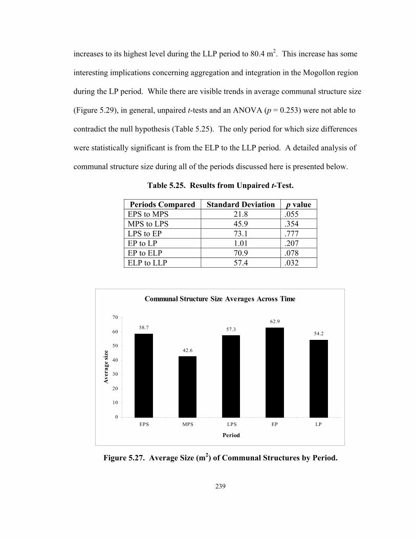
239
increases to its highest level during the LLP period to 80.4 m2. This increase has some
interesting implications concerning aggregation and integration in the Mogollon region
during the LP period. While there are visible trends in average communal structure size
(Figure 5.29), in general, unpaired t-tests and an ANOVA (p = 0.253) were not able to
contradict the null hypothesis (Table 5.25). The only period for which size differences
were statistically significant is from the ELP to the LLP period. A detailed analysis of
communal structure size during all of the periods discussed here is presented below.
Table 5.25. Results from Unpaired t-Test.
Periods Compared Standard Deviation p value EPS to MPS 21.8 .055 MPS to LPS 45.9 .354 LPS to EP 73.1 .777 EP to LP 1.01 .207 EP to ELP 70.9 .078 ELP to LLP 57.4 .032
Communal Structure Size Averages Across Time
58.7
42.6
57.362.9
54.2
0
10
20
30
40
50
60
70
EPS MPS LPS EP LP
Period
Ave
rage
size
Figure 5.27. Average Size (m2) of Communal Structures by Period.

240
Communal Structure Size Averages Across Time
58.7
42.6
57.362.9
33.8
80.4
0
10
20
30
40
50
60
70
80
90
EPS MPS LPS EP ELP LLP
Period
Ave
rage
siz
e
Figure 5.28. Average Communal Structure Size (m2) with the LP Period Separated into ELP and LLP Periods.
Figure 5.29. Regression Chart Depicting Average Communal Structure Size (in m2) across Time, with 1 Representing the EPS Period and 6 Representing the LLP Period.
p = 0.58

241
Pit Structure Period
The analysis of the location data provided evidence that can be used to suggest
that during the Pit Structure period many sites have large communal structures that
appear to be serving as integrating mechanisms for large dispersed communities.
However, there are changes in the average sizes of these structures from the EPS to the
MPS to the LPS period although they are not statistically significant changes (Table 5.25
and Figure 5.33). There is an interesting change in communal structure size that occurs
during the MPS period, which is explored below.
Early Pit Structure Period (A.D. 250 to 700). Size data were available for 22 EPS
period communal structures from 18 sites (Appendix II; Table 5.26). During the EPS
period, the average communal structure size is approximately 59 m2 (Figure 5.27). No
very small communal structures (i.e., smaller than 20 m2) date to the EPS period, and the
smallest one is approximately 24 m2. Some EPS sites have very large structures, like the
112 m2 structure at Crooked Ridge village and the 85 m2 SU site communal structure.
While communal structure size does vary during the EPS period, size data provide
information about aggregation and integration in Mogollon communities dating to this
period.
Table 5.26. Communal Structure Size during the EPS Period. Site Number Site Name Structure Number Size (m2)
LA 12110 McAnally Unit 11 23.8 LA 6538 Diablo Feature 5 31.9 Lagoon 35.3 LA 127260 Ridout Locus House F 35.8 LA 6538 Diablo Feature 14 36.3 LA 635 Galaz Unit 8 37 LA 1113 Old Town A67 39

242
Table 5.26 continued.
Site Number Site Name Structure Number Size (m2) LA 19075 40.3 LA 32536 Cuchillo 1 41 LA 1867 Harris House 14 44 LA 53 Three Circle Room 19 53.2 LA 53 Three Circle 2A 57.2 LA 5421 Saige-McFarland Pithouse 1/Great Kiva 57.7 LA 34813 Winn Canyon Room 2/Kiva 63.5 LA 64931 SU House V 78.5 W:10:15 Crooked Ridge Pithouse 9 82 LA 11568 Mogollon House 5A 82.5 LA 103907 Bluff House 5 83 LA 64931 SU Pithouse A 84.9 AZ P:16:1 Bear ruin Kiva No. 1 86 LA 9713 Promotory House B 86 W:10:15 Crooked Ridge Structure 19 111.6
Most EPS period sites have one communal structure, the majority of which are the
largest pit structures at the sites (Table 5.26). These size data when combined with
chronometric and location data suggest that social integration was the norm at the
majority of EPS period sites. At the same time however, four EPS period sites, Diablo,
Crooked Ridge, SU, and Three Circle, have two communal structures, frequently of
comparable size.
Diablo village has two relatively small EPS period communal structures, although
both are larger than the other pit structures identified at the site (Anyon and LeBlanc
1980; Creel and Anyon 2003; Dycus 1997; Hammack 1966; Linse 1999a, 1999b).
Situated along the upper Gila River drainage in New Mexico, the site has two EPS period
communal structures, Features 5 and 14 (Anyon and LeBlanc 1980; Dycus 1997).
Ceramic dates for Feature 5 range from A.D. 400 to 650 and Feature 14 dates from A.D.

243
550 to 650. Dycus’ (1997) analysis of architectural evidence from the site provides a
construction history for the site, which shows that Feature 14 was constructed before
Feature 5. The history has been used to suggest that Feature 14 was abandoned when
Feature 5 was built and that the two were not contemporary (Dycus 1997). Size data for
the two features are interesting in that Feature 5 is 32 m2 and Feature 14 is 36 m2, which
means that the residents of Diablo village abandoned a larger structure in favor of a
slightly smaller one. Despite the size differences, if the construction history provided by
Dycus (1997) is reliable, Diablo is an example of EPS period integration.
At Crooked Ridge, the smaller structure appears to have been replaced by the
larger one after some period of site occupation (Wheat 1955). A smaller structure,
Pithouse 9 (82 m2), was later replaced by the larger structure 119 (112 m2). At this site, it
appears that social integration was promoted throughout the EPS period and that at some
point the people living at Crooked Ridge needed a larger structure to facilitate this goal.
The SU site, situated in the Reserve area of southwestern New Mexico, has two
EPS period communal structures (Cordell 1997:222; Martin and Rinaldo 1947; Wills
1991). House V and Pithouse A have been identified as EPS period communal
structures. The ranges of dates for the two structures do not overlap, as is the case for the
other EPS period sites that have two communal structures. Pithouse A has a radiocarbon
date range of A.D. 460 to 497 (Laboratory of Anthropology site files, Santa Fe, New
Mexico), and researchers (Martin and Rinaldo 1947; Wheat 1955) estimate that House V
was constructed and used between A.D. 550 and 750. Pithouse A predates House V and
as was the case at Diablo village, at the SU site, the earlier structure is slightly larger than

244
the later one. Pithouse A is 85 m2, while House V is 75 m2 (Martin and Rinaldo 1947;
Wheat 1955). The two EPS period communal structures at SU appear to have been used
sequentially, rather than simultaneously, thus providing evidence for EPS period
integration.
The Three Circle site is situated in the northern Mimbres River valley in
southwestern New Mexico and has two EPS period communal structures (Bradfield
1927-1928; Creel and Anyon 2003). Rooms 2A (57 m2) and 19 (53 m2) both have
ceramic dates of A.D. 550 to 750 and are approximately the same size, although 2A is the
largest of the 24 pit structures at the site. Researchers (Bradfield 1927-1928; Creel and
Anyon 2003:73) have suggested that Room 19 was used from the EPS period into the
MPS period, while 2A was abandoned and burned at the end of the EPS period. This
may help to explain the presence of the two structures at the site in that 19 likely replaced
the destroyed 2A. However, the two were both used until the end of the EPS period,
suggesting that some degree of population aggregation occurred.
Size data, in conjunction with frequency data, suggest that at all but one EPS
period sites social integration occurred. The average communal structure size of 59 m2
during this period indicates that single large communal structures were in place at almost
all sites during this pit structure period. By providing only one communal structure for a
community, participation and hence integration is emphasized.
Middle Pit Structure Period (A.D. 700 to 850). During the MPS period, the
average communal structure size decreases to about 43 m2. Size data were available for
11 MPS period structures from eight sites (Table 5.27). While MPS communal structure

245
sizes range from 20 to 71 m2, similar to the range seen during the EPS period, although
without the largest EPS sizes, no very large or very small structures are present in the
MPS period sample (Table 5.27). Based on the size and frequency data for MPS period
sites, it appears that at this time in many areas of the Mogollon region, some degree of
population aggregation began to occur. Six MPS sites, a majority, have only one
communal structure, but, the Harris (Anyon and LeBlanc 1980; Diehl and LeBlanc 2001)
site has two MPS period communal structures each. There are three communal structures
dating to the MPS period at the Wind Mountain site (Woosley and McIntyre 1996).
Table 5.27. Communal Structure Size during the MPS Period.
Site Number Site Name Structure Number Size (m2) LA 6083 Gallita Springs Feature 40 20 LA 127260 Wind Mountain House O 28.2 LA 127260 Wind Mountain House AK 29.9 Turquoise Ridge Structure 35 30 LA 34787 Black's Bluff Pit House 1 37.1 LA 127260 Wind Mountain House AB 40.5 LA 1867 Harris House 23 45.5 LA 1113 Old Town A71 52 LA 11568 Mogollon House 3 55.4 LA 9709 Turkey Foot Ridge Pithouse K 59.2 LA 1867 Harris 8 70.9
At the Mimbres valley Harris site, there are two MPS period communal structures
including the large 71 m2 structure 8 and the smaller 46 m2 House 23 (Creel and Anyon
2003; Haury 1936; Haury and Sayles 1947). A ceramic of A.D. 650 to 750 is available
for structure 8, and House 23 has a tree-ring cutting date of A.D. 838v (Creel and Anyon
2003). These dates provide evidence that, although the two Harris communal structures
date to the MPS period, they were probably not contemporary. The residents of this site

246
appear to have replaced their larger structure with the smaller House 23. It is unclear
why the community chose to build a smaller communal structure, but the size data for
these structures provide more support for integration than aggregation during the MPS
period.
Size data were available for three structures from Wind Mountain situated in
southwestern New Mexico (Woosley and McIntyre 1996). The sizes of the structures
range from 28 to 41 m2, and no very large structure dates to the MPS period at Wind
Mountain. Whether or not these three structures were contemporary speaks directly to
issues of aggregation and integration. According to archaeomagnetic dates, the oval
House AB, the largest of the three Wind Mountain communal structures, was built and
used between A.D. 620 and 730. The square House AK produced archaeomagnetic dates
ranging from A.D. 640 and 780 and ceramic dates for the circular House O range from
A.D. 650 and 750 (Woosley and McIntyre 1996). The three structures are different
shapes and are randomly spaced among the 50 pit structures at the site (Woosley and
McIntyre 1996). Architectural, archaeomagnetic, and construction data from the Wind
Mountain suggest that the three communal structures were contemporary (Woosley and
McIntyre 1996). Variation in size data from the site provides evidence for some degree
of population aggregation during the MPS period. The relatively small communal
structures identified at the site also provide evidence that large central meeting places
were not present during the LPS period, also suggesting aggregation.
During the MPS period, communal structure size decreases from the EPS period
from an average size of 58 m2 to only 43 m2. At the same time, there is only one site,

247
Wind Mountain, with evidence for increasing aggregation during the MPS period.
The fact that communal structure size decreases in the absence of data for increasing
aggregation is interesting because it may imply that in fact communities placed an
increasing emphasis on integration during this period. By reducing the numbers of
people who could participate in communal activities, the community could reinforce the
importance of group membership. Size data for both EPS and MPS period communal
structures indicate relative stability in social integration.
Late Pit Structure Period (A.D. 850 to 1000). Large communal structures initially
associated with the EPS period reappear in many areas of the Mogollon region during the
LPS period. At the same time, there are many small structures dating to this period.
In general, there is a great deal more communal structure size variation during the LPS
period than during previous periods (Table 5.28). Some LPS period structures are
relatively small (e.g., structures 21 and 22, both 12 m2, from Lee village), while others
are very large, including the 232 m2 communal structure excavated in southern New
Mexico at LA 3274 (Martin et al. 1957). Average size for the 38 LPS period communal
structures (Table 5.27), for which size data were available, is approximately 57 m2, larger
than during the MPS period, but similar to that calculated for the EPS period. Variation
in communal structure size may provide evidence for population aggregation in many
areas during this period. Interestingly, in some cases, large to very large communal
structures are found at LPS period sites (e.g., LA 3274 and Harris village).

248
Table 5.28. Communal Structure Size during the LPS Period.
Site Number Site Name Structure Number Size (m2) LA 6000 Lee 21 12 LA 6000 Lee 23 12 LA 64931 SU Pithouse Y 12.5 LA 190 Cameron Creek 105 13.3 LA 190 Cameron Creek 127 13.7 LA 6083 Gallita Springs Feature 38 16 LA 6000 Lee 20 16 LA 78337 Bradsby 1 16.2 LA 6000 Lee 18 18 LA 190 Cameron Creek 112 18.1 LA 6000 Lee 19 19 LA 2465 NAN 91 20 LA 6000 Lee 22 22 LA 39261 25 LA 1691/LA 15002 Swarts Room 2 27.5 LA 127260 Wind Mountain House XX 28 LA 127260 Wind Mountain House Y 29.8 LA 190 Cameron Creek 119 35.3 LA 127260 Wind Mountain House U 36.9 LA 3099 WS Ranch/McKeen Kiva C 39.7 LA 2465 NAN 52 43.2 LA 2465 NAN 43 58 LA 71877 Lake Roberts Vista Great Kiva 60 AZ W:10:111 Nantack Pithouse 10 60 LA 18888 Beauregard Structure 1 64 LA 5841 Cooney Ranch #1 Communal Structure 1 64 LA 127260 Wind Mountain House X 70.5 LA 9657 Sawmill/Fox Farm Kiva 75.6 LA 1691/LA 15002 Swarts Room W 76 LA 1113 Old Town A16 78 LA 190 Cameron Creek Kiva 85.3 LA 38624 Starkweather Pithouse B 99 LA 4424 Wheatley Ridge House 7 100.4 LA 1691/LA 15002 Swarts Room AE 109.4 LA 1867 Harris House 10 143 AZ W:10:111 Nantack Great Kiva 1 152.8 LA 635 Galaz 42A 175.3 LA 3274 Great Kiva 232.2

249
The communal structure found at LA 3274 is very large, 232 m2, and associated
with a very small community (Martin et al 1957). The LPS period site consists of 33
structures and the very large Great Kiva, which has a storage room and a long ramp
entryway. The LA 3274 communal structure provides evidence for a LPS period
community that emphasized social integration (Martin et al. 1957). Given the
discrepancy between the size of the Great Kiva and the size of the community, it is also
possible that the large structure served as a meeting place for multiple communities. At
the same time, it is possible that the people in this community chose to build a large
communal structure, just as people today construct elaborate churches for religious and
ritual reasons. Regardless of who was being integrated, the Great Kiva at LA 3274
provides evidence for social integration during the LPS period.
Old Town (Creel 1998, 1999a), Harris, Galaz (Anyon and LeBlanc 1984), and
Wheatley Ridge (Laboratory of Anthropology site files, Santa Fe, New Mexico) sites all
have a single relatively large (i.e., at least 75 m2) communal structure (Table 5.26).
At the same time some sites (e.g., SU, Gallita Springs, and Bradsby) have one rather
small (i.e., less than 20 m2) communal structure at their sites during the LPS period.
These size variations were not present to the same degree during either of the previous
periods and provide evidence for diversity in integration during the LPS period. At some
sites, large structures are used to integrate people, while at others rather small structures
are constructed. As previously stated, the very small structures may not be communal
structures at all (Gilman 2006; Lekson 1989), but that does not erase the fact that at least
the large structures evidence social integration during the LPS period. Communal

250
structure size data from the LPS period also provide some evidence for population
aggregation during this period.
Six LPS period sites have more than one communal structure (Table 5.26).
Nantack (Breternitz 1959) has two LPS period communal structures, the Mimbres valley
sites of NAN (Shafer 2003) and Swarts (Carlson 1965) have three, Wind Mountain
(Woosley and McIntyre 1996) has four, Cameron Creek (Bradfield 1931) has five, and
Lee village (Bussey 1972, 1975) has six communal structures. The contemporaneity of
LPS period communal structures at Mogollon sites is presented below, as these data help
to provide evidence for aggregation and/or integration.
Size data from the two LPS period communal structures at Nantack village, a site
in eastern Arizona, provide further support for integration at the site (Breternitz 1956,
1959). Nantack consists of 21 pit structures and includes Pithouse 10, which is 60 m2,
and the Great Kiva , which is approximately 153 m2 (Breternitz 1956, 1959). Ceramic
dates for the two LPS period communal structures range from A.D. 900 to 1000.
Although these dates suggest that the structures were contemporary, Breternitz (1956)
examined the site’s construction history and found that Pithouse 10 was constructed
before Great Kiva 1. Breternitz (1956, 1959) suggests that the community initially
constructed the smaller structure and later built the much larger structure, perhaps to
serve a growing population (Breternitz 1956). It is also possible that Great Kiva 1 was
built to facilitate visitors to the site, as the size of the structure would have been more
than adequate to accommodate members of the Nantack community. Size data from

251
Nantack village support the idea social integration was emphasized within this LPS
period community.
At NAN, a 20-30-structure LPS period village, there is evidence for three
contemporary structures (Burden 2001; Shafer 1983, 1989, 1990, 2003). The dates for
three LPS period communal structures, Rooms 43, 52, and 91, overlap. Archaeomagnetic
dates and construction sequences suggest that communal structure 52 was one of the first
structures to be constructed at the site, and it dates between A.D. 859 and 930 (Burden
2001; Shafer 1989, 1990). The early construction of Room 52 suggests that it was
important to the people building the community to have a communal structure as part of
their initial village plan. It is possible however, that structure 43 was built first, as a non-
cutting tree-ring date of A.D. 900 is available. A ceramic date range of A.D. 900 to 1000
places structure 91 chronometrically, as does a construction history for the site that
provides information about when this structure was built.
Interestingly, structure 43, which construction sequences for the site suggest may
have been constructed later than structure 52, is the largest of the three NAN communal
structures (Burden 2001). It is possible that the initial structure, 52, was not large enough
for the community, and so the community built a larger one to accommodate a greater
number of the community’s members.
If the three NAN communal structures are contemporary, the size variation they
display provides evidence for population aggregation in the Mimbres area during the LPS
period. If the structures are not contemporary, and only one structure was used at a time,
data from NAN may be evidence for social integration during the LPS. The two smaller

252
structures, 52 (43 m2) and 91 (20 m2) which were associated with specific areas of the
site, were burned and have dedicatory objects, suggesting that they may have been
destroyed and replaced by the larger, 58 m2 structure 43 (Burden 2001; Creel and Anyon
2003; Shafer 1989, 1990). Size data from the three LPS period NAN communal
structures suggest that the site was formed via aggregation evidenced by the presence of
two smaller communal structures (Shafer 2003). The aggregated NAN community
became integrated at some point, as evidenced by the construction of a larger communal
structure during the later part of the LPS period.
The Mimbres valley Swarts ruin consists of 40 to 60 pit structures, which includes
three communal structures, Room AE, Room 2, and Room W (Cosgrove and Cosgrove
1974). A date range of A.D. 750 to 1000 was available for two of the structures and a
tree-ring non-cutting date of A.D. 900vv was available for Room W (Anyon and LeBlanc
1980; Cosgrove and Cosgrove 1974). The three Swarts communal structures vary greatly
in size.
Room AE is the largest of the three at 109 m2; Room W is smaller at 76 m2 and
structure 2 is the smallest at 28 m2 (Cosgrove and Cosgrove 1974). Construction data for
the site suggest that Rooms AE and 2 were abandoned prior to the construction of Room
W (Carlson 1965). All three of the Swarts structures were burned upon their
abandonment, but no radiocarbon or tree-ring dates are available (Cosgrove and
Cosgrove 1974). Construction sequences can be used to support the idea that structures
AE and 2 were destroyed and replaced with a single communal structure, Room W
(Cosgrove and Cosgrove 1974). Interestingly, Room W is smaller than structure AE,

253
although it is still a large structure. At Swarts, size data, combined with frequency and
location data, provide support for early LPS period population aggregation, which was
replaced by social integration later during the period.
At the Wind Mountain site, specific dates are available for Houses U, Y, X, and
XX, the site’s LPS period communal structures (Woosley and McIntyre 1996).
Archaeomagnetic and ceramic dates for these four structures range from A.D. 750 to
1030. The four Wind Mountain communal structures could have been built and
abandoned at various times throughout this almost 300-year period. However, dates for
specific structures indicate that some of the structures were contemporary. For example,
the archaeomagnetic dates for the largest Wind Mountain communal structure, House X,
which is 71 m2, range from A.D. 800 to 940 (Woosley and McIntyre 1996).
Dates for House XX, which is much smaller than House X at 28 m2, range from
A.D. 778 to 1030. Ceramic dates, which range from A.D. 750 to 1000, are the only ones
available for Houses U and Y (Woosley and McIntyre 1996). As a result, it is difficult to
assess the contemporaneity of these two LPS period structures. Houses Y and U are
relatively small and are 30 and 37 m2, respectively. The presence of four possibly
contemporary communal structures with a wide range of sizes provides evidence for a
continuation of MPS period population aggregation at Wind Mountain during the LPS
period. That there are three smaller communal structures and one larger one at Wind
Mountain has implications for issues of aggregation at the site. The overlapping dates for
the multiple Wind Mountain communal structures, which vary in size from 28 to 71 m2,
provide evidence for some degree of population aggregation at the site. It is also possible

254
that the large House X was built to help promoter integration at an aggregated site.
However, the size variation may simply reflect diversity that existed within an aggregated
community.
There are five LPS period communal structures at the 40-pit structure Cameron
Creek site (Bradfield 1931). The structures range in size from 13 to 85 m2. Three of the
communal structures, 105, 127, and 112, are relatively small, 13, 14, and 18 m2
respectively, structure 119 is 35 m2, and one, designated “Kiva,” is quite large at 85 m2
(Anyon and LeBlanc 1980; Bradfield 1931). It is difficult to assess the contemporaneity
of the Cameron Creek communal structures because such a wide range of dates is
available for the site. Some researchers (Anyon and LeBlanc 1980) suggest that some of
these five structures date to the LPS period, while others date to the EP period. The
contemporaneity of communal structures at this site appear to indicate that population
aggregation occurred to some degree. The size variation that exists at Cameron Creek is
similar to that seen at Wind Mountain and while it indicates some degree of aggregation,
it may establish the presence of integration at the site. The Kiva is much larger than the
other communal structures at the site and could reflect community diversity or could have
been used to integrate an aggregated community. In the absence of more definitive
chronometric data, it is only possible to state that aggregation may have occurred at
Cameron Creek.
At Lee village (Bussey 1972), there are six relatively small communal structures
and all of them date to the LPS period (Bussey 1972). From smallest to largest,
structures 21 and 23 are both 12 m2, structure 20 is 16 m2, structures 18 and 19 are 18 and

255
19 m2, respectively, and structure 22 is 22 m2 (Bussey 1972). As previously stated, using
a Robinson’s Index, Bussey (1972:51-53) calculated construction sequences for several
of the communal structures dating to the LPS period. Based on his findings, he was able
to say that structures 21, 22, and 23 predate structures 18, 19, and 20. Bussey (1975)
proposed a date range of A.D. 920 to 980 for structures 21, 22, and 23 and A.D. 980 to
1050 for 18, 19, and 20.
Following Bussey (1975), at least three of the six structures at Lee village were
contemporary at any one time, and it is likely that the earlier three may also have been
replaced by the three almost identically sized communal structures at some point during
the LPS period. It is unclear why these structures were replaced, and only one of the
earlier structures, 21, showed evidence of burning (Bussey 1972). Size data, when
combined with construction evidence for the six Lee village communal structures provide
evidence for population aggregation during the LPS period.
Size variability during the LPS period provides evidence for population
aggregation at Wind Mountain, Cameron Creek, and Lee sites, aggregation followed by
integration at NAN and Swartz, and social integration at all others (e.g., Old Town,
Galaz, and Nantack). There is more evidence for population aggregation during this
period than during either of the previous pit structure periods. However, evidence for
social integration remains prevalent during the LPS period. There is more LPS period
variation in communal structure size than during either the EPS or the MPS period.
Average communal structure size during the LPS period is almost identical to that of the

256
EPS period and is certainly affected by the very small and very large structures in the
sample.
Very large communal structures (i.e., greater than 70 m2) are much more common
during the LPS period, and some sites (e.g., Galaz, Nantack, and LA 3274) have
structures larger than 140 m2. These large structures may indicate an increase in the size
of LPS period communities, in that many LPS period structures are much larger than
those identified during the MPS period. LPS period size variation continues into the EP
period and the average communal structure size increases once again.
Pueblo Period
At the beginning of the Pueblo period, size variation continues from the LPS
period. Assemblage size for the EP period is the largest of all the periods and appears to
reflect population increase in many areas of the Mogollon region during this period
(Anyon and LeBlanc 1980; Cordell 1997). Average communal structure size decreases
to its lowest value during the beginning of the LP period only to increase during the LLP
period, when communal structure sizes are, on average, the largest that they have ever
been. Detailed analyses of communal structure size, by period, are included in the
following sections.
The Early Pueblo Period (A.D. 1000 to 1150). Size data were available for 50 EP
period communal structures from 27 sites (Table 5.29). The average size of an EP period
communal structure is approximately 63 m2, which is about five square meters larger than
the LPS average (Figure 5.27). During the EP period, there is a great deal more variation
in communal structure frequency and location than is seen during any of the Pit Structure

257
periods; the same is true for communal structure size during the EP period. EP period
communal structure sizes range from very small, approximately 5 m2, to very large, 288
m2, with a great deal of variation in-between. Unlike during the Pit Structure periods,
only 12 EP period sites have one communal structure these include Diablo, Dry Prong,
Elk Ridge, Ojo Caliente G, Redrock, Saige-McFarland, Sand Flat, TJ, Wheaton Smith,
Yeo 194, LA 18753, and LA 66686. Eleven EP period sites including Pine Creek,
Treasure Hill, West Fork, Woodrow, Rock House, Pueblo Lillie Allen, Graveyard Point,
Mattocks, Galaz, Dinwiddie, and Black’s Bluff have two communal structures. Tla Kii
and Carter Ranch have three EP period communal structures and there are five at NAN
and Wind Mountain (Table 5.29).
Table 5.29. Communal Structure Size during the EP Period.
Site Number Site Name Structure Number Size (m2) LA 66782 Sand Flat 4.7 Carter Ranch Kiva 1 8.1 Carter Ranch Room 16 8.4 LA 127260 Wind Mountain Room 15 9 LA 127260 Wind Mountain Room 3 9.1 LA 5421 Saige-McFarland Pithouse 3 9.8 LA 8675 West Fork 10 9.8 LA 6536 Graveyard Point Feature 8 11.4 LA 1118 Rock House Feature 8 11.6 LA 1118 Rock House Feature 7 11.6 AZ P:16:2 Tla Kii Kiva 2 12 LA 3639 Pine Creek Room 1 12.7 LA 6783 Dinwiddie Feature 14 12.8 LA 635 Galaz Kiva 107 12.8 LA 6783 Dinwiddie Feature 11 13.3
LA 4986 Pueblo Lillie Allen Site Cluster/Yankee Gulch East Pithouse/Kiva 2 13.5
LA 676 Mattocks Unit 410 13.8 LA 34787 Black's Bluff Kiva 7 14

258
Table 5.29 continued.
LA 16241 Treasure Hill Room 6 14.3 LA 16241 Treasure Hill Room 8 14.6 LA 676 Mattocks Kiva 48 14.8 LA 18753 15.2 LA 127260 Wind Mountain House V 15.3 LA 3639 Pine Creek Room 4 15.9 LA 8675 West Fork 6 16 LA 6538 Diablo Feature 7 16.8 LA 6536 Graveyard Point Feature 9 16.8 LA 2465 NAN 58 17.8 LA 127260 Wind Mountain House P2 18.2 LA 34787 Black's Bluff Great Kiva 13 28
LA 4986 Pueblo Lillie Allen Site Cluster/Yankee Gulch East Pithouse/Kiva 1 28.4
LA 18903 Wheaton Smith Unit 34 28.8 LA 2465 NAN 57 32.2 LA 2465 NAN 39 36 LA 127260 Wind Mountain Room 7 37.9 LA 2465 NAN 18 38.8 LA 66686 Kiva 42 LA 2465 NAN 45 95 LA 78963 Elk Ridge Kiva 100 LA 86310 Ojo Caliente G Great Kiva 113 LA 2454 Woodrow 120 LA 635 Galaz 73 (Parrot Kiva) 146.8 LA 5412 Redrock 189.4 W:6:5 Dry Prong Kiva 1 192 LA 54955 TJ 200 Carter Ranch Great Kiva 235 AZ P:16:2 Tla Kii Kiva 52 260.2 LA 2454 Woodrow 279 LA 1294 Yeo 194 Great Kiva 279 AZ P:16:2 Tla Kii Kiva 1 287.6
259
Pine Creek pueblo is located on a tributary of the Gila River in southwestern New
Mexico (Anyon and LeBlanc 1980). The two EP period communal structures at this site,
Rooms 1 and 4, are relatively small (Anyon and LeBlanc 1980). Room 1 is 13 m2 and
Room 4 is 16 m2. The size of the two structures suggests that they would have been used
by smaller segments of the Pine Creek community. Dates for the two structures span the
entire EP period from A.D. 1000 to 1150, and Anyon and LeBlanc (1980) suggest that
the two communal structures were contemporary, although they do not provide
chronometric data to support this claim. The two Pine Creek pueblo communal structures
are relatively small and may have been used during the same period. If they are
contemporary, size data for these structures1 provide evidence for population aggregation
in this area of the Mogollon region during the EP period, however there is insufficient
evidence to support this claim.
Treasure Hill, situated on Cameron Creek in southwestern New Mexico, also
appears to provide evidence for population aggregation during the EP period (Anyon and
LeBlanc 1980; Cosgrove 1923). Rooms 6 and 8 are the two EP period structures and are
approximately the same size, 14 and 15 m2, respectively (Anyon and LeBlanc 1980;
Cosgrove 1923). Ceramic dates for the two structures, Rooms 6 and 8, do overlap
(Cosgrove 1923). Room 6 is associated with the northern roomblock and Room 8 with
the east roomblock (Anyon and LeBlanc 1980; Cosgrove 1923). While there are no
definitive chronometric data for these structures, it is unclear if they were contemporary
or if they were used sequentially. However, given the small sizes and location data for
the two structures, Treasure Hill appears to provide evidence for EP period aggregation.

260
As was the case at Treasure Hill, there are no absolute dates for the two West
Fork communal structures (Anyon and LeBlanc 1980; Ice 1968). Date ranges for
communal structures 10 and 6 are A.D. 1000 to 1150. Both of the structures are
relatively small, structure 10 is 10 m2 and 6 is larger at 16 m2 (Shafer 2003). The two
structures are associated with specific roomblocks at this EP period site (Ice 1968). In
the absence of absolute dates for structures 10 and 6, it is difficult to determine if the two
structures were contemporary. However, size and location data support the idea that the
West Fork communal structures provide evidence for EP period population aggregation.
There are two EP period communal structures at the 300-room Woodrow ruin,
located in southwestern New Mexico (Stuart and Gauthier 1981). Neither of the
Woodrow structures was given a number, and both are quite large, 120 and 279 m2
(Stuart and Gauthier 1981). The structures are embedded within two of the site’s 16
roomblocks (S. Lekson, personal communication 2005). The lack of dates for the
structures is problematic for determinations of whether or not they were coeval. The
communal structures have very little post-depositional fill within them, and the site
appears to have been abandoned at the end of the EP period (S. Lekson, personal
communication 2005; Stuart and Gauthier 1981). Because these structures were not
excavated, there are no floor context ceramics, which makes it difficult to argue that one
of the structures was abandoned and another built and used. Given size data alone, in the
absence of clearer chronometric data, it is difficult to say if the Woodrow communal
structures provide evidence for EP period population aggregation or integration.

261
Rock House ruin is situated on the Mimbres River and has two EP period
communal structures (Anyon and LeBlanc 1980). The two structures, Features 7 and 8,
are exactly the same size (11.6 m2), and their dates overlap with one another.
Construction data for the site show that Feature 8 was abandoned prior to the construction
of Feature 7 (Anyon and LeBlanc 1980; Laboratory of Anthropology site files, Santa Fe,
New Mexico). In this case, the people living at Rock House ruin replaced their original
communal structure with another one of the exact same size; therefore, these structures
provide evidence for social integration during the EP period.
The two EP Pueblo Lillie Allen communal structures, Kivas 1 and 2, were studied
by Kayser (1971). Kayser’s (1971) examinations led him to conclude that the
construction of Kiva 1 predated Kiva 2. At the same time, he also suggested that the two
communal structures were used at the site simultaneously. Kiva 1 is 24 m2,
approximately double the size of Kiva 2, which is 14 m2 (Kayser 1971). Because there
are two communal structures, which are associated with different areas of the site and
because they vary in size, Kivas 1 and 2 likely represent evidence for increased
population aggregation during the EP period.
The two Graveyard Point communal structures do not vary a great deal in size
(Hammack 1966). Features 8 and 9 are both quite small at 11 and 17 m2. Both structures
are spatially separated from the rest of the site’s architecture. Ceramic dates are the only
ones available for the two EP period communal structures and so it is not possible to
determine whether the two were contemporaneous. Given the similar size of the two

262
structures, if they are contemporary they appear to reflect population aggregation during
the EP period (Anyon and LeBlanc 1980).
In the Mimbres valley at the Mattocks ruin, there are two communal structures.
Unit 410 was initially a habitation pit structure and was remodeled into a communal
structure, (Anyon and LeBlanc 1980:267; Gilman and LeBlanc n.d.; LeBlanc 1983).
Kiva 48, the second EP period communal structure, is quite small at 15 m2. The
remodeled Unit 410 was slightly smaller, 14 m2 (Gilman and LeBlanc n.d.). As is the
case with several other EP period communal structures discussed in this section, the sizes
of the small structures, like those identified at Mattocks, are problematic. Gilman (1998)
and others (Lekson 1979) have discussed small “out of sequence” pit structures
suggesting that they are not communal structures at all, but rather represent temporary
residences for people constructing surface roomblocks. Because Unit 410 and Kiva 48
are approximately the same size and are associated with two different parts of the site
suggests that they were the physical manifestation of aggregation at Mattocks. It is
unclear if these small structures are contemporary if they are they provide evidence for
EP period aggregation.
At the Mimbres valley Galaz ruin, there are two EP period communal structures
(Anyon and LeBlanc 1984). Kiva 107 and structure 73, also referred to as Parrot Kiva,
were identified at the site. Kiva 107 is very small, 12 m2, and the Parrot Kiva is very
large at 147 m2. Ceramic dates for Kiva 107 range from A.D. 1000 to 1150, while
ceramic dates for Parrot Kiva range from A.D. 950 to 1150 (Anyon and LeBlanc 1984).
Anyon and LeBlanc (1984:135-137) state that Kiva 107 was remodeled two times during

263
the EP period and that the Parrot Kiva was purposefully destroyed at the end of the EP
period (Creel and Anyon 2003). Given the relative dates for these structures, it is
difficult to determine whether the two structures are contemporary, but the fact that Kiva
107 was remodeled suggests that it was used throughout the EP period. It is possible that
both population aggregation and integration occurred at this 150-room pueblo. The very
small Kiva 107 may have been built and used by one group within the larger community.
The very large Parrot Kiva most likely served the community as a whole.
During the EP period at the Dinwiddie site, in southwestern New Mexico, there
are two communal structures (Bussey 1972). Based on ceramic data collected during site
excavations the site has been dated between A.D. 1032 and 1100 (Bussey 1972:78).
Features 11 and 14 are both approximately 13 m2, and the relative dates available for the
structures do overlap (Anyon and LeBlanc 1980; Bussey 1972; Linse 1999a). There are
two roomblocks at the Dinwiddie site, one eastern and one western (Anyon and LeBlanc
1980; Linse 1999a). Feature 14 is attached at the northern end of the western roomblock
(Anyon and LeBlanc 1980; Bussey 1972:62). Feature 11 is associated with the eastern
roomblock at the site (Anyon and LeBlanc 1980:268-269; Bussey 1972:62). Given the
relatively short occupation at the site, the size of the communal structures, and the
location of these structures associated with roomblocks, aggregation likely occurred
during the EP period at Dinwiddie.
There are 12 roomblocks and two communal structures at the EP period site of
Black’s Bluff located in southwestern New Mexico (Anyon and LeBlanc 1980; Brunet
1972; Fitting et al. 1972). The two communal structures, Kiva 7 and Great Kiva 13, date

264
to the EP period. Unfortunately, only ceramic dates ranging from A.D. 1000 to 1175 are
available for the two structures (Fitting et al. 1972). Neither structure is exceptionally
large. Great Kiva 13 is 28 m2 and Kiva 7 is half the size at 14 m2 (Anyon and LeBlanc
1980). The larger of the two structures, Great Kiva 13, is located in a prominent location
while the smaller Kiva 7 is associated with one of the site’s roomblocks (Fitting et al.
1972).
Given the lack of absolute dates, it is difficult to evaluate whether or not they are
contemporary. If the two are contemporary, the Great Kiva could reflect the importance
of social integration at the site, while Kiva 7 reflects possible population aggregation at
the site. As was the case at Galaz, the sizes of the Black’s Bluff communal structures are
interesting because they may reflect diversity within the community (i.e., some people
build and use smaller communal structures while others do not). The presence of two
smaller structures and one large one suggests that at Black’s Bluff aggregation and
integration occurred at this EP period site.
Tla Kii is located on Forestdale Creek in east-central Arizona. Kivas 1, 2, and 52,
make up the Tla Kii’s EP communal structure assemblage (Haury 1985; Herr 2001).
Kiva 1 is 288 m2 and dates from A.D. 1008 to 1121, a date of A.D. 1035 was provided
for the 12 m2 Kiva 2, and a ceramic date range of between A.D. 1000 and 1150 was
provided for the 260 m2 (Kiva 52) structure at the site. Interestingly, site reports (Herr
2001) indicate that the Tla Kii inhabitants did not complete the construction of Kiva 2,
which was situated within one of the roomblocks. Kiva 2 was abandoned in favor of the

265
much larger Kiva 1, which is 288 m2, which was situated 25 meters to the south of the
site.
Construction of a small communal structure may have represented a desire of the
people living at Tla Kii to privatize their activities or to create a space where fewer
people could attend functions. The abandonment of this smaller structure, which was
never finished and therefore never used and the construction of a much larger one
suggests that integration of large numbers of people became the ultimate priority. Kiva
52 is also large, 260 m2, and given its size, it is probably not a contemporary of Kiva 1, as
the residents of a 21-room pueblo would not likely need two very large communal
structures (Herr 2001). When considered as a whole, it is likely that size data from Tla
Kii provide evidence to support the idea that social integration, rather than aggregation,
was emphasized at this site during the EP period.
Communal structure data from the Carter Ranch (Laboratory of Anthropology site
files, Santa Fe, New Mexico; Longacre 1970), situated in the Forestdale region in eastern
Arizona, are problematic because only date ranges are available for the EP period
assemblage. There are tree-ring cutting dates for the 235 m2 Great Kiva ranging from
A.D. 1116 to 1156 and ceramic dates for the 8 m2 Room 16 and the 8 m2 Kiva 1, which
range from A.D. 1000 to 1150. Kiva 1 is enclosed within one of the site’s plazas. Room
16 is associated with one of the roomblocks at the site, and the Great Kiva is 10 meters
from the site’s center. Site reports housed at the Laboratory of Anthropology in Santa Fe,
New Mexico, state that the Great Kiva was constructed earlier than the other two much

266
smaller structures. The physical separation of the large communal structure from the
site’s center provides support for some degree of social integration at Carter Ranch.
The facts that the Great Kiva was burned upon its abandonment and that the two
later structures are incorporated into the site’s architecture appears to provide evidence
for integration and then aggregation during the EP period. It does appear that population
aggregation did occur at the site, as evidenced by the presence of two very small
communal structures. Size data from Carter Ranch also provide support for initial
integration, followed by a period of population aggregation.
The Mimbres valley NAN Ranch ruin has five EP communal structures (Burden
2001; Shafer 2003). Aggregation appears to have occurred during the EP period, as was
the case during the LPS period at this site. Dates for the 39 m2 communal structure 18
range from A.D. 1071 to 1100. The 32 m2 structure 57 dates from A.D. 1025 to 1070;
structure 58, which is 18 m2, dates from A.D. 1000 to 1130. The largest communal
structure, 45, was 95 m2 and has a tree ring date of A.D. 1107v. Structure 39 is 36 m2
and has a tree ring date of A.D. 1090v. All five of these EP period communal structures
were used during the EP period (Burden 2001).
Using construction sequences for the site, Shafer (2003) and Burden (2001) have
provided evidence that structure 57 (A.D. 1025 to 1070), was a contemporary of structure
58 (A.D. 1000 to 1130). Structure 57 was abandoned before the construction of
structures 18, 45, and 39 (Burden 2001). Shafer (2003) suggests during the EP period,
communal structures 18, 45, 39, and 58 were in fact contemporary. The sizes of the three
small structures provide evidence for population aggregation at NAN Ranch ruin, and

267
there is also evidence for some degree of social integration, given the presence of one
large, centrally located communal structure.
Evidence for population aggregation can also be found at the EP period site of
Wind Mountain (Woosley and McIntyre 1996). The site consists of three roomblocks
and five communal structures (Woosley and McIntyre 1996). As was the case during the
MPS and LPS periods, aggregation appears to have occurred during the EP period at
Wind Mountain. The five Wind Mountain communal structures include Room 3 (A.D.
1000 to 1150), Room 7 (A.D. 1040 to 1130), Room 15 (A.D. 1030 to 1150), House V
(A.D. 970 to 1050), and P2 (A.D. 1100+/-) (Woosley and McIntyre 1996). The
structures range in size from 15 to 38 m2. All of the structures are relatively small and
are scattered throughout the site (Woosley and McIntyre 1996). As previously discussed,
following Gilman (1998) and Lekson (1989), the size of the five structures does make
their delineation as communal structures difficult. That the site has a history of more
than one communal structure makes it interesting as an example of long-term population
aggregation in this area of the Mogollon region.
Data from both NAN and Wind Mountain provide examples of multi-period
aggregation. At these sites, aggregation begins during the LPS period and continues into
the EP period. While not all of the communal structures at NAN and Wind Mountain are
contemporary, at both sites, multiple contemporary communal structures appear to have
been used at the same time.
During the EP period there appears to be size data that can be used as evidence for
both population aggregation (e.g., Treasure Hill, West Fork, and Wind Mountain) and

268
social integration (e.g., Diablo, Dry Prong, Elk Ridge, Rock House, Saige-McFarland,
Sand Flat, and TJ) in various areas of the Mogollon region. There are also sites like
Galaz, NAN, and Black’s Bluff with evidence for both aggregation and integration during
the EP period and Carter Ranch with evidence for integration followed by aggregation.
Communal structure sizes vary a great deal during this period. Some sites (e.g.,
Wind Mountain) have multiple small communal structures, while others have a single
very large communal structure (e.g., Yeo 194). The size variation may suggest several
possibilities. First, that some degree of cultural diversity is present at these sites during
this period (i.e., aggregation). Second, that the inhabitants of certain roomblocks had
greater social importance than others did (i.e., aggregation). Third, that aggregation and
integration can occur simultaneously even at a single site. Finally, forth, that integration
can replace aggregation at a site.
Late Pueblo Period (A.D. 1150 to 1450). The LP period was divided into ELP
and LLP periods (Figure 5.28). The decline of average size to 54 m2 is for the LP period
as a whole (Figure 5.28). However, it appears that the decline occurred primarily during
the early part of the LP period, when average communal structure size decreased
significantly from the ELP period to 34 m2 (Figure 5.28). This decrease coincides with a
period of social reorganization in many areas of the Mogollon region, including the
Mimbres, Reserve, and western areas (Cordell 1997; Nelson and LeBlanc 1986; Nelson
1999). Communal structure size increases once again during the LLP period to the
highest ever documented to an average of approximately 80 m2.

269
One site that provides evidence for long-term integration during the LP period is
the Point of Pines ruin (Gerald 1957; Stone 2001). Point of Pines (W:10:50) is a very
large 800-room site situated in eastern Arizona that dates to the ELP and LLP periods
(Gerald 1957; Stone 2001). There are two communal structures at the site, Kivas 1 and 2
(Gerald 1957). Kiva 1 is a very large structure, 200 m2, which was constructed at the
beginning of the ELP period. This structure was later remodeled and expanded to an
even larger Kiva 2 at 264 m2 (Gerald 1957; Stone 2001). In addition to being made
larger than Kiva 1, Kiva 2 was elaborated architecturally upon its construction to include
three internal rooms.
The communal structure data from Point of Pines can be used to suggest that Kiva
1, a large communal structure, was built and used during the ELP period and was later
replaced by an even larger structure during the LLP period. At Point of Pines, one large
integrating structure was built and used during each of the two LP periods to help
organize the community’s large population.
Early Late Pueblo Period (A.D. 1150 to 1300). Size data were available for 32 of
the ELP period communal structures (Table 5.30). The ELP period structures listed in
Table 5.30 can be used to support the idea that population aggregation occurred in many
areas during the ELP period (see Nelson 1999). However, communal structure size
varies quite a bit during the ELP period, although not to the same degree witnessed
during the EP period. The smallest ELP period structure is less than 8 m2 and the largest
is 180 m2. Three ELP period sites, Chodistaas, the Gila Cliff Dwellings, and W:10:65,

270
have two communal structures; Higgins Flat and Taylor Draw have three ELP period
communal structures, and both Turkey Creek and W:10:37 have four.
Table 5.30. Communal Structure Size during the ELP Period.
Site Number Site Name Structure Number Size (m2) W:10:37 Kiva 5 7.5 W:10:37 Kiva 3 9.6 W:10:37 Kiva 2 10.5 W:10:51 Point of Pines Pithouse 13 10.6 W:10:37 Kiva 1 10.6 W:10:65 Kiva 2 10.9 W:10:65 Kiva 1 11 AZ W:9:123 Turkey Creek Room 152-K1 11.6 LA 6565 Taylor Draw Feature 15 12 AZ W:9:123 Turkey Creek Room 251-K3 13 AZ W:9:123 Turkey Creek Room 237-K2 14 LA 6565 Taylor Draw Feature 22 16 LA 6565 Taylor Draw Feature 7 16 W:10:37 Kiva 4 17.3 LA 68188 Fox Place 18.5 W:10:57 Kiva 1 21.1 LA 8891 Schoolhouse Canyon Kiva 22.09 LA 4913 Gila Cliff Dwellings Room 27 25 LA 3271 Valley View Room 2 29.3 LA 467 Hulbert 30.5 LA 4913 Gila Cliff Dwellings Room 17 31.5
LA 2112 Smokey Bear/Block Lookout Feature 4 32.8
AZ P:14:24 Chodistaas Room 2a 33.8 LA 15075 Montoya Room 4 37.8 AZ P:14:8 Grasshopper Springs Room 7/Protokiva 39 LA 4026 Goesling Ranch 46.1 LA 8682 Higgins Flat Kiva 2 48 LA 2949 Apache Creek Great Kiva 50 AZ P:14:24 Chodistaas Room 18a 50 LA 8682 Higgins Flat Kiva 1 99.8 LA 8682 Higgins Flat Great Kiva 128.4 AZ W:9:123 Turkey Creek Great Kiva 180

271
At Chodistaas pueblo (Lowell 1999; J. Jefferson Reid personal communication,
2000, 1992; Riggs 2001), the size data help to support the idea that population
aggregation occurred during the ELP period. The two communal structures identified at
the site, Rooms 18a and 2a, are 50 and 34 m2, respectively, and each is associated with
one side of the 18-room pueblo. Room 18a is a walled communal structure with an
attached room, located on the south side of the roomblock. Room 2a is not walled and is
located on the community’s north side. Both structures have been dated to between A.D.
1263 and 1290, based on tree ring cutting date ranges from the site (Lowell 1999). The
relatively short occupation of the site suggests that the two communal structures were
contemporary. The size variation supports the idea the Chodistaas is an example of ELP
period aggregation, with two distinct groups living at the site, a northern and a southern
community, each with an associated communal structure.
At the Gila Cliff Dwellings in southern New Mexico, Rooms 17 and 27 date to
the ELP period. A tree-ring cutting date of A.D. 1287 is available for Room 17, and a
tree ring cutting date range of A.D. 1270 to 1290 was provided for Room 27 (Anderson et
al. 1986; Gadd 1993). The two rectangular structures, 17 and 27, are 32 and 25 m2,
respectively (Anderson et al. 1986; Gadd 1993). The relatively short-term occupation of
the site provides support for the idea that the two structures are contemporary. Rooms 17
and 27 are about the same size, and are associated with two of the site’s caves. These
data suggest some degree of aggregation at the site.
At W:10:65, a 40-room pueblo site located in the Point of Pines region of eastern
Arizona, there are two small, 11 m2, communal structures that date between A.D. 1150

272
and 1265, based on ceramics found within the fill of the structures (Olsen 1959; Stone
2001). It is difficult to evaluate whether they were used at the same time or not because
of the lack of absolute dates. The sizes of the two structures and the fact that they are
associated with two different roomblocks suggest that some degree of population
aggregation was present at the site. Because it is not possible to determine whether the
structures were contemporary, there is insufficient evidence to support this contention.
Construction data from Higgins Flat (Martin 1979; Martin and Rinaldo 1950;
Martin et al. 1956; Rinaldo et al. 1956) provide evidence that the site’s three communal
structures were contemporary. The community of Higgins Flat pueblo, a 15-25-room
ELP period pueblo, appears to have had early population aggregation, which was
subsequently replaced by social integration. The Great Kiva (A.D. 1249 to 1281), Kiva 1
(A.D. 1175 to 1250), and Kiva 2 (1175 to 1250) at Higgins Flat, situated along the upper
San Francisco River in western New Mexico, overlap in date ranges (Martin 1979;
Martin and Rinaldo 1950; Martin et al. 1957). However, construction data from the site
indicate that the Great Kiva was superimposed on Kiva 1, and therefore replaced it
(Martin 1979).
The Great Kiva is very large, 128 m2, and appears to have replaced the somewhat
smaller Kiva 1, 100 m2 (Rinaldo et al. 1956). The Great Kiva and Kiva 1 were both
situated in between the site’s two roomblocks. While a specific date is not available for
Kiva 2, construction evidence has been used to suggest that it was a contemporary of
Kiva 1. Kiva 2 is smaller than the other two communal structures at 48 m2 and is
physically separated from both of the roomblocks, situated outside of the eastern

273
roomblock. Construction data can be used to suggest that the Higgins Flat community
initially consisted of two aggregating groups, one associated with Kiva 1 and the other
with Kiva 2. Over time, the centrally located Great Kiva appears to have become the
focus of communal activities for the entire community. The smaller Kiva 2 appears to
have fallen into disuse after the Great Kiva was built. The three communal structures at
Higgins Flat appear to provide an example of an initially aggregated community that
became integrated over time.
Taylor Draw, a 60-room pueblo situated in the Jornada area of the Mogollon
region, has four ELP period communal structures according to the Laboratory of
Anthropology site files housed in Santa Fe, New Mexico. However, I have found no data
for the fourth structure. Therefore, the three structures for which there is evidence are
discussed here. Taylor Draw provides an example of population aggregation in the
Jornada area. Features 7, 15, and 22 date between A.D. 1100 and 1200, based on
ceramics and construction data (e.g., building sequences; Laboratory of Anthropology
site files, Santa Fe, New Mexico). Construction histories developed for the communal
structures suggest they were contemporary. Feature 15 is the smallest of the three
structures and is 12 m2. Features 7 and 22 are both 16 m2. No location data are available
for these structures. If the Taylor Draw communal structures are contemporary, the site
represents aggregation in the Jornada region. Given the lack of absolute dates for the
structures, however, it is not possible to determine whether they were contemporary.
While size data support aggregation, the lack of chronometric data provides insufficient
evidence for aggregation or integration at Taylor Draw.

274
Four communal structures from Turkey Creek pueblo date to the ELP period
(Lowell 1991; R. Karl, personal communication, 2003). The site is situated along Turkey
Creek in the Point of Pines region of eastern Arizona and has 335 rooms (Lowell 1991).
The Great Kiva and Rooms 152-K1, 251-K2, and 237-K3 all date within a 61-year
period. The Great Kiva has a tree-ring cutting date of A.D. 1240 and 152-K1, 251-K2,
and 237-K3 range in age from A.D. 1225 to 1286 (Lowell 1991). The largest structure,
the Great Kiva, is 180 m2 and it is centrally located. The other three structures, 152-K1,
251-K2, and 237-K3, are much smaller, 12 m2, 14 m2, and 13 m2, respectively, and are
scattered throughout the site.
Size data, when combined with chronometric and location data, can be used to
suggest that both population aggregation and social integration occurred during these 61
years at Turkey Creek. The three very small structures are found throughout the site, and
two of the structures were found underneath rooms (Lowell 1991). As previously
discussed, construction sequences available for the site suggest that the three smaller
communal structures were associated with the first part of the site’s occupation
(Lowell 1991). These three smaller communal structures suggest that the Turkey Creek
community was formed by population aggregation. At the same time, the very large
centrally located Great Kiva suggests that at some point during the ELP period the
community began to promote social integration. Construction sequences and variation in
structure size suggest that initial aggregation at the site was replaced by integration
toward the end of the site’s occupation.

275
W:10:37 (Olsen 1959; Stone 2001), situated in east-central Arizona, has five ELP
period communal structures. Kivas 1, 2, 3, 4, and 5 have been dated between A.D. 1150
and 1265, based on ceramic data. The five structures range in size from approximately
8 m2 (Kiva 5) to 17 m2 (Kiva 4), with average communal structure size of about 11 m2.
The ELP period community at W:10:37 consisted of 40 rooms, which is a ratio of rooms
to communal structures is 8 to 1. The lack of absolute dates makes it difficult to
determine if all of the communal structures were contemporary, although Stone (2001)
has suggested based on construction data that these structures were contemporary. It is
possible, given the ratio of communal structures to habitation rooms and the size
variation, that the W:10:37 community was relatively segmented. It is possible that this
ELP period site consisted of five aggregated clusters of eight rooms, each with a
differently sized communal structure.
Size data for ELP period communal structures suggest that during this period both
aggregation and integration occurred at Mogollon sites. At some sites, (e.g., Higgins Flat
and Turkey Creek) aggregation is evidenced by the presence of multiple communal
structures). Size results are similar to those provided by the analyses of frequency and
location data in that during this period integration is present at many sites, but
aggregation continues to be present at several sites within the region.
Late Late Pueblo Period (A.D. 1300 to 1450). Communal structure size data were
available for 10 LLP period structures from six sites (Table 5.31). Structure size
variation continues during this later part of the LP period, but the average size at this time
increases substantially to 80.4 m2 (Figure 5.28). The increase of average communal

276
structure size by almost 50 m2 from the ELP period to the LLP period is notable. While
LLP period structure size varies from 13 m2 to 263 m2, communal structure sizes are
similar to those associated with the EP period. There are fewer middle range communal
structures in the LLP period assemblage (Table 5.31). In other words, there are small and
very large, but no medium sized communal structures in the LLP period assemblage.
Table 5.31. Communal Structure Size during the LLP Period.
Site Number Site Name Structure Number Size (m2) LA 8780 Grasshopper Room 341 12.5 LA 5793 Ormand Room 79 17.1 W:10:47 Kiva 1 19 W:10:52 Kiva 1 20.1 W:10:52 Kiva 2 20.1 W:10:48 Kiva 1 21.2 LA 8780 Grasshopper Room 246 29.2 LA 8780 Grasshopper Great Kiva 181.8 W:10:50 Point of Pines Kiva 1 220 W:10:50 Point of Pines Kiva 2 263
At large LLP period sites like eastern Arizona’s 500-room Grasshopper pueblo
and the 800-room Point of Pines ruin, very large communal structures (182 and 263 m2,
respectively) are found in enclosed plaza areas. Three of the six LLP period sites have
one relatively small (approximately 20 m2) communal structure, and three sites have
more than one communal structure for which size data were available. W:10:52 and
Point of Pines have two LLP period communal structures each and Grasshopper has three
(Table 5.30).
At W:10:52, a 100-room LLP period pueblo, there are two communal structures,
Kivas 1 and 2 (Smiley 1952). Although location data are not available for these
277
communal structures, size data can be used to suggest that population aggregation
occurred at the site during the LLP period. Both structures are relatively small, each
being approximately 20 m2. Smiley (1952) suggests that the structures were
contemporary. He states that based on construction data the two W:10:52 communal
structures were used during the same 50-year period (A.D. 1400 to 1450). Two relatively
small communal structures at a 100-room pueblo occupied for 50 years provide evidence
for population aggregation, because the structures are small enough that they would have
served a segment of the site’s population rather than the entire community.
During the LLP period at the Point of Pines site, situated in eastern Arizona, two
very large communal structures were identified. Kiva 1 is 220 m2 and Kiva 2 is even
larger at 263 m2 (Gerald 1957; Stone 2001). The two structures do not appear to have
been contemporary (Stone 2001). Dates for Kiva 1 range from A.D. 1265 to 1325/1350,
while Kiva 2 has been dated from 1325/1350 to 1400 (Gerald 1957; Stone 2001).
Construction data for the site suggest that Kiva 2 replaced the remodeled Kiva 1 and that
Kiva 2 was used for the majority of the LLP period (Stone 2001). Point of Pines provides
evidence for social integration during the LLP period at this large site.
Grasshopper pueblo provides support for a dual emphasis on population
aggregation and social integration during the LLP period (Reid 1989; Riggs 2001). At
Grasshopper pueblo, the Great Kiva is very large, 182 m2, and has a tree-ring date of
A.D. 1330 (Reid 1989; Reid and Montgomery 1999; Riggs 2001). This large structure
was not built until the site had been occupied for more than 50 years, and it may have
been constructed in an effort to promote integration within a growing community. There

278
are two smaller communal structures at Grasshopper. Each is embedded within two of
the site’s roomblocks and each was constructed as the roomblocks were added to the site.
Room 246 is 29 m2 and is associated with roomblock 3 (Riggs 2001). Room 341 is
12 m2 and attached to roomblock 7. Both smaller communal structures were built before
the Great Kiva and their size and locations reflect initial aggregation at the site. The
large Grasshopper Great Kiva, which was built later, would have provided space for
many more community members to participate in communal activities. This larger
facility may have been built to promote social integration within an aggregated
community.
Size data, combined with chronometric and location data, suggest that integration
occurred at Ormand, W:10:47, W:10:48, and Point of Pines. These data provide evidence
for LLP period aggregation was identified at W:10:52. Communal structure size
variation at Grasshopper provides evidence for LLP period aggregation followed by
integration. Reasons for LLP period social integration in the Mogollon region are
explored below and in Chapter 6.
Communal Structure Size: A Summary
Size data are used in this section as measure aggregation and integration at
Mogollon sites (Table 5.32). Communal structure sizes vary quite a bit during all
periods. The EPS, LPS, and EP period size averages are similar, but in some cases
proceed or follow what are sometimes extreme variations in size. It may be the case that
population aggregation and social integration occur in patterns with periods of
aggregation are mitigated by an increased emphasis on integration.

27
9
Tab
le 5
.32.
Site
s with
Evi
denc
e fo
r A
ggre
gatio
n an
d/or
Inte
grat
ion
Bas
ed o
n C
omm
unal
Str
uctu
re S
ize
Dat
a.
Peri
od
Evi
denc
e fo
r ag
greg
atio
n E
vide
nce
for
inte
grat
ion
Evi
denc
e fo
r ag
greg
atio
n th
en in
tegr
atio
n
Evi
denc
e fo
r in
tegr
atio
n th
en
aggr
egat
ion
Insu
ffic
ient
da
ta
EPS
(1) T
hree
Circ
le
(17)
Bea
r, B
luff
, Cro
oked
Rid
ge, C
uchi
llo,
Dia
blo,
Gal
az, H
arris
, Lag
oon,
McA
nally
, M
ogol
lon,
Old
Tow
n, P
rom
otor
y, R
idou
t Lo
cus,
Saig
e-M
cFar
land
, SU
, Win
n C
anyo
n,
LA 1
9075
MPS
(1
) Win
d M
ount
ain
(7) B
lack
’s B
luff
, Gal
lita
Sprin
gs, H
arris
, M
ogol
lon,
Old
Tow
n, T
urke
y Fo
ot R
idge
, Tu
rquo
ise
Rid
ge
LPS
(2) L
ee, W
ind
Mou
ntai
n (1
6) B
eaur
egar
d, B
rads
by, C
oone
y R
anch
#1,
G
alaz
, Gal
lita
Sprin
gs, H
arris
, Lak
e R
ober
ts
Vis
ta, N
anta
ck, O
ld T
own,
Saw
mill
, St
arkw
eath
er, S
U, W
heat
ley
Rid
ge, W
S R
anch
, LA
327
4, L
A 3
9261
(2) N
AN
, Sw
arts
(1) C
amer
on
Cre
ek
EP
(6) D
inw
iddi
e,
Gra
veya
rd P
oint
, Pu
eblo
Lill
ie A
llen,
Tr
easu
re H
ill, W
est
Fork
, Win
d M
ount
ain
(14)
Dia
blo,
Dry
Pro
ng, E
lk R
idge
, Ojo
C
alie
nte
G, R
edro
ck, R
ock
Hou
se, S
aige
-M
cFar
land
, San
d Fl
at, T
J, Tl
a K
ii, W
heat
on
Smith
, Yeo
194
, LA
187
53, L
A 6
6686
(1
) Car
ter R
anch
(3
) Mat
tock
s, Pi
ne C
reek
, W
oodr
ow
ELP
(3) C
hodi
staa
s, G
ila
Clif
f Dw
ellin
gs,
W:1
0:37
(11)
Apa
che
Cre
ek, F
ox P
lace
, Goe
slin
g R
anch
, Gra
ssho
pper
Spr
ing,
Hul
bert,
Mon
toya
, Po
int o
f Pin
es, S
choo
lhou
se C
anyo
n, S
mok
ey
Bea
r, V
alle
y V
iew
, W:1
0:57
(1) H
iggi
ns F
lat
(2
) Tay
lor
Dra
w,
W:1
0:65
LLP
(1) W
:10:
52
(4) O
rman
d, P
oint
of P
ines
, W:1
0:47
, W:1
0:48
(1
) Gra
ssho
pper
*S
ize
data
from
Gal
az, B
lack
’s B
luff
, and
NA
N (E
P) a
nd T
urke
y C
reek
(LL
P) p
rovi
de e
vide
nce
for
sim
ulta
neou
s ag
greg
atio
n an
d in
tegr
atio
n.

280
During the EPS period, communal structures are an average of 59 m2. Average
size drops substantially to 43 m2 during the MPS period, but there is only evidence from
one site, Wind Mountain, indicates that population aggregation occurs during this period.
There is a rebounding of average structure size during the LPS period, when the average
floor area of these structures is approximately 57 m2 (Figures 5.27 and 5.28). The
majority of LPS period sites have only one communal structure, but size data do offer
some evidence for aggregation continuing into the LPS period. At NAN and Swarts,
initial aggregation was followed by integration.
Average communal structure size increases slightly into the EP period communal
structures, calculated to about 63 m2 however, average size is relatively stable across
time. Some Early Pueblo period sites appear to have been more aggregated than
integrated, possibly due to rapid population growth and immigrating populations. Six
sites have size evidence for aggregation and size data from Tla Kii and Carter Ranch
suggest that integration and aggregation occurred at these sites during the EP period.
However, many EP period sites have only one relatively large communal structure,
providing evidence that although population begins to be an issue, social integration
continues to be emphasized at the majority of EP period sites.
Population aggregation appears to continue, and possibly to increase during the
LP period. Interestingly, when all LP period sites are lumped together, the average size
of the communal structure decreases during the LP period occupation of the Mogollon
area in general to 54 m2 (Figure 5.32). When the LP period is divided into early and late
components, average communal structure size declines during the ELP period to 34 m2.

281
Communal structure size is the smallest it has ever been during the ELP period
(Figure 5.28). These data can be used to suggest that population aggregation occurred
during this period because aggregating groups of people living at sites appear to have
built small communal structures with their roomblocks, an architectural style also seen in
Ancestral Pueblo communities in areas of northern New Mexico (Hewett 1906;
Nisengard, n.d., 2005). Evidence for LLP period aggregation, based on size data, was
occurs at only one site, W:10:52 and communal structure size rebounds to an
unprecedented average of 80 m2 (Figure 5.28). During the LLP period Grasshopper site,
it appears that even when there is evidence for population aggregation, integration is
emphasized (see Riggs 1999, 2001 for discussion of population aggregation at
Grasshopper pueblo).
Several researchers have provided evidence for substantial population dispersal at
the end of the EP period in some parts of the Mogollon region (Anyon and LeBlanc 1980,
1984; Cordell 1994; Hegmon et al. 1998; Nelson 1999). Some of these researchers have
also found data in some areas of the Mogollon region (e.g., Mimbres valley,
Grasshopper) to support the idea that LP period sites were less populated, but possibly,
more integrated (Anyon and LeBlanc 1980). The communal structures included in the
size analysis do illustrate that larger communal structures were built during the LP
period, thus providing support for the idea that communal structures were likely serving
the entire community or at least larger segments of their communities.
As previously stated, there has been debate about who exactly is being integrated
by a small communal structure or ‘kin kiva’ (Gilman 2006; Gilman and LeBlanc n.d.;

282
Lekson 1989). It is possible that the Great Kivas and large plaza pueblos of the Pueblo
period lacked the level of intimacy common to earlier times. If this was the case, the
smaller structures that are contemporaneous with larger communal structures may
represent the meeting places for members of cooperating kin groups. Cooperating kin
groups may include extended families, related but autonomous communities that
participate in marriage alliances, or two or more communities that are cooperating
economically, politically, and/or religiously.
Size data can be combined with frequency and location data to provide additional
support for the findings outlined in this section. In many cases, data from these three
characteristics compliment one another, in other cases analyses provide in conflicting
results. Comparisons of these three types of data are provided at the end of this chapter
and in Chapter 6.
Communal Structure Shape
As stated in Chapter 1 (Table 1.1), I suggest that the shape of a communal
structure can be related to issues of aggregation and integration, in that contemporary
within-site and between structure variations may be indicative of population aggregation
at a site. In contrast, for this analysis, less variation and increased standardization in the
shape of contemporary communal structures are interpreted as evidence of social
integration. In some cases, there are multiple contemporary communal structures of the
same shape at a single site. Similarity in shape may suggest that there is an overarching
belief system, which mandates the shape of a communal structure within a particular

283
community. Shape similarity may also indicate a desire by members of an aggregated
community to do things to “fit in.”
Throughout the course of the analysis of shape data, I found that structure shape is
largely time dependent, for example, earthen lobes largely associated with the EPS
period, while rectangular structures are common during the LPS and Pueblo periods.
However, patterns in communal structure shape can provide support for frequency,
location, and size data, to help measure population aggregation and social integration.
In general, Mogollon communal structures are D-shaped, rectangular, square, and
circular; circular kivas may or may not have earthen lobes. There are also some
irregularly shaped structures in the assemblage. For purposes of simplicity, for Figure
5.30, I coded oval structures as circular and oval structures with lobes as circular
structures with lobes. All of the irregular structures were described as “rectangular
and/or irregular,” and so these structures have been coded as rectangular (Figure 5.30).
In an effort to understand structure shape variability, and its relationship to aggregation
and integration I provide a discussion of structure shape by period in the following
sections. Shape data are available for 167 of the structures in the Appendix II database to
demonstrate that these structures do vary (Figure 5.30). Specific dates were available for
149 of the 167 structures (Appendix II).

28
4
Mog
ollo
n C
omm
unal
Str
uctu
re S
hape
s
17%
9% 4%
56%14
%
Circ
ular
Circ
ular w
ith lo
bes
D-s
hape
dRe
ctan
gular
Squa
re
Figu
re 5
.30.
Per
cent
age
of C
omm
unal
Str
uctu
re S
hape
s at S
ites i
n th
e M
ogol
lon
Reg
ion.

285
Pit Structure Period
During the Pit Structure period, several communal structure shapes not seen
during later periods are present. Certain shapes, specifically lobed circular communal
structures, are present during the EPS period, but disappear from the Mogollon region
after this period. At the same time, communal structure shape during the early portion of
the Pit Structure period varies little with circular structures dominating the assemblage.
Rectangular, D-shaped, and square structures are present in EPS and MPS periods,
however rectangular structures do not become dominant until the LPS period.
Early Pit Structure Period (A.D. 250 to 700). Little variation in structure shape
exists during the EPS period (Figure 5.31). Eighty-six percent, or 19 of 22, of all EPS
period communal structures in this assemblage are circular; 68 percent of these structures
have earthen lobes that surround them at the entries (Figure 5.31 and Table 5.33).
Rectangular communal structures account for only two of the 22 structures dating to this
early period and there is one D-shaped structure. The occurrence of lobed structures, not
found during any other period, helps to distinguish these early communal structures from
those that date to later periods. In some cases, these lobes help to differentiate other pit
structures found at these sites that appear to have been used for habitation purposes.

286
Communal Structure Shapes during the Early Pit Structure Period
6
13
12
00
2
4
6
8
10
12
14
Circular Circular with lobes D-shaped Rectangular Square
Shape
Num
ber
of st
ruct
ures
Figure 5.31. Communal Structure Shapes during the EPS Period.
Table 5.33. Communal Structure Shapes during the EPS Period. Site Number Site Name Structure Number Structure Shape AZ P:16:1 Bear ruin Kiva No. 1 Circular LA 103907 Bluff House 5 Circular W:10:15 Crooked Ridge Pithouse 9 Circular LA 9713 Promotory House B Circular LA 127260 Ridout Locus House F Circular LA 32536 Cuchillo 1 Circular with lobes LA 6538 Diablo Feature 14 Circular with lobes LA 635 Galaz Unit 8 Circular with lobes Lagoon Circular with lobes LA 12110 McAnally Unit 11 Circular with lobes LA 1113 Old Town A67 Circular with lobes LA 64931 SU Pithouse A Circular with lobes LA 64931 SU House V Circular with lobes LA 53 Three Circle Room 19 Circular with lobes LA 34813 Winn Canyon Room 2/Kiva Circular with lobes LA 19075 Circular with lobes LA 1867 Harris House 14 D-shaped/Oval

287
Table 5.33 continued.
Site Number Site Name Structure Number Structure Shape LA 53 Three Circle 2A Oval LA 6538 Diablo Feature 5 Oval with lobes LA 11568 Mogollon House 5A Oval with lobes W:10:15 Crooked Ridge Structure 19 Rectangular LA 5421 Saige-McFarland Pithouse 1/Great Kiva Rectangular
The majority of EPS period sites have only one, large, circular communal
structure. The frequency and shape data provide support for the idea that social
integration was promoted during this period. The fact that so many of the structures are
circular may be indicative of relatively small populations, small communities, regional
integration, or a reflection of novice construction techniques employed during the EPS
period. Four EPS period sites, Crooked Ridge (Wheat 1955), Three Circle (Bradfield
1927-1928), Diablo (Hammack 1966), and SU (Martin and Rinaldo 1947), have two EPS
period communal structures.
Dates for the two communal structures at Crooked Ridge were insufficient in
determining the contemporaneity of the structures. As a result, while shape data provide
some evidence for aggregation, in that they are two different shapes, these data do not
provide any additional information about aggregation or integration at the site. At the SU
site, dates for the two structures provide information that they were not contemporary.
However, both of the SU structures are circular with lobes. These data can be used to
help support the idea that integration occurred at the site during the EPS period. The
community built a second structure to replace the earlier one. Shape data alone do not
provide support for aggregation or integration at the site. However, when these data are

288
combined with frequency, location, and size data they contribute an additional piece of
evidence to reinforce the idea that integration occurred at the SU site.
At Diablo, Features 5 and 14 date to the EPS period and are only slightly different
in shape, the former is oval with lobes and the latter is circular with lobes. Chronometric
data for the two Diablo communal structures are inconclusive and a date range of 100 to
200 years has been provided. As a result, size data do not provide specific information
about aggregation and/or integration. There are chronometric data that provide evidence
that the two Three Circle communal structures were contemporary. These data have been
used to support the idea that some degree of population aggregation occurred at the site
during the EPS period. The fact that the two Three Circle communal structures are
different shapes (2A is oval and Room 19 is circular with lobes) provides additional
support for aggregation at the site, as variation in communal structure shape is one
indicator of aggregation.
Middle Pit Structure Period (A.D. 700 to 850). During the MPS period, people
living in the Mogollon region live in circular, oval, and rectangular pit structures with
rounded corners. These people also build communal structures in a variety of shapes
(Figure 5.32 and Table 5.34). Although the MPS period sample is relatively small (n =
11), there are changes in communal structure shape during this period when it is
compared to the EPS period. Specifically, MPS period communal structures are spread
more evenly among the possible shapes than during the EPS period (Table 5.34 and
Figure 5.32).

289
Communal Structure Shape during the Middle Pit Structure Period
4
0
2
3
2
0
1
2
3
4
5
Circular Circular withLobes
D-shaped Rectangular Square
Shape
Num
ber o
f stru
ctur
es
Figure 5.32. Communal Structure Shapes during the MPS Period.
Table 5.34. Communal Structure Shapes during the MPS Period.
Site Number Site Name Structure Number Structure Shape Turquoise Ridge Structure 35 Circular LA 127260 Wind Mountain House O Circular LA 11568 Mogollon House 3 Circular LA 1113 Old Town A71 D-shaped LA 1867 Harris 8 D-shaped LA 127260 Wind Mountain House AB Oval LA 34787 Black's Bluff Pit House 1 Rectangular LA 1867 Harris House 23 Rectangular LA 9709 Turkey Foot Ridge Pithouse K Rectangular LA 6083 Gallita Springs Feature 40 Square LA 127260 Wind Mountain House AK Square

290
As previously stated, earthen lobes disappear from communal structures after the
EPS period. While circular structures (including oval) are still the most common in the
EPS period shape assemblage, D-shaped, rectangular, and square structures are also built
(Figure 5.32). Eighty percent of MPS period sites have only one communal structure.
The shape data may reflect some degree of diversity (i.e., aggregation) in the Mogollon
region as a whole during this period. Two MPS period sites, Harris and Wind Mountain,
have more than one communal structure and may provide evidence for aggregation.
At the Harris site, located on the Mimbres River in southwestern New Mexico,
there are two MPS period communal structures, structure 8, which is rectangular, and the
D-shaped House 23 (Creel and Anyon 2003; Haury 1936; Haury and Sayles 1947). The
two Harris communal structures were not contemporary and therefore do not provide
information concerning aggregation or integration at the site. Communal structure shape
variation during the MPS period at this site may be indicative of stylistic variation
(Conkey 1989; Conkey and Hastorf 1990), which does not necessarily provide
information about aggregation or integration. At the same time, architectural variation at
the site may indicate a change in social, religious, or economic control within the
community (Rapoport 1969, 1982), which could provide evidence for integration (i.e.,
only one communal structure at the site) or aggregation (i.e., different groups living at the
site with separate control of the communal structure).
There are three MPS period communal structures at Wind Mountain, situated in
southwestern New Mexico (Woosley and McIntyre 1996). House AB is an oval structure
and the largest of the three. The square House AK and the circular House O also date to
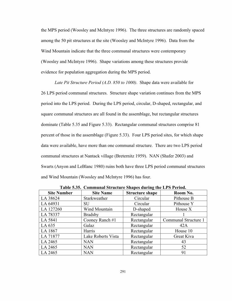
291
the MPS period (Woosley and McIntyre 1996). The three structures are randomly spaced
among the 50 pit structures at the site (Woosley and McIntyre 1996). Data from the
Wind Mountain indicate that the three communal structures were contemporary
(Woosley and McIntyre 1996). Shape variations among these structures provide
evidence for population aggregation during the MPS period.
Late Pit Structure Period (A.D. 850 to 1000). Shape data were available for
26 LPS period communal structures. Structure shape variation continues from the MPS
period into the LPS period. During the LPS period, circular, D-shaped, rectangular, and
square communal structures are all found in the assemblage, but rectangular structures
dominate (Table 5.35 and Figure 5.33). Rectangular communal structures comprise 81
percent of those in the assemblage (Figure 5.33). Four LPS period sites, for which shape
data were available, have more than one communal structure. There are two LPS period
communal structures at Nantack village (Breternitz 1959). NAN (Shafer 2003) and
Swarts (Anyon and LeBlanc 1980) ruins both have three LPS period communal structures
and Wind Mountain (Woosley and McIntyre 1996) has four.
Table 5.35. Communal Structure Shapes during the LPS Period. Site Number Site Name Structure shape Room No.
LA 38624 Starkweather Circular Pithouse B LA 64931 SU Circular Pithouse Y LA 127260 Wind Mountain D-shaped House X LA 78337 Bradsby Rectangular 1 LA 5841 Cooney Ranch #1 Rectangular Communal Structure 1 LA 635 Galaz Rectangular 42A LA 1867 Harris Rectangular House 10 LA 71877 Lake Roberts Vista Rectangular Great Kiva LA 2465 NAN Rectangular 43 LA 2465 NAN Rectangular 52 LA 2465 NAN Rectangular 91

292
Table 5.35 continued. Site Number Site Name Structure shape Room No. AZ W:10:111 Nantack Rectangular Great Kiva 1 AZ W:10:111 Nantack Rectangular Pithouse 10 LA 1113 Old Town Rectangular A16 LA 1691/LA 15002 Swarts Rectangular Room W LA 1691/LA 15002 Swarts Rectangular Room 2 LA 1691/LA 15002 Swarts Rectangular Room AE LA 9657 Sawmill/Fox Farm Rectangular Kiva LA 4424 Wheatley Ridge Rectangular House 7 LA 127260 Wind Mountain Rectangular House Y LA 127260 Wind Mountain Rectangular House U LA 127260 Wind Mountain Rectangular House XX LA 3099 WS Ranch Rectangular Kiva C LA 3274 Rectangular Xxx LA 18888 Beauregard Square Structure 1 LA 6083 Gallita Springs Square Feature 38
Communal Structure Shape during the Late Pit Structure Period
20 1
21
2
0
5
10
15
20
25
Circular Circular withlobes
D-shaped Rectangular Square
Shape
Num
ber
of st
ruct
ures
Figure 5.32. Communal Structure Shapes during the LPS Period.

293
The two Nantack communal structures are not contemporary and are the same
shape and at least two of the three LPS period communal structures identified at NAN
and Swarts are contemporary, and all of them are rectangular. While frequency data from
these sites provide evidence for aggregation, shape data, provide contradictory support
for integration at these sites. Redundancy in shape choice may indicate a degree of
integration across time. As was previously stated, shape data may be largely time
dependent and may in fact not provide a great deal of evidence specific to issues of
aggregation and/or integration.
NAN and Swarts ruins each have three LPS period rectangular communal
structures. At NAN, 43 replaced structures 52 and 91 at some point during the LPS
period. The fact that all of these structures are rectangular suggests some degree of
integration at the site, which appears to have culminated in the abandonment of two
structures in favor of a single communal structure at the site. The three Swarts communal
structures, Rooms W, AE, and 2 provide evidence similar to that found at NAN. All
three structures are rectangular and during the LPS period, AE replaced W and 2. LPS
period shape data for the Swarts structures provide evidence for some degree of social
integration at the site, which may have been an overarching presence given the fact that
even when there are multiple communal structures they are all the same shape.
As was the case during the MPS period, chronometric data for the four Wind
Mountain communal structures provide evidence that these structures were contemporary
(Woosley and McIntyre 1996). One of the structures is D-shaped and the other three are
rectangular. There is some variation in communal structure shape at Wind Mountain

294
during the LPS period, which provides additional evidence for population aggregation at
the site.
Pueblo Period
The Early Pueblo Period (A.D. 1000 to 1150). Shape data were available for
47 EP period communal structures (Figure 5.34). Shape is relatively consistent between
the LPS and EP periods (Table 5.36). Circular communal structures continue to be
relatively rare, while rectangular communal structures are the most common. Square
communal structures are also identified at EP period sites (Figure 5.34). During this
period, communal structures are frequently attached to masonry rooms. Twelve EP
period sites have two communal structures. There are three communal structures, for
which shape data are available, at Carter Ranch pueblo. Both NAN and Wind Mountain
have five EP period communal structures.
At Pine Creek, there are two EP period communal structures, Rooms 1 and 4
(Anyon and LeBlanc 1980). Room 1 is square and Room 4 is rectangular, both are
spatially separated from other structures at the site. The two structures can only be dated
between A.D. 1000 and 1150 and it is not clear if the two structures were contemporary.
As a result, shape data alone for the two structures provides evidence for aggregation at
the site. In the absence of specific chronometric data, however it is not possible to say
whether this was the case at Pine Creek.

295
Communal Structure Shape during the Early Pueblo Period
4
0 1
34
8
0
5
10
15
20
25
30
35
40
Circular Circular withlobes
D-shaped Rectangular Square
Shape
Num
ber
of st
ruct
ures
Figure 5.34. Communal Structure Shapes during the EP Period.
Table 5.36. Communal Structure Shapes during the EP Period. Site Number Site Name Structure Number Structure Shape Carter Ranch Great Kiva Circular LA 11075 Gatton's Park Circular LA 54955 TJ Circular AZ P:16:2 Tla Kii Kiva 1 Circular Carter Ranch Kiva 1 D-shaped Carter Ranch Room 16 Rectangular W:6:5 Dry Prong Kiva 1 Rectangular LA 78963 Elk Ridge Kiva Rectangular LA 635 Galaz Kiva 107 Rectangular LA 635 Galaz 73 Rectangular LA 6536 Graveyard Point Feature 8 Rectangular LA 6536 Graveyard Point Feature 9 Rectangular LA 33642 Jennie Riley Stallworth Great Kiva Rectangular LA 33642 Jennie Riley Stallworth Rectangular LA 676 Mattocks Unit 410 Rectangular LA 676 Mattocks Kiva 48 Rectangular LA 2465 NAN 58 Rectangular

296
Table 5.36 continued. Site Number Site Name Structure Number Structure Shape LA 2465 NAN 57 Rectangular LA 2465 NAN 18 Rectangular LA 3639 Pine Creek Room 4 Rectangular
LA 4986 Pueblo Lillie Allen Site Cluster/Yankee Gulch East Pithouse/Kiva 1 Rectangular
LA 5412 Redrock Rectangular LA 1118 Rock House Feature 8 Rectangular LA 1118 Rock House Feature 7 Rectangular LA 5421 Saige-McFarland Pithouse 3 Rectangular LA 66782 Sand Flat Rectangular AZ P:16:2 Tla Kii Kiva 2 Rectangular LA 16241 Treasure Hill Room 6 Rectangular LA 16241 Treasure Hill Room 8 Rectangular LA 8675 West Fork 10 Rectangular LA 8675 West Fork 6 Rectangular LA 127260 Wind Mountain House P2 Rectangular LA 127260 Wind Mountain Room 3 Rectangular LA 127260 Wind Mountain Room 15 Rectangular LA 127260 Wind Mountain Room 7 Rectangular LA 127260 Wind Mountain House V Rectangular LA 2454 Woodrow Rectangular LA 2454 Woodrow Rectangular LA 66686 Kiva Rectangular LA 6538 Diablo Feature 7 Square LA 6783 Dinwiddie Feature 14 Square LA 6783 Dinwiddie Feature 11 Square LA 2465 NAN 39 Square LA 2465 NAN 45 Square LA 3639 Pine Creek Room 1 Square
LA 4986 Pueblo Lillie Allen Site Cluster/Yankee Gulch East Pithouse/Kiva 2 Square
LA 18903 Wheaton Smith Unit 34 Square
The two EP period communal structures at Treasure Hill are both rectangular.
Rooms 6 and 8 are associated with two of the site’s roomblocks and are approximately
the same size (Anyon and LeBlanc 1980). Researchers have suggested that Rooms 6 and

297
8 were contemporary, which indicates some degree of aggregation at the site. The fact
that the two structures are the same shape is interesting and may indicate some degree of
standardization in construction. This standardization may suggest integration within an
aggregated site during the EP period.
Features 7 and 8 are the two EP period Rock House ruin communal structures
(Anyon and LeBlanc 1980). As was the case at Treasure Hill, both Rock House
structures are rectangular. Unlike the previously discussed site however, Features 7 and
8 were not coeval. The rectangular Feature 7 was constructed initially attached to the
site’s only roomblock. Feature 7 was subsequently abandoned and remodeled into the
structure referred to as Feature 8. The shape data for Features 7 and 8, when combined
with chronometric data provide evidence for social integration at the site.
At West Fork, structures 6 and 10 date to the EP period. Like many communal
structures that date to this period, both West Fork structures are rectangular (Anyon and
LeBlanc 1980; Ice 1968). A ceramic date range of A.D. 1000 to 1150 is the only one
available for structures 6 and 10 and it is not clear if these structures were contemporary.
Given the lack of chronometric dates for the West Fork structures, shape data do not
contribute additional information about aggregation or integration.
Structure 73 and Kiva 107 are two rectangular EP period communal structures
from Galaz (Anyon and LeBlanc 1984). Structure 73 is also referred to as Parrot Kiva,
because a macaw was placed into the structure upon its abandonment and destruction.
Based on the ceramic dates and construction evidence available for these two structures,
it appears that Parrot Kiva was constructed prior to Kiva 107, perhaps during the latter

298
part of the LPS period (Anyon and LeBlanc 1984:134). However, during the EP period
Kiva 107 was built. Therefore, the two structures were both were used during the EP
period. The longevity of Kiva 107’s use is supported by the fact that it was remodeled
twice during the EP period (Anyon and LeBlanc 1984:135-137). Shape data for the two
structures suggest that while integration may have been emphasized during the EP period,
given the presence of an initial communal structure. Construction of a second structure
suggests aggregation, however, the fact that they are both rectangular suggest some
degree of integration at the site.
The two unnumbered EP period Woodrow ruin communal structures are both
rectangular. The structures have not been subject to excavation and as a result, they can
only be dated generally to the EP period. While the structures are the same shape and
provide some evidence of integration (i.e., architectural standardization), lack of more
specific chronometric data make it difficult to assess these data in terms of aggregation
and integration.
At Pueblo Lillie Allen, Kivas 1 and 2 date to the EP period. Both structures are
relatively small and Kiva 1 is rectangular, while Kiva 2 is square (Kayser 1971).
Kayser’s (1971) examinations of the two communal structures led him to conclude that
the construction of Kiva 1 predated Kiva 2. At the same time, he also suggested that the
two communal structures were used at the site simultaneously. Because there are two
communal structures of different shapes, the two Pueblo Lillie Allen communal
structures provide evidence for initial integration and the site and subsequent population
aggregation during the EP period.

299
There are two EP period communal structures at Jennie Riley Stallworth. One is
a rectangular Great Kiva and the other is an unnumbered rectangular structure. Accola
and Neely (1980) provide a 100 year ceramic date range from A.D. 1000 to 1100 for the
two structures. No more specific chronometric data were available for the two structures.
While the presence of two structures at the site provides evidence for aggregation, the
fact that both structures are rectangular may suggest some degree of EP period
integration. Without more specific dates for the two Jennie Riley Stallworth communal
structures, shape data do not contribute to our understanding of aggregation or integration
at the site.
Features 8 and 9 are the two EP period Graveyard Point communal structures
(Hammack 1966). Both structures are quite small and both are rectangular. Ceramic
dates are the only ones available for the two EP period communal structures and so it is
not possible to determine whether the two were contemporaneous. Given the shapes of
the two structures, they may reflect some degree of integration at the site. However, if
they are contemporary they reflect EP period population aggregation (Anyon and
LeBlanc 1980).
In the Mimbres valley at the Mattocks ruin, there are two communal structures.
Unit 410 is rectangular. Kiva 48, the second EP period communal structure, is also
rectangular. Both of these structures are relatively small and each is associated with a
roomblock at the site. Because Unit 410 and Kiva 48 are approximately the same size
and are associated with two different parts of the site suggests that they were the physical
manifestation of aggregation at Mattocks. However, it is unclear if these small structures

300
are contemporary and the fact that they are the same shape may provide evidence for
some degree of integration at the site in the form of architectural standardization.
There are two differently shaped EP period communal structures at Tla Kii.
Kiva 1 is a circular structure and Kiva 2 is rectangular. The construction of Kiva 2 was
never completed and Kiva 1 was the only communal structure actually built and used
during the EP period. As a result, the very large, circular Kiva 1 provides evidence for
social integration at Tla Kii during the EP period.
Dinwiddie has two EP period communal structures for which shape data are
available. Features 7 and 14 are both square structures that are associated with specific
areas of the site. Based on ceramic data collected during site excavations the site has
been dated between A.D. 1032 and 1100 and the relative dates available for the structures
do overlap (Anyon and LeBlanc 1980; Bussey 1972; Linse 1999a). There are two
roomblocks at the Dinwiddie site, one eastern and one western (Anyon and LeBlanc
1980; Linse 1999a). The redundancy in shape is indicative of a social, economic, or
ritual balance of power, or of architectural standardization (i.e., integration), while the
presence of two contemporary communal structures suggests that aggregation occurred
during the EP period.
There is a great deal of shape diversity among the three Carter Ranch communal
structures. Kiva 1 is D-shaped, Room 16 is rectangular, and there is a circular Great
Kiva. Construction and chronometric data for the Carter Ranch communal structures
suggest that the Great Kiva was the first built at the site. The large circular structure was
abandoned and destroyed before Kiva 1 and Room 16 were built. As a result, of these

301
data and the shape diversity that exists at the site it appears that initial integration was
replaced by aggregation.
At NAN Ranch, the five EP period communal structures, 18, 39, 45, 57, and 58,
are square and rectangular. While not all of the structures are contemporary, as discussed
in the frequency section, shape variation is present throughout the EP period at the site.
Communal structure shape data from NAN therefore support the idea that aggregation
occurred at the site.
All five of the Wind Mountain communal structures, Houses P2 and V and
Rooms 3, 7, and 15, are rectangular. Shape standardization may provide evidence for
integration at the site, even though chronometric, location, and size data suggest that
aggregation occurred at the site. More specifically, consistency or redundancy in shape
choice may provide evidence for architectural and/or community planning (i.e.,
integration).
Late Pueblo Period (A.D. 1150 to 1400). Shape data were available for 33 ELP
period and 10 LLP period communal structures (Appendix II). An increase in
architectural variation is documented for the LP period (A.D. 1150 to 1400). Circular
(including oval) and rectangular structures are the most common shapes (Figures 5.35
and 5.36). More variation is present during the ELP period than during the LLP period
(Figures 5.35 and 5.36) This increase in structure shape variation from the ELP period
into the LLP provides evidence for aggregation during the early part of the ELP period
and integration during the LLP period.

302
Communal Structure Shape during the Early Late Pueblo Period
11
01
12
7
2
0
2
4
6
8
10
12
14
Circular Circularwith Lobes
D-shaped Rectangular Square Irregular
Shape
Num
ber o
f stru
ctur
es
Figure 5.35. Communal Structure Shapes during the ELP Period.
Early Late Pueblo Period (A.D. 1150 to 1300). Circular and rectangular
communal structures occur at almost the same frequency during the ELP period with
D-shaped, and square shapes also present. Ten of the 33 structures for which shape data
were available are the only structures at their ELP period site (Table 5.37). There are,
however, several sites with multiple communal structures. Five ELP period sites,
including Point of Pines, the Gila Cliff Dwellings, Higgins Flat, Chodistaas, and
W:10:65, have two communal structures. Taylor Draw has three ELP period structures,
Turkey Creek has four, and W:10:37 has five communal structures.

303
Table 5.37. Communal Structure Shapes during the ELP Period.
Site Number Site Name Structure Name Structure Shape LA 2949 Apache Creek Great Kiva Circular LA 4026 Goesling Ranch Circular W:10:50 Point of Pines Kiva 5 Circular
LA 1119 Small House North of Arroyo Seco Circular
LA 6565 Taylor Draw Feature 15 Circular LA 6565 Taylor Draw Feature 22 Circular LA 6565 Taylor Draw Feature 7 Circular AZ W:9:123 Turkey Creek Room 152-K1 Circular LA 8682 Higgins Flat Kiva 1 D-shaped W:10:37 Kiva 5 Irregular W:10:37 Kiva 4 Irregular LA 15075 Montoya Room 4 Oval W:10:65 Kiva 2 Oval W:10:65 Kiva 1 Oval AZ P:14:24 Chodistaas Room 2a Rectangular AZ P:14:24 Chodistaas Room 18a Rectangular LA 68188 Fox Place Rectangular LA 4913 Gila Cliff Dwellings Room 27 Rectangular LA 8682 Higgins Flat Great Kiva Rectangular AZ W:9:123 Turkey Creek Great Kiva Rectangular AZ W:9:123 Turkey Creek Room 251-K3 Rectangular AZ W:9:123 Turkey Creek Room 237-K2 Rectangular LA 3274 Rectangular W:10:37 Kiva 1 Rectangular W:10:57 Kiva 1 Rectangular LA 4913 Gila Cliff Dwellings Room 17 Rectangular AZ P:14:8 Grasshopper Spring Room 7/Protokiva Square LA 467 Hulbert Square W:10:51 Point of Pines Pithouse 13 Square LA 8891 Schoolhouse Canyon Kiva Square
LA 2112 Smokey Bear/Block Lookout Feature 4 Square
W:10:37 Kiva 3 Square W:10:37 Kiva 2 Square

304
Frequency and size data for Point of Pines have been used to support the idea that
social integration occurred at the site during the ELP period. The two communal
structures at Point of Pines are different shapes, one is circular, and the other is square.
Because the structures were not contemporary the shape data for this site do not provide
additional information about aggregation or integration. Both of the Gila Cliff Dwellings
communal structures are contemporary, rectangular, and are associated with different
parts of the site. Because the two Gila Cliff Dwellings communal structures are the same
shape, they provide evidence for some degree of integration (i.e., shape standardization)
at this ELP period site.
Shape data from the two Higgins Flat communal structures provide evidence that
initial aggregation at the site was later replaced by integration. Kiva 1 predates the Great
Kiva and the two structures are different shapes. Kiva 1 is D-shaped and the Great Kiva
is rectangular (Martin and Rinaldo 1950). The shape data alone do not provide additional
support for or challenge conclusions concerning aggregation or integration. However,
when combined with chronometric and other data, it does appear that aggregation was
replaced by integration by the end of the site’s occupational history. In terms of shape
data independently, evidence for integration is that the smaller D-shape communal
structure was replaced with a much larger rectangular Great Kiva.
As previously stated, the Chodistaas communal structures provide evidence that
population aggregation occurred at the site during the ELP period. Shape data cannot
contribute additional support for this conclusion, as both of the structures are rectangular,
and therefore may reflect some degree of integration. Both of the W:10:65 communal

305
structures are oval and dating for them is insufficient, as a result, while shape data may be
used to suggest redundancy of shape during the period, they cannot provide definitive
information about aggregation or integration at the site. Insufficient data also affects
shape data results for the Taylor Draw site. The three ELP period structures at Taylor
Draw are circular, and suggest some degree of integration however, the structures cannot
be dated relative to one another.
Of the four Turkey Creek (Lowell 1991; R. Karl, personal communication)
communal structures, three, Rooms 237-K2, 251-K3, and the Great Kiva, are rectangular
and Room 152-K1 is circular. The largest structure, the Great Kiva, is centrally located.
Again, the smaller structures are scattered throughout the site. Residents of Turkey
Creek pueblo constructed the smaller structures at the beginning of the site’s occupation
(Lowell 1991). Later, they built the larger, rectangular Great Kiva. Given the initial
communal structure shape variation, these data provide evidence for aggregation at the
site upon its establishment. Construction of a Great Kiva suggests that an aggregated
community made efforts to promote social integration during the later part of the ELP
period. The variation in communal structure shape at Turkey Creek provides evidence
for initial aggregation at the site and when combined with chronometric data support the
idea that integration also occurred at the site.
There are five ELP period communal structures at W:10:37 (Olson 1959;
Stone 2001). Chronometric data from the site provide insufficient evidence for the
contemporaneity of the structures and as a result, these data alone do not provide
evidence for either aggregation or integration at the site. Communal structure shape

306
variation, however, does provide support for aggregation at the site. Two of the W:10:37
communal structures, Kivas 4 and 5, are irregularly shaped, Kivas 2 and 3 are square, and
Kiva 1 is rectangular. The diversity in structure shape at W:10:37 can be used to
demonstrate ELP period population aggregation at the site.
Late Late Pueblo Period (A.D. 1300 to 1450). Ten communal structures from six
sites date to the LLP period (Figure 5.36). Two sites, W:10:47 and W:10:48 have a
single rectangular communal structure. There are multiple LLP period communal
structures at Point of Pines, W:10:52, and Grasshopper pueblo (Table 5.38). Data from
these sites can be used in varying degrees to provide evidence for aggregation and
integration during the LLP period. In some cases shape data compliment chronometric
and other data, in other cases, shape data contradict existing data.
Communal Structure Shape during the Late Late Pueblo Period
0 0 0
9
1
0
2
4
6
8
10
12
Circular Circular withlobes
D-shaped Rectangular Square
Shape
Num
ber
of st
ruct
ures
Figure 5.36. Communal Structure Shape during the LLP Period.

307
Table 5.38. Communal Structure Shapes during the LLP Period.
Site Number Site Name Structure Number Structure Shape LA 8780 Grasshopper Great Kiva Rectangular LA 8780 Grasshopper Room 341 Rectangular LA 8780 Grasshopper Room 246 Rectangular LA 5793 Ormand Room 79 Rectangular W:10:50 Point of Pines Kiva 1 Rectangular W:10:47 Kiva 1 Rectangular W:10:52 Kiva 1 Rectangular W:10:52 Kiva 2 Rectangular W:10:48 Kiva 1 Rectangular W:10:50 Point of Pines Kiva 2 Square
The two Point of Pines communal structures are different shapes, one being
square and the other rectangular, however, the two are not contemporary. However,
shape data does provide some evidence that the very large, 800-room community was
integrated. The original rectangular Kiva 1 was modified into a larger, square communal
structure, Kiva 2 with three internal rooms. The remodeling of a structure with four
equal sides within which there are several rooms suggests an elaboration of an integrating
communal structure. While the three internal rooms may reflect some degree of
aggregation within the community, the fact that they situated within the walls of the only
communal structure at the site may reflect a decision by three possibly autonomous
groups to reinforce solidarity (i.e., integration).
Kivas 1 and 2, the two W:10:52 communal structures, were likely contemporary
(Smiley 1952). However, because these two structures are both rectangular, shape data
may provide evidence for integration. As previously discussed, the Grasshopper
communal structures are also contemporary (Riggs 2003). All of the Grasshopper

308
communal structures are rectangular. As was the case at W:10:52 the fact that the
Grasshopper structures are contemporary provides evidence for population aggregation at
the site. However, the shapes of these structures could be interpreted as providing
evidence for social integration at the site. As stated at the beginning of the section,
redundancy in shape may provide evidence for an overarching belief system, mandating
communal structure shape. Shape similarity may also be indicative of a desire by
members of an aggregated community to assimilate.
Communal Structure Shape: A Summary
Circular communal structures are found during most of the periods at Mogollon
sites. During the EPS period, 86 percent of the structures are circular and 68 percent of
these have lobes. At the same time, there is some variation during this early period.
Shape variation continues into the MPS period and only 27 percent are circular during
this period. The percent of circular communal structure drops to 8 percent during the
LPS period and people living ion the Mogollon region begin to build many more
rectangular structures than previously documented in the region. Eighty-one percent of
LPS period communal structures are rectangular, which is a mirror image of shape
diversity during the EPS period. During the EP period, the percent of rectangular
structures drops to 72 percent, while the number of circular structures remains about the
same. Square structures become more common during the EP period as well and account
for 17 percent of the assemblage. The percent of circular communal structures increases
from previous periods during the ELP period and are 25 percent of the assemblage.
Thirty-six percent of ELP period communal structures are rectangular, which also marks

309
a change from the LPS and EP periods. There is a great deal of diversity in ELP period
communal structure shapes. This diversity does not continue into the LLP period when
no circular communal structures are present and rectangular structures account for
90 percent of the assemblage.
Shape data provide varying degrees of support for aggregation and integration at
Mogollon sites across time. In some cases, (e.g., Nantack, Gila Cliff Dwellings, and
Wind Mountain) shape data contradict other data in terms of aggregation and integration.
In other cases (e.g., Carter Ranch and NAN), shape data provide additional support for
chronometric information and other . Shape data for Mogollon communal structures do
provide some additional information about aggregation or integration in the region
(Table 5.39).

31
0
Tab
le 5
.39.
Site
s with
Evi
denc
e fo
r A
ggre
gatio
n an
d/or
Inte
grat
ion
Bas
ed o
n C
omm
unal
Str
uctu
re S
hape
Dat
a.
Pe
riod
E
vide
nce
for
aggr
egat
ion
Evi
denc
e fo
r in
tegr
atio
n E
vide
nce
for
aggr
egat
ion
then
in
tegr
atio
n
Evi
denc
e fo
r in
tegr
atio
n th
en
aggr
egat
ion
Insu
ffic
ient
da
ta
EPS
(1) T
hree
C
ircle
(1
5) B
ear,
Blu
ff, C
uchi
llo, G
alaz
, Har
ris, L
agoo
n,
McA
nally
, Mog
ollo
n, O
ld T
own,
Pro
mot
ory,
Rid
out
Locu
s, Sa
ige-
McF
arla
nd, S
U, W
inn
Can
yon,
LA
19
075
(2) C
rook
ed
Rid
ge, D
iabl
o
MPS
(1
) Win
d M
ount
ain
(7) B
lack
’s B
luff
, Gal
lita
Sprin
gs, H
arris
, Mog
ollo
n,
Old
Tow
n, T
urke
y Fo
ot R
idge
, Tur
quoi
se R
idge
LPS
(1) W
ind
Mou
ntai
n (1
6) B
eaur
egar
d, B
rads
by, C
oone
y R
anch
#1,
Gal
az,
Gal
lita
Sprin
gs, H
arris
, Lak
e R
ober
ts V
ista
, NA
N,
Nan
tack
, Old
Tow
n, S
awm
ill, S
tark
wea
ther
, SU
, W
heat
ley
Rid
ge, W
S R
anch
, LA
327
4
(1) S
war
ts
EP
(1) N
AN
(1
6) D
iabl
o, D
inw
iddi
e, D
ry P
rong
, Elk
Rid
ge, G
alaz
, G
atto
n’s P
ark,
Red
rock
, Roc
k H
ouse
, Sai
ge-
McF
arla
nd, S
and
Flat
, TJ,
Tla
Kii,
Tre
asur
e H
ill,
Whe
aton
Sm
ith, W
ind
Mou
ntai
n, L
A 6
6686
(2
) Car
ter
Ran
ch,
Pueb
lo L
illie
A
llen
(6) G
rave
yard
Po
int,
Pine
C
reek
, Jen
nie
Rile
y St
allw
orth
, M
atto
cks,
Wes
t For
k,
Woo
drow
EL
P (2
) C
hodi
staa
s, W
:10:
37
(11)
Apa
che
Cre
ek, F
ox P
lace
, Gila
Clif
f Dw
ellin
gs,
Goe
slin
g R
anch
, Gra
ssho
pper
Spr
ing,
Hul
bert,
M
onto
ya, S
choo
lhou
se C
anyo
n, S
mok
ey B
ear,
W:1
0:57
, W:1
0:65
(2) H
iggi
ns
Flat
, Tur
key
Cre
ek
(2
) Tay
lor
Dra
w, P
oint
of
Pin
es
LLP
(6
) Gra
ssho
pper
, Orm
and,
Poi
nt o
f Pin
es, W
:10:
47,
W:1
0:48
, W:1
0:52

311
Communal Structure Hearths
One interesting note in the analysis of internal communal structure features is that
it revealed that 56 percent of all communal structure hearths (67 of 119) in the database
are circular or oval (Figure 5.37) (see Creel and Anyon 2003 for a similar discussion)..
A great deal of variation is found in the remaining 44 percent. Communal structure
variation is consistent across time, although the number of hearths increases during the
Pueblo period (Figures 5.38, 5.39, 5.40, 5.41, 5.42, and 5.43). The importance of hearth
diversity as it relates to issues of aggregation and integration is discussed below.
Communal Structure Hearths
58
1
9
21
12
8
3
7
0
10
20
30
40
50
60
70
Circular D-shaped Oval Rectangular Square Unknownshape
Irregular No formalhearth
Hearth shape
Num
ber
of h
eart
hs
Figure 5.37. A General Overview of Communal Structure Hearth Shape.

31
2
Hea
rth
Shap
e du
ring
the
Earl
y Pi
t Str
uctu
re P
erio
d
024681012
Circ
ular
Rect
angu
lar
Ova
lSq
uare
No
form
alhe
arth
Shap
e
Number of structuresH
eart
h Sh
ape
durin
g th
e M
iddl
e Pi
t Str
uctu
re P
erio
d
02468
Circ
ular
Rect
angu
lar
Ova
lSq
uare
No
form
alhe
arth
Shap
e
Number of structures
Hea
rth
Shap
e du
ring
the
Late
Pit
Stru
ctur
e Pe
riod
024681012
Circ
ular
Rect
angu
lar
Ova
lSq
uare
No
form
alhe
arth
Shap
e
Number of structures
Figu
res 5
.38,
5.3
9, a
nd 5
.40.
Hea
rth
Shap
e du
ring
the
EPS
, MPS
, and
LPS
Per
iods
. D
-sha
ped,
unk
now
n sh
ape,
and
ir
regu
lar
hear
ths a
re in
clud
ed in
Fig
ure
5.37
, but
no
hear
ths o
f the
se th
ree
shap
e ca
tego
ries
are
dat
ed to
spec
ific
peri
ods.

31
3
Hea
rth
Shap
e du
ring
the
Early
Pue
blo
Perio
d
024681012
Circ
ular
Rect
angu
lar
Ova
lSq
uare
No
form
alhe
arth
Shap
e
Number of structuresH
eart
h Sh
ape
durin
g th
e Ea
rly L
ate
Pueb
lo P
erio
d
024681012
Circ
ular
Rect
angu
lar
Ova
lSq
uare
No
form
alhe
arth
Shap
e
Number of structures
Hea
rth
Shap
e du
ring
the
Late
Lat
e Pu
eblo
Per
iod
01234567
Circ
ular
Rect
angu
lar
Ova
lSq
uare
No
form
alhe
arth
Shap
e
Number of structures
Figu
res 5
.41,
5.4
2, a
nd 5
.43.
Hea
rth
Shap
e du
ring
the
EP,
EL
P, a
nd L
LP
Peri
ods.
D-s
hape
d, u
nkno
wn
shap
e, a
nd
irre
gula
r he
arth
s are
incl
uded
in F
igur
e 5.
37, b
ut n
o he
arth
s of t
hese
thre
e sh
ape
cate
gori
es a
re d
ated
to sp
ecifi
c pe
riod
s.

314
I was also interested in the relationship between communal structure shape and
hearth shape (Figure 5.44). The analysis of communal structure hearths provides
evidence that hearth shape changes through time, as does communal structure shape.
In this sample, almost all of the EPS period hearths in the assemblage are circular
(Figure 5.38). During the MPS period, all of the communal structure hearths are circular
(Figure 5.39). Hearth shape variation increases during the LPS period when circular,
square, oval, and rectangular hearths are constructed. This variation continues into the
EP period and several communal structures dating to this period have no formal hearth.
There is a slight decrease in variation during the ELP period and square communal
structures disappear from the assemblage all together. During the LLP period, circular
and rectangular hearths are found in almost equal numbers in communal structures.
Hearth shape may be time dependent as suggested by some archaeologists
(Creel and Anyon 2003; Diehl and LeBlanc 2001). However, the fact that diversity is
present may provide evidence for regional aggregation, in that people start to use all
shapes at the same time (i.e., LPS period). Ultimately, communal structure hearth shape
is somewhat useful as a measure of aggregation and integration, and provides some
supporting evidence for these phenomena in the Mogollon region as a whole.
.

31
5
Hea
rth
Shap
e an
d C
omm
unal
Str
uctu
re S
hape
0510152025
Circ
ular
Circ
ular
with
lobe
sD
-sha
ped
Rect
angu
lar
Squa
re
Com
mun
al s
truc
ture
sha
pe
Number of hearths
Circ
ular
Ova
lRe
ctan
gula
rSq
uare
Figu
re 5
.44.
Com
mun
al S
truc
ture
Sha
pe a
nd H
eart
h Sh
ape.

316
Communal Structure Orientation
As was the case for features, initially, I thought that an analysis of communal
structure orientation, based primarily on ramp entryways, would provide information
about aggregation and integration. I proposed that redundancy in orientation in multiple
contemporary communal structures would indicate integration, whereas variation would
be indicative of aggregation. Orientation data were available for 136 of the Appendix II
communal structures (Figure 5.45), with specific dates available for 126 structures. After
completing an initial analysis of structure orientation, I found that more than 68 percent
of the communal structures in this database are oriented to the East or to the Southeast
(Figure 5.45). Kang (1989:4) cites similar percentages in his study of Mogollon pit
structures. Given this result, it was clear that my expectations summarized in Table 1.1
were not necessarily supported by the orientation data. However, in some cases
communal structure orientation can be a useful measure of integration and aggregation.
In other cases, orientation data appear to contradict other data. For example, at Wind
Mountain there are nine communal structures dating from the MPS to the EP period
(Woosley and McIntyre 1996). Seven of the nine Wind Mountain communal structures
are oriented to the east (the other two are oriented to the northeast and the north),
suggesting a redundancy in communal structure orientation not found in other
characteristics of these structures.

317
Mogollon Communal Structure Orientation
5
10
54
39
13
7
4 4
0
10
20
30
40
50
60
North Northeast East Southeast South Southwest West Northwest
Direction
Num
ber
of st
ruct
ures
Figure 5.45. General Communal Structure Orientation.
Redundancy in orientation is likely related to a variety of factors. Communal
structure orientation may be indicative of regional social mechanisms in that
standardization may be promoted to emphasize group identification at a regional scale.
However, many pit structures used for habitation purposes are oriented to the east as well.
Therefore, orientation could be related to a need to maximize or minimize the amount of
sunlight/thermal energy in a particular room. In his study of thermal energy, Kang
(1989) found that east-facing structures maximize solar energy, particularly during cool

318
morning hours. It is also possible that orientation choice is related to overarching beliefs,
which would supersede other alternatives (Kang 1989:6). As previously stated, there is
some variation in communal structure orientation.
As was the case with features, there are a few examples for which structure
orientation provides supporting evidence for aggregation and/or integration at a site.
Sites with multiple communal structures with varying orientations will provide evidence
for aggregation and sites with multiple communal structures dating to several periods
with consistency in orientation will provide support for social integration.
Pit Structure Period
Early Pit Structure Period. During the EPS period, 19 of the 23 communal
structures for which orientation data are available are oriented to the east or the southeast
(Figure 5.46). Diablo, Three Circle, and Crooked Ridge all have two communal
structures dating to the EPS period. However, both of the structures as Diablo and Three
Circle are oriented to the east (Appendix II). At Crooked Ridge, structure 19, one of the
EPS period communal structures, is oriented to the east, while the other, pithouse 9, is
oriented to the southwest. The two Three Circle communal structures are contemporary
and therefore appear to provide evidence for EPS period aggregation, however the fact
that both structures are oriented in the same direction may provide some evidence for an
overarching architectural standard at the site. Chronometric data from Crooked Ridge
and Diablo were insufficient. Therefore, while the orientations of the two structures at
Crooked Ridge do vary and therefore may provide evidence for aggregation, it is difficult
to assess this because it is unclear if the structures were contemporary.

319
Communal Structure Orientation during the Early Pit Structure Period
0
2
4
6
8
10
12
North Northeast East Southeast South Southwest West Northwest
Orientation
Num
ber
of st
ruct
ures
Figure 5.46. Communal Structure Orientation during the EPS Period.
EPS period communal structure orientation data from specific sites does not
provide information about aggregation in the Mogollon region. The fact that there is
variation, as opposed to standardization, may suggest some degree aggregation in the
region during the EPS period.
Middle Pit Structure Period. Communal structure orientation during the MPS
period is quite similar to that seen during the EPS period (Figure 5.47). Again, a majority
of 10 MPS period communal structures are oriented to the southeast and east with a few
structures oriented in other directions (Figure 5.47 and Appendix II). Wind Mountain
and Harris have multiple MPS period communal structures; Wind Mountain has three and
Harris has two. The two Harris communal structures were not contemporary and as a
result do not provide information about aggregation at the site. At Wind Mountain, it

320
appears that the three MPS period communal structures were contemporary and there is
some orientation variation. House O’s orientation is only given as “east by Woosley and
McIntyre (1996). House AK is oriented at 15 degrees and House AB orientation is 117
degree (Woosley and McIntyre 1996). The variation in these three structures provides
support for aggregation in that there is no orientation standardization at the site. MPS
period communal structure orientation data is quite similar to that seen during the EPS
period and does not provide a great deal of information about aggregation.
Communal Structure Orientation during the Middle Pit Structure Period
0
2
4
6
8
10
12
North Northeast East Southeast South Southwest West Northwest
Orientation
Num
ber
of st
ruct
ures
Figure 5.47. Communal Structure Orientation during the MPS Period.

321
Late Pit Structure Period. During the LPS period, there is an increase in
communal structure orientation. While a majority of structures is oriented to the east and
southeast, some structures are oriented to the north, northeast, south, and west
(Figure 5.48). There is also an increase in the sample size for this period; orientation data
are available for 25 LPS period communal structures (Appendix II). NAN, Nantack,
Swarts, and Wind Mountain all have multiple LPS period communal structures for which
orientation data are available.
Communal Structure Orientation during the Late Pit Structure Period
0
2
4
6
8
10
12
North Northeast East Southeast South Southwest West Northwest
Orientation
Num
ber
of st
ruct
ures
Figure 5.48. Communal Structure Orientation during the LPS Period.
Two LPS period communal structures were identified at Nantack village.
However, the two structures were not contemporary and as a result, orientation data do
not provide additional information about aggregation at the site. At NAN ranch two of

322
the three LPS period communal structures were contemporary and were ultimately
replaced by a third structure. Structures 52 and 91 were coeval and varied in their
orientations. Structure 52 is oriented to the southeast at 133 degrees and structure 92 was
oriented to the east. This structure variation suggests some degree of aggregation at the
site. The two structures were subsequently replaced by structure 43, which was also
oriented to the east somewhere between 80 and 100 degrees (Burden 2001; Shafer 2003).
Orientation data for NAN’s communal structures provides evidence for early PS period
aggregation, which was replaced by social integration manifested in the form of a
communal structure oriented to the east.
At Wind Mountain, orientation data are available for Houses XX, U, X, and Y.
House XX has a northeastern orientation of 66 degrees, House U has an orientation of 85
degrees, House X is oriented to the east-southeast at 102 degrees, and House Y is
oriented to the south with a 188 degree orientation. Because these structures vary in their
orientation from northeast to south, they do provide evidence of some degree of
aggregation at the site during the LPS period.
As was the case during the EPS and MPS periods, structure orientation does not
provide a great deal of information about aggregation and/or integration. However, data
for the LPS period provided more information than the previous periods. These data also
contributes evidence for an increase in general communal structure orientation, these data
can be used to support the idea that population aggregation increased in the Mogollon
region during the LPS period.

323
Pueblo Period
Early Pueblo Period. Orientation data were available for 36 EP period communal
structures (Figure 5.49). Tla Kii, Carter Ranch, Wind Mountain, Woodrow, Pueblo Lillie
Allen, and Dinwiddie have multiple communal structures oriented in the same direction
(Appendix II). These structures provide evidence for some degree of integration or at
least some degree of architectural standardization at these six EP period sites. At the
Graveyard Point, Galaz, West Fork, Mattocks, Rock House, Treasure Hill, and Pine
Creek, have two EP period communal structures oriented in different directions. Because
it is not clear if the Graveyard Point, West Fork, Mattocks, and Pine Creek structures
were contemporary it is not possible to discuss the orientation of these structures as
related to issues of aggregation and integration.
Communal Structure Orientation during the Early Pueblo Period
0
2
4
6
8
10
12
North Northeast East Southeast South Southwest West Northwest
Orientation
Num
ber
of st
ruct
ures
Figure 5.49. Communal Structure Orientation during the EP Period.

324
Structure 73 and Kiva 107 at Galaz are contemporary. Structure 73 is oriented to
the east, while Kiva 107 is oriented to the northeast. Orientation variation at Galaz
suggests some degree of aggregation. At Rock House, the southwest oriented Feature 8
replaced the northeast oriented Feature 7 during the EP period. Because the Rock House
communal structures are not coeval they provide evidence for integration at the site, the
variation in orientation is curious because at an integrated site one would expect to find
consistency. It is possible that at Rock House two aggregated communities were present,
but in an effort to promote integration at the site only one of the communities maintained
the communal structure. Rooms 6 and 8 at Treasure Hill were contemporary and Room 6
is oriented to the south while Room 8 is oriented to the west. Because the structures were
contemporary, and vary in their orientation, they do provide evidence for aggregation at
this EP period site.
Structures 39, 45, 58, 57, and 18 at NAN date to the EP period and are included in
the orientation analysis. Three of the structures are oriented to the northeast/southwest
and two are oriented to the east. Not all of these structures were coeval. Structures 39,
18 and 58 were contemporary as were 45 and 58. Structure 57, which is oriented to the
northeast/southwest, was destroyed in a fire and structure 18, oriented in the same
direction was built atop the destroyed structure. When 18 was subsequently destroyed,
structure 45, oriented to the east, was built atop it. The presence of two communal
structure orientations and variation from structure to structure across time suggests some
degree of aggregation at the site during the EP period.

325
Late Pueblo Period.
As was the case during earlier periods and eastern or southeastern orientation
continues to be the preference for Mogollon communal structures, although there is some
variation present.
Early Late Pueblo Period. Orientation data are available for 24 ELP period
communal structures (Figure 5.50). Multiple communal structures with available
orientation data are identified at six sites. The Hough site, Taylor Draw, Chodistaas, and
the Gila Cliff Dwellings all have two structures, while Higgins Flat and Turkey Creek
have three and there are five at W:10:37 (Appendix II).
Communal Structure Orientation during the Early Late Pueblo Period
0
2
4
6
8
10
12
North Northeast East Southeast South Southwest West Northwest
Orientation
Num
ber
of st
ruct
ures
Figure 5.50. Communal Structure Orientation during the ELP Period.
326
All of the Hough, Chodistaas, Gila Cliff Dwellings, and Turkey Creek are
oriented to the southeast (Figure 5.50 and Appendix II). Redundancy in communal
structure orientation within these sites suggests some degree of integration, even in cases
where the communal structures are contemporary and appear to reflect aggregation
(e.g., Chodistaas and the Gila Cliff Dwellings). Communal structure orientation variation
is however present at Taylor Draw, Higgins Flat, and W:10:37.
There are two communal structures at Jornada Taylor Draw, Features 7 and 15.
Feature 7 is oriented to the northwest, while 15 is oriented to the southwest. There are
about 60 rooms and three communal structures at the site, although orientation data are
available for only two of the three. It is not clear if the ELP period communal structures
were coeval and as a result while orientation variation provides evidence for aggregation
at the site it is not possible to definitively say that this is the case.
Orientation data are available for the three ELP period Higgins Flat communal
structures, Kivas 1 and 2 and the Great Kiva. Kiva 1 and the Great Kiva are oriented to
the southeast and Kiva 2 is oriented to the east. Kivas 1 and 2 were coeval and preceded
the construction of the Great Kiva at the site. Orientation variation between the two
coeval communal structures suggests aggregation initially occurred at the site. The
replacement of these structures with the Great Kiva provides evidence for integration.
Orientation data from Higgins Flat provide evidence for aggregation and subsequent
integration.
Kivas 1, 2, 3, 4, and 5 date to the ELP period at the 40-room W:10:37. Kivas 2, 3,
and 4 are oriented to the east, while Kivas 1 and 5 are oriented to the south. Orientation

327
variation provides evidence for some degree of aggregation at the site because the
structures were coeval.
Late Late Pueblo Period. Kivas 1 and 2 at Point of Pines are both oriented to the
southeast providing evidence for integration at the site. Similarly, the three Grasshopper
communal structures are oriented to the east, providing evidence for some degree of
integration even at a site with other evidence for aggregation. The only LLP period site
with two communal structures oriented in different directions is W:10:52. Kiva 1 is
oriented to the east, while Kiva 2 is oriented to the southwest. It is unknown if the
W:10:52 structures were coeval so it is not possible to state whether or not the structure
variation present at the site reflects aggregation.
Communal Structure Orientation during the Late Late Pueblo Period
0
2
4
6
8
10
12
North Northeast East Southeast South Southwest West Northwest
Orientation
Num
ber
of st
ruct
ures
Figure 5.51. Communal Structure Orientation during the LLP Period.

328
As previously stated, the majority of the Appendix II sites are oriented to the east
or southeast (Figure 5.45). While an eastern orientation is the most common, communal
structure orientation does vary to some degree throughout the Pit Structure and Pueblo
periods (Figures 5.46, 5.47, 5.48, 5.49, 5.50, and 5.51). Interestingly, we begin to see
more ramps orientated in directions other than east and southeast during the LPS and EP
periods (Figures 5.48 and 5.49). During the EP period, the most communal structure
orientation variation occurs (Figure 5.49). However, some degree of variation continues
through the ELP and LLP periods (Figures 5.50 and 5.51).
Given the results of this limited analysis of communal structure orientation, an
eastern or southeastern orientation appears to have been the preference for residents of
the Mogollon region. However, a great deal of variation does exist, and may reflect some
degree of population aggregation across all periods. Variation may also be a result of a
lack of standardization, thus also supporting the contention that aggregation occurred
throughout the Mogollon region from the EPS period to the LLP period. However,
orientation may simply not be a useful measure of aggregation and integration.
Wall Construction Technique
Construction data, more specifically, building materials, were collected for the
communal structures included in this analysis to provide information about aggregation
and integration in Mogollon communities (Appendix II; Table 1.1). To summarize
briefly the expectations outlined in Table 1.1, I propose that redundancy across time or at
the same time within sites in the construction techniques used to erect communal

329
structures would reflect integration. Variation in wall construction materials for
contemporary communal structures at a single site is indicative population aggregation.
Construction data were available for 78 of the Appendix II communal structures,
and specific dates were available for 73 of those structures (Figure 5.52). I used data
reported by researchers in published and unpublished reports, articles, and field notes.
The five categories reported were adobe, bermed, earthen, masonry, and adobe and
masonry (Figure 5.52).
Communal Structure Wall Construction Materials
0
5
10
15
20
25
EPS MPS LPS EP ELP LLP
Period
Num
ber
of st
ruct
ures
AdobeMasonrySubsurface earthen wallsMasonry and AdobeBermed
Figure 5.52. Communal Structure Wall Construction Materials by Period.

330
Adobe walls refer to those walls constructed from adobe itself, not adobe plaster.
Bermed wall consist of mounded or banked earth. Earthen walls are those identified in
subterranean structures that have been excavated into the natural soils and bedrock.
Earthen walls can be plastered or unplastered. The materials used to construct masonry
walls vary from place to place depending on resource availability, these walls may also
be plastered. Adobe and masonry walls are those constructed with a combination of the
two materials. While adobe and masonry walls are the most common across time, there
is some variation that may be related to issues of aggregation and integration.
Figures 5.53 and 5.54 illustrate variation in communal structure wall construction
materials from the Pit Structure to Pueblo periods. One of the most obvious differences
in communal structures from the Pit Structure to Pueblo periods is the presence of a
majority of subterranean structures during the former period (Figures 5.53 and 5.54).
Some degree of variation exists across all periods, although relatively little material
diversity is present during the MPS, ELP, and LLP periods. The most variation exists
during the LPS and EP periods.
During three of the six periods, some form of masonry was the most common
wall construction material (Figures 5.52, 5.53, and 5.54). Interestingly, masonry-walled
communal structures are first evidenced at Saige-McFarland during the EPS period,
several hundred years before the construction of masonry-walled above ground
roomblocks. Masonry was not the only construction material used by people living in the
Mogollon region and many structures in the sample were excavated into native clays or
bedrock and subsequently plastered with adobe (Figure 5.52).

331
Except for recent information presented by Creel (1999c) and Anyon and Creel
(2003), it is difficult to associate any particular construction techniques with communal
structures. Creel (1999c) suggests that certain communal structures are constructed with
a predetermined plan for destruction. Purposeful destruction of communal structures is
discussed in a subsequent section. I did find in my analysis of construction materials that
these data were not always useful measures of aggregation and/or integration. In many
cases, sites with multiple communal structures had construction data for only one of the
structures. In other cases, very general descriptions of the construction materials were
provided by researchers, which made it difficult to discuss between structure variation,
which was thought to provide evidence for aggregation and/or integration.

33
2
Com
mun
al S
truct
ure
Wal
l Con
stru
ctio
n M
ater
ials
durin
g th
e EP
S pe
riod
0123
Ado
beM
ason
rySu
bsur
face
ear
then
walls
Mas
onry
and
Ado
beBe
rmed
Mat
eria
l
Number of structures
Co
mm
unal
Stru
ctur
e W
all C
onst
ruct
ion
Mat
eria
ls du
ring
the
MPS
Per
iod
0123
Ado
beM
ason
rySu
bsur
face
ear
then
walls
Mas
onry
and
Ado
beBe
rmed
Mat
eria
ls
Number of structures
C
omm
unal
Str
uctu
re W
all C
onst
ruct
ion
Mat
eria
ls d
urin
g th
e LP
S Pe
riod
012345678
Ado
beM
ason
rySu
bsur
face
ear
then
walls
Mas
onry
and
Ado
beBe
rmed
Mat
eria
ls
Number of structures
Fi
gure
5.5
3. P
it St
ruct
ure
Wal
l Con
stru
ctio
n M
ater
ials
.
Com
mun
al S
truc
ture
Wal
l Con
stru
ctio
n M
ater
ials
dur
ing
the
EP P
erio
d
0510152025
Ado
beM
ason
rySu
bsur
face
ear
then
walls
Mas
onry
and
Ado
beBe
rmed
Mat
eria
ls
Number of structures
C
omm
unal
Stru
ctur
e W
all C
onst
ruct
ion
Mat
eria
ls du
ring
the
ELP
Perio
d
024681012
Ado
beM
ason
rySu
bsur
face
ear
then
wal
lsM
ason
ry a
nd A
dobe
Berm
ed
Mat
eria
ls
Number of structures
Co
mmun
al St
ructu
re W
all C
onstr
uctio
n Mate
rials
durin
g the
LLP
Perio
d
0123456
Adob
eM
asonr
ySu
bsurfa
ce ea
rthen
walls
Maso
nry a
nd A
dobe
Berm
ed
Mate
rials
Number of structures
Figu
re 5
.54.
Pue
blo
Wal
l Con
stru
ctio
n M
ater
ials
.

333
The “Closing” of a Communal Structure
In a 2003 article, Anyon and Creel discuss the purposeful destruction of some
Mimbres Mogollon communal structures. They provide evidence that in some cases
communal structures were built with destruction in mind, and when they had served their
purpose within their communities, they were either collapsed or burned, often after
dedicatory items had been placed within their walls. It is possible that the purposeful
destruction of communal structures was a practice only associated with the ancient
Mimbreños, but it is also possible that such “rituals” occurred in other areas of the
Mogollon region as well. These data may be related to aggregation and integration and
for this reason, I looked for evidence of burning and/or what was described as purposeful
dismantling of Mogollon communal structures (Table 5.40).
Table 5.40. Evidence for Burning and Dismantling of Mogollon Communal Structures.
Not Burned Burned Evidence for intentional burning Dismantled
52 19 11 3 I proposed that the destruction of a communal structure is associated with issues
of aggregation and integration. If multiple communal structures are used at a site
simultaneously and have no evidence of dismantling or burning, they are likely indicative
of aggregation at the site. If, however, one communal structure is destroyed at a site
before a new one is built and used it can indicate social integration in that the people
living within a community feel that one communal space must be “closed” before a new
one can take its place (see Creel and Anyon 2003). Evidence for burning and other kinds

334
of destruction, or lack there of, was available for 85 of the Appendix II communal
structures and specific dates were available for 77 of the 85 structures.
The majority of structures, 61 percent or 52 of the 85 structures, were not burned,
19 structures burned, 11 structures were reported to have been intentionally burned
(e.g., vidence for the cleaning out of structures prior to fire, the presence of fuels placed
in the structures) (Table 5.39). Three of the 85 structures including the Great Kiva at
Ormand (Hammack et al. 1966; Wallace 1998), communal structure 1 at Cooney Ranch
#1 (Stokes 2000b), and Room 152-K1 at Turkey Creek (Lowell 1991) were dismantled as
reported by researchers based on removal of center posts and other construction materials
and the purposeful collapse of structure walls.
The intentional dismantling of Room 97 at the Ormand site is evidenced by the
fact that the roof, posts, and artifacts were removed. Upon its abandonment, residents
removed the center posts and all roof materials. While the structure was not burned, it
likely collapsed when construction materials were removed (Hammack et al. 1966:32;
Wallace 1998:167).
Stokes (2000b:28) states that Communal Structure 1 was initially abandoned
sometime near the end of the LPS period or early EP period. This structure was
subsequently “completely dismantled” at some point during the EP period, based on the
presence of diagnostic sherds found in the fill within the structure (Stokes 2000b:28).
Room 152-K1 at Turkey Creek (Lowell 1991) was covered with rooms prior to the
construction of another ELP period communal structure.

335
In some cases, (e.g., Feature 4 at the Smokey Bear ruin, A-16 at Old Town,
Room 1 at NAN, and communal structure 73 at Galaz) structures appear to have been
ritually “closed” prior to their intentional burning (Creel and Anyon 2003). These kinds
of rituals include filling sipapus with crystals and white sand, placing dedicatory or
termination objects (e.g., bird burials) in the corners or floors of the structures, and
placing caches of items (e.g., crystals, shells, and pots) on the structure floors before or
after they burned.
Researchers have provided evidence for the burning of Mogollon communal
structures across time (Figure 5.55). A structure burning either before its abandonment
or after is not uncommon (Figure 5.55 and Appendix II). Information that relates to
arguments made by Anyon and Creel (2003) is evidence for purposeful burning and/or
intentional destruction of a communal structure (Figures 5.56 and 5.57). These data do
relate to aggregation and integration in that there are some sites (e.g., Old Town and
Galaz) with evidence for the destruction of a communal structure prior to the construction
of another one at the site (i.e., evidence for integration). However, destruction data were
not as helpful in terms of identifying aggregation and integration as I had hypothesized.
This is largely, because there are limited examples of such activity and very few sites
have multiple contemporary communal structures with evidence for variation in
destruction. I do provide evidence for sites with these kinds of data that can be used to
discuss aggregation and integration after I discuss one other characteristic related to
destruction/dismantling of a communal structures, that of burials.

336
Communal Structure Burning by Period
0
2
4
6
8
10
EPS MPS LPS EP ELP LLP
Period
Num
ber
of st
ruct
ures
Figure 5.55. Evidence for Communal Structure Burning.
Evidence for Intentional Burning by Period
0
1
2
3
4
5
EPS MPS LPS EP ELP LLP
Period
Num
ber
of st
ruct
ures
Figure 5.56. Intentionally Burned Communal Structures by Period.

337
Dismantling
0
1
2
3
4
EPS MPS LPS EP ELP LLP
Period
Num
ber
of st
ruct
ures
Figure 5.57. Evidence for Communal Structure Dismantling by Period.
Burials
Throughout the course of the research conducted for this study, I found evidence
for many burials within communal structures, more than in habitation rooms. I propose
that burials are also an indicator of the ritual closing of a communal structure and, to
some degree, aggregation and integration. Twenty-one of the communal structures in
Appendix II have between 1 and 58 burials in them for a total of 129 burials
(Figure 5.58). The majority of the internments appear to have coincided with the burning
of the structure. In fact, one communal structure, 42A at Galaz, with evidence for
intentional burning holds 58 of the 129 reported burials (although 55 were post-
abandonment internments) (Appendix II).

338
Burials
0
2
4
6
8
10
EPS MPS LPS EP ELP LLP
Period
Num
ber
of st
ruct
ures
Figure 5.58. Evidence for Burials within Communal Structures. Counts do not include structures with multiple burials.
As was the case with burning and purposeful destruction, the importance of
burials within the walls of a communal structure provides information about aggregation
and integration in Mogollon communities. In terms of aggregation and integration,
burials are a focus because the use of a communal structure for burial purposes may
reaffirm that person’s connection to that structure and/or to their community. If the
residents of a community destroy one communal structure, and/or use it for burials (such
that it could not be reused) before building a new structure, there are indications of social
integration at the site. If there are multiple communal structures at the site and
abandonment/termination rituals vary from structure to structure, these data provide
evidence for population aggregation. The Mimbres valley Old Town site provides a good
example of a cycle of construction and destruction in a Mogollon community.

339
Intentionally Burned Communal Structures
At Old Town, the three Pit Structure period communal structures were all built in
the same location within the community; the MPS period structure was built atop the EPS
period structure and the LPS period structure atop the MPS period structure (Creel 2000).
At the end of the LPS period, after remodeling the structure at least twice, members of
the community filled the sipapus with white quartz sand, placed termination objects in the
corners of the structure (including an owl burial), burned A16, and while it was burning
collapsed the walls into the structure (Creel 1998, 1999a, 2000). At this site, the
communal structure was built and destroyed in the same place for several hundreds of
years and was destroyed at the end of the occupation of this area of the site (Creel 1997,
1998, 1999a). The construction and destruction of Old Town’s three communal
structures provide evidence for social integration at the site.
NAN site communal structure construction and destruction also seems to relate to
aggregation and integration. Room 18 was built atop the smaller, burned Room 57 and
Room 45 was constructed on top of 18 when it was also subsequently destroyed by fire
(Shafer 2003). In addition, termination also appears to be important at NAN and both of
the LPS period communal structures, 52 and 91, were burned at the end of the period
(Shafer 2003). Structure 52 was burned using cornhusks as fuel and then filled with
gravel and termination objects (Burden 2001; Shafer 2003). Subsequently, the structure
was the burial place for at least six people (Burden 2001; Shafer 2003). When structure
91 was abandoned the sipapu was filled with white sand and a red seed jar with 412
amethyst crystals was buried below the floor before the structure was burned

340
(Burden 2001; Shafer 2003). The destruction of these LPS period communal structures
provides evidence for both aggregation and integration. The variation in termination
objects, the use of cornhusks as fuels in structure 52 and not in 91, and filling of structure
52 provide evidence for aggregation within the community in that these are evidence of
diversity at NAN. The fact that members of the community participated in the
destruction of the two structures and conducted rituals to “close” structures 52 and 91
provides evidence for social integration, similar to that seen at Old Town, within an
aggregated community.
At the Galaz site, three of the four communal structures were purposefully
destroyed (Anyon and LeBlanc 1984). Structure 8 dates to the EPS period. Prior to
abandonment, a crystal was placed in the center posthole after it was removed and the
structure was burned (Anyon and LeBlanc 1984). Data from the LPS period structure
42A provide an exceptional example of the destruction of a Mimbres valley communal
structure. Two decapitated infant burials and one additional burial were found in the
purposefully burned 42A (Anyon and LeBlanc 1984). Subsequently, archaeologists
uncovered 55 post-abandonment burials dating to the end of the LPS period within 42A.
The burials marked the complete closure of this communal structure was truly at this
point and it was never used again (Anyon and LeBlanc 1984). The use of structure 42A
for so many internments may indicate a change in social integration as well because these
55 people may have been important members of an integrated community buried within
the walls of the structure that was used to integrate their LPS period community.

341
During the EP period, residents of the community destroyed a third Galaz
communal structure. Structure 73 is also known as Parrot Kiva because a macaw, with
turquoise and shell wrapped around its legs, was placed, as a dedicatory object after the
structure was burned (Anyon and LeBlanc 1984). The consistency in the “closure” of
communal structures with dedicatory items, burials, and burning provides evidence for a
history of integration at the site.
While most of the evidence for purposeful destruction of communal structures
comes from sites located in the Mimbres valley, the LLP period Smokey Bear ruin
provides evidence for termination practices in the Jornada region (Wiseman 1976).
Feature 4, an ELP period communal structure, was intentionally burned but only after the
sipapu was covered with a crystalline aragonite stone and “many dedicatory effects” had
been placed in the structure (Wiseman 1976:32). The burning of the Smokey Bear
communal structure also includes six cremations and nine burials (Wiseman 1976).
The fact that Feature 4 is the only communal structure at the site provides evidence for
integration, but the additional “closing” rituals associated with the structure provide
additional support for integration. Again, the use of the structure for burials, and indeed
for so many burials, also provides evidence for the communal importance of Feature 4.
All of the evidence for purposeful communal structure destruction can be related
specifically to population aggregation and social integration. Eleven structures including
A67, A16, and A71 from Old Town, structures 18, 52, 57 and 91 from NAN, Communal
structures 8, 42A, 73 at Galaz, and Feature 4 at Smokey Bear have evidence for
intentional burning. The Cooney Ranch #1, Ormand, and Turkey Creek sites have

342
communal structures that had evidence for intentional dismantling. The majority of sites
with evidence for destruction are in the Mimbres valley, which provides evidence for
some degree of social integration in the area. At these sites, evidence for integration is
that the communal structures are destroyed using techniques/rituals (e.g., bird burials,
crystals, sand filled sipapus, and human internments) not evidenced in other areas of the
Mogollon region. In destroying a communal structure, by fire or purposeful dismantling,
particularly a large one like Parrot Kiva and A16, is not an easy task, the act of
destruction itself provides evidence for integration. In this instance, group affiliation is
reaffirmed via participation in the dismantling and/or destruction of a community’s
communal structure.
Destruction, dismantling, burning, and burial data also provide evidence for
aggregation in that there is variation in termination practices between sites. For instance,
at some sites (e.g., Old Town), location preferences were so important that residents
destroyed older communal structures to build new ones in the same places. At other sites
(e.g., NAN), communal structure location was not necessarily important, but the
destruction of previously used communal structures is done before a new one is built. At
some sites (e.g., Galaz) communal structures are used for burials, while at others they are
not. Finally, while there are bird burials at two sites, Old Town and Galaz, two different
birds (one macaw and one owl) were buried. These examples of diversity do provide
evidence for regional population aggregation within the area.

343
The Analysis of Mogollon Communal Structures: A Summary
The communal structure characteristics initially listed in Table 1.1 were intended
to measure aggregation and integration. The analysis of these characteristics presented in
this chapter revealed that three characteristics, frequency, location, and size, were the
most useful measures of population aggregation and social integration (Table 5.41).
Table 5.41. Summary of Measures of Aggregation and Integration. Measure Aggregated Integrated
Frequency: The most useful measure of aggregation and integration, frequency based on dating was a prerequisite for all other measures.
Multiple contemporary communal structures.
Fewer communal structures at a site; in most cases only one structure at a site, regardless of site size.
Location: Useful when frequency was known.
Multiple structures associated with particular areas of a site.
Centrally, prominently, spatially separate, or isolated from other structures at a site.
Size: Useful when frequency was known.
Variability in communal structure size when multiple contemporary structures present.
Usually a large structure, although communal structure size is often relative to site size.
Shape: Useful when frequency was known.
Variation in contemporary communal structure shape at a single site; sometimes contradicted other characteristics.
This characteristic is not revealing at a site level, because there is only one contemporary communal structure but reflects integration across time at a site and may reflect some degree of regional integration.
Wall construction technique/materials: Not a particularly useful measure, largely because of a lack of detailed data. Useful when frequency was known.
Frequently little variation from structure to structure at the same site.
Interesting at sites with a single communal structure with construction material variation. Potentially useful at a regional level.
Hearth shape: A useful measure for communal structures characterization. Useful when frequency was known.
In many cases, hearth shape did not vary a great deal from structure to structure. In some cases, this characteristic did support other data.
This characteristic is not necessarily revealing at a site level but can reflect architectural standardization at a regional level.
Orientation: Not a particularly useful measure. Useful when frequency was known.
Orientation varied among contemporary communal structures; in some cases contradicted other data.
This characteristic is not revealing at the site level but may be used to support regional integration.

344
Communal Structure Frequency
Communal structure frequency was the most important of all of the characteristics
used to measure population aggregation and social integration. Chronometric data from
the 110 sites provided information that some sites have more contemporary communal
structures than others do, and that communal structure frequency does change through
time. At many sites, ceramic dates were the only ones available for communal structures
(Appendix II); therefore, in some cases it was difficult to determine whether structures
provided evidence for aggregation or integration. Some researchers (Bussey 1972; Dycus
1997) provide detailed construction histories for the communal structures they identified
at the sites they studied (e.g., Lee and Diablo villages respectively); these data were very
helpful in assessing population aggregation and social integration.
In general, expectations regarding frequency data were that sites with multiple
contemporary communal structures were aggregated, because the structures reflect
segregation and/or segmentation within a community. Integrated sites have few
contemporary communal structures, most commonly only one, as having fewer structures
encourages social solidarity. Results from frequency data presented in Table 5.9 showed
a majority of sites with evidence for social integration.
There were also data suggesting that at some sites aggregation was common
sometimes across time. At other sites, aggregation was eventually replaced by, or
complemented with, social integration. A detailed investigation of communal structure
dates, or more specifically chronometric data, eliminated some sites from the analyses.

345
Chronometric data provided information about population aggregation and social
integration in the Mogollon region across time. A majority of Mogollon sites have only
one communal structure. When the percent of sites with one structure is combined with
sites with multiple non-contemporary communal structures the percent of sites with
evidence for integration increases There are, however, sites with evidence for
aggregation during most periods as well. During the EPS period, six percent of sites have
frequency data for aggregation; this percentage increases to 13 percent during the MPS
period and drops to nine during the LPS period. During the EP period, traditionally
believed to be the period during which population growth affected the Mogollon region,
the percent of aggregated sites is only eight percent. During the ELP period, 14 percent
of sites in the assemblage have frequency data supporting aggregation. No LLP period
sites have evidence for aggregation alone, although the three Grasshopper communal
structures support the idea that residents mitigated population aggregation within their
community by constructing a large Great Kiva to promote integration
Frequency data provide evidence for social integration at a majority of sites across
time. During the Pit Structure period, the percent of sites with only one contemporary
communal structure is the same for the EPS and LPS periods, with only a slight decrease
during the MPS period. At the same time, a decrease in the percent of sites with evidence
for integration during the EP period provides evidence that aggregation. Combinations of
aggregation and integration became more common during this period and continued into
the ELP period. During the LLP period however, the percent of sites with one communal
structure (including those sites with multiple non-contemporary communal structures) is

346
80 percent, very similar to those calculated for the Early and Late Pit Structure period.
Ultimately, the fact that statistically I was unable to disprove the null hypothesis using
both t-tests and an ANOVA supports my argument that social integration was common
across time and throughout most of the Mogollon region.
Communal Structure Location
The second measure of aggregation and integration considered was communal
structure location. Location is important because the placement of a communal structure
within a community provides information about facility accessibility or lack thereof. For
example, a communal structure located within an enclosed roomblock provides easy
accessibility for the inhabitants of the roomblock and limits or at least provides for
monitoring of access, to the structure. In contrast to that, a centrally/prominently located
communal structure helps to promote social integration, because it becomes a focal point
for community activities and rituals. In this study, aggregated sites had multiple
communal structures attached to or located close to a roomblock or section of the
community with which they are associated. Integrated communities commonly had one
structure, situated in a central or prominent location. Spatially separated or isolated
communal structures also reflect integration because they are accessible to an entire
community or communities.
As was the case with frequency data, communal structure location information
provides support for social integration at a majority of Mogollon sites across time and
space. While location data were more limited than frequency data (i.e., these data were
available for 127 structures), they did provide additional information about aggregation

347
and integration across time. Isolated, prominent, and spatially separate communal
structures all provided support for social integration. I proposed that communal
structures attached to or associated with particular areas of a site supported population
aggregation. Initial counts suggested an almost even split between aggregated and
integrated sites.
Sixty-two communal structures fall into the associated category. Fifty-two of the
structures are in prominent locations at the site. When these 52 structures are combined
with the three isolated and 10 spatially separate structures, they account for 51 percent of
the assemblage. However, a more detailed analysis of location data provided more
support for the presence of social integration at a majority of sites. Some of the
associated structures were associated with a single roomblock or with a very small pit
structure site (e.g., the Fox Place communal structure, Room 7 at Grasshopper Springs,
Features 7 and 8 at Rock House). These structures therefore provide evidence for social
integration at these sites. While location data in general provided a great deal of evidence
for integration, there were sites with location data suggesting aggregation occurred at
several Mogollon sites (e.g., Galaz, Lee, NAN, Gila Cliff Dwellings). In some cases
(e.g., Wind Mountain), these data provide evidence for population aggregation across
time at individual sites.
Communal structure location data suggest that aggregation became a visible
influence as early as the Early Pit Structure period. This trend continues into the LPS
period, when the percentage increases to 20 and remains relatively stable into the EP and
ELP periods. It is not until the Late Late Pueblo period when evidence for aggregation

348
seems to disappear, although Grasshopper pueblo provides evidence for initial
aggregation and subsequent integration during this period.
Communal Structure Size
Communal structure size was the third characteristic selected to measure
population aggregation and social integration. More size data were available for
Mogollon communal structures than were location data (n = 164). The size of a
communal structure is important because smaller structures allow for fewer participants,
while larger facilities provide space for more people to take part in communal activities,
rituals, and events. The initial hypothesis was that aggregated communities would have
multiple relatively small contemporary structures. In contrast, integrated communities
should have fewer, larger communal structures. Very large communal structures situated
at sites that were relatively small might have integrated larger numbers of people possibly
from other communities.
As was the case with chronometric and location data, size data were particularly
useful at sites with multiple structures, because these data provided additional evidence
for integration and aggregation at sites where the two occurred simultaneously or
sequentially. Size data suggest that at some sites with two or more communal structures
(e.g., Galaz, Grasshopper, and NAN); one of the structures is very large, thus providing a
place for social integration within an aggregated community. It should also be noted that
in many cases communal structure size was independent of village size (Appendix II).
That is, some relatively small sites had extremely large communal structures

349
(e.g., Bear and Dry Prong). As was the case with frequency and location data, size data
supported the idea that people living at the majority of sites were socially integrated.
Results from the analysis of size data closely resembled those of location,
although there is some variation. However, size data are important because they provide
additional information about aggregation and integration. There is at least one site dating
to each of the Pit Structure and Pueblo periods with evidence for population aggregation,
although most sites provide evidence for the importance of social integration across time
throughout much of the Mogollon region. Interestingly, size data suggest that at Galaz,
Grasshopper, NAN, and Black’s Bluff aggregation and integration occurred
simultaneously. In these cases, there are multiple contemporary smaller communal
structures along with one large structure.
Communal Structure Shape
Communal structure shape was a somewhat less useful measure of aggregation
and integration. However, shape data from 149 communal structures were available.
Sites with a single communal structure did not necessarily contribute to a better
understanding of aggregation and integration. However, shape data for sites with
multiple communal structures were more helpful. Certain shapes are common during
particular periods. For example, circular structures with lobes are only present during the
EPS period; rectangular communal structures become most common during the LPS
period and are the most common across time.

350
I initially suggested that shape variation would reflect social diversity within a
community, that people aggregating on the landscape would build different communal
structure shapes at a single site. In some cases, shape data provided supplemental
information about other characteristics (e.g., frequency, location, and size). In these
cases, sites with multiple communal structures had structures that were identical in shape
(e.g., Grasshopper, NAN, Turkey Creek, and Wind Mountain). This is interesting
because these data can be used to suggest that even at aggregated sites some degree of
integration, manifested in architectural standardization, exists. It may also be that
communal structure shape is related to architectural choices that supersede diversity
(i.e., rectangular structures connected to rectangular roomblocks). Shape data were
useful in that they did provide information about the potential for aggregation and
integration to occur simultaneously, while there may be multiple communal structures at
a site (i.e., aggregation) they may all be the same shape (i.e., integration). These data
also revealed patterns and trends in communal structure shape across time at the
community (e.g., NAN, Old Town, and Wind Mountain) such that shape does not
necessarily remain consistent across time even at an integrated site.
Communal Structure Wall Construction
Wall construction technique was a characteristic that was not very effective for
measuring aggregation and integration. Wall construction data were relatively limited,
available for only 73 of the 206 structures in the Appendix II database. Site reports,
articles, and existing databases did not frequently include these data. While the geology
and ecology of the Mogollon region are somewhat diverse and therefore a variety of

351
materials may be used to build a communal structure, construction patterns were largely
redundant throughout the region. People typically used adobe plaster to line their
subterranean communal structures or some form of cobble stone masonry with adobe
plaster to construct semi-subterranean, subterranean, and aboveground structures. These
structural consistencies may be coincidental, they may be a result of a shared common
background among people living in the region, or they may be the result of a pan-
Mogollon expression of communal structure architecture. Construction data alone make
it is difficult to assess any of the three scenarios.
Hearth Shape
Hearths did stand out as useful among the internal feature data (Appendix II).
Hearth shape, like structure shape, is somewhat time dependent, but there is diversity
across space. At some sites, changes in hearth shape coincided with structure shape.
At other sites, hearth shape varied from structure to structure. For this reason, hearth data
did provide additional evidence for aggregation and integration. Communal structure
hearths provided evidence that hearth shape changes through time, as does communal
structure shape. Almost all of the EPS period hearths in the assemblage are circular and
all MPS period communal structure hearths are circular. Variation increased during the
LPS period when structures had circular, square, oval, and rectangular hearths. This
variation continues into the EP period and some communal structures have no formal
hearth. There is a slight decrease in variation during the ELP period and square
communal structures disappear from the assemblage all together. The decline continues

352
into the LLP period when circular and rectangular hearths are found in almost equal
numbers.
Hearth shape may be time dependent as suggested by some archaeologists (Creel
and Anyon 2003; Diehl and LeBlanc 2001). However, the fact that diversity is present
may provide evidence for regional aggregation, in that people start to use all shapes at the
same time (i.e., LPS period). Ultimately, communal structure hearth shape provides
some evidence for aggregation and integration, but is not the most useful characteristic.
Communal Structure Orientation
I thought that communal structure orientation had the potential to reveal
information about aggregation and integration. An aggregated site would have more
diversity in structure orientation among structures, while a socially integrated site should
have a more standardized orientation. It was interesting that structure orientation was
somewhat consistent across time for the 126 structures for which these data were
available (i.e., an eastern orientation was the most common).
The majority of the Appendix II sites are oriented to the east or southeast. While
an eastern orientation is the most common, communal structure orientation does vary to
some degree throughout the Pit Structure and Pueblo periods. Interestingly, we begin to
see more ramps orientated in directions other than east and southeast during the LPS and
EP periods. During the EP period, the most communal structure orientation variation
occurs. However, some degree of variation continues through the ELP and LLP periods.
However, some variation does exist, and may reflect some degree of population
aggregation across all periods. Variation may also be a result of a lack of
353
standardization, thus also supporting the contention that aggregation occurred throughout
the Mogollon region from the EPS period to the LLP period.
The Mimbres valley Old Town site provides an interesting example of orientation
throughout the entire Pit Structure period. Residents of the Old Town community built
three communal structures in approximately the same location, one dating to the EPS
period, one to the MPS period, and one to the LPS period (Appendix II). These
structures are three different shapes and three different sizes. While all three structures
are orientated to the southeast, they do vary. The circular, lobed EPS period structure is
at an orientation of 141 degrees, the D-shaped MPS period communal structure is
oriented in almost the same direction at 135 degrees. Finally, the rectangular LPS period
structure was oriented at 114 degrees. While in general the orientation of the three
structures is relatively consistent to the southeast, there is some variation, suggesting that
there is not a rigorous compliance with specific architectural patterns. Fine-grained
orientation information, combined with location, shape, and size variation from the Old
Town communal structures may provide information about change within an integrated
community. In this case, the orientation and location of the communal structure were the
only redundant characteristics across time and provided evidence for long-term social
integration at the site.
Integration, Aggregation, and Analyses of Mogollon Communal Structures
While it does appear that population aggregation occurred in some areas (e.g., the
Mimbres valley and Grasshopper, for example) of the Mogollon region, frequency, size,
and location data provide evidence that people living in all areas of the region promoted

354
social integration, in more cases than not, across both time and space. Although sites like
Lee, Point of Pines, Wind Mountain, and W:10:37 provide examples of aggregation
occurring across time, at the majority of sites there is strong evidence for integration.
Communal structure data from a few sites, such as Higgins Flat and Grasshopper,
demonstrate that aggregation and integration can and do occur simultaneously at a single
site. Still other sites such as NAN provide evidence that an aggregated community may
become integrated and vice versa.
The percentage of Mogollon sites with only one communal structure, based on
frequency data, is a very strong indicator of social integration. The percentage of sites
with evidence for integration is relatively high across all periods, but there is some
variation, which suggests that while integration was emphasized at the vast majority of
Mogollon sites, some degree of population aggregation did occur, especially during the
MPS, EP, and ELP periods. The EP period appears to be a time of change, however,
while the percent of sites with evidence for integration does decrease, there is not a
significant increase in the number of aggregated sites. In addition, the percent of sites
with conflicting or insufficient data actually increases during the EP period, contributing
to the apparent decrease in the number of sites with evidence for integration.
Social integration was the most common form of community organization in the
Mogollon region with some examples of population aggregation and combinations of
integration and aggregation. It also follows that population aggregation at the level of the
individual site was a relatively short-lived endeavor throughout much of the Mogollon
region (however, see Lee and Wind Mountain as exceptions); at a regional level, though,

355
there is a great deal of evidence to suggest that the area as a whole was occupied
continuously for centuries. The region experienced population aggregation beginning as
early as the Early Pit Structure period, which continued to some degree during the Late
Pit Structure and Early Pueblo periods. One of the mechanisms used by people living in
the Mogollon region to mitigate the affects of population aggregation was to build
communal structures and in some cases large structures, thereby providing integrative
mechanisms. The implications of the results presented in this chapter are discussed using
a more theoretical perspective in Chapter 6, as is a discussion of suggestions for
archaeologists conducting research that includes communal structures.

356
CHAPTER 6
COMMUNAL STRUCTURES, AGGREGATION, AND INTEGRATION: INTERPRETATIONS, CONCLUSIONS, AND FUTURE DIRECTIONS
Social changes occur within the existing social framework. Population growth
and depopulation within the Mogollon region occurred largely from within, as evidenced
in the material remains from the area (Cordell 1997:348-355; Creel 1996b). This does
not mean that diversity did not exist within the region, between sites, or even within sites,
and some researchers (Gladwin and Gladwin 1934; Shafer 1996) have suggested that
immigrants were part of the occupation of the Mogollon region (Woodson 1999).
Regardless of their origins, people have to learn how to mitigate a situation in which an
increase of the number of people living within a community occurs. The more people
who live together, the more “complex” decision making and other tasks can become
(Adler and Wilshusen 1990; Creel, in press). The architectural data presented in
Chapter 5 provides evidence for how communities throughout the Mogollon region
mitigated these kinds of conditions and changes, particularly in terms of population
aggregation and social integration across time.
Traditionally, researchers working in the United States Southwest have suggested
that population aggregation occurred throughout the area at various times and was
followed by periods of population dispersals (Berry 1982; Blake et al. 1986; Cordell
1997). In the Mogollon region, population aggregation was thought to have occurred in
several areas, but the most obvious manifestation of this was focused in the Mimbres
valley during a period commonly referred to as the Classic Mimbres phase (Anyon and

357
LeBlanc 1980; Brady and Clark 1999; Cordell 1997; Gilman 1980; Hegmon and Brady
2001). In my research, I was interested in the timing of population aggregation occurred
in various areas of the Mogollon region. I was also curious about the material
manifestations of population aggregation and social integration in the archaeological
record. Finally, I wanted to explore how people cope with issues of aggregation and the
role of integration, particularly in areas that experience unprecedented population
increase and community growth (Blake et al. 1986).
Three hypotheses regarding aggregation and integration were presented in
Chapter 1. The first of the three deals with the ways in which ecological issues, including
rainfall patterns, resource availability, and drought affect aggregation and integration. I
found that all of these conditions are present across time throughout the entire Mogollon
region and it is difficult to gauge what the impacts of these factors to specific sites were,
because there is no evidence of catastrophic events until a drought that affected some
parts of the area in A.D. 1150 (Cordell 1997:208).
As Cordell (1997:208) and others (Minnis 1985) have suggested the population
aggregation that occurred to some degree during the EP period brought about resource
depression, which was only exacerbated by extended and unanticipated decreases in
rainfall in at least some areas of the Mogollon region. Communal structure data from the
LLP period, which followed a period of population aggregation, provide evidence for a
renewed interest in social integration throughout the region (e.g., Grasshopper). The
analyses of communal structure data do provide evidence for aggregation during periods
of relative resource abundance and “normal” rainfall patterns (e.g., EP and ELP periods).

358
On the contrary, integration, which is continuous throughout the period considered in
Chapter 5, appears to be reinforced across time, but even more strenuously during periods
when communities are vulnerable to resource depression and climatological fluctuations
(e.g., EPS and LLP periods).
The second hypothesis put forth in Chapter 1 is that aggregation and resource
depression and/or conflicts motivate integration. In an effort to evaluate this question, I
considered site location as well as communal structure frequency, size, and location
during periods when aggregation appeared to be an issue (Cordell 1997). Previous
research has suggested that aggregation occurred during the EPS and EP periods.
Topographic data presented in Chapter 5 suggested that many Early Pit Structure
(EPS) period settlements, the first physical manifestations of population aggregation on
the landscape in the Mogollon region, were situated in defensible topographic locations
[e.g., as previously noted by Anyon and LeBlanc (1980); Cordell (1997:204); LeBlanc
(1999) and others]. These site locations include mesa tops, terraces, ridges, and hilltops.
The earliest Mogollon communal structures are found at these sites. The frequency
analysis for the EPS period indicated that 83 percent of the EPS period sites included in
Appendix II have evidence for integration (i.e., a single communal structure). Location
data also supported the idea that integration existed at a majority of EPS period site.
Eighty-two percent of structures were situated in prominent, spatially separate, or isolated
locations within their communities. Given these site locations are defensive, (Hard and
Roney 1998; LeBlanc 1999), communal structure data provide evidence for early
integration motivated primarily by aggregation and potential or realized external threats.

359
The fact that as stated in Chapter 3 during the EPS period people living that the Mogollon
region were supplementing their foraging diet with farming, resource depression also
existed due to crop failures, raiding, and less than sufficient harvest rates.
Population aggregation has also been thought to occur during the EP period
(Anyon and LeBlanc 1980). Communal structure data for this period does suggest that
aggregation was more common at this time, with only 64 percent of sites having evidence
for integration. In fact across time, frequency data provide evidence the each period with
some evidence for population aggregation is followed by a period of integration (e.g.,
MPS to LPS and ELP to LLP), except for the EP period, which appears to be followed by
a continuation of aggregation into the ELP period.
Ultimately, however, I found that in general, even through aggregation occurred
at various times, integration was present at a majority of Mogollon sites across time.
This may be a result of continuing population aggregation throughout the region and
because external threats were always an issue given fluctuations in the production of
agricultural goods as a result of rainfall patterns, raiding (Cordell 1997; LeBlanc 1999),
over-population (see Blake et al. 1986), and resource depression (Cannon 2001; Minnis
1985).
The third and final hypothesis is that both aggregation and integration are
relatively short-lived endeavors, particularly in areas like the Mogollon region of the
southwestern United States, with regular fluctuations in resources and rainfall. Analyses
of communal structure data provide information that this hypothesis was both correct and
incorrect. In general, at the site level aggregation and integration are relatively short

360
lived. The average life of a Mogollon community is in most cases two to three
generations (Cordell 1997:246) although people may return to a community after moving
away for some time. In the Mogollon region over the entire 1100-year time span,
integration was the most common form of organization, so in that way, the region reflects
long-term integration, although not necessarily at the site level. Integration is visible in
the archaeological record for long periods (e.g., Old Town) at some sites. However, in
most cases, sites were relatively short lived (e.g., Bear Ruin, Black’s Bluff) and
aggregation was often replaced by integration, or an aggregated community was
integrated as well (e.g. NAN, Grasshopper).
While the hypotheses initially presented in Chapter 1 and explored here focused
on environmental factors, one of the most interesting aspects of the analysis of communal
structure data is that social factors likely play an equally important role in aggregation
and integration. In the Mogollon region, population aggregation precedes integration, as
discussed above. Integration may in fact be a social response to the impacts of planned
or unplanned aggregation within a community. Patterns in communal structure
frequency, location, and size data suggest that even when aggregation does occur it is
tempered by or replaced with integration. In most cases, a focus on integration appears to
have superseded environmental conditions in the Mogollon region across time. While
this was not my initial interest, it represents a contribution to the literature as well as do
my definitions and descriptions of aggregation and integration.
In Chapter 1, I described and defined population aggregation in my own manner
and list factors associated with this organizational form. I suggested that aggregation

361
occurs for a variety of reasons, including, fluctuating rainfall patterns (Minnis 1985),
increasing agricultural productivity (Stone and Downum 1999), external threats (LeBlanc
1999), and social influences (Fish and Fish 1994). In fact, all of these conditions affected
the lives of the people living in the Mogollon region to some degree. I also found that the
factors motivating social integration are multifaceted. As discussed in Chapter one, these
include, extended periods of ecological distress, decreasing agricultural productivity,
concentrated areas of required or desired resources, sustained external threats, or a need
for a larger group of people to accomplish long terms goals. During the periods included
in this study, one or all of these conditions was present in the Mogollon region.
Research on Mogollon communal structures provided a perspective of
aggregation and integration that was unique to the Mogollon region, but also a technique
that can be applied to any area with some form of communal architecture. Communal
structure research suggested that population aggregation occurred as early as the Late Pit
Structure period, if not earlier in some areas (e.g., Mimbres valley), and not at all in
others. These structures also provided evidence for consistency in community
organization, primarily in the form of social integration. While this thesis is not the first
place that such issues have been dealt with, it provides an intensive study of communal
architecture, aggregation, and integration.
Given the knowledge that aggregation and integration occur for a variety of
reasons, my general conclusion is that both of these phenomena are social issues and that
while both may be present at any time, in the Mogollon region in general, people focused
on and actively pursued socially integrated communities. This conclusion is important,

362
because I suggest it contradicts some of the ideas about changes in the Mogollon region
across time and the impact of population aggregation in communities in the region. We
will return to this discussion later in this chapter. However, in order to understand the
relationship between aggregation and integration, I examined some of the models
presented earlier and the ways in which other archaeologists have defined and dissected
these issues in the past.
Theoretical Perspectives on the Analysis of Mogollon Communal Structures
Recently, Creel (in press), using Johnson (1982) and Adler’s (1989) concepts of
scalar stress, suggested that within Mogollon sites, specifically Mimbres sites, there may
be different levels of organization within a community. The number of levels and the
elaboration of the architectural manifestations of theses levels would depend in part on
the size of the community (e.g., the number of households and the numbers of individuals
per household). In his study, Creel (in press) suggests that communal structures provide
evidence for organizational levels.
In a related argument, Hill (1970) proposed that social integration and population
aggregation are two independent phenomena, even though they might both occur within a
single community. I have suggested that Mogollon communal structures can be used to
measure integration and aggregation. I have also stated that across time, it appears that
people living in the region promoted social integration in their communities even when
aggregation occurred. The data and research I presented in Chapter 5 provide evidence
for this argument. The following section provides a review and some conclusions about
this evidence.

363
Analyzing Communal Structures, Aggregation, and Integration: Conclusions and Interpretations
Data from 206 communal structures from 110 sites, presented and analyzed in
Chapter 5, support the idea that both population aggregation and social integration
occurred in all areas of the Mogollon region included in this analysis, sometimes
simultaneously within a single site (e.g., Grasshopper). At the same time, communal
structure data in general suggest that people maintained and reiterated a focus on social
integration across time and space. Evidence to support this claim can be found in several
places. In some cases, a lack of evidence also provides reinforcement for ideas
concerning aggregation and integration. One such case can be found in the statistical
analyses included in portions of Chapter 5.
While a majority of my analyses focused on comparisons of averages and
frequency distributions, I was interested in results from statistical analyses of appropriate
data. In an effort to determine the statistical significance of changes in communal
structures across time and their relationship to issues of aggregation and integration, I
considered which data were appropriate for statistical analyses. Communal structure
frequency, because I compared the average number of communal structure per site across
time, these data could be analyzed statistically. I also determined that communal
structure size averages were also appropriate for statistical analysis.
The statistical analyses I decided to apply to determine significance were t-tests
and an ANOVA. These choices were because I was comparing unequal time periods and
variable sample sizes. I initially applied unpaired Student’s t-tests

364
(http://www.physics.csbsju.edu/stats/t-test_NROW_form.html) to these data. Results
from these t-tests, comparing frequency and subsequently size by period across time,
showed that the null hypothesis could not be rejected, and therefore that the changes
across time were not statistically significant. I followed the t-test with a multivariate
ANOVA (http://www.physics.csbsju.edu/stats/anova_NGROUP_NMAX_form.html).
The same was true when these tests were applied to communal structure size data
(although the t-test did show significance from the ELP to the LLP period). These results
are interesting on one hand and problematic on the other.
The absence of statistical significance in communal structure frequency does not
invalidate the arguments that I subsequently made in Chapter 5. These data provide
support for social integration at a majority of sites. The percentage of sites with one
communal structure (based on raw counts) prior to more detailed analyses provides
information that a majority of sites have only one communal structure (Table 6.1,
Appendix II). In addition, in general, there is relatively little variation in average
communal structure frequency across time as well (Figure 6.1).
Table 6.1. Percent of Sites with One Communal Structure Based on Raw Counts.
Period % of sites with one communal structure EPS 78 MPS 63 LPS 78 EP 56
ELP 52 LLP 70

365
Average Frequency of Communal Structures by Period
1.22
1.5 1.571.67
1.86
1.4
0
0.5
1
1.5
2
EPS MPS LPS EP ELP LLP
Period
Ave
rage
Fre
quen
cy
Figure 6.1. Average Communal Structure Frequency by Period.
Average frequency and the percent of sites with only one communal structure also
suggests that while changes in social organization, specifically aggregation and
integration, did occur in the Mogollon region, integration was the primary organizational
form at many sites. The subsequent analyses presented in Chapter 5 provide consistent
evidence for social integration across time, which may help to explain the lack of
statistical significance. At the same time, these kinds of data do not necessarily lend
themselves to statistical analyses for reasons discussed below.
Statistical analysis of communal structure data was difficult for several reasons.
First, the chronology of the Mogollon region is based primarily on ceramic and
architectural data. Periods vary from 350 years to 150 years, which makes it difficult to
analyze data from these unequal periods. In addition, communal structure samples size

366
by period range from 10 to 60, and as a result, calculated standard deviations were quite
large. Variability in period length and in the number of structures dating to each of these
periods did influence the statistical results presented in Chapter 5 for both communal
structure frequency and size. Because of these difficulties, which certainly are not
anomalies in archaeological data, I conducted the more thorough investigation of
communal structures presented in Chapter 5.
At the end of my analyses, I conclude first that as I suggested, population
aggregation and social integration are two unique occurrences, although they can and do
overlap and intermingle at individual sites. Second, these two organizational strategies
are manifested in the archaeological record, specifically in site architecture. Finally, I
found that social integration was the primary form of social organization across time in
the Mogollon region. Evidence for this, in addition to the raw communal structure counts
discussed above, resulted from the detailed analyses of communal structure frequency,
location, and size (Table 6.2).
Table 6.2. Comparison of Percent of Sites with Evidence for Aggregation and/or Integration Based on Analyses of Frequency, Location, and Size Data.
Period Percent of sites
with frequency evidence for integration
Percent of sites with location evidence for integration
Percent of sites with size evidence
for integration
EPS 83 78 94 MPS 75 83 87 LPS 83 70 76 EP 64 61 58
ELP 59 60 65 LLP 80 33 80

367
An Interpretation of the Importance of Aggregation and Integration
The ideas of population aggregation and social integration are not new, however
stating the these two phenomena occur and measuring them in the archaeological record
of the United States Southwest, using architectural remains, is relatively recent.
Researchers like Adler (1989), Blake et al. (1986), Crown and Kohler (1994), and others
have presented these kinds of studies in the past and archaeologists continue to reflect on
aggregation and integration and what these terms mean and how they are relevant to the
study of ancient communities.
The relevance of aggregation and integration is reiterated in ethnographic records
and in contemporary society. Ethnographic studies presented by (Adler and Wilsusen
1990; Chagnon 1968, 1992; Dozier 1970a, 1970b; Ferguson 1996; Kent 1990b; Ladd
1979). In many cases, new community development is based on concepts of aggregation
and integration, with communities forming in both ways and oscillating between the two.
In other cases, ethnographic data shows that while integration is promoted within a
community, aggregation can also be present. This is the case in some contemporary
American Indian communities like San Ildefonso Pueblo in northern New Mexico.
San Ildefonso has a large centrally located “great kiva” on the south side of the
pueblo, which at one point was the only communal structure in the community, and the
only structure on the south side of the pueblo (A. Gonzales, personal communication,
2006). However, today there are five communal structures, including four smaller kivas
(A. Gonzales, personal communication, 2006). The smaller kivas were built as the
community grew and the balance of power between the north and south portions of the

368
community became more concrete. I provide this example because if given only the
architectural data, one might assume that the community is socially integrated via the
large “great kiva.” In reality, the community is in fact integrated in that many times, all
members of the pueblo share this kiva, but at certain times of the year the northern
portion of the community controls the kiva and at other times, the southern portion has
specific use rights (A. Gonzales, personal communication, 2004; Tim Martinez, personal
communication, 2003). In addition, smaller communal structures have been built by
pockets of the community that wish to have their own private places for rituals, events,
and meetings. Three of San Ildefonso’s kivas are smaller than 20 m2 and are referred to
as kivas by members of the community, the importance of this s discussed in the
following section in some depth. Communal structure data from this community,
descendents of Ancestral Pueblo peoples provides evidence for aggregation and
integration within the community and for a degree of aggregation within a single
communal structure.
While I would not suggest that ethnographic data could be used to provide a one
to one comparison of archaeological data and contemporary data, the San Ildefonso
example is important, because it illustrates the complicated nature of aggregation and
integration. Human interactions are of course always complicated and involve political,
social, spiritual, and economic factors. Archaeologists strive to understand this
complexity with the tools and information that they have at their disposal. The San
Ildefonso example also provides an example of a potential disconnect between
archaeological or contemporary architectural data and social behavior. At the same time,

369
however, knowing ways to identify occurrences of aggregation and integration in the
archaeological record provides a point from which archaeologists can ask additional
questions regarding the nature of social organization in the ancient Southwest and
elsewhere.
Future Directions: Defining Mogollon Communal Structures
One contentious aspect of the research presented in Chapter 5 is what constitutes
a Mogollon communal structure. Many years ago, Smith (1952, 1990) posed the same
question, and he used data from Ancestral Pueblo (Anasazi) sites to form his definitions.
In my analysis of the 206 structures included in Appendix II, I found that in general,
standardization in communal structure construction was not the case. I also found that
the results of my analyses were drastically different when I removed structures that were
smaller than 20 m2. As I stated in a previous chapter, it is difficult to assess the in-field
interpretations of other scholars and to make a definitive judgment about whether or not a
specific structure qualifies as a communal structure in hindsight.
As previously discussed, Gilman (2006) and others (Lekson 1989) have argued
that the small structures traditionally called “kin kivas” are not communal structures at
all. While I do agree that some small “out-of-sequence” pit structures may be mislabeled
as communal structures in the Mogollon region, ethnographic and archaeological
research from other areas of the southwestern United States makes it difficult to dismiss
all of these structures. Archaeologists working on the Pajarito Plateau in northern New
Mexico find small communal structures associated with six to12 room pueblos
(Nisengard, n.d., 2005; K. Schmidt, personal communication, 2003; Vierra et al. 2002).

370
Pueblo monitors assisting archaeologists working in the area stated that small kivas are
quite common (T. Martinez personal communication, 2004). While small communal
structures do not serve to integrate large numbers of people, they are important in the
community with which they are associated, as either a spiritual meeting place or a place
for visitors to join members of the community for rituals and/or events (T. Martinez
personal communication, 2004).
An analysis of Mogollon communal structures reveals the importance of these
small structures, because they can be used to measure population aggregation and social
integration. The presence or absence of small structures affected the percentages
calculated using frequency data (Table 6.3). In general, percents did not change too
much (e.g., LPS period). However, during the EP period, there is a significant change in
the percent of sites with only one communal structure when these structures are excluded.
Table 6.3. Percent Comparisons of Mogollon Sites with One Communal Structure by Period, with Structures Smaller than 20 m2 and Excluding Those Structures.
Period Percent of sites with one
communal structure based on original frequency data
Percent of sites with one communal structure excluding structures smaller than 20 m2
EPS 83 83 MPS 75 75 LPS 83 87 EP 64 92
ELP 62 65 LLP 80 75 Small structures, while present during the LPS period, become much more
common during the EP period and the change may be a result of the sheer number of
these at this time. It is also interesting that during the LLP period there is a decline in the
number of sites with a single communal structure, primarily because during this period,

371
some sites have only one, relatively small communal structure to serve the entire site.
The LLP period change may reflect aggregation, as it is possible that only certain
members of these LLP period communities built communal structures.
Archaeologists in the field must be clear about why they have defined a structure
as communal. There should be a standardized criteria used to determine if a structure
served a communal function, which is certainly complicated by the lack of
standardization in the structures themselves. We must also be sure not to place too much
emphasis on the importance of the word ‘communal.’ A community can be a very large
or very small entity, and to suggest that there are not enough people living at a site to be
integrated by a communal structure (see Lekson 1989) may jeopardize our understanding
of the lives of people living in the ancient desert borderlands. After all, our dining and
living rooms become communal spaces when they are used as a venue for family meals,
rituals, ceremonies, and for entertaining neighbors, family, and other guests!
As a final summary, my analysis of communal structures shows that when change
occurs (e.g., population aggregation, population growth), people living in at least some
Mogollon villages made a concerted effort to maintain some degree of social stability.
Communal structure data provide evidence that in many Mogollon communities there
was an emphasis on social integration. Social integration was reinforced within these
communities by the construction and use of a single, commonly large, communal
structure at a site. Subsequent studies may explore exceptions to integration at sites,
which might provide information about the people who built and used the sites and
communal structures.

372
REFERENCES CITED Accola, R. M., and J. A. Neely
1980 Mogollon Settlement Patterns in the Middle San Francisco River Valley Drainage, West-Central New Mexico: A Report on the Reconnaissance of Selected Areas in 1979. Manuscript on file at the Laboratory of Anthropology, Santa Fe, New Mexico.
Adams, E. C.
1989 Changing Form and Function in Western Pueblo Ceremonial Architecture from A.D. 1000 to A.D. 1500. In The Architecture of Social Integration in Prehistoric Pueblos, edited by W. D. Lipe and M. Hegmon, pp. 155-160. Crow Canyon Archaeological Center, Cortez, Colorado.
1991 The Origin and Development of the Pueblo Katsina Cult. University of Arizona Press, Tucson.
Adams, K. R., and J. K. Hanselka
2001 Macrobotánica. In Una Investigación Arqueológica de los Sitios Cerros con Trincheras del Arcaico Tardío en Chihuahua, México, by R. J. Hard, J. E. Zapata, and J. Roney, pp. 29-31. Special Report No. 27-S, Center for Archaeological Research, The University of Texas at San Antonio, San Antonio.
Adams, R.
1988 Little Walnut Para Update Training. Cultural Resource Report, Silver City Ranger District, Gila National Forest, Grant County, New Mexico. Manuscript on file at the Laboratory of Anthropology, Santa Fe, New Mexico.
Adler, M. A.
1989a Agrarian Strategies and the Development of Prehistoric Aggregated Settlements on the Northern Colorado Plateau. Paper presented at the Annual Meetings of the American Anthropological Association, Washington, D.C.
1989b Ritual Facilities and Social Integration in Nonranked Societies. In The Architecture of Social Integration in Prehistoric Pueblos, edited by W. D. Lipe and M. Hegmon, pp. 35-52. Occasional Paper No. 1, Crow Canyon Archaeological Center, Cortez, Colorado.
1994 Population Aggregation and the Anasazi Social Landscape: A View from the Four Corners. In The Ancient Southwestern Community: Models and Methods for the Study of Prehistoric Social Organization, edited by W. H. Wills and R. D. Leonard, pp. 85-101. University of New Mexico Press, Albuquerque.
373
Adler, M. A., and R. H. Wilshusen 1990 Large-scale Integrative Facilities in Tribal Societies. World Archaeology
22:133-144. Alves, E. E.
1932 A Small Ruin in New Mexico. Texas Archaeological and Paleontological Society Bulletin 4:40-43.
Anderson, K. M., G. J. Fenner, D. P. Morris, G. A. Teague, and C. McKusick
1986 The Archaeology of the Gila Cliff Dwellings. Publications in Anthropology 36. Western Archeological and Conservation Center, National Park Service, United States Department of the Interior. Washington, D.C.
Anyon, R. A., and D. Creel
2003 New Interpretations of Mimbres Public Architecture and Space: Implications for Cultural Change. American Antiquity 68:67-92.
Anyon, R., P. A. Gilman, and S. A. LeBlanc
1981 A Re-evaluation of the Mimbres-Mogollon Sequence. Kiva 46:209-225. Anyon, R., and S. A. LeBlanc
1980 The Architectural Evolution of Mogollon-Mimbres Communal Structures. Kiva 45:253-277.
1984 The Galaz Ruin: A Prehistoric Mimbres Village in Southwestern New Mexico. The Maxwell Museum of Anthropology and University of New Mexico Press, Albuquerque.
Anyon, R., S. A. LeBlanc, and M. W. Diehl
2001 Miscellaneous Studies on the McAnally and Thompson Sites: Excavated Units and Depositional Contexts, Ceramic Seriation, and Miscellaneous Artifacts. In Early Pithouse Villages of the Mimbres Valley and Beyond: The McAnally and Thompson Sites in their Cultural and Ecological Contexts, by M. W. Diehl and S. A. LeBlanc, pp. 91-113. Papers of the Peabody Museum of Archaeology and Ethnology, Volume 83, Harvard University, Cambridge, Massachusetts.
Banning, E. B.
1996 Houses, Compounds, and Mansions in the Prehistoric Near East. In People Who Live in Big Houses: Archaeological Perspectives on Large Domestic Structures, edited by G. Coupland and E. B. Banning, pp. 165-185. Monographs in World Archaeology No. 27. Prehistory Press, Madison, Wisconsin.

374
Bettison, C. A., and B. J. Roth 1995 Proposed Archaeological Study of the Lake Roberts Vista Site, July 1-
August 15, 1995. Proposal submitted to the Forest Archaeologist, Gila National Forest, and Silver City, New Mexico.
Binford, L. R.
1962 Archaeology as Anthropology. American Antiquity 28:217-225. 1965 Archaeological Systematics and the Study of Culture Process. American
Antiquity 31(2):203-210. Blake, M., S. A. LeBlanc, and P. E. Minnis
1986 Changing Settlement and Population in the Mimbres Valley, Southwestern New Mexico. Journal of Field Archaeology 13:439-464.
Bluhm, E. A.
1957 Sawmill Site: A Reserve Phase Village, Pine Lawn Valley, Western New Mexico. Fieldana 47:1.
1960 Mogollon Settlement Patterns in Pine Lawn Valley, New Mexico. American Antiquity 25:538-546.
Boserup, E.
1965 The Conditions of Agricultural Growth: The Economics of Agrarian Change Under Population Pressure. Aldine, Chicago.
Bradfield, W.
1927-1928 Field Notes of the Three Circle Ruin Excavations. Manuscript on file, Laboratory of Anthropology, Santa Fe, New Mexico.
1931 Cameron Creek Village: A Site in the Mimbres Area in Southwestern New Mexico. School of American Research Monograph No 1, Santa Fe, New Mexico.
Brady, J. A. and T. C. Clark
1999 Evaluating Social Conformity in the Classic Mimbres: A Perspective from the Eastern Mimbres Area. Paper presented at the 10th Mogollon Archaeology Conference, Silver City, New Mexico.
Brandt, E. A.
1994 Egalitarianism, Hierarchy, and Centralization in the Pueblos. In The Ancient Southwestern Community: Models and Methods for the Study of Prehistoric Social Organization, edited by W. H. Wills and R. D. Leonard, pp. 9-23. University of New Mexico Press, Albuquerque.

375
Breternitz, D. A 1956 The Archaeology of Nantack Village, Point of Pines, Arizona.
Anthropological Papers of the University of Arizona, Tucson. 1959 Excavations at Nantack Village Point of Pines, Arizona. Anthropological
Papers No.1 of the University of Arizona, Tucson. 1966 An Appraisal of Tree-ring Dated Pottery in the Southwest.
Anthropological Papers of the University of Arizona No. 10, Tucson. Brown, D. E.
1994 Biotic Communities of the Southwestern United States and Northwestern New Mexico. University of Utah Press, Salt Lake City.
Brunet, F.
1972 Preliminary Report of 1972 Excavations at the Black's Bluff Site MC 144, Gila National Forest, Near Cliff, New Mexico. Manuscript on file, United States Forest Service, Gila National Forest, Silver City, New Mexico.
Burden, D.
2001 Reconstructing the Past: Architectural Analysis of Communal Structures at the NAN Ranch Ruin (LA 2465), Grant County, New Mexico. Unpublished Master’s thesis, Department of Anthropology, Texas A&M University, College Station.
Bussey, S. D.
1972 Late Mogollon Manifestations in the Mimbres Branch, Southwestern New Mexico. Unpublished Ph.D. dissertation, Department of Anthropology, University of Oregon, Eugene. University Microfilms, Ann Arbor.
1975 The Archaeology of Lee Village: A Preliminary Report. COAS Monograph 2. COAS publishing, Las Cruces, New Mexico.
Cameron, C. M.
1990 The Effect of Varying Estimates of Pit Structure Use-Life on Prehistoric Population Estimates in the American Southwest. Kiva 55:155-166.
1995 The Migration and Movement of Southwestern Peoples. Journal of Field Archaeology 14:104-124.
1996 Observations on the Pueblo House and Household. In People Who Live in Big Houses: Archaeological Perspectives on Large Domestic Structures, edited by G. Coupland and E. B. Banning, pp. 71-88. Monographs in World Archeology No. 27. Prehistory Press, Madison, Wisconsin.
1999 Room Size, Organization of Construction, and Archaeological Interpretation in the Puebloan Southwest. Journal of Anthropological Archaeology 18:201-239.
376
Cannon, M. D. 2000 Large Mammal Relative Abundance in Pithouse and Pueblo Period
Archaeofaunas from Southwestern New Mexico: Resource Depression among the Mimbres-Mogollon? Journal of Anthropological Archaeology 19:317-347.
2001 Large Mammal Resource Depression and Agricultural Intensification: An Empirical Test in the Mimbres Valley, New Mexico. Unpublished Ph.D. dissertation, Department of Anthropology, University of Washington, Seattle. University Microfilms, Ann Arbor.
Carlson, R. L.
1965 Four Mimbres Sites. The Earl Morris Excavations of 1926. Manuscript on file with author.
Carneiro, R. L.
1967 On the Relationship between Size of Population and Complexity of Social Organization. Southwestern Journal of Anthropology 23:234-243.
1970 A Theory of the Origin of the State. Science 169:733-738. Carpenter, J., and G. Sanchez
1997 Prehistory of the Borderlands. Arizona State Museum Archaeological Series 186. The University of Arizona Press, Tucson.
Chagnon, N. A.
1968 Yanomamö Social Organization and Warfare. In War: The Anthropology of Armed Conflict and Aggression, edited by M. Fried, M. Harris, and R. Murphy, pp. 85-91. Garden City, New Jersey, Natural History Press.
1992 Yanomamö. 4th ed. Harcourt Brace College Publishers, San Antonio. Charnov, E. L., G. H. Orians, and K. Hyatt
1976 Ecological Implications of Resource Depression. The American Naturalist 110:247-259.
Childe, V. G.
1934 The Most Ancient East. Paul Kegan, London. 1950 The Urban Revolution. Town Planning Review 21:3-17.
Cohen, A.
1974 Two-Dimensional Man: An Essay on the Anthropology of Power and Symbolism in Complex Society. University of California Press, Berkeley.
Cohen, M. N.
1977 The Food Crisis in Prehistory: Overpopulation and the Origins of Agriculture. Yale University Press, New Haven, Connecticut.

377
Conkey, M. W. 1989 Use of Diversity in Stylistic Analysis. In Quantifying Diversity in
Archaeology, edited by R. D. Leonard and G. T. Jones, pp. 118-129. Cambridge University Press, Cambridge, Massachusetts.
Conkey, M. W., and C. Hastorf (editors)
1990 The Uses of Style in Archaeology. Cambridge University Press, Cambridge, Massachusetts.
Cordell, L. S.
1994 Introduction: Community Dynamics of Population Aggregation in the Prehistoric Southwest. In The Ancient Southwestern Community: Models and Methods for the Study of Prehistoric Social Organization, edited by W. H. Wills and R. D. Leonard, pp. 79-83. University of New Mexico Press, Albuquerque.
1997 Archaeology of the Southwest, 2nd edition. Academic Press, Inc., New York.
Cordell, L. S., D. E. Doyel, and K. W. Kintigh
1994 Processes of Aggregation in the Prehistoric Southwest. In Themes in Southwestern Prehistory, edited by G.J. Gumerman, pp. 109-133. School of American Research, Santa Fe, New Mexico.
1996 Models and Frameworks for Archaeological Analysis of Resource Stress in the American Southwest. In Evolving Complexity and Environmental Risk in the Prehistoric Southwest, edited by J. Tainter and B. B. Tainter, pp. 251-266. Santa Fe Institute, Studies in the Sciences of Complexity, vol. XXIV, Addison-Wesley, New York.
Cordell, L. S., and F. Plog
1979 Escaping the Confines of Normative Thought: A Reevaluation of Puebloan Prehistory. American Antiquity 44(3):405-429.
Cosgrove, C. B.
1923 Two Kivas at Treasure Hill. El Palacio 15:19-21. 1947 Caves of the Upper Gila and Hueco Areas in New Mexico and Texas.
Peabody Museum of American Archaeology and Ethnology 24:2. Harvard University, Cambridge, Massachusetts.
Cosgrove, H. S., and C. B. Cosgrove
1974 [1932] The Swarts Ruin: A Typical Mimbres Site in Southwestern New Mexico. Papers of the Peabody Museum of Archaeology and Ethnology, Vol. 15, No. 1, Kraus reprint, Millwood.

378
Creamer, W. 1993 The Architecture of Arroyo Hondo Pueblo, New Mexico. Arroyo Hondo
Archaeological Series, Volume 7. School of American Research Press, Santa Fe, New Mexico.
Creel, D.
1989 Status Report on Testing at the Old Town Site (LA 1113), Luna County, New Mexico, Summer 1989. Report submitted to the U.S. Bureau of Land Management, New Mexico State Office, by the Department of Anthropology, Texas A&M University, College Station.
1990 Status Report on Testing at the Old Town Site (LA 1113), Luna County, New Mexico, Summer 1990. Report submitted to the U.S. Bureau of Land Management, New Mexico State Office, by the Texas Archeological Research Laboratory, The University of Texas at Austin.
1991 Status Report on Testing at the Old Town Site (LA 1113), Luna County, New Mexico, Summer 1991. Report submitted to the U.S. Bureau of Land Management, New Mexico State Office, by the Texas Archeological Research Laboratory, The University of Texas at Austin.
1996 Status Report on Testing at the Old Town Site (LA 1113), Luna County, New Mexico, Summer 1994. Report submitted to the U.S. Bureau of Land Management, New Mexico State Office, by the Texas Archeological Research Laboratory, The University of Texas at Austin.
1997a Status Report on Excavations at the Old Town Site (LA 1113), Luna County, New Mexico, Summer 1996. The Department of Anthropology and the Texas Archeological Research Laboratory, The University of Texas at Austin. Report submitted to the U.S. Bureau of Land Management, Las Cruces District, New Mexico State Office.
1997b Interpreting the End of the Mimbres Classic. In Prehistory of the Borderlands: Recent Research in the Archaeology of Northern Mexico and the Southern Southwest, pp. 25-31. Arizona State Museum Archaeological Series 186. Arizona State Museum, University of Arizona, Tucson.
1998 Status Report on Excavations at the Old Town Site (LA 1113), Luna County, New Mexico, Summer 1997. The Department of Anthropology and the Texas Archeological Research Laboratory, The University of Texas at Austin. Report submitted to the U.S. Bureau of Land Management, Las Cruces District, New Mexico State Office.
1999a Status Report on Excavations at the Old Town Site (LA 1113), Luna County, New Mexico, Summer 1998. The Department of Anthropology and the Texas Archeological Research Laboratory, The University of Texas at Austin. Report submitted to the U.S. Bureau of Land Management, Las Cruces District, New Mexico State Office.

379
1999b The Black Mountain Phase in the Mimbres Area. In The Casas Grandes World: A Diversity of Views, edited by C. Schaafsma and C. Riley, pp. 108-120. University of Utah Press, Salt Lake City.
1999c Environmental Variation and Prehistoric Culture in the Mimbres Area. In Culture and Environment in the Ancient Southwest, edited by D. Doyel and J. Dean. University of Utah Press, Salt Lake City.
In pressEvidence for Mimbres Social Differentiation at the Old Town Site. In Mimbres Society, edited by V. S. Powell-Marti and P.A. Gilman. University of Arizona, Tucson.
Crotty, H. K.
1995 Anasazi Mural Art of the P IV Period, A.D. 1300-1600: Influences, Selective Adaptation, and Cultural Diversity in the Prehistoric Southwest. Unpublished Ph.D. dissertation, Department of Art History, University of California, Los Angeles.
Crown, P.
1991 Evaluating the Construction Sequence and Population of Pot Creek Pueblo, Northern New Mexico. American Antiquity 56(2):291-341.
1994 Ceramics and Ideology: Salado Polychrome Pottery. University of New Mexico Press, Albuquerque.
Crown, P. L., and T. A. Kohler
1994 Community Dynamics, Site Structure, and Aggregation in the Northern Rio Grande. In The Ancient Southwestern Community: Models and Methods for the Study of Prehistoric Social Organization, edited by W. H. Wills and R. D. Leonard, pp. 103-117. University of New Mexico Press, Albuquerque.
Crown, P. L., J. D. Orcutt, and T. A. Kohler
1996 Pueblo Cultures in Transition: The Northern Rio Grande. In The Prehistoric Pueblo World, A.D. 1150-1350, edited by M. A. Adler, pp. 188-204. University of Arizona Press, Tucson.
Cummings, B.
1915 Kivas of the San Juan Drainage. American Anthropologist 17(2):272-282. Dean, J. S., W. H. Doelle, and J. D. Orcutt
1994 Adaptive Stress, Environment, and Demography. In Themes in Southwest Prehistory, edited by G. J. Gumerman, pp. 53-66. School of American Research, Santa Fe, New Mexico.

380
Diehl, M. W. 1990 Architecture as a Material Correlate of Mobility Strategies: Some
Implications for Archaeological Interpretation. Unpublished Master’s thesis, Department of Anthropology, State University of New York at Buffalo, Buffalo.
1992 Architecture as a Material Correlate of Mobility Strategies: Some Implications for Archaeological Interpretations. Behavior Science Research 26:1-35.
1994 Subsistence Economies and Emergent Social Differences: A Case Study from the North American Southwest. Unpublished Ph.D. dissertation, Department of Anthropology, State University of New York at Buffalo, Buffalo.
1996 The Intensity of Maize Processing and Production in Upland Mogollon Pithouse Villages A.D. 200-1000. American Antiquity 61:102-115.
1997 Changes in Architecture and Land Use Strategies in the American Southwest: Upland Mogollon Pithouse Dwellers, A.D. 200-1000. Journal of Field Archaeology 24:179-194.
1998 The Interpretation of Archaeological Floor Assemblages: A Case Study from the American Southwest. American Antiquity 35:305-319.
Diehl, M., and P. A. Gilman
1996 Implications from the Designs of Different Southwestern Architectural Forms. In Interpreting Southwestern Diversity: Underlying Principles and Overarching Patterns, edited by P. R. Fish and J. J. Reid, pp. 189-193. Arizona State University Anthropological Papers 48. Arizona State University Press, Tempe.
Diehl, M. W., and S. A. LeBlanc
2001 Early Pithouse Villages of the Mimbres Valley and Beyond: The McAnally and Thompson Sites in Their Cultural and Ecological Contexts. Papers of the Peabody Museum of Archaeology and Ethnology, Volume 83, Harvard University, Cambridge, Massachusetts.
DiPeso, C .C.
1974 Casas Grandes: A Fallen Trading Center of the Gran Chicimeca. Amerind Foundation Series No. 9. Amerind Foundation, Dragoon and Northland Press, Flagstaff, Arizona.
Douglas. J. E.
1994 Autonomy and Regional Systems in the Late Prehistoric Southern Southwest. American Antiquity 60:240-257.

381
Dozier, E. P. 1970a Making Inferences from the Present to the Past. In Reconstructing
Prehistoric Pueblo Societies, edited by W. A. Longacre, pp. . University of New Mexico Press, Albuquerque.
1970b The Pueblo Indians of North America. Holt, Rinehart, and Winston, Inc.,
Dallas, Texas. Dunnell, R. C.
1970 Seriation Method and Its Evaluation. American Antiquity 63:617-634. Dvorak, S. A., and S. Swanson
2001 Mogollon Settlement History and Landscape Ecology in the Blue River Watershed. Paper presented at the 66th Annual Meeting for American Archaeology, New Orleans, Louisiana.
Dycus, D.
1997 The Mangas Phase is Dead, but it Won't Lie Down : An Analysis of LA 6537 and LA 6538, Catron County, New Mexico. Unpublished Master’s thesis, Department of Anthropology, University of Oklahoma, Norman. University Microfilms, Ann Arbor.
Ember, C. R., and M. Ember
1992 Resource Unpredictability, Mistrust, and War. Journal of Conflict Resolution 36:242-262.
Ember, M.
1982 Statistical Evidence for an Ecological Explanation of Warfare. American Anthropologist 84:645-649.
Ezzo, J. A.
1993 Human Adaptation at Grasshopper Pueblo, Arizona: Social and Ecological Perspectives. International Monographs in Prehistory Archaeological Series 4.
Ezzo, J. A., and W. L. Deaver
1996 Data Recovery at the Costello-King Site (AZ AA:12:503 [ASM]), A Late Archaic Site in the Northern Tucson Basin. Manuscript on file, Statistical Research, Inc., Tucson, Arizona.
Feinman, G., and J. E. Neitzel
1984 Too Many Types: An Overview of Sedentary Prestate Societies in the Americas. In Advances in Archaeological Method and Theory, Vol. 7, edited by M. B. Schiffer, pp. 39-102. Academic Press, New York.

382
Ferguson, T. J. 1996 Historic Zuni Architecture and Society: An Archaeological Application of
Space Syntax. Anthropological Papers of the University of Arizona, No. 60. The University of Arizona Press, Tucson.
Fish, P. R., S. K. Fish, G. J. Gumerman, and J. J. Reid 1994 Toward an Explanation for Southwestern “Abandonments.” In Themes in
Southwestern Prehistory, edited by G. J. Gumerman, pp.135-163. School of American Research, Santa Fe, New Mexico.
Fish, S. K., and P. R. Fish
1984 Prehistoric Agricultural Strategies in the Southwest. Anthropological Research Papers 33. Arizona State University Press, Tempe.
1994 Multisite Communities as Measures of Hohokam Aggregation. In The Ancient Southwestern Community: Models and Methods for the Study of Prehistoric Social Organization, edited by W. H. Wills and R. D. Leonard, pp. 119-130. University of New Mexico Press, Albuquerque.
Fitting, J. E., C. B. Hemphill, and D. R. Abbe
1972 Four Archaeological Sites in the Big Burro Mountain: A Preliminary Report. U.S. Forest Service, Gila Center. Manuscript on file, Amerind Foundation, Dragoon, Arizona.
1973 An Early Mogollon Community: A Preliminary Report on the Winn Canyon Site. The Artifact 11:1-94.
1982a The Upper Gila Water Supply Study: A Class I Cultural Resources Overview. Manuscript on file with the Laboratory of Anthropology, Santa Fe, New Mexico, Hemphill Associates, Springfield.
1982b The Upper Gila Water Supply Study: A Class I Cultural Resources Overview; NPS Denver and SW Reg. Office 1989 Statement of Significance, Study of Alternative Mimbres Culture, New Mexico. Manuscript on file with the Laboratory of Anthropology, Santa Fe, New Mexico.
Fritz, G., K. Adams, R. J. Hard, and J. R. Roney
1999 Evidence for Cultivation of Amaranthus sp. (Amaranthaceae) 3,000 Years Ago at Cerro Juanaqueña, Chihuahua. Paper presented at the 22nd Annual Conference of the Society of Ethnobiology, Oaxaca, Mexico.
Gabin, V. L.
1977 New Mexico Climatological Data: Precipitation, Temperature, Evaporation, and Wind; Monthly and Annual Means, 1850-1975. W. K. Summers, Socorro, New Mexico.
383
Gadd, P. 1993 Documentation of No Adverse Effect and Data Recovery Plan for the
Ruins Vista Trail Reconstruction Project. Heritage Program Cultural Resource Report, Grant County, New Mexico, Mimbres Ranger Station, Gila National Forest. Manuscript on file at the Laboratory of Anthropology, Santa Fe, New Mexico.
Gerald, M. V.
1957 Two Great Kivas at Point of Pines. Unpublished Master’s thesis, Department of Anthropology, University of Arizona, Tucson.
Gilman, P. A.
1980 The Early Pueblo Period-Classic Mimbres. In An Archaeological Synthesis of South-Central and Southwestern New Mexico, edited by S. A. LeBlanc and M. E. Whalen, pp. 205-270. Office of Contract Archaeology, University of New Mexico, Albuquerque.
1983 Changing Architectural Forms in the Prehistoric Southwest. Unpublished Ph.D. dissertation, University of New Mexico, Albuquerque.
1987 Architecture as Artifact: Pit Structures and Pueblos in the American Southwest. American Antiquity 52:538-564.
1990 Social Organization and Classic Mimbres Period Burials in the SW United States. Journal of Field Archaeology 17(4):457-469.
1995 Multiple Dimensions of the Archaic-to-Pit Structure Period Transition in Southeastern Arizona. Kiva 60(4):619-632.
1997 Wandering Villagers: Pit Structures, Mobility, and Agriculture in Southeastern Arizona. Anthropological Research Papers No. 49, Arizona State University, Tempe.
1998 The Function of Pit Structures Contemporary with Puebloan Buildings. Paper presented at the 63rd Society for American Archaeology Meetings, Nashville, Tennessee.
2006 The Function of Pit Structures Contemporary with Puebloan Buildings. In Exploring Variability in Mogollon Pithouses, edited by B. Roth and R. J. Stokes. Arizona State University Anthropological Research Papers, Tempe. In press.
Gilman, P. A., and S. A. LeBlanc
n.d. Early Aggregation in the Prehistoric Southwest: The Mattocks Site in the Mimbres Valley, New Mexico (in preparation).
Gladwin, W., and H. S. Gladwin
1934 A Method for Designation of Cultures and their Variations. Medallion Papers 15. Gila Pueblo, Globe, Arizona.

384
Gladwin H. S., and E. B. Sayles 1936 An Archaeological Survey of Chihuahua, Mexico. Medallion Papers,
Number 22. Gila Pueblo, Globe, Arizona. Glassie, H.
1975 Folk Housing in Middle Virginia. The University of Tennessee Press, Nashville.
Graves, M. W., S. J Holbrook, and W. A. Longacre
1982 Aggregation and Abandonment at Grasshopper Pueblo: Evolutionary Trends in the Late Prehistory of East-Central Arizona. In Multidisciplinary Research at Grasshopper Pueblo, Arizona, edited by W. A. Longacre, S. J. Holbrook, and W. M. Graves. Anthropological Papers of the University of Arizona 40:110-121. University of Arizona Press, Tucson.
Grissino-Mayer, H. D.
1996 El Malpais Precipitation Reconstruction. IGBP PAGES/World Data Center-A for Paleoclimatology Data Contribution Series #96-002. NOAA/NGDC Paleoclimatology Program, Boulder, Colorado.
Halstead, P., and J. O’Shea
1989 Introduction: Cultural Responses to Risk and Uncertainty. In Bad Year Economics: Cultural Responses to Risk and Uncertainty, edited by P. Halstead and J. O’Shea, pp. 2-7. Cambridge University Press, Cambridge, Massachusetts.
Hammack, L. C.
1966 Diablo Highway Salvage Project. Laboratory of Anthropology Notes 41. Museum of New Mexico, Santa Fe.
Hanselka, J. K.
2000 Late Archaic Plant Use and Early Agriculture in Northwestern Chihuahua, Mexico: Insights from Cerros de Trincheras Sites. Unpublished Master’s thesis, Department of Anthropology, University of Texas at San Antonio, San Antonio.
Hard, R. J.
1986 Ecological Relationships Affecting the Rise of Farming Economies: A Test for the American Southwest. Unpublished Ph.D. dissertation, Department of Anthropology, University of New Mexico, Albuquerque.
1990 Agricultural Dependence in the Mountain Mogollon. In Perspectives on Southwestern Prehistory, edited by P. E. Minnis and C. L. Redman, pp. 135-149. Westview Press, Boulder, Colorado.

385
Hard, R. J, R. P. Mauldin, and G. R. Raymond 1996 Mano Size, Stable Carbon Isotope Ratios, and Macrobotanical Remains as
Multiple Lines of Evidence of Maize Dependence in the American Southwest. Journal of Archaeological Method and Theory 3:253-318.
Hard, R. J. and J. R. Roney
1999 A Massive Terraced Village Complex in Chihuahua, Mexico, 3000 Years Before Present. Science 279:1661-1664.
2000 An Archaeological Investigation of Late Archaic Cerros de Trincheras Sites in Chihuahua, Mexico. Report to Consejo de Arqueología Instituto Nacional de Antropología e Historia. Center for Archaeological Research, The University of Texas at San Antonio, Special Report, No. 25.
2002a Late Archaic Period Hilltop Settlements in Northwestern Chihuahua, Mexico. Paper presented at the Southwest Symposium, in Society and Politics in the Greater Southwest. Manuscript on file, University of Texas at San Antonio, San Antonio.
2002b Variability in Agricultural Adaptations in the Southwest. Paper presented at the Annual Meeting of the Society for American Archaeology, Denver, March 20-24, 2002.
2005 The Transition to Farming on the Rio Casas Grandes and in the Southern Jornada Mogollon Region in the North American Southwest. In Current Perspectives on the Late Archaic Across the Borderlands, pp. 141-186, edited by B. J. Vierra. University of Texas Press, Austin.
Hard, R. J., J. E. Zapata, B. K. Moses, and J. R. Roney
1999 Terrace Construction in Northern Chihuahua, Mexico: 1150 B.C. and Modern Experiments. Journal of Field Archaeology 26:129-146.
Haury, E.
1936 The Mogollon Culture of Southwestern New Mexico. Medallion Papers 20. Gila Pueblo, Globe, Arizona.
1941 Excavations in the Forestdale Valley, East Central Arizona. University of Arizona Bulletin 11(4), Social Science Bulletin 12. University of Arizona, Tucson.
1950 The Stratigraphy and Archaeology of Ventana Cave, Arizona. The University of New Mexico Press, Albuquerque.
1962 The Greater American Southwest. In Courses Toward Urban Life: Archaeological Considerations of Some Cultural Alternates, edited by R. J. Braidwood and G. R. Willey, pp. 106-131. Viking Fund Publications in Anthropology 32. Wenner-Gren Foundation, New York.
1985 Mogollon Culture in the Forestdale Valley, East-Central Arizona. University of Arizona Press, Tucson.
1989 Point of Pines, Arizona: A History of the University of Arizona Archaeological Field School. In Anthropological Papers of the University of Arizona No. 50. University of Arizona Press, Tucson.
386
Haury, E. W., and E. B. Sayles 1947 An Early Pit House Village of the Mogollon Culture, Forestdale Valley,
Arizona. Social Science Bulletin 16, Tucson. Hegmon, M. M.
1989 Social Integration and Architecture. In The Architecture of Social Integration in Prehistoric Pueblos, edited by W. D. Lipe and M. Hegmon, pp. 5-14. Occasional Paper No.1, Crow Canyon Archaeological Center, Cortez, Colorado.
1995 The Social Dynamics of Pottery Style in the Early Puebloan Southwest. Occasional Paper No. 5, Crow Canyon Archaeological Center, Cortez, Colorado.
Hegmon, M. (editor)
2000 The Archaeology of Regional Interaction. Proceedings of the 1996 Southwest Symposium. University Press of Colorado, Boulder.
Hegmon, M., and J. A. Brady
2001 Mimbres Communities during the Classic Period. Paper presented at the 56th Annual Society for American Archaeology, Denver, Colorado.
Hegmon, M., K. Hays-Gilpin, R. H. McGuire, A. E. Rautman, and S. Schlanger
2000 Changing Perceptions of Regional Interaction in the Prehistoric Southwest. In The Archaeology of Regional Interaction, edited by M. Hegmon, pp. 1-21. Proceedings of the 1996 Southwest Symposium. University Press of Colorado, Boulder, Colorado.
Hegmon, M., and W. D. Lipe (eds.)
1989 The Architecture of Social Integration in Prehistoric Pueblos. Occasional Paper No. 1, Crow Canyon Archaeological Center, Cortez, Colorado.
Hegmon, M., M. C. Nelson, R. Anyon, D. Creel, S. A. LeBlanc, and H. J. Shafer
1999 Scale and Time-Space Systematics in the Post-A.D. 1100 Mimbres Region of the North American Southwest. Kiva 65:143-166.
Hegmon, M. M., M. C. Nelson, and S. Ruth
1998 Abandonment and Reorganization in the Mimbres Region of the American Southwest. American Anthropologist 100(1):148-162.
Herr, S. A.
2001 Beyond Chaco: Great Kiva Communities on the Mogollon Frontier Anthropological Papers of the University of Arizona, Number 66. University of Arizona Press, Tucson.

387
Hill, J. N. 1970 Broken K Pueblo: Prehistoric Social Organization in the American
Southwest. Anthropological Papers of the University of Arizona, Number 18. The University of Arizona Press, Tucson.
Hodder, I. 1986 Reading the Past: Current Approaches to Interpretation in Archaeology
(2nd edition). Cambridge University Press, Cambridge, Massachusetts. 1989 Interpretive Archaeology and its Role. American Antiquity 56(1):7-8.
Hogg, D. J.
1977 Report on the Excavation of Three Mogollon Pit Houses on the Upper Mimbres River, New Mexico. Unpublished Master’s thesis, Department of Anthropology, Eastern New Mexico University, Portales.
Hough, W.
1907 Antiquities of the Upper Gila and Salt River Valleys in Arizona and New Mexico. Bureau of American Ethnology Bulletin 35. Washington D.C.
Holliday, D. Y.
1996 Were Some More Equal?: Diet and Health at the NAN Ranch Pueblo, Mimbres Valley, New Mexico. Unpublished Ph.D. dissertation, University of Wisconsin, Madison. University Microfilms, Ann Arbor.
Huckell, B. B.
1995 Of Marshes and Maize: Preceramic Agricultural Settlements in the Cienega Valley, Southeastern Arizona. Anthropological papers of the University of Arizona 59. University of Arizona Press, Tucson.
1999 McEuen. Archaeology Southwest 13(1):12. Hunter-Anderson, R. L.
1986 Prehistoric Adaptation in the American Southwest. Cambridge University Press, Cambridge, Massachusetts.
Ice, R. J.
1968 West Fork Ruin: A Stratified Site near Gila Cliff Dwellings National Monument New Mexico. Laboratory of Anthropology Notes 48. Museum of New Mexico, Santa Fe.
Irwin-Williams, C.
1979 Post-Pleistocene Archaeology, 7000-2000 B.C. In Southwest, edited by A. Ortiz, pp. 31-42. Handbook of North American Indians, vol. 10, W. C. Sturtevant, general editor. Smithsonian Institution, Washington, D.C.

388
Johnson, A. E. 1961 A Ball Court at Point of Pines, Arizona. American Antiquity 26:563-567.
Johnson, A. W., and T. K. Earle
1987 The Evolution of Human Societies from Foraging Groups to Agrarian States. Stanford University Press, Stanford, California.
Johnson, G. A.
1982 Organizational Structure and Scalar Stress. In Theory and Explanation in Archaeology, edited by C. Renfrew, M. J. Rowlands, and B. A. Seagraves, pp. 389-421. Academic Press, New York.
Jordan, G. W.
1995 Transport Networks as Integrative Mechanisms. Unpublished Master’s thesis, Department of Anthropology, University of Colorado at Denver.
Jorgensen, J. G.
1983 Comparative Traditional Economies and Ecological Adaptations. In Southwest, edited by A. Ortiz, pp. 684-710. Handbook of North American Indians, vol. 10, W. C. Sturtevant, general editor. Smithsonian Institution, Washington, D.C.
Judge, W. J.
1989 Chaco Canyon-San Juan Basin. In Dynamics of Southwestern Prehistory, edited by L. S. Cordell and G. J. Gumerman, pp. 209-262. Smithsonian Institution, Washington, D.C.
Kang, B. W.
1989 The Relationship Between House Orientation and Thermal Efficiency in the American Southwest. Paper presented at the 56th Annual Meeting for the Society for American Archaeology Meetings, New Orleans.
Kayser, D. W.
1971 Mobile Oil Corporation Uranium Lease Area, Laguna, New Mexico. Museum of New Mexico, Laboratory of Anthropology Notes No. 59, Santa Fe.
Kelley, J. H.
1984 The Archaeology of the Sierra Blanca Region of Southeastern New Mexico. Anthropological Papers No. 74. Museum of Anthropology, University of Michigan, Ann Arbor.

389
Kent, S. 1989 Mobility Strategies and Site Structure. In The Interpretation of
Archaeological Spatial Patterning, edited by E. M. Kroll and T. D. Price, pp. 33-59. Plenum Press, New York.
1990a Activity Areas and Architecture: An Interdisciplinary View of the Relationship Between Use of Space and Domestic Built Environments. In Domestic Architecture and the Use of Space: An Interdisciplinary Cross- Cultural Study, edited by S. Kent, pp. 1-8. Cambridge University Press, Cambridge, Massachusetts.
1990bA Cross-Cultural Study of Segmentation, Architecture, and the Use of Space. In Domestic Architecture and the Use of Space: An Interdisciplinary Cross-Cultural Study, edited by S. Kent, pp. 127-152. Cambridge University Press, Cambridge, Massachusetts.
Kidder, A. V.
1924 An Introduction to the Study of Southwestern Archaeology. Yale University Press, New Haven, Connecticut.
Kintigh, K. W.
1994 Chaco, Communal Architecture and Cibolan Aggregation. In The Ancient Southwestern Community: Models and Methods for the Study of Prehistoric Social Organization, edited by W. H. Wills and R. D. Leonard, pp. 131-140. University of New Mexico Press, Albuquerque.
Kirkpatrick, D. T., and K. W. Laumbaugh
1988 An Archaeological Survey of 17 segments of Telephone R-o-w Western Sierra County, New Mexico. Manuscript on file at the Laboratory of Anthropology, Santa Fe, New Mexico.
Kohler, T. A., and C. R. Van West
1996 The Calculus of Self-Interest in the Development of Cooperation: Sociopolitical Development and Risk Among the Northern Anasazi. In Evolving Complexity and Environmental Risk in the Prehistoric Southwest, edited by J. Tainter and B. B. Tainter, pp. 169-196. Santa Fe Institute, Studies in the Sciences of Complexity, vol. XXIV, Addison-Wesley, New York.
Laboratory of Anthropology, Site Files, Santa Fe, New Mexico. Ladd, E. J.
1979 Zuni Social and Political Organization. In Southwest, edited by A. Ortiz, pp. 482-491. Handbook of North American Indians, Vol. 9, W.C. Sturtevant, general editor, Smithsonian Institution, Washington, D.C.

390
Laumbaugh, K. 1984 An Archaeological Survey of a 14.4/24.9 KV Electric District Line in
Sierra Co. Manuscript on file with Human Systems Research, Tucson. 1992 Reconnaissance Survey of the National Park Service Ojo Caliente Study
Area, Socorro County, New Mexico. Human Systems Research, Tularosa, New Mexico.
LeBlanc, S. A.
1976 Mimbres Archaeological Center: Preliminary Report of the Second Season of Excavation, 1975. Journal of New World Archaeology 1(6):1-23.
1977 The 1976 Field Season of the Mimbres Foundation in Southwestern New Mexico. Journal of New World Archaeology 2(2):1-24.
1980 Early Pithouse Period. In An Archaeological Synthesis of South-Central and Southwestern New Mexico, edited by S. A. LeBlanc and M. E. Whalen, pp. 271-316. Office of Contract Archaeology, University of New Mexico, Albuquerque.
1983 The Mimbres People: Ancient Pueblo Painters of the American Southwest. Thames and Hudson Ltd., London.
1989 Cultural Dynamics in the Southern Mogollon Area. In Dynamics of Southwestern Prehistory, edited by L. S. Cordell and G. J. Gumerman, pp. 179-207. Smithsonian Institution Press, Washington, D.C.
1999 Prehistoric Warfare in the American Southwest. The University of Utah Press, Salt Lake City.
2000 Regional Interaction and Warfare in the Late Prehistoric Southwest. In The Archaeology of Regional Interaction, edited by M. Hegmon, pp. 41-70. Proceedings of the 1996 Southwest Symposium, University Press of Colorado, Boulder, Colorado.
LeBlanc, S. A., and M. E. Whalen (editors)
1980 An Archaeological Synthesis of South-Central and Southwestern New Mexico. Manuscript on file, Office of Contract Archaeology, University of New Mexico, Albuquerque.
Lekson, S. A.
1978 Settlement Patterns in the Redrock Valley Unpublished Master’s thesis, Department of Anthropology, Eastern New Mexico University, Portales.
1982 Architecture and Settlement Plan in the Redrock Valley of the Gila River, Southwestern New Mexico. In Mogollon Archaeology: Proceedings of the 1980 Mogollon Conference, edited by P. H. Beckett, pp. 61-73. Acoma Books, Ramona, California.
1985 An Archaeological Ruin of the Rio Grande Valley. Manuscript on file at the State Historic Preservation Office, Santa Fe, New Mexico.
1988a The Idea of the Kiva in Anasazi Archaeology. Kiva 53(3):213-234. 1988b The Mangus Phase in Mimbres Archaeology. Kiva 53:129-145.

391
1989 Kivas? In The Architecture of Social Integration in Prehistoric Pueblos, edited by W. D. Lipe and M. Hegmon, pp. 161-167. Occasional Paper No. 1, Crow Canyon Archeological Center, Cortez, Colorado.
1990 Mimbres Archaeology of the Upper Gila, New Mexico. Anthropological Papers of the University of Arizona No. 53. University of Arizona Press, Tucson.
1996 Southwestern New Mexico and Southeastern Arizona, A.D. 900 to 1300. In Southwestern New Mexico and Southeastern Arizona Region Data from Appendix of The Prehistoric Pueblo World, A.D. 1150-1350, edited by M. A. Adler, pp. 57-72. University of Arizona Press, Tucson.
2002 War in the Southwest, War in the World. American Antiquity 67:607-623. Lekson, S. H., K. Laumbaugh, P. J. McKenna, and D. Kirkpatrick
1988 Reconnaissance Survey of Ojo Caliente, Alamosa Creek, Southwestern Socorro County, New Mexico. Manuscript on file, Human Systems Research, Inc., Tucson.
Lehmer, D. J.
1948 The Jornada Branch of the Mogollon. University of Arizona Bulletin 19:2, Social Science Bulletin 17. Tucson.
Leonard, R. D., and H. E. Reed
1993 Population Aggregation in the Prehistoric American Southwest: A Selectionist Model. American Antiquity 58(4):648-661.
Lightfoot, K. G.
1979 Food Redistribution Among Prehistoric Pueblo Groups. Kiva 44:319-339. Lightfoot, K. G., and G. M. Feinman
1982 Social Differentiation and Leadership Development in Early Pithouse Villages in the Mogollon Region of the American Southwest. American Antiquity 47(1):64-86.
Lightfoot, K. G., and F. Plog
1984 Intensification Along the North Side of the Mogollon Rim. In Prehistoric Agricultural Strategies in the Southwest, edited by S. K. Fish and P. R. Fish, pp. 179-195. Anthropological Research Papers 33. Arizona State University, Tempe.
Lightfoot, K. G., and S. Upham
1989 Complex Societies in the Prehistoric American Southwest: A Consideration of the Controversy. In The Sociopolitical Structure of Prehistoric Southwestern Societies, edited by S. Upman, K. G. Lightfoot, and R. A. Jewett, pp. 3-30. Westview Press, Boulder, Colorado.

392
Linse, A. R. 1999 Settlement Change Documentation and Analysis: A Case Study from the
Mogollon Region of the American Southwest. Unpublished Ph.D. dissertation, Department of Anthropology, University of Washington, Seattle. University Microfilms, Ann Arbor.
Lipe, W. D.
1994 Comments on Population Aggregation and Community Organization. In The Ancient Southwestern Community: Models and Methods for the Study of Prehistoric Social Organization, edited by W. H. Wills and R. D. Leonard, pp. 141-143. University of New Mexico Press, Albuquerque.
Longacre, W. A.
1966 Changing Patterns of Social Integration: A Prehistoric Example from the American Southwest. American Anthropologist (68):94-102.
1970 Archaeology as Anthropology: A Case Study. Anthropological Papers of the University of Arizona, Number 17. Tucson.
Longacre, W. A., and J. J. Reid
1974 The University of Arizona Archaeological Field School at Grasshopper: Eleven Years of Multidisciplinary Research and Teaching. In Behavioral Archaeology at the Grasshopper Ruin, edited by J. J. Reid. Kiva 40(1-2):3-38.
Lowell, J. C.
1988 The Social Use of Space at Turkey Creek Pueblo: An Architectural Analysis. Kiva 53:85-99.
1991 Prehistoric Households at Turkey Creek Pueblo, Arizona. Anthropological Papers of the University of Arizona, Number 54. University of Arizona Press, Tucson.
1999 The Fires of Grasshopper: Enlightening Transformations in Subsistence Practices through Fire-Feature Analysis. Journal of American Archaeology 18:441-470.
Marshall, M. P., J. Stein, R. W. Loose, and J. E. Novotny
1979 Anasazi Communities of the San Juan Basin. Manuscript on file, Public Service Company of New Mexico, Albuquerque and New Mexico Historic Preservation Division, Santa Fe.

393
Martin P. S. 1939 The SU Site: Excavations at a Mogollon Village, Western New Mexico,
1939. Fieldiana Anthropology 32(1):1-97. 1943 The SU Site: Excavations at a Mogollon Village, Western New Mexico,
Second Season, 1941. Fieldiana Anthropology 32(2):98-271. 1979 Prehistory: Mogollon. In Southwest, edited by A. Ortiz, pp. 61-74.
Handbook of North American Indians, Vol. 9, W. C. Sturtevant, general editor, Smithsonian Institution, Washington, D.C.
Martin, P. S., and J. B. Rinaldo
1947 The SU Site: Excavations at a Mogollon Village, Western New Mexico, Third Season, 1946. Anthropological Series, Field Museum of Natural History, Vol. 32, no. 3, Chicago.
1950a Turkey Foot Ridge Site: A Mogollon Village, Pine Lawn Valley, Western New Mexico. Fieldiana Anthropology 38(2).
1950b Sites of the Reserve Phase, Pine Lawn Valley, Eastern New Mexico. Fieldiana Anthropology 38(3).
Martin, P. S., J. B. Rinaldo, and E. Antevs
1949 Cochise and Mogollon Sites, Pinelawn Valley, Western New Mexico. Fieldiana Anthropology 38(1).
Martin, P. S., J. B. Rinaldo, and E. S. Barter
1957 Late Mogollon Communities: Four Sites of the Tularosa Phase, Western New Mexico. Fieldiana Anthropology 49(1):1-105.
Martin, P. S., J. B. Rinaldo, W. A. Longacre, L. G. Freeman, Jr., J. A. Brown, R. H. Hevly, and M. E. Cooley
1964 Chapters in the Prehistory of Eastern Arizona, II. Fieldiana Anthropology 5.
Martin, P. S. J. B. Rinaldo, and M. Kelley
1940 The SU Site, Excavations at a Mogollon Village, Western New Mexico. Field Museum of Natural History, Anthropological Series 32(1).
Masse, W. B.
1991 The Quest for Subsistence Sufficiency and Civilization in the Sonoran Desert. In Chaco and Hohokam: Prehistoric Regional Systems in the American Southwest, edited by P. L. Crown and W. J. Judge, pp. 195-244. School of American Research Press, Santa Fe, New Mexico.
Mauldin, R., P. A. Gilman, and C. M. Stevenson
1996 Mogollon Village Revisited: Recent Chronometric Results and Interpretations. Kiva 61(4):385-400.

394
McGuire, R. H. 1984 The Boserup Model and Agricultural Intensification in the United States
Southwest. In Prehistoric Agricultural Strategies in the Southwest, edited by S. K. Fish and P. R. Fish, pp. 327-334. Anthropological Research Papers 33. Arizona State University, Tempe.
McGuire, R. H., and E. Villalpando
2006 Excavations at Cerro de Trincheras. In Enduring Borderlands Traditions: Trincheras Sites In Time, Space, And Society, edited by P. R. Fish, S. K. Fish, and M. E. Villalpando. University of Arizona Press, Tucson, in press.
McGuire, R. H., M. E. Villalpando, V. Vargas, and E. Gallaga
1999 Cerro de Trincheras and the Casas Grandes World. In The Casas Grandes World, edited by C. L. Riley and C. F. Schaafsma, pp. 134-146, University of Utah Press, Provo.
McKenna, P. J., and J. E. Bradford
1986 The T.J. Ruin at the Gila Cliff Dwellings National Monument. Paper presented at the 10th Annual Mogollon Conference, Tucson, Arizona.
McNamee, Gregory
1994 Gila: The Life and Death of an American River. University of New Mexico Press, Albuquerque.
Mills, J. P., and V. M. Mills
1972 The Dinwiddie Site. The Artifact 11(4):5-7. Minnis, P. E.
1985 Social Adaptations to Food Stress: A Prehistoric Southwestern Example. University of Chicago Press, Chicago.
1992 Earliest Plant Cultivation in the Desert Borderlands of North America. In The Origins of Agriculture: An International Perspective, edited by C. W. C. and P. J. Watson, pp. 121-141. Smithsonian Institution Press, Washington, D.C.
Morgan, W. N.
1994 Ancient Architecture of the Southwest. University of Texas Press, Austin. Munford, B., C. Guiliana, C. Daniel, and J. Schutt
1994 LA 50548: The Cuchillo Site. In On the Periphery of the Mimbres Mogollon: The Cuchillo Negro Archeological Project, edited by J. Schutt, R. Chapman, and J. Piper, pp. 57-179. Office of Contract Archaeology, University of New Mexico, Albuquerque.

395
Neely, J. 1974 The Prehistoric Lunt and Stove Canyon Sites, Point of Pines, Arizona.
Unpublished Ph.D. dissertation, Department of Anthropology, University of Arizona, Tucson.
Neiman, F. D.
1995 Stylistic Variation in Evolutionary Perspective: Inferences from Decorative Diversity and Inter-assemblage Distance in Illinois Woodland Ceramic Assemblages. American Antiquity 60:7-36.
Nelson, B. A., T. A. Kohler, and K. W. Kintigh
1994 Demographic Alternatives: Consequences for Current Models of Southwestern Prehistory. In Understanding Complexity in the Prehistoric Southwest, edited by G. J. Gumerman and M. Gell-Mann, pp. 113-146. Addison-Wesley, Reading, Massachusetts.
Nelson, B. A., and S. A. LeBlanc
1986 Short-term Sedentism in the American Southwest: The Mimbres Valley Salado. University of New Mexico Press, Albuquerque.
Nelson, M. C.
1993a Changing Occupational Patterns Among Prehistoric Horticulturalists in Southwest New Mexico. Journal of Field Archaeology 20:43-57.
1993b Classic Mimbres Land Use in the Eastern Mimbres Region, Southwestern, New Mexico. Kiva 59:27-47.
1993c Eastern Mimbres Archaeological Project: Archaeological Research on the Ladder Ranch. Report submitted to the Turner Foundation, Atlanta, Georgia.
1999 Mimbres During the Twelfth Century: Abandonment, Continuity, and Reorganization. University of Arizona Press, Tucson.
Nesbitt, P. H.
1931 The Ancient Mimbrenos, Based on Investigations at the Mattocks Ruin, Mimbres Valley, New Mexico. Logan Museum Bulletin Number 4. Beloit College, Beloit, Wisconsin.

396
Nisengard J. E. 1995 Changing Social Organization in the Mogollon Culture Area: An Analysis
of Variability in the Functions of Communal Structures. Unpublished Master’s thesis report, University of Colorado at Denver, Denver.
2007 Architecture and Aggregation on the Pajarito Plateau, Case Studies from the Land Conveyance and Transfer Project. In The Land Conveyance and Transfer Data Recovery Project: A Window to the Past, Los Alamos Unrestricted Release (LA-UR)-05-7216. Los Alamos National Laboratory, Los Alamos.
Nisengard, J. E., and K. M. Schmidt
1998 Faunal Remains from Cerro Juanaqueña: An Aggregated Late Archaic Site in Northern Chihuahua, Mexico. Paper presented at the 63rd Annual Meetings of the Society for American Archaeology Seattle, Washington.
Oakes, Y. R.
1999 Evaluating Placement of Mogollon Sites. In Sixty Years of Mogollon Archaeology, edited by S. M. Whittlesey, pp. 163-172. SRI Press, Tucson, Arizona.
Oakes, Y. R., and D. A. Zamora
1993 Archaeological Testing and Data Recovery Plan for Four Sites along U.S. 180 Near Luna, Catron County, New Mexico. Archaeology Notes 139, Santa Fe.
Olson, A. P.
1959 An Evaluation of the Phase Concept in Southwestern Archaeology. Unpublished Ph.D. dissertation, Department of Anthropology, University of Arizona, Tucson.
1960 The Dry Prong Site, East Central Arizona. American Antiquity 26(2):185-204.
Parker, M. L.
1967 Dendrochronology of Point of Pines. Unpublished Master’s thesis, Department of Anthropology, University of Arizona, Tucson.
Peckham, S.
1958 Salvage Archaeology in New Mexico, 1957-58: A Partial Report. El Palacio 65:161-168.
Peterson, J. A.
1988 Settlement and Subsistence Patterns in the Reserve Phase and Mountain Mogollon: A Test Case from Devil’s Park, New Mexico. Kiva 53:113-128.

397
Plog, F. 1984 Exchange, Tribes, and Alliances: The Northern Southwest. American
Archaeology 4:217-223. Plog, S.
1989 Sociopolitical Implications of Stylistic Variation in the American Southwest. In The Uses of Style in Archaeology, edited by M. Conkey and C. Hastorf, pp. 61-72. Cambridge University Press, Cambridge, Massachusetts.
Powell, V. S.
2001 Iconography and Group Formation During the Late Pithouse and Classic Periods of the Mimbres Society, A.D. 970-1140. Unpublished Ph.D. dissertation, Department of Anthropology, University of Oklahoma, Norman.
Rapoport, A.
1969 House Form and Culture. Prentice Hall, Englewood Cliffs, New Jersey. 1982 The Meaning of the Built Environment: A Nonverbal Communication
Approach. Sage Publications, Beverley Hills, California. Rautman, A. E.
1995 Economic Organization and Social Networks among Prehistoric Agriculturalists in Central New Mexico. Final Report on the Excavation of Pueblo de la Mesa. Manuscript on file, Cibola National Forest, Torrance County, New Mexico.
1996 Risk, Reciprocity, and the Operation of Social Networks. In Evolving Complexity and Environmental Risk in the Prehistoric Southwest, edited by J. Tainter and B. B. Tainter, pp. 197-222. Santa Fe Institute, Studies in the Sciences of Complexity, vol. XXIV, Addison-Wesley, New York.
Ravesloot, J. C.
1979 The Animas Phase: The Post Classic Mimbres Occupation of the Mimbres Valley, New Mexico. Unpublished Master’s thesis, Department of Anthropology, Southern Illinois University at Carbondale, Carbondale. University Microfilms, Ann Arbor.
Reid, J. J.
1974 Behavioral Archaeology at the Grasshopper Ruin. Kiva, 40(1 and 2). 1989 A Grasshopper Perspective on the Mogollon of the Arizona Mountains. In
Dynamics of Southwestern Prehistory, edited by L. S. Cordell and G. J. Gumerman, pp. 65-98. Smithsonian Institution Press, Washington, D.C.

398
Reid, J. J., and B. K. Montgomery 1999 Ritual Space in the Grasshopper Region, East-Central Arizona. In Sixty
Years of Mogollon Archaeology, edited by S. M. Whittlesey, pp. 23-30. SRI Press, Tucson, Arizona.
Reid, J. J., and I. Shimada
1982 Pueblo Growth at Grasshopper: Methods and Models. In Multidisciplinary Research at Grasshopper Pueblo, Arizona, edited by W. A. Longacre, S. J. Holbrook, and M. W. Graves, pp. 12-18. University of Arizona Press, Tucson.
Reid, J. J., and S. M. Whittlesley
1990 The Complicated and the Complex: Observations on the Archaeological Record of Large Pueblos. In Perspectives on Southwestern Prehistory, edited by P. E. Minnis and C. L. Redman, pp. 184-195. Westview Press, Boulder, Colorado.
Riggs, C. R.
1999 The Architecture of Grasshopper Pueblo: Dynamics of Form, Function, and Use of Space in a Prehistoric Community. Unpublished Ph.D. dissertation, Department of Anthropology, University of Arizona, Tucson. University Microfilms, Ann Arbor.
2000 Architecture: A Grasshopper Perspective on Late Mogollon Pueblos. Paper presented at the 11th Mogollon Archaeology Conference, October 13-14, Las Cruces, New Mexico.
2001 Architecture of Grasshopper Pueblo. The University of Utah Press, Salt Lake City.
Riggs, C. R., Deaver, W. L., Ezzo, J. A.
2000 The Structure of early Formative Agricultural Fields: Data Recovery at the Ina-Trico Locus of the Costello-King Site (AZ AA:12:503 [ASM]). Technical Report No. 00-55, Statistical Research, Inc., Tucson.
Roberts, F. H. H., Jr.
1929 Shabik’eshchee Village. Bureau of American Ethnology, Bulletin 92. Washington, D.C.
1935 A Survey of Southwestern Archaeology. American Anthropologist 37:1-33.
Robinson, E. J.
1991 An Inventory of Tree Ring Dated Prehistoric Sites in the American Southwest. University of Arizona Press, Tucson.
399
Robinson, W. J., and C. M. Cameron 1991 A Directory of Tree-Ring Dated Prehistoric Sites in the American
Southwest. Manuscript on file, Laboratory of Tree-Ring Research, University of Arizona, Tucson.
Rocek, T. R.
1994 Sedentism and Mobility in the Southwest. In Interpreting Southwestern Diversity: Underlying Principles and Overarching Patterns, edited by P. R. Fish and J. J. Reid, pp. 17-22. Arizona State University Anthropological Research Papers No. 48, Tempe.
Rock, J. T.
1974 The Use of Social Models in Archaeological Interpretation. In Behavioral Archaeology at the Grasshopper Ruin, edited by J. J. Reid. Kiva 40(1-2):81-91.
Roney, J. R., and R. J. Hard
1999 Northwestern Mexico: New Perspectives on the Late Archaic from Cerro Juanaqueña. Paper presented at the 64th Annual Meeting of the Society for American Archaeology, Chicago, Illinois.
2002a Cerro de Trincheras in Northwestern Chihuahua: The Argument for Defense. Paper presented at the Enduring Borderland Traditions: Trincheras Sites in Tine, Space, and Society Seminar, Amerind Foundation, Dragoon, Arizona.
2002b Early Agriculture in Northwestern Chihuahua. In Traditions, Transitions, and Technologies: Themes in Southwestern Archaeology in the Year 2000, edited by S. Schlanger, pp. 163-180. University of Colorado Press, Boulder.
Roth, B. J.
1992 A Preliminary Report of Excavations at the Lake Roberts Vista Site May 19 – June 19, 1992. Manuscript on file, Laboratory of Anthropology, Santa Fe, New Mexico.
Roth, B. J., and C. Bettison
2001 Excavations at the Lake Roberts Vista Site, Gila National Forest, New Mexico. Manuscript on file, Western New Mexico University Museum, Silver City.
Rouse, I.
1962 Southwest Archaeology Today. In An Introduction to the Study of Southwestern Archaeology, by A.V. Kidder, pp. 1-53.
400
Sackett, J. R. 1989 Style and Ethnicity in Archaeology: The Case for Isochrestism. In The Uses
of Style in Archaeology, edited by M. Conkey and C. Hastorf, pp. 32-43. Cambridge University Press, Cambridge, Massachusetts.
Sanchez, J. L.
1996 A Re-evaluation of Mimbres Faunal Subsistence. Kiva 61:295-307. Sayles, E. B.
1945 The San Simon Branch, Excavations at Cave Creek and in the San Simon Valley. Volume I: Material Culture. Medallion Papers, Number 34, Gila Pueblo, Globe, Arizona.
Scarborough, R., and I. Shimada
1974 Geological Analysis of Wall Composition at Grasshopper with Behavioral Implications. In Behavioral Archaeology at the Grasshopper Ruin, edited by J. J. Reid. Kiva 40(1-2):49-66.
Schaafsma, P., and R. N. Wiseman
1992 Serpents in the Prehistoric Pecos Valley of Southeastern New Mexico. In Archaeology, Art, and Anthropology, Papers in Honor of J.J. Brody, edited by M. S. Duran and D. T. Kirkpatrick, pp. 175-183. The Archaeological Society of New Mexico, Albuquerque.
Schmidt, K. M.
1999 The Five Feature Site (AZ CC:7:55 [ASM]): Evidence for a Prehistoric Rabbit Drive in Southeastern Arizona. Kiva 65:103-124.
Schmidt, K. M., and J. K. Hanselka
2001 Eat to Live, Live to Eat: Late Archaic Settlement-Subsistence Systems in the Desert Borderlands. Paper presented at the 66th Annual Meeting of the Society for American Archaeology, New Orleans, Louisiana.
Schmidt, K. M., and J. E. Nisengard 1998 Faunal Remains from Cerro Juanaqueña: An Aggregated Late Archaic
Site in Northern Chihuahua. Paper presented at the 63rd Annual Society for American Archaeology Meetings, Seattle, Washington.
2001 Los Restos de Fauna. In Una Investigación Arqueológica de los Sitios Cerros con Trincheras del Arcaico Tardío en Chihuahua, México, by R. J. Hard, J. E. Zapata, and J. Roney, pp.31-37. Special Report No. 27-S, Center for Archaeological Research, The University of Texas at San Antonio.

401
Schriever, B. A., II 2005 Mimbres-Mogollon Mobility: The Late Pithouse Period and the Florida
Mountain Site, Luna County, New Mexico. Unpublished Master’s thesis, Department of Anthropology, University of Oklahoma, Norman. University Microfilms, Ann Arbor.
Shafer, H. J.
1981 The NAN Ranch Archaeological Project: 1981 Season. Texas A&M Press, College Station.
1982 Classic Mimbres Phase Households and Room Use Patterns. Kiva 48(1-2):17-38.
1983 The NAN Ranch Archaeological Project 1982 Season. Texas A&M Press, College Station.
1989 Classic Mimbres Architectural and Mortuary Patterning at the NAN Ranch Ruin (LA 15049), Southwestern New Mexico. In Mogollon V, edited by P. Beckett, pp. 34-49. COAS Publishing and Research, Las Cruces, New Mexico.
1990 Archaeology at the NAN Ruin: 1986 Interim Report. The Artifact (29):1-42.
1995 Architecture and Symbolism in Transitional Pueblo Development in the Mimbres Valley, SW New Mexico. Journal of Field Archaeology 22:23-47.
1999 The Mimbres Classic and Postclassic: A Case for Discontinuity. In The Casas Grandes World, edited by C. F. Schaafsma and C. L. Riley, pp. 121-133. University of Utah Press, Salt Lake City.
2003 Mimbres Archaeology at the NAN Ranch Ruin. University of New Mexico Press, Albuquerque.
Shafer, H. J., and R. L. Brewington
1995 Microstylistic Changes in Mimbres Black-on-White Pottery: Examples from the NAN Ruin, Grant County, New Mexico. Kiva 64(3):5-29.
Shafer, H. J., and A. J. Taylor
1986 Mimbres Mogollon Pueblo Dynamics and Ceramic Style Change. Journal of Field Archaeology 13:43-68.
Shaffer, B. S.
1992 Interpretation of Gopher Remains from Southwestern Archaeological Assemblages. American Antiquity 57(4):683-691.
Shaffer, B. S., and J. A. Neely
1992 Intrusive Anuran Remains in Pit House Features: A Test of Methods. Kiva 57(4)343-351.

402
Shaffer, B. S., and C. P. Schick 1995 Environment and Animal Procurement by the Mogollon of the Southwest.
North American Archaeologist 16:117-132. Smiley, F. E.
1994 The Agricultural Transition in the Northern Southwest: Patterns in the Current Chronometric Data. Kiva 60:165-189.
Smiley, T. L.
1952 Four Late Prehistoric Kivas at Point of Pines, Arizona. Social Science Bulletin 21, University of Arizona, Tucson.
Smith, E. A.
1983 Evolutionary Ecology and the Analysis of Human Social Behavior. In Rethinking Human Adaptation: Biological and Cultural Models, edited by Dyson-Hudson and Little, pp. 23-40. Westview Press, Boulder, Colorado.
Smith, E. A., and B. Winterhalder
1991 Evolutionary Ecology and Human Behavior. Aldine de Gruyter, New York.
Smith, W.
1952 Kiva Mural Decorations at Awatovi and Kawaika-a. Papers of the Peabody Museum of Archaeology and Ethnology, 37. Harvard University, Cambridge.
1972 Prehistoric Kivas of Antelope Mesa: Northeastern Arizona. Papers of the Peabody Museum of Archaeology and Ethnology, 39, No. 1. Harvard University, Cambridge, Massachusetts.
1973 The Williams Site: A Frontier Mogollon Village in West-Central New Mexico. Papers of the Peabody Museum of Archaeology and Ethnology, Volume 39(2), Harvard University, Cambridge, Massachusetts.
1990 When is a Kiva? And Other Questions About Southwestern Archaeology, edited by Raymond H. Thompson, University of Arizona Press, Tucson.
Speth, J. D.
1988 Do we Need Concepts like “Mogollon,” “Anasazi,” and Hohokam” Today? Kiva 53(2):201-204.
Spielmann, K. A.
1994 Clustered Confederacies: Sociopolitical Organization in the Protohistoric Rio Grande. In The Ancient Southwestern Community, edited by W. H. Wills and R. D. Leonard, pp. 45-54. University of New Mexico Press, Albuquerque.

403
Stafford C. R., and G. E. Rice 1980 Studies in the Prehistory of the Forestdale Region Arizona.
Anthropological Field Studies 1. Office of Cultural Resource Management, Department of Anthropology, Arizona State University, Tempe.
Stein, W. T.
1963 Mammal Remains from Archaeological Sites in the Point of Pines Region, Arizona. American Antiquity 29:213-220.
Steward, J.
1937 Ecological Aspects of Southwestern Society. Anthropos 32:87-104. Stokes, R. J.
2000a Dating Fill Deposits and Pithouses in the Mimbres Area Through Two Ceramic Seriation Techniques: An Example from the Lake Roberts Vista Site. Kiva 65:235-251.
2000b Late Mimbres Pueblos in Peripheral Areas: Final Report on Test Excavations at LA 5841 (Cooney Ranch #1), Middle Fork of the Mimbres River, Southwestern New Mexico, August 7-19, 1999. Manuscript on file, Laboratory of Anthropology, Santa Fe, New Mexico.
Stokes, R. J., and B. J. Roth
1999 Mobility, Sedentism, and Settlement Patterns in Transition: The Late Pithouse Period in the Sapillo Valley, New Mexico. Journal of Field Archaeology 26(4):423-434.
Stone, G. D., and C. E. Downum
1999 Non-Boserupian Ecology and Agricultural Risk: Ethnic Politics and Land Control in the Arid Southwest. American Anthropologist 101(1):113-128.
Stone, T.
1992 The Process of Aggregation in the American Southwest: A Case Study from Zuni New Mexico. Unpublished Ph.D. dissertation, Department of Anthropology, Arizona State University, Tempe.
1999 The Chaos of Collapse: Disintegration and Reintegration of Inter-regional Systems. Antiquity 73:110-118.
2001 Kiva Diversity in the Point of Pines Region of Arizona. Kiva 67(4):385-411.
Stuart, D. E., and R. P. Gauthier
1984 Prehistoric New Mexico: Background for Survey. University of New Mexico Press, Albuquerque.

404
Sullivan, A. P. 1974 Problems in the Estimation of Original Room Function: A Tentative
Solution from the Grasshopper Ruin. Behavioral Archaeology at the Grasshopper Ruin, edited by J. J. Reid. Kiva 40(1-2):93-100.
Szuter, C. R., and F. E. Bayham
1989 Sedentism and Prehistoric Animal Procurement among Desert Horticulturalists of the North American Southwest. In Farmers as Hunters: The Implications of Sedentism, edited by S. Kent, pp. 80-95. Cambridge University Press, Cambridge, Massachusetts.
1996 Faunal Exploitation during the Late Archaic and Early Ceramic/Pioneer Periods in South Central Arizona. In Early Formative Adaptations in the Southern Southwest, edited by B. J. Roth, pp. 65-72. Prehistory Press, Madison, Wisconsin.
Szuter, C. R., and W. B. Gillespie
1994 Interpreting Use of Animal Resources at Prehistoric American Southwest Communities. In The Ancient Southwestern Community: Models and Methods for the Study of Prehistoric Social Organization, edited by W. H. Wills and R. D. Leonard, pp. 67-78. University of New Mexico Press, Albuquerque.
United States Forest Service, Gallito Springs Field Office, Gallito Springs, New Mexico. Van West, C. R.
1994 Modeling Prehistoric Agricultural Productivity in Southwestern Colorado: A GIS Approach. Reports of Investigations 67. Department of Anthropology, Washington State University, Pullman, and Crow Canyon Archaeological Center, Cortez, Colorado.
Vierra, B. J. (editor)
2005 Current Research on the Late Archaic Across the Borderlands. University of Texas Press, Austin.
Vierra, B. J., J. E. Nisengard, B. C. Harmon, B. M. Larson, D. C. Curewitz, K. M. Schmidt, P. J. McBride, S. J. Smith, and T. L. Binzen
2002 Excavations at a Coalition Period Pueblo (LA 4624) on Mesita Del Buey, Los Alamos National Laboratory. Cultural Resource Report No. 213. LA-UR-02-5929. Prepared for the Department of Energy, Los Alamos Site Office.
Vivian, R. G.
1997 Chacoan Roads: Morphology. Kiva 63(1):7-34.
405
Wallace, L. T. 1998 The Ormand Village: Final Report on the 1965-1966 Excavation.
Museum of New Mexico, Office of Archaeological Studies, Archaeology Notes 229. Museum of New Mexico, Santa Fe, New Mexico.
1999 Salado Architecture at Ormand Village, Western New Mexico. In Sixty Years of Mogollon Archaeology, edited by S. M. Whittlesey, pp. 191-196. SRI Press, Tucson, Arizona.
Wasley, W. W.
1952 The Late Pueblo Occupation at Point of Pines, East Central Arizona. Unpublished Master’s thesis, Department of Anthropology, University of Arizona, Tucson.
Welch, J. R.
1991 From Horticulture to Agriculture in the Late Prehistory of the Grasshopper Region, Arizona. In Mogollon V, edited by P. Beckett, pp. 75-92. COAS Publishing and Research, Las Cruces, New Mexico.
Wendorf, F.
1950 A Report on the Excavation of a Small Ruin Near Point of Pines, East Central Arizona. Social Science Bulletin 19, University of Arizona, Tucson.
1954 WNMT #41, Highway Salvage Archaeology, Volume 1:5. Manuscript on file, Laboratory of Anthropology, Santa Fe, New Mexico.
Wetherington, R. K.
1969 Excavations at Pot Creek Pueblo. Fort Burgwin Research Center 6. Taos, New Mexico.
Whalen, M. E.
1980 The Pueblo Periods of South-Central New Mexico. In Archaeological Synthesis of South-Central and Southwestern New Mexico, edited by S. A. LeBlanc and M. E. Whalen, pp. 387-448. Office of Contract Archaeology, University of New Mexico, Albuquerque.
1981 Cultural-Ecological Aspects of the Pithouse-to-Pueblo Transition in a Portion of the Southwest. American Antiquity 46(1):75-92.
1994 Turquoise Ridge and Late Prehistoric Residential Mobility in the Desert Mogollon Region. Anthropological Papers No. 118. University of Utah Press, Salt Lake City.
Whalen, M. E., and P. E. Minnis
1996 Ballcourts and Regional Organization in the Casas Grandes Region. American Antiquity 61(4):732-746

406
Wheat, J. B. 1954 Crooked Ridge Village (Arizona W:10:15). University of Arizona Bulletin
25(3), Social Science Bulletin 24. 1955 Mogollon Culture Prior to A.D. 1000. Memoirs of the Society for
American Archaeology No. 10. Supplement to American Antiquity, Vol. XX 4(2).
Whittlesey, S. M.
1995 Mogollon, Hohokam, and O’otam: Rethinking the Early Formative Period in Southern Arizona. Kiva 60(4):465-480.
1999 Preface. In Sixty Years of Mogollon Archaeology, edited by S. M. Whittlesey, pp. vii-xiv. SRI Press Tucson, Arizona.
Wiessner, P.
1989 Is There a Unity to Style? In The Uses of Style in Archaeology, edited by M. Conkey and C. Hastorf, pp. 105-112. Cambridge University Press, Cambridge.
Wilcox, D. R.
1984 Multi-ethnic Division of Labor in the Protohistoric Southwest. Papers of the Anthropological Society of New Mexico 9:141-156.
Wilcox, D. R., and J. Haas
1994 The Scream of the Butterfly: Competition and Conflict in the Prehistoric Southwest. In Themes in Southwest Prehistory, edited by G. J. Gumerman, pp. 211-238. School of American Research Press, Santa Fe, New Mexico.
Wills, W. H.
1988 Early Prehistoric Agriculture in the American Southwest. School of American Research Press, Santa Fe, New Mexico.
1989 Patterns of Prehistoric Food Production in West-Central New Mexico. Journal of Anthropological Research 49:139-157.
1991a Early Prehistoric Agriculture in the American Southwest. School of American Research Press, Santa Fe, New Mexico.
1991b Foraging Systems and Plant Cultivation during the Emergence of Agricultural Economies in the Prehistoric American Southwest. In Transitions to Agriculture in Prehistory, edited by A. B. Gebauer and T. D. Price, pp. 153-176. Monographs in World Archaeology 4. Prehistory Press, Madison, Wisconsin.
1995 Archaic Foraging and the Beginning of Food Production in the American Southwest. In Last Hunters, First Farmers: New Perspectives on the Prehistoric Transition to Agriculture, edited by T. D. Price and A. B. Gebauer, pp. 215-242. School of American Research Press, Santa Fe.
407
1996 The Transition from Preceramic to Ceramic Period in the Mogollon Highlands of Western New Mexico. Journal of Field of Archaeology 23:335-359.
Wills, W. H., and R. D. Leonard (editors)
1994 Preface. In The Ancient Southwestern Community: Models and Methods for the Study of Prehistoric Social Organization, pp. xiii-xvi. University of New Mexico Press, Albuquerque.
Wiseman, R. N.
1976 Multi-Disciplinary Investigations at the Smokey Bear Ruin (LA 2112), Lincoln County, New Mexico. COAS Publishing and Research, Las Cruces, New Mexico.
Wolf, E. R. 1982 Europe and the People Without History. University of California Press,
Berkeley. Wood, J. W.
1998 A Theory of Preindustrial Population Dynamics: Demography, Economy, and Well-being in Malthusian Systems. Current Anthropology 39:99-135.
Woodbury, R. B.
1961 Prehistoric Agricultural at Point of Pines, Arizona. Society for American Archaeology Memoirs, No. 17, Salt Lake City, Utah.
1979 Zuni Prehistory and History to 1850. In Southwest, edited by A. Ortiz, pp. 467-473. Handbook of North American Indians, Vol. 9, W. C. Sturtevant, general editor, Smithsonian Institution, Washington, D.C.
1993 Sixty Years of Southwestern Archaeology: A History of the Pecos Conference. University of New Mexico Press, Albuquerque.
Woodson, K.
1999 Migrations in Late Anasazi Prehistory: The Evidence from the Goat Hill Site. Kiva 65:63-84.
Woodson, M. K., T. E. Jones, and J. S. Crary
1999 Exploring Late-Prehistoric Mortuary Patterns of Southeastern Arizona and Southwestern New Mexico. In Sixty Years of Mogollon Archaeology, edited by S. M. Whittlesey, pp. 67-80. SRI Press, Tucson, Arizona.
Woosley, A. I., and A. J. McIntyre
1996 Mimbres Mogollon Archaeology: Charles C. DiPeso's Excavations at Wind Mountain. University of New Mexico Press, Albuquerque.

408
409
APPENDIX I
CODES FOR COMMUNAL STRUCTURES DATABASE

410
Communal Structure Location I Isolated structure P Prominent location S Spatially separated A Associated with a particular
roomblock or part of the site Period Codes 1 Early Pit Structure (EPS)
(A.D. 250-700) 2 Middle Pit Structure (MPS)
(A.D. 700-850) 3 Late Pit Structure (LPS)
(A.D. 850-1000) 4 Early Pueblo (EP)
(A.D. 1000-1150) 5 Early Late Pueblo (ELP)
(A.D. 1150-1300) 6 Late Late Pueblo (LLP)
(A.D.1300–1450) 7 Pit Structure Period (PS)
(A.D. 250-1000) 8 Pit Structure to Early Pueblo
(LPS/EP) (A.D. 250-1150) 9 General Pueblo (P)
(A.D. 1000-1150) 10 Late Pueblo (LP)
(A.D. 1150-1450) 11 Mogollon (M)
(A.D. 200-1400) Structure Shape Codes 1 Circular 2 Rectangular 3 Circular with lobes 4 D-shaped 5 Oval 6 Square 7 Irregular
Structure Orientation Codes 1 North 2 Northeast 3 East 4 Southeast 5 South 6 Southwest 7 West 8 Northwest 9 No evidence for an entryway Entryway codes 1 Roof Entry 2 Ramp Entry 3 Stepped Entry 4 Doorway 5 Unknown, destroyed, or could
not be identified Hearth Shape Codes 1 Circular 2 Rectangular 3 Oval 4 Square 5 Irregular 6 No formal hearth 7 Yes, unknown shape 8 Firepit Topography Codes 1 Terrace 2 Ridge 3 Hilltop 4 Cliff/Cave 5 Floodplain 6 Bench 7 Mesa/Butte 8 Talus Slope/Hillslope

411
Vegetation Codes 1 Grassland 2 Woodland 3 Forest 4 Desert scrubland 5 Mixed forest and woodland 6 Marshland Site Size Codes 1 1-49 pit structures or rooms. 2 50-99 pit structures or rooms.
3 100-199 pit structures or rooms. 4 200-299 pit structures or rooms. 5 >300 pit structures or rooms. Burning 0 Not burned 1 Burned 2 Evidence for intentional burning
of the structure 3 Destroyed upon abandonment,
but not burned Note - xxx is used to indicate missing or unavailable data.

412
APPENDIX II
COMMUNAL STRUCTURES DATABASE

App
endi
x II
.xx
x =
mis
sing
dat
a
Site Number
Site Name
Total Number of Communal Structures
Contemporary?
Structure Number
Period
LA 2
949
Apa
che
Cre
ek1
n/a
Gre
at K
iva
ELP
LA 3
275
Ara
gon
Hig
hway
Sal
vage
1n/
aN
one
give
nLP
AZ
P:16
:1B
ear R
uin
1n/
aK
iva
1EP
SLA
188
88B
eaur
egar
d1
n/a
Stru
ctur
e 1
LPS
LA 3
4787
Bla
ck's
Blu
ff3
Unk
now
nK
iva
7EP
LA 3
4787
Bla
ck's
Blu
ff3
Unk
now
nG
reat
Kiv
a 13
EP
LA 3
4787
Bla
ck's
Blu
ff3
No,
LPS
Pit H
ouse
1LP
S
LA 1
0390
7B
luff
1n/
aH
ouse
5EP
SLA
783
37B
rads
by1
n/a
1LP
SLA
190
Cam
eron
Cre
ek5
Unk
now
n10
5LP
S/EP
LA 1
90C
amer
on C
reek
5U
nkno
wn
127
LPS/
EP
LA 1
90C
amer
on C
reek
5U
nkno
wn
112
LPS/
EPLA
190
Cam
eron
Cre
ek5
Unk
now
n11
9LP
S/EP
LA 1
90C
amer
on C
reek
5U
nkno
wn
Kiv
aLP
S/EP
UTM
dat
a ar
e av
aila
ble
from
the
auth
or a
t jni
seng
ard@
lanl
.gov
413

App
endi
x II
.xx
x =
mis
sing
dat
a
Site Number
LA 2
949
LA 3
275
AZ
P:16
:1LA
188
88LA
347
87LA
347
87
LA 3
4787
LA 1
0390
7LA
783
37LA
190
LA 1
90
LA 1
90LA
190
LA 1
90
Dates (A.D.)
Dating notes and/or alternative dates
Size (m2)
Location
Structure Shape
Structure Shape Code
1100
-125
0C
eram
ic d
ate
50P
Circ
ular
1
1175
-140
0C
eram
ic d
ate
xxx
xxx
xxx
xxx
667
+/- 6
0; 6
57vv
; 675
+/-2
Rad
ioca
rbon
dat
e; T
ree-
ring
non-
cutti
ng d
ate
86I
Circ
ular
175
0-10
00C
eram
ic d
ate
64xx
xSq
uare
610
00-1
175
Cer
amic
dat
e14
Axx
xxx
x10
00-1
175
Cer
amic
dat
e28
Pxx
xxx
x
778-
800
Tree
-rin
g da
te ra
nge
(Any
on a
nd
LeB
lanc
198
0)37
.1P
Rec
tang
ular
2
320
v; 3
03r
Tree
-rin
g cu
tting
and
non
-cut
ting
date
s83
PC
ircul
ar1
996v
Tree
-rin
g no
n-cu
tting
dat
e16
.2A
Rec
tang
ular
275
0-11
00C
eram
ic d
ate
13.3
AR
ecta
ngul
ar2
750-
1100
Cer
amic
dat
e13
.7A
Rec
tang
ular
2
750-
1100
Cer
amic
dat
e18
.1A
Rec
tang
ular
275
0-11
00C
eram
ic d
ate
35.3
xxx
Circ
ular
1
750-
1100
Cer
amic
dat
e85
.3xx
xR
ecta
ngul
ar/Ir
regu
lar
7
UTM
dat
a ar
e av
aila
ble
from
the
auth
or a
t jni
seng
ard@
lanl
.gov
414

App
endi
x II
.xx
x =
mis
sing
dat
aSite Number
LA 2
949
LA 3
275
AZ
P:16
:1LA
188
88LA
347
87LA
347
87
LA 3
4787
LA 1
0390
7LA
783
37LA
190
LA 1
90
LA 1
90LA
190
LA 1
90
Entryway
Entryway Codes
Orientation
Features
Sipapu
Vent
Deflector
Niche
Pit
Storage Pit
Burials
Floor Vault
Footdrum
Bench
Other
Ram
p2
Sout
heas
txx
x0
00
00
00
00
00
xxx
xxx
xxx
xxx
00
00
00
00
00
0
Roo
f ent
ry1
Sout
heas
tB
ench
, sip
apu,
pit,
pos
sibl
e lo
om a
ncho
rs, h
earth
10
00
10
00
01
1R
amp
212
0xx
x0
00
00
00
00
00
xxx
xxx
xxx
xxx
00
00
00
00
00
0xx
xxx
xxx
xxx
x0
00
00
00
00
00
Ram
p2
East
xxx
00
00
00
00
00
0
Ram
p2
Sout
heas
tFl
oor t
renc
h, h
earth
00
00
00
01
00
0xx
xxx
xW
est
xxx
00
00
00
00
00
0xx
xxx
xN
orth
wes
tV
ent
01
00
00
00
00
0xx
xxx
xSo
uth
Ven
t0
10
00
00
00
00
Roo
f ent
ry1
Sout
heas
tV
ent,
cons
truct
ed in
blo
cked
en
tryw
ay, h
earth
01
00
00
00
00
0R
amp
210
1-S/
East
Hea
rth0
00
00
00
00
00
Ram
p (w
ith st
eps)
217
3H
earth
00
00
00
00
00
0
UTM
dat
a ar
e av
aila
ble
from
the
auth
or a
t jni
seng
ard@
lanl
.gov
415

App
endi
x II
.xx
x =
mis
sing
dat
aSite Number
LA 2
949
LA 3
275
AZ
P:16
:1LA
188
88LA
347
87LA
347
87
LA 3
4787
LA 1
0390
7LA
783
37LA
190
LA 1
90
LA 1
90LA
190
LA 1
90
Number of Hearths
Hearth Shape
Hearth Shape Codes
Quad Name
General location and/or County
xxx
xxx
xxx
Cru
zvill
eC
atro
n C
o, W
este
rn N
ew M
exic
o
xxx
xxx
xxx
Squi
rrel
Spr
ings
Can
yon
Cat
ron
Co,
Wes
tern
New
Mex
ico
1C
ircul
ar1
xxx
Nav
ajo
Co,
eas
t-cen
tral A
rizon
axx
xxx
xxx
xH
endr
icks
Pea
kG
rant
Co,
sout
hwes
tern
New
Mex
ico
xxx
xxx
xxx
Man
gus S
prin
gsG
rant
Co,
sout
hwes
tern
New
Mex
ico
xxx
xxx
xxx
Man
gus S
prin
gsG
rant
Co,
sout
hwes
tern
New
Mex
ico
xxx
xxx
xxx
Man
gus S
prin
gsG
rant
Co,
sout
hwes
tern
New
Mex
ico
1C
ircul
ar (s
tone
line
d)1
Alm
aC
atro
n C
o, W
este
rn N
ew M
exic
o xx
xxx
xA
llie
Can
yon
Gra
nt C
o, so
uthw
este
rn N
ew M
exic
oxx
xxx
xxx
xH
urle
y W
est
Gra
nt C
o, so
uthw
este
rn N
ew M
exic
oxx
xxx
xxx
xH
urle
y W
est
Gra
nt C
o, so
uthw
este
rn N
ew M
exic
o
1Sq
uare
4H
urle
y W
est
Gra
nt C
o, so
uthw
este
rn N
ew M
exic
o1
Circ
ular
1H
urle
y W
est
Gra
nt C
o, so
uthw
este
rn N
ew M
exic
o
1Ir
regu
lar
5H
urle
y W
est
Gra
nt C
o, so
uthw
este
rn N
ew M
exic
o
UTM
dat
a ar
e av
aila
ble
from
the
auth
or a
t jni
seng
ard@
lanl
.gov
416

App
endi
x II
.xx
x =
mis
sing
dat
a
Site Number
LA 2
949
LA 3
275
AZ
P:16
:1LA
188
88LA
347
87LA
347
87
LA 3
4787
LA 1
0390
7LA
783
37LA
190
LA 1
90
LA 1
90LA
190
LA 1
90
Water
Topography
Vegetation
Elevation (ft)
Phase Names
Tula
rosa
Riv
erTe
rrac
eW
oodl
and
6420
Tula
rosa
/Res
erve
xxx
Rid
geFo
rest
6560
Tula
rosa
Fore
stda
le C
reek
Fifth
terr
ace
Fore
st65
60Pi
thou
se P
erio
d/Fo
rest
dale
Mim
bres
Riv
erR
idge
Gra
ssla
nd62
20Th
ree-
Circ
leFo
rest
dale
Cre
ekH
illto
pG
rass
land
4360
Mim
bres
/Man
gus
Fore
stda
le C
reek
Hill
top
Gra
ssla
nd43
60M
imbr
es/M
angu
s
Fore
stda
le C
reek
Hill
top
Gra
ssla
nd43
60Th
ree-
Circ
le
Fore
stda
le C
reek
Hill
top
Piño
n/Ju
nipe
r50
40H
illto
p/G
eorg
etow
nM
imbr
es R
iver
Rid
geD
eser
t Scr
ubla
nd63
70C
lass
icM
imbr
es R
iver
Rid
geG
rass
land
5865
Thre
e-C
ircle
/ Ear
ly C
lass
icM
imbr
es R
iver
Rid
geG
rass
land
5865
Thre
e-C
ircle
/ Ear
ly C
lass
ic
Mim
bres
Riv
erR
idge
Gra
ssla
nd58
65Th
ree-
Circ
le/ E
arly
Cla
ssic
Mim
bres
Riv
erR
idge
Gra
ssla
nd58
65Th
ree-
Circ
le/ E
arly
Cla
ssic
Mim
bres
Riv
erR
idge
Gra
ssla
nd58
65Th
ree-
Circ
le/ E
arly
Cla
ssic
UTM
dat
a ar
e av
aila
ble
from
the
auth
or a
t jni
seng
ard@
lanl
.gov
417

App
endi
x II
.xx
x =
mis
sing
dat
a
Site Number
LA 2
949
LA 3
275
AZ
P:16
:1LA
188
88LA
347
87LA
347
87
LA 3
4787
LA 1
0390
7LA
783
37LA
190
LA 1
90
LA 1
90LA
190
LA 1
90
Site Size
Site Size Codes
Construction Technique
Burning
75 ro
oms
1xx
xxx
x
1 pi
thou
se, 1
room
bloc
k1
xxx
xxx
40+/
-1
Sand
floo
r, pl
aste
r cla
y w
alls
xxx
8+ p
ithou
ses
1xx
xxx
x12
room
bloc
ks4
Ado
be a
nd c
obbl
e be
rmed
xxx
12 ro
ombl
ocks
4xx
xxx
x
12 ro
ombl
ocks
4xx
xxx
x
30-3
5 pi
thou
ses
1B
edro
ck fl
oor
xxx
xxx
xxx
xxx
xxx
110
room
s (A
.D. 1
000-
1175
)3
xxx
011
0 ro
oms (
A.D
. 100
0-11
75)
3xx
x0
110
room
s (A
.D. 1
000-
1175
)3
Cob
bles
tone
mas
onry
and
ado
be0
110
room
s (A
.D. 1
000-
1175
)3
xxx
xxx
110
room
s (A
.D. 1
000-
1175
)3
xxx
xxx
UTM
dat
a ar
e av
aila
ble
from
the
auth
or a
t jni
seng
ard@
lanl
.gov
418

App
endi
x II
.xx
x =
mis
sing
dat
aSite Number
LA 2
949
LA 3
275
AZ
P:16
:1LA
188
88LA
347
87LA
347
87
LA 3
4787
LA 1
0390
7LA
783
37LA
190
LA 1
90
LA 1
90LA
190
LA 1
90
Add
ition
al In
form
atio
n an
d N
otes
Mea
sure
d fr
om m
ap in
Pec
kham
's re
port.
Lar
ge c
omm
unal
room
, AR
MS
says
27
pith
ouse
s and
7 ro
ombl
ocks
.
Poss
ibly
two
com
mun
al st
ruct
ures
.
Shap
ed li
ke a
turtl
e, m
ain
cham
ber i
s circ
ular
; loc
ated
in th
e ou
tski
rts o
f the
vill
age
in th
e Fo
rest
dale
Val
ley.
A.D
. 657
is a
tree
-rin
g da
te (D
iehl
and
Le
Bla
nc 2
001)
. 38
m2
with
ben
ch, A
. D. 7
02 c
uttin
g or
non
-cut
ting
date
from
Rob
inso
n an
d C
amer
on 1
991.
Als
o N
M Z
:1:2
7. U
pper
Mim
bres
Val
ley;
5 m
long
ent
ryw
ay. 6
5.5
(Lin
se 1
999)
.A
lso
MC
144
.A
lso
MC
144
.
Als
o M
C 1
44. 2
.75
m lo
ng e
ntry
way
.
Als
o A
Z P:
16:2
0. L
ater
al e
ntry
way
, 3x
the
size
of a
ll ot
her s
truct
ures
at t
he si
te, l
ocat
ed in
the
cent
er o
f the
site
, bed
rock
wal
ls.
Als
o N
M Y
:4:3
5. P
art o
f roo
mbl
ock.
Rem
odel
ed p
it ho
use;
par
t of r
oom
bloc
k; 1
10 ro
oms
in 4
room
bloc
ks fr
om 1
000-
1175
.R
emod
eled
pit
hous
e; p
art o
f roo
mbl
ock;
110
room
s in
4 ro
ombl
ocks
from
100
0-11
75. 1
2.8
m2
(Lin
se 1
999)
.
Rem
odel
ed p
it ho
use;
par
t of r
oom
bloc
k; 1
10 ro
oms
in 4
room
bloc
ks fr
om 1
000-
1175
. 12.
8 m
2 (L
inse
199
9).
2.4
m lo
ng e
ntry
way
; 110
room
s fr
om 1
000-
1175
.O
ne h
undr
ed a
nd th
irty-
eigh
t roo
ms a
nd 4
0 pi
t stru
ctur
es (W
heat
195
5) 1
10 ro
oms i
n fo
ur ro
ombl
ocks
from
100
0-11
75. 4
4.3
m2
(Lin
se 1
999)
.
UTM
dat
a ar
e av
aila
ble
from
the
auth
or a
t jni
seng
ard@
lanl
.gov
419

App
endi
x II
.xx
x =
mis
sing
dat
a
Site Number
LA 2
949
LA 3
275
AZ
P:16
:1LA
188
88LA
347
87LA
347
87
LA 3
4787
LA 1
0390
7LA
783
37LA
190
LA 1
90
LA 1
90LA
190
LA 1
90
Ref
eren
ces
Leks
on 1
996
(roo
m c
ount
s); P
eckh
am 1
958.
Wen
dorf
195
4.
Die
hl a
nd L
e B
lanc
200
1; H
aury
194
0, 1
985;
Whe
at 1
955
(siz
e da
ta).
Any
on a
nd L
eBla
nc 1
980;
LeB
lanc
197
6; L
inse
199
9.Fi
tting
et a
l. 19
72.
Fitti
ng e
t al.
1972
.
Any
on a
nd L
eBla
nc 1
980,
Bru
net 1
972.
Hau
ry 1
985;
Hau
ry a
nd S
ayle
s 194
7.A
nyon
and
LeB
lanc
198
0.A
nyon
and
LeB
lanc
198
0; B
radf
ield
193
1; W
heat
195
5.A
nyon
and
LeB
lanc
198
0; B
radf
ield
193
1; W
heat
195
5.
Any
on a
nd L
eBla
nc 1
980;
Bra
dfie
ld 1
931;
Whe
at 1
955.
Any
on a
nd L
eBla
nc 1
980;
Bra
dfie
ld 1
931;
Whe
at 1
955.
Any
on a
nd L
eBla
nc 1
980;
Bra
dfie
ld 1
931;
Whe
at 1
955.
UTM
dat
a ar
e av
aila
ble
from
the
auth
or a
t jni
seng
ard@
lanl
.gov
420

App
endi
x II
.xx
x =
mis
sing
dat
a
Site Number
Site Name
Total Number of Communal Structures
Contemporary?
Structure Number
Period
Car
ter R
anch
Car
ter R
anch
3Y
esK
iva
1EP
Car
ter R
anch
Car
ter R
anch
3Y
esR
oom
16
EP
Car
ter R
anch
Car
ter R
anch
3Fi
rst C
S at
site
, ear
lier
than
oth
ers
Gre
at K
iva
EPA
Z Q
:15:
3C
asa
Mal
pais
1n/
aN
one
give
nEL
PA
Z P:
14:2
4C
hodi
staa
s2
Yes
Roo
m 2
aEL
P
AZ
P:14
:24
Cho
dist
aas
2Y
esR
oom
18a
ELP
LA 5
841
Coo
ney
Ran
ch #
11
n/a
Com
mun
al S
truct
ure
1LP
S
LA 5
066
Cot
tonw
ood
Cre
ek P
uebl
o1
n/a
Non
e gi
ven
EPW
:10:
15C
rook
ed R
idge
2U
nkno
wn
Pith
ouse
9EP
SW
:10:
15C
rook
ed R
idge
2U
nkno
wn
Stru
ctur
e 19
EPS
LA 3
2536
Cuc
hillo
1n/
a1
EPS
LA 6
538
Dia
blo
3N
o, E
PFe
atur
e 7
EPLA
653
8D
iabl
o3
Unk
now
nFe
atur
e 5
EPS
LA 6
538
Dia
blo
3U
nkno
wn
Feat
ure
14EP
SLA
678
3D
inw
iddi
e2
Yes
Feat
ure
14EP
UTM
dat
a ar
e av
aila
ble
from
the
auth
or a
t jni
seng
ard@
lanl
.gov
421

App
endi
x II
.xx
x =
mis
sing
dat
a
Site Number
Car
ter R
anch
Car
ter R
anch
Car
ter R
anch
AZ
Q:1
5:3
AZ
P:14
:24
AZ
P:14
:24
LA 5
841
LA 5
066
W:1
0:15
W:1
0:15
LA 3
2536
LA 6
538
LA 6
538
LA 6
538
LA 6
783
Dates (A.D.)
Dating notes and/or alternative dates
Size (m2)
Location
Structure Shape
Structure Shape Code
1000
-115
0C
eram
ic d
ate
8.1
PD
-sha
ped
4
1000
-115
0C
eram
ic d
ate
8.4
AR
ecta
ngul
ar2
1116
-115
6A
rcha
eom
agne
tic d
ate
rang
e23
5S
Circ
ular
112
68-1
274
Tree
-rin
g cu
tting
dat
e ra
nge
xxx
xxx
xxx
1263
-129
0Tr
ee-r
ing
cutti
ng d
ate
rang
e33
.75
AR
ecta
ngul
ar2
1263
-129
0Tr
ee-r
ing
cutti
ng d
ate
rang
e50
AR
ecta
ngul
ar2
900-
980
Tree
-rin
g da
te ra
nge
64P
Rec
tang
ular
2
1000
-115
0C
eram
ic d
ate
xxx
xxx
xxx
xxx
400-
600
Cer
amic
dat
e82
PC
ircul
ar1
400-
600
Cer
amic
dat
e11
1.6
PR
ecta
ngul
ar2
550-
650
Cer
amic
dat
e41
xxx
Circ
ular
with
lobe
s3
1000
-115
0C
eram
ic d
ate
16.8
SSq
uare
640
0-65
0C
eram
ic d
ate
31.9
xxx
Ova
l with
lobe
s5
550-
650
Cer
amic
dat
e36
.3xx
xC
ircul
ar w
ith lo
bes
510
00-1
150
Cer
amic
dat
e12
.8A
Squa
re6
UTM
dat
a ar
e av
aila
ble
from
the
auth
or a
t jni
seng
ard@
lanl
.gov
422

App
endi
x II
.xx
x =
mis
sing
dat
aSite Number
Car
ter R
anch
Car
ter R
anch
Car
ter R
anch
AZ
Q:1
5:3
AZ
P:14
:24
AZ
P:14
:24
LA 5
841
LA 5
066
W:1
0:15
W:1
0:15
LA 3
2536
LA 6
538
LA 6
538
LA 6
538
LA 6
783
Entryway
Entryway Codes
Orientation
Features
Sipapu
Vent
Deflector
Niche
Pit
Storage Pit
Burials
Floor Vault
Footdrum
Bench
Other
xxx
xxx
East
to S
ED
efle
ctor
, ash
pit,
hea
rth, b
ench
, bu
rials
00
10
10
20
01
0
xxx
xxx
xxx
Squa
re a
sh p
it, d
efle
ctor
, ven
t, pl
atfo
rm, b
ench
, hea
rth0
11
01
00
00
11
Ram
p (d
ivid
ed in
to
two
sect
ions
)2
100/
Sout
heas
tB
ench
, rec
tang
ular
pits
, m
ason
ry p
illar
s, he
arth
00
00
30
00
01
5xx
xxx
xxx
xxx
x0
00
00
00
00
00
xxx
xxx
Sout
heas
tPl
atfo
rm0
00
00
00
00
01
xxx
xxx
Sout
heas
tPl
atfo
rm0
00
00
00
00
01
xxx
xxx
xxx
Cen
ter p
ost h
ole
00
00
00
00
00
0
xxx
xxx
xxx
xxx
00
00
00
00
00
0R
amp
(with
step
s)2
Sout
hwes
tPi
t, he
arth
00
00
10
00
00
0R
amp
(with
step
s)2
East
Hea
rth0
00
00
00
00
00
xxx
xxx
110
Hea
rth0
00
00
00
00
00
Ram
p2
xxx
Ven
t, B
ench
, hea
rth0
10
00
00
00
10
Ram
p2
East
Foot
gro
oves
, hea
rth0
00
00
00
01
00
Ram
p2
92/E
ast
Foot
dru
ms,
basi
n sh
aped
pits
, he
arth
00
00
20
00
10
0xx
xxx
xEa
stH
earth
, ven
t0
10
00
00
00
00
UTM
dat
a ar
e av
aila
ble
from
the
auth
or a
t jni
seng
ard@
lanl
.gov
423

App
endi
x II
.xx
x =
mis
sing
dat
aSite Number
Car
ter R
anch
Car
ter R
anch
Car
ter R
anch
AZ
Q:1
5:3
AZ
P:14
:24
AZ
P:14
:24
LA 5
841
LA 5
066
W:1
0:15
W:1
0:15
LA 3
2536
LA 6
538
LA 6
538
LA 6
538
LA 6
783
Number of Hearths
Hearth Shape
Hearth Shape Codes
Quad Name
General location and/or County
1R
ecta
ngul
ar, s
lab
lined
2xx
xEa
st-c
entra
l Ariz
ona
1D
-sha
ped,
cla
y lin
ed5
xxx
East
-cen
tral A
rizon
a
1C
ircul
ar1
xxx
East
-cen
tral A
rizon
axx
xxx
xxx
xSp
ringe
rvill
eEa
ster
n A
rizon
axx
xxx
xxx
xC
hedi
ski P
eak
East
-cen
tral A
rizon
a
xxx
xxx
xxx
Che
disk
i Pea
kEa
st-c
entra
l Ariz
ona
xxx
xxx
xxx
Hay
Mes
aG
rant
Co,
sout
hwes
tern
New
Mex
ico
xxx
xxx
xxx
Alli
e C
anyo
nG
rant
Co,
sout
hwes
tern
New
Mex
ico
1C
ircul
ar1
Poin
t of P
ines
Eas
tEa
st-c
entra
l Ariz
ona
1U
nkno
wn
shap
e7
Poin
t of P
ines
Eas
tEa
st-c
entra
l Ariz
ona
1C
ircul
ar1
Cuc
hillo
Sier
ra C
o, so
uthw
este
rn N
ew M
exic
o1
Squa
re4
Gila
Hot
Spr
ings
Sout
hwes
tern
New
Mex
ico
1C
ircul
ar1
Gila
Hot
Spr
ings
Sout
hwes
tern
New
Mex
ico
1O
val
3G
ila H
ot S
prin
gsSo
uthw
este
rn N
ew M
exic
o1
Squa
re4
Clif
fG
rant
Co,
sout
hwes
tern
New
Mex
ico
UTM
dat
a ar
e av
aila
ble
from
the
auth
or a
t jni
seng
ard@
lanl
.gov
424

App
endi
x II
.xx
x =
mis
sing
dat
a
Site Number
Car
ter R
anch
Car
ter R
anch
Car
ter R
anch
AZ
Q:1
5:3
AZ
P:14
:24
AZ
P:14
:24
LA 5
841
LA 5
066
W:1
0:15
W:1
0:15
LA 3
2536
LA 6
538
LA 6
538
LA 6
538
LA 6
783
Water
Topography
Vegetation
Elevation (ft)
Phase Names
xxx
xxx
xxx
5800
Car
rizo
xxx
xxx
xxx
5800
Car
rizo
xxx
xxx
xxx
5800
Car
rizo
Littl
e C
olor
ado
Riv
erTe
rrac
eD
eser
t Scr
ubla
nd69
20La
te P
uebl
oxx
xxx
xxx
x60
79La
te P
uebl
o
xxx
xxx
xxx
6079
Late
Pue
blo
Mim
bres
Riv
erTe
rrac
ePo
nder
osa
Pine
fore
st a
nd
piño
n/ju
nipe
r woo
dlan
d68
40Th
ree-
Circ
leC
otto
nwoo
d C
reek
an
d M
imbr
es R
iver
Terr
ace
Woo
dlan
d63
00C
lass
icB
lack
Riv
erR
idge
Woo
dlan
d62
00Pi
thou
se/C
ircle
Pra
irie
Bla
ck R
iver
Rid
geW
oodl
and
6200
Geo
rget
own/
Circ
le P
rairi
eR
io G
rand
eFl
oodp
lain
/Val
ley
Des
ert S
crub
land
4820
Geo
rget
own
Upp
er G
ila d
rain
age
Terr
ace
Woo
dlan
d56
40C
lass
icU
pper
Gila
dra
inag
eTe
rrac
eW
oodl
and
5640
Geo
rget
own
Upp
er G
ila d
rain
age
Terr
ace
Woo
dlan
d56
40G
eorg
etow
nG
ila R
iver
Terr
ace
Woo
dlan
d54
20M
anga
s
UTM
dat
a ar
e av
aila
ble
from
the
auth
or a
t jni
seng
ard@
lanl
.gov
425

App
endi
x II
.xx
x =
mis
sing
dat
a
Site Number
Car
ter R
anch
Car
ter R
anch
Car
ter R
anch
AZ
Q:1
5:3
AZ
P:14
:24
AZ
P:14
:24
LA 5
841
LA 5
066
W:1
0:15
W:1
0:15
LA 3
2536
LA 6
538
LA 6
538
LA 6
538
LA 6
783
Site Size
Site Size Codes
Construction Technique
Burning
xxx
xxx
xxx
0
xxx
xxx
xxx
xxx
xxx
xxx
xxx
2xx
xxx
xxx
xxx
x9:
1 ra
tio. 1
8 ro
om p
uebl
o1
xxx
xxx
9:1
ratio
. 18
room
pue
blo
1xx
x0
xxx
xxx
xxx
3
75 ro
oms;
4 ro
ombl
ocks
2C
obbl
e-ad
obe
xxx
100
room
pith
ouse
vill
age
3xx
x2
100
room
pith
ouse
vill
age
3xx
x2
75 ro
oms
2xx
x1
xxx
xxx
Mas
onry
wal
ls w
ith c
olum
ns0
10 p
ithou
ses
1xx
xxx
x
10 p
ithou
ses
1xx
xxx
x3
pith
ouse
s, 2
room
bloc
ks, 5
0 ro
oms
2C
obbl
e an
d ad
obe
xxx
UTM
dat
a ar
e av
aila
ble
from
the
auth
or a
t jni
seng
ard@
lanl
.gov
426

App
endi
x II
.xx
x =
mis
sing
dat
aSite Number
Car
ter R
anch
Car
ter R
anch
Car
ter R
anch
AZ
Q:1
5:3
AZ
P:14
:24
AZ
P:14
:24
LA 5
841
LA 5
066
W:1
0:15
W:1
0:15
LA 3
2536
LA 6
538
LA 6
538
LA 6
538
LA 6
783
Add
ition
al In
form
atio
n an
d N
otes
Com
mun
al st
ruct
ure
is lo
cate
d w
ithin
an
encl
osed
pla
za.
Ten
met
ers N
W o
f the
room
bloc
k, b
urne
d af
ter a
band
onm
ent.
Earli
er th
an o
ther
two.
111
6-11
56 (c
uttin
g da
tes)
.G
reat
Kiv
a, v
eget
atio
n in
clud
es sa
ltbus
h an
d w
olfb
erry
. 126
8-12
74 (c
uttin
g da
tes)
.N
orth
ern
porti
on o
f site
. 9:1
ratio
; pro
toki
va. 1
232-
1288
(cut
ting
date
s). M
easu
red
from
map
in L
owel
l 199
9.9:
1 ro
om to
kiv
a ra
tio, w
alle
d pl
aza.
Mea
sure
d fr
om m
ap in
Low
ell 1
999.
Stru
ctur
e lo
cate
d in
the
sout
hern
are
a of
the
site
, sm
alle
r ro
om a
ttach
ed to
the
room
, pos
sibl
y a
prot
okiv
a. 1
232-
1288
(cut
ting
date
s).
Dis
man
tled
durin
g C
lass
ic P
erio
d, 4
0-50
room
pue
blo,
par
tially
exc
avat
ed.
75 ro
oms i
n 4
room
bloc
ks, p
ossi
ble
Gre
at K
iva.
100
room
pith
ouse
vill
age,
soil
is b
lack
. 64
m2
(Whe
at 1
955)
100
room
pith
ouse
vill
age,
soil
is b
lack
.B
urne
d.In
ters
ects
Pith
ouse
7. 8
00-1
000
Man
gas,
17.2
m2
(Lin
se 1
999)
.5.
8m lo
ng e
ntry
way
. 40.
5 m
2 (L
inse
199
9).
3.62
m lo
ng e
ntry
way
.A
lso
3477
1. 1
3.7
m2
(Lin
se 1
999)
.
UTM
dat
a ar
e av
aila
ble
from
the
auth
or a
t jni
seng
ard@
lanl
.gov
427

App
endi
x II
.xx
x =
mis
sing
dat
a
Site Number
Car
ter R
anch
Car
ter R
anch
Car
ter R
anch
AZ
Q:1
5:3
AZ
P:14
:24
AZ
P:14
:24
LA 5
841
LA 5
066
W:1
0:15
W:1
0:15
LA 3
2536
LA 6
538
LA 6
538
LA 6
538
LA 6
783
Ref
eren
ces
Labo
rato
ry o
f Ant
hrop
olog
y, S
anta
Fe,
New
Mex
ico.
Labo
rato
ry o
f Ant
hrop
olog
y, S
anta
Fe,
New
Mex
ico.
Labo
rato
ry o
f Ant
hrop
olog
y, S
anta
Fe,
New
Mex
ico.
Ric
k K
arl,
pers
onal
com
mun
icat
ion
Low
ell 1
999;
J. Je
ffer
son
Rei
d, p
erso
nal c
omm
unic
atio
n.
Low
ell 1
999;
J. Je
ffer
son
Rei
d, p
erso
nal c
omm
unic
atio
n.
Stok
es 2
000b
.
Labo
rato
ry o
f Ant
hrop
olog
y, S
anta
Fe,
New
Mex
ico.
Whe
at 1
955:
58-
64.
Whe
at 1
955:
58-
64.
Any
on a
nd C
reel
200
3; K
irkpa
trick
and
Lau
mba
ugh
1988
.A
nyon
and
LeB
lanc
198
0; D
ycus
199
7; H
amm
ack
1966
; Lin
se 1
999.
Any
on a
nd L
eBla
nc 1
980;
Dyc
us 1
997;
Ham
mac
k 19
66; L
inse
199
9.
Any
on a
nd L
eBla
nc 1
980;
Dyc
us 1
997;
Ham
mac
k 19
66; L
inse
199
9.A
nyon
and
LeB
lanc
198
0; L
inse
199
9.
UTM
dat
a ar
e av
aila
ble
from
the
auth
or a
t jni
seng
ard@
lanl
.gov
428

App
endi
x II
.xx
x =
mis
sing
dat
a
Site Number
Site Name
Total Number of Communal Structures
Contemporary?
Structure Number
Period
LA 6
783
Din
wid
die
2Y
esFe
atur
e 11
EP
W:6
:5D
ry P
rong
1n/
aK
iva
1EP
LA 7
8963
Elk
Rid
ge1
n/a
Kiv
aEP
LA 6
8188
Fox
Plac
e1
n/a
Non
e gi
ven
ELP
LA 6
35G
alaz
4N
oK
iva
107
EP
LA 6
35G
alaz
4N
o73
(Par
rot K
iva)
EP
LA 6
35G
alaz
4N
o, E
PSU
nit 8
/ Gre
at K
iva
8/Pi
thou
se 8
EPS
LA 6
35G
alaz
4N
o, L
PS42
ALP
S
LA 6
083
Gal
lita
Sprin
gs2
No,
LPS
Feat
ure
38LP
SLA
608
3G
allit
a Sp
rings
2N
o, M
PSFe
atur
e 40
MPS
UTM
dat
a ar
e av
aila
ble
from
the
auth
or a
t jni
seng
ard@
lanl
.gov
429

App
endi
x II
.xx
x =
mis
sing
dat
a
Site Number
LA 6
783
W:6
:5LA
789
63
LA 6
8188
LA 6
35
LA 6
35
LA 6
35
LA 6
35
LA 6
083
LA 6
083
Dates (A.D.)
Dating notes and/or alternative dates
Size (m2)
Location
Structure Shape
Structure Shape Code
1000
-115
0C
eram
ic d
ate
13.3
ASq
uare
6
1000
-115
0C
eram
ic d
ate
192
PR
ecta
ngul
ar2
1000
-115
0C
eram
ic d
ate
100
PR
ecta
ngul
ar2
1215
-129
0A
rcha
eom
agne
tic d
ate
rang
e18
.5A
Rec
tang
ular
210
00-1
150
Cer
amic
dat
e12
.8A
Rec
tang
ular
2
900-
1150
Cer
amic
and
con
stru
ctio
n da
tes
146.
8P
Rec
tang
ular
2
650+
/-60
Rad
ioca
rbon
dat
e37
AC
ircul
ar w
ith lo
bes
3
750-
1000
Cer
amic
dat
e17
5.3
PR
ecta
ngul
ar2
875-
950
Tree
-rin
g da
te ra
nge
16xx
xSq
uare
680
0rTr
ee-r
ing
cutti
ng d
ate
20P
Squa
re6
UTM
dat
a ar
e av
aila
ble
from
the
auth
or a
t jni
seng
ard@
lanl
.gov
430

App
endi
x II
.xx
x =
mis
sing
dat
aSite Number
LA 6
783
W:6
:5LA
789
63
LA 6
8188
LA 6
35
LA 6
35
LA 6
35
LA 6
35
LA 6
083
LA 6
083
Entryway
Entryway Codes
Orientation
Features
Sipapu
Vent
Deflector
Niche
Pit
Storage Pit
Burials
Floor Vault
Footdrum
Bench
Other
xxx
xxx
East
Hea
rth, v
ent
01
00
00
00
00
0
Step
ped
entry
way
3EN
E
Sepa
rate
room
in k
iva,
fo
otdr
um, b
ench
ext
ends
aro
und
entir
e ki
va0
00
00
00
01
11
xxx
xxx
55xx
x0
00
00
00
00
00
xxx
xxx
xxx
Hea
rth0
00
01
00
00
01
Roo
f ent
ry1
Nor
thea
stV
ent,
buria
l, he
arth
01
00
00
10
00
0
Step
ped
entry
way
382
/Eas
t
Sipa
pu fi
lled
with
fine
whi
te
quar
tz sa
nd, t
wo
polis
hed
gree
n st
ones
, Mac
aw b
uria
l with
tu
rquo
ise
bead
s, he
arth
10
00
00
00
00
1
Ram
p w
ith lo
bes
285
/Eas
tSi
papu
, pits
, hea
rth1
00
01
00
00
00
Ram
p2
125
(SE)
Sipa
pus (
2 fil
led
with
non
loca
l qu
artz
sand
, 4 w
ith lo
cal s
and)
, bu
rials
, hea
rth5
00
00
055
00
00
Ram
p2
East
Sipa
pu, d
efle
ctor
, ven
t, he
arth
11
10
00
00
00
0xx
xxx
xSo
uth
Hea
rth0
00
00
00
00
00
UTM
dat
a ar
e av
aila
ble
from
the
auth
or a
t jni
seng
ard@
lanl
.gov
431

App
endi
x II
.xx
x =
mis
sing
dat
aSite Number
LA 6
783
W:6
:5LA
789
63
LA 6
8188
LA 6
35
LA 6
35
LA 6
35
LA 6
35
LA 6
083
LA 6
083
Number of Hearths
Hearth Shape
Hearth Shape Codes
Quad Name
General location and/or County
1Sq
uare
4C
liff
Gra
nt C
o, so
uthw
este
rn N
ew M
exic
o
1C
ircul
ar1
Free
zeou
t Mtn
.Ea
st-c
entra
l Ariz
ona
xxx
xxx
xxx
Alli
e C
anyo
nG
rant
Co,
sout
hwes
tern
New
Mex
ico
1U
nkno
wn
shap
exx
xR
osw
ell S
outh
Cha
vez
Co,
sout
heas
tern
New
Mex
ico
1O
val (
adob
e lin
ed)
3Sa
n Lo
renz
oG
rant
Co,
sout
hwes
tern
New
Mex
ico
1Sq
uare
(dou
ble
cobb
le li
ned-
16 la
yers
of
ado
be; 1
.12x
0.94
x0.1
8)4
San
Lore
nzo
Gra
nt C
o, so
uthw
este
rn N
ew M
exic
o
1O
val (
70x6
5x25
cm
, ado
be a
nd ro
ck
lined
)3
San
Lore
nzo
Gra
nt C
o, so
uthw
este
rn N
ew M
exic
o
1Sq
uare
(ado
be)
4Sa
n Lo
renz
oG
rant
Co,
sout
hwes
tern
New
Mex
ico
1C
ircul
ar1
Gal
lo M
ount
ains
Eas
tC
atro
n C
o, W
este
rn N
ew M
exic
o 1
Circ
ular
1G
allo
Mou
ntai
ns E
ast
Cat
ron
Co,
Wes
tern
New
Mex
ico
UTM
dat
a ar
e av
aila
ble
from
the
auth
or a
t jni
seng
ard@
lanl
.gov
432

App
endi
x II
.xx
x =
mis
sing
dat
a
Site Number
LA 6
783
W:6
:5LA
789
63
LA 6
8188
LA 6
35
LA 6
35
LA 6
35
LA 6
35
LA 6
083
LA 6
083
Water
Topography
Vegetation
Elevation (ft)
Phase Names
Gila
Riv
erTe
rrac
eW
oodl
and
5420
Man
gas
xxx
Rid
ge/B
ench
Piño
n/Ju
nipe
r90
00R
eser
veM
imbr
es R
iver
Terr
ace
Gra
ssla
nd63
30C
lass
ic
Rio
Hon
doFl
oodp
lain
/Val
ley
Gra
ssla
nd36
73Jo
rnad
aM
imbr
es R
iver
Firs
t ter
race
Gra
ssla
nd58
40C
lass
ic
Mim
bres
Riv
erFi
rst t
erra
ceG
rass
land
5840
Cla
ssic
Mim
bres
Riv
erFi
rst t
erra
ceG
rass
land
5840
San
Fran
cisc
o
Mim
bres
Riv
erFi
rst t
erra
ceG
rass
land
5840
Thre
e-ci
rcle
xxx
Hill
slop
eFo
rest
7960
Early
Res
erve
xxx
Hill
slop
eFo
rest
7960
Thre
e-C
ircle
UTM
dat
a ar
e av
aila
ble
from
the
auth
or a
t jni
seng
ard@
lanl
.gov
433

App
endi
x II
.xx
x =
mis
sing
dat
a
Site Number
LA 6
783
W:6
:5LA
789
63
LA 6
8188
LA 6
35
LA 6
35
LA 6
35
LA 6
35
LA 6
083
LA 6
083
Site Size
Site Size Codes
Construction Technique
Burning
3 pi
thou
ses,
2 ro
ombl
ocks
, 50
room
s2
Ston
e m
ason
ryxx
x
18 ro
oms
1M
ason
ry, s
emi s
ubte
rran
ean
0M
ultip
le ro
ombl
ocks
xxx
xxx
xxx
10 p
ithou
ses
1xx
x0
150
room
s3
Cob
ble
lined
0
150
room
s3
Cob
ble
ston
e m
ason
ry2
150
room
s3
Pudd
led
adob
e1
150
room
s3
Ado
be w
ith p
last
er w
alls
2
75 ro
oms
2C
ours
ed m
ason
ry1
75 ro
oms
2xx
x0
UTM
dat
a ar
e av
aila
ble
from
the
auth
or a
t jni
seng
ard@
lanl
.gov
434

App
endi
x II
.xx
x =
mis
sing
dat
aSite Number
LA 6
783
W:6
:5LA
789
63
LA 6
8188
LA 6
35
LA 6
35
LA 6
35
LA 6
35
LA 6
083
LA 6
083
Add
ition
al In
form
atio
n an
d N
otes
Als
o LA
347
71. A
RM
S sa
ys st
ruct
ure
is 4
.5 m
2. 1
4.0
m2
(Lin
se 1
999)
.
Eigh
teen
room
s in
U-s
hape
d pu
eblo
, fou
r roo
ms a
ssoc
iate
d w
ith k
iva
that
surr
ound
the
step
ped
entra
nce
(are
a in
clud
ing
room
s is 3
06
sq m
eter
s).
Thirt
y-fo
ur p
its a
t site
, hea
rth, 1
0 pi
thou
ses;
serp
ent p
aint
ed (g
reen
hea
d w
ith fo
rwar
d po
intin
g ho
rn) i
n a
deep
rect
angu
lar p
it in
the
kiva
. A.D
. 122
5-13
50 (A
RM
S).
Mid
dle
Mim
bres
Val
ley;
rem
odel
ed tw
ice,
new
hea
rth, n
ew v
ent s
haft.
11.
5 m
2 (G
ilman
and
LeB
lanc
n.d
.)
Mid
dle
Mim
bres
Val
ley
8.08
x2.6
4-3.
5m th
ree
step
ped
entry
way
; bur
ned,
ded
icat
ory
and
term
inat
ion
obje
cts,
mac
aw w
ith tu
rquo
ise
and
shel
l wra
pped
aro
und
its le
gs.
Mid
dle
Mim
bres
Val
ley;
Lat
eral
ent
ryw
ay w
ith lo
bes;
bur
ned,
Uni
t 4 c
onst
ruct
ed a
top
burn
ed re
mai
ns o
f stru
ctur
e, c
ryst
al in
cen
ter
post
hole
, 2x
size
of d
omes
tic st
ruct
ures
. C14
650
+/-6
0.
Mid
dle
Mim
bres
Val
ley;
two
infa
nt b
uria
ls (c
rani
a m
issi
ng),
one
buria
l, 55
pos
t aba
ndon
men
t bur
ials
pur
pose
fully
bur
ned,
four
room
s bu
ilt a
top
kiva
- on
e w
alle
d pl
aza.
Late
ral e
ntry
way
; mea
sure
d fr
om m
ap; d
estro
yed
in fi
re, p
aint
.F5
1-po
ssib
le k
iva
rese
rve
post
-38;
mea
sure
d fr
om m
ap.
UTM
dat
a ar
e av
aila
ble
from
the
auth
or a
t jni
seng
ard@
lanl
.gov
435

App
endi
x II
.xx
x =
mis
sing
dat
a
Site Number
LA 6
783
W:6
:5LA
789
63
LA 6
8188
LA 6
35
LA 6
35
LA 6
35
LA 6
35
LA 6
083
LA 6
083
Ref
eren
ces
Any
on a
nd L
eBla
nc 1
980;
Lin
se 1
999.
Ols
on 1
960.
Any
on a
nd C
reel
200
3.
Cro
tty 1
995;
Sch
aafs
ma
and
Wis
eman
199
2:17
8; W
isem
an 1
976,
199
1, 1
993.
Any
on a
nd L
eBla
nc 1
984.
Any
on a
nd L
eBla
nc 1
980,
198
4; L
eBla
nc 1
976.
Any
on a
nd L
eBla
nc 1
980,
198
4; L
eBla
nc 1
977.
Any
on a
nd L
eBla
nc 1
980,
198
4; L
eBla
nc 1
976.
Fore
st S
ervi
ce: G
allit
o Sp
rings
Pro
ject
, Lab
orat
ory
of A
nthr
opol
ogy,
San
ta F
e, N
ew M
exic
o.Fo
rest
Ser
vice
: Gal
lito
Sprin
gs P
roje
ct, L
abor
ator
y of
Ant
hrop
olog
y, S
anta
Fe,
New
Mex
ico.
UTM
dat
a ar
e av
aila
ble
from
the
auth
or a
t jni
seng
ard@
lanl
.gov
436

App
endi
x II
.xx
x =
mis
sing
dat
a
Site Number
Site Name
Total Number of Communal Structures
Contemporary?
Structure Number
Period
LA 1
1075
Gat
ton'
s Par
k3
No,
EP
Non
e gi
ven
EPLA
110
75G
atto
n's P
ark
3U
nkno
wn
Non
e gi
ven
Pit S
truct
ure
LA 1
1076
Gat
ton'
s Par
k3
Unk
now
nN
one
give
nPi
t Stru
ctur
e
LA 4
913
Gila
Clif
f Dw
ellin
gs2
Yes
Roo
m 1
7EL
PLA
491
3G
ila C
liff D
wel
lings
2Y
esR
oom
27
ELP
LA 4
026
Goe
slin
g R
anch
1n/
aN
one
give
nEL
P
LA 8
780
Gra
ssho
pper
3Y
esG
reat
Kiv
aLL
PLA
878
0G
rass
hopp
er3
Yes
Roo
m 3
41LL
P
LA 8
780
Gra
ssho
pper
3Y
esR
oom
246
LLP
AZ
P:14
:8G
rass
hopp
er S
prin
g1
n/a
Roo
m 7
/Pro
toki
vaEL
PLA
653
6G
rave
yard
Poi
nt2
Unk
now
nFe
atur
e 8
EPLA
653
6G
rave
yard
Poi
nt2
Unk
now
nFe
atur
e 9
EPLA
186
7H
arris
4N
o, E
PSH
ouse
14
EPS
LA 1
867
Har
ris4
No,
LPS
Hou
se 1
0LP
SLA
186
7H
arris
4N
o8
MPS
LA 1
867
Har
ris4
No
Hou
se 2
3M
PS
UTM
dat
a ar
e av
aila
ble
from
the
auth
or a
t jni
seng
ard@
lanl
.gov
437

App
endi
x II
.xx
x =
mis
sing
dat
a
Site Number
LA 1
1075
LA 1
1075
LA 1
1076
LA 4
913
LA 4
913
LA 4
026
LA 8
780
LA 8
780
LA 8
780
AZ
P:14
:8LA
653
6LA
653
6LA
186
7
LA 1
867
LA 1
867
LA 1
867
Dates (A.D.)
Dating notes and/or alternative dates
Size (m2)
Location
Structure Shape
Structure Shape Code
1000
-115
0C
eram
ic d
ate
xxx
AC
ircul
ar1
550-
1000
Gen
eral
per
iod
date
81P
Circ
ular
155
0-11
00G
ener
al p
erio
d da
te12
1P
Circ
ular
1
1287
Tree
-rin
g cu
tting
dat
e31
.5A
Rec
tang
ular
/Irre
gula
r2
1270
-129
0Tr
ee-r
ing
non-
cutti
ng d
ate
rang
e25
AR
ecta
ngul
ar2
1100
-125
0C
eram
ic d
ate
46.1
2P
Circ
ular
1
1330
Tree
-rin
g cu
tting
dat
e18
1.8
PR
ecta
ngul
ar2
1300
-140
0C
eram
ic a
nd c
onst
ruct
ion
date
s12
.48
AR
ecta
ngul
ar2
1300
-140
0C
eram
ic a
nd c
onst
ruct
ion
date
s29
.19
AR
ecta
ngul
ar2
1270
-129
0Tr
ee-r
ing
cutti
ng d
ate
39A
Squa
re6
1000
-115
0C
eram
ic d
ate
11.4
SR
ecta
ngul
ar2
1000
-115
0C
eram
ic d
ate
16.8
SR
ecta
ngul
ar2
582r
Tree
-rin
g cu
tting
dat
e44
PD
-sha
ped/
Ova
l4
877v
; 877
r; 73
6vv;
843
vv; 8
46vv
; 85
4vv;
858
vv; 8
60vv
; 869
vv; 8
70vv
Tree
-rin
g no
n-cu
tting
dat
es14
3P
Rec
tang
ular
265
0-75
0C
eram
ic d
ate
70.9
PD
-sha
ped/
Ova
l4
836v
v; 8
38vv
Tree
-rin
g no
n-cu
tting
dat
es45
.5P
Rec
tang
ular
2
UTM
dat
a ar
e av
aila
ble
from
the
auth
or a
t jni
seng
ard@
lanl
.gov
438

App
endi
x II
.xx
x =
mis
sing
dat
aSite Number
LA 1
1075
LA 1
1075
LA 1
1076
LA 4
913
LA 4
913
LA 4
026
LA 8
780
LA 8
780
LA 8
780
AZ
P:14
:8LA
653
6LA
653
6LA
186
7
LA 1
867
LA 1
867
LA 1
867
Entryway
Entryway Codes
Orientation
Features
Sipapu
Vent
Deflector
Niche
Pit
Storage Pit
Burials
Floor Vault
Footdrum
Bench
Other
xxx
xxx
xxx
xxx
00
00
00
00
00
0xx
xxx
xxx
xxx
x0
00
00
00
00
00
xxx
xxx
xxx
xxx
00
00
00
00
00
0
Doo
rway
4So
uthe
ast
Mur
al a
rt, w
all n
iche
s, pl
atfo
rm,
stor
age
cham
bers
(Roo
ms 1
8-19
)0
00
11
10
00
01
Doo
rway
4So
uthe
ast
Shel
f, st
orag
e pi
t0
00
00
10
00
01
Ram
p2
Sout
heas
txx
x0
00
00
00
00
00
Roo
f ent
ry o
r fro
m
adja
cent
Roo
m 1
61/
4Ea
stFo
otdr
um, h
earth
s0
10
00
00
01
00
Roo
f ent
ry1
East
Blo
cked
doo
rway
, hea
rths
01
00
00
00
00
0
Roo
f ent
ry1
East
2 fir
e pi
ts, 2
mea
ling
bins
, bl
ocke
d do
orw
ay, h
earth
s0
00
30
00
00
01
xxx
xxx
xxx
Plat
form
00
00
00
00
00
1xx
xxx
xN
orth
wes
txx
x0
00
00
00
00
00
xxx
xxx
Sout
hxx
x0
00
00
00
00
00
Ram
p2
East
Hea
rth0
00
00
00
00
00
Ram
p2
138
Hea
rth0
00
00
00
00
00
Ram
p2
104
Hea
rth0
00
00
00
00
00
Ram
p2
138
Hea
rth0
00
00
00
00
00
UTM
dat
a ar
e av
aila
ble
from
the
auth
or a
t jni
seng
ard@
lanl
.gov
439

App
endi
x II
.xx
x =
mis
sing
dat
aSite Number
LA 1
1075
LA 1
1075
LA 1
1076
LA 4
913
LA 4
913
LA 4
026
LA 8
780
LA 8
780
LA 8
780
AZ
P:14
:8LA
653
6LA
653
6LA
186
7
LA 1
867
LA 1
867
LA 1
867
Number of Hearths
Hearth Shape
Hearth Shape Codes
Quad Name
General location and/or County
xxx
xxx
xxx
Alli
e C
anyo
nG
rant
Co,
sout
hwes
tern
New
Mex
ico
xxx
xxx
xxx
Alli
e C
anyo
nG
rant
Co,
sout
hwes
tern
New
Mex
ico
xxx
xxx
xxx
Alli
e C
anyo
nG
rant
Co,
sout
hwes
tern
New
Mex
ico
0N
o fo
rmal
hea
rth6
Littl
e Tu
rkey
Par
kSo
uthw
este
rn N
ew M
exic
o0
No
form
al h
earth
6Li
ttle
Turk
ey P
ark
Sout
hwes
tern
New
Mex
ico
xxx
xxx
xxx
Mes
a Pe
rada
Cat
ron
Co,
Wes
tern
New
Mex
ico
2R
ecta
ngul
ar a
nd sl
ablin
ed1
Che
disk
i Pea
kEa
st-c
entra
l Ariz
ona
1C
ircul
ar a
nd sl
ablin
ed1
Che
disk
i Pea
kEa
st-c
entra
l Ariz
ona
53
circ
ular
and
slab
lined
, 2 re
ctan
gula
r an
d sl
ablin
ed1
Che
disk
i Pea
kEa
st-c
entra
l Ariz
ona
xxx
xxx
xxx
Che
disk
i Pea
kEa
st-c
entra
l Ariz
ona
xxx
xxx
xxx
Gila
Hot
Spr
ings
Sout
hwes
tern
New
Mex
ico
xxx
xxx
xxx
Gila
Hot
Spr
ings
Sout
hwes
tern
New
Mex
ico
1U
nkno
wn
shap
e7
San
Lore
nzo
Gra
nt C
o, so
uthw
este
rn N
ew M
exic
o
1C
ircul
ar1
San
Lore
nzo
Gra
nt C
o, so
uthw
este
rn N
ew M
exic
o1
Circ
ular
1Sa
n Lo
renz
oG
rant
Co,
sout
hwes
tern
New
Mex
ico
1C
ircul
ar1
San
Lore
nzo
Gra
nt C
o, so
uthw
este
rn N
ew M
exic
o
UTM
dat
a ar
e av
aila
ble
from
the
auth
or a
t jni
seng
ard@
lanl
.gov
440

App
endi
x II
.xx
x =
mis
sing
dat
a
Site Number
LA 1
1075
LA 1
1075
LA 1
1076
LA 4
913
LA 4
913
LA 4
026
LA 8
780
LA 8
780
LA 8
780
AZ
P:14
:8LA
653
6LA
653
6LA
186
7
LA 1
867
LA 1
867
LA 1
867
Water
Topography
Vegetation
Elevation (ft)
Phase Names
xxx
Hill
top/
Ben
chW
oodl
and
6625
Cla
ssic
xxx
Hill
top/
Ben
chW
oodl
and
6625
San
Fran
cisc
o-Th
ree
Circ
lexx
xH
illto
p/B
ench
Woo
dlan
d66
25La
te P
ithou
se
Gila
Riv
erC
liff/C
ave
Woo
dlan
d60
00Tu
laro
saG
ila R
iver
Clif
f/Cav
eW
oodl
and
6000
Tula
rosa
xxx
Rid
geW
oodl
and
6380
Post
Cla
ssic
Salt
Riv
erFl
oodp
lain
Woo
dlan
d60
00Po
st C
lass
icSa
lt R
iver
Floo
dpla
inW
oodl
and
6000
Post
Cla
ssic
Salt
Riv
erFl
oodp
lain
Woo
dlan
d60
00Po
st C
lass
icSa
lt R
iver
Floo
dpla
inW
oodl
and
5840
Post
Cla
ssic
xxx
Terr
ace
Woo
dlan
d56
00C
lass
icxx
xTe
rrac
eW
oodl
and
5600
Cla
ssic
Mim
bres
Riv
erB
ench
Gra
ssla
nd60
00G
eorg
etow
n
Mim
bres
Riv
erB
ench
Gra
ssla
nd60
00Th
ree-
Circ
leM
imbr
es R
iver
Ben
chG
rass
land
6000
San
Fran
cisc
oM
imbr
es R
iver
Ben
chG
rass
land
6000
Thre
e-C
ircle
UTM
dat
a ar
e av
aila
ble
from
the
auth
or a
t jni
seng
ard@
lanl
.gov
441
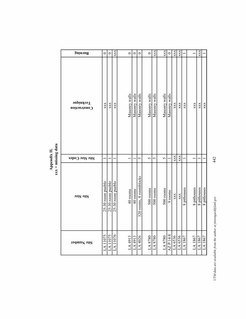
App
endi
x II
.xx
x =
mis
sing
dat
a
Site Number
LA 1
1075
LA 1
1075
LA 1
1076
LA 4
913
LA 4
913
LA 4
026
LA 8
780
LA 8
780
LA 8
780
AZ
P:14
:8LA
653
6LA
653
6LA
186
7
LA 1
867
LA 1
867
LA 1
867
Site Size
Site Size Codes
Construction Technique
Burning
25-3
0 ro
om p
uebl
o1
xxx
025
-30
room
pue
blo
1xx
x0
25-3
0 ro
om p
uebl
o1
xxx
xxx
40 ro
oms
1M
ason
ry w
alls
040
room
s1
Mas
onry
wal
ls0
320
room
s, 8
room
bloc
ks5
Mas
onry
wal
ls0
500
room
s5
Mas
onry
wal
ls0
500
room
s5
Mas
onry
wal
lsxx
x
500
room
s5
Mas
onry
wal
lsxx
x9
room
s1
Mas
onry
wal
ls0
xxx
xxx
xxx
xxx
xxx
xxx
xxx
xxx
8 pi
thou
ses
1xx
x1
8 pi
thou
ses
1xx
x1
8 pi
thou
ses
1xx
xxx
x8
pith
ouse
s1
xxx
1
UTM
dat
a ar
e av
aila
ble
from
the
auth
or a
t jni
seng
ard@
lanl
.gov
442

App
endi
x II
.xx
x =
mis
sing
dat
aSite Number
LA 1
1075
LA 1
1075
LA 1
1076
LA 4
913
LA 4
913
LA 4
026
LA 8
780
LA 8
780
LA 8
780
AZ
P:14
:8LA
653
6LA
653
6LA
186
7
LA 1
867
LA 1
867
LA 1
867
Add
ition
al In
form
atio
n an
d N
otes
Kiv
a in
corp
orat
ed in
to ro
ombl
ock;
25-
30 ro
om p
uebl
o, fo
ur sm
alle
r roo
mbl
ocks
, sev
en p
ithou
se d
epre
ssio
ns (L
ekso
n 19
89).
Gre
at K
ivas
obs
erve
d by
Sto
kes.
Size
via
site
sket
ch.
Gre
at K
iva
set o
ff fr
om ro
ombl
ocks
; tw
o ro
und
gian
t kiv
as.
Als
o LA
100
45. C
liff d
wel
lings
, ver
y sh
ort o
ccup
atio
n - o
ne g
ener
atio
n, d
oors
into
two
atta
ched
stor
age
room
s.A
lso
LA 1
0045
. Clif
f dw
ellin
gs, v
ery
shor
t occ
upat
ion
- one
gen
erat
ion.
320
room
s, fiv
e ro
ombl
ocks
and
a G
reat
Kiv
a; A
RM
S sa
ys th
e si
te is
Anc
estra
l Pue
blo.
Als
o A
Z P:
14:1
. 6:1
room
ratio
. K
iva
is a
con
verte
d pl
aza.
500
room
pla
za; t
hree
larg
e ro
ombl
ocks
+ sm
alle
r one
s; th
ree
plaz
as.
Als
o A
Z P:
14:1
. Roo
mbl
ock
7.
Als
o A
Z P:
14:1
. 6:1
room
ratio
. Pro
to-k
iva:
Roo
m b
lock
3.
7:1
ratio
. eig
ht ro
om p
uebl
o, sm
alle
r roo
m a
ttach
ed to
kiv
a. 1
278
(cut
ting
date
s). S
ize
mea
sure
d fr
om m
ap in
Low
ell 1
999.
Als
o N
M Q
:1:1
4. B
urne
d; 4
.5m
long
ent
ryw
ay. A
.D.
582
(tree
-rin
g da
te).
38 m
2 (W
heat
195
5).
Als
o N
M Q
:1:1
4. M
imbr
es V
alle
y; si
x m
eter
long
ent
ryw
ay; b
urne
d. A
.D. 7
36,8
43,8
46,8
54,8
58 (t
ree-
ring
date
s). 1
35 m
2 (W
heat
19
55).
Als
o N
M Q
:1:1
4. M
imbr
es V
alle
y, fi
ve m
eter
long
ent
ryw
ay.
Als
o N
M Q
:1:1
4. M
imbr
es V
alle
y, b
urne
d. A
.D. 8
36, 8
38 (t
ree-
ring
date
). 50
m2
(Whe
at 1
955)
.
UTM
dat
a ar
e av
aila
ble
from
the
auth
or a
t jni
seng
ard@
lanl
.gov
443

App
endi
x II
.xx
x =
mis
sing
dat
a
Site Number
LA 1
1075
LA 1
1075
LA 1
1076
LA 4
913
LA 4
913
LA 4
026
LA 8
780
LA 8
780
LA 8
780
AZ
P:14
:8LA
653
6LA
653
6LA
186
7
LA 1
867
LA 1
867
LA 1
867
Ref
eren
ces
Labo
rato
ry o
f Ant
hrop
olog
y, S
anta
Fe,
New
Mex
ico.
Labo
rato
ry o
f Ant
hrop
olog
y, S
anta
Fe,
New
Mex
ico.
Labo
rato
ry o
f Ant
hrop
olog
y, S
anta
Fe,
New
Mex
ico.
And
erso
n et
al.
1986
; G
add
1993
.A
nder
son
et a
l. 19
86 ;
Gad
d 19
93.
Jack
son
1972
; Mar
shal
l et a
l.. 1
979.
Low
ell 1
999;
Rei
d an
d W
hittl
esle
y 19
90; R
iggs
199
9, 2
000,
200
3.Lo
wel
l 199
9; R
eid
and
Whi
ttles
ley
1990
; Rig
gs 1
999,
200
0, 2
003.
Low
ell 1
999;
Rei
d an
d W
hittl
esle
y 19
90; R
iggs
199
9, 2
000,
200
3.Lo
wel
l 199
9; R
eid
and
Whi
ttles
ley
1990
; Rig
gs 1
999,
200
0, 2
003.
Any
on a
nd L
eBla
nc 1
980;
Ham
mac
k 19
66.
Any
on a
nd L
eBla
nc 1
980;
Ham
mac
k 19
66.
Any
on a
nd L
eBla
nc 1
980;
Die
hl 1
996,
199
7; D
iehl
and
LeB
lanc
200
1; H
aury
193
6; W
heat
195
5.
Any
on a
nd L
eBla
nc 1
980;
Die
hl 1
996,
199
7; D
iehl
and
LeB
lanc
200
1; H
aury
193
6; W
heat
195
5.A
nyon
and
LeB
lanc
198
0; D
iehl
199
6, 1
997;
Die
hl a
nd L
eBla
nc 2
001;
Hau
ry 1
936;
Whe
at 1
955.
Any
on a
nd L
eBla
nc 1
980;
Die
hl 1
996,
199
7; D
iehl
and
LeB
lanc
200
1; H
aury
193
6; W
heat
195
5.
UTM
dat
a ar
e av
aila
ble
from
the
auth
or a
t jni
seng
ard@
lanl
.gov
444

App
endi
x II
.xx
x =
mis
sing
dat
a
Site Number
Site Name
Total Number of Communal Structures
Contemporary?
Structure Number
Period
LA 8
682
Hig
gins
Fla
t3
Und
er G
reat
Kiv
a, c
oeva
l w
ith K
iva
2K
iva
1EL
P
LA 8
682
Hig
gins
Fla
t3
Supe
rimpo
sed
on K
iva
1G
reat
Kiv
aEL
P
LA 8
682
Hig
gins
Fla
t3
Coe
val w
ith K
iva
1K
iva
2EL
P
LA 3
279
Hou
gh si
te2
No
Roo
m 1
ELP
LA 3
279
Hou
gh si
te2
No
Gre
at K
iva
ELP
LA 4
67H
ulbe
rt1
n/a
Non
e gi
ven
LLP
LA 3
3642
Jenn
ie R
iley
Stal
lwor
th2
Unk
now
nG
reat
Kiv
aEP
LA 3
3642
Jenn
ie R
iley
Stal
lwor
th2
Unk
now
nEP
Lago
onLa
goon
1n/
aN
one
give
nEP
S
LA 7
1877
Lake
Rob
erts
Vis
ta2
Unk
now
nG
reat
Kiv
aLP
S
LA 7
1877
Lake
Rob
erts
Vis
ta2
Unk
now
nN
one
give
nPi
t Stru
ctur
eLA
539
0La
rgo
Cre
ek1
n/a
Non
e gi
ven
LP
LA 6
000
Lee/
Fort
Wes
t Hill
6Y
es, w
ith 2
2 an
d 23
21LP
S
UTM
dat
a ar
e av
aila
ble
from
the
auth
or a
t jni
seng
ard@
lanl
.gov
445

App
endi
x II
.xx
x =
mis
sing
dat
a
Site Number
LA 8
682
LA 8
682
LA 8
682
LA 3
279
LA 3
279
LA 4
67LA
336
42LA
336
42La
goon
LA 7
1877
LA 7
1877
LA 5
390
LA 6
000
Dates (A.D.)
Dating notes and/or alternative dates
Size (m2)
Location
Structure Shape
Structure Shape Code
1175
-125
0C
eram
ic d
ate
99.7
5P
D-s
hape
d4
1249
-128
1Tr
ee-r
ing
cutti
ng d
ate
rang
e12
8.4
PR
ecta
ngul
ar2
1175
to 1
250
Cer
amic
dat
e48
AR
ecta
ngul
ar2
1123
/24;
111
9-11
23 (s
ix n
on-c
uttin
g da
tes c
lust
er)
Tree
-rin
g cu
tting
dat
e; n
on-c
uttin
g da
tes c
lust
er12
.23
AR
ecta
ngul
ar1
1080
-115
0C
eram
ic d
ate
97.3
8P
Circ
ular
213
00N
ot a
vaila
ble
30.4
8P
Squa
re6
1000
-110
0C
eram
ic d
ate
xxx
PR
ecta
ngul
ar2
1000
-110
0C
eram
ic d
ate
xxx
xxx
Rec
tang
ular
255
0-65
0C
eram
ic d
ate
35.3
SC
ircul
ar w
ith lo
bes
3
900v
Tree
-rin
g no
n-cu
tting
dat
e60
PR
ecta
ngul
ar2
600-
1000
Gen
eral
per
iod
date
16.7
2xx
xxx
xxx
x11
75-1
400
Cer
amic
dat
exx
xxx
xxx
xxx
x
900
to 1
000
Cer
amic
dat
e12
Axx
xxx
x
UTM
dat
a ar
e av
aila
ble
from
the
auth
or a
t jni
seng
ard@
lanl
.gov
446

App
endi
x II
.xx
x =
mis
sing
dat
aSite Number
LA 8
682
LA 8
682
LA 8
682
LA 3
279
LA 3
279
LA 4
67LA
336
42LA
336
42La
goon
LA 7
1877
LA 7
1877
LA 5
390
LA 6
000
Entryway
Entryway Codes
Orientation
Features
Sipapu
Vent
Deflector
Niche
Pit
Storage Pit
Burials
Floor Vault
Footdrum
Bench
Other
Ram
p2
Sout
heas
tH
earth
00
00
00
00
00
0
xxx
xxx
Sout
heas
tFl
at, c
ircul
ar, p
aint
ed st
ones
on
floor
of s
truct
ure,
hea
rth0
00
00
00
00
01
Roo
f1
East
Ven
t, he
arth
01
00
00
00
00
0R
amp
with
room
s on
side
s2
Sout
heas
txx
x0
00
00
00
00
00
Ram
p2
Sout
heas
tFo
ot d
rum
s, pi
ts, b
uria
l, he
arth
00
00
10
10
10
0xx
xxx
xxx
xxx
x0
00
00
00
00
00
xxx
xxx
xxx
xxx
00
00
00
00
00
0xx
xxx
xxx
xxx
x0
00
00
00
00
00
Ram
p2
102
xxx
00
00
00
00
00
0
xxx
xxx
67Si
papu
, tw
o pi
ts, h
earth
11
xxx
xxx
xxx
xxx
00
00
00
00
00
0xx
xxx
xxx
xxx
x0
00
00
00
00
00
xxx
xxx
xxx
xxx
00
00
00
00
00
0
UTM
dat
a ar
e av
aila
ble
from
the
auth
or a
t jni
seng
ard@
lanl
.gov
447

App
endi
x II
.xx
x =
mis
sing
dat
aSite Number
LA 8
682
LA 8
682
LA 8
682
LA 3
279
LA 3
279
LA 4
67LA
336
42LA
336
42La
goon
LA 7
1877
LA 7
1877
LA 5
390
LA 6
000
Number of Hearths
Hearth Shape
Hearth Shape Codes
Quad Name
General location and/or County
1R
ecta
ngul
ar2
Dill
on M
ount
ain
Cat
ron
Co,
Wes
tern
New
Mex
ico
1R
ecta
ngul
ar2
Dill
on M
ount
ain
Cat
ron
Co,
Wes
tern
New
Mex
ico
1R
ecta
ngul
ar2
Dill
on M
ount
ain
Cat
ron
Co,
Wes
tern
New
Mex
ico
xxx
xxx
xxx
Luna
Cat
ron
Co,
Wes
tern
New
Mex
ico
1R
ecta
ngul
ar (t
hree
epi
sode
s of u
se)
2Lu
naC
atro
n C
o, W
este
rn N
ew M
exic
o xx
xxx
xxx
xSa
n Pa
trici
oLi
ncol
n C
o, so
uth-
cent
ral N
ew M
exic
o xx
xxx
xxx
xO
'Blo
ck C
anyo
nC
atro
n C
o, W
este
rn N
ew M
exic
o xx
xxx
xxx
xO
'Blo
ck C
anyo
nC
atro
n C
o, W
este
rn N
ew M
exic
o xx
xxx
xxx
xxx
xSo
uthw
este
rn N
ew M
exic
o
1R
ecta
ngul
ar2
Cop
pera
s Pea
kG
rant
Co,
sout
hwes
tern
New
Mex
ico
xxx
xxx
xxx
Cop
pera
s Pea
kG
rant
Co,
sout
hwes
tern
New
Mex
ico
xxx
xxx
xxx
Larg
o M
esa
Cat
ron
Co,
Wes
tern
New
Mex
ico
xxx
xxx
xxx
Clif
fG
rant
Co,
sout
hwes
tern
New
Mex
ico
UTM
dat
a ar
e av
aila
ble
from
the
auth
or a
t jni
seng
ard@
lanl
.gov
448

App
endi
x II
.xx
x =
mis
sing
dat
a
Site Number
LA 8
682
LA 8
682
LA 8
682
LA 3
279
LA 3
279
LA 4
67LA
336
42LA
336
42La
goon
LA 7
1877
LA 7
1877
LA 5
390
LA 6
000
Water
Topography
Vegetation
Elevation (ft)
Phase Names
Upp
er S
an F
ranc
isco
R
iver
Rid
geW
oodl
and
6000
Res
erve
Upp
er S
an F
ranc
isco
R
iver
Rid
geW
oodl
and
6000
Res
erve
/Tul
aros
aU
pper
San
Fra
ncis
co
Riv
erR
idge
Woo
dlan
d60
00R
eser
ve
San
Fran
cisc
o R
iver
Firs
t ter
race
Woo
dlan
d71
20Tu
laro
sa
San
Fran
cisc
o R
iver
Firs
t ter
race
Woo
dlan
d71
20Tu
laro
saxx
xFl
oodp
lain
Gra
ssla
nd56
40Po
st C
lass
ic/J
orna
daSa
n Fr
anci
sco
Riv
erR
idge
Fore
st65
40R
eser
veSa
n Fr
anci
sco
Riv
erR
idge
Fore
st65
40R
eser
veG
ila R
iver
xxx
xxx
xxx
Geo
rget
own
Lake
Rob
erts
/ Sap
illo
Cre
ekTe
rrac
eSc
rubl
and
6180
Late
Thr
ee-C
ircle
Lake
Rob
erts
/ Sap
illo
Cre
ekTe
rrac
eSc
rubl
and
6180
Geo
rget
own-
Cla
ssic
xxx
Rid
geW
oodl
and
7300
Tula
rosa
Gila
Riv
erB
ench
Gra
ssla
nd46
10Th
ree-
circ
le
UTM
dat
a ar
e av
aila
ble
from
the
auth
or a
t jni
seng
ard@
lanl
.gov
449

App
endi
x II
.xx
x =
mis
sing
dat
a
Site Number
LA 8
682
LA 8
682
LA 8
682
LA 3
279
LA 3
279
LA 4
67LA
336
42LA
336
42La
goon
LA 7
1877
LA 7
1877
LA 5
390
LA 6
000
Site Size
Site Size Codes
Construction Technique
Burning
1 pi
thou
se, 2
room
bloc
ks (2
5 &
15+
ro
oms)
, 30
room
s1
Mas
onry
with
ado
be p
last
er0
1 pi
thou
se, 2
room
bloc
ks (2
5 &
15+
ro
oms)
, 30
room
s1
Mas
onry
on
dirt
01
pith
ouse
, 2 ro
ombl
ocks
(25
& 1
5+
room
s), 3
0 ro
oms
1M
ason
ry, s
ubte
rran
ean
0
35 ro
oms
1C
obbl
e st
one
mas
onry
0
35 ro
oms
1C
obbl
e st
one
mas
onry
04
room
bloc
ks2
xxx
01
room
bloc
k1
xxx
xxx
1 ro
ombl
ock
1xx
xxx
xIs
olat
ed c
omm
unal
stru
ctur
eN
Axx
xxx
x
50+
room
s2
Cob
ble
adob
e1
50+
room
s2
xxx
010
-12
room
s1
xxx
xxx
70 p
ithou
ses
3xx
x0
UTM
dat
a ar
e av
aila
ble
from
the
auth
or a
t jni
seng
ard@
lanl
.gov
450

App
endi
x II
.xx
x =
mis
sing
dat
aSite Number
LA 8
682
LA 8
682
LA 8
682
LA 3
279
LA 3
279
LA 4
67LA
336
42LA
336
42La
goon
LA 7
1877
LA 7
1877
LA 5
390
LA 6
000
Add
ition
al In
form
atio
n an
d N
otes
Pit s
truct
ure
kiva
, 1.5
met
ers d
eep,
mas
onry
on
dirt,
und
er G
reat
Kiv
a.
Mas
onry
wal
ls, G
reat
Kiv
a su
perim
pose
d on
ear
lier D
-sha
ped
kiva
, lie
s bet
wee
n tw
o ro
ombl
ocks
.
Phot
o of
site
in v
olum
e 9
Han
dboo
k of
the
Nat
ive
Am
eric
an In
dian
s.A
lso
WN
MT
80. G
reat
Kiv
a w
ith c
ircul
ar k
iva
next
to it
, ram
p en
tryw
ay h
as a
room
on
eith
er si
de; 5
0 ro
oms (
AR
MS
says
20
mas
onry
ro
oms)
, tw
o pi
t stru
ctur
es. D
ates
from
http
://w
3ariz
ona.
edu/
~sca
rp/s
ites/
grea
tkiv
as/h
ough
s/in
dex.
htm
lA
lso
WN
MT
80. G
reat
Kiv
a w
ith c
ircul
ar k
iva
next
to it
, ram
p en
tryw
ay h
as a
room
on
eith
er si
de; 5
0 ro
oms (
AR
MS
says
20
mas
onry
ro
oms)
, tw
o pi
t stru
ctur
es. P
artia
l roo
f.C
omm
unal
stru
ctur
e si
tuat
ed in
the
plaz
a.G
reat
Kiv
a an
d K
iva.
Gre
at K
iva
and
Kiv
a.Th
ree
met
er lo
ng e
ntry
way
.
Bur
ned;
20-
60 o
ne-s
tory
room
s.
Floo
r pla
ster
ed w
ith P
leis
toce
ne c
lay;
20-
60 o
ne-s
tory
room
s.10
-12
mas
onry
room
s.A
RM
S sa
ys fi
ve k
ivas
(100
0-11
75);
thre
e co
urse
d m
ason
ry ro
ombl
ocks
; thr
ee p
artia
l mas
onry
room
bloc
ks; t
hree
cob
ble
base
d ja
cal
room
bloc
ks w
ith tw
o ro
oms e
ach;
63
pit s
truct
ures
(all
room
bloc
ks a
re la
rge)
.
UTM
dat
a ar
e av
aila
ble
from
the
auth
or a
t jni
seng
ard@
lanl
.gov
451

App
endi
x II
.xx
x =
mis
sing
dat
a
Site Number
LA 8
682
LA 8
682
LA 8
682
LA 3
279
LA 3
279
LA 4
67LA
336
42LA
336
42La
goon
LA 7
1877
LA 7
1877
LA 5
390
LA 6
000
Ref
eren
ces
Mar
tin 1
979;
Mar
tin a
nd R
inal
do 1
950;
Mar
tin e
t al.
1957
; Rin
aldo
et a
l. 19
56.
Mar
tin 1
979;
Mar
tin a
nd R
inal
do 1
950;
Mar
tin e
t al.
1957
; Rin
aldo
et a
l. 19
56.
Mar
tin 1
979;
Mar
tin a
nd R
inal
do 1
950;
Mar
tin e
t al.
1957
; Rin
aldo
et a
l. 19
56.
Oak
es 1
999;
Oak
es a
nd Z
amor
a 19
93; U
nite
d St
ates
For
est S
ervi
ce 1
996.
Oak
es 1
999;
Oak
es a
nd Z
amor
a 19
93; U
nite
d St
ates
For
est S
ervi
ce 1
996.
Alv
es 1
932;
Wis
eman
197
6.A
ccol
a an
d N
eely
198
0.A
ccol
a an
d N
eely
198
0.A
nyon
and
Cre
el 2
003;
Any
on a
nd L
eBla
nc 1
980,
198
4.
Bet
tison
and
Rot
h 19
95; S
toke
s 200
0a, 2
000b
.
Bet
tison
and
Rot
h 19
95; S
toke
s 200
0a, 2
000b
.
Bus
sey
1972
, 197
5.
UTM
dat
a ar
e av
aila
ble
from
the
auth
or a
t jni
seng
ard@
lanl
.gov
452

App
endi
x II
.xx
x =
mis
sing
dat
a
Site Number
Site Name
Total Number of Communal Structures
Contemporary?
Structure Number
Period
LA 6
000
Lee/
Fort
Wes
t Hill
6Y
es, w
ith 2
1 an
d 23
23LP
S
LA 6
000
Lee/
Fort
Wes
t Hill
6Y
es, w
ith 1
8 an
d 19
20LP
S
LA 6
000
Lee/
Fort
Wes
t Hill
6Y
es, w
ith 1
9 an
d 20
18LP
S
LA 6
000
Lee/
Fort
Wes
t Hill
6Y
es, w
ith 1
8 an
d 20
19LP
S
LA 6
000
Lee/
Fort
Wes
t Hill
6Y
es, w
ith 2
1 an
d 23
22LP
SW
:9:8
3Lu
ntxx
xn/
aN
one
give
nPi
t Stru
ctur
e
LA 6
76M
atto
cks
2U
nkno
wn
Uni
t 410
EPLA
676
Mat
tock
s2
Unk
now
nK
iva
48EP
LA 1
2110
McA
nally
1n/
aU
nit 1
1EP
SLA
115
68M
ogol
lon
2N
o, E
PSH
ouse
5A
EPS
LA 1
1568
Mog
ollo
n2
No,
MPS
Hou
se 3
MPS
LA 1
5075
Mon
toya
1n/
aR
oom
4EL
P
UTM
dat
a ar
e av
aila
ble
from
the
auth
or a
t jni
seng
ard@
lanl
.gov
453

App
endi
x II
.xx
x =
mis
sing
dat
a
Site Number
LA 6
000
LA 6
000
LA 6
000
LA 6
000
LA 6
000
W:9
:83
LA 6
76LA
676
LA 1
2110
LA 1
1568
LA 1
1568
LA 1
5075
Dates (A.D.)
Dating notes and/or alternative dates
Size (m2)
Location
Structure Shape
Structure Shape Code
900
to 1
000
Cer
amic
dat
e12
Axx
xxx
x
900
to 1
000
Cer
amic
dat
e16
Axx
xxx
x
900
to 1
000
Cer
amic
dat
e18
Axx
xxx
x
900
to 1
000
Cer
amic
dat
e19
Axx
xxx
x
900
to 1
000
Cer
amic
dat
e22
Axx
xxx
x60
0-90
0G
ener
al p
erio
d da
texx
xxx
xxx
xxx
x
1020
vv a
nd 1
015-
1250
(MT3
00)
Tree
-rin
g no
n-cu
tting
dat
e;
arch
aeom
agne
tic d
ate
rang
e13
.8A
Rec
tang
ular
210
00-1
150
Cer
amic
dat
e14
.8A
Rec
tang
ular
254
8-76
2 (2
-sig
ma
calib
rate
d) (S
tuiv
er
and
Rei
mer
199
3); 5
45+/
185
(LeB
lanc
and
Wha
len)
; 580
+/-
60R
adio
carb
on d
ate
23.8
AC
ircul
ar w
ith lo
bes
155
0-75
0C
eram
ic d
ate
82.5
PO
val w
ith lo
bes
565
0-75
0C
eram
ic d
ate
55.4
PC
ircul
ar1
1100
-120
0C
eram
ic d
ate
37.7
5xx
xO
val
5
UTM
dat
a ar
e av
aila
ble
from
the
auth
or a
t jni
seng
ard@
lanl
.gov
454

App
endi
x II
.xx
x =
mis
sing
dat
aSite Number
LA 6
000
LA 6
000
LA 6
000
LA 6
000
LA 6
000
W:9
:83
LA 6
76LA
676
LA 1
2110
LA 1
1568
LA 1
1568
LA 1
5075
Entryway
Entryway Codes
Orientation
Features
Sipapu
Vent
Deflector
Niche
Pit
Storage Pit
Burials
Floor Vault
Footdrum
Bench
Other
xxx
xxx
xxx
xxx
00
00
00
00
00
0
xxx
xxx
xxx
xxx
00
00
00
00
00
0
xxx
xxx
xxx
xxx
00
00
00
00
00
0
xxx
xxx
xxx
xxx
00
00
00
00
00
0
xxx
xxx
xxx
xxx
00
00
00
00
00
0xx
xxx
xxx
xxx
x0
00
00
00
00
00
Ram
p (b
lock
ed
durin
g C
lass
ic
perio
d)2
East
Ven
t con
stru
cted
in b
lock
ed
entry
way
, 5 b
uria
ls, 2
pla
ster
ed
pits
, hea
rth0
10
02
05
00
00
Unk
now
n5
Sout
hV
ent,
ledg
e, 3
bur
ials
, hea
rth0
10
00
03
00
01
Ram
p2
Sout
heas
tPo
stho
les (
7), h
earth
00
00
00
00
00
0R
amp
2N
orth
east
xxx
00
00
00
00
00
0R
amp
2Ea
stPi
ts0
00
03
00
00
00
Roo
f ent
ry1
Non
e vi
sibl
eW
all n
iche
, 5 b
uria
ls, h
earth
00
01
00
50
00
0
UTM
dat
a ar
e av
aila
ble
from
the
auth
or a
t jni
seng
ard@
lanl
.gov
455

App
endi
x II
.xx
x =
mis
sing
dat
aSite Number
LA 6
000
LA 6
000
LA 6
000
LA 6
000
LA 6
000
W:9
:83
LA 6
76LA
676
LA 1
2110
LA 1
1568
LA 1
1568
LA 1
5075
Number of Hearths
Hearth Shape
Hearth Shape Codes
Quad Name
General location and/or County
xxx
xxx
xxx
Clif
fG
rant
Co,
sout
hwes
tern
New
Mex
ico
xxx
xxx
xxx
Clif
fG
rant
Co,
sout
hwes
tern
New
Mex
ico
xxx
xxx
xxx
Clif
fG
rant
Co,
sout
hwes
tern
New
Mex
ico
xxx
xxx
xxx
Clif
fG
rant
Co,
sout
hwes
tern
New
Mex
ico
xxx
xxx
xxx
Clif
fG
rant
Co,
sout
hwes
tern
New
Mex
ico
xxx
xxx
xxx
xxx
xxx
3O
ne re
ctan
gula
r (re
mod
eled
), on
e ci
rcul
ar (e
arlie
r)2,
1Sa
n Lo
renz
oG
rant
Co,
sout
hwes
tern
New
Mex
ico
1R
ecta
ngul
ar2
San
Lore
nzo
Gra
nt C
o, so
uthw
este
rn N
ew M
exic
o
1C
ircul
ar1
San
Lore
nzo
Gra
nt C
o, so
uthw
este
rn N
ew M
exic
oxx
xxx
xxx
xA
lma
Cat
ron
Co,
Wes
tern
New
Mex
ico
xxx
xxx
xxx
Alm
aC
atro
n C
o, W
este
rn N
ew M
exic
o 1
Ova
l3
Dyw
erG
rant
Co,
sout
hwes
tern
New
Mex
ico
UTM
dat
a ar
e av
aila
ble
from
the
auth
or a
t jni
seng
ard@
lanl
.gov
456

App
endi
x II
.xx
x =
mis
sing
dat
a
Site Number
LA 6
000
LA 6
000
LA 6
000
LA 6
000
LA 6
000
W:9
:83
LA 6
76LA
676
LA 1
2110
LA 1
1568
LA 1
1568
LA 1
5075
Water
Topography
Vegetation
Elevation (ft)
Phase Names
Gila
Riv
erB
ench
Gra
ssla
nd46
10Th
ree-
circ
le
Gila
Riv
erB
ench
Gra
ssla
nd46
10Th
ree-
circ
le
Gila
Riv
erB
ench
Gra
ssla
nd46
10Th
ree-
circ
le
Gila
Riv
erB
ench
Gra
ssla
nd46
10Th
ree-
circ
le
Gila
Riv
erB
ench
Gra
ssla
nd46
10Th
ree-
circ
lexx
xxx
xxx
xxx
xPi
t stru
ctur
e/St
ove
Can
yon
Phas
e
Mim
bres
Riv
erFi
rst t
erra
ceG
rass
land
5778
Cla
ssic
Mim
bres
Riv
erFi
rst t
erra
ceG
rass
land
5778
Cla
ssic
Mim
bres
Riv
erH
illto
pD
eser
t Scr
ubla
nd60
00C
umbr
e/G
eorg
etow
nSa
n Fr
anci
sco
Riv
erM
esa/
But
teW
oodl
and
5147
Geo
rget
own-
San
Fran
cisc
oSa
n Fr
anci
sco
Riv
erM
esa/
But
teW
oodl
and
5147
San
Fran
cisc
oM
imbr
es R
iver
Terr
ace
Gra
ssla
nd44
94A
nim
as
UTM
dat
a ar
e av
aila
ble
from
the
auth
or a
t jni
seng
ard@
lanl
.gov
457

App
endi
x II
.xx
x =
mis
sing
dat
a
Site Number
LA 6
000
LA 6
000
LA 6
000
LA 6
000
LA 6
000
W:9
:83
LA 6
76LA
676
LA 1
2110
LA 1
1568
LA 1
1568
LA 1
5075
Site Size
Site Size Codes
Construction Technique
Burning
70 p
ithou
ses
3xx
x0
70 p
ithou
ses
3xx
x0
70 p
ithou
ses
3xx
x0
70 p
ithou
ses
3xx
x0
70 p
ithou
ses
3xx
x0
14 p
ithou
ses
1xx
xxx
x
160-
170
room
s3
Ado
be0
160-
170
room
s3
xxx
xxx
12 p
ithou
ses
1xx
x1
23 p
ithou
ses
1xx
xxx
x23
pith
ouse
s1
xxx
xxx
30-4
0 ro
oms
1C
obbl
e an
d ad
obe
xxx
UTM
dat
a ar
e av
aila
ble
from
the
auth
or a
t jni
seng
ard@
lanl
.gov
458

App
endi
x II
.xx
x =
mis
sing
dat
aSite Number
LA 6
000
LA 6
000
LA 6
000
LA 6
000
LA 6
000
W:9
:83
LA 6
76LA
676
LA 1
2110
LA 1
1568
LA 1
1568
LA 1
5075
Add
ition
al In
form
atio
n an
d N
otes
AR
MS
says
five
kiv
as (1
000-
1175
); th
ree
cour
sed
mas
onry
room
bloc
ks; t
hree
par
tial m
ason
ry ro
ombl
ocks
; thr
ee c
obbl
e ba
sed
jaca
l ro
ombl
ocks
with
two
room
s eac
h; 6
3 pi
t stru
ctur
es (a
ll ro
ombl
ocks
are
larg
e).
AR
MS
says
five
kiv
as (1
000-
1175
); th
ree
cour
sed
mas
onry
room
bloc
ks; t
hree
par
tial m
ason
ry ro
ombl
ocks
; thr
ee c
obbl
e ba
sed
jaca
l ro
ombl
ocks
with
two
room
s eac
h; 6
3 pi
t stru
ctur
es (a
ll ro
ombl
ocks
are
larg
e).
AR
MS
says
five
kiv
as (1
000-
1175
); th
ree
cour
sed
mas
onry
room
bloc
ks; t
hree
par
tial m
ason
ry ro
ombl
ocks
; thr
ee c
obbl
e ba
sed
jaca
l ro
ombl
ocks
with
two
room
s eac
h; 6
3 pi
t stru
ctur
es (a
ll ro
ombl
ocks
are
larg
e).
AR
MS
says
five
kiv
as (1
000-
1175
); th
ree
cour
sed
mas
onry
room
bloc
ks; t
hree
par
tial m
ason
ry ro
ombl
ocks
; thr
ee c
obbl
e ba
sed
jaca
l ro
ombl
ocks
with
two
room
s eac
h; 6
3 pi
t stru
ctur
es (a
ll ro
ombl
ocks
are
larg
e).
AR
MS
says
five
kiv
as (1
000-
1175
); th
ree
cour
sed
mas
onry
room
bloc
ks; t
hree
par
tial m
ason
ry ro
ombl
ocks
; thr
ee c
obbl
e ba
sed
jaca
l ro
ombl
ocks
with
two
room
s eac
h; 6
3 pi
t stru
ctur
es (a
ll ro
ombl
ocks
are
larg
e).
Mid
dle
Mim
bres
Val
ley;
rem
odel
ed p
it st
ruct
ure,
3-p
ost-h
abita
tion
buria
ls. T
ree-
ring
date
A.D
. 102
0; a
rcha
eom
agne
tic d
ate
on la
te
hear
th A
.D. 1
015-
1250
. 12.
7 m
2 (G
ilman
and
LeB
lanc
n.d
.).M
iddl
e M
imbr
es V
alle
y. 1
5.2
m2
(Gilm
an a
nd L
eBla
nc n
.d.)
Bur
ned;
3 m
long
ent
ryw
ay. A
.D. 5
48-7
62 ra
dioc
arbo
n da
te. A
lma
plai
n ja
rs a
nd b
owls
. Si
ze v
ia A
nyon
and
LeB
lanc
198
0 an
d D
iehl
20
01.
Als
o M
ogol
lon
1:15
. San
Fra
ncis
co R
iver
; 1m
long
ent
ryw
ay. R
adio
car
bon
date
.A
lso
Mog
ollo
n 1:
15. S
an F
ranc
isco
Riv
er. 6
.2m
long
ent
ryw
ay. R
adio
carb
on d
ate.
71
m2
(Whe
at 1
955)
.Z:
5:11
2
UTM
dat
a ar
e av
aila
ble
from
the
auth
or a
t jni
seng
ard@
lanl
.gov
459

App
endi
x II
.xx
x =
mis
sing
dat
a
Site Number
LA 6
000
LA 6
000
LA 6
000
LA 6
000
LA 6
000
W:9
:83
LA 6
76LA
676
LA 1
2110
LA 1
1568
LA 1
1568
LA 1
5075
Ref
eren
ces
Bus
sey
1972
, 197
5.
Bus
sey
1972
, 197
5.
Bus
sey
1972
, 197
5.
Bus
sey
1972
, 197
5.
Bus
sey
1972
, 197
5.Jo
hnso
n 19
61; N
eely
197
4.
Gilm
an a
nd L
eBla
nc n
.d.;
LeB
lanc
198
3; N
esbi
tt 19
31.
Gilm
an a
nd L
eBla
nc n
.d.;
LeB
lanc
198
3; N
esbi
tt 19
31.
Any
on e
t al.
2001
; Any
on a
nd L
eBla
nc 1
980;
Die
hl a
nd L
eBla
nc 2
001;
Hau
ry 1
936;
LeB
lanc
197
7.A
nyon
and
LeB
lanc
198
0; H
aury
193
6; W
heat
195
5.A
nyon
and
LeB
lanc
198
0; H
aury
193
6; W
heat
195
5.R
aves
loot
197
9.
UTM
dat
a ar
e av
aila
ble
from
the
auth
or a
t jni
seng
ard@
lanl
.gov
460

App
endi
x II
.xx
x =
mis
sing
dat
a
Site Number
Site Name
Total Number of Communal Structures
Contemporary?
Structure Number
Period
LA 2
465
NA
N R
anch
8Y
es, c
oeva
l with
57
then
18
, 39,
and
45
58EP
LA 2
465
NA
N R
anch
8
Coe
val w
ith 5
8, d
estro
yed
by fi
re, R
oom
18
built
at
op it
57EP
LA 2
465
NA
N R
anch
8
Coe
val w
ith 3
9 an
d 58
, de
stro
yed
by fi
re, R
oom
45
bui
lt at
op it
18EP
LA 2
465
NA
N R
anch
8C
oeva
l with
18,
45,
and
58
39EP
LA 2
465
NA
N R
anch
8C
oeva
l with
29
and
5845
EP
LA 2
465
NA
N R
anch
8R
epla
ced
52 a
nd 9
143
LPS
LA 2
465
NA
N R
anch
8Y
es, c
oeva
l with
91
52LP
S
LA 2
465
NA
N R
anch
8Y
es, c
oeva
l with
52
91LP
S
UTM
dat
a ar
e av
aila
ble
from
the
auth
or a
t jni
seng
ard@
lanl
.gov
461

App
endi
x II
.xx
x =
mis
sing
dat
a
Site Number
LA 2
465
LA 2
465
LA 2
465
LA 2
465
LA 2
465
LA 2
465
LA 2
465
LA 2
465
Dates (A.D.)
Dating notes and/or alternative dates
Size (m2)
Location
Structure Shape
Structure Shape Code
1000
-113
0 (1
105v
v fo
r ren
ovat
ion)
Arc
haeo
mag
netic
dat
e ra
nge;
tree
-rin
g da
te17
.82
AR
ecta
ngul
ar2
1025
-107
0A
rcha
eom
agne
tic d
ate
rang
e32
.2A
Rec
tang
ular
2
1066
vv, 1
068v
v (u
nder
45)
; 107
1-11
00Tr
ee-r
ing
date
s; A
rcha
eom
agne
tic
date
rang
e38
.76
AR
ecta
ngul
ar2
1090
vv (C
oeva
l with
45)
; Mim
bres
St
yle
III o
n flo
ors;
106
3, (O
bsid
ian
Hyd
ratio
n)
Tree
-rin
g da
te36
ASq
uare
6(C
oeva
l with
39)
; tre
e rin
g 11
07r;
1066
vvTr
ee-r
ing
non-
cutti
ng d
ate
95P
Squa
re6
900v
v; 9
00-1
010
(cer
amic
dat
e, b
ased
on
Sha
fer's
ass
essm
ent -
did
not
bur
n)Tr
ee-r
ing
non-
cutti
ng d
ate
58A
Rec
tang
ular
285
9vv;
AM
S da
tes 6
13-7
59, 6
38-7
78;
660-
720,
740
-860
, 810
-860
Tree
-rin
g da
te; A
MS
date
s;
Arc
haeo
mag
netic
dat
e ra
nges
43.2
AR
ecta
ngul
ar2
900-
1000
(Cer
amic
dat
e - l
ate
Thre
e C
ircle
)C
eram
ic d
ate
20A
Rec
tang
ular
2
UTM
dat
a ar
e av
aila
ble
from
the
auth
or a
t jni
seng
ard@
lanl
.gov
462

App
endi
x II
.xx
x =
mis
sing
dat
aSite Number
LA 2
465
LA 2
465
LA 2
465
LA 2
465
LA 2
465
LA 2
465
LA 2
465
LA 2
465
Entryway
Entryway Codes
Orientation
Features
Sipapu
Vent
Deflector
Niche
Pit
Storage Pit
Burials
Floor Vault
Footdrum
Bench
Other
Doo
rway
4N
orth
east
-Sou
thw
est
Ven
t, 4
dist
urbe
d bu
rials
, be
nchs
, fire
pits
, pits
, hea
rths
01
00
10
40
03
0
Unk
now
n5
Nor
thea
st-S
outh
wes
tPi
ts, 1
0 bu
rials
, hea
rth0
00
06
010
00
00
Ram
p2
Nor
thea
st-S
outh
wes
tPi
ts, b
uria
l0
00
010
01
00
00
Doo
rway
4Ea
stV
ent,
wal
l nic
hes,
4 bu
rials
, he
arth
01
04
00
40
00
0
Ram
p2
East
Pits
00
00
30
00
00
0
Ram
p2
80-1
00H
earth
00
00
00
00
00
0R
amp;
4.3
met
ers
long
213
3D
efle
ctor
, pits
, hea
rth0
01
01
04
00
00
Roo
f ent
ry1
East
Ven
t, pi
ts, s
ipap
us, h
earth
s, po
ssib
le a
ltar
21
00
91
00
00
1
UTM
dat
a ar
e av
aila
ble
from
the
auth
or a
t jni
seng
ard@
lanl
.gov
463

App
endi
x II
.xx
x =
mis
sing
dat
aSite Number
LA 2
465
LA 2
465
LA 2
465
LA 2
465
LA 2
465
LA 2
465
LA 2
465
LA 2
465
Number of Hearths
Hearth Shape
Hearth Shape Codes
Quad Name
General location and/or County
1C
ircul
ar1
San
Lore
nzo
Gra
nt C
o, so
uthw
este
rn N
ew M
exic
o
1Ir
regu
lar
5Sa
n Lo
renz
oG
rant
Co,
sout
hwes
tern
New
Mex
ico
0N
o fo
rmal
hea
rth6
San
Lore
nzo
Gra
nt C
o, so
uthw
este
rn N
ew M
exic
o
1C
ircul
ar1
San
Lore
nzo
Gra
nt C
o, so
uthw
este
rn N
ew M
exic
o
0N
o fo
rmal
hea
rth6
San
Lore
nzo
Gra
nt C
o, so
uthw
este
rn N
ew M
exic
o
1O
val t
o re
ctan
gula
r3
San
Lore
nzo
Gra
nt C
o, so
uthw
este
rn N
ew M
exic
o
1C
ircul
ar1
San
Lore
nzo
Gra
nt C
o, so
uthw
este
rn N
ew M
exic
o
2O
val a
nd c
ircul
ar1,
3Sa
n Lo
renz
oG
rant
Co,
sout
hwes
tern
New
Mex
ico
UTM
dat
a ar
e av
aila
ble
from
the
auth
or a
t jni
seng
ard@
lanl
.gov
464

App
endi
x II
.xx
x =
mis
sing
dat
a
Site Number
LA 2
465
LA 2
465
LA 2
465
LA 2
465
LA 2
465
LA 2
465
LA 2
465
LA 2
465
Water
Topography
Vegetation
Elevation (ft)
Phase Names
Mim
bres
Riv
erTe
rrac
e ov
erlo
okin
g M
imbr
es R
iver
Gra
ssla
nd57
50C
lass
ic
Mim
bres
Riv
erTe
rrac
e ov
erlo
okin
g M
imbr
es R
iver
Gra
ssla
nd57
50C
lass
ic
Mim
bres
Riv
erTe
rrac
e ov
erlo
okin
g M
imbr
es R
iver
Gra
ssla
nd57
50C
lass
ic
Mim
bres
Riv
erTe
rrac
e ov
erlo
okin
g M
imbr
es R
iver
Gra
ssla
nd57
50C
lass
ic
Mim
bres
Riv
erTe
rrac
e ov
erlo
okin
g M
imbr
es R
iver
Gra
ssla
nd57
50C
lass
ic
Mim
bres
Riv
erTe
rrac
e ov
erlo
okin
g M
imbr
es R
iver
Gra
ssla
nd57
50La
te T
hree
-Circ
le
Mim
bres
Riv
erTe
rrac
e ov
erlo
okin
g M
imbr
es R
iver
Gra
ssla
nd57
50Th
ree
Circ
le
Mim
bres
Riv
erTe
rrac
e ov
erlo
okin
g M
imbr
es R
iver
Gra
ssla
nd57
50Th
ree
Circ
le
UTM
dat
a ar
e av
aila
ble
from
the
auth
or a
t jni
seng
ard@
lanl
.gov
465

App
endi
x II
.xx
x =
mis
sing
dat
a
Site Number
LA 2
465
LA 2
465
LA 2
465
LA 2
465
LA 2
465
LA 2
465
LA 2
465
LA 2
465
Site Size
Site Size Codes
Construction Technique
Burning
100+
room
s in
4 ro
ombl
ocks
2C
obbl
e st
one
mas
onry
1
100+
room
s in
4 ro
ombl
ocks
2C
obbl
e an
d ad
obe
1
100+
room
s in
4 ro
ombl
ocks
2C
obbl
e an
d ad
obe
1
100+
room
s in
4 ro
ombl
ocks
2D
oubl
e to
qui
ntup
le c
ours
ed c
obbl
e st
one
mas
onry
0
100+
room
s in
4 ro
ombl
ocks
2D
oubl
e co
urse
d sl
ab m
ason
ry a
nd a
dobe
0
25-3
0 pi
t stru
ctur
es2
Exca
vate
d in
to n
ativ
e cl
ays a
nd n
ot im
prov
ed0
25-3
0 pi
t stru
ctur
es2
Cob
ble-
adob
e pl
aste
red
wal
ls2
25-3
0 pi
t stru
ctur
es2
Exca
vate
d in
to n
ativ
e cl
ays a
nd p
last
ered
2
UTM
dat
a ar
e av
aila
ble
from
the
auth
or a
t jni
seng
ard@
lanl
.gov
466

App
endi
x II
.xx
x =
mis
sing
dat
aSite Number
LA 2
465
LA 2
465
LA 2
465
LA 2
465
LA 2
465
LA 2
465
LA 2
465
LA 2
465
Add
ition
al In
form
atio
n an
d N
otes
Als
o LA
150
49. T
hree
floo
r res
urfa
cing
epi
sode
s, so
me
rem
odel
ing,
use
d th
roug
hout
the
Cla
ssic
per
iod,
des
troye
d by
fire
.
Als
o LA
150
49. D
estro
yed
by fi
re a
nd la
rger
stru
ctur
e, R
oom
18,
bui
lt at
op it
.
Als
o LA
150
49. D
estro
yed
by fi
re a
nd a
noth
er st
ruct
ure,
Roo
m 4
5 w
as b
uilt
atop
it.
Als
o LA
150
49. S
hafe
r (20
03:8
0) su
gges
ts th
is m
ay h
ave
been
the
wom
en's
kiva
giv
en th
e ar
tifac
ts fo
und
with
in th
e st
ruct
ure.
Als
o LA
150
49. L
arge
st st
ruct
ure
at th
e si
te, c
lose
st so
urce
for t
he m
ason
ry 1
4 km
aw
ay (S
hafe
r 198
1:21
), rh
yolit
e sl
ab c
olum
n or
roof
su
ppor
t.
Als
o LA
150
49. M
iddl
e M
imbr
es V
alle
y; S
tyle
II B
lack
-on-
whi
te sh
erd
on th
e flo
or.
Als
o LA
150
49. M
iddl
e M
imbr
es V
alle
y, p
ossi
ble
pain
ted
wal
l dec
orat
ion
(ser
pent
), bu
rned
(cor
n hu
sks p
ossi
bly
used
to fu
el th
e fir
e),
Mim
bres
Sty
le I
bow
l, fil
led
with
gra
vel a
fter i
t bur
ned,
term
inat
ion
obje
cts,
at le
ast s
ix b
uria
ls.
Als
o LA
150
49. M
iddl
e M
imbr
es V
alle
y, th
e flo
or w
as p
last
ered
at l
east
thre
e tim
es, s
ipap
u fil
led
with
whi
te sa
nd u
pon
aban
donm
ent,
Mim
bres
red-
film
ed se
ed ja
r fill
ed w
ith 4
12 a
met
hyst
cry
stal
s pla
ced
belo
w th
e flo
or o
f the
room
, des
troye
d by
fire
; Sty
le II
Bla
ck-o
n-w
hite
sher
d on
floo
r.
UTM
dat
a ar
e av
aila
ble
from
the
auth
or a
t jni
seng
ard@
lanl
.gov
467

App
endi
x II
.xx
x =
mis
sing
dat
a
Site Number
LA 2
465
LA 2
465
LA 2
465
LA 2
465
LA 2
465
LA 2
465
LA 2
465
LA 2
465
Ref
eren
ces
Any
on a
nd C
reel
200
3; B
urde
n 20
01; S
hafe
r 198
1, 1
982,
198
3, 1
989,
199
5, 2
003.
Any
on a
nd C
reel
200
3; B
urde
n 20
01; S
hafe
r 198
1, 1
982,
198
3, 1
989,
199
5, 2
003.
Any
on a
nd C
reel
200
3; B
urde
n 20
01; S
hafe
r 198
1, 1
982,
198
3, 1
989,
199
5, 2
003.
Any
on a
nd C
reel
200
3; B
urde
n 20
01; S
hafe
r 198
1, 1
982,
198
3, 1
989,
199
5, 2
003.
Any
on a
nd C
reel
200
3; B
urde
n 20
01; S
hafe
r 198
1, 1
982,
198
3, 1
989,
199
5, 2
003.
Any
on a
nd C
reel
200
3; B
urde
n 20
01; S
hafe
r 198
1, 1
982,
198
3, 1
989,
199
5, 2
003.
Any
on a
nd C
reel
200
3; B
urde
n 20
01; S
hafe
r 198
1, 1
982,
198
3, 1
989,
199
5, 2
003.
Any
on a
nd C
reel
200
3; B
urde
n 20
01; S
hafe
r 198
1, 1
982,
198
3, 1
989,
199
5, 2
003.
UTM
dat
a ar
e av
aila
ble
from
the
auth
or a
t jni
seng
ard@
lanl
.gov
468
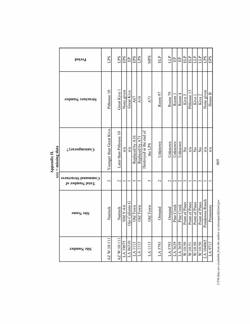
App
endi
x II
.xx
x =
mis
sing
dat
a
Site Number
Site Name
Total Number of Communal Structures
Contemporary?
Structure Number
Period
AZ
W:1
0:11
1N
anta
ck2
You
nger
than
Gre
at K
iva
Pith
ouse
10
LPS
AZ
W:1
0:11
1N
anta
ck2
Late
r tha
n Pi
thou
se 1
0G
reat
Kiv
a 1
LPS
LA 1
9075
NM
Y:4
:61
n/a
Non
e gi
ven
EPS
LA 8
6310
Ojo
Cal
ient
e G
1n/
aG
reat
Kiv
aEP
LA 1
113
Old
Tow
n3
Rep
lace
d by
A16
A67
EPS
LA 1
113
Old
Tow
n3
Rep
lace
d by
A71
A16
LPS
LA 1
113
Old
Tow
n3
Des
troye
d at
the
end
of
the
LPS
A71
MPS
LA 5
793
Orm
and
2U
nkno
wn
Roo
m 9
7EL
P
LA 5
793
Orm
and
2U
nkno
wn
Roo
m 7
9LL
PLA
363
9Pi
ne C
reek
2U
nkno
wn
Roo
m 1
EPLA
363
9Pi
ne C
reek
2U
nkno
wn
Roo
m 4
EPW
:10:
50Po
int o
f Pin
es3
No
Kiv
a 5
ELP
W:1
0:51
Poin
t of P
ines
1n/
aPi
thou
se 1
3EL
PW
:10:
50Po
int o
f Pin
es3
No
Kiv
a 1
LLP
W:1
0:50
Poin
t of P
ines
3N
oK
iva
2LL
PLA
104
065
Pond
eros
a R
anch
1n/
aN
one
give
nLP
SLA
971
3Pr
omot
ory
1n/
aH
ouse
BEP
S
UTM
dat
a ar
e av
aila
ble
from
the
auth
or a
t jni
seng
ard@
lanl
.gov
469

App
endi
x II
.xx
x =
mis
sing
dat
a
Site Number
AZ
W:1
0:11
1
AZ
W:1
0:11
1LA
190
75LA
863
10LA
111
3LA
111
3
LA 1
113
LA 5
793
LA 5
793
LA 3
639
LA 3
639
W:1
0:50
W:1
0:51
W:1
0:50
W:1
0:50
LA 1
0406
5LA
971
3
Dates (A.D.)
Dating notes and/or alternative dates
Size (m2)
Location
Structure Shape
Structure Shape Code
900-
1000
Cer
amic
dat
e60
PR
ecta
ngul
ar2
900-
1000
Cer
amic
dat
e15
2.8
PR
ecta
ngul
ar2
305+
/-85
Rad
ioca
rbon
dat
e40
.3S
Circ
ular
with
lobe
s3
1000
-117
5C
eram
ic d
ate
113
Pxx
xxx
x65
0+/-
Arc
haeo
mag
netic
dat
e39
PC
ircul
ar w
ith lo
bes
387
4-92
5A
rcha
eom
agne
tic d
ate
rang
e78
PR
ecta
ngul
ar2
800-
874
Arc
haeo
mag
netic
dat
e ra
nge
52P
D-s
hape
d4
1100
-late
130
0C
eram
ic d
ate
71.0
7P
Rec
tang
ular
2
1300
-145
0C
eram
ic d
ate
17.1
AR
ecta
ngul
ar2
1000
-115
0C
eram
ic d
ate
12.7
SSq
uare
610
00-1
150
Cer
amic
dat
e15
.9S
Rec
tang
ular
211
50-1
265
Cer
amic
dat
exx
xxx
xC
ircul
ar1
1265
-130
0A
rcha
eom
agne
tic d
ate
rang
e10
.6A
Squa
re6
1265
-132
5/13
50C
eram
ic d
ate
220
PR
ecta
ngul
ar2
1325
/135
0-14
00C
eram
ic d
ate
263
PSq
uare
690
0vTr
ee-r
ing
non-
cutti
ng d
ate
xxx
xxx
xxx
xxx
250
- 600
Cer
amic
dat
e86
xxx
Circ
ular
1
UTM
dat
a ar
e av
aila
ble
from
the
auth
or a
t jni
seng
ard@
lanl
.gov
470

App
endi
x II
.xx
x =
mis
sing
dat
aSite Number
AZ
W:1
0:11
1
AZ
W:1
0:11
1LA
190
75LA
863
10LA
111
3LA
111
3
LA 1
113
LA 5
793
LA 5
793
LA 3
639
LA 3
639
W:1
0:50
W:1
0:51
W:1
0:50
W:1
0:50
LA 1
0406
5LA
971
3
Entryway
Entryway Codes
Orientation
Features
Sipapu
Vent
Deflector
Niche
Pit
Storage Pit
Burials
Floor Vault
Footdrum
Bench
Other
Step
ped
entry
way
3So
uth?
Stor
age
pits
, foo
tdru
m, b
ench
, he
arth
00
00
01
00
11
0St
eppe
d en
tryw
ay:
2.25
met
er lo
ng3
East
Stor
age
pits
, hea
rth0
00
00
11
00
01
Ram
p2
126
Hea
rth0
00
00
00
00
00
xxx
xxx
xxx
xxx
00
00
00
00
00
0xx
xxx
x14
1/So
uthe
ast
xxx
00
00
00
00
00
0R
amp
211
4Fl
oor v
aults
, sip
apus
, hea
rth4
00
01
00
20
00
xxx
xxx
135
Floo
r vau
lt/fo
otdr
um, c
hild
bu
rial,
buria
l, he
arth
00
00
00
11
00
0
Roo
f ent
ry1
Nor
thD
efle
ctor
, pit,
ova
l pit
(pos
sibl
e fo
ot d
rum
), he
arth
s0
01
01
00
01
00
Roo
f ent
ry1
Wes
tLa
dder
hol
e, fl
oor g
roov
e,
hear
th0
00
00
00
00
01
xxx
xxx
Sout
hxx
x0
00
00
00
00
00
Roo
f ent
ry1
Nor
thea
stH
earth
00
00
00
00
00
0xx
xxx
xxx
xSi
papu
10
00
00
00
00
0xx
xxx
xEa
stSi
papu
, ven
t, he
arth
11
00
00
00
00
0xx
xxx
xSo
uthe
ast
Ven
t, fo
ot d
rum
s, pi
ts, h
earth
01
00
10
00
10
0xx
xxx
xSo
uthe
ast
Ven
t, he
arth
01
00
00
00
00
0xx
xxx
xxx
xxx
x0
00
00
00
00
00
Step
ped
3Ea
stxx
x0
00
00
00
00
00
UTM
dat
a ar
e av
aila
ble
from
the
auth
or a
t jni
seng
ard@
lanl
.gov
471

App
endi
x II
.xx
x =
mis
sing
dat
aSite Number
AZ
W:1
0:11
1
AZ
W:1
0:11
1LA
190
75LA
863
10LA
111
3LA
111
3
LA 1
113
LA 5
793
LA 5
793
LA 3
639
LA 3
639
W:1
0:50
W:1
0:51
W:1
0:50
W:1
0:50
LA 1
0406
5LA
971
3
Number of Hearths
Hearth Shape
Hearth Shape Codes
Quad Name
General location and/or County
1C
ircul
ar1
xxx
East
-cen
tral A
rizon
a
1C
ircul
ar1
xxx
East
-cen
tral A
rizon
a1
Circ
ular
1A
llie
Can
yon
Gra
nt C
o, so
uthw
este
rn N
ew M
exic
oxx
xxx
xxx
xM
onto
ya B
utte
Soco
rro
Co,
wes
t-cen
tral N
ew M
exic
oxx
xxx
xxx
xLu
naC
atro
n C
o, W
este
rn N
ew M
exic
o 1
Circ
ular
1Lu
naC
atro
n C
o, W
este
rn N
ew M
exic
o
1C
ircul
ar1
Luna
Cat
ron
Co,
Wes
tern
New
Mex
ico
3R
ecta
ngul
ar (s
labl
ined
) and
irre
gula
r2,
5C
liff
Gra
nt C
o, so
uthw
este
rn N
ew M
exic
o
1C
ircul
ar1
Clif
fG
rant
Co,
sout
hwes
tern
New
Mex
ico
xxx
xxx
xxx
Bea
r Mou
ntai
nG
rant
Co,
sout
hwes
tern
New
Mex
ico
1C
ircul
ar1
Bea
r Mou
ntai
nG
rant
Co,
sout
hwes
tern
New
Mex
ico
xxx
xxx
xxx
Poin
t of P
ines
Eas
tEa
st-c
entra
l Ariz
ona
1U
nkno
wn
shap
e7
Poin
t of P
ines
Eas
tEa
st-c
entra
l Ariz
ona
1U
nkno
wn
shap
e7
Poin
t of P
ines
Eas
tEa
st-c
entra
l Ariz
ona
1C
ircul
ar1
Poin
t of P
ines
Eas
tEa
st-c
entra
l Ariz
ona
xxx
xxx
xxx
Nor
th S
tar M
esa
Gra
nt C
o, so
uthw
este
rn N
ew M
exic
oxx
xxx
xxx
xB
ull B
asin
Cat
ron
Co,
Wes
tern
New
Mex
ico
UTM
dat
a ar
e av
aila
ble
from
the
auth
or a
t jni
seng
ard@
lanl
.gov
472

App
endi
x II
.xx
x =
mis
sing
dat
a
Site Number
AZ
W:1
0:11
1
AZ
W:1
0:11
1LA
190
75LA
863
10LA
111
3LA
111
3
LA 1
113
LA 5
793
LA 5
793
LA 3
639
LA 3
639
W:1
0:50
W:1
0:51
W:1
0:50
W:1
0:50
LA 1
0406
5LA
971
3
Water
Topography
Vegetation
Elevation (ft)
Phase Names
Bla
ck R
iver
Rid
geM
ixed
Woo
dlan
d60
40Th
ree-
Circ
le/N
anta
ck p
hase
Bla
ck R
iver
Rid
geM
ixed
Woo
dlan
d60
40Th
ree-
Circ
le/N
anta
ck p
hase
Mim
bres
Riv
erM
esa
top
Gra
ssla
nd66
00C
umbr
e/G
eorg
etow
nxx
xR
idge
Gra
ssla
nd62
90M
imbr
es C
lass
icM
imbr
es R
iver
Ben
chG
rass
land
4879
Geo
rget
own
Mim
bres
Riv
erB
ench
Gra
ssla
nd48
79Th
ree-
Circ
le
Mim
bres
Riv
erB
ench
Gra
ssla
nd48
79Sa
n Fr
anci
sco
Gila
Riv
erFi
rst t
erra
ceG
rass
land
4522
Mim
bres
-Sal
ado
Gila
Riv
erFi
rst t
erra
ceG
rass
land
4522
Sala
doD
uck
Cre
ekB
ench
Gra
ssla
nd51
60C
lass
icD
uck
Cre
ekB
ench
Gra
ssla
nd51
60C
lass
icPo
int o
f Pin
es C
reek
Rid
geW
oodl
and
5920
Tula
rosa
Poin
t of P
ines
Cre
ekR
idge
Woo
dlan
d59
80M
aver
ick
Mou
ntai
nPo
int o
f Pin
es C
reek
Rid
geW
oodl
and
5920
Pine
dale
Poin
t of P
ines
Cre
ekR
idge
Woo
dlan
d59
60C
anyo
n C
reek
Rid
geW
oodl
and
6360
Late
Pith
ouse
San
Fran
cisc
o R
iver
Hill
top
Fore
st63
40Pi
nela
wn
UTM
dat
a ar
e av
aila
ble
from
the
auth
or a
t jni
seng
ard@
lanl
.gov
473

App
endi
x II
.xx
x =
mis
sing
dat
a
Site Number
AZ
W:1
0:11
1
AZ
W:1
0:11
1LA
190
75LA
863
10LA
111
3LA
111
3
LA 1
113
LA 5
793
LA 5
793
LA 3
639
LA 3
639
W:1
0:50
W:1
0:51
W:1
0:50
W:1
0:50
LA 1
0406
5LA
971
3
Site Size
Site Size Codes
Construction Technique
Burning
21 p
it st
ruct
ures
and
surf
ace
room
s1
Exca
vate
d in
to n
ativ
e cl
ays
0
21 p
it st
ruct
ures
and
surf
ace
room
s1
Nat
ive
clay
s for
low
er w
all,
no u
pper
con
stru
ctio
nxx
xIs
olat
ed c
omm
unal
stru
ctur
eN
Axx
xxx
x6
room
bloc
ks3
xxx
xxx
150+
room
s1
xxx
115
0+ ro
oms
2A
dobe
with
som
e m
ason
ry2
150+
room
s1
Cou
rsed
ado
be w
alls
14
room
bloc
ks/a
ppro
x. 3
0 ro
oms e
ach,
10
0 ro
oms
3C
obbl
e m
ason
ry w
ith a
dobe
as w
ell,
each
wal
l diff
eren
t3
4 ro
ombl
ocks
/app
rox.
30
room
s eac
h,
100
room
s3
Ado
be0
xxx
xxx
xxx
xxx
xxx
xxx
xxx
xxx
800
room
s5
xxx
xxx
14 p
ithou
ses
1xx
xxx
x80
0 ro
oms
5M
ason
ry, e
nclo
sed
in ro
ombl
ock
080
0 ro
oms
5xx
xxx
x15
0+4
xxx
xxx
5-7
pit s
truct
ures
1xx
xxx
x
UTM
dat
a ar
e av
aila
ble
from
the
auth
or a
t jni
seng
ard@
lanl
.gov
474

App
endi
x II
.xx
x =
mis
sing
dat
aSite Number
AZ
W:1
0:11
1
AZ
W:1
0:11
1LA
190
75LA
863
10LA
111
3LA
111
3
LA 1
113
LA 5
793
LA 5
793
LA 3
639
LA 3
639
W:1
0:50
W:1
0:51
W:1
0:50
W:1
0:50
LA 1
0406
5LA
971
3
Add
ition
al In
form
atio
n an
d N
otes
Poss
ible
kiv
a, b
ased
on
size
, 10
pith
ouse
s, yo
unge
r tha
n th
e G
reat
Kiv
a.
Gre
at K
iva/
10 p
ithou
ses.
Als
o N
M Y
:4:6
. Site
is si
tuat
ed 1
50 m
eter
s abo
ve fl
oodp
lain
.Si
x ro
ombl
ocks
and
two
isol
ated
room
s; G
reat
Kiv
a (n
ot e
xcav
ated
).A
lso
Z:5:
14. L
ower
Mim
bres
Val
ley;
roun
d, b
urne
d.A
lso
Z:5:
14. L
ower
Mim
bres
Val
ley,
bur
ned,
ded
icat
ory
and
term
inat
ion
obje
cts,
evid
ence
for r
emod
elin
g, tw
o flo
ors.
Als
o Z:
5:14
. Low
er M
imbr
es V
alle
y; in
fant
bur
ial,
burn
ed.
Gre
at k
iva
- in
plaz
a, 2
00 p
eopl
e (s
cala
r stre
ss m
odel
), bu
ilt o
n su
rfac
e, n
ot su
bter
rane
an, p
urpo
sefu
lly d
ism
antle
d an
d cl
eane
d ou
t.Th
e st
ruct
ure
is lo
cate
d w
ithin
the
room
bloc
k; th
ere
is a
cac
he o
f sha
ped
ston
es/m
anos
nea
r the
cen
tral p
ost.
The
re a
re ro
oms a
ttach
ed
to th
e st
ruct
ure
and
have
doo
rway
s int
o th
e st
ruct
ure.
800
room
s.Fo
urte
en p
ithou
ses.
800
room
s, ki
va re
mod
eled
to 2
64 sq
uare
met
ers d
urin
g C
anyo
n C
reek
pha
se a
nd h
as th
ree
inte
rnal
room
s.80
0 ro
oms.
This
Gre
at K
iva
is th
e la
rges
t site
in th
e Sa
pillo
Val
ley
iden
tifie
d to
dat
e.
UTM
dat
a ar
e av
aila
ble
from
the
auth
or a
t jni
seng
ard@
lanl
.gov
475

App
endi
x II
.xx
x =
mis
sing
dat
a
Site Number
AZ
W:1
0:11
1
AZ
W:1
0:11
1LA
190
75LA
863
10LA
111
3LA
111
3
LA 1
113
LA 5
793
LA 5
793
LA 3
639
LA 3
639
W:1
0:50
W:1
0:51
W:1
0:50
W:1
0:50
LA 1
0406
5LA
971
3
Ref
eren
ces
Bre
tern
itz 1
956,
195
9.
Bre
tern
itz 1
956,
195
9.A
nyon
and
LeB
lanc
198
0; A
nyon
and
Cre
el 2
003;
Hog
g 19
77.
Laum
baug
h, p
erso
nal c
omm
unic
atio
n; L
ekso
n et
al.
1988
.C
reel
199
7a, 1
998,
199
9a, 1
999b
; Any
on a
nd C
reel
200
3.C
reel
199
7a, 1
998,
199
9a, 1
999b
; Any
on a
nd C
reel
200
3.
Cre
el 1
997a
, 199
8, 1
999a
, 199
9b; A
nyon
and
Cre
el 2
003.
Wal
lace
199
8.
Wal
lace
199
8.A
nyon
and
LeB
lanc
198
0.A
nyon
and
LeB
lanc
198
0.G
eral
d 19
57; S
tone
200
1.W
endo
rf 1
950.
Ger
ald
1957
; Sto
ne 2
001.
Ger
ald
1957
; Sto
ne 2
001.
Labo
rato
ry o
f Ant
hrop
olog
y, S
anta
Fe,
New
Mex
ico.
Whe
at 1
955.
UTM
dat
a ar
e av
aila
ble
from
the
auth
or a
t jni
seng
ard@
lanl
.gov
476

App
endi
x II
.xx
x =
mis
sing
dat
a
Site Number
Site Name
Total Number of Communal Structures
Contemporary?
Structure Number
Period
LA 5
391
Pueb
lo C
ordo
val
1n/
aN
one
give
nLL
P
LA 4
986
Pueb
lo L
illie
Alle
n Si
te
Clu
ster
/Yan
kee
Gul
ch E
ast
2Y
esPi
thou
se/K
iva
2EP
LA 4
986
Pueb
lo L
illie
Alle
n Si
te
Clu
ster
/Yan
kee
Gul
ch E
ast
2Y
esPi
thou
se/K
iva
1EP
LA 5
412
Red
rock
1n/
aN
one
give
nEP
LA 1
2726
0R
idou
t Loc
us1
n/a
Hou
se F
EPS
LA 1
118
Roc
k H
ouse
2Se
cond
one
at t
he si
te.
Feat
ure
8EP
LA 1
118
Roc
k H
ouse
2
Rem
odel
ed p
it st
ruct
ure,
m
ade
smal
ler b
y re
mod
elin
g, a
band
oned
pr
ior t
o us
e of
F8.
Feat
ure
7EP
LA 5
421
Saig
e-M
cFar
land
2N
o, E
PPi
thou
se 3
EP
LA 5
421
Saig
e-M
cFar
land
2N
o, E
PSPi
thou
se 1
/Gre
at K
iva
EPS
LA 6
6782
Sand
Fla
t1
n/a
EPLA
965
7Sa
wm
ill/F
ox F
arm
1n/
aK
iva
LPS
UTM
dat
a ar
e av
aila
ble
from
the
auth
or a
t jni
seng
ard@
lanl
.gov
477

App
endi
x II
.xx
x =
mis
sing
dat
a
Site Number
LA 5
391
LA 4
986
LA 4
986
LA 5
412
LA 1
2726
0LA
111
8
LA 1
118
LA 5
421
LA 5
421
LA 6
6782
LA 9
657
Dates (A.D.)
Dating notes and/or alternative dates
Size (m2)
Location
Structure Shape
Structure Shape Code
1250
-135
0C
eram
ic d
ate
xxx
xxx
xxx
xxx
1057
-115
0R
epor
t doe
s not
spec
ify o
rigin
of
date
13.5
xxx
Squa
re6
1057
-115
0R
epor
t doe
s not
spec
ify o
rigin
of
date
28.4
xxx
Rec
tang
ular
2
1100
Cer
amic
dat
e (r
epor
t pro
vide
s dat
e of
110
0 fo
r thi
s stru
ctur
e bu
t doe
s no
t spe
cify
orig
in o
f dat
e18
9.4
PR
ecta
ngul
ar2
620-
710
Arc
haeo
mag
netic
dat
e ra
nge
35.8
4xx
xC
ircul
ar1
1000
-115
0C
eram
ic d
ate
11.6
AR
ecta
ngul
ar2
1000
-115
0C
eram
ic d
ate
11.6
AR
ecta
ngul
ar2
950-
1100
Cer
amic
dat
e9.
8xx
xR
ecta
ngul
ar2
672
+/-
Rad
ioca
rbon
dat
e; 6
45 to
770
A
rcha
eom
agne
tic d
ate
rang
e57
.7xx
xR
ecta
ngul
ar2
1000
-115
0C
eram
ic d
ate
4.65
xxx
Rec
tang
ular
295
0vv
Tree
-rin
g no
n-cu
tting
dat
e75
.6xx
xR
ecta
ngul
ar2
UTM
dat
a ar
e av
aila
ble
from
the
auth
or a
t jni
seng
ard@
lanl
.gov
478

App
endi
x II
.xx
x =
mis
sing
dat
aSite Number
LA 5
391
LA 4
986
LA 4
986
LA 5
412
LA 1
2726
0LA
111
8
LA 1
118
LA 5
421
LA 5
421
LA 6
6782
LA 9
657
Entryway
Entryway Codes
Orientation
Features
Sipapu
Vent
Deflector
Niche
Pit
Storage Pit
Burials
Floor Vault
Footdrum
Bench
Other
xxx
xxx
xxx
xxx
00
00
00
00
00
0
xxx
xxx
Sout
hwes
txx
x0
00
00
00
00
00
xxx
xxx
Sout
hwes
txx
x0
00
00
00
00
00
xxx
xxx
xxx
xxx
00
00
00
00
00
0R
oof e
ntry
?1
115
Bur
ials
, hea
rth0
00
00
03
00
00
Roo
f ent
ry1
Sout
hwes
tV
ent
01
00
00
00
00
0
Roo
f ent
ry1
Nor
thea
stH
earth
00
00
00
00
00
0R
oof e
ntry
1Ea
stV
ent,
fire
pit
01
00
10
00
00
0
Ram
p2
110
Fire
pit,
5 flo
or v
aults
, 2 fl
oor
pits
, 2 w
all n
iche
s0
00
22
00
50
01
xxx
xxx
xxx
xxx
00
00
00
00
00
0R
amp
2So
uthe
ast
Foot
dru
m, h
earth
00
00
00
00
10
0
UTM
dat
a ar
e av
aila
ble
from
the
auth
or a
t jni
seng
ard@
lanl
.gov
479

App
endi
x II
.xx
x =
mis
sing
dat
aSite Number
LA 5
391
LA 4
986
LA 4
986
LA 5
412
LA 1
2726
0LA
111
8
LA 1
118
LA 5
421
LA 5
421
LA 6
6782
LA 9
657
Number of Hearths
Hearth Shape
Hearth Shape Codes
Quad Name
General location and/or County
xxx
xxx
xxx
Gal
lo M
ount
ain
East
Cat
ron
Co,
Wes
tern
New
Mex
ico
xxx
xxx
xxx
Que
ens H
ead
Cat
ron
Co,
Wes
tern
New
Mex
ico
xxx
xxx
xxx
Que
ens H
ead
Cat
ron
Co,
Wes
tern
New
Mex
ico
xxx
xxx
xxx
Red
rock
Gra
nt C
o, so
uthw
este
rn N
ew M
exic
o1
Circ
ular
, col
lare
d1
Win
d M
ount
ain
Gra
nt C
o, so
uthw
este
rn N
ew M
exic
o1
Circ
ular
1Ta
ylor
Mou
ntai
nSo
uthw
este
rn N
ew M
exic
o
1Sq
uare
4Ta
ylor
Mou
ntai
nSo
uthw
este
rn N
ew M
exic
o1
Circ
ular
1C
liff
Gra
nt C
o, so
uthw
este
rn N
ew M
exic
o
1Sq
uare
4C
liff
Gra
nt C
o, so
uthw
este
rn N
ew M
exic
oxx
xxx
xxx
xA
rago
nC
atro
n C
o, W
este
rn N
ew M
exic
o 1
Ova
l3
Res
erve
Cat
ron
Co,
Wes
tern
New
Mex
ico
UTM
dat
a ar
e av
aila
ble
from
the
auth
or a
t jni
seng
ard@
lanl
.gov
480

App
endi
x II
.xx
x =
mis
sing
dat
a
Site Number
LA 5
391
LA 4
986
LA 4
986
LA 5
412
LA 1
2726
0LA
111
8
LA 1
118
LA 5
421
LA 5
421
LA 6
6782
LA 9
657
Water
Topography
Vegetation
Elevation (ft)
Phase Names
Ben
chW
oodl
and
7800
Tula
rosa
Apa
che
Cre
ekTa
lus s
lope
Des
ert S
crub
land
6820
Apa
che
Cre
ek/E
arly
Tul
aros
a
Apa
che
Cre
ekTa
lus s
lope
Des
ert S
crub
land
6820
Apa
che
Cre
ek/E
arly
Tul
aros
a
xxx
xxx
Des
ert S
crub
land
4200
Man
gus/
Mog
ollo
n V
Upp
er G
ila d
rain
age
Rid
geSc
rubl
and
5640
Geo
rget
own
Cam
eron
Cre
ekTe
rrac
eG
rass
land
5080
Thre
e C
ircle
Cam
eron
Cre
ekTe
rrac
eG
rass
land
5080
Late
Pith
ouse
Gila
Riv
erM
esa
Woo
dlan
d45
80C
lass
ic M
imbr
es
Gila
Riv
erM
esa
Woo
dlan
d45
80Sa
n Fr
anci
sco
xxx
Rid
ge/h
ill sl
ope
Woo
dlan
d76
40R
eser
veD
ry L
egge
tt A
rroy
oV
alle
y/A
rroy
o/W
ash
Fore
st64
20R
eser
ve (T
hree
-Circ
le)
UTM
dat
a ar
e av
aila
ble
from
the
auth
or a
t jni
seng
ard@
lanl
.gov
481

App
endi
x II
.xx
x =
mis
sing
dat
a
Site Number
LA 5
391
LA 4
986
LA 4
986
LA 5
412
LA 1
2726
0LA
111
8
LA 1
118
LA 5
421
LA 5
421
LA 6
6782
LA 9
657
Site Size
Site Size Codes
Construction Technique
Burning
1 ro
ombl
ock
2xx
xxx
x
1 ro
ombl
ock
2xx
x0
1 ro
ombl
ock
2xx
xxx
x
500
room
s5
Mas
onry
wal
led,
poo
rly c
ours
ed ri
ver c
obbl
esxx
x10
-20
pith
ouse
s1
Subt
erra
nean
xxx
1 ro
ombl
ock
2C
obbl
esto
ne m
ason
ry0
1 ro
ombl
ock
2xx
x0
20-4
0 pi
t stru
ctur
es1
Mas
onry
wal
led
0
20-4
0 pi
t stru
ctur
es1
Cob
ble
ston
e m
ason
ry2
3 ro
ombl
ocks
with
15+
room
s1
xxx
08-
10 ro
oms
1M
ason
ry w
alls
0
UTM
dat
a ar
e av
aila
ble
from
the
auth
or a
t jni
seng
ard@
lanl
.gov
482

App
endi
x II
.xx
x =
mis
sing
dat
aSite Number
LA 5
391
LA 4
986
LA 4
986
LA 5
412
LA 1
2726
0LA
111
8
LA 1
118
LA 5
421
LA 5
421
LA 6
6782
LA 9
657
Add
ition
al In
form
atio
n an
d N
otes
AR
MS
data
base
says
eig
ht k
ivas
at t
he si
te, b
ut n
o fu
rther
info
rmat
ion
is a
vaila
ble.
The
stru
ctur
e w
as re
used
afte
r aba
ndon
men
t as a
hab
itatio
n un
it.
Als
o M
C-1
66. F
orm
erly
cal
led
Cem
eter
y R
uin;
500
+ ro
oms,
15 o
f whi
ch a
re c
obbl
e st
one
mas
onry
.N
M:Y
:7:3
One
com
mun
al st
ruct
ure
aban
done
d pr
ior t
o us
e of
the
seco
nd o
ne a
t the
site
; atta
ched
to ro
ombl
ock.
Rem
odel
ed p
it st
ruct
ure,
mad
e sm
alle
r by
rem
odel
ing,
atta
ched
to ro
ombl
ock.
Als
o M
C-1
46. R
oof e
ntry
way
. A.D
. 645
-700
Rad
ioca
rbon
dat
e.A
lso
MC
-146
. The
stru
ctur
e w
as b
urne
d on
aba
ndon
men
t; tw
o ca
ches
wer
e fo
und
in th
e st
ruct
ure
(incl
udin
g m
ica,
shel
l, an
d qu
artz
cr
ysta
l). T
hree
Circ
le A
D 6
45-7
70 (L
ekso
n 19
88);
Late
Thr
ee-C
ircle
(Any
on a
nd C
reel
200
3).
The
stru
ctur
e is
enc
lose
d by
rubb
le p
ile.
Rem
odel
ed la
ter,
wal
ls b
ecom
e m
ore
form
al m
ason
ry, L
-sha
ped
pueb
lo.
UTM
dat
a ar
e av
aila
ble
from
the
auth
or a
t jni
seng
ard@
lanl
.gov
483

App
endi
x II
.xx
x =
mis
sing
dat
a
Site Number
LA 5
391
LA 4
986
LA 4
986
LA 5
412
LA 1
2726
0LA
111
8
LA 1
118
LA 5
421
LA 5
421
LA 6
6782
LA 9
657
Ref
eren
ces
Labo
rato
ry o
f Ant
hrop
olog
y, S
anta
Fe,
New
Mex
ico.
Kay
ser 1
971.
Kay
ser 1
971.
Leks
on 1
978.
Any
on a
nd C
reel
200
3; W
oosl
ey a
nd M
cInt
yre
1996
.A
nyon
and
LeB
lanc
198
0.
Any
on a
nd L
eBla
nc 1
980.
Any
on a
nd L
eBla
nc 1
980.
Any
on a
nd L
eBla
nc 1
980;
Woo
sley
and
McI
ntyr
e 19
96.
Dam
es a
nd M
oore
-Zun
i Arc
h. P
rogr
am (O
'Brie
n et
al.)
.La
bora
tory
of A
nthr
opol
ogy,
San
ta F
e, N
ew M
exic
o.
UTM
dat
a ar
e av
aila
ble
from
the
auth
or a
t jni
seng
ard@
lanl
.gov
484

App
endi
x II
.xx
x =
mis
sing
dat
a
Site Number
Site Name
Total Number of Communal Structures
Contemporary?
Structure Number
Period
LA 8
891
Scho
olho
use
Can
yon
1n/
aK
iva
LLP
LA 1
119
Smal
l Hou
se N
orth
of
Arr
oyo
Seco
1n/
aN
one
give
nEL
P
LA 2
112
Smok
ey B
ear/B
lock
Lo
okou
t1
n/a
Feat
ure
4LL
PLA
846
57Sq
uaw
Can
yon
1n/
aN
one
give
nLP
SLA
386
24St
arkw
eath
er1
n/a
Pith
ouse
BLP
SW
:9:1
0St
ove
Can
yon
1n/
aK
iva
1EP
S/M
PSLA
649
31SU
3N
oPi
thou
se A
EPS
LA 6
4931
SU3
No
Hou
se V
EPS
LA 6
4931
SU3
No,
LPS
Pith
ouse
YLP
SLA
169
1Sw
arts
3C
oeva
l with
Roo
m 2
Roo
m W
LPS
LA 1
691
Swar
ts3
Coe
val w
ith R
oom
WR
oom
2LP
SLA
169
1Sw
arts
3N
o, la
ter t
han
othe
rsR
oom
AE
LPS
LA 6
565
Tayl
or D
raw
3U
nkno
wn
Feat
ure
15EL
PLA
656
5Ta
ylor
Dra
w3
Unk
now
nFe
atur
e 22
ELP
LA 6
565
Tayl
or D
raw
3U
nkno
wn
Feat
ure
7EL
PLA
53
Thre
e C
ircle
2Y
esR
oom
19
EPS
LA 5
3Th
ree
Circ
le2
Yes
2AEP
SLA
549
55TJ
1n/
aG
reat
Kiv
aEP
UTM
dat
a ar
e av
aila
ble
from
the
auth
or a
t jni
seng
ard@
lanl
.gov
485

App
endi
x II
.xx
x =
mis
sing
dat
a
Site Number
LA 8
891
LA 1
119
LA 2
112
LA 8
4657
LA 3
8624
W:9
:10
LA 6
4931
LA 6
4931
LA 6
4931
LA 1
691
LA 1
691
LA 1
691
LA 6
565
LA 6
565
LA 6
565
LA 5
3LA
53
LA 5
4955
Dates (A.D.)
Dating notes and/or alternative dates
Size (m2)
Location
Structure Shape
Structure Shape Code
1250
-135
0C
eram
ic d
ate
22.0
9A
Squa
re6
1150
-125
0C
eram
ic d
ate
xxx
SC
ircul
ar1
1250
-135
0C
eram
ic d
ate
32.8
PSq
uare
680
0-95
0C
eram
ic d
ate
xxx
xxx
xxx
xxx
900
Cer
amic
dat
e99
xxx
Circ
ular
160
0-90
0G
ener
al p
erio
d da
te62
.64
PR
ecta
ngul
ar2
200-
550
Cer
amic
dat
e84
.9xx
xC
ircul
ar w
ith lo
bes
155
0-75
0C
eram
ic d
ate
78.5
xxx
Circ
ular
with
lobe
s3
750-
1000
Cer
amic
dat
e12
.5xx
xC
ircul
ar1
900v
Tree
-rin
g no
n-cu
tting
dat
e76
xxx
Rec
tang
ular
275
0-10
00C
eram
ic d
ate
27.5
xxx
Rec
tang
ular
275
0-10
00C
eram
ic d
ate
109.
4xx
xR
ecta
ngul
ar2
1100
-120
0C
eram
ic d
ate
12xx
xC
ircul
ar1
1100
-120
0C
eram
ic d
ate
16xx
xC
ircul
ar1
1100
-120
0C
eram
ic d
ate
16xx
xC
ircul
ar1
550-
750
Cer
amic
dat
e53
.2xx
xC
ircul
ar w
ith lo
bes
355
0-75
0C
eram
ic d
ate
57.2
xxx
Ova
l5
1000
-120
0C
eram
ic d
ate
200
PC
ircul
ar1
UTM
dat
a ar
e av
aila
ble
from
the
auth
or a
t jni
seng
ard@
lanl
.gov
486

App
endi
x II
.xx
x =
mis
sing
dat
aSite Number
LA 8
891
LA 1
119
LA 2
112
LA 8
4657
LA 3
8624
W:9
:10
LA 6
4931
LA 6
4931
LA 6
4931
LA 1
691
LA 1
691
LA 1
691
LA 6
565
LA 6
565
LA 6
565
LA 5
3LA
53
LA 5
4955
Entryway
Entryway Codes
Orientation
Features
Sipapu
Vent
Deflector
Niche
Pit
Storage Pit
Burials
Floor Vault
Footdrum
Bench
Other
Ram
p2
Nor
thw
est
3 ni
ches
(N,S
,W w
alls
), 2
benc
hes,
defle
ctor
, ven
t, he
arth
01
13
00
00
02
0
xxx
xxx
xxx
xxx
00
00
00
00
00
0
Roo
f ent
ry1
East
Sipa
pu, v
ent,
ash
pit,
ladd
er
post
s, bu
rials
, hea
rth1
10
01
09
00
01
xxx
xxx
xxx
xxx
00
00
00
00
00
0St
eppe
d3
Nor
thxx
x0
00
00
00
00
00
xxx
xxx
East
xxx
00
00
00
00
00
0R
amp
2Ea
stPi
ts, f
loor
gro
ove
00
00
30
00
10
0R
amp
2So
uthe
ast
Pits
00
00
40
00
00
0xx
xxx
xEa
stxx
x0
00
00
00
00
00
xxx
xxx
119
Hea
rth0
00
00
00
00
00
xxx
xxx
xxx
xxx
00
00
00
00
00
0xx
xxx
x12
0H
earth
00
00
00
00
00
0R
amp
2So
uthw
est
Ben
ch, h
earth
00
00
00
00
01
0R
amp
2xx
xD
efle
ctor
& v
ent,
hear
th0
11
00
00
00
00
xxx
xxx
Nor
thw
est
Def
lect
or &
ven
t, he
arth
01
10
00
00
00
0R
amp
271
/Nor
thea
stB
uria
l 90,
hea
rth0
00
00
01
00
00
Ram
p2
63/N
orth
east
Bur
ial,
hear
th0
00
00
05
00
00
xxx
xxx
xxx
xxx
00
00
00
00
00
0
UTM
dat
a ar
e av
aila
ble
from
the
auth
or a
t jni
seng
ard@
lanl
.gov
487

App
endi
x II
.xx
x =
mis
sing
dat
aSite Number
LA 8
891
LA 1
119
LA 2
112
LA 8
4657
LA 3
8624
W:9
:10
LA 6
4931
LA 6
4931
LA 6
4931
LA 1
691
LA 1
691
LA 1
691
LA 6
565
LA 6
565
LA 6
565
LA 5
3LA
53
LA 5
4955
Number of Hearths
Hearth Shape
Hearth Shape Codes
Quad Name
General location and/or County
1R
ecta
ngul
ar (s
labl
ined
)2
Que
ens H
ead
Gra
nt C
o, so
uthw
este
rn N
ew M
exic
o
xxx
xxx
xxx
Cab
allo
Sier
ra C
o, so
uthw
este
rn N
ew M
exic
o
1C
ircul
ar1
Enci
noso
Linc
oln
Co,
sout
h-ce
ntra
l New
Mex
ico
xxx
xxx
xxx
Indi
an P
eaks
Eas
tC
atro
n C
o, W
este
rn N
ew M
exic
o xx
xxx
xxx
xR
eser
veC
atro
n C
o, W
este
rn N
ew M
exic
o xx
xxx
xxx
xxx
xxx
xxx
xxx
xxx
xR
eser
veC
atro
n C
o, W
este
rn N
ew M
exic
o xx
xxx
xxx
xR
eser
veC
atro
n C
o, W
este
rn N
ew M
exic
o xx
xxx
xxx
xR
eser
veC
atro
n C
o, W
este
rn N
ew M
exic
o 1
Squa
re4
Dw
yer
Gra
nt C
o, so
uthw
este
rn N
ew M
exic
oxx
xxx
xxx
xD
wye
rG
rant
Co,
sout
hwes
tern
New
Mex
ico
1C
ircul
ar1
Dw
yer
Gra
nt C
o, so
uthw
este
rn N
ew M
exic
oxx
xU
nkno
wn
shap
e7
Pink
Pea
kSo
corr
o C
o, c
entra
l New
Mex
ico
1C
ircul
ar1
Pink
Pea
kSo
corr
o C
o, c
entra
l New
Mex
ico
1C
ircul
ar1
Pink
Pea
kSo
corr
o C
o, c
entra
l New
Mex
ico
1C
ircul
ar1
Alli
e C
anyo
nG
rant
Co,
sout
hwes
tern
New
Mex
ico
1C
ircul
ar1
Alli
e C
anyo
nG
rant
Co,
sout
hwes
tern
New
Mex
ico
xxx
xxx
xxx
Gila
Hot
Spr
ings
Sout
hwes
tern
New
Mex
ico
UTM
dat
a ar
e av
aila
ble
from
the
auth
or a
t jni
seng
ard@
lanl
.gov
488

App
endi
x II
.xx
x =
mis
sing
dat
a
Site Number
LA 8
891
LA 1
119
LA 2
112
LA 8
4657
LA 3
8624
W:9
:10
LA 6
4931
LA 6
4931
LA 6
4931
LA 1
691
LA 1
691
LA 1
691
LA 6
565
LA 6
565
LA 6
565
LA 5
3LA
53
LA 5
4955
Water
Topography
Vegetation
Elevation (ft)
Phase Names
xxx
Floo
dpla
in/V
alle
yxx
xxx
xR
eser
ve
xxx
Terr
ace/
Mes
a/B
utte
Gra
ssla
nd43
00Jo
rnad
aLa
s Tab
las &
R
icha
rdso
n cr
eeks
Hill
top
Gra
ssla
nd60
60Jo
rnad
axx
xR
idge
Woo
dlan
d72
80Pr
e-R
eser
veSa
n Fr
anci
sco
Riv
erH
illto
pW
oodl
and
6120
Thre
e-C
ircle
xxx
xxx
xxx
xxx
Pit s
truct
ure/
Stov
e C
anyo
n Ph
ase
San
Fran
cisc
o R
iver
Rid
geW
oodl
and
6440
Early
Pit
Stru
ctur
e (C
umbr
e)Sa
n Fr
anci
sco
Riv
erR
idge
Woo
dlan
d64
40G
eorg
etow
nSa
n Fr
anci
sco
Riv
erR
idge
Woo
dlan
d64
40Th
ree-
Circ
leM
imbr
es R
iver
Terr
ace/
Rid
geG
rass
land
5600
Late
Thr
ee-C
ircle
Mim
bres
Riv
erTe
rrac
e/R
idge
Gra
ssla
nd56
00Th
ree-
Circ
leM
imbr
es R
iver
Terr
ace/
Rid
geG
rass
land
5600
Thre
e-C
ircle
xxx
Terr
ace
Woo
dlan
d60
50Jo
rnad
axx
xTe
rrac
eW
oodl
and
6050
Jorn
ada
xxx
Terr
ace
Woo
dlan
d60
50Jo
rnad
aM
imbr
es R
iver
Mes
a/B
utte
Woo
dlan
d64
75G
eorg
etow
n/Sa
n Fr
anci
sco
Mim
bres
Riv
erM
esa/
But
teW
oodl
and
6475
Geo
rget
own/
San
Fran
cisc
oG
ila R
iver
Mes
a to
p/cl
iff e
dge
Gra
ssla
nd57
75M
imbr
es
UTM
dat
a ar
e av
aila
ble
from
the
auth
or a
t jni
seng
ard@
lanl
.gov
489

App
endi
x II
.xx
x =
mis
sing
dat
a
Site Number
LA 8
891
LA 1
119
LA 2
112
LA 8
4657
LA 3
8624
W:9
:10
LA 6
4931
LA 6
4931
LA 6
4931
LA 1
691
LA 1
691
LA 1
691
LA 6
565
LA 6
565
LA 6
565
LA 5
3LA
53
LA 5
4955
Site Size
Site Size Codes
Construction Technique
Burning
15-2
0 ro
oms
1M
ason
ry0
12 ro
ombl
ocks
4B
erm
ed w
alls
xxx
Mul
tiple
surf
ace
room
s and
pith
ouse
sxx
xA
dobe
27
pith
ouse
s1
xxx
xxx
12 su
rfac
e ro
oms a
nd 2
0 pi
thou
ses
1xx
xxx
x17
pith
ouse
s1
xxx
xxx
35 p
it st
ruct
ures
1xx
x1
35 p
it st
ruct
ures
1xx
xxx
x35
pit
stru
ctur
es1
xxx
xxx
40-6
0 pi
thou
ses
2xx
x1
40-6
0 pi
thou
ses
2xx
x1
40-6
0 pi
thou
ses
2xx
x1
60 ro
oms
2xx
xxx
x60
room
s2
xxx
xxx
60 ro
oms
2xx
xxx
x24
+ pi
thou
ses
1xx
xxx
x24
+ pi
thou
ses
1xx
x1
5 ro
ombl
ocks
/200
room
s4
Cob
ble
ston
e m
ason
ryxx
x
UTM
dat
a ar
e av
aila
ble
from
the
auth
or a
t jni
seng
ard@
lanl
.gov
490

App
endi
x II
.xx
x =
mis
sing
dat
aSite Number
LA 8
891
LA 1
119
LA 2
112
LA 8
4657
LA 3
8624
W:9
:10
LA 6
4931
LA 6
4931
LA 6
4931
LA 1
691
LA 1
691
LA 1
691
LA 6
565
LA 6
565
LA 6
565
LA 5
3LA
53
LA 5
4955
Add
ition
al In
form
atio
n an
d N
otes
Ram
p en
tryw
ay, i
n ro
ombl
ock,
not
bur
ned,
con
stru
cted
dur
ing
last
occ
upat
ion;
15-
20 ro
oms.
Als
o Y
ea's
U13
6. G
reat
Kiv
a 70
-100
met
ers f
rom
room
bloc
ks, s
ix p
it st
ruct
ures
and
12
room
bloc
ks.
AK
A B
lock
Loo
kout
Site
; nin
e bu
rials
; six
cre
mat
ions
, sip
apu
cove
red
with
cry
stal
line
arag
onite
ston
e, lo
ts o
f ded
icat
ory
effe
cts,
inte
ntio
nally
bur
ned.
Gre
at K
iva,
seve
n pi
thou
ses -
AR
MS
says
A.D
. 200
-600
.
Seve
ntee
n pi
thou
ses,
one
kiva
, one
bal
l cou
rt.Th
irty-
five
pit s
truct
ures
at t
he si
te. T
he C
14 d
ates
for t
he st
ruct
ure
are
A.D
. 460
-497
. 74
m2
(Whe
at 1
955)
.
Als
o Z:
5:60
and
LA
150
02.
Als
o Z:
5:60
and
LA
150
02.
Als
o Z:
5:60
and
LA
150
02.
Sixt
y ro
oms;
ram
p en
tryw
ay (n
ote
on A
RM
S fo
rm sa
ys th
ere
are
four
exc
avat
ed k
ivas
at t
he si
te).
Sixt
y ro
oms;
ram
p en
tryw
ay.
Sixt
y ro
oms.
Two
met
er lo
ng e
ntry
way
.O
ne m
eter
long
ent
ryw
ay; b
urne
d; la
rges
t pit
stru
ctur
e on
site
.A
RM
S sa
ys th
ree
Gre
at K
ivas
at s
ite -
A.D
. 500
-140
0, a
s do
McK
enna
and
Bra
dfor
d. S
ize
estim
ated
from
site
sket
ch.
UTM
dat
a ar
e av
aila
ble
from
the
auth
or a
t jni
seng
ard@
lanl
.gov
491
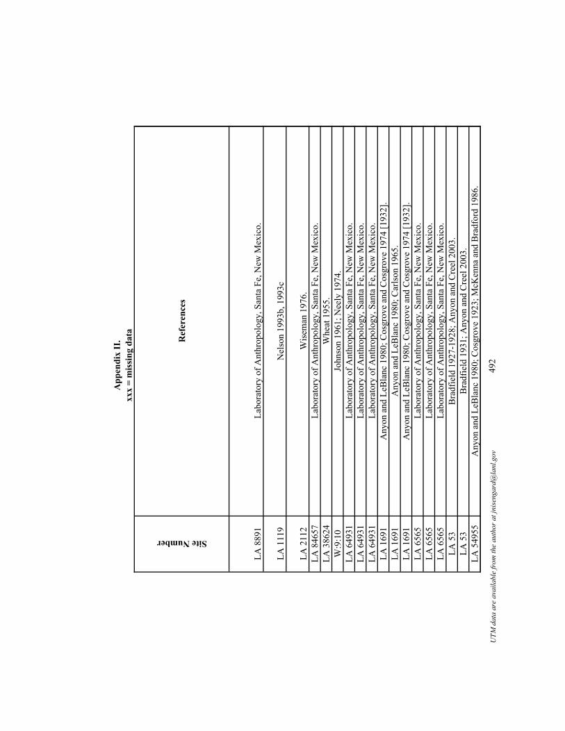
App
endi
x II
.xx
x =
mis
sing
dat
a
Site Number
LA 8
891
LA 1
119
LA 2
112
LA 8
4657
LA 3
8624
W:9
:10
LA 6
4931
LA 6
4931
LA 6
4931
LA 1
691
LA 1
691
LA 1
691
LA 6
565
LA 6
565
LA 6
565
LA 5
3LA
53
LA 5
4955
Ref
eren
ces
Labo
rato
ry o
f Ant
hrop
olog
y, S
anta
Fe,
New
Mex
ico.
Nel
son
1993
b, 1
993c
Wis
eman
197
6.La
bora
tory
of A
nthr
opol
ogy,
San
ta F
e, N
ew M
exic
o.W
heat
195
5.Jo
hnso
n 19
61; N
eely
197
4.La
bora
tory
of A
nthr
opol
ogy,
San
ta F
e, N
ew M
exic
o.La
bora
tory
of A
nthr
opol
ogy,
San
ta F
e, N
ew M
exic
o.La
bora
tory
of A
nthr
opol
ogy,
San
ta F
e, N
ew M
exic
o.A
nyon
and
LeB
lanc
198
0; C
osgr
ove
and
Cos
grov
e 19
74 [1
932]
.A
nyon
and
LeB
lanc
198
0; C
arls
on 1
965.
Any
on a
nd L
eBla
nc 1
980;
Cos
grov
e an
d C
osgr
ove
1974
[193
2].
Labo
rato
ry o
f Ant
hrop
olog
y, S
anta
Fe,
New
Mex
ico.
Labo
rato
ry o
f Ant
hrop
olog
y, S
anta
Fe,
New
Mex
ico.
Labo
rato
ry o
f Ant
hrop
olog
y, S
anta
Fe,
New
Mex
ico.
Bra
dfie
ld 1
927-
1928
; Any
on a
nd C
reel
200
3.B
radf
ield
193
1; A
nyon
and
Cre
el 2
003.
Any
on a
nd L
eBla
nc 1
980;
Cos
grov
e 19
23; M
cKen
na a
nd B
radf
ord
1986
.
UTM
dat
a ar
e av
aila
ble
from
the
auth
or a
t jni
seng
ard@
lanl
.gov
492

App
endi
x II
.xx
x =
mis
sing
dat
a
Site Number
Site Name
Total Number of Communal Structures
Contemporary?
Structure Number
Period
AZ
P:16
:2Tl
a K
ii3
No,
not
com
plet
edK
iva
2EP
AZ
P:16
:2Tl
a K
ii3
No,
repl
aced
Kiv
a 2
Kiv
a 52
EP
AZ
P:16
:2Tl
a K
ii3
No,
inte
grat
ion
Kiv
a 1
EPLA
162
41Tr
easu
re H
ill2
Yes
Roo
m 6
EPLA
162
41Tr
easu
re H
ill2
Yes
Roo
m 8
EP
AZ
W:9
:123
Turk
ey C
reek
4N
o, la
ter t
han
othe
rsG
reat
Kiv
aEL
P
AZ
W:9
:123
Turk
ey C
reek
4Y
es, c
oeva
l with
Roo
m
237-
K2
Roo
m 1
52-K
1EL
PA
Z W
:9:1
23Tu
rkey
Cre
ek4
Yes
Roo
m 2
51-K
3EL
P
AZ
W:9
:123
Turk
ey C
reek
4Y
es, C
oeva
l with
Roo
m
152-
K1
Roo
m 2
37-K
2EL
P
LA 9
709
Turk
ey F
oot R
idge
1n/
aPi
thou
se K
MPS
Turq
uois
e R
idge
1n/
aSt
ruct
ure
35M
PSLA
327
1V
alle
y V
iew
1n/
aR
oom
2EL
PLA
888
89V
icto
rio3
Unk
now
nN
one
give
nEL
PLA
888
89V
icto
rio3
Unk
now
nN
one
give
nEL
P
UTM
dat
a ar
e av
aila
ble
from
the
auth
or a
t jni
seng
ard@
lanl
.gov
493

App
endi
x II
.xx
x =
mis
sing
dat
a
Site Number
AZ
P:16
:2
AZ
P:16
:2
AZ
P:16
:2LA
162
41LA
162
41
AZ
W:9
:123
AZ
W:9
:123
AZ
W:9
:123
AZ
W:9
:123
LA 9
709
LA 3
271
LA 8
8889
LA 8
8889
Dates (A.D.)
Dating notes and/or alternative dates
Size (m2)
Location
Structure Shape
Structure Shape Code
1035
; 111
3+/-2
Tree
-rin
g no
n-cu
tting
dat
e;
radi
ocar
bon
date
12xx
xR
ecta
ngul
ar2
1000
-115
0; 1
008+
x to
112
3+/-1
(H
aury
198
5)C
eram
ic d
ate;
Tre
e-rin
g no
n-cu
tting
da
te ra
nges
260.
2xx
xxx
xxx
x
1008
-112
1Tr
ee-r
ing
non-
cutti
ng d
ates
287.
6I
Circ
ular
110
00-1
150
Cer
amic
dat
e14
.3A
Rec
tang
ular
210
00-1
150
Cer
amic
dat
e14
.6A
Rec
tang
ular
2
1240
Tree
-rin
g cu
tting
dat
e18
0P
Rec
tang
ular
2
1225
-128
6A
rcha
eom
agne
tic d
ate
rang
e11
.6A
Circ
ular
112
25-1
286
Arc
haeo
mag
netic
dat
e ra
nge
13A
Rec
tang
ular
2
1225
-128
6A
rcha
eom
agne
tic d
ate
rang
e14
AR
ecta
ngul
ar2
767r
; 751
vv; 7
67vv
; 774
vv; 7
75vv
; 77
7vv;
778
vv; 7
67-7
73vv
Tree
-rin
g cu
tting
and
non
-cut
ting
date
s59
.2xx
xR
ecta
ngul
ar2
770-
820
Arc
haeo
mag
netic
dat
e ra
nge
30xx
xC
ircul
ar1
1100
-125
0C
eram
ic d
ate
29.3
xxx
xxx
xxx
1100
-120
0C
eram
ic d
ate
xxx
xxx
xxx
xxx
1100
-120
0C
eram
ic d
ate
xxx
xxx
xxx
xxx
UTM
dat
a ar
e av
aila
ble
from
the
auth
or a
t jni
seng
ard@
lanl
.gov
494

App
endi
x II
.xx
x =
mis
sing
dat
aSite Number
AZ
P:16
:2
AZ
P:16
:2
AZ
P:16
:2LA
162
41LA
162
41
AZ
W:9
:123
AZ
W:9
:123
AZ
W:9
:123
AZ
W:9
:123
LA 9
709
LA 3
271
LA 8
8889
LA 8
8889
Entryway
Entryway Codes
Orientation
Features
Sipapu
Vent
Deflector
Niche
Pit
Storage Pit
Burials
Floor Vault
Footdrum
Bench
Other
Non
e0
Sout
heas
tB
ench
00
00
00
00
01
0
xxx
xxx
xxx
xxx
00
00
00
00
00
0
Step
ped
entry
way
3So
uthe
ast
Ben
ch, a
nnex
room
s add
ed to
ki
va0
00
00
00
00
11
xxx
xxx
Sout
hV
ent
01
00
00
00
00
0xx
xxx
xW
est
Ven
t0
10
00
00
00
00
Ram
p2
Sout
heas
tFo
ot d
rum
, hea
rth0
00
00
00
01
00
No
info
xxx
xxx
Hea
rth0
00
00
00
00
00
Roo
f ent
ry1
Sout
heas
tB
uria
l, he
arth
s0
00
00
01
00
00
Roo
f ent
ry1
Sout
heas
t
Ven
t, st
orag
e bi
n (p
ortio
ns o
f ro
om w
alle
d of
f to
crea
te th
is
bin)
, hea
rths
01
00
01
00
00
0
Step
ped
entry
way
3Ea
stPi
ts0
00
03
00
00
00
Ram
p2
Sout
heas
tPo
ssib
le v
ent,
benc
h, fi
repi
t0
10
00
00
00
10
xxx
xxx
xxx
xxx
00
00
00
00
00
0xx
xxx
xxx
xxx
x0
00
00
00
00
00
xxx
xxx
xxx
xxx
00
00
00
00
00
0
UTM
dat
a ar
e av
aila
ble
from
the
auth
or a
t jni
seng
ard@
lanl
.gov
495

App
endi
x II
.xx
x =
mis
sing
dat
aSite Number
AZ
P:16
:2
AZ
P:16
:2
AZ
P:16
:2LA
162
41LA
162
41
AZ
W:9
:123
AZ
W:9
:123
AZ
W:9
:123
AZ
W:9
:123
LA 9
709
LA 3
271
LA 8
8889
LA 8
8889
Number of Hearths
Hearth Shape
Hearth Shape Codes
Quad Name
General location and/or County
0N
o fo
rmal
hea
rth6
xxx
East
-cen
tral A
rizon
a
xxx
xxx
xxx
xxx
East
-cen
tral A
rizon
a
xxx
xxx
xxx
xxx
East
-cen
tral A
rizon
axx
xxx
xxx
xFt
. Bay
ard
Gra
nt C
o, so
uthw
este
rn N
ew M
exic
oxx
xxx
xxx
xFt
. Bay
ard
Gra
nt C
o, so
uthw
este
rn N
ew M
exic
o
1C
ircul
ar1
Nat
anes
Mou
ntai
nsG
raha
m C
o, e
ast-c
entra
l Ariz
ona
1C
ircul
ar1
Nat
anes
Mou
ntai
nsG
raha
m C
o, e
ast-c
entra
l Ariz
ona
31
Circ
ular
, 1 re
ctan
gula
r1,
2N
atan
es M
ount
ains
Gra
ham
Co,
eas
t-cen
tral A
rizon
a
32
Circ
ular
, 1 u
nkno
wn
1N
atan
es M
ount
ains
Gra
ham
Co,
eas
t-cen
tral A
rizon
a
xxx
xxx
xxx
Bul
l Bas
inC
atro
n C
o, W
este
rn N
ew M
exic
o 1
Fire
pit
8El
Pas
oEl
Pas
o C
o, W
est T
exas
xxx
xxx
xxx
Squi
rrel
Spr
ing
Can
yon
Cat
ron
Co,
Wes
tern
New
Mex
ico
xxx
xxx
xxx
Mon
toya
Blu
ffSo
uthw
este
rn N
ew M
exic
oxx
xxx
xxx
xM
onto
ya B
luff
Sout
hwes
tern
New
Mex
ico
UTM
dat
a ar
e av
aila
ble
from
the
auth
or a
t jni
seng
ard@
lanl
.gov
496

App
endi
x II
.xx
x =
mis
sing
dat
a
Site Number
AZ
P:16
:2
AZ
P:16
:2
AZ
P:16
:2LA
162
41LA
162
41
AZ
W:9
:123
AZ
W:9
:123
AZ
W:9
:123
AZ
W:9
:123
LA 9
709
LA 3
271
LA 8
8889
LA 8
8889
Water
Topography
Vegetation
Elevation (ft)
Phase Names
Fore
stda
le C
reek
Firs
t ter
race
Piño
n/Ju
nipe
r60
00C
arriz
o
Fore
stda
le C
reek
Firs
t ter
race
Piño
n/Ju
nipe
r60
00C
arriz
o
Fore
stda
le C
reek
Firs
t ter
race
Piño
n/Ju
nipe
r60
00C
arriz
oC
amer
on C
reek
Rid
geG
rass
land
6060
Cla
ssic
Cam
eron
Cre
ekR
idge
Gra
ssla
nd60
60C
lass
ic
Turk
ey C
reek
Rid
geG
rass
land
6600
Tula
rosa
Turk
ey C
reek
Rid
geG
rass
land
6600
Tula
rosa
Turk
ey C
reek
Rid
geG
rass
land
6600
Tula
rosa
Turk
ey C
reek
Rid
geG
rass
land
6600
Tula
rosa
San
Fran
cisc
o R
iver
Rid
geFo
rest
6240
San
Fran
cisc
o/Th
ree-
Circ
leR
io G
rand
eR
idge
Scru
blan
d35
00Sa
n Fr
anci
sco-
Thre
e C
ircle
xxx
Hill
top
Fore
st65
60R
eser
ve/T
ular
osa
xxx
Terr
ace
Woo
dlan
d60
00La
te R
eser
ve/E
arly
Tul
aros
axx
xTe
rrac
eW
oodl
and
6000
Late
Res
erve
/Ear
ly T
ular
osa
UTM
dat
a ar
e av
aila
ble
from
the
auth
or a
t jni
seng
ard@
lanl
.gov
497

App
endi
x II
.xx
x =
mis
sing
dat
a
Site Number
AZ
P:16
:2
AZ
P:16
:2
AZ
P:16
:2LA
162
41LA
162
41
AZ
W:9
:123
AZ
W:9
:123
AZ
W:9
:123
AZ
W:9
:123
LA 9
709
LA 3
271
LA 8
8889
LA 8
8889
Site Size
Site Size Codes
Construction Technique
Burning
21 ro
oms
1xx
x0
21 ro
oms
1xx
xxx
x
21 ro
oms
1H
ard
pack
ed c
lay
floor
, mas
onry
wal
ls0
70+
room
s in
six
room
bloc
ks2
Mas
onry
wal
lsxx
x70
+ ro
oms i
n si
x ro
ombl
ocks
2M
ason
ry w
alls
xxx
335
room
s5
xxx
xxx
335
room
s5
xxx
333
5 ro
oms
5xx
xxx
x
335
room
s5
xxx
110
-20
pith
ouse
s (14
pith
ouse
s, 1
non-
resi
dent
ial)
1xx
xxx
xxx
xxx
xxx
xxx
x10
-12
room
s1
xxx
xxx
36 su
rfac
e ro
oms
1xx
xxx
x36
surf
ace
room
s1
xxx
xxx
UTM
dat
a ar
e av
aila
ble
from
the
auth
or a
t jni
seng
ard@
lanl
.gov
498

App
endi
x II
.xx
x =
mis
sing
dat
aSite Number
AZ
P:16
:2
AZ
P:16
:2
AZ
P:16
:2LA
162
41LA
162
41
AZ
W:9
:123
AZ
W:9
:123
AZ
W:9
:123
AZ
W:9
:123
LA 9
709
LA 3
271
LA 8
8889
LA 8
8889
Add
ition
al In
form
atio
n an
d N
otes
Con
stru
ctio
n of
this
stru
ctur
e w
as n
ot c
ompl
eted
, aba
ndon
ed fo
r con
stru
ctio
n of
the
GK
, 21
room
pue
blo.
East
-cen
tral A
rizon
a, k
iva
burn
ed, 2
5m so
uth
of th
e pu
eblo
, ste
pped
ent
ranc
e. T
wen
ty-o
ne ro
om p
uebl
o, la
rgel
y de
stro
yed
by e
rosi
on.
In N
orth
Hou
se ro
ombl
ock.
In E
ast H
ouse
room
bloc
k.C
onst
ruct
ed e
arly
; Mea
sure
men
t fro
m m
ap; 3
35 ro
oms,
Gre
at K
iva,
thre
e sm
all k
ivas
, sev
eral
form
al p
laza
s at t
he si
te. T
ree-
ring
date
A
.D. 1
240.
Cov
ered
by
dwel
lings
, 335
room
s.Th
ree
hund
red
and
thirt
y-fiv
e ro
oms.
Cov
ered
by
dwel
lings
, 335
room
s.
Tree
ring
dat
es: A
.D. 7
51vv
; 767
vv; 7
74vv
.A
lso
TX:4
:132
. Lat
eral
ent
ryw
ay. T
he st
ruct
ure
is th
ree
times
as l
arge
as o
ther
stru
ctur
es a
t the
site
.Te
n to
twel
ve ro
om re
ctan
gula
r pue
blo
with
two
kiva
s.Th
irty-
six
surf
ace
room
s/44
7 ro
oms a
ccor
ding
to M
ogol
lon
Con
fere
nce
pape
r (20
02).
Thirt
y-si
x su
rfac
e ro
oms.
UTM
dat
a ar
e av
aila
ble
from
the
auth
or a
t jni
seng
ard@
lanl
.gov
499

App
endi
x II
.xx
x =
mis
sing
dat
a
Site Number
AZ
P:16
:2
AZ
P:16
:2
AZ
P:16
:2LA
162
41LA
162
41
AZ
W:9
:123
AZ
W:9
:123
AZ
W:9
:123
AZ
W:9
:123
LA 9
709
LA 3
271
LA 8
8889
LA 8
8889
Ref
eren
ces
Hau
ry 1
985;
Her
r 200
1.
Hau
ry 1
985;
Her
r 200
1.
Hau
ry 1
985;
Her
r 200
1.A
nyon
and
LeB
lanc
198
0; C
osgr
ove
1923
.A
nyon
and
LeB
lanc
198
0; C
osgr
ove
1923
.
Ric
k K
arl p
erso
nal c
omm
unic
atio
n; L
owel
l 199
1.
Ric
k K
arl p
erso
nal c
omm
unic
atio
n; L
owel
l 199
1.R
ick
Kar
l per
sona
l com
mun
icat
ion;
Low
ell 1
991.
Ric
k K
arl p
erso
nal c
omm
unic
atio
n; L
owel
l 199
1.
Die
hl a
nd L
e B
lanc
200
1; L
ight
foot
and
Fei
nman
198
2; M
artin
and
Rin
aldo
195
0; W
heat
195
5.W
hale
n 19
94.
Schr
oder
et a
l. 19
54; W
endo
rf 1
954.
Labo
rato
ry o
f Ant
hrop
olog
y, S
anta
Fe,
New
Mex
ico.
Labo
rato
ry o
f Ant
hrop
olog
y, S
anta
Fe,
New
Mex
ico.
UTM
dat
a ar
e av
aila
ble
from
the
auth
or a
t jni
seng
ard@
lanl
.gov
500

App
endi
x II
.xx
x =
mis
sing
dat
a
Site Number
Site Name
Total Number of Communal Structures
Contemporary?
Structure Number
Period
LA 8
8889
Vic
torio
3U
nkno
wn
Non
e gi
ven
ELP
LA 1
9071
War
m sp
rings
1n/
aK
iva
Pit S
truct
ure
LA 8
675
Wes
t For
k2
Unk
now
n10
EPLA
867
5W
est F
ork
2U
nkno
wn
6EP
LA 4
424
Whe
atle
y R
idge
1n/
aH
ouse
7LP
S
LA 1
8903
Whe
aton
Sm
ith1
n/a
Uni
t 34
EP
LA 1
2726
0W
ind
Mou
ntai
n12
Yes
Hou
se P
2EP
LA 1
2726
0W
ind
Mou
ntai
n12
Yes
Roo
m 3
EPLA
127
260
Win
d M
ount
ain
12Y
esR
oom
15
EPLA
127
260
Win
d M
ount
ain
12Y
esR
oom
7EP
LA 1
2726
0W
ind
Mou
ntai
n12
Yes
Hou
se V
EPLA
127
260
Win
d M
ount
ain
12Y
esH
ouse
YLP
SLA
127
260
Win
d M
ount
ain
12Y
esH
ouse
ULP
SLA
127
260
Win
d M
ount
ain
12Y
esH
ouse
XX
LPS
LA 1
2726
0W
ind
Mou
ntai
n12
Yes
Hou
se X
LPS
UTM
dat
a ar
e av
aila
ble
from
the
auth
or a
t jni
seng
ard@
lanl
.gov
501

App
endi
x II
.xx
x =
mis
sing
dat
a
Site Number
LA 8
8889
LA 1
9071
LA 8
675
LA 8
675
LA 4
424
LA 1
8903
LA 1
2726
0LA
127
260
LA 1
2726
0LA
127
260
LA 1
2726
0LA
127
260
LA 1
2726
0LA
127
260
LA 1
2726
0
Dates (A.D.)
Dating notes and/or alternative dates
Size (m2)
Location
Structure Shape
Structure Shape Code
1100
-120
0C
eram
ic d
ate
xxx
xxx
xxx
xxx
600-
1000
Gen
eral
per
iod
date
62xx
xR
ecta
ngul
ar2
1000
-115
0C
eram
ic d
ate
9.8
AR
ecta
ngul
ar2
1000
-115
0C
eram
ic d
ate
16A
Rec
tang
ular
287
0-93
6A
rcha
eom
agne
tic d
ate
rang
e10
0.4
xxx
Rec
tang
ular
2
1000
-115
0C
eram
ic d
ate
28.8
ASq
uare
6
1100
Tree
-rin
g no
n-cu
tting
dat
e18
.24
AR
ecta
ngul
ar2
1000
-115
09.
06A
Rec
tang
ular
210
30-1
150
Arc
haeo
mag
netic
dat
e ra
nge
8.96
AR
ecta
ngul
ar2
1040
-113
0A
rcha
eom
agne
tic d
ate
rang
e37
.9A
Rec
tang
ular
2
970-
1080
Arc
haeo
mag
netic
dat
e ra
nge
15.2
7A
Rec
tang
ular
275
0-10
00C
eram
ic d
ate
29.8
4A
Rec
tang
ular
275
0-10
00C
eram
ic d
ate
36.9
AR
ecta
ngul
ar2
778-
1030
Arc
haeo
mag
netic
dat
e ra
nge
27.9
5P
Rec
tang
ular
2
800-
940
Arc
haeo
mag
netic
dat
e ra
nge
70.5
PD
-sha
ped
4
UTM
dat
a ar
e av
aila
ble
from
the
auth
or a
t jni
seng
ard@
lanl
.gov
502

App
endi
x II
.xx
x =
mis
sing
dat
aSite Number
LA 8
8889
LA 1
9071
LA 8
675
LA 8
675
LA 4
424
LA 1
8903
LA 1
2726
0LA
127
260
LA 1
2726
0LA
127
260
LA 1
2726
0LA
127
260
LA 1
2726
0LA
127
260
LA 1
2726
0
Entryway
Entryway Codes
Orientation
Features
Sipapu
Vent
Deflector
Niche
Pit
Storage Pit
Burials
Floor Vault
Footdrum
Bench
Other
xxx
xxx
xxx
xxx
00
00
00
00
00
0xx
xxx
x12
1xx
x0
00
00
00
00
00
xxx
xxx
Sout
hwes
tH
earth
00
00
00
00
00
0xx
xxx
xN
orth
xxx
00
00
00
00
00
0R
amp
2Ea
stH
earth
00
00
00
00
00
0
Doo
rway
4W
est
Hea
rth0
00
00
00
00
00
Roo
f ent
ry1
113
Ven
t (re
mod
eled
ent
ryw
ay fr
om
earli
er p
it st
ruct
ure)
, hea
rth0
10
00
00
00
00
Roo
f ent
ry1
Unk
now
nV
ent,
hear
ths
01
00
00
00
00
0R
oof e
ntry
1U
nkno
wn
Ven
t, he
arth
01
00
00
00
00
0La
tera
l ent
ry4
East
Two
pits
, hea
rth0
00
02
00
00
00
Roo
f ent
ry1
85V
ent,
hear
th0
10
10
00
00
00
Ram
p2
188
Hea
rth0
00
00
00
00
00
Ram
p2
85W
all n
iche
, hea
rth0
00
10
00
00
00
Ram
p2
66H
earth
00
00
00
00
00
0
Ram
p2
102
Wal
l nic
he, s
helf,
mas
sive
ce
ntra
l pos
t, tw
o flo
or g
roov
es,
hear
th0
00
10
01
00
02
UTM
dat
a ar
e av
aila
ble
from
the
auth
or a
t jni
seng
ard@
lanl
.gov
503

App
endi
x II
.xx
x =
mis
sing
dat
aSite Number
LA 8
8889
LA 1
9071
LA 8
675
LA 8
675
LA 4
424
LA 1
8903
LA 1
2726
0LA
127
260
LA 1
2726
0LA
127
260
LA 1
2726
0LA
127
260
LA 1
2726
0LA
127
260
LA 1
2726
0
Number of Hearths
Hearth Shape
Hearth Shape Codes
Quad Name
General location and/or County
xxx
xxx
xxx
Mon
toya
Blu
ffSo
uthw
este
rn N
ew M
exic
oxx
xxx
xxx
xFa
ywoo
d St
atio
nSo
uthw
este
rn N
ew M
exic
o1
Circ
ular
1Li
ttle
Turk
ey P
ark
Sout
hwes
tern
New
Mex
ico
xxx
xxx
xxx
Littl
e Tu
rkey
Par
kSo
uthw
este
rn N
ew M
exic
o1
Unk
now
n sh
ape
7R
eser
veC
atro
n C
o, W
este
rn N
ew M
exic
o
1R
ecta
ngul
ar, s
lab
lined
2Sa
n Lo
renz
oG
rant
Co,
sout
hwes
tern
New
Mex
ico
1R
ecta
ngul
ar2
Win
d M
ount
ain
Gra
nt C
o, so
uthw
este
rn N
ew M
exic
o2
One
circ
ular
, one
squa
re1,
4W
ind
Mou
ntai
nG
rant
Co,
sout
hwes
tern
New
Mex
ico
1R
ecta
ngul
ar2
Win
d M
ount
ain
Gra
nt C
o, so
uthw
este
rn N
ew M
exic
o1
Circ
ular
1W
ind
Mou
ntai
nG
rant
Co,
sout
hwes
tern
New
Mex
ico
1C
ircul
ar c
lay
lined
and
col
lar
1W
ind
Mou
ntai
nG
rant
Co,
sout
hwes
tern
New
Mex
ico
1C
ircul
ar1
Win
d M
ount
ain
Gra
nt C
o, so
uthw
este
rn N
ew M
exic
o1
Circ
ular
1W
ind
Mou
ntai
nG
rant
Co,
sout
hwes
tern
New
Mex
ico
1C
ircul
ar1
Win
d M
ount
ain
Gra
nt C
o, so
uthw
este
rn N
ew M
exic
o
1O
val b
asin
with
slop
ing
side
s3
Win
d M
ount
ain
Gra
nt C
o, so
uthw
este
rn N
ew M
exic
o
UTM
dat
a ar
e av
aila
ble
from
the
auth
or a
t jni
seng
ard@
lanl
.gov
504

App
endi
x II
.xx
x =
mis
sing
dat
a
Site Number
LA 8
8889
LA 1
9071
LA 8
675
LA 8
675
LA 4
424
LA 1
8903
LA 1
2726
0LA
127
260
LA 1
2726
0LA
127
260
LA 1
2726
0LA
127
260
LA 1
2726
0LA
127
260
LA 1
2726
0
Water
Topography
Vegetation
Elevation (ft)
Phase Names
xxx
Terr
ace
Woo
dlan
d60
00La
te R
eser
ve/E
arly
Tul
aros
aM
imbr
es R
iver
Floo
dpla
in/V
alle
yG
rass
land
5025
Late
Pit
Stru
ctur
eW
est F
ork
Gila
Riv
erTe
rrac
e/B
ench
Mar
shla
nd56
60C
lass
icW
est F
ork
Gila
Riv
erTe
rrac
e/B
ench
Mar
shla
nd56
60C
lass
icxx
xFl
oodp
lain
/Val
ley
Fore
st59
60R
eser
ve/T
hree
-Circ
leM
imbr
es
Riv
er/G
allin
a Sp
ring
Ben
chG
rass
land
5680
Cla
ssic
Upp
er G
ila d
rain
age
Rid
geSc
rubl
and
5640
Man
gus/
Mim
bres
Upp
er G
ila d
rain
age
Rid
geSc
rubl
and
5640
Cla
ssic
Upp
er G
ila d
rain
age
Rid
geSc
rubl
and
5640
Cla
ssic
Upp
er G
ila d
rain
age
Rid
geSc
rubl
and
5640
Cla
ssic
Upp
er G
ila d
rain
age
Rid
geSc
rubl
and
5640
Cla
ssic
Upp
er G
ila d
rain
age
Rid
geSc
rubl
and
5640
Thre
e-ci
rcle
Upp
er G
ila d
rain
age
Rid
geSc
rubl
and
5640
Thre
e-ci
rcle
Upp
er G
ila d
rain
age
Rid
geSc
rubl
and
5640
Thre
e-ci
rcle
Upp
er G
ila d
rain
age
Rid
geSc
rubl
and
5640
San
Fran
cisc
o/Th
ree
circ
le
UTM
dat
a ar
e av
aila
ble
from
the
auth
or a
t jni
seng
ard@
lanl
.gov
505

App
endi
x II
.xx
x =
mis
sing
dat
a
Site Number
LA 8
8889
LA 1
9071
LA 8
675
LA 8
675
LA 4
424
LA 1
8903
LA 1
2726
0LA
127
260
LA 1
2726
0LA
127
260
LA 1
2726
0LA
127
260
LA 1
2726
0LA
127
260
LA 1
2726
0
Site Size
Site Size Codes
Construction Technique
Burning
36 su
rfac
e ro
oms
1xx
xxx
xxx
xxx
xxx
x2
Larg
e5
xxx
0La
rge
5xx
xxx
x14
pith
ouse
s1
Mas
onry
line
dxx
x
xxx
xxx
Cob
bles
tone
mas
onry
0
50+
pit s
truct
ures
& 3
room
bloc
ks2
Mas
onry
with
pla
ster
xxx
50+
pit s
truct
ures
& 3
room
bloc
ks2
Subt
erra
nean
xxx
50+
pit s
truct
ures
& 3
room
bloc
ks2
Subt
erra
nean
xxx
50+
pit s
truct
ures
& 3
room
bloc
ks2
Cob
ble
ston
e m
ason
ryxx
x
50+
pit s
truct
ures
& 3
room
bloc
ks2
Subt
erra
nean
, bui
lt in
fill
of H
ouse
Uxx
x50
+ pi
t stru
ctur
es &
3 ro
ombl
ocks
2Su
bter
rane
anxx
x50
+ pi
t stru
ctur
es &
3 ro
ombl
ocks
2Su
bter
rane
anxx
x50
+ pi
t stru
ctur
es &
3 ro
ombl
ocks
2B
uilt
over
Hou
se A
B; s
ubsu
rfac
exx
x
50+
pit s
truct
ures
& 3
room
bloc
ks2
Subt
erra
nean
xxx
UTM
dat
a ar
e av
aila
ble
from
the
auth
or a
t jni
seng
ard@
lanl
.gov
506

App
endi
x II
.xx
x =
mis
sing
dat
aSite Number
LA 8
8889
LA 1
9071
LA 8
675
LA 8
675
LA 4
424
LA 1
8903
LA 1
2726
0LA
127
260
LA 1
2726
0LA
127
260
LA 1
2726
0LA
127
260
LA 1
2726
0LA
127
260
LA 1
2726
0
Add
ition
al In
form
atio
n an
d N
otes
Thirt
y-si
x su
rfac
e ro
oms.
Als
o Y
:8:3
2. B
urne
d, te
rmin
atio
n ob
ject
s.A
lso
know
n as
the
TJ R
anch
Hom
este
ad.
The
com
mun
al st
ruct
ure
is a
ttach
ed to
a ro
ombl
ock.
Als
o kn
own
as th
e TJ
Ran
ch H
omes
tead
.
Als
o Z:
1:46
. Com
mun
al st
ruct
ure
is a
ttach
ed to
a ro
ombl
ock.
Als
o N
M:Y
:7:1
. Man
gas C
reek
, Bur
ro M
ount
ains
; AR
MS
says
five
kiv
as 9
50-1
150;
eig
ht k
ivas
550
-950
.A
lso
NM
:Y:7
:1. M
anga
s Cre
ek, B
urro
Mou
ntai
ns; A
RM
S sa
ys fi
ve k
ivas
950
-115
0; e
ight
kiv
as 5
50-9
50.
Als
o N
M:Y
:7:1
. Man
gas C
reek
, Bur
ro M
ount
ains
; AR
MS
says
five
kiv
as 9
50-1
150;
eig
ht k
ivas
550
-950
.A
lso
NM
:Y:7
:1. M
anga
s Cre
ek, B
urro
Mou
ntai
ns; A
RM
S sa
ys fi
ve k
ivas
950
-115
0; e
ight
kiv
as 5
50-9
50.
Als
o N
M Y
:7:1
. VER
Y D
EEP
STR
UC
TUR
E - 2
20 c
m; M
anga
s Cre
ek, B
urro
Mou
ntai
ns; A
RM
S sa
ys fi
ve k
ivas
950
-115
0; e
ight
ki
vas 5
50-9
50.
Als
o N
M:Y
:7:1
. Man
gas C
reek
, Bur
ro M
ount
ains
; AR
MS
says
five
kiv
as 9
50-1
150;
eig
ht k
ivas
550
-950
.A
lso
NM
:Y:7
:1. M
anga
s Cre
ek, B
urro
Mou
ntai
ns; A
RM
S sa
ys fi
ve k
ivas
950
-115
0; e
ight
kiv
as 5
50-9
50.
Als
o N
M:Y
:7:1
. Man
gas C
reek
, Bur
ro M
ount
ains
; AR
MS
says
five
kiv
as 9
50-1
150;
eig
ht k
ivas
550
-950
.
Als
o N
M Y
:7:1
. Man
gas C
reek
, Bur
ro M
ount
ains
; AR
MS
says
five
kiv
as 9
50-1
150;
eig
ht k
ivas
550
-950
.
UTM
dat
a ar
e av
aila
ble
from
the
auth
or a
t jni
seng
ard@
lanl
.gov
507

App
endi
x II
.xx
x =
mis
sing
dat
a
Site Number
LA 8
8889
LA 1
9071
LA 8
675
LA 8
675
LA 4
424
LA 1
8903
LA 1
2726
0LA
127
260
LA 1
2726
0LA
127
260
LA 1
2726
0LA
127
260
LA 1
2726
0LA
127
260
LA 1
2726
0
Ref
eren
ces
Labo
rato
ry o
f Ant
hrop
olog
y, S
anta
Fe,
New
Mex
ico.
Labo
rato
ry o
f Ant
hrop
olog
y, S
anta
Fe,
New
Mex
ico.
Any
on a
nd L
eBla
nc 1
980;
Ice
1968
.A
nyon
and
LeB
lanc
198
0; Ic
e 19
68.
Labo
rato
ry o
f Ant
hrop
olog
y, S
anta
Fe,
New
Mex
ico.
Any
on a
nd L
eBla
nc 1
980.
Woo
sley
and
McI
ntyr
e 19
96.
Woo
sley
and
McI
ntyr
e 19
96.
Woo
sley
and
McI
ntyr
e 19
96.
Woo
sley
and
McI
ntyr
e 19
96.
Woo
sley
and
McI
ntyr
e 19
96.
Woo
sley
and
McI
ntyr
e 19
96.
Woo
sley
and
McI
ntyr
e 19
96.
Woo
sley
and
McI
ntyr
e 19
96.
Any
on a
nd C
reel
200
3; W
oosl
ey, a
nd M
cInt
yre
1996
.
UTM
dat
a ar
e av
aila
ble
from
the
auth
or a
t jni
seng
ard@
lanl
.gov
508

App
endi
x II
.xx
x =
mis
sing
dat
a
Site Number
Site Name
Total Number of Communal Structures
Contemporary?
Structure Number
Period
LA 1
2726
0W
ind
Mou
ntai
n12
Yes
Hou
se A
BM
PS
LA 1
2726
0W
ind
Mou
ntai
n12
Yes
Hou
se A
KM
PS
LA 1
2726
0W
ind
Mou
ntai
n12
Yes
Hou
se O
MPS
LA 3
4813
Win
n C
anyo
n1
n/a
Roo
m 2
/Kiv
aEP
S
LA 3
259
WN
MT
411
n/a
Non
e gi
ven
Mog
ollo
n
LA 3
278
WN
MT
92/G
lenw
ood
Hig
hway
Sal
vage
#1
1n/
aK
iva
Mog
ollo
nLA
245
4W
oodr
ow2
Unk
now
nN
one
give
nEP
LA 2
454
Woo
drow
2U
nkno
wn
Non
e gi
ven
EP
LA 3
099
WS
Ran
ch/M
cKee
n2
No,
LP
Kiv
a G
LPLA
309
9W
S R
anch
/McK
een
2N
o, L
PSK
iva
CLP
SLA
129
4Y
eo 1
941
n/a
Gre
at K
iva
EPLA
327
42
No,
ELP
Non
e gi
ven
ELP
W:1
0:37
5Y
esK
iva
5EL
PW
:10:
375
Yes
Kiv
a 3
ELP
W:1
0:37
5Y
esK
iva
2EL
P
UTM
dat
a ar
e av
aila
ble
from
the
auth
or a
t jni
seng
ard@
lanl
.gov
509

App
endi
x II
.xx
x =
mis
sing
dat
a
Site Number
LA 1
2726
0
LA 1
2726
0
LA 1
2726
0LA
348
13
LA 3
259
LA 3
278
LA 2
454
LA 2
454
LA 3
099
LA 3
099
LA 1
294
LA 3
274
W:1
0:37
W:1
0:37
W:1
0:37
Dates (A.D.)
Dating notes and/or alternative dates
Size (m2)
Location
Structure Shape
Structure Shape Code
620-
730
Arc
haeo
mag
netic
dat
e ra
nge
40.5
AO
val
5
640-
780
Arc
haeo
mag
netic
dat
e ra
nge
29.8
5A
Squa
re6
650-
750
Cer
amic
dat
e28
.24
AC
ircul
ar1
310+
/-75
Rad
ioca
rbon
dat
e63
.5S
Circ
ular
with
lobe
s3
650-
1350
Gen
eral
cul
tura
l dat
e14
xxx
Rec
tang
ular
2
600-
1200
Gen
eral
cul
tura
l dat
e15
.9xx
xxx
xxx
x10
00C
eram
ic d
ate
120
PR
ecta
ngul
ar2
1000
Cer
amic
dat
e27
9P
Rec
tang
ular
2
1175
-140
0C
eram
ic d
ate
13xx
xC
ircul
ar1
950
+/-8
0R
adio
carb
on d
ate
39.7
AR
ecta
ngul
ar2
1000
-117
5C
eram
ic d
ate
279
xxx
xxx
xxx
1200
Tree
-rin
g no
n-cu
tting
dat
exx
xI
Rec
tang
ular
211
50-1
265
Cer
amic
dat
e7.
5xx
xIr
regu
lar
711
50-1
265
Cer
amic
dat
e9.
6xx
xSq
uare
611
50-1
265
Cer
amic
dat
e10
.5xx
xSq
uare
6
UTM
dat
a ar
e av
aila
ble
from
the
auth
or a
t jni
seng
ard@
lanl
.gov
510

App
endi
x II
.xx
x =
mis
sing
dat
aSite Number
LA 1
2726
0
LA 1
2726
0
LA 1
2726
0LA
348
13
LA 3
259
LA 3
278
LA 2
454
LA 2
454
LA 3
099
LA 3
099
LA 1
294
LA 3
274
W:1
0:37
W:1
0:37
W:1
0:37
Entryway
Entryway Codes
Orientation
Features
Sipapu
Vent
Deflector
Niche
Pit
Storage Pit
Burials
Floor Vault
Footdrum
Bench
Other
Ram
p2
117
Hea
rth0
00
00
00
00
00
Ram
p2
15Th
ree
pits
, bur
ial,
mul
tiple
pos
t ho
les,
hear
th0
00
03
01
00
00
Des
troye
d by
su
bseq
uent
co
nstru
ctio
nN
DEa
stH
earth
00
00
00
00
00
0R
oof e
ntry
110
3H
earth
00
00
00
00
00
0
Ram
p2
Sout
heas
txx
x0
00
00
00
00
00
xxx
xxx
xxx
xxx
00
00
00
00
00
0R
amp
2So
uthe
ast
xxx
00
00
00
00
00
0R
amp
2So
uthe
ast
xxx
00
00
00
00
00
0
xxx
xxx
xxx
xxx
00
00
00
00
00
0xx
xxx
xSo
uth
2 flo
or v
aults
, hea
rth0
00
00
00
20
00
xxx
xxx
xxx
xxx
00
00
00
00
00
0R
amp
2xx
xxx
x0
00
00
00
00
00
xxx
xxx
Sout
hV
ent
01
00
00
00
00
0xx
xxx
xEa
stV
ent,
hear
th0
10
00
00
00
00
Roo
f ent
ry1
East
Ven
t, st
orag
e pi
t, he
arth
01
00
01
00
00
0
UTM
dat
a ar
e av
aila
ble
from
the
auth
or a
t jni
seng
ard@
lanl
.gov
511

App
endi
x II
.xx
x =
mis
sing
dat
aSite Number
LA 1
2726
0
LA 1
2726
0
LA 1
2726
0LA
348
13
LA 3
259
LA 3
278
LA 2
454
LA 2
454
LA 3
099
LA 3
099
LA 1
294
LA 3
274
W:1
0:37
W:1
0:37
W:1
0:37
Number of Hearths
Hearth Shape
Hearth Shape Codes
Quad Name
General location and/or County
1C
ircul
ar1
Win
d M
ount
ain
Gra
nt C
o, so
uthw
este
rn N
ew M
exic
o
1O
val
3W
ind
Mou
ntai
nG
rant
Co,
sout
hwes
tern
New
Mex
ico
1C
ircul
ar1
Win
d M
ount
ain
Gra
nt C
o, so
uthw
este
rn N
ew M
exic
o1
Unk
now
n sh
ape
7C
ante
en C
anyo
nG
rant
Co,
sout
hwes
tern
New
Mex
ico
xxx
xxx
xxx
Squi
rrel
Spr
ings
Cat
ron
Co,
Wes
tern
New
Mex
ico
xxx
xxx
xxx
Gle
nwoo
dC
atro
n C
o, W
este
rn N
ew M
exic
o xx
xxx
xxx
xC
ante
en C
anyo
nG
rant
Co,
sout
hwes
tern
New
Mex
ico
xxx
xxx
xxx
Can
teen
Can
yon
Gra
nt C
o, so
uthw
este
rn N
ew M
exic
o
xxx
xxx
xxx
Alm
aC
atro
n C
o, W
este
rn N
ew M
exic
o 1
Unk
now
n sh
ape
7A
lma
Cat
ron
Co,
Wes
tern
New
Mex
ico
xxx
xxx
xxx
Mon
ticel
loSo
uthw
este
rn N
ew M
exic
oxx
xxx
xxx
xSq
uirr
el S
prin
gs C
anyo
nC
atro
n C
o, W
este
rn N
ew M
exic
o xx
xxx
xxx
xPo
int o
f Pin
es W
est
East
-cen
tral A
rizon
a1
Circ
ular
1Po
int o
f Pin
es W
est
East
-cen
tral A
rizon
a1
Circ
ular
1Po
int o
f Pin
es W
est
East
-cen
tral A
rizon
a
UTM
dat
a ar
e av
aila
ble
from
the
auth
or a
t jni
seng
ard@
lanl
.gov
512

App
endi
x II
.xx
x =
mis
sing
dat
a
Site Number
LA 1
2726
0
LA 1
2726
0
LA 1
2726
0LA
348
13
LA 3
259
LA 3
278
LA 2
454
LA 2
454
LA 3
099
LA 3
099
LA 1
294
LA 3
274
W:1
0:37
W:1
0:37
W:1
0:37
Water
Topography
Vegetation
Elevation (ft)
Phase Names
Upp
er G
ila d
rain
age
Rid
geSc
rubl
and
5640
Geo
rget
own/
San
Fran
cisc
o
Upp
er G
ila d
rain
age
Rid
geSc
rubl
and
5640
San
Fran
cisc
o
Upp
er G
ila d
rain
age
Rid
geSc
rubl
and
5640
San
Fran
cisc
oG
ila R
iver
Terr
ace
Woo
dlan
d46
20C
umbr
e
xxx
Terr
ace/
Hill
slop
eW
oodl
and
6535
San
Fran
cisc
o-Po
st C
lass
ic
xxx
Hill
top
Gra
ssla
nd46
80M
imbr
esG
ila R
iver
Ben
chG
rass
land
4640
Cla
ssic
Gila
Riv
erB
ench
Gra
ssla
nd46
40C
lass
ic
xxx
Terr
ace
Gra
ssla
nd49
60Tu
laro
saxx
xTe
rrac
eG
rass
land
4960
Thre
e-C
ircle
xxx
Ben
chSc
rubl
and
5625
Man
gus/
Mim
bres
xxx
Hill
slop
eFo
rest
6500
Late
Tul
aros
aW
illow
Cre
ekR
idge
Woo
dlan
d60
00Tu
laro
saW
illow
Cre
ekR
idge
Woo
dlan
d60
00Tu
laro
saW
illow
Cre
ekR
idge
Woo
dlan
d60
00Tu
laro
sa
UTM
dat
a ar
e av
aila
ble
from
the
auth
or a
t jni
seng
ard@
lanl
.gov
513

App
endi
x II
.xx
x =
mis
sing
dat
a
Site Number
LA 1
2726
0
LA 1
2726
0
LA 1
2726
0LA
348
13
LA 3
259
LA 3
278
LA 2
454
LA 2
454
LA 3
099
LA 3
099
LA 1
294
LA 3
274
W:1
0:37
W:1
0:37
W:1
0:37
Site Size
Site Size Codes
Construction Technique
Burning
50+
pit s
truct
ures
& 3
room
bloc
ks2
Subt
erra
nean
xxx
50+
pit s
truct
ures
& 3
room
bloc
ks2
Poss
ible
Hoh
okam
influ
ence
; sub
surf
ace
xxx
50+
pit s
truct
ures
& 3
room
bloc
ks2
Unp
last
ered
wal
lsxx
x60
pit
stru
ctur
es2
xxx
xxx
60-8
0 ro
oms&
five
30-
50 ro
om
room
bloc
ks4
Uns
hape
d co
bble
sxx
x
20 ro
oms
1xx
xxx
x16
room
bloc
ks/3
00 ro
oms
4xx
xxx
x16
room
bloc
ks/3
00 ro
oms
4xx
xxx
x
100+
room
s3
xxx
xxx
100+
room
s3
Cob
ble
and
adob
e, m
ason
ry li
ned
02
room
bloc
ks2
xxx
xxx
33 ro
oms
1M
ason
ry w
alls
xxx
40 ro
oms
1xx
xxx
x40
room
s1
xxx
xxx
40 ro
oms
1xx
xxx
x
UTM
dat
a ar
e av
aila
ble
from
the
auth
or a
t jni
seng
ard@
lanl
.gov
514

App
endi
x II
.xx
x =
mis
sing
dat
aSite Number
LA 1
2726
0
LA 1
2726
0
LA 1
2726
0LA
348
13
LA 3
259
LA 3
278
LA 2
454
LA 2
454
LA 3
099
LA 3
099
LA 1
294
LA 3
274
W:1
0:37
W:1
0:37
W:1
0:37
Add
ition
al In
form
atio
n an
d N
otes
Als
o N
M Y
:7:1
. Man
gas C
reek
, Bur
ro M
ount
ains
; AR
MS
says
five
kiv
as 9
50-1
150;
eig
ht k
ivas
550
-950
. Arc
haeo
mag
netic
dat
e A
.D.
650-
870.
Als
o N
M:Y
:7:1
. Man
gas C
reek
, Bur
ro M
ount
ains
; AR
MS
says
five
kiv
as 9
50-1
150;
eig
ht k
ivas
550
-950
.
Als
o N
M:Y
:7:1
. Man
gas C
reek
, Bur
ro M
ount
ains
; AR
MS
says
five
kiv
as 9
50-1
150;
eig
ht k
ivas
550
-950
.La
rges
t pit
stru
ctur
e pe
riod
site
in th
e M
imbr
es re
gion
. A
.D. 4
11 (L
ekso
n); 3
50 B
.C.
Gre
at K
iva
and
smal
l Kiv
a (A
RM
S); a
ssoc
iate
d st
orag
e ro
om; m
ain
room
bloc
k 60
-80
room
s; su
rrou
nded
by
five
smal
l 30-
50 ro
om
room
bloc
ks.
Twen
ty o
r mor
e ro
oms.
Thre
e ki
vas t
otal
; tw
o fr
om 6
00-1
000;
one
from
100
0-14
00 (A
RM
S); 1
6 ro
ombl
ocks
with
300
room
s and
33
pit d
epre
ssio
ns.
Thre
e ki
vas t
otal
; tw
o fr
om 6
00-1
000;
one
from
100
0-14
00 (A
RM
S); 1
6 ro
ombl
ocks
with
300
room
s and
33
pit d
epre
ssio
ns.
Smal
l stru
ctur
e.O
ne h
undr
ed a
nd fi
fty ro
oms a
t the
site
. Th
e ki
va is
clo
sest
to ro
ombl
ocks
A a
nd B
.D
ates
are
fro
m th
e A
RM
S da
taba
se.
Gre
at K
iva
- 150
yar
ds fr
om si
te to
the
N, R
amp
entry
way
; 33
ston
e m
ason
ry ro
oms.
Forty
room
s.Fo
rty ro
oms.
Forty
room
s.
UTM
dat
a ar
e av
aila
ble
from
the
auth
or a
t jni
seng
ard@
lanl
.gov
515

App
endi
x II
.xx
x =
mis
sing
dat
a
Site Number
LA 1
2726
0
LA 1
2726
0
LA 1
2726
0LA
348
13
LA 3
259
LA 3
278
LA 2
454
LA 2
454
LA 3
099
LA 3
099
LA 1
294
LA 3
274
W:1
0:37
W:1
0:37
W:1
0:37
Ref
eren
ces
Any
on a
nd C
reel
200
3; W
oosl
ey, a
nd M
cInt
yre
1996
.
Woo
sley
and
McI
ntyr
e 19
96.
Woo
sley
and
McI
ntyr
e 19
96.
Any
on a
nd L
eBla
nc 1
980;
Fitt
ing
1973
.
Wen
dorf
195
4.
Labo
rato
ry o
f Ant
hrop
olog
y, S
anta
Fe,
New
Mex
ico.
Labo
rato
ry o
f Ant
hrop
olog
y, S
anta
Fe,
New
Mex
ico.
Labo
rato
ry o
f Ant
hrop
olog
y, S
anta
Fe,
New
Mex
ico.
Acc
ola
and
Nee
ly 1
980;
Fitt
ing
et a
l. 19
82; R
obin
son
1991
; Rob
inso
n an
d C
amer
on; S
haff
er a
nd N
eely
19
92.
Acc
ola
and
Nee
ly 1
980;
Fitt
ing
et a
l. 19
82; R
obin
son
et a
l. 19
91.
Leks
on 1
985.
Mar
tin e
t al.
1957
; Wen
dorf
195
4.
Ols
on 1
959;
Sto
ne 2
001.
Ols
on 1
959;
Sto
ne 2
001.
Ols
on 1
959;
Sto
ne 2
001.
UTM
dat
a ar
e av
aila
ble
from
the
auth
or a
t jni
seng
ard@
lanl
.gov
516

App
endi
x II
.xx
x =
mis
sing
dat
a
Site Number
Site Name
Total Number of Communal Structures
Contemporary?
Structure Number
Period
W:1
0:37
5Y
esK
iva
1EL
P
W:1
0:37
5Y
esK
iva
4EL
PW
:10:
571
n/a
Kiv
a 1
ELP
W:1
0:65
2U
nkno
wn
Kiv
a 2
ELP
W:1
0:65
2U
nkno
wn
Kiv
a 1
ELP
LA 1
4883
?n/
aN
one
give
nEP
LA 1
8753
1n/
aN
one
give
nEP
LA 3
272
1n/
aN
one
give
nEP
LA 5
389
1n/
aN
one
give
nEP
LA 5
405
1n/
aN
one
give
nEP
LA 6
079
1n/
aN
one
give
nEP
LA 6
6686
1n/
aK
iva
EPLA
687
092
No,
EP
Non
e gi
ven
EP
W:1
0:47
1n/
aK
iva
1LL
P
W:1
0:48
1n/
aK
iva
1LL
PW
:10:
522
Unk
now
nK
iva
1LL
P
W:1
0:52
2U
nkno
wn
Kiv
a 2
LLP
UTM
dat
a ar
e av
aila
ble
from
the
auth
or a
t jni
seng
ard@
lanl
.gov
517

App
endi
x II
.xx
x =
mis
sing
dat
a
Site Number
W:1
0:37
W:1
0:37
W:1
0:57
W:1
0:65
W:1
0:65
LA 1
4883
LA 1
8753
LA 3
272
LA 5
389
LA 5
405
LA 6
079
LA 6
6686
LA 6
8709
W:1
0:47
W:1
0:48
W:1
0:52
W:1
0:52
Dates (A.D.)
Dating notes and/or alternative dates
Size (m2)
Location
Structure Shape
Structure Shape Code
1150
-126
5C
eram
ic d
ate
10.6
xxx
Rec
tang
ular
2
1150
-126
5C
eram
ic d
ate
17.3
xxx
Irre
gula
r7
1150
-126
5C
eram
ic d
ate
21.1
xxx
Rec
tang
ular
211
50-1
265
Cer
amic
dat
e10
.9A
Ova
l5
1150
-126
5C
eram
ic d
ate
11A
Ova
l5
1000
-117
5C
eram
ic d
ate
xxx
Pxx
xxx
x
1000
-117
5C
eram
ic d
ate
15.2
4S
xxx
xxx
1000
-117
5C
eram
ic d
ate
xxx
Pxx
xxx
x10
00-1
100
Cer
amic
dat
exx
xxx
xxx
xxx
x10
00-1
100
Cer
amic
dat
exx
xxx
xxx
xxx
x10
00-1
175
Cer
amic
dat
exx
xP
xxx
xxx
1000
-115
0C
eram
ic d
ate
42P
Rec
tang
ular
210
00-1
150
Cer
amic
dat
exx
xxx
xxx
xxx
x
1400
-145
0A
rcha
eom
agne
tic d
ate
rang
e19
xxx
Rec
tang
ular
2
1400
-145
0A
rcha
eom
agne
tic d
ate
rang
e21
.2xx
xR
ecta
ngul
ar2
1400
-145
0A
rcha
eom
agne
tic d
ate
rang
e20
.1xx
xR
ecta
ngul
ar2
1400
-145
0A
rcha
eom
agne
tic d
ate
rang
e20
.1xx
xR
ecta
ngul
ar2
UTM
dat
a ar
e av
aila
ble
from
the
auth
or a
t jni
seng
ard@
lanl
.gov
518

App
endi
x II
.xx
x =
mis
sing
dat
aSite Number
W:1
0:37
W:1
0:37
W:1
0:57
W:1
0:65
W:1
0:65
LA 1
4883
LA 1
8753
LA 3
272
LA 5
389
LA 5
405
LA 6
079
LA 6
6686
LA 6
8709
W:1
0:47
W:1
0:48
W:1
0:52
W:1
0:52
Entryway
Entryway Codes
Orientation
Features
Sipapu
Vent
Deflector
Niche
Pit
Storage Pit
Burials
Floor Vault
Footdrum
Bench
Other
Roo
f ent
ry1
Sout
hV
ent,
benc
h/pl
atfo
rm, h
earth
s0
10
00
00
00
10
Roo
f ent
ry1
East
Ven
t, st
orag
e pi
t, fo
ot d
rum
, he
arth
01
00
01
00
10
0R
oof e
ntry
1N
orth
Ven
t, he
arth
01
00
00
00
00
0D
estro
yed
Dxx
xN
o fe
atur
es id
entif
ied
00
00
00
00
00
0D
estro
yed
Dxx
xN
o fe
atur
es id
entif
ied
00
00
00
00
00
0xx
xxx
xxx
xxx
x0
00
00
00
00
00
xxx
xxx
xxx
xxx
00
00
00
00
00
0xx
xxx
xxx
xxx
x0
00
00
00
00
00
xxx
xxx
xxx
xxx
00
00
00
00
00
0xx
xxx
xxx
xxx
x0
00
00
00
00
00
xxx
xxx
xxx
xxx
00
00
00
00
00
0xx
xxx
xxx
xxx
x0
00
00
00
00
00
xxx
xxx
xxx
xxx
00
00
00
00
00
0
xxx
xxx
Sout
hV
ent,
benc
h/pl
atfo
rm, w
all
nich
e, si
papu
, hea
rth1
10
10
00
00
10
xxx
xxx
Sout
heas
tA
sh p
it, fo
ot d
rum
, pla
tform
, ve
nt, h
earth
10
00
10
00
11
0R
oof e
ntry
1Ea
stV
ent,
benc
h/pl
atfo
rm, h
earth
01
00
00
00
01
0
Ram
p2
Sout
hwes
tV
ent,
wal
l nic
hes,
benc
h,
foot
drum
/floo
r gro
ove,
hea
rth0
10
20
00
11
10
UTM
dat
a ar
e av
aila
ble
from
the
auth
or a
t jni
seng
ard@
lanl
.gov
519

App
endi
x II
.xx
x =
mis
sing
dat
aSite Number
W:1
0:37
W:1
0:37
W:1
0:57
W:1
0:65
W:1
0:65
LA 1
4883
LA 1
8753
LA 3
272
LA 5
389
LA 5
405
LA 6
079
LA 6
6686
LA 6
8709
W:1
0:47
W:1
0:48
W:1
0:52
W:1
0:52
Number of Hearths
Hearth Shape
Hearth Shape Codes
Quad Name
General location and/or County
3O
ne sq
uare
, one
circ
ular
1,4
Poin
t of P
ines
Wes
tEa
st-c
entra
l Ariz
ona
1C
ircul
ar1
Poin
t of P
ines
Wes
tEa
st-c
entra
l Ariz
ona
1R
ecta
ngul
ar2
Poin
t of P
ines
Eas
tEa
st-c
entra
l Ariz
ona
0N
o fo
rmal
hea
rth6
Poin
t of P
ines
Eas
tEa
st-c
entra
l Ariz
ona
0N
o fo
rmal
hea
rth6
Poin
t of P
ines
Eas
tEa
st-c
entra
l Ariz
ona
xxx
xxx
xxx
Larg
o M
esa
Cat
ron
Co,
Wes
tern
New
Mex
ico
xxx
xxx
xxx
Larg
o M
esa
Cat
ron
Co,
Wes
tern
New
Mex
ico
xxx
xxx
xxx
Ara
gon
Cat
ron
Co,
Wes
tern
New
Mex
ico
xxx
xxx
xxx
Larg
o M
esa
Cat
ron
Co,
Wes
tern
New
Mex
ico
xxx
xxx
xxx
Larg
o M
esa
Cat
ron
Co,
Wes
tern
New
Mex
ico
xxx
xxx
xxx
Gal
lo M
ount
ain
East
Cat
ron
Co,
Wes
tern
New
Mex
ico
xxx
xxx
xxx
Silv
er C
ityG
rant
Co,
sout
hwes
tern
New
Mex
ico
xxx
xxx
xxx
Will
iam
sbur
g N
W/S
alad
one
Tank
Sier
ra C
o, so
uthw
este
rn N
ew M
exic
o
1R
ecta
ngul
ar2
Poin
t of P
ines
Eas
tEa
st-c
entra
l Ariz
ona
1U
nkno
wn
shap
e7
Poin
t of P
ines
Eas
tEa
st-c
entra
l Ariz
ona
1Sq
uare
4Po
int o
f Pin
es E
ast
East
-cen
tral A
rizon
a
1R
ecta
ngul
ar2
Poin
t of P
ines
Eas
tEa
st-c
entra
l Ariz
ona
UTM
dat
a ar
e av
aila
ble
from
the
auth
or a
t jni
seng
ard@
lanl
.gov
520

App
endi
x II
.xx
x =
mis
sing
dat
a
Site Number
W:1
0:37
W:1
0:37
W:1
0:57
W:1
0:65
W:1
0:65
LA 1
4883
LA 1
8753
LA 3
272
LA 5
389
LA 5
405
LA 6
079
LA 6
6686
LA 6
8709
W:1
0:47
W:1
0:48
W:1
0:52
W:1
0:52
Water
Topography
Vegetation
Elevation (ft)
Phase Names
Will
ow C
reek
Rid
geW
oodl
and
6000
Tula
rosa
Will
ow C
reek
Rid
geW
oodl
and
6000
Tula
rosa
Will
ow C
reek
Rid
geW
oodl
and
5960
Res
erve
Will
ow C
reek
Rid
geW
oodl
and
5980
Res
erve
Will
ow C
reek
Rid
geW
oodl
and
5980
Res
erve
xxx
Floo
dpla
in/V
alle
yW
oodl
and
7265
Res
erve
xxx
Rid
geW
oodl
and
7300
Res
erve
xxx
xxx
Fore
st69
00A
pace
Cre
ekxx
xTe
rrac
eW
oodl
and
7360
Cla
ssic
xxx
Rid
geW
oodl
and
7300
Cla
ssic
xxx
Terr
ace
Fore
st78
40R
eser
veW
alnu
t Cre
ekB
ench
Woo
dlan
d65
80C
lass
icxx
xTe
rrac
eSc
rubl
and
4600
Ani
mas
Will
ow C
reek
Rid
geW
oodl
and
5920
Poin
t of P
ines
Will
ow C
reek
Rid
geW
oodl
and
5920
Can
yon
Cre
ekW
illow
Cre
ekR
idge
Woo
dlan
d59
20Po
int o
f Pin
es
Will
ow C
reek
Rid
geW
oodl
and
5920
Poin
t of P
ines
UTM
dat
a ar
e av
aila
ble
from
the
auth
or a
t jni
seng
ard@
lanl
.gov
521

App
endi
x II
.xx
x =
mis
sing
dat
a
Site Number
W:1
0:37
W:1
0:37
W:1
0:57
W:1
0:65
W:1
0:65
LA 1
4883
LA 1
8753
LA 3
272
LA 5
389
LA 5
405
LA 6
079
LA 6
6686
LA 6
8709
W:1
0:47
W:1
0:48
W:1
0:52
W:1
0:52
Site Size
Site Size Codes
Construction Technique
Burning
40 ro
oms
1xx
xxx
x
40 ro
oms
1xx
xxx
x3
room
s1
xxx
xxx
40 ro
oms
1xx
xxx
x40
room
s1
xxx
xxx
6 ro
oms
1xx
xxx
x
75-1
50 ro
oms
3xx
xxx
x6
room
s1
xxx
xxx
16-2
0 ro
oms
1xx
xxx
x20
room
s1
xxx
xxx
1 ro
ombl
ock
1C
ours
ed m
ason
ryxx
x4
room
s/1
room
bloc
k1
Cob
ble
and
adob
exx
x7
room
bloc
ks3
xxx
xxx
100
room
s2
Flag
ston
e flo
orxx
x
100
room
s2
xxx
xxx
100
room
s2
xxx
xxx
xxx
xxx
Flag
ston
e flo
orxx
x
UTM
dat
a ar
e av
aila
ble
from
the
auth
or a
t jni
seng
ard@
lanl
.gov
522

App
endi
x II
.xx
x =
mis
sing
dat
aSite Number
W:1
0:37
W:1
0:37
W:1
0:57
W:1
0:65
W:1
0:65
LA 1
4883
LA 1
8753
LA 3
272
LA 5
389
LA 5
405
LA 6
079
LA 6
6686
LA 6
8709
W:1
0:47
W:1
0:48
W:1
0:52
W:1
0:52
Add
ition
al In
form
atio
n an
d N
otes
Forty
room
s.
Forty
room
s.Th
ree
room
s.Fo
rty ro
oms a
t the
site
; thi
s is t
he o
nly
Poin
t of P
ines
site
with
two
kiva
s.Fo
rty ro
oms a
t the
site
; thi
s is t
he o
nly
Poin
t of P
ines
site
with
two
kiva
s.Tw
o ki
vas a
nd si
x ro
oms.
Als
o LA
148
84. G
reat
Kiv
a 10
0 ft
north
of r
oom
bloc
k, fo
ur sm
all k
ivas
are
a pl
aza;
75-
100
mas
onry
room
s and
50
outli
er ro
oms.
Six
room
rect
angu
lar r
oom
bloc
k w
ith tw
o ki
vas o
ut fr
ont.
Als
o LA
153
89. 1
6-20
mas
onry
room
s.Tw
enty
mas
onry
room
s and
AR
MS
says
four
kiv
as.
One
room
bloc
k.Fo
ur ro
oms i
n on
e ro
ombl
ock.
AR
MS
says
two
kiva
s, se
ven
room
bloc
ks, r
oast
ing
feat
ure
A.D
. 117
5-14
00.
One
hun
dred
room
s, an
tler b
uria
l in
room
.
One
hun
dred
room
s.O
ne h
undr
ed ro
oms.
One
hun
dred
room
s.
UTM
dat
a ar
e av
aila
ble
from
the
auth
or a
t jni
seng
ard@
lanl
.gov
523

App
endi
x II
.xx
x =
mis
sing
dat
a
Site Number
W:1
0:37
W:1
0:37
W:1
0:57
W:1
0:65
W:1
0:65
LA 1
4883
LA 1
8753
LA 3
272
LA 5
389
LA 5
405
LA 6
079
LA 6
6686
LA 6
8709
W:1
0:47
W:1
0:48
W:1
0:52
W:1
0:52
Ref
eren
ces
Ols
on 1
959;
Sto
ne 2
001.
Ols
on 1
959;
Sto
ne 2
001.
Ols
on 1
959;
Sto
ne 2
001.
Ols
on 1
959;
Sto
ne 2
001.
Ols
on 1
959;
Sto
ne 2
001.
Labo
rato
ry o
f Ant
hrop
olog
y, S
anta
Fe,
New
Mex
ico.
Labo
rato
ry o
f Ant
hrop
olog
y, S
anta
Fe,
New
Mex
ico.
Wen
dorf
195
4.La
bora
tory
of A
nthr
opol
ogy,
San
ta F
e, N
ew M
exic
o.La
bora
tory
of A
nthr
opol
ogy,
San
ta F
e, N
ew M
exic
o.Fo
rest
Ser
vice
- G
allit
o Sp
rings
Pro
ject
.A
dam
s 198
9.D
ames
and
Moo
re 1
988
(O' B
rian)
.
Smile
y 19
52.
Smile
y 19
52.
Smile
y 19
52.
Smile
y 19
52.
UTM
dat
a ar
e av
aila
ble
from
the
auth
or a
t jni
seng
ard@
lanl
.gov
524

App
endi
x II
.xx
x =
mis
sing
dat
a
Site Number
Site Name
Total Number of Communal Structures
Contemporary?
Structure Number
Period
LA 4
031
1n/
aN
one
give
nLP
LA 6
8709
2N
o, L
PN
one
give
nLP
LA 3
274
2N
o, L
PSG
reat
Kiv
aLP
SLA
392
11
n/a
Non
e gi
ven
LPS
LA 3
9261
4U
nkno
wn
Non
e gi
ven
LPS/
EPLA
392
614
Unk
now
nSt
ruct
ure
HM
ogol
lon
LA 3
9261
4U
nkno
wn
Stru
ctur
e K
Mog
ollo
nLA
392
614
Unk
now
nSm
all K
iva
1M
ogol
lon
LA 4
3840
1n/
aN
one
give
nPi
t Stru
ctur
eLA
476
261
n/a
Non
e gi
ven
Pueb
loLA
540
41
n/a
Non
e gi
ven
Pueb
lo
UTM
dat
a ar
e av
aila
ble
from
the
auth
or a
t jni
seng
ard@
lanl
.gov
525

App
endi
x II
.xx
x =
mis
sing
dat
a
Site Number
LA 4
031
LA 6
8709
LA 3
274
LA 3
921
LA 3
9261
LA 3
9261
LA 3
9261
LA 3
9261
LA 4
3840
LA 4
7626
LA 5
404
Dates (A.D.)
Dating notes and/or alternative dates
Size (m2)
Location
Structure Shape
Structure Shape Code
1175
-140
0C
eram
ic d
ate
xxx
xxx
xxx
xxx
1175
-140
0C
eram
ic d
ate
xxx
xxx
xxx
xxx
900-
1000
Cer
amic
dat
e23
2.2
xxx
Rec
tang
ular
290
0-10
00C
eram
ic d
ate
xxx
xxx
xxx
xxx
850-
1150
Cer
amic
dat
e25
xxx
Squa
re6
200-
1400
Gen
eral
cul
tura
l dat
e31
.2xx
xxx
xxx
x20
0-14
00G
ener
al c
ultu
ral d
ate
33xx
xR
ecta
ngul
ar2
200-
1400
Gen
eral
cul
tura
l dat
exx
xxx
xxx
xxx
x60
0-10
00G
ener
al p
erio
d da
te21
Pxx
xxx
x10
00-1
400
Gen
eral
per
iod
date
112
SC
ircul
ar1
1000
-140
0G
ener
al p
erio
d da
texx
xP
xxx
xxx
UTM
dat
a ar
e av
aila
ble
from
the
auth
or a
t jni
seng
ard@
lanl
.gov
526

App
endi
x II
.xx
x =
mis
sing
dat
aSite Number
LA 4
031
LA 6
8709
LA 3
274
LA 3
921
LA 3
9261
LA 3
9261
LA 3
9261
LA 3
9261
LA 4
3840
LA 4
7626
LA 5
404
Entryway
Entryway Codes
Orientation
Features
Sipapu
Vent
Deflector
Niche
Pit
Storage Pit
Burials
Floor Vault
Footdrum
Bench
Other
xxx
xxx
xxx
xxx
00
00
00
00
00
0xx
xxx
xxx
xxx
x0
00
00
00
00
00
Ram
p2
Sout
heas
txx
x0
00
00
00
00
00
xxx
xxx
xxx
xxx
00
00
00
00
00
0
Ram
p2
xxx
xxx
00
00
00
00
00
0xx
xxx
xEa
stxx
x0
00
00
00
00
00
Ram
p2
82/E
ast
xxx
00
00
00
00
00
0R
amp
2xx
xxx
x0
00
00
00
00
00
xxx
xxx
xxx
xxx
00
00
00
00
00
0xx
xxx
xxx
xxx
x0
00
00
00
00
00
xxx
xxx
xxx
xxx
00
00
00
00
00
0
UTM
dat
a ar
e av
aila
ble
from
the
auth
or a
t jni
seng
ard@
lanl
.gov
527

App
endi
x II
.xx
x =
mis
sing
dat
aSite Number
LA 4
031
LA 6
8709
LA 3
274
LA 3
921
LA 3
9261
LA 3
9261
LA 3
9261
LA 3
9261
LA 4
3840
LA 4
7626
LA 5
404
Number of Hearths
Hearth Shape
Hearth Shape Codes
Quad Name
General location and/or County
xxx
xxx
xxx
Sala
zar C
anyo
nC
atro
n C
o, W
este
rn N
ew M
exic
o xx
xxx
xxx
xW
illia
msb
urg
NW
/Sal
adon
e Ta
nkSi
erra
Co,
sout
hwes
tern
New
Mex
ico
xxx
xxx
xxx
Squi
rrel
Spr
ings
Can
yon
Cat
ron
Co,
Wes
tern
New
Mex
ico
xxx
xxx
xxx
Teja
na M
esa
Cat
ron
Co,
Wes
tern
New
Mex
ico
xxx
xxx
xxx
Ant
elop
e R
idge
Gra
nt C
o, so
uthw
este
rn N
ew M
exic
oxx
xxx
xxx
xA
ntel
ope
Rid
geG
rant
Co,
sout
hwes
tern
New
Mex
ico
xxx
xxx
xxx
Ant
elop
e R
idge
Gra
nt C
o, so
uthw
este
rn N
ew M
exic
oxx
xxx
xxx
xA
ntel
ope
Rid
geG
rant
Co,
sout
hwes
tern
New
Mex
ico
xxx
xxx
xxx
Gal
lo M
ount
ain
Wes
tC
atro
n C
o, W
este
rn N
ew M
exic
o xx
xxx
xxx
xLu
naC
atro
n C
o, W
este
rn N
ew M
exic
o xx
xxx
xxx
xLa
rgo
Mes
aC
atro
n C
o, W
este
rn N
ew M
exic
o
UTM
dat
a ar
e av
aila
ble
from
the
auth
or a
t jni
seng
ard@
lanl
.gov
528

App
endi
x II
.xx
x =
mis
sing
dat
a
Site Number
LA 4
031
LA 6
8709
LA 3
274
LA 3
921
LA 3
9261
LA 3
9261
LA 3
9261
LA 3
9261
LA 4
3840
LA 4
7626
LA 5
404
Water
Topography
Vegetation
Elevation (ft)
Phase Names
xxx
Rid
geG
rass
land
6600
Res
erve
xxx
Terr
ace
Scru
blan
d46
00A
nim
asxx
xH
ill sl
ope
Fore
st65
00R
eser
vexx
xLo
w ri
seSc
rubl
and
6580
Res
erve
xxx
Rid
geG
rass
land
4640
Mim
bres
xxx
Rid
geG
rass
land
4640
Mog
ollo
nxx
xR
idge
Gra
ssla
nd46
40M
ogol
lon
xxx
Rid
geG
rass
land
4640
Mog
ollo
nxx
xR
idge
Fore
st78
40Pi
t Stru
ctur
e pe
riod
xxx
Rid
geFo
rest
7180
Mim
bres
xxx
Terr
ace
Woo
dlan
d73
00Pu
eblo
UTM
dat
a ar
e av
aila
ble
from
the
auth
or a
t jni
seng
ard@
lanl
.gov
529

App
endi
x II
.xx
x =
mis
sing
dat
a
Site Number
LA 4
031
LA 6
8709
LA 3
274
LA 3
921
LA 3
9261
LA 3
9261
LA 3
9261
LA 3
9261
LA 4
3840
LA 4
7626
LA 5
404
Site Size
Site Size Codes
Construction Technique
Burning
1 ro
ombl
ock
1xx
xxx
x7
room
bloc
ks3
xxx
xxx
33 ro
oms
1xx
x0
two
3 ro
om st
ruct
ures
1C
obbl
esto
ne m
ason
ryxx
x
14 ro
oms
1xx
x0
14 ro
oms
1xx
xxx
x14
room
s1
Mas
onry
xxx
14 ro
oms
1xx
xxx
x10
room
s1
And
esite
cob
bles
xxx
18 ro
oms/
2 ro
ombl
ocks
1B
asal
t and
vol
cani
c tu
ff c
obbl
esxx
x10
-12r
oom
s/1
room
bloc
k1
xxx
0
UTM
dat
a ar
e av
aila
ble
from
the
auth
or a
t jni
seng
ard@
lanl
.gov
530

App
endi
x II
.xx
x =
mis
sing
dat
aSite Number
LA 4
031
LA 6
8709
LA 3
274
LA 3
921
LA 3
9261
LA 3
9261
LA 3
9261
LA 3
9261
LA 4
3840
LA 4
7626
LA 5
404
Add
ition
al In
form
atio
n an
d N
otes
AR
MS
says
two
kiva
s, se
ven
room
bloc
ks, r
oast
ing
feat
ure
A.D
. 117
5-14
00.
Gre
at K
iva
- Ram
p en
tryw
ay a
ssoc
iate
d st
orag
e ro
om; 3
3 st
one
mas
onry
room
s.Tw
o 3
room
cob
ble
mas
onry
stru
ctur
es.
Ram
p en
tryw
ay; m
ulti-
com
pone
nt si
te, G
reat
Kiv
a as
soci
ated
with
eig
ht m
ason
ry ro
oms,
six
cobb
le b
ased
jaca
l roo
ms,
thre
e sm
all
kiva
s.
One
U-s
hape
d ro
ombl
ock
- 10
cont
iguo
us ro
oms.
Sepa
rate
d fr
om ro
ombl
ock,
five
met
ers s
outh
wes
t of r
oom
bloc
ks; t
wo
room
bloc
ks w
ith 1
8 ro
oms.
One
room
bloc
k - 1
0-12
mas
onry
room
s, ki
va in
the
cent
er.
UTM
dat
a ar
e av
aila
ble
from
the
auth
or a
t jni
seng
ard@
lanl
.gov
531

App
endi
x II
.xx
x =
mis
sing
dat
a
Site Number
LA 4
031
LA 6
8709
LA 3
274
LA 3
921
LA 3
9261
LA 3
9261
LA 3
9261
LA 3
9261
LA 4
3840
LA 4
7626
LA 5
404
Ref
eren
ces
Labo
rato
ry o
f Ant
hrop
olog
y, S
anta
Fe,
New
Mex
ico.
Labo
rato
ry o
f Ant
hrop
olog
y, S
anta
Fe,
New
Mex
ico.
Mar
tin e
t al.
1957
; Wen
dorf
, 195
4.
Labo
rato
ry o
f Ant
hrop
olog
y, S
anta
Fe,
New
Mex
ico.
Labo
rato
ry o
f Ant
hrop
olog
y, S
anta
Fe,
New
Mex
ico.
Labo
rato
ry o
f Ant
hrop
olog
y, S
anta
Fe,
New
Mex
ico.
Labo
rato
ry o
f Ant
hrop
olog
y, S
anta
Fe,
New
Mex
ico.
Labo
rato
ry o
f Ant
hrop
olog
y, S
anta
Fe,
New
Mex
ico.
Labo
rato
ry o
f Ant
hrop
olog
y, S
anta
Fe,
New
Mex
ico.
Labo
rato
ry o
f Ant
hrop
olog
y, S
anta
Fe,
New
Mex
ico.
Labo
rato
ry o
f Ant
hrop
olog
y, S
anta
Fe,
New
Mex
ico.
UTM
dat
a ar
e av
aila
ble
from
the
auth
or a
t jni
seng
ard@
lanl
.gov
532

This report has been reproduced directly from the best available copy. It is available electronically on the Web (http://www.doe.gov/bridge).
Copies are available for sale to U.S. Departmentof Energy employees and contractors from: Office of Scientific and Technical Information P.O. Box 62 Oak Ridge, TN 37831 (865) 576-8401
Copies are available for sale to the public from: National Technical Information Service U.S. Department of Commerce 5285 Port Royal Road Springfield, VA 22161 (800) 553-6847

Related Documents


![Presentation Llys Elba [Read-Only] · PDF fileLlys Elba Information • Accommodation – 33 One Bed Properties • Amenities – Communal Lounge – 8 Parking Spaces – Communal](https://static.cupdf.com/doc/110x72/5a764af47f8b9a4b538d1a4b/presentation-llys-elba-read-only-llys-elba-information-accommodation-.jpg)


