NPS Form 10-900 United States Department of the Interior National Park Service 0MB No. 1024-0018 National Register of Historic Places Registration Form (Expires 5/31/2012) RECEIVED 2280 M/.\Y 1 3 2016 Nat. Register of Historic Places 41/ Thi~ Corm i~ for U~(! in nominating or r cq u ci;li ng dcrcrm111ru:ir.ms for incfa,idu~l propcrt:i ei; ~nd di~ln(: t,; . Sec iniotNa!i, Qli~kP~~~ S:gr t \.t'J!Bfl 11c1 ·in, / Im,, to Ct,mplelr fl lf National fugister of Historic Places fugistration For111. If any item does not apply to the property being documented, enter "N/ A" for "not applicable." For function s, architectural classification, materials, and areas of significance, enter only categories and subcategories from the instruction s. Place additional certification comments, entries, and narrative items on continuation sheets if needed (NPS Form 10-900a). 1. Name of Property historic name COLUMBIA TURNPIKE EAST TOLLHOUSE other names/ site number HILLSDALE TOLL HOUSE 2. Location street & number ROUTE 23 ----- ---- - ---- ------------------- city or town D ~~t-for publication _H_I_L_L_ S_D _AL __ E ___________________ _ _______ LJ v1c1n1ty state NEWYORK code NY county COLUMEIA code 021 zip code 12529 3. State/Federal Agency Certification As the designated authority under the National Historic Preservation Act, as amended, I hereby certify that this _x__ nomination __ request for determination of eligibility meets the documentation standards for registering properties in the National Register of Historic Places and meets the procedural and professional requirements set forth in 36 CFR Part 60 . In my opinion, the property __x_meets 0 __ does not meet the National Register Criteria. I recommend that 0 this property be considered significant at the following level(s) of significance: national statewide llocal sf 1/tLR State or Federal agency /bureau or Tribal Government In my opinion, the property _meets_ does not meet the National Register criteria. Signature of commenting official Title 4. National Park Service Certification I hereby certify that this property is: ~ entered in the National Register _ determined not eligible for the National Register Date State or Federal agency/bureau or Tribal Government _ determined eligible for the National Register _ removed from the National Register 1

Welcome message from author
This document is posted to help you gain knowledge. Please leave a comment to let me know what you think about it! Share it to your friends and learn new things together.
Transcript
NPS Form 10-900
United States Department of the Interior National Park Service
0MB No. 1024-0018
National Register of Historic Places Registration Form
(Expires 5/31/2012)
RECEIVED 2280 M/.\Y 1 3 2016
Nat. Register of Historic Places
41/
Thi~ Corm i~ for U~(! in nominating or rcquci;ling dcrcrm111ru:ir.ms for incfa,idu~l propcrt:iei; ~nd di~ln(:t,;. Sec iniotNa!i,Qli~kP~~~ S:grt\.t'J!Bfl11c1·in, / Im,, to Ct,mplelr fllf National fugister of Historic Places fugistration For111. If any item does not apply to the property being documented, enter "N/ A" for "not applicable." For functions, architectural classification, materials, and areas of significance, enter only categories and subcategories from the instructions. Place additional certification comments, entries, and narrative items on continuation sheets if needed (NPS Form 10-900a).
1. Name of Property
historic name COLUMBIA TURNPIKE EAST TOLLHOUSE
other names/ site number HILLSDALE TOLL HOUSE
2. Location
street & number ROUTE 23 ---------- -----------------------city or town
D ~~t-for publication
_H_I_L_L_S_D_AL __ E ___________________ _ _______ LJ v1c1n1ty
state NEWYORK code NY county COLUMEIA code 021 zip code 12529
3. State/Federal Agency Certification
As the designated authority under the National Historic Preservation Act, as amended,
I hereby certify that this _x__ nomination __ request for determination of eligibility meets the documentation standards for registering properties in the National Register of Historic Places and meets the procedural and professional requirements set forth in 36 CFR Part 60.
In my opinion, the property __x_meets0 __ does not meet the National Register Criteria. I recommend that
0this property be considered
significant at the following level(s) of significance:
national statewide llocal
s f 1/tLR
State or Federal agency /bureau or Tribal Government
In my opinion, the property _meets_ does not meet the National Register criteria.
Signature of commenting official
Title
4. National Park Service Certification
I hereby certify that this property is:
~ entered in the National Register
_ determined not eligible for the National Register
Date
State or Federal agency/bureau or Tribal Government
_ determined eligible for the National Register
_ removed from the National Register
1
United States Department of the Interior National Park Service / National Register of Historic Places Registration Form NPS Form 10-900 OMB No. 1024-0018 (Expires 5/31/2012) COLUMBIA TURNPIKE EAST TOLLHOUSE COLUMBIA CO., NEW YORK Name of Property County and State
2
5. Classification Ownership of Property (Check as many boxes as apply.)
Category of Property (Check only one box.)
Number of Resources within Property (Do not include previously listed resources in the count.)
Contributing Noncontributing
X private X building(s) 1 1 buildings
public - Local district 0 0 sites
public - State site 0 0 structures
public - Federal structure 0 0 objects
object 1 0 Total Name of related multiple property listing (Enter "N/A" if property is not part of a multiple property listing)
Number of contributing resources previously listed in the National Register
N/A N/A 6. Function or Use
Historic Functions (Enter categories from instructions.)
Current Functions (Enter categories from instructions.)
DOMESTIC: single dwelling VACANT
TRANSPORTATION: road related/toll gate
7. Description
Architectural Classification (Enter categories from instructions.)
Materials (Enter categories from instructions.)
NO STYLE foundation: STONE, CONCRETE
walls: WOOD SHINGLE, CLAPBOARD
roof: ASPHALT SHINGLE
other: GLASS, METAL
United States Department of the Interior National Park Service / National Register of Historic Places Registration Form NPS Form 10-900 OMB No. 1024-0018 (Expires 5/31/2012) COLUMBIA TURNPIKE EAST TOLLHOUSE COLUMBIA CO., NEW YORK Name of Property County and State
3
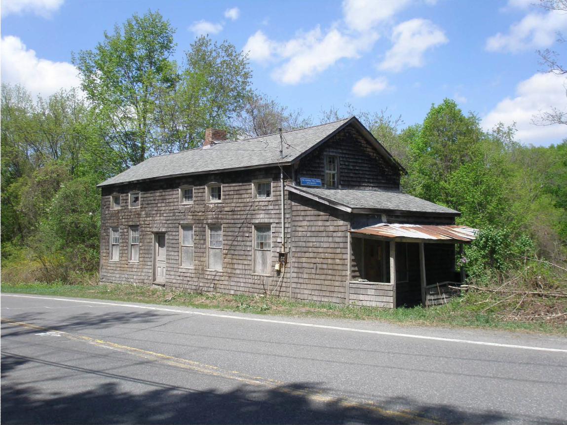
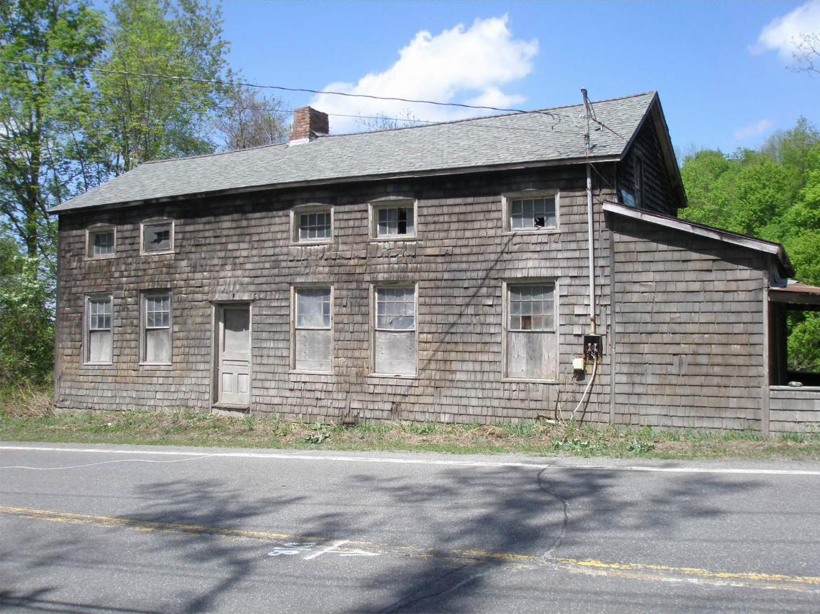
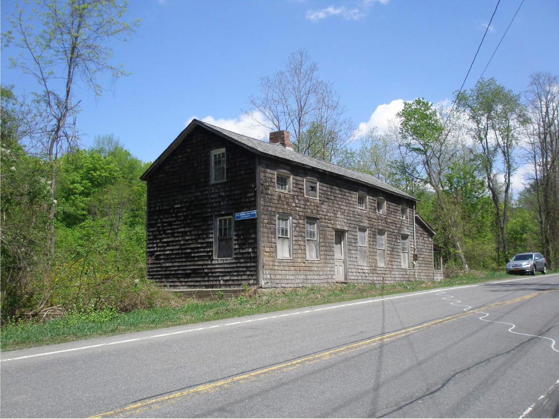
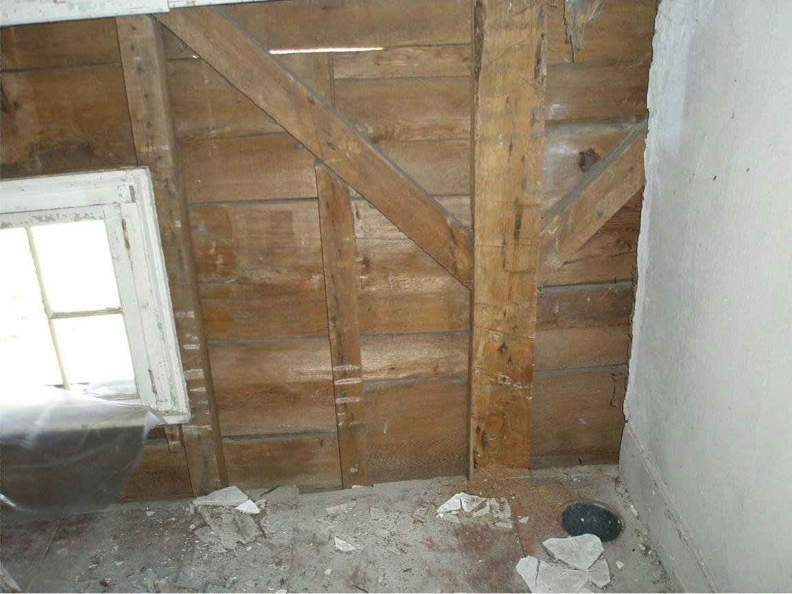
Narrative Description Summary Paragraph The Columbia Turnpike East Tollhouse is a one and one-half story timber frame dwelling with an end-gabled roof and linear footprint. The building, consisting of a main block and a one-story lean-to which abuts the east gable elevation, is six bays wide by one bay deep; the fenestration of the south-facing elevation, the principal one, is asymmetrical in arrangement. Exterior walls are covered on three elevations with wood shingles, applied over earlier wood siding, while the rear (north) elevation retains clapboard siding. The roof is covered with asphalt shingles. The building’s south facade fronts immediately on State Route 23, a circumstance of its former role as the easternmost toll house and gate for the former Columbia Turnpike, which provided overland communication between western Massachusetts and the Hudson River at Hudson, New York, between 1800 and 1906. At one time, when it still functioned as a toll station on the turnpike, the building was fronted by a toll gate, an open structure with a gable roof aligned with its roof ridge perpendicular to that of the dwelling; this structure housed a gate which could be lowered or raised as needed to restrict the movement of road traffic. The interior contains two principal rooms at first-floor level, serviced by a central chimney mass with back-to-back fireplaces, in addition to a smaller room, bathroom and kitchen; four rooms are situated above, at half-story level, the largest one being located on the west side of the plan. The building largely retains its historic-era form and interior layout, in addition to many original and subsequent historic-period finishes. Deterioration is nevertheless present, such as on the interior, where plaster and lath have been lost, most conspicuously in the west room of the first-floor, where the wall studding is presently exposed, the plaster and lath having been removed. The building nevertheless survives with its vital relationship to the roadway intact and with a high degree of integrity of plan; many finish features also remain, though the plaster work, in particular, has suffered during the 20-year period in which the building has been unoccupied and as such unheated. Both the construction technology and interior finishes suggest a date of construction in the early to mid-1830s. In addition to the gate house, the property also includes a light-frame privy, which has been deemed non-contributing due to its ruinous state. ________________________________________________________________________________________________________________________ Narrative Description Location & Setting The nominated building is located on the north side of State Route 23, in the Town of Hillsdale, Columbia County, approximately one mile from New York State’s border with Massachusetts, and a few miles east of the hamlet of Hillsdale. To the east, on Route 23, is Oxbow Road, which extends in a northerly direction from the main road; to the west is Route 23’s intersection with Mansfield Road and Mitchell Street, which meet and form a four-way intersection. The building sits in close proximity to the road, directly across from a steep embankment beyond which opens up a tree-lined agricultural field. There is no dedicated vehicular parking associated with the nominated property, and instead visitors to the building park in the north shoulder of Route 23, immediately east of the building. Although the toll house was built on a narrow but flat shoulder of land, the associated property falls away quickly behind the building, to the north, towards a small stream, and this area of the property is now badly overgrown. A small frame “two holer” privy, of light frame construction, is located behind the toll house, a short distance down the hill from the dwelling; it is now in a semi-collapsed state and completely encased in natural growth. Construction & Finish Overview The toll house was built with a square-rule braced timber frame with sawn studding to which exterior clapboard and interior lath was affixed, and was erected above a stone foundation and partially excavated basement. A total of five transverse bents were used in constructing the building, their spacing and placement relating directly to the arrangement of interior space. At first-floor level in the west room the corner posts were notched out to match the depth of the studding, thereby allowing the posts to not be expressed (as opposed to having the post project into the room); on the upper level they were not notched out and instead are expressed and boxed with wood casings, as are the top plates, between expanses of plaster. With the exception of the
United States Department of the Interior National Park Service / National Register of Historic Places Registration Form NPS Form 10-900 OMB No. 1024-0018 (Expires 5/31/2012) COLUMBIA TURNPIKE EAST TOLLHOUSE COLUMBIA CO., NEW YORK Name of Property County and State
4
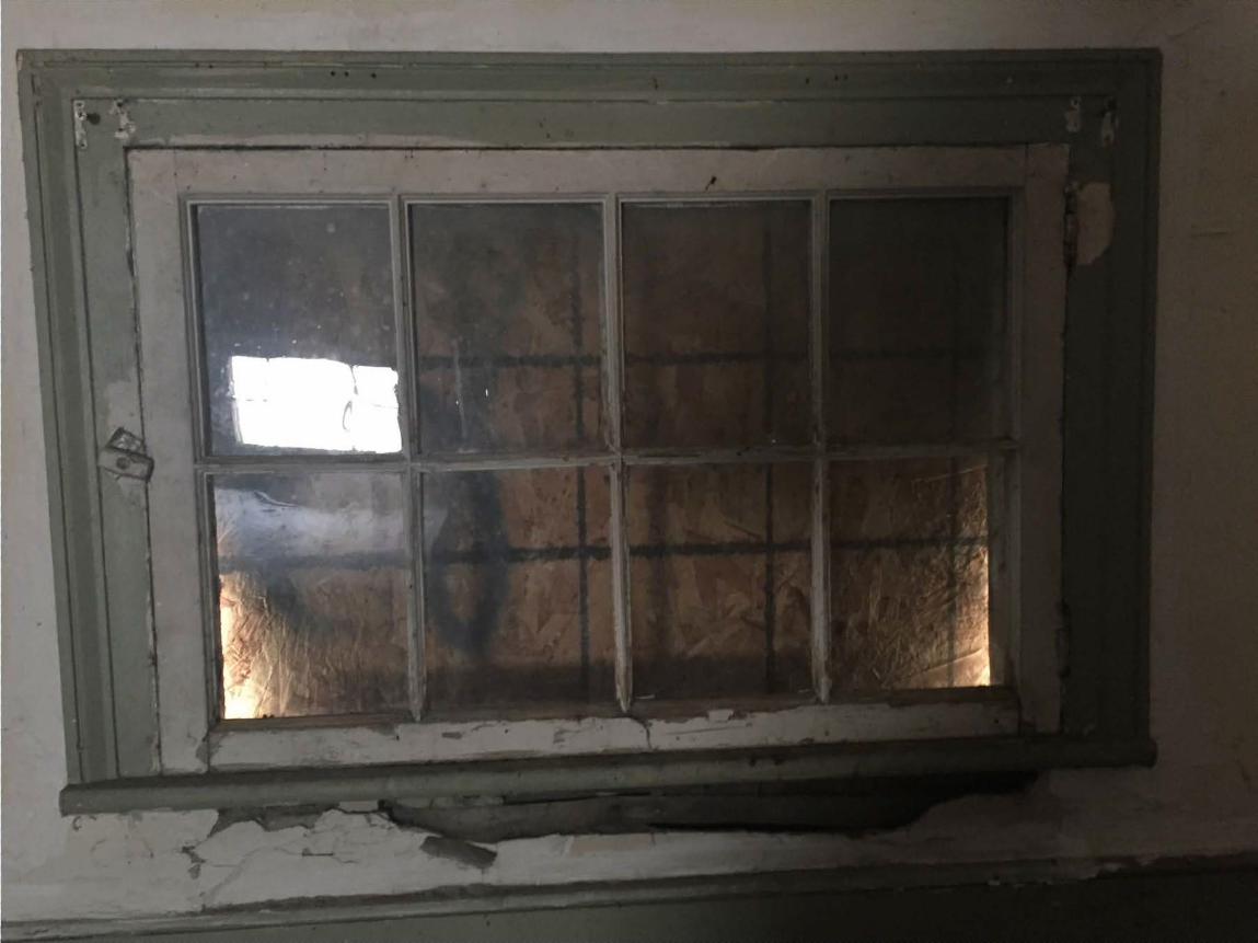
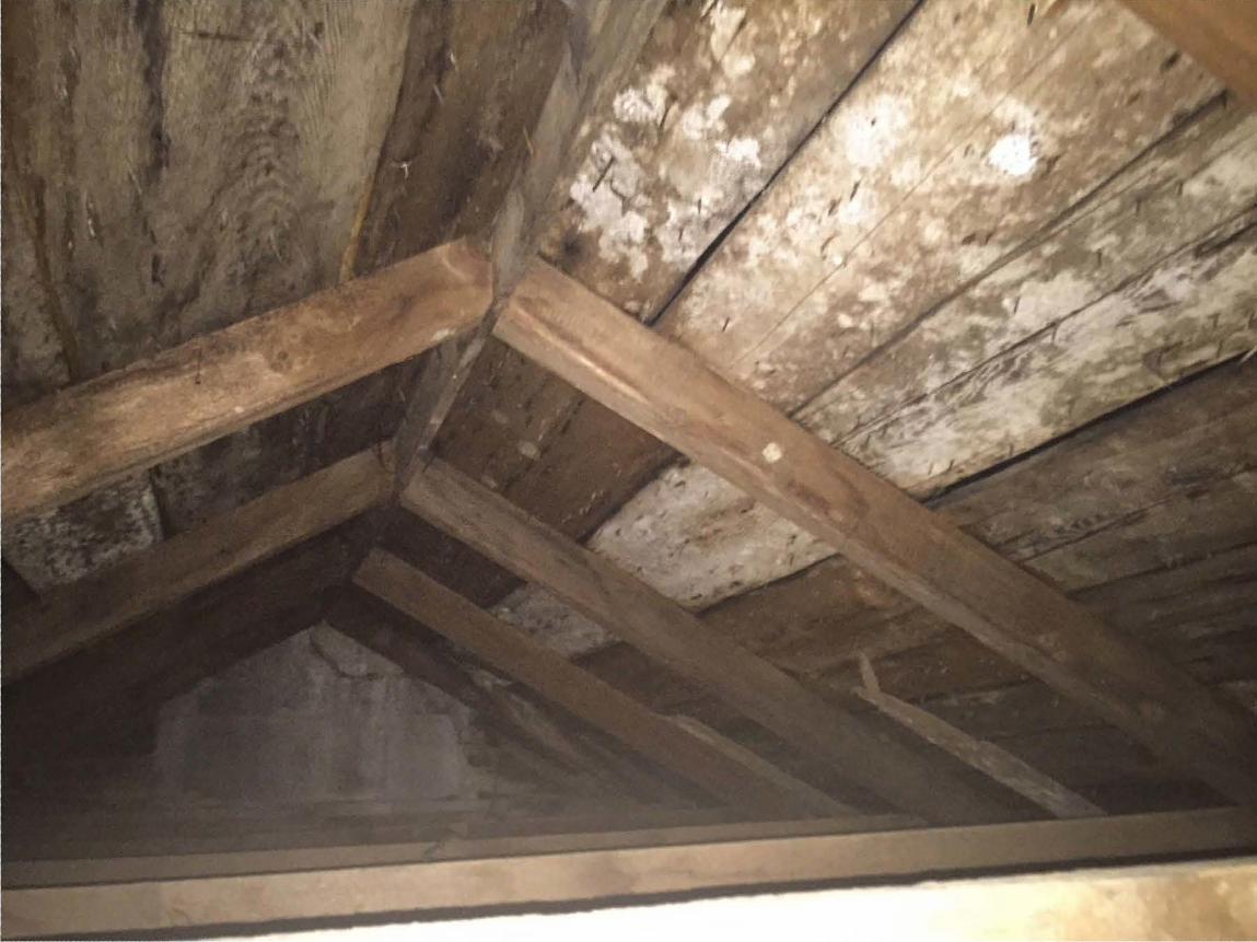
posts, which were hewn from oak, most all of the visible framing, such as sawn studding and rafters, was fashioned from hemlock. Sawn members were cut on a water-powered reciprocating saw. The roof frame consists of relatively small-scale sawn rafter pairs which are nailed at their apex to a narrow ridge board; the basement framing consists of sawn hemlock joists, arranged longitudinally, which are tenoned into hewn transverse girders the placement of which indicates partitions above. Original lath is of the split-board type; while later lath is circular-sawn. Upstairs some of the original partitions are beaded plank, which in the southeast room was later covered with lath and plastered over. Vertical communication between the basement, first and upper floor is by means of a box stair located against the north wall and which is accessed from the larger easternmost room at first-floor level. Most apparent of the building’s interior features are doors and trim which portray Greek Revival-style influence and are now presumed to be original to the building when erected ca. 1835. These include flat-profiled door and window trim and both vertical two-panel and also six panel doors, the latter which open up from the entrance “porch” into the two larger rooms. The mantel and oven door in the east room is of simplified conception; that in the west room is a later retrofit, ca. 1870. Wide plank softwood flooring is used at both first and half-story level. While most of the doors are hung on butt hinges, two upstairs doors are hung on older iron HL hinges, presumably reused from an earlier application. Exterior The building’s principal elevation is the south-facing façade. Were it not for the additional bay on the east side, the building would have a symmetrical five-bay façade consisting of a central door with pairs of windows to either side. Instead, the building has six bays, one being the door (third bay moving east), the remainder being windows and consisting of a larger window at first-story level and smaller windows at half-story level, all five of which are fitted with eight-light wood casements; on the inside, these half-story windows are low, positioned as they are on the knee wall between floor level and the top plate. Two of the lower window openings (the westernmost ones) are fitted with six-over-six wood sash, the balance being hung with twelve-over-twelve wood sash. All window openings have simple wood frames and have been largely boarded up on the interior. As for the entrance, it is fitted with a glazed and paneled door consisting of an upper glazed section with three panels below. The exterior is fitted with wood shingles, badly deteriorated, applied directly to earlier wood siding. The cornice is of a simple wood type. The elevation of the lean-to corresponding with the façade is blind. A chimney rises from the roof ridge at a position corresponding with the entrance bay and chimney mass; a second chimney, located on the roof ridge near the east elevation, was taken down at an unknown time. The east elevation is fronted by the one-story lean-to, in front of which is a dilapidated wood porch with shingled apron and asphalt roof. The porch now shields a door which has an adjacent window hung with six-over-six wood sash. Above the pitched roof of the lean-to is an offset window hung with six-over-six wood sash which provides light to the southeast chamber at half-story level. A small area of shingles on this elevation has deteriorated to the extent that the siding below is visible; it appears to be novelty siding, and not clapboard. The west elevation has two windows, both offset, a larger one with six-over-six wood sash that brings light into the west parlor, and a smaller one, also with six-over-six wood sash, that lights the west bed chamber. The north, or rear, elevation exhibits more sparse fenestration, with four first-story windows—one each lighting the principal east and west rooms, in addition to smaller ones in the small northeast room and the adjacent bathroom—and two small windows at half story level, their position matching those lighting the principal rooms below. Evident on this elevation is efforts to augment the original stone foundation with poured concrete. Significant deterioration of the wood siding and sill is evident.
United States Department of the Interior National Park Service / National Register of Historic Places Registration Form NPS Form 10-900 OMB No. 1024-0018 (Expires 5/31/2012) COLUMBIA TURNPIKE EAST TOLLHOUSE COLUMBIA CO., NEW YORK Name of Property County and State
5
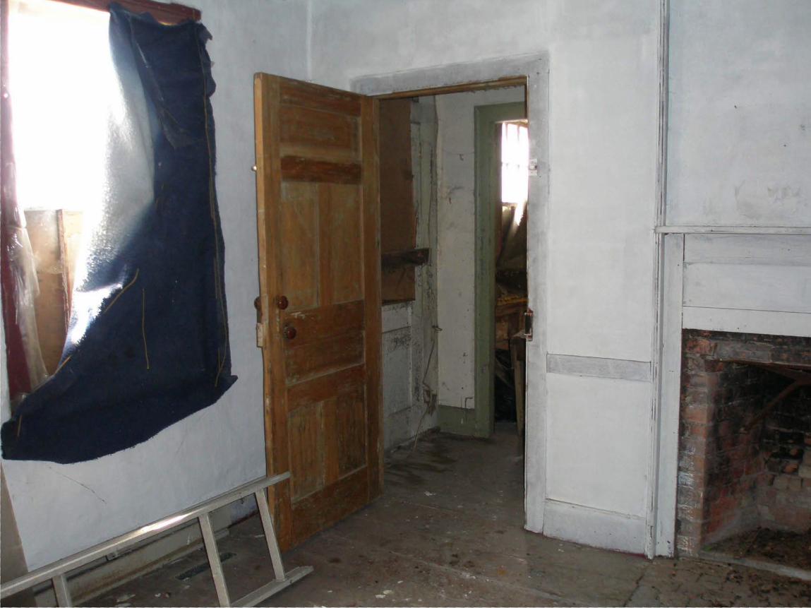
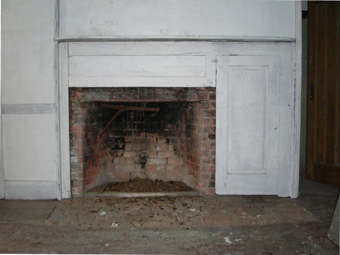
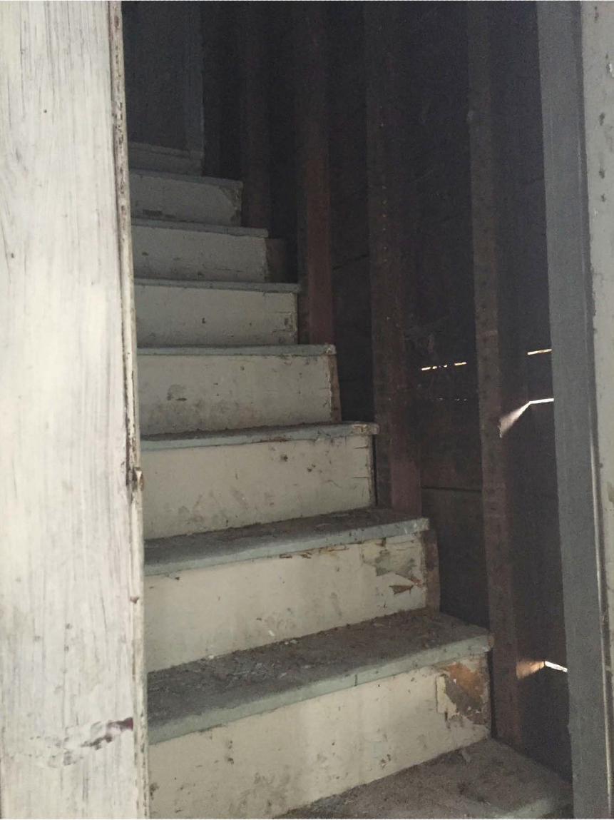
Interior The westernmost room was by all indications the parlor and principal interior space. Walls in this room have had their plaster and lath removed—in association with a never-completed renovation project—and the ceiling has similarly been fitted with sheetrock. Windows nevertheless remain in place, some retaining all of their trim, and the doors and architraves corresponding with the front and rear passages between the two principal rooms also remain in place. Baseboards are of a simple wood type with beaded upper edge, a type used throughout. The fireplace and corresponding chimney breast are centered against the east wall, between the front and rear passages, and set before the firebox is a ca. 1870s mantel that presumably represents a retrofit to the original finish in this room. Door trim is of a back-banded Greek Revival type with a beaded interior edge, and the doors are of both a six and two-paneled type consistent with a date in the 1830s. The south passage between the larger rooms serves as the entrance hall from road side, while the north passage has built-in shelving indicating its partial use for storage. The larger east room appears to have functioned in part as a kitchen and keeping room, given the presence of a bake oven adjacent to the fireplace. This hearth retains its original wood trim and paneled oven door, and like that in the opposite room has a small iron cooking crane. Against the north wall is the boxed stair, providing vertical communication between the three levels of interior space, adjacent to which is a window. Opening up from this room is the small chamber, beyond which (to the east) is a bathroom that occupies the northeast corner of the plan and which is contained within the lean-to, and also the kitchen. The kitchen corresponds with the full depth of these two rooms, being that there is no wall in it demarcating the division between the main block and lean-to, as there is between the small chamber and bathroom. The kitchen and bathroom represent upgrades made to the building in more recent times, possibly after the cessation of the turnpike. The lean-to, presumed to be an addition, nevertheless appears in early images. Upstairs, the westernmost room—above the west parlor— served as the main bed chamber. It is well-lighted by means to the small front and rear windows as well as west gable window. The smaller windows are of an inward-swinging casement type and retain their original sash, glazing and Greek Revival-style architraves. The remaining rooms are smaller and of simpler conception, their partitions having been formed with vertical beaded board, augmented with plaster subsequently. The presence of sawn lath in the hallway, immediately adjacent to the west bed chamber, with has plaster on split-board lath, suggests the hallway may have had a board ceiling originally. The stair portal here is open and aligned on two sides by a simple wood railing. The studding in the north wall, along with some of the posts and braces, has been exposed given the removal of plaster and lath. The top plate retains it boxed and beaded casing. Two doors on this level, opening up into the northeastern and southeastern bed chambers, have doors hung on iron HL hinges. The ceiling of the half-story is affixed to collar ties which were nailed to the rafter pairs. The partial basement is unfinished. Visible there is the floor framing system and also the cradle that sustains the hearth in the easternmost of the two larger rooms above.
United States Department of the Interior National Park Service / National Register of Historic Places Registration Form NPS Form 10-900 OMB No. 1024-0018 (Expires 5/31/2012) COLUMBIA TURNPIKE EAST TOLLHOUSE COLUMBIA CO., NEW YORK Name of Property County and State
6
8. Statement of Significance
Applicable National Register Criteria (Mark "x" in one or more boxes for the criteria qualifying the property for National Register listing.)
X A Property is associated with events that have made a significant contribution to the broad patterns of our history.
B Property is associated with the lives of persons significant in
our past.
X C Property embodies the distinctive characteristics of a type, period, or method of construction or represents the work of a master, or possesses high artistic values, or represents a significant and distinguishable entity whose components lack individual distinction.
D Property has yielded, or is likely to yield, information important in prehistory or history.
Criteria Considerations (Mark "x" in all the boxes that apply.) Property is:
A
Owned by a religious institution or used for religious purposes.
B removed from its original location.
C a birthplace or grave.
D a cemetery.
E a reconstructed building, object, or structure.
F a commemorative property.
G less than 50 years old or achieving significance
within the past 50 years.
Areas of Significance (Enter categories from instructions.)
ARCHITECTURE
TRANSPORTATION
Period of Significance
ca. 1835- 1906
Significant Dates
ca. 1835; 1906
Significant Person (Complete only if Criterion B is marked above.)
N/A
Cultural Affiliation
N/A
Architect/Builder
unknown
Period of Significance (justification) The cited period of significance, ca. 1835 to 1906, corresponds with the building’s direct use in association with the Columbia Turnpike, from the time of the dwelling’s completion until the abandonment of this overland toll route in 1906. Criteria Considerations (explanation, if necessary) N/A
□ □
□
□
United States Department of the Interior National Park Service / National Register of Historic Places Registration Form NPS Form 10-900 OMB No. 1024-0018 (Expires 5/31/2012) COLUMBIA TURNPIKE EAST TOLLHOUSE COLUMBIA CO., NEW YORK Name of Property County and State
7
Statement of Significance Summary Paragraph The Columbia Turnpike East Tollhouse is a rare and significant survival from New York State’s turnpike era. This historic overland transportation route, chartered in 1799, helped shape the development and growth of adjacent areas of Columbia County, New York, following its completion, as well as parts of Berkshire County, Massachusetts; from the terminal point on the Hudson River, at Hudson, transportation of goods to distant markets was effected. The turnpike remained in operation as a toll road until its closure in 1906, by which time its importance as a travel artery had been greatly diminished by new and more efficient modes of transportation. During its heyday the turnpike served as a valuable conduit for agricultural products and livestock from New York and Massachusetts farms and for the shipment of other regional products and material, including marble from stone quarries in western Massachusetts. The nominated building served as the easternmost of a series of toll houses established by the company, which collected revenue from travelers on the Columbia Turnpike from the Massachusetts border to its terminal point at Hudson. Its physical features suggest it was constructed in the 1830s to replace an earlier building, which had by all indications been located further to the west. Toll collectors resided with their families and were tasked with collecting usage fees and operating the gate that restricted movement at points along the road. While the gate that once spanned the road was by all indications removed over a century ago, the dwelling itself survives with its basic form and spatial features intact to the nineteenth century and with any number of interpretable interior features. It remains an important legacy of the early nineteenth century turnpike era, which witnessed the creation of incorporated toll roads that were of tremendous benefit to commerce, communication and settlement of new areas in New York State. NRHP significance is being claimed in association with Criterion A, in the area of Transportation, given the building’s vital and longstanding historic association with the former Columbia Turnpike—the historic route of which largely survives to this day— and additionally under Criterion C, in the area of Architecture, as a largely intact example of domestic architecture built specifically as a toll keeper’s house. ________________________________________________________________________________________________________________________ Narrative Statement of Significance Historical Context The history of the Columbia Turnpike and its importance to the economic vitality and development of those areas which it provided improved transportation for is well established. This historic overland east-west route allowed for communication between western Massachusetts and the Hudson River at Hudson, New York. Chartered by the New York State Legislature in 1799, it remained an incorporated entity until it was sold to Columbia County in 1906, at which time it ceased functioning as a toll road.1 At the time of its incorporation the turnpike company, the third such road corporation officially chartered in New York State, maintained $25,000 in capital stock, a considerable sum for the time.2 The corporation was established for “improving the road from the City of Hudson to the line of Massachusetts on the route to Hartford…” and the directors were sanctioned to “enter into any land where they might deem it proper for the purchase of said road, and contract with the owner or owners for the purchase of so much thereof as may be necessary for making the said road and erected and establishing gates, toll gates, etc.”3 Work on the route and associated infrastructure was undertaken between 1799 and 1800; among the earliest bills that survive among the company’s papers is a bill for $15 submitted by William Cockburn for six days of surveyor’s work.4 The completed turnpike represented an immediate improvement to regional transportation at the dawn of the nineteenth century and offered a more reliable means by which the greater region’s agricultural goods and other products could be brought efficiently 1 “Sale of the Turnpike: Toll-gates on the Highway went out of Commission Thursday,” The Columbia Weekly Republican, 24 May 1906. 2 The capital stock consisted of 1,000 shares at $25 each, with bi-annual dividends paid in January and July. A figure of $50,000, apparently erroneous, is given in the account published as “The Old Columbia Turnpike,” Chatham Courier, 9 December 1891; in Columbia County at the End of the Century (Hudson: Hudson Gazette, 1900). 3 Quoted from early turnpike company records as published in “History of Old Turnpike Revealed in Manuscript,” The Courier, 3 July 1941. 4 Ibid
United States Department of the Interior National Park Service / National Register of Historic Places Registration Form NPS Form 10-900 OMB No. 1024-0018 (Expires 5/31/2012) COLUMBIA TURNPIKE EAST TOLLHOUSE COLUMBIA CO., NEW YORK Name of Property County and State
8
to market overland. Additionally, the traffic which it bore gave rise to new commercial opportunities for those areas it traversed, among them hotel stands and stage lines which served the needs of travelers and drovers making their way along its course. Elisha Pitkin served as first president while Elisha Jenkins held the post of treasurer. The Columbia Turnpike was followed in rapid succession by other such roads which were incorporated and constructed in Columbia County, among them the Rensselaer & Columbia Turnpike, 1799, the Hudson & Livingston Turnpike, 1802, and the Ancram & Susquehanna Turnpike, 1804.5 The state’s ever-expanding turnpike network represented the first period of regional transportation improvement—efforts prior to this era were, with some exceptions, typically of local or town-wide scope— followed thereafter by the development of the state’s canal system and later yet in the nineteenth century the emergence of the railroad. From the Massachusetts border the Columbia Turnpike’s route crossed through the Columbia County towns of Hillsdale, Copake, Taghkanic, Claverack, and Greenport before ending at its western terminus in Hudson. Two spurs on the Massachusetts side of the border linked the road with points in the Commonwealth, among them Great Barrington. The nominated building was one of five toll gates situated along the road’s east-west route; the westernmost one, located just outside of Hudson (NRHP-listed), is a stone building of more advanced construction than the nominated building, which is a much simpler frame construct. The following overview of the Columbia Turnpike, a partial transcription of a newspaper article published in 1891, provides a succinct account of the turnpike and how it was viewed in a regional context. It dates to when it remained operational, albeit in much diminished terms:
The Old Columbia Turnpike A Structure at One Time Second in Interest to Only the Erie Canal
About three-quarters of a century ago or more, the Columbia Turnpike from Hudson to Great Barrington [MA], was organized. In those days it was as much a subject of public interest and there was probably as much or more local comment concerning it than there was when the Harlem division of the New York Central [Railroad] then known as the New York and Harlem, was extend from Dover Plains to Chatham Four Corners in 1851 and 1852. At the period mentioned, it was believed that the Columbia Turnpike was a great public improvement, not quite as important as the Erie canal, but at the same time an enterprise that would be very beneficial to Columbia and Berkshire [MA] counties. In those days there was not a hundredth part the travel there is now. A man who had been west of Buffalo, or down south as far as Washington, D.C., or Richmond, Va., or even “down east” as far as Boston, was looked upon by his neighbors as a traveler and a man of enlarged views, and his description of the wonders he had seen were listened to by his fellow men with that interest that their grand-children and great-great-grandchildren read the experiences of George Kennan in Russia and Siberia. The capital stock of the Columbia Turnpike was fixed at $50,000, which was a big sum for these times and the then thriving young city of Hudson, one of the great centers of the whale fishing interest, was at the western terminus, much gratified at the new tributary, bringing local trade to her very doors in the quaint old lumber wagons of the industrious farmers of the country towns of Eastern Columbia and Western Berkshire counties. The Turnpike was according to its charter, to occupy a strip of land 50 feet in width and extending from Hudson to a point in Hillsdale, not far from the Massachusetts state line, where it formed into two branches and one, the northern one, went up “over the mountain” by way of the “Oxbow,” a very crooked road through the village of North Egremont, down thence by the Hartford and Albany Turnpike for a short distance and for which use a rental was paid. About two miles from North Egremont on Egremont Plain, it again used its own
5 Columbia County at the End of the Century, 49.
United States Department of the Interior National Park Service / National Register of Historic Places Registration Form NPS Form 10-900 OMB No. 1024-0018 (Expires 5/31/2012) COLUMBIA TURNPIKE EAST TOLLHOUSE COLUMBIA CO., NEW YORK Name of Property County and State
9
highway to Great Barrington. The south branch went east over the mountain by way of South Egremont, and a short distance this side of Great Barrington, it again united with the north branch of the Turnpike. There were five toll gates on the Turnpike, situated as follows: One east of Academy Hill in Greenport, about a mile and a half east of Hudson. Another one at what was once known as “Todd city,” a small settlement of half a dozen or more houses, a mile east of Martindale. The third about two miles east of Hillsdale, and one on the north branch, a mile and a half west of North Egremont, and the other on the south branch about a quarter of a mile east of the Massachusetts line. These toll houses were small dwellings close to the highway. Over the roadway was built an open shed with gate or rack on pulleys, which could be lowered or raised at the pleasure of the keeper. Here in a conspicuous spot was placed a large board or something like an old-fashioned blackboard on which was a white ground and thereon was painted in letters about two inches in length, the rates of toll for a one-horse wagon, chariot, sulkey, or waggon (they spelled it with two “g’s”); the rates of toll for a led or driven horse, for a score of sheep and swine and neat cattle.6 In its earliest years the new turnpike served as a critical conduit which conveyed farm produce and livestock to the market at Hudson for sale and shipment to distant markets via the Hudson River. Massachusetts farmers from as far away as Otis, Tyringham, New Marlborough, and Sandisfield—all situated in southeastern Berkshire County—came to rely on the turnpike to deliver surplus farm goods and products to Hudson for sale and shipment to the markets of New York City; “it was no unusual sight to see strings of teams a quarter or half a mile in length going along the turnpike…it was a day’s journey from these eastern [Massachusetts] towns to Hudson and a day to return.”7 Traffic on the turnpike was at times extremely busy, and was by no means limited to the warmer months of the year; in an account published in February 1803, it was noted that on a single Saturday that month, 750 sleighs passed through the western gatehouse outside of Hudson.8 Hudson, much like Newburgh to the south—the terminus of the Cochecton Turnpike on the west side of the Hudson River—was soon flooded with the farm products and materials of a vast outlying rural area. In addition to serving as a vital connector linking the interests of farm and market, the Columbia Turnpike was also used in association with at least one major building project, the construction of Girard College in Philadelphia, Pennsylvania, which was built to the designs of the noted architect Thomas Ustick Walter in the 1830s. Marble from western Massachusetts, such as that taken from the quarries at Stockbridge and which typically bears that name, was viewed favorably and had previously been used in the construction of City Hall in Manhattan, ca. 1811, erected to the designs of architects John McComb, Jr. and J.-F. Mangin. A marble of similar characteristics was also quarried in Sheffield and Lanesborough, Massachusetts. One period observer touted the supremacy of the marble from the Sheffield quarries: “A visit to this quarry… will give one perhaps, the best idea of the value and extent of the Berkshire marbles…”9 A contract for marble used in constructing the building today known as Founder’s Hall at Girard College, a landmark of the American Greek Revival designed by Walter, was let to the quarry at Sheffield, an arrangement which required overland transportation of this material, quarried but not otherwise dressed, to Hudson. From the year 1835 for four years of thereabouts the Sheffield marble quarries owned and controlled by Philo Upson and Chester Goodale, had a larger contract for furnishing marble with which to build the Girard College of Philadelphia. All this marble had to be carried over the Columbia turnpike to Hudson from the quarries and thence by sloops, etc. to New York and then through the Raritan canal
6 “The Old Columbia Turnpike.” 7 Ibid 8 Chronicle Express (New York City), 28 February 1803; “On Saturday, 19th February, 750 sleighs passed through the Columbia Turnpike Gate in this city, besides those which came to this market by the other roads.” Information as previously published in the Hudson Bee. 9 American Railroad Journal and Mechanic’s Magazine, vol. VII (New York: Schaeffer and Hedge, 1841), 230.
United States Department of the Interior National Park Service / National Register of Historic Places Registration Form NPS Form 10-900 OMB No. 1024-0018 (Expires 5/31/2012) COLUMBIA TURNPIKE EAST TOLLHOUSE COLUMBIA CO., NEW YORK Name of Property County and State
10
to its destination at Philadelphia. Many of the old residents of Hillsdale and Egremont still remember seeing the huge wagons with wheels seven or eight feet in diameter from the axles of which were suspended huge blocks of marble weighing 8 to 15 or more tons. These wagons were drawn by huge Pennsylvania horses, as they were called, hitched tandem style. At times there might be seen wagons drawn by 10 or 12 of these huge steeds slowly but surely going along the highway. These same large wagons were often the cause of frightening other horses unused to the unwonted sight.10 Another period source noted the need for railroads, and not turnpikes and conventional roads, to convey the coveted Massachusetts marble to distant project sites, after viewing first-hand in Hudson “the immensity of labor… in drawing the huge blocks of marble from the quarries, used in the construction of the Girard College, Philadelphia.”11 The success of the turnpike enterprise sustained businesses which made their livelihood in direct association with its operation. By 1814 a series of hotels and taverns had been established along its course, among them those operated near Craryville, Bain’s Corners, Todd City, Martindale, Smoky Hollow, Claverack, and at the so-called Fountain Head, some of these names having long since fallen from common usage. These businesses provided food, drink and lodging for road-weary travelers, and as such their fortunes were tied directly to the viability of the road. In the hamlet of Hillsdale, which benefitted immediately from the completion of the turnpike, travelers and drovers were accommodated and valuable services, such as blacksmithing, could be procured. Stagecoach service was soon thereafter established to serve passenger traffic; in 1830 one such coach line was operated by the Hudson and Pittsfield Line, under the management of Frink & Smith, which stopped at Reed’s Stage House in Hillsdale before continuing to Hudson for connection to steamboat service to New York City.12 The author of the 1891 newspaper account recounted such a scene, relative to a line operated for a time by a man named Miller: Every day about 11 o’clock the big Concord coach drawn by four and sometimes six horses would come rolling up in front of Thaddeus Reed’s Hillsdale House. Inside and outside were from 12 to 18 passengers and there were occasions when it was necessary to have two and sometimes three coaches run…It was the ambition of many a country boy to be a stage driver and sit up aloft cracking the long lash of a whip and go whirling through the country.13 Not unlike on today’s toll roads, revenues on the turnpike were generated by the collection of fees at toll gates strategically located along its course and operated by toll keepers who resided in dedicated dwellings with their families. According to the 1891 account, the East Hillsdale toll, as it was referenced, was at one time kept by James Doherty; however, census data does not corroborate Doherty, an Irish native and longtime Hillsdale resident, as having held this position. Among those documented as having tended the Hillsdale gate was Stephen Oakley, who noted “Gate Keeper” as his occupation in the 1850 federal census of the Town of Hillsdale. Oakley, 34 years of age, resided in the nominated building with his wife, Emaline Oakley, in addition to a second female adult, Augusta Oakley—presumably Stephen Oakley’s sister—and two children. In 1855 the Hillsdale gate was tended by a new keeper, Edward Smith, as noted in the New York State census of that year, which indicated the house as a frame dwelling valued at $500. Smith, 30, was residing at the toll house with his wife and a one-year-old child; according to the census data, the family had only been in Hillsdale for five months at the time census data was recorded, in June. Tolls were either collected by the keeper or by a member of the family, who raised and lowered the gate which spanned the road as needed. The system of pay-for-use
10“The Old Columbia Turnpike.” 11Commercial Advertiser, 24 August 1838. 12“Hold on Driver- I cannot wait!!” Advertisement, Berkshire Journal, 11 November 1830. 13“Old Columbia Turnpike.”
United States Department of the Interior National Park Service / National Register of Historic Places Registration Form NPS Form 10-900 OMB No. 1024-0018 (Expires 5/31/2012) COLUMBIA TURNPIKE EAST TOLLHOUSE COLUMBIA CO., NEW YORK Name of Property County and State
11
turnpikes soon gave rise to “shunpikes,” which functioned in essence to allow travelers to avoid fees collected at the toll gates. Penalties were soon established in an attempt to stem the usage of such shunpikes. The importance of the turnpike system in New York State declined during the course of the nineteenth century, during which time extensive canal and later yet railroad networks were established, thereby siphoning off travelers and others who once relied solely on roads to move about. This decline was already largely complete by the time the 1891 account was penned: But those days are past never more to return. The turnpike is still in existence but its toll receipts are meagre compared with the old days and the swiftly whirling passenger and the long freight train now carry the people and produce of the country. Gone too are the ancient Berkshire county farms and many of them are today abandoned and uncultivated and the only use made of them is for the pasturage of sheep and young cattle. Gone are the stage coaches and all the other institutions that once made the Columbia turnpike an important highway the most so of any in the county. But many of the old inhabitants still look back to the days of half a century ago and say they are better than those of the present. Are they?14 In 1898 Hillsdale residents were making concerted overtures to the Columbia Turnpike Company to abandon the section of road they managed from the state line to Hollowville, “thus relieving the people of the gate near Hillsdale and the one near Martindale.” By that time it was noted that “The east gate has already been raised pending the outcome of the proceedings… With the middle gate gone, which is the only one where a full toll can be charged, it is only a question of a short time when they must abandon the whole of the road.”15 The Columbia Turnpike remained an active incorporated entity until 1906, at which time it was purchased by Columbia County and its remaining toll gates retired from active service. In February of that year there was a fire at the toll house which “burned through the boards in the fire place,” but which was discovered soon enough to limit serious damage.16 In 1921 the building was sold at auction.17 Although unclear in the documentary record, the nominated building appears to have been erected a generation following the turnpike’s establishment; the original ca. 1800 toll gate may have been located west of the current location, near present-day Collins Street, and as such closer to the hamlet of Hillsdale. According to a published account of a legal decision, rendered prior to 1823, there was a dispute relative to the original location of the toll house which could account for its having been relocated: 28. The act incorporating the Columbia turnpike company, for improving the road from Hudson to the Massachusetts line, a distance of about twenty miles, authorizes the company to erect the most eastwardly turnpike gate on the road, “at a place near the Massachusetts line, as the president and directors should direct;” held, that a tollgate erected at a place two miles and three quarters from the Massachusetts line, was not placed near that line, within the meaning of the act. Griffen v. House, 18 J.R. 397.18 Efforts are currently being made to assess whether one of the small number of seemingly early buildings located along Collins Street may, in fact, be the earlier toll house.
14Ibid 15“War Raging Against Turnpike Company,” 13 August 1898, Hudson Daily Register. 16“Toll Gate House was Afire,” Columbia Weekly Republican, 8 February 1906. 17“Auction Sales,” Columbia Republican, 7 June 1921. “Also a house and lot half acre on highway, known as toll gate property, 1¾ miles east of Hillsdale. House has seven rooms and good well.” 18William Johnson, A Digest of the Cases Decided and Reported in the Supreme Court of Judicature, the Court of the Chancery, and the Court for the Correction of Errors, of the State of New-York, from 1799 to 1823, vol. II (Albany, E.F. Backus, 1825), 429.
United States Department of the Interior National Park Service / National Register of Historic Places Registration Form NPS Form 10-900 OMB No. 1024-0018 (Expires 5/31/2012) COLUMBIA TURNPIKE EAST TOLLHOUSE COLUMBIA CO., NEW YORK Name of Property County and State
12
Architectural Context The Columbia Turnpike East Tollhouse remains largely what it was when first erected, a purpose-built vernacular building characterized by simple lines, a straightforward plan and modest finish treatments. A one-and-one-half story construct, it was erected on a rectangular plan with a gable roof; the interior was efficiently arranged around a central fireplace mass that serviced two first-floor fireplaces in the larger rooms. The exterior as presently constituted, and as depicted in historic images, was devoid of stylistic references such as moulded cornices and an entrance frontispiece; the shingled exterior was adopted on three of the four elevations in more recent times. The building was built with a braced timber frame consisting of five bents matching the position of principal partitions; between the posts are aligned sawn studs to which exterior clapboard and interior lath was nailed. The walls do not appear to have been insulated with brick infill or “nogging.” Both original split-board lath and later sawn lath are present and indicative of more than one period of plastering. At first-floor level the corner posts were notched out in order to meet the depth of the studding and as such to not be expressed; on the upper level corner posts, intermediate posts and the top plate are cased with wood and expressed. The general plan of the building recalls New England models, and in particular houses of the traditional hall-and-parlor type—precursor to the fully developed center-chimney Cape house or Connecticut River Valley-plan houses— with the principal roadside door entering into a small hall the size of which was restricted by the chimney mass, and with doors opening into the two principal rooms to either side; augmenting this plan were two additional rooms occupying a narrow bay on the east side, which later received a lean-to addition. Both principal rooms featured fireplaces of smallish scale equipped with cast-iron cooking cranes and having brick-laid hearths; that in the east room also has a brick bake oven, suggesting the other room served as the more formal room or parlor. Some of the interior features, namely vertical two-paneled doors and flat-profiled architraves, are expressive of the Greek Revival style and would appear to date to the early to mid-1830s at the earliest. Communication between the basement, first floor and upper level is effected by means of a simple boxed stair situated against the rear wall. Flooring is wide plank throughout. Evidence suggests the upper level wasn’t completely finished during the first building campaign. The westernmost room retains its original plaster on split-board lath finish and Greek Revival-style woodwork; the plaster on the hallway ceiling immediately adjacent to this room, by comparison, was affixed to sawn lath, and the remaining partitions are formed of beaded vertical plank, which was plastered and lathed in one area subsequently. This evidence suggests that, originally, the upper level contained only one well-finished bed chamber, the remainder of the space being only nominally finished at first with plank walls and perhaps a plank ceiling. The gate portion of the building, long since removed, was a freestanding wood frame structure with gable roof the ridge of which was aligned perpendicular to that of the dwelling. Photographs indicate that it was partially affixed to the house on its north side and further propped up, with long poles, on its south side. The gate itself was raised and lowered by means of a rope situated near the doorway and operated by the attendant. A gate of similar type was employed on the toll house outside of Hudson, as seen in period photographs. The nominated building, born of practical necessity and of straightforward design characteristics, satisfied the modest requirements of the various toll keepers and their families that occupied it during the course of its usage in relation to the Columbia Turnpike. Utilitarian in construction and finish, it is nevertheless a rare surviving example of turnpike-related architecture which retains its historic interrelationship with the road it was built to service. ________________________________________________________________________________________________________________________ Developmental history/additional historic context information (if appropriate) N/A
United States Department of the Interior National Park Service / National Register of Historic Places Registration Form NPS Form 10-900 OMB No. 1024-0018 (Expires 5/31/2012) COLUMBIA TURNPIKE EAST TOLLHOUSE COLUMBIA CO., NEW YORK Name of Property County and State
13
9. Major Bibliographical References
Bibliography (Cite the books, articles, and other sources used in preparing this form.) Books Johnson, William. A Digest of the Cases Decided and Reported in the Supreme Court of Judicature, the Court of the Chancery, and the Court for the Correction of Errors, of the State of New-York, from 1799 to 1823, vol. II. Albany, E.F. Backus, 1825. Columbia County at the End of the Century. Hudson: Hudson Gazette, 1900. Newspapers & Periodicals Berkshire Journal Chatham Courier The Chronicle Express The Columbia Weekly Republican Commercial Advertiser Hudson Bee Hudson Daily Register American Railroad Journal and Mechanic’s Magazine Previous documentation on file (NPS): Primary location of additional data:
preliminary determination of individual listing (36 CFR 67 has been State Historic Preservation Office requested) Other State agency previously listed in the National Register Federal agency previously determined eligible by the National Register Local government designated a National Historic Landmark University recorded by Historic American Buildings Survey #____________ Other
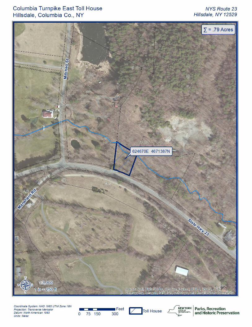
recorded by Historic American Engineering Record # __________ Name of repository: recorded by Historic American Landscape Survey # ___________ Historic Resources Survey Number (if assigned): 10. Geographical Data Acreage of Property Less than one acre (.79) (Do not include previously listed resource acreage.) UTM References (Place additional UTM references on a continuation sheet.) 1 18 624670 4671387 3 Zone
Easting
Northing Zone
Easting
Northing
2 4 Zone
Easting
Northing
Zone
Easting
Northing
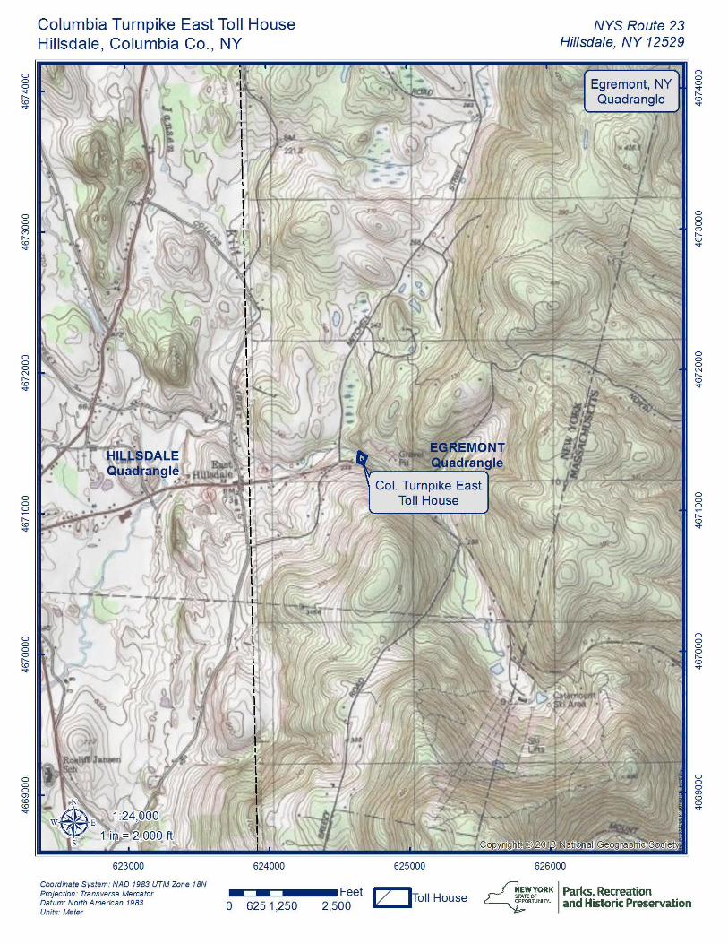
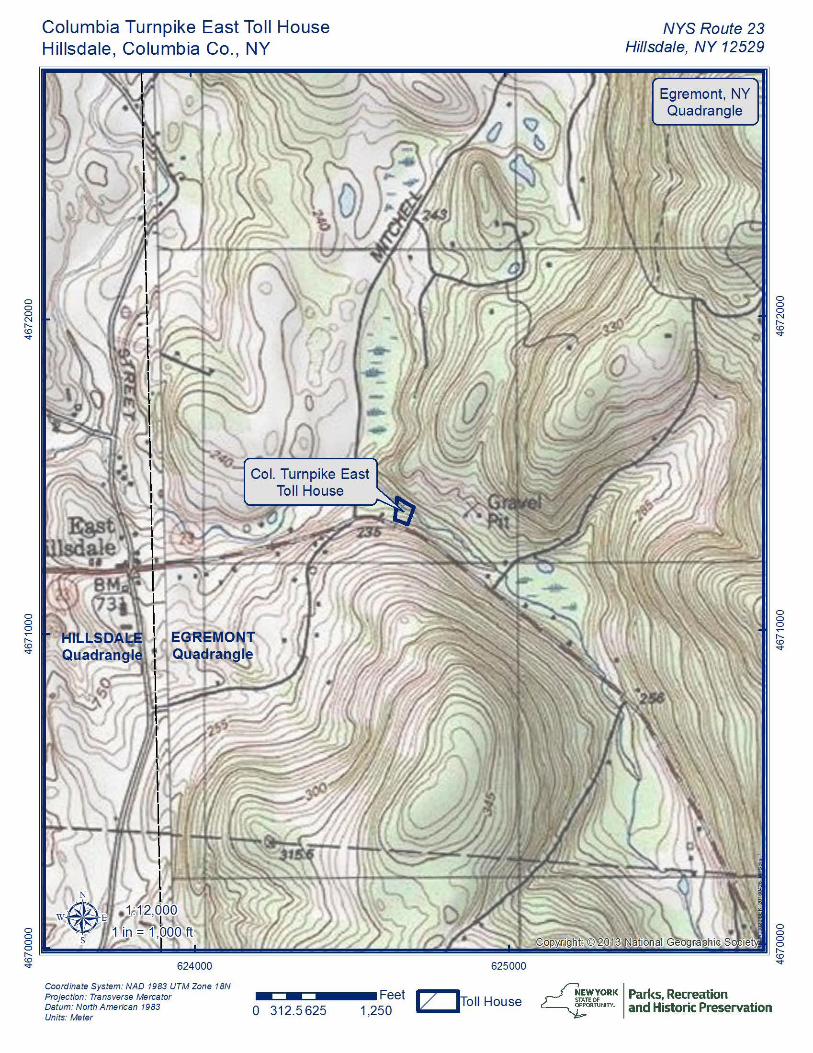
Verbal Boundary Description The boundary for this NRHP nomination is depicted on the enclosed mapping, which was drawn at a scale of 1:24,000, 1: 12,000 and 1: 3,000; all maps are entitled “Columbia Turnpike East Toll House, Hillsdale, Columbia Co., NY.” Boundary Justification The boundary reflects historic circumstances and corresponds with the current legal boundary for the property.
United States Department of the Interior National Park Service / National Register of Historic Places Registration Form NPS Form 10-900 OMB No. 1024-0018 (Expires 5/31/2012) COLUMBIA TURNPIKE EAST TOLLHOUSE COLUMBIA CO., NEW YORK Name of Property County and State
14
11. Form Prepared By
name/title William E. Krattinger
organization NYS Division for Historic Preservation date February 2016
street & number PO Box 189 telephone (518) 268-2167
city or town Waterford State NY zip code 12180
e-mail [email protected]
Additional Documentation
Submit the following items with the completed form:
• Maps: A USGS map (7.5 or 15 minute series) indicating the property's location.
A Sketch map for historic districts and properties having large acreage or numerous resources. Key all photographs to this map.
• Continuation Sheets
• Additional items: (Check with the SHPO or FPO for any additional items.) Photographs:
Photographs by William E. Krattinger, February 2016; original files at NYS Division for Historic Preservation, Waterford, NY 12188; TIFF file format. 0001 EXTERIOR, view looking to northwest showing east and south elevations 0002 EXTERIOR, south elevation 0003 EXTERIOR, west and south elevations, view looking to northeast 0004 INTERIOR, first floor, view looking into entrance hall from main east room 0005 INTERIOR, first floor, fireplace and bake oven, east room 0006 INTERIOR, enclosed staircase, east room north wall 0007 INTERIOR, west room, view looking towards southwest corner showing frame and studding 0008 INTERIOR, half-story level, view eastward looking from west bed chamber into hallway 0009 INTERIOR, west bed chamber, view showing original swinging casement and wood architrave 0010 INTERIOR, half-story level, view showing braced post and studding, north wall 0011 INTERIOR, above finished ceiling of half-story, view showing rafters with sawn ridge board Property Owner:
(Complete this item at the request of the SHPO or FPO.)
name Victoria Jenssen
street & number 1668 Whiteside Road telephone
city or town Cleveland, Nova Scotia state Canada BOE 1JO Paperwork Reduction Act Statement: This information is being collected for applications to the National Register of Historic Places to nominate properties for listing or determine eligibility for listing, to list properties, and to amend existing listings. Response to this request is required to obtain a benefit in accordance with the National Historic Preservation Act, as amended (16 U.S.C.460 et seq.). Estimated Burden Statement: Public reporting burden for this form is estimated to average 18 hours per response including time for reviewing instructions, gathering and maintaining data, and completing and reviewing the form. Direct comments regarding this burden estimate or any aspect of this form to the Office of Planning and Performance Management. U.S. Dept. of the Interior, 1849 C. Street, NW, Washington, DC.
United States Department of the Interior National Park Service / National Register of Historic Places Registration Form NPS Form 10-900 OMB No. 1024-0018 (Expires 5/31/2012) COLUMBIA TURNPIKE EAST TOLLHOUSE COLUMBIA CO., NEW YORK Name of Property County and State
15
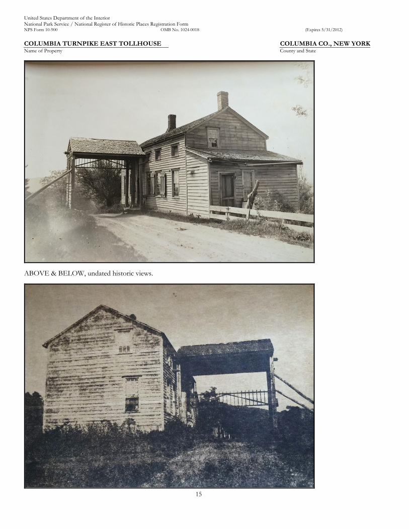
ABOVE & BELOW, undated historic views.
United States Department of the Interior National Park Service / National Register of Historic Places Registration Form NPS Form 10-900 OMB No. 1024-0018 (Expires 5/31/2012) COLUMBIA TURNPIKE EAST TOLLHOUSE COLUMBIA CO., NEW YORK Name of Property County and State
16
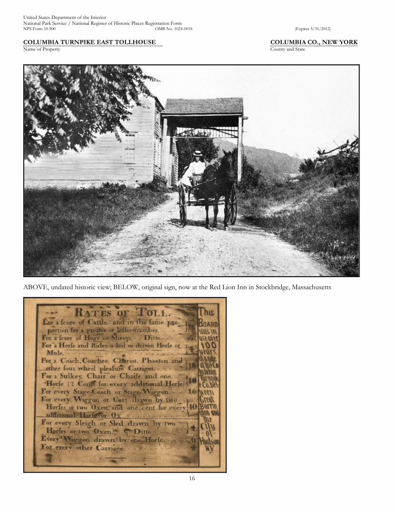
ABOVE, undated historic view; BELOW, original sign, now at the Red Lion Inn in Stockbridge, Massachusetts
United States Department of the Interior National Park Service / National Register of Historic Places Registration Form NPS Form 10-900 OMB No. 1024-0018 (Expires 5/31/2012) COLUMBIA TURNPIKE EAST TOLLHOUSE COLUMBIA CO., NEW YORK Name of Property County and State
17
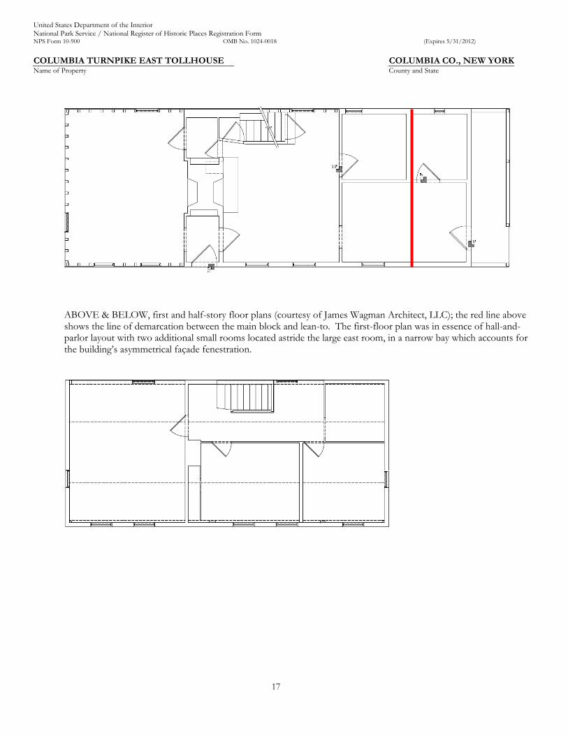
ABOVE & BELOW, first and half-story floor plans (courtesy of James Wagman Architect, LLC); the red line above shows the line of demarcation between the main block and lean-to. The first-floor plan was in essence of hall-and- parlor layout with two additional small rooms located astride the large east room, in a narrow bay which accounts for the building’s asymmetrical façade fenestration.
L __ _
---------------------------- 1~-----------------------------------ii _____________ _ I I 11
I I I ----------
I I 11
0 0 0 .... "'CD ....
0 0 0 C')
"'CD ....
0 0 0 N "'CD ....
0 0 0 ~
"'CD ....
0 0 0 0 "'CD ....
0 0 0 a, CD CD ....
Columbia Turnpike East Toll House Hillsdale, Columbia Co. , NY
ft/ '
623000
Coordinate System: NAO 1983 UTM Zone 18N Projection: Transverse Mercator Datum: North A merican 1983 Units: Meter
. -624000
- 1111 0 625 1,250
625000
Feet .v __ lToll House 2,500 - -
NYS Route 23 Hillsdale, NY 12529
626000
Egremont, NY Quadrangle
...Jl.~~0;0 RK I Parks, Recreation
~ 0• ruN,TY. and Historic Preservation
0 0 0 .... "'CD ....
0 0 0 C')
"'CD ....
0 0 0 N "'CD ....
0 0 0 ~
"'CD ....
0 0 0 0 "'CD ....
0 0 0 N "(0 ....
0 0 0 ~
"(0 ....
Columbia Turnpike East Toll House Hillsdale, Columbia Co. , NY
N
NYS Route 23 Hillsdale, NY 12529
Egremont, NY Quadrangle
0 0 0 N "(0 ....
0 0 0 ~
"(0 ....
0 g 8 .{. 0
~ ~~~~~~~~~~~~~~~~~~~~~~~~~~~-~~~~~~ ~ ~ ~~ ~~ ~
Coordinate System: NAO 1983 UTM Zone 18N Projection: Transverse Mercator Datum: North American 1983 Units: Meter
- 1111 0 312.5625 Feet .. v_ .. lToll House
1,250 - -...Jl.~~0;
0 RK I Parks, Recreation ~ 0• ruN,TY. and Historic Preservation
Columbia Turnpike East Toll House Hillsdale, Columbia Co. , NY
Coordinate System: NAO 1983 UTM Zone 18N Projection: Transverse Mercator ■MIC:JMMDMMM• Feet Datum: North American 1983 Units: Meter
300 0 75 150 v ~ oll House
NYS Route 23 Hillsdale, NY 12529
I L = . 79 Acres ]
...Jl.~~0;0 RK I Parks, Recreation
~ 0• ruN,TY. and Historic Preservation
'
I
UNITED STATES DEPARTMENT OF THE INTERIOR NATIONAL PARK SERVICE
NATIONAL REGISTER OF HISTORIC PLACES EVALUATION/RETURN SHEET
REQUESTED ACTION: NOMINATION
PROPERTY NAME:
MULTIPLE NAME:
Columbia Turnpike East Tollhouse
STATE & COUNTY: NEW YORK, Columbia
DATE RECEIVED: DATE OF 16TH DAY:
5/13/16 6/17/16
DATE OF PENDING LIST: DATE OF 45TH DAY:
6/02/16 6/28/16
DATE OF WEEKLY LIST :
REFERENCE NUMBER: 16000411
REASONS FOR REVIEW:
APPEAL: N OTHER: N REQUEST: N
DATA PROBLEM: N PDIL: N SAMPLE: N
COMMENT WAIVER: N
iACCEPT RETURN
ABSTRACT/SUMMARY COMMENTS:
RECOM. /C~A !Ji. REVIEWER~vti
TELEPHONE a=
LANDSCAPE: N PERIOD: N SLR DRAFT: N
LESS THAN 50 YEARS: PROGRAM UNAPPROVED: NATIONAL:
REJECT {p&i;w DATE I
DISCIPLINE ---------DATE -------------
DOCUMENTATION see attached comments Y/N see attached SLR Y/N
If a nomination is returned to the nominating authority, the nomination is no longer under consideration by the NPS.
N N N
~~~orORK Parks, Recreation ~oRruNin and Historic Preservation
ANDREW M. CUOMO Governor
5 May 2016
Alexis Abernathy National Park Service
ROSE HARVEY Commissioner
National Register of Historic Places 1201 Eye St. NW, 8th Floor Washington, D.C. 20005
Re: National Register Nomination
Dear Ms. Abernathy:
RECEIVED 2280 MAY 1 3 '2016
Nat. Register o1 Historic Places National Park Service
I am pleased to submit the following two nominations, both on disc, to be considered for listing by the Keeper of the National Register:
Columbia Turnpike East Tollhouse, Columbia County Methodist Episcopal church of Lansingburgh, Rensselaer County
Please feel free to call me at 518.268.2165 if you have any questions.
:;~lc~k, A ~thleen LaFrank l ~ational Register Coordinator
New York State Historic Preservation Office
New York State Office of Parks, Recreation and Historic Preservation Division for Historic Preservation. Peebles Island, PO Box 189, Waterford, New York 12188-0189
• 518-237-8643 • www.nysparks.com •
Related Documents