Collaboration Support System for City Plans or Community Designs Based on VR/CG Technology Tomohiro Fukuda, Ryuichiro Nagahama,Atsuko Kaga and Tsuyoshi Sasada 461 issue 0 4, volume 0 1 international journal of architectural computing

Welcome message from author
This document is posted to help you gain knowledge. Please leave a comment to let me know what you think about it! Share it to your friends and learn new things together.
Transcript
Collaboration SupportSystem for City Plans orCommunity DesignsBased on VR/CGTechnologyTomohiro Fukuda, Ryuichiro Nagahama,AtsukoKaga and Tsuyoshi Sasada
461issue 0 4, volume 01international journal of architectural computing
Collaboration Support System for City Plans orCommunity Designs Based on VR/CG TechnologyTomohiro Fukuda, Ryuichiro Nagahama,Atsuko Kaga and Tsuyoshi Sasada
This paper reports on a collaboration support systemfor city plans or community designs based on virtualreality (VR) or computer graphics (CG) technology. Itreports on an extension to an ongoing researchprogramme, and in particular it introduces thedevelopments of portable VR equipment, and anexpression method using CG to enable the realisticviewing of night scenes, and application to realprojects.
462
1. Introduction
A design development process for a city plan or a community design whichincludes both daytime design and nighttime design is a kind of a socialactivity.As such it is very important to collaborate with many participantswho are not only professional people such as planners, designers, engineersand administrators but also non-professional people such as clients andcitizens [1].To respond to this we have developed a “VR/CG-basedCollaboration Support System”.This system is capable of providing adynamic virtual experience of a city plan or a community design, allowingmany people at a time to examine it through VR scenes. It can also beeffectively used as a design or communication medium and, consequently,substantially improve the efficiency of design and review. Once a 3D virtualspace is constructed (normally based on design drawings) participants whowish to view the VR environment can select portable VR equipment [2] ordome-screened VR equipment [3] according to their needs, to experienceand evaluate the design.We have also described an expression method usingVR to allow for the realistic viewing of night scenes [4].And we have alsoapplied and evaluated our latest system to real projects.This system alsoallows people to have a better spatial feeling by use of virtual walking,comparison of multiple plans, and the making of design changes interactively.In this paper, we focus on the development of the extended portable VRequipment and the expression method using CG, to allow for the realisticviewing of night scenes, and we show application of the augmented systemto real projects.
2. System improvement
In the sections below we describe the details of the extended portable VRequipment and expression method using CG to allow for the realisticviewing of night scenes.
2.1. Extended portable VR system
The portable VR system is based in a PC environment (Windows95/98/NT/Me/2000/XP).The software applied in that environment consistsof a VRML (Virtual Reality Modeling Language) browser (Cosmo Player2.1x) and a JAVA applet on a Web browser (Netscape Navigator 4.06~4.78or Internet Explorer 4.x~5.5).The following explains the main functions forthe portable VR system:
1. Project participants walk-through and bird’s-eye view in a 3D virtualspace.Their position and orientation in a 3D virtual space arerepresented on a 2D map in real time. If a participant changes theirposition and orientation by dragging the mouse on a 2D map, theviewpoint in the 3D virtual space is changed and represented in real
463Collaboration Support System for City Plans or Community Designs Based on VR/CG Technology
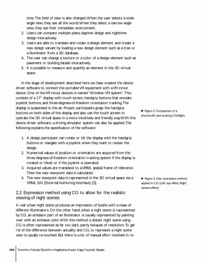
time.The field of view is also changed.When the user selects a wide-angle view, they see all the world.When they select a narrow-angleview, they see their immediate environment.
2. Users can compare multiple plans, daytime design and nighttimedesign interactively.
3. Users are able to translate and rotate a design element, and create anew design variant by loading a new design element such as a tree ora illuminator from a 3D database.
4. The user can change a texture or a color of a design element such aspavement or building facade interactively.
5. It is possible to measure and quantify an element in the 3D virtualspace.
In the stage of development described here we have created the devicedriver software to connect the portable VR equipment with a VR in/outdevice. One of the VR in/out devices is named “Window-VR system”.Thisconsists of a 17” display with touch screen, handgrip buttons that emulatejoystick buttons, and three-degrees-of-freedom orientation tracking.Thedisplay is suspended in the air. Project participants grasp the handgripbuttons on both sides of the display and also use the touch screen tooperate the 3D virtual space in a more intuitively and friendly way.With thisdevice driver software, a driving simulator system can also be applied.Thefollowing explains the specification of the software:
1. A design participant can rotate or tilt the display with the handgripbuttons or navigate with a joystick when they want to review thedesign.
2. Numerical values of position or orientation are acquired from thethree-degrees-of-freedom orientation tracking system if the display isrotated or tilted, or if the joystick is operated.
3. Acquired values are translated to a VRML spatial frame of reference.Then the new viewpoint data is calculated.
4. The new viewpoint data is represented in the 3D virtual space via aVRML EAI (External Authoring Interface) [5].
2.2. Expression method using CG to allow for the realisticviewing of night scenes
A real urban night scene produces an impression of bustle with a mass ofdifferent illuminators. On the other hand, when a night scene is representedby CG, an emission part of an illuminator is usually represented by paintingover with an emissive color.With this method a distant night scene usingCG is often represented as far too dark, partly because of resolution.To getrid of the difference between actuality and CG, to represent a night sceneview is usually re-touched. But there is a lot of manual effort involved in re-
c Figure 2. Comparison of a
photo(Left) and existing CG(Right)
c Figure 3. New expression method
applied in CG (Left: eye effect; Right:
camera effect)
464 Tomohiro Fukuda, Ryuichiro Nagahama,Atsuko Kaga,Tsuyoshi Sasada
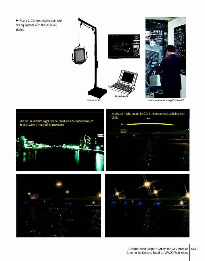
c Figure 1. Connecting the portable
VR equipment with the VR in/out
device
465Collaboration Support System for City Plans or Community Designs Based on VR/CG Technology
Portable VRWindow VR a scene of operating Window VR
An actual distant night scene produces an impression ofbustle with a mass of illuminators.
A distant night scene in CG is represented as being toodark.
In photographs, especially night ones, the exposuretime must be quite long which results, effectively, insuperimposing reflections from undulating waves onthe water surface
In CG, a method of bump mapping which assumesinfinitesimal shutter time is used.
BLOOM
CORONA
EXPOSURE
touching and it is difficult process involving trial and error.To solve thisproblem and simulate a more photo-realistic night scene, we developedthree functions in the “Inspire”, lighting simulation software [6].Thefollowing explains the functions:
1. BLOOM: a bloom glare (bright spot around a bright pixel – such asthat in which a light source is located) is simulated [7].
2. CORONA: a corona glare (bright spot with rays emanating from abright pixel) is simulated.
3. EXPOSURE: effect control for photo-like rendering [8]. Zero meansordinary rendering which assumes infinitesimal time.Values otherthan zero make sense only if exposure textures are present in thescene. In photographs, especially night ones, the exposure time mustbe quite long which produces particular effects. For example inFigure 1 the long exposure time results effectively in superimposingreflections from undulating waves on the water surface that, in turn,is available with the exposure texture.The value of exposure time forthe rendering should be decided with a time interval (end time)defined for the exposure texture.
3.Application of the system to the real projects
To evaluate the system that has been developed, we have applied thetechniques to a number of real projects.These projects are described, alongwith the techniques used, in the sections below.
3.1. Street of retail stores in Japan
This project is for a street of store renovations in the U city government inJapan.This street is located in a center of commerce in U city. But in recentyears commerce in this area has lost its vitality. In Japan this problem is notonly this area, but also in many other areas. From the 1960 ’s, which was aperiod of the high growth in the economy, until now, residential areas havebeen developed in the suburbs of Japanese cities. Many public and privatefacilities have also moved to the suburbs. Fewer people live in the centre ofthe city.And the central area of the cities in Japan are not well suited to thehigh levels on modern motor transport. Consequently stores in the centreof cities have tended to lose out to suburban supermarkets.
To aid revitalization of this street we have continuously supported thisenterprise with our VR system, for about two years from April 2000 .Participants in the development process are composed of the U citygovernment, planners, the chamber of commerce, the Town ManagementOrganization and inhabitants.The VR system is used in design study meetings,not only among professionals (weekly) but also among both professionals andinhabitants (monthly).This is useful for simulating the plans and sharing theagreed design images with participants.There are four steps in the process:
466 Tomohiro Fukuda, Ryuichiro Nagahama,Atsuko Kaga,Tsuyoshi Sasada
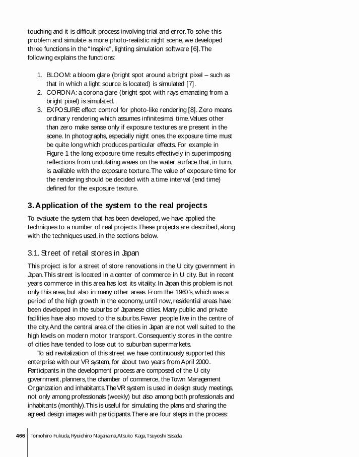
1. We made the 3D virtual space representing the actual world basedon ground plans and photos of building facades.
2. We simulated replacement of street lighting and the arcades.3. We used the 3D virtual space to try out four road alignments: 1)
straight alignment, 2) curved alignment (two patterns) and 3) branchalignment. Project participants compared plans and agreed on thedirection of curve alignment.The participants reviewed the changesfrom a driver’s and a pedestrian’s sequential view.
c Figure 4. street of stores renewal
enterprise
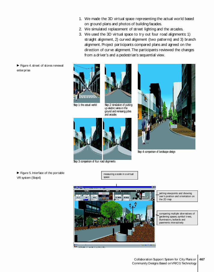
c Figure 5. Interface of the portable
VR system (Step4)
467Collaboration Support System for City Plans or Community Designs Based on VR/CG Technology
Step 1: the actual world Step 2: simulation of putting up electric wires in the ground and removing poles and arcades
Step 3: comparison of four road alignments
Step 4: comparison of landscape design
comparing multiple alternatives ofgardening spaces, symbol trees,illuminators, bollards andpavements interactively
measuring a scale in a virtualspace
setting viewpoints and showinguser’s position and orientation onthe 2D map
4. We augmented the 3D virtual space with a landscape design.Participants compared the multiple design alternatives (that includedplanted areas, trees, benches, lighting equipment, bollards andpavements) interactively.
In the near future, the building facades will be designed with the aid ofthe VR system.
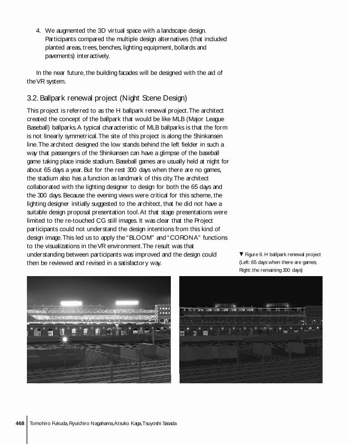
3.2. Ballpark renewal project (Night Scene Design)
This project is referred to as the H ballpark renewal project.The architectcreated the concept of the ballpark that would be like MLB (Major LeagueBaseball) ballparks.A typical characteristic of MLB ballparks is that the formis not linearly symmetrical.The site of this project is along the Shinkansenline.The architect designed the low stands behind the left fielder in such away that passengers of the Shinkansen can have a glimpse of the baseballgame taking place inside stadium. Baseball games are usually held at night forabout 65 days a year. But for the rest 300 days when there are no games,the stadium also has a function as landmark of this city.The architectcollaborated with the lighting designer to design for both the 65 days andthe 300 days. Because the evening views were critical for this scheme, thelighting designer initially suggested to the architect, that he did not have asuitable design proposal presentation tool.At that stage presentations werelimited to the re-touched CG still images. It was clear that the Projectparticipants could not understand the design intentions from this kind ofdesign image.This led us to apply the “BLOOM” and “CORONA” functionsto the visualizations in the VR environment.The result was thatunderstanding between participants was improved and the design couldthen be reviewed and revised in a satisfactory way.
. Figure 6. H ballpark renewal project
(Left: 65 days when there are games;
Right: the remaining 300 days)
468 Tomohiro Fukuda, Ryuichiro Nagahama,Atsuko Kaga,Tsuyoshi Sasada
4. Results and conclusion
With this system, participants have been able to design and review city plansor community designs in real projects in a more comprehensive and betterunderstood way.The features that we have been able to provide throughthe enhanced VR environment are not provided by physical model,perspective drawing or conventional CG.Also, it is clear that these projectsshow the potential of collaboration through computer visualized media. Inour future work, we are aiming to create more photorealistic VR and CGimages.
Acknowledgements
We would like to thank the many participants of projects.
References1. Sasada,T., Computer Graphics and Design: Proceedings of The Fourth Conference on
Computer Aided Architectural Design Research in Asia (CAADRIA’99), Shanghai, 1999,pp. 21-29.
2. Fukuda,T., Nagahama, R., Sasada,T., Collaboration Support System for PublicDesign: Proceedings of The Third Conference on Computer Aided Architectural DesignResearch in Asia (CAADRIA’98), Osaka, 1998, pp. 299-307.
3. Fukuda,T., Nagahama, R., Oh, S., Kaga,A., Sasada,T., Collaboration Support Systemfor Nightscape Design based on VR Technology: Proceedings of The Fifth Conferenceon Computer Aided Architectural Design Research in Asia (CAADRIA2000), Singapore,2000, pp. 501-510.
4. Fukuda,T., Nagahama, R., Oh, S., Kaga,A., Sasada,T.,, Collaboration SupportSystem for Nightscape Design based on VR Technology: Proceedings of The 6thConference on Computer Aided Architectural Design Research in Asia (CAADRIA2001),Sydney, 2001, pp. 103-111.
5. http://www.web3d.org/WorkingGroups/vrml-eai/ [1999].
6. http://www.integra.co.jp/eng/products/inspirer/ index.htm [2001].
7. Spencer, G.et al, Physically-Based Glare Effects for Digital Images, SIGGRAPH’95.Conference Proc ., 1995, pp. 325-334.
8. Abrosimov, D. et al, Computer Simulation of Water Surface View: Proc. of 9thInternational Conference on Computer Graphics & Vision GRAPHICON’99, 1999, pp.255-260.
469Collaboration Support System for City Plans or Community Designs Based on VR/CG Technology
Tomohiro Fukuda*, Ryuichiro Nagahama*, Atsuko Kaga**,Tsuyoshi Sasada**,*Matsushita Electric Works, Ltd., 1-5-1, Higashi-shinbashi, Minato-ku,Tokyo105-8301, Japan**Department of Environmental Engineering, Graduate School ofEngineering, Osaka University, 2-1,Yamadaoka, Suita, Osaka 565-0871, Japan
*{fukuda, nagahama}@ai.mew.co.jp**{kaga_atsuko, sasada}@env.eng.osaka-u.ac.jp
Related Documents