Collaboration Across the Road Weather Enterprise: The Pathfinder Project December 2016 FHWA-HOP-16-086

Welcome message from author
This document is posted to help you gain knowledge. Please leave a comment to let me know what you think about it! Share it to your friends and learn new things together.
Transcript
Collaboration Across the Road Weather Enterprise: The Pathfinder Project
December 2016 FHWA-HOP-16-086

Notice
This document is disseminated under the sponsorship of the U.S. Department of Transportation in the interest of information exchange. The U.S. Government assumes no liability for the use of the information contained in this document.
The U.S. Government does not endorse products or manufacturers. Trademarks or manufacturers' names appear in this report only because they are considered essential to the objective of the document.
Quality Assurance Statement
The Federal Highway Administration (FHWA) provides high-quality information to serve Government, industry, and the public in a manner that promotes public understanding. Standards and policies are used to ensure and maximize the quality, objectivity, utility, and integrity of its information. The FHWA periodically reviews quality issues and adjusts its programs and processes to ensure continuous quality improvement.
(Front Cover Picture Source: Wyoming Department of Transportation)

Technical Report Documentation Page 1. Report No. FHWA-HOP-16-086
2. Government Accession No.
3. Recipient’s Catalog No.
4. Title and Subtitle Collaboration Across the Road Weather Enterprise: The Pathfinder Project
5. Report Date December 2016 6. Performing Organization Code
7. Author(s) Megan Helsel, Brenda Boyce, Tyler Poling, Sudharson Sundararajan
8. Performing Organization Report No. N/A
9. Performing Organization Name And Address Booz Allen Hamilton 8283 Greensboro Drive McLean, VA 22102
10. Work Unit No. (TRAIS)
11. Contract or Grant No. DTFH6111D00019
12. Sponsoring Agency Name and Address U.S. Department of Transportation Federal Highway Administration 1200 New Jersey Avenue, SE Washington, DC 20590
13. Type of Report and Period Covered Final: 2013-2016
14. Sponsoring Agency Code FHWA
15. Supplementary Notes FHWA Task Manager, Paul Pisano, Road Weather and Work Zone Management Team Lead
16. Abstract
Weather has a significant impact on the operations of the nation’s roadway system year-round. To help improve weather impacts on our roadways the Federal Highway Administration (FHWA) Road Weather Management Program (RWMP) and the National Oceanic and Atmospheric Administration’s (NOAA’s) National Weather Service (NWS) have been working together to document the state-of-the-practice and working relationships between State Departments of Transportation (DOTs) and the weather enterprise. The Pathfinder project was initiated in to document current State DOT interactions and working relationships with the weather enterprise (both NWS and private sector). The team documented best practices across the agencies to disseminate consistent messages about the weather and its impact on the roads. This document serves as a guidance document for improving the collaboration between State DOTs and the weather enterprise.
17. Key Words Pathfinder, Road Weather Management Program (RWMP), National Oceanic and Atmospheric Administration (NOAA), National Weather Service (NWS), Road Weather Information Systems (RWIS)
18. Distribution Statement No Restrictions
19. Security Classif. (of this report) Unclassified
20. Security Classif. (of this page) Unclassified
21. No. of Pages 96
22. Price N/A
Form DOT F 1700.7 (8-72) Reproduction of completed page authorized


TABLE OF CONTENTS
EXECUTIVE SUMMARY .......................................................................................................... 1
CHAPTER 1. UNDERSTANDING WEATHER’S IMPACT ON THE NATION’S ROADWAY SYSTEM.................................................................................................................. 3
CHAPTER 2. APPLYING ROAD WEATHER FORECASTING IN YOUR STATE .......... 5
CHAPTER 3. MAKING THE INVESTMENT CASE FOR ROAD WEATHER FORECASTING AND DECISION SUPPORT SERVICES .................................................... 9
CHAPTER 4. THE PATHFINDER PROJECT ...................................................................... 13
CHAPTER 5. INTRODUCTION TO PATHFINDER CONCEPTS ..................................... 15
CHAPTER 6. GUIDANCE FOR PATHFINDER PROJECT STANDUP ............................ 19
CHAPTER 7. PATHFINDER GUIDANCE ............................................................................. 29
CHAPTER 8. NEXT STEPS ...................................................................................................... 37
APPENDIX A. THE PATHFINDER PROJECT – BACKGROUND ................................... 39
APPENDIX B. MAKING THE CASE FOR AN INVESTMENT DECISION ..................... 43
APPENDIX C. EXAMPLES OF SHARED IMPACT MESSAGES...................................... 45
APPENDIX D. SPECIFIC COLLABORATION EXAMPLES OF PATHFINDER TEAMS....................................................................................................................................................... 51
APPENDIX E. FEDERAL RELATED INITIATIVES ........................................................... 55
APPENDIX F. NATIONAL WEATHER SERVICE WEATHER FORECAST OFFICES BY STATE ................................................................................................................................... 63
APPENDIX G. PARTNER COLLABORATION AND RELATIONSHIPS ........................ 67
APPENDIX H. EVENT DATA ARCHIVING CHECKLISTS .............................................. 73
ACKNOWLEDGEMENTS ....................................................................................................... 77
REFERENCES ............................................................................................................................ 79
iii


LIST OF FIGURES
Figure 1. Photo. Plowing is One of Many Treatment Strategies for Adverse Weather. ................. 4
Figure 2. Photo. Road Weather Information Helps Maintenance Activities Run Smoothly. ......... 5
Figure 3. Photo. Fog is a Common Weather Condition Affecting Visibility. ................................ 6
Figure 4. Chart. Weather-Related Crashes, Fatalities, and Injuries. ............................................... 9
Figure 5. Photo. A Large Number of Crashes Each Year Are Related to Adverse Weather. ...... 10
Figure 6. Graph. Weather-Related Impacts on Arterials and Freeways. ...................................... 11
Figure 7. Photo. I-80 Corridor Shown Across Various Weather Forecast Offices, Department of Transportation, and Weather Service Provider Operational Boundaries. ..................................... 13
Figure 8. Chart. Weather, Roads, Timing, and Motorists Affect Impact. .................................... 15
Figure 9. Photo. Traffic Operations Center. ................................................................................. 20
Figure 10. Photo. A Snow Plow and Other Vehicles Driving in the Snow. ................................. 30
Figure 11. Photo. Weather Forecasting Offices County Warning Areas in the Project Region…41
Figure 12. Photo. Economic Impact of Road Weather Events. .................................................... 43
Figure 13. Photo. National Weather Service Image Shared via Facebook, 12/23/14. .................. 45
Figure 14. Photo. National Weather Service Image Shared via Twitter, 12/23/14. ..................... 46
Figure 15. Photo. Wyoming Department of Transportation Traffic Management Center Dynamic Message Sign Updated 12/24/25. ................................................................................................. 47
Figure 16. Photo. National Weather Service Graphic (1) for Expected Christmas Winter Event.47
Figure 17. Photo. National Weather Service Graphic (2) for Expected Christmas Winter Event.48
Figure 18. Chart. National Weather Service Graphic (3) for Expected Christmas Winter Event. 48
Figure 19. Photo. National Weather Service Graphic (4) for Expected Christmas Winter Event.49
Figure 20. Photo. Utah Weather Story Example........................................................................... 52
Figure 21. Graph. Aggregate Vehicle Miles Traveled vs. Time of Day. ...................................... 53
Figure 22. Photo. National and Regional National Weather Service Headquarters ..................... 66
Figure 23. Chart. Schematic of Idealized, Event-specific Communication Flow for Case 1. ...... 68
Figure 24. Chart. Schematic of Idealized, Event-specific Communication Flow for Case 2. ...... 68
Figure 25. Chart. Schematic of Idealized, Event-specific Communication Flow for Case 3. ...... 69
Figure 26. Chart. Schematic of Idealized, Event-specific Communication Flow for Case 4a. .... 69
Figure 27. Chart. Schematic of Idealized, Event-specific Communication Flow for Case 4b. .... 70
v


LIST OF TABLES
Table 1. Typical Responsibilities of a State Department of Transportation. ................................ 21
Table 2. Typical National Weather Service Operational Responsibilities. .................................. 23
Table 3. Typical Private Sector Responsibilities. ......................................................................... 25
Table 4. Weather-Related Crash Statistics. ................................................................................... 44
Table 5. Level 3 and Level 4 – Most Mature – Road Weather Operations Program Components........................................................................................................................................................ 56
Table 6. National Weather Service Weather Forecast Offices by State. ...................................... 63
Table 7. National Weather Service Archiving Checklist for Events. ........................................... 73
Table 8. Department of Transportation Archiving Checklist for All Events. ............................... 74
vii


LIST OF ACRONYMS ACRONYM DEFINITION AASHTO American Association of State Highway and Transportation Officials CCTV Closed-Circuit Television CMF Capability Maturity Framework CMM Capability Maturity Model DMS Dynamic Message Sign DOT Department of Transportation DSS Decision Support Systems ESS Environmental Sensor Station FHWA Federal Highway Administration HAR Highway Advisory Radio ITS Intelligent Transportation System LOS Level of Service NOAA National Oceanic and Atmospheric Administration NWS National Weather Service NWS-CYS National Weather Service Forecast Office – Cheyenne, Wyoming NWS-RIW National Weather Service Forecast Office – Riverton, Wyoming NWS-SLC National Weather Service Forecast Office – Salt Lake City, Utah PIO Public Information Officer Rd/Wx Road Weather RWIS Road Weather Information System RWM Road Weather Management RWMP Road Weather Management Program SHRP2 Strategic Highway Research Program 2 SLC Salt Lake City TI Traveler Information TMC Traffic Management Center TOC Traffic Operations Center UDOT Utah Department of Transportation US United States USDOT United States Department of Transportation VMS Variable Message Sign VMT Vehicle Miles Traveled VSL Variable Speed Limit WFO Weather Forecast Offices WRN Weather-Ready Nation WRTM Weather-Responsive Traffic Management WSP Weather Service Provider WYDOT Wyoming Department of Transportation Wx Weather
ix


COLLABORATION ACROSS THE ROAD WEATHER ENTERPRISE: THE PATHFINDER PROJECT
EXECUTIVE SUMMARY
The Federal Highway Administration (FHWA) Road Weather Management Program (RWMP) and the National Oceanic and Atmospheric Administration’s (NOAA’s) National Weather Service (NWS) have been working together to document the state-of-the-practice and working relationships between State Departments of Transportation (DOTs) and the weather enterprise. The objective of this work is to encourage further collaboration through growing partnerships, with the ultimate goals of saving lives and property and to keep the economy moving. The weather enterprise encompasses public and private meteorological entities, including NWS weather forecast offices (WFOs), and private weather service providers, especially those contracted by DOTs. The objective of this document is to provide information and guidance to State DOTs and the weather enterprise regarding different methods and best practices for cross-agency collaboration and the integration of weather information into daily transportation operations. The Pathfinder project was initiated in 2014 as a pilot project across four western States (California, Nevada, Utah, and Wyoming) to document current State DOT interactions and working relationships with the weather enterprise (both NWS and private sector). The focus was on the I-80 corridor which represents a mix of metropolitan and rural areas and serves as a main commercial trucking route. The team documented best practices across the agencies to disseminate consistent messages about the weather and its impact on the roads, and the way in which the messages prompt travelers to change departure times, cancel trips, choose alternate routes, or select different modes of transportation in response to adverse weather conditions. This document serves as a guidance document for improving the collaboration between State DOTs and the weather enterprise. Did You Know? The Pathfinder project is a joint initiative that aims to save lives, time and money on our nation’s roadways by minimizing the impacts of weather through the dissemination of consistent and actionable information.
Refer to Appendix A to Learn More Learn more about Pathfinder project details.
1


COLLABORATION ACROSS THE ROAD WEATHER ENTERPRISE: THE PATHFINDER PROJECT
CHAPTER 1. UNDERSTANDING WEATHER’S IMPACT ON THE NATION’S
ROADWAY SYSTEM
THE WEATHER IMPACT Weather has a significant impact on the operations of the nation’s roadway system year-round. Rain reduces pavement friction; winter weather can leave pavements snow/frost covered or icy; fog, smoke, blowing dust, heavy precipitation, and vehicle spray can restrict visibility; flooding, snow accumulation, and wind-blown debris can cause lane obstructions. These weather events translate to changes in traffic conditions, roadway safety, travel reliability, operational effectiveness, and productivity. Weather affects traffic conditions in a variety of ways. Weather events may prompt travelers to change departure times, cancel trips, choose alternate routes, or select different modes of transport. Slick pavements, low visibility, and lane obstructions lead to driving at lower speeds or with increased following distances. These changes in driver behavior can affect the operation of signalized roadways, where traffic signals are timed for clear, dry conditions, resulting in reduced traffic throughputs, increased delays, and increased travel times. Weather affects roadway safety by increasing exposure to hazards and crash risk. Weather also affects the operational effectiveness and productivity of traffic management agencies and road maintenance agencies through increased costs and lost time. It is, therefore, an important responsibility of traffic managers and maintenance personnel to implement operational strategies that optimize system performance under such conditions by mitigating the effects of weather on the roadways. The operational approaches these personnel use dictate their needs for weather and road condition information. Accurate, timely, route-specific weather information allows traffic and maintenance managers to better operate and maintain roads under adverse conditions. The U.S. Department of Transportation (USDOT) Federal Highway Administration (FHWA) Road Weather Management Program (RWMP) has defined three types of road weather management strategies that can be employed in response to rain, snow, ice, fog, high winds, flooding, tornadoes, hurricanes, and avalanches: advisory, control and treatment. Advisory Strategies. These strategies provide information on prevailing and predicted conditions as well as impacts to motorists. A variety of approaches are available to traffic managers to advise travelers of road weather conditions and weather-related travel restrictions (such as road closures resulting from fog, smoke or flooding). Strategies include posting warnings on dynamic message signs (DMS), broadcasting messages via highway advisory radio (HAR), providing road condition reports
3

COLLABORATION ACROSS THE ROAD WEATHER ENTERPRISE: THE PATHFINDER PROJECT
through interactive traveler information (TI) systems such as websites and 511-phone systems, and Public Information Officer (PIO) interaction with media. Control Strategies. These strategies alter the state of roadway devices to permit or restrict traffic flow and regulate roadway capacity. To control traffic flow during adverse weather, traffic managers may regulate lane use (such as lane reversals for evacuations), close hazardous roads and bridges, restrict access on particular roadways to designated vehicle types (e.g., tractor-trailers during high winds), implement variable speed limits (VSL), adjust freeway ramp metering rates, or modify traffic signal timings.
Figure 1. Photo. Plowing is One of Many Treatment Strategies for Adverse Weather.
(Source: United States Department of Transportation)
Treatment Strategies. These strategies apply resources to roadways to minimize or eliminate weather impacts. Maintenance managers use road weather information and decision support tools to assess the nature and magnitude of winter storms, determine the level of staffing required during a weather event, plan and execute proactive and reactive road treatment strategies (e.g., plowing, sanding, chemical applications), and activate anti-icing/deicing systems. Road Weather Observations. Road weather observations are a critical aspect of any forecast system. They allow for vital understanding of weather impacts and situational awareness of current conditions. Observations also provide a basis for value added applications including nowcasting/forecasting systems and supply a ground truth for assessment of forecast quality. For example, road weather observations can be used to understand when forecasts deviate from reality and allow for an understanding of forecast accuracy. Finally, observation information provides an excellent basis for road maintenance performance measurement. Did You Know? Beyond winter weather, maintenance managers are also concerned about the impacts of other events such as sand storms and wildfires that may reduce visibility and create hazardous driving conditions.
4

COLLABORATION ACROSS THE ROAD WEATHER ENTERPRISE: THE PATHFINDER PROJECT
CHAPTER 2. APPLYING ROAD WEATHER FORECASTING IN YOUR STATE
Figure 2. Photo. Road Weather Information Helps Maintenance Activities Run Smoothly.
(Source: Wyoming Department of Transportation) The Benefits of Road Weather Forecasting in a Nutshell
• Access to high-quality road weather information helps decision makers improve safety, enhance traffic flow and travel reliability, and increase agency productivity.
• Road weather mitigation strategies enhance roadway safety by: o Reducing crash frequency and severity. o Restricting access to hazardous roads. o Encouraging safer driver behavior.
• Road weather management strategies enhance traffic flow and mobility by: o Allowing the public to make more informed travel decisions. o Promoting more uniform traffic flow. o Reducing traffic congestion and delay, and minimizing the time to clear roads of
snow and ice. • Productivity is increased through better interagency communication and data sharing,
and by reduced labor, material, and equipment costs for snow and ice control operations.
USE OF ROAD WEATHER INFORMATION IN MAINTENANCE OPERATIONS Maintenance managers obtain and make extensive use of road weather information such as pavement temperature forecasts, water, snow and ice accumulation, and road condition predictions. This information helps managers make proactive decisions for a variety of winter and non-winter maintenance activities, including decisions about staffing levels, the selection and timing of maintenance activities, and resource management (such as personnel, equipment, and materials) as well as road treatment strategies during winter storms.
5

COLLABORATION ACROSS THE ROAD WEATHER ENTERPRISE: THE PATHFINDER PROJECT
Winter road maintenance activities are especially sensitive to weather conditions. Some of the most common weather conditions experienced throughout this season of the year include snow, ice, frost, freezing rain, and fog. Other conditions, such as blowing snow further complicate these weather aspects. During this period of the year, maintenance tasks can often involve snow and ice treatment strategies, including plowing snow, spreading abrasives to improve vehicle traction, and dispensing anti-icing/deicing chemicals to lower the freezing point of precipitation on the pavement. In regions with heavy snowfall, maintenance managers may erect snow fences adjacent to roads to reduce blowing and drifting snow. Other mitigation strategies may include the use of slope sensors and avalanche forecasts to minimize landslide and avalanche risks. When a slope becomes unstable because of snow accumulation or soil saturation, roads in the slide path may be closed to allow the controlled release of an avalanche or landslide. After snow, mud and debris are cleared and damaged infrastructure repaired, the affected route can be reopened to traffic.
Figure 3. Photo. Fog is a Common Weather Condition Affecting Visibility. (Source: Georgia Department of Transportation)
Many non-winter maintenance activities are also affected by weather conditions. Mowing is conducted on a cycle throughout the summer months but will be suspended during heavy rain and thunderstorms. The spraying of herbicides is not conducted during rainstorms or high winds. Striping requires a dry roadway, no high winds, a minimum ambient air temperature, and no immediate likelihood of rain. Surface repairs (such as pothole and seam repairs) using hot mix asphalt need dry pavement with a minimum ambient air temperature and no risk of rain in the short term. Many maintenance activities will also be suspended for thunderstorms, tornado forecasts, and periods of low visibility to protect the safety of both maintenance personnel and travelers who may unexpectedly encounter maintenance equipment on or near the roadway. Examples of Additional Collaboration Events
• Red Flag (Fire Weather) Warnings. • Burn Bans. • High Winds. • Flash Flooding.
6

COLLABORATION ACROSS THE ROAD WEATHER ENTERPRISE: THE PATHFINDER PROJECT
USE OF ROAD WEATHER INFORMATION IN TRAFFIC OPERATIONS The FHWA RWMP is working with State and local transportation agencies to become more proactive in the way they manage traffic operations during weather events. Weather-Responsive Traffic Management (WRTM) is the central component of the program’s efforts. WRTM involves the implementation of traffic advisory and control strategies in direct response to or in anticipation of developing roadway and visibility issues that result from deteriorating or forecasted weather conditions. Over the past 10 years, transportation agencies have implemented a variety of strategies to mitigate the impacts of adverse weather on their operations. These strategies range from simple flashing signs to coordinated traffic-control strategies and the dissemination of regional TI. Operational strategies that traffic managers are currently using include:
• Motorist advisories, alerts, and warnings intended to increase the awareness of the traveler to current and impending weather and pavement conditions. Approaches include active warning systems that warn drivers of unsafe travel conditions through a particular section of roadway, often in remote or isolated locations; pre-trip road condition information and forecast systems; and en-route weather alerts and pavement condition information.
• Speed-management strategies designed to manage drivers’ speed during inclement weather events. This includes both advisory, which usually involves posting an advisory travel speed deemed safe by the operating agency for the current travel conditions, and regulatory, which include speed limits that change based on road, traffic, or weather conditions.
• Vehicle restriction strategies involve placing restrictions on the types or characteristics of vehicles allowed to use a facility during inclement weather events. These strategies might include size, height, weight, or profile restrictions.
• Road restriction strategies restrict the use of a facility during inclement weather to help
travelers avoid sections of roadway that are dangerous. • Traffic signal control strategies involve making modifications or influencing the way
traffic signals operate during inclement weather to allow for more uniform traffic flow based on the prevailing or predicted weather conditions.
USE OF ROAD WEATHER INFORMATION BY MOTORISTS AND COMMERCIAL VEHICLE OPERATORS Traffic managers disseminate road weather information to road users of all types to influence their travel decisions.
7

COLLABORATION ACROSS THE ROAD WEATHER ENTERPRISE: THE PATHFINDER PROJECT
Motorists make travel decisions by using traveler information (TI) via roadway infrastructure, telephone systems, websites, broadcast media, and interactive smart phone applications that have road weather information both pre-trip and en-route. Road weather TI applications are being tailored to different road users allowing them to make informed travel decisions regarding travel mode, departure time, route selection, vehicle type and equipment, speed choice/selection, and driving behavior. In the event of a road closure, travelers will need alternate route information. Commercial vehicle operators will also use this information as well as information from their truck dispatchers for travel decisions. Commercial vehicle operators are especially sensitive to time delays and may need additional information about road restrictions caused by high winds, height and weight limits, or subsurface freeze/thaw conditions. These applications use detailed information and allow for the dissemination of road weather information in a standard, easy to understand format. While different types of road users have varying information needs, it is important to have consistent information when disseminated from different sources. Did You Know? Pathfinder identified additional areas for future expansion of road weather information including further integration with the Commercial Trucking Industry and Emergency Services. Visit http://ntl.bts.gov for more information.
Key Points
• Road weather and weather are closely related, however it is important to stress that weather forecasts are not intended for giving motorists detailed information on the road weather conditions.
• Road weather and weather forecasts need to be differentiated from one another, as well as standardized so that road users and managers can make appropriate decisions regarding travel.
• Road weather and weather forecasts must address both current and predicted conditions.
8
COLLABORATION ACROSS THE ROAD WEATHER ENTERPRISE: THE PATHFINDER PROJECT
CHAPTER 3. MAKING THE INVESTMENT CASE FOR ROAD WEATHER
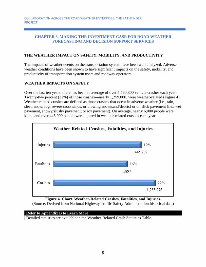
FORECASTING AND DECISION SUPPORT SERVICES THE WEATHER IMPACT ON SAFETY, MOBILITY, AND PRODUCTIVITY The impacts of weather events on the transportation system have been well analyzed. Adverse weather conditions have been shown to have significant impacts on the safety, mobility, and productivity of transportation system users and roadway operators. WEATHER IMPACTS ON SAFETY Over the last ten years, there has been an average of over 5,760,800 vehicle crashes each year. Twenty-two percent (22%) of those crashes—nearly 1,259,000, were weather-related (Figure 4). Weather-related crashes are defined as those crashes that occur in adverse weather (i.e., rain, sleet, snow, fog, severe crosswinds, or blowing snow/sand/debris) or on slick pavement (i.e., wet pavement, snowy/slushy pavement, or icy pavement). On average, nearly 6,000 people were killed and over 445,000 people were injured in weather-related crashes each year.
Figure 4. Chart. Weather-Related Crashes, Fatalities, and Injuries.
(Source: Derived from National Highway Traffic Safety Administration historical data) Refer to Appendix B to Learn More Detailed statistics are available in the Weather-Related Crash Statistics Table.
9

COLLABORATION ACROSS THE ROAD WEATHER ENTERPRISE: THE PATHFINDER PROJECT
Figure 5. Photo. A Large Number of Crashes Each Year Are Related to Adverse Weather.
(Source: Wyoming Highway Patrol) WEATHER IMPACTS ON MOBILITY Significant roadway capacity reductions can be caused by flooding or by lane obstructions caused by snow accumulation and wind-blown debris. Road closures and access restrictions resulting from hazardous conditions (such as large trucks in high winds) also decrease roadway capacity. Weather events reduce mobility and travel time reliability through speed reductions and increases in speed variance. Reduced friction due to wet, snow or ice-covered pavement also leads to travel time delays, and start-up delays (i.e., how long it takes a line of cars to start moving from a red light).
10

COLLABORATION ACROSS THE ROAD WEATHER ENTERPRISE: THE PATHFINDER PROJECT
Figure 6. Graph. Weather-Related Impacts on Arterials and Freeways.
(Source: Derived from National Highway Traffic Safety Administration historical data) Significant impacts are also felt on freeways in the presence of adverse weather conditions. Figure 6 illustrates a few percentage ranges that different weather-conditions can have on arterial and freeway travel. Overall, it has been estimated that 23 percent of non-recurring delay on highways across the nation is due to impacts associated with snow, ice, and fog. This amounts to an estimated 544 million vehicle-hours of delay per year. One important takeaway from Figures 4 and 6 is that there are a range of weather-related impacts to traffic safety and mobility, from minimal to severe. Impact type changes with weather event timing, type, location, etc. The specific impacts for each weather event is an important part of forecasting and decision support services for road system users.
11

COLLABORATION ACROSS THE ROAD WEATHER ENTERPRISE: THE PATHFINDER PROJECT
WEATHER IMPACTS ON PRODUCTIVITY Adverse weather can also increase the operating and maintenance costs of road maintenance agencies, traffic management agencies, emergency management agencies, law enforcement agencies, and commercial vehicle operators. Winter road maintenance activities account for roughly 20 percent of State transportation agency maintenance budgets. Each year, State and local agencies spend more than $2.3 billion on snow and ice control operations. Each year, trucking companies lose an estimated 32.6 billion vehicle-hours because of weather-related congestion in the nation’s top 281 metropolitan areas. The estimated cost of weather-related delay to trucking companies is $3.1 billion annually in the nation’s 50 largest cities. The availability of accurate, up-to-date road weather observations that are tailored to the needs of roadway operators together with the decision support tools that place the observation data in a transportation system operations and management context plays a significant role in helping better prepare roadway operators and users of the transportation system for adverse weather conditions. In turn, this approach improves safety, mobility, and productivity.
12

COLLABORATION ACROSS THE ROAD WEATHER ENTERPRISE: THE PATHFINDER PROJECT
CHAPTER 4. THE PATHFINDER PROJECT
In an effort to better serve the end user (decision makers and the traveling public), the National Oceanic and Atmospheric Administration’s (NOAA) National Weather Service (NWS) and the United States Department of Transportation (USDOT) Federal Highway Administration (FHWA) Road Weather Management Program (RWMP) are working together on an initiative entitled “Surface Transportation Weather Collaboration: The Pathfinder Project.” The initiative objective is to build a framework that facilitates collaborative partnerships between NWS Weather Forecast Offices (WFO), State Departments of Transportation (DOT), and as applicable, private sector Weather Service Providers (WSP) supporting DOTs. Within the first phase of the initiative, the team identified a singular interstate corridor (Interstate 80) across four States (California, Nevada, Utah, and Wyoming) with a variety of WFO, DOT, and WSP operational configurations to test the implementation of a cross-entity collaboration framework in a real-world setting (Figure 7).
Figure 7. Photo. I-80 Corridor Shown Across Various Weather Forecast Offices,
Department of Transportation, and Weather Service Provider Operational Boundaries. (Source: Adapted from the National Oceanic and Atmospheric Administration website)
BACKGROUND AND MOTIVATION A key mission shared among the Pathfinder participants is to improve safety, mobility, and the economy. Essential to accomplishing this mission is communicating information to decision makers and the public to ensure informed decisions and preparedness when faced with rain, snow, fog, wind, wildfire, or other potentially impactful weather events to the surface transportation system. Through collaboration on road weather impact messages, weather forecast offices (WFOs), departments of transportation (DOTs), and weather service providers (WSPs) can better serve the needs of users of road weather information, supporting mission fulfillment.
13

COLLABORATION ACROSS THE ROAD WEATHER ENTERPRISE: THE PATHFINDER PROJECT
What is the Pathfinder Project? The Pathfinder project is a joint initiative to save lives, time and money on our nation’s roadways by minimizing the impacts of weather through the dissemination of consistent and actionable information.
Refer to Appendix A to Learn More Learn more about Pathfinder project details.
14

COLLABORATION ACROSS THE ROAD WEATHER ENTERPRISE: THE PATHFINDER PROJECT
CHAPTER 5. INTRODUCTION TO PATHFINDER CONCEPTS
THE IMPACT MESSAGE
Here, the term “impact” is used to distinguish the type of information relayed to the public. The “impact forecast” adds value to a standard weather forecast by placing the weather into the context of the local transportation system. Impact considers the weather, the road surface, average traffic volumes, how the weather’s interaction with the road surface and/or vehicles will affect traffic, how effective maintenance mitigation efforts will be during the event, and so on. Classifying the impact of an upcoming event demands a thorough knowledge of the weather and traffic in a given area, as well as some understanding of human factors. For example, all else being equal, a given winter storm may have a low to moderate impact in an area where traveling in wintry weather is commonplace, but have a high impact in an area that rarely, if ever, encounters wintry road conditions. Time of day and traffic volume are important, as the impact of a weather event will be greatly increased if it is forecast to occur during a peak commute period. While the classification of impacts is somewhat subjective, the Pathfinder participants can arrive at shared impact messages through relationship building, education about each other’s agency operations, and collaboration.
Figure 8. Chart. Weather, Roads, Timing, and Motorists Affect Impact.
(Source: Federal Highway Administration) Note that not all weather results in a significant impact, and the designation of a storm as minimally-impactful is just as important to communicate to road users as one that is more significantly-impactful. In fact, the focus should be on the regular communication of impact due to weather events on a day-to-day basis. Refer to Appendix C to Learn More Refer to some examples of shared weather impact messages.
15

COLLABORATION ACROSS THE ROAD WEATHER ENTERPRISE: THE PATHFINDER PROJECT
The term “event” is used throughout this document to denote any specific weather occurrence which has an impact on driving conditions, (e.g., slick roads due to rain, snow or ice; flooded roadways; poor visibility due to fog, heavy precipitation, blowing dust or smoke; or high cross winds). Here, an event usually refers to the entire course of a storm, for example, a winter storm with a defined beginning and ending. An event may last hours or days. During the winter of 2014-2015, the first winter of the Pathfinder Project, the weather forecast offices (WFOs), departments of transportation (DOTs), and weather service providers (WSPs) collaborated before, during, and after winter storms to establish common impact messages for dissemination. The collaboration was performed via NWSChat, emails, conference calls, and in person. Messages disseminated by the NWS were via services such as text products, websites, graphics, video briefings, and media interviews. DOT Traveler Information (TI) systems such as Dynamic Message Signs, websites, highway advisory radio, and 511 were employed. THE IMPORTANCE OF COLLABORATION Motorists search for and receive weather-related information from a variety of sources. When inconsistent information is obtained, it becomes increasingly difficult to reach a conclusion on how the weather may potentially impact their travel choices. When State DOTs and the weather enterprise collaborate on shared weather impact messages, consistent information may be obtained across the gamut of sources, which in turn is more likely to allow more travelers to make informed decisions regarding their travel in the face of inclement weather. Benefits of the Creation of a Shared Weather Impact Message
• Provides improved, consistent traveler information and messaging. • Reinforces weather and travel messages. • Improves public response. • Engages the State Department of Transportation and the weather enterprise.
CASE STUDY EXAMPLE OF PATHFINDER COLLABORATION The mutual benefit of collaboration between DOTs and National Weather Service (NWS) was realized in the initial Pathfinder States where local WFOs and the State DOT’s Traffic Operations Centers (TOCs) instigated evolving partnerships to develop impact-specific weather messages for motorists. These messages would be released to the public from both agencies explaining the timing, duration, location and impacts of the weather on local roadways. Though the State DOTs communicated the messages through TI outlets and the WFOs communicated through advisory products (watch, warning, etc.) and “Weather Story” graphics, the substance of the messages were the same. Most local media outlets closely followed and re-posted advisory products, which further expanded the reach of these messages. As a result of the collaboration, these elements helped travelers make alternative travel plans prior to the worst of the upcoming weather.
16

COLLABORATION ACROSS THE ROAD WEATHER ENTERPRISE: THE PATHFINDER PROJECT
From several experiences in the Pathfinder States, the collaborative model has been promoted as an inexpensive method to increase the range and effectiveness of road weather messaging to reach the public prior to events and to help them plan their travel. The improved, consistent information resulted in a more-informed public, improving safety and mobility by decreasing or shifting discretionary travel. Refer to Appendix D to Learn More Read specific collaboration examples from the Utah, Wyoming, and Nevada Pathfinder teams.
17


COLLABORATION ACROSS THE ROAD WEATHER ENTERPRISE: THE PATHFINDER PROJECT
CHAPTER 6. GUIDANCE FOR PATHFINDER PROJECT STANDUP
LINKS TO FEDERAL INITIATIVES The expansion of the collaborative model nationwide has been supported by initiatives at federal headquarters for both the Federal Highway Administration (FHWA) and the National Weather Service (NWS), such as:
• The Strategic Highway Research Program 2 (SHRP2) Capability Maturity Model (CMM).
• The Weather-Ready Nation (WRN) Roadmap. The SHRP2 CMM provides transportation agencies with a tool to improve transportation system management. It was refined for several sub-topics, including road weather management (RWM). The model classifies the mature program as one that operates with a high degree of collaboration with the weather community before an event and proactively messages the public. Recommended tasks for maturing in the area of collaboration with the weather enterprise include:
• Establish lines of communications between Department of Transportation (DOT) and identified meteorologists.
• Create an email list of points-of-contact in the weather community. • Institute a list serve for exchange of coordination information. • Develop standard operating procedures for coordination. • Establish and attend local joint meetings between the weather and transportation
communities to discuss road weather management. • Hold post-event debriefings between DOT staff and the weather community. • Establish methods for archiving weather data and forecasts.
The establishment of the collaborative relationship is optimized when there is a dedicated weather position within the DOT, when joint meetings are made routine prior to hazardous weather events, and when NWS, private sector and academic resources are integrated into DOT operational procedures. These are the traits of a mature Road Weather Management Program (RWMP). PARTNERS’ RESPONSIBILITIES THROUGHOUT WEATHER EVENTS There are numerous facets to State DOTs, the weather forecasting offices (WFOs) and, when present, DOT-contracted weather service providers. This section provides an overview of the responsibilities of each partner as they relate to operating procedures during hazardous weather events. The following section refines the responsibilities to interaction and relationship-building among the partners.
19

COLLABORATION ACROSS THE ROAD WEATHER ENTERPRISE: THE PATHFINDER PROJECT
Refer to Appendix E to Learn More For additional details on Federal initiatives.
Figure 9. Photo. Traffic Operations Center.
(Source: Utah Traffic Operations Center) Pathfinder Testimonial “Before Pathfinder, working together was often disjointed because there were misunderstandings, and a lack of knowledge and end goals. After Pathfinder, relationships improved, communication was more consistent and action-oriented. Pathfinder helped build structure and an organized path of communication between all parties involved.” - Vice President of Road Weather/Meteorologist, DayWeather, Inc.
STATE DEPARTMENT OF TRANSPORTATION State DOT traffic management and maintenance operations function in real time. A few of their typical operational responsibilities (both general and storm-specific) are listed in Table 1. Due to the intrinsic nature of weather in DOT resource allocation, planning divisions have weather-related responsibilities as well. The financial needs of DOT operations change from year to year with changes in the weather, updates to operational methodologies, and the availability of technological advances. Therefore, planning divisions should remain intimately aware of the weather and climate that dictate the actions and changing nature of the DOT’s operational divisions.
20

COLLABORATION ACROSS THE ROAD WEATHER ENTERPRISE: THE PATHFINDER PROJECT
Table 1. Typical Responsibilities of a State Department of Transportation.
Traffic Management Responsibilities Maintenance Operations Responsibilities General Responsibilities: Manage traffic and incidents (weather is considered an incident). Maintain highways and infrastructure.
Maintain (a pre-determined) level of service (LOS) through traffic control devices and techniques.
Maintain (a pre-determined) LOS through maintenance activities.
Manage Intelligent Transportation System (ITS) infrastructure signals/timing, Variable Message Sign (VMS), Variable Speed Limit (VSL), Closed-Circuit Television (CCTV), Road Weather Information System (RWIS).
Manage resources (equipment, material, etc.).
Gather information (from field devices, field crews, other agencies, other States).
Communicate (within and with traffic operations).
Disseminate information (to public, other agencies, other States). Safety (themselves, public).
Monitor (traffic flow, road conditions, road weather).
Gather, understand, and utilize road weather information.
Share weather information with weather enterprise. Manage performance metrics.
Manage performance metrics. Event-Specific Responsibilities: Pre-event: gather a detailed understanding of the upcoming weather, its impacts to the road system, locations and timing.
Pre-event: gather a detailed understanding of the upcoming weather, its impacts to the road system, locations and timing.
Develop a traffic management plan. Develop a maintenance plan.
Warn travelers of expected impacts. Prepare infrastructure (e.g., apply anti-icers, clear culverts, etc.).
During the event: continue to gather road condition and traffic information and continue to keep the public updated on road conditions, traffic speeds, and incidents.
During the event: continue to gather road weather and traffic information.
Use traffic control devices to manage travel by reducing speeds, altering traffic signal timing, offering information and alternative routes, etc.
Help to maintain mobility and safety through mitigation of weather-related hazards.
Post-event: maintain communication with the public regarding road conditions as roads are cleared and/or congestion is relieved.
Provide timely information about hazardous driving conditions and roadway or lane closures or blockages due to adverse weather conditions within 20 minutes or less from the time the conditions are observed.
21

COLLABORATION ACROSS THE ROAD WEATHER ENTERPRISE: THE PATHFINDER PROJECT
WEATHER ENTERPRISE “Weather Enterprise” is a term which encompasses all weather service-providing organizations within the public and private sector (including news media), each catering their forecasts and data products to their customers’ needs. For the purpose of DOT-Weather Enterprise interaction, the broad field of providers is focused into two participating entities: The National Oceanic and Atmospheric Administration’s (NOAA’s) NWS and private road weather service providers. NATIONAL WEATHER SERVICE The NWS is a division of NOAA within the U.S. Department of Commerce. Its nationwide offices include:
• One hundred and twenty-two (122) WFOs that cover set geographical areas called county warning areas (listed in Appendix F).
• NWS national headquarters and regional headquarters (refer to Appendix F). • Thirteen (13) River Forecast Centers collocated with WFOs. • Nine (9) Centers for Environmental Prediction, including the Storm Prediction Center
and the National Hurricane Center. The official mission of the NWS is to “provide weather, water, and climate data, forecasts and warnings for the protection of life and property.” Its stated vision is: “A Weather-Ready Nation,” in which “society is prepared for and responds to weather-dependent events.” To this end, the NWS has catered its forecast products to the general public and to emergency managers alike to mitigate impacts from daily weather to high-impact events. The NWS has worked to build and maintain relationships with government agencies to better understand their weather information needs. Table 2 lists a few of their typical operational responsibilities (both general and storm-specific). Prior to a weather event, NWS forecasters assign a watch, warning or advisory designation to the event. The criteria are based on the severity of the event, as designated by numerical forecast values (e.g., snow amount, wind speed, etc.). However, recent efforts have sought to alter the thresholds for these products to expected impact, instead of numerical forecast values. For example, a winter storm is forecast to accumulate two inches of snow, which would place the event in advisory criteria. However, the precipitation is expected to occur quickly, beginning at 5 p.m. and local road temperatures have been hovering just above freezing. Snow is expected to first melt on the road surface, but quickly freeze as road temperatures drop, creating a slick layer of ice and snow. At 5 p.m., traffic volume will be high. The combined effects from the weather, road temperature and traffic would create a higher impact event than would be expected from the forecast alone. A WFO may re-assign the event to warning level for its expected transportation impact. The text contained in the forecast product would provide decision support by explaining the impact and including “call-to-action statements.”
22

COLLABORATION ACROSS THE ROAD WEATHER ENTERPRISE: THE PATHFINDER PROJECT
Table 2. Typical National Weather Service Operational Responsibilities.
Routine National Weather Service Services National Weather Service Services in Support of Public Safety Officials
General Responsibilities Produce a suite of weather, water, and climate information services, including non-routine watches, warnings, and advisories.
Partner on outreach and education efforts, including customer workshops and awareness weeks.
Disseminate observation and forecast information via legacy text products, National Oceanic and Atmospheric Administration (NOAA) Weather Radio, and digital services, including websites and social media.
Facilitate sharing of National Weather Service (NWS) forecast and observation data for use in partner information services.
Conduct community outreach and education efforts in support of a Weather-Ready Nation.
Coordinate and provide input on selection of sites for Department of Transportation (DOT) and NWS observation systems.
Build relationships with core partners and learn and document their decision thresholds and community impacts.
Coordinate seasonal meetings.
Conduct employee training to improve impact-based decision support services and situational awareness.
Interact for non-routine situations that may be critical to public safety, such as fires, hazardous materials incidents, dense fog, and dangerous conditions that are not well covered by standard NWS products.
Event-Specific Responsibilities Provide decision support services remotely and on-site to community leaders and decision makers.
Provide Site-specific (Spot) Forecasts essential to public safety.
Serve as a conduit to media, ensuring dissemination of key messaging.
Collaborate regarding significant weather events where public safety is at risk, to include timing and impacts, and to ensure consistent public messaging.
Gather and disseminate past and current storm-related information (e.g. precipitation totals, wind speeds).
Share storm reports for use in messaging and verification.
Conduct post-event after-action reviews and surveys as deemed necessary.
Participate in post-event after action reviews.
23

COLLABORATION ACROSS THE ROAD WEATHER ENTERPRISE: THE PATHFINDER PROJECT
THE PRIVATE SECTOR The meteorological private sector includes a range of companies that provide weather forecasts, observation-based technologies and Decision Support Systems (DSS), and/or data services to various clientele. They may be independent, associated with a media group, or contract with other companies and agencies. The forecasters are especially trained in transportation-specific weather, and their products focus on weather interaction with the road surface and with traffic mobility. Table 3 lists a few typical operational responsibilities (both general and storm-specific) for private sector entities. There are several private weather firms serving State DOTs nationwide. Almost all of the firms provide internal operational forecasts and decision support, but the DOT may request other services, such as modeling and software development, weather instrumentation, research, data management, personnel training, collaboration with other agencies, decision support (e.g., winter maintenance treatment recommendations), and producing TI weather conditions and forecasts. During weather events, the company will usually be asked to: conduct briefings with maintenance, traffic operations, emergency managers, and others; interpret and disseminate weather observations, interact with other divisions and agencies; answer questions from DOT personnel; provide weather alerts; and so on, as requested. Each DOT has a different working arrangement with their contractor, though there are a few DOTs that have no contracted weather support. Forecasters may be located within a Traffic Management Center (TMC), elsewhere in-state or elsewhere out-of-state. Various configurations of these arrangements will dictate the manner of collaboration between the DOT, its contractors and the NWS.
24

COLLABORATION ACROSS THE ROAD WEATHER ENTERPRISE: THE PATHFINDER PROJECT
Table 3. Typical Private Sector Responsibilities.
Private Sector Collaboration General Responsibilities Learn the capabilities of maintenance operations. Produce weather and road weather forecast information and/or support. Provide decision-support for various decision-makers. Accommodate other potential Department of Transportation (DOT) needs, such as modeling and software development, weather instrumentation and data management, personnel training, research, program management, collaboration with other agencies and producing TI weather conditions and forecasts. Event-Specific Responsibilities Conduct briefings with maintenance, traffic operations, emergency managers, or others. Conduct annual event scenario response training. Interpret and disseminate weather observations. Interact with other divisions and agencies. Answer questions from Department of Transportation (DOT) personnel. Provide weather alerts.
EMERGENCY MANAGERS Emergency management encompasses all actions to prepare for, respond to, and recover from a disaster or emergency. Sometimes you will hear about emergency preparedness or emergency response. Each State dictates when emergency management is initiated based on a set of thresholds (e.g., closure, NWS warning). After an analysis of the current and/or forecasted weather and there is an indication that thresholds will be met, the emergency management team should be included in the collaborated messages to the public. With this inclusion, all messages will be consistent and the proper information will be conveyed.
EMERGENCY RESPONDERS Emergency responders depend on roadways to provide crucial services to individuals and communities. People who are in danger or are physically hurt rely on emergency responders to come to their rescue without being affected by the weather condition. Communication flows with emergency responders is needed at the start to insure they can effectively continue to operate without the repercussions of hazardous weather conditions. Furthermore, the very nature of hazardous weather conditions will likely increase the need for emergency responders making their inclusion even more imperative to include them when establishing collaborative relationships.
25

COLLABORATION ACROSS THE ROAD WEATHER ENTERPRISE: THE PATHFINDER PROJECT
ACADEMIA It is important to remember that academia is also an important partner to State DOT weather-related operations. Although academia’s role of forecasting is rarely operational in nature, the State DOT can work with local universities or transportation institutes to conduct research or build tools to assist operations. A State DOT can also leverage the data management resources of universities to quality control and archive its road weather information systems (RWIS) data. In these ways, academia serves as an important segment of the weather enterprise. Refer to Appendix F to Learn More For a list of all weather forecast offices within the United States.
PARTNER COLLABORATION AND RELATIONSHIPS As mentioned in the previous section, every State DOT has a different operational configuration with their private sector contractor, and some DOTs do not have one. The operational configuration of the partners will affect how collaborative communication takes place. The following five configuration cases were identified nationwide:
Case 1: Private Sector Meteorologist in the TMC. Case 2: Private Sector Meteorologist outside the TMC. Case 3: No Private Sector Meteorologist. Case 4a: Private Sector and DOT Meteorologists in the TMC. Case 4b: Private Sector and DOT Meteorologists outside the TMC.
For Cases 1, 2 and 3, there is no DOT-employed meteorologist on staff. In Case 4, the DOT has an employed meteorologist. Cases 1, 2, 4a and 4b show that the physical location of the private sector meteorologists may be inside or outside of the TMC. The physical location of all partners during events will affect communication between them. Refer to Appendix G to Learn More Illustrates how event-specific communication flows. Media is included as an important part of the weather enterprise and an important conduit for traveler information and forecasts.
The participating State DOT should be aware of the configuration of their public and private partners, as well as any tools that would ease communication between each. This guidance will not suggest specific ways of communicating among each of these five configuration cases. Successful collaborative partnerships arise from building relationships between all participants within the State DOT and weather enterprise. Relationships should be fostered through successive and varied joint activities throughout the year. It is important that many modes of interaction become part of standard operating procedures. Interaction methodologies should be clearly outlined and practiced regularly. While partner interaction may become a requirement in operational policy, authentic trust, open dialogue and true collaboration are built over time and
26

COLLABORATION ACROSS THE ROAD WEATHER ENTERPRISE: THE PATHFINDER PROJECT
by working toward a common goal. Each partner must be willing not only to give information, but also to listen and to consider the viewpoint from the other agency. Ultimately, the purpose of the collaboration is to provide the traveling public with consistent road weather impact information so they can make better decisions, and this goal must be kept central to the effort. In many ways, this effort is about changing operational culture at the State DOT, in the private sector, and at the NWS. Naturally, there will be disagreements with weather forecasts, specific timing, etc., but there will also be commonalities. It is imperative to the collaborative effort to look past potential disagreements and identify the commonalities in each entity’s tools, resources, and expertise. Open communication will aid in developing road impact agreements. Throughout the Pathfinder project, meteorologists on both sides needed to be reminded each time that the ultimate goal of the collaboration goes beyond having the “best” weather forecast, to having a shared impact message so the public can take appropriate action. At the same time, State DOT management must realize that putting forth the effort to collaborate pays off on the transportation system and the efficiency of their operations.
27

COLLABORATION ACROSS THE ROAD WEATHER ENTERPRISE: THE PATHFINDER PROJECT
Getting Started Quick Reference Guide: Setting Initial Collaboration Guidelines and Procedures Identify partners
• Determine the key points of contact across all of the key agencies, organizations and companies.
Determine qualifying collaboration events • Impactful precipitation events effecting travel such as high winds, etc.
Select communication mediums and set procedures • NWSChat
o Decide if the chat room is private or public. o Initiate the conversation. o Discuss 3 main items until general agreement is reached:
1) Impact potential 2) Location of potential impact 3)Timing of potential impact. • Conference calls- as necessary scheduled through chat or email.
Establish point person at each participating entity • Announce regular shift hours. • Obtain name and contact information for after hours. • Define lines of communication, i.e., determine who will be communicating with whom,
especially doing weather events. Synchronize forecast schedules
• As much as possible, synchronize. o Releases of information to the public. o Schedules for Pathfinder collaboration chats and conference calls.
Establish definitions and create shared resources • Photo repository, PowerPoint templates, shared impact messages, dynamic message
sign message templates. Create shared Impact message for the public
• Recognize contributions of each entity (retweet, utilize other entity’s graphic on your social media post, etc.).
• Set goals for distribution of messages based on the event type: For example, for an ice event ~ Release and distribute impact messages at least 24 hours before the event.
Conduct post event review, and archiving data, and document operating procedures.
28

COLLABORATION ACROSS THE ROAD WEATHER ENTERPRISE: THE PATHFINDER PROJECT
CHAPTER 7. PATHFINDER GUIDANCE
STEP 1: IDENTIFYING PARTNERS
The first step across seasonal, event-centric and on-going coordination is to identify the key partners. Who will be the prime points of contact within the State Department of Transportation (DOT) (from both traffic and maintenance management)? Does the State have private sector weather support? Is there a separate Traveler Information (TI) contractor? For each, the points of contact should be identified. Will the State’s emergency manager be involved? Which National Weather Service (NWS) forecast office of offices will be involved? Will one Weather Forecast Office (WFO) serve as the primary point of contact? In addition to identifying the points of contact, determine the best means of communication (e.g., phone, email).
STEP 2: DETERMINING QUALIFYING COLLABORATIONS EVENTS
Once the first step has been completed, it is important to establish collaboration efforts around weather events that will affect travel. Discussions should take place prior to every weather season, and afterward for post-season review. However, a season is not limited to calendar seasons, and the partnership may have established other “hazard seasons” that are particular to the State, e.g., hurricane season, spring flooding season, wildfire season, etc. Many State DOTs hold large pre-winter meetings, but not all seasons need the same scale of meetings; they should be scaled to the weather’s impact and response.
STEP 3: SELECT COMMUNICATION MEDIUMS AND SET PROCEDURES
In the pre-season meetings, each entity should meet to establish or review lines of communication (i.e., who communicates with whom), rules of interaction, means of communication (i.e., teleconferences, NWSChat, and websites) responsibilities and operating procedures, and to re-introduce the individual players. Ensure all contact information is accurate and up to date. Set up protocols for when the weather enterprise (NWS and private sector) contacts the DOT (usually pre-event and a storm evolves) and vice versa (to maintain communication, share observations, ask questions, etc.). Site visits are also recommended. All partners should be aware of the potential impacts that the transportation system could face that season and the manner in which the State DOT will work to mitigate those impacts. Share what each agency is doing to prepare, such as making sure critical instrumentation and communications are working and material supplies are in place, and educating forecasters on recent research and techniques.
Prior to and during weather events, each agency has its own list of responsibilities and tasks it undertakes to accomplish its goals. As interactions become a normative part of operating procedures, many of the responsibilities of each agency become shared with the other. During weather events most interactions between partners occur via phone; however, other means of communication can be used, including email and NWSChat. NWSChat can be used to share
29
COLLABORATION ACROSS THE ROAD WEATHER ENTERPRISE: THE PATHFINDER PROJECT
quick informational bytes and to plan conference calls between the operational partners. Another advantage to NWSChat is that a log of chatroom activity is automatically archived for easy review. Furthermore, it may be necessary to conduct a mid-season assessment to review whether the initially designed lines of communication, rules of interaction, responsibilities, and operating procedures are meeting the needs of each entity. Pathfinder Team Best Practice
• Seasonal Coordination Meetings are most effective if held in person. • Post-season meetings are just as important as pre-season meetings. • Remember to include seasonal partners in meetings.
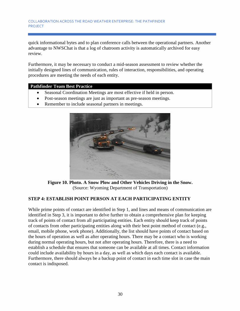
Figure 10. Photo. A Snow Plow and Other Vehicles Driving in the Snow.
(Source: Wyoming Department of Transportation) STEP 4: ESTABLISH POINT PERSON AT EACH PARTICIPATING ENTITY While prime points of contact are identified in Step 1, and lines and means of communication are identified in Step 3, it is important to delve further to obtain a comprehensive plan for keeping track of points of contact from all participating entities. Each entity should keep track of points of contacts from other participating entities along with their best point method of contact (e.g., email, mobile phone, work phone). Additionally, the list should have points of contact based on the hours of operation as well as after operating hours. There may be a contact who is working during normal operating hours, but not after operating hours. Therefore, there is a need to establish a schedule that ensures that someone can be available at all times. Contact information could include availability by hours in a day, as well as which days each contact is available. Furthermore, there should always be a backup point of contact in each time slot in case the main contact is indisposed.
30

COLLABORATION ACROSS THE ROAD WEATHER ENTERPRISE: THE PATHFINDER PROJECT
STEP 5: SYNCHRONIZE FORECAST SCHEDULES Prior to the event, weather entities prepare forecasts and brief each other and the DOT. Their focus is the general character of the storm and its anticipated impacts to the roadway and to motorists. The Department of Transportation (DOT) uses this information to prepare a game plan for mitigating the impacts of the storm through maintenance operations and traffic management. With mitigation plans in mind, the collective group discusses how the event will impact the traveling public and works together to create a shared public message containing details on the upcoming weather – type, location and timing – how that weather will affect traveling on the roads, and recommended actions the public should take to stay safe. An interaction schedule is also set for the rest of the event.
A shared message between the DOT and NWS is very important for instilling confidence in the public, helping them to make informed decisions and improving safety and mobility during the event. During the event, collaboration continues throughout the event while it is in progress. Regular cross-agency briefings are used to share observations, mitigation plans and road closure updates, as well as reviewing forecasts for the remainder of the event. During multi-day events, the interaction process becomes repetitive, including forecast updates, recurring briefings, observation sharing and public information updates. Weather forecast messages that are communicated to the public from the NWS and DOT are updated around the same time as each other to maintain consistency between both agencies. Most of the during-storm interactions occur via phone, but NWSChat is used to highlight changes to the message or the forecast and to quickly share observations. Local media may then access these changes via social media outlets and share the updated impact messages through re-posting, updating press releases, etc.
National Weather Service’s Weather-Ready Nation National Weather Services’ Weather-Ready Nation is about building community resilience in the face of increasing vulnerability to extreme weather and water events. Record-breaking snowfall, cold temperatures, extended drought, high heat, severe flooding, violent tornadoes, and massive hurricanes have all combined to reach the greatest number of multi-billion dollar weather disasters in the nation’s history. The devastating impacts of extreme events can be reduced through improved readiness, which is why the Weather-Ready Nation initiative is so important. Through operational initiatives, National Oceanic and Atmospheric Administration’s National Weather Service is transforming its operations to help America respond. In the end, emergency managers, first responders, government officials, businesses and the public will be empowered to make fast, smart decisions to save lives and livelihoods. Building a Weather-Ready Nation requires the action of a vast nationwide network of partners including other government agencies and emergency managers, researchers, the media, insurance industry, non-profits, the private sector, the Weather Enterprise and more. (National Oceanic and Atmospheric Administration, 2014).
31

COLLABORATION ACROSS THE ROAD WEATHER ENTERPRISE: THE PATHFINDER PROJECT
Getting Started Quick Reference Guide: Pre- and During Event Collaboration Guidelines and Procedures Pre-Event Activities Each entity should prepare their forecasts in order to be prepared to brief the others. Focus should be on
• General character of the storm. • Anticipated impacts to the roadway and motorists.
During pre-event briefings, work together to discuss/develop • Mitigation plan(s) for maintenance operations and traffic management.
o Shared public messages, containing details on storm type, potential impacts and impacted locations/infrastructures, and timing.
• Recommended actions the public should take to stay safe. • Interaction schedule for the course of the event.
During-Event Activities Hold regular cross-agency briefings to
• Share observations. • Provide updates to any mitigation plans/road closures. • Review forecasts. • Discuss potential updates to shared impact messages for both content and timing. • Review interaction schedule for the remainder of the event.
Remember, a consistent, shared message from all sources is important for instilling public confidence and influencing informed decisions to improve safety and mobility.
STEP 6: ESTABLISH DEFINITIONS AND CREATE SHARED RESOURCES Collaborative relationships take time and cooperation to develop. These relationships are maintained through regular meetings, site visits, collaboration on projects and research. Oftentimes, it is possible to become involved with professional organizations across disciplines. For example, DOT meteorologists and other operations managers could be involved with the local American Meteorological Society chapter, if one exists. Also, shared resources and standard terminology should be established to foster better communication between entities, which will further increase collaboration effectiveness. There should be a constant effort to improve the message and the collaboration, and as the program matures, other personnel and partners can be included to increase the effectiveness of information dissemination. Relationships with media can improve using yearly media workshops and through involving DOT PIO’s in the collaborative effort. Also, DOT field crews and public weather spotters may be alerted to the efforts and encouraged to increase their observations from the field. Further, to ensure the forecast message remains a high-quality and effective product, the partnering meteorological entities will review their forecasts for clarity and accuracy on a regular basis.
32

COLLABORATION ACROSS THE ROAD WEATHER ENTERPRISE: THE PATHFINDER PROJECT
Pathfinder Team Performance Management Best Practice Collaboration should occur during significant events. Below are examples of suggested archiving best practices from the Pathfinder team.
• Determine what weather forecasting offices will document such as o Important NWSChat/email exchanges. o Conference calls. o Social media posts/tweets/videos/web graphics/weather stories.
• Determine what the State Department of Transportation/contracted meteorologist will document such as o Alerts, traveler advisories, 511-messages. o Use of dynamic message signs and variable speed limits.
• Determine what the entire group will document such as o Best practices and lessons learned. o Additional resource costs. o Benefits to State, public, private sector, and the National Weather Service.
• Document operating procedures to ensure continuity o Develop generic messages for future events. o Identify training needs and follow through with training as needed. o Capture all policy and procedural changes that occur due to Pathfinder in your
agency. • Conduct formal post-event meetings. • Assess the impacts of Pathfinder implementation via agency performance
management systems (e.g., changes in traffic patterns). • NWSChat is automatically archived.
Pathfinder Team Best Practice To reach a consensus on a shared impact message, focus less on the specifics of the forecast and instead strive to reach agreement on:
• Impact Potential. • Location of Potential Impact. • Timing of Potential Impact.
STEP 7: CREATE SHARED IMPACT MESSAGE FOR THE PUBLIC It is important to make sure there is communication between entities when disseminating information to the public. To reduce public confusion, entities should recognize each other’s impact messages, which will promote awareness and keep information constant. There are several tools and resources at the disposal of State DOTs and the weather enterprise that can enable expanded reaches of collaborative, shared transportation focused weather messages. On the following page is a summary of the outreach tools used by various Pathfinder team entities to interface with the public on shared road weather impact messages.
33

COLLABORATION ACROSS THE ROAD WEATHER ENTERPRISE: THE PATHFINDER PROJECT
National Weather Service:
• Text and Grid Based Forecasts. • Web Graphics. • Partner Briefings. • Social Media. • NOAA Weather Radio All Hazards.
Department of Transportation:
• Social Media. • Electronic Message Signs. • Highway Advisory Radios. • Digital Subscription Alerts. • Public Affairs. • Traveler Information (website/phone/mobile application). • Commercial Vehicle Communications.
STEP 8: CONDUCT POST EVENT REVIEW AND DATA ARCHIVING Post Event and Post Season Meetings After the event, an after action review may be warranted. This is done collaboratively and in-person, if possible. Some form of analysis or data archiving is recommended for each event, regardless of the severity, though the extent to which an event is analyzed can be scaled to the severity. A storm catalog can help with automatically archiving a standard set of data from each event. As with after action reviews, post-event analyses should include a detailed review of the collaboration undertaken throughout the event. Post-season meetings are just as essential as pre-season meetings. All partners come to the table and the weather impacts experienced over the season are reviewed. Here, it is also important to review the collaboration effort: the challenges and successes experienced by each partner, the tasks and goals that need to be outlined for the next season, and the ability of the agency to agree upon and disseminate a shared public message. At this time, the team should document operating procedures, especially to help ensure continuity when staff turnover occurs.
Pathfinder Team Best Practice • Repost, retweet, and recognize each other’s emblems on social media posts. • Reach out to the media. • Include the Department of Transportation’s Public Information Officer and use press
releases.
34

COLLABORATION ACROSS THE ROAD WEATHER ENTERPRISE: THE PATHFINDER PROJECT
Pathfinder effectiveness should also be documented within the context of agency performance management systems. For example, efforts to measure mobility and changes in traffic conditions should be assessed during Pathfinder execution as a means of quantifying the effectiveness of the effort. The team may want to develop generic messages to help consistency and to ease execution during future weather (Wx) events. Educational Opportunities The Pathfinder Team has recognized the value in understanding their counterparts’ job functions and constraints, and encourages sharing industry information and education opportunities with one another. It may be necessary to develop training materials to education and inform new team members. Such training materials should be specific to the Pathfinder team and their operational model. It is also important to educate local media on the collaborative efforts being made amongst DOT and weather entities.
35


COLLABORATION ACROSS THE ROAD WEATHER ENTERPRISE: THE PATHFINDER PROJECT
CHAPTER 8. NEXT STEPS
The Pathfinder project has realized improved communication throughout various seasons and helped develop a better understanding of the needs and goals of State Departments of Transportation and the weather enterprise. It has helped build and maintain a solid foundation between agencies and increased interagency training. Based on the experiences of the Pathfinder project, continued improvement now looks toward the next steps, which may include the following:
• Maintaining year-long collaboration. • Expanding collaborative efforts and messaging during the warm season. • Sharing more information (traffic data, connected vehicle data, etc.). • Improving message timing (dynamic message signs and others). • Holding formal after-event reviews. • Gaining a better understanding of how various travelers receive and use weather
information (i.e., truckers vs. general public). • Expanding communication channels to adjacent States.
To learn more about the Pathfinder project and other efforts regarding road weather management, please visit the Road Weather Management Program’s homepage at http://ops.fhwa.dot.gov/weather/.
37


COLLABORATION ACROSS THE ROAD WEATHER ENTERPRISE: THE PATHFINDER PROJECT
APPENDIX A. THE PATHFINDER PROJECT – BACKGROUND
The Surface Transportation Weather Collaboration Pathfinder Project, which has come to be known familiarly as the “Pathfinder Project,” was designed to assess the Department of Transportation (DOT)-to-weather enterprise collaborative model in States that differ operationally (Refer to the five operational cases in Appendix G). The administration of the project was jointly led by the National Weather Service (NWS) and DOT leadership, managing the project in a collaborative manner, with significant input from private sector participants. The Project tested the collaborative model in four adjacent States (California, Nevada, Utah and Wyoming) each with a different NWS-DOT-private operational configuration (detailed below) to explore the feasibility of this cross-entity collaboration framework in different DOT settings. Lessons learned over the 2014-2015 winter season were used to create this guidance document for other DOTs to utilize. PROJECT APPROACH Objectives By testing the collaborative model in States with various operational configurations (Refer to five cases in Appendix G), the ultimate objective of the project was to see if the Utah model is transferable to other partner agencies throughout the country. The lessons learned in these project States were used to provide guidance for developing collaborative relationships between DOT Traffic Management Centers (TMCs), NWS Weather Forecasting Offices (WFOs) and private sector partners of any operational configuration. The project also sought to examine:
• The extent to which collaborating improves operations at each agency. • The extent to which culture change is possible in the NWS, DOTs and private sector. • How the partners can create an environment in which the private sector views
collaborating with the NWS as good for business. Assumptions and Constraints A major assumption of the project is that there is a causal link between traffic response and the impact-related message released by the DOT and NWS. Making that link, however, involves a number of individual assumptions, including:
• The majority of travelers seeking information about the event received the DOT/NWS message.
• The message was widely distributed because the media relayed the same message released by the DOT/NWS.
39

COLLABORATION ACROSS THE ROAD WEATHER ENTERPRISE: THE PATHFINDER PROJECT
• The message was much more acceptable or believable by the public because there was
agreement from multiple sources. • Those who altered travel plans did so in response to the message.
These assumptions can be tested through social and behavioral studies. Social science indicates that message consistency is a critical aspect for getting the public to respond to warnings (Sorensen, 2000). Years of experience in Utah has also showed that drivers modified their behavior when consistent, clear messages regarding weather impacts were relayed to them prior to events. One such study was conducted in the Salt Lake City metro area during January 2013, and assessed drivers’ sources of weather and road information, their decisions to modify travel or commute plans, and their perceptions of storm impacts and severity. A couple of key findings were (1) the public uses multiple sources to gather information about an upcoming event, but most frequently accesses local media; (2) that the forecast messages relayed to the public do cause motorists to change their travel plans; and (3) most frequently travelers decided to change their travel schedule or route, with a smaller, but not insignificant portion of respondents deciding not to travel at all. Social studies should continue to be done to ensure the public is receiving the information it needs to make important decisions about travel. During introductory and instructional meetings with management from State DOTs, NWS WFOs and private sector consultants from the four project States, it was requested that each agency put forth equal participatory effort into collaborating and documenting the results. There were separate meetings with private sector partners involved in the effort to try to understand and address concerns they may have with sharing their own proprietary knowledge and expertise with the NWS. There is much to be learned from the private sector on how to best accomplish the goals of the collaborative effort. They were encouraged, during the project, to note ways in which collaboration impacted their business, whether positively or negatively. EVALUATION LOCATIONS – SELECTED STATES The four States identified for testing in this project were California, Nevada, Utah and Wyoming, which also happen to be active members of the I-80 Corridor Coalition. They were chosen because:
• The States’ DOTs represent four operational configuration cases (Caltrans – Case 3, Nevada DOT – Case 2, Utah DOT – Case 4a, Wyoming DOT – Case 1).
• I-80 is a major commercial trucking corridor. • There are only one or two WFOs per State along the corridor, simplifying the lines of
communication during the testing phase. • The States offer a mix of metropolitan and rural roadways. • They offer a mix of mountain summits and open plains, which experience everything
from snow and wind to dust and wildfire. • Most major storms that come across the Intermountain West will impact all four States,
offering a clear comparison of the impacts felt in each State and how the States collaborate across borders.
40

COLLABORATION ACROSS THE ROAD WEATHER ENTERPRISE: THE PATHFINDER PROJECT
• There are already established relationships and communication protocols between the
States involved in the I-80 Corridor Coalition, simplifying project coordination and initiation.
Specifically, the WFOs involved in the project were: Sacramento, Reno, Elko, Salt Lake City, Riverton and Cheyenne. Refer to Figure 11 for the locations and coverage of these WFOs.
Figure 11. Photo. Weather Forecasting Offices County Warning Areas in the Project
Region. The Location of I-80 is Denoted by the Bold, Red Line. (Source: Adapted from National Oceanic and Atmospheric Administration website)
DATA COLLECTION After each event, the partners were asked to document their collaborative efforts individually and their results and perceptions of the collaboration. A questionnaire was sent out to each State after the events. The motivations of the questionnaire were clearly stated for the personnel to see each time it was filled out; and they are
• To help you identify successful collaboration habits. • To help you identify challenges, opportunities for improvement and goals for the next
weather event. • To prepare you for after-action review discussions with your partners. • To help you decide what data are pertinent for archiving. • With your answers from all other weather events this year, to build a reference library for
easy post-season review. • To assist in the effort to develop guidelines for other State DOTs, WFOs and private
firms. Each DOT and WFO was asked to archive as much pertinent data as possible during the course of events for post-event and post-season review. Data collected includes:
41

COLLABORATION ACROSS THE ROAD WEATHER ENTERPRISE: THE PATHFINDER PROJECT
• Traveler Information. Variable Message Signs (VMS) and 511-messages, social media,
local media stories. • Road Weather Info. Road Weather Information System (RWIS) data, camera images,
maintenance logs. • Collaboration. Phone calls and emails, NWSChat logs, in-person meetings. • Public Response. Traffic data, news stories, public feedback.
The partners could refer to checklists (shown in Appendix H) to ensure all pertinent data was collected, either during each event, or at the end of the season. After-action reviews (AARs) were held at the partners’ discretion. AARs serve as a format to bring all partners to the table after an event to review the details of the event, the role each partner played, what worked well, what needed improvement, and what actions need to be taken to see improvement. AARs can also be held at the end of a season for reviewing the entire season.
42

COLLABORATION ACROSS THE ROAD WEATHER ENTERPRISE: THE PATHFINDER PROJECT
APPENDIX B. MAKING THE CASE FOR AN INVESTMENT DECISION
OPERATIONAL POLICIES AND CONSTRAINTS Operational policies for road weather management activities vary from State to State, both in terms of their detail and their formality. Many State transportation agencies have documented policies and procedures that describe strategies for conducting winter and non-winter maintenance activities under various adverse weather conditions. Similar guidelines for the management of traffic operations under adverse weather conditions appear to be less widespread but are gaining ground because of the efforts of the Federal Highway Administration (FHWA) Weather- Responsive Traffic Management initiative, among other efforts. In many instances, the documented policies and procedures appear to be derived from personnel experience and informal rules of practice. It also appears that documented operational policies are supplemented with undocumented practices. According to the American Association of State Highway and Transportation Officials (AASHTO), State transportation agencies are increasingly adopting the use of performance-based management approaches. All State Departments of Transportation track asset condition and safety data. The majority of States provide comprehensive performance data to decision makers to increase accountability and achieve the best possible transportation system performance under current levels of investment. The definition of the performance measures and the formality of reporting again vary from State to State, but weather-related metrics, particularly relating to snow removal during winter storms, are not uncommon. Overall, no operational policies related to road weather management are common across the United States.
Figure 12. Photo. Economic Impact of Road Weather Events.
(Source: American Highways Users Alliance performed by IHS Global Insight)
43

COLLABORATION ACROSS THE ROAD WEATHER ENTERPRISE: THE PATHFINDER PROJECT
Table 4. Weather-Related Crash Statistics.
Road Weather Weather-Related Crash Statistics
Conditions Annual Averages Average Annual Percentages Wet 907,831 crashes 16% of vehicle crashes 73% of weather-related crashes
Pavement 352,221 persons injured 15% of crash injuries 80% of weather-related injuries 4,488 persons killed 13% of crash fatalities 77% of weather-related fatalities Rain 573,784 crashes 10% of vehicle crashes 46% of weather-related crashes 228,196 persons injured 10% of crash injuries 52% of weather-related injuries 2,732 persons killed 8% of crash fatalities 47% of weather-related fatalities Snow / 210,341 crashes 4% of vehicle crashes 17% of weather-related crashes
Sleet 55,942 persons injured 3% of crash injuries 13% of weather-related injuries 739 persons killed 2% of crash fatalities 13% of weather-related fatalities Icy 151,944 crashes 3% of vehicle crashes 13% of weather-related crashes
Pavement 38,770 persons injured 2% of crash injuries 9% of weather-related injuries 559 persons killed 2% of crash fatalities 10% of weather-related fatalities Snowy / 174,446 crashes 4% of vehicle crashes 14% of weather-related crashes
Slushy 41,597 persons injured 2% of crash injuries 10% of weather-related injuries
Pavement 538 persons killed 2% of crash fatalities 10% of weather-related fatalities Fog 28,533 crashes 1% of vehicle crashes 3% of weather-related crashes 10,448 persons injured 1% of crash injuries 3% of weather-related injuries 495 persons killed 2% of crash fatalities 9% of weather-related fatalities
(Source: Ten-year averages from 2004 to 2013 analyzed by Booz Allen Hamilton, based on National Highway Traffic Safety Administration data)
44

COLLABORATION ACROSS THE ROAD WEATHER ENTERPRISE: THE PATHFINDER PROJECT
APPENDIX C. EXAMPLES OF SHARED IMPACT MESSAGES
The following example is from Wyoming, using the December 24-25 winter event. NWSCHAT LOG FOR DECEMBER 23, 2014
Wyoming Department of Transportation (WYDOT) Meteorologist: It’s looking more and more like there will be significant travel concerns across much of the state on Thursday. We should think about having a conference call some time tomorrow (Wed) to discuss greatest impact areas on I-80 for Pathfinder purposes. It looks like WYDOT will have plenty of space on Dynamic Message Signs (DMS) tomorrow for some weather-text. National Weather Service (NWS) Riverton, Wyoming (RIW)-office (name protected): Sounds good on this end. Looks very interesting! NWS-Cheyenne, Wyoming (CYS)-office (name protected): Hi WYDOT, will pass on to rest of crew for tomorrow. WYDOT Meteorologist: Okay, thank you. I’ll probably be in contact with everyone to coordinate more formal conversation tomorrow. NWS-Salt Lake City, Utah (SLC)-office (name protected): Sounds good here at SLC.
Figure 13. Photo. National Weather Service Image Shared via Facebook, 12/23/14.
(Source: National Weather Service Cheyenne Wyoming Facebook Page)
45

COLLABORATION ACROSS THE ROAD WEATHER ENTERPRISE: THE PATHFINDER PROJECT
Figure 14. Photo. National Weather Service Image Shared via Twitter, 12/23/14.
(Source: National Weather Service Cheyenne Twitter Account) NWSCHAT LOG FOR DECEMBER 24, 2014 WYDOT Meteorologist: Okay, I’m adding a little more stress to the blowing snow and low visibility potential for road conditions. TMC currently has DMS signs updated for all of I-80, but also in sections where there are watches/warnings for I-25 and I-90. Those signs will stay up until road conditions start deteriorating. Let’s hope people pay attention and get all their traveling in before tomorrow. NWS-RIW-office (name protected): Absolutely! It sounds like we’re all on the same page. NWS-SLC-office (name protected): WYDOT, for Uinta Co., we are expecting the most significant impacts to occur in the 4 p.m. – 8 p.m. window Thursday evening/night, with and behind the backdoor front. Impacts will likely begin to materialize tomorrow morning with the initial frontal passage, but not to the same extent. Have issued a YouTube briefing discussing travel impacts and storm total snow graphics to go alone with the Winter Storm Warning in
46

COLLABORATION ACROSS THE ROAD WEATHER ENTERPRISE: THE PATHFINDER PROJECT
place. Please let us know if you would like us to add additional messaging regarding I-80. Thanks!
Figure 15. Photo. Wyoming Department of Transportation Traffic Management Center
Dynamic Message Sign Updated 12/24/25. (Source: Wyoming Department of Transportation)
Figure 16. Photo. National Weather Service Graphic (1) for Expected Christmas Event.
(Source: National Weather Service)
47

COLLABORATION ACROSS THE ROAD WEATHER ENTERPRISE: THE PATHFINDER PROJECT
Figure 17. Photo. National Weather Service Graphic (2) for Expected Christmas Event.
(Source: National Weather Service)
Figure 18. Chart. National Weather Service Graphic (3) for Expected Christmas Event.
(Source: National Weather Service)
48

COLLABORATION ACROSS THE ROAD WEATHER ENTERPRISE: THE PATHFINDER PROJECT
Figure 19. Photo. National Weather Service Graphic (4) for Expected Christmas Winter
Event. (Source: National Weather Service)
49

COLLABORATION ACROSS THE ROAD WEATHER ENTERPRISE: THE PATHFINDER PROJECT
APPENDIX D. SPECIFIC COLLABORATION EXAMPLES OF PATHFINDER TEAMS SURFACE TRANSPORTATION WEATHER COLLABORATION: THE PATHFINDER PROJECT IN UTAH CASE STUDY Weather collaboration for surface transportation in Utah occurs primarily between four entities, the Utah Department of Transportation (UDOT), the private sector WeatherNet, LLC, and Weather Forecast Offices (WFO) Salt Lake City, UT (SLC) and Grand Junction, CO (GJT). These parties are collectively referred to as the Utah Weather Partners. For a road weather impact study, the University of Utah was also brought into the Utah Weather Partners fold. Out of this effort, collaboration occurs across a broad spectrum of activities and events, with the goal of maximizing societal benefits with respect to safe and efficient vehicular travel. Winter storms, high wind, dense fog, severe thunderstorms, flash flooding, and wildfires are among events for which collaboration occur. While discussion of the meteorology or hydrology of the event sometimes occurs, the focus is on impacts and messaging, in-line with the emphasis of the partnership that delivery of impacts-based information and consistent messaging should result in informed decisions and improved driver responses. Collaborated information is then distributed by the Utah Weather Partners and media via multiple mediums. To illustrate the efforts in Utah, collaboration for a winter storm event in January 2013 is highlighted below. The event featured a band of heavy snow which moved into the Salt Lake City metropolitan area around 2200 UTC (3:00 PM MST) on 10 January 2013. With cold road surface temperatures, rapidly cooling air temperatures, and high anticipated snowfall rates, it was expected that snow would rapidly accumulate on area roadways during the evening commute. Confidence was high that this event would have a significant negative impact on driving conditions. Thus, several days before its arrival, collaboration and messaging began in an effort to provide notification of possible impacts. By late evening, most of the Salt Lake Valley had received between 4 and 8 inches of snow, with the majority of the accumulation during the evening commute. Collaboration in NWSChat, an instant messaging program used by the National Weather Service (NWS) and its partners, began three days prior to the storm. At this point, dense fog was also being discussed. By the following day, 8 January 2013, collaboration was occurring in NWSChat, including setting a time for a midday coordination call. During the call, event timing, impacts, including anticipated road conditions and routes to be effected, and precautionary messages were coordinated. Later in the day, a link to a YouTube event briefing was produced. Similar coordination continued into the day of the event, when collaboration in NWSChat and conference calls shifted to specific timing of the snow impacting the commute. A chat message issued the morning of the storm stated “NWS, UDOT has decided to post VMS signs reading "Winter Storm xxxx Time" These signs are currently indicating road impacts in Ogden at 3 p.m., SLC at 4 p.m., Provo/Utah County at 5 p.m. We are expecting the evening commute to be impacted significantly by this storm.” This information was reflected in UDOT variable message signs (VMS), with information also shared via UDOT Road Weather Alert graphics, 511 service,
51

COLLABORATION ACROSS THE ROAD WEATHER ENTERPRISE: THE PATHFINDER PROJECT
and social media. At the same time, this information was distributed via WFO SLC legacy text products, Weather Story graphics (example in Figure 19), and social media. This event occurred during a road weather impact study, so information on motorist behavior throughout the Salt Lake Valley was available. A targeted survey, developed collaboratively by the Utah Weather Partners and University of Utah, and administered by PEGUS Research, gathered information from 400 respondents. The responses for each event were used to:
1. Assess the weather information that drivers possessed prior to and during a storm. 2. Determine sources of weather and road information. 3. Explore uses, specifically modification of travel and/or commute plans, based on event
information. 4. Examine perceptions of storm impacts and severity, including driver satisfaction with
information provided. Of note, the survey revealed that 62% of survey respondents noted they changed their schedule, 26% changed their route, and 13% decided not to travel. Comparison of the self-reported actions from interviewees with data obtained by UDOT from the Performance Measurement System (PeMS) shows the verbal reports are fairly well supported. Figure 20 indicates the afternoon peak commute time shifted from a typical peak at 5 p.m. (red) to an actual peak at 3 p.m. (blue), with traffic volume at the typical peak commute period reduced by 43%.
Figure 20. Photo. Utah Weather Story Example.
(Source: National Weather Service)
Figure 20 shows an example of a weather story graphic issued by Weather Forecast Office (WFO) Salt Lake City, UT (SLC) depicting the timing of the weather system into the area, anticipated snowfall rates, impacts, and UDOT web cameras. Figure 21 shows traffic data collected by the Performance Management System (PeMS), specifically aggregate vehicle miles
52

COLLABORATION ACROSS THE ROAD WEATHER ENTERPRISE: THE PATHFINDER PROJECT
traveled (VMT) by hour in the study area on 10 January 2013 during a snow event (blue line) and on a control day on 17 January 2013 (red line). The vertical shading indicates the time of the peak commute during the snow event (blue) and on the control day (red).
Figure 21. Graph. Aggregate Vehicle Miles Traveled versus Time of Day.
(Source: Utah Department of Transportation)
WYOMING DEPARTMENT OF TRANSPORTATION PATHFINDER SUMMARY The introduction of Pathfinder was well-received and a natural “next step” for the Wyoming DOT (WYDOT). The project helped improve methods of communication and relationships with weather partners while increasing the quality of information shared with the traveling public. There is little doubt that consistent weather impact messaging has helped both the weather service providers and the DOT get the message out to the traveling public about important weather events. Starting From Scratch Prior to Pathfinder, WYDOT’s Dynamic Message Signs (DMS) were used primarily for displaying current road conditions (eg: Slick Roads, Wet Roads, Reduced Visibility, etc.). There was limited communication and understanding of weather messaging between WYDOT and local National Weather Service Forecast Offices. WYDOT’s two private weather providers each played individual roles in providing weather support. To implement Pathfinder, several meetings
53

COLLABORATION ACROSS THE ROAD WEATHER ENTERPRISE: THE PATHFINDER PROJECT
were set up prior to the winter season. All parties involved discussed a strategy for seamless communication, establishing message consistency (to the public and on social media) and best practices for sharing that message with the traveling public. To keep the project from becoming too overwhelming, the focus was narrowed down to just the I-80 corridor through the State. This main interstate was equipped heavily with RWIS, DMS and VSL signs – plenty of technology to provide information to the travelers. The Pathfinder Project One of the first steps was to initiate communication and start a discussion between WYDOT and the weather enterprise as early as possible prior to a significant weather event. Discussions took place frequently ahead of incoming weather events, especially in regards to how significantly travel will be impacted. There were three main discussion points:
1. Highlight the most significant impacts. 2. Location. 3. Timing (expected beginning and end-times).
An impact-message (based on high confidence in the latest weather forecast) was carefully crafted and agreed upon by all parties, then disseminated to the public through WYDOT’s various messaging systems. Message delivery was primarily through DMS, Highway Advisory Radio’s and Email and Text Message Alert Systems. Small refinements were continuously made during the first winter season of practice, including improving the timing of message-delivery and creating specific forms to make message-delivery easier for TMC operators. The Success of Pathfinder The implementation of Pathfinder created a formal and systematic pathway for all weather partners to communicate and collaborate on upcoming weather that will impact travel. The spirit of cooperation has been outstanding between private partners, the National Weather Service and WYDOT. There is a common goal – to provide the public with important decision-making information so that they can make informed travel decisions. It only makes sense to work together.
54

COLLABORATION ACROSS THE ROAD WEATHER ENTERPRISE: THE PATHFINDER PROJECT
APPENDIX E. FEDERAL RELATED INITIATIVES
Expanding the collaborative model nationwide is supported by related initiatives at the Federal Highway Administration (FHWA) (Road Weather Capability Maturity Framework) and the National Weather Service (NWS) (Weather-Ready Nation). These initiatives are described below. ROAD WEATHER CAPABILITY MATURITY FRAMEWORK The establishment of the collaborative relationship is optimized when there is a dedicated weather position within the State Department of Transportation (DOT), when joint meetings are routinely conducted prior to hazardous weather events, and when NWS, private sector and academic resources are integrated into State DOT operational procedures. These are many of the traits of a mature Road Weather Managmenet Progam (RWMP). The Road Weather Capability Maturity Framework (RWCMF) was established by the FHWA RWMP to outline the traits of weather programs at various levels of maturity, and guide programs in growing in maturity. Table 5 provides details of the more mature road weather programs (termed Level 3 and Level 4).
55

COLLABORATION ACROSS THE ROAD WEATHER ENTERPRISE: THE PATHFINDER PROJECT
Table 5. Level 3 and Level 4 – Most Mature – Road Weather Operations Program Components.
Dimension Description Level 3 Level 4 (Highest) General Definition (consistent
with American Association of State Highway and Transportation Officials Capability Maturity Model):
Standardized strategy applications implemented in priority contexts and managed for performance; Technical and business processes developed, documented, and integrated into the Department of Transportation (DOT); Partnerships aligned.
Full, sustainable core DOT program priority, established on the basis of continuous improvement with top level management status and formal partnerships.
Agencies at this level for road weather management are likely to be or have:
Agencies at this level for road weather management are likely to be or have:
Business Process
Capabilities for formal scoping, planning, programming, and budgeting of the program.
• Funding for road weather management is part of regional planning process.
• Dedicated funds with flexibility are available as part of a multi-year program.
• Resource sharing processes and procedures in place to maximize response capabilities in accordance to the scale of the event between jurisdictions of an agency. Inter-agency collaboration is improving but challenges continue to exist.
• Policies allow for a full range of appropriate advisory, control and treatment strategies. Primarily driven by and reliant on operator and field personnel feedback.
• Funding is tied to a multi-year strategic roadmap for road weather.
• Strategic plan includes consideration on future needs incorporating medium-term and long-term changes to climate, technology and reinvestment in systems.
• Plan that includes recovery and resiliency of systems to extreme weather.
• Common process and procedures allow greater integration into other aspects of the agency like construction, transit operations.
• Established and understood guidelines, overrides and thresholds for automated activation of advisory, control and treatment actions.
56

COLLABORATION ACROSS THE ROAD WEATHER ENTERPRISE: THE PATHFINDER PROJECT
Table 5. Level 3 and Level 4 – Most Mature – Road Weather Operations Program Components (continued).
Dimension Description Level 3 Level 4 (Highest) General Definition
(consistent with American Association of State Highway and Transportation Officials Capability Maturity Model):
Standardized strategy applications implemented in priority contexts and managed for performance; Technical and business processes developed, documented, and integrated into DOT; Partnerships aligned.
Full, sustainable core DOT program priority, established on the basis of continuous improvement with top level management status and formal partnerships.
Agencies at this level for road weather management are likely to be or have:
Agencies at this level for road weather management are likely to be or have:
Systems and Technology
Capabilities to use systems engineering, systems architecture standards, level of interoperability, and standardization.
• Systems and technologies integrated fully into the regional ITS infrastructure.
• All deployments follow a robust systems engineering process driven by clear user needs.
• Generally reliable systems with remote health monitoring and limited quality control algorithms.
• Design specifications, siting criteria allow for consistency in deployment of systems.
• High-level of integration with internal and external weather sources.
• Some use of decision-support tools but improvements in interpretation and analysis are needed.
• Geographically complete coverage through fully build out RWIS network.
• Road segment information gathered through field personnel input but latency issues continue to persist.
In addition to items in Level 3: • Agency invests in test beds and
other research to continuously develop new capabilities.
• Systems engineering process is used for all projects with high internal capability to review deliverables like requirements and design documents.
• Device reliability and data quality issues are automatically tracked, reported and responded to by field personnel.
• Multiple sources of weather, road weather data including road segment data.
• Agency has strong capability to assess, integrate weather and road weather data into decision-making through appropriate decision-support tools.
57

COLLABORATION ACROSS THE ROAD WEATHER ENTERPRISE: THE PATHFINDER PROJECT
Table 5. Level 3 and Level 4 – Most Mature – Road Weather Operations Program Components (continued). Dimension Description Level 3 Level 4 (Highest)
General Definition (consistent with American Association of State Highway and Transportation Officials Capability Maturity Model):
Standardized strategy applications implemented in priority contexts and managed for performance; Technical and business processes developed, documented, and integrated into DOT; Partnerships aligned.
Full, sustainable core DOT program priority, established on the basis of continuous improvement with top level management status and formal partnerships.
Agencies at this level for road weather management are likely to be or have:
Agencies at this level for road weather management are likely to be or have:
Performance Measurement
Capabilities for performance measures definition, data acquisition, and utilization.
• Ability to generate congestion and reliability measures in real-time for adverse weather conditions.
• Winter severity index used but regional comparisons are still difficult to make.
• Performance measures for weather reported on a seasonal basis including overall traffic impacts.
In addition to items in Level 3: • Ability to document the benefit
over null or the “do-nothing.” • Ability to define measures and
normalize them over seasons, events and regions through a documented process.
• Ability to report performance through publically available dashboards by event.
58

COLLABORATION ACROSS THE ROAD WEATHER ENTERPRISE: THE PATHFINDER PROJECT
Table 5. Level 3 and Level 4 – Most Mature – Road Weather Operations Program Components (continued).
Dimension Description Level 3 Level 4 (Highest) General Definition (consistent
with American Association of State Highway and Transportation Officials Capability Maturity Model):
Standardized strategy applications implemented in priority contexts and managed for performance; Technical and business processes developed, documented, and integrated into DOT; Partnerships aligned.
Full, sustainable core DOT program priority, established on the basis of continuous improvement with top level management status and formal partnerships.
Agencies at this level for road weather management are likely to be or have:
Agencies at this level for road weather management are likely to be or have:
Culture Capabilities relating to technical understanding, leadership, outreach, and program legal authority.
• Clear objectives for safety, level of service, cost-efficiency are documented and understood at all levels of the agency.
• High level of comfort in using forecast and meteorological information to make both strategic and tactical decisions from both traffic and maintenance standpoint.
• Action reviews post major event allow for improvement in tactics and overall strategy.
• Consideration of full lifecycle of event with greater emphasis on recovery, mitigation, planning than in Level 2.
In addition to items in Level 3: • Agency sets other objectives
like environmental stewardship, customer satisfaction as integral part of the road weather response.
• Continuous improvement process through after action reviews, best practice surveys, technology insertion.
• Able to consider managing demand on facilities/network prior to the event and influence mode, route and time choices.
59

COLLABORATION ACROSS THE ROAD WEATHER ENTERPRISE: THE PATHFINDER PROJECT
Table 5. Level 3 and Level 4 – Most Mature – Road Weather Operations Program Components (continued).
Dimension Description Level 3 Level 4 (Highest) General Definition (consistent
with American Association of State Highway and Transportation Officials Capability Maturity Model):
Standardized strategy applications implemented in priority contexts and managed for performance; Technical and business processes developed, documented, and integrated into DOT; Partnerships aligned.
Full, sustainable core DOT program priority, established on the basis of continuous improvement with top level management status and formal partnerships.
Agencies at this level for road weather management are likely to be or have:
Agencies at this level for road weather management are likely to be or have:
Organization and Workforce
Capabilities relating to programmatic status, organizational structure, staff development, and recruitment and retention.
• Staffing needs are formalized with specific roles across the entire department and include a broader range of skills including weather expertise, field equipment maintenance.
• Access to documented procedures, training manuals for in-take of staff relating to all aspects of road weather operations.
• Support to participate in Peer to Peer exchanges between regional, national agencies allow for exchange of best practices and ideas.
In addition to items in Level 3: • Cross-training of agency staff
on road weather management activities.
• Meteorological expertise. • In-house analysis, modeling
capabilities for alternative analysis of road weather management strategies.
• An in-house certification program for road weather personnel.
60

COLLABORATION ACROSS THE ROAD WEATHER ENTERPRISE: THE PATHFINDER PROJECT
Table 5. Level 3 and Level 4 – Most Mature – Road Weather Operations Program Components (continued).
Dimension Description Level 3 Level 4 (Highest) General Definition (consistent
with American Association of State Highway and Transportation Officials Capability Maturity Model):
Standardized strategy applications implemented in priority contexts and managed for performance; Technical and business processes developed, documented, and integrated into DOT; Partnerships aligned.
Full, sustainable core DOT program priority, established on the basis of continuous improvement with top level management status and formal partnerships.
Agencies at this level for road weather management are likely to be or have:
Agencies at this level for road weather management are likely to be or have:
Collaboration Capabilities relating to relationships with public safety agencies, local governments, metropolitan planning organizations, the private sector and the traveling public.
• All involved stakeholders have strong situational awareness pre- and during event and are able to coordinate responses.
• High degree of collaboration with the weather community with pre-event discussions and phone calls informing the overall response.
• Proactive messaging via the media. Lead in getting the message out to the traveling public.
• Starting to engage the public directly via social media.
In addition to items in Level 3: • Joint operational decision
making between internal and external stakeholders such as decisions on diversions, road closures, coordinated travel advisories.
• Device sharing and control • In-house or procured expertise
to act as liaison between weather enterprise and DOTs.
• Social media, citizen reports are widely used to create a customer-oriented two-way engagement strategy with the public and media.
Table adapted from the Road Weather Capability Maturity Framework. http://ops.fhwa.dot.gov/tsmoframeworktool/index.htm
61

COLLABORATION ACROSS THE ROAD WEATHER ENTERPRISE: THE PATHFINDER PROJECT
THE WEATHER-READY NATION ROADMAP The National Oceanic and Atmospheric Administration’s Weather-Ready Nation campaign “is about building community resilience in the face of increasing vulnerability to extreme weather…” and “requires the action of a vast nationwide network of partners…” (National Oceanic and Atmospheric Administration, 2014). Those partners include other government agencies, private weather firms, the media, etc. The campaign represents a shift away from criteria-based weather advisories and toward impact-based decision support services for their users. Because weather impacts vary across the nation, each National Weather Service weather forecasting office has been charged with developing an “impacts catalog” specific to their region. Understanding the full range of weather impacts in their region requires working closely with partners to understand user needs and facilitate user decision-making. More information about the Weather-Ready Nation Roadmap can be found at: http://www.nws.noaa.gov/com/weatherreadynation/about.html.
62

COLLABORATION ACROSS THE ROAD WEATHER ENTERPRISE: THE PATHFINDER PROJECT
APPENDIX F. NATIONAL WEATHER SERVICE WEATHER FORECAST OFFICES
BY STATE
Table 6. National Weather Service Weather Forecast Offices by State. State National Weather Service’s Weather Forecast Offices
Inside State Boundaries1 Outside State Boundaries2 AK Anchorage, Fairbanks, Juneau Not Applicable AL Birmingham, Huntsville, Mobile Tallahassee, FL AR Little Rock Jackson, MS; Memphis, TN; Shreveport, LA;
Tulsa, OK AZ Flagstaff, Phoenix, Tucson Las Vegas, NV CA Eureka, Jan Joaquin Valley, Monterey
/ San Francisco, Oxnard / Los Angeles, Sacramento, San Diego
Las Vegas, NV; Reno, NV; Medford, OR; Phoenix, AZ
CO Denver / Boulder; Grand Junction Pueblo
Goodland, KS
CT Not Applicable Albany, NY; New York City, NY; Boston, MA DE Not Applicable Philadelphia, PA FL Jacksonville, Key West, Melbourne,
Miami, Tallahassee, Tampa Bay Mobile, AL
GA Atlanta Charleston, SC; Columbia, SC; Greenville-Spartanburg, SC; Jacksonville, FL; Tallahassee, FL
HI Honolulu Not Applicable IA Davenport, Des Moines La Crosse, WI; Omaha, NE; Sioux Falls, SD ID Boise, Pocatello / Idaho Falls Missoula, MT; Riverton, WY; Spokane, WA IL Chicago, Lincoln Davenport, IA; Paducah, KY; St. Louis, MO IN Indianapolis, Northern Indiana Chicago, IL: Cincinnati, OH; Louisville, KY;
Paducah, KY KS Dodge City, Goodland, Topeka,
Wichita Hastings, NE; Kansas City / Pleasant Hill, MO; Springfield, MO
KY Jackson, Louisville, Paducah Cincinnati, OH; Charleston, WV LA Lake Charles, New Orleans / Baton
Rouge, Shreveport Jackson, MS
MA Boston Albany, NY MD Baltimore / Washington, DC Philadelphia, PA; Pittsburg, PA; Wakefield, VA ME Caribou, Portland Not Applicable
1 Located within the referenced state (Source: http://www.stormready.noaa.gov/contact.shtml) 2 Located outside of the referenced state, but serves areas within the referenced states.
63

COLLABORATION ACROSS THE ROAD WEATHER ENTERPRISE: THE PATHFINDER PROJECT
Table 6. National Weather Service Weather Forecast Offices by State (continued). State National Weather Service’s Weather Forecast Offices
Inside State Boundaries3 Outside State Boundaries4 MI Detroit, Grand Rapids, Marquette,
North Michigan, Central Michigan, Lower Michigan
Northern Indiana
MN Duluth, Minneapolis Aberdeen, SD; Sioux Falls, SD; Grand Forks, ND; La Crosse, WI
MO Kansas City / Pleasant Hill, Springfield, St. Louis
Davenport, IA; Memphis, TN; Paducah, KY
MS Jackson Memphis, TN; Mobile, AL; New Orleans / Baton Rouge, LA
MT Billings, Glasgow, Great Falls, Missoula
Riverton, WY
NC Newport, Raleigh, Wilmington Greenville - Spartanburg, SC; Morristown, TN; Roanoke, VA; Wakefield, VA
ND Bismarck, Grand Forks Not Applicable NE Hastings, North Platte, Omaha Cheyenne, WY; Goodland, KS; Sioux Falls, SD NH Not Applicable Portland, ME NJ Not Applicable New York City, NY; Philadelphia, PA NM Albuquerque El Paso, TX; Midland / Odessa, TX NY Albany, Binghamton, Buffalo, New
York City Burlington, VT
NV Elko, Las Vegas, Reno Not Applicable OH Cincinnati, Cleveland Charleston, WV; Northern Indiana; Pittsburgh,
PH OK Norman, Tulsa Amarillo, TX; Shreveport, LA OR Medford, Pendleton, Portland Boise, ID PA Central Pennsylvania, Philadelphia,
Pittsburgh Binghamton, NY; Cleveland, OH
RI Not Applicable Boston, MA SC Charleston, Columbia, Greenville -
Spartanburg Wilmington, NC
SD Aberdeen; Rapid City; Sioux Falls Not Applicable TN Memphis, Morristown, Nashville Huntsville, AL
3 Located within the referenced state (Source: http://www.stormready.noaa.gov/contact.shtml) 4 Located outside of the referenced state, but serves areas within the referenced states.
64

COLLABORATION ACROSS THE ROAD WEATHER ENTERPRISE: THE PATHFINDER PROJECT
Table 6. National Weather Service Weather Forecast Offices by State (continued).
State National Weather Service’s Weather Forecast Offices Inside State Boundaries5 Outside State Boundaries6
TX Amarillo, Austin / San Antonio, Brownsville, Corpus Christi, Dallas / Fort Worth, El Paso, Houston / Galveston, Lubbock, Midland / Odessa, San Angelo
Lake Charles, LA; Shreveport, LA; Oklahoma City, OK
UT Salt Lake City Grand Junction, CO VA Roanoke, Wakefield Charleston, WV; Morristown, TN; Washington,
DC / Baltimore, MD VT Burlington Albany, NY WA Seattle / Tacoma, Spokane Pendleton, Or; Portland, OR WI Green Bay, La Crosse, Milwaukee /
Sullivan Duluth, MN; Minneapolis, MN
WV Charleston Pittsburgh, PA; Roanoke, VA; Washington, DC / Baltimore, MD
WY Cheyenne, Riverton Billings, MT; Rapid City, SD; Salt Lake City, UT
5 Located within the referenced state (Source: http://www.stormready.noaa.gov/contact.shtml) 6 Located outside of the referenced state, but serves areas within the referenced states.
65

COLLABORATION ACROSS THE ROAD WEATHER ENTERPRISE: THE PATHFINDER PROJECT
Figure 22. Photo. National and Regional National Weather Service Headquarters.
(Source: http://www.weather.gov/organization/regional)
66
COLLABORATION ACROSS THE ROAD WEATHER ENTERPRISE: THE PATHFINDER PROJECT
APPENDIX G. PARTNER COLLABORATION AND RELATIONSHIPS
As mentioned in the body of the report, every State Department of Transportation (DOT) has a different operational configuration with their private sector contractor, and some DOTs do not have one. The operational configuration of the partners will affect how communication and collaboration takes place. Five configuration cases were identified nationwide. They are:
Case 1 - Private Sector Meteorologist in the Traffic Management Center (TMC). Case 2 - Private Sector Meteorologist outside the TMC. Case 3 - No Private Sector Meteorologist. Case 4a - Private Sector and DOT Meteorologists in the TMC. Case 4b - Private Sector and DOT Meteorologists outside the TMC.
For Cases 1, 2 and 3, there is no DOT-employed meteorologist on staff. In Case 4, the DOT has an employed meteorologist. The physical location of the meteorologists during events affects communication among all the players. Therefore, Cases 1, 2, 4a and 4b specify the physical location of the meteorologists inside or outside of the TMC. There was no configuration found nationwide in which a DOT has an employed meteorologist but no private sector. The schematics in Figures 23-27 illustrate the five possible DOT-private configurations and how event-specific communication would flow between all participants in an idealized manner. Media is included as an important part of the weather enterprise and is an important conduit for traveler information (TI) and forecasts. Note: “Wx” = weather; “Rd/Wx” = road weather or road and weather, and “DSS” = decision support systems.
67

COLLABORATION ACROSS THE ROAD WEATHER ENTERPRISE: THE PATHFINDER PROJECT
Figure 23. Chart. Schematic of Idealized, Event-specific Communication Flow for Case 1.
(Source: Federal Highway Administration)
Figure 24. Chart. Schematic of Idealized, Event-specific Communication Flow for Case 2.
(Source: Federal Highway Administration)
68

COLLABORATION ACROSS THE ROAD WEATHER ENTERPRISE: THE PATHFINDER PROJECT
Figure 25. Chart. Schematic of Idealized, Event-specific Communication Flow for Case 3.
(Source: Federal Highway Administration)
Figure 26. Chart. Schematic of Idealized, Event-specific Communication Flow for Case 4a.
(Source: Federal Highway Administration)
69

COLLABORATION ACROSS THE ROAD WEATHER ENTERPRISE: THE PATHFINDER PROJECT
Figure 27. Chart. Schematic of Idealized, Event-specific Communication Flow for Case 4b.
(Source: Federal Highway Administration)
Successful collaborative partnerships arise from building relationships between all participants within the DOT and weather enterprise. Relationships should be fostered through successive and varied joint activities throughout the year, and at different timescales: seasonal, event-centric and ongoing. It is important that each mode of interaction becomes part of standard operating procedures. Interaction methodologies should be clearly outlined and practiced regularly. While partner interaction may become a requirement in operational policy, authentic trust, open dialogue and true collaboration are built over time and by working toward a common goal. Each partner must be willing not only to give information, but also to listen and to consider the viewpoint from the other agency. Ultimately, the purpose of the collaboration is to provide the traveling public with consistent road weather impact information so they can make better decisions, and this goal must be kept central to the effort. In many ways, this effort is about changing or enhancing operational culture at the DOT, in the private sector, and at the NWS. For example, meteorologists from one organization collaborating with those from another is certainly contrary both to operational meteorologist training and to the goals of the individual weather company or agency, whose business model is the creation of a
70

COLLABORATION ACROSS THE ROAD WEATHER ENTERPRISE: THE PATHFINDER PROJECT
proprietary forecast product. As witnessed in Utah, it took a complete change of culture to have the meteorologists let down their guards and come to the table to listen and share openly. In Utah, forecast disagreements between the Salt Lake City WFO and UDOT’s private sector meteorologist were rare. However, the leadership in the WFO recognized that when disagreements did arise, it was best practice for their forecasters to leverage and integrate the expertise of the DOT’s meteorologists in forecasting road weather parameters, especially for rural areas in the State. Meteorologists on both sides needed to be reminded each time that the ultimate goal of the collaboration goes beyond having the “best” weather forecast, to having a shared impact message so the public can take appropriate action. At the same time, DOT management must realize that putting forth the effort to collaborate pays off on the transportation system and the efficiency of their operations.
71


COLLABORATION ACROSS THE ROAD WEATHER ENTERPRISE: THE PATHFINDER PROJECT
APPENDIX H. EVENT DATA ARCHIVING CHECKLISTS
NATIONAL WEATHER SERVICE CHECKLIST The purpose of this checklist is to guide the documentation of important event information for post-event and post-season review. Many of the items in the table below, especially in the “Messaging” and “Observations” categories, are routinely archived, either at the National Climate Data Center or locally at Weather Forecast Offices (WFOs). Thus, focus on archiving items in the “Collaboration” and “Impacts/Public Response” categories. It is not necessary to archive every event. Instead, seek to archive those events of significant societal impact and/or where societal impacts for a potential high impact event were mitigated due to collaboration.
Table 7. National Weather Service Archiving Checklist for Events.
Collaboration Messaging Observations Impacts/Public Response
Conference calls NWSChat Emails Webinars Media interaction In-person meetings
(pre-event, during, etc.)
Collaborative website
Text products (outlooks, watches, warnings, advisories, forecasts, etc.)
Social media Weather stories YouTube
briefings Webinars Media interviews
Public information statements and local storm reports
Radar imagery MesoWest Locally produced
maps and/or event summaries
News stories (accidents, travel delays, power outages, etc.)
Service assessments (local, regional, national)
Local surveys After action
reviews Public feedback
Notes Collaboration - Please log dates and times that key coordination calls, webinars, media interaction, in person meetings, etc. took place. Also, include participants and nature of calls. An online operations log and/or Google Docs approach is recommended. NWSChat information is available from the NWSChat page. Use the following instructions:
1. Login in via the “Access Online Tools” interface. 2. Select “Chatroom Logs” in the interface. 3. Use the interface to select the chat room or chat rooms of choice and year, month, and
day information. Messaging - Please note any specific messages shared and/or used, specifically concerning anticipated impacts and/or precautionary actions, such as do not travel, or adjust your commute
73

COLLABORATION ACROSS THE ROAD WEATHER ENTERPRISE: THE PATHFINDER PROJECT
time. Social media information can be retrieved from WFO Facebook, Twitter, and YouTube sites. Observations - As noted above, many of the items are routinely archived, either at the National Climate Data Center or locally at the WFO. If not, please manually capture. Impacts/Public Response - Capture news stories, including URLs, which highlight impacts of the event and key items from any service assessments, surveys, and/or after actions reviews. Also, please note any public comments (social media, website, phone, etc.), specifically with respect to storm messaging. Please use the “Post-event Questionnaire for National Weather Service Weather Forecast Offices” to guide any after action reviews with partners. The after action review is a structured review or debriefing process for analyzing what happened, why it happened, and how it can be done better by the participants and those responsible for the event. All partners and key participants should be included, and a detailed weather, traffic, and collaboration review should take place. DEPARTMENT OF TRANSPORTATION CHECKLIST The purpose of this checklist is to guide the documentation of important event information for post-event and post-season reviewing.
Table 8. Department of Transportation Archiving Checklist for All Events. Traveler
Information Road Weather Info Collaboration Public Response
Variable Message Signs (VMS) & 511 messages
Social media Local media
Road Weather Information System (RWIS) data
Camera images Maintenance logs
Phone calls & emails
NWSChat logs In-person
meetings
Traffic data News stories Public feedback
Notes Variable Message Signs and 511 Messages - Depending on your software capabilities, you can automatically or manually log any pertinent pre-event Variable Message Sign (VMS) messages concerning upcoming impacts. For example, “HEAVY SNOW/5 PM TODAY/PLAN TRAVEL” with sign locations and time of message deployment. Format can be text-based, map-based, graphical, etc. Weather-related messages placed on the 511-phone line or weather graphics or information posted to 511- websites can be saved as images or transcripts. Social Media - Save Twitter or Facebook messaging regarding the forecasted travel impact of the upcoming storm.
74

COLLABORATION ACROSS THE ROAD WEATHER ENTERPRISE: THE PATHFINDER PROJECT
Local Media - Save pre- or during-event messages from local media that mirror the message being disseminated by the DOT and NWS. RWIS Data - Save data trends from pertinent Environmental Sensor Stations (RWIS-ESS). Camera Images - Save any images you notice that tell the story of what happened. Maintenance Logs - Include relevant storm-specific maintenance logs that relay the impact of the event and how it was mitigated. Phone Calls - Every time a phone call takes place between entities, document the details – date, time, participants, and nature of call. A shared spreadsheet, a website or even a white board accessible by all can help. NWSChat Logs - Chatroom logs can be compiled in the NWSChat Live interface. In-Person Meetings - Document any in-person meetings that were had before, during or after the event – who was there and what action items came from the meetings. Traffic Data - Utilizing traffic data, can you show that the public responded to the event warnings? For example, did they change the time they normally travel? Changes in a.m./p.m. peak times? Were there less delays (than might be expected relative to previous similar events)? Event-related data should be compared to baseline days with normal traffic. News Stories - Save post-event news stories that highlight the impact experienced from the event. Public Feedback - Save any comments (whether on social media or through your agency’s feedback forms) the public shares regarding storm messaging. Please use the Post-event Questionnaire to guide an after-action review with all partners. The after-action review is a structured review or de-briefing process for analyzing what happened, why it happened, and how it can be done better by the participants and those responsible for the event. All partners and key participants are at the table, and a detailed weather, traffic and collaboration review is given. PRIVATE SECTOR A checklist for private sector entities is difficult to present due to the fact that many may have their own procedures, which may be proprietary, and specific activities may be highly variable based on specific terms laid out in their contract. However, the private sector entities should collaborate with NWS and DOT resources to guide the documentation of important event information for post-event and post-season review.
75


COLLABORATION ACROSS THE ROAD WEATHER ENTERPRISE: THE PATHFINDER PROJECT
ACKNOWLEDGEMENTS
Thank you to the participants of the 2015 Pathfinder Stakeholder Meetings for your valuable input in developing the best practices guidance and documentation for the creation of a more effective weather impact message, including the State Departments of Transportation, the National Weather Service, and the private sector weather providers.
77


COLLABORATION ACROSS THE ROAD WEATHER ENTERPRISE: THE PATHFINDER PROJECT
REFERENCES
Association of Fish and Wildlife Agencies, State Wildlife Action Plan (SWAP) Best Practices Working Group. (2012, November). Best Practices for State Wildlife Action Plans: Voluntary Guidance to States for Revision and Implementation. Washington, DC: Association of Fish and Wildlife Agencies. Retrieved September 25, 2015, from http://www.fishwildlife.org/files/SWAPBestPractices.pdf Baker, J. (2015, April 18). The Weather Channel. Retrieved October 1, 2015, from I-80 In Wyoming Opens After Poor Weather Caused Day-Long Shutdown: http://www.weather.com/news/news/snow-blinds-drivers-along-i-80-in-wyoming Federal Highway Administration. (2010, November 8). Real-Time System Management Information Program [1201] Fact Sheet. Retrieved October 22, 2015, from FHWA Office of Operations: Programs of Interest: http://www.ops.fhwa.dot.gov/1201/factsheet/factsheet.pdf National Oceanic and Atmospheric Administration. (2014, May 16). Weather-Ready Nation. Retrieved October 6, 2015, from About: http://www.nws.noaa.gov/com/weatherreadynation/about.html#.VhPn1flViko National Weather Service. (n.d.). Regional Headquarters. Retrieved October 21, 2015, from National Weather Service Organization: http://www.weather.gov/organization/regional Sorensen, J. H. (2000, May). Hazard Warning Systems: Review of 20 Years of Progress. Natural Hazards Review, 1(2), 119-125.
79


U.S. Department of Transportation
Federal Highway Administration
Office of Operations
1200 New Jersey Avenue, SE
Washington, DC 20590
Office of Operations Web Site
www.ops.fhwa.dot.gov
December 2016
FHWA-HOP-16-086
Related Documents