Ocean Exploration New Frontiers in e E/V Nautilus and NOAA Ship Okeanos Explorer 2011 Field Season VOL. 25, NO. 1, SUPPLEMENT | MARCH 2012 GUEST EDITORS | KATHERINE L.C. BELL, KELLEY ELLIOTT, CATALINA MARTINEZ, AND SARAH A. FULLER Oceanography

Welcome message from author
This document is posted to help you gain knowledge. Please leave a comment to let me know what you think about it! Share it to your friends and learn new things together.
Transcript

Ocean Exploration
NewFrontiers in
The E/V Nautilus and NOAA Ship Okeanos Explorer
2011 Field Season
VOL . 25 , N O. 1 , SUPPLE MENT | M ARCH 2012
g U E ST E d iTO R S | K AT H E R i N E L . C . B E L L , KE L L E y E L L i OT T,
C ATA L i N A M A RT i N E z , A N d S A R A H A . F U L L E R
Oceanography
ContentsForeword .......................................................................................................................................................................................................................1
introduction ................................................................................................................................................................................................................2
Joint Program Overview Map ............................................................................................................................................................................4
Telepresence ................................................................................................................................................................................................................6
Technology ...................................................................................................................................................................................................................8 Exploration Vessel Nautilus .......................................................................................................................................................................8 NOAA Ship Okeanos Explorer ...............................................................................................................................................................12 The URi inner Space Center and Exploration Command Centers ...................................................................................16
Education and Outreach ...................................................................................................................................................................................18 Exploration Vessel Nautilus ....................................................................................................................................................................18 Nautilus Live ...................................................................................................................................................................................................20 NOAA Ship Okeanos Explorer ...............................................................................................................................................................22
E/V Nautilus 2011 Field Season ......................................................................................................................................................................24 Coastal Exploration of the Southern Black Sea Off Ereğli and Sinop, Turkey ............................................................26 Continued documentation of the Coastal Landscape Off the datça Peninsula, Turkey ....................................28 Continued Exploration of the Santorini Volcanic Field and Cretan Basin, Aegean Sea .......................................30 Submarine Volcanoes of the Aeolian Arc, Tyrrhenian Sea ...................................................................................................32 Submarine Volcanism in the Straits of Sicily ................................................................................................................................34 Nautilus Explores the Western Mediterranean Sea ..................................................................................................................36 in Search of Serpentinization on gorringe Bank ........................................................................................................................38 Seafloor Pockmarks, deepwater Corals, and Cold Seeps Along the Continental Margin of israel ................40 The development of High-Resolution Seafloor Mapping Techniques ..........................................................................42
NOAA Ship Okeanos Explorer 2011 Field Season .................................................................................................................................46 NOAA Ship Okeanos Explorer 2011 Field Season Overview ................................................................................................48 Exploration of the deepwater galápagos Region......................................................................................................................50 Exploration of the Mid-Cayman Rise ...............................................................................................................................................52 Mapping gas Seeps with the deepwater Multibeam Echosounder on Okeanos Explorer .................................54 “Always Exploring” ......................................................................................................................................................................................56 Exploring New Frontiers in information Management ..........................................................................................................58
Epilogue................................................................................................................................................................... 60
Authors.................................................................................................................................................................... 62
Acknowledgements .......................................................................................................................................... 64
References .............................................................................................................................................................. 67
PREFERREd CiTATiONBell, K.L.C., K. Elliott, C. Martinez, and S.A. Fuller, eds. 2012. New Frontiers in Ocean Exploration: The E/V Nautilus and NOAA Ship Okeanos Explorer 2011 Field Season. Oceanography 25(1), supplement, 68 pp, http://dx.doi.org/ 10.5670/oceanog.2011.supplement.01.

1
This supplement to the March 2012 issue of Oceanography is dedicated to the continuing expeditions of the US National Oceanic and Atmospheric Administration (NOAA) Ship Okeanos Explorer and Exploration Vessel (E/V) Nautilus. The mission of these two ships is to explore the most unknown areas of the world’s ocean, while engaging the interest of scientists, educators, students, and the general public in undersea exploration and discovery through active participation in real time. The March 2011 supple-ment to Oceanography chronicled the first series of mis-sions undertaken by E/V Nautilus, and here we describe the following field season dedicated to this growing pro-gram. Our hope is to continue producing annual supple-ments to highlight the accomplishments of this systematic ocean exploration program.
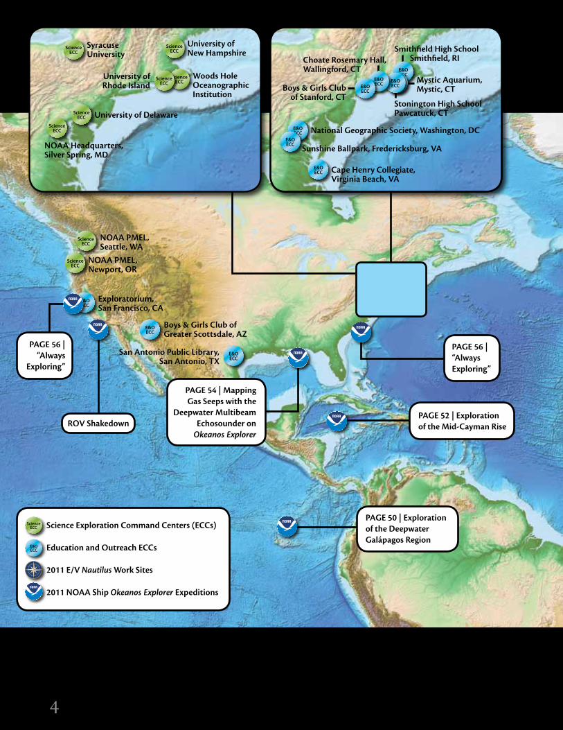
Through a partnership that includes the NOAA Office of Ocean Exploration and Research, the Ocean Exploration Trust, the Institute for Exploration, the University of Rhode Island, the University of New Hampshire, and other institutions, teams of scientists and engineers are imple-menting the vision of President Clinton’s Panel on Ocean Exploration (2000), which challenged the United States to develop assets dedicated to exploring remote ocean areas not routinely investigated by existing research vessels. With guidance and advice from the Ocean Exploration Advisory Working Group, a standing subcommittee of the NOAA Science Advisory Board, and the Nautilus Advisory Board, Okeanos Explorer and Nautilus operate under a new para-digm of “telepresence-enabled” expeditions that make it possible for interdisciplinary teams of experts, working in Exploration Command Centers (ECCs) at academic insti-tutions and other locations around the United States and overseas, to participate in each mission.
Satellite and high-bandwidth Internet2 technol-ogy transmit data, including remotely operated vehicle (ROV) video feeds, to shore in real time, supporting the participation of science teams at the Inner Space Center at the University of Rhode Island Graduate School of Oceanography, and a growing ECC network. At ECCs, shore-based teams view information in real time and com-municate with operational teams aboard the ships, help-ing to direct exploration activities. Significant progress has been made this year to stream the information on the World Wide Web over standard Internet1, enabling broader access and participation.
This dedicated network also makes it possible for educa-tors, students, and the general public to participate in the missions. Nautilus engages “Educators-at-Sea” on every expedition to work with the shipboard team, preparing and transmitting high-definition video highlights and other products for posting on http://www.NautilusLive.org, making it possible for interested parties to pose questions to the scientists and engineers on board the ship. Likewise, professional educators and students engage in missions con-ducted by Okeanos Explorer, in real time through http://oceanexplorer.noaa.gov, and by accessing curriculum mate-rials that meet national education standards and incorporat-ing information and data generated by each mission.
Through this supplement, we hope to continue to gener-ate interest in this unique program and encourage use of the preliminary results presented. Those who are interested in specific data and information from Okeanos Explorer, please visit http://explore.noaa.gov to access the digital atlas. For E/V Nautilus information, please visit http://www.oceanexplorationtrust.org.
FOREWORdBy John McDonough and Robert D. Ballard
1

2
This 2012 “New Frontiers” Oceanography supplement highlights the Okeanos Explorer and Nautilus explora-tion programs as they provide a foundation of systematic telepresence-enabled exploration of the world’s ocean. Both programs emerged from a national dialogue on ocean exploration, culminating in the 2000 report of President Clinton’s Panel on Ocean Exploration, Discovering Earth’s Final Frontier: A US Strategy for Ocean Exploration. (Full details appear in the March 2011 supplement available at http://tos.org/oceanography/archive/24-1_supp.html.) Ten years after this report, Okeanos Explorer and Nautilus exploration programs operate worldwide, fully involv-ing scientists and members of the public who participate from shore via telepresence to advance ocean explora-tion, technology development, and literacy. This second Oceanography supplement finds our programs moving toward a national strategy for ocean exploration, partner-ing with academic, industry, government, and nongovern-mental organizations to meet our primary goals of global ocean exploration; education, outreach, and training; and technology development.
The first section details the capabilities of Nautilus and Okeanos Explorer, specifically, the deep submergence vehicles, mapping capabilities, data management, and tele-presence systems used to carry out systematic exploration
aboard each ship. Nautilus uses side-scan sonar for the sur-vey phase of exploration, and investigates targets of interest with the Hercules-Argus dual-body ROV system equipped with high-definition cameras, oceanographic sensors, and manipulators for collection of geological, biological, and water samples (see pages 8–11). One new tool currently in development for Nautilus integrates several sensors, includ-ing stereo imagery, structured light, and high-frequency multibeam sonars for making high-resolution maps that characterize geological, archaeological, and biological sites (see pages 42–45). Okeanos Explorer is equipped with an EM302 swath bathymetric mapping system as well as the Little Hercules-Seirios dual-body ROV system, which use high-definition cameras and oceanographic sensors (see pages 12–15). In 2011, Okeanos Explorer tested and proved the new Seirios camera sled and multibeam water column detection capabilities. Satellite dishes installed on both ships send video, sensor, and audio data from sea to a hub at the Inner Space Center, where it is relayed to Exploration Command Centers so that scientists ashore can investigate new ocean areas and phenomena simultane-ously with the ship-based teams (see pages 16–17).
Next, we focus on our education and outreach pro-grams, which engage millions of people around the globe by using telepresence technology to increase the ocean
Advancing Scientific Knowledge, Technology innovation, and Ocean Literacy Through Systematic
Telepresence-Enabled Ocean Exploration
iNTROdUCTiON
By Katherine L.C. Bell and Craig W. Russell
2

3
literacy of people of all ages (see pages 18–23). Several levels of educational programming inspire and educate the next generation of explorers. At the broadest level, we use live Internet streaming, production of television specials, and partnerships with museums, aquariums, and science centers to reach the largest number of people possible. The next level involves more direct engagement through curriculum development for formal and informal education programs. We are working with several part-ners to develop standards-based curricula that are tied to expeditions and exploration. Finally, we use on-board and shore-based internship programs to train undergraduates and graduate students in science and engineering, address-ing a lack of scientific and technical capacity identified by the oceanographic community.
The final section of this supplement reports on the results of over eight months of exploration by the Nautilus and Okeanos Explorer expedition teams. During the 2011 field season, Nautilus continued its work in the Black and Mediterranean Seas, and ventured into the North Atlantic Ocean for a total of 136 days at sea (see pages 24–45). The work this year was multidisciplinary, including geologi-cal, biological, chemical, and archaeological investiga-tions in many regions of interest. In Turkey, the Nautilus team focused on seafloor imaging and studying the effects
of Black Sea water chemistry on archaeological sites; in Greece and Italy, they investigated volcanically and hydrothermally active regions; off Portugal, they explored uplifted blocks of crust and mantle; and they targeted submarine canyons and other bathymetric features on the passive margins of Spain and Israel. The results of the Okeanos Explorer expeditions focus on the 2011 field season (see pages 46–59), when the ship was at sea for 138 days on expeditions along the Galápagos Rift, in the Gulf of Mexico, and in Mid-Cayman Rise region of the Caribbean. These expeditions targeted biological and geo-logical exploration as well as mapping of these regions.
The Nautilus and Okeanos Explorer programs are fully engaged in obtaining a greater breadth of knowledge and understanding of the ocean’s depths, and in sharing all that is learned in real time or in as close to real time as possible. We are working hard to expand our exploration programs in an effort to search for, locate, and describe new habitats and phenomena, establishing a rich foundation of informa-tion to catalyze further exploration, research, and educa-tion. Whether at sea or via the Internet, we invite you to share in the excitement of discovery through our ocean exploration programs during the 2012 field season.
3
4
ScienceECC
E&OECC
ScienceECC
E&OECC
Science Exploration Command Centers (ECCs)
Education and Outreach ECCs
2011 E/V Nautilus Work Sites
2011 NOAA Ship Okeanos Explorer Expeditions
ScienceECC
E&OECC
ScienceECC
E&OECC
ScienceECC
E&OECC
ScienceECC
E&OECC
ScienceECC
E&OECC
ScienceECC
E&OECC
4
PAGE 50 | Exploration of the Deepwater Galápagos Region
PAGE 52 | Exploration of the Mid-Cayman Rise
PAGE 54 | Mapping Gas Seeps with the
Deepwater Multibeam Echosounder on
Okeanos Explorer
NOAA Headquarters,Silver Spring, MD
NOAA PMEL, Seattle, WA
NOAA PMEL,Newport, OR
Exploratorium, San Francisco, CA
Boys & Girls Club of Greater Scottsdale, AZ
San Antonio Public Library, San Antonio, TX
SyracuseUniversity
University of Delaware
University of New Hampshire
Woods Hole Oceanographic Institution
Cape Henry Collegiate,Virginia Beach, VA
Sunshine Ballpark, Fredericksburg, VA
National Geographic Society, Washington, DC
Choate Rosemary Hall,Wallingford, CT
Mystic Aquarium,Mystic, CT
Smithfield High School Smithfield, RI
Stonington High SchoolPawcatuck, CT
Boys & Girls Club of Stanford, CT
University of Rhode Island
ScienceECC
E&OECC
ScienceECC
E&OECC
ScienceECC
E&OECC
ScienceECC
E&OECC
ScienceECC
E&OECC
ScienceECC
E&OECC
ScienceECC
E&OECC
ScienceECC
E&OECC
ScienceECC
E&OECC
ScienceECC
E&OECC
ScienceECC
E&OECC
ScienceECC
E&OECCScience
ECCE&OECC
PAGE 56 | “Always Exploring”
PAGE 56 | “Always
Exploring”
ROV Shakedown

5
Ministry of Marine Affairs and Fisheries, Jakarta, Indonesia
ScienceECC
E&OECC
JOiNT PROgRAM OVERViEW MAP
5
PAGE 26 | Coastal Exploration of the Southern Black Sea Off Ereğli and Sinop, Turkey
PAGE 32 | Submarine Volcanoes of
the Aeolian Arc, Tyrrhenian Sea
PAGE 34 | Submarine
Volcanism in the Straits of Sicily
PAGE 36 | Nautilus Explores the Western Mediterranean Sea
PAGE 38 | In Search of Serpentinization
on Gorringe Bank
PAGE 40 | Seafloor Pockmarks, Deepwater Corals, and Cold Seeps Along the Continental
Margin of Israel
PAGE 28 | Continued Documentation of the
Coastal Landscape Off the Datça Peninsula, Turkey
PAGE 30 | Continued Exploration of the Santorini Volcanic Field and Cretan Basin, Aegean Sea
University of Haifa,Haifa, Israel
ScienceECC
E&OECC

6
TELEPRESENCE
6
BackgroundTelepresence provides an individual or group of individuals with the data and information necessary for participa-tion in an event or effort live when not physically present. This concept is not new, as telepresence technology has been applied in myriad ways for decades by government agencies and private industry. The vision of adapting this technology for oceanographic work was first conceived by Robert Ballard more than 25 years ago. He envisioned the use of telepresence to connect scientists, teachers, and students on shore to live images and real-time data from ships at sea, providing a portal into the excitement of oceanographic discovery, and demonstrating to a broad audience the importance of exploring and protecting our largely unknown ocean.
development and Evolution of a ParadigmThrough many years of extensive collaborative efforts, the Institute for Exploration (IFE), the NOAA Office of Ocean Exploration and Research (OER), and the University of Rhode Island (URI) worked to determine the most effective and efficient application of this rapidly evolving technology for ocean science, exploration, education, and outreach. Each subsequent year brought new challenges and innovations. Over the years, we have developed and refined complex ship- and shore-based operating protocols, brought new ship- and shore-based telepresence systems online, and built the hub for this technology at URI, called the Inner Space Center (ISC). The ISC includes a production studio for live and post-produced education and outreach efforts and a “Mission Control Center” for ship-to-shore connectivity to support telepresence-enabled expedi-tions. Simultaneously, the NOAA Ship Okeanos Explorer and E/V Nautilus were extensively refitted to become the first two platforms customized for telepresence-enabled systematic ocean exploration.
implementation and EfficiencyTraditional ship-based efforts evolve around a narrowly defined set of objectives and, in large part, begin and end with the team assembled on board the ship. Thus, berthing is a key limiting factor in terms of available expertise and opportunity for participation. Because it is not possible to fully predict discoveries during an ocean exploration mission, it is also not possible to determine the full spec-trum of expertise that may be needed. The application of telepresence technology for ship-based work is extremely efficient as it permits unlimited access to personnel on shore, transcending schedules, expertise, skills, and abilities of traditional shipboard teams. Telepresence also enables the development of partnerships between geographically dispersed groups who otherwise might not have the oppor-tunity to collaborate due to cost or logistics, and ultimately allows for the most efficient use of all resources, as access to data and information between ship and shore is immediate and sustained for the duration of an expedition.
Subtle differences in the way Okeanos Explorer and Nautilus are configured result in two slightly differ-ent, but complementary, staffing and operating models. Okeanos Explorer has extremely limited science/mission berthing, and thus relies heavily on daily input from teams on shore standing regular watches during ROV dives and during other major operations. With a maximum of three key science participants on board the ship for ROV cruises, shore-based participants are integral players in day-to-day decision making and planning. This model is referred to as “Doctors-on-Duty” and was most recently used during the 2011 exploration of the Mid-Cayman Rise (see pages 52–53), when a group of shore-based scientists was located at onshore Exploration Command Centers.
With greater berthing capacity, E/V Nautilus operates more autonomously with a team on board the ship. A mul-tidisciplinary, international network of scientists is called
Systematic Ocean Exploration Enabled by Telepresence Technology
By Catalina Martinez, Dwight F. Coleman, Katherine L.C. Bell, Webb Pinner, and Craig W. Russell
77
upon when needed, making these individuals’ expertise available almost immediately through the ship-to-shore access enabled by telepresence technology. “Doctors-on-Call” were used during several Nautilus projects in 2010 and 2011.
Web-based access to data, products, and information is essential for effective real-time collaboration. Recent improvements in video streaming via standard Internet and the advent of online chatting have enabled participation from any location that has Internet access. The continuing evolution of operating protocols, refinement of data man-agement and distribution processes, and effective training of participants to operate between ship and shore are also key, along with the development and application of telep-resence technology for education and outreach purposes. Each field season brings new challenges and opportunities to provide the most meaningful remote experience possible to those on shore, and to provide the most effective and efficient collaboration for operations at sea.
Through the different modes of operation associated with the application of telepresence-enabled systematic ocean exploration, we have connected researchers, educa-tors, and the public to the excitement of discovering our largely unknown ocean in ways that just a few years ago were simply not possible, bringing Robert Ballard’s initial vision to fruition in recent years. The Inner Space Center is the hub for this activity, where telepresence is facilitated; video, audio, and data streams are recorded and distributed in real time; and teams of participants are hosted during expeditions. As new technologies come online and new lessons are learned, the partners will continue to refine this operating paradigm, transcending the bounds of real-time access, increasing the pace and scope of discovery, and sharing the excitement of ocean exploration as quickly and as broadly as technology allows.
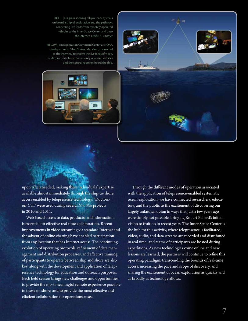
RigHT | diagram showing telepresence systems on board a ship of exploration and the pathways
connecting live feeds from remotely operated vehicles to the inner Space Center and onto
the internet. Credit: K. Cantner
BELOW | An Exploration Command Center at NOAA Headquarters in Silver Spring, Maryland, connected
to the internet2 to receive the live feeds of video, audio, and data from the remotely operated vehicles
and the control room on board the ship.

8
FORMERLy | Alexander von Humboldt
LENgTH | 64.23 meters (211 feet)
BEAM | 10.5 meters (34.5 feet)
dRAFT | 4.9 meters (14.75 feet)
TONNAgE | 1,249 gross, 374 net
MAiN PROPULSiON | Single 1,286 kW (1,700 HP) controllable pitch
SPEEd | 10 knots service, 12 knots maximum
ENdURANCE | 40 days at sea
RANgE | 24,000 kilometers (13,000 nautical miles)
dyNAMiC POSiTiONiNg | Bow thruster and stern azimuth pump-jet
CLASSiFiCATiON | Germanischer Lloyd (GL) 100 A5 E1 (ice strengthened)
BUiLT | 1967, Rostock, Germany
By Katherine L.C. Bell, Brennan Phillips, and Robert Knott
Exploration Vessel Nautilus
BERTHiNg | 48 persons (17 crew, 31 science/mission)
FLAg | St. Vincent and the Grenadines
HOME PORT | Bodrum, Turkey
MiSSiON SySTEMS | Custom 4,000 m rated dual-body remotely operated vehicles with high-definition video cameras; two side-scan sonar towfish (100/400 kHz and 300/600 kHz); 12 kHz Knudsen Chirp 3200 echo-sounder; 2.4 m tracking ELSP antenna capable of up to 20 Mbps (C-band circular or linear); four Tandberg SD encoders with multiplex for encapsulating real-time video streaming; RTS Telex intercom for real-time com-munications; Cisco C90 for video teleconferencing; two Omneon Mediadecks (MDM-5321 and SMD-2200-BB) for video recording, playback, and storage; 27 TB disk storage for nonvideo data.
TECHNOLOgy
8
Credit: T. Pierce

9
ARgus was first launched in 2000 as a deep-tow system capable of diving as deep as 6,000 m. Argus is typically used in tandem with Hercules, where it hovers several meters above the seafloor and provides a bird’s-eye view of Hercules on the seafloor, but can also be used as a stand-alone towsled. The electro-polished stainless steel frame carries a broadcast-quality high-definition camera, several standard-definition cameras, and two powerful 1,200 W arc lamps capable of producing over 100,000 lumens of light each. In addition to the cameras and lights, Argus supports a wide range of instrumentation, including a depth sensor, altimeter, CTD, subbottom profiler, scanning sonar, and side-scan sonar. Argus uses dual two-horsepower electric thrusters that permit heading adjustment and limited lateral movement.
REMOTELy OPERATEd VEHiCLES
HERCuLEs is the primary vehicle of our two-body ROV system. Hercules is rated to a depth of 4,000 m, and is always deployed with Argus. Equipped with cameras, lights, instru-ments, manipulators, and a wide array of sampling tools, Hercules can take on virtually any exploration mission. The primary camera is a broadcast-quality high-definition system that is supplemented by six standard-definition cameras. Four powerful lights (over 60,000 lumens total) illuminate the forward working area, while smaller incan-descent lights provide auxiliary illumination. Standard instrumentation includes a fast-profiling conductivity-temperature-depth (CTD) sensor, an oxygen probe, two high-resolution scanning sonars, a 1.2 MHz multibeam sonar, and a high-resolution stereo still camera system. The primary manipulator is a highly dexterous Kraft Predator arm with force feedback, complemented by a seven-function ISE Magnum manipulator for sample collection. Hercules is also equipped with a number of tools, including a suction sampler, sampling boxes with actuating trays, and sediment coring equipment, as well as several other purpose-built tools for different scientific objectives. Using a state-of-the-art navigation system in tandem with ultra-short baseline positioning, Hercules is capable of maneuver-ing and hovering on a centimeter-scale grid. Together with Argus, Hercules has completed over 200 dives in the Atlantic Ocean, Mediterranean Sea, and Black Sea.
9
ABOVE | Hercules. Credit: T. Pierce
RigHT | Argus.

10
TELEPRESENCE SySTEMS
The E/V Nautilus satellite system uses a very-small aperture terminal (VSAT) to enable two-way Internet connectivity between ship and shore. The maximum uplink capability is 46 Mbps, though the amount of satellite bandwidth is determined by the ship’s location and the satellite being used. For the past two seasons, we have allocated 15 Mbps from ship to shore and 2 Mbps from shore to Nautilus. From the Mediterranean region, the signal is sent from Nautilus to a geosynchronous satellite, and then down to a ground station in Andover, Maine. The ground station then passes the signals to the Inner Space Center (ISC) at the University of Rhode Island Graduate School of Oceanography. At the ISC, the multicast video streams are distributed to the Internet and Internet2, and are used in highlight reels and webcasts. During expeditions, Nautilus is capable of sending up to four simultaneous broadcast-quality video streams and all associated intercom traffic and data back to shore in real time.
All audio compo-nents of the telepres-ence network use a centralized intercom system for manag-ing shipboard and ship-to-shore com-munications. This network facilitates communication
10
MAPPiNg SySTEMS
DiANA, one of two side-scan sonar systems on board Nautilus, is used to create maps of the seafloor and to identify targets of interest that ROVs Hercules and Argus investigate in more detail. Diana is an Edgetech 4200 MP side-scan sonar towfish that uses dual 300 and 600 kHz frequencies, with a range of approximately 200 m on either side of the towfish. The Diana system is capable of being towed to a depth of 2,000 m but is currently limited by cable length to 600 m. Diana’s transducers can also be installed on the Argus towsled, which greatly increases the maximum towing depth to 2,000 m.
ECHO is a five-channel Benthos deep-tow side-scan sonar system rated to 3,000 m water depth. Echo’s operating frequencies are 100 and 400 kHz, which cover a total swath width up to 1,000 m. Echo is also equipped with a Chirp 2–7 kHz subbottom profiler that permits identification of subseafloor features.
ABOVE | Diana.Credit: E. Martin
LEFT | Echo. Credit: D. Wright
Credit: R.D. Ballard
between users working in the control van, the ship’s officers on the bridge, and the various labs around the ship, as well as participants on shore. The intercom system is integrated with the Nautilus video streaming and video recording sub-systems, which allow the intercom audio to be heard in the live video streams on shore and in the recorded video clips.
11
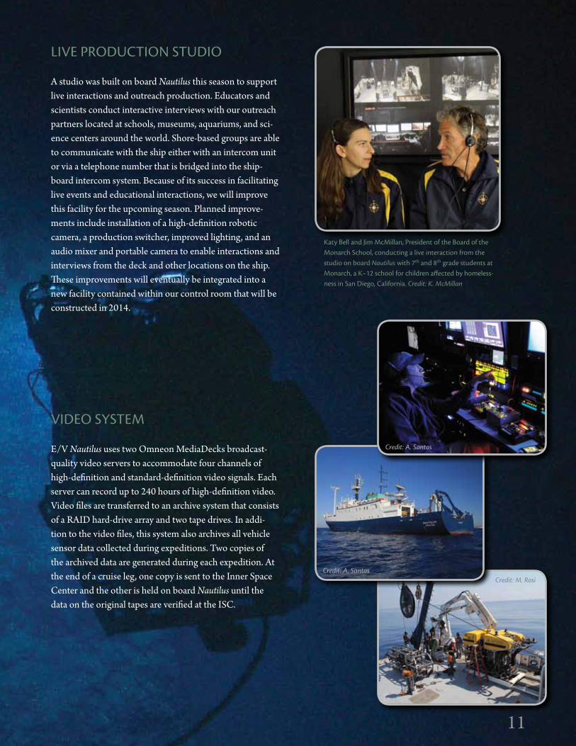
LiVE PROdUCTiON STUdiO
A studio was built on board Nautilus this season to support live interactions and outreach production. Educators and scientists conduct interactive interviews with our outreach partners located at schools, museums, aquariums, and sci-ence centers around the world. Shore-based groups are able to communicate with the ship either with an intercom unit or via a telephone number that is bridged into the ship-board intercom system. Because of its success in facilitating live events and educational interactions, we will improve this facility for the upcoming season. Planned improve-ments include installation of a high-definition robotic camera, a production switcher, improved lighting, and an audio mixer and portable camera to enable interactions and interviews from the deck and other locations on the ship. These improvements will eventually be integrated into a new facility contained within our control room that will be constructed in 2014.
VidEO SySTEM
E/V Nautilus uses two Omneon MediaDecks broadcast-quality video servers to accommodate four channels of high-definition and standard-definition video signals. Each server can record up to 240 hours of high-definition video. Video files are transferred to an archive system that consists of a RAID hard-drive array and two tape drives. In addi-tion to the video files, this system also archives all vehicle sensor data collected during expeditions. Two copies of the archived data are generated during each expedition. At the end of a cruise leg, one copy is sent to the Inner Space Center and the other is held on board Nautilus until the data on the original tapes are verified at the ISC.
11
Katy Bell and Jim McMillan, President of the Board of the Monarch School, conducting a live interaction from the studio on board Nautilus with 7th and 8th grade students at Monarch, a K–12 school for children affected by homeless-ness in San diego, California. Credit: K. McMillan
Credit: A. santos
Credit: A. santosCredit: M. Rosi

12
NOAA Ship Okeanos Explorer
FORMERLy | USNS Capable
LENgTH | 68 meters (224 feet)
BEAM | 13 meters (43 feet)
dRAFT | 4.6 meters (15 feet, 1 inch)
diSPLACEMENT | 2,312 LT
MAiN PROPULSiON | Diesel electric with twin inboard turning screws (1,600 Shaft HP)
SPEEd | 10 knots
ENdURANCE | 40 days at sea
RANgE | 17,780 kilometers (9,600 nautical miles)
dyNAMiC POSiTiONiNg (dP-1) | 500 HP retractable azimuth bow thruster and two 250 HP stern thrusters
CLASSiFiCATiON | Stalwart-class ocean surveillance ship
BUiLT | 1987, Halter Marine in Pascagoula, MS, USA
BERTHiNg | 46 persons (27 crew, 19 mission/science)
FLAg | United States of America
HOME PORT | North Kingstown, RI, USA
MiSSiON SySTEMS | Kongsberg EM 302 multibeam sonar; Kongsberg EK 60 fisheries sonar; Knudsen 3260 subbottom profiler; Sea-Bird Electronics 9/11+ CTD rosette with Sea-Bird SBE-32 carousel; in situ sensors (light scattering, dissolved oxygen, oxidation reduction potential); Sippican expendable bathythermograph sound velocity profiling; Custom 4,000 m rated dual-body remotely operated vehicles with high-definition video cameras; 3.7 m SeaTel tracking antenna capable of up to 46 Mbps Internet service; three Tandberg EN8090 high-definition video encoders for real-time video streaming; EVS XT2 high-definition, disk-based instant-replay video recorder; 130 TB disk storage; RTS Telex intercom for real-time audio communications.
By Craig W. Russell, Webb Pinner, David Lovalvo, Adam skarke, Elizabeth Lobecker, Mashkoor Malik, and LT Megan Nadeau
TECHNOLOgy
12

13
REMOTELy OPERATEd VEHiCLES
LiTTLE HERCuLEs is one part of Okeanos Explorer’s two-body ROV system. Owned by the Institute for Exploration, Little Hercules was entirely retrofitted by NOAA’s Ocean Exploration and Research Program
in 2009 for use on board Okeanos Explorer through a partnership between the two programs. Little Hercules is rated to 4,000 m depth, and always operates in concert with a second vehicle. Communication with Little Hercules is conducted over fiber optic cable, and control of the vehicle and all onboard sensors is via surface computers located in the Okeanos Explorer control room. Little Hercules is very maneuverable, with four electric thrusters mounted in a configuration that allows it to move through the water much like a helicopter moves in air. Little Hercules carries a single high-definition video camera, two additional task video cameras, two high-intensity lights, a depth and altitude sensor, a CTD, and a full-color sector-scan imaging sonar system. An ultra-short baseline navigation system tracks the vehicle while it is underwater.
sEiRiOs is the second vehicle in Okeanos Explorer’s two-body, ROV system for exploring the ocean bottom with an impressive array of underwater cameras and sensors. It can operate as a stand-alone towed
vehicle or in tandem, as a camera and light platform, to another ROV such as Little Hercules. In its dual role, Seirios can be towed in relatively close proximity to the seafloor or attached to the ROV to “fly” several meters above it. Seirios is currently rated to go as deep as 4,000 m, but future modifications will soon push that limit to 6,000 m. It is purposely designed to be negatively buoyant in water; thus, it carries no foam pack for flotation. It includes two high-definition cameras and 2,400 watts of broadcast-quality lighting. Seirios also carries two five-horsepower electric thrusters that allow it to move both rotationally and laterally. Depth sensors, an altimeter, a full-color sector scan imaging sonar, a CTD, and several other “task” cameras are additional standard equipment.
MAPPiNg SySTEMS
Okeanos Explorer is equipped with three ocean mapping sonar systems: a 30 kHz multibeam sonar, an 18 kHz single-beam sonar, and a 3.5 kHz subbottom profiler. The multi-beam sonar yields high-resolution three-dimensional maps of the seafloor surface, the single beam sonar produces maps of water column acoustic reflectivity (Figures 1 and 2), and the subbottom profiler generates profiles of Earth’s geologi-cal structure immediately beneath the seafloor.
Data collected with the sonar systems are initially spatially referenced with a differential global positioning system (GPS) and then corrected for the ships motions, such as pitching and rolling that occurred during collection. The data are then further corrected to account for verti-cal variability in the speed of sound in the ocean created
Figure 1. EM 302 multibeam seabed and water column data examples.
13

14
Figure 2. EM 302 multibeam sonar and EK 60 single-beam data examples. EK 60 and EM 302 provide similar data, but the multibeam sonar covers a much larger area of the seafloor.
TELEPRESENCE
VSATOkeanos Explorer uses VSAT to enable Internet and phone/fax connectivity at sea. This very prominent antenna is mounted on the mast aft of the bridge, and is capable of tracking a geostationary satellite even under moderate to heavy sea states.
REAL-TiME VidEO STREAMiNgOkeanos Explorer is capable of streaming up to three simul-taneous, high-definition video feeds to shore with a total delay of fewer than three seconds. These simultaneous feeds are accomplished using the same high-definition video encoder technology used throughout the broadcast industry for streaming television, news, and live sporting events. The encoders compress the raw high-definition video to a more manageable size and format, allowing it to be transmitted over computer networks. This compressed, but still full, high-definition video is only accessible at loca-tions connected to Internet2. Additional video encoders located at the Inner Space Center compress the full high-definition video by roughly 75%, allowing the feed to be distributed over standard Internet connections for public viewing on web pages and mobile devices.
14
by changes in temperature and salinity with depth. These changes are precisely measured by conductivity and tem-perature sensing instruments deployed over the side of the ship at regular intervals of no more than six hours. All sonar data are collected, corrected, and processed in real time on board Okeanos Explorer with dedicated mapping comput-ers and specialized software.
Summary map products created with the processed acous-tic data are generated on a daily basis and immediately made available to collaborating scientists on shore via the ship’s VSAT satellite system (see Telepresence sec-tion below). At the conclusion of each cruise, all collected raw sonar data and finalized summary map products, as well as associated metadata, are delivered to the National Geophysical Data Center (http://www.ngdc.noaa.gov), where they are archived and subsequently made available to the general public within 60 to 90 days.
15
WEB-BASEd ACCESS TO dATA ANd OPERATiONAL iNFORMATiONThe Okeanos Explorer Program provides several additional web-based tools to ensure shore-side participants stay informed and have direct access to the most up-to-date data and operational information 24/7.
The Okeanos Explorer Portal is a web portal for posting and accessing operational information, including daily ship status reports, ROV dive plans, ROV dive summaries, participant contact information, background information, news, and general documentation about how to use the collaboration tools.
The Okeanos Explorer FTP server is a shore-based file-server dedicated to Okeanos Explorer. All data collected by the vessel are transmitted to the FTP server every hour. This server provides participants with access to the latest data and information.
The Okeanos Explorer Gallery is a website that provides quick access to the latest still imagery collected by the ves-sel. This website is extremely useful to members of the media and educational teams who require updated still imagery for news articles and press releases.
Okeanos Explorer also leverages Web 2.0 technologies to inform participants and the general public, including social media venues such as Twitter and Facebook, and web syn-dication tools such as RSS.
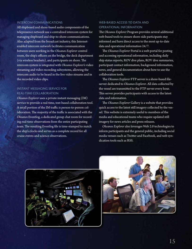
iNTERCOM COMMUNiCATiONSAll shipboard and shore-based audio components of the telepresence network use a centralized intercom system for managing shipboard and ship-to-shore communications. Also adapted from the broadcast industry, this Internet-enabled intercom network facilitates communication between users working in the Okeanos Explorer control room, the ship’s officers on the bridge, the deck department (via wireless headsets), and participants on shore. The intercom system is integrated with Okeanos Explorer’s video streaming and video recording subsystems, allowing the intercom audio to be heard in the live video streams and in the recorded video clips.
iNSTANT MESSAgiNg SERViCE FOR REAL-TiME COLLABORATiONOkeanos Explorer uses a private instant messaging (IM) service to provide a real-time, text-based collaboration tool. A small portion of the IM traffic is person-to-person col-laboration. The majority of the traffic is associated with the Okeanos Eventlog, a dedicated group chat room for record-ing real-time observations from the entire participating team. The resulting Eventlog file is time-stamped to match the ship’s clocks and serves as a complete record for all cruise events and science observations.
15

16
TECHNOLOgy
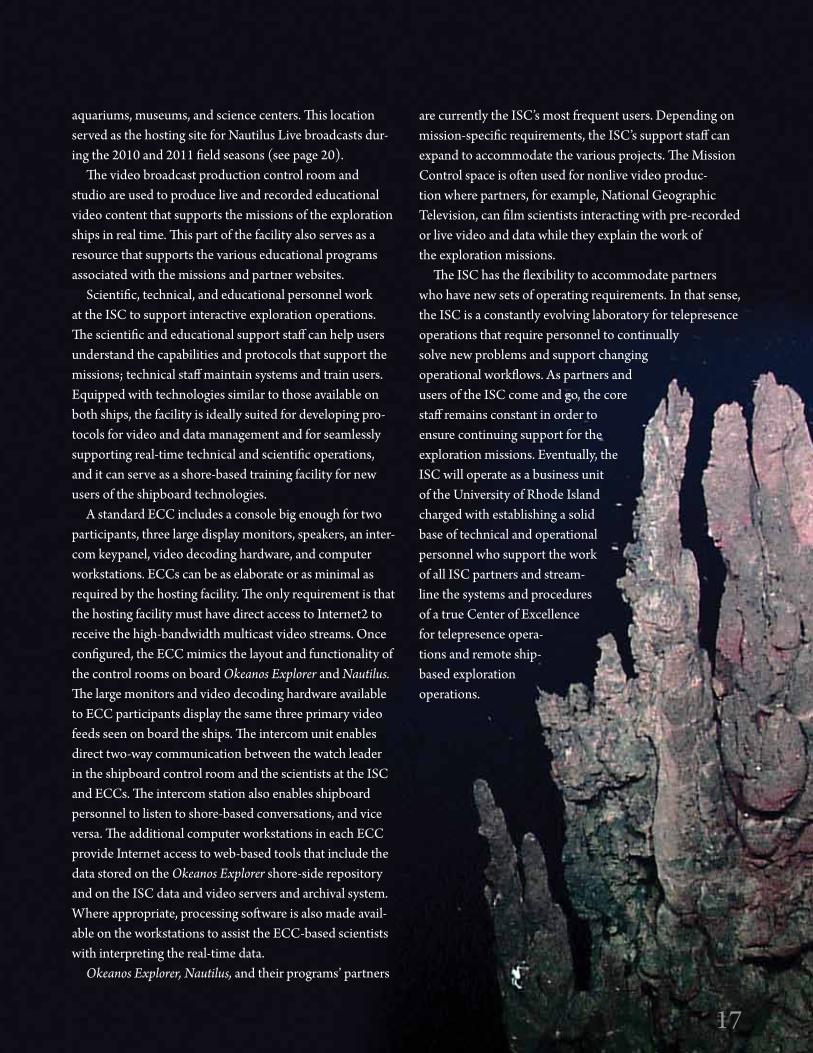
Telepresence technology enables real-time participation in ocean exploration expeditions from shore. Although any participant can be a passive observer of the programs from anywhere with a broadband Internet connection, being a fully engaged participant requires additional infrastructure. The Inner Space Center at the University of Rhode Island Graduate School of Oceanography serves as the hub for supporting the technical and functional aspect of each Exploration Command Center (Figure 1). ECCs are mul-tifaceted command stations that allow users to participate directly with shipboard operations (Figure 2).
The ISC connects to all ECCs and serves as the shore-based technical hub for all telepresence-enabled explora-tion on Okeanos Explorer and Nautilus (see page 6). The
ISC manages all of the ECC intercom units, hosts the web-based access tools, and provides technical assistance to ECC users. This facility also serves as the dissemination point for all data collected from Nautilus. In addition to the ISC’s support services, the Mission Control facility can physically host groups of scientists, students, and educators who participate in expeditions from shore. Although it cur-rently works primarily with Nautilus and Okeanos Explorer, the ISC is capable of supporting three exploration vessels working simultaneously.
The Mission Control space within the ISC has several ECC-style workstations, or pods, where multiple users have access to all streaming data, video, and information, plus intercom keypanels for two-way voice communication with the ships and other ECCs. This space also represents an advanced data visualization laboratory for the display, analysis, and broadcast of live video feeds, maps, data sets, and other scientific results. One of the pods in Mission Control is equipped with video broadcast technologies so that an educator or scientist can “go live” to the Internet, to a classroom, or to informal science education facilities like
The URi inner Space Center and Exploration Command Centers
By Dwight F. Coleman
Figure 1. dwight Coleman communicates with Nautilus and Okeanos Explorer simultaneously from Mission Control at the inner Space Center (iSC) during a live media event to both ships. The Mission Control space at the iSC is equipped with a large projection screen that can handle displays of live feeds of video, data, and audio communications from multiple ships of exploration in real time.
Figure 2. Shore-based cruise participants at the NOAA Pacific Marine Environmental Laboratory in Seattle, Washing-ton, staff an internet2-enabled Exploration Command Center, Live video feeds streaming from Okeanos Explorer are decoded and displayed on the large screen monitors in real time. Access to data and other cruise information is managed through integrated personal computers, and voice com-munication is handled through the intercom keypanel.
16
17
aquariums, museums, and science centers. This location served as the hosting site for Nautilus Live broadcasts dur-ing the 2010 and 2011 field seasons (see page 20).
The video broadcast production control room and studio are used to produce live and recorded educational video content that supports the missions of the exploration ships in real time. This part of the facility also serves as a resource that supports the various educational programs associated with the missions and partner websites.
Scientific, technical, and educational personnel work at the ISC to support interactive exploration operations. The scientific and educational support staff can help users understand the capabilities and protocols that support the missions; technical staff maintain systems and train users. Equipped with technologies similar to those available on both ships, the facility is ideally suited for developing pro-tocols for video and data management and for seamlessly supporting real-time technical and scientific operations, and it can serve as a shore-based training facility for new users of the shipboard technologies.
A standard ECC includes a console big enough for two participants, three large display monitors, speakers, an inter-com keypanel, video decoding hardware, and computer workstations. ECCs can be as elaborate or as minimal as required by the hosting facility. The only requirement is that the hosting facility must have direct access to Internet2 to receive the high-bandwidth multicast video streams. Once configured, the ECC mimics the layout and functionality of the control rooms on board Okeanos Explorer and Nautilus. The large monitors and video decoding hardware available to ECC participants display the same three primary video feeds seen on board the ships. The intercom unit enables direct two-way communication between the watch leader in the shipboard control room and the scientists at the ISC and ECCs. The intercom station also enables shipboard personnel to listen to shore-based conversations, and vice versa. The additional computer workstations in each ECC provide Internet access to web-based tools that include the data stored on the Okeanos Explorer shore-side repository and on the ISC data and video servers and archival system. Where appropriate, processing software is also made avail-able on the workstations to assist the ECC-based scientists with interpreting the real-time data.
Okeanos Explorer, Nautilus, and their programs’ partners
are currently the ISC’s most frequent users. Depending on mission-specific requirements, the ISC’s support staff can expand to accommodate the various projects. The Mission Control space is often used for nonlive video produc-tion where partners, for example, National Geographic Television, can film scientists interacting with pre-recorded or live video and data while they explain the work of the exploration missions.
The ISC has the flexibility to accommodate partners who have new sets of operating requirements. In that sense, the ISC is a constantly evolving laboratory for telepresence operations that require personnel to continually solve new problems and support changing operational workflows. As partners and users of the ISC come and go, the core staff remains constant in order to ensure continuing support for the exploration missions. Eventually, the ISC will operate as a business unit of the University of Rhode Island charged with establishing a solid base of technical and operational personnel who support the work of all ISC partners and stream-line the systems and procedures of a true Center of Excellence for telepresence opera-tions and remote ship-based exploration operations.
17

18
Using Nautilus as a Platform for Lifelong Learning By Alexandra Bell Witten, Katherine L.C. Bell, Amy O’Neal,
Katrina Cubina, Jennifer Argenta, and Eleanor smalley
In addition to its role as a platform for innovation in tech-nology and ocean exploration, the Nautilus Exploration Program provides a vehicle for developing education and outreach programs to engage people of all ages. These programs encompass broad-scale outreach, K–12 science, technology, engineering, and mathematics (STEM) programs, undergraduate and graduate internships, and on-the-job training.
Nautilus inspires the explorer in almost everyone. Several organizational partners, including the National Geographic Society, Sea Research Foundation, and the JASON Project, present our work to the public using numerous types of media, including the Internet, film, television, magazines, and books, as well as live theater shows at aquariums and museums, to reach the broadest audience possible. These moments of discovery displayed through the various media allow us to capture the imaginations of millions of people, with the ultimate goal of leading them further down the path of higher education. In total, we estimate that we have reached approximately 14 million people since Nautilus first set sail in 2009.
Educators at SeaThe Educators-at-Sea Program is an effort to address the shortage of students entering STEM fields by bringing the excitement of ocean exploration to audiences of all ages. The program embeds two educators in each cruise to sup-port all of our educational activities. During the 2011 field season, a total of 19 Educators-at-Sea joined expedition teams. They came from museums, aquariums, and public and private schools across the United States.
Educators-at-Sea posted 65 blogs and over 500 photo-graphs on the Nautilus Live website, depicting every-thing from scientific activities, to vehicle operations and maintenance, to daily life and living conditions aboard Nautilus, and the many faces, personalities, and careers integral to the exploration program. Educators participated
in 482 shows with the Nautilus Live Theater at Mystic Aquarium, and in live interactions with over 3,500 people around the world. Back on shore, the educators continue to work directly with over 2,000 of their own students, shar-ing their experiences on board Nautilus.
Classroom and After-School ProgramsIn 2011, we worked to turn inspiration into educational engagement at the middle and high school levels by infus-ing live elements into formal and informal curricular mate-rials. These curricula cover the basic principles and stan-dards required of STEM education programs serving mid-dle school grades in all 50 states. The JASON Project con-tinued to develop digital labs and curricular materials spe-cific to Nautilus that are available at http://www.jason.org. These labs and materials were estimated to reach over 400,000 students in 2011.
In addition, nine JASON Student Argonauts and four JASON Educator Argonauts were selected to participate in transit legs on Nautilus (Figure 1). Five students were selected from high schools and technical schools, four were from Boys & Girls Clubs in the United States, and one internationally from Romania. These individuals attended a camp in July to prepare them for their oceano-graphic expedition. While on board, they participated in research projects and posted blogs and video updates to the JASON Project and Nautilus Live websites, and each group did two live webcasts, viewed by 1,700 people.
In 2011, Immersion Learning developed Nautilus-based programs in partnership with 55 youth-serving organizations. Immersion focused on inspirational career role models as part of its two new Immersion programs: Nautilus Live and Remotely Operated Vehicles. The programs consist of hands-on science, technology, engineering, and math activities, as well as multimedia resources related to Nautilus and remotely operated vehi-cles. Immersion held over 20 professional development
EdUCATiON ANd OUTREACHExPLORATiON VESSEL NAuTiLus
18
19
workshops, training a total of 376 program leaders.
The JASON Project and Immersion cre-
ated a new series of live webcast events to enable tens
of thousands of students to interact directly with world-renowned scientists. During each 45-minute webcast, they learn about the featured host’s work and career path and vote in polls and ask questions. Live webcasts are archived for ongoing use at http://jason.org/live. In May 2011, 21,091 viewers participated in a live webcast entitled “Meet Ocean Explorers—Robert Ballard and Katy Croff Bell”. In addition, the two scientists each did a live webcast from Nautilus during the cruise, and they were viewed by 2,300 people collectively.
Honors Program In 2011, the Ocean Exploration Trust instituted an Honors Research Program for advanced high school students. Two students from Choate Rosemary Hall were selected to work with scientists at the University of Rhode Island Graduate School of Oceanography, and one student worked at the Cape Henry Collegiate School. The students developed
summer research projects on oceanographic topics and processed 2010 Nautilus field program data, the products of which will serve as the basis for further research and explo-ration. The students joined a leg of the 2011 field season where they continued their research, later presenting their results at their schools. The 2012 program will build on this prototype and emphasize attracting honors students from underrepresented communities.
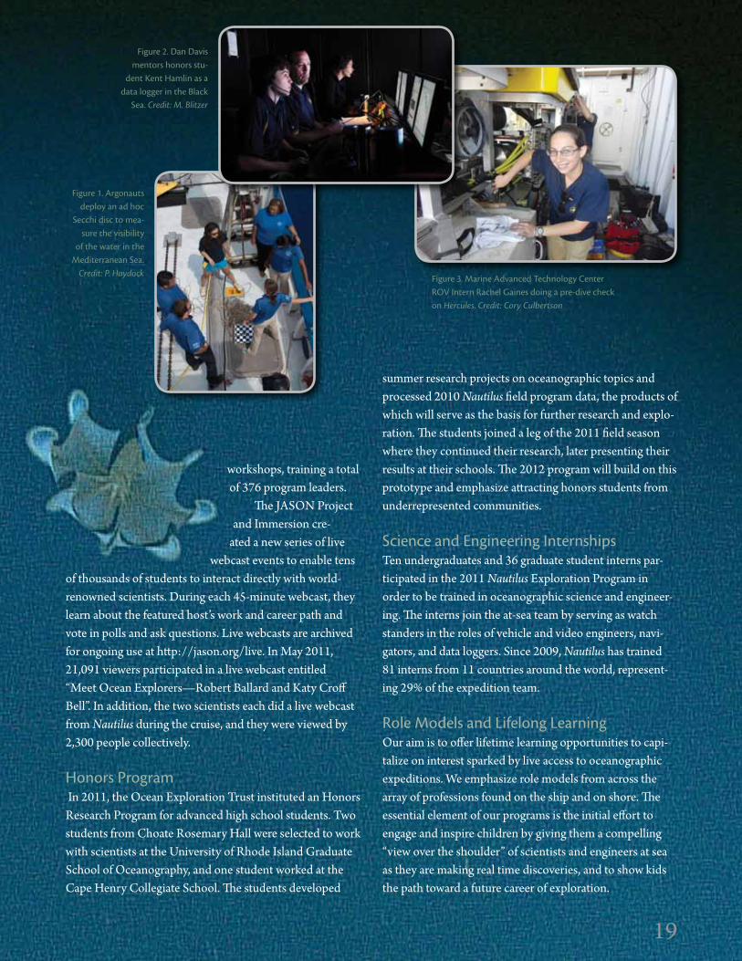
Science and Engineering internshipsTen undergraduates and 36 graduate student interns par-ticipated in the 2011 Nautilus Exploration Program in order to be trained in oceanographic science and engineer-ing. The interns join the at-sea team by serving as watch standers in the roles of vehicle and video engineers, navi-gators, and data loggers. Since 2009, Nautilus has trained 81 interns from 11 countries around the world, represent-ing 29% of the expedition team.
Role Models and Lifelong LearningOur aim is to offer lifetime learning opportunities to capi-talize on interest sparked by live access to oceanographic expeditions. We emphasize role models from across the array of professions found on the ship and on shore. The essential element of our programs is the initial effort to engage and inspire children by giving them a compelling “view over the shoulder” of scientists and engineers at sea as they are making real time discoveries, and to show kids the path toward a future career of exploration.
Figure 1. Argonauts deploy an ad hoc
Secchi disc to mea-sure the visibility
of the water in the Mediterranean Sea.
Credit: P. Haydock
Figure 2. dan davis mentors honors stu-
dent Kent Hamlin as a data logger in the Black
Sea. Credit: M. Blitzer
Figure 3. Marine Advanced Technology Center ROV intern Rachel gaines doing a pre-dive check on Hercules. Credit: Cory Culbertson
19

2020
inspiring the Next generation Through Real-Time Access to Ocean Exploration
Real-time streaming of video from the bottom of the ocean provides an excellent opportunity to engage the public. The central challenge of our outreach programming is to provide sufficient contextual information surrounding the video so that the viewer will quickly understand what is happening on the ship and immediately become an engaged participant. In a theater setting, the host/interpreter fills this important role. On the web, we need a layered strategy involving web interface design, content workflows, and interpretation by members of the Nautilus team.
Nautilus Live WebsiteThe Nautilus Live website, http://www.NautilusLive.org, is designed to surround the live video stream coming from the ship with current information to help the audience identify and understand what is happening in the mission (Figure 1). The site displays the current status of opera-tions, includes a map showing the ship’s location, and
provides a changing display of the notes being recorded by the watch Data Logger in real time. Also available are blogs, photos, and highlight videos, which are updated on the site multiple times per day. Beginning in August 2011, the web-site was embedded in the National Geographic Society’s Oceans Portal. From July 20 to November 16, the website hosted 204,179 visits of which 97,696 were unique visitors from 173 countries. The number of unique visitors doubled over 2010 thanks in part to the National Geographic Society partnership to reach new global audiences. Website users are able to leave comments on posted blogs, images, and video, and to share Nautilus Live content with social networks using Facebook and Twitter.
The most widely used interactive feature of the website was “Send a Question.” Visitors watching the live video on the site could submit a question without leaving the home page. Team members answered the questions live over the intercom audio, which accompanied the video on the web-site. Thus, web visitors could submit a question and get a response within moments. During the 2011 season, over 13,000 questions and comments were received through the Nautilus Live website. In several instances, website visi-tors used the “Send a Question” option to identify and/or provide research background on a discovery, for example, during the discovery of the shipwreck M/S Dodekanisos (see pages 28–29).
Another interactive feature launched this year enabled website viewers to identify great moments in the live video by submitting keyword “tags.” These user- generated notes were recorded and time-stamped, enabling video production personnel to search for the viewer-tagged video segments and then include them in daily on-demand highlight clips.
The final addition to the Nautilus Live website in 2011 was the integration of a shore-based production team, which
Figure 1. The Nautilus Live home page includes live video, status updates, on-watch data logger observations, and links to photos, blogs, and on-demand videos.
EdUCATiON ANd OUTREACHNAUTiLUS LiVE
By Todd Viola, Alexandra Bell Witten, Patrick shea, susan Poulton, and Katherine L.C. Bell

2121
Boys & Girls Clubs, libraries, informal education sites, and science centers across the country. These centers displayed the live feeds in an immersive group setting configured to replicate the control van on board Nautilus. They featured the same displays and exclusive interactive opportunities as the Nautilus Live Theater. We also facilitated approxi-mately 55 live interactions between educators, students, and scientists on the ship with schools and informal education sites on shore, reaching approximately 3,500 people from pre-kindergarten classes to retirees at public lectures.
Outreach and MediaAn important part of the outreach story is the effort to help our partners reach audiences in the United States and abroad. In 2011, we held press and public events at Mystic Aquarium, in conjunction with the NOAA Office of Exploration and Research at the Inner Space Center, and at Exploration Command Center sites. Members of the press and dignitaries visited the ship in Turkey, Greece, and Israel; the latter two appeared to coincide with increased viewership on the Nautilus Live website in those countries. The partner countries also held live interactions with the ship in their native languages.
We will use the lessons learned during this year to imple-ment a more robust communications plan for future years in an effort to increase live viewership all over the world.
Figure 2. Approximately 100,000 unique visitors to the Nautilus Live website came from 173 countries around the world.
focused on postproduction and interpretation for outreach audiences. The Inner Space Center-based team produced 235 on-demand videos, which included daily updates, expe-dition summaries, “Behind the Science” pieces, and “Meet the Team” videos that focused on individual team members, their work and/or educational backgrounds, and their jobs on the ship. These items complemented personnel profiles that were featured on the website.
Nautilus Live Theater at Mystic Aquarium The premier venue for informal public outreach was at Mystic Aquarium, where a 50-seat Nautilus Live Theater was constructed in 2010. Over the course of the four-month 2011 field season, the theater hosted 486 live pre-sentations, each of which included a live interaction with either the Educator-at-Sea on board Nautilus or the team at the Inner Space Center. Including the 2011 pre-expedition presentations beginning on July 1 through the end of the brief post-expedition show, over 29,000 guests participated in a theater show.
Visitors who came to the theater ranged from families and early childhood education classes to retirees; they represented partners, universities, and other aquariums, middle and high school classes, and local and international visitors. Many guests followed up their visits by going to the Nautilus Live website. Sample survey comments from guests included: “Got me interested in the expedition and made me go online and follow it live” and “Being able to speak with a crew member on board was really neat. I had so many questions that I could have asked.”
Expanding beyond the Nautilus Live Theater is a network of 11 Exploration Command Centers designed for educa-tion and outreach purposes. They are located at schools,
Figure 3. While aboard Nautilus, Educator-at-Sea Sharon Pearson (a) engages in a live interaction with her students (b) in Las Vegas, Nevada. Credit T. Milliard
b
a
100,000+10,000+1,000+
10+100+
1+

22
Professional development for educators using the new NOAA Ship Okeanos Explorer Education Materials Collection3 was also launched in 2011. The collection encourages educators and students to become actively involved with the ship’s voyages and discoveries. The col-lection is presented in two volumes: Volume 1: Why Do We Explore? focuses on climate change, ocean health, human health, and energy as important reasons for ocean exploration. Volume 2: How Do We Explore? targets system-atic exploration methods and advanced technological assets and capabilities of Okeanos Explorer. Lessons are cross-referenced with A Framework for K–12 Science Education Practices, Crosscutting Concepts, and Core Ideas (NRC, 2012) and with the Ocean Literacy Essential Principles and Fundamental Concepts4. Both volumes have been offered as online courses in partnership with the College of Exploration and are archived at http://www.coexploration.org/oe. The online courses drew more than 1,500 partici-pants representing all 50 US states and 29 countries.
Our efforts to educate the next generation of explor-ers also extend to the field. NOAA’s Office of Ocean Exploration and Research (OER) supported eight hydro-graphic internships on board Okeanos Explorer during the 2011 field season, providing opportunities for undergradu-ates to work with ship’s crew and scientists as an introduc-tion to acoustics and multibeam data acquisition and pro-cessing. At-sea training opportunities were also provided to ROV pilots, data managers, and video production engi-neers, building critical capacity for future ocean explora-tion missions. In addition, OER developed shore billets at the University of Rhode Island and in Seattle, WA, to train NOAA Corps officers in support of shipboard and shore-based operations specific to Okeanos Explorer’s mission.
1 http://explore. noaa.gov/media/http/pubs/pres_panel_rpt.pdf | 2 Ocean Explorer Expedition Education Modules are available at http://oceanexplorer.noaa.gov/edu/modules/welcome.html | 3 The NOAA Ship Okeanos Explorer Education Materials Collection is available at: http://oceanexplorer.noaa.gov/okeanos/edu/welcome.html | 4 http://oceanliteracy.wp2.coexploration.org
Enhancing Ocean Science Literacy Through NOAA Ocean Exploration Education By Paula Keener and Mashkoor Malik
ABOVE | ROV team members Karl McLetchie, Tom Kok, and Joel de Mello (left to right) pose in front of Little Hercules.
LEFT | Educators learn about energy transfer through chemo-synthesis in an activity called “Candy Chemosynthesis.”
ABOVE | Students learn how wavelengths of light
travel to various depths in the deep ocean using special mask filters in an
activity called “Light in the deep dark Ocean.”
22
Outreach: Communicating Benefits to Society By Fred gorell and Keeley Belva
The NOAA Ship Okeanos Explorer is a national ocean-based asset through which a key recommendation from The Report of the President’s Panel on Ocean Exploration1—“reaching out in new ways to learners of all ages to enhance ocean literacy”—is being implemented. The Okeanos Explorer 2011 field season provided opportunities to continue carrying out this recommendation at national and international levels. Exploration Education Modules developed for the Galápagos Rift and Mid-Cayman Rise expeditions delivered information about daily discoveries and the science behind the expeditions2.
LEFT | Cover of Volume 1: Why Do We Explore? from the new NOAA Ship Okeanos Explorer Education Materials Collection (http://oceanexplorer.noaa.gov/okeanos/edu/welcome.html).
EdUCATiON ANd OUTREACHNOAA SHiP OKEANOs ExPLORER

23
In 2010, NOAA explored the Sulawesi Sea with its Indonesian partners, mapping a major seamount, discover-ing new ones, and imaging approximately 90 potentially new deep-sea species. Those observations and more were communicated via three news releases and press confer-ences, presentations to audiences in Indonesia and the United States, website updates, and media interviews. Additional benefits of this program included acquiring data for use by ocean resource managers and strengthening ties between the United States and Indonesia.
During Okeanos Explorer’s transit back to continental US waters, it supported the NOAA Fisheries Service by obtaining plastic and plankton samples from the ocean for research. Agency scientists are interested in learning whether plankton, at the base of the ocean food chain, may be ingesting toxins borne by plastic particles, and a news release emphasized this focus.
The 2011 Galápagos Rift expedition was the first in our program to feature live video available to audiences ashore via standard Internet. Combined with the follow-on expedi-tion, standard Internet reached more than 250,000 unique visitors, part of NOAA’s Office of Ocean Exploration and Research’s goal to bring the excitement of ocean discovery to audiences in classrooms, newsrooms, and living rooms.
During the 2011 Mid-Cayman Rise expedition in the Caribbean Sea, scientists described fault systems that trans-ported rocks from deep within Earth’s interior to the ocean floor. Those deep faults may be the location of extensive hydrothermal systems that could host an abundant deep-sea and subsurface biosphere that draws its energy from these fluids rather than the sun. A NOAA news release covered mission discoveries. During this 2011 expedi-
tion, Okeanos Explorer and Nautilus in the Black Sea sent simultaneous live imagery to audiences, including media, at two Exploration Command Centers, showing
the capabilities of telepresence technology to enable communications to multiple audiences
ashore in exciting ways.
The 2011 Gulf of Mexico expedition demonstrated the capability of Okeanos Explorer’s multibeam sonar to map gaseous seeps by imaging their “footprints” in the water column. The lead expedition scientist explained that this research will “increase knowledge of the marine environ-ment, including the distribution of natural sources of methane input into the ocean and the identification of com-munities of life often associated with methane gas seeps.” Again, NOAA issued a news release. Following this expedi-tion, the ship visited Pascagoula, Mississippi, where out-reach activities included ship tours and briefings for media, 40 students, and three US Congressional staffers.
In October, both US senators from Rhode Island, explorer Robert Ballard, and NOAA and University of Rhode Island leadership welcomed the crew and explora-tion team to Okeanos’s new home port in Rhode Island.
Okeanos Explorer expeditions were extensively cov-ered by NOAA web and social media sites. For more about the Okeanos Explorer Program, visit http://www.oceanexplorer.noaa.gov, or connect with us at YouTube, Facebook, Twitter, iTunes, and Flickr.
Outreach: Communicating Benefits to Society By Fred gorell and Keeley Belva
23
TOP | in 10 years of ocean exploration, 40 million individuals have visited NOAA’s award-winning website http://oceanexplorer.noaa.gov, where the
Mid-Cayman Rise expedition was featured in 2011. BOTTOM | Robert Ballard is interviewed about telepresence technology by 60 Minutes’ reporter Lara Logan, ashore at the inner Space Center at the University of Rhode island.
Filling the screen is live video of the wake of NOAA Ship Okeanos Explorer at sea, operating off Hawaii. Credit: Joe giblin, uRi.

24
The year 2011 marks the third field season for Exploration Vessel Nautilus. Over the past three years, we have worked with hundreds of people from all over the world to explore the deep sea, and have used telepresence technology to bring the excitement of our expeditions to millions of viewers worldwide. Our four-month field season built upon years of working in the Mediterranean and Black Sea regions, strengthening relationships with many of our partners, and building new ones as we look toward investigating unexplored areas. Our successful collabora-tion with 186 participants from 19 countries illustrates the diplomatic power of Nautilus and our common goal of exploring the world’s ocean.
The 2011 season commenced in July off the Turkish Black Sea coast, where we collaborated with local geolo-gists, biologists, and archaeologists to acoustically map the continental shelf and document evidence of internal wave dynamics and trawling activity, particularly as they affect the preservation of ancient shipwrecks (see pages 26–27). During this project, nine shipwrecks with varying degrees of preservation were discovered, the oldest dating to ca. 500 BCE. We continued our work in Turkish waters off the coast of Knidos in the southeastern Aegean Sea, where we investigated the coastal deep waters (see pages 28–29). We
By Katherine L.C. Bell
explored large areas of seabed, documenting marine geo-logical features and 10 previously undiscovered shipwrecks. These discoveries, in combination with extensive seafloor mapping, are helping us study the effect of trawling on the destruction of shipwreck sites in deep water.
Exploration of volcanic centers in Greek and Italian waters led to exciting discoveries in geology, chemistry, and biology that will lead to a better understanding of past and present volcanic and hydrothermal systems in these areas. Our collaboration with Greek scientists expanded from Earth scientists to include water chem-ists and microbiologists as we continued our exploration of the Santorini and Kolumbo volcanoes, as well as the nearby Christiana group of four small islets and the deep Cretan Basin (see pages 30–31). New exploration in the Italian Aeolian Arc and Straits of Sicily offered a glimpse into vast hydrothermal systems, along with the vent site of a recent underwater volcanic eruption and the discovery of a World War II Italian airplane (see pages 32–35).
The passive margins of Spain and Israel proved to be amazingly dynamic targets of exploration. Off the coast of Spain, we found extensive deposits of ancient volcanic rocks, including pillow basalts, as well as deepwater coral reefs and an abundance of other biology (see pages 36–37).
E/V NAuTiLus 2011 FiELd SEASON
24
Continued exploration off the Israeli coast resulted in the dis-covery of seafloor vents, pos-sibly releasing methane, and associated megafauna, including colonies of small tubeworms (see pages 40–41).
The 2011 season was the first time that Nautilus has worked in the Atlantic Ocean. Due west of the Strait of Gibraltar lies Gorringe Bank, a ridge composed of two uplifted blocks of oceanic crust and mantle (see pages 38–39). As its geological origin is similar to that of the Atlantic Massif on the Mid-Atlantic Ridge, we hypothesized
Gorringe Bank
W. Mediterranean
Aeolian Arc
Straits of Sicily Hellenic ArcSE AegeanSea
Black Sea
E. Mediterranean
Gorringe Bank
W. Mediterranean
Aeolian Arc
Straits of Sicily Hellenic ArcSE AegeanSea
Black Sea
E. Mediterranean

25
that it could have similar hydrothermal systems to those found at Lost City. Although we did not find evidence of active venting, we did recover samples of serpentinite and gabbro similar to those documented at Lost City. We also observed many species of coral, fish, and other ben-thic organisms, which were abundant at this intersection between the North Atlantic Ocean and Mediterranean Sea.
Throughout our expedition, we continued to develop and test new technologies to enhance our ability to char-acterize new regions as accurately and efficiently as pos-sible. Our Mapping and Imaging Team continues to break new ground by developing techniques to map not only the seafloor, but also active seafloor venting, using stereo imagery, structured light, and high-frequency multibeam sonar (see pages 42–45). We are optimistic about the ini-tial results and the broad range of potential applications of these new techniques. Two student projects were also
developed this year, one to collect water samples under pressure, and the other to build a rock chipper to collect samples from outcrops.
In conjunction with our Advisory Board, the Nautilus team is now developing our cruise plans for 2012 and beyond. We expect to conduct a two-month field season in the summer of 2012, our last in the Mediterranean region for the foreseeable future. We will then install an EM302 multibeam system on Nautilus the following winter, giving us the capability to move out of previously studied areas into truly unexplored regions. A transit from Turkey to the Caribbean will be used to test the new multibeam system, and it will be followed by a full field season in the Caribbean region in 2013. We are looking forward to bringing our capabilities to new parts of the globe, forming new partnerships, and learning even more about our underexplored ocean.
25
2011 NAuTiLus By THE NUMBERS
19 Countries represented on Nautilus
24 Cultural sites discovered
67 Women on the Expedition Team
70 Collaborating institutions
186 Participants on the Expedition Team
1,080 Hours underwater
Credit: T. Pierce
Credit: T. Pierce

26
Coastal Exploration of the Southern Black Sea Off Ereğli and Sinop, TurkeyBy Michael L. Brennan, Dan Davis, Chris Roman, ilya V. Buynevich, Alexis Catsambis, Meko Kofahl, Maureen Merrigan, suna Tuzun, Muhammet Duman, Derya urkmez, J. ian Vaughn, and Tufan Turanli
The Black Sea is the largest anoxic basin on Earth. Below approximately 155 m depth, its waters become depleted in oxygen, and hydrogen sulfide is present in the water column. We returned to the Turkish Black Sea coast at the beginning of this year’s expedition for the first time since 2007. Expeditions in 1999, 2000, 2003, and 2007 mapped and explored the area off Sinop between the 100 and 400 m isobaths to document the possible paleoshoreline that predated Black Sea flooding following the last ice age. During these surveys, four Byzantine-era amphora wrecks were found: three at 100 m depth, and one well-preserved wooden wreck with its mast still standing upright at 325 m depth (Ward and Ballard, 2004). In 2011, we returned to continue exploring the seabed across the oxic/anoxic inter-face where internal wave motion between these water lay-ers affects sediment dynamics along the shelf. This internal wave action increases the preservation potential for ship-wrecks that lie in water depths shallower than 155 m.
While conducting the side-scan sonar survey of the shelf along the Turkish coast, we observed a variety of seafloor features, including large sediment slumps along the steeper slope off Ereğli and waveforms below ~ 200 m depth off
Sinop (Figure 1). We explored these bedform areas with the ROV Hercules (Figure 2) during a dive into the anoxic water layer to collect sediment cores. Push cores were collected in oxic and suboxic layers for comparisons between these environments (Figure 3). We collected a total of 12 cores, processed them on board, and then sent them to various institutions in Turkey and the United States for geological and biological analyses, including microbiology, grain size, porewater chemistry, and meiofauna. The resulting database will help us learn more about the biogeochemical processes occurring in these water layers.
Using the dissolved oxygen (O2) sensor on Hercules to locate coring sites in the suboxic zone (the interval at which O2 is < 5 µM), we found that this layer began at 120 m depth. In a study done in the same area northwest of Sinop, Duman et al. (2006) reported the oxic/anoxic halocline to be between 100 and 110 m, with the suboxic transitional zone extending from 100 m down to ~ 200 m, which is
Figure 1. Side-scan sonar image of bedforms off Sinop, Turkey.
Figure 2. Hercules flying over a series of bedforms.
Figure 3. Hercules taking sedi-ment cores in the suboxic zone at 120 m depth off Sinop, Turkey.
26

27
the depth where we began documenting bedforms (mega-ripples with superimposed ripples). The observed onset of suboxic conditions at 120 m depth correlates well with the ranges cited by Duman et al. (2006), and with the preserva-tion state of shipwreck sites located during this expedition.
During the acoustic surveys of the shelf, we located nine shipwrecks ranging in age from the 4th century BCE to the 19th century CE. These wrecks all lie between 100 and 115 m depth, as do Sinop A, B, and C, discovered in 2000. The wooden components of all of these ships remain preserved to varying extents. Those wrecks from 2000 and 2011 that lie along the 100 m depth contour largely contained cargoes of amphoras. Their timbers, however, are preserved better than expected when compared to ancient shipwrecks found in the Aegean Sea because of the low-oxygen content of the suboxic zone. In addition, internal waves caused by intense storms push suboxic waters up onto the shelf above 120 m depth, preventing wood-boring organisms from consuming the wooden parts of the shipwrecks.
The Black Sea shipwrecks have been damaged by trawl fishing, which we commonly observe at many sites in the Aegean Sea (Brennan, 2010). Sinop A, for example, has trawl scars running through the entire site from multiple directions. These scars are apparent in a photomosaic of the wreck (Figure 4). Many of the wrecks located in 2011 contain large amounts of wood. Some of them, such as Sinop H, still retain a vessel shape (Figure 5), whereas others, such as Ereğli C (Figure 6), have had their timbers
ripped away and scattered on the seafloor, presumably by trawl fishing. Therefore, the current preservation state of each wreck site in the Black Sea reflects both human activi-ties in the area and the presence of suboxic waters along the continental shelf. Further work over the next few years will focus on exploring and documenting new sites along this coastal area of northern Turkey to gain a broader under-standing of the chemical processes in the water column, as well as the extent and intensity of trawl fishing in order to evaluate the preservation potential of cultural materials.
Figure 4 (above). Photomosaic of the Sinop A wreck site with trawl scars running in multiple directions.
Figure 5. Sinop H wreck site showing well-preserved remains
of the hull and other timbers.
Figure 6. Ereğli C wreck site showing remains of the ship’s timbers scattered by trawling.
27

28
Continued documentation of the Coastal Landscape Off the datça Peninsula, TurkeyBy Michael L. Brennan, Robert D. Ballard, Muhammet Duman, gabrielle inglis, suna Tuzun, and Tufan Turanli
Since 2008, we have been documenting the coastal deep water (50–600 m) off southwestern Turkey around the Bodrum and Datça peninsulas. Over the past four years of expeditions, culminating in this past summer’s work, we explored large areas of seabed and documented features such as rock ridges and slumps from the steep slopes of the peninsula, carbonate crusts from methane seeps, numerous ancient shipwrecks, and areas of seabed scarred by heavy bottom trawling activity (Brennan et al., 2011). Combining these data has allowed us to begin mapping the direct effect of trawling on the destruction of shipwreck sites in deep water. Wreck sites located in the rocky areas we docu-mented west and northwest of Knidos are less damaged than those south of Knidos in flat terrain, where trawling is generally conducted parallel to isobaths. The 25 ancient wrecks found in these areas of the southeastern Aegean Sea comprise a sufficiently large database for initiating spatial comparisons between wrecks to help evaluate differences in the modern sites on the seabed.
The objectives of this year’s expedition were to investi-gate some of the sonar targets located in 2010, fill in gaps in our side-scan sonar coverage in these areas, and conduct new mapping and imaging surveys of some of the previ-ously discovered wrecks to evaluate them for recent trawl damage. Some of the sonar targets investigated over the past few years were identified as geological features, either rock outcrop exposures along the slope or crusts from gas seeps. Like shipwreck sites, these features are important for biological investigations, as the rocky substrates act as reefs on which benthic organisms colonize, and fish such as a boarfish, congregate (Figure 1). We also noted that some of the amphoras of several ancient shipwreck sites were slumped into a small depression within the site. Microbathymetric mapping of Knidos L illustrates such a feature (Figure 2). Such depressions at wreck sites may be the result of conger eels excavating sediments from around the artifacts to create burrows within the wreck (Figure 3). We observed these eels in similar depressions at multiple Aegean and Mediterranean wreck sites.
28
5552
5550
5548
5546
5544
5542
5540
5538
5536
2318 2316 2314 2312 2310 2308 2306 2304 2302 2300
Dep
th (m
)
North (m)
419.8
420.0
420.2
420.4
420.6
420.8
421.0
Figure 1. A school of boarfish Capros aper) congregate around a rock outcrop in the Aegean Sea off Knidos, Turkey.
Figure 2. Multibeam microbathymetry map of
the Knidos L shipwreck site showing depressed
area of amphoras.
Figure 3. Knidos L wreck site with a conger eel
(Conger conger) within the amphora pile.

2929
We found 10 ancient wrecks this year near Knidos. Many of them are smaller than the large amphora wrecks that we found over the past few years, for example, Knidos T, located northwest of the peninsula (Figure 4). Such smaller wrecks were not carrying liquid cargo in amphoras, instead, they may have been carrying an organic cargo or no cargo at all, so their seafloor sites are smaller. These wreck sites are important to document carefully and completely because they contain a wide variety of small artifacts rather than uniform amphoras, and can tell us much about the ancient economy. Knidos T contains a multitude of small ceramic vessels, flat stone blocks, and metal chain, among other artifacts, much of which would be obscured by amphoras had this ship been carrying them.
While side-scan sonar mapping a series of rock ridges and slumps just west of the Datça peninsula at 486 m depth, we also located the wreck of the Greek M/S Dodekanisos. The Dodekanisos sank in 1958 in a gale on its way to the Greek island of Kos, and was identified by viewers watching Nautilus Live in Greece (Figure 5). The ship settled on the seabed upright with a slight list to starboard, its bow facing northwest. We conducted a high-resolution multibeam survey of the wreck at 15 m altitude with Hercules. The microbathymetry map shows mounds of
Figure 5. Wreck of M/S Dodekanisos, with Hercules hover-ing over the bow.
sediment on the port side that were pushed up by the ship upon landing on the seabed (Figure 6). Though the ship is intact, its residence underwater over the past 50 years has led to heavy deterioration. The wooden deck planking has rotted away in many places, and the steel is heavily cor-roded and degraded (Figure 5). This shipwreck illustrates the continued navigational hazard that the Datça cape has posed to mariners since ancient times.
Figure 4 (above). Knidos T wreck site showing a variety of artifacts,
including small ceramics, flat blocks, and metal chain.
Figure 6 (right). Multibeam microbathymetry map of the
ship Dodekanisos. Sediment mounds resulting from impact with the bottom are visible on
the wreck’s port side.
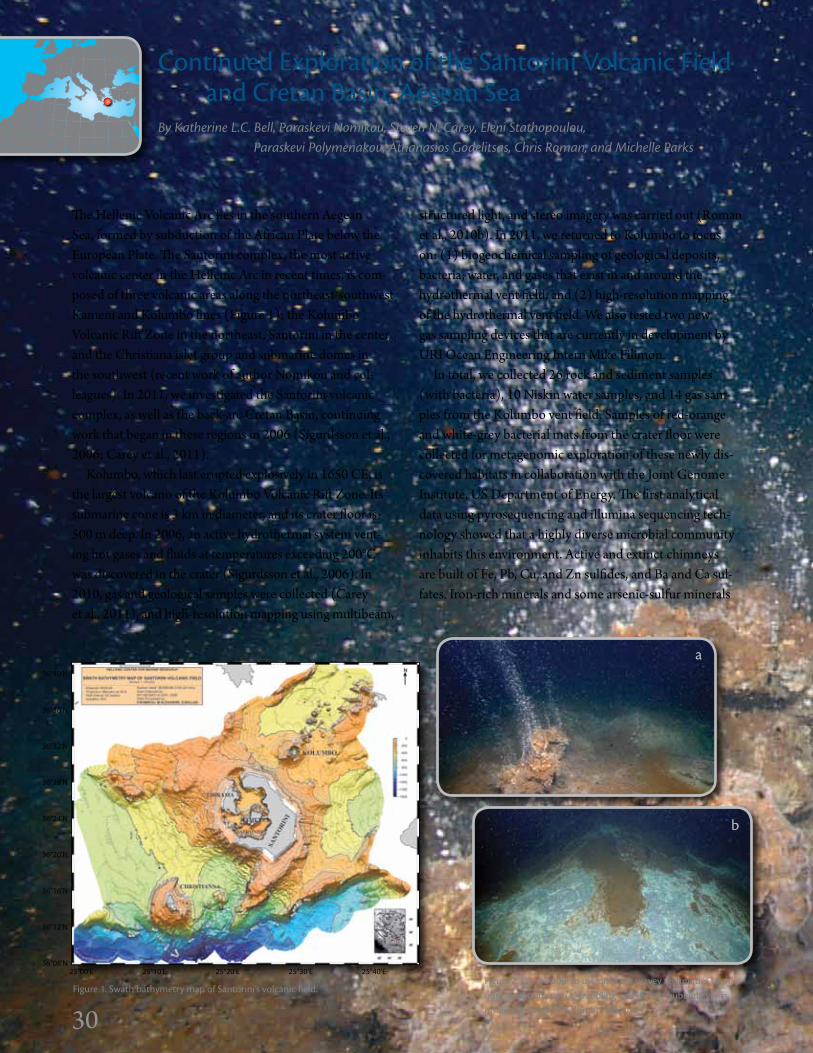
30
Continued Exploration of the Santorini Volcanic Field and Cretan Basin, Aegean SeaBy Katherine L.C. Bell, Paraskevi Nomikou, steven N. Carey, Eleni stathopoulou, Paraskevi Polymenakou, Athanasios godelitsas, Chris Roman, and Michelle Parks
30
The Hellenic Volcanic Arc lies in the southern Aegean Sea, formed by subduction of the African Plate below the European Plate. The Santorini complex, the most active volcanic center in the Hellenic Arc in recent times, is com-posed of three volcanic areas along the northeast-southwest Kameni and Kolumbo lines (Figure 1): the Kolumbo Volcanic Rift Zone in the northeast, Santorini in the center, and the Christiana islet group and submarine domes in the southwest (recent work of author Nomikou and col-leagues). In 2011, we investigated the Santorini volcanic complex, as well as the back-arc Cretan Basin, continuing work that began in these regions in 2006 (Sigurdsson et al., 2006; Carey et al., 2011).
Kolumbo, which last erupted explosively in 1650 CE, is the largest volcano of the Kolumbo Volcanic Rift Zone. Its submarine cone is 3 km in diameter, and its crater floor is 500 m deep. In 2006, an active hydrothermal system vent-ing hot gases and fluids at temperatures exceeding 200°C was discovered in the crater (Sigurdsson et al., 2006). In 2010, gas and geological samples were collected (Carey et al., 2011), and high-resolution mapping using multibeam,
structured light, and stereo imagery was carried out (Roman et al., 2010b). In 2011, we returned to Kolumbo to focus on: (1) biogeochemical sampling of geological deposits, bacteria, water, and gases that exist in and around the hydrothermal vent field, and (2) high-resolution mapping of the hydrothermal vent field. We also tested two new gas sampling devices that are currently in development by URI Ocean Engineering Intern Mike Filimon.
In total, we collected 26 rock and sediment samples (with bacteria), 10 Niskin water samples, and 14 gas sam-ples from the Kolumbo vent field. Samples of red-orange and white-grey bacterial mats from the crater floor were collected for metagenomic exploration of these newly dis-covered habitats in collaboration with the Joint Genome Institute, US Department of Energy. The first analytical data using pyrosequencing and illumina sequencing tech-nology showed that a highly diverse microbial community inhabits this environment. Active and extinct chimneys are built of Fe, Pb, Cu, and Zn sulfides, and Ba and Ca sul-fates. Iron-rich minerals and some arsenic-sulfur minerals
Figure 1. Swath bathymetry map of Santorini’s volcanic field.
36°40'N
36°36'N
36°32'N
36°28'N
36°24'N
36°20'N
36°16'N
36°12'N
36°08'N 25°00'E 25°10'E 25°20'E 25°30'E 25°40'E
a
Figure 2. We are able to use different survey techniques to map out distributions of (a) bubbling and (b) nonbubbling vents inside the crater of Kolumbo Volcano.
b

3131
that may be of biogenic origin cover some of the Kolumbo chimneys. Initial studies also indicate possible microbial microtextures in the cores of the chimneys (Kilias et al., 2011). Gas samples collected in 2010 showed that 99% of the gas being emitted from the hydrothermal vents is com-posed of CO2 (Carey et al., 2011). Not surprisingly, pre-liminary onboard analysis of water samples in 2011 shows pH levels lower than average; detailed chemical analysis is currently in progress.
Kolumbo mapping efforts focused on two new ways to visualize active physical processes (Figure 2). First, we mapped the hydrothermal vent field and actively bub-bling vents at high resolution. Second, we tested the use of structured light mapping over areas venting hot water without bubbles (“shimmery” water). The observed refrac-tion of light can be used to visualize these venting areas (see pages 42–45). The preliminary results of both tech-niques were excellent, and we anticipate that these maps will contribute to a better understanding of Kolumbo’s geo-logical activity, and demonstrate the use of mapping tem-poral changes in biogeological systems. These techniques should also be useful in other exploratory applications.
Our work inside Santorini caldera focused on two regions: the hydrothermal vent field in the northern basin (Figure 3), and the north and east slopes of Nea Kameni Island. The low-temperature vent field in the northern basin, first discovered in 2006, is composed of small (1–4 m) mounds covered in yellow bacteria. Sediment samples were collected here to compare the microbial com-munity to that in nearby Kolumbo. Since January 2011, interferometric synthetic aperture radar and GPS measure-ments1 collected on the Kameni islands and Thera suggest caldera-wide uplift occurs at a fairly constant rate. This
continued inflation may indicate the influx of new magma beneath Nea Kameni. ROV exploration along the northern slopes of Nea Kameni revealed lava flows and fractured lava blocks that were formed during the 1707–1711 and 1925–1928 CE eruptions. At the top of a volcanic dome, east of Nea Kameni, we also discovered a crater with shimmery water.
The Christiana group of four small islets belongs to a stand-alone volcanic cone that domed the seafloor at the junction of a pair of fault zones trending NNW-SSE and NNE-SSW. A group of submarine domes near the Christiana islets occur at an average depth of 500 m and are believed to be of volcanic origin (recent work of author Nomikou and colleagues). Until now, no visual observa-tions had been made on the submarine domes; we con-ducted several Hercules dive transects up their slopes to study their origin, history, and relationship with the rest of the Santorini volcanic complex. We found evidence of faulting (Figure 4)—cliffs up to 100 m tall, and small colo-nies of yellow, presumably sulfur-reducing hydrothermal bacteria, as well as abundant benthic megafauna, including sponges, corals, sea cucumbers, and urchins.
The final area of interest was the Cretan Basin in the Sea of Crete, where we discovered an area of pockmarked mounds in 2006. Our goal in 2011 was to map the region with side-scan sonar to determine the geographic extent of the mound area, followed by visual reconnaissance with Hercules, and to collect sediment samples to investigate how these features formed (Figure 5). Unfortunately, fail-ure of the side-scan system prevented us from carrying out the planned mapping, but we collected push cores from several of the mounds, and analysis is in progress.
Figure 3. Hercules collects a push core of a yellow bacterial colony and sediment from the hydrothermal vent field in the northern basin of Santorini.
Figure 4. Hercules inspects a
large fracture on the slope of the Christiana domes.
Figure 5. Unidentified mounds in the Cretan Basin are a few meters in diam-
eter, approximately 1 m high, and com-monly have a small crater at the top.
1 GPS measurements have been collected as a collaborative project that includes the University of Oxford, the National Technical University of Athens, the Georgia Institute of Technology, and the University of Patras.

32
Submarine Volcanoes of the Aeolian Arc, Tyrrhenian SeaBy steven N. Carey, Katherine L.C. Bell, Mauro Rosi, Michael Marani, Paraskevi Nomikou, sharon L. Walker, Kevin Faure, and Joshua Kelly
The southeast Tyrrhenian Sea off the western coast of southern Italy is one of the two areas of the Mediterranean basin where active subduction and associated volcanism occur. Rollback of westward-dipping Ionian oceanic litho-sphere has created a small back-arc basin and the Aeolian Arc with seven subaerial volcanoes: Stromboli, Panarea, Vulcano, Lipari, Salina, Filicudi, and Alicudi volcanic islands (Figure 1). At least eight submarine volcanoes in the area have been explored to a limited degree. For several decades, the submarine centers in the arc and back-arc have been the target of geophysical, volcanological, and min-eral exploration (e.g., Dekov and Savelli, 2004). Deep-sea dredging has collected evidence of hydrothermal activity at many of the submarine centers. CTD recordings in the water column, coupled with helium isotopic measure-ments, identified significant chemical signals at Palinuro, Enarete, Eolo, Marsili, Sisifo, and Secca del Capo that may result from hydrothermal venting (Lupton et al., 2011).
During the 2011 Nautilus field season, four submarine volcanoes, or seamounts, in the Aeolian Arc (Eolo, Enarete, Palinuro, and Casoni) were explored for evidence of recent volcanic activity and hydrothermal venting. Eolo is atypi-cal of seamounts in the Aeolian Arc, having a complex
structure that may be related to caldera collapse. We found sediment draping most of the volcano, suggesting a lack of recent volcanism, but we found evidence of hydrothermal venting at a number of sites—small patches (tens of cen-timeters across) of bright yellow-orange bacteria coloniz-ing fractures in volcanic rock outcrops (Figure 2). In one locale, we encountered a small group of living tubeworms around a small outcrop of manganese-encrusted rocks.
On nearby Enarete, outcrops of manganese-encrusted lava flows and rocks broken off from lava domes were abun-dant. In some areas at the summit, fluids with temperatures up to 5°C above the ambient seawater were actively dis-charging. Bacteria were common in these areas, and small (a few tens of centimeters in height), fragile chimneys com-posed of iron oxides dotted the seafloor (Figure 3).
Palinuro Seamount is a complex feature, consisting of
Figure 1. Bathymetric map of the Tyrrhenian Sea showing the location of the sub-aerial and submarine volcanic centers of the Aeolian Arc. Red circles indicate the submarine centers explored during the 2011 Nautilus field season.
Figure 2 (top photo). yellow-orange bacteria colonizing an area of low-temperature hydrothermal fluid venting on Eolo Seamount, Tyrrhenian Sea.
Figure 3 (bottom photo). yellowish-brown iron-oxide hydrothermal vent on the summit of Enarete Seamount, Tyrrhenian Sea.
38
°30'
N
38°4
6'N
39
°00'
N
39°1
5'N
39
°30'
N
39°4
6'N
13°30'E 13°46'E 14°00'E 14°15'E 14°30'E 14°46'E 15°00'E 15°15'E 15°30'E 15°46'E 16°00'E

33
five coalesced volcanic edifices lying along an east-west trending fault system extending seaward off the northern limit of Calabria (Figure 1). The seamount cluster spans a total length of 50 km, with a maximum width of about 25 km at its base. Previous seafloor observations show that sediment covers large parts of Palinuro Seamount, with outcrops of volcanic rocks being relatively rare in the upper portion of the coalesced volcanic edifices. Massive sulfide fragments had been recovered from the western portion of the seamount at approximately 600 m water depth by gravity coring, dredging, and video-guided grab sampling (Monecke et al., 2009). In this area, new exploration by the ROV Hercules revealed areas of fluids venting at tem-peratures up to 54°C. Large colonies of living tubeworms (Siboglinidae) surrounded the venting areas and were draped by cotton- and cobweb-like bacteria (Figure 4).
Near Palinuro in the high-temperature venting areas, honeycomb chimneys with interconnected globular spires were coated with brownish yellow bacteria (Figure 5). These fragile structures are likely constructed of iron-containing minerals, and many display a bright green core indicative of nontronite, an iron-rich clay common in low-temperature hydrothermal systems (Figure 6). On Palinuro’s eastern end, there was also evidence of low-temperature hydrothermal venting from spires up to 30 cm in height. Interestingly, we observed small yellow tube-like structures that resembled some type of worm, but may instead be bacterial structures. The discovery of active vent-ing at each summit along most of Palinuro’s 50 km length explains the many strong water-column chemical signals observed by Lupton et al. (2011) in their CTD survey.
The final submarine center we explored was a small sea-mount south of Stromboli. We observed many small cones and ridges south-southwest of the island that are likely the submarine extensions of the Stromboli magmatic system. Previous dredging of Casoni Seamount recovered volcanic samples that were warm. No hydrothermal venting was
discovered at Casoni, but a relatively fresh sequence of well-exposed pillow basalts and breccias indicate young sub-marine volcanism. Of particular interest were large mounds (Figure 7) that appear to have been inflation features on the submarine flows, likely analogous to uplifted crusts, or tumuli, often observed on subaerial basaltic lava flows, such as in Hawaii.
Figure 4. Colony of living tube-worms (siboglinidae) in the
vicinity of high-temperature (54°C) venting on the western
end of Palinuro Seamount. A small octopus is visible on the
right-hand side of the image.
Figure 7. inflated pillow basalt
structure south of Stromboli Volcano on
Casoni Seamount.
Figure 6. Bulbous iron-oxide vent on the eastern side of Palinuro Seamount showing an interior composed of green nontronite.
Figure 5. Tubular iron-oxide vent on the western side of Palinuro Seamount showing
an interior composed of green nontronite.

34
Submarine Volcanism in the Straits of SicilyBy steven N. Carey, Katherine L.C. Bell, Michael Marani, Mauro Rosi, Edward T. Baker, Chris Roman, Marco Pistolesi, and Joshua Kelly
Tectonic extension during the late Miocene to Pliocene (about 10.5 to 2.5 million years ago) formed the Straits of Sicily, or Sicily Channel, between Sicily and the North African continental margin (Civile et al., 2010). Three principal elongated depressions in this deep intraplate rift zone—the Pantelleria, Linosa, and Malta grabens—occur along the length of the channel with maximum depths of 1,317, 1,529, and 1,731 m, respectively (Figure 1). Each gra-ben is filled with thick (> 1,000 m) sedimentary sequences, so-called turbidites (Calanchi et al., 1989), and is gener-ally bounded by northwest-southeast trending faults. The continental crust along the grabens is significantly thinned, with a minimum thickness of 17–18 km found beneath the Pantelleria and Linosa grabens. Subaerial and submarine volcanism occur at various locations within the Straits of Sicily as a result of crustal thinning. Subaerial volcanism is restricted to the islands of Pantelleria in the northwest and Linosa to the southeast (Figure 1).
In contrast, a large number of submarine volcanic centers (at least 10) have been identified within the gra-bens and along the shallower platforms adjacent to Sicily
(Rotolo et al., 2006). New multibeam mapping around Pantelleria revealed the presence of at least 30 small vol-canic cones in 100–650 m water depth (Bosman et al., 2007). Historical activity in the area was recorded as early as 264 BCE, and the last documented submarine erup-tion took place in 1891, several kilometers northwest of Pantelleria at Foerstner Volcano (Washington, 1909). The 1891 eruption was unusual because it produced meter-size basaltic scoria blocks that rose to the surface and degassed (sometimes exploding) before becoming saturated with seawater and then sinking back to the seafloor (Figure 2).
In 2011, E/V Nautilus scientists went to the area north-west of Pantelleria to investigate the location of the 1891 vent and to examine the structure, relative age, and com-position of the numerous volcanic cones. We confirmed the location of the 1891 eruption vent about 4 km off the northwest coast (Figure 3). Surrounding the vent, a small mound with a peak at 255 m water depth, was an exten-sive field of large scoria blocks distributed on a seafloor mantled by fine-grained sediment (Figure 4). These blocks were likely transported briefly on the sea surface by local
Figure 1 (left). Bathymetric map of the Straits of Sicily showing the location of the Pantelleria, Malta, and Linosa grabens.
Figure 2 (above). Lithograph of floating scoria blocks from the 1891 submarine eruption of Foernster Volcano, Northwest Pantelleria. From Butler (1892)
34
38°N
37°N
36°N
10°E 11°E 12°E 13°E 14°E 15°E
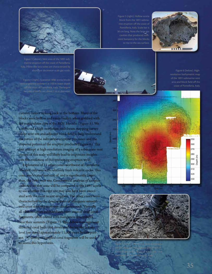
35
currents before sinking back to the bottom. Many of the blocks were hollow and easily broken when grabbed with the manipulator arm of the ROV Hercules (Figure 5). We conducted a high-resolution multibeam mapping survey of the vent site and adjacent block field to help understand the nature of the submarine eruption processes and the dispersal pattern of the eruptive products (Figure 6). This first attempt at high-resolution imaging of a submarine vent system of this scale will likely lead to important insights into the evolution of this interesting eruption style.
Exploration of 11 other cones northwest of Pantelleria revealed only one with relatively fresh volcanic rocks. This cone was located just east of, and is significantly larger than, the 1891 vent site. Geochemical analyses of samples collected on this cone will be compared to the 1891 scoria to see whether this vent site may also have been associ-ated with the most recent eruption. The other cones were characterized by the development of a biogenic mineral-ized crust covering outcrops of volcanic rock. Virtually all of these cones exhibited extensive areas of dead coral fragments, often coated with manganese precipitates, near their summits (Figure 7). This debris may represent drowned coral beds that developed during the last sea level low stand approximately 11,000 years before pres-ent. 14C dating of sampled coral fragments will be used to assess this hypothesis.
Figure 3 (above). Vent area of the 1891 sub-marine eruption off the coast of Pantelleria,
italy. Pillow-like lava tubes are characterized by abundant decimeter-scale gas voids.
Figure 4 (right). Scattered 1891 scoria blocks on fine-grained sediment at 350 m water depth
off the coast of Pantelleria, italy. The largest individual blocks are about 1 m in diameter.
Figure 5 (right). Hollow scoria block from the 1891 subma-rine eruption off the coast of Pantelleria, italy. Scale bar is
30 cm long. Note the large gas cavities that produced suffi-
cient buoyancy for the blocks to rise to the sea surface.
Figure 7 (above). dead coral beds being sam-pled by Hercules’ manipulator arm at 400 m water depth on the slopes of a volcanic cone northwest of Pantelleria island, italy.
35
Figure 6 (below). High-resolution bathymetric map of the 1891 submarine vent area and block field off the
coast of Pantelleria, italy.
250
260
270
280
290
300
310
320
330
300
280
260
240
220
200
180
160
140
120
Dep
th (m
)
Nor
th (m
)
240 260 280 300 320 340 360 380 400East (m)
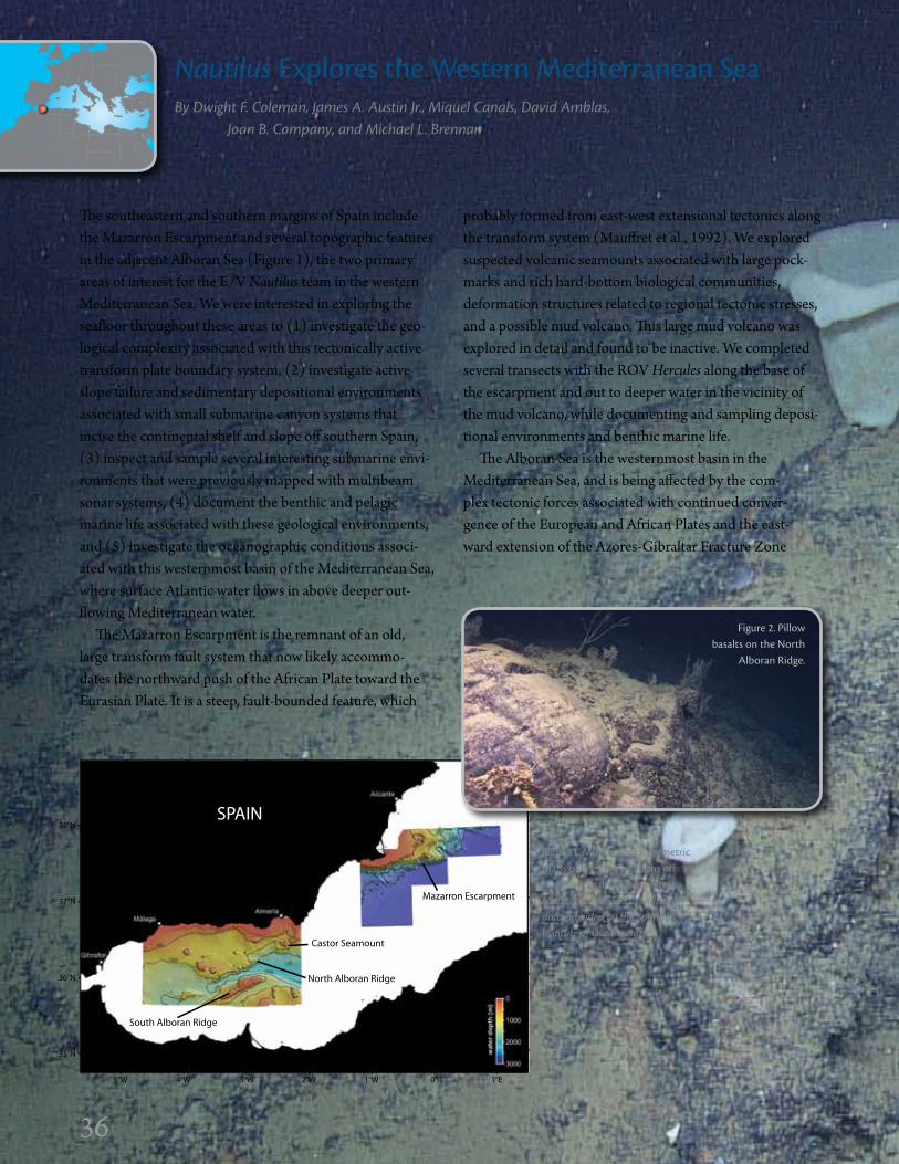
36
Nautilus Explores the Western Mediterranean SeaBy Dwight F. Coleman, James A. Austin Jr., Miquel Canals, David Amblas, Joan B. Company, and Michael L. Brennan
36
SPAIN
South Alboran Ridge
North Alboran Ridge
Castor Seamount
Mazarron Escarpment
5°W 4°W 3°W 2°W 1°W 0° 1°E
38°N
37°N
36°N
35°N
The southeastern and southern margins of Spain include the Mazarron Escarpment and several topographic features in the adjacent Alboran Sea (Figure 1), the two primary areas of interest for the E/V Nautilus team in the western Mediterranean Sea. We were interested in exploring the seafloor throughout these areas to (1) investigate the geo-logical complexity associated with this tectonically active transform plate boundary system, (2) investigate active slope failure and sedimentary depositional environments associated with small submarine canyon systems that incise the continental shelf and slope off southern Spain, (3) inspect and sample several interesting submarine envi-ronments that were previously mapped with multibeam sonar systems, (4) document the benthic and pelagic marine life associated with these geological environments, and (5) investigate the oceanographic conditions associ-ated with this westernmost basin of the Mediterranean Sea, where surface Atlantic water flows in above deeper out-flowing Mediterranean water.
The Mazarron Escarpment is the remnant of an old, large transform fault system that now likely accommo-dates the northward push of the African Plate toward the Eurasian Plate. It is a steep, fault-bounded feature, which
probably formed from east-west extensional tectonics along the transform system (Mauffret et al., 1992). We explored suspected volcanic seamounts associated with large pock-marks and rich hard‐bottom biological communities, deformation structures related to regional tectonic stresses, and a possible mud volcano. This large mud volcano was explored in detail and found to be inactive. We completed several transects with the ROV Hercules along the base of the escarpment and out to deeper water in the vicinity of the mud volcano, while documenting and sampling deposi-tional environments and benthic marine life.
The Alboran Sea is the westernmost basin in the Mediterranean Sea, and is being affected by the com-plex tectonic forces associated with continued conver-gence of the European and African Plates and the east-ward extension of the Azores-Gibraltar Fracture Zone
Figure 1. Multibeam bathymetric maps of the dive locations off southern Spain in the western Mediterranean Sea. Multibeam data provided by the spanish institute of Oceanography
Figure 2. Pillow basalts on the North
Alboran Ridge.
36

3737
(see pages 38–39). Dives on both the South and North Alboran Ridges, which flank a deepwater channel in the central Alboran Sea, confirmed that they are composed of submarine volcanic rocks, including pillow basalts (Figures 2 and 3). This volcanic terrain likely represents the remnants of Miocene rifting (~ 22 million years ago), which stretched and thinned the continental crust and opened the Alboran Basin along the east-west trending transform system (Muñoz et al., 2008). A side-scan sonar survey using the Echo towfish in the deeper portion near the Alboran Channel at the base of the Alboran Ridge supplemented dives along the north side of the ridge. This survey revealed a relatively flat seafloor with surpris-ingly heavy sedimentation, probably resulting from tur-bidite deposits related to mass-wasting processes on the adjacent steeper ridge flank.
The Alboran Sea is a very productive part of the Mediterranean; marine life abounds, including other‐worldly siphonophores several meters long (Figure 4). In some of the intermediate-depth regions, especially where swift currents exist along steep rock faces on the Alboran Ridge, we found abundant benthic marine life, including oyster and deepwater coral communities. On an upslope transect of the South Alboran Ridge, from about 1,200 m to 500 m depth, we observed heavy and recent trawl marks scarring the seabed starting at 800 m. These furrows remained prevalent as we moved upslope. Few benthic biota were present near the furrows, probably as a result of the pervasive seafloor disruption by these fishing activities.
We also investigated portions of the submarine exten-sion of the Carboneras Fault, which comes on shore in southern Spain. This active fault is part of the trans‐Alboran shear zone, where the largest historical earthquakes in southeastern Spain have originated. Dives included por-tions of the Almeria Canyon and its tributaries. Another part of this zone is Castor Seamount, where we encoun-tered more volcanic outcrops and associated biota, includ-ing glass sponges and soft coral communities (Figure 5). Along the Almeria Canyon transect, we visually inspected the seafloor at specific depth horizons to document the sedimentary geological character and benthic biology. This effort was part of an attempt to document and compare the canyons off southern Spain with canyons off eastern Spain, where similar ROV transect dives had been carried out previously. By comparing the nature of the canyons at specific depths with similar techniques, we established a
baseline by which to gauge future changes in the seafloor environment and living communities. Similar comparisons could be made to other submarine canyons along the con-tinental slopes and mid-basin ridges in other parts of the Mediterranean Sea.
Our dives in this part of the Mediterranean confirmed that it is tectonically complex, with many active faults and evidence of previous volcanic activity, and that its deepwa-ter biota are rich and diverse, despite the negative impacts of intensive fishing in some areas. The complexity of the seafloor terrain, the dynamics of the oceanographic condi-tions through mixing of water masses, and the richness of the marine biology throughout the region made this explo-ration program off southern Spain truly worthwhile, and the Nautilus team agreed that future work in this area should be carried out through an expanded exploration program.
Figure 5. glass sponges and soft corals on Castor Seamount in the Alboran Sea.
37
Figure 4. A sipho-nophore inspected
by Hercules in the Alboran Sea.
Figure 3. A squid swims near vol-canic outcrops
on the South Alboran Ridge.
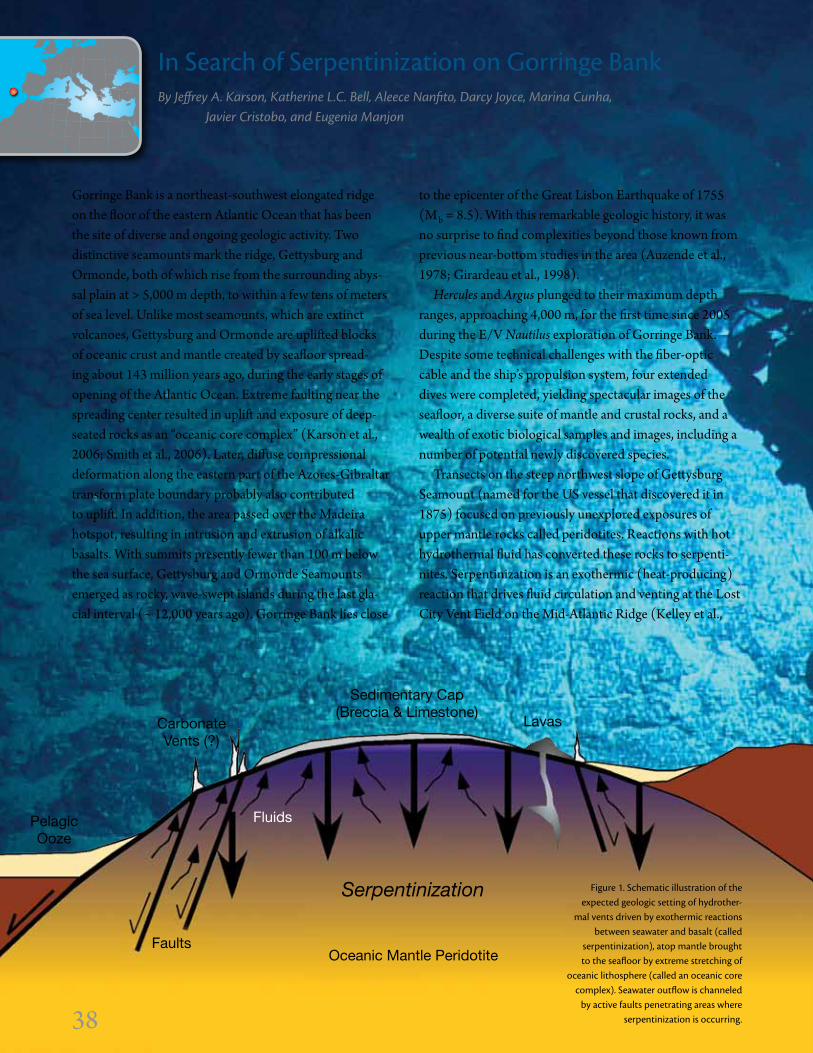
38
in Search of Serpentinization on gorringe BankBy Jeffrey A. Karson, Katherine L.C. Bell, Aleece Nanfito, Darcy Joyce, Marina Cunha, Javier Cristobo, and Eugenia Manjon
Gorringe Bank is a northeast-southwest elongated ridge on the floor of the eastern Atlantic Ocean that has been the site of diverse and ongoing geologic activity. Two distinctive seamounts mark the ridge, Gettysburg and Ormonde, both of which rise from the surrounding abys-sal plain at > 5,000 m depth, to within a few tens of meters of sea level. Unlike most seamounts, which are extinct volcanoes, Gettysburg and Ormonde are uplifted blocks of oceanic crust and mantle created by seafloor spread-ing about 143 million years ago, during the early stages of opening of the Atlantic Ocean. Extreme faulting near the spreading center resulted in uplift and exposure of deep-seated rocks as an “oceanic core complex” (Karson et al., 2006; Smith et al., 2006). Later, diffuse compressional deformation along the eastern part of the Azores-Gibraltar transform plate boundary probably also contributed to uplift. In addition, the area passed over the Madeira hotspot, resulting in intrusion and extrusion of alkalic basalts. With summits presently fewer than 100 m below the sea surface, Gettysburg and Ormonde Seamounts emerged as rocky, wave-swept islands during the last gla-cial interval (~ 12,000 years ago). Gorringe Bank lies close
to the epicenter of the Great Lisbon Earthquake of 1755 (Mb = 8.5). With this remarkable geologic history, it was no surprise to find complexities beyond those known from previous near-bottom studies in the area (Auzende et al., 1978; Girardeau et al., 1998).
Hercules and Argus plunged to their maximum depth ranges, approaching 4,000 m, for the first time since 2005 during the E/V Nautilus exploration of Gorringe Bank. Despite some technical challenges with the fiber-optic cable and the ship’s propulsion system, four extended dives were completed, yielding spectacular images of the seafloor, a diverse suite of mantle and crustal rocks, and a wealth of exotic biological samples and images, including a number of potential newly discovered species.
Transects on the steep northwest slope of Gettysburg Seamount (named for the US vessel that discovered it in 1875) focused on previously unexplored exposures of upper mantle rocks called peridotites. Reactions with hot hydrothermal fluid has converted these rocks to serpenti-nites. Serpentinization is an exothermic (heat-producing) reaction that drives fluid circulation and venting at the Lost City Vent Field on the Mid-Atlantic Ridge (Kelley et al.,
OceanicCrust
PelagicOoze
CarbonateVents (?)
Lavas
Faults
Serpentinization
Fluids
Sedimentary Cap(Breccia & Limestone)
Oceanic Mantle Peridotite
Figure 1. Schematic illustration of the expected geologic setting of hydrother-
mal vents driven by exothermic reactions between seawater and basalt (called
serpentinization), atop mantle brought to the seafloor by extreme stretching of
oceanic lithosphere (called an oceanic core complex). Seawater outflow is channeled
by active faults penetrating areas where serpentinization is occurring.38

39
2001, 2007). It is still the only known vent system of its kind on the seafloor. Unlike the well-known black smoker vents found along spreading centers such as the East Pacific Rise, Lost City is located 20 km off the spreading axis, on top of an oceanic core complex, with no volcanic activ-ity. Could serpentinization-driven venting remain active even in very old mantle rock outcrops? Building upon the experience from Lost City, we targeted specific areas on Gettysburg Seamount to address that question (Figure 1). Although we found no evidence of active venting, we did find distinctive rock types, including serpentinites cut by veins of gabbro (an intrusive rock) altered by high-temperature water/rock reactions similar to those docu-mented at Lost City (Figures 2–4). It is possible that any carbonate vent structures that once existed could have been eroded away when the seamount stood above sea level. Our initial exploration, focused on specific target areas, yielded interesting results that could set the stage for future work in this fascinating and enigmatic geologic setting.
Transects on Ormonde Seamount documented complex geology in previously unexplored areas. As anticipated from previous studies, we found highly fractured and altered lower crustal gabbroic rocks and overlying limestones, sedimentary breccias, and fresh-looking alkalic lavas.
Despite a mainly barren seafloor covered with smooth pelagic ooze, the lower slopes of both seamounts proved to be rich in exotic and, in some cases, previously unknown or poorly studied organisms, including sponges, corals, and fish. Direct observation and sampling targeted large organisms, but rock samples, and a particularly richly colonized slab of wood, also yielded a huge number of tiny sessile specimens as a bonus. Imagery and samples document a surprising degree of biological diversity in both mega- and macrofaunal assemblages. Microfauna were sampled from water and rock surfaces. On both seamounts, we observed several different species of gor-gonian (soft) corals and collected samples for ongoing genetic connectivity work. Sponges were of special inter-est; we collected many specimens, including a possible new carnivorous species. Microscopic, elemental, and isotopic studies will continue in shore-based labs in the United States, Spain, and Portugal.
This cruise once again demonstrated the efficacy and future potential of Nautilus, Hercules, and Argus to explore and document seafloor features in deep waters of the Atlantic focusing on complex geological and biological frontiers.
Figure 2. ROV Hercules approaches a large outcrop of hydrothermally altered mantle rock (peridotite).
Figure 4. A sample of gabbro, an intrusive rock,
that has been altered by hydrothermal fluids.
39
Figure 3. Sampling serpentinized peri-dotite (dark) and cross-cutting gab-broic veins (light).

40
Seafloor Pockmarks, deepwater Corals, and Cold Seeps Along the Continental Margin of israelBy Dwight F. Coleman, James A. Austin Jr., Zvi Ben-Avraham, Yizhaq Makovsky, and Daniel Tchernov
The E/V Nautilus 2011 field season culminated in a return to the Israeli continental margin to investigate regions of interest first explored during the 2010 Nautilus field season (Coleman et al., 2011). Two significant discoveries from the 2010 expedition were seafloor pockmarks at the base of a submarine canyon off Akko, northern Israel, and deep-water coral communities living on fossilized reef rock along the northern slump scar of the Palmachim Disturbance off southern Israel (Figure 1). We also investigated the toe of the Palmachim Disturbance in water depths of 1,000–1,100 m; there we discovered cold seeps consisting of carbonate mounds, seafloor encrustations, and disturbed sediment where we observed gas seepage (probably meth-ane) and communities of tubeworms, mollusks, and other vent fauna. A multidisciplinary team explored these regions in detail using the Hercules and Argus ROV system to col-lect high-resolution video imagery, oceanographic data, and biological and geological samples.
Off Akko, at the base of a submarine canyon in water depths of 500–600 m, Hercules investigated large sea-floor pockmarks, ranging in diameter from a few meters to several tens of meters, and up to several meters deep (Figure 2). We suspect these pockmark features are the
result of gas and fluid escape, possibly associated with salt dissolution at depth that created negative pressure and zones of weakness in the subseafloor within which over-lying sediments collapse. Pockmark walls were actively slumping. We discovered fossilized vent structures along the walls and sampled them. Live communities of tube-worms thrived on regions of dark, possibly methane-rich sediment. We sampled the sediment and biology of these areas using push corers. One short dive along the Dor Disturbance, off Haifa, Israel (Figure 1, Area 2), investi-gated several features mapped previously by Israeli sci-entists with multibeam sonar. During this dive, several sediment push cores were collected to help characterize the recent geological history of the disturbance related to sedi-ment deposition at the base of a submarine canyon.
In a third region off southern Israel, along the edges of the Palmachim Disturbance, a large submarine landslide extending from the upper continental slope to the top of the continental rise, we explored two areas in water depths of approximately 1,100 m: the northern boundary, where there is a slump scar, and the toe of the Disturbance, where slide sediments are folded into gently undulating peaks and valleys. At the scar boundary, we further investigated
Depth (m)
Area 1: Akko
Area 2: Dor
Area 3: Palmachim
32˚00’
32˚30’
33˚00’
34˚00’ 34˚30’ 35˚00’ 35˚30’33˚30’
–100
–300
–500
–700
–900
–1,100
–1,300
> –1,500
Turkey
Cyprus
Isra
el
Egypt
EasternMediterranean
Sea
Figure 2. ROV Hercules exploring a large seafloor pockmark off Akko, israel.
Figure 1. Map showing the survey locations and ROV dive tracks for three areas off the coast of israel—Akko, dor, and Palmachim. inset map shows the location within the eastern Mediterranean Sea.
40

41
a region of deepwater corals and other fauna living on fossilized carbonate reef deposits, which we discovered in 2010. The purpose of this dive was to delineate the extents of these reef features and coral communities, and to collect samples to understand the age and origin of the coral habitat. We discovered and sampled several large communities consisting of two types of coral (black coral variety Antipatharia and a cold-water bamboo coral variety Isididae), along with the material that makes up the sub-strate on which these corals grow. In several cases, coral was found growing on man-made objects—pottery shards, a large glass jar, and an ancient amphora (Figure 3). We col-lected these samples, as they constrain the age of the coral and can be correlated to nearby communities of similar age, size, and variety. We believe this interesting ecosystem is unique in this part of the Mediterranean, and by study-ing the biological character of the coral communities, we can understand more about their origins, distributions, and population dynamics.
Finally, we conducted two ROV dives along the toe of the Palmachim Disturbance. Processed high-resolution seismic data from this area were used to create a base map of the bathymetry and structure of this geologic feature, which guided the dives. We noticed that the crests of some gentle fold features were breached, creating small pock-marks and gullies. In addition, we investigated small faults and scarps and we discovered an extensive area of cold seeps. Similar structures were documented by an expedi-tion led by the Institute for Exploration in 1999 off Egypt and the Gaza Strip using the Jason/Medea ROV system (Coleman and Ballard, 2001). Large mounds and build-ups of calcium carbonate, which characterize these seeps, precipitated out of solution as gas and fluid escape con-tinued (Figure 4). Some buildups resemble sedimentary encrustations. We observed active gas venting along some perimeters of these buildup structures, which are filled with small holes presumably caused by large volumes of escaping gas/fluid at some previous time. Chemosymbiotic communities of polychaetes and mollusks live in proximity
to these seeps (Figure 5). Samples of sediment, carbon-ate crust, and biological communities were collected. We propose that these features are prevalent along other areas on the Israeli continental margin, and may be indicative of gas/fluid-charged sediments emitting methane and other hydrocarbons, possibly associated with deeper reservoirs of natural gas, as have been recently discovered in deep water off the coast of Israel.
Figure 3. A deepwater black coral growing on an amphora (pos-
sibly from the Ottoman period) collected by Hercules near the
northern scar of the Palmachim disturbance off southern israel.
41
Figure 4. ROV Hercules collecting a sample from
a cold hydrocarbon seep on the toe of the
Palmachim disturbance.
Figure 5. A small colony of tube worms and an urchin living around a cold hydrocarbon seep on the toe of the Palmachim disturbance.

42
The 2011 field season continued the development of cen-timeter-level mapping techniques for marine geology, biol-ogy, and archaeology. The ROV Hercules is equipped with a suite of mapping instruments that enable detailed visual and acoustic seafloor surveys. The mapping sensors include a 1,375 kHz BlueView Technologies multibeam, verged color and black and white 12-bit 1360 × 1024 Prosilica stereo cameras, and a 100 mW 532 nm green laser sheet. The sensors are mounted near the rear of vehicle and arranged to image a common area. The vehicle navigation data comes from an RDI Doppler velocity log (DVL), IXSEA OCTANS fiber-optic gyroscope, and a Paroscientific depth sensor.
During the 2011 field season, one or more of the above sensors mapped 21 shipwrecks (see page 27, Figure 4). At many wrecks in the Black Sea, exceptionally turbid water prevented complete photographic surveys. However, the
BlueView sonar worked in all cases and provided bathy-metric data with multicentimeter-level resolution. We also continued the use of structured light laser imaging (Roman et al., 2010a) to obtain fine-scale, centimeter-level bathymetric maps of complete shipwrecks (Figure 1). This technique uses a camera to image a laser line projected on the seafloor. If the geometry between the laser and camera is known through calibration, a three-dimensional profile of the bottom can be measured to subcentimeter precision along the laser line. The laser system can produce bathym-etry in turbid conditions where standard camera images become too contrast-limited for stereo vision techniques.
The laser system is set up by first calibrating the stereo cameras and then solving for the relationship between the image points on the laser line in the three-dimensional camera frame coordinate system. This year, we developed an in situ calibration procedure that can be used over
The development of High-Resolution Seafloor Mapping Techniques By Chris Roman, gabrielle inglis, J. ian Vaughn, Clara smart, Bertrand Douillard, and stefan Williams
Figure 1. A detailed bathy-metric map of a whole shipwreck created with the ROV Hercules and the bathymetric structured light laser system.
2584 2586 2588 2590 2592 2594 2596 2598 2600 2602 2604East (m)
Nor
th (m
)
Dep
th (m
)
3776
3774
3772
3770
3768
3766
3764
3762
3760
380.4
380.2
380.0
379.8
379.6
379.4
379.2
379.0
378.8
378.6
42

43
4000
3980
3960
3940
3920
3900
3880
3860
3840
3820
3800
5800 5820 5840 5860 5880 5900 5920East (m)
Nor
th (m
)
Dep
th (m
)
506
504
502
500
498
496
494
492
3880
3860
3840
3820
3800
3780 5780 5800 5820 5840 5860 5880 5900 5920
East (m)
Active bubble plumes
Nor
th (m
)
Dep
th (m
)
503.5
503.0
502.5
502.0
501.5
501.0
500.5
500.0
Figure 2. Bathymetric maps of the Kolumbo vent field created with the ROV Hercules and the 1,375 kHz BlueView multibeam sonar. (a) The entire field showing the hotter, more active bubbling vents in the southern section and larger, less-active vents in the northern section. (b) A close up of the southern section showing the distribution of active bubble plumes (gray patches) detected by the BlueView sonar (Figure 3).
b
a
natural terrain during operations. The approach uses paired feature points automatically extracted from stereo images of the laser line, and the stereo projection places these points in the three-dimensional camera frame. The draw-back of this method is that it relies on the accuracy of the stereo calibration, which may be completed in a tank or using additional in situ methods.
To survey complete shipwrecks, we use a previously developed bathymetric simultaneous localization and map-ping (SLAM) technique (Roman and Singh, 2007). This method relies on matching sections of the laser data across overlapping tracklines to help reduce the negative effects of position drift in the ROV’s dead-reckoned navigation. Our goal is to produce such surveys of areas on the order of tens of meters per side, and at grid resolutions of 5 mm. The
43
ability to make reliable across-track matches in an auto-mated fashion over such complex scenes can be challenging and is a topic of ongoing research.
During exploration of the Hellenic Volcanic Arc, the BlueView sonar was used to create a large bathymetric map covering the known extent of the Kolumbo vent field. This survey was completed at an altitude of 9 m with a trackline spacing of 5 m. The narrow spacing ensured that a full vol-ume at least 5 m above the seafloor was completely resolved. The data were then processed to both resolve the seafloor bathymetry (Figure 2a) and identify the active bubble plumes (Figure 2b). This survey altitude also reduced the navigation problems associated with corruption of the DVL velocity measurements by the bubble plumes.
To identify active plumes, the bubbles were segmented
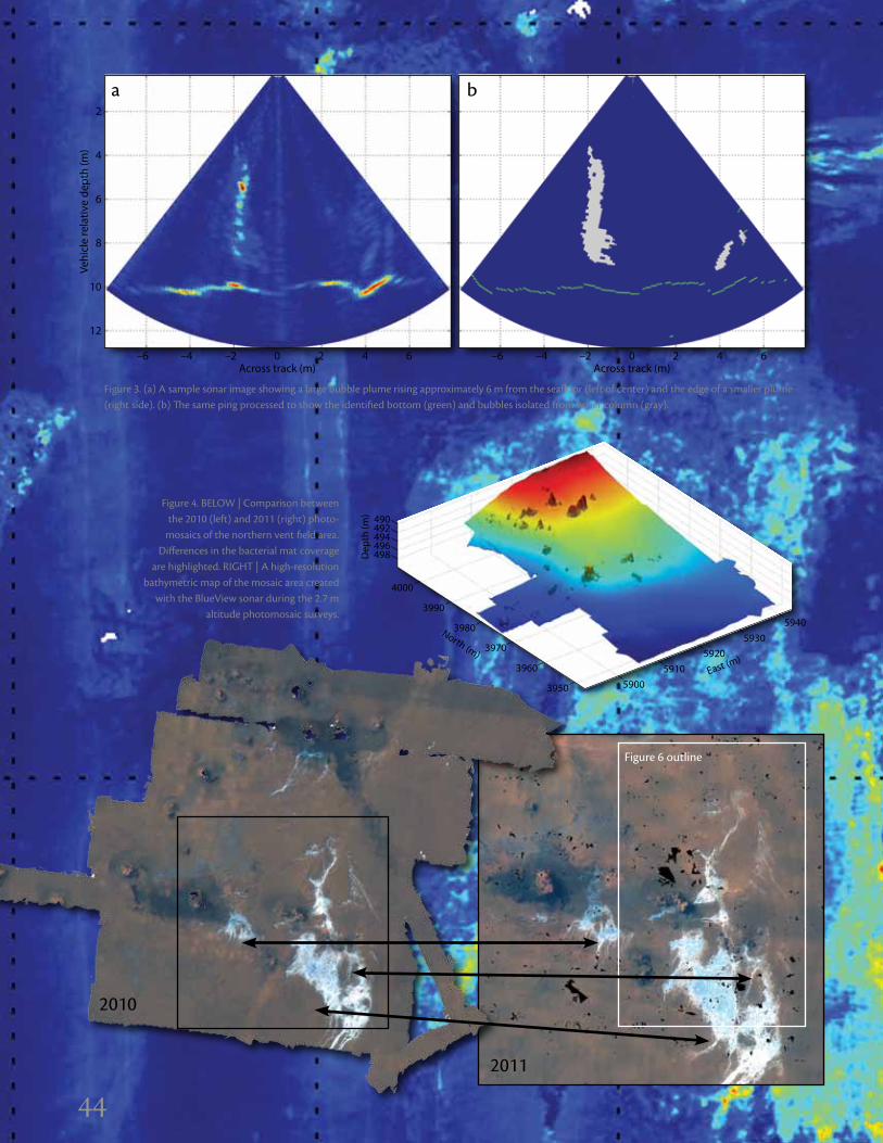
44
Figure 3. (a) A sample sonar image showing a large bubble plume rising approximately 6 m from the seafloor (left of center) and the edge of a smaller plume (right side). (b) The same ping processed to show the identified bottom (green) and bubbles isolated from water column (gray).
Vehi
cle
rela
tive
dept
h (m
)
2
4
6
8
10
12
–6 –4 –2 0 2 4 6Across track (m)
Vehi
cle
rela
tive
dept
h (m
)
2
4
6
8
10
12
–6 –4 –2 0 2 4 6Across track (m)
ba
44
Figure 4. BELOW | Comparison between the 2010 (left) and 2011 (right) photo-
mosaics of the northern vent field area. differences in the bacterial mat coverage
are highlighted. RigHT | A high-resolution bathymetric map of the mosaic area created
with the BlueView sonar during the 2.7 m altitude photomosaic surveys.
59003950
59105920
East (m)
59305940
3960
3970
3980North (m)
3990
4000
490492494496498D
epth
(m)
2010
2011
Figure 6 outline

45
Nor
th (m
)
East (m)
3990
3985
3980
3975
3970
3965 5924 5926 5928 5930 5932 5934 5936 5938 5940
Vent
ing
pote
ntia
l—ca
lcul
ated
sec
ond
mom
ent (
x 10
5 )
10
9
8
7
6
5
4
3
2
1
0
completed at a 2.7 m altitude due to the persistent turbidity in the area (Figure 2).
A smaller bathymetric survey centered on the bacterial mat area was also completed using the green laser. This survey was used to map the fine-scale bathymetry of what seemed to be downhill flow channels and to locate areas of diffuse water venting over the bacterial mat. The presence of venting fluid can be detected by looking at the quality of the imaged laser line. The laser will refract as it passes through the warm water and appear blurred in the image (Figure 5). By batch processing the laser data and comput-ing pixel intensity moments in the vertical image dimen-sion about the center of the laser line, the amount of blur can be quantified and color-coded as a proxy for venting intensity (Figure 6). The basic spatial pattern of the bacte-rial map seen in the photomosaic (Figure 4) can also be seen here. Visual inspection confirmed varying amounts of shimmering water over the extent of the mat. Temperature probes taken with Hercules indicate vent temperatures between 30° and 60°C above ambient in the area.
Figure 6. A seafloor map color-coded to show the distribution
and intensity of active venting in the vicinity of the bacterial mat (Figure 4). The color scale indi-
cates the degree of blurring seen in the laser line (Figure 5).
from the water column data (Figure 3a). The algorithm first looked for the bottom by searching back from the maxi-mum range. Once detected, the bottom was then excluded from the sonar image so the bubbles could be identified by isolating the water column values above a multiple of the mean background signal level. The pixels identified as bubbles were then cleaned using several morphological fil-tering operations to consolidate the identified plumes and remove spurious points (Figure 3b). Passes over the most active areas of the field showed the largest bubble plumes extending approximately 12 m from the seafloor before being dissolved. The bubble plumes were found emanating from a subset of chimney features as well as some relatively flat areas of the seafloor (Figure 2a).
At the northern end of the vent field, a comparison between photomosaics completed in 2010 and 2011 shows a change in the bacterial mat covering the seafloor (Figure 4; Mahon et al., 2008; Johnson-Roberson et al., 2010). Some differences in the overall shape and several new streams of bacteria are evident. These surveys were
Figure 5. A 2 m wide sample image showing the laser line projected on the seafloor. The crisp line (left side) is undis-turbed, while refraction due to hot water venting (center and right side) blurs the line.
45
Vert
ical
pix
el
Horizontal pixel
50
100
150
200
250
300
350
400
100 200 300 400 500 600
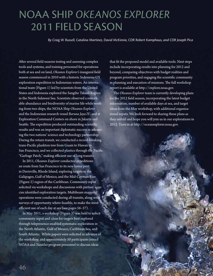
46
After several field seasons testing and assessing complex tools and systems, and training personnel for operations both at sea and on land, Okeanos Explorer’s inaugural field season commenced in 2010 with a historic Indonesia-US exploration expedition in Indonesian waters. An interna-tional team (Figure 1) led by scientists from the United States and Indonesia explored the Sangihe Talaud Region in the North Sulawesi Sea. Scientists observed a remark-able abundance and biodiversity of marine life while work-ing from two ships, the NOAA Ship Okeanos Explorer and the Indonesian research vessel Baruna Jaya IV, and at Exploration Command Centers on shore in Jakarta and Seattle. The expedition produced outstanding scientific results and was an important diplomatic success in advanc-ing the two nations’ science and technology partnership. During the return transit, we conducted a record-breaking trans-Pacific plankton tow from Guam to Hawaii to San Francisco, and we collected plastics through the Pacific “Garbage Patch,” making efficient use of long transits.
In 2011, Okeanos Explorer conducted expeditions en route from San Francisco to its new home port in Davisville, Rhode Island, exploring targets in the Galápagos, Gulf of Mexico, and the Mid-Cayman Rise (Figure 2) region of the Caribbean. Community input solicited via workshops and discussions with partner agen-cies identified exploration targets. Multibeam mapping operations were conducted during all transits, along with surveys of opportunity where feasible, to make the most efficient use of each day at sea (see pages 56–57).
In May 2011, a workshop (Figure 3) was held to solicit community input and ideas for targets best explored through telepresence-enabled systematic exploration in the North Atlantic, Gulf of Mexico, Caribbean Sea, and South Atlantic. White papers were solicited in advance of the workshop, and approximately 50 participants joined NOAA and Nautilus program personnel to discuss ideas
By Craig W. Russell, Catalina Martinez, David McKinnie, CDR Robert Kamphaus, and CDR Joseph Pica
that fit the proposed model and available tools. Next steps include incorporating results into planning for 2012 and beyond, comparing objectives with budget realities and program priorities, and engaging the scientific community in planning and execution of missions. The full workshop report is available at http://explore.noaa.gov.
The Okeanos Explorer team is currently developing plans for the 2012 field season, incorporating the latest budget information, number of available days at sea, and target ideas from the May workshop, with additional organiza-tional inputs. We look forward to sharing these plans as they unfold and hope you will join us in our explorations in 2012. Tune in at http://oceanexplorer.noaa.gov.
NOAA SHiP OKEANOs ExPLORER 2011 FiELd SEASON
46
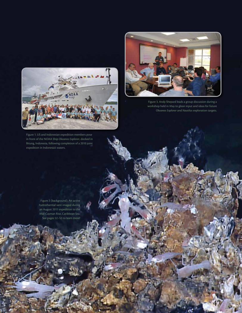
47
Figure 1. US and indonesian expedition members pose in front of the NOAA Ship Okeanos Explorer, docked in Bitung, indonesia, following completion of a 2010 joint expedition in indonesia’s waters.
Figure 2 (background). An active hydrothermal vent imaged during an August 2011 expedition to the Mid-Cayman Rise, Caribbean Sea.
See pages 52–53 to learn more!
Figure 3. Andy Shepard leads a group discussion during a workshop held in May to glean input and ideas for future
Okeanos Explorer and Nautilus exploration targets.
47

48
NOAA SHiP OKEANOs ExPLORER2011 FiELd SEASON OVERViEW
48
NOAA PMEL, Seattle, WA
NOAA PMEL, Newport, OR
2011 FiELd SEASON STATiSTiCS
7 Cruises
33 CTd Casts
349 xBT Casts
31 ROV Sites
34,329 distance Mapped (km)
180,773 Area Mapped (sq km)
Okeanos Explorer Port of Call
Exploration Command Center
EX1101 | EXPLORATION MAPPING See page 56: Always Exploring
EX1102 | ROV SHAKEDOWN
ECC
ECC
ECC
San Francisco, CA
San Diego, CA

4949
Mystic Aquarium & Institute for Exploration
Inner Space Center, University of Rhode Island
University of New Hampshire
Davisville, RI
Key West, FL
EX1103 | GALáPAGOS RIFT See page 50: Exploration of the
Deepwater Galápagos Region
EX1106 | EXPLORATION
MAPPING See page 56:
Always Exploring
EX1105 | GULF OF MEXICO
See page 54: Mapping Gas Seeps with the
Deepwater Multibeam Echosounder on
Okeanos Explorer
EX1104 | MID-CAYMAN RISE See page 52: Exploration of the Mid-Cayman Rise
Panama City, Panama
Puntarenas, Costa Rica
Pascagoula, MS
ECC
ECC ECC
ECC
NOAA Headquarters, Silver Spring, MD

50
Exploration of the deepwater galápagos RegionBy Timothy M. shank, Edward T. Baker, Robert W. Embley, stephen Hammond, James F. Holden,
scott White, sharon L. Walker, Miguel Calderón, santiago Herrera, T. Jennifer Lin, Catriona Munro, Taylor Heyl, Lucy C. stewart, Mashkoor Malik, Elizabeth Lobecker, and Jeremy Potter
In June and July 2011, Okeanos Explorer surveyed diverse habitats and geologic settings of the deep Galápagos region, including axial volcanic ridges, hydrothermal vents, off-axis sulfide mounds, and seamounts. During this expedition, the ship provided scientists, engineers, and the public an opportunity to explore unknown areas and revisit histori-cal sites in the Galápagos Rift. The ship’s multibeam sonar mapped more than 40,000 km2 of seafloor, 11 CTD tows conducted along approximately 400 km of the unexplored eastern arm of the rift surveyed for hydrothermal plumes, and 12 ROV dives collected more than 90 hours of high-definition digital video. Broadband satellite transmitted data and ROV video feeds from the ship to a team of
scientists on shore. The expedition team evaluated seafloor observations; directed seafloor ROV, CTD, and mapping operations in real time; and maintained a portal for out-reach (http://oceanexplorer.noaa.gov).
The shipboard and shoreside expedition completed the first multibeam bathymetric map of the Galápagos Rift axis from 101.3°W to 98.0°W and conducted a continu-ous CTD and multibeam transect between 89.33°W and 85.75°W (Figure 1). Our survey revealed at least 20 dis-tinct water-column anomalies along the eastern arm of the rift, corresponding to an overall spatial density of hydro-thermal plumes about twice that of the central rift (Baker et al., 2008). Venting was concentrated in two distinct areas
Figure 1. Hydrothermal plume survey (top) showing venting sites at 88.56°–88.09°W and 86.25°–85.87°W, bathy-metric coverage (middle), and images of Uka Pacha (left) and Tempus Fugit (right) vent fields discovered during the expedition. in the top panel, ∆NTU corresponds to light backscattering by hydrothermal precipitates, and oxidation-reduction potential anomalies mark locations where reduced hydrothermal chemicals (e.g., H2S, Fe+2) were detected.
(Figure 1). One consisted of contiguous, intense plumes rising as high as 250 m above the seafloor. The other, host-ing weaker plumes, was near the historical vent fields Rose Garden, discovered in 1979, and Rosebud, discovered in 2002 (Shank et al., 2003).
Five ROV dives near 88.3°W, the location of the largest hydrothermal plume signal (Figure 1), found recently erupted lava flows spread over at least 14 km, as well as several regions of vigorous diffuse venting. At two sites, white flocculent material—potentially micro-bial in origin—issued from the vents in a “snowblower” fashion. Two newly named vent fields, Uka Pacha and Pegasus, featured white microbial mats blanketing extensive areas along the base and sides of the axial graben
50
Dep
th (k
m)
Discovered Vent Fields
–88°W –87°W –86°W–89°W
2.4
2.6
2.2
2.0
1.8
1.6
1.4
0.000 0.004 0.008 0.014 0.022 0.030 0.050 0.200
∆NTU
Oxidation-Reduction Potential Anomalies
Uka Pacha Pegasus Tempus Fugit
Rosebud
Dep
th (k
m)
Discovered Vent Fields
–88°W –87°W –86°W–89°W
2.4
2.6
2.2
2.0
1.8
1.6
1.4
0.000 0.004 0.008 0.014 0.022 0.030 0.050 0.200
∆NTU
Oxidation-Reduction Potential Anomalies
Uka Pacha Pegasus Tempus Fugit
Rosebud
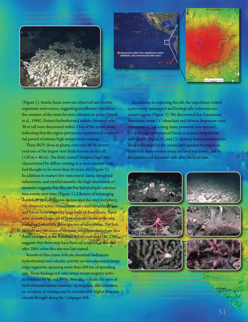
51
(Figure 1). Sessile fauna were not observed and mobile organisms were scarce, suggesting insufficient time since the creation of the vents for new colonists to arrive (Shank et al., 1998). Extinct hydrothermal sulfide chimneys over 30 m tall were discovered within 2 km of the active vents, indicating that the region previously experienced a substan-tial period of intense high-temperature venting.
Three ROV dives at plume sites near 86°W discov-ered one of the largest vent fields known on the rift (120 m × 40 m). The field, named Tempus Fugit, was characterized by diffuse venting in a once-massive clam bed thought to be more than 20 years old (Figure 2). In addition to mature live vesicomyid clams, siboglinid tubeworms, and mytilid mussels, the high abundance of juveniles suggests that this site has had multiple coloniza-tion events over time (Figure 1). Clusters of scavenging dandelion siphonophores demarcated the site’s periphery. We observed active colonization on relatively older pillow and lobate lavas ringed by large beds of dead clams. There were at least 13 species of vent-endemic fauna at the site, including potentially three species of tubeworms. The lack of biota and presence of vitreous, unsedimented lobate lava flows observed at the Rosebud diffuse vent field (86.2°W) suggests that there may have been an eruption at this site after 2005 when this site was last visited.
Results of this cruise indicate abundant and recent hydrothermal and volcanic activity on two adjacent tectonic ridge segments, spanning more than 200 km of spreading axis. These findings not only reveal recent eruptive activ-ity between 85°W and 89°W, they also indicate the rates of hydrothermal habitat turnover via eruption, dike intrusion, or cessation of venting may be considerably higher than pre-viously thought along the Galápagos Rift.
In addition to exploring the rift, the expedition visited a previously unmapped and biologically unknown sea-mount region (Figure 3). We discovered that Paramount Seamount hosts: (1) abundant and diverse deepwater coral communities (including many potential new species), (2) a strongly pronounced break in faunal composition with depth (Figure 4), and (3) distinct faunal communities likely influenced by the seamount’s summit having been subject to wave erosion when sea level was lower, and by the presence of drowned reefs after sea level rose.
Figure 3. (left) Map indicating the large area of the eastern Pacific hosting biologically unstudied sea-mounts. Box shows location of Paramount Seamount. (right) detail of Paramount Seamount bathymetry. Light green line indicates the track line of the ROV dive.
Figure 2. Extensive beds of Calyptogena clam shells host-ing sparsely populated live clams (majority > 20 cm long) within and on the margins of the Tempus Fugit vent field.
Figure 4. (left column) The deep slope of the seamount harbors a high abundance of primnoid and paramuricid gorgonians and antipatharians, and their galatheid crab associates. (right column) The shallow zone harbors a high diversity of different species of small primnoid gorgonians, bubblegum corals, and antipatharians. High abundances of ophiuroid brittle stars occupy the surface of red minerals, which presumably are the remnants of an ancient shallow-water coral reef.
51
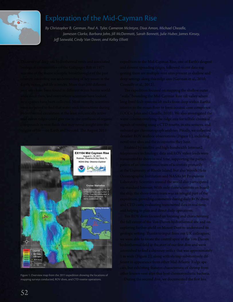
52
Exploration of the Mid-Cayman Rise By Christopher R. german, Paul A. Tyler, Cameron Mcintyre, Diva Amon, Michael Cheadle, Jameson Clarke, Barbara John, Jill McDermott, sarah Bennett, Julie Huber, James Kinsey, Jeff seewald, Cindy Van Dover, and Kelley Elliott
Discovery of deep-sea hydrothermal vents and associated biological communities on the Galápagos Rift in 1977 was one of the major scientific breakthroughs of the past century, informing our understanding of key issues in the Earth, ocean, and life sciences. More than 100 different vent sites have been found in different ocean basins world-wide since then, and everywhere scientists have looked, new species have been collected. Most recently, scientists were surprised to find that water-rock interactions during hydrothermal circulation at the least volcanically active mid-ocean ridges could give rise to the synthesis of organic compounds in vent fluids that may reveal insight into the origins of life—on Earth and beyond. The August 2011
expedition to the Mid-Cayman Rise, one of Earth’s deepest and slowest spreading ridges, followed recent data sug-gesting there are multiple vent sites present in shallow and deep settings along this ridge axis (German et al., 2010; Connelly et al., 2012).
The expedition focused on mapping the shallow outer “walls” bounding the Mid-Cayman Rise rift valley where long-lived fault-systems lift rocks from deep within Earth’s interior to the ocean floor to form oceanic core complexes (OCCs; John and Cheadle, 2010). We also investigated the water column overlying the ridge axis for telltale chemical signals of venting using a CTD rosette, in situ sensors, and onboard gas chromatograph analyses. Finally, we collected detailed ROV seafloor observations (Figure 1), including novel vent sites and the ecosystems they host.
Enabled by satellite and high-bandwidth Internet2 telepresence technology, data and ROV video feeds were transmitted to shore in real time, supporting the partici-pation of an international team of scientists primarily at the University of Rhode Island, but also Woods Hole Oceanographic Institution and NASA’s Jet Propulsion Laboratory. Scientists around the world also participated via standard Internet. With only three scientists on board the ship, the shore-based team was an integral part of the expedition, providing comments during daily ROV dives and CTD casts, evaluating transmitted data in real time, and helping to plan and direct daily operations.
Ten ROV dives focused on locating and characterizing the full extent of the Von Damm hydrothermal site and on exploring further afield on Mount Dent to understand its geologic setting. Thanks to input from our UK colleagues, we were able to locate the central spire of the Von Damm hydrothermal field at the start of our first dive and were astonished to find a chimney orifice that was approximately 1 m wide (Figure 2), along with shrimp substantively dif-ferent in appearance from other Mid-Atlantic Ridge spe-cies, but exhibiting features characteristic of shrimp from other known vent sites that host chemosynthetic bacteria.
During the second dive, we documented the first live
19°0
0'N
82°00'W 81°30'W 81°00'W
18°3
0'N
18°0
0'N
Figure 1. Overview map from the 2011 expedition showing the locations of mapping surveys conducted, ROV dives, and CTd rosette operations.
52

53
tubeworm at an Atlantic hydrothermal field (Figure 3). Our shore-based colleagues confirmed that while these tubeworms were distinct from those seen at hydrother-mal vents on the Galápagos Rift, they appeared similar to species found in the Gulf of Mexico, where they live in association with cold hydrocarbon seeps, and at vent fields as far afield as Marsili Seamount off the coast of Italy, and the Lau Basin near Tonga. Continuing our exploration of the Von Damm site we found additional venting sites and tubeworm aggregations. In one location, microbial mats, vent shrimp, tubeworms, and gastropods were all observed coexisting in an area of hydrothermal fluid flow (Figure 4).
A second expedition objective was to understand tec-tonic processes associated with OCC formation and evolu-tion, and to answer the question: why does the Von Damm field occur where it does? For our investigation, we used ROV cameras to explore the south wall of Mount Dent, located beneath the vent site. Our mission also included an extensive nighttime multibeam program, enabling us to map the bathymetry of three OCCs rising from the rift valley floor.
Toward the end of the cruise, an ROV dive was con-ducted in the southeast corner of the Mid-Cayman Rise to explore a suspected axial volcanic ridge. The ROV dive revealed interleaved pillow basalts and sheet flows at the first outcrop. There was no evidence of recent volca-nic activity, nor active venting or associated vent fauna. Nonetheless, identification of ropey “pahoehoe” lava tex-tures (Figure 5) confirmed that lava emission rates, even on an ultraslow-spreading ridge, can be impressive.
The final ROV dive of the expedition conducted a geo-logical and biological transect from south to north up the
interior wall of the North Cayman Fracture Zone. Although fracture zones represent one of the three major types of plate tectonic boundary, they have received relatively little attention, and, as far as we know, this was the first deep-submergence investigation of this particular feature.
This exploratory expedition was extremely productive and successful. We documented the full extent of the Von Damm vent field (approximately 150 m on a side), iden-tified the major sites of active venting, and located new biological communities. Using our CTD and mapping pro-grams, we investigated the fate of fluid discharge from the site, tested for the location of other sites, and investigated geologic processes that underpin hydrothermal venting. This work provides an invaluable legacy for further interna-tionally coordinated research beginning with an ROV Jason sampling program in January 2012.
Figure 2 (left). ROV Little Hercules examining the ~ 1 m diameter vent-orifice at the summit of the Von damm central spire.
Figure 3 (above). image of the first live tubeworm photographed at a vent site in Atlantic waters.
Figure 5. Ropey “pahoehoe” lava textures from more than
3,000 m deep at the Mid-Cayman Rise (above) are iden-
tical to those associated with fresh flows at Chain of Craters
Road, Hawaii Volcanoes National Park (right).
Figure 4. Location where active fluid flow, micro-bial mats, vent shrimp, gastropods, and tubeworms
were all observed together at a single site.
53
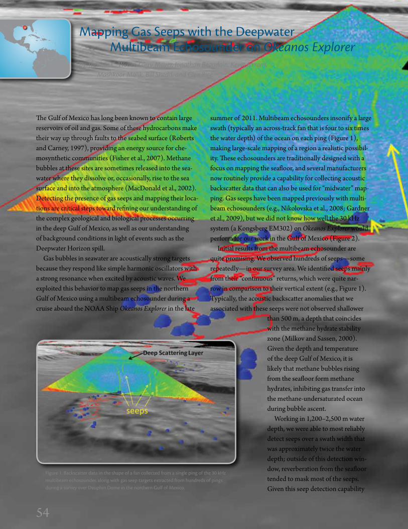
54
Mapping gas Seeps with the deepwater Multibeam Echosounder on Okeanos ExplorerBy Thomas C. Weber, Larry Mayer, Jonathan Beaudoin, Kevin Jerram, Mashkoor Malik, Bill shedd, and glen Rice
The Gulf of Mexico has long been known to contain large reservoirs of oil and gas. Some of these hydrocarbons make their way up through faults to the seabed surface (Roberts and Carney, 1997), providing an energy source for che-mosynthetic communities (Fisher et al., 2007). Methane bubbles at these sites are sometimes released into the sea-water where they dissolve or, occasionally, rise to the sea surface and into the atmosphere (MacDonald et al., 2002). Detecting the presence of gas seeps and mapping their loca-tions are critical steps toward refining our understanding of the complex geological and biological processes occurring in the deep Gulf of Mexico, as well as our understanding of background conditions in light of events such as the Deepwater Horizon spill.
Gas bubbles in seawater are acoustically strong targets because they respond like simple harmonic oscillators with a strong resonance when excited by acoustic waves. We exploited this behavior to map gas seeps in the northern Gulf of Mexico using a multibeam echosounder during a cruise aboard the NOAA Ship Okeanos Explorer in the late
summer of 2011. Multibeam echosounders insonify a large swath (typically an across-track fan that is four to six times the water depth) of the ocean on each ping (Figure 1), making large-scale mapping of a region a realistic possibil-ity. These echosounders are traditionally designed with a focus on mapping the seafloor, and several manufacturers now routinely provide a capability for collecting acoustic backscatter data that can also be used for “midwater” map-ping. Gas seeps have been mapped previously with multi-beam echosounders (e.g., Nikolovska et al., 2008; Gardner et al., 2009), but we did not know how well the 30 kHz system (a Kongsberg EM302) on Okeanos Explorer would perform for our work in the Gulf of Mexico (Figure 2).
Initial results from the multibeam echosounder are quite promising. We observed hundreds of seeps—some repeatedly—in our survey area. We identified seeps mainly from their “continuous” returns, which were quite nar-row in comparison to their vertical extent (e.g., Figure 1). Typically, the acoustic backscatter anomalies that we associated with these seeps were not observed shallower
Figure 1. Backscatter data in the shape of a fan collected from a single ping of the 30 kHz multibeam echosounder, along with gas seep targets extracted from hundreds of pings during a survey over dauphin dome in the northern gulf of Mexico.
54
than 500 m, a depth that coincides with the methane hydrate stability zone (Milkov and Sassen, 2000). Given the depth and temperature of the deep Gulf of Mexico, it is likely that methane bubbles rising from the seafloor form methane hydrates, inhibiting gas transfer into the methane-undersaturated ocean during bubble ascent.
Working in 1,200–2,500 m water depth, we were able to most reliably detect seeps over a swath width that was approximately twice the water depth; outside of this detection win-dow, reverberation from the seafloor tended to mask most of the seeps. Given this seep detection capability

55
Figure 3. Seeps (blue dots) mapped with the multibeam echosounder over-
laid on bathymetry (gray scale) along with seismic anomalies provided by the Bureau of Ocean Energy Management.
and assuming a water depth of 1,500 m and a speed of 10 kts, it is possible to survey more than 50 km2 of seafloor each hour for potential seep locations.
Most of the seep-like structures we observed acousti-cally with the multibeam echosounder were on the edges of salt domes, which are common in the Gulf of Mexico’s oil and gas province. Often, the seep observations were within suspected “hardground” anomalies mapped using three-dimensional seismic data (http://www.boemre.gov/offshore/mapping/SeismicWaterBottomAnomalies.htm). These positive anomalies possibly indicate past carbonate or hydrate structures, whereas negative seismic anomalies possibly indicate young, high-flux gas seeps or hydrate formations at or just below the seabed interface. However,
as Figure 3 shows, we also observed seeps on the edges of salt domes where there were no seismic anomalies (e.g., the eastern edge of Dauphin Dome) and sometimes did not observe seeps where positive seismic anomalies existed (e.g., the eastern side of Gloria Dome). Together, the seismic anomaly maps and the multibeam echosounder water-column detection of seeps offer clues regarding which areas were historically active but are now inactive, which areas have been active long enough to form carbon-ate hardgrounds, and which areas may be locations of newer events that have not yet formed carbonate structures substantial enough to be detected as seismic anomalies.
55
Figure 2. A contrast in backscatter: a seep simul-taneously mapped with the both an 18 kHz single-beam echo sounder (left) and the 30 kHz multibeam echosounder (right). The echogram shown for the single-beam echosounder is constructed from hundreds of pings as the ship travels over the seeps. The data from the multi-beam echosounder are from a single ping.

56
“Always Exploring”By Elizabeth Lobecker, Craig W. Russell, and Kelley Elliott
NOAA’s Okeanos Explorer, “America’s ship for ocean explo-ration,” systematically explores the ocean every day of every cruise to maximize public benefit from the ship’s unique capabilities. “Always Exploring” is a guiding principle. With 95% of the ocean unexplored, we pursue every opportunity to map, sample, explore, and survey at planned destinations as well as during transits. Throughout the ship’s geographi-cally diverse 2010 and 2011 field seasons, multiple oppor-tunities arose to transform standard operational transit cruises into interdisciplinary explorations by acquiring high-quality, innovative scientific data around the clock, and rapidly disseminating those data to the public.
Planning Efficient Cruise Tracks and Complementary OperationsDuring cruise planning, transits are optimized to allow mapping of unexplored or unmapped regions. We review input received from ocean science and management com-munities to identify unexplored regions for possible inclu-sion. We also consult those scientists and managers to verify that potential targets remain a high priority and were not recently explored.
The Okeanos Explorer Program also supports surveys of opportunity to add layers of scientific value to cruises. We conduct nonmapping surveys of opportunity and include well-defined exploratory operations that help transform standard ship shakedown and transit mapping cruises into multilayered voyages of discovery. Surveys selected are those that reflect the exploration mission or provide an opportunity to test additional capabilities that could be incorporated into systematic exploration operations.
TechnologyAn integral element of Okeanos Explorer’s “Always Exploring” model is the ship’s seafloor and water column mapping capability. The principal mapping sensor, the EM 302 multibeam sonar, is staffed on all transit cruises for 24-hour seabed and water column data collection and processing. As appropriate on a cruise-by-cruise basis, the ship’s Kongsberg EK 60 fisheries sonar and Knudsen 3260 subbottom profiler provide additional data sets. The low resolution of bathymetric data derived from satellite altim-etry allows recognition of very large features and the general character of the seafloor. At full ocean depths, the ship’s multibeam bathymetric data are at least 40 times finer reso-lution than satellite data. This capability allows imaging of previously unknown features and visualizing a truer picture of the seafloor and water column. Since commissioning,
0
–10
–20
–30
–40
–50
–60
dB
Figure 1. A sample of marine life and plastics collected during the transit cruise from Hawaii to California. Most debris concen-trated in the “garbage Patch” is composed of small bits of plastic not immediately visible to the naked eye.
Figure 2. EM 302 multibeam bottom backscatter data showing 3,000 m high San Juan Seamount offshore of Southern California. Warmer colors indicate higher acoustic reflectivity, providing information about the relative hardness of the seafloor, with implications for erosion and habitat.
56
BACKgROUNd iMAgE | Okeanos Explorer West Coast 2011 field
season EM 302 multibeam data.

57
the Okeanos Explorer team has collected more than 88,000 linear kilometers of bathymetry stretching from Indonesia’s Sulawesi Sea to the North Atlantic, mapped a number of seamounts not found in existing bathymetry or charts, successfully tested its mapping system to 7,954 m depth over the Mariana Trench, and demonstrated the multibeam sonar’s ability to detect gaseous and physical fea-tures in wide areas of the water column. Notably, this ability resulted in the discovery of 1,400 m high plumes, confirmed to be methane gas, off the coast of northern California. Gas hydrate scientists at Monterey Bay Aquarium Research Institute conducted discovery follow-up work in the sum-mer of 2011, and the initial results analyzing the vent source geomorphology were presented at the 2011 fall meeting of the American Geophysical Union (Gwiazda et al., 2011).
“Always Exploring” during the 2010 and 2011 Field SeasonsDuring the 2010 field season, the Okeanos Explorer Program partnered with NOAA’s National Marine Fisheries Service to conduct two surveys of opportunity during Okeanos Explorer’s return transits from Indonesia. A Continuous Plankton Recorder collected plankton from Guam to Hawaii, and on to San Francisco, across these historically undersampled regions. Surface water samples
collected in Manta nets during the transit from Hawaii to San Francisco were analyzed for plastics (Figure 1) to gain a greater understanding of the extent of the Pacific “Garbage Patch.” Plankton sample data will help scientists better understand the nature of the plankton community in these regions (http://go.usa.gov/Q4F). Combined with the plastics data, insights may be gained into the effect of plastics on the marine food web (http://go.usa.gov/QRI).
During the 2011 field season, the Okeanos Explorer Program added additional days to operational transits to define unexplored features and map areas identified as high-priority exploration targets and areas of interest by the science and management community. Examples include transits along the Florida Escarpment, near a subset of the thousands of unmapped seamounts in the Pacific Ocean (Figure 2), along the deep canyons at the continental shelf break off the US East Coast (Figure 3, left), along sig-nificant portions of several National Marine Sanctuaries, including the Channel Islands and Monterey Bay, and along America’s coasts where historically important shipwrecks rest (Figure 3, right). Results of these cruises are expected to be incorporated into future explorations by Okeanos Explorer, the Bureau of Ocean Energy Management, and the NOAA Office of National Marine Sanctuaries.
–300–600–900
–1200–1500–1800–2100
meters
meters–160
–164
–168
–172
–176
–180
–184Figure 3. (above) Screen shot looking west
over Baltimore and South Wilmington Canyons on the US Continental Shelf Break.
(right) Screenshot of an unidentified shipwreck mapped off the Atlantic coast of Florida.
57
BACKgROUNd iMAgE | Okeanos Explorer gulf of Mexico and US East Coast 2011 field
season EM 302 multibeam data.

58
NOAA’s exploration flagship, Okeanos Explorer, is equipped to incorporate information management objectives into multidisciplinary data collection and processing operations in real time. A constant stream of data and information shared between shipboard and shore-based participants via satellites and high-bandwidth Internet2 (called tele-presence technology) enables a geographically distrib-uted expedition team to jointly and dynamically manage on going exploration activities. This information manage-ment strategy couples the ship’s unique telepresence-enabled capabilities with shore-side partner resources and efficient work-flow management to produce three primary benefits: (1) success of the scientific mission is enhanced by sharing data with shore-side partners in near-real time; (2) educators and the public can rely on timely access to information in support of education and outreach initia-tives; and (3) environmental data management mandates for data dissemination, accessibility, and long-term user understanding of information are addressed.
Near Real-Time data Sharing ServicesScientific data collection and ship-to-shore data flow com-mence when Okeanos Explorer sails. Data products, reports, and other mission information created by shipboard per-sonnel are stored in the Ship-Board Repository Server (SBRS) in a standardized directory structure.
The Shore-Side Repository Server (SRS) is an informa-tion collection/dissemination point that synchronizes hourly with the SBRS to provide near-real-time access to cruise data and information products (e.g., daily updates, dive reports, mapping products, videos). Shipboard and
shore-based personnel use the SRS as a data exchange loca-tion to access and review the previous day’s data, discuss results, and make planning decisions.
The SRS system is also integral to maintaining public awareness of expedition progress. Information is presented in the Okeanos Explorer Atlas, a publicly accessible Internet map that displays ship location and expedition information in mission-specific context. Daily updates posted to the map include daily highlights, ROV dive locations, oceanographic data, and seafloor mapping imagery. The atlas links educa-tors to Exploration Education Materials so that data can be incorporated into lesson plans for classroom use.
Automated procedures are used to manage and docu-ment data while the cruise is underway, improving data standardization, reliability, and throughput time for meta-data documentation, data, and information products in three primary categories:
1. VidEO ANd STiLL iMAgERy MANAgEMENTOkeanos Explorer and its ROVs are equipped with eight high-definition and 21 standard-definition video cam-eras. Video is recorded digitally in full resolution, and is processed based on feedback from the expedition science team. Compressed versions of the videos are created for easy transmittal and web viewing. Still imagery is created from recorded video clips during post-processing. The video data and products are transmitted to the SRS where they are shared with expedition participants and the public via Internet access points. Images and videos are preserved in the NOAA Central Library and many are also accessible from the library’s online catalog.
2. SEAFLOOR MAPPiNg dATA MANAgEMENTOkeanos Explorer is equipped with a suite of acoustic map-ping sensors, including a Kongsberg EM302 multibeam sonar system. High-resolution data are developed into a standard suite of quality-controlled mapping products, including gridded bathymetry and bottom backscatter data. These products are shared via SRS and are used for decision making in the field through collaboration with shore-based cruise participants. After the cruise, the map-ping data are reviewed and are submitted to the National Geophysical Data Center for long-term stewardship.
Exploring New Frontiers in information Management By sharon Mesick, Elizabeth Lobecker, Webb Pinner, susan gottfried, and Brendan Reser
58
Shore-sideScientists
PublicAccess
AutomatedArchivalProcess
SRS
MultibeamData
ROVData
Reports,Products
SBRS
The Ship-board Repository Server (SBRS) is the data collection point on the ship that is synchronized with the SRS
The Shore-side RepositoryServer (SRS) is the shore-
based information collectionand dissemination point

59
3. OCEANOgRAPHiC dATA MANAgEMENTThe ship and ROVs are equipped with CTD sensors. These data are used to calibrate the multibeam sensor, character-ize the physical properties of the water column, and iden-tify potential ROV dive locations. They are included in SRS updates, and are displayed in the Okeanos Explorer Atlas, where profile data may be compared to historical profiles in the World Ocean Atlas.
Navigational, meteorological, and oceanographic data collected from ship sensors are recorded in the NOAA Scientific Computing System (SCS). Daily SCS data trans-missions to the SRS are converted to an Open Geospatial Consortium (OGC) compliant NetCDF3 format for direct public access. Oceanographic data are preserved at the National Oceanographic Data Center.
Short- and Long-Term BenefitsIn the remote exploration paradigm, ready access to infor-mation onshore within 24 hours of data collection enables shoreside and shipboard scientific teams to jointly man-age exploration efforts. The program’s well-managed data facility makes Okeanos Explorer a responsive and efficient exploration platform.
In addition to short-term operational improvements, benefits from this data management approach accrue to all NOAA partners over the long term. The informa-tion management strategy and practices used aboard Okeanos Explorer serve as an example for Rolling Deck to Repository (R2R) programs in both the academic and NOAA fleet, and provide a proof-of-concept for NOAA’s environmental data management policies and proce-dures. As a result of these practices, exploration results are widely disseminated to have maximum impact in the research, commercial, regulatory, and educational realms, and to excite the public imagination and encourage public involvement in exploration.
(A) Christopher german, Mid-Cayman Rise Expedition Science Team Leader. (B) EM302 multibeam data collected over Mount dent, a sea-mount explored during the Mid-Cayman Rise Expedition. (C) Fledermaus visualization showing CTd Tow-yo data collected over the Mid-Cayman Rise while searching for hydrothermal vent activity (post-processed data courtesy of Sarah Bennett, NASA-JPL, and James Kinsey and Christopher german, WHOi) (d) The Okeanos Explorer Atlas digital map allows the public to follow expedition activities in near-real time. (E) The Okeanos Explorer image gallery provides highlight images of each day’s ROV dive.
A
B
C
D
E
“… i was called back to the conference party line, out at sea, because the team working ashore had come up with new interpretations based on the most recent multibeam data that meant we should reconsider and, we all quickly agreed, completely re-plan the very next day’s ROV dive.”
—Chris german, WHOi, Mid-Cayman Rise Expedition Science Team Lead
59
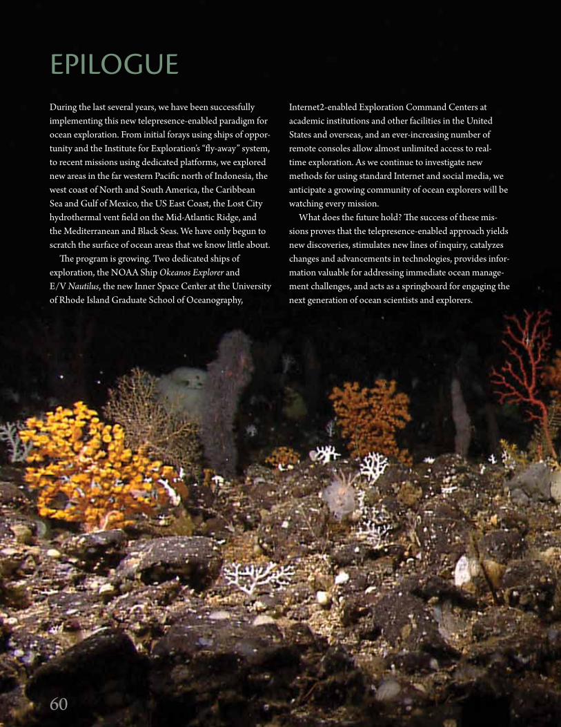
6060
During the last several years, we have been successfully implementing this new telepresence-enabled paradigm for ocean exploration. From initial forays using ships of oppor-tunity and the Institute for Exploration’s “fly-away” system, to recent missions using dedicated platforms, we explored new areas in the far western Pacific north of Indonesia, the west coast of North and South America, the Caribbean Sea and Gulf of Mexico, the US East Coast, the Lost City hydrothermal vent field on the Mid-Atlantic Ridge, and the Mediterranean and Black Seas. We have only begun to scratch the surface of ocean areas that we know little about.
The program is growing. Two dedicated ships of exploration, the NOAA Ship Okeanos Explorer and E/V Nautilus, the new Inner Space Center at the University of Rhode Island Graduate School of Oceanography,
Internet2-enabled Exploration Command Centers at academic institutions and other facilities in the United States and overseas, and an ever-increasing number of remote consoles allow almost unlimited access to real-time exploration. As we continue to investigate new methods for using standard Internet and social media, we anticipate a growing community of ocean explorers will be watching every mission.
What does the future hold? The success of these mis-sions proves that the telepresence-enabled approach yields new discoveries, stimulates new lines of inquiry, catalyzes changes and advancements in technologies, provides infor-mation valuable for addressing immediate ocean manage-ment challenges, and acts as a springboard for engaging the next generation of ocean scientists and explorers.
EPiLOgUE

61
To guide our exploration missions in 2012 and 2013, we conducted a workshop in May 2011, which provided an opportunity for scientists to identify targets in the Atlantic basin, including the Gulf of Mexico and Caribbean Sea. We plan to conduct a more in-depth workshop focused on the Caribbean in 2012. E/V Nautilus will transit through the Atlantic and Caribbean to the Pacific in 2013, while Okeanos Explorer will continue to concentrate on the Atlantic, Gulf of Mexico, and Caribbean.
We have been working with the ocean science and engineering communities on the installation of a multi-beam sonar system on E/V Nautilus, and on expanding to 6,000 m the depth capabilities of the ROV dedicated to Okeanos Explorer. We will continue to engage these communities in discussions concerning new sensors and
61
systems to continue to improve ship-based systems and the growing shore-based network.
During challenging economic times, this new para-digm for ocean exploration continues to demonstrate great value. Through telepresence technology, we can now explore remote regions with a far greater number of experts compared to traditional means, and deliver data, informa-tion, and preliminary findings in real and near-real time. And, most importantly, by maintaining our focus on truly unknown ocean areas, we have an opportunity to make significant discoveries that could, perhaps, stimulate new areas of the economy.
62
AUTHORSdAVid AMBLAS is a Phd candidate, University of Barcelona, Spain.diVA AMON is a Phd candidate, Ocean and Earth Science, University
of Southampton, UK.JENNiFER ARgENTA is Educational Programming Assistant,
Ocean Exploration Trust, Croton-on-Hudson, Ny.JAMES A. AUSTiN JR. is Senior Research Scientist, institute for
geophysics, University of Texas at Austin, Austin, Tx.EdWARd T. BAKER is Supervisory Oceanographer, NOAA, Pacific
Marine Environmental Laboratory, Seattle, WA.ROBERT d. BALLARd is director, Center for Ocean Exploration,
graduate School of Oceanography, University of Rhode island; President, Ocean Exploration Trust; and President, institute for Exploration, Mystic, CT.
JONATHAN BEAUdOiN is Research Scientist, Center for Coastal and Ocean Mapping, University of New Hampshire, durham, NH.
KATHERiNE L.C. BELL is Vice President, Ocean Exploration Trust and Chief Scientist, Nautilus Exploration Program, Narragansett, Ri.
KEELEy BELVA is a Public Affairs Specialist, NOAA, Office of Ocean Exploration and Research, Silver Spring, Md.
zVi BEN-AVRAHAM is Professor of geophysics, Tel Aviv University, and director, Charney School of Marine Sciences, University of Haifa, israel.
SARAH BENNET is Caltech Postdoctoral Scholar, National Aeronautics and Space Administration, Jet Propulsion Laboratory, Pasadena, CA.
MiCHAEL L. BRENNAN is a Phd candidate, graduate School of Oceanography, University of Rhode island, Narragansett, Ri.
iLyA V. BUyNEViCH is Assistant Professor, Earth and Environmental Science, Temple University, Philadelphia, PA.
MigUEL CALdERÓN is a scientist with Unidad Técnica de la Comisión Nacional sobre el derecho del Mar, Ecuador.
MiQUEL CANALS is Professor, University of Barcelona, Spain.STEVEN N. CAREy is Professor, graduate School of Oceanography,
University of Rhode island, Narragansett, Ri. ALExiS CATSAMBiS is Underwater Archaeologist and Cultural
Resource Manager, Underwater Archaeology Branch, US Naval History and Heritage Command, Washington, dC.
MiCHAEL CHEAdLE is Associate Professor of geophysics/Magmatic Processes, University of Wyoming, Laramie, Wy.
JAMESON CLARKE is a Phd candidate, duke University Marine Laboratory, Beaufort, NC.
dWigHT F. COLEMAN is director, inner Space Center, graduate School of Oceanography, University of Rhode island, Narragansett, Ri.
JOAN B. COMPANy is Senior Scientist, Marine Science institute of the Spanish Research Council, Barcelona, Spain.
JAViER CRiSTOBO is director, Oceanographic Centre of gijón, Spain.KATRiNA CUBiNA is Vice President of immersion Learning, Sea
Research Foundation, Mystic, CT.MARiNA CUNHA is Lecturer, Marine Conservation and Marine
Biology and Ecology, University of Aveiro, Portugal.dAN dAViS is Assistant Professor, Classical Archaeology, Luther
College, decorah, iA.BERTRANd dOUiLLARd is Postdoctoral investigator, Australian
Centre for Field Robotics, University of Sydney, Australia.MUHAMMET dUMAN is Associate Professor, institute of Marine
Science and Technology, dokuz Eylül University, Turkey.KELLEy ELLiOTT is Field Operations and Technology Specialist, NOAA,
Office of Ocean Exploration and Research, Silver Spring, Md.
ROBERT W. EMBLEy is Senior Research Scientist, NOAA, Pacific Marine Environmental Laboratory, Newport, OR.
KEViN FAURE is director, geological Resources division, gNS Science, Lower Hutt, New zealand.
SARAH A. FULLER is data Manager, institute for Exploration, Aspen, CO.CHRiSTOPHER R. gERMAN is Chief Scientist for deep Submergence,
Woods Hole Oceanographic institution, Woods Hole, MA.ATHANASiOS gOdELiTSAS is Assistant Professor, Mineralogy
and Mineral Chemistry, National Kapodistrian University of Athens, greece.
FREd gORELL is Public Affairs Officer, NOAA, Office of Ocean Exploration and Research, Silver Spring, Md.
SUSAN gOTTFRiEd is OER information Management Coordinator, NOAA, National Coastal data development Center, Stennis Space Center, MS.
STEPHEN HAMMONd is Acting Chief Scientist, NOAA, Office of Ocean Exploration and Research, and director, NOAA Vents Program, Pacific Marine Environmental Laboratory, Newport, OR.
SANTiAgO HERERRA is a Phd candidate, Woods Hole Oceanographic institution, Woods Hole, MA.
TAyLOR HEyL is Research Assistant, Woods Hole Oceanographic institution, Woods Hole, MA.
JAMES F. HOLdEN is Associate Professor, department of Microbiology, University of Massachusetts, Amherst, MA.
JULiE HUBER is Assistant Scientist, Marine Biological Laboratory, Woods Hole, MA.
gABRiELLE iNgLiS is a Phd candidate, department of Ocean Engineering, University of Rhode island, Narragansett, Ri.
KEViN JERRAM is a graduate student, University of New Hampshire, Center for Coastal and Ocean Mapping, durham, NH.
BARBARA JOHN is Professor, department of geology and geophysics, University of Wyoming, Laramie, Wy.
dARCy JOyCE is an undergraduate, department of Earth Sciences, Syracuse University, Syracuse, Ny.
CdR ROBERT KAMPHAUS is Commanding Officer, NOAA Ship Okeanos Explorer.
JEFFREy A. KARSON is Professor of geology and Chairman of the department of Earth Sciences, Syracuse University, Syracuse, Ny.
PAULA KEENER is Education Program director, NOAA, Office of Ocean Exploration and Research, Charleston, SC.
JOSHUA KELLy is a graduate student, graduate School of Oceanography, University of Rhode island, Narragansett, Ri.
JAMES KiNSEy is Assistant Scientist, Woods Hole Oceanographic institution, Woods Hole, MA.
ROBERT KNOTT is Senior Video Engineer, institute for Exploration, Narragansett, Ri.
MEKO KOFAHL is a graduate student, Nautical Archaeology Program, Texas A&M University, College Station, Tx.
T. JENNiFER LiN is a graduate student, department of Microbiology, University of Massachusetts, Amherst, MA.
ELizABETH LOBECKER is Physical Scientist, NOAA, Office of Ocean Exploration and Research, durham, NH.
dAVid LOVALVO is Underwater Operations Manager, NOAA, Office of Ocean Exploration and Research, Redding, CT.
yizHAQ MAKOVSKy is Senior Lecturer, department of Marine geosciences, Charney School of Marine Sciences, University of Haifa, israel.

63
AUTHORSMASHKOOR MALiK is Physical Scientist, NOAA, Office of Ocean
Exploration and Research, Silver Spring, Md.EUgENiA MANJÓN is Associate Professor, department of Biology,
University of Málaga, Spain. MiCHAEL MARANi is Senior Scientist, institute of Marine Science,
National Research Council, italy.CATALiNA MARTiNEz is Rhode island Regional Manager, NOAA,
Office of Ocean Exploration and Research, Narragansett, Ri.LARRy MAyER is director, Center for Coastal and Ocean Mapping,
University of New Hampshire, durham, NH.JiLL MCdERMOTT is an MiT-WHOi Joint Program student, Woods
Hole Oceanographic institution, Woods Hole, MA.JOHN MCdONOUgH is deputy director, NOAA, Office of Ocean
Exploration and Research, Silver Spring, Md.CAMERON MCiNTyRE is Research Associate, Woods Hole
Oceanographic institution, Woods Hole, MA.dAVid MCKiNNiE is international Affairs Senior Advisor, NOAA,
Office of Ocean Exploration and Research, Seattle, WA.MAUREEN MERRigAN is a graduate student, Nautical Archaeology
Program, Texas A&M University, College Station, Tx.SHARON MESiCK is OER information Management Team Federal
Program Manager, NOAA, National Coastal data development Center, National Oceanographic data Center, Stennis Space Center, MS.
CATRiONA MUNRO is Research Assistant, Woods Hole Oceanographic institution, Woods Hole, MA.
LT MEgAN NAdEAU is Operations Officer on board the NOAA Ship Okeanos Explorer.
ALEECE NANFiTO recently completed her master’s degree in Earth sciences, Syracuse University, Syracuse, Ny.
PARASKEVi NOMiKOU is Marine geologist, National Kapodistrian University of Athens, greece.
AMy O’NEAL is director of Educational Programming, Ocean Exploration Trust, Lyme, CT.
MiCHELLE PARKS is a Phd candidate, department of Earth Sciences, University of Oxford, UK.
BRENNAN PHiLLiPS is Operations Manager, institute for Exploration, Narragansett, Ri.
CdR JOSEPH PiCA is the former Commanding Officer of the NOAA Ship Okeanos Explorer.
WEBB PiNNER is Telepresence Operations Manager, NOAA, Office of Ocean Exploration and Research, Narragansett, Ri.
MARCO PiSTOLESi is a postdoctoral researcher, department of Earth Sciences, University of Pisa, italy.
PARASKEVi POLyMENAKOU is Researcher, Marine Biology and genetics, Hellenic Centre for Marine Research, greece.
JEREMy POTTER is Expedition Manager, NOAA, Office of Ocean Exploration and Research, Silver Spring, Md.
SUSAN POULTON is Vice President of digital Content Programming, National geographic Society, Washington, dC.
BRENdAN RESER is Oceanographer, OER information Management Team, NOAA, National Coastal data development Center, Stennis Space Center, MS.
LTJg gLEN RiCE is Team Lead, NOAA integrated Ocean and Coastal Mapping Center, Center for Coastal and Ocean Mapping, durham, NH.
CHRiS ROMAN is Assistant Professor, Ocean Engineering and graduate School of Oceanography, University of Rhode island, Narragansett, Ri.
MAURO ROSi is Professor, Earth Sciences, University of Pisa, italy.CRAig W. RUSSELL is Program Manager, Okeanos Explorer Program,
NOAA, Office of Ocean Exploration and Research, Seattle, WA. JEFF SEEWALd is department Chair, Marine Chemistry and
geochemistry, Woods Hole Oceanographic institution, Woods Hole, MA.
TiMOTHy M. SHANK is Associate Scientist, Biology department, Woods Hole Oceanographic institution, Woods Hole, MA.
PATRiCK SHEA is Vice President of Live Events, Sea Research Foundation, Chicago, iL.
BiLL SHEdd is a geophysicist for the gulf of Mexico Region, Bureau of Ocean Energy Management, New Orleans, LA.
AdAM SKARKE is Physical Scientist, NOAA, Office of Ocean Exploration and Research, durham, NH.
ELEANOR SMALLEy is Executive Vice President and Chief Operating Officer, The JASON Project, Ashburn, VA.
CLARA SMART is a graduate student, Ocean Engineering, University of Rhode island, Narragansett, Ri.
ELENi STATHOPOULOU is Research Associate, Laboratory of Environmental Chemistry, National Kapodistrian University of Athens, greece.
LUCy C. STEWART is a Phd candidate, department of Microbiology, University of Massachusetts, Amherst, MA.
dANiEL TCHERNOV is Head, Marine Biology department and deputy director, Charney School of Marine Sciences, University of Haifa, israel.
TUFAN TURANLi is Project Manager, Ocean Exploration Trust, Bodrum, Turkey.
SUNA TUzUN is a graduate student, Adnan Menderes University, Aydin, Turkey.
PAUL A. TyLER is Professor, deep-Sea Biology, University of Southampton, National Oceanography Centre, UK.
dERyA URKMEz is a Phd candidate, institute of Natural and Applied Sciences, Sinop University, Turkey.
CiNdy VAN dOVER is director, duke University Marine Laboratory, Beaufort, NC.
J. iAN VAUgHN is a graduate student, Ocean Engineering, University of Rhode island, Narragansett, Ri.
TOdd ViOLA is Website Producer, Sea Research Foundation, Arlington, VA.
SHARON L. WALKER is Oceanographer, NOAA, Pacific Marine Environmental Laboratory, Seattle, WA.
THOMAS C. WEBER is Research Assistant Professor, Center for Coastal and Ocean Mapping, University of New Hampshire, durham, NH.
SCOTT WHiTE is Associate Professor, department of Earth and Ocean Sciences, University of South Carolina, Columbia, SC.
STEFAN WiLLiAMS is Associate Professor, Australian Center for Field Robotics, University of Sydney, Australia.
ALExANdRA BELL WiTTEN is director of Programs, institute for Exploration, and Manager of Programs, Center for Ocean Exploration,, University of Rhode island, Narragansett, Ri.
64
ACKNOWLEdgEMENTSExECUTiVE COMMiTTEE• Robert D. Ballard25, 33, 84, GSO Professor and IFE/OET President• Katherine L.C. Bell84, Vice President and Chief Scientist• Laurie Bradt33, IFE Vice President• Dwight F. Coleman25, ISC Director• Robert Knott33, Senior Video Engineer• Ian Kulin33, Project Manager• Amy O’Neal84, Educator Program Director• Brennan Phillips33, Operations Manager• Chris Roman25, Mapping and Imaging Program Director• Alexandra Bell Witten25, 33, 84, Director of Programs and
Communications Chair
NAuTiLus AdViSORy BOARd• James A. Austin Jr.129
• Steven Carey 25
• Jeffrey A. Karson99
• Deborah Kelley74
• Larry Mayer122
• Timothy M. Shank133
E/V NAuTiLus EdUCATiON, OUTREACH, ANd COMMUNiCATiONS• James Alexander 103 • Jennifer Argenta84 • Artemia Argyriou104 • Laura Batt92 • Whitney Caldwell36 • Daniel Casey36 • Sean Corcoran103 • Katrina Cubina92 • Graham English103 • Lisa Friedman36 • Peter Glankoff92 • Jessica Harrop92 • Peter Haydock36 • Michael Hennessey36 • Kieren Hogan103 • Todd McLeish125 • Barbara Moffet55 • Susan Poulton55 • Melissa Salpietra32 • Patrick Shea92 • Eleanor Smalley36 • Jocelyne Smith36 • Todd Viola92 • The Dilenschneider Group Inc.
E/V NAuTiLus AT-SEA SCiENCE TEAM• Nigar Alkan38 • Ahuva Almogi-Labin22 • Husne Altiok35 • David Amblas110 • Gilad Antler119 • Varvara Antoniou55 • James A. Austin Jr.129 • Edward T. Baker80 • Esra Billur Balcioglu35 • Robert D. Ballard25, 33, 84 • Konstantina Bejelou55 • Katherine L.C. Bell84 • Zvi Ben-Avraham119 • Michael L. Brennan25 • Ilya V. Buynevich100 • Miquel Canals110 • Steven Carey25 • Alexis Catsambis61 • Dwight F. Coleman32 • Joan-Baptista Company44 • Javier Cristobo34 • Marina Cunha112 • Niv David119 • Dan Davis40 • Luisa Duenas111 • Muhammet Duman16 • Oded Ezra119 • Kevin Faure24 • Sarah A. Fuller33 • Allison Fundis130 • Samuel Georgian100 • Athanasios Godelitsas55 • Onur Gonulal35 • Ariela Goregia55 • Darcy Marie Joyce97 • Natalia Kapetenaki54 • Efstratios Karagiannis26 • Jeffrey A. Karson99 • Katerina Katsetsiadou55 • Joshua Kelly25 • Muhsine Kocakurt21 • Meko Kofahl101 • Isidoros Livanos55 • Jay Lunden100 • Yizhaq Makovsky119 • Eugenia Manjon120 • Michael Marani43 • Maureen Merrigan101 • Aaron Micallef110 • Ian Montgomery98 • Elizabeth Morrissey123 • Aleece Nanfito99 • Paraskevi Nomikou55 • Michelle Parks87 • Marco Pistolesi124 • Paraskevi Polymenakou30 • Nairooz Qupty119 • Nicole Raineault117 • Mauro Rosi124 • Maxim Rubin119 • Hiroaki Saito123 • Barbaros Simsek21 • Eleni Stathopoulou55 • Daniel Tchernov119 • Arda Tonay35 • Francesco Torre116 • Tufan Turanli33 • Suna Tuzun1 • Derya Urkmez94 • Sharon L. Walker80
E/V NAuTiLus AT-SEA MAPPiNg TEAM• Donald Dansereau5 • Bertrand Douillard5 • Ashton Flinders25 • Gabrielle Inglis25 • Chris Roman25 • Clara Smart25 • Lachlan Toohey5 • J. Ian Vaughn25
E/V NAuTiLus AT-SEA OPERATiONS TEAM• John Ahern133 • Robert Beard33 • Richard Bell83 • Roger Bewig62 • Jennifer Bline125 • Paul Brett47 • Steven Bucklew33 • Hannuman Bull33 • Julie Cudahy48 • Alex DeCiccio125 • Mark DeRoche33 • Gregg Diffendale33 • Michael Durbin33 • Carter DuVal117 • Benjamin Erwin33 • Michael Filimon125 • C. Scott Follett46 • Rachel Gaines41 • Todd Gregory33 • Jonathan Howland133 • Alexander Kavanaugh41, 125 • Robert Knott32 • Roderick MacLeod33 • Angelos Mallios110 • Eric Martin50 • Karl McLetchie33 • Jean-Louis Michel39 • Rhonda Moniz33 • Mary Nichols47 • Brennan Phillips33 • Thomas Pierce33 • Sergio Quesada110 • Brian Raynes33 • Hadar Sade119 • Allan Santos33
• Aviad Scheinin119 • S. Ryan Skelley47 • G. Matt Slusher33 • Wes Smith47 • Belinda Spalding62 • Scott Stamps33 • Emily Stickel47 • Derek Sutcliffe125 • Casey Taylor62 • Rami Tsadok119 • Kerry Whalen33 • Erika Young117 • Harrison Zimmer32
EdUCATORS-AT-SEA• Jennifer Argenta84 • Margaret Blitzer9 • Bonnie Cronin97 • Cory Culbertson114 • Dara Dawson20 • Debra Duffy8 • Samuel Garson51 • Katrina Homan9 • Randy Laurence102 • Charles Lockert28 • Emily Lovejoy9 • David Low95 • Deandra Ludwig37 • Thomas Menditto13 • Martin Momsen11 • Amy O’Neal84 • Sharon Pearson90 • Tiffany Risch14 • Krystal Waltman97
E/V NAuTiLus SHORE TEAM• Adam Arrighi32 • Laurie Bradt33 • Celia Cackowski32 • Dwight F. Coleman32 • Alex DeCiccio32 • Megan Ferguson32 • Cris Gomez32 • Robert Knott32 • Dave LePage32 • Catherine McCaughey32 • Janice Meagher33 • Angela Murphy33 • Kaitlyn Nevers32 • Derek Sutcliffe32 • Don Sweet32 • Dan Tundis32 • Brent Wallin32 • Harrison Zimmer32
JAsON ARgONAUTS ANd HONORS RESEARCH PROgRAM STUdENTS• Romeo Cruz36 • Kenton Hamlin9 • Devyn Jackson36 • Collin Janison36 • Courtney Paphites8 • Jason Pittman36 • Lucinda Reese36 • TaShawn Reese36 • Hillary Rodriguez36 • William Sawyer9 • Bennett Silverman9 • Erin Walsh36 • Jacob Zamora36
E/V NAuTiLus CREW ANd MARiTiME MANAgEMENT• Igor Abasov • Jeff Avery • Anatoliy Chamata • Pavel Chubar • Teddy Rey Endriga • Viktor Khmelnychenko • Sergiy Levchuk • Rohan MacAllister • Yuriy Malchenko • Serhiy Mazur • Albert Diaz Padlan • Sergey Semenov • Oleg Seredyuk • Bohdan Skylar • Recep Sulucak • John Toner • Fedir Uzun • Igor Varlygin • Vitaliy Verbitsky

65
ACKNOWLEdgEMENTS E/V NAuTiLus MAJOR SPONSORS ANd PARTNERS• Graduate School of Oceanography, University of Rhode Island• Office of Education, National Oceanic and
Atmospheric Administration• Office of Ocean Exploration and Research,
National Oceanic and Atmospheric Administration• Office of Naval Research• National Geographic Society• Sea Research Foundation• Ocean Exploration Trust Directors, Sponsors and Contributors
NOAA OCEAN ExPLORATiON AdViSORy WORKiNg gROUP• Vera Alexander115
• James A. Austin Jr.129
• Jesse Ausubel88
• Robert D. Ballard25, 33, 84
• Ruth Blake134
• Terry Garcia54
• Patricia Fryer29
• Larry Mayer122
• Timothy M. Shank133
OKEANOs ExPLORER AT-SEA MiSSiON TEAM• Adam Argento79 • Dave Armstrong113 • Jonathan Beaudoin122 • Brian Bingham113 • Joe Biscotti113 • Roland Brian113 • Brian Brinckman113 • Miguel Calderón18 • Frank Cantelas76 • Elizabeth Chase76 • Jeff Condiotty39 • Tony Dahlheim39 • Gregg Diffendale113 • Kelley Elliott76 • Christopher R. German133 • Denise Gordon71 • Todd Gregory113 • Ashley Harris113 • Vincent Howard113 • Kevin Jerram122 • Gustav Karl Kågesten113 • Steve Katz78 • Tom Kok113 • Nicolas Kraus113 • Elizabeth Lobecker76 • David Lovalvo76 • Anthony Lukach76 • Mashkoor Malik76 • Larry Mayer122 • Cameron McIntyre133 • Karl McLetchie113 • John Mefford113 • Bobby Mohr113 • Megan Nadeau81 • Andy O’Brien113 • Brendan Philip113 • Christopher Pinero76 • Webb Pinner76 • Jeremy Potter76 • Sharath Ravula113 • Brendan Reser71 • LTJG Glen Rice75 • Chris Ritter113 • Maddie Schroth-Miller122 • Timothy M. Shank133 • Bill Shedd7 • Adam Skarke76 • Paul A. Tyler59 • Thomas C. Weber122 • Jeff Williams113 • David Wright113
OKEANOs ExPLORER SHORE MiSSiON TEAM• Diva Amon128 • Edward T. Baker80 • Keeley Belva76 • Sarah Bennett53 • Eleanor Bors57, 133 • Nathan Buck80 • David Butterfield80 • Walter Cho133 • Michael Cheadle131 • Jameson Clarke17 • Max Coleman53 • Robert W. Embley80 • Stephen Hammond76, 80 • Santiago Herrera133 • James F. Holden121 • Julie Huber42 • Barbara John131 • James Kinsey133 • T. Jennifer Lin121 • Catalina Martinez76 • Tim McClinton126 • Jill McDermott45, 133 • John McDonough76 • Susan Merle80 • Teresa Mesa42 • Julie Meyer42 • Cat Munro133 • Mike Perfit118 • Joe Resing80 • Brendan Reser71 • Craig W. Russell76 • Jeff Seewald133 • Julie Smith42 • Lucy Stewart121 • Art Trembanis117 • Cindy Van Dover17 • Nicola VerPlanck76 • Sharon L. Walker80 • Scott White126 • Harrison Zimmer32
OKEANOs ExPLORER EdUCATiON, OUTREACH, ANd MEdiA TEAM• Keeley Belva76 • Joanne Flanders76 • Mel Goodwin • Sandra Goodwin10 • Fred Gorell76 • David Hall77 • Susan Haynes76 • Paula Keener76 • Melissa Ryan76
OKEANOs ExPLORER dATA MANAgEMENT TEAM• Anna Fiolek64 • David Fischman72 • McKinley Freeman71 • Denise Gordon71 • Susan Gottfried71 • Catalina Martinez76 • Sharon Mesick71 • LT Megan Nadeau81 • Andrew Navard71 • Webb Pinner76 • Brendan Reser71 • Thomas Ryan74
OKEANOs ExPLORER CREW• Kirk Andreopoulos • LT Michael Anthony • Kelson Baird • Jeff Brawley • Rainier Capati • Kyle Chernoff • Joseph Clark • Margret Collins • Richard Conway • James Deeton • Robert Dennis • Stephen Eshnaur • Ricardo Gabona • Ed Gahr • William Hance • John Herring • Michael Hocko • Jerrod Hozendorf • CDR Robert Kamphaus • LTJG Brian Kennedy • Michael Kruitwagen • Asher Liss • Dana Mancinelli • Randolph McCoade • Lanny McCormack • LT Megan Nadeau • LTJG Matthew O’Leary • Jonathan Peaks • LCDR Thomas Peltzer • Colleen Peters• ENS Felix Rivera • Christopher Rawley • Elaine Stuart • Lillian Stuart • Roy Toliver • Timothy Van Dyke • Carl VerPlanck • LCDR Nicola VerPlanck • Liam Vickers • Mark Walker • Steve Weber • Kenneth Wells
PARTNERS ANd PARTiCiPATiNg iNSTiTUTiONS1. Adnan Menderes University, Aydin, Turkey2. Agency for the Assessment and Application of Technology,
Jakarta, Indonesia3. Aquarium of the Pacific, Long Beach, CA4. Audubon Aquarium of the Americas, New Orleans, LA5. Australian Center for Field Robotics, University of Sydney,
Sydney, Australia6. Birch Aquarium at Scripps Institution of Oceanography, La Jolla, CA7. Bureau of Ocean Energy Management, New Orelans, LA8. Cape Henry Collegiate School, Virginia Beach, VA9. Choate Rosemary Hall, Wallingford, CT10. Coastal Images Graphic Design, Mount Pleasant, SC11. Cochrane-Fountain City School District, Fountain City, WI12. College of Exploration, Potomac Falls, VA13. Consolidated School District of New Britian, CT14. Coventry High School, Coventry, RI15. Dauphin Island Sealab, Dauphin Island, AL16. Dokuz Eylül University, Institute of Marine Science and Technology,
Izmir, Turkey17. Duke University Marine Lab, Beaufort, NC18. Ecuador Naval Oceanographic Institute, Guayaquil, Ecuador19. Exploratorium, San Francisco, CA20. Fredericksburg Academy, Fredericksburg, VA21. General Directorate of Mineral Research, Turkey22. Geological Survey of Israel, Jerusalem, Israel23. Georgia Aquarium, Atlanta, GA24. GNS Science, New Zealand25. Graduate School of Oceanography, University of Rhode Island,
Narragansett, RI26. Greek Ephorate of Antiquities, Ministry of Culture, Athens, Greece27. Gulf Coast Research Laboratory Marine Education Center,
Ocean Springs, MS28. Gwinnett School of Mathematics, Science and Technology,
Lawrenceville, GA29. Hawaii Institute of Marine Biology, University of Hawaii, Manoa30. Hellenic Center for Marine Research, Athens, Greece31. Ifremer, La Trinité-sur-Mer, France32. Inner Space Center, University of Rhode Island, Narragansett, RI33. Institute for Exploration, Mystic, CT

66
34. Instituto Español de Oceanografía, Spain35. Istanbul University, Istanbul, Turkey36. The JASON Project, Ashburn, VA37. John G. Shedd Aquarium, Chicago, IL38. Karadeniz Technical University, Trabzon, Turkey39. Kongsberg Underwater Technology, Inc., Lynnwood, WA40. Luther College, Decorah, Iowa41. Marine Advanced Technology Education Center, Monterey, CA42. Marine Biological Laboratory, Woods Hole, MA43. Marine Science Institute of the Italian National Research Council,
Bologna, Italy44. Marine Science Institute of the Spanish Research Council,
Barcelona, Spain45. Massachusetts Institute of Technology, Cambridge, MA46. Memorial University, Newfoundland, Canada47. Middle Tennessee State University, Murfreesboro, TN48. Milwaukee School of Engineering, Milwaukee, WI49. Ministry of Marine Affairs and Fisheries, Jakarta, Indonesia50. Monterey Bay Aquarium Research Institute, Monterey, CA51. Mount Rainier High School, Des Moines, WA52. NASA Astrobiology Science & Technology for Exploring Planets53. NASA Jet Propulsion Lab, Pasadena, CA54. National Geographic Society, Washington, DC55. National Kapodistrian University of Athens, Athens, Greece56. National Aquarium, Baltimore, MD57. National Institute of Water and Atmospheric Research, Auckland,
New Zealand58. National Marine Sanctuary Foundation, Silver Spring, MD59. National Oceanography Centre, Southampton, United Kingdom60. Nauticus National Maritime Center, Norfolk, VA61. Naval History and Heritage Command, Washington, DC62 Naval Oceanographic Office, Stennis Space Center, MS63. New England Aquarium, Boston, MA64. NOAA Central Library, Silver Spring, MD65. NOAA Channel Islands National Marine Sanctuary,
Santa Barbara, CA66. NOAA Gulf of the Farallones National Marine Sanctuary, San
Francisco, CA67. NOAA Marine Operations Center, Atlantic, Norfolk, VA68. NOAA Marine Operations Center, Pacific, Newport, OR69. NOAA Monitor National Marine Sanctuary, Newport News, VA70. NOAA Monterey Bay National Marine Sanctuary, Monterey, CA71. NOAA National Coastal Data Development Center,
Stennis Space Center, MS72. NOAA National Geophysical Data Center, Boulder, CO73. NOAA National Marine Fisheries Service, Silver Spring, MD74. NOAA National Oceanographic Data Center, Silver Spring, MD75. NOAA Office of Coast Survey, Silver Spring, MD76. NOAA Office of Ocean Exploration and Research,
Silver Spring, MD77. NOAA Office of Marine and Aviation Operations, Silver Spring, MD78. NOAA Office of National Marine Sanctuaries, Silver Spring, MD79. NOAA Pacific Hydrography Branch, Seattle, WA80. NOAA Pacific Marine Environmental Laboratory, Seattle, WA81. NOAA Ship Okeanos Explorer, Davisville, RI82. NOAA Ship Pisces, Pascagoula, MS83. Northeast Fisheries Science Center, National Marine Fisheries
Service, Woods Hole, MA84. Ocean Exploration Trust, Old Lyme, CT85. Oregon Sea Grant, Corvallis, OR
86. Oregon State University, Hatfield Marine Science Center, Newport, OR
87. Oxford University, Oxford, United Kingdom88. Rockefeller University, New York, NY89. Royal Geographic Society, Suffolk, United Kingdom90. Sandy Searles Miller IB World School, Las Vegas, NV91. Sant Ocean Hall, Washington, DC92. Sea Research Foundation, Mystic, CT93. SeaWorld Indonesia, Jakarta, Indonesia94. Sinop University, Sinop, Turkey95. Sound School, New Haven, CT96. South Carolina Aquarium, Charleston, SC97. Southwest High School, Houston, TX98. Stanford University, Palo Alto, CA99. Syracuse University, Syracuse, NY100. Temple University, Philadelphia, PA101. Texas A&M University, College Station, TX102. Texas A&M University, Kingsville, TX103. Titanic Belfast, Belfast, United Kingdom104. Top Melodi, Greek Radio, Greece105. UK Foreign and Commonwealth Office, London, United Kingdom106. US Department of State, Bureau of Oceans, Environment and
Science, Washington, DC107. US Embassy, Jakarta, Indonesia108. US Embassy, Quito, Ecuador109. US Geological Survey, Reston, VA110. Universidat de Barcelona, Barcelona, Spain111. Universidad de los Andes, Bogota, Colombia112. Universidade de Aveiro, Aveiro, Portugal113. University Corporation for Atmospheric Research, Boulder, CO114. University High School, Illinois State University, Normal, IL115. University of Alaska, Anchorage, AK116. University of Bologna, Bologna, Italy117. University of Delaware, Newark, DE118. University of Florida, Gainesville, FL119. University of Haifa, Haifa, Israel120. University of Málaga, Málaga, Spain121. University of Massachusetts, Amherst, MA122. University of New Hampshire, Center for Coastal and Ocean
Mapping, Durham, NH123. University of New Hampshire, Durham, NH124. University of Pisa, Pisa, Italy125. University of Rhode Island, Kingstown, RI126. University of South Carolina, Columbia, SC127. University of South Florida, College of Marine Science,
St. Petersburg, FL128. University of Southampton, Southampton, United Kingdom129. University of Texas, Austin, TX130. University of Washington, Seattle, WA131. University of Wyoming, Laramie, WY132. Waikiki Aquarium, Honolulu, HI133. Woods Hole Oceanographic Institution, Woods Hole, MA134. Yale University, New Haven, CT
The authors would like to thank the governments of the Republic of Turkey, Hellenic Republic, Italian Republic, Kingdom of Spain, Portuguese Republic, State of Israel, Republic of Indonesia, Republic of Ecuador, Republic of Costa Rica, Republic of Panama, Republic of Nicaragua, Republic of Honduras, United Kingdom, and British Overseas Territory of the Cayman Islands for their cooperation and continued support of ocean exploration in their waters.

67
REFERENCESAuzende, J.M., J.L. Olivet, J. Charvet, A. LeLann, X. LePichon,
J.H. Monteiro, A. Nicolas, and A. Ribeiro. 1978. Sampling and observation of oceanic mantle and crust on Gorringe Bank. Nature 273:46–59, http://dx.doi.org/10.1038/273046a0.
Baker, E.T., R.M. Haymon, J.A. Resing, S.M. White, S.L. Walker, K.C. Macdonald, and K. Nakamura. 2008. High-resolution surveys along the hotspot-affected Galápagos Spreading Center: 1. Distribution of hydrothermal activity. Geochemistry Geophysics Geosystems 9, Q09003, http://dx.doi.org/10.1029/2008GC002028.
Bosman, A., M. Calarco, D. Casalbore, F.L. Chiocci, M. Coltelli, A.M. Conte, E. Martorelli, C. Romagnoli, and A. Sposato. 2007. New insights into the recent submarine volcanism of Pantelleria Island. Pp. 177–178 in GNGTS (Gruppo Nazionale di Geofisica della Terra Solida) abstract session 1.3.
Brennan, M.L. 2010. The disarticulation of ancient shipwreck sites by mobile fishing gear: A case study from the southeast Aegean Sea. INA Quarterly 36(4):6–7.
Brennan, M.L., T. Turanli, B. Buxton, K.L. Croff Bell, C.N. Roman, M. Kofahl, O. Koyagasioglu, D. Whitesell, T. Chamberlain, T. Sullivan, and R. Ballard. 2011. Landscape imaging of the southeast Aegean Sea. Pp. 18–19 in New Frontiers in Ocean Exploration: The E/V Nautilus 2010 Field Season. K.L.C. Bell and S.A. Fuller, eds, Oceanography 24(1), supplement. Available online at: http://tos.org/oceanography/archive/24-1_supp.html (accessed December 26, 2011).
Butler, G.W. 1892. Abstract of Mr. A. Ricci’s account of the submarine erup-tion northwest of Pantelleria, October 1891. Nature 46:584–585, http://dx.doi.org/10.1038/046584a0.
Calanchi, N., P. Colantoni, P.L. Rossi, M. Saitta, and G. Serri. 1989. The Strait of Sicily continental rift system: Physiography and petrochemistry of the submarine volcanic centres. Marine Geology 87:55–83.
Carey, S., K.L.C. Bell, P. Nomikou, G. Vougioukalakis, C.N. Roman, K. Cantner, K. Bejelou, M. Bourbouli, and J. F. Martin. 2011. Exploration of the Kolumbo Volcanic Rift Zone. Pp. 24–25 in New Frontiers in Ocean Exploration: The E/V Nautilus 2010 Field Season. K.L.C. Bell and S.A. Fuller, eds. Oceanography 24(1), supplement, http://tos.org/oceanography/archive/24-1_supp.html (accessed December 26, 2011).
Civile, D., E. Lodolo, D. Accettella, R. Geletti, Z. Ben-Avraham, M. Deponte, L. Facchin, R. Ramella, and R. Romeo. 2010. The Pantelleria graben (Sicily Channel, Central Mediterranean): An example of intraplate ‘passive’ rift. Tectonophysics 490:173–183, http://dx.doi.org/10.1016/ j.tecto.2010.05.008.
Coleman, D.F., J.A. Austin Jr., Z. Ben-Avraham, and R.D. Ballard. 2011. Exploring the continental margin of Israel: “Telepresence” at work. Eos, Transactions American Geophysical Union 92(10), 81, http://dx.doi.org/ 10.1029/2011EO100002.
Coleman, D.F., and R.D. Ballard. 2001. A highly concentrated region of cold hydrocarbon seeps in the southeastern Mediterranean Sea. Geo-Marine Letters 21:162–167.
Connelly, D.P., J.T. Copley, B.J. Murton, K. Stansfield, P.A. Tyler, C.R. German, C.L. Van Dover, D. Amon, M. Furlong, N. Gindlay, and others. 2012. Hydrothermal vent fields and chemosynthetic bacteria on the world’s deepest seafloor spreading centre. Nature Communications, http://dx.doi.org/10.1038/ncomms1636.
Dekov, V.M., and C. Savelli. 2004. Hydrothermal activity in the SE Tyrrhenian Sea: An overview of 30 years of research. Marine Geology 204:161–185, http://dx.doi.org/10.1016/S0025-3227(03)00355-4.
Duman, M., S. Duman, T.W. Lyons, M. Avci, E. Izdar, and E. Demirkurt. 2006. Geochemistry and sedimentology of shelf and upper slope sedi-ments of the south-central Black Sea. Marine Geology 227:51–65, http://dx.doi.org/10.1016/j.margeo.2005.11.009.
Fisher, C., H. Roberts, E. Cordes, and B. Bernard. 2007. Cold seeps and asso-ciated communities of the Gulf of Mexico. Oceanography 20(4):118–129, http://dx.doi.org/10.5670/oceanog.2007.12.
Gardner, J.V., M. Malik, and S. Walker. 2009. Plume 1400 meters high discovered at the seafloor off the Northern California Margin. Eos, Transactions American Geophysical Union 90(32):275, http://dx.doi.org/10.1029/2009EO320003.
German, C.R., A. Bowen, M.L. Coleman, D.L. Honig, J.A. Huber, M.V. Jakuba, J.C. Kinsey, M.D. Kurz, S. Leroy, J.M. McDermott, and others. 2010. Diverse styles of submarine venting on the ultra-slow spreading Mid-Cayman Rise. Proceedings of the National Academy of Sciences of the United States of America 107:14,020–14,025, http://dx.doi.org/10.1073/pnas.1009205107.
Girardeau, J., G. Cornen, M.-O. Beslier, B. Le Gall, C. Monnier, P. Agrinier, G. Dubuisson, L. Pinheiro, A. Ribeiro, and H. Whitechurch. 1998. Extensional tectonics in the Gorringe Bank rocks, Eastern Atlantic Ocean: Evidence of an oceanic ultra-slow mantellic accreting centre. Terra Nova 10:330–336, http://dx.doi.org/ 10.1046/j.1365-3121.1998.00209.x.
Gwiazda, R., C.K. Paull, D.W. Caress, E. Lundsten, K. Anderson, and H. Thomas. 2011. Seafloor morphology associated with deep-water gas plumes near Eel Canyon. Poster session presented at the 2011 fall Meeting of the American Geophysical Union, December 5–9, San Francisco, CA.
John, B.E., and M.J. Cheadle. 2010. Deformation and alteration associated with oceanic and continental detachment fault systems: Are they similar? Pp. 175–205 in Diversity of Hydrothermal Systems on Slow Spreading Ocean Ridges. Geophysical Monograph Series 188, P.A. Rona, C.W. Devey, J. Dyment, and B.J. Murton, eds, American Geophysical Union, Washington, DC, http://dx.doi.org/10.1029/2008GM000772.
Johnson-Roberson, M., O. Pizarro, S.B. Williams, and I.J. Mahon. 2010. Generation and visualization of large-scale three-dimensional reconstructions from underwater robotic surveys. Journal of Field Robotics 27(1):21–51, http://dx.doi.org/10.1002/rob.20324.
Karson, J.A., E.A. Williams, G.L. Früh-Green, D.S. Kelley, D.R. Yoerger, and M. Jakuba. 2006. Detachment shear zone on the Atlantis Massif Core Complex, Mid-Atlantic Ridge 30°N. Geochemistry, Geophysics, Geosystems 7(6), http://dx.doi.org/10.1029/2005GC001109.
Kelley, D.S., J.A. Karson, D.K. Blackman, G. Früh-Green, D. Butterfield, M. Lilley, E.J. Olson, M.O. Schrenk, K.R. Roe, J. Lebon, and A.-S. Party. 2001. An off-axis hydrothermal vent field near the Mid-Atlantic Ridge at 30°N. Nature 412:146–149, http://dx.doi.org/10.1038/35084000.
Kelley, D.S., G.L. Früh-Green, J.A. Karson, and K.A. Ludwig. 2007. Lost City hydrothermal field revisited. Oceanography 20(4):90–99, http://dx.doi.org/10.5670/oceanog.2007.09.
Kilias S., P. Nomikou, A. Godelitsas, P. Polymenakou, E. Stathopoulou, S. Carey. 2011. Interdisciplinary mineralogic, microbiological and chemi-cal studies of active Kolumbo shallow submarine arc-related hydrothermal vent field, Aegean Sea: Preliminary results. Poster presented at the William Smith Meeting 2011: Remote Sensing of volcanoes & Volcanic processes: Integrating observation & modelling, Geological Society, London, 4–5 October 2011, London.
Lupton, J., C. deRonde, M. Sprovieri, E. Baker, P. Bruno, F. Italiano, S. Walker, K. Faure, M. Leybourne, K. Britten, and R. Greene. 2011. Active hydrothermal discharge on the submarine Aeolian Arc. Journal of Geophysical Research 116, B02102, http://dx.doi.org/ 10.1029/2010JB007738.
MacDonald, I.R., I.L.R. Sassen, P. Stine, R. Mitchell, and N.J. Guinasso. 2002. Transfer of hydrocarbons from natural seeps to the water column and atmosphere. Geofluids 2:95–107, http://dx.doi.org/ 10.1046/j.1468-8123.2002.00023.x.
Mahon, I., S.B. Williams, O. Pizarro, and M. Johnson-Roberson. 2008. Efficient view-based SLAM using visual loop closures. IEEE Transactions on Robotics 24(5):1,002–1,014, http://dx.doi.org/10.1109/TRO.2008.2004888.
Mauffret, A., A. Maldonado, and A.C. Campillo. 1992. Tectonic frame-work of the Eastern Alboran and Western Algerian basins, western Mediterranean. Geo-Marine Letters 123:104–110, http://dx.doi.org/ 10.1007/BF02084919.

68
Milkov, A.V., and R. Sassen. 2000. Thickness of the gas hydrate stability zone, Gulf of Mexico continental slope. Marine and Petroleum Geology 17:981–991, http://dx.doi.org/10.1016/S0264-8172(00)00051-9.
Monecke, T., S. Petersen, K. Lackschewitz, M. Hugler, M. Hannington, and J. Gemmel. 2009. Shallow submarine hydrothermal systems in the Aeolian volcanic arc, Italy. Eos, Transactions American Geophysical Union 90(13):110–111, http://dx.doi.org/10.1029/2009EO130002.
Muñoz, A., M. Ballesteros, I. Montoyac, J. Rivera, J. Acosta, and E. Uchupi. 2008. Alboran Basin, southern Spain: Part I. Geomorphology. Marine and Petroleum Geology 25:59–73, http://dx.doi.org/10.1016/ j.marpetgeo.2007.05.003.
Nikolovska, A., H. Sahling, and G. Bohrmann. 2008. Hydroacoustic methodology for detection, localization, and quantification of gas bubbles rising from the seafloor at gas seeps from the eastern Black Sea. Geochemistry Geophysics Geosystems 9, Q10010, http://dx.doi.org/10.1029/2008GC002118.
NRC (National Research Council). 2012. A Framework for K–12 Science Education Practices, Crosscutting Concepts, and Core Ideas. National Academies Press, Washington, DC, 320 pp.
Roberts, H.H., and R.S. Carney. 1997. Evidence of episodic fluid, gas, and sediment venting on the northern Gulf of Mexico continental slope. Economic Geology 92:863–879, http://dx.doi.org/10.2113/gsecongeo.92.7-8.863.
Roman, C., G. Inglis, and J. Rutter. 2010a. Application of structured light imaging for high resolution mapping of underwater archaeological sites. OCEANS 2010 IEEE, Sydney, Australia, http://dx.doi.org/10.1109/OCEANSSYD.2010.5603672.
Roman, C.N., G. Inglis, J.I. Vaughn, S. Williams, O. Pizarro, A. Friedman, and D. Steinberg. 2010b. Development of high-resolution underwater mapping techniques. Pp. 14–17 in New Frontiers in Ocean Exploration: The E/V Nautilus 2010 Field Season. K.L.C. Bell and S.A. Fuller, eds. Oceanography 24(1), supplement, http://tos.org/oceanography/archive/24-1_supp.html (accessed December 26, 2011).
Roman, C., and H. Singh. 2007. A self-consistent bathymetric mapping algorithm. Journal of Field Robotics 24(1–2):26–51, http://dx.doi.org/ 10.1002/rob.20164.
Rotolo, S.G., F. Castorina, D. Cellula, and M. Pompilio. 2006. Petrology and geochemistry of submarine volcanism in the Sicily Channel. Journal of Geology 114:355–365, http://dx.doi.org/10.1086/501223.
Shank, T.M., D. Fornari, and D. Yoerger. 2003. Deep submergence synergy: Alvin and ABE explore the Galápagos Rift at 86°W. Eos, Transactions American Geophysical Union 84:425–433, http://dx.doi.org/10.1029/ 2003EO410001.
Shank, T.M., D.J. Fornari, K.L. Von Damm, M.D. Lilley, R.M. Haymon, and R.A. Lutz. 1998. Temporal and spatial patterns of biological com-munity development at nascent deep-sea hydrothermal vents along the East Pacific Rise. Deep-Sea Research Part II 46:465–515, http://dx.doi.org/10.1016/S0967-0646(97)00089-1.
Sigurdsson, H., S. Carey, M. Alexandri, G. Vougioukalakis, K.L. Croff, C. Roman, D. Sakellariou, C. Anagnostou, G. Rousakis, C. Ioakim, and others. 2006. Marine investigations of Greece’s Santorini volcanic field. Eos, Transactions American Geophysical Union 87(34), 337, http://dx.doi.org/10.1029/2006EO340001.
Smith, D.K., J.R. Cann, and J. Escartín. 2006. Widespread active detachment faulting and core complex formation near 13°N on the Mid-Atlantic Ridge. Nature 442:440–443, http://dx.doi.org/10.1038/nature04950.
Ward, C., and R. Ballard. 2004. Black Sea shipwreck survey 2000. International Journal of Nautical Archaeology 33:2–13.
Washington, H.S. 1909. The submarine eruptions of 1831 and 1891 near Pantelleria. American Journal of Science Series Four 27:131–150, http://dx.doi.org/10.2475/ajs.s4-27.158.131.

Credits Support for this publication is provided by the Ocean Exploration Trust and the National Oceanic and Atmospheric Administration, Office of Ocean Exploration and Research. ©2012 The Oceanography Society
Editor: Ellen Kappel Assistant Editor: Vicky CullenLayout and design: Johanna Adams
Permission is granted to reprint in whole or in part for any noncommercial, educational uses. The Oceanography Society requests that the original source be credited.
Single printed copies are available upon request from [email protected].

Related Documents


