1 Coastal CRC Coastal Water Habitat Mapping Project, Coastal Geomorphology Subproject (CG): Report on the Relationships between Marine Geology and the Benthic Habitats of the Recherché Archipelago inner shelf, Western Australia. Milestone Report CG4.04B Authors: David Ryan, Brendan Brooke, Lindsay Collins, Andy Bickers, Katrina Baxter, and Justy Siwabessy. 1. Introduction The Recherché Archipelago comprises a unique series of rocky islands that lie within the westernmost reaches of the Great Australian Bight (GAB), the world’s largest cool-water carbonate depositional province (Bone et al., 1994; James et al., 2001). The Archipelago is geomorphically complex, comprising Proterozoic through to Late Quaternary bedrock outcrops that occur within a mixed carbonate and siliciclastic shallow water shelf environment (Fairbridge and Serventy, 1954). A major current research focus in the Archipelago is mapping benthic habitats at a range of scales and levels of detail (Kendrick et al., 2002; Baxter, 2003). This research is being driven by concerns about potential negative impacts of proposed fisheries aquaculture developments on the diverse but poorly understood marine biota of the region (Fisheries WA, 2000; Figure 1). Although research is being undertaken on the fisheries ecology and other marine ecological systems in the Archipelago (Kendrick et al., 2002; Baxter, 2003; Bickers, 2003), seabed geomorphology and sedimentary processes, which exert fundamental controls on marine habitat distributions, have not been investigated in any detail. 1.1 Aims In this paper we examine relationships between bottom sediments, geomorphology, wave energy and the distribution of benthic habitats in Esperance Bay, an inner-shelf area typical of the Recherché Archipelago. Because relatively few studies have been conducted on this remote region, we also provide a brief review of the geomorphology and surficial sediments of other parts of the GAB with particular relevance to the Recherché Archipelago. The specific aims of the study are:

Welcome message from author
This document is posted to help you gain knowledge. Please leave a comment to let me know what you think about it! Share it to your friends and learn new things together.
Transcript
1
Coastal CRC Coastal Water Habitat Mapping Project,
Coastal Geomorphology Subproject (CG):
Report on the Relationships between Marine Geology and the Benthic Habitats of the Recherché Archipelago inner
shelf, Western Australia.
Milestone Report CG4.04B
Authors:
David Ryan, Brendan Brooke, Lindsay Collins, Andy Bickers, Katrina Baxter, and Justy Siwabessy.
1. Introduction The Recherché Archipelago comprises a unique series of rocky islands that lie within the westernmost reaches of the Great Australian Bight (GAB), the world’s largest cool-water carbonate depositional province (Bone et al., 1994; James et al., 2001). The Archipelago is geomorphically complex, comprising Proterozoic through to Late Quaternary bedrock outcrops that occur within a mixed carbonate and siliciclastic shallow water shelf environment (Fairbridge and Serventy, 1954). A major current research focus in the Archipelago is mapping benthic habitats at a range of scales and levels of detail (Kendrick et al., 2002; Baxter, 2003). This research is being driven by concerns about potential negative impacts of proposed fisheries aquaculture developments on the diverse but poorly understood marine biota of the region (Fisheries WA, 2000; Figure 1). Although research is being undertaken on the fisheries ecology and other marine ecological systems in the Archipelago (Kendrick et al., 2002; Baxter, 2003; Bickers, 2003), seabed geomorphology and sedimentary processes, which exert fundamental controls on marine habitat distributions, have not been investigated in any detail. 1.1 Aims In this paper we examine relationships between bottom sediments, geomorphology, wave energy and the distribution of benthic habitats in Esperance Bay, an inner-shelf area typical of the Recherché Archipelago. Because relatively few studies have been conducted on this remote region, we also provide a brief review of the geomorphology and surficial sediments of other parts of the GAB with particular relevance to the Recherché Archipelago. The specific aims of the study are:
2
1) To investigate in detail the marine geology and sedimentary dynamics of the Recherché Archipelago.
2) To use the detailed bathymetric maps provided by the Reson Seabat 8125 multibeam sonar to assess the geomorphic features of the seabed in vicinity of Woody Island and Remark Island.
3) Collect a representative set of sediment grab samples from Esperance Bay, to investigate the relationship between seabed sediments and pre-defined ecological habitat classes.
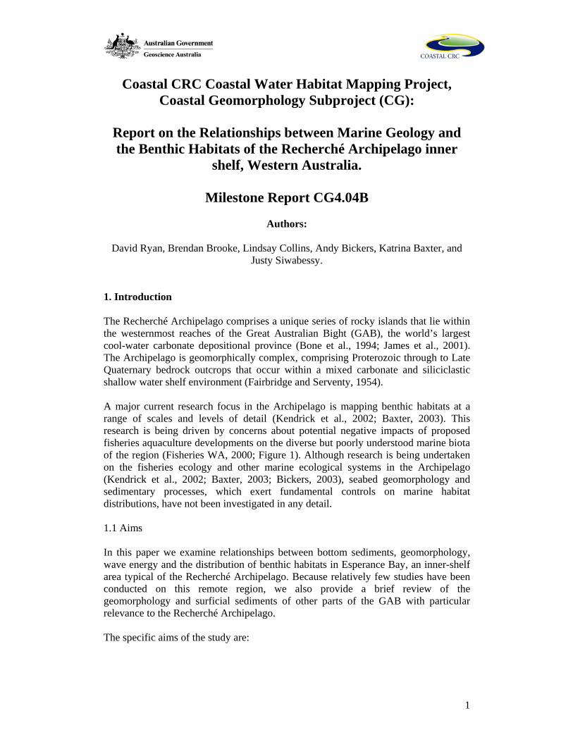
1.2 Study Participants and Collaboration Participants in the collaborative sediment survey included David Ryan (GA, Curtin University of Technology, CUT), Katrina Baxter (University of Western Australia, UWA), Simon Grove (UWA), Andy Bickers (UWA), and Paul Rose (Coastal Eco Charters, Esperance). Other participants in the concurrent multibeam survey included Dr Rob McCauley (CUT), Dr Justy Siwabessy (CUT), and Marcus Gray (RV Firebird). The first Geoscience Australia (GA) sediment survey in the Recherche Archipelago was conducted during October-November, 2003 (Ryan, 2004). The sediment sampling programme was initiated as a survey of opportunity, in collaboration with the Coastal Water Habitat Mapping Reson 8125 multibeam survey that was conducted in the Recherche Archipelago. After further internal review and permission from the Fisheries Research and Development Corporation (FRDC; Kendrick et al., 2004), this work is intended for submission to the journal Estuarine, Coastal and Shelf science. As such, the authors request that the information herein be kept confidential to the Coastal CRC and partners until the publication process is complete. 2. Regional setting 2.1 Overview The Recherché Archipelago spans a section of the south-western coast of Western Australia, between longitude 121°30’E and 124°15’E, around latitude 34° south. The study area, Esperance Bay, is situated in the western portion of the Recherché Archipelago, in the vicinity of the town of Esperance (Figure 1). The Archipelago was first charted in detail by Matthew Flinders in 1802, and comprises 105 dome-shaped islands, and more than 1500 islets and exposed shoals (Fisheries WA, 2000).
3
121°48'0"E
121°48'0"E
122°6'0"E
122°6'0"E
34°1
2'0"
S33
°54'
0"S
0 10 20 305Kilometres
Esperance Bay
Perth
WESTERNAUSTRALIAEsperance
Cape Le Grand
Woody IslandGroup
Remark IslandGroup
34°1
2'0"
S33
°54'
0"S
180150
120
210
240
270
300
330
090
060
030000
Frequency of peak wave direction(3 hour observations)
500 1000
Figure 1 – Location of Esperance Bay in Western Australia. The wind rose diagram indicates the frequency of wave direction for the Esperance region (after Kendrick et al., 2004). 2.2 Climate and Oceanography The Mediterranean-type climate that dominates south-western Western Australia features moderate temperatures, very dry summers, and cool wet winters. Average minimum and maximum temperatures in summer range from 16-26 oC (max. 35 oC, January - February), whereas average winter temperatures range from 8-17 oC (min. 7 oC, June - August). Mean annual rainfall in the Esperance region is 623 mm, 50% of which occurs between May and August, however average annual evaporation is about 1600 mm, and is greatest during the summer months. As a result, the region is generally arid and this, coupled with the low-relief onshore topography, results in minimal fluvial discharge into coastal waters. The dominant wind direction in summer is from the southeast, and afternoon sea breezes occur from October to March. In Jan and Feb, over 25% of sea breezes exceed 30km/h. During winter, south-west winds frequently prevail and regular north-west storm events occur, with calmer periods between fronts (Sanderson et al., 2000). Currents vary in intensity, and interaction between upwelling cooler waters from the south, and the warmer waters of the eastward-flowing Leeuwin Current produces a seasonally variable oceanographic climate (McGowran et al., 1997; Pearce and Pattiaratchi, 1997). Sea temperatures vary from a summer maximum of 20ºC to a spring minimum of 16ºC, with little temperature-induced stratification. Salinity is typically slightly less than 36‰, and the semi-diurnal spring-tidal range is 1.1 m (Pearce and Pattiaratchi, 1997).
4
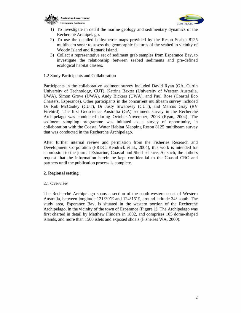
The south-west coast of Western Australia is exposed to the most extreme wave energy of the entire Australian coastline (Harris et al., 2002). The Recherché Archipelago is constantly under the influence of high intensity south-westerly ocean swells throughout the year (Figure 2). The south-west swell regime features high modal deep-water wave heights (> 2.5 m), and long swell periods (> 12 s), with wavelengths up to 200 m reported (Kendrick et al., 2002). Storm wave energy during the winter is often extreme, although the Port of Esperance receives a small degree of shelter from the islands of the Archipelago (Harris and O’Brien, 1998).
Figure 2 – Map RMS wave height (in metres) for the Esperance region (after Kendrick et al., 2004). See Figure 1 for frequency of wave direction.
2.3 Bathymetry The continental shelf in the Recherché region has an uneven topography, and at the continental slope drops rapidly to approximately 3600 m, contrasting with the gently sloping shelf of the main GAB region (Connolly and Von Der Borch, 1967). Numerous deep submarine canyon systems exist at the margin of the continental shelf, including the Bremer, Stokes, and Esperance Canyons (Von der Borch, 1968). The head of the Esperance Canyon lies in about 100 m of water, about 30 km offshore from Esperance at the edge of the continental shelf. A sediment-filled palaeo-valley is thought to extend from the shore near Esperance out to the head of the Esperance Canyon (Von der Borch, 1968; Clarke et al., 1996). Within the inner Recherché Archipelago shelf, the average seafloor depth is about 40 m, and the majority of the islands occur inshore of the 50 m bathymetric contour. A few islands occur nearer to the shelf edge in as much as 80 m of water (Australian Hydrographic Service, 1990; Figure 3). 2.4 Regional Geology
5
The Recherché Archipelago lies within the Middle Proterozoic granites, gneisses and migmatites of the Nornalup Complex, in the ancient Yilgarn Craton (Nelson et al., 1995; Clark et al., 2000). Outcrops of these rocks form conspicuous steep-sided mountains onshore, and numerous dome-shaped islands and shoals that rise from the inner continental shelf. The complex Proterozoic topography protrudes through the mainly flat Tertiary to Quaternary sequences (Myers 1990, 1995). Deposition of estuarine and mixed siliciclastic-carbonate sediment has been occurring in the region since at least the middle Eocene, resulting in long-term coastal progradation. These sediments now form the extensive Norseman Formation Limestone (Clarke et al., 1996) that is overlain by Quaternary calcarenites and unconsolidated recent sediments of the Esperance Coastal Plain, and the Esperance Sandplain Formations (Morgan and Peers, 1973). It is thought that numerous outcrops of Tertiary limestone and Pleistocene calcarenite occur offshore, and some of the Proterozoic islands are capped by remnants of Tertiary limestone (James et al., 1994; Kendrick et al., 2002). The modern shoreline is characterised by coastal sand barriers and transgressive dune systems that have developed between rocky headlands, which form south-east facing crenulate-shaped bays (Sanderson et al., 2000). Marine erosion of the coast is evident for the whole region, and has incised into the resistant basement rocks and the patches of younger limestone. Rock platforms and drowned shorelines have been reported offshore at depths of 6-8 m, 11-13 m, 16-21 m and at 54-100 m below sea level (Morgan and Peers, 1973; Myers, 1995), reflecting marine abrasion and lower sea-level still-stands in the region during the Quaternary. Several small creeks arise in the sandplain and flow to small lakes and inter-dune lagoons near the coast, however, provide negligible sediment input to the ocean because of the extremely low flow (Harris and O’Brien, 1998). Bandy Creek, adjacent to Esperance Bay, has a small catchment and a very low, seasonally erratic flow (Figure 3). Esperance Bay is a wide, semi-enclosed embayment that is open mainly to the south-west. The bay is bordered by Cape Le Grand to the east, and Observatory Point to the west. There are two main granitic island groups within the embayment, namely the Woody Island group (comprising Woody, Thomas, Gunton and Canard Islands), and the Remark Island group (comprising Remark, Sandy Hook, Long and Frederick Islands). 2.5 Quaternary Geology and Geomorphology An increasing body of literature has been produced regarding Quaternary non-tropical carbonate sediments, and their relevance in terms of the distribution of carbonate-producing biota and the global production and accumulation of carbonate sediments (Mount, 1984; Nelson, 1988; Rao, 1996; James, 1997). Quaternary sedimentation on the high-energy cool-water carbonate shelf of the GAB has largely been restricted by wave abrasion processes, and it has been suggested that the focus of sediment accumulation is currently on the mid- to outer-shelf, below the storm wave base (Feary and James, 1998). The GAB also features elements of pure carbonate production and accumulation, as well as a smaller degree of mixed siliciclastic-carbonate deposits on parts of the inner shelf. Contrasting with tropical systems, which tend to experience short-term storm episodes, sediment mixing in the cool-
6
water carbonate settings of the GAB is controlled by year-round high swell energy, which influences the seabed down to at least mid-shelf depth (James, 1997). Shelf Sediments of the Great Australian Bight The GAB is a large continental embayment, stretching approximately 1300 km eastward from the Recherché Archipelago to the Eyre Peninsula in South Australia (Figure 1). The shelf is an immense and generally flat submarine plain, up to 260 km wide at the Head of Bight (James et al., 2001). The GAB shelf has been subdivided into the lower shoreface-inner shelf (< 50 m water depth), middle shelf (50 to 120 m) and outer shelf, which extends to the shelf break (125 to 170 m). Along the margin, the outer shelf is 10 to 30 km wide, except in the west where the whole shelf narrows to < 30 km (James et al., 2001). The provinces of the GAB carbonate realm include the Lacepede Shelf to the east (Gostin et al., 1988; James et al., 1992; Bone and James, 1993; Hageman et al., 1995), the Eucla Shelf (James et al., 1994; Feary and James, 1998), bordered by the Otway Shelf further to the east (Boreen and James, 1993). The high degree of wave energy is responsible for sorting sands by oscillatory motion to depths of over 100 m, strongly influencing the distribution of surficial sediments on the mid- to inner-shelf (James et al., 1994; James et al., 2001). The presence of inner shelf limestone outcrops has led to the term ‘shaved shelf’ being coined for shallow areas of the GAB where wave abrasion is dominant (James et al., 1994; Li et al., 1999). Sediments found in < 100 m water depth comprise mainly coarse-grained sand and gravel, with a significant (> 50%) relict (or ‘palimpsest’) fraction that attests to wave reworking and slow accumulation (James et al., 2001). Temperate carbonate-dominated marine environments tend to be dominated by the heterozoan assemblage, described by James (1997), which comprises mainly bryozoans, bivalves, red algae, benthic foraminifera and barnacles. However, in the western GAB, it has been shown that the seasonal warm-water influence of the Leeuwin Current affects sedimentation, allowing significant production by species usually identified with the tropical photozoan assemblage (James et al., 2001). In deeper water (below the storm wave base), extensive spiculitic carbonate mud deposition occurs. At this depth, sediment accumulation can occur, and consequently a 500 m thick prograding sediment wedge has been deposited on the mid- to outer-shelf during the Quaternary, produced mainly by heterozoan organisms (Feary and James, 1998). Shelf Sediments of the Recherché Archipelago At present, very little research has been undertaken on the Quaternary sediments of the inner shelf of the GAB, including the Recherché Archipelago, partly due to the remoteness and high-energy nature of the surrounding coast. However, the abundance of carbonate producing organisms on the inner shelf has previously been predicted, due to the known influence of the warm water Leeuwin Current (McGowran et al., 1997). In the Recherché, living representatives of sub-tropical to tropical biota such as the calcareous alga Halimeda, and the benthic foraminifera Marginopera and Amphisorus are plentiful, and are suspected to significantly boost rates of carbonate production on the inner shelf (Cann and Clarke, 1993; Bone et al., 1994; Li et al., 1999). In addition to this, the more typical cool-water carbonate contributors of the heterozoan association (James, 1997), are also present in abundance, including bryozoan, mollusc, and rhodolith components. Accumulations of quartz-feldspar sand
7
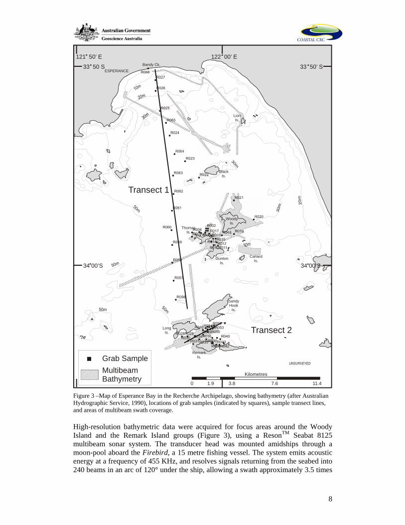
have been observed at the littoral margins of the islands of the Archipelago, mixed with bioclastic carbonate sands (Cann and Clarke, 1993). The Holocene sediments are mixed with relict Pleistocene particles, typically towards the middle shelf, and the accumulation of recent sediments is thought to be thin (< 2 m), forming a discontinuous veneer over older Tertiary limestones and Pleistocene calcarenites. (Li et al., 1999). 3. Materials and methods 3.1 Study Design In this study we principally investigate the nature of the Quaternary sediments, and their relationships with geomorphology, wave energy, and the distribution of benthic habitats in Esperance Bay. The benthic habitats of Esperance Bay have been previously mapped using high-frequency sidescan sonar and underwater video (Bickers, 2003). Seabed morphology and habitat boundaries in the bay are based on a nearly complete side-scan sonar coverage of the bay, which was ground-truthed with a towed video that also enabled the identification of the dominant benthic biota. These data were used to produce the 1:100,000 map of 12 habitat classes (Kendrick et al., 2004; Baxter, 2003). In this study, we amalgamate the more similar habitat classes of Baxter (2003) into six broader habitat types. For each of these habitats, we examine samples of sediment, underwater video, high-resolution multi-beam bathymetry and wave-exposure data. We then explore the relationship between these physical benthic features and the areal distribution of benthic habitats. 3.2 Field Program This study is focussed on the seabed of Esperance Bay adjacent to the Remark and Woody Island groups, and along a transect across the bay, from the Remark Island group to Bandy Creek, approximately 20 km in length (Figure 3). Sediment samples, approximately 0.5 litres in volume, were collected using a hand-deployed Shipeck grab-sampler from a 10 m charter vessel, in November 2003. Sites around the Remark and Woody Island groups were targeted (Figure 3) in order to adequately represent the various habitat types. Video imagery of the seabed was acquired using equipment and procedures reported in Baxter (2003), and Bickers (2003). Briefly, during video-camera tows, a live video display is transmitted to the surface via a cable, and information from the GPS and depth sounder are also displayed on screen. This system allowed the real-time inspection of benthic features, and adjustment of camera altitude. The video imagery was used in the field to assess and select areas for sediment grab sampling, and to ensure that grab samples obtained were representative of the wider area. Video data were retained for each of the grab sampling sites.
8
0 3.8 7.6 11.41.9
Kilometres
Transect 2
Transect 1
MultibeamBathymetry
Grab Sample
34 00’S
33 50’ S
122 00’ E
34 00’S
33 50 S
121 50’ E
WoodyIs.
ThomasIs.
BlackIs.
Bandy Ck.ESPERANCE
GuntonIs.
SandyHook
Is.
RemarkIs.
LongIs.
CanardIs.
LionIs.
Figure 3 –Map of Esperance Bay in the Recherche Archipelago, showing bathymetry (after Australian Hydrographic Service, 1990), locations of grab samples (indicated by squares), sample transect lines, and areas of multibeam swath coverage. High-resolution bathymetric data were acquired for focus areas around the Woody Island and the Remark Island groups (Figure 3), using a ResonTM Seabat 8125 multibeam sonar system. The transducer head was mounted amidships through a moon-pool aboard the Firebird, a 15 metre fishing vessel. The system emits acoustic energy at a frequency of 455 KHz, and resolves signals returning from the seabed into 240 beams in an arc of 120° under the ship, allowing a swath approximately 3.5 times
9
the water depth to be mapped. Sounding data collected were resolved into a 1 m2 grid, from which the median sounding was selected to represent the nominal depth for each grid cell. The multibeam survey was conducted over sites that were selected to maximise the diversity of bottom types covered. 3.3 Laboratory analyses Sediment samples were analysed for sediment grain-size, proportion of CaCO3, and granular composition. Grain size analyses were conducted using standard mesh-sieves, indicating the mud:sand:gravel ratio for each sample. The separated sand fraction was analysed using a Malvern laser grain size analyser, providing a volume-percentage mean grainsize, and grainsize standard deviation (sorting). Due to a large range in sediment grain size, the pebble component (4 mm and above) was also separated. CaCO3 proportions were determined using the CaCO3 ‘bomb’ gas evolution method (Muller and Gastner, 1971). Samples were washed and dried using standard sedimentological processing techniques (Lewis and McConchie, 1994). The separated sand and gravel fractions for selected sediment samples were analysed under transmitted and reflected light microscope to determine the sediment fossil and detrital constituents. For the medium to coarse sand fraction (0.25 to 1.00 mm), samples were split using a standard sample splitter, and approximately 300 grains were identified for each sample, on a sample tray. The composition of the gravel fraction was also considered, and samples were similarly identified and weighed to determine relative proportions. Methods of microscope and sedimentological analysis follow those described by Lewis and McConchie (1994). 4. Results 4.1 Geomorphology and Bathymetry Bathymetric contours (Australian Hydrographic Service, 1990), derived for the Esperance Bay study area indicate a seabed that gradually slopes towards the south-west, interspersed with significant areas of shallow seabed adjacent to rocky islands and submerged shoals (Figure 3). The numerous islands and shoals provide an area of shallow water habitat (e.g. less than 30 m depth) much greater than that seen on coastlines lacking such topographic variation (for example, the central and eastern portions of the GAB). Figure 4 presents a generalised habitat map of the Esperance Bay study area, based upon previous sidescan sonar and underwater video survey (Baxter, 2003; Bickers, 2003). For the purpose of clarity, the map has been condensed from the original twelve classes into six major benthic habitat types, by amalgamating similar habitat classes (Table 1).

10
Legend
Seagrass beds
Grab sample site
High relief bedrock
Low relief limestone
Dunes
Rhodolith beds
Planar Sand
Unknown
0 3.8 7.6 11.41.9
Kilometres
34 00’S
33 50’ S
122 00’ E
34 00’S
33 50 S
121 50’ E
WoodyIs.
ThomasIs.
BlackIs.
Bandy Ck.ESPERANCE
GuntonIs.
SandyHook
Is.
RemarkIs.
LongIs.
CanardIs.
LionIs.
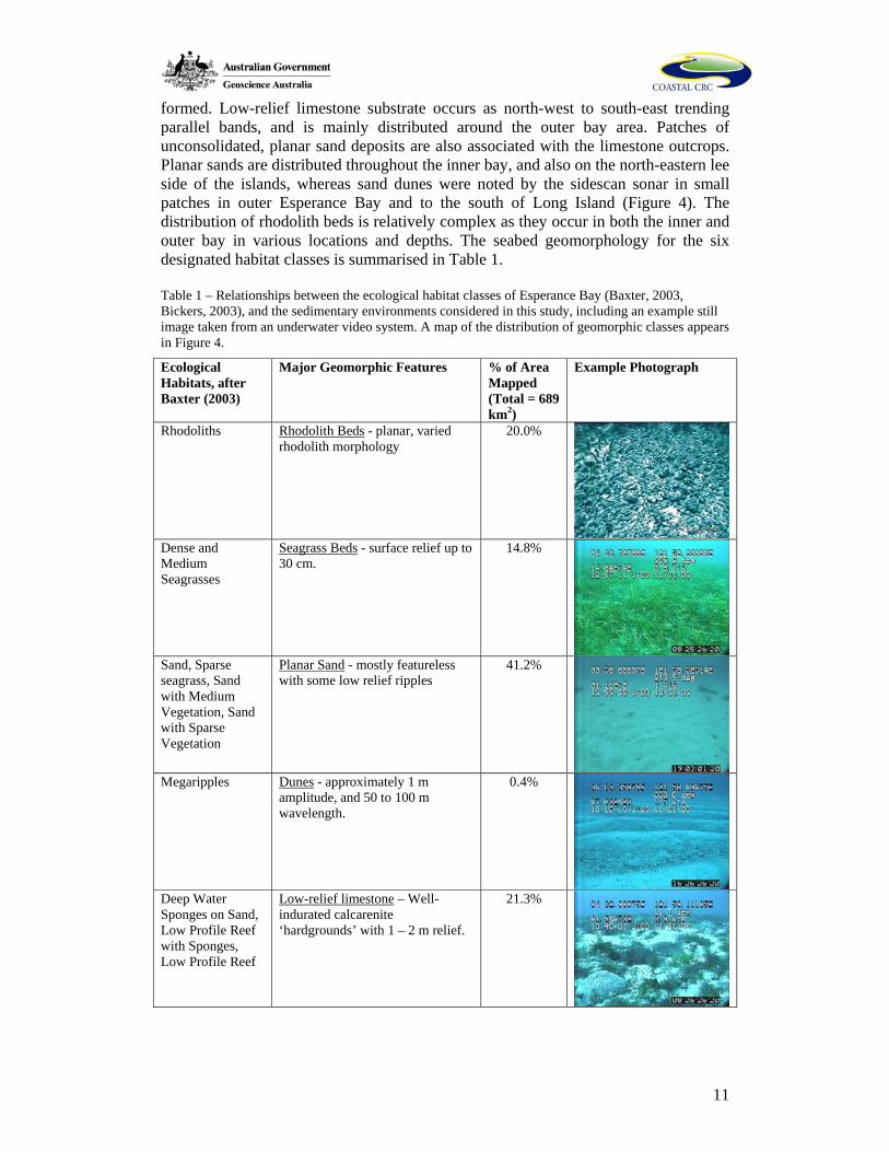
Figure 4 – Map of benthic habitat classes, based on the detailed benthic habitat map produced by (Kendrick et al., 2004). The original twelve ecologically relevant classes have been amalgamated to six geomorphic classes for the purpose of this study (Table 1). Mapping was conducted by Baxter (2003) and Bickers (2003), based on sidescan sonar and Landsat TM imagery, and ground-truthed using divers and a towed video system.
Extensive areas of flat-lying sandy seagrass banks occur within 5 km of the shoreline, with large patches adjacent to the north-eastern margins of the Woody and Remark island groups. High-relief bedrock tends to occur close to islands and rocky headlands, and comprises the granite-gneiss material from which the islands are
11
formed. Low-relief limestone substrate occurs as north-west to south-east trending parallel bands, and is mainly distributed around the outer bay area. Patches of unconsolidated, planar sand deposits are also associated with the limestone outcrops. Planar sands are distributed throughout the inner bay, and also on the north-eastern lee side of the islands, whereas sand dunes were noted by the sidescan sonar in small patches in outer Esperance Bay and to the south of Long Island (Figure 4). The distribution of rhodolith beds is relatively complex as they occur in both the inner and outer bay in various locations and depths. The seabed geomorphology for the six designated habitat classes is summarised in Table 1. Table 1 – Relationships between the ecological habitat classes of Esperance Bay (Baxter, 2003, Bickers, 2003), and the sedimentary environments considered in this study, including an example still image taken from an underwater video system. A map of the distribution of geomorphic classes appears in Figure 4.
Ecological Habitats, after Baxter (2003)
Major Geomorphic Features % of Area Mapped (Total = 689 km2)
Example Photograph
Rhodoliths Rhodolith Beds - planar, varied rhodolith morphology
20.0%
Dense and Medium Seagrasses
Seagrass Beds - surface relief up to 30 cm.
14.8%
Sand, Sparse seagrass, Sand with Medium Vegetation, Sand with Sparse Vegetation
Planar Sand - mostly featureless with some low relief ripples
41.2%
Megaripples Dunes - approximately 1 m
amplitude, and 50 to 100 m wavelength.
0.4%
Deep Water Sponges on Sand, Low Profile Reef with Sponges, Low Profile Reef
Low-relief limestone – Well-indurated calcarenite ‘hardgrounds’ with 1 – 2 m relief.
21.3%
12
High Profile Reef High-relief bedrock - large relief with granitic geomorphology
2.4%
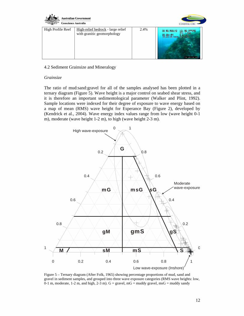
4.2 Sediment Grainsize and Mineralogy Grainsize The ratio of mud:sand:gravel for all of the samples analysed has been plotted in a ternary diagram (Figure 5). Wave height is a major control on seabed shear stress, and it is therefore an important sedimentological parameter (Walker and Plint, 1992). Sample locations were indexed for their degree of exposure to wave energy based on a map of mean (RMS) wave height for Esperance Bay (Figure 2), developed by (Kendrick et al., 2004). Wave energy index values range from low (wave height 0-1 m), moderate (wave height 1-2 m), to high (wave height 2-3 m).
0 0.2 0.4 0.6 0.8 1
1
0.8
0.6
0.4
0.2
01
0.8
0.6
0.4
0.2
0High wave-exposure
G
mG
gM
M sM mS S
gmS gS
msG sGModeratewave-exposure
Low wave-exposure (Inshore) Figure 5 – Ternary diagram (After Folk, 1965) showing percentage proportions of mud, sand and gravel in sediment samples, and grouped into three wave exposure categories (RMS wave heights: low, 0-1 m, moderate, 1-2 m, and high, 2-3 m). G = gravel, mG = muddy gravel, msG = muddy sandy
13
gravel, sG = sandy gravel, gM = gravely mud, gmS = gravely muddy sand, gS = gravely sand, M = mud, sM = sandy mud, mS = muddy sand, and S = sand. RMS wave height information based upon Figure 2.
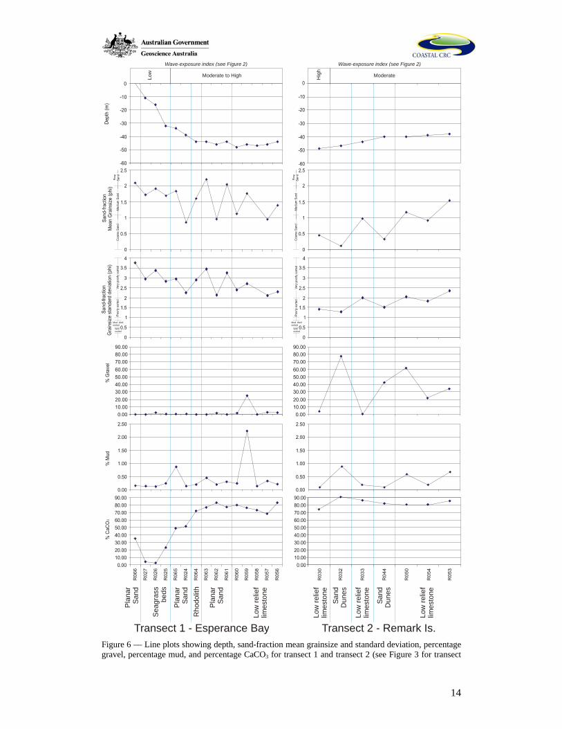
Figure 5 shows that the majority of sediment samples from Esperance Bay may be classified as poorly to very poorly sorted gravely sand. The gravel component is highly variable, ranging from 0 to almost 100%, mainly comprising rhodoliths, and individual fragments of weathered limestone. Samples that contain rhodolith material were typically gravels, sandy gravels, and muddy sandy gravels. The largest clasts were 5 cm in diameter (e.g. sample R001), and comprise mainly rhodolith fragments, with some molluscs and intact bryozoans (described below). Mud occurred in very low proportions, typically 0 - 2%, the highest being 28% (west of Woody Island, sample R002), and tended to co-occur in samples with a high proportion of gravel. Only sites that occur in areas of low wave exposure have a significant (but low) mud fraction. Samples that are predominantly sand were dominant at sites distal to the island groups, and within inner Esperance Bay. Areas of moderate wave exposure are characterised by sands to gravely sands, whereas areas of higher exposure comprise mainly gravely sands and sandy gravels. Sedimentological Transects Data for sample transects across Esperance Bay (transect 1, Fig. 3), and through the Remark Island group (transect 2) are depicted in Figure 6.
14
Pla
nar
Sa n
d
Sea
gras
sbe
ds
Rho
dolit
h
Low
relie
flim
e sto
ne
Pla
nar
San
d
Pla
nar
San
d
Mod. Wellsorted
Wellsorted
Mod. Wellsorted
Wellsorted
Sand
Dun
es
Low
relie
flim
e sto
ne
Sand
Dun
es
Low
relie
flim
esto
ne
Low
relie
flim
esto
ne
Low Moderate to High H
igh
Wave-exposure index (see Figure 2) Wave-exposure index (see Figure 2)
Transect 1 - Esperance Bay Transect 2 - Remark Is.
Moderate
Figure 6 –– Line plots showing depth, sand-fraction mean grainsize and standard deviation, percentage gravel, percentage mud, and percentage CaCO3 for transect 1 and transect 2 (see Figure 3 for transect
15
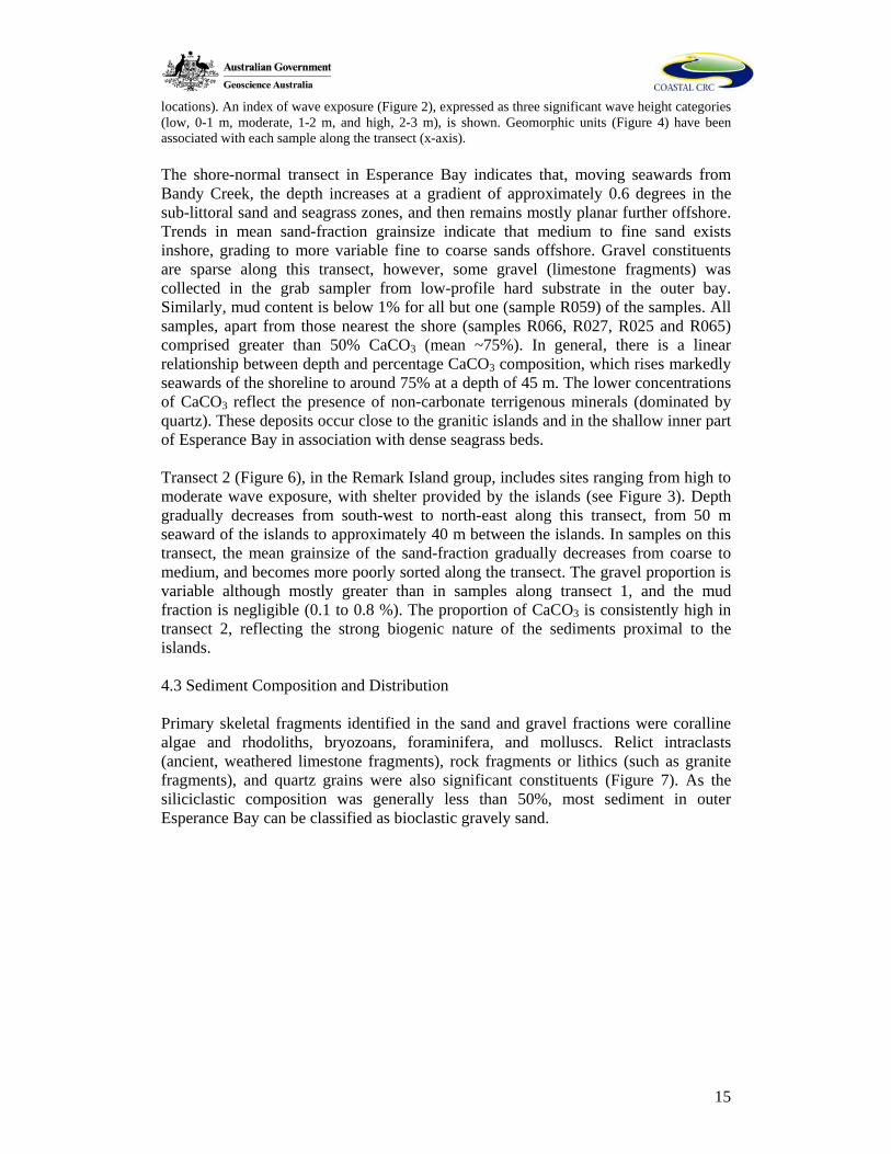
locations). An index of wave exposure (Figure 2), expressed as three significant wave height categories (low, 0-1 m, moderate, 1-2 m, and high, 2-3 m), is shown. Geomorphic units (Figure 4) have been associated with each sample along the transect (x-axis). The shore-normal transect in Esperance Bay indicates that, moving seawards from Bandy Creek, the depth increases at a gradient of approximately 0.6 degrees in the sub-littoral sand and seagrass zones, and then remains mostly planar further offshore. Trends in mean sand-fraction grainsize indicate that medium to fine sand exists inshore, grading to more variable fine to coarse sands offshore. Gravel constituents are sparse along this transect, however, some gravel (limestone fragments) was collected in the grab sampler from low-profile hard substrate in the outer bay. Similarly, mud content is below 1% for all but one (sample R059) of the samples. All samples, apart from those nearest the shore (samples R066, R027, R025 and R065) comprised greater than 50% CaCO3 (mean ~75%). In general, there is a linear relationship between depth and percentage CaCO3 composition, which rises markedly seawards of the shoreline to around 75% at a depth of 45 m. The lower concentrations of CaCO3 reflect the presence of non-carbonate terrigenous minerals (dominated by quartz). These deposits occur close to the granitic islands and in the shallow inner part of Esperance Bay in association with dense seagrass beds. Transect 2 (Figure 6), in the Remark Island group, includes sites ranging from high to moderate wave exposure, with shelter provided by the islands (see Figure 3). Depth gradually decreases from south-west to north-east along this transect, from 50 m seaward of the islands to approximately 40 m between the islands. In samples on this transect, the mean grainsize of the sand-fraction gradually decreases from coarse to medium, and becomes more poorly sorted along the transect. The gravel proportion is variable although mostly greater than in samples along transect 1, and the mud fraction is negligible (0.1 to 0.8 %). The proportion of CaCO3 is consistently high in transect 2, reflecting the strong biogenic nature of the sediments proximal to the islands. 4.3 Sediment Composition and Distribution Primary skeletal fragments identified in the sand and gravel fractions were coralline algae and rhodoliths, bryozoans, foraminifera, and molluscs. Relict intraclasts (ancient, weathered limestone fragments), rock fragments or lithics (such as granite fragments), and quartz grains were also significant constituents (Figure 7). As the siliciclastic composition was generally less than 50%, most sediment in outer Esperance Bay can be classified as bioclastic gravely sand.
16
Figure 7 – Typical components of the sand- and gravel-fractions for bottom sediment samples from Esperance Bay: A) Fine quartzose sand, inner Esperance Bay (sample R027); B) Sample primarily comprised of recent skeletal carbonate fragments (sample R005); C) Sample comprising equal proportions of lithic (coloured) and carbonate (white) material (sample R046); D) Gravel fraction rhodolith material; E) Rounded rhodoliths (sample R032); F) Branching rhodoliths (sample R007); G) Robust branching bryozoan; H) Zooid from a delicate branching bryozoan; I) Small zooid from a delicate articulated zooidal bryozoan; J) Fenestrate bryozoan; K) Marginopera benthic foraminifera; L) Relict intraclast with carbonate cement and rounded quartz grain; M) Relict intraclast; N) Relict intraclast; O) Grey-black heavy mineral.
Table 2 provides a brief description of each of the sediment grain types commonly found within samples from Esperance Bay, and their typical size-fractions, morphologies, and distribution
17
Table 2 – Summary of physical properties, morphology and distribution for each of the major sediment particle types found in Esperance Bay. Particle Type Grain Size Average
Samp. Proportion
Morphology Distribution Image
Calc. Algae & Rhodoliths
Coarse gravel to pebble (50mm diam.)
20%, some samples 100%
‘Fruticose’ (Marrack 1999) in lee of Woody Is to weathered and rounded
Varied, depth range 22 to 47 m.
Fig. 7D, E, & F
Bryozoans
Mainly Fine sand (zooids)
15 - 30% Articulated & robust branching, fenestrate, zooidal, and foliose
Typically deeper, moderate wave exp. Sites
Fig. 7H, I, J
Molluscs
Sand & gravel fraction fragments
5-10% Various, highly diverse pelecypod & gastropod fauna
Varied, more abundant in seagrasses
-
Foraminifera
Fine sand to coarse gravel
5-10% Various benthic, minor planktonic
Large Marginopera common in shallow water
Fig. 7K
Terrigenous Sediments
Fine sand (inshore) and coarse sand/gravel (offshore)
20% Inshore: clean, well-rounded fine sand. Offshore: angular granitic rock fragments
Within 3-4 km of mainland; proximal to offshore islands
Fig. 7A, ~ 30% 7C, O
Relict Intraclasts
Medium to Coarse sand
15% Various well rounded, stained & cemented bioclast & quartz fragments
Mainly offshore, exposed locations
Fig. 7L, M, N
Undifferentiated Bioclasts
Med. To fine sand
20% Various unidentified grains, also ostracods, barnacles, echinoids, sponges & arthropods
Varied -
The average sediment composition of each of the benthic geomorphic habitat types (Figure 4, Table 1) is described in Figure 8.
18
E) Inshore seagrass
D) Offshore seagrassC) Planar Sand
B) Rhodolith Beds
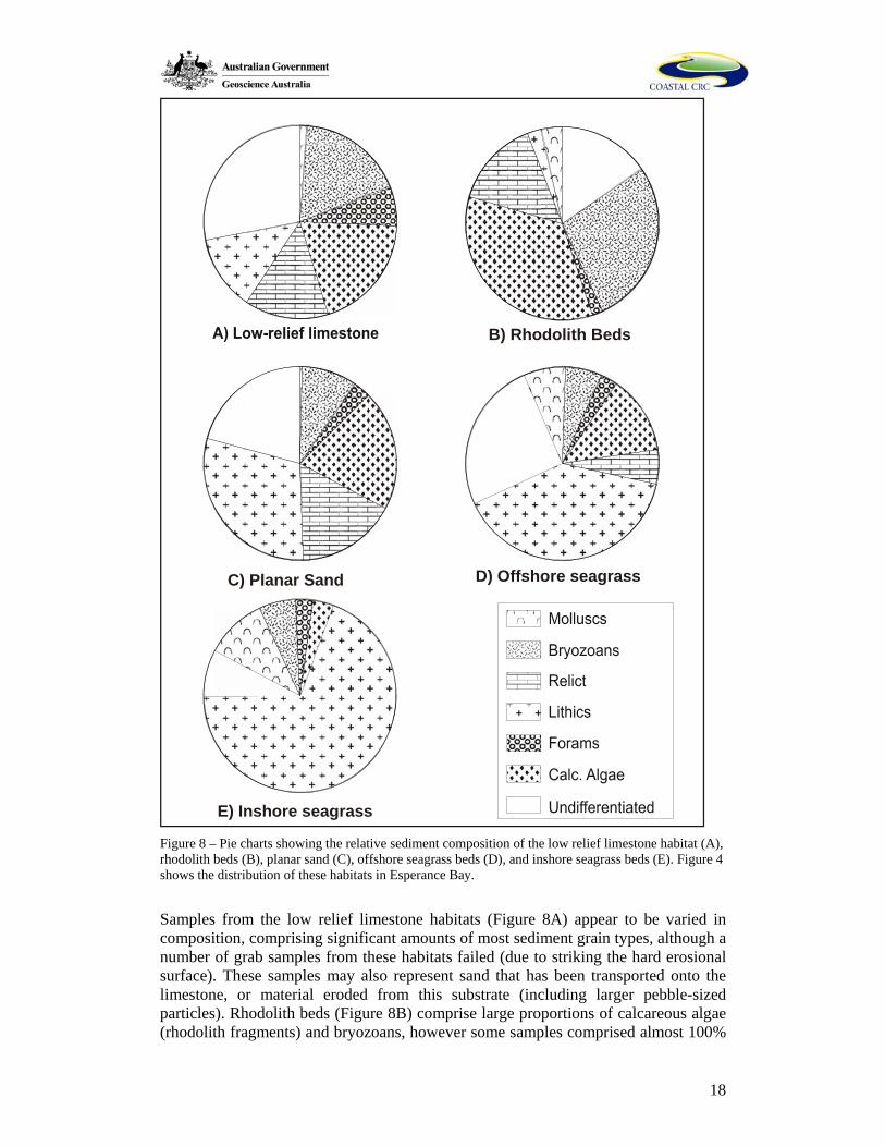
Figure 8 – Pie charts showing the relative sediment composition of the low relief limestone habitat (A), rhodolith beds (B), planar sand (C), offshore seagrass beds (D), and inshore seagrass beds (E). Figure 4 shows the distribution of these habitats in Esperance Bay.
Samples from the low relief limestone habitats (Figure 8A) appear to be varied in composition, comprising significant amounts of most sediment grain types, although a number of grab samples from these habitats failed (due to striking the hard erosional surface). These samples may also represent sand that has been transported onto the limestone, or material eroded from this substrate (including larger pebble-sized particles). Rhodolith beds (Figure 8B) comprise large proportions of calcareous algae (rhodolith fragments) and bryozoans, however some samples comprised almost 100%
19
well formed rhodoliths. Planar sand habitat (Figure 8C) also has variable sediment composition, with large relict, lithic and calcareous algal components. A difference was noted between sediment from the inshore seagrass beds and the patches of seagrass offshore (Figure 4), therefore samples from each were analysed separately. Sediment samples acquired from both offshore seagrass beds (Figure 8D, the north-eastern side of the island groups), and inshore seagrass beds (Figure 8E, close to the mainland) varied markedly in composition, however both included a significant mollusc component. Sediment samples from inshore seagrass beds, which grow on the large inshore area of quartz sand (Figure 6) comprise a very large proportion of lithic sediment. Broader compositional trends can be ascertained from the aggregated percentage abundance of bioclastic (various skeletal remains), lithic (terrigenous quartz and rock fragments), and relict (older rounded and stained) material. Figure 9 depicts the variation of these sedimentary components along the two transects (the locations of which are shown in Figure 3).
Per
cent
Abu
ndan
ceP
lana
r S
a nd
Sea
gras
s
Rho
doli t
h
Low
-rel
ief
limes
tone
Dun
es
Pla
nar
San
d
Pla
nar
San
d
Dun
es
Low
-rel
ief
limes
tone
Low
-rel
ief
limes
tone
Low
-rel
ief
limes
tone
Transect 1 Transect 2
Low
Hig
hModerate
Wave-exposure index (see Figure 2) Wave-exposure index (see Figure 2)
Moderate to High
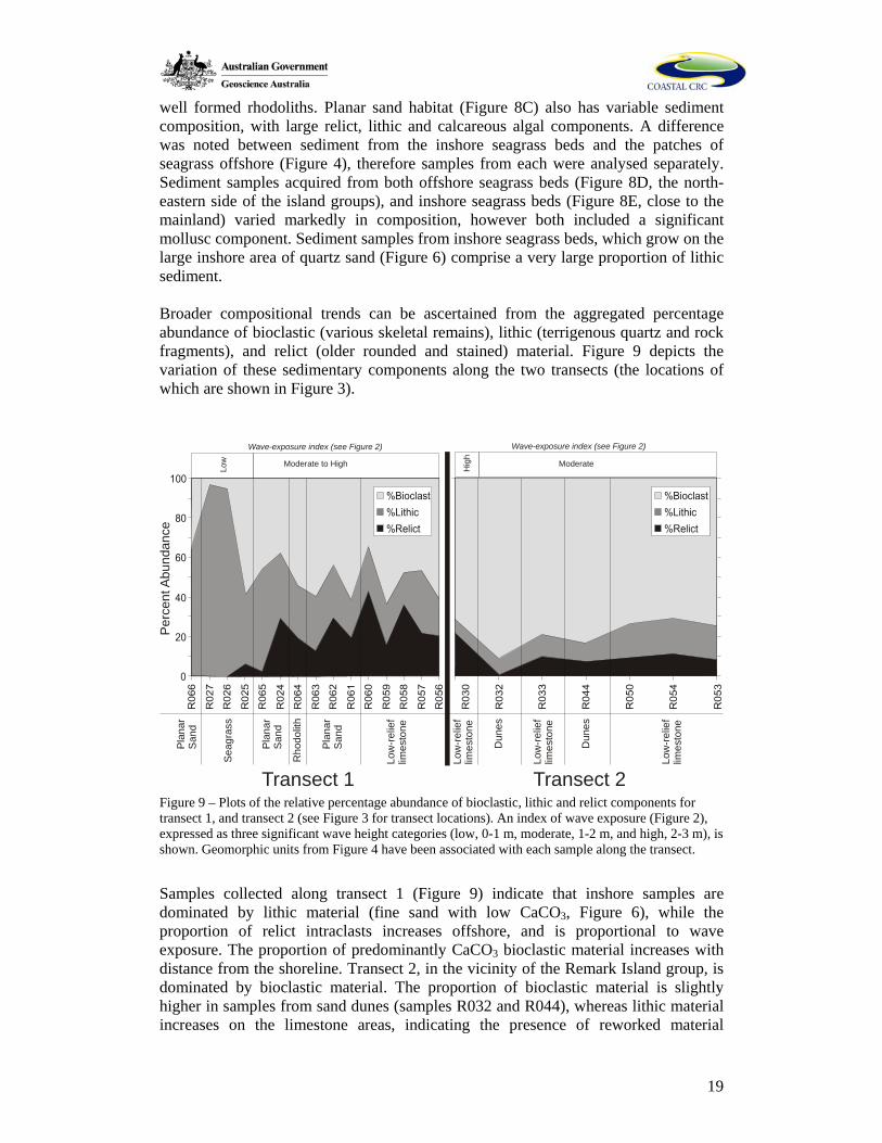
Figure 9 – Plots of the relative percentage abundance of bioclastic, lithic and relict components for transect 1, and transect 2 (see Figure 3 for transect locations). An index of wave exposure (Figure 2), expressed as three significant wave height categories (low, 0-1 m, moderate, 1-2 m, and high, 2-3 m), is shown. Geomorphic units from Figure 4 have been associated with each sample along the transect.
Samples collected along transect 1 (Figure 9) indicate that inshore samples are dominated by lithic material (fine sand with low CaCO3, Figure 6), while the proportion of relict intraclasts increases offshore, and is proportional to wave exposure. The proportion of predominantly CaCO3 bioclastic material increases with distance from the shoreline. Transect 2, in the vicinity of the Remark Island group, is dominated by bioclastic material. The proportion of bioclastic material is slightly higher in samples from sand dunes (samples R032 and R044), whereas lithic material increases on the limestone areas, indicating the presence of reworked material
20
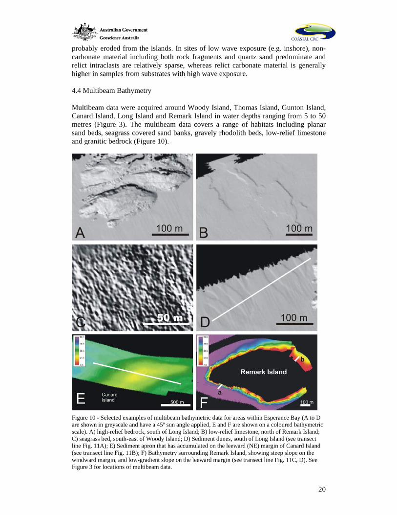
probably eroded from the islands. In sites of low wave exposure (e.g. inshore), non-carbonate material including both rock fragments and quartz sand predominate and relict intraclasts are relatively sparse, whereas relict carbonate material is generally higher in samples from substrates with high wave exposure. 4.4 Multibeam Bathymetry Multibeam data were acquired around Woody Island, Thomas Island, Gunton Island, Canard Island, Long Island and Remark Island in water depths ranging from 5 to 50 metres (Figure 3). The multibeam data covers a range of habitats including planar sand beds, seagrass covered sand banks, gravely rhodolith beds, low-relief limestone and granitic bedrock (Figure 10).
Figure 10 - Selected examples of multibeam bathymetric data for areas within Esperance Bay (A to D are shown in greyscale and have a 45º sun angle applied, E and F are shown on a coloured bathymetric scale). A) high-relief bedrock, south of Long Island; B) low-relief limestone, north of Remark Island; C) seagrass bed, south-east of Woody Island; D) Sediment dunes, south of Long Island (see transect line Fig. 11A); E) Sediment apron that has accumulated on the leeward (NE) margin of Canard Island (see transect line Fig. 11B); F) Bathymetry surrounding Remark Island, showing steep slope on the windward margin, and low-gradient slope on the leeward margin (see transect line Fig. 11C, D). See Figure 3 for locations of multibeam data.
21
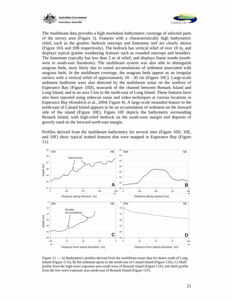
The multibeam data provides a high resolution bathymetric coverage of selected parts of the survey area (Figure 3). Features with a characteristically high bathymetric relief, such as the granitic bedrock outcrops and limestone reef are clearly shown (Figure 10A and 10B respectively). The bedrock has vertical relief of over 10 m, and displays typical granite weathering features such as rounded outcrops and boulders. The limestone typically has less than 2 m of relief, and displays linear trends (north-west to south-east lineations). The multibeam system was also able to distinguish seagrass beds, most likely due to raised accumulations of sediment associated with seagrass beds. In the multibeam coverage, the seagrass beds appear as an irregular surface with a vertical relief of approximately 20 - 30 cm (Figure 10C). Large-scale sediment bedforms were also detected by the multibeam sonar on the seafloor of Esperance Bay (Figure 10D), seawards of the channel between Remark Island and Long Island, and in an area 5 km to the north-east of Long Island. These features have also been reported using sidescan sonar and video techniques at various locations in Esperance Bay (Kendrick et al., 2004; Figure 4). A large-scale mounded feature to the north-east of Canard Island appears to be an accumulation of sediment on the leeward side of the island (Figure 10E). Figure 10F depicts the bathymetry surrounding Remark Island, with high-relief bedrock on the south-west margin and deposits of gravely sand on the leeward north-east margin. Profiles derived from the multibeam bathymetry for several sites (Figure 10D, 10E, and 10F) show typical seabed features that were mapped in Esperance Bay (Figure 11).
-60
-50
-40
-30
-20
-10
0
0255075100
-60
-50
-40
-30
-20
-10
0 25 50 75 100
0
Dep
th (m
)
Distance from island shoreline (m) Distance from island shoreline (m)
SW NE SW NE
0 245 490 735 980
Distance along transect (m)
NW SE
5404052701350
Distance along transect (m)
SW
Dep
th (m
)
NE
C D
A B
Sand waves
Boulderaccumulations
Figure 11 –– A) Bathymetric profiles derived from the multibeam sonar data for dunes south of Long Island (Figure 11A); B) the sediment apron to the north-east of Canard Island (Figure 11E); C) Shelf profile from the high-wave exposure area south-west of Remark island (Figure 11F); and shelf profile from the low wave exposure area north-east of Remark Island (Figure 11F).
22
Figure 11A shows the sand dunes detected by the multibeam system, south of Long Island. The dunes are unidirectional, indicated by the asymmetrical form of the dune, with a gently sloping stoss side. They range from 60 to 130 m in wavelength, with an amplitude of approximately 1 m. The direction of dune migration is from the middle shelf towards the coast, along a positive seafloor slope of approximately 0.7o. Figure 11B shows a transverse profile of the deposit on the north-east leeward side of Canard Island, which rises 5 m from the surrounding seabed and is approximately 500 m wide. Figure 11C and 11D compare the high and low wave exposure margins of Remark Island. Figure 11C, on the seaward (high wave exposure) margin, shows a steep and uneven surface close to the shoreline. This area appears to be littered with boulders (several metres in diameter) that have been eroded from the island. In contrast, Figure 11D shows the relatively smooth, shallow gradient on the leeward side of the islands formed by the accumulation of sandy sediment. 4.5 Summary of Benthic Habitats Clear relationships are evident between various sediment textural and compositional properties and the benthic habitats of Esperance Bay (Table 3).
23
Table 3 – Summarised sedimentary and geomorphic characteristics for the six geomorphic units identified in this study, including mean grainsize, sorting, percentage CaCO3, percentage gravel, sand and mud, and swell exposure, averaged for each group of samples. Seabed morphology determined from multibeam sonar and underwater video. Geomorphic Unit Mean Grainsize
(phi) Sorting (phi) % CaCO3 % Gravel %Sand % Mud Swell
Exp. Seabed Morphology
Seagrass Beds (including both inshore and offshore)
1.28 (med. sand) 2.04 (very poorly sorted)
61.04 (inshore ~20%, offshore ~80%)
13.51 85.71 0.78 Low Uneven surface, vertical variation 20-30 cm over 2-3 m laterally, depending on density of seagrass.
High-relief bedrock (e.g. granite)
n/a n/a n/a n/a n/a n/a Varied High-relief (>10 m) surface displaying weathered granitic geomorphology.
Low-relief limestone 0.89 (Coarse sand)
1.88 (poorly sorted)
78.29 25.50 74.21 0.29 Mod Low relief (~2m), linear limestone bedforms, ~ 200-300m wide. Areas with dense coverage of macroalgae, sponges, & ascidians.
Rhodolith Beds -3 to -5 (pebble) 79.66 36.66 58.42 4.92 Varied Mostly planar; relief less than the resolution of the multibeam system. Probable relief ~ 2-5 cm.
Planar Sands 1.33 (medium sand)
2.35 (very poorly sorted)
70.33 7.69 91.43 0.88 Low Smooth, featureless sand surface.
Dunes 0.49 (coarse sand)
1.56 (poorly sorted)
86.00 32.83 66.82 0.35 High Asymmetric dunes with amplitude ~ 1m and wavelength 5-150 m. Smaller dunes not resolved.
24
Seagrass beds occur only in areas of low wave exposure, and generally comprise a poorly sorted medium sand. These habitats exhibit a wide range of sediment composition, dominated by quartz inshore, and primarily carbonate sediments in the offshore patches (Figure 4, Figure 8D and 8E). High relief bedrock habitat occurs in association with both submerged shoals and rocky islands throughout the bay, and is characterised by a large range of sessile organisms and attaching algae (Table 1). Low-relief limestone occurs as patches of linear outcrop that is colonised by macroalgae and sessile organisms, mainly in outer Esperance Bay (Figure 4), often with partial covers of coarse sand and gravel (possibly lags). Rhodolith beds are typically gravel- to pebble-rich, occur mainly in deeper water or protected locations, and are the only habitat with a significant mud component (Figure 4). Smooth, mostly featureless planar medium sands dominate throughout Esperance Bay (Table 1, Figure 4), however some areas feature large wavelength sand dunes that indicate that the sediment is mobile. 5. Discussion 5.1 Sediment Facies and Production Rates The results of this study suggest that the sedimentary environments of the Recherché Archipelago inner- to mid-shelf appear to share some similarities with other sections of the GAB (James, 1997) in that sediments are produced by biogenic action, and distributed by ocean swell, storm-events and tidal transport (James et al., 1992; James et al., 1994; Feary and James, 1998; James et al., 2001). However, there are some important differences in the nature and origins of the inner shelf facies. Analysis of the distribution of seabed habitats (Figure 4), sediment texture (Figure 6) and composition (Figures 7, 8, and 9), and other habitat information (Table 3) suggests that three readily identifiable sediment facies can be identified in Esperance Bay:
1) Sub-littoral quartz-dominated sand banks; 2) Sandy bio-calcarenite gravels; and 3) Palimpsest sediment lags and reef.
The depth range, distribution and sedimentary characteristics of these three facies types is summarised in Table 4. Table 4 – Summary data for the three main sedimentary facies identified for Esperance Bay.
Facies Depth Range (m)
Location and Exposure
Textural Characteristics
Sediment Composition
Sub-littoral quartz
0-30 Sub-littoral, within 5 km of the shoreline
Fine, well sorted & rounded sand
Mainly quartz, minor carbonate fragments. Associated with shallow-water seagrasses.
Sandy bioclastic calcarenite
5 – 50 Proximal to islands in moderate to low wave exposure environments.
Poorly sorted, angular sands to gravels.
Mixed lithic fragments of quartz, feldspars and micas, also rhodoliths, bryozoans, forams and molluscs.
25
Relict limestones and palimpsest sediment lags
30-50 Outer Esperance Bay in high wave exposure environments.
Poorly indurated limestone, partly inundated by sands containing relict material.
Varying amounts of relict intraclasts, and other rounded carbonates.
Although its presence was noted by Cann and Clarke (1993), the nature and extent of the sub-littoral quartz-dominated sand facies adjacent to the shoreline of Esperance Bay has not been previously described in detail. Longshore drift, driven by the strong oblique south-westerly swell (Figure 2), moves this material in an easterly direction and supplies the quartzose sand found on beaches of the region (Sanderson et al., 2000). Biogenic carbonate sediments, in the form of gastropods, foraminifera, and bivalves, are produced in association with seagrasses that colonise the nearshore zone, however they form a very low proportion (approximately 5%) of this predominantly quartzose sediment. Varying proportions of freshly eroded lithic material are associated with the bedrock highs in the bay. Rock fragments are removed from the granitic bedrock by subaerial weathering and wave erosion, and comprise up to 25% of localised seabed deposits (Figure 9, transect 2). It is likely that this material significantly adds to the coastal sediment budget. Other parts of the GAB inner- and mid-shelf (such as the Lacepede and Eucla shelves) tend to lack significant terrigenous sediment, and are composed primarily of bioclastic sediment, or erosional hardgrounds (Bone and James, 1993; Feary and James, 1998; James et al., 2001). In this aspect also, the Recherché Archipelago differs from existing GAB facies models. Recent sand and gravel sized carbonate sediments were found in abundance in Esperance Bay, whereas palimpsest lags and hardgrounds are more typical for the majority of the inner shelf of the GAB (James et al., 1994; Li et al., 1999). Topographic highs formed by bedrock outcrops in the Recherché Archipelago produce a shoreline and littoral zone that is very large in areal extent and complexity (Figure 3). Consequently, there is a great deal of shallow habitat available for colonisation by carbonate producing organisms which, when coupled with the productive warm waters of the Leeuwin Current, creates a prolific carbonate ‘factory’. Sediments in Esperance Bay comprise a mixture of bioclasts from both the cool-water heterozoan, and typically warm-water photozoan assemblages (James, 1997), for example the foraminifera Marginopera and Amphisorus. Non-geniculate red algae, such as rhodoliths, are also very important sediment producers (Marrack, 1999). Extension rates of such calcareous algae have been estimated at around 0.4 m.kyr-1 in waters less than 20 metres depth, however the majority of rhodolith beds in the study area appear in water between 30 and 40 m depth (Foster, 2001). CaCO3 production rates from high latitude (western Europe) northern hemisphere rhodolith beds have been estimated at around 1000g CaCO3 m2.yr-1 (Bosence and Wilson, 2003). It is likely that localised production rates of carbonate sediments in the Recherché Archipelago inner shelf are significantly greater than have been observed in other parts of the GAB (Boreen and James, 1993), where the focus of sediment accumulation is on the mid- to outer-shelf, below the storm wave base (Feary and James, 1998). The presence of rocky islands and shoals encourage production of both carbonate and terrigenous sediment that make a significant contribution to the coastal sediment budget.
26
5.2 Sediment Transport and Accumulation Previous studies of cool water carbonates in the GAB propose vertical sediment accumulation rates of around 0.25 m.kyr-1 on open shallow shelves, to greater than 1.00 m.kyr-1 in seagrass beds, deep water mounds and sand wave environments (Boreen and James, 1993; Rao, 1996). Bathymetric data reveal that significant sediment accumulation has occurred on the northeastern (leeward) side of the resistant bedrock islands and shoals in Esperance Bay (Figure 10, 11). Sediments accumulate here due to the relatively lower wave energy environments (nodal points) that form sediment ‘aprons’ of significant volume near the larger islands. The windward sides of the islands appear to be mainly clean-swept by currents, and sediment starved (Figure 10). Rhodolith beds, many of which occur on the leeward margins of rocky islands, are known to favour substrates of unconsolidated calcareous sediment, and therefore likely indicate environments of deposition. Excessive sediment influx, however, likely results in burial of individuals (Foster, 2001).Very little overall accumulation of mud occurs in Esperance Bay. The only substrate that included mud was rhodolith beds, which appear to provide a lower energy environment in which small quantities of mud (up to approximately 30% near the surface) accumulate. Significant mud accumulations associated with rhodoliths has also been described in the southern Gulf of California (Foster et al., 1997; Halfar et al., 2000). Accumulation rates for cool-water rhodolith beds in high-latitude northern hemisphere environments have been estimated at around 0.5 m.kyr-1 (Bosence and Wilson, 2003). Multibeam bathymetry shows that sediment is being transported from the windward side of the islands to the leeward side, via low amplitude, long wavelength asymmetric sand dunes (Figure 10). Additionally, a narrow band of multibeam sonar coverage in the south-western section of the study area (5 km NW of Long Island, Figure 3) indicates the presence of large sand dunes. These occur in more than 50 m water depth, and have wavelengths of 50 to 100 m. Video evidence suggests that many dunes contain rounded rhodolith gravel in the troughs. Such sand dunes represent the active transport of sediment (and potentially rhodoliths), much of which appears to originate on the middle shelf (below the wave scour base). Some of the smaller bedforms observed with underwater video partially cover the low-relief limestone habitat, and some appear to be partially cemented. Many of these consolidated deposits appear to be overprinted by more recent dunes, with evidence of active bioturbation and gravel armouring of troughs and flanks. This succession of deposits appears to reflect cementation during low-energy periods, interspersed with sediment transportation during high energy events. This influx of sediment may be responsible for the ‘sand-inundation’ of limestone reefs and their associated sessile communities that has been observed by divers and remote underwater video (Bickers, 2003). Outcrops of relict limestone in Esperance Bay (Figure 4) appear to be limited in their extent due to relatively high biogenic sedimentation production rates. Rounded, relict material was retrieved in low quantities in grab samples in these areas, probably derived from the weathering of older limestone. The proportions of relict material found in this study range from approximately 0 to 30%, in contrast to the much more
27
significant (> 50%) palimpsest fraction found elsewhere in the GAB at comparable depths (James et al., 2001). This implies a greater rate of production and accumulation of biogenic sediments on the Recherché inner shelf. It has been suggested that most of the relict material was deposited on the shallow shelf during the Pleistocene, particularly during marine isotope stages 3 and 4, when sea level was at least 60 metres lower than at present (James, 1997). The shore-parallel morphology of the limestone reef systems in the south-western margin of Esperance Bay, at around 50 to 60 m water depth (Figure 4) appears to resemble a drowned palaeo-shoreline. The low relief limestone substrate (or ‘hardgrounds’) are analogous with the ‘shaved shelf’ conditions proposed for other parts of the GAB, and probably experiences similar reworking and negligible sediment accumulation rates, around 0.25 m.kyr-1 or lower (Boreen and James, 1993).
5.3 Relationships between Geomorphic Facies and Habitats
Although as many as twelve ecological habitat types have been classified and characterised in Esperance Bay (Baxter, 2003; Bickers, 2003; Kendrick et al., 2004), only three significant geomorphic facies types occur, including two depositional environments, and one environment of intermittent erosion and deposition (Table 4). The inshore quartz-dominated facies, with shallow water depths and low wave exposure, supports an extensive seagrass community (Figure 4). However, although the majority of seagrass in Esperance Bay occurs in this sub-littoral zone, significant seagrass also occurs on the northeastern sides of the offshore island groups, upon a substrate of mainly coarse carbonate sands (Figure 4, Figure 8D). This observation indicates that seagrass growth is independent of sediment type in Esperance Bay, and that its distribution is more related to hydraulic energy and water depth (as a function of water clarity). Rhodoliths are an important seabed feature in Esperance Bay, providing a stable, three-dimensional microhabitat to which other organisms can attach or find shelter, including foliose algae, crustaceans, polychaetes and molluscs (Marrack, 1999; Foster, 2001; Hinojosa-Arango and Riosmena-Rodríguez, 2004). The distribution of rhodolith beds in Esperance Bay is complex. Significant patches that occur north of the Woody Island group and near Black Island (Figure 4) appear to favour moderate to low wave energy conditions. Burial by mobile sand sheets may limit rhodolith distribution, as does high water motion where tidal or wave energy may be focussed (Harris et al., 1996; Marrack, 1999). A band of rhodoliths was also mapped seawards of the Remark Island group (Figure 4), however, wave energy at the seabed may be more moderate in this exposed region due to the greater water depth (approximately 60 m). It has been noted elsewhere that rhodoliths are rarely found on hard substrates (Foster, 2001), therefore it is suggested that rhodolith beds and low-relief limestone habitats in the Recherché may be mutually exclusive. A number of rhodolith growth forms were observed, however, a full assessment of the physical distribution of morphological types in Esperance Bay is yet to be conducted. Our initial observations suggest that there is some correlation between wave exposure and branching rhodolith growth forms, as noted by Marrack (1999). However the movement of rhodoliths is also known to be caused by factors other than wave energy, such as ocean currents (Hills and Jones, 2000). Rhodolith beds are thought to have significant conservation value due to the highly diverse range of organisms that associate with them, their
28
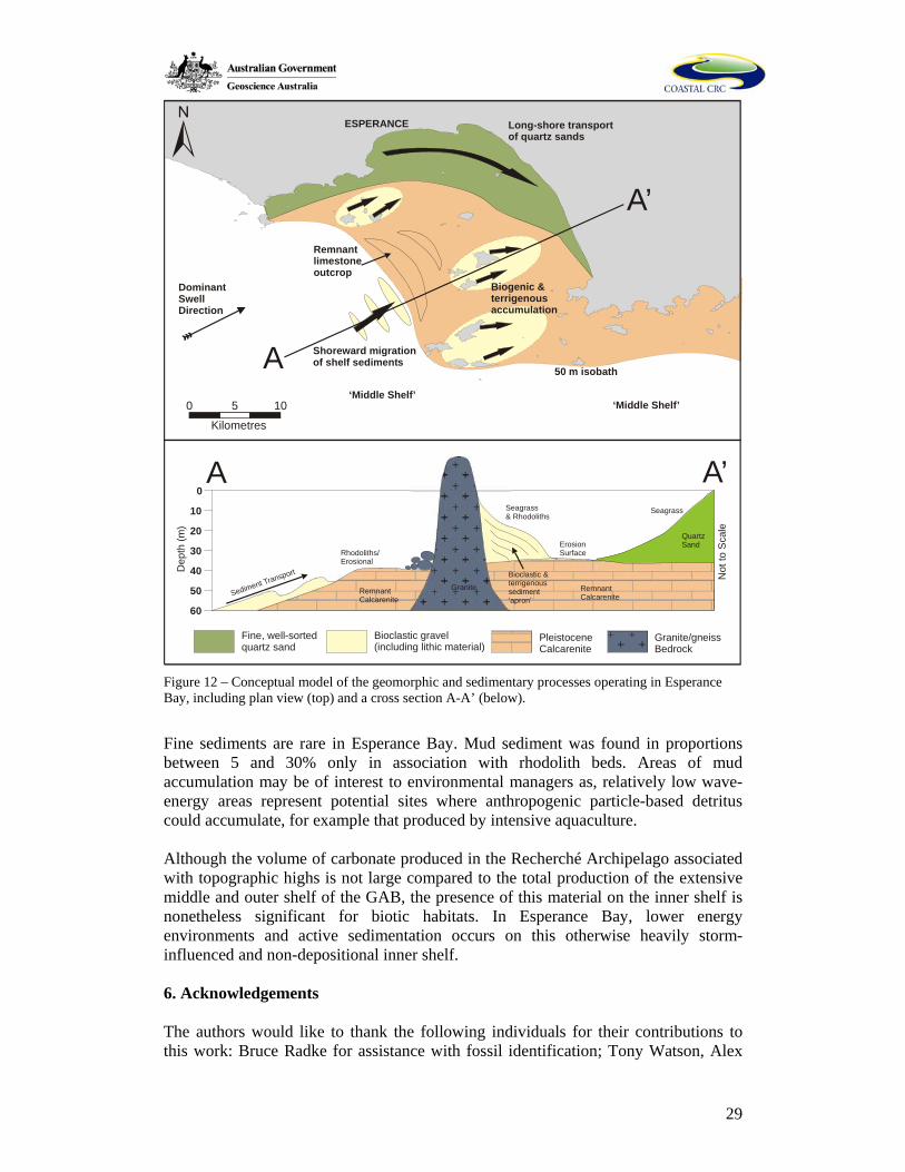
sparse distribution in Australia (Harris et al., 1996), slow growth rates (Foster, 2001), and susceptibility to damage from bottom trawling (Foster et al., 1997). Sidescan sonar has proven to be a highly successful tool for accurately and rapidly mapping the distribution of this important habitat in Esperance Bay (Bickers, 2003). Both granitic bedrock and low profile limestone reefs are important habitats for sessile and attaching organisms, including sponges, ascidians, bryozoans and various macroalgae (Table 1, Figure 8). However, the abundance of unconsolidated sand and the exposed setting of most of the limestone outcrops suggest that they are marginal or unstable habitats, and are prone to intermittent inundation by sand during high-energy storm events. The presence of long wavelength, low amplitude mobile sand dunes suggests that sand transport is a significant feature of the seabed in Esperance Bay. The sand dunes are located in the deeper regions of the study area which, suggests that they may originate from sediments produced by organisms on the middle shelf (e.g. bryozoans) and transported into shallower water during high energy swell events. The sparse nature of these large sand dunes (Figure 4) suggests that they may be significant as habitats in themselves, particularly for benthic macrofauna (Barros et al., 2004). 5.4 Summary and Conceptual Model There are a range of distinctive surficial sedimentary processes operating in Esperance Bay (Figure 12). In the nearshore and littoral zone (within 4 km of the shore) there is a quartz-rich sediment province that comprises reworked ancient sediments that are being transported in an easterly direction by littoral wave-driven currents, and induced longshore currents (Figure 12). Seagrasses are common here due to the shallow, clear nature of the water, and bind sediments, increasing the rate of sediment accumulation. The numerous islands that occur in the bay are both sediment producers, and also shield sections of the bay from the high energy south-westerly swell. Sediments are produced, in varying proportions, by calcium carbonate based organisms (primarily rhodoliths and other calcareous algae, bryozoans, foraminifera, and molluscs). Terrigenous sediment is also derived from the weathering and erosion of the granitic islands, producing arenitic, immature, gravely sediments. Areas of submerged limestone exposure, which probably represent remnant calcarenite shoreline deposits that formed during periods of lower sea-level, form important present-day habitats for sessile organisms in the areas of deeper water (Figure 12).
29
0 105
Kilometres
ESPERANCE
Shoreward migrationof shelf sediments
‘Middle Shelf’‘Middle Shelf’
Biogenic &terrigenousaccumulation
50 m isobath
Remnantlimestoneoutcrop
DominantSwellDirection
Long-shore transportof quartz sands
60
50
40
30
20
10
0
A
A’
A A’
Dep
th (m
)
Not
to S
cale
Seagrass& Rhodoliths
Seagrass
Remnant Calcarenite
Remnant Calcarenite
Bioclastic &terrigenoussediment‘apron’
QuartzSand
Rhodoliths/Erosional
ErosionSurface
GraniteSediment Transport
Fine, well-sortedquartz sand
PleistoceneCalcarenite
Bioclastic gravel (including lithic material)
Granite/gneissBedrock
Figure 12 – Conceptual model of the geomorphic and sedimentary processes operating in Esperance Bay, including plan view (top) and a cross section A-A’ (below).
Fine sediments are rare in Esperance Bay. Mud sediment was found in proportions between 5 and 30% only in association with rhodolith beds. Areas of mud accumulation may be of interest to environmental managers as, relatively low wave-energy areas represent potential sites where anthropogenic particle-based detritus could accumulate, for example that produced by intensive aquaculture. Although the volume of carbonate produced in the Recherché Archipelago associated with topographic highs is not large compared to the total production of the extensive middle and outer shelf of the GAB, the presence of this material on the inner shelf is nonetheless significant for biotic habitats. In Esperance Bay, lower energy environments and active sedimentation occurs on this otherwise heavily storm-influenced and non-depositional inner shelf. 6. Acknowledgements The authors would like to thank the following individuals for their contributions to this work: Bruce Radke for assistance with fossil identification; Tony Watson, Alex
30
McLauglin, and Richard Brown for sedimentology lab assistance; Vicky Passlow, Dan Clark, and Kriton Glenn for useful comments and advice; and Paul Rose, Rob McCauley, Simon Grove, and Marcus Gray for assistance in the field. This study was partly funded by the Cooperative Research Centre for Coastal Zone, Estuary and Waterway Management, Coastal Water Habitat Mapping Project. 7. References Australian Hydrographic Service, 1990. Approaches to Esperance, 1:75,000, AUS 119. Barros, F., Underwood, A. J., and Archambault, P. (2004) The influence of troughs and crests of ripple marks on the structure of subtidal benthic assemblages around rocky reefs. Estuarine, Coastal and Shelf Science, 60, 781-790. Baxter, K. J. (2003). Broad scale classification and prediction of marine habitats: integrating GIS and rule based modelling. In: C. D. Woodroffe and R. A. Furness (Eds.) Coastal GIS 2003: an integrated approach to Australian coastal issues, Proceedings, 7-8 July 2003. Wollongong Papers on Maritime Policy, No 14. Bickers, A. N. (2003). Cost effective marine habitat mapping from small vessels using GIS, sidescan sonar and video. In: C. D. Woodroffe and R. A. Furness (Eds.) Coastal GIS 2003: an integrated approach to Australian coastal issues, Proceedings, 7-8 July 2003. Wollongong Papers on Maritime Policy, No 14. Bosence, D. and Wilson, D. (2003). Maerl growth, carbonate production rates and accumulation rates in the north east Atlantic. Aquatic Conservation: Marine and Freshwater Ecosystems, 13, S1, S21-S31. Bone, Y. and James, N. P. (1993). Bryozoans as carbonate sediment producers on the cool-water Lacepede Shelf, southern Australia. Sedimentary Geology, 86, 247-271. Bone, Y., Clarke, J., James N. (1994). Carbonate sediments of Woody Island, Esperance region, Western Australia. Geological Society Of Australia, Abstracts, 12th Australian Geological Convention, 37, 34. Boreen, T. D. and James, N. P. (1993). Holocene sediment dynamics on a cool-water shelf: Otway, southeastern Australia. Journal of Sedimentary Petrology, 63, 574-588. Cann J. H. and Clarke, J. D. A. (1993) The significance of Marginopera vertebralis (Foraminifera) in surficial sediments at Esperance, Western Australia, and in last interglacial sediments in northern Spencer Gulf, South Australia. Marine Geology, 111, 171-187. Clark, D. J., Hensen, B. J., Kinny, P. D. (2000). Geochronological constraints for a two-stage history of the Albany-Fraser Orogen, Western Australia. Precambrian Research, 102, 155-183.
31
Clarke, J. D. A., Bone, Y. and James, N. P. (1996). Temperate bryozoan limestones in Eocene drowned estuaries, Bremer Basin, Western Australia. Sedimentary Geology, 101, 213-226. Connolly, J. R. and Von der Borch, C. C. (1967). Sedimentation and physiography of the sea floor south of Australia. Sedimentary Geology, 1, 181-220. Fairbridge, R.W., and Serventy, V.N. (1954). 1b. Physiography. In. The Archipelago of the Recherché, pp. 9-28. Feary, D. A. and James, N. P. (1998). Seismic stratigraphy and geological evolution of the Cenozoic Cool-water Eucla Platform, Great Australian Bight. AAPG Bulletin, 82, 792-816. Fisheries Western Australia (2000). Aquaculture plan for the Recherché Archipelago. Fisheries Management Paper, No. 140. (138 pp) Folk, R. L. (1965). Petrology of sedimentary rocks. Hemphills, University of Texas, Austin, USA. 159 pp. Foster, M. S., Riosmena-Rodríguez, R., Steller, D. L. and Woelkerling, Wm. J. (1997) Living rhodolith beds in the Gulf of California and their implications for paleoenvironmental interpretation. In. M. E. Johnson and J. Ledesma-Vázquez (Eds) Pliocene Carbonates and Related Facies Flanking the Gulf of California, Baja California, Mexico. Boulder, Colorado, Geological Society of America Special Paper, 318, 127-139. Foster, M. S. (2001). Rhodoliths: Between rocks and soft places. Journal of Phycology, 37, 659-667. Gostin, V. A., Belperio, A. P., and Cann, J. H. (1998). The Holocene non-tropical coastal and shelf carbonate province of southern Australia. Sedimentary Geology, 60, 51-70. Hageman, S. J., Bone, Y., McGowran, B., James, N. P. (1995). Modern bryozoan assemblages and distribution on the cool-water Lacepede Shelf, southern Australian margin. Australian Journal of Earth Sciences, 42, 571-580. Halfar, J., Godinez-Orta, L., and Ingle, J. C. (2000). Microfacies analysis of recent carbonate environments in the southern Gulf of California, Mexico – A model for warm-temperate to subtropical carbonate formation. Palaios, 15, 323-342. Harris, P. T. and O’Brien P. (1998). Australian ports environmental data and risk analysis. Phase 1: Literature Review. Report prepared for the Australian Quarantine Inspection Service (AQIS), Australian Geological Survey Organisation, Canberra. (181 pp). Harris, P. T., Heap, A. D., Bryce, S. M., Porter-Smith, R., Ryan, D. A., and Heggie, D. T. (2002). Classification of Australian clastic coastal depositional environments
32
based on a quantitative analysis of wave, tide and river power. Journal of Sedimentary Research, 72(6), 858-870. Harris, P. T., Tsuji, Y., Marshall, J. F., Davies, P. J., Honda, N., and Matsuda, H. (1996) Sand and rhodolith-gravel entrainment on the mid- to outer-shelf under a western boundary current: Fraser Island continental shelf, eastern Australia. Marine Geology, 129, 313-330. Hills, D. J. and Jones, B. (2000). Peyssonnelid rhodoliths from the Late Pleistocene Ironshore Formation, Grand Cayman, British West Indies. Palaios, 15, 212-224. Hinojosa-Arango, G., and Riosmena-Rodríguez, R. (2004). Influence of rhodolith-forming species and growth-form on associated fauna of rhodolith beds in the central-west Gulf of California, México. Marine Ecology, 25(2), 109-127. James, N.P. (1997). The cool-water carbonate depositional realm. In: N. P. James and J. D. A. Clarke (eds) Cool-Water Carbonates: SEPM Special Publication, 56, 1-22. James, N. P., Bone, Y., Von der Borch, C. C., and Gostin, V. A. (1992). Modern carbonates and terrigenous clastic sediments on a cool water, high energy, mid-latitude shelf: Lacepede, southern Australia. Sedimentology, 39, 877-903. James, N. P., Boreen, T. D., Bone, Y., Feary, D. A. (1994). Holocene carbonate sedimentation of the west Eucla shelf, Great Australian Bight: a shaved shelf. Sedimentary Geology, 90, 161-177. James, N. P., Bone, Y., Collins, L. B., and Kyser, T. K. (2001). Surficial sediments of the Great Australian Bight: facies dynamics and oceanography on a vast cool-water carbonate shelf. Journal of Sedimentary Research, 71(4), 549-567. Kendrick, G. A., Harvey, E., Hill, J., McDonald, J. I., Grove, S. (2002). Characterising the fish habitats of the Recherché Archipelago: review of existing information. Fisheries Research Development Corporation Project 2001/060. (98 pp) Kendrick, G. A., Harvey, E., McDonald, J., Pattiaratchi, C., Cappo, M., Fromont, J., Shortis, M., Grove, S., Bickers, A., Baxter, K., Goldberg, N., Kletczkowski, M., and Butler, J., (2004). Characterising the fish habitats of the Recherche Archipelago. Draft Final Report, FRDC 2001/060, 54 pp. Lewis, D. W. and McConchie, D. (1994). Analytical Sedimentology. Chapman and Hall, New York. (197 pp.) Li, Q., James, N. P., Bone, Y., McGowran, B. (1999). Palaeoceanographic significance of recent foraminiferal biofacies on the southern shelf of Western Australia: a preliminary study. Palaeogeography, Palaeoclimatology, Palaeoecology 147, 101-120. Marrack, E. C. (1999) The relationship between water motion and living rhodolith beds in the southwestern Gulf of California, Mexico. Palaios, 14, 159-171.
33
McGowran, B., Li, Q., Cann, J., Padley, D., McKirdy, D. M., and Shafik, S. (1997). Biogeographic impact of the Leuuwin current in southern Australia since the late middle Eocene. Palaeogeography, Palaeoclimatology, Palaeoecology, 136, 19-40. Morgan, K. H., and Peers, R. (1973). Esperance-Mondrain Island, W.A. Western Australia Geological Survey, 1:250 000 Geological Series Explanatory Notes. Mount, J. F. (1984). Mixing of siliciclastic and carbonate sediments in shallow shelf environments. Geology, 12, 432-435. Muller, G., and Gastner, M. (1971). The “karbonate bombe” a simple device for the determination of the carbonate content in sediments, soils and other materials. Neues Jahrb. Mineral. Monatsh., 10, 466–469. Myers, J. S. (1990). Western Gneiss Terrane. In Geology and Mineral Resources of Western Australia. Geological Survey, Western Australian Memoirs, 3, pp. 13-32. Myers, J. S. (1995). Geology of the Esperance 1:1 000 000 sheet. Explanatory notes on the Esperance 1:1 000 000 geological map sheet. Geological Survey of Western Australia, Perth. Nelson, C. S. (1988). An introductory perspective on non-tropical shelf carbonates. Sedimentary Geology, 60, 3-12. Nelson, D. R., Myers, J. S., and Nutman, P. (1995). Chronology and evolution of the Middle Proterozoic Albany-Fraser Orogen, Western Australia. Australian Journal of Earth Sciences, 42, 481-495. Pearce A., and Pattiaratchi C. (1997). Applications of satellite remote sensing to the marine environment in Western Australia. Journal of the Royal Society of Western Australia, 80, 1-14 Rao, C. P. (1996). Modern carbonates tropical, temperate, polar: Introduction to sedimentology and geochemistry. Arts of Tasmania, University of Tasmania, Hobart. (206 pp). Ryan, D. A. (2004). Recherche Archipelago Sediment Survey #1. Coastal Water Habitat Mapping Progress Report, November 2003. Milestone Report to the Coastal CRC, CG3.03, 9 pp. Sanderson, P. G., Eliot, I., Hegge, B., and Maxwell, S. (2000). Regional variation of coastal morphology in southwestern Australia: a synthesis. Geomorphology, 34, 73-88. Von der Borch, C. C. (1968). Southern Australian submarine canyons: their distribution and ages. Marine Geology, 6, 267-279. Walker, R. G., and Plint, A. G. (1992). Wave- and storm-dominated shallow marine systems. In R. G. Walker and N. P. James (Eds) Facies Models: response to sea level change. Geological Association of Canada, pp. 219-238.

34
Related Documents


