Coast Millennium Trail Master Plan D R A F T January 18, 2000 ™ Prepared for: Whatcom County Parks & Recreation Bellingham Parks & Recreation Port of Bellingham Wha tcom C ounty Co uncil of Go vernmen ts ™ Coast Millennium Trail Campaign Committee: Roger D eSpain, C ommitte e Co-C hair & Dire ctor, Whatcom County Parks & Recreation Department Jim Miller, Co mmittee C o-Cha ir & Execu tive Director, Wha tcom C o. Cou ncil of G overnm ents Byron Elmendorf, Director, Tim Wahl, Leslie Bryson, Bellingham Parks & Recreation Carol W illiams, Fred S eeger, Port of Bellingham Ellen Barto n, Gord on Rog ers, Wha tcom C o. Cou ncil of G overnm ents Dave E rickson, D irector, City of Ferndale Parks & Recreation Scott Cha lfant, Park M anage r, Larrabee State Park James N eill, Washington State Parks Crystal Rich , Marketin g/Com munity Re lations Co ordinator, City of Blaine Darrell Hillaire, Lummi Nation Kim Ce derstrom , Wha tcom T ranspo rtation A uthority John Co oper, Bellingham/Whatcom County Convention & Visitors Bureau Faruk Ta ysi, Ken H ertz, Trillium Corporation Peter Fras er, Monty D ennison, Fraser Dennison Communications Michae l Brennan , Bellingham/Whatcom Chamber of Commerce Richard S turgill, Friends of the Plover Jim Kaemingk, former mayor, Lynden ™ Honorary Chairs: Pete Krem en, Cou nty Execu tive, Wha tcom C ounty Hardy Sta ub, Ma yor, City of White Rock, B.C. ™ Plan prepared by: Ken W ilcox, principa l planner, Osprey Environmental Services, Inc. Sara Rod gers, Rodge rs GIS

Welcome message from author
This document is posted to help you gain knowledge. Please leave a comment to let me know what you think about it! Share it to your friends and learn new things together.
Transcript

Coast Millennium TrailMaster Plan
D R A F T
January 18, 2000
™ Prepared for:
Whatcom County Parks & Recreation
Bellingham Parks & Recreation
Port of Bellingham
Wha tcom C ounty Co uncil of Go vernmen ts
™ Coast Millennium Trail Campaign Committee:
Roger D eSpain, C ommitte e Co-C hair & Dire ctor, Whatcom County Parks & Recreation Department
Jim Miller, Co mmittee C o-Cha ir & Execu tive Director, Wha tcom C o. Cou ncil of G overnm ents
Byron Elmendorf, Director, Tim Wahl, Leslie Bryson, Bellingham Parks & Recreation
Carol W illiams, Fred S eeger, Port of Bellingham
Ellen Barto n, Gord on Rog ers, Wha tcom C o. Cou ncil of G overnm ents
Dave E rickson, D irector, City of Ferndale Parks & Recreation
Scott Cha lfant, Park M anage r, Larrabee State Park
James N eill, Washington State Parks
Crystal Rich , Marketin g/Com munity Re lations Co ordinator, City of Blaine
Darrell Hillaire, Lummi Nation
Kim Ce derstrom , Wha tcom T ranspo rtation A uthority
John Co oper, Bellingham/Whatcom County Convention & Visitors Bureau
Faruk Ta ysi, Ken H ertz, Trillium Corporation
Peter Fras er, Monty D ennison, Fraser Dennison Communications
Michae l Brennan , Bellingham/Whatcom Chamber of Commerce
Richard S turgill, Friends of the Plover
Jim Kaemingk, former mayor, Lynden
™ Honorary Chairs:
Pete Krem en, Cou nty Execu tive, Wha tcom C ounty
Hardy Sta ub, Ma yor, City of White Rock, B.C.
™ Plan prepared by:
Ken W ilcox, principa l planner, Osprey Environmental Services, Inc.
Sara Rod gers, Rodge rs GIS
Coast Millennium Trail Master Plan
——Contents ——
1. Introduction 1
2. Project description 3
3. Planning areas & development status 53.1 Area #1: Skagit County to Nooksack River 93.2 Area #2: Nooksack River to Aldergrove Road 113.3 Area #3: Aldergrove Road to White Rock, B.C. 143.4 Area #4: Marine Drive to Ferndale & Lummi River 17
4. Planning issues & priorities 184.1 Links & destinations 184.2 Potential routes & alternatives 184.3 Right-of-way issues 194.4 Trailheads & trail access 204.5 Natural & scenic features 214.6 Cultural & historic sites 214.7 Other sites of interest 224.8 Anticipated use 224.9 Trail buffers 234.10 Public safety & security 23
5. Recommendations 255.1 Preferred routing & alignments 255.2 Width, grades & surfacing 285.3 Trailhead facilities 315.4 Sites of interest 37
™ Interpretive sites 37™ Viewpoints 38™ Wildlife & natural areas 38™ Parks 39
5.5 Trail signing 445.6 General design themes & continuity 445.7 Trail development guidelines 455.8 Facility maintenance & management 46
6. Cost estimates 50
7. Potential funding sources 52
8. Funding & development strategy 59
9. Agency & public participation 61
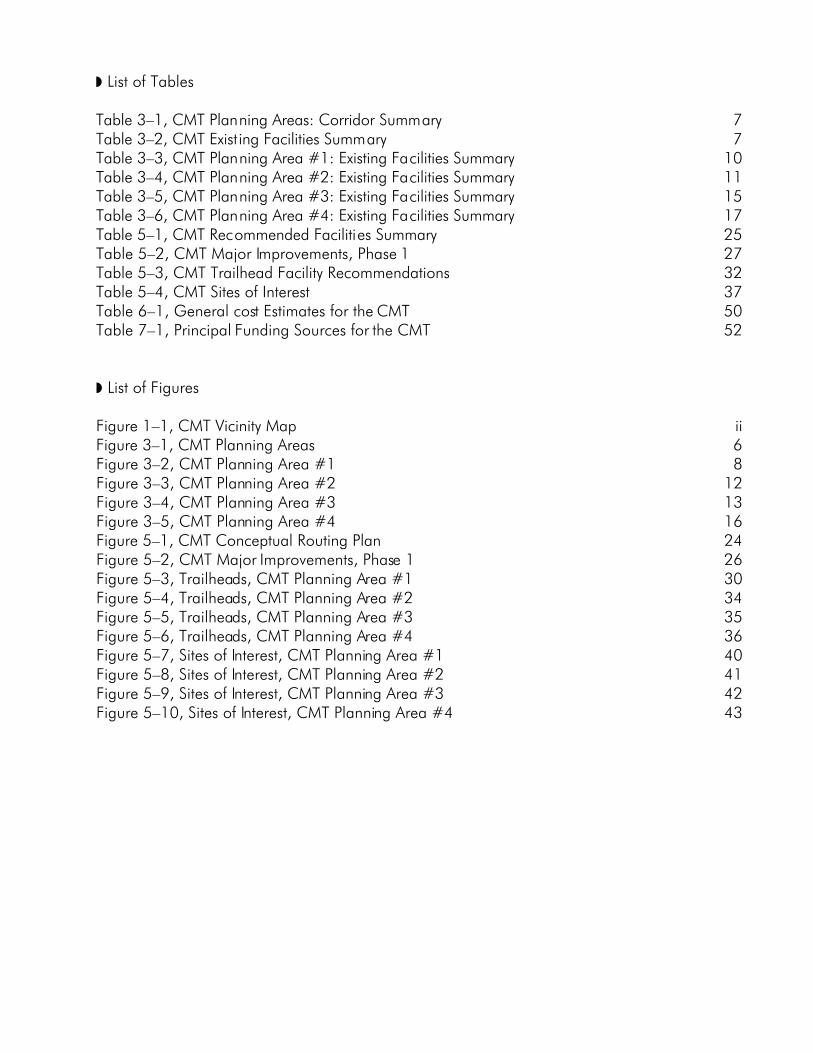
™ List of Tables
Table 3–1, CMT Planning Areas: Corridor Summary 7Table 3–2, CMT Exist ing Facilities Summary 7Table 3–3, CMT Planning Area #1: Existing Facilities Summary 10Table 3–4, CMT Planning Area #2: Existing Facilities Summary 11Table 3–5, CMT Planning Area #3: Existing Facilities Summary 15Table 3–6, CMT Planning Area #4: Existing Facilities Summary 17Table 5–1, CMT Recommended Facilities Summary 25Table 5–2, CMT Major Improvements, Phase 1 27Table 5–3, CMT Trailhead Facility Recommendations 32Table 5–4, CMT Sites of Interest 37Table 6–1, General cost Estimates for the CMT 50Table 7–1, Principal Funding Sources for the CMT 52
™ List of Figures
Figure 1–1, CMT Vicinity Map iiFigure 3–1, CMT Planning Areas 6Figure 3–2, CMT Planning Area #1 8Figure 3–3, CMT Planning Area #2 12Figure 3–4, CMT Planning Area #3 13Figure 3–5, CMT Planning Area #4 16Figure 5–1, CMT Conceptual Routing Plan 24Figure 5–2, CMT Major Improvements, Phase 1 26Figure 5–3, Trailheads, CMT Planning Area #1 30Figure 5–4, Trailheads, CMT Planning Area #2 34Figure 5–5, Trailheads, CMT Planning Area #3 35Figure 5–6, Trailheads, CMT Planning Area #4 36Figure 5–7, Sites of Interest, CMT Planning Area #1 40Figure 5–8, Sites of Interest, CMT Planning Area #2 41Figure 5–9, Sites of Interest, CMT Planning Area #3 42Figure 5–10, Sites of Interest, CMT Planning Area #4 43

CMT vicinity map
1DRAFT - Coast Millennium Trail Master Plan (1/25/00)
Coast Millennium Trail Master Plan
——1. Introduction——
The idea of a border-to-border, multi-use trail along the coastal region of western
Whatcom County, Washington, is not a new concept—in fact, it’s an idea that’s beenaround for at least a quarter of a century. In the early to mid-1970s an ambitious effort
was undertaken to establish a continuous Pacific Coast bicycle route from southern California to theCanadian border. A route was defined and mapped, and preliminary plans were drafted but never
implemented. In the 1980s, plans for coastal trails appeared in several local trail plans, as thepublic's demand for new trail opportunities increased.
In 1989, the Whatcom County Parks and Recreation Open Space Plan identified the "CoastalBike Route" as a key component of a county-wide network of trails and bikeways. A few years later,
the county's Bicycle Transportation Plan further emphasized the need for such a facility. Of the top tenpriority projects identified in that plan, four involved key sections within this coastal corridor.
(Chuckanut Dr., Marine Dr., Lummi Shore Rd., and Birch Bay Dr.).Bellingham's South Bay Trail, an integral link in the coastal trail idea, was developed in the
mid-1990s, connecting the downtown area with the Fairhaven community and with the alreadyexisting Interurban Trail—an enormously popular multi-use trail that extends six miles south of
Bellingham to Larrabee State Park at the Skagit County line. Shorter trail sections along the Whatcomcoast have also been developed over the years, especially in the Blaine/Birch Bay area, though many
large gaps must be filled in order to complete the dream of a border-to-border tra il.Whatcom County's proximity to the Canadian border makes the not ion of an international trail
attractive as well. The prospect of a major trail system between the Seattle and Vancouvermetropolitan areas is equally appealing, and far more ambitious. Communities throughout the
coastal regions of Washington State have seen broad support for waterfront trails. As new facilitiesand trail plans are developed, coastal links throughout the region are likely to occur. British Columbia
has also undertaken regional planning efforts to enhance an already elaborate trail system there. TheCity of White Rock has shown strong support for development of an international trail. By way of
White Rock and the existing Boundary Bay Trail, the CMT can be extended all the way to PointRoberts.
Recognizing these opportunities for a preeminent regional trail system and the broad supportthat has been demonstrated for it, a public-private partnership was established in the spring of 1999
to pursue the goal of developing a "Coast Millennium Trail" (or CMT) between Skagit County andWhite Rock, B.C. A CMT Campaign Committee was formed comprising representatives of Whatcom
County, the Cities of Bellingham, Ferndale and Blaine, the Port of Bellingham, Washington StateParks, Whatcom County Council of Governments, the Trillium Corporation (who was instrumental in
bringing the parties together initially), and others. Representatives from Lynden, the Lummi Nation,Whatcom Transit Authority, Bellingham/Whatcom County Convention & Visitors Bureau, and other
organizations also contributed to the effort. Core participants signed a resolution in support of theplanning effort, and funding commitments were made by Whatcom County, the City of Bellingham,
the Port of Bellingham, and the Trillium Corporation.On September 24th, 1999, Mayor Hardy Staub of the City of White Rock, B.C., hosted an
international signing ceremony for representatives of communities on both sides of the border, as afurther demonstration of the broad support this project has received. Representatives of the
Semiahmoo First Nation band also expressed support for the trail and its future extension around
2 DRAFT - Coast Millennium Trail Master Plan (1/25/00)
Boundary Bay to Po int Roberts. The Campaign Committee's most immediate objectives were to complete the master plan,
identify funding sources, begin ground-breaking, and establish a completely signed route, border-to-border, by the year 2000. Recognizing that portions of the CMT may require temporary routing, the
committee will continue to pursue full development of permanent facilities as funding and right-of-waybecome available. If initial fundraising efforts for trail development are successful, portions of the
route should be open by mid-2000.Clearly, the CMT offers tremendous recreation potential, tourism and community health
benefits, and economic development opportunities, while serving the needs of cycling and walking asviable and essential modes of transportation in Whatcom County—and beyond.
Acknowledgements
This master plan could not have been completed w ithout the enthusiastic support of many peoplefrom both the public and private sectors. In addition to positive comments and suggestions offered by
citizens, special recognition is due each member of the CMT Campaign Committee which steered theoverall planning process. Roger DeSpain (Whatcom Co. Parks & Recreation) and Jim Miller
(Whatcom Co. Council of Governments) co-chaired the committee. Thanks also go to Pete Kremen,Whatcom County Executive, and Mayor Hardy Staub and his planning staff with the City of White
Rock, B.C.This multi-agency plan was funded by contributions from Whatcom County, the City of
Bellingham, the Port of Bellingham, and the Trillium Corporation.
[CMT PHOTO]

3DRAFT - Coast Millennium Trail Master Plan (1/25/00)
Coast Millennium Trail Master Plan
——2. Project Description——
The Coast Millennium Trail (CMT) consists of a braided corridor of on- and off-streetfacilities extending northward from the Colony Creek area of northwestern Skagit County
to White Rock, British Columbia, just north of the international boundary. The principalroute is roughly fifty miles in length, much of it along quiet backroads and existing multi-use trails. The
CMT divides just north of Bellingham in order to link the Ferndale community into the system(rejoining near the Lummi River); it divides again at Drayton Harbor (rejoining at Blaine). Several
spurs and alternative routes have been identified as well, adding considerably to the total number ofmiles inventoried for this plan.
The CMT passes through three state parks (Larrabee, Birch Bay and Peace Arch), and anumber of city and county parks and natural areas, as well as running close to the marine shoreline in
many locations. The route links urban and rural communities to a wide variety of recreation sites,natural areas, viewpoints, water access areas, historic sites, employment centers, tourist destinations,
and other connecting trails. Sites of particular interest are noted in Part 3, along with much moredetailed descriptions of the trail itself and related facilities.
Where facilities currently exist, off -street portions of the route generally consist of mostly level,limestone-surfaced multi-use paths, typically six to ten feet in width. Bellingham’s South Bay Trail is a
good example of this type of facility (and a good model for much of the new trail developmentenvisioned in this plan). Short paved sections are found at Boulevard Park and Squalicum Harbor in
Bellingham, and at Semiahmoo and Blaine. On-street facilities include designated bikelanes in partsof Bellingham and Blaine, undesignated striped paved shoulders at many locations throughout the
corridor, and other shared roadways lacking adequate shoulders for walking or cycling. Sharedroadways presently account for more than half the CMT corridor. The lack of paved shoulders,
combined with heavier traffic volumes, are a particular concern along Marine Drive, Haxton Way,Lake Terrell Road, and Drayton Harbor Road. This plan addresses these concerns.
As additional rights-of-way become available, it is anticipated that off-street facilities will beextended and that they will eventually account for most of the trail miles through the county. On-street
facilities, however, will remain important as well, often serving as needed links in the regional bicycletransportation system. This mix of facilities can provide a full complement of recreation and
transportation opportunities. Many scenic, educational, interpretive, economic, and environmentalbenefits can also be realized in concert with trail development, and the overall vision for the Coast
Millennium Trail reflects these opportunities.
Development of the CMT Master Plan proceeded as outlined below:
™ CMT corridor reconnaissance conducted;™ Field data addressing existing conditions along the route recorded in a data base
(see tables in the next section);™ Working maps produced;
™ Discussion papers drafted for various elements of the plan;™ Funding sources and strategies considered;
™ Preliminary cost-estimates made for major project elements;™ Phasing plan developed;
4 DRAFT - Coast Millennium Trail Master Plan (1/25/00)
™ Specific recommendations made;™ Draft plan prepared and reviewed;
™ [Revisions made and final plan completed.]
The process was open to agency and public participation throughout. A summary ofcomments received at public meetings is found in Section 9 of this plan.
The CMT Master Plan includes a discussion of four major planning areas and the status oftrail development within each of these areas, as well as a brief analysis of various planning issues and
priorities along the route. Recommendations are provided that address the preferred design andlocation of the CMT and related facilities. Funding and development strategies, cost estimates,
funding sources, and a phasing plan are also included, along with a summary of agency and publicparticipation in developing this master plan.
[CMT PHOTO]
5DRAFT - Coast Millennium Trail Master Plan (1/25/00)
Coast Millennium Trail Master Plan
—–3. Planning Areas & Development Status–—
Development of the Coast Millennium Trail is an ambitious goal, one that will require agreat deal of effort to bring to fruition—an effort commensurate with the extraordinary
benefits the trail offers. To ensure a successful outcome, the master plan presents amulti-year, programmed approach that addresses funding, final design and engineering, permitting,
environmental review, negotiation of rights-of-way, construction, and other needs.Fortunately, many sections of the CMT could be developed quickly and inexpensively, while
areas with existing facilities may only require minor improvements and signing to establish atemporary or permanent route. Additionally, many segments of the CMT would be viable and useful
on their own, even if other nearby segments were incomplete. Thus, the entire trail does not need tobe built at once, and instead, improvements can be made on a segment-by-segment basis. From a
regional standpoint, more extensive connections are desirable, and trail development prioritiesshould, of course, focus on the most beneficial links in the system, until ultimately the entire CMT
corridor is developed. Recommendations in this plan reflect this general approach to developing theCMT.
With that in mind, the CMT corridor has been divided into four general planning areas, asfollows:
™ Planning Area #1 - Skagit County to Nooksack River
™ Planning Area #2 - Nooksack River to Aldergrove Road™ Planning Area #3 - Aldergrove Road to White Rock, B.C.
™ Planning Area #4 - Marine Drive to Ferndale & Lummi River
Planning area boundaries are shown in Figure 3–1 on the next page. Maps for each of thefour planning areas accompany the descriptions for those areas. Within each planning area the trail
corridor was divided into segments ranging in length between a quarter-mile or less, to more than twomiles. Segments were defined based on existing conditions and development opportunities; logical
end points were selected; and each segment was delineated on the planning area maps. Alternativeroutes were identified where appropriate.
The results of the CMT corridor inventory and reconnaissance are provided in table formfollowing a brief introduction to each planning area. The complete database, detailed segment maps,
and photos are contained in a separate document. (Included in the inventory are the number, nameand ownership of each trail segment, as well as information concerning trail type, use, length, width,
grade, surfacing, and condition, as well as the location of trailheads, points of interest, trail junctionsand problem areas.) Table 3–1 on the next page provides a general breakdown of the four planning
areas and the distances involved. A summary of existing facilities (by type) is provided in Table 3–2.Facility types are defined as:
™ Separated Path/ PAVED or UNPAVED (off-street trail or sidewalk integral to the CMT)
™ Designated Bikelane (on-street lane, 4' min imum width, striped & signed for bicyclists)™ 4'+ Striped Shoulder (paved shoulders both sides, 4' minimum width, undesignated)
™ Shared Roadway (all other roads with less than 4' paved shoulders both sides)™ No Facilities (no trail or roadway exis ts; undeve loped land; or beachwalk )

6 DRAFT - Coast Millennium Trail Master Plan (1/25/00)
Figure 3–1CMT Planning Areas
7DRAFT - Coast Millennium Trail Master Plan (1/25/00)
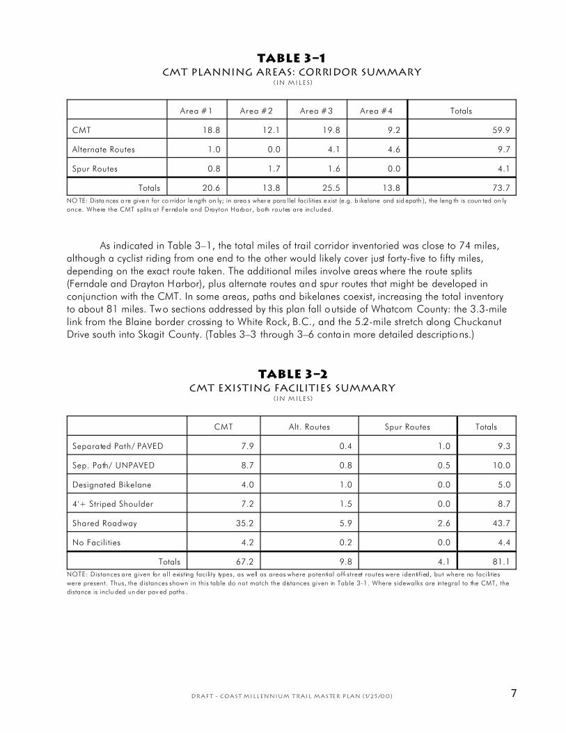
TABLE 3–1CMT Planning Areas: Corridor SummarY
(In miles)
Area #1 Area #2 Area #3 Area #4 Totals
CMT 18.8 12.1 19.8 9.2 59.9
Alternate Routes 1.0 0.0 4.1 4.6 9.7
Spur Routes 0.8 1.7 1.6 0.0 4.1
Totals 20.6 13.8 25.5 13.8 73.7
NO TE: Dista nces a re give n for co rridor le ngth on ly; in area s wher e para llel facilities e xist (e.g. b ikelane and sid epath ), the leng th is coun ted on ly
once. Where the CMT spli ts at Ferndale and Drayton Harbor, both routes are included.
As indicated in Table 3–1, the total miles of trail corridor inventoried was close to 74 miles,although a cyclist riding from one end to the other would likely cover just forty-five to fifty miles,
depending on the exact route taken. The additional miles involve areas where the route splits(Ferndale and Drayton Harbor), plus alternate routes and spur routes that might be developed in
conjunction with the CMT. In some areas, paths and bikelanes coexist, increasing the total inventoryto about 81 miles. Two sections addressed by this plan fall outside of Whatcom County: the 3.3-mile
link from the Blaine border crossing to White Rock, B.C., and the 5.2-mile stretch along ChuckanutDrive south into Skagit County. (Tables 3–3 through 3–6 conta in more detailed descriptions.)
TABLE 3–2CMT Existing Facilities Summary
(In miles)
CMT Alt. Routes Spur Routes Totals
Separated Path/ PAVED 7.9 0.4 1.0 9.3
Sep. Path/ UNPAVED 8.7 0.8 0.5 10.0
Designated Bikelane 4.0 1.0 0.0 5.0
4'+ Striped Shoulder 7.2 1.5 0.0 8.7
Shared Roadway 35.2 5.9 2.6 43.7
No Facilities 4.2 0.2 0.0 4.4
Totals 67.2 9.8 4.1 81.1
NOTE: Distances are given for all existing facili ty types, as well as areas where potential off-street routes were identif ied, but where no facili t ies
were present. Thus, the distances shown in this table do not match the distances given in Table 3-1. Where sidewalks are integral to the CMT, the
distance is inclu ded un der pav ed paths .

8 DRAFT - Coast Millennium Trail Master Plan (1/25/00)
Figure 3–2CMT Planning Area #1

9DRAFT - Coast Millennium Trail Master Plan (1/25/00)
3.1 CMT Planning Area #1
Skagit County to Nooksack River
Summary of Existing Facilities
As shown in Figure 3–2, Planning Area #1 extends from northwestern Skagit County to theNooksack River bridge on Marine Drive, about 20 trail miles to the north. Beginning at Legg Road
(near SR 11 Milepost 9) the CMT route follows Chuckanut Drive northward for 5.3 miles to theClayton Beach Trailhead at Larrabee State Park. This section of Chuckanut Drive is narrow and
winding, often bounded by steep rocky slopes above and below the road, and famous for its manyscenic views of the bays and islands of northwest Washington.
The highway is generally lacking shoulders, and sight distance is limited in some areas.Despite obvious safety concerns, the highway has been a popular cycling destination for many years
and will likely remain so into the future. Minor roadway improvements and signing could improvesafety for nonmotorized users, and in some areas, off-street paths for hikers may be feasible,
particularly between Larrabee State Park and Oyster Creek. Privately-owned conservation areas, andsubstantial public lands managed by Washington State Parks and the Department of Natural
Resources exist along portions of Chuckanut Drive, which may be accessible to lim ited traildevelopment. Steep and rugged ground, however, will likely limit such paths to a narrow hiking trail
standard. At the same time, extensive areas of SR 11 do not appear suitable for pedestrian orequestrian traffic. A number of existing pull-outs along the highway offer viewing and interpretive
opportunities, as well as potential sites for local trail access. A unique fossil outcropping exists nearone of these pull-outs. A few private homes have been established south of Larrabee State Park.
Chuckanut Drive is also the focus of a scenic byway corridor management plan (a separate planningprocess currently underway) which recognizes the area’s unique recreational and scenic value.
Near Milepost 10, south of Oyster Creek, the Pacific Northwest Trail climbs steeply to the eastand provides an important regional link between the CMT and the Chuckanut Mountains trail system.
Parking in this area is limited to parallel shoulder parking. The Pacific Northwest Trail Association hasexplored possible links to the Samish Bay dikes to the south, an effort that should be coordinated with
development plans for the CMT.At Larrabee State Park’s Clayton Beach Trailhead, the CMT route shifts slightly away from
Chuckanut Drive and follows the Interurban Trail another six miles into Bellingham. Washington’sfirst state park, Larrabee, is an outstanding destination facility with extensive mountain trails, forests,
lakes, streams, rugged marine coastline, beaches, tidepools, wetlands, and spectacular views. Thepark offers day-use facilities, camping, and a host of amenities for visitors. While the park would
seem to provide a logical site from which to access the CMT, parking facilities are often heavily usedin summer and during weekends throughout the year. Thus, some additional parking may be
necessary to accommodate the increased demand of trail users who wish to access the CMT from th islocation. At Larrabee, the CMT connects with two popular trails to Clayton Beach and Fragrance
Lake; the latter is open to hikers only.Immediately north of Larrabee, the Interurban Trail is mostly level, about eight feet in width,
surfaced with crushed rock, and in generally good condit ion; however, a minor slide area, rockfall,and a very steep dip (behind the Chuckanut Fire Hall) require some improvement. A small trail
parking area exists where the CMT crosses Hiline and Cleator Road. Farther north, easements alongseveral sections of the trail accommodate nearby residents whose driveways cross or travel along the
trail for a short distance. The CMT intersects the Teddy Bear Cove Trail about two miles north ofLarrabee.
Another steep grade exists where the trail crosses California Street (a bridge is desirable here).Beyond, the trail narrows and deteriorates as it enters Bellingham’s Arroyo Park, steepens on a

10 DRAFT - Coast Millennium Trail Master Plan (1/25/00)
descent to a bridge over Chuckanut Creek, then climbs briefly to two small parking areas on OldSamish Highway. A CMT bypass has been discussed for this area and is addressed later in this plan.
The CMT route stays with the Interurban Trail to Fairhaven Park and Padden Creek, passingthe recently developed Rotary Interurban Trailhead near 18th Street. At 10th and Donovan, the trail
narrows and makes a short, steep rise (another regrade is desirable here). The CMT route follows 10th
Street and the South Bay Trail north into the Old Fairhaven Historic District. Combined on- and off-
street facilities are followed past Taylor Street Dock (slated for reconstruction) and through BoulevardPark. Two unofficial railroad crossings exist at the north and south ends of the park which are
expected to be improved in the near future. The City also expects to extend an existing pedestrian pierat the park perhaps as far south as Taylor Street Dock.
The CMT follows the South Bay Trail into downtown Bellingham, where facilities mostly consistof streets and sidewalks, with a possible off-street bypass running between Holly Street and the
Georgia Pacific mill. The route passes west of Maritime Heritage Park (and a future link to WhatcomCreek Trail), then follows Roeder Avenue along the waterfront at Squalicum Harbor to Little
Squalicum Beach—a future park site and west terminus for the proposed Bay-to-Baker Trail—beforeclimbing to Eldridge Avenue and continuing on to Marine Drive.
The CMT would link to the Port of Bellingham’s existing trail and parking area nearBellingham International Airport. The south end of this trail offers one the best island/bay views along
the CMT between Bellingham and Birch Bay. The link to Ferndale begins here (see Planning Area#4). Beyond, the CMT route follows Marine Drive past an excellent view of the Nooksack Delta (one
of the largest undeveloped river deltas in western Washington). The route passes Marietta beforereaching the Nooksack River bridge. Other than the Port of Bellingham site and short sections of
paved shoulders, facilities are substantially lacking between Roeder Avenue and the Nooksack River.In many ways, Planning Area #1 will be the easiest to develop, since 10 miles of existing trails
and related facilities can easily be incorporated into the CMT. The Interurban and South Bay Trailsaccount for the bulk of these miles, representing nearly one-fifth of the CMT within Whatcom County.
The extent of paved and unpaved paths, wide shoulders, bikelanes, and shared roadways, issummarized in Table 3–3. Approximately half the CMT route is comprised of shared roadways having
less than ideal paved shoulder width for cycling.
TABLE 3–3CMT Planning Area #1: Existing Facilities Summary
(In miles)
CMT Alt. Routes Spur Routes Totals
Separated Path/ PAVED 2.8 0.2 0.8 3.8
Sep. Path/ UNPAVED 7.1 0.8 0.0 7.9
Designated Bikelane 1.0 0.0 0.0 1.0
4'+ Striped Shoulder 0.5 0.0 0.0 0.5
Shared Roadway 11.8 0.0 0.0 11.8
No Facilities 0.1 0.0 0.0 0.1
Totals 23.3 1.0 0.8 25.1
NOTE: Distances are given for all existing facili ty types, as well as areas where potential off-street routes were identif ied, but where no facili t ies
were present. Thus, the total distance shown in this table does not necessarily match the distance given in Table 3-1. Where sidewalks are integral
to the CM T, the distance is included u nder pa ved pa ths.
11DRAFT - Coast Millennium Trail Master Plan (1/25/00)
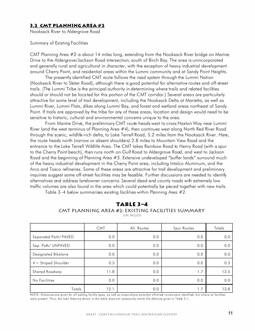
3.2 CMT Planning Area #2
Nooksack River to Aldergrove Road
Summary of Existing Facilities
CMT Planning Area #2 is about 14 miles long, extending from the Nooksack River bridge on MarineDrive to the Aldergrove/Jackson Road intersection, south of Birch Bay. The area is unincorporated
and generally rural and agricultural in character, with the exception of heavy industrial developmentaround Cherry Point, and residential areas within the Lummi community and at Sandy Point Heights.
The presently identified CMT route follows the road system through the Lummi Nation(Nooksack River to Slater Road), although there is good potential for alternative routes and off-street
trails. (The Lummi Tribe is the principal authority in determining where trails and related facilitiesshould or should not be located for this portion of the CMT corridor.) Several areas are particularly
attractive for some level of trail development, including the Nooksack Delta at Marietta, as well asLummi River, Lummi Flats, dikes along Lummi Bay, and forest and wetland areas northeast of Sandy
Point. If trails are approved by the tribe for any of these areas, location and design would need to besensitive to historic, cultural and environmental concerns unique to the area.
From Marine Drive, the preliminary CMT route heads west to cross Haxton Way near LummiRiver (and the west terminus of Planning Area #4), then continues west along North Red River Road
through the scenic, wildlife-rich delta, to Lake Terrell Road, 5.2 miles from the Nooksack River. Here,the route heads north (narrow or absent shoulders) 2.8 miles to Mountain View Road and the
entrance to the Lake Terrell Wildlife Area. The CMT takes Rainbow Road to Henry Road (with a spurto the Cherry Point beach), then runs north on Gulf Road to Aldergrove Road, and west to Jackson
Road and the beginning of Planning Area #3. Extensive undeveloped “buffer lands” surround muchof the heavy industrial development in the Cherry Point area, including Intalco Aluminum, and the
Arco and Tosco refineries. Some of these areas are attractive for trail development and preliminaryinquiries suggest some off-street facilities may be feasible. Further discussions are needed to identify
alternatives and address landowner concerns. Several dead-end county roads with extremely lowtraffic volumes are also found in the area which could potentially be pieced together with new trails.
Table 3–4 below summarizes existing facilities within Planning Area #2.
TABLE 3–4CMT Planning Area #2: Existing Facilities Summary
(In miles)
CMT Alt. Routes Spur Routes Totals
Separated Path/ PAVED 0.0 0.0 0.0 0.0
Sep. Path/ UNPAVED 0.0 0.0 0.0 0.0
Designated Bikelane 0.0 0.0 0.0 0.0
4'+ Striped Shoulder 0.3 0.0 0.0 0.3
Shared Roadway 11.8 0.0 1.7 13.5
No Facilities 0.0 0.0 0.0 0.0
Totals 12.1 0.0 1.7 13.8
NOTE: Distances are given for all existing facili ty types, as well as areas where potential off-street routes were identif ied, but where no facili t ies
were present. Thus, the total distance shown in this table does not necessarily match the distance given in Table 3-1.

12 DRAFT - Coast Millennium Trail Master Plan (1/25/00)
Figure 3–3CMT Planning Area #2

13DRAFT - Coast Millennium Trail Master Plan (1/25/00)
Figure 3–4CMT Planning Area #3

14 DRAFT - Coast Millennium Trail Master Plan (1/25/00)
3.3 CMT Planning Area #3
3. Aldergrove Road To White Rock, B.C.
Summary of Existing Facilities
Planning Area #3 extends from the junction of Aldergrove and Jackson Roads north through the BirchBay area, then splits east and west around Drayton Harbor (rejoining at Blaine), before continuing
across the border to White Rock, B.C. The total length via the easterly route is about 17 miles. Thewesterly route is slightly shorter, but includes a foot-ferry crossing at the mouth of Drayton Harbor.
The foot-ferry, MV Plover, is a registered historic vessel that provides a unique connection for trailusers, while enhancing the CMT experience.
Unlike Planning Area #2, significant trail facilities are already in place (paved paths, widepaved shoulders and bikelanes) which can be utilized by the CMT. Where there are major gaps in the
system, private landowners have offered to prov ide substantial public right-of-way for the trail.From Aldergrove Road to Grandview Road, a temporary two-mile route follows vacated
portions of Aldergrove and Point Whitehorn Roads through property owned by the TrilliumCorporation. As this property develops, a more permanent multi-use trail system would be constructed
for the CMT, and public beach access around Point Whitehorn could potentially be accommodated.From Grandview, another property owner (Malibu) has offered trail access northward to Birch Bay
State Park and Birch Bay Drive.At the park, there is good potential for a mile-long pedestrian trail and boardwalk through
Terrell Creek wetlands and along the creek to the park’s north end. In addition, it may be feasible toconstruct a one-mile spur trail (or loop system) to the east to enhance nature enjoyment and wildlife-
viewing opportunities in this area, including a possible viewing area for the Birch Bay great blueheron nesting colony—one of the largest in the Northwest.
The CMT route continues north along Birch Bay Drive which was recently improved with 4-footstriped paved shoulders all the way to the north end of the bay (3.6 miles from the state park). Here,
the route again crosses Trillium properties east of Shintaffer Road between Birch Bay Drive andSemiahmoo Parkway where it connects with an existing paved path and bikelanes. From near th is
point, the easterly CMT route follows Shintaffer Road north to Drayton Harbor Road, then turns eastto California Creek and Blaine Road (SR 549). Road shoulders are narrow or absent through this
area, although road improvements are projected for 2005 in the County’s six-year road plan. Busytraffic and narrow bridges at California and Dakota Creeks are also problematic for safe
nonmotorized use. Road right-of-way is narrow (40 feet) along Drayton Harbor Road, and the existingroadway runs very close to the shoreline, further complicating the prospects for a separated path
along the harbor. Nevertheless, this is an important link in the system and further study will berequired to determine the most appropriate CMT alignment through the area.
A temporary route continues north on Blaine Road and Peace Portal Drive (intermittent pavedshoulders) into Blaine; a much more attractive alternative follows both developed and undeveloped
streets nearer the harbor from the California Creek bridge, northward across Dakota Creek andbeyond to a railroad crossing near Bayview and Peace Portal. A high, wide median between the
railroad tracks and Peace Portal offers an appealing corridor for the CMT if a public right-of-way canbe established. This portion of the trail would rejoin Peace Portal to the north and link with new
bikelanes that lead through town to Marine Drive and the I-5 overpass.The westerly CMT route follows Semiahmoo Parkway through Semiahmoo Park to the north
end of Semiahmoo Spit and the foot ferry dock. (At the park, a connecting route could be developedalong the old Drayton Harbor Road, which is currently closed and somewhat overgrown, to its end at
a residential area where a new trail could be built up the slope to the present Drayton Harbor Road;existing bike lanes or paved path could be extended eastward to Shintaffer.) From Semiahmoo Park,
15DRAFT - Coast Millennium Trail Master Plan (1/25/00)
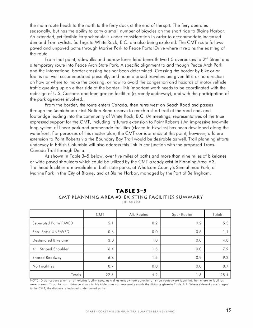
the main route heads to the north to the ferry dock at the end of the spit. The ferry operatesseasonally, but has the ability to carry a small number of bicycles on the short ride to Blaine Harbor.
An extended, yet flexible ferry schedule is under consideration in order to accommodate increaseddemand from cyclists. Sailings to White Rock, B.C. are also being explored. The CMT route follows
paved and unpaved paths through Marine Park to Peace Portal Drive where it rejoins the east leg ofthe route.
From that point, sidewalks and narrow lanes lead beneath two I-5 overpasses to 2nd Street anda temporary route into Peace Arch State Park. A specific alignment to and though Peace Arch Park
and the international border crossing has not been determined. Crossing the border by bike or onfoot is not well accommodated presently, and nonmotorized travelers are given little or no direction
on how or where to make the crossing, or how to avoid the congestion and hazards of motor vehicletraffic queuing up on either side of the border. This important work needs to be coordinated with the
redesign of U.S. Customs and Immigration facilities (currently underway), and with the participation ofthe park agencies involved.
From the border, the route enters Canada, then turns west on Beach Road and passesthrough the Semiahmoo First Nation Band reserve to reach a short trail at the road end, and
footbridge leading into the community of White Rock, B.C. (At meetings, representatives of the tribeexpressed support for the CMT, including its future extension to Point Roberts.) An impressive two-mile
long system of linear park and promenade facilities (closed to bicycles) has been developed along thewaterfront. For purposes of this master plan, the CMT corridor ends at this point; however, a future
extension to Point Roberts via the Boundary Bay Trail would be desirable as well. Trail planning effortsunderway in British Columbia will also address this link in conjunction with the proposed Trans-
Canada Trail through Delta.As shown in Table 3–5 below, over five miles of paths and more than nine miles of bikelanes
or wide paved shoulders which could be utilized by the CMT already exist in Planning Area #3.Trailhead facilities are available at both state parks, at Whatcom County’s Semiahmoo Park, at
Marine Park in the City of Blaine, and at Blaine Harbor, managed by the Port of Bellingham.
TABLE 3–5CMT Planning Area #3: Existing Facilities Summary
(In miles)
CMT Alt. Routes Spur Routes Totals
Separated Path/ PAVED 5.1 0.2 0.2 5.5
Sep. Path/ UNPAVED 0.6 0.0 0.5 1.1
Designated Bikelane 3.0 1.0 0.0 4.0
4'+ Striped Shoulder 6.4 1.5 0.0 7.9
Shared Roadway 6.8 1.5 0.9 9.2
No Facilities 0.7 0.0 0.0 0.7
Totals 22.6 4.2 1.6 28.4
NOTE: Distances are given for all existing facili ty types, as well as areas where potential off-street routes were identif ied, but where no facili t ies
were present. Thus, the total distance shown in this table does not necessarily match the distance given in Table 3-1. Where sidewalks are integral
to the CM T, the distance is included u nder pa ved pa ths.

16 DRAFT - Coast Millennium Trail Master Plan (1/25/00)
Figure 3–5CMT Planning Area #4
17DRAFT - Coast Millennium Trail Master Plan (1/25/00)
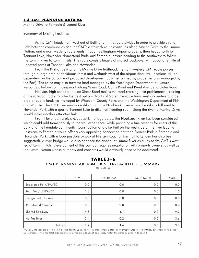
3.4 CMT Planning Area #4
Marine Drive to Ferndale & Lummi River
Summary of Existing Facilities
As the CMT heads northwest out of Bellingham, the route divides in order to provide stronglinks between communities and the CMT: a westerly route continues along Marine Drive to the Lummi
Nation; and a northwesterly route leads through Bellingham Airport property, then heads north toTennant Lake, Hovander Homestead Park, and Ferndale, before bending to the southwest to follow
the Lummi River to Lummi Flats. The route consists largely of shared roadways, with about one mile ofunpaved paths at Tennant Lake and Hovander.
From the Port of Bellingham’s Marine Drive trailhead, the northwesterly CMT route passesthrough a large area of deciduous forest and wetlands west of the airport (final trail locations will be
dependent on the outcome of proposed development activities on nearby properties also managed bythe Port). The route may also traverse land managed by the Washington Department of Natural
Resources, before continuing north along Wynn Road, Curtis Road and Rural Avenue to Slater Road.Heavier, high-speed traffic on Slater Road makes the road crossing here problematic (crossing
at the railroad tracks may be the best option). North of Slater, the route turns west and enters a largearea of public lands co-managed by Whatcom County Parks and the Washington Department of Fish
and Wildlife. The CMT then reaches a dike along the Nooksack River where the dike is followed toHovander Park with a spur to Tennant Lake (a dike trail heading south along the river to Marine Drive
would make another attractive link).From Hovander, a bicycle/pedestrian bridge across the Nooksack River has been considered
which could add tremendously to the trail experience, while providing a fine amenity for users of thepark and the Ferndale community. Construction of a dike trail on the west side of the river leading
upstream to Ferndale would offer a very appealing connection between Pioneer Park in Ferndale andHovander Park, with a loop possible by way of Nielsen Road (a river trail to Lynden has also been
suggested). A river bridge would also enhance the appeal of Lummi River as a link to the CMT’s westleg at Lummi Flats. Development of this corridor requires negotiation with property owners, as well as
the Lummi Nation whose authority and concerns would obviously need to be addressed.
TABLE 3–6CMT Planning Area #4: Existing Facilities Summary
(In miles)
CMT Alt. Routes Spur Routes Totals
Separated Path/ PAVED 0.0 0.0 0.0 0.0
Sep. Path/ UNPAVED 1.0 0.0 0.0 1.0
Designated Bikelane 0.0 0.0 0.0 0.0
4'+ Striped Shoulder 0.0 0.0 0.0 0.0
Shared Roadway 4.8 4.4 0.0 9.2
No Facilities 3.4 0.2 0.0 3.6
Totals 9.2 4.6 0.0 13.8
NOTE: Distances are given for all existing facili ty types, as well as areas where potential off-street routes were identif ied, but where no facili t ies
were present. Thus, the total distance shown in this table does not necessarily match the distance given in Table 3-1.
18 DRAFT - Coast Millennium Trail Master Plan (1/25/00)
Coast Millennium Trail Master Plan
——4. Planning & Design Issues——
Development of the CMT raises a number of planning and design issues that shouldbe considered prior to final design or construction of facilities. Issues range fromidentifying and linking destinations; delineating temporary or permanent routes;
public right-of-way needs within the trail corridor; trailheads and trail access; natural, scenic,cultural and historic sites and resources; anticipated use; the need for buffers to minimize
environmenta l or land use impac ts; as well as public safety and security. These issues are
addressed here and in the plan recommendations in the next section.
4.1 Links & destinations
The CMT offers many opportunities to link communities with a major facility for
recreation and nonmotorized transportation, while enhanc ing public access to natural, scenic
and recreation areas, historic and cultural sites, a variety of tourist destinations, and other
connecting trails. Opportunities also exist to link many schools, businesses, employment
centers, and residential areas within the most populated region of Whatcom County. The
CMT also offers a unique and important link between Washington and British Columbia. As
much as possible, general routing of the CMT attempts to make many of these connections,
while taking advantage of existing facilities and public right-of-way.
In Whatcom County, the CMT would provide links between three incorporated
cities—Bellingham, Ferndale and Blaine—as well as several other communities, notably the
Lummi Nation, Sandy Poin t Heights, and Birch Bay. (The proposed Nooksack Trail could
eventually connec t Lynden to the CMT via Ferndale.) Employment centers in these communi-
ties, and in the Cherry Point industrial area, would enjoy easy access to the trail for commute
purposes. Visitors to the County would find the CMT attractive as a tourism destination, as
well as a means to access many other tourist-oriented facilities and recreation sites.
Three state parks, two county parks, a number of city parks, a few undeveloped local
or regional park sites, and several major wildlife areas exist along the CMT corridor. There
are also opportunities (discussed below) to deve lop some portions of the corridor not simply
as a trail, but as a linear park or greenway, with additional benefits for fish, wildlife and
habitat conservation.
Thus, the CMT is likely to bring direct economic and environmental benefits to local
communities, while improving the viability of nonmotorized transportation in the region.
4.2 Potential routes & alternatives
The overall route of the CMT, illustrated in the previous section and in this plan’s
recommendations, reflects the desire to make many of the linkages addressed above. In
locations where a permanent trail alignment could not be identified (generally due to a lack of
public right-of-way), temporary routes have been delineated. These typically follow rural roads
with reduced traffic volumes, which may be suitable for most bicyclists, although some areas
like Marine Drive and Drayton Harbor Road have higher traffic speeds or volumes that
diminish their usefulness—especially for equestrians and pedestrians. Parallel paths within the

19DRAFT - Coast Millennium Trail Master Plan (1/25/00)
road right-ow-way may be an option in some areas (discussed below). Where temporary links
are identified, negotiations should be undertaken with adjacent landowners to determine
whether more permanent rou tes can be established which serve a greater diversity o f trail
users. (The potential for alternative routes is discussed in the Recommendations in section 5.)
4.3 Right-of-way issues
By definition, trails require lengthy, uninterrupted corridors that are both physically and
legally accessible to the public, either by ownership, easement or other means. Streets, roads
and highways account for the vast majority of these public corridors, and in some areas,
existing roads and paved shoulders may provide an acceptable facility for cyclists. If suitable
facilities are absent, rights-of-way may still be wide enough to accommodate wide shoulders
or a trail on one or both sides of the road. However, traffic safety, drainage facilities, other
utilities, adjacent struc tures, driveways, no ise, and aesthetic concerns tend to substantially limit
the suitability of such areas for trail development.
Utility corridors, particula rly underground pipelines, can somet imes provide a suitable
route, but they often occur on easements that exclude public access. Large blocks of public or
private land can provide important trail opportunities, as can certain conservation easements.
Developing areas may be subject to land use regulations that encourage or require provisions
for public access, and outright donations of trail easements have occurred where landowners
or developers are particularly supportive of trails.
The CMT corridor is essentially a “piecing together” of existing public trails, on-street
facilities, and areas where public right-of-way eithe r exists or can be readily negotiated. Where
no obvious alternatives exist, a temporary route is identified, generally following public roads.
Areas where the lack of public right-of-way is most problematic include the following:
™ Chuckanut Drive south of Clayton Beach Trailhead
™ Marine Drive northwest of Little Squalicum
™ Bellingham International Airport to Slater Road
™ Hovander Park to Slater Road & Haxton Way (Lummi River area)
™ Nooksack Delta & Lummi Flats (Lummi Nation)
™ Slater Road to Lake Terrell
™ Lake Terrell to Arco Refinery
™ Drayton Harbor, south & east shores
™ British Columbia border to White Rock
Established roads may be the only realistic alternative for routing the CMT through
these areas until more attractive opportunities emerge. While some roads with lower speed
limits or traffic volumes may be acceptable to experienced cyclists, they may not be
appropria te for pedestrians, equestrians or less experienced (or very young) cyclists . If
permanent routing of the CMT is to ultimately serve users of all ages and abilities, additional
public right-of-way may need to be negotiated in the areas listed above.
It should be noted that if road shoulders are the only facility available, a conflict can
arise between the cyclist’s preference for paved shoulders, and an equestrian’s preference for
unpaved. On low-speed, low volume roads, cyclists may be able to safely share the traffic
lane, while horses and foot traffic may be able to utilize an unpaved shoulder, at least on a
temporary bas is, although generally accepted transportation design gu idelines tend not to
encourage such use. Yet, if the road right-of-way is the only public corridor available in a
particular area, unpaved shoulders may be the facility of choice, at least as a temporary
20 DRAFT - Coast Millennium Trail Master Plan (1/25/00)
solution. Local circumstances (and cost) will influence this decision between using road
shoulders or separated paths adjacent to the road. Parallel paths will likely encounter fewer
difficulties along roads that border large contiguous areas of undeveloped land. Frequent
intersections with driveways or other roads can increase the risk for accidents. If more
desirable alternatives are unavailable to foot traffic or those on horseback, parallel paths
should be considered. Where pedestrian or equestrian safety cannot be reasonably assured,
the route could be identified for cyclists only.
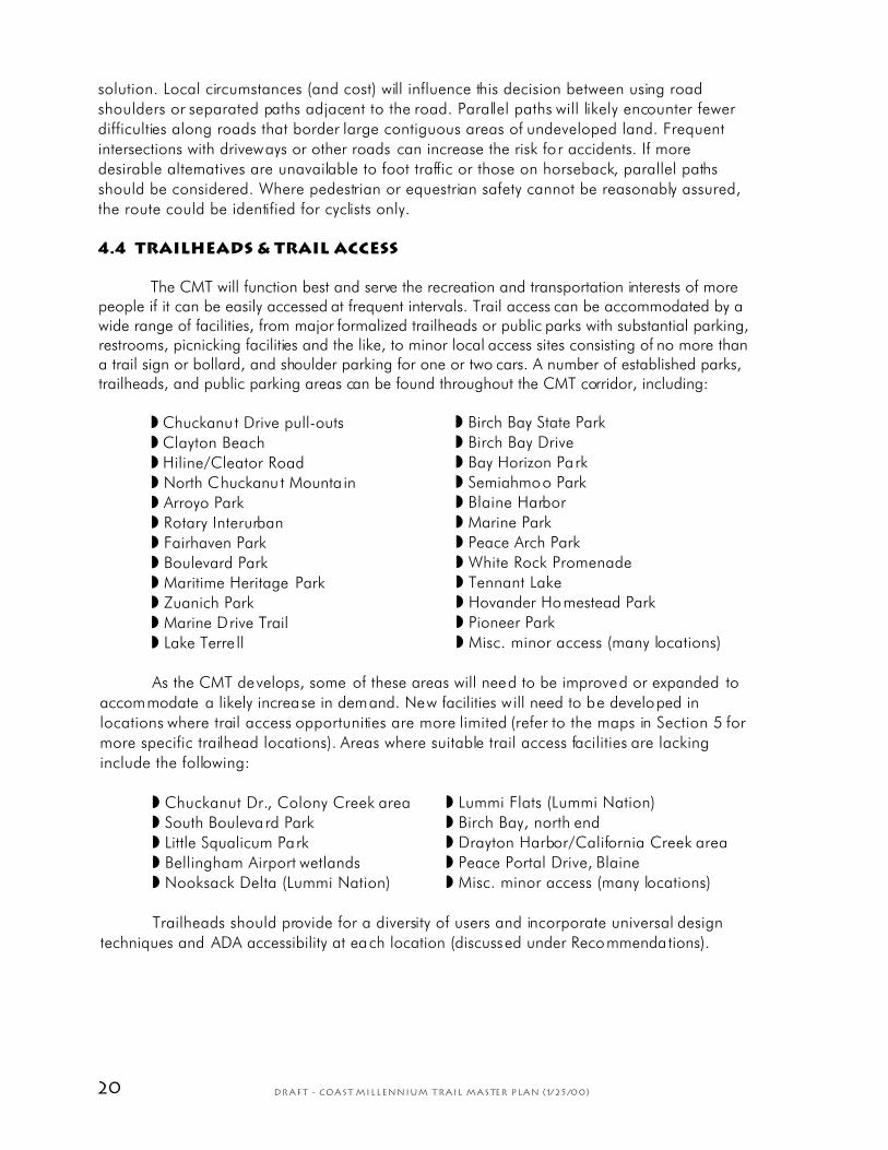
4.4 Trailheads & trail access
The CMT will function best and serve the recreation and transportation interests of morepeople if it can be easily accessed at frequent intervals. Trail access can be accommodated by awide range of facilities, from major formalized trailheads or public parks with substantial parking,restrooms, picnicking facilities and the like, to minor local access sites consisting of no more thana trail sign or bollard, and shoulder parking for one or two cars. A number of established parks,trailheads, and public parking areas can be found throughout the CMT corridor, including:
™ Chuckanut Drive pull-outs
™ Clayton Beach
™ Hiline/Cleator Road
™ North Chuckanu t Mounta in
™ Arroyo Park
™ Rotary Interurban
™ Fairhaven Park
™ Boulevard Park
™ Maritime Heritage Park
™ Zuanich Park
™ Marine Drive Trail
™ Lake Terre ll
™ Birch Bay State Park
™ Birch Bay Drive
™ Bay Horizon Park
™ Semiahmoo Park
™ Blaine Harbor
™ Marine Park
™ Peace Arch Park
™ White Rock Promenade
™ Tennant Lake
™ Hovander Homestead Park
™ Pioneer Park
™ Misc. minor access (many locations)
As the CMT develops, some of these areas will need to be improved or expanded to
accommodate a likely increase in demand. New facilities will need to be developed in
locations where trail access opportunities are more limited (refer to the maps in Section 5 for
more specific trailhead locations). Areas where suitable trail access facilities are lacking
include the following:
™ Chuckanut Dr., Colony Creek area
™ South Boulevard Park
™ Little Squalicum Park
™ Bellingham Airport wetlands
™ Nooksack Delta (Lummi Nation)
™ Lummi Flats (Lummi Nation)
™ Birch Bay, north end
™ Drayton Harbor/California Creek area
™ Peace Portal Drive, Blaine
™ Misc. minor access (many locations)
Trailheads should provide for a diversity of users and incorporate universal design
techniques and ADA accessibility at each location (discussed under Recommendations).
21DRAFT - Coast Millennium Trail Master Plan (1/25/00)
4.5 Natural & scenic features
The CMT corridor passes through a varied natural landscape of rugged coastlines, steepbluffs, forested mountains and lowlands, rocky outcrops, streams, lakes, wetlands, floodplains,meadows, headlands, bays, beaches, tidepools, tidal flats, and other features that contributeimmensely to the overall scenic quality of the corridor. In many locations, the route affordsspectacular views of the bays and islands extending outward from Whatcom County’s extensivemarine shoreline.
Many important fish and wildlife areas are encountered along the corridor, including thefollowing regionally significant habitats:
™ Colony Creek
™ Oyster Creek
™ Samish Bay
™ Chuckanut Mountains
™ Chuckanut Creek
™ Padden Creek
™ Whatcom Creek
™ Bellingham Bay
™ Bellingham airport wetlands
™ Nooksack River & Delta
™ Lummi Flats & Lummi River
™ Lake Terre ll
™ Tennant Lake
™ Cherry Point & Point Whitehorn
™ Birch Bay
™ Terrell Creek
™ Semiahmoo Spit & Bay
™ Drayton Harbor
™ California Creek
™ Dakota Creek
™ Boundary Bay
All of these areas provide opportunities for recreational and aesthetic enjoyment by
trail users, as well as places to learn about ecosystems and the environment. The presence of
sensitive species and habitats in some areas requires that extra care be taken in the location,
design and use of facilities—not only to provide needed protection, but to further enhance the
trail experience for users. Where appropriate, wildlife viewing and interpretive facilities can be
provided, along with other improvements that accommodate scenic and educational
enjoyment of the natural landscape (or seascape). Blinds, clearings, and even a few viewing
platforms or towers would be desirable in some instances. (Recommended viewpoints and
interpretive sites are found in Section 5.)
4.6 Cultural & historic sites
The Lummi Tribe and Semiahmoo First Nation Band have a long history of settlement
and sustenance in the geographic areas we now refer to as western Whatcom County and
British Columbia. This cultural heritage is, to a large extent, the foundation of our history.
While the landscape has changed radically since the arrival of non-native settlers in the mid-
1800s, much evidence of the Lummi and Semiahmoo past still exists in the memory, the
photographs, and the artifacts of native villages, ceremonial sites, travel corridors, and
hunting and fishing grounds. The tribes’ affinity for the marine coast and its tributary streams
and rivers suggests the need for great sensitivity in locating and developing certain portions of
the CMT, especially around known or suspected archaeological or ceremonial sites.
Within the Lummi and Semiahmoo communities that exist today, there is, however,
more than indigenous cultural tradition and privacy issues to be concerned about. There are
legal and jurisdictional concerns and responsibilities that will require cooperation and consent
in the development of new trail facilities within the bounds of the reservations. Thus, the design
and development effort for these locations needs to be a cooperative effort that addresses

22 DRAFT - Coast Millennium Trail Master Plan (1/25/00)
concerns that migh t arise for Native American communities , while enhancing the trail
experience for all who choose to enjoy it.
Since the 1850's, the region’s colorful history has many facets, from urban and rural
development and the early mainstays of logging, mining, fishing and agriculture, to the
emergence of a much more diversified commercial and industrial economic base. Evidence of
this more recent histo ric period can also be found at many locations along the CMT corridor.
As a result, there are numerous opportunities for interpretive and educational facilities that
could be integrated with development o f the CMT. Examples might inc lude an his toric
whistlestop along the Interurban Trolley; the era of tall sailing ships on the Bellingham
waterfront; an explanation of place names like Whatcom, Nooksack, Cherry Point or Point
Whitehorn; or the precise locat ion of Captain George Vancouver’s landing at birch Bay in
1792. Further suggestions for interpretive sites and possible themes are included in the
Recommendations in Section 5.
4.7 Other sites of interest
In addition to the possible enhancement of natural, scenic, cultural and historic sites of
interest noted above, other sites may be worthy of noting, if not in the form of interpretive
facilities or general trailhead information, perhaps in brochures or other literature that may be
published on the CMT. Other sites and facilities of interest to trail users might include
campgrounds, hostels, bed and breakfast establishments, restaurants, museums, tourist
attractions, multi-modal transportation hubs, community transit stops, bike shops, pub lic
restrooms and emergency facilities, among others. One could list perhaps hundreds of sites
and facilities within these broad categories. Though most are not specifically iden tified in this
plan, the Bellingham-Whatcom County Convention and Visitors Bureau and others have
expressed interest in compiling this information.
4.8 Anticipated use
The CMT offers a major new facility for recreation and transportation in the Whatcom
County area. The trail would likely have strong appeal to recreational and commuter cyclists,
as well as mountain bikers, hikers, joggers, equestrians and llama packers. While much of the
trail would be open to nonmotorized use and would be developed to a barrier-free standard,
a crushed limestone surface in most areas would discourage some uses, such as skating,
roller blading, or faster cycling. In time, wheelchairs and strollers would likely be
accommodated over virtually the entire distance.
Regardless of the travel mode, people will be able to use the trail for exercise, fresh
air, scenic enjoyment, educa tion, or to s imply trave l from one point to another. Use rs could
enjoy a picnic or a sunset stroll with the family, participate in a class fieldtrip on forestry,
geology, history or a multitude of other subjects, go birdwatching, photograph nature, or
countless other activities, all of which shou ld generate significan t demand for use o f this trail.
As a backbone trail system between communities, the CMT will become the principal north-
south corridor of the regional trail system, complementing other regional trails like the
proposed Bay-to-Baker and Nooksack Trails, and the City of Bellingham’s developing network
of trails and greenways.
The demand for trails in Whatcom County and the city of Bellingham has been
documented in several recen t comprehensive park and recreation plans. Random household
surveys have shown that over half the population uses trails for one or more of the purposes
mentioned above, and that the demand for trail-related recreation opportunities is genera lly
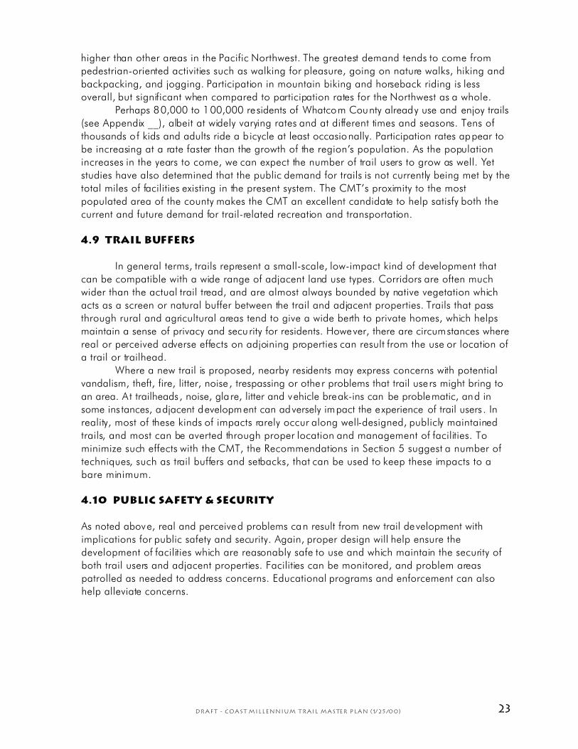
23DRAFT - Coast Millennium Trail Master Plan (1/25/00)
higher than other areas in the Pacific Northwest. The greatest demand tends to come from
pedestrian-oriented activities such as walking for pleasure, going on nature walks, hiking and
backpacking, and jogging. Participation in mountain biking and horseback riding is less
overall, but significant when compared to participation rates for the Northwest as a whole.
Perhaps 80,000 to 100,000 residents of Whatcom County already use and enjoy trails
(see Appendix __), albeit at widely varying rates and at different times and seasons. Tens of
thousands of kids and adults ride a b icycle at least occasionally. Participation rates appear to
be increasing at a rate faster than the growth of the region’s population. As the population
increases in the years to come, we can expect the number of trail users to grow as well. Yet
studies have also determined that the public demand for trails is not currently being met by the
total miles of facilities existing in the present system. The CMT’s proximity to the most
populated area of the county makes the CMT an excellent candidate to help satisfy both the
current and future demand for trail-related recreation and transportation.
4.9 Trail buffers
In general terms, trails represent a small-scale, low-impact kind of development that
can be compatible with a wide range of adjacent land use types. Corridors are often much
wider than the actual trail tread, and are almost always bounded by native vegetation which
acts as a screen or natural buffer between the trail and adjacent properties. Trails that pass
through rural and agricultural areas tend to give a wide berth to private homes, which helps
maintain a sense of privacy and security for residents. However, there are circumstances where
real or perceived adverse effects on adjoining properties can result from the use or location of
a trail or trailhead.
Where a new trail is proposed, nearby residents may express concerns with potential
vandalism, theft, fire, litter, noise , trespassing or other problems that trail users might bring to
an area. A t trailheads, noise, gla re, litter and vehicle break-ins can be problematic, and in
some ins tances, adjacent development can adversely impact the experience of trail users . In
reality, most of these kinds of impacts rarely occur along well-designed, publicly maintained
trails, and most can be averted through proper location and management of facilities. To
minimize such effects with the CMT, the Recommendations in Section 5 suggest a number of
techniques, such as trail buffers and setbacks, that can be used to keep these impacts to a
bare minimum.
4.10 Public safety & security
As noted above, real and perceived problems can result from new trail development with
implications for public safety and security. Again, proper design will help ensure the
development of facilities which are reasonably safe to use and which maintain the security of
both trail users and adjacent properties. Facilities can be monitored, and problem areas
patrolled as needed to address concerns. Educational programs and enforcement can also
help alleviate concerns.
24 DRAFT - Coast Millennium Trail Master Plan (1/25/00)
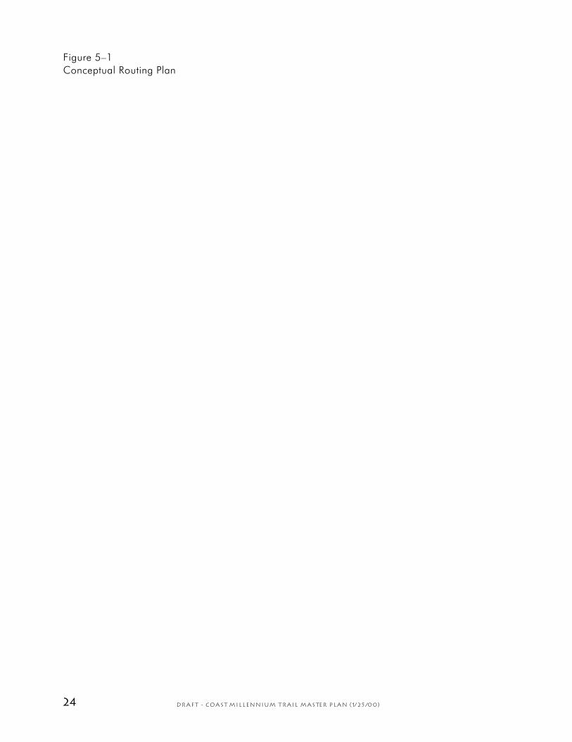
Figure 5–1
Conceptual Routing Plan
25DRAFT - Coast Millennium Trail Master Plan (1/25/00)
Coast Millennium Trail Master Plan
——5. Recommendations——
Recommendations are provided for overall routing and alignment of trails, includ-
ing both permanent and temporary routes, as well as the preferred standards for
trail width, grades and su rfacing. Locations and suggested improvements are
provided for trailheads, interpretive sites, beach and water access, viewpoints, natural areas,
and other sites of interest. Trail signing is addressed, along with general design themes and
continuity, trail development guidelines , and facility maintenance and management.
5.1 Preferred routing & alignments
The CMT represents an extensive braided corridor of on- and off-street facilities to be
developed in phases, as funding and circumstances allow. In some areas, insufficient funding
or right-of-way may delay trail development for several years or more; temporary routes have
been identified for these areas. Portions of the route that can be more easily constructed or
improved are addressed in the first phase of development. Phase 1 generally consists of the
construction of pe rmanent facilities through most of Plann ing Areas #1 and #3, with
additional spot improvements, temporary routing and signing for the entire CMT corridor (a
complete phasing plan is provided in Section 8).
Figure 5–1 on the facing page illustrates an overall routing plan for the CMT,
including both permanent and temporary routes. As opportunities arise to develop additional
off-street facilities, particularly within Planning Area #2, actual trail alignments will change.
Nevertheless, the CMT should remain more or less within the same broad corridor in order to
maintain important transportation and recreation links in the system. Table 3–1 below
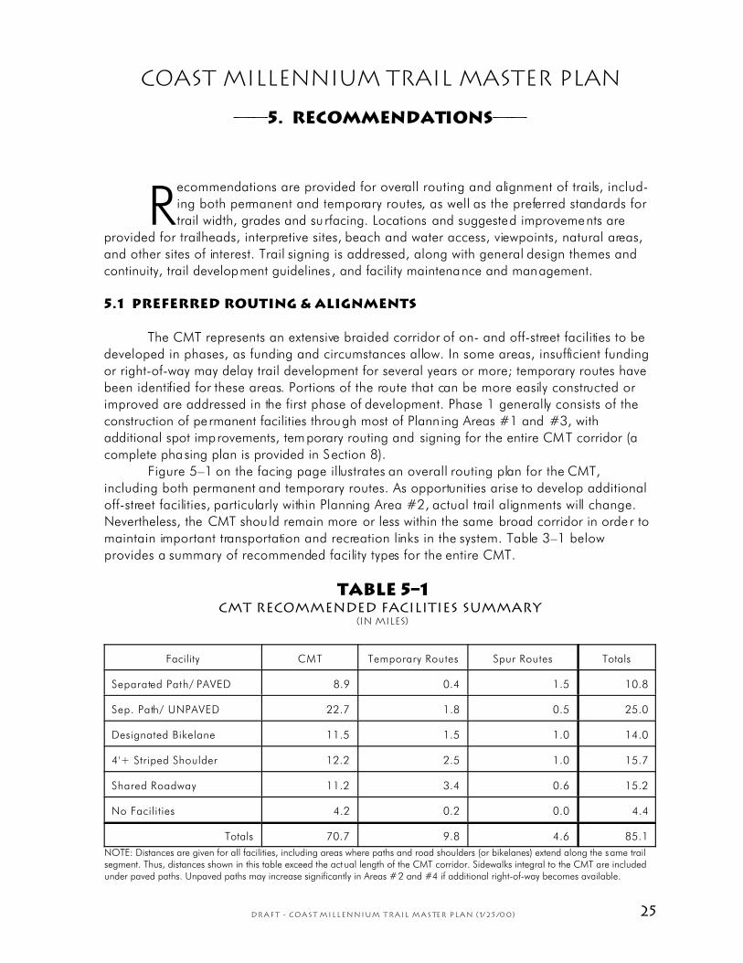
provides a summary of recommended facility types for the entire CMT.
TABLE 5–1CMT Recommended Facilities Summary
(In miles)
Facility CMT Temporary Routes Spur Routes Totals
Separated Path/ PAVED 8.9 0.4 1.5 10.8
Sep. Path/ UNPAVED 22.7 1.8 0.5 25.0
Designated Bikelane 11.5 1.5 1.0 14.0
4'+ Striped Shoulder 12.2 2.5 1.0 15.7
Shared Roadway 11.2 3.4 0.6 15.2
No Facilities 4.2 0.2 0.0 4.4
Totals 70.7 9.8 4.6 85.1
NOTE: Distances are given for all facilities, including areas where paths and road shoulders (or bikelanes) extend along the same trailsegment. Thus, distances shown in this table exceed the actual length of the CMT corridor. Sidewalks integral to the CMT are includedunder paved paths. Unpaved paths may increase significantly in Areas #2 and #4 if additional right-of-way becomes available.

26 DRAFT - Coast Millennium Trail Master Plan (1/25/00)
Figure 5–2
Major Improvements, Phase 1

27DRAFT - Coast Millennium Trail Master Plan (1/25/00)
Permanent routes are planned at locations where one or more of the following
circumstances apply:
™ Substantial facilities are existing
™ Public rights-of-way presently exist or may become availab le in the near future
™ Funding has been identified for development of proposed facilities
™ Alternatives are generally unava ilable
Temporary and alternate rou tes can provide interim connect ions in the regional trail
system, even if permanent routes are presently unavailable. Temporary routes generally consist
of rural roads and highways that can provide through connections until separated paths,
bikelanes, striped shoulders, or other more suitable facilities are established. These routes
should be appropriately signed.
Specific areas have been identified where new trail construction, or improvements to
existing facilities can more readily occur as part of Phase 1. Some of the more substantial
construc tion elements of this initial phase are shown on Figure 5–2, and briefly described in
Table 5–2. For more detailed descriptions and locations of proposed improvements, re fer to
the CMT Technical Supplement (a separate document).
TABLE 5–2CMT Major Improvements, Phase 1
I tem # (Fig. 5–2) Location Description
Planning Area #1
1 Clayton Beach Trailhead New link to Interurban
2 Fragra nce C reek, ste ep dip Regrade; raise crossing w/ new bridge
3 California St., N. Chuckanut Mt. Trailhead Trail bridge & Arroyo bypass to west
4 Interurb an Tra il Misc. repairs (city & county)
5 Boulevard Park area Railroad crossing
6 Little Squalicum Beach Trail & e levated board walk
Planning Area #2
8 Marine Dr. bridge Railroad crossing (bridge or at-grade)
9 Minor im provem ents As need ed for temp orary route
Planning Area #3
10 Malibu Trail New trail construction
11 Birch Bay State Park link New trail construction
12 Birch Bay Drive/Semiahmoo (Tri ll ium) New trail construction
13 Drayton Harbor Rd. - Old Drayton Hbr Rd. Improve o ld roadb ed; new trail constr.
28 DRAFT - Coast Millennium Trail Master Plan (1/25/00)
14 Plover dock Misc. do ck enha nceme nts
15 Drayton Harbor Rd. & Calif. Cr. bridge Improve shoulders & widen bridge
Planning Area #4
7 Route to Hov ande r & Fern dale Signing & spot imp rovemen ts
5.2 Width, grades & surfacing
The principal CMT corridor should be developed to a high, barrier-free standard that
will accommodate a diversity of trail users, be functional, enjoyable, reasonably safe, and
cost-efficient to build and maintain. Design should be consistent with established guidelines
for universal access, while complementing the natural and aesthetic quality of adjacent
surroundings.
Generally, an eight-foot minimum tread width, compacted crushed limestone (or
asphalt) surface, and maximum grades of five percent will suffice for off-street facilities. Paved
shoulders and b ikelanes should not be less than four to five feet in width (see below).
The CMT is intended for both nonmotorized transportation and recreational use by
foot traffic (walkers, hikers and joggers), cyclists (kids, adults, mountain and touring bikes),
equestrians, and llama packers, although some facilities may not be suitable for all user
groups. For example, striped paved shoulders at Birch Bay provide an excellent link for
cyclists, but are not we ll suited to pedestrians. A separate pedestrian path along the shore
would nicely accommodate foot traffic. Some areas may be unsuitable for stock, such as
Chuckanut Drive south of Larrabee State Park. To the extent practical, the proposed mix of
facilities and braided routes attempts to accommodate all of these users.
Where possible, trail construction specifications should adhere to the following:
Off-street facilities
Trail width: Generally 10 feet to 12 feet (8 feet minimum; 14 feet maximum), plus 1 to 3 feet
of clear space each side. Width will vary according to a variety of factors:
™ 8 feet Rural or remote areas; relatively low demand
™ 10 feet Urban or rural communities; low to moderate demand
™ 12 feet Urban areas; source/destination areas; moderate to high demand
™ 14 feet Urban source/destination areas; high demand; unique circumstances
In some instances, a secondary path or spur trail may be constructed to a lower
standard if doing so will allow that path to serve its intended purpose. For example, steep and
rocky slopes along Chuckanut Drive preclude development of an eight-foot wide multi-use
path, yet foot traffic could benefit considerably from a more primitive trail perhaps as narrow
as eighteen inches and with sharp vertical and horizontal variation. Equestrians may benefit
from a narrow, soft-surface trail separated from a striped paved shoulder that is better suited
to cyclists. Where all user groups share the same facility, the full-width standard should apply.
Maximum grades: 5% throughout. A level or gentle grade of 0% to 5% will accommodate a
high level of barrier-free access. Steeper grades up to 10% may be acceptab le for temporary
barrier-free routes, and areas awaiting funding, final design and development of permanent
29DRAFT - Coast Millennium Trail Master Plan (1/25/00)
facilities. Steeper grades should be limited to distances not greater than fifty feet wherever
practical. Generally, continuous grades steeper than 10% or extending more than fifty feet
should not be designated barrier-free.
Tread surfacing: The preferred surface treatment for off-street facilities is compacted crushed
limestone; limited asphalt paving may be acceptable in parks or urban areas where paved
paths are already present. Properly installed, crushed limestone over a solid base forms a
relatively smooth, durable surface suitable for most bicycles, wheelchairs and strollers.
On-street facilities
There are essentially three types of facilities which make up the on-street portions of the CMT:
Designated bikelanes, undesignated striped paved shou lders, and shared roadways with little
or no shoulder. Minimum widths, grades and surfacing should normally be as follows:
™ Designated bikelane
Definition: A paved lane or shoulder designated, signed and/or marked specifically for
bicycle use (also referred to as a Class II Bikeway under Washington State Department
of Transportation (WSDOT) design standards for nonmotorized transportation facilities;
a separated path intended for bicycle use is a Class I facility).
Minimum width: Generally 4 feet; 5 fee t if a curb is present; higher-speed, higher-
traffic volume roads may warrant additional width.
Maximum grade: Same as existing roadway.
Surfacing: Same as existing roadway (asphalt or ch ip-seal)
™ Shared roadway with striped, paved shoulders (min. 4' width)
Definition: An existing road with striped paved shoulders at least 4 feet in width. If the
road is designated as a bike route, it is considered a Class III Bikeway under WSDOT
design standards; undesignated, it is a Class IV facility.
Minimum width: Generally 4 feet; 5 fee t if a curb is present; higher-speed, higher-
traffic volume roads may warrant additional width.
Maximum grade: Same as existing roadway.
Surfacing: Same as existing roadway (asphalt or ch ip-seal)
™ Shared Roadway without striped paved shoulders (< 4' width)
Definition: An existing road with motor vehicle travel lanes shared by bicycles, either
lacking striped paved shoulders, or with paved shoulders less than 4 feet in width. Also
a Class III or IV Bikeway, as above.
Minimum width: Same as existing roadway; roads with moderate traffic volumes, truck
traffic or higher-speeds may not be suitable for bike route designation.
Maximum grade: Same as existing roadway.
Surfacing: Same as existing roadway (asphalt or ch ip-seal)
There are much more extensive guidelines available to address specific standards that
should be app lied to on- and off-stree t facilities. These are addressed in Section 5.7 . For more
detailed descriptions of recommended facilities throughout the CMT corridor, refer to the
maps and tab les contained in the CMT Technica l Supplement.

30 DRAFT - Coast Millennium Trail Master Plan (1/25/00)
Figure 5–3
Trailheads, CMT Planning Area #1

31DRAFT - Coast Millennium Trail Master Plan (1/25/00)
5.3 Trailhead facilities
To ensure that the CMT will be reasonably accessible to the public, trailhead facilities
are needed at appropriate intervals. Urban areas will require trail access at more frequent
intervals than rural areas, due to the higher concentrations of trail users that can be expected
within more populated areas. For purposes of convenience and safety in rural areas, a
minimum interval of one to two miles is suggested.
Trail access may consist of a wide array of facilities, from large, formally developed
trailheads with restrooms and parking for twenty cars or more, to small, local access areas
with limited shoulder parking for one or two cars. City, county and state parks, some Port of
Bellingham facilities In Bellingham and Blaine, and many other public facilities can also be
utilized to access the CMT. Many such sites already exist.
Existing and proposed trailheads are shown for each of the four planning areas in
Figures 5–3 through 5–6, and are summarized in Table 5–3 on the next page. Presently, at
least thirty trail access areas exist along the CMT corridor; thirteen of them could be
considered “minor” sites for local access which do not require significant expansion or costly
development of new facilities . Of the remaining seventeen “major” sites, fourteen are public
parks and three are established trailheads, most of these also will not require major expansion
to accommodate trail access.
This plan recommends an additional twenty-five sites, including ten “major” trailheads
and fifteen “minor” access areas. Each major site could serve as a hub for a particular area or
community along the corridor. A brief description of each major site follows:
™ Little Squalicum / Eldridge Ave: A site on Eldridge Avenue just north of the Little
Squalicum bridge could potentially be developed as a major trailhead for the CMT,
the Bay-to-Baker Trail, and other trails within the proposed park.
™ Roeder/Seaview Avenue: This site would provide access to Little Squalicum Beach
from Roeder Avenue; exact location is undetermined.
™ Kwina Road (Lummi Nation): A site near the Northwest Indian College or the Lummi
Tribal Center is suggested to enhance commuter cycling and recreation opportunities
for the Lummi community; actual location and development will require the Lummi
Tribe’s involvement and authorization.
™ Cherry Point: A small county park has been proposed near the Cherry Point beach at
the south end o f Gulf Road; the site could provide CMT access by way of a spur.
™ Point Whitehorn: Trillium Corporation may develop beach and tra il access in th is
area as part of ongoing development activity south of Birch Bay.
™ North Birch Bay: A new trailhead is suggested where the CMT leaves Birch Bay Drive
at the north end of the bay (to cross Trillium-owned properties).
™ MV Plover Dock: Trailhead facilities may be incorporated into proposed
redevelopment of the foot ferry dock at the north end o f Semiahmoo Spit.
™ California Creek: An intermediate access point is needed between Birch Bay and
Blaine; California Cr. offers an attractive location if a specific site becomes available.
™ Blaine Harbor: The Port of Bellingham is developing expanded public access and
parking at Blaine Harbor which could be used to access the CMT.
™ Peace Arch Park (BC): North of the Canadian border, additional trailhead facilities
would appeal to those who wish to use the park as a north- or south-bound starting
point.

DRAFT - Coast Millennium Trail Master Plan (1/25/00)
TABLE 5–3CMT Trailhead Facility Recommendations
Primary Trailhead: Ž Proposed Ž Existing
Secondary Trailhead: • Proposed • Existing
Location Class Priority Parking Comment
Planning Area #1
Colony Creek • 3 1-3 Shoulder parking; minimal facilities.
Pacific N W Tra il • 2 4-9 Local access; minimal facilities.
South DNR • 3 1-3 Local access; minimal facilities.
Clayton Beach Ž 1 25+ Major access; demand from park use.
Cleator Road • 2 4-9 Local access; minimal facilities.
N. Chu ckanut M t. Ž 1 25+ Major access; extensive facilities.
Arroyo Pa rk • 2 4-9 Local access; minimal facilities.
Rotary Interurban Ž 2 10-24 Local access; modest facilities.
Fairhaven Park Ž 2 10-24 Local access; extensive facilities.
S. Boulevard/Taylor Dock • 2 4-9 Local access; modest facilities.
Bouleva rd Park Ž 1 10-24 Major access; extensive facilities.
Maritime Heritage Park Ž 1 10-24 Major access; extensive facilities.
Zuanich Park Ž 3 10-24 Local access; modest facilities.
Little Squalicum / Ma rine Drive Ž 1 10-24 Major access; extensive facilities.
Roeder/Seaview Avenue Ž 1 10-24 Major access; modest facilities.
Marin e Drive T rail • 2 4-9 Local access; minimal facilities.
Jones Lane • 3 1-3 Local access; minimal facilities.
Marrietta • 2 1-3 Local access; minimal facilities.
Planning Area #2
Kwina Rd (NW Indian College?) Ž 2 4-9 Local access; modest facilities.
Lummi River • 3 1-3 Local access; minimal facilities.
Sandy P oint Heigh ts • 3 1-3 Local access; minimal facilities.
Lake Terrell • 3 1-3 Local access; modest facilities.
Lake Terrell Overlook • 3 1-3 Local access; minimal facilities.
Cherry Point Ž 2 4-9 Local access; modest facilities.
DRAFT - Coast Millennium Trail Master Plan (1/25/00)
Planning Area #3
Point W hitehorn Ž 3 ?? Local access; modest facilities.
Grandview Road • 2 1-3 Local access; minimal facilities.
Birch Bay State Park S Ž 1 10-24 Major access; extensive facilities.
Birch Bay State Park N Ž 2 10-24 Major access; extensive facilities.
Bay Rim Beach Access • 2 1-3 Local access; modest facilities.
Bay Road • 3 1-3 Local access; minimal facilities.
Bay Ho rizon Park Ž 2 4-9 Local access; extensive facilities.
Birch Bay • 1 4-9 Local access; minimal facilities.
Harborview • 1 4-9 Local access; modest facilities.
Cedar A venue Pa rk • 3 1-3 Local access; minimal facilities.
N. Birch Bay Ž 1 10-24 Major access; modest facilities.
Semiahmoo Parkway • 2 1-3 Local access; minimal facilities.
Semiahm oo Park Ž 1 10-24 Major access; extensive facilities.
Tongue Point • 2 1-3 Local access; minimal facilities.
MV Plover Dock Ž 2 1-3 Major access; modest facilities.
Drayton Harbor Road • 2 1-3 Local access; minimal facilities.
California Creek Ž 2 10-24 Major access; extensive facilities.
Peace Portal • 3 1-3 Local access; minimal facilities.
Blaine Harbor Ž 1 10-24 Major access; modest facilities.
Marine V iew Park • 1 4-9 Major access; extensive facilities.
Peace Arch Park (WA) Ž 1 10-24 Major access; extensive facilities.
Peace Arch Park (BC) Ž 1 10-24 Major access; extensive facilities.
White Rock Promenade (BC) Ž 2 10-24 Major access; extensive facilities.
Planning Area #4
Marine Drive Trailhead Ž 2 10-24
Major access; modest facilities.
Wynn Road • 3 1-3
Local access; minimal facilities.
Slater Rd. WDFW Access • 2 4-9 Local access; minimal facilities.
Tennant Lake Ž 1 4-9 Major access; modest facilities.
Hovander Homestead Ž 1 10-24 Major access; extensive facilities.
Pioneer P ark • 2 4-9 Local access; modest facilities.
Nooksack Bike/Ped Bridge • 3 4-9 Local access; minimal facilities.
Slater Rd. @ S. Red River • 3 1-3 Local access; minimal facilities.
34 DRAFT - Coast Millennium Trail Master Plan (1/25/00)
Figure 5–4
Trailheads, CMT Planning Area #2
35DRAFT - Coast Millennium Trail Master Plan (1/25/00)
Figure 5–5
Trailheads, CMT Planning Area #3

36 DRAFT - Coast Millennium Trail Master Plan (1/25/00)
Figure 5–6
Trailheads, CMT Planning Area #4

37DRAFT - Coast Millennium Trail Master Plan (1/25/00)
5.4 Sites of interest
There are many opportunities to enhance enjoyment of the CMT through the use of
interpretive sites, beach or water access, viewpoints, parks, natural areas, wildlife viewing
areas, and other sites of interest. A number of specific sites and locations are suggested and
briefly summarized in Table 5–4 below. Note that interpretive sites and viewpoints may be
feasible at many more locations than those listed; only the more significant or unique sites are
noted. Also, some sites are listed more than once, like Tennant Lake, where an excellent view
tower near the CMT offers a fine view into an important wildlife area.
Many of the facilities listed in the table already exist. Significant opportunities exist to
develop new amenities in conjunction with the trail, including:
™ Interpretive sites along the Interurban Trail, at the Nooksack River Delta, at Terre ll
Creek, Birch Bay and Drayton Harbor.
™ Viewpoints at Colony Creek, Little Squalicum, the Port of Bellingham’s Marine Drive
Trailhead, Nooksack Delta , Bellingham Airport wetlands, Lummi Fla ts, Lake Terrell,
Cherry Point, Point Whitehorn, and Peace Portal Drive in Blaine. The historic view
tower at Tennant Lake was recently reconstructed, and a proposed bicycle-pedestrian
bridge over the Nooksack River at Hovander Homestead would add another excellent
viewpoint.
™ New parks at Old Fairhaven Town Square, Little Squalicum, Cherry Point, Cedar
Avenue (Birch Bay) and Montfort Park in Blaine.
TABLE 5–4CMT Sites of Interest
Planning Area Site / Location Description / Theme
Interpretive Sites
1 Interurban Trail (multiple locations) Chuck anut M t., forests, geolo gy, history
1 Bellingham Bay (multiple locations) Waterfront history, bays & islands
1 Nooksack River Nooks ack De lta, Native A merican h istory
3 Terrell Creek / Birch Bay Bay, wetlands, Captain Vancouver
3 North Birch Bay Shorelines, N ative Am erican history
3 Dakota Creek Estuaries, creeks, Drayton Harbor
4 Tennant Lake Birds & other wildlife, lakes, floodplains
Viewpo ints
1 Colony C reek / Blanc hard Islands, Samish Flats & Bay
1 Chuckanut Drive Pull-outs (multiple) Islands, bays, Chuckanut coast
1 Wildca t Cove / La rrabee Sta te Park Islands, bays, Chuckanut coast
1 Bouleva rd Park Bellingham Bay & Lumm i Is.
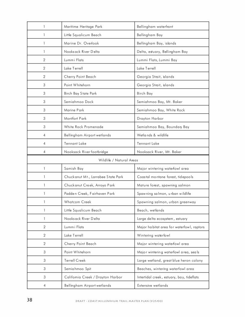
38 DRAFT - Coast Millennium Trail Master Plan (1/25/00)
1 Maritime Heritage Park Bellingham waterfront
1 Little Squalicum Beach Bellingham Bay
1 Marine Dr. Overlook Bellingham Bay, islands
1 Nooks ack River D elta Delta, estuary, Bellingham Bay
2 Lumm i Flats Lummi Flats, Lummi Bay
2 Lake Terrell Lake Terrell
2 Cherry Point Beach Georgia Strait, islands
3 Point W hitehorn Georgia Strait, islands
3 Birch Bay S tate Park Birch Bay
3 Semiahmoo Dock Semiahmoo Bay, Mt. Baker
3 Marine P ark Semiahmoo Bay, White Rock
3 Montfort P ark Drayton Harbor
3 White Rock Promenade Semiahmoo Bay, Boundary Bay
4 Bellingham Airport wetlands Wetla nds & wildlife
4 Tennant Lake Tennant Lake
4 Nooksack River footbridge Nooksack River, Mt. Baker
Wildlife / Natural Areas
1 Samish Bay Major wintering waterfowl area
1 Chuck anut M t., Larrabee S tate Park Coas tal montane forest, tid epoo ls
1 Chuck anut Cre ek, Arroyo P ark Mature forest, spawning salmon
1 Padde n Creek, F airhaven P ark Spaw ning sa lmon, u rban w ildlife
1 Whatcom Creek Spawning salmon, urban greenway
1 Little Squalicum Beach Beach, wetlands
1 Nooks ack River D elta Large de lta ecosystem , estuary
2 Lumm i Flats Major ha bitat area fo r waterfow l, raptors
2 Lake Terrell Wintering waterfowl
2 Cherry Point Beach Major wintering waterfowl area
3 Point W hitehorn Majo r winterin g wat erfowl a rea, sea ls
3 Terrell Creek Large wetland, great blue heron colony
3 Semia hmoo Spit Beaches, wintering waterfowl area
3 California Creek / Drayton Harbor Intertidal creek , estuary, ba y, tideflats
4 Bellingham Airport wetlands Extensive wetlands

39DRAFT - Coast Millennium Trail Master Plan (1/25/00)
4 Tennant Lake Wintering waterfowl, wildlife area
Parks
1 Larrabee State Park WA State Parks
1 Arroyo Pa rk City of Bellingham
1 Fairhaven Park City of Bellingham
1 Old Fa irhaven To wn Squ are City of Bellingham
1 Bouleva rd Park City of Bellingham
1 Maritime Heritage Park City of Bellingham
1 Little Squalicum Park (proposed) City of Bellingh am / W hatcom County
2 Cherry Point Beach (proposed) Wha tcom C ounty
3 Birch Bay S tate Park WA State Parks
3 Bay Ho rizon Park Wha tcom C ounty
3 Cedar Avenue Park (undeveloped) Wha tcom C ounty
3 Semiahm oo Park Wha tcom C ounty
3 Montfort P ark City of Blaine
3 Marine P ark City of Blaine
3 Peace A rch Park WA State Parks, B.C. Provincial Parks
3 White R ock Park City of White Rock, B.C.
3 White Rock Promenade City of White Rock, B.C.
4 Hovander Homestead / Tennant Lake Wha tcom C o., WA Dept. Fish & W ildlife
4 Pioneer P ark City of Fe rndale
4 Hasting s Park City of Fe rndale
4 Vande ryacht Pa rk City of Fe rndale

40 DRAFT - Coast Millennium Trail Master Plan (1/25/00)
Figure 5–7
Sites of Interest, CMT Planning Area #1

41DRAFT - Coast Millennium Trail Master Plan (1/25/00)
Figure 5–8
Sites of Interest, CMT Planning Area #2

42 DRAFT - Coast Millennium Trail Master Plan (1/25/00)
Figure 5–9
Sites of Interest, CMT Planning Area #3
43DRAFT - Coast Millennium Trail Master Plan (1/25/00)
Figure 5–10
Sites of Interest, CMT Planning Area #4

44 DRAFT - Coast Millennium Trail Master Plan (1/25/00)
5.5 Trail Signing
Signing for the CMT accomplishes several purposes, and generally consists of the
following types:
™ Informational: Signs, kiosks, maps & general information
™ Interpretive: Natural, scenic, cultural & historic sites of interest
™ Directional: Trailheads, junctions & mileposts
™ Regulatory: Rules of the road; trail-specific regulations; restricted areas
Informational signs should be located at most trailheads, parks and other sites
maintained for trail access. Limited information may also be posted at major trail junctions.
Interpretive signs should be designed consistent with an overa ll design theme, and their
subject matter should reflect the location, surroundings, history or other characteristics of the
area in which they are located. Directional signs should mostly be located at trailheads and
major trail junctions. Small milepost markers with the CMT logo could be placed low to the
ground along the entire route, generally at one-mile intervals. Regulatory signs should be
placed as needed to comply with usual traffic safety demands, to encourage appropriate use
of facilities, to discourgage trespassing, or for other purposes. Rules for the use of the CMT
should be posted at trailheads.
Overall, signing should be kept to a reasonable minimum, be tastefully designed, and
located in areas that avoid visually interfering with the aesthetic quality of the trail
environment. Properly used, signs can help ensure that trails and related fac ilities remain
functional and attractive for both transportation and recreational use.
[Note: Additional sign detail will be added once an official trail name is selected and a trail logo has been
designed and ap proved.]
5.6 General design themes & continuity
To ensure continu ity of facilities through and between jurisdict ions, and to genera lly
satisfy user expectations for a regional facility, consistency should be maintained among the
following trail elements:
™ Trail design (widths, grades & surfacing)
™ Signing & interpretation
™ Landscaping trea tments
™ Architectural features
™ Trail logos & artistic themes
As a multi-agency project, the CMT passes through several jurisdictions, each with a
somewhat different approach to the design of trails, signs, landscaping, architectural features
and other amenities. Some effort shou ld be made to coordinate design features so that overall
themes for the CMT are main tained through final design and development of major trail
facilities. This is not intended to preclude the use of design elements already in use by the
various jurisdictions. At a minimum, the trail name and logo should remain consistent and be
incorpora ted into the design of signing and information displays across jurisdictions, if
possible.

45DRAFT - Coast Millennium Trail Master Plan (1/25/00)
5.7 Trail development guidelines
Design guidelines provide a means of ensuring that trails, trailheads and related
facilities developed and main tained under this plan can reasonably accommodate their
intended use, while controlling costs and minimizing adverse impacts to natural resources, the
environment, and other trail users. In some cases, design guidelines help set an overall tone
for development, in terms of the scale, appearance, and functionality of trails, trailheads,
signing, and other facilities. They also provide a level of consistency and reliability in the
construction techniques and materials used.
More specifically, guidelines address trail surfacing, width, grades, and clearances,
drainage features, structures like bridges, boardwalks, signs, signposts, and hitching posts,
trailhead parking areas, restrooms, bikeracks, viewing platforms, railings, benches, picnic
tables, and other site furnishings or facilities. Facilities can and should be tailored to intended
or anticipa ted users . For example, a barrie r-free trail may be designed differently from a trail
that will receive heavy use by horses. Also, an "easy" barrier-free trail should meet a higher
standard than a "moderate" or "difficult" one. Mountain bikers, hikers and equestrians often
enjoy a narrower winding path more than a trail that is wide and straight, though the latter
becomes important when a facility is specifically designed for nonmotorized transportation.
Design can also help reduce user conflicts on multi-use trails.
The guidelines proposed fo r the CMT are consis tent with those for simila r facilities in
Whatcom County, and Bellingham in particular. The illustrations on the following pages
(Figures 5–11 through 5–13) are suggestive of the major types of on- and off-street facilities
to be encountered on the CMT. Some variation can be expected in order to address localized
conditions or objectives.
Guidelines are derived from a number of sources, including WSDOT’s Facilities for
Nonmotorized Transportation (Section 1020 of the Design Manual, 1989); The American
Association of Sta te Highway and Transportation Officials (AASHTO, 1999) Guide for the
Development of Bicycle Facilities; and A Design Guide: Universal Access to Outdoor
Recreation (PLAE, Inc., 1993).
The AASHTO guide is widely recognized as a foremost authority for the design of
bicycle transportation facilities in the U.S. The PLAE, Inc. guide addresses trail design in light
of the need to provide universal access under the 1990 Americans with Disabilities Act. Both
documents contain many excellent graphics, charts and technical design tools, but are
copyrighted and not reproduced here. Illustrations in Figures 5–11 through 5–13 are from the
WSDOT manual which is generally consistent with the AASHTO guide.
Addressing Potential Conflicts Among Trail Users
Occasionally, concerns are expressed about the conflicts that can occur between
different trail user groups—an issue that can often be resolved through education and careful
design of facilities. For example, some hikers may object to horses or bikes on a particular
trail because of the apparent damage they may be causing to trails. Ye t when a tra il is built
correctly to withstand its intended use, the damage is effectively mitigated and the apparent
conflict virtually disappears. As another example, if fast-riding cyclists or discourteous hikers
become disruptive to eques trians, an e ffective education program sponsored by responsible
cyclists and hikers can help resolve the problem.
A good overview of this subject is contained in a 1994 report prepared for the Federal
Highway Administration entitled Conflicts on Multiple-Use Trails. The authors suggest twelve
principles for minimizing conflicts, as provided below:

46 DRAFT - Coast Millennium Trail Master Plan (1/25/00)
™ Recognize conflict as goal interference
™ Provide adequate trail opportunities
™ Minimize the number of contacts in problem areas
™ Involve users as early as possib le
™ Understand user needs
™ Identify the actual sources of conflict
™ Work with affected users
™ Promote trail etiquette
™ Encourage positive interaction among different users
™ Favor "light-handed management"
™ Plan and act locally
™ Monitor progress
Although major problems with user conflicts are not anticipated for the CMT, these
techniques can be utilized to address them if needed.
5.8 Facility maintenance & management
Facility maintenance and ongoing management of the CMT will rest with a number of
different agencies; typically, the responsible agency will be the jurisdiction within which a given
portion of the CMT is located. Cooperative maintenance agreements should be considered,
as needed, to enhance the efficiency of repair and maintenance tasks. Volunteers should be
able to contribute significantly to periodic maintenance and repair, and they should be
encouraged to become involved. A volunteer coordinator cou ld assist with training and grant-
writing, and perhaps planning, enforcement, and other tasks under the direction of one or
more agencies.
Responsible jurisdictions should meet regularly to coordinate efforts, address problems,
funding issues, opportunities, and to ensure the trail is functioning well overall as intended.
47DRAFT - Coast Millennium Trail Master Plan (1/25/00)
Figure 5–11
CMT Design Guidelines
Off-street facilities

48 DRAFT - Coast Millennium Trail Master Plan (1/25/00)
Figure 5–12
CMT Design Guidelines
On-street Facilities
49DRAFT - Coast Millennium Trail Master Plan (1/25/00)
Figure 5–13
CMT Design Guidelines
On-street Facilities
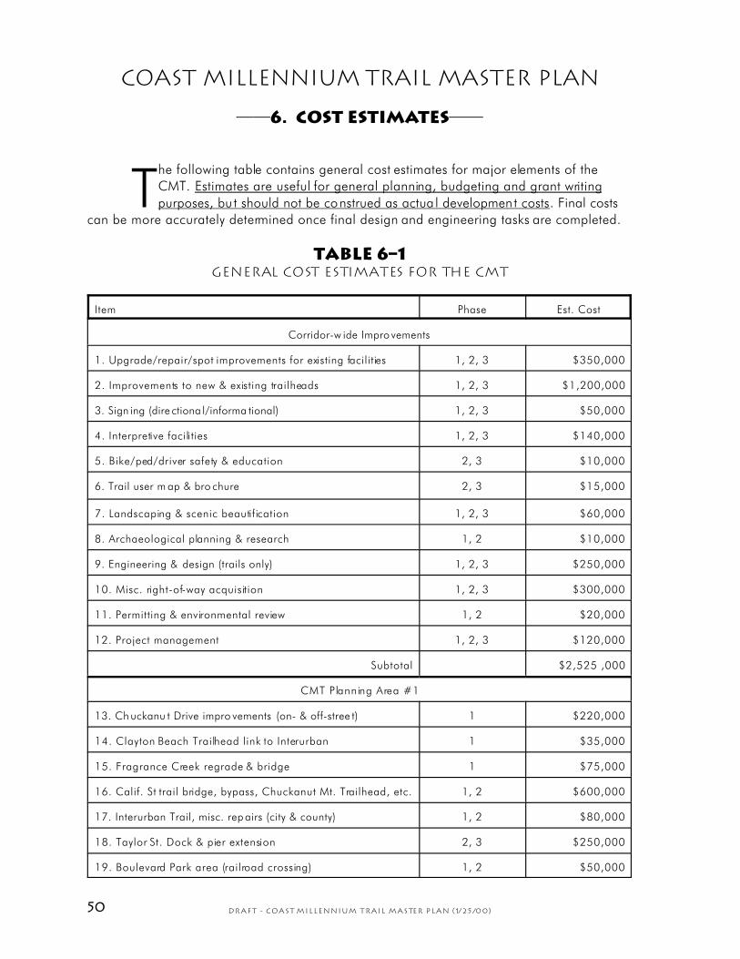
50 DRAFT - Coast Millennium Trail Master Plan (1/25/00)
Coast Millennium Trail Master Plan
——6. Cost Estimates——
The following table contains general cost estimates for major elements of the
CMT. Estimates are useful for general planning, budgeting and grant writing
purposes, bu t should not be construed as actua l development costs. Final costs
can be more accurately determined once final design and engineering tasks are completed.
Table 6–1General Cost Estimates for the CMT
Item Phase Est. Cost
Corridor-w ide Impro vements
1. Upgrade/repair/spot improvements for existing facilities 1, 2, 3 $350,000
2. Improvements to new & existing trailheads 1, 2, 3 $1,200,000
3. Sign ing (dire ctiona l/informa tional) 1, 2, 3 $50,000
4. Interpretive facilities 1, 2, 3 $140,000
5. Bike/ped/driver safety & education 2, 3 $10,000
6. Trail user m ap & bro chure 2, 3 $15,000
7. Landscaping & scenic beautification 1, 2, 3 $60,000
8. Archaeological planning & research 1, 2 $10,000
9. Engineering & design (trails only) 1, 2, 3 $250,000
10. Misc. right-of-way acquisition 1, 2, 3 $300,000
11. Permitting & environmental review 1, 2 $20,000
12. Project management 1, 2, 3 $120,000
Subtotal $2,525 ,000
CMT Planning Area #1
13. Ch uckanu t Drive impro vements (on- & off-stree t) 1 $220,000
14. Clayton Beach Trailhead link to Interurban 1 $35,000
15. Fragrance Creek regrade & bridge 1 $75,000
16. Calif. St trail bridge, bypass, Chuckanut Mt. Trailhead, etc. 1, 2 $600,000
17. Interurban Trail, misc. rep airs (city & county) 1, 2 $80,000
18. Taylor St. Dock & pier extension 2, 3 $250,000
19. Boulevard Park area (railroad crossing) 1, 2 $50,000

51DRAFT - Coast Millennium Trail Master Plan (1/25/00)
20. Little Squalicum Beach (trail & elevated boardwalk) 1, 2 $500,000
21. Roeder/Eldridge link 2, 3 $90,000
22. Ma rine Dr. trail misc . improvem ents 1, 2 $40,000
23. Marine Dr. BNRR crossing 2 $50,000
24. Other improvements (unspecified) 1, 2, 3 $250,000
Subtotal $2,240,000
CMT Planning Area #2
25. Ma rine Dr. imp rovemen ts 2, 3 $150,000
26. Misc. improvements, Lummi Nation 2, 3 $240,000
27. Misc . county roa d improve ments 2, 3 $200,000
28. Other off-street trails (unspecified) 2, 3 $200,000
Subtotal $790,000
CMT Planning Area #3
29. M alibu T rail 1 $60,000
30. Birch Bay State Park, pedestrian trail & bike link 1, 2 $150,000
31. Birch Bay Drive to Semiahmoo Pkwy 1 $80,000
32. Drayton Harbor Rd. to Old Drayton Harbor easement 1 $60,000
33. Plove r & dock e nhance ments 1, 2 $60,000
34. Peace Portal to Calif. Cr. bridge & Drayton Harbor Rd. 1, 2 $400,000
35. Other improvements (unspecified) 1, 2, 3 $250,000
Subtotal $1,060 ,000
CMT Planning Area #4
36. Bellingha m Airp ort trail 2, 3 $100,000
37. W etland board walk/n ature tra ils 2, 3 $80,000
38. W ynn Rd. to S later Rd. trail & ro ad impro vements 2, 3 $120,000
39. Tenn ant Lake/H ovande r trail improvem ents 2, 3 $60,000
40. Nooksack River bike/ped bridge 2, 3 $300,000
41. Dike trail to down town Fe rndale/Pio neer Park 2, 3 $50,000
42. Lu mmi R iver Trail 3 $40,000
43. Other improvements (unspecified) 1, 2, 3 $120,000
Subtotal $870 ,000
TOTA L project co sts $7,485 ,000

52 DRAFT - Coast Millennium Trail Master Plan (1/25/00)
Coast Millennium Trail Master Plan
——7. potential funding sources——
The financial resources needed to develop the CMT are available from a wide
variety of federal, state, regional, local, and private sources. However, much of
the funding may come from a handful of grant programs, particularly those
administered by the Washington Department of Transportation (WSDOT) and the Interagency
Committee for Outdoor Recreation (IAC). Local and private contributions, both financial and
in-kind, will also be very important, not only to sa tisfy local matching requirements, but to
expedite development over the near-term. Principal funding sources are listed below.
Perhaps the most important grant program admin istered by WSDOT that may benefit
the CMT is the Surface Transportation Program (STP) Enhancement Program. Originally
established by Congress in 1991, this competitive program has become a principal funding
source fo r bicycle and pedest rian transportation facilities nationwide. The key is
“transportation.” Facilities that are purely recreational would not likely qualify for funding.
Obviously, the CMT has a strong nonmotorized transporta tion component that should
compete well with other projects in the region. For example, two key sections of the CMT, the
South Bay Trail in Bellingham, and the Birch Bay Bikeway, have both received grants from the
STP Enhancement Program.
Table 7–1Principal Funding Sources for the CMT
Funding Source Administered by: Applications due: Notes
TEA-21/STP Enhancement
Program
WCCOG,
WSDOT
Sep 1999 $21 million statewide in FFY
2000-2001; approx. 75% based
on pop ulation, 25 % discretio nary
WWRP (W A Wildlife &
Recreation Program)
IAC May 2000 $50 million +/-; state budget
appropriation varies year to year
NO VA (N on-hig hway Off-
road Vehicle Activities)
IAC May 2000 Limited circu mstanc es; up to
100% funding; $10 0,000 max.
ALEA (Aquatic Lands
Enhanc ement A ccount)
WA DNR Oct 2000 Biannual gra nts enh ance p ublic
access to shorelines; 25% match
Wha tcom C o. Path s & Tra ils
Reserve Fund
Whatcom Co. N/A From state fuel tax; an important
source o f local matc hing dollars
Whatcom Co. Conservation
Futures Levy
Whatcom Co. N/A Active le vy; for acquisition only
Bellingham G reenways
Program
Bellingham N/A Voter-ap proved levy s upports
trails, etc. in or near Bellingham
Private contributions CMT committee N/A Donations of land , right-of-way,
materials, labor, and/or money
53DRAFT - Coast Millennium Trail Master Plan (1/25/00)
Approximately $21 million in STP Enhancement grants is available statewide for the
FFY 2000-2001 biennium (comparable to FFY 1998-1999). About 75% of the money is
distributed based on population; 25% is discretionary. The required local match may be less
than 20% of the total project cost, depending on circumstances. (An Enhancement grant
application for the CMT was submitted to WSDOT for consideration during the current
round; a decision will be forthcoming in early 2000.)
The Washington Interagency Committee for Outdoor Recrea tion (IAC) administers
several other major grant programs that are funded by state and federal sources, but which
focus more on recreation and conservation objectives. The principal funding programs at IAC
are the Washington Wildlife and Recreation Program (WWRP) which is derived from an
annual, though somewhat unpredictable, appropriation by the state legislature ($50 million
was allocated in 1999 for projects that were scrutinized in 1998). Generally a 50% local
match is required. In limited circumstances, the Non-highway Off-Road Vehicle Activities
program (NOVA), also administered by IAC, provides grants up to $100,000 for
nonmotorized trail development, without the requirement of a local match, although a
financial or in-kind contribution is recommended. NOVA is funded out of the state motor
vehicle fuel tax. Applications for the next grant cycle are due the first of May, 2000.
Other sources may become available through IAC, and new opportunities there
should be monitored. The Aquatic Lands Enhancement Account administered by the
Washington Department of Natural Resources offers a limited, though still significant, source
of funding as well, on a biannual basis. The next round of applications are due in the fall of
2000.
Competition for state and federal funds is on the rise as trail programs increase in
popularity and more communities compete for limited funds. For this reason and in view of
the fact that most grant programs require local jurisdictions to assume a share of project
costs, local funding mechanisms are needed to implement trail and trailhead improvements
along the CMT.
Local sources can range from bond issues and specia l levies, such as Bellingham's
two highly success ful Greenways levies; increasing the local percentage of state motor vehicle
fuel tax proceeds that are dedicated to paths and trails; sale of surplus properties; assessment
of impact fees on new development; user fees; and general appropriations. Some of these
sources require the County to have a capital facilities plan in place in order to qualify a
project for spending.
Potential funding sources in the private sector also exist and should not be
overlooked. In fact, portions of this master planning process were privately funded, and some
willingness to donate right-of-way or otherwise contribute to trail development costs has also
been expressed in the private sector. Donations of land, easements or right-of-way, as well as
contributions of cash, expertise, labor and materials by business, industry, organizations and
individuals can be a great help to any community that must raise critical funds for matching
grants.
A brief summary of all potential funding sources for development of the Coast
Millennium Trail follows.
7.1 Federal sources
TEA-21/STP Enhancement Program
As noted above, a variety of transportation-related grants and funding programs under TEA-
21 (Transportation Equity Act for the 21st Century) may offer significant resources for some
trail projects. Grants are administered through the Washington Department of Transportation,

54 DRAFT - Coast Millennium Trail Master Plan (1/25/00)
and are distributed by state, regional and metropolitan planning organizations. Qualifying
projects include rail-tra ils, bikeways, pedestrian facilities, rail corridor acquisition, scenic
beautification, historic preservation of transportation structures, archaeological work, and
other transportation-related purposes. TEA-21 also includes a national Recreational Trails
Program which, although generally underfunded, has the potential to become a meaningful
resource in the future.
The state is required to distribute a portion of the TEA-21 funds expended in the
Surface Transporta tion Program (STP) on enhancements; local jurisdictions must typically
provide a minimum 13.5% match on enhancement grants for bicycle, pedestrian, or
equestrian facilities (a higher match strengthens a proposal). Jurisdictions may direct other
STP funds to nonmotorized transportation projects, and may submit for statewide competitive
funds which support creative, multi-modal solutions to significant transportation challenges.
Federal Public Lands Highways Discretionary Fund
Bicycle and pedestrian trails that provide access to or within federal lands are eligible for
funding under this program (administered by WSDOT). Federal lands along the CMT corridor
are obviously very limited (perhaps at the border crossing only), although this potential
funding source should be investigated. In 1998, grants totaled $4 million nationwide under
this program.
Federal Aid Bridge Replacement Program
This competitive program is administered by WSDOT and provides 80% federal funding for
replacing deficient or obsolete road bridges. If the CMT relies on such a bridge now or in the
future, this grant source can be a significant one.
Land & Water Conservation Fund (LWCF)
The LWCF comes from federal appropriations administered in Washington State by the
Inter-Agency Committee for Outdoor Recreation (IAC). Funding levels have been well below
what was once envisioned by Congress but significant funds could become available in the
future for land acquisition and trail development. The Fund should be monitored regularly.
Technical Assistance Programs
The National Park Service Rivers and Trails Conservation Assistance Program provides
technical support (not funding) for planning and design of trails and greenways. The U.S.
Forest Service Master Performer Program makes expertise available to local agencies on a
partnership basis, including planning, design and assistance with accessibility. The
Washington Department of Transportation provides limited technical support for bicyc le safety
and education programs, and facility design and construction. IAC provides general
information on programs, funding, technical resources, and agency and organization
contacts. The National Center on Accessibility is a good source of technical information
concerning access to trails and recreation facilities by disabled persons. The Washington
State Parks and Recreation Commission offers limited technical assistance.
Direct Appropriations
Congress occasionally appropriates money directly for certain projects, as occurred with the
Centennial Trail in Spokane, and a bicycle route on the Olympic Peninsula.
Community Development Block Grants (CDBG)
These limited funds are available through the Federal Department of Housing and Urban

55DRAFT - Coast Millennium Trail Master Plan (1/25/00)
Development for projects which benefit low and moderate income households and
community development projects. Funds may be used for development but not for
maintenance and operations. Bellingham has successfully applied these funds to trail projects
in the city.
EPA TRAQ Center, Transportation-Related Grants
The U.S. Environmental Protection Agency’s Transportation Air Quality Center (TRAQ)
maintains a clearinghouse of information on transportation-related projects funded by EPA.
Grant projects tend to involve education and public outreach geared toward the reduction of
emissions from motor vehicles, and not actual development of facilities.
7.2 State sources
Washington Wildlife & Recreation Program (IAC)
As noted above, the WWRP is a major source of recreation and habitat conservation money
made available by the legislature through the Governor's capital budget request. The
program funds trail acquisition and development, and other projects such as parks, water
access, and habitat enhancements which may include trails. While funding requests have
become highly competitive, the CMT may compete well considering the unique opportunities
it provides, and its importance as a regional and international recreation resource.
NOVA (IAC)
NOVA funds are appropriated from a portion of the motor vehicle fuel tax and off-road
vehicle permit fees, and are available under certain circumstances for acquisition and
development of nonmotorized recreation trails, as well as off-road vehicle (ORV) trails and
facilities. Up to 100% funding may be available.
Motor Vehicle Fuel Tax
To support the construction, operation and maintenance of local transportation projects,
22.78% of fuel taxes collected by the state are disbursed to counties (roughly twice what is
allotted to cities). These funds can be supplemented through a local option fuel tax which can
also be applied to policing roads. State law requires that a small percentage of these funds
be applied to paths and trails, which broadly interpreted at the local level, has included road
shoulders and sidewalks along county roads. However, these limited dollars can be extremely
important as matching funds for projects like the CMT.
Rural Arterial Program/County Arterial Preservation Program
These are state funds allocated to counties for rural arterials and may be applied to
bicycle/pedestrian improvements along arterials.
Public Works Trust Funds
The PWTF provides state-administered low interest loans for public works projects which in
certain circumstances could potentially benefit the CMT.
Aquatic Lands Enhancement Account (WDNR)
Administe red by the Washington Department of Natural Resources, these funds are available
every other year for the acquisit ion and development of wate r-oriented recreation or public
access projects including trails. A 25% local match is required.
56 DRAFT - Coast Millennium Trail Master Plan (1/25/00)
Coastal Zone Management grants (WDOE)
WDOE offe rs small grants to local agencies for shore land trails and public access projects
with a 50% local matching requirement.
Timber Excise Tax
Counties can tax timber harvesters, subject to state law. There are no limitations on
expenditures, although some benefit to forestry-dependent communities may be implied.
Community Economic Revitalization Board (CERB)
CERB offers grants and low interest loans to jurisdictions who wish to develop transportation
projects related to priva te development.
Direct Appropriations
The State Legislature occasionally appropriates money directly for some projects, such as the
Centennial Trail in Snohomish County and a number of projects funded by WWRP.
Cooperative Agency Funding
Cities, counties, districts, state, federal or tribal agencies, and non-profit organizations may
work together creatively to generate funding for a variety of uses.
7.3 Local sources
General Funds
General funds are those appropriated by local government and include property taxes, local
option sa les taxes, u tility taxes, general sta te-shared revenues, business license fees, public
works trust funds, special purpose district revenues, and other sources. General funds may be
used for a variety of needs including public transportation and recreation.
Whatcom County Road Fund
The Whatcom County road fund is largely derived from local property taxes, a portion of the
state motor vehicle fuel tax distributed to cities and counties for building and maintaining the
road system, and from grant programs administered by the state. The fund is available for
on-street bicycle and pedestrian facilities. A six-year planning horizon makes it difficult to
access these funds over the near-term for the CMT, except where planned road
improvements happen to dovetail with needed improvements for bikes and pedestrians (for
example, Marine Dr., Lake Terrell Rd. and Birch Bay Dr. are a ll scheduled for improvements
which will benefit the CMT)).
Development Impact Fees
Impact fees may be imposed on development activities for improvements that are related to a
proposed development and which reflect the project's impact or cost to public facilities or
infrastructure. However, Whatcom County has not yet adopted impact fee assessments as
envisioned under the Growth Management Act. Once that occurs, fees may be collected for
transportation or recreation-related impacts which, in some cases, could benefit the CMT.
Development Permits/Impact Mitigation (SEPA)
Facilities or financial contributions may be required as a condition of approval of
development permits to ensure compliance with public policies and regulations, or to
mitigate transportation and environmental impacts associated with a particu lar development.

57DRAFT - Coast Millennium Trail Master Plan (1/25/00)
In many instances, specific conditions can be negotiated to better serve the needs of the
developer and the public. (Impact fees are closely related and are addressed above.)
Conservation Futures Levy
Under RCW 84.34.210, a county may levy as much as 6.25 cents on every $1,000 assessed
valuation, without voter approval, to generate a modest amount of revenue for land
acquisition, including parks, trail corridors, and other recreation and open space areas. The
levy can be short or long term but may not be used for development. Whatcom County has
taken advantage of this opportunity already in the Chuckanut Mountains, at Squires Lake,
and at Canyon Lake Ridge. This levy could become a very important resource for acquiring
land or easements for the CMT, particularly where significant opportunities for habitat
conservation also exist.
Bond Measures
Bonds are either voter approved or passed by the local legislative body. Voter approved
bonds increase property taxes in order to pay the debt incurred and usually require 60% voter
approval. Revenue bonds are normally paid from funds generated by an income-producing
activity rather than by taxes. Councilmanic bonds, authorized by the legislature, do not
increase taxes. There are no limitations on the use of bonds, and they can be structured to be
collected over a short or long period of time.
Real Estate Excise Tax (REET)
REET is a tax on the sa le of property (up to 1/2 of 1%) which can be used to pay for projects
identified in local capital facilities plans.
Special Levies
These include the acquisition of funds through taxation, usually involving property taxes. The
approval of 60% of the voters is normally required to pass a special levy. Voters in the City of
Bellingham have approved the Greenways and Beyond Greenways levies in recent years, an
ongoing program that has brought many tangible results and enjoys wide support. A
comparable voter-approved levy for Whatcom County should be seriously considered.
Paths & Trails Reserve Fund
RCW 47.30 requires local jurisdictions to reserve a percentage of fuel tax revenues for
transportation-related bicycle, pedestrian and equestrian facilities. Whatcom County has
applied two percent of these funds to paths and trails which helps provide a small but re liable
source of local matching money for grants. In the past, a substantial portion of these dollars
went toward road shoulder widening along routes which may or may not have provided the
most benefit to nonmotorized travelers. The money is also available for planning and design
services.
Public Works Trust Fund
The PWTF provides low-interest loans from the Wash ington Department of Community
Development which can be used for roads, bridges and capital improvement planning.
Special Assessment Debt
Bonds can be financed through Local Improvement Districts (LID) or Road Improvement
Districts (RID) which collect fees from developers and landowners based on the level of
benefit realized.
58 DRAFT - Coast Millennium Trail Master Plan (1/25/00)
Transit Tax
Transit Authorities may also levy taxes to support their operations, with voter approval. Transit
access to certain portions of the CMT would provide significan t benefits to the region’s multi-
modal transportation system.
Hotel/Motel Tax
Proceeds can be used for projects that enhance tourism and opportunities for travelers.
User Fees & Tolls
Fees may be collected locally from the user of a public facility. Parking, entrance,
registration, and program fees are among those which may be collec ted. Tolls a re genera lly
intended to pay off construction bonds.
Local Vehicle License Fees
By referendum, counties can collect additional license fees for the benefit of nonmotorized
transportation (RCW 82.80.020). Revenues are shared between cities and the county.
Proceeds from sale of surplus property
Surplus public property may be sold to generate funds for land acquisition or other needs.
Franchise Agreements
Franchise agreements with utilities and other entities can include a provision for recreational
use of a site or corridor.
Health Grants
Small grants are available under a variety of federal programs that can help pay for facilities
which benefit public health.
7.4 Private sources
Private Contributions
Business, organization and individual donations of money, property, materials or volunteer
services can be significant resources for trail projects and trailheads. For example, a local
Rotary club made a financial contribution toward a new trailhead for the Interurban Trail, and
a number of clubs have organized volunteer trail maintenance and construction activities in
the Chuckanuts and elsewhere. The Birch Bay community has raised money to put toward
enhancement of the waterfront generally, which could also benefit walkers and cyclists.
Land Exchanges & Donations
Outright donations of land or easements, and public-private land exchanges, such as the
land exchange that increased public ownership in the Chuckanuts, can be considered under
a variety of circumstances. This can be especially important where land values make up a
significant portion of a local match toward other grant programs.
Foundation Grants to Nonprofit Organizations
Non-profit organizations advocating trail, greenway, and habitat conservation projects have
had some success in Washington Sta te obtaining modest foundation grants to support their
efforts. The proposed Bay-to-Baker Trail received funds from at least two private foundations
(in the range of $5,000 to $10,000).
59DRAFT - Coast Millennium Trail Master Plan (1/25/00)
Coast Millennium Trail Master Plan
——8. funding & Development Strategy——
Careful coordination of the Coast Millennium Trail’s many diverse elements and
design challenges w ill expedite its development. For example , construc tion in
some areas may not be possible until final alignments are determined,
easements are secured, or other tasks are completed. Temporary routing of some sections
may also be necessary until adequate funding is obtained and a permanent, fully connected
corridor has been identified. In addition, certain funding sources may or may not be
appropriate for different project elements.
An overall funding and development st rategy, as outlined in this section, will help
ensure the best use of limited resources, as well as the development of functional, attractive
facilities consistent with the master plan.
8.1 Project Phasing
Project development is organized into four phases, as follows:
™ Phase 1 Construction of permanent facilities through most of Planning Areas
#1 and #3, with additional spot improvements, temporary routing and
signing for the entire CMT corridor.
Est. cost: $2,400,000
Funded by: Spring-summer, 2000
Construction: Summer-fall, 2000
™ Phase 2 Construction of permanent facilities through most of Planning Area
#4, particularly between downtown Bellingham, and the City of
Ferndale, including acquisition of land or easements.
Est. cost: $1,500,000
Funded by: Spring-summer, 2001
Construction: Summer-fall, 2001
Phase 3 Construction of permanent facilities through most of Planning Area
#2, including acquisition of land or easements.
Est. cost: $2,000,000
Funded by: Spring-summer, 2002
Construction: Summer-fall, 2002
Phase 4 Final completion of all project elements.
Est. cost: $1,585,000
Funded by: Spring-summer, 2003
Construction: Summer-fall, 2003
For a detailed listing of suggested improvements within each Planning Area, refe r to
the Recommendations in Section 5, and the tables describing the work needed to complete
each trail segment, trailhead, or other trail amenity.
60 DRAFT - Coast Millennium Trail Master Plan (1/25/00)
In essence, Phase 1 emphasizes those elements in Planning Areas #1 and #3 that
are relatively affordable and ready to construct, while providing for signing of the entire
route. This would result in substantially completed facilities from the Skagit County line to
downtown Bellingham, and from Aldergrove Rd north to Semiahmoo Spit. By the end of the
second phase, facilities would be substantially completed between north Bellingham and
Ferndale, and from Squalicum Harbor to the Nooksack River. Once final trail alignments are
determined in Planning Area #2, Phase 3 could complete the more permanent route
between the Nooksack Rive r and Alderg rove Rd. It is expected that minor gaps may still
remain, and that some higher-cost items, such as major trail bridges, trailheads, outstanding
land acquisitions and the like, may require additional time to secure the funds necessary for
their completion. Phase 4 addresses these remaining items. If funding, volunteers, or other
resources become available to tackle a specific pro ject ahead of schedule, the work should
be encouraged.
Development of each phase would be preceded by several steps involving funding,
work commitments, and final design, generally as follows:
™ Project details defined for a specific phase o f development;
™ Funding sources identified (grant source and local match, if required);
™ Commitments obtained from private contributors and/or volunteers;
™ Project information and grant applications assembled and submitted;
™ Funding approved;
™ Design/engineering consultant selected;
™ Permitting, environmental review conducted;
™ Final design and construction documents completed;
™ Advertise for bids, contractor selected;
™ Construction begins;
™ Improvements completed and approved;
™ Facility maintenance.
8.2 Plan Implementation
Implementation of the master plan by the various agencies can be realized more
effectively if each formally adopts or endorses the plan and commits itself to a cooperative or
leadership role in carrying out the recommendations. Agencies should maintain regular
communications with each other, coordinate their efforts, assign responsibilities and, at least
once a year, assess the progress that has been made and establish new objectives for the
coming year. Agencies may wish to apply for grants jointly in some instances.
The ongoing cost of maintenance and operation of facilities should be considered
and the needed resources identified prior to development. For trails, these costs are expected
to be minimal since most facility maintenance and some construction could be conducted by
trained volunteers. The resource poten tial that exists in a quality volunteer program is
substantial, although to be e ffective such a program may warrant the services of a paid
volunteer coordinator. (The City of Bellingham currently employs a volunteer coordinator for
its Greenways program, potentially a good model for the CMT.) Many grant programs accept
in-kind and volunteer contributions toward the required local match, thus a well-organized
volunteer program has the potential to pay for itself many times over.
While volunteer efforts can certainly contribute to many of the facilities identified,
some of the larger projects such as the development of trailheads, bridges, and other
amenities may require a commitment of staff time to see them through.
61DRAFT - Coast Millennium Trail Master Plan (1/25/00)
Coast Millennium Trail Master Plan
——9. Participation of Agencies & the Public——
[Summarize all agency and public participation in developing the plan...]
Public Meeting 10/6/99
A public meeting was held in Bellingham once a general routing plan was established
and many of the principal issues had been identified. The public was invited to submit
additional comments, concerns and suggestions for the proposed trail. The meeting was
modestly attended and most of the participating agencies and trail user groups were
represented.
Ideas generated by public participants included the following:
™ An affordable alternative to constructing bridges might be to use gangway ramps
(e.g. Mantle Industries in Blaine). Ramps up to 100 feet long cost as little as $40,000
and can be constructed with multiple surfaces, coverings, and made fairly wide.
™ A "Harbor to Harbor" concept was emphasized fo r the trail overall.
™ There is a need to provide ample bicycle racks along trail and numerous pastry/ice
cream shops as natural stopping places.
™ The CMT should tie into plans for the Chuckanut scenic byway.
™ Provide opportunities for Mt. Baker Hiking Club, the Mountaineers, and others to
participate as volunteers.
™ Several concerns exist for equestrian facilities. There needs to be off-road facilities
with parking lots at ends of segments that accommodate horse trailer parking.
™ Information for hikers should highlight off-road portions of the trail that are open to
horses.
™ It was suggested that railroad companies be approached to get involved in the
project. (Historically, railroad owners in the NW have been reluctant to accommodate
alternative rail corridor users.) It was pointed out that the rail industry is subsidized
with tax payer dollars. The railroads "owe us something."
™ Two places in Blaine might be good rights-of-way for the CMT: a strip of state
right-of-way between Peace Portal Rd. and the rail line just south of Blaine on a bluff;
and a connection to the undeveloped Monfort Park off Sweet Rd. and Peace Portal
Rd. Plans were made to explore Bla ine with a knowledgeable citizen to investiga te
these areas.
The public was invited to continue to be involved in the project and comment on the
draft master plan when it is completed. Volunteer cards were handed out for those wishing to
participate in promoting and developing the CMT.
Related Documents