CNES PRIORITIES IN POLAR AND CRYOSPHERE RESEARCH Polar Space Task Group – 3rd Session Juliette Lambin, Steven Hosford Wednesday, May 22th, 2013 Paris, France 1

Welcome message from author
This document is posted to help you gain knowledge. Please leave a comment to let me know what you think about it! Share it to your friends and learn new things together.
Transcript

CNES PRIORITIES IN POLAR AND CRYOSPHERE RESEARCH
Polar Space Task Group – 3rd Session
Juliette Lambin, Steven Hosford
Wednesday, May 22th, 2013
Paris, France
1

OU
TLIN
E
CNES MISSIONS FOR POLAR/CRYOSPHERE OBSERVATIONSRADAR: ALTIMETRY, SAROPTICAL IMAGERY
06/06/20132

Présentation programme SARAL – J. Lambin, février 20133
10 11 12 13 14 15 16 17 18 19 20 21 22
Wide‐Swath
altimetry
Saral/AltiKa Fr./India
09Launc h date
Altimetry12/01
3/02
Jason-1 France/USA Jason-3 Europe/USA
Proposed (A/B)
Sentinel‐3B Europe
SWOT USA/France
Jason‐CS
A and B Europe/USA
Sentinel-3A Europe
fp July 2012
Geodetic orbit
ENVISAT Europe
Ocean missions @ CNES (various levels of contributions)
06/08
SalinitySMOS Europe
CFOSAT Fr./ChinaWind ‐
Wave
Ocean ColourPARASOL/POLDER France12/04 OCAPI ???
Concept (O)
Sentinel-3A-B Europe

06/06/20134

OCEAN WAVEFORM
06/06/20135
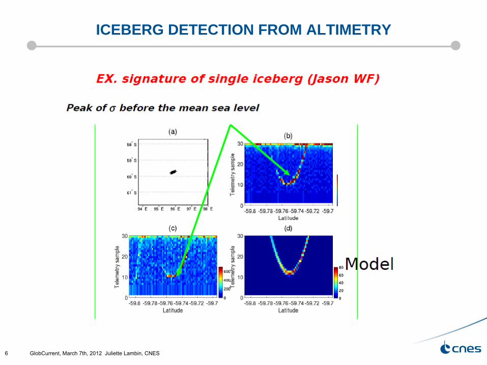
ICEBERG DETECTION FROM ALTIMETRY
GlobCurrent, March 7th, 2012 Juliette Lambin, CNES6

06/06/20137

SARAL SATELLITE FOR ARGOS AND ALTIKA
Cooperation with ISRO (India Space Research organization)Ka-band nadir altimetry missionHigher precision, shorter along-track sampling
Gap filler between ENVISAT & SENTINEL3Same orbit as ENVISAT (35 days, SSO)New Ka-band altimeter, higher precision, compact design, integrated radiometer/altimeterPOD: DORIS, LRAOther CNES payload Argos-3 instrument, X-band telemetry
Status: Launched by PSLV (ISRO) on Feb 26th Validation phase on-going
Data policy : ~ the same as JASON missionsPI: Jacques Verron (LEGI)
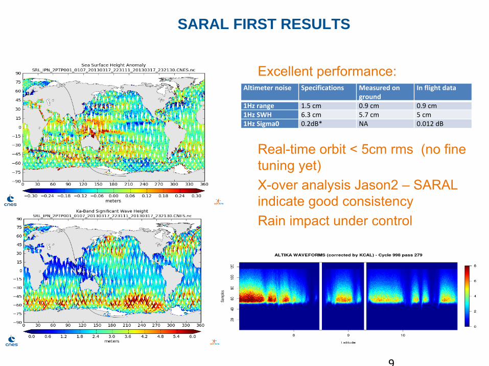
SARAL FIRST RESULTS
Altimeter noise Specifications Measured on
ground In flight data
1Hz range 1.5 cm 0.9 cm 0.9 cm1Hz SWH 6.3 cm 5.7 cm 5 cm1Hz Sigma0 0.2dB* NA 0.012 dB
Excellent performance:
Real-time orbit < 5cm rms (no fine tuning yet)X-over analysis Jason2 –
SARAL indicate good consistencyRain impact under control
9

Recul des glaces de mer Arctiques

Sea Ice Thickness accessible through altimetry

Antartica: 30 M km3: height change from altimetry (ENVISAT)
m/an
T. Flament

Altika onboard SARAL: What will it bring to
polar studies ?
1‐
Same orbit as ERS‐1, ERS‐2, EnvisatAbout 20 years of continuous measurements
Necessary for continental
ice sheets

Altika onboard SARAL: What will it
bring to polar studies ?
Ku2‐5 m
Ka2‐10 cm
2‐
Ka‐band (35 GhZ), penetration depth
is about 50 times less than Ku (13.6
GhZ)
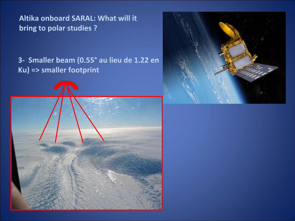
3‐
Smaller beam (0.55°
au lieu de 1.22 en
Ku) => smaller footprint
Altika onboard SARAL: What will it
bring to polar studies ?

4‐
AltiKa frequency and bandwidth
induce a better vertical resolution
(30cm wrt to 45 in Ku‐band)
Waveform with less
penetration, smaller footprint,
better sampling
5‐
Higher PRF in Ka‐band, along‐track
sampling twice the Ku‐band one (175
m instead of 350 m)
6‐
First time we will benefit from
combination of active and passive
measurement (altimeter –
radiometer), in Ka‐band
Altika onboard SARAL: What will it
bring to polar studies ?

TWO SLIDES ON… CFOSAT CHINA-FRANCE OCEANOGRAPHY SATELLITE
China-France CooperationCurrently in phase C/DLaunch expected end of 2014
SWIM, new spaceborne instrument
technology innovations (antenna, on-board digital processing)Nadir chanel ~altimeter
SCAT, new concept of wind scatterometer
Ku-band, rotating fan-beam
Access to 2D wave spectrum with high angular resolution and with
global scaleJoint measurements of winds and wavesPI: Danièle Hauser (CNRS/LATMOS)
►SSO Orbit, 7am descending
►519 km altitude, 13‐days cycle

18
SWIM INSTRUMENT
Surface Waves Investigation and Monitoring
Real aperture radar in Ku‐band6 incidence angles: 0°, 2°, 4°, 6°, 8°
et 10°
Rotation speed: 5.7 rpm
Will measure:Directionnal wave spectrum in the wavelenght range
70‐500 m
Accuracy: 10% on wavelength, 15°
on direction, 15% on
spectral level around the peak
SWH and wind speed from nadir
Normalized radar cross‐section from 0°
to 10°Absolute accuracy of ±1 dB, relative accuracy between
incidences ±
0.1 dB
Airborne instrument in 2012 (KUROS)

CFOSAT ON ICE
•
Secondary objectives–
polar ice sheet and land surfacemonitoring: roughness, vegetation and soil moistness in semi-arid regions, polar ice sheet characterics=>Multi-incidence normalized radar cross-section for estimatingSurface parameters (in particular roughness)

SWOT SURFACE WATER AND OCEAN TOPOGRAPHY
Hydrology and Oceanography mission Global, repeated high-resolution elevation measurements of ocean and inland water bodiesBaseline payload : Ka-band interferometric altimeter (KaRIn)Traditional altimetry payload
CNES budget secured in March’11 through General
Investment Fund
NASA/CNES Cooperation scheme approvedMission Concept Review succesfully passed in Sept 2012Phase A”
underway at CNES, “pre-phase A”
at NASA/JPL (Key Decision Point “A”
in a few days!)CNES involvement:Participation in KaRInDORIS, AltimeterPlatformGround segment
Launch ~2020 !

SIMULATION OF OCEAN DYNAMICS BY SWOTSIMULATION OF OCEAN DYNAMICS BY SWOT80
0 km
600 km
200 km

CNES INVOLVEMENT IN OCEAN OBSERVATION
Ocean sciences are one of the major interests of CNES Earth observation programsSupporting (and supported by) a strong scientific community through dedicated research funding Supporting several larger scope projects and initiatives (e.g. Mercator-Ocean, CORIOLIS and bioArgo, Boussole, GIS COOC…)Strong support to R&D (Instrument, mission concepts, data processing…)
In terms of satellites missions, the heavy weight is still on physical ocean observationaltimetry (Jason-1/2/3/CS, SARAL/AltiKa, SWOT, Sentinel-3, Hy-2A, )salinity (SMOS) wind/waves (CFOSAT),ocean color: PARASOL, Sentinel-3, “GEOCAPI”
Related Documents


